
Spalding County Unincorporated
City Zoning Code
City Zoning Code
APPENDIX J
COMMERCIAL/INDUSTRIAL DEVELOPMENT ORDINANCE21
Editor's note— A resolution adopted June 16, 1998, amended the zoning ordinance by adding provisions as Appendix J to read as herein set out.
ARTICLE 3. - FEES
The following fees shall be assessed for submission, review, and approval of construction plans for commercial/industrial development of real property. For the purposes of this article, the term "development" refers to the total amount of disturbed acreage proposed for a project site. For development consisting of:
1.
Less than two (2) acres .....Set by board
of commissioners
2.
2—4.99 acres .....Set by board
of commissioners
3.
5—9.99 acres .....Set by board
of commissioners
4.
10 or more acres .....Set by board
of commissioners
4'.
Additions to existing development where the total amount of impervious surface added
is less than 5,000 square feet .....Set by board
of commissioners
5.
Additions to previously reviewed and approved sites (original site less than two (2)
acres) .....Set by board
of commissioners
6.
Construction or refurbishment of telecommunications antennas and towers .....Set by board
of commissioners
7.
Utility installation .....Set by board
of commissioners
8.
Resubmittal of construction plans .....Set by board
of commissioners
(Res. of 6-16-98, § 1; Res. No. A-99-10, §§ 1, 2, 9-7-99; Res. No. A-00-13, §§ 1, 2, 7-17-00; Res. No. A-04-06, § 1, 5-3-04; Res. No. A-04-14, § 2, 8-2-04; Res. No. A-06-11, § 1, 8-7-06; Res. No. A-07-03, §§ 7, 8, 5-7-07; Res. No. A-08-21, § 2, 10-6-08; Res. No. A-11-02, § 1, 7-18-11)
Sec. 101. - Short title.
This document is entitled the Commercial/Industrial Development Ordinance of Spalding County, Georgia.
(Res. of 6-16-98, § 1)
Sec. 102. - Authority.
The power of a local government to enact an ordinance such as this, which is intended to protect the public health, safety, and welfare, is provided by the 1983 Constitution of the State of Georgia, Article 9, Section 2, Paragraph 4.
(Res. of 6-16-98, § 1)
Sec. 103. - Jurisdiction.
This ordinance applies to all land within unincorporated Spalding County, Georgia.
(Res. of 6-16-98, § 1)
Sec. 104. - Purposes.
The commercial/industrial development ordinance of Spalding County, Georgia, seeks to encourage the development of desirable land use patterns within Spalding County in accordance with the Spalding County comprehensive plan. The promotion of sound land use patterns is intended to reduce or eliminate the occurrence of certain conditions which can threaten the general health, safety, and welfare of the residents of Spalding County. This ordinance should serve the following purposes:
A.
Encourage the development of economically sound and stable communities.
B.
Assure the provisions of required utilities, facilities, and services to new land development.
C.
Assure the adequate protection of safe and convenient traffic access and circulations—both vehicular and pedestrian—in new land development.
D.
Assure the provision of needed public open spaces and building sites in new land developments through the dedication or reservation of land for recreational, educational, and other public purposes.
E.
Assure in general the wise development of new areas in harmony with the Spalding County comprehensive plan.
F.
Assure consideration of any environmental impact (past, present and future) as a result of new land development.
G.
Assure site environmental inspection, clean-up and certification.
(Res. of 6-16-98, § 1)
Sec. 105. - Content.
This ordinance provides for the following:
A.
Defines certain terms used in this ordinance.
B.
Establishes minimum standards for facilities associated with land development.
C.
Provides procedures for the administration and amendment of this ordinance.
D.
Provides penalties for violation of this ordinance.
E.
Repeals conflicting ordinances.
F.
Assures appropriate environmental impact inspections and review.
(Res. of 6-16-98, § 1)
Sec. 201. - Interpretation of certain common terms.
When used in this ordinance, the following words and phrases have the meanings as defined in this article. Terms not defined here have the same meaning as is found in most dictionaries, where consistent with the context. The terms must,will, and shall are mandatory in nature, indicating that an action has to be done. The term may is permissive and allows discretion regarding an action. When consistent with the context, words used in the singular number include the plural, and those used in the plural number include the singular. Words used in the present tense include the future. The word developer includes a firm, corporation, co-partnership, association, institution, or person. The word lot includes the words plot and parcel. The word building includes the word structure. The words used or occupied as applied to any land or building include the words intended, arranged, or designed, to be used or occupied.
(Res. of 6-16-98, § 1)
Sec. 202. - General definitions.
A.
Administrative officer: The person, officer, or official and his authorized representative, whom the county manager of Spalding County has designated as its agent for the administration of these regulations.
B.
Block: A piece or parcel of land entirely surrounded by public highways or streets, other than alleys.
C.
Board of commissioners: The Board of Commissioners of Spalding County.
D.
Buffer: That portion of a lot established for open space purposes and intended to separate properties with different and possibly incompatible types of use. A buffer shall not be occupied with structures and facilities except as permitted by this ordinance. Where required by this ordinance, a buffer must include the installation of a suitable visual screen in accordance with the provisions contained in Article 4 of the Spalding County zoning ordinance.
E.
Building line: The line that represents the distance a building must be set back from the boundary line of a lot, measured at the foundation of the building.
F.
Building setback line: A line parallel to a specified minimum distance from the front, side, or rear property lines beyond which no foundation wall or part of the structure of any building projects with the exception of roof overhang, steps, and the subsurface projection of footings.
G.
Centerline, street: That line surveyed and monumented by the governing authority as the centerline of a street, or if such a centerline has not been surveyed, it is the line running midway between the outside curbs or ditches of the street.
H.
Comprehensive plan: Any part or element of the overall plan for development adopted by the board of commissioners as amended.
I.
Construction plan: A plan which shows all street design and profiles, topographic information, utility construction plans, sediment and erosion control plans, and other information which may be required by the administrative officer. It is submitted to the administrative officer and requires only his approval after review by the appropriate county departments.
J.
Crosswalk: A right-of-way within a block dedicated to public use, intended primarily for pedestrian use, and designed to provide access to adjacent roads and lots.
K.
County: Spalding County, Georgia.
L.
Curb cut: The point at which vehicular access is provided to an adjoining street from a lot.
M.
Design standards: The specifications to land owners or developers for the preparation of plans indicating among other things the optimum, minimum, or maximum dimensions of such items as rights-of-way, setbacks, etc.
N.
Easement: The right or privilege of using another's property, for purposes such as constructing and maintaining sanitary sewers, water mains, electric lines, telephone lines, storm sewers, gas lines, bicycle paths, pedestrian ways, and other purposes.
O.
Elevation, front: The view of a building or group of buildings as seen from directly in front of the structure.
P.
Environmental matters: Those matters pertaining to possible soil and groundwater contamination, including storage tanks, chemical use, storage and disposition, hazardous waste and solid waste disposal, air quality, and surface water contamination.
Q.
Flood boundary: That area threatened by possible flood under normal to severe circumstance; determined as shown on the flood insurance rate map, published by the Federal Emergency Management Agency (FEMA), July 2, 1991.
R.
Lot: A parcel of land under single ownership occupied or capable of being occupied by one (1) or more buildings and customarily incidental accessory buildings or uses, including such open spaces as are required by this ordinance.
S.
Lot, corner: A lot located at the intersection of two (2) or more streets.
T.
Lot, double frontage: A lot, other than a corner lot, which has frontage on more than one (1) street.
U.
Lot of record: A lot which is part of a subdivision, the plat of which has been recorded in the office of the Clerk of the Superior Court of Spalding County, Georgia; or a parcel of land described by metes and bounds, the plat or description of which has been recorded in said office. If a portion of a parcel has been conveyed at the time of the adoption of this ordinance, the remaining portion of the lot or parcel will be considered a lot of record.
V.
Lot remnant: Any portion or portions of a lot not suitable for building upon because of size or topography and remaining after the transfer of other portions of the lot to adjoining lots.
W.
Lot width: The distance between side lot lines measured at the front building line. If a corner lot, the distance between lot lines measured along the front building line that parallels or more nearly parallels the rear lot line.
X.
Owner(s) of record: The owner(s) of property as specified on the deed of the lot of record.
Y.
Parks and playgrounds: Public or community land, open spaces, or recreation areas represented on a subdivision plat as dedicated, reserved, or intended to be reserved, for recreational purposes.
Z.
Pedestrian way: Crosswalk or other areas designed and marked specifically for pedestrian traffic.
AA.
Percentage of grade: Measured down the street centerline, the distance vertically (up and down) from the horizontal in feet and tenths of a foot for each one hundred (100) feet of horizontal distance.
BB.
Planned development: A coordinated development designed and constructed according to a development plan which has been approved by the board of commissioners.
CC.
Planning commission: The Spalding County planning commission.
DD.
Preapplication review: An initial and informal stage of review at which the developer may make known proposals and the county may respond and/or advise the developer concerning the application of the provisions of this ordinance.
EE.
Private drive: A nonpublic, privately owned accessway.
FF.
Protective covenants: Contracts made between private parties, or conditions recorded with an approved plat and running with the title to the land, specifying the manner in which land may be used, developed, or improved with the intent of protecting and preserving the physical and economic integrity of a given area.
GG.
Public hearing: An official session of the planning commission or the board of commissioners, advertised according to law and called for purposes specified in the public notice.
HH.
Reserve strip: A strip or parcel of land along, around, or between properties for the purpose of restricting access.
II.
Review agency: Any so designated agency other than the planning commission or the board of commissioners which may review appropriate parts of plan submissions by reason of technical capability, authority, or interest.
JJ.
Right-of-way: A strip of land designed, reserved, dedicated, or purchased for the purpose of pedestrian or vehicular access or utility line installation and owned by a county or municipality.
KK.
Road: A public or private right-of-way affording primary access by pedestrians and vehicles to and between properties and designated as a street, highway, thoroughfare, parkway, road, avenue, boulevard, or place.
1.
Freeways are grade-separated, high-capacity streets from which access to abutting property is prohibited, and which have interchanges at specific locations with major and minor right-of-way required for a proposed street and include all streets shown as freeways on the county thoroughfare plan.
2.
Major and secondary arterials are those which are used primarily for fast or heavy traffic and may provide controlled access to abutting properties and include all streets shown as existing or proposed major or secondary arterials on the county thoroughfare plan.
3.
Collector streets are those which carry traffic from local streets to the system of major and secondary arterials, and include all streets shown as existing or proposed collector streets on the county thoroughfare plan.
4.
Minor streets are subdivision streets which are over one thousand (1,000) feet in length, and/or provide frontage and access for more than twenty-four (24) lots. No minor street shall connect to another minor street.
5.
Local streets are subdivision streets which are less than one thousand (1,000) feet in length and provide access and frontage for fewer than twenty-four (24) lots.
LL.
Subdivider: Any individual, firm, association, syndicate, copartnership, corporation, trust, or other legal entity having sufficient proprietary interest in the land sought to be subdivided to commence and maintain proceedings to subdivide the same under the subdivision ordinance.
MM.
Subdivision:
1.
The division of a lot of record at the time of enactment of the unified development ordinance into five (5) or more lots, building sites, or other divisions for the purpose—Whether immediate or future—Of sale, legacy, or building development.
2.
This definition does not include the following:
a.
The combination or recombination of portions of previously platted lots where the total number of lots is not increased and the resultant lots are at least equal to standards set forth in this ordinance.
b.
The division of land among heirs by judicial decree.
c.
The division of land into parcels of three (3) or more acres where no new street is involved.
(Res. of 6-16-98, § 1)
Sec. 401. - Initial information.
A.
Article 4 outlines the procedures to be followed in order to comply with the requirements of this ordinance. The developer, who initially may not be familiar with this ordinance, first visits the office of the administrative officer to get information concerning ordinances affecting his proposed development.
B.
The administrative officer will show the developer a copy of this ordinance. The developer may either review the document in the office or he may purchase a copy for his own use.
(Res. of 6-16-98, § 1)
Sec. 402. - Compliance with development regulations required.
A.
Physical development: No "developer" or "person" may proceed with any construction work on a proposed development before obtaining construction plan approval and the appropriate permits.
B.
Use of plat: The transfer of, sale, agreement to sell, or negotiation to sell land by reference to, exhibition of, or other use of a plat that has not been given a final certificate of approval by the board of commissioners and recorded in the office of the Clerk of the Superior Court of Spalding County is prohibited. The description by metes and bounds in the instrument of transfer or other documents does not exempt the transaction from this prohibition.
C.
Erection of building: No building permit will be issued, no building may be erected, and no factory-manufactured building may be installed on any lot unless the street giving access to the lot has been approved in accordance with the provisions of Spalding County.
(Res. of 6-16-98, § 1)
Sec. 403. - General overview of construction plan procedures.
Introduction: The procedure for the formal review and approval of construction plans is as follows: Prior to making any street improvements or installing any utilities or other improvements, the developer must submit to the administrative officer construction plans of the proposed development prepared in accordance with the provisions of this ordinance. The construction plans must show all street design profiles, topographic information, utility construction plans, sediment and erosion control plans, and other information as may be requested by the administrative officer. The construction plan stage requires the review and approval of only the administrative officer and the appropriate county departments.
(Res. of 6-16-98, § 1)
Sec. 404. - Submission and approval of construction plans.
A.
Construction plan submission: Prior to certification of zoning and issuance of a building permit, a site plan must be approved for all construction including expansions and additions.
B.
Format: Nine (9) copies of the construction plans must be submitted to the administrative officer. The scale on the construction plans shall not be less than fifty (50) feet to the inch.
C.
Phased development: Development to be constructed in phases must have complete construction documents for all phases.
D.
Review of construction plans: The review committee is as follows:
1.
Planning department;
2.
Public works department;
3.
Health department;
4.
Soil conservation service;
5.
Water and sewerage facilities authority;
6.
Fire department;
7.
County engineer;
8.
Utility (electricity, gas, telephone, and cable TV) departments, authorities, cooperatives, or franchises.
Plans received before 12:00 noon on Monday will be routed out for review on Tuesday of the following week. All submittals received after the 12:00 noon deadline will be held and routed out the following Monday. All agencies must approve or disapprove the construction plans within seven (7) or fourteen (14) days of the receipt of the plans depending on when they were submitted pursuant to the Monday deadline. Plans review meetings are held on Tuesday afternoon. You will be notified of the time of your meeting. If the plans are disapproved, the developer shall be notified in writing of the reasons for disapproval at the plan review meeting. Upon receipt of revised plans, all agencies shall approve or disapprove the revised constructions plans within the seven (7) to fourteen (14) day period as previously submitted. When the plans are approved, the building official is then authorized to issue permits so that the developer may begin construction.
E.
Compliance with nationwide permit regulations for wetlands: The developer shall submit documentation to show that the proposed construction complies with the terms and conditions of nationwide permit regulations as promulgated by Part 330, Appendix (c)(13)(d) of Regulations for Wetlands published in the Federal Register, Volume 56, No. 226, November 22, 1991.
F.
Suitability of land: Land on which there is a danger to health, safety, or property will not be approved for a use that will continue or increase such danger, unless such hazards can be and are corrected. Examples of such conditions are as follows:
1.
Land subject to flooding, improper drainage, or erosion.
2.
Land with excessive slope or other physical constraints which make it unsuitable for development.
G.
Approval of construction plans: Approval of construction plans and issuance of a building permit constitutes authorization to proceed with the installation of any required improvements, subject to the approval of agencies having the proper authority over such individual improvements.
H.
Approval period: Approval of construction plans is valid for a period of two (2) years. Any application for a building permit submitted after the time has lapsed will not be accepted. Construction plans should be resubmitted and should conform to the current adopted standards (as of the date of resubmittal) of the Spalding County Unified Development Ordinance. Review fees will apply.
(Res. of 6-16-98, § 1; Res. No. A-01-02, § 1, 4-2-01; Res. No. A-11-10, §§ 1, 2, 1-9-12; Res. No. A-18-06, §§ 1, 2, 7-16-18)
Sec. 405. - Specifications for construction plans.
A.
A letter requesting review and approval of the construction plans, giving the name, address and telephone number of the developer submitting the plan.
B.
Name and location of development.
C.
Name, address, telephone number, and seal of engineer preparing plan.
D.
Vicinity map.
E.
Date, scale, north arrow, and number of sheets.
F.
Zoning of property.
G.
Zoning of adjoining property.
H.
Locations and dimensions of all existing structures (principal and accessory).
I.
Locations and dimensions of all proposed structures (principal and accessory) and proposed use(s).
J.
Rights-of-way, pavement edges, centerlines of roadways, and all easements.
K.
Minimum yards and setbacks specified in the zoning ordinance.
K'.
Buffers and screening as required by section 405 and 407 of the Unified Development Ordinance.
L.
Exits, entrances, internal circulation patterns showing traffic lanes, fire lanes, and acceleration/deceleration lanes, and streets and driveways on both sides of the street within one hundred (100) feet of a property line.
M.
Parking layout, including handicapped parking and landscaping. (See Appendix G: Standard for Off-Street Parking and Service Facilities for specifications.)
N.
Required landscape areas, buffers, and screening. (Detailed landscaping plans may be submitted separately—See Appendix K: Landscape Ordinance for specifications.)
O.
Off-street loading. (See Appendix G: Standard for Off-Street Parking and Service Facilities for specifications.)
P.
Location of refuse collection and any outside storage and/or service areas, and how such refuse and storage areas will be screened. (See Appendix G: Standard for Off-Street Parking and Service Facilities for specifications.)
Q.
Signs (may be submitted separately). (See Appendix E: Sign Ordinance for specifications.)
R.
Field run or aerial topographic map referenced to a datum of mean sea level with contour intervals not to exceed two (2) feet.
S.
Water and sanitary sewer plans (if applicable) which comply with all county development standards.
T.
A specification chart on the plans with all pipe gauges and other pertinent specifications.
U.
Site grading plan with soil erosion and sedimentation control plan in accordance with the Towaliga Soil and Water Conservation District Office Standards.
V.
The one-hundred-year floodplain must be depicted accurately and bear the certification of a registered professional engineer or professional surveyor and the sources of all data shall be identified on the plan.
W.
Hydrology study:
1.
Hydrology study will be required for storm frequencies of 2-, 5-, 10-, 25-, 50- and 100-years. Studies shall include pertinent hydrographs, drainage maps, and outlet structures (plan and profile views).
2.
Detention is required for storm frequencies of 2-, 5-, 10-, 25-, 50- and 100-years. No additional runoff will be allowed. All detention facilities shall be fenced with a cyclone fence a minimum of six (6) feet in height. Potential access to detention facilities shall be provided by means of a fifteen-foot minimum width fence gate, latched and locked five (5) or more feet above grade, a fifteen-foot minimum width easement to a public right-of-way.
3.
Detention requirements for any development located adjacent to a watercourse with a drainage basin significantly larger than the area proposed for development may include a required "timing study analysis." If required, such study must comply with the guidelines set forth in the Georgia Stormwater Management Manual utilizing acceptable methods for determining flow path times and hydrographs. HEC-1 models must be utilized to produce hydrographs of the site and basin for use in determining peak flow rates at the study point determined to be the critical point of study. The "10% rule" outlined in the Georgia Stormwater Management Manual should be utilized in studying the downstream impact of development and reported in the study. A predesign meeting will be required before plans or a study is developed and submitted for review.
X.
Total area of the property.
Y.
Area to be developed.
Z.
Area of impervious surface.
AA.
Percentage of impervious surface.
(Res. of 6-16-98, § 1; Res. No. A-00-07, § 3, 7-17-00; Res. No. A-01-02, § 4, 4-2-01; Res. No. A-02-05, § 1, 9-3-02; Res. No. A-03-01, § 1, 3-17-03)
Sec. 405'. - Specifications for construction plans for expansion and/or addition to existing commercial or industrial sites not exceeding five thousand square feet of impervious surface.
Construction plans for expansions and/or additions to existing commercial or industrial sites, which do not expand or add to such site by more than five thousand (5,000) square feet of impervious surface and do not add additional or multiple stories must meet the minimum standards of design set forth in this ordinance and must include the following; however, expansions which do not add more than five hundred (500) square feet of impervious surface or which add less than five hundred (500) square feet of building shall not be required to submit a construction plan:
A.
A letter requesting review and approval of the construction plans for the expansion or addition, giving the name, address and telephone number of the developer submitting the plan.
B.
Name and location of the development.
C.
Name, address, telephone number and seal of person preparing the plan for expansion or addition.
D.
Date, scale, north arrow and number of sheets.
E.
Locations and dimensions of all existing structures (principal and accessory).
F.
Location and dimensions of the proposed expansion or addition.
G.
Minimum yards and setbacks specified in the zoning ordinance.
H.
Exits, entrances, internal circulation patterns showing traffic lanes, fire lanes and acceleration/deceleration lanes, only if being modified or changed as a result of the expansion or addition.
I.
Parking layout, including handicapped parking and landscaping, only if being modified or changed as a result of the expansion or addition.
J.
Off-street loading, only if being modified or changed as a result of the expansion or addition.
K.
Location of refuse collection and any outside storage and/or service areas, and how such refuse and storage areas will be screened, only if being modified or changed as a result of the expansion or addition.
L.
Water and sanitary sewer plans (if applicable) which comply with all county development standards, only if being modified or changed as a result of the expansion or addition.
M.
A specification chart on the plans with all pipe gauges and other pertinent specifications.
N.
Site grading plan with soil erosion and sedimentation control plan.
(Res. No. A-03-01, § 2, 3-17-03; Res. No. A-04-06, §§ 2, 3, 5-3-04)
Sec. 406. - Other plans required.
The following may be submitted with a site plan or may be submitted separately; however, no clearing, grubbing or grading shall be undertaken until a land disturbance permit has been approved and visibly posted at the primary point of access to the property:
A.
Building plans (four (4) sets).
B.
Landscape, buffer and screening plan (nine (9) sets). (See UDO and Appendix K: Landscape Ordinance for specifications.)
C.
Grading and soil erosion plan (nine (9) sets). (See Appendix D: Soil Erosion Ordinance for specifications.)
D.
Hydrological study (two (2) sets).
E.
Water and sewer plan (nine (9) sets).
F.
Sign plan (three (3) sets). (See Appendix E: Sign Ordinance for specifications.)
G.
Facade elevations (three (3) sets for departmental review or ten (10) sets if board of commissioner review is requested).
(Res. of 6-16-98, § 1; Res. No. A-07-09, § 1, 10-15-07)
Sec. 407. - Development standards for utility installations.
A.
Utility easements: When it is found to be necessary and desirable to locate public utility lines in other than street rights-of-way, easements must be shown on the plat for such purposes. Such easements must not be less than twenty (20) feet wide and, where possible, must be centered on rear or side lot lines. All utility easements shall comply with the minimum standards as specified by the utility provider.
B.
Water supply systems:
1.
Public water system: If a public water supply is available to the proposed development and connection to it is permitted, water mains, fire hydrants, and stub connections must be shown on the construction plans.
2.
Private water supply system: If public water supply is not available, the developer may install private water developed according to plans and specifications shown on the approved construction plans and approved by the Spalding County Health Department. The county must consider the recommendation of the Spalding County Health Department regarding any proposed private water supplies in considering approval of the plans.
C.
Sanitary sewer disposal systems:
1.
Public sewage system: If a public sewage system is available to a proposed subdivision and connection to it is permitted, sewage mains and stub connections must be shown on the construction plans.
2.
Individual sewage system: When a public sewage system is not available, the developer must carefully consider the capability and suitability of the general area of the property to support an individual sewage system (septic tank). Such proposed sewage system must be approved by the Spalding County Health Department. The county must consider the recommendation of the Spalding County Health Department regarding any proposed private sewage systems in considering approval of the plans.
(Res. of 6-16-98, § 1)
Sec. 408. - Development standards for drainage facilities.
A.
Watercourse and drainage easements: Where a proposed subdivision is traversed by a watercourse, drainageway, or stream, appropriate provisions must be made to accommodate stormwater and drainage through and from the proposed subdivision. Such an easement must conform substantially with the lines of the watercourse and be wide enough and of adequate construction to be satisfactory for the purpose.
B.
Compliance with the Spalding County Stormwater Manual: All subdivision development must comply with the Spalding County Stormwater Manual as amended from time to time.
C.
Detention facility maintenance:
1.
The stormwater detention storage capacity or function of any detention basin, pond or other impoundment, whether natural or manmade, shall not be removed or diminished without the county's express approval.
2.
It shall be the responsibility of the property owner to maintain the operational characteristics of any stormwater detention facility constructed on their property pursuant to the requirements of this ordinance and/or any other regulation enacted by Spalding County for such purpose, and to maintain the detention facility free of obstruction, silt or debris.
3.
A certified record survey of each detention facility shall be prepared by a land surveyor currently registered in the State of Georgia. A certified record drawing of the facility shall be prepared based upon the survey. Based on the actual parameters established on the record drawing, an addendum to the stormwater management report shall be prepared which demonstrates that the facility, as constructed, complies with the requirements of this ordinance and/or any other regulation enacted by Spalding County for such purpose. The amended stormwater management report shall be certified by a professional engineer currently registered in the State of Georgia, in accordance with the provisions of Georgia law. Such certification shall substantially comply with the following form:
Detention Pond Certification Form
Date: _______
To: SPALDING COUNTY BUILDING INSPECTION DEPARTMENT
Project Name: _____
Designed Storage Volume: _____
As Built Storage Volume: _____
(Provide 8½ x 11 drawing of designed outlet structure and as built outlet structure.)
By placing my professional stamp and signature hereon, I certify that this detention pond is constructed according to the approved design on file with Spalding County and on record at the Spalding County Building Inspection Department. I further certify that all the drainage area designed to drain to this pond in fact does drain to said pond and the outflow from the pond is equal to or less than the maximum allowable outflow for the ten- and one-hundred-year storm events. Calculations to determine the as-built storage volume shall be maintained by me and provided to Spalding County in the event they are needed by Spalding County to verify this volume capacity.
Signature _____
Seal _____
(Res. of 6-16-98, § 1; Res. of 5-4-99, §§ 5, 6; Res. No. A-00-07, §§ 1, 2, 7-17-00; Res. No. A-03-06, §§ 4, 6, 6-2-03; Res. No. A-04-15, §§ 1, 2, 8-2-04; Res. No. A-06-16, § 2, 1-8-07)
Sec. 409. - Development standards for driveway entrances.
A.
Driveway construction for commercial/industrial development adjoining county roads shall consist of six (6) inches of DOT 3000 PSI Concrete or the following:
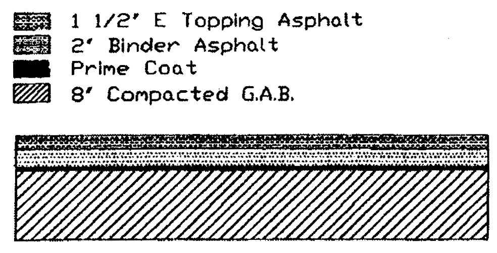
Driveway construction requirements
(Res. of 6-16-98, § 1)
Sec. 410. - Certifications.
The following certificates shall be inscribed on the construction plans:
a.
I hereby certify that the engineering requirements for these construction documents as prescribed by the Commercial/Industrial Development Ordinance of Spalding County have been fulfilled.
_____ .
Registered Professional Engineer No. _______
Date: _______
b.
I hereby certify that this construction plan was approved by Spalding County on _____ .
_____
Administrative Officer
c.
I hereby understand that approval of this construction plan is valid for a period of two years. Any application for a building permit submitted after the time has lapsed will not be accepted. Construction plans should be resubmitted and should conform to the current adopted standards (as of the date of resubmittal) of the Spalding County Unified Development Ordinance. Review fees will apply.
_____
Property Owner
Date: _______
(Res. of 6-16-98, § 1; Res. No. A-01-02, § 3, 4-2-01)
Sec. 411. - Site plan revisions.
Any deviations or revisions from an approved site plan must be shown on a revised site plan and approved by the county employee(s) having jurisdiction over the change. Changes shall be authorized in writing on the revised site plan by the appropriate county employee(s). A copy of the revised site plan will then be given to the building official for inclusion in the project file.
(Res. of 6-16-98, § 1)
Sec. 412. - Certificate of occupancy.
In no case shall a certificate of occupancy be issued by the building official unless an as-built condition is reflected on an approved site plan.
(Res. of 6-16-98, § 1)
Sec. 413. - Appeals and variances.
Provisions for appeals and variances are set forth in Article 4, sections 410 and 411 of the Spalding County unified development ordinance.
(Res. of 6-16-98, § 1)
Sec. 414. - Penalties.
Any person who violates any provision of this ordinance or any amendment to this ordinance, or who fails to perform any act required hereunder or commits any prohibited act shall be guilty of a misdemeanor and punishable by a fine of not more than one thousand dollars ($1,000.00) for each offense. Each and every day for which any violation is committed or permitted to continue shall constitute a separate offense and shall be punishable as such hereunder.
(Res. of 6-16-98, § 1)
Sec. 415. - Remedies.
If any building or land is used or maintained in violation of this ordinance, anyone, including the county, who would be harmed by such a violation may initiate legal proceedings to obtain an injunction or other appropriate remedy to stop the violation or to prevent any act which would constitute such a violation. Other legal remedies are also available as provided by Georgia law.
(Res. of 6-16-98, § 1)
Sec. 416. - Architectural and design standards.
Objectives
In an effort to maintain high quality, long-lasting and sustainable development within Spalding County, the County hereby adopts the following design criteria for all newly constructed nonresidential commercial, industrial and institutional buildings. They are intended to encourage an "old-town" look and feel of historical Georgia villages. These guidelines will foster architectural diversity and interest, yet achieve and maintain a consistent, durable and pleasing aesthetic/visual quality.
The use of a common palate of building materials should be maintained for all buildings Facades to create a consistent and traditional architectural identity. Traditional architecture includes the use of red brick, pitched roofs, low-profile signage and subdued colors. For large commercial/retail buildings, variations in facade, roofline and depth should be provided to lend the appearance of multi-tenant occupancy.
Facade elevations criteria
Facade elevations submitted as an application for a development approval shall clearly indicate all of the proposed building materials and colors for each facade as described herein. The plans shall clearly show the location and calculate the amount/percentages of all building materials per facade.
Groups of buildings on the same parcel of land may be reviewed and permitted as a single project rather than individual buildings. Grouping of similar buildings is encouraged to minimize the number of reviews required and to allow for originality and design flexibility.
A.
Allowed building materials, retail, office, or institutional: Where the primary use of a development consists of retail, office or institutional uses the following facade material shall be allowed:
Facade(s) visible to the general public: Brick, stone, split faced concrete masonry unit (CMU), cement plank (hardy-plank) siding, glass.
Additional material allowed where facade(s) are not visible to the general public: Painted concrete block or painted formed concrete or prefabricated metal panel.
B.
Allowed building materials, warehousing, manufacturing and other industrial: Where the primary use of a development consists of retail, office or institutional uses the following facade material shall be allowed:
Facades facing public rights-of-way: Brick, stone, split faced concrete masonry unit (CMU), cement plank (hardy-plank) siding, glass.
Additional material allowed where facade(s) are not visible from a public right-of-way: Painted concrete block or painted formed concrete or prefabricated metal panel.
C.
Accent/trim exterior building material: Small amounts of building materials such as wood, tile, stucco, etc., may be used to enhance the elevation of the building or for decorative elements but may not exceed ten (10) percent of total wall area per facade. A building material that is allowed (such as brick) may be used in any percentage throughout the structure. Neon tubing or similar shaped light fixture is not an acceptable accent/trim treatment.
Roof requirements
A.
Pitched roofs: All one-story buildings less than ten thousand (10,000) gross square feet must have a pitched roof (between 4:12 and 12:12). If a pitched roof is not possible, a combination of flat roof and pitched roof is required. Provide a pitched roof on front and side of the building to screen view of any flat roof. Create arcades, drive-under canopies, porches and other features with pitched roof. Materials for pitched roofs shall be limited to architectural dimensional grade asphalt shingles, natural slate, natural terra cotta, natural wood shake, copper or factory finished sheet metal.
B.
Mansard roofs: Mansard roofs shall have a maximum pitch of 12:12 with a minimum six-foot vertical surface length.
C.
Flat roofs: Flat roofs may be of any material that meets local codes. Exposed metal flashing shall be copper or factory finished sheet metal. If factory finished metal flashing is used, such as standing seam, the color must be an earth tone color to blend with other materials or of a color to simulate weathered copper or bronze. All buildings with flat roofs should include parapet articulation on the front facade(s) of such building. There shall be roof articulations/offsets at a minimum of one per each one hundred twenty-five (125) linear feet of length by a change in the top line of the parapet. Additional articulation may occur at any lesser distance. If the front facade is less than one hundred twenty-five (125) linear feet, then a minimum of one roof articulation must occur.
D.
Other: Drive under canopies for gasoline pumps shall have a pitched roof consistent with the pitched roof material requirements in paragraph A. The materials, ratio, and color of the gas canopies pitched roof shall be consistent with any associated primary structure. Where a full pitch is not possible, a hip roof or may be provided. In such situations, a minimum 3:12 roof pitch shall be maintained.
Arcade/structural canopy for retail use
For any multi-tenant commercial shopping center or strip center, a covered arcade/structural canopy shall be provided along the front facade of the building. Arcades are covered walkways connected to or separate from the principal building. They should be designed in a manner which provides architectural depth to the building and includes covered areas for relief from the weather. The arcade should be a minimum of five (5) feet in width.
Venting/HVAC and other equipment
All mechanical equipment, including rooftop equipment, fan units and vents that are generally associated with commercial, office and institutional used buildings shall be screened from public view.
Temporary buildings
Temporary buildings, mobile buildings, including, but not limited to trailers, campers and recreational vehicles and tents, shall not be allowed within public view with the exception of authorized dealerships of such buildings, street vendors and temporary trailers associated with approved construction projects.
Buildings in excess of 30,000 square feet
For one single story commercial building in excess of thirty thousand (30,000) square feet of floor area, the following design criteria shall apply in addition to those listed above:
Facades should be articulated to reduce the massive scale and the uniform, impersonal appearances of large retail buildings and provide visual interest that will be consistent with the community's identity, character and scale.
Facades greater than one hundred (100) feet in length, measured horizontally, shall incorporate wall plane projections or recesses having a depth of at least three (3) percent of the length of the facade and extending at least twenty (20) percent of the length of the facade. No uninterrupted length of any facade shall exceed one hundred (100) horizontal feet.
Ground floor facades that face public streets shall have arcades, display windows, entry areas, awnings, or other such features along no less than sixty (60) percent of their horizontal length.
Building facades must include a repeating pattern that shall include no less than three of the following elements: color change; texture change; material change; and expression of architectural or structural bay through a change in plane no less than twenty-four (24) inches in width, such as an offset, reveal, or projecting rib. All elements shall repeat at intervals of no more than thirty (30) feet, either horizontally or vertically.
Alternate review
Request to vary from the above requirements and alternative design proposals can only be approved by the Spalding County Board of Commissioners at a public meeting. The board of commissioners may require additional information, including, but not limited to, material samples and facade mock-ups in order to make a determination whether the alternate proposal meets the intent of these requirements.
This ordinance is intended to be followed as outlined above. In the event, the intent of this ordinance can be achieved with minor deviations which do not substantially impact the goals or intent of this ordinance, The Administrative Officer of Spalding County has the authority to modify the specific provisions. The board of commissioners may as part of an approval, may include conditions, modifications or requirements necessary to mitigate any part of their decision. The board of commissioners may establish filing requirements, fees and deadlines as needed.
(Res. No. A-07-09, § 2, 10-15-07)
Sec. 501. - Purpose.
This article formalizes the powers and duties of the administrative officer, the planning commission, the board of appeals, and the board of commissioners where this ordinance is concerned. It should also provide a convenient list of services provided by each official to aid in complying with the requirements of this ordinance.
(Res. of 6-16-98, § 1)
Sec. 502. - Powers and duties of the administrative officer.
The administrative officer has the power and duty to provide the following services related to this ordinance:
A.
Provide initial information about this ordinance upon request.
B.
Advise how to contact members of the planning commission, the board of appeals, and the board of commissioners for services provided by those bodies.
C.
Offer practical suggestions on how to comply with the requirements of this ordinance.
D.
Maintain complete records concerning this ordinance and related matters, and make such records available to the public upon request.
E.
Propose amendments to this ordinance.
F.
Approve landscape plans as specified in this ordinance.
(Res. of 6-16-98, § 1)
Sec. 503. - Powers and duties of the planning commission.
The planning commission has the power and duty to provide the following services related to this ordinance:
A.
Advise the board of commissioners on applications for amendment to this ordinance by examining amendment applications and providing written recommendations with reasons for the recommendations to the board of commissioners as specified in Article 4, section 414 of the Spalding County unified development ordinance.
B.
Dispense general information about this ordinance to the public upon request.
C.
Propose amendments to this ordinance.
D.
Maintain and update the Spalding County comprehensive plan so that it may provide a current database with which decisions on proposed amendments to this ordinance may be made that utilize sound planning principles.
E.
Carry out an ongoing comprehensive planning program that will provide current data on which decisions regarding this ordinance may be based that utilize sound planning principles.
(Res. of 6-16-98, § 1)
Sec. 504. - Powers and duties of the board of appeals.
The board of appeals has the power and duty to provide the following services:
A.
Accept applications for appeal of an action of the administrative officer or the planning commission and render official decisions on them according to procedures specified in Article 4, section 410 of the Spalding County unified development ordinance.
B.
Authorize variances according to procedures specified in Article 4, section 411 of the Spalding County unified development ordinance.
(Res. of 6-16-98, § 1)
Sec. 505. - Powers and duties of the board of commissioners.
The board of commissioners has the power and duty to provide the following services related to this ordinance:
A.
Accept applications for amendment of this ordinance and render official decisions on them after referring them to the planning commission for review and recommendations as specified in Article 4, section 414 of the Spalding County unified development ordinance.
B.
Propose amendments to this ordinance.
(Res. of 6-16-98, § 1)
Sec. 601. - Adoption of this ordinance.
The adoption of this ordinance shall operate as a repeal of any ordinances in conflict with this ordinance.
(Res. of 6-16-98, § 1)
Sec. 602. - Effect of repeal.
The repeal provided for in the preceding section of this ordinance shall not affect any offense or act committed or done or any penalty or forfeiture incurred or any contract or right established or accruing before the effective date; nor shall it affect any prosecution, suit or proceeding pending or any judgment rendered prior to the effective date.
(Res. of 6-16-98, § 1)
Sec. 603. - Severability of provisions.
It is hereby declared to be the intention of the county that the sections, paragraphs, sentences, clauses and phrases of this ordinance hereby adopted are severable, and if any phrase, clause, sentence, paragraph or section of this ordinance hereby adopted shall be declared unconstitutional or otherwise invalid by the valid judgment or decree of a court of competent jurisdiction, this unconstitutionality or invalidity shall not affect any of the remaining phrases, clauses, sentences, paragraphs and sections of this ordinance hereby adopted.
(Res. of 6-16-98, § 1)
Sec. 604. - Effect of catchlines.
The catchlines of the several sections of this ordinance printed in boldface type are intended as mere catchwords to indicate the contents of the sections and shall not be deemed or taken to be titles of the sections nor as any part of the sections, nor, unless expressly so provided, shall they be so deemed when any of the sections, including the catchlines, are amended or reenacted.
(Res. of 6-16-98, § 1)
Sec. 605. - Effective date.
This ordinance shall be effective June 16, 1998, the date of its adoption.
(Res. of 6-16-98, § 1)