
Spalding County Unincorporated
City Zoning Code
City Zoning Code
APPENDIX K
LANDSCAPING AND TREE PRESERVATION ORDINANCE FOR MULTI-FAMILY, COMMERCIAL, INSTITUTIONAL AND INDUSTRIAL DEVELOPMENTS22
Editor's note— Res. No. A-06-15, adopted May 7, 2007, repealed the former App. K, §§ 101—105, 201, 202, 301—305, 401—405, 501—505, and enacted a App. K as set out herein. The former App. K pertained to landscape and tree preservation ordinance. See Code Comparative Table for history.
ARTICLE 2. - TREE PRESERVATION[23]
Editor's note— Res. No. A-10-09, § 5, adopted May 16, 2011, repealed former Article 2 and enacted a new article as set out herein. Former Article 2, §§ 201—204, pertained to legal status provisions and derived from Res. No. A-06-15, 5-7-07.
Sec. 101. - Short title.
This ordinance shall be known as the Spalding County Landscape and Tree Preservation Ordinance.
(Res. No. A-06-15, 5-7-07; Res. No. A-10-09, §§ 1, 2, 5-16-11)
Editor's note— Res. No. A-10-09, § 1, adopted May 16, 2011, repealed the former section and enacted a new section as set out herein. The former section pertained to similar subject matter and derived from Res. No. A-06-15, 5-7-07.
Sec. 102. - Definitions.
A.
Administrative officer. The person, officer, or official and his authorized representative designated by the County Manager of Spalding County for the administration of these regulations.
B.
Basal area. The cross-sectional area of all trees on a given measured area four and one-half (4.5) feet above the ground. In American forest practice, it is expressed in square feet for an acre. EXAMPLE: An acre of land with a basal area of one hundred twenty (120) would have one hundred twenty (120) square feet of cross-sectional trunk area (3.14 x r 2 where r is equal to one-half (½) the diameter of the tree).
C.
Caliper. A landscaping standard which describes the diameter of a tree trunk one (1) foot above the rootball.
D.
Canopy tree. A tree which grows above a height of fifty (50) feet and whose species is included in the USDA Tree Hardiness Map—Zone 7b or is specifically approved as such by the Planning Commission of Spalding County.
E.
Critical root zone. The minimum area beneath a tree that must be left undisturbed in order to preserve sufficient root mass to give a tree a reasonable chance of survival. The critical root zone (CRZ) will equal one and one-half (1.5) times the radius of the dripline. EXAMPLE: A tree with a dripline radius of twenty (20) feet would have a CRZ radius of thirty (30) feet.
F.
Dripline. A line on the ground established by a vertical plane extending from a tree's outermost branch tips down to the ground; i.e., the line enclosing the area directly beneath the tree's crown from which rainfall would drip.
G.
Ground cover. Plant material and grasses of less than three (3) feet in height.
H.
Impervious surface. Hard-surfaced areas which neither prevent nor severely restrict the entry of water into the soil mantle and/or cause water to run off the surface in greater quantities or at an increased rate of flow. Common impervious surfaces include, but are not limited to, rooftops, sidewalks, walkways, patio areas, driveways, parking lots, storage areas, and other surfaces which similarly impact the natural infiltration or runoff patterns. For the purposes of this ordinance, gravel surface areas are considered to be impervious.
I.
Land disturbance activity. Any activity for which a soil erosion or land disturbance permit is required under Appendix D of the Spalding County Unified Development Ordinance (UDO).
J.
Landscape plan. A document provided to Spalding County prior to land disturbance activity (LDA), which shows the plan view of the site, including proposed improvements. It must also include the location of all existing trees over ten (10) inches in caliper (including size and species), all proposed plants and trees, amount of impervious surface existing and proposed, a list of plant material and the calculations showing compliance with this ordinance. It may also include a plan that identifies tree protection areas, existing trees to be retained and proposed trees to be planted on a site to meet minimum requirements, as well as methods of tree protection to be undertaken on the site and other pertinent information.
K.
Parking field. The area included in a row of parking spaces within a parking lot.
L.
Parking lot island. A landscaping strip located in a parking lot. Such island must be sized to allow the plants and trees located within it to grow to their mature size.
M.
Shrub (or bush). A horticultural rather than strictly botanical category of woody plant distinguished from a tree by its multiple stems and lower height, usually less than twenty (20) feet tall. A large number of plants can be either shrubs or trees, depending on the growing conditions they experience. For the purposes of this ordinance, for a plant to be considered a shrub, it must be capable of growing to a minimum height of three (3) feet.
N.
Site. Any plot or parcel of land, or a combination of contiguous lots or parcels of land, where a landscape plan is required.
O.
Specimen tree or stand. Any tree or grouping of trees which has been determined, by the administrative officer, to be of high value because of its species, size, age or other professional criteria. General criteria for the determination of specimen trees of stands of trees are provided in the Spalding County Tree Protection Standards.
P.
Tree protection area. Any portion on a site where existing trees proposed to be retained in order to comply with the requirements of this ordinance are located or any other existing trees proposed to be retained due to zoning conditions or requirements from other ordinances.
Q.
Tree save area. Any portion of a site where existing trees that are proposed to be retained in order to comply with the requirements of this Ordinance are located. The tree save area shall include no less than seventy-five (75) percent of the total area defined by the critical root zone (CRZ) of a tree or a group of trees, collectively.
R.
Understory tree. A tree which grows to a height of less than fifty (50) feet and the species of which is included in the USDA Tree Hardiness Map—Zone 7b, or is specifically approved as such by the Planning Commission of Spalding County.
(Res. No. A-10-09, §§ 3, 4, 5-16-11; Res. No. A-06-15, 5-7-07; Res. No. A-10-10, §§ 1—4, 11-15-10)
Editor's note— Res. No. A-10-09, § 3, adopted May 16, 2011, repealed the former section and enacted a new section as set out herein. The former section pertained to similar subject matter and derived from Res. No. A-06-15, 5-7-07; Res. No. A-10-10, §§ 1—4, 11-15-10.
Sec. 103. - Applicability.
This ordinance shall govern the development of property located within the R-3, O-I, C-1A, C-1, C-1B, C-1C, C-2, and C-3 zoning districts which increases the amount of impervious surface. To the extent redevelopment or additional development occurs on property which is already covered by impervious surface, the provision of this ordinance shall only apply to the area of any increase in impervious surface thereon.
(Res. No. A-06-15, 5-7-07)
Sec. 104. - Plan review.
A.
Prior to land disturbance activity (LDA) for new development or expansion of existing impervious surfaces nine (9) copies of the landscape plan, meeting the requirements of this article must be submitted to Spalding County Community Development Department. Sites on which the disturbed area is less than one (1) acre shall submit a landscape plan with the site plan required under appendix J, section 404.
B.
The landscape plan must include the following information: Property lines, easements, rights-of-way, existing and proposed parking facilities, existing and proposed structures, contours at two-foot intervals, storm water facilities, utilities, type and size of material, plant list, landscape calculations, north arrow and graphic scale.
C.
When the impervious area within the project exceeds twenty thousand (20,000) square feet the landscape plan must be drawn by a landscape architect, registered and licensed under Official Code of Georgia: Section 43-23-1, et seq. Rules and Regulations of the State of Georgia: Chapter 310.
D.
The community development department staff shall review the submitted plan for compliance with the provisions of this ordinance.
(Res. No. A-06-15, 5-7-07)
Sec. 105. - Minimum plant requirements.
A.
One (1) two-inch caliper canopy tree shall be planted for every two thousand five hundred (2,500) square feet of impervious surface on site and one (1) two-inch understory tree shall be planted for every three thousand (3,000) square feet of impervious surface on site.
B.
One (1) shrub minimum of three-gallon container shall be planted for every five hundred (500) square feet of impervious surface on site.
C.
Ground cover shall be provided in all pervious areas disturbed during construction.
D.
Plant material required by this ordinance shall be in addition to requirements for planting in a buffer.
E.
All plant materials shall be of a species that is identified in the USDA Tree Hardiness Map - Zone 7b. However species selection shall also take into consideration soil types, available planting area, disease susceptibility, root characteristics, and aesthetic appeal.
F.
The planting of the following trees shall not count toward meeting the minimum landscape requirements:
1.
Bradford Pear.
2.
Sweet Gum.
3.
Reserved.
4.
Reserved.
5.
Reserved.
(Res. No. A-06-15, 5-7-07; Res. No. A-12-03, §§ 1—4, 4-2-12)
Sec. 107. - Design criteria.
A.
A minimum twenty-foot landscape buffer shall be provided along areas of the site where parking is adjacent to a right-of-way. A minimum two-foot berm shall also be provided in these areas.
B.
One parking lot landscape island shall be provided for every ten (10) parking spaces on site. Said landscape area shall be a minimum of ten (10) feet in width and extend the length of the parking space. Such islands may be combined to form larger islands or public open spaces.
C.
A landscape island, minimum ten (10) feet width and extending the length of the parking field, shall be provided for every five (5) rows of parking.
(Res. No. A-06-15, 5-7-07)
Sec. 108. - Maintenance.
A.
All material planted to meet the requirements of this ordinance shall be maintained by the property owner in perpetuity. Changes to the landscaping plan during and after construction must be reported to the zoning administrator.
(Res. No. A-06-15, 5-7-07)
Sec. 109. - Enforcement.
A.
All material shown on the landscape plan must be planted prior to the issuance of a certificate of occupancy. At the discretion of the administrative officer, a bond or letter of credit in favor of Spalding County may be submitted to the County instead of the planting. Such assurances shall be allowed as a temporary extension of the above planing deadline and must be a minimum of one hundred twenty (120) percent of the value of the plant material and labor cost of the items to be completed to the satisfaction of the county and must include a deadline date not to exceed one hundred eighty (180) days. Said bond amount shall be estimated by the applicant's registered landscape architect or landscape contractor and approved by the Spalding County Administrative Officer.
B.
Failure to maintain required landscape material shall be deemed a violation of Spalding County Code and prosecuted under the provisions thereof.
(Res. No. A-06-15, 5-7-07)
Sec. 201. - Protection of existing trees.
A.
The retention of existing trees on land to be developed is encouraged. A credit toward the requirements of Section 105 shall apply for each healthy tree of existing ten-inch caliper or greater preserved and protected on site. The plant requirements of Section 105 shall be reduced by one (1) inch for every five (5) inches of existing trees saved.
B.
To utilize this credit, the developer shall submit a tree protection plan as a part of the landscape plan required by Section 105. When a choice is available as to which existing trees to save, specimen trees, even isolated individual trees, will be given preference over other trees. Non-specimen trees should be saved in stands.
(Res. No. A-10-09, §§ 5, 6, 5-16-11)
Sec. 202. - Tree inventories and surveys.
All trees that count toward meeting density requirements must be inventoried, excluding those in required land use buffers which will not count toward landscaping requirements. On sites greater than three (3) acres, trees may be inventoried using the basal area scientific method.
(Res. No. A-10-09, §§ 5, 6, 5-16-11)
Sec. 203. - Plan review standards.
A.
Tree save areas shall be delineated on the landscape plan and designated as to whether protection during construction will be active or passive (Section 205).
B.
The method used to inventory the trees must be indicated on the plans.
C.
Buffers must be identified on the landscape plan.
(Res. No. A-10-09, §§ 5, 6, 5-16-11)
Sec. 204. - Construction standards.
Tree protection devices to eliminate damage to existing trees during construction shall be required. Prohibited activities shall include, but not be limited to:
A.
Soil compaction in the critical root zone from heavy equipment, vehicular or excessive pedestrian traffic, or storage of equipment or materials;
B.
Root disturbance due to cuts, fills or trenching;
C.
Wounds to exposed roots, trunks or limbs; or
D.
Other activities such as chemical storage, cement truck cleaning, fire, etc.
(Res. No. A-10-09, §§ 5, 6, 5-16-11)
Sec. 205. - Location and types of tree protection devices.
Tree protection devices shown on the landscape plan shall be installed and completely protect the surrounding critical root zone of each tree to be preserved. Active protection is required where tree save areas lie in proximity to land disturbance activity (LDA). Passive protection may be used in areas where land disturbance activities will not occur. Any changes to the landscape plan are subject to the administrative officer's review.
(Res. No. A-10-09, §§ 5, 6, 5-16-11)
Sec. 206. - Materials.
A.
Active tree protection shall consist of chain link, orange laminated plastic, wooden post or rail fencing (See Detail 1—Active Tree Protection).
B.
Passive protection shall consist of heavy mill plastic flagging of a bright color on a continuous, durable restraint sufficient to delineate the bounds of any tree protection or save areas (See Detail 2—Passive Tree Protection).
C.
All tree protection areas shall be designated on site with "Tree Protection Area" signs posted visibly on all sides of the fenced-in area. These signs inform subcontractors of the tree protection requirement. Signs requesting subcontractor cooperation and compliance with the tree protection standards are recommended for site entrances.
(Res. No. A-10-09, §§ 5, 6, 5-16-11)
Sec. 207. - Sequence of installation and removal.
All tree protection devices shall be installed prior to the installation of any erosion control. The administrative officer shall inspect installation. The property owner and/or developer shall ensure that all tree protection devices remain in functioning condition throughout development. If passive tree protection is not kept in functioning condition throughout development, active tree protection may be required.
(Res. No. A-10-09, §§ 5, 6, 5-16-11)
Sec. 208. - Other specifications.
A.
Where clearing has been approved, trees shall be removed in a manner that does not adversely impact the trees to be preserved. Avoid felling trees into tree protection areas or disturbing roots inside the tree protection areas.
B.
All erosion and sedimentation control measures shall be installed so that sediment will not accumulate within the tree protection area.
(Res. No. A-10-09, §§ 5, 6, 5-16-11)
Sec. 209. - Tree protection plan requirements.
Any landscape plan which provides for the protection of existing trees shall be prepared in compliance with Section 104 and this section. The landscape plan shall be submitted with the site development plan, drawn to the same scale as documents prepared for a land disturbance permit application on the property, and it shall cover the same area. After submission of the plan, the administrative officer will perform a site walk. The landscape plan shall provide sufficient information and detail to clearly demonstrate compliance with this ordinance.
(Res. No. A-10-09, §§ 5, 6, 5-16-11)
Sec. 210. - Pre-submittal conference.
Developers and design professionals are encouraged to meet with the administrative officer prior to submitting a landscape plan. The administrative officer is available for field inspections of site conditions prior to plan submittal to give advice as to the relative value of trees, and to assist in the landscape planning process as it relates to preserving trees.
(Res. No. A-10-09, §§ 5, 6, 5-16-11)
Detail No. 1 Active Tree Protection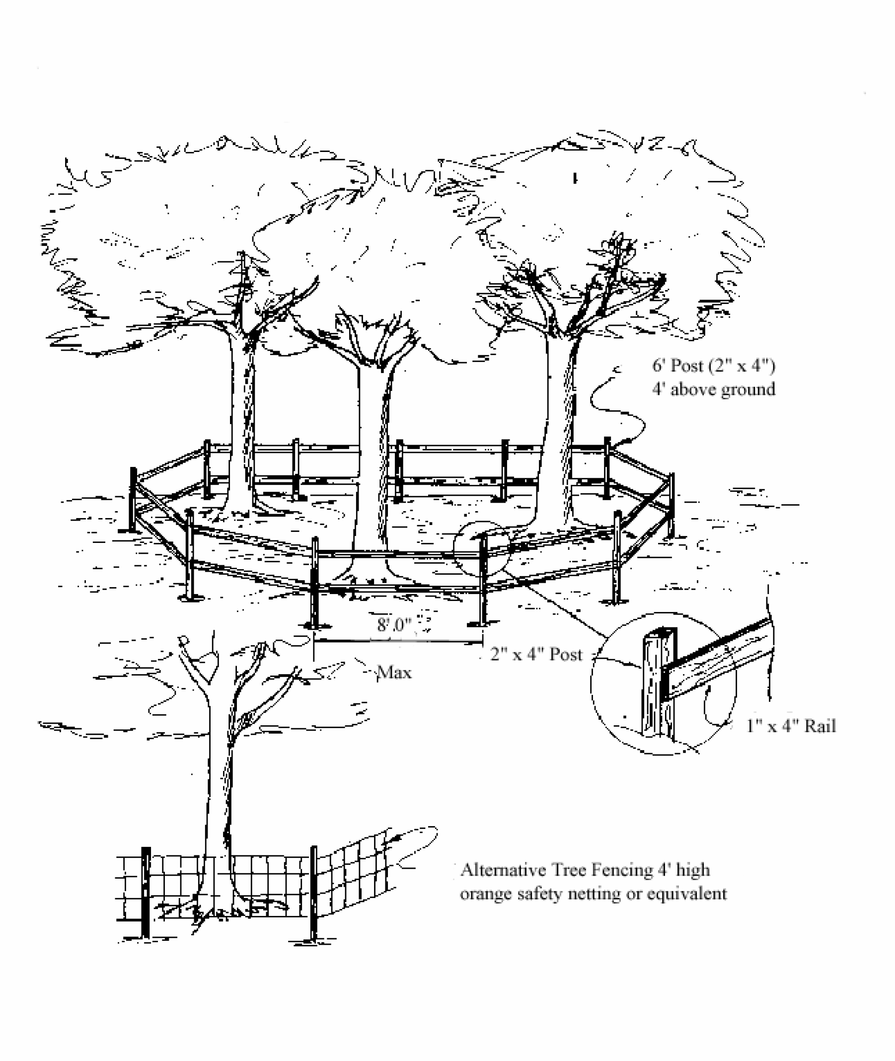
(Res. No. A-10-09, §§ 5, 6, 5-16-11)
Detail No. 2 Passive Tree Protection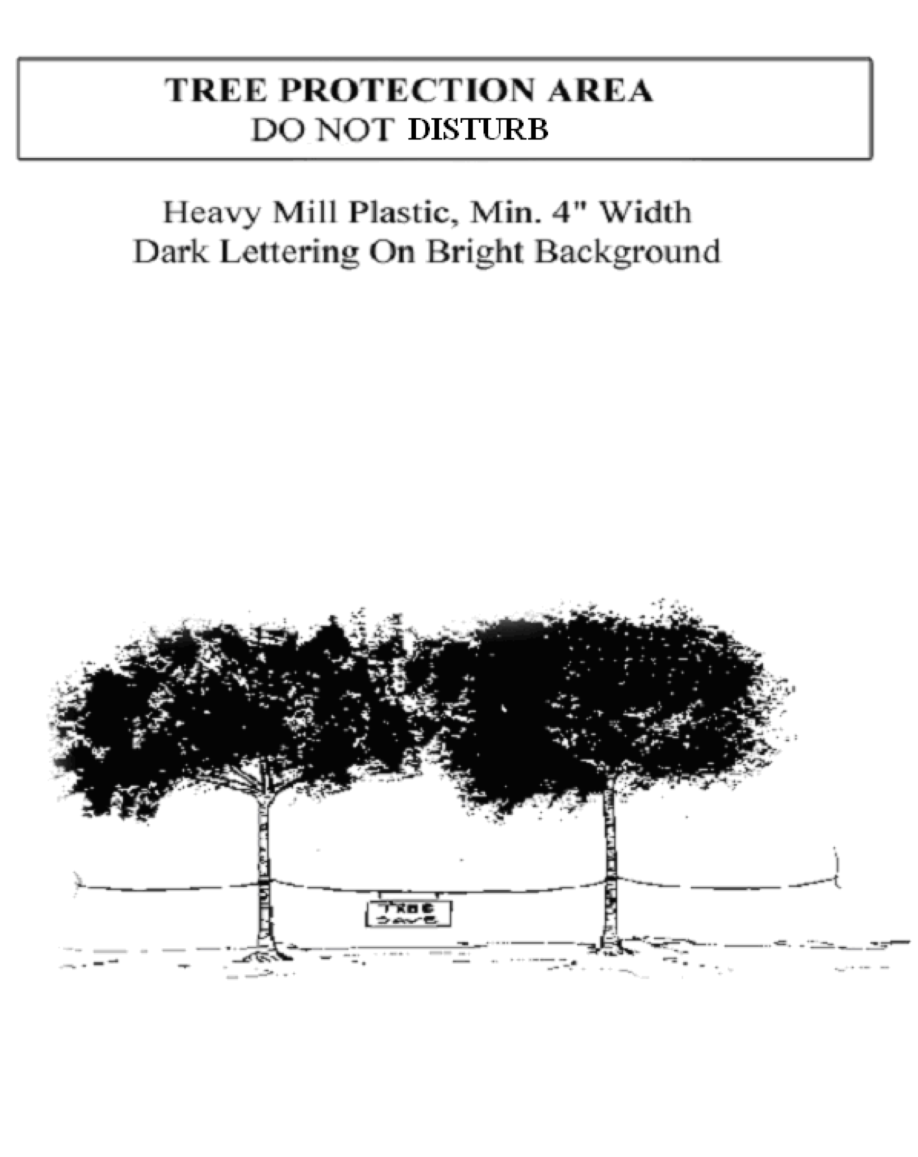
(Res. No. A-10-09, §§ 5, 6, 5-16-11)