
Statesboro City Zoning Code
ARTICLE 2
1.- INTRODUCTION AND GENERAL PROVISIONS
Sec. 2.1.1. - Establishment of districts, zones, and overlays.
A.
Districts established. For the purposes of this zoning ordinance, the City of Statesboro is hereby divided into separate districts, zones, and overlays as designated in Table 2.1.1-A — District Names Established.
Table 2.1.1-A — District Names Established
B.
Translation of former districts. Where certain former districts, zones, or overlays have been removed or reclassified within the zoning ordinance but remain mapped as part of the zoning map of the City of Statesboro, they shall be regulated as follows:
(1)
The (CR) commercial retail district shall be regulated by the standards of the (MX) mixed-use district.
(2)
The (R-10) one-household residential district and the (R-8) one-household residential district shall be regulated by the standards of the (R-6) one-household residential district.
(3)
The (R-30) one-household residential district and the (R-20) one-household residential district shall be regulated by the standards of the (R-15) one-household residential district.
(Ord. No. 2023-12, § 1(Exh. A), 9-19-23)
Sec. 2.1.2. - Zoning map.
A.
Zoning map established. The boundaries for the zoning districts established in subsection 2.1.1.A. are shown and established on the zoning map of the City of Statesboro. The zoning map of the City of Statesboro is incorporated and made part of this zoning ordinance. The zoning map of the City of Statesboro was adopted by motion of July 7, 1987.
B.
Interpretation of map boundaries. The boundaries between districts are, unless otherwise indicated, either the centerlines of streets, lanes, watercourses, rights-of-way of power lines and other public utilities or such lines extended or lines parallel thereto. Where the boundaries of a single district are indicated as including directly opposite sides of a street, lane, lake or watercourse, or right-of-way of a power line or other public utility, for any portion of its length, the indicated district shall be construed to apply to the entire bed of such street, lane, lake or watercourse, or right-of-way of such power line, railroad or other public utility, lying within such portion of its length. Where uncertainty exists as to the location of said boundaries as shown on the zoning map, the following rules apply:
(1)
Where a district boundary is indicated as approximately following the centerline of a street, lane, lake or watercourse, or right-of-way of a power line or other public utility, such centerline shall be construed to be such boundary.
(2)
Where a district boundary is indicated as approximately following a lot line or other property line, such lot line shall be construed to be such boundary.
(3)
Where a district boundary divides a lot or runs through undivided property, the location of such boundary, unless otherwise specified by figures on the zoning map, shall be determined by applying the scale appearing on said map to the given area.
(4)
Where figures are shown on the zoning map between a street and a district boundary, they shall indicate that the district boundary runs parallel to the street line at a distance therefrom equivalent to the number of feet so indicated, unless specified. Where scaled distances do not agree with such figures, the figures control.
(Ord. No. 2023-12, § 1(Exh. A), 9-19-23)
Sec. 2.1.3. - Rules of interpretation.
A.
Public safety, health, and welfare. In interpreting and applying the provisions of this zoning ordinance, they shall be held to be the minimum requirements for the promotion of the public safety, health, and welfare. Where this zoning ordinance imposes a greater restriction upon the building, structures, or premises, upon heights of buildings or structures or requires larger open spaces than are imposed or required by any other codes, permits, or regulations, or by easements, covenants, deed restrictions or agreements, the provisions of this zoning ordinance govern.
(Ord. No. 2023-12, § 1(Exh. A), 9-19-23)
Sec. 2.1.4. - Rules of measurement.
A.
Measuring lot area. Lot area is measured as the total horizontal surface area of the land contained within all front, rear, and side lot lines. Public and private rights-of-way are not included in the lot area.
B.
Determining building heights.
(1)
Building height measurement in feet. Building height expressed in feet is measured from the mean level of the ground surrounding the building to a point midway between the highest and lowest points on the roof.
(2)
Building height measurement in stories. Building height expressed in stories is measured from the lowest level that is fully or partially above-ground. A mezzanine does not count as a story. An attic in a pitched roof form does not count as a story where 50 percent or more of the attic floor area has a clear height of less than seven and one-half feet (measured from the finished floor to the finished ceiling).
(3)
Exclusions from building height measurement. For the purposes of height limitations in this UDC, a building height measurement excludes spires, belfries, cupolas, and domes not intended for human occupancy, nor monuments, water towers, observation towers, transmission towers, chimneys, smokestacks, conveyors, flagpoles, radio towers, television towers, masts, aerials, and similar structures.
C.
Determining building coverage of lot. The building coverage of a lot is measured as the ratio between the sum of areas on a lot covered by buildings and the total lot area.
D.
Determining lot width. Lot width is measured as a straight line between the two endpoints of the minimum front yard setback and the intersecting lot lines. For lots with more than one frontage, the smallest measurement among each frontage determines the lot width.
E.
Determining setbacks. A setback is measured as the shortest distance in a straight line between the outside edge of a structure or sign and a specified property line or public right-of-way. Where no property line is specified, the measurement is taken to the nearest property line.
F.
Measuring amenity space. Amenity space is measured as a ratio of the total site area before development compared to the collective footprints of those areas meeting the definition of an amenity space.
G.
Measuring light level. Light levels are specified, calculated, and measured in foot-candles. All foot-candle values are maintained footcandles. Measurements are made at ground level with the light-registering portion of the meter held parallel to the ground pointing up.
H.
Signage measurements. The following standards control when computing sign area and height:
(1)
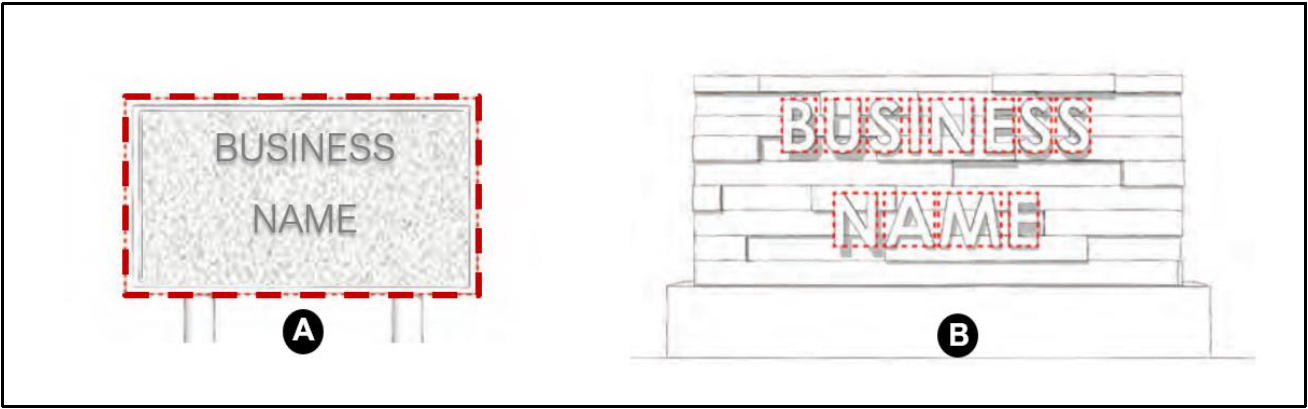
Computation of area of individual signs. Signs on a background are calculated per diagram "A" in Figure 2.1.4-A by means of the smallest shape (e.g., square, circle, rectangle) that surrounds the extreme limits of writing or other display, together with any material or color forming an integral part of the background of the display or used to differentiate the sign from the backdrop or structure against which it is placed, but not including any supporting framework. Signs consisting of individual letters or features attached to a wall are calculated per diagram "B" in Figure 2.1.4-A as the total area of a hypothetical box surrounding each letter or feature. Sign area excludes any supporting framework or bracing unless such framework or bracing is part of the message or sign face.
(2)
Computation of area of multi-faced signs. The area of a sign with more than one face is calculated by totaling the areas of all sign faces visible from any one point. When two faces are identical and back-to-back, so that both faces cannot be viewed from any one point at the same time, the sign is computed by the measurement of one of the faces.
(3)
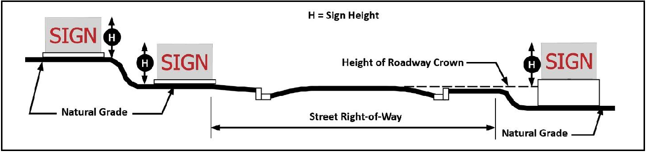
Computation of sign height. The height of a sign is measured from the highest of either the natural grade or the roadway crown of the adjacent street which the sign faces to the top of the highest attached component of the sign, as illustrated in Figure 2.1.4-B.
I.
Measuring diameter at breast height. The diameter of a tree is measured at four and one-half feet above grade level.
(Ord. No. 2023-12, § 1(Exh. A), 9-19-23)
Sec. 2.1.5. - Annexation and de-annexation.
A.
Annexation. In the event of annexation of new areas to the city, such areas are considered regulated as the R-40 district until otherwise classified.
B.
De-annexation. In the event of de-annexation that removes territory from the city, district boundaries are construed as moving with city limits to no longer include de-annexed geographies.
(Ord. No. 2023-12, § 1(Exh. A), 9-19-23)

