
Statesboro City Zoning Code
ARTICLE 2
2. - ZONING DISTRICTS
Sec. 2.2.1. - (R-2) townhouse residential district.
A.
Purpose. The purpose of the R-2 townhouse residential district is to establish reasonable standards of performance and selection of permitted uses therein, in order to maintain and protect the desirable benefits which attached residential uses have throughout the community.
B.
Governing tables. In case of discrepancy with the content of any excerpt table provided within this section, the following tables govern the following standards:
(1)
Table 2.3.2-A — Comprehensive Principal Use Permissions Table governs the uses permitted and prohibited within each district.
(2)
Table 2.3.3-A — Comprehensive Dimensional Standards Table governs dimensional development standards within each district.
(3)
Table 2.5.2-A — Comprehensive Vehicular Parking Requirements governs parking requirements for each type of use.
C.
Excerpt tables. The following tables provide excerpts of the use permissions, vehicular parking requirements, and dimensional standards applicable to the R-2 district.
Table 2.2.1-A — Excerpt: R-2 District Use Permissions and Parking Requirements
Table 2.2.1-B — Excerpt: R-2 Dimensional Standards
D.
Accessory uses and structures. In addition to other applicable standards, accessory structures in the R-2 district must meet the dimensional and location requirements of Table 2.2.1-C — (R-2) Accessory Uses and Structures.
Table 2.2.1-C — (R-2) Accessory Uses and Structures
E.
Off-street parking. No off-street parking of motor vehicles is allowed between a principal structure and a street, except when such off-street parking of motor vehicles occurs on a driveway that conforms to city standards.
F.
Generally applicable regulations. See article 2.5 — generally applicable regulations for regulations regarding:
(1)
Section 2.5.1 — Accessory uses and structures.
(2)
Section 2.5.2 — Parking and loading.
(3)
Section 2.5.3 — Signs.
(4)
Section 2.5.4 — Landscaping and buffering.
(5)
Section 2.5.5 — Fences, and walls, and screening.
(6)
Section 2.5.6 — Historic preservation incentives.
(7)
Section 2.5.7 — Lighting.
(8)
Section 2.5.8 — Swimming pools and enclosures.
(9)
Section 2.5.9 — Corner visibility.
(10)
Section 2.5.10 — Utilities.
(Ord. No. 2023-12, § 1(Exh. A), 9-19-23)
Sec. 2.2.2. - (R-3) medium density multi-household residential district.
A.
Purpose. The purpose of the R-3 district is to provide for orderly development of one-household, two-household, three-household, and four-household dwellings, permitting and protecting the desirable benefits of such developments and appropriate associated uses for the City of Statesboro.
B.
Governing tables. In case of discrepancy with the content of any excerpt table provided within this section, the following tables govern the following standards:
(1)
Table 2.3.2-A — Comprehensive Principal Use Permissions Table governs the uses permitted and prohibited within each district.
(2)
Table 2.3.3-A — Comprehensive Dimensional Standards Table governs dimensional development standards within each district.
(3)
Table 2.5.2-A — Comprehensive Vehicular Parking Requirements governs parking requirements for each type of use.
C.
Excerpt tables. The following tables provide excerpts of the use permissions, vehicular parking requirements, and dimensional standards applicable to the R-3 district.
Table 2.2.2-A — Excerpt: R-3 District Use Permissions and Parking Requirements
Table 2.2.2-B — Excerpt: R-3 District Dimensional Standards
D.
Accessory uses and structures. In addition to other applicable standards, accessory structures in the R-3 district must meet the dimensional and location requirements of Table 2.2.2-C — (R-3) Accessory Uses and Structures.
Table 2.2.2-C — (R-3) Accessory Uses and Structures
E.
Generally applicable regulations. See article 2.5 — generally applicable regulations for regulations regarding:
(1)
Section 2.5.1 — Accessory uses and structures.
(2)
Section 2.5.2 — Parking and loading.
(3)
Section 2.5.3 — Signs.
(4)
Section 2.5.4 — Landscaping and buffering.
(5)
Section 2.5.5 — Fences, and walls, and screening.
(6)
Section 2.5.6 — Historic preservation incentives.
(7)
Section 2.5.7 — Lighting.
(8)
Section 2.5.8 — Swimming pools and enclosures.
(9)
Section 2.5.9 — Corner visibility.
(10)
Section 2.5.10 — Utilities.
(Ord. No. 2023-12, § 1(Exh. A), 9-19-23)
Sec. 2.2.3. - (R-4) high density residential district.
A.
Purpose. The purpose of establishing high density residential districts is to encourage the logical and timely development of land for apartment and other high density residential purposes in accordance with the objectives, policies, and proposals of the most recently adopted comprehensive plan; to permit a variety of housing; to assure the suitable design of apartments in order to protect the surrounding environment of adjacent and nearby neighborhoods; and to ensure that the proposed development will constitute a residential environment of sustained desirability and stability and not produce a volume of traffic in excess of the capacity for which access streets are designed.
B.
Governing tables. In case of discrepancy with the content of any excerpt table provided within this section, the following tables govern the following standards:
(1)
Table 2.3.2-A — Comprehensive Principal Use Permissions Table governs the uses permitted and prohibited within each district.
(2)
Table 2.3.3-A — Comprehensive Dimensional Standards Table governs dimensional development standards within each district.
(3)
Table 2.5.2-A — Comprehensive Vehicular Parking Requirements governs parking requirements for each type of use.
C.
Excerpt tables. The following tables provide excerpts of the use permissions, vehicular parking requirements, and dimensional standards applicable to the R-4 district.
Table 2.2.3-A — Excerpt: R-4 District Use Permissions and Parking Requirements
Table 2.2.3-B — Excerpt: R-4 District Dimensional Standards
D.
Accessory uses and structures. In addition to other applicable standards, accessory structures in the R-3 district must meet the dimensional and location requirements of Table 2.2.3-C — (R-4) Accessory Uses and Structures.
Table 2.2.3-C — (R-4) Accessory Uses and Structures
E.
Generally applicable regulations. See article 2.5 — generally applicable regulations for regulations regarding:
(1)
Section 2.5.1 — Accessory uses and structures.
(2)
Section 2.5.2 — Parking and loading.
(3)
Section 2.5.3 — Signs.
(4)
Section 2.5.4 — Landscaping and buffering.
(5)
Section 2.5.5 — Fences, and walls, and screening.
(6)
Section 2.5.6 — Historic preservation incentives.
(7)
Section 2.5.7 — Lighting.
(8)
Section 2.5.8 — Swimming pools and enclosures.
(9)
Section 2.5.9 — Corner visibility.
(10)
Section 2.5.10 — Utilities.
(Ord. No. 2023-12, § 1(Exh. A), 9-19-23)
Sec. 2.2.4. - (R-6) one-household residential.
A.
Purpose. The purpose of the R-6 residential district is to establish reasonable standards of performance and selection of uses permitted therein, in order to maintain and protect the desirable benefits which one-household detached residential uses have throughout the community. In an R-6 residential district, the following regulations apply.
B.
Governing tables. In case of discrepancy with the content of any excerpt table provided within this section, the following tables govern the following standards:
(1)
Table 2.3.2-A — Comprehensive Principal Use Permissions Table governs the uses permitted and prohibited within each district.
(2)
Table 2.3.3-A — Comprehensive Dimensional Standards Table governs dimensional development standards within each district.
(3)
Table 2.5.2-A — Comprehensive Vehicular Parking Requirements governs parking requirements for each type of use.
C.
Excerpt tables. The following tables provide excerpts of the use permissions, vehicular parking requirements, and dimensional standards applicable to the R-6 district.
Table 2.2.4-A — Excerpt: R-6 District Use Permissions and Parking Requirements
Table 2.2.4-B — Excerpt: R-6 District Dimensional Standards
D.
Accessory uses and structures. In addition to other applicable standards, accessory structures in the R-6 district must meet the dimensional and location requirements of Table 2.2.4-C — (R-6) Accessory Uses and Structures.
Table 2.2.4-C — (R-6) Accessory Uses and Structures
E.
Generally applicable regulations. See article 2.5 — generally applicable regulations for regulations regarding:
(1)
Section 2.5.1 — Accessory uses and structures.
(2)
Section 2.5.2 — Parking and loading.
(3)
Section 2.5.3 — Signs.
(4)
Section 2.5.4 — Landscaping and buffering.
(5)
Section 2.5.5 — Fences, and walls, and screening.
(6)
Section 2.5.6 — Historic preservation incentives.
(7)
Section 2.5.7 — Lighting.
(8)
Section 2.5.8 — Swimming pools and enclosures.
(9)
Section 2.5.9 — Corner visibility.
(10)
Section 2.5.10 — Utilities.
(Ord. No. 2023-12, § 1(Exh. A), 9-19-23)
Sec. 2.2.5. - (R-15) one-household residential.
A.
Purpose. The purpose of the R-15 residential district is to establish reasonable standards of performance and selection of uses permitted therein, in order to maintain and protect the desirable benefits which one-household detached residential uses have throughout the community.
B.
Governing tables. In case of discrepancy with the content of any excerpt table provided within this Section, the following tables govern the following standards:
(1)
Table 2.3.2-A — Comprehensive Principal Use Permissions Table governs the uses permitted and prohibited within each district.
(2)
Table 2.3.3-A — Comprehensive Dimensional Standards Table governs dimensional development standards within each district.
(3)
Table 2.5.2-A — Comprehensive Vehicular Parking Requirements governs parking requirements for each type of use.
C.
Excerpt tables. The following tables provide excerpts of the use permissions, vehicular parking requirements, and dimensional standards applicable to the R-15 district.
Table 2.2.5-A — Excerpt: R-15 District Use Permissions and Parking Requirements
Table 2.2.5-B — Excerpt: R-15 District Dimensional Standards
D.
Accessory uses and structures. In addition to other applicable standards, accessory structures in the R-15 district must meet the dimensional and location requirements of Table 2.2.5-C — (R-15) Accessory Uses and Structures.
Table 2.2.5-C — (R-15) Accessory Uses and Structures
E.
Generally applicable regulations. See article 2.5 — generally applicable regulations for regulations regarding:
(1)
Section 2.5.1 — Accessory uses and structures.
(2)
Section 2.5.2 — Parking and loading.
(3)
Section 2.5.3 — Signs.
(4)
Section 2.5.4 — Landscaping and buffering.
(5)
Section 2.5.5 — Fences, and walls, and screening.
(6)
Section 2.5.6 — Historic preservation incentives.
(7)
Section 2.5.7 — Lighting.
(8)
Section 2.5.8 — Swimming pools and enclosures.
(9)
Section 2.5.9 — Corner visibility.
(10)
Section 2.5.10 — Utilities.
F.
Educational, religious, or philanthropic uses. In an R-15 residential district, a lot used for educational facilities and religious or philanthropic institutions may have more than one principal building, provided that each additional building must be substantially similar in material, roof material, foundation, and general aesthetic appearance to existing buildings on the site, or to the predominant building on the site if certain existing buildings are nonconforming according to the provisions of this zoning ordinance. Such a determination will be made at the discretion of the zoning administrator upon review of a complete application for additional buildings.
G.
Municipal, county, state, or federal uses. In an R-15 residential district, municipal, county, state, or federal uses (other than correctional institutions, penal institutions, or sanitary landfills) are permitted upon review of a complete application by the mayor and city council where the mayor and city council makes the following findings:
(1)
The proposed use and structures are aesthetically compatible with surrounding properties.
(2)
There will be no adverse impact on the property values of properties surrounding the proposed use, or the extent of the adverse impact to property values is mitigated by the proposed use's increase in or protection of public health, safety, morals, and general welfare.
(3)
There will be no adverse impact on traffic, parking, stormwater management, and other city or government services and quality of life in the surrounding neighborhoods.
(Ord. No. 2023-12, § 1(Exh. A), 9-19-23)
Sec. 2.2.6. - (R-40) one-household residential.
A.
Purpose. The purpose of the R-40 residential district is to establish reasonable standards of performance and selection of uses permitted therein, in order to maintain and protect the desirable benefits which one-household detached residential uses have throughout the community.
B.
Governing tables. In case of discrepancy with the content of any excerpt table provided within this section, the following tables govern the following standards:
(1)
Table 2.3.2-A — Comprehensive Principal Use Permissions Table governs the uses permitted and prohibited within each district.
(2)
Table 2.3.3-A — Comprehensive Dimensional Standards Table governs dimensional development standards within each district.
(3)
Table 2.5.2-A — Comprehensive Vehicular Parking Requirements governs parking requirements for each type of use.
C.
Excerpt tables. The following tables provide excerpts of the use permissions, vehicular parking requirements, and dimensional standards applicable to the R-40 district.
Table 2.2.6-A — Excerpt: R-40 District Use Permissions and Parking Requirements
Table 2.2.6-B — Excerpt: R-40 District Dimensional Standards
D.
Accessory uses and structures. In addition to other applicable standards, accessory structures in the R-40 district must meet the dimensional and location requirements of Table 2.2.6-C — (R-40) Accessory Uses and Structures.
Table 2.2.6-C — (R-40) Accessory Uses and Structures
E.
Generally applicable regulations. See article 2.5 — generally applicable regulations for regulations regarding:
(1)
Section 2.5.1 — Accessory uses and structures.
(2)
Section 2.5.2 — Parking and loading.
(3)
Section 2.5.3 — Signs.
(4)
Section 2.5.4 — Landscaping and buffering.
(5)
Section 2.5.5 — Fences, and walls, and screening.
(6)
Section 2.5.6 — Historic preservation incentives.
(7)
Section 2.5.7 — Lighting.
(8)
Section 2.5.8 — Swimming pools and enclosures.
(9)
Section 2.5.9 — Corner visibility.
(10)
Section 2.5.10 — Utilities.
F.
Educational, religious, or philanthropic uses. In an R-40 residential district, a lot used for educational facilities and religious or philanthropic institutions may have more than one principal building, provided that each additional building must be substantially similar in material, roof material, foundation, and general aesthetic appearance to existing buildings on the site, or to the predominant building on the site if certain existing buildings are nonconforming according to the provisions of this zoning ordinance. Such a determination will be made at the discretion of the zoning administrator upon review of a complete application for additional buildings.
G.
Municipal, county, state, or federal uses. In an R-40 residential district, municipal, county, state, or federal uses (other than correctional institutions, penal institutions, or sanitary landfills) are permitted upon review of a complete application by the mayor and city council of Statesboro where the mayor and city council of Statesboro makes the following findings:
(1)
The proposed use and structures are aesthetically compatible with surrounding properties.
(2)
There will be no adverse impact on the property values of properties surrounding the proposed use, or the extent of the adverse impact to property values is mitigated by the proposed use's increase in or protection of public health, safety, morals, and general welfare.
(3)
There will be no adverse impact on traffic, parking, stormwater management, and other city or government services and quality of life in the surrounding neighborhoods.
(Ord. No. 2023-12, § 1(Exh. A), 9-19-23)
Sec. 2.2.7. - (CBD) central business district.
A.
Purpose. The purpose of the CBD district is to provide for the orderly development of a major business and commerce area of the city in accordance with the objectives, policies, and proposals of the comprehensive plan. The development of this district must be directed as to the plans and redevelopment proposals heretofore shown in the comprehensive plan and studies which may subsequently follow. The logical and timely development of land for business purposes is herein a stated purpose of this district. The district proposes to permit a uniformity of design to ensure the orderly arrangement of buildings, land uses and parking areas, and all construction hereafter proposed for this area must be related to this objective. The architectural and design arrangement of buildings are encouraged to conform to the general character and plans of the central business district.
B.
Governing tables. In case of discrepancy with the content of any excerpt table provided within this section, the following tables govern the following standards:
(1)
Table 2.3.2-A — Comprehensive Principal Use Permissions Table governs the uses permitted and prohibited within each district.
(2)
Table 2.3.3-A — Comprehensive Dimensional Standards Table governs dimensional development standards within each district.
(3)
Table 2.5.2-A — Comprehensive Vehicular Parking Requirements governs parking requirements for each type of use.
C.
Excerpt tables. The following tables provide excerpts of the use permissions, vehicular parking requirements, and dimensional standards applicable to the CBD district.
Table 2.2.7-A — Excerpt: CBD District Use Permissions and Parking Requirements
Table 2.2.7-B — Excerpt: CBD Dimensional Standards
D.
Generally applicable regulations. See article 2.5 — generally applicable regulations for regulations regarding:
(1)
Section 2.5.1 — Accessory uses and structures.
(2)
Section 2.5.2 — Parking and loading.
(3)
Section 2.5.3 — Signs.
(4)
Section 2.5.4 — Landscaping and buffering.
(5)
Section 2.5.5 — Fences, and walls, and screening.
(6)
Section 2.5.6 — Historic preservation incentives.
(7)
Section 2.5.7 — Lighting.
(8)
Section 2.5.8 — Swimming pools and enclosures.
(9)
Section 2.5.9 — Corner visibility.
(10)
Section 2.5.10 — Utilities.
E.
Curb cuts restricted. Where a lot abuts an improved alley right-of-way, a parking garage or parking lot shall only be approved if:
(1)
Vehicular access into and out of the garage is provided from the alley; and
(2)
All other curb cuts from the lot to non-alley rights-of-way are removed and restored to provide uninterrupted pedestrian walkways.
F.
Parking garage design standards. See subsection 2.5.2.M.
G.
Parking lots. Parking lots in the CBD district must meet the following standards in addition to or as modified from all other applicable standards.
(1)
Required setback. Parking lots must provide a minimum 20-foot setback from non-alley rights-of-way.
(2)
Required elements within setback. Within the required setback, the lot must provide at least one public bench, at least two bicycle parking spaces, landscaping, and hardscaping that provides a park-like or plaza-like setting.
(3)
Interruption of setback. This landscaped or hardscaped frontage may be interrupted only for the smallest areas required to permit vehicles to enter and/or exit the parking lot.
(4)
Prohibited locations. Parking lots are prohibited in the following locations:
(i)
In front yards and corner side yards; and
(ii)
Closer to either street than the principal building façade on corner lots.
H.
Bicycle parking. Bicycle parking, if provided, must be accessible to all building occupants and provided in a safe, accessible, well-lit, and convenient location within 50 feet of a building entrance. Bicycle parking must provide clear and maneuverable access to a street or trail and must be located at least as close to the building entrance as the closest car parking space serving that building, except for handicapped parking spaces.
I.
Active frontages.
(1)
Buildings must provide active frontages as follows:
(i)
All buildings, except parking garages, must provide active frontages on all stories abutting public streets (excluding public alleys).
(ii)
Parking garages must provide active frontages per subsection 2.5.2.M.
(2)
Active frontages must meet the standards of section 2.5.13 — active frontages.
(3)
Active frontages must have transparent glass that faces abutting public streets as shown in Table 2.2.7-C — CBD Active Frontage Standards.
(4)
Active frontages must have pedestrian access from abutting public streets when required in Table 2.2.7-C — CBD Active Frontage Standards.
Table 2.2.7-C — CBD Active Frontage Standards
(Ord. No. 2023-12, § 1(Exh. A), 9-19-23)
Sec. 2.2.8. - (O) office and business office district.
A.
Purpose. The purpose of the O district is to provide for orderly development of office and business uses, permitting and protecting the desirable benefits of such developments and appropriate associated uses.
B.
Governing tables. In case of discrepancy with the content of any excerpt table provided within this section, the following tables govern the following standards:
(1)
Table 2.3.2-A — Comprehensive Principal Use Permissions Table governs the uses permitted and prohibited within each district.
(2)
Table 2.3.3-A — Comprehensive Dimensional Standards Table governs dimensional development standards within each district.
(3)
Table 2.5.2-A — Comprehensive Vehicular Parking Requirements governs parking requirements for each type of use.
C.
Excerpt tables. The following tables provide excerpts of the use permissions, vehicular parking requirements, and dimensional standards applicable to the O district.
Table 2.2.8-A — Excerpt: O District Use Permissions and Parking Requirements
Table 2.2.8-B — Excerpt: O Dimensional Standards
D.
Generally applicable regulations. See article 2.5 — generally applicable regulations for regulations regarding:
(1)
Section 2.5.1 — Accessory uses and structures.
(2)
Section 2.5.2 — Parking and loading.
(3)
Section 2.5.3 — Signs.
(4)
Section 2.5.4 — Landscaping and buffering.
(5)
Section 2.5.5 — Fences, and walls, and screening.
(6)
Section 2.5.6 — Historic preservation incentives.
(7)
Section 2.5.7 — Lighting.
(8)
Section 2.5.8 — Swimming pools and enclosures.
(9)
Section 2.5.9 — Corner visibility.
(10)
Section 2.5.10 — Utilities.
(Ord. No. 2023-12, § 1(Exh. A), 9-19-23)
Sec. 2.2.9. - (MX) mixed-use district.
A.
Purpose. The purpose of the MX district is to provide for orderly development and redevelopment of residential, commercial, and office uses in a walkable built environment, permitting and protecting the desirable benefits of such developments and appropriate associated uses for the City of Statesboro.
B.
Governing tables. In case of discrepancy with the content of any excerpt table provided within this section, the following tables govern the following standards:
(1)
Table 2.3.2-A — Comprehensive Principal Use Permissions Table governs the uses permitted and prohibited within each district.
(2)
Table 2.3.3-A — Comprehensive Dimensional Standards Table governs dimensional development standards within each district.
(3)
Table 2.5.2-A — Comprehensive Vehicular Parking Requirements governs parking requirements for each type of use.
C.
Excerpt tables. The following tables provide excerpts of the use permissions, vehicular parking requirements, and dimensional standards applicable to the MX district.
Table 2.2.9-A — Excerpt: MX Use Permissions and Parking Requirements
Table 2.2.9-B — Excerpt: MX Dimensional Standards
D.
Generally applicable regulations. See article 2.5 — generally applicable regulations for regulations regarding:
(1)
Section 2.5.1 — Accessory uses and structures.
(2)
Section 2.5.2 — Parking and loading.
(3)
Section 2.5.3 — Signs.
(4)
Section 2.5.4 — Landscaping and buffering.
(5)
Section 2.5.5 — Fences, and walls, and screening.
(6)
Section 2.5.6 — Historic preservation incentives.
(7)
Section 2.5.7 — Lighting.
(8)
Section 2.5.8 — Swimming pools and enclosures.
(9)
Section 2.5.9 — Corner visibility.
(10)
Section 2.5.10 — Utilities.
E.
Sidewalks and pedestrian areas.
(1)
Sidewalks and pedestrian areas are required along the public right-of-way for each property.
(2)
Sidewalks must be at least five feet wide and meet city standards and specifications.
(3)
Sidewalks must use decorative paving that is consistent with the designs adopted by the city.
(4)
Where adequate right-of-way exists, sidewalks and decorative paving must extend to create additional space for street crossings, gatherings, or clustering of street furniture.
(5)
Continuous walkways must be provided from the public sidewalk or right-of-way to the main customer entrance of all principal buildings. Walkways must meet the width and clearance standards of subsection 2.5.2.C.(2).
F.
Street furniture and lighting.
(1)
Lighting may be used for the following:
(i)
To accent architectural details.
(ii)
To accent building entrances.
(iii)
To accent signs.
(iv)
To illuminate sidewalks.
(v)
To accent tree canopy or other landscaping.
(2)
Exterior lighting must have a low level of luminescence that casts a color similar to daytime light and should not interfere with the adjacent property or automobile traffic.
(3)
Lighting standards must meet those required by the Safe By Design Program of the City of Statesboro and must include parking areas.
(4)
All street furniture must adhere to the specifications of and be approved in design and placement by the city.
G.
Parking garage design standards. See subsection 2.5.2.M.
H.
Parking lots. Parking lots in the MX district must meet the following standards in addition to or as modified from all other applicable standards.
(1)
Required setback. Parking lots must provide a minimum 20-foot setback from non-alley rights-of-way.
(2)
Required elements within setback. Within the required setback, the lot must provide at least one public bench, at least two bicycle parking spaces, landscaping, and hardscaping that provides a park-like or plaza-like setting.
(3)
Interruption of setback. This landscaped or hardscaped frontage may be interrupted only for the smallest areas required to permit vehicles to enter and/or exit the parking lot.
(4)
Prohibited locations. Parking lots are prohibited in the following locations:
(i)
In front yards and corner side yards; and
(ii)
Closer to either street than the principal building façade on corner lots.
I.
Bicycle parking. Bicycle parking, if provided, must be accessible to all building occupants and provided in a safe, accessible, well-lit, and convenient location within 50 feet of a building entrance. Bicycle parking must provide clear and maneuverable access to a street or trail and must be located at least as close to the building entrance as the closest car parking space serving that building, except for handicapped parking spaces.
J.
Active frontages.
(1)
Buildings must provide active frontages as follows:
(i)
All buildings, except parking garages, must provide active frontages on all stories abutting public streets (excluding public alleys).
(ii)
Parking garages must provide active frontages per subsection 2.5.2.M.
(2)
Active frontages must meet the standards of section 2.5.13 — active frontages.
(3)
Active frontages must have transparent glass that faces abutting public streets as shown in Table 2.2.9-C — MX District Active Frontage Standards.
(4)
Active frontages must have pedestrian access from abutting public streets when required in Table 2.2.9-C — MX District Active Frontage Standards.
Table 2.2.9-C — MX District Active Frontage Standards
K.
Modifications to parking space requirements. The following standards may reduce the minimum required off-street parking spaces, as applicable.
(1)
Lots of record that are 5,000 square feet or less in area are not required to provide off-street parking spaces. The minimum required off-street parking spaces required in Table 2.5.2-A — Comprehensive Vehicular Parking Requirements are reduced for lots that are between 5,000 square feet and 10,000 square feet in area per the provisions of Table 2.2.9-D — MX District Parking Requirement Reductions. Lots that are 10,000 square feet or greater in area must provide 100% of the minimum off-street parking spaces required in Table 2.5.2-A — Comprehensive Vehicular Parking Requirements, except as modified by subsection 2.5.2.F.
Table 2.2.9-D — MX District Parking Requirement Reductions
(Ord. No. 2023-12, § 1(Exh. A), 9-19-23; Ord. No. 2025-01, 7-1-25)
Sec. 2.2.10. - (HOC) highway oriented commercial district.
A.
Intent. The HOC highway oriented commercial district is for establishments offering accommodations, supplies, or services to motorists, and for certain specialized uses such as retail outlets, extensive commercial amusements, and service establishments which, although serving the entire community and its trading area, do not and should not be encouraged in other retail commercial or nonretail commercial districts. The HOC districts ordinarily must be located along roads designated in the major thoroughfare plan as major highways. The specific intent of this section is:
(1)
To encourage the logical and timely development of land for HOC purposes in accordance with the objectives, policies and proposals of the most recently adopted comprehensive plan, the location of the HOC district must be in accordance with the said city plan.
(2)
To encourage the construction of, and the continued use of land for commercial, service and amusement uses serving both local and long-distance travelers.
(3)
To provide for orderly development and concentration of such uses within the HOC district as designated in the most recently adopted comprehensive plan.
(4)
To provide appropriate space, and in particular, sufficient depth from the street, to satisfy the needs of modern commercial development where access is entirely dependent on the automobile.
(5)
To encourage the development of the district with such uses and in such a manner as to minimize traffic hazards and interference from highway-oriented businesses.
B.
Governing tables. In case of discrepancy with the content of any excerpt table provided within this section, the following tables govern the following standards:
(1)
Table 2.3.2-A — Comprehensive Principal Use Permissions Table governs the uses permitted and prohibited within each district.
(2)
Table 2.3.3-A — Comprehensive Dimensional Standards Table governs dimensional development standards within each district.
(3)
Table 2.5.2-A — Comprehensive Vehicular Parking Requirements governs parking requirements for each type of use.
C.
Excerpt tables. The following tables provide excerpts of the use permissions, vehicular parking requirements, and dimensional standards applicable to the HOC district.
Table 2.2.10-A — Excerpt: HOC Use Permissions and Parking Requirements
Table 2.2.10-B — Excerpt: HOC Dimensional Standards
D.
Generally applicable regulations. See article 2.5 — generally applicable regulations for regulations regarding:
(1)
Section 2.5.1 — Accessory uses and structures.
(2)
Section 2.5.2 — Parking and loading.
(3)
Section 2.5.3 — Signs.
(4)
Section 2.5.4 — Landscaping and buffering.
(5)
Section 2.5.5 — Fences, and walls, and screening.
(6)
Section 2.5.6 — Historic preservation incentives.
(7)
Section 2.5.7 — Lighting.
(8)
Section 2.5.8 — Swimming pools and enclosures.
(9)
Section 2.5.9 — Corner visibility.
(10)
Section 2.5.10 — Utilities.
E.
Development consideration requirements. The general plan for new HOC districts must include evidence showing that the development considers, makes provisions for, and is executed in accordance with the following conditions:
(1)
It must consist of a harmonious selection of uses, grouping of buildings, service and parking area circulation, and open spaces, planned and designed as an integrated unit in a manner that constitutes a safe, efficient, and convenient highway oriented commercial district.
(2)
The development must provide adequate areas for emergency responding vehicles and equipment, for loading and unloading delivery trucks, and for servicing refuse collection.
(3)
Service areas must be screened from view from any abutting public street and from within the parking area.
(4)
Provision must be made for safe and efficient ingress and egress to and from public streets serving the site without congestion to or interference with normal traffic flow.
F.
Site standards. No facility may be erected or used that is not adequately served with both sanitary sewers and public water unless authorized as a special exception and upon submission of satisfactory evidence to the fact that sanitary sewers and public water supply are not feasible for the subject property. Such evidence may include but will not be limited to a specific recommendation from the UDC administrator, local health officer, or official representative of the state health department.
G.
Parking lots. Parking lots in the HOC district must meet the following standards in addition to or as modified from all other applicable standards.
(1)
Required setback. Parking lots must provide a minimum 20-foot setback from non-alley rights-of-way.
(2)
Required elements within setback. Within the required setback, the lot must provide at least one public bench, at least two bicycle parking spaces, landscaping, and hardscaping that provides a park-like or plaza-like setting.
(3)
Interruption of setback. This landscaped or hardscaped frontage may be interrupted only for the smallest areas required to permit vehicles to enter and/or exit the parking lot.
H.
Bicycle parking. Any bicycle parking spaces provided within the setback may be counted towards the minimum required bicycle parking spaces.
(Ord. No. 2023-12, § 1(Exh. A), 9-19-23)
Sec. 2.2.11. - (L-I) light industrial districts.
A.
Intent. The purpose of the L-I district is to establish and preserve areas for industrial and related uses of such a nature that they do not create serious problems of compatibility with other kinds of uses.
B.
Governing tables. In case of discrepancy with the content of any excerpt table provided within this section, the following tables govern the following standards:
(1)
Table 2.3.2-A — Comprehensive Principal Use Permissions Table governs the uses permitted and prohibited within each district.
(2)
Table 2.3.3-A — Comprehensive Dimensional Standards Table governs dimensional development standards within each district.
(3)
Table 2.5.2-A — Comprehensive Vehicular Parking Requirements governs parking requirements for each type of use.
C.
Excerpt tables. The following tables provide excerpts of the use permissions, vehicular parking requirements, and dimensional standards applicable to the L-I district.
Table 2.2.11-A — Excerpt: L-I Use Permissions and Parking Requirements
Table 2.2.11-B — Excerpt: L-I Dimensional Standards
D.
Generally applicable regulations. See article 2.5 — generally applicable regulations for regulations regarding:
(1)
Section 2.5.1 — Accessory uses and structures.
(2)
Section 2.5.2 — Parking and loading.
(3)
Section 2.5.3 — Signs.
(4)
Section 2.5.4 — Landscaping and buffering.
(5)
Section 2.5.5 — Fences, and walls, and screening.
(6)
Section 2.5.6 — Historic preservation incentives.
(7)
Section 2.5.7 — Lighting.
(8)
Section 2.5.8 — Swimming pools and enclosures.
(9)
Section 2.5.9 — Corner visibility.
(10)
Section 2.5.10 — Utilities.
(Ord. No. 2023-12, § 1(Exh. A), 9-19-23)
Sec. 2.2.12. - (PUD) planned unit development district overlay.
A.
Intent. The purpose of the PUD district is to permit great flexibility in the use and design of structures and land in situations where modification of specific provisions of this zoning ordinance will not be contrary to its intent and purpose or significantly inconsistent with the planning on which it is based and will not be harmful to the neighborhood in which they occur.
B.
Uses. The mayor and city council may authorize uses not permitted in the district where the lot is located, providing such uses are desirable or convenient for the users of the lot as developed or the immediate neighborhood, and provided that such uses are planned to assure that they will not materially alter the existing character of the neighborhood. However, uses not permitted in the district where the lot is located will not be permitted to occupy more than ten percent of the lot area nor more than ten percent of the building floor area. Where the planning commission determines that the application is consistent with subsection 2.2.12.A of this article and with the other requirements thereof, it will enter an order authorizing development and use in accordance with the site plan and description contained in the application modified as the planning commission may require to carry out the intent and purpose of this section and containing any conditions or restrictions which the planning commission may consider necessary to carry out the purposes of this zoning ordinance and to protect the public health, safety and welfare. The order must recite the reasons and findings of fact upon which it is based.
C.
Minimum lot size required. The provisions of this section may only be applied upon application of the owner, to any lot over ten acres in size.
D.
Dimensional standards. The owner must file a proposed site plan and detailed description of the structures to be erected, the other facilities of the project and the land uses involved. In addition, they must furnish such other information as the zoning administrator may reasonably require. In acting upon the application, the planning commission may alter setback requirements, height limits, building size limits, off-street parking regulations, landscaping rules and density and intensity limits but only with approval from the mayor and city council.
E.
Procedural requirements. The plan of the proposed planned unit development with any required supplementary information must be referred to the planning commission. The planning commission must report its recommendation for approval or disapproval with reasons and any additional requirements to the mayor and city council for action. The mayor and city council must hold a public hearing in the same manner and give notice thereof as required upon application for a variance. If no report is submitted by the planning commission within 30 days of referral, the mayor and city council may take action without such a report.
F.
Mixed-use concurrency requirements.
(1)
At least twenty percent of the total gross floor area of the completed PUD development must be devoted to residential uses and at least twenty percent of the total gross floor area of the completed PUD development must be devoted to nonresidential uses. For developments exceeding 100 acres in size, the concurrency requirement is reduced to ten percent of the gross floor area for both residential and commercial uses.
(2)
No more than 75 residential units may be issued a certificate of occupancy in a PUD development until such time as at least 20,000 gross square feet of nonresidential floor area has been issued a certificate of occupancy. Any mixed-use concurrency requirements beyond the first 75 residential units may be required by conditional zoning.
(3)
No certificate(s) of occupancy may be issued for more than 100,00 gross square feet of nonresidential floor are in a PUD development until such time as a certificate of occupancy has been issued for at least 20 residential units. Any mixed-use concurrency requirements beyond the first 100,000 gross square feet may be required by conditional zoning.
G.
PUD infrastructure requirements. All roads built within a PUD, whether being considered for public or private ownership, must be built to the minimum standards of a local road as outlined in sections 3.2.2 and 3.2.3 of the of the UDC unless serving as a multifamily parking lot.
(Ord. No. 2023-12, § 1(Exh. A), 9-19-23; Ord. No. 2025-01, 7-1-25)
Sec. 2.2.13. - (BMO) Blue Mile overlay.
A.
Purpose. The purpose of the Blue Mile overlay is to modify certain underlying base zoning standards so that the layout, design, and function of new development supports the corridor's growth as a vibrant, walkable, and bikeable connection between the GSU campus and downtown Statesboro that attracts and serves residents, students, and visitors.
B.
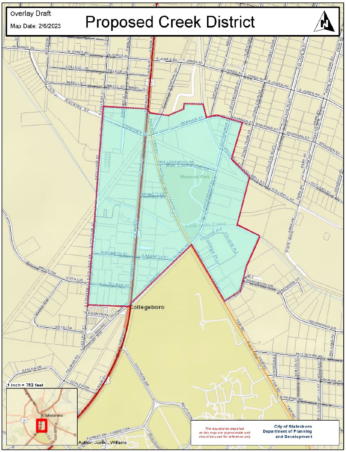
Boundaries. Boundaries. The boundaries of the Blue Mile overlay are shown below as the "proposed creek district" and are hereby incorporated into the zoning map by reference.
C.
Applicability.
(1)
This section applies to all zoning districts within the Blue Mile overlay.
(2)
The standards in the underlying zoning district or elsewhere in this UDC will continue to apply within this overlay, unless otherwise expressly stated in these overlay district regulations.
D.
Private agreements. When a property in this overlay is subject to a private design agreement or covenant, no building permit may be approved until the applicant submits evidence demonstrating that the proposed design has been shared with the entity responsible for enforcing such private design agreement or covenant. The city will not enforce any private agreement or covenant.
E.
Relief.
(1)
The zoning administrator is authorized to grant administrative variances to the requirements of this overlay.
(2)
Administrative variances may only be granted as follows:
(i)
To permit a practice that is not consistent with a specific provision of this overlay but is justified by the purpose of the overlay in subsection 2.2.13.A.;
(ii)
Administrative variances relating to a physical element or numeric measurements must be based upon credible evidence submitted by the applicant demonstrating that approval, if granted, would not offend the purposes in subsection 2.2.13.A.;
(iii)
When there are such extraordinary and exceptional situations or conditions pertaining to the particular piece of property that the literal or strict application of the regulations would create an unnecessary hardship due to size, shape, topography, or other extraordinary and exceptional situations or conditions not caused by the applicant;
(iv)
When relief, if granted would not cause a substantial detriment to the public good and surrounding properties; and
(v)
When the public safety, health, and welfare are secured, and that substantial justice is done.
(3)
Administrative variances may not be used to:
(i)
Increase the permitted site density;
(ii)
Increase the maximum permitted number of stories in a building; or
(iii)
Permit a use that is not allowed by the overlay or the underlying zoning.
F.
Uses.
(1)
Permitted uses are regulated by the underlying zoning district unless a use is prohibited by subsection 2.2.13.F.(2)(i), below.
(2)
The following uses are prohibited:
(i)
Adult entertainment businesses.
(ii)
Junkyards.
(iii)
Automotive and allied sales and services.
(iv)
Tattoo parlors.
(v)
Vape shops.
G.
Dimensional standards. Table 2.2.13-A — (BMO) Dimensional Standards provides dimensional standards applicable to the Blue Mile overlay.
Table 2.2.13-A — (BMO) Dimensional Standards
H.
Parking and loading requirements.
(1)
Required off-street parking may be located off-site anywhere in the Blue Mile overlay district, subject to the shared and joint parking standards of subsection 2.5.2.F.
(2)
There is no off-street parking requirement for outdoor dining areas.
I.
Parking garage design standards. See subsection 2.5.2.M.
J.
Parking lots. Parking lots in the BMO district must meet the following standards in addition to or as modified from all other applicable standards.
(1)
Required setback. Parking lots must provide a minimum 20-foot setback from non-alley rights-of-way.
(2)
Required elements within setback. Within the required setback, the lot must provide at least one public bench, at least two bicycle parking spaces, landscaping, and hardscaping that provides a park-like or plaza-like setting.
(3)
Interruption of setback. This landscaped or hardscaped frontage may be interrupted only for the smallest areas required to permit vehicles to enter and/or exit the parking lot.
(4)
Prohibited locations. Parking lots are prohibited in the following locations:
(i)
In front yards and corner side yards;
(ii)
Within any yard along the Creek on the Blue Mile; and
(iii)
Closer to either street than the principal building façade on corner lots
K.
Bicycle parking. Bicycle parking, if provided, must be accessible to all building occupants and provided in a safe, accessible, well-lit, and convenient location within 50 feet of a building entrance. Bicycle parking must provide clear and maneuverable access to a street or trail and must be located at least as close to the building entrance as the closest car parking space serving that building, except for handicapped parking spaces.
L.
Active frontages.
(1)
Buildings must provide "active frontages" as follows:
(i)
All buildings, except parking garages, must provide active frontages on all stories abutting public streets (excluding public alleys) and the Creek on the Blue Mile.
(ii)
Parking garages must provide active frontages per subsection 2.5.2.M.
(2)
Active frontages must meet the standards of section 2.5.13 — active frontages.
(3)
Active frontages must have transparent glass that faces abutting public streets and the Creek on the Blue Mile as shown in Table 2.2.13-B — (BMO) Active Frontage Standards.
(4)
Active frontages must have pedestrian access from abutting public streets and the Creek on the Blue Mile when required in Table 2.2.13-B — (BMO) Active Frontage Standards.
Table 2.2.13-B — (BMO) Active Frontage Standards
M.
Outdoor dining.
(1)
The ground beneath at-grade outdoor dining areas may only be covered in landscape pavers, tiles, brick, concrete, terrazzo, stone (but not crushed stone), wood or composite decking, synthetic turf (but not Astroturf), or similar materials. The use of asphalt paving is prohibited.
(2)
Outdoor dining furniture must be commercial grade, as determined by the zoning administrator.
(3)
Umbrellas and other shade structures are permitted.
(4)
Sidewalk cafés within a public right-of-way must meet the following:
(i)
Must first obtain all necessary approvals from the city;
(ii)
May not impede the use of the right-of-way by pedestrians or otherwise present a risk to the public health, safety, and general welfare; and
(iii)
May not be located within the Creek on the Blue Mile Trail.
(5)
Except for sidewalk cafes, outdoor dining area boundaries must be defined by one or more of the following:
(i)
A commercial grade fence, as determined by the zoning administrator;
(ii)
Planters or other landscaping;
(iii)
Building walls or freestanding walls;
(iv)
Differences in hardscape surface material or colors; or
(v)
Other design techniques that show where outdoor dining is authorized.
N.
Landscaping. When an "active frontage" is not provided along and abutting public streets or the Creek on the Blue Mile, a landscaped strip, or planter with a minimum width of five feet utilizing a combination of trees, shrubs, and flowers must be provided.
O.
Screening.
(1)
The following must be located only on the side or rear of a building and screened from view from the Creek on the Blue Mile, a public street, or an adjacent property:
(i)
Loading docks and off-street loading areas;
(ii)
Trash collection and storage areas, dumpsters, and compactors;
(iii)
Outside storage areas for items not typically placed for display;
(iv)
Mechanical equipment not mounted on a roof; and
(v)
Drive-through lanes and menu boards.
(2)
Screening must meet the following:
(i)
Screening may only be 100 percent opaque fences, 100 percent opaque walls, brick lattices, or evergreen landscaping.
(ii)
Fences and walls used for screening must be at least one foot higher than the actual height required to screen the object behind it from view.
(iii)
Evergreen landscaping must be expected to reach a height of eight feet with a spread of four feet within three years of planting.
(Ord. No. 2023-12, § 1(Exh. A), 9-19-23)
Sec. 2.2.14. - (DSDA) Downtown Statesboro Development Authority overlay.
A.
Intent.
(1)
It is the intent of this section to establish design and development standards for the Downtown Statesboro Development Authority overlay, herein after called the "district." The purpose of this section is to foster and strengthen economic vitality in the district while respecting and enhancing the special character of the existing development in the area.
(2)
The district is a compact assembly of storefront buildings, short walkable blocks, mixed uses, pedestrian amenities, and consolidated on- and off-street parking as well as one- and two-household dwellings, multi-household developments, and an assortment of former dwellings turned boutique commercial uses.
(3)
The district is especially vulnerable to intrusion from incompatible uses and development practices. The district is so important and significant to the city, that it justifies special regulations designed to protect and enhance its character, which is affected by new development. The potential to impact existing development is much less in other areas of the community than in the downtown core area, and hence the regulations outside the district area do not merit the same protection.
(4)
The purpose of this section is to establish requirements for building and site design for new developments and for the significant modification of existing developments within the district. This section is intended to protect the existing character of the downtown and encourage orderly development in accordance with the most recently adopted comprehensive plan and the Downtown Statesboro Master Plan.
(5)
The following principles serve as the foundation for the section:
(i)
Provide efficient use of land and services;
(ii)
Provide a mix of land uses which strengthen opportunities for economic vitality and support pedestrian activity as well as housing opportunities;
(iii)
Provide community gathering places and pedestrian/visitor amenities;
(iv)
Maintain and expand a distinct storefront commercial character associated with the district, specifically two- to four-story tall buildings, rectangular in mass with traditional design features;
(v)
Provide transitions to adjacent neighborhoods and commercial areas;
(vi)
Maintain and enhance the area's character through design standards;
(vii)
Protect the character of existing residential neighborhoods within the district; and
(viii)
Promote compatibility between residential and nonresidential adjacent and nearby uses.
B.
Boundaries. The Downtown Statesboro Development Authority boundaries that were in effect immediately before adoption of this UDC are the boundaries of this district. Said boundaries are incorporated and made part of this zoning ordinance.
C.
Uses.
(1)
A building may be erected, altered, or used, and a lot may be used or occupied for any reason permissible by right within the underlying zoning district for the property within the district.
(2)
Any alteration, change, or modification to any structure or site within the district which exceeds 50 percent of the fair market value of the structure or site as determined by the Bulloch County Tax Assessor is subject to the requirements of this section.
(3)
This section will not apply to routine maintenance, and repair of a structure or site. However, changes to exterior colors must comply with this section.
(4)
Outdoor storage or equipment, materials, or inventory is not permitted except during construction.
(5)
Chain link and barbed wire fences are prohibited.
D.
Regulation of murals.
(1)
A mural is a sign containing a noncommercial message, picture, scene, or diagram exhibited on the outside wall of a building or structure through application of paint, canvas, tile, panels or similar materials such that the wall becomes the background surface or platform for the mural. A mural is a representation of a creative idea that is expressed in a form and manner as to provide aesthetic enjoyment for the viewer rather than to specifically convey the name of the business or a commercial message about the products or services offered on the property upon which the mural is displayed. A mural will be considered a wall sign or commercial message if it contains words, logos, trademarks, or graphic representations of any person, product or service for the purpose of advertising or identifying a business. Explanatory wording relative to the artwork may be incorporated into the mural. Signatures are allowed and limited to a maximum of two square feet in size.
(2)
Murals must comply with the following standards:
(i)
Murals may not contain text, graphics or symbols that promote or advertise a service, product or business or promote a political party or candidate.
(ii)
No part of any mural may extend beyond the building wall or freestanding wall on which it is tiled, painted, or affixed.
(iii)
No part of the mural may extend more than six inches from the plane of the wall upon which it is tiled, painted, or affixed.
(iv)
Murals may not comprise more than 25 percent of a single façade of a building.
(v)
The mural must comply with O.C.G.A. § 16-12-80 and O.C.G.A. § 36-60-3.
(vi)
The mural may not advertise any activity deemed illegal under the laws of Georgia or the United States.
(vii)
The mural's theme should be historical in nature to the City of Statesboro and respect the greater context of the community.
(viii)
The mural's colors and design must comply with these design standards and the requirements thereof.
(ix)
Murals may be placed on commercial walls, structures, or fences only.
(x)
Murals are restricted to commercial and mixed-use zones.
(3)
The following forms of murals are prohibited:
(i)
Murals that contain elements that change, move, rotate, or otherwise create a changing message or image.
(ii)
Murals that use flashing, scrolling or internal lights.
(iii)
Murals that contain electrical or mechanical components.
(iv)
Murals are prohibited in residential zoning districts.
E.
Site standards.
(1)
Sidewalks and pedestrian areas.
(i)
Sidewalks and pedestrian areas are required along the public right-of-way for each property.
(ii)
Sidewalks must be at least five feet wide and meet city standards and specifications.
(iii)
Sidewalks must use decorative paving that is consistent with the designs adopted by the city.
(iv)
Where adequate right-of-way exists, sidewalks and decorative paving must extend to create additional space for street crossings, gatherings, or clustering of street furniture.
(v)
Continuous walkways must be provided from the public sidewalk or right-of-way to the main customer entrance of all principal buildings. Walkways must meet the width and clearance standards of subsection 2.5.2.C.(2).
(2)
Street furniture and lighting.
(i)
Lighting may be used for the following:
(a)
To accent architectural details.
(b)
To accent building entrances.
(c)
To accent signs.
(d)
To illuminate sidewalks.
(e)
To accent tree canopy or other landscaping.
(ii)
Exterior lighting must have a low level of luminescence that casts a color similar to daytime light and should not interfere with the adjacent property or automobile traffic.
(iii)
Lighting standards must meet those required by the Safe By Design Program of the City of Statesboro and must include parking areas.
(iv)
All street furniture must adhere to the specifications of and be approved in design and placement by the City of Statesboro.
(3)
Landscaping.
(i)
All properties must adhere to the applicable provisions of article 4.1 — urban forest beautification and conservation. Tree placement is required as follows:
(a)
Locate street trees along edges of sidewalks, maintain a clearly defined pedestrian travel zone;
(b)
Locate trees within parking areas as required by section 2.5.2 — parking and loading;
(c)
Install new trees where walkway widths permit; and/or
(d)
Replace trees that are diseased or have passed their life cycle.
(ii)
Parking areas must be landscaped according to the standards of section 2.5.2 — parking and loading.
(iii)
Foundation landscaping along 50 percent of the building length is required for each building on the property, excluding any portions of buildings that directly front the public sidewalk.
(iv)
In order to protect significant trees, the following apply to any tree on the property that is greater than 20 inches in diameter, which will be known as a heritage tree, and to any tree that is greater than 30 inches in diameter, which will be known as a historic tree, that is located within any required setback or buffer area:
(a)
A heritage tree which is removed must be replaced with a minimum of two four-inch caliper shade trees.
(b)
A historic tree which is removed must be replaced with a minimum of four four-inch caliper shade trees.
(c)
New trees used to comply with heritage and historic tree replacement requirements will not count toward the tree canopy requirements of article 4.1 — urban forest beautification and conservation.
(d)
No construction, grading, equipment, or material storage, or any other activity is allowed within the critical root zone of a heritage or historic tree unless the steps taken adequately ensure the tree's health.
(e)
Heritage or historic trees may not be cut, removed, pushed over, killed, harmed, trimmed, sprayed, or destroyed without written approval of the city.
(f)
Trees may be removed to clear lots within the district, so long as the lot remains in compliance with article 4.1 — urban forest beautification and conservation.
(v)
Landscaped areas, including buffer and screening areas, must be maintained in good condition and kept free of dead plants, weeds, or debris.
(vi)
All planting areas must be protected from vehicle damage by the installation of curbing or other methods approved by the zoning administrator. Alternative barrier designs which provide improved infiltration, storage or storm water are strongly encouraged.
(vii)
The plant materials used in and around parking lots and adjacent to street rights-of-way and pedestrian ways must be designed to assure visibility at intersections and safety of pedestrians. Therefore, shrubs must not exceed two feet in height at maturity, and trees are to be pruned to at least six feet above ground.
(viii)
All planting areas must be stabilized with ground covers, mulches, or other approved materials to prevent soil erosion and to allow rainwater infiltration. Rubber mulch is not acceptable.
(ix)
Grassed areas must be finished with sod.
(x)
In order to provide additional safety measures to the site through environmental design, clear visibility must be maintained from the building to the street, parking areas, pedestrian walkways, and passing vehicles.
(4)
Buffering and screening requirements.
(i)
Buffer and/or screenings are required in order to reduce the impact of a use of land on adjacent uses that are of a significantly different character, density, or intensity. The width of the buffer yard must be the same as the setback requirement in the applicable zoning district and all screening materials must be located within the required yard. A buffer yard may only be occupied by permitted landscaping and screening materials, underground utilities, and storm water retention areas. Buffer yards and screening are required in addition to any other landscaping requirement listed in this section.
(ii)
The following items are permitted for use as buffering materials.
(a)
Evergreen buffer vegetation, included in the acceptable evergreen list, meeting a minimum height of six feet.
(b)
Masonry walls measuring at least six feet in height, but no more than eight feet in height. Natural and painted concrete block walls are not permitted.
(c)
A solid wood fence measuring at least six feet in height, but not more than eight feet. If wood is used, only treated or rot resistant wood is acceptable. Chain-link, barbed wire, stock wire and similar type fences are not permitted.
(d)
With the approval of the zoning administrator, any combination of allowed screening materials that meets the intent of this section may be used.
(5)
Parking lots. See section 2.5.2 — parking and loading.
F.
Standards for improvements.
(1)
Mechanical, electrical, utility, and sanitation equipment. Utilities must be buried within rights-of-way or easements as approved by the City of Statesboro.
(2)
Signage. All property within the district is subject to the regulations for Sign District 3 or Sign District 4, as applicable within section 2.5.3 — signs of the UDC.
(i)
Electronic message boards. Electronic message boards and changeable copy — whether programmable, electronic, or manual — must be housed in stone or brick casing and must be integrated with conventional signage. The message board area of the sign is considered changeable copy and regulated as such by section 2.5.3 — signs of the UDC.
(a)
Changeable copy signs. Changeable copy signs are permitted as an integral part of any permanent signs which meet all other requirements of the UDC, and further subject to the following restrictions:
(b)
The changeable copy portion of the sign may not exceed 50 percent of the overall display surface area of the sign, or 20 square feet, whichever is less. Manual and electronic changeable copy fuel price digits are excluded from the permitted changeable copy area so long as they comply with the overall area limitations for the signs on which they are placed.
(c)
The total display area of any sign containing changeable copy panels must not exceed the size limitations imposed elsewhere in this zoning ordinance.
(d)
Only static displays are permitted. Changes are limited to the instant replacement of unrelated text, incorporating no transitional sequence between messages, such as dissolving, fading, scrolling or other similar actions.
(e)
Messages displayed on changeable copy signs must change no more frequently than in increments of eight seconds.
(f)
Changeable copy signs will only be allowed as part of the original construction and erection of a sign which complies with the specifications required by this article, or as part of a significant structural alteration to an existing sign, and thus being an integral part of that sign, and in the case of an existing nonconforming sign, such structural alteration, will otherwise bring the sign into compliance with the other dimensional requirements of the sign district within which it is located. Changeable copy signs which exceed the specifications contained herein and which are altered in form by the addition of structural materials to meet the requirements of this section are not permitted.
(g)
Monotone color scheme displays are permitted.
(ii)
Signs will lose their nonconforming status if they are out of service for 12 months or more.
(iii)
The color palette for the district applies to signage in the district.
(iv)
Projecting signs may not exceed one square foot of sign area per linear foot of building façade width.
(3)
Building orientation.
(i)
Buildings must have their primary pedestrian entrance(s) oriented to the primary street and sidewalk. Building entrances may include entrances to individual units, lobby entrances, entrances oriented to pedestrian plazas, or breezeway/courtyard entrances to a cluster of spaces.
(ii)
A building may have an entrance facing a side yard when a direct pedestrian walkway is provided between the building entrance and the street right-of-way.
(4)
Commercial and mixed-use building design. All buildings on block faces containing one or more ground story storefront (either existing or historically existing), all buildings containing commercial uses, and all mixed-use buildings must comply with the following standards:
(i)
A storefront must be provided on the ground story, as specified in section 2.5.11 — storefronts.
(ii)
Buildings must have consistent spacing of similar shaped windows with trim or other decorative molding on all stories.
(iii)
All buildings with a flat roof must have a decorative cornice at the top of the building; or eaves, when the building is designed with a pitched roof.
(iv)
Cornices or changes in material may be used to differentiate ground story storefronts from upper stories. Ground story facades should utilize cornices, signs, awnings, exterior lighting, display windows and entry insets.
(5)
Exterior building and roofing materials.
(i)
Building materials. Exterior building materials must be similar to the materials used on the existing buildings in the district, when visible. Brick and stone masonry are considered compatible with wood siding.
(a)
When similar materials are not proposed, such as a stucco building in a row of brick structures, other characteristics such as scale and proportion, form, architectural detailing, height, color, and texture must be utilized to ensure that adequate similarity exists for the building to be considered compatible.
(b)
Highly reflective materials, such as reflective glass, are prohibited.
(c)
Buildings must be consistently detailed on all sides. Windows and doors must be defined with detail elements such as frames, sills, and lintels, and placed to visually establish and define the building stories and establish human scale and proportion.
(d)
Exposed rough or re-sawn siding and exposed, untreated concrete are prohibited as finished exteriors. Metal siding and vinyl siding (except as accent materials) are prohibited.
(e)
Accessory structures and buildings should be similar in material and color to the primary building on the site.
(f)
If visible from a public street or adjoining residential district, building facades must use materials consistent with those used on the front of the building and should be designed with similar detailing and be comparable in quality and materials.
(ii)
Flat roofs must incorporate finished parapet walls with three-dimension cornice treatments designed to conceal the roof and roof mounted mechanical equipment.
(6)
Exterior building color palette and re-roofing.
(i)
Recommended color shades must draw from the range of color shades of structures that already exist in the district.
(ii)
All wood structures and wood trim must be painted.
(iii)
Exterior paint colors must be chosen to blend and complement the overall scheme of other buildings on the street. The selected paint palette should correspond to the architecture of the building and utilize a historic paint palette.
(iv)
Building trim should be painted a complementary color that is lighter or darker than the actual building color. The goal is to define the trim elements (cornices, storefront, window frames, doors, etc.) without overpowering the remainder of the building.
(v)
Use one main trim color with an option of a secondary accent color to define the details.
(vi)
Exterior colors must be chosen from the designated scheme set forth above or from those colors included in the historic collection of commonly recognized paint lines.
G.
Variances. Variance applications from this section will proceed under section 2.7.4 — variances and appeals except for landscaping issues, which will proceed as variances from article 4.1 — urban forest beautification and conservation.
(Ord. No. 2023-12, § 1(Exh. A), 9-19-23)

