
Sterling City Zoning Code
ARTICLE VIII
FORM-BASED CODE
Sec. 102-801.- Sterling Redevelopment Form district.
A.
Introduction to form-based code. The Sterling Redevelopment Form-Based Code (SRFBC) is a legal document that regulates land-development within the Sterling Redevelopment Form district (form district) through standards and controls related to building form and placement. Form district regulations govern the design framework of the built environment and public areas while employing more flexible requirements relative to building use and density. This flexibility allows for dynamic change in uses over time as the needs of the community and marketplace evolve, while creating a more predictable physical environment. The SRFBC uses clear and simple graphics for the building envelope, including height, site layout, and building elements that define the public spaces; and incorporates broad guidelines for use.
B.
Establishment of the form district. The proposed form district is generally bounded by the Rock River on the south, Avenue G on the west, West 3rd Street on the north, and Locust Street and 1st Avenue on the east. (See Figure 8.1: Regulating Plan for specific boundaries.) Boundaries indicated as approximately following platted parcel lines shall be construed as following the parcel lines. Boundaries indicated as following natural features or shorelines shall be construed as following those features or shoreline. Projections from the shoreline into water areas shall be subject to the regulations pertaining to the land at the shoreline.
C.
Foundations for the SRFBC and relationship to adopted plans. The standards provided in the SRFBC were built on community input received during the public involvement events for the Riverfront Redevelopment Plan, as well as principles of traditional neighborhood design and smart growth, and are consistent with many of the principles outlined in the comprehensive strategic plan.
D.
Intent. The standards outlined in the SRFBC assert the following principles that facilitate the vision of this community:
• Communities should be designed to reestablish and reinforce the public domain.
• Districts should exhibit human scale.
• Neighborhoods should be diverse in use and population.
• Form should derive from historic context, and be sensitive to natural features and climatic conditions.
These principles result in strategies that retain distinctive traditional form, reduce negative environmental impact, support pedestrian and bicycle environments, reduce auto dependence, encourage adaptive reuse and investment, ensure compatibility of development between uses and sub-districts, and create more affordable and sustainable neighborhoods. These principles embrace the idea that pedestrians are the catalyst for meaningful communities. The SRFBC is designed to create development that reinforces the public domain without sacrificing the diversity of character of individual buildings, and to reintroduce the pedestrian within a mixed-use, compact neighborhood setting.
This is a district which has traditionally included a variety of transitioning residential, commercial, and industrial uses. This provides the background context for the SRFBC. The goal of the SRFBC is to promote development that is compatible in context and character with traditional urban neighborhood centers, and is consistent with the community vision and goals. The Sterling Redevelopment Form-Based Code is designed to foster sustainable infill redevelopment in a vibrant, mixed-use, pedestrian-friendly pattern that encourages diverse and compact development.
The SRFBC promotes a lively pedestrian environment by allowing for small businesses and other commercial uses at the street level, and encouraging upper story residences and offices that overlook public space. Building form standards encourage high quality buildings that respect their urban context. The SRFBC prescribes design principles that are pedestrian friendly, demonstrate environmental responsibility, and integrate public space within the built environment.
E.
Conformance with form district regulations. The form district regulations apply only to new construction and development, including expansions. Structures in existence prior to the effective date of the SRFBC shall not be required to meet the standards created herein until any of the following conditions occurs.
No building, structure, or land shall be subdivided, erected, converted, enlarged, reconstructed, moved, or structurally altered except in conformity with the regulations contained in the SRFBC and in conformity with the area requirements (including height restrictions) of the form sub-district in which the property is located. Lots created after the effective date of the SRFBC shall meet the requirements of the applicable form sub-district.
Prior to the issuance of any building or site construction permit, a determination of conformance with these regulations shall be made by the building and zoning superintendent. Where there is doubt concerning the interpretation of the provisions of the SRFBC, the decision of the plan commission shall prevail, subject to appeal. Wherever there appears to be a conflict between the Sterling Redevelopment Form-Based Code and other sections of the Sterling Zoning Ordinance, the requirements specifically set forth in the Sterling Redevelopment Form-Based Code shall prevail. For development standards not covered by the Sterling Redevelopment Form-Based Code, the other applicable sections in the Sterling Zoning Ordinance shall be used as the requirement. Relief from the standards in this chapter can be obtained only through the zoning board of appeals. Any elements located on the public right-of-way require a license from the City of Sterling.
F.
Appeals. Deviations from the building form standards can be approved only through a variance process as provided for in section 102-905 of the Sterling Zoning Ordinance.
(Ord. No. 2015-10-16, Exh. A, 10-5-15)
Sec. 102-802. - Components of the Sterling Redevelopment Form-Based Code.
The primary components of the SRFBC are: the regulating plan; district-wide guiding principles (including parking requirements); sub-district standards (including illustrated building form standards, streetscape principles, site layouts, and uses); and definitions. These components are explained below.
A.
Regulating plan. The regulating plan is the coding key for the form district and serves as a public space master plan referring the reader to specific information on prescribed development for each sub-district within the district. Building on the results of the Riverfront Redevelopment Plan and the comprehensive strategic plan, a regulating plan has been produced for the Sterling Redevelopment Form District. Sub-districts reflect unique context, locational considerations, and desired future form and function of the public realm.
B.
Guiding principles and standards. This section includes both general advisory principles and prescriptive standards, both of which apply to the entire form district and address topics such as connectivity and access; streets, blocks and alleys; buildings; streetscapes; and parking requirements.
C.
Sub-district standards. The sub-district standards illustrate and explain the building form standards, streetscape standards, and site layout for all development within the form district. Relationships between each lot and public spaces (street-space, open space, pedestrian pathways, etc.) are prescribed.
(1)
Building form standards.
(a)
The intent of the building form standards is to shape the specific physical form and functional character of the built environment within the form district in order to frame the street-space in accordance with community goals. The standards are designed to reflect the minimum level of control necessary to accomplish this intent.
(b)
The building form standards establish basic parameters governing building form, including the envelope for building placement (in three dimensions) and certain permitted/required building elements, such as window and door openings, porches and stoops, balconies, and street walls. The building form standards establish both the boundaries within which development may occur and specific elements that may or shall be present. The applicable standard for a building is determined by its sub-district, as identified on the regulating plan. This produces a coherent street-space and allows the building greater latitude behind its street façade.
(2)
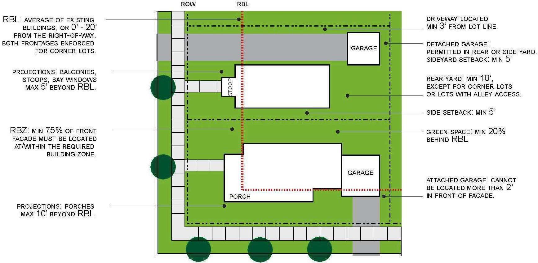
Site layout. The site layout section assists owners and builders in understanding the relationship between the public space and their own building/lot, and how primary and secondary structures and parking can be configured within each sub-district. Illustrations identify the parameters for the placement of street trees and other public space amenities (e.g., benches, signs, street lights, etc.), and detail typical corner and inner lot layouts from an overhead view.
(3)
Uses. Land uses and activated permitted by right and/or by special use permit are outlined in section 102-919.
(4)
Streetscape standards.
(a)
The purpose of the streetscape standards is to define coherent street-space and to assist owners and builders in understanding the relationship between the public space and their own building/lot. These principles describe the parameters for the placement of street trees and other public space amenities (e.g., benches, signs, street lights, etc.) on or near each building site. The prescribed general physical characteristics of the street-space are intended to establish a safe, environmentally responsible, pedestrian-friendly environment. The streetscape standards illustrate typical configurations for streets within the form sub-districts. Vehicular traffic lane widths, curb radii, sidewalk and tree planting area dimensions, and on-street parking configurations are addressed.
(b)
The street-space is designed to balance the needs of all modes of transportation, including motorized and non-motorized, and to ensure maximum mobility and access. While all streets must appropriately balance multimodal transportation needs, street character will vary within each sub-district. Some streets will accommodate a large volume of fast-moving traffic and provide a more active and intense urban pedestrian experience while other streets will provide a less active and more intimately scaled street-space.
D.
Definitions. Some words in the SRFBC are applied in a more specific way than typical common usage, and have been defined herein. Definitions are found in article I: introduction and definitions of this chapter.
E.
Approval process. In order to obtain zoning compliance approval for construction within the boundaries of this district, an applicant shall follow the building site and operation plan process outlined in section 102-924 of this chapter.
F.
How to use the form-based code. The SRFBC will prescribe building placement, the parameters for its three-dimensional form, both required and allowed architectural/functional elements, and the range of allowable uses. Following are the steps to follow in using the SRFBC:
(1)
Review the regulating plan. This plan identifies five sub-districts within the Sterling Redevelopment Form District. Find the property in question. Note the color of the sub-district—this determines the applicable building form standard, streetscape standards and street type specifications for each property. (see regulating plan key for guidance)
(2)
Find the appropriate building form standard page in this article. The building form standard explains the basic parameters for building on a particular site in terms of height, site layout, elements, and use.
(3)
See sub-district street type specifications for illustrations of general parameters pertaining to the street space.
(4)
Check the guiding principles and standards for conformance with all general principles including parking requirements.
(Ord. No. 2015-10-16, Exh. A, 10-5-15)
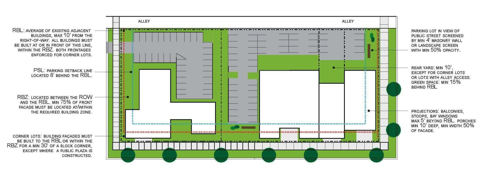
Sec. 102-803. - Sterling Redevelopment Form-District Regulating Plan.
The regulating plan provides standards for the disposition of each property or lot and illustrates how each relates to the adjacent properties and street-space. The regulating plan is the coding key for the form district that provides specific information on permitted development for each property. The graphic below explains the elements of the regulating plan and serves as a reference when examining the regulating plan.
Figure 8.1: City of Sterling Redevelopment Regulating Plan
(Ord. No. 2015-10-16, Exh. A, 10-5-15)
Sec. 102-804. - District-wide guiding principles and standards.
Sterling neighborhoods in and around the downtown reflect traditional neighborhood design principles which serve as the context and framework for this chapter. The following sections outline the underlying principles and prescriptive standards that apply to the Sterling Redevelopment Form District as organized by topic.
A.
General layout and orientation.
(1)
Guiding principles.
(a)
The front façade required building line exists within a prescribed zone defined by distance from the public right-of-way. In this way, building placement within each sub-district is coherent and agreeable, but not regimented to the degree that the effect is of a contrived, sterile, themed or highly planned development. This prescribed zone is based on the existing framework of a traditional urban neighborhood oriented to the pedestrian, and not a suburban environment oriented to motorized transportation.
(b)
New development in the Sterling Redevelopment Form District should integrate street (roadway) design, public space, open space, the natural environment, and the built environment to create a complementary and connected pattern for efficient growth and development access.
(c)
Existing buildings are encouraged to incorporate onsite stormwater management techniques per current City of Sterling stormwater management design standards.
(d)
Consideration should be given to adjusting the site layout to accommodate development occurring in harmony with and supportive of the natural environment or designed to mitigate harsh, winter conditions, thereby creating a more pedestrian supportive environment.
(2)
Standards. New or infill development:
(a)
Front and street setbacks necessary to comply with buffer requirements set forth in section 102-520.B(2)(c) shall supersede sub-district requirements.
(b)
All site plans for redevelopment or new construction shall include provisions for on-site stormwater management, per City of Sterling stormwater management design standards, using appropriate techniques such as rain gardens, green roofs, rain barrels collecting water for landscaping, or other bio-filtration methods to minimize stormwater run-off into the public space and public stormwater system.
B.
Connectivity and access.
(1)
Guiding principles.
(a)
The SRFBC is intended to create and enhance a safe and welcoming pedestrian environment within a multimodal transportation network; to decrease dependence on the automobile; and improve streetscapes and connections to make walking and biking in the form district easy, safe, convenient, and desirable.
(b)
The SRFBC embraces compact, traditional development patterns with street and site layouts offering multiple connections without cul-de-sacs or dead-ends.
(2)
Standards. At the time of, and within, new or infill development:
(a)
All non-residential developments which provide automobile parking facilities shall provide bicycle parking facilities (racks) at a ratio of at least one bicycle parking space for every 15 automobile parking spaces. Multi-family developments shall provide said facilities at a ratio of at least one bicycle parking space for every five units in a multi-family development.
(b)
Where the traditional street grid is broken, pedestrian connections will be established through a designated pedestrian pathways. The area within a pedestrian pathway shall be a public access easement or public right-or-way. Pedestrian pathways or rights-of way illustrated on the regulating plan are not considered to be established until the City of Sterling obtains the property or lands are dedicated for such purposes.
(c)
Clearly defined, safe pedestrian spines shall be provided from adjacent public rights-of-way through off-street parking areas or front landscaping areas to non-residential building entrances (at least one per site).
(d)
Proposed developments that create new streets shall place utility lines underground.
C.
Blocks, streets, and alleys.
(1)
Streets.
(a)
The street is a coherent space, with consistent building placement and scale on both sides. Consistent standards ensure a cohesive and coherent street identity while allowing for individual variation.
(b)
Wherever possible, streets are narrow to encourage traffic calming techniques, but will accommodate on-street parking (except as prohibited on state highways).
(c)
Wherever practical (i.e., upon redevelopment of streets or narrowing of travel lanes) bicycle accommodations should be added to streets to encourage multi-modal access.
(d)
Streets are lined with sidewalks and well placed trees and landscaping, and are fronted by porches, balconies, and entries rather than garage doors and wide driveways.
(2)
Standards.
(a)
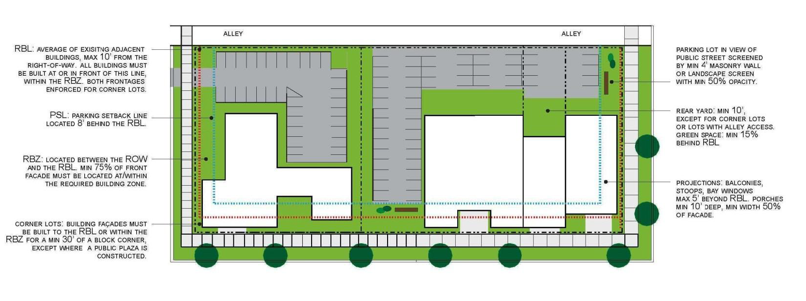
All lots shall be considered to be part of a block. No block face shall have a length greater than 400 feet without an alley, common drive or access easement, or pedestrian pathway providing through-access to another street, alley or common access easement, street-space, or recreational land. Individual lots with less than 75 feet of frontage are exempt from the requirement to interrupt the block face; those with over 250 feet of frontage shall meet the requirement within their lot, unless already satisfied within that block face.
(b)
Where shown on the regulating plan for the form district, alleys shall be developed within the rear setback as part of a redevelopment project, and in accordance with the following:
(i)
Alleys shall be constructed to meet the city construction standards in order to be suitable for emergency and service vehicle access.
(ii)
Alleys shown on the regulating plan represent suggested and approximate configurations. The specific configuration may include shared parking areas and other uses so long as reasonable service access is relatively unimpeded.
(iii)
Where an alley does not exist and is not feasible to construct at the time of redevelopment of any property, the applicant is required to maintain the area within the rear setback by, at a minimum:
(1)
The placement of sod or seeding and provision of routine landscape maintenance to the area
(2)
Keeping the area clear of debris, stored materials, vehicles, and structures.
(c)
The SRFBC prohibits the vacation or closure of alleyways functioning in accordance with the Sterling Redevelopment Form District Regulating Plan. Roadways and alleyways not functioning in accordance with the regulating plan may be vacated and/or replatted to conform to the regulating plan.
D.
Buildings.
(1)
Guiding principles.
(a)
Building form promotes diversity by accommodating flexible opportunities for a variety of residential, commercial, light industrial, and recreational uses.
(b)
Buildings oversee the street-space with visually active fronts. For example, orientation of household gathering spaces (porches and entryways) is toward the front of the structure. This overview of the street-space contributes to vital and safe public space and enhances the pedestrian environment.
(c)
Buildings frame the majority of the street-space, and have façades that are closely related in orientation, position, and scale to exhibit an agreeable public space.
(d)
Preferred exterior building materials include concrete, masonry, tile, stone, and wood.
(e)
A variety of rooflines are encouraged to reduce the massive scale of large buildings and to complement the character of roofs with the form district.
(2)
Standards.
(a)
Buildings larger than 40,000 square feet are required to petition the plan commission for a special use permit in accordance with section 102-919 of this chapter.
(b)
Primary building entrances shall be oriented toward streets, parks and plazas, and not to the interior of blocks or to parking lots and garages. Secondary entrances oriented toward parking lots are permitted.
(c)
Highly reflective exterior building materials, including but not limited to reflective glass and polished metal surfaces, are prohibited due to the undesirable blinding effect compounded by snow.
(d)
All lots shall share a frontage line with a street-space. Residential layouts such as single-family cluster housing, urban townhouses, or apartment clusters shall be allowed to face an alley, common courtyard, or public space provided no street-space adjoins the building, but in general, primary ground floor residential entries must orient to and be visible from the street, not to interior blocks or parking lots.
(e)
Building façades are the public "face" of every building. For each block face within the Sterling Redevelopment Form District, long façades located along the required building line (RBL) shall be divided into discrete façades every 70 feet on average so as not to present one long, continuous façade. Individual infill projects on lots with frontage of less than 75 feet are exempted from this requirement.
(f)
The façade shall include a functioning, primary street-space entry. The entry requirement may be satisfied through the use of liner shops (small shops with direct access onto the fronting sidewalk) wrapping large footprint buildings.
(g)
In no case shall the street-side façade of a building consist of a blank wall or an unbroken series of garage doors.
(h)
Building façades of commercial, retail, and multi-family residential uses that exceed 100 feet in length measured along the street façade shall have variations in roofline or rooftop parapet to reduce the massive scale of the large buildings. Rooftop equipment shall be concealed behind parapets or screened from view by pedestrians.
(i)
All sides of a multi-family residential building facing a public street shall display a similar level of quality.
(j)
Drive-through service windows are permitted in the rear of mid-block and alley accessed locations with a special use permit in accordance with section 102-919.
(k)
Accessory structures shall not be located in front of the primary building unless allowed in the individual sub-district standards.
E.
Streetscape requirements.
(1)
Guiding principles.
(a)
Streetscape elements include both manmade and planted features within the street-space that combine to create the character of the public domain. This includes travel lanes between the curbs as well as the sidewalks and planting strips. Public plazas and open space also contribute to the street space.
(b)
Street trees provide both form (canopy) and comfort (shade) to the street-space. Native trees and plants efficiently contribute to the reduction of air and noise pollution, maintenance of natural habitat, the conservation of water, and stormwater management.
(c)
Regular spacing of street trees gives coherence to the streetscape, enhancing character.
(d)
Sidewalks should be designed to facilitate both clear access to the fronts of buildings and passage for pedestrians along the block.
(e)
The following street-type standards are designed to provide the necessary infrastructure to balance the needs of all multimodal forms of traffic, to maximize mobility, and to foster a character that is inviting to all users.
(2)
Standards.
(a)
The tree planting zone (terrace) is located immediately adjacent to the curb and shall be continuous. In addition to the required planting of trees as covered below, this area may also be used for the placement of street furniture including utility poles, waste receptacles, fire hydrants, traffic signs, newspaper vending boxes, bus shelters, bicycle racks and similar elements in a manner that does not obstruct pedestrian access or motorist visibility as determined by the building and zoning superintendent.
(b)
Street trees shall be planted at an average spacing of no greater than 30 feet on the side(s) of the street-space being developed (dependent on available right-of-way width).
(c)
The developer is required to install sidewalks and/or pedestrian spines, according to the appropriate sub-district regulation, where none currently exist.
(d)
Crosswalks shall be designed in accordance with City of Sterling Engineering Standards.
(e)
Sidewalks and other pedestrian pathways and pedestrian spines shall be separated from the roadway.
(f)
Public sidewalks shall be constructed of concrete, located along both sides of all public streets, and shall have minimum width of five feet.
F.
Parking.
(1)
Guiding principles. Parking goals for the Sterling Redevelopment District are:
(a)
Reduce fragmented, uncoordinated, inefficient, single-purpose reserved parking and encourage shared parking and access drives.
(b)
Reduce the number of large, open parking areas that create unpleasant, windswept spaces for pedestrians.
(c)
Reduce the amount of impervious surfaces that contribute to water pollution and/or excessive stormwater runoff.
(d)
Avoid nuisance impacts on adjacent neighborhoods by providing for efficient and adequate parking for all uses contained within the form-district. Maximize on-street parking to increase pedestrian comfort by providing a buffer between the pedestrian and moving traffic, support commercial businesses, and provide residential visitor parking.
(e)
Incorporate convenient bicycle parking.
(f)
Conceal parking from the public street-space by locating the majority of parking beside or behind buildings.
(g)
Utilize smaller parking lots within a framework of vegetation to create a better microclimate for pedestrians, reduce stormwater run-off, and provide more opportunities for snow storage.
(2)
Standards.
(a)
Parking requirements shall be met either on-site or within a 600-foot radius of the development parcel.
(b)
The number of parking stalls required for a development or site shall comply with the regulations outlined in section 102-227 of this chapter.
(c)
Parking lots shall be designed to accommodate the requirements of snow clearing equipment.
(d)
Shared parking shall be designated by appropriate signage and markings.
(e)
Landscape screening, landscaping, and tree canopy requirements for surface parking areas as provided for in section 102-227.B. of this chapter shall be required upon construction of any new surface parking area, or will be required for any existing surface parking area when 50 percent or more of the lot is reconstructed or resurfaced. Seal-coating shall be exempted
G.
Landscaping, buffering, and screening. Landscaping, buffering, and screening for all development shall comply with the regulations outlined in section 102-520, landscaping.
H.
Lighting. Outdoor lighting for all development shall comply with the regulations outlined in section 102-606, lighting.
(Ord. No. 2015-10-16, Exh. A, 10-5-15)
Sec. 102-805. - Sterling Redevelopment Form-District sub-districts.
A.
General information.
(1)
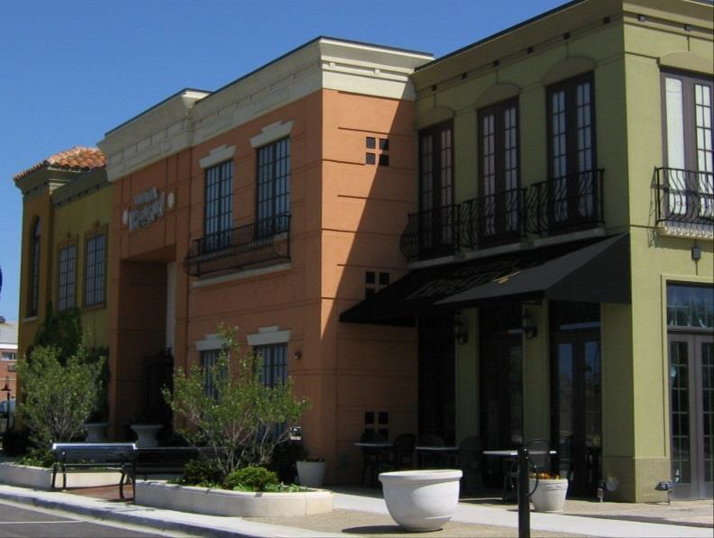
Traditional neighborhood-residential (TN-R). Residential development is traditional, two-story, single family homes on small lots. It is important to the community to preserve this pedestrian-friendly, compact neighborhood type where homes are of similar scale and character.
(2)
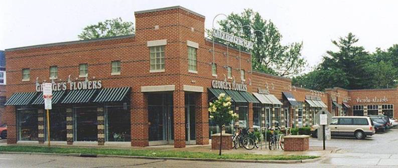
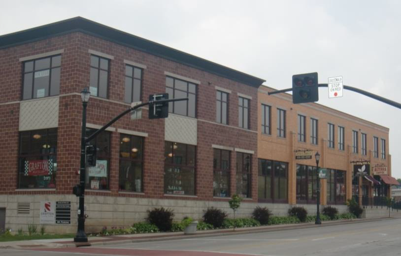
Traditional neighborhood—commercial residential (TN-CR). In this sub-district, neighborhood-scale retail and other commercial uses exist in harmony with a variety of residential forms. Buildings closely frame vibrant streets that are designed for pedestrian convenience.
(3)
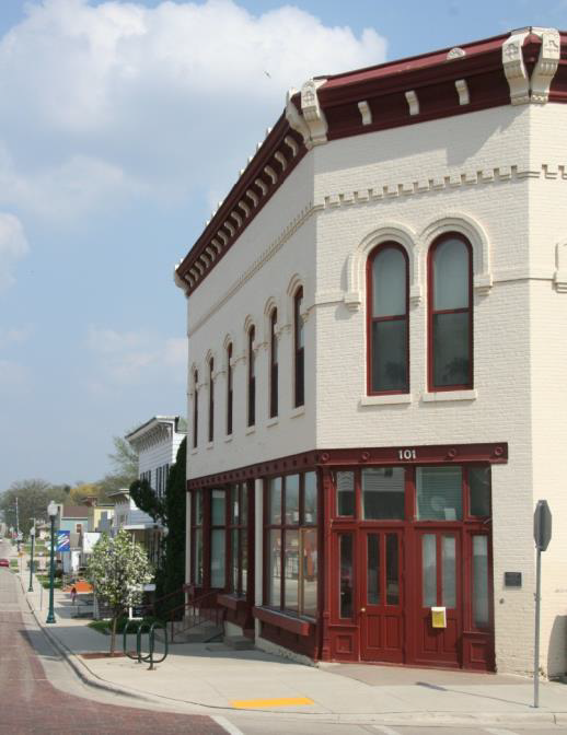
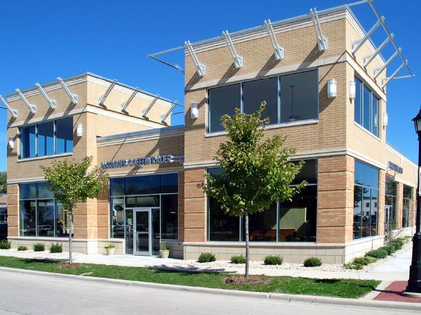
Corridor-mixed use (C-MU). All sub-districts converge upon this lively, central sub-district which contains a variety of activities supported through corridor development and crucial neighborhood intersections. Because of this centrality, it is important to enhance the connectivity of this sub-district to all others. Both regional-scale and neighborhood-scale activities are integrated with residences, creating a unique neighborhood environment. This sub-district provides the most opportunity for a variety of residential forms including townhouses, apartments, housing over commercial use, and loft apartments. A wide variety of land uses including retail, restaurants, office, civic, commercial, light industrial, and residential are accommodated. The inclusion of pedestrian and non-motorized pathways and connections is of primary importance in positioning this sub-district as a mobility hub.
(4)
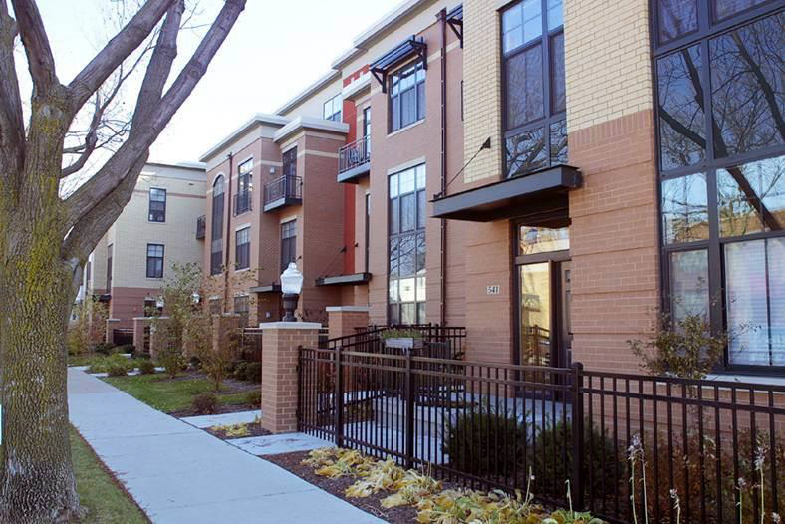
Riverfront-mixed use (R-MU). This sub-district maintains, foremost, a connection with the public riverfront while serving as a link between downtown and the Sterling neighborhoods. As such, development must respect, maintain, and enhance public access to the riverfront and be carried out in such a way to avoid negative impact on the environment. Development is compact and oriented to the pedestrian, and illustrates a moderately dense, urban form consistent with downtown yet unique in the preservation of connected open space and view corridors.
(5)
Riverfront-recreation conservation (W-RC). This sub-district exists for the specific preservation of public access to the Rock River riverfront, and provides for recreation and conservation activities.
B.
Sub-district regulations. The following sub-district regulations shall apply for the Sterling Redevelopment Form-District:
(1)
Traditional neighborhood—residential (TN-R).
| Intent | Representative Character |
| The TN-R sub-district is intended to preserve the existing character of the traditional residential neighborhood and to guide redevelopment in a manner which is consistent and compatible with this form. residential character is reflected around a framework of well-connected, grid street systems with sidewalks, and the pedestrian environment is enhanced by compact development on small lots, and homes set relatively close to the street, with front porches and clearly defined front entrances. This sub-district is intended to create and preserve viable and walkable neighborhoods and provide for all season non-motorized connections. The principles herein encourage pedestrian scale form with appropriate amenities such as pedestrian scale lighting, street trees, and street widths applying traffic calming principles while accommodating on-street parking |  |
 |  |
| Guiding Principles | |
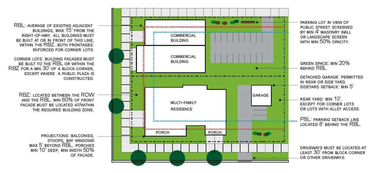
| Residential lots in this sub-district exhibit a distinctive, traditional pattern of placement of principal and accessory structures, their relationship to streets and alleys, and provision for open areas. The active, visual features of the residence will dominate the streetscape, and garages will generally be positioned behind the principal structure to reduce their visual impact. This configuration allows residents to keep a watchful eye on the street and creates a more human-scaled and less monotonous environment. | |
| Building Form Standards | Elements and Use |
|---|---|
 | |
| Site Layout | |
|---|---|
 |
(2)
Traditional neighborhood—commercial residential (TN-CR).
| Intent | Representative Character |
| The intent of the TN-CR is to promote the establishment of a mix of neighborhood-serving activities that effectively integrates retail, office, institutional, and other non-residential uses within residential neighborhoods while preserving traditional neighborhood character. This integration of uses will promote shopping and service opportunities within the neighborhoods, and will accommodate non-motorized forms of transportation, including public transit. Development in this sub-district will provide for commercial at a scale that is appropriate for nearby residential areas, while placing primary importance on a safe and pleasing pedestrian environment. New development will be compatible within the context of traditional neighborhood form. Commercial is closely integrated with residences so as to encourage vitality and safety as residents keep eyes on the streets. Trees and vegetation are necessary to improve the pedestrian landscape and provide buffers from activity. | 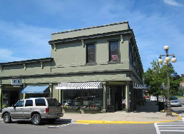 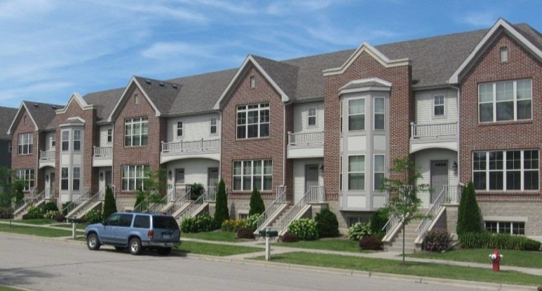 |
 | |
| Guiding Principles | |
| Buildings in the sub-district are often narrow, closely spaced or attached, and built out to or near the street, preserving pedestrian scale and welcoming streetscapes. Design standards promote pedestrian scale form with appropriate amenities such as pedestrian scale lighting, street trees, parks, and open spaces. Street widths facilitate traffic calming principles while accommodating on-street parking. On-street parking separates the pedestrian from traffic, and provides convenient access for businesses. On-site parking is located in the rear or on the side of the principal building. | |
| Building Form Standards | Elements and Use |
 | |
| Site Layout | |
 |
(3)
Corridor-mixed use (C-MU).
| Intent | Representative Character |
The corridor-mixed use sub-district is intended as a diverse, generally pedestrian-friendly
environment that provides adequate vehicular access while creating an aesthetically
pleasing appearance along heavily travelled corridors in Sterling. This district serves
as a vital arterial link and a gateway connection to downtown. The C-MU sub-district
serves to provide a smooth transition into more intense downtown development patterns
by strategically and efficiently accommodating vital commercial and residential uses
while preserving a pleasing pedestrian environment Pedestrian and non-motorized movement
between downtown, the riverfront, and the neighborhoods adjoining each is important
in this district. Motorized access will be carefully designed and more intense activities
will be carefully screened so as to place emphasis on the main building entrances.
The area will reflect the community's desire to enhance the visual quality of the
area by establishing minimum criteria for development while promoting amenities necessary
to attract businesses, residents, and visitors.
 |    |
| Building Form Standards | Elements and Use |
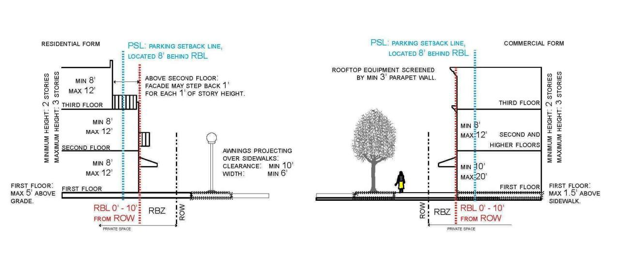 | |
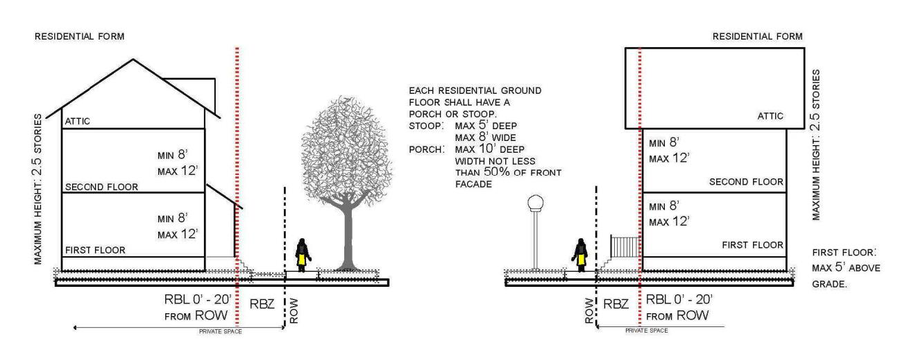
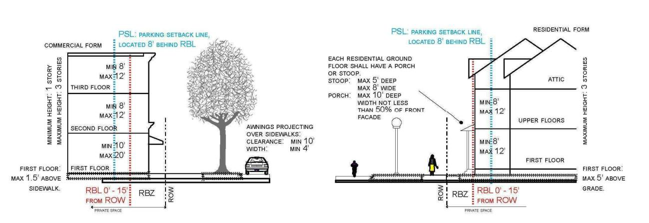
| Building height 1. Each principal building will be at least two stories in height, but no greater than three stories in height for non-residential and three stories for multi-family residential. 2. An additional tower story is allowed above the maximum building story height, within the following parameters. a) The footprint of the tower shall not exceed 300 square feet. b) No horizontal façade dimension of the tower shall exceed 20 feet. c) Story height is the same as those for upper stories. 3. No attic story is permitted above a tower story. 4. Floors over two stories may be set back a minimum of one foot from the front façade of the floor below for every one foot in height. Accessory Structure Height Accessory buildings shall be no greater than one story or 20 feet, measured to the eave or top of parapet. Ground Story Height: Commercial and Civic Uses 1. The ground story finished floor elevation shall be equal to, or greater than the exterior sidewalk elevation in front of the building, to a maximum finished floor elevation of 18 inches above the sidewalk. 2. Minimum height of the ground story shall be ten feet. Maximum story height shall be 20 feet. Ground Story Height: Residential/Multi-Family Uses 1. The finished floor elevation shall be no more than five feet above the exterior sidewalk elevation at the RBL. 2. Minimum height of the ground story shall be eight feet. Maximum story height shall be 12 feet. Upper Story Height: All Uses Minimum height of the ground story shall be eight feet. Maximum story height shall be 12 feet. Mezzanines Mezzanines having a floor area greater than one-third of the floor area of the story in which the mezzanine is situated shall be counted as full stories. Fencing A fence conforming to section 102-211 may be placed on a lot. | Building Projections 1. Balconies, bay windows and stoops shall not project closer than five feet to a lot line or more than five feet beyond the RBL. 2. Awnings that project over the sidewalk portion of a street-space shall maintain a clear height of at least ten feet, and shall be a minimum of six feet wide. 3. No part of any building except overhanging eaves, balconies, bay windows, stoops and porches as specified by the SRFBC shall encroach beyond the RBL. No projections will encroach onto the public right-of-way. Doors/Entries 1. At least one functioning entry door shall be provided along the ground story façade of each building. 2. Doors shall be provided at intervals not exceeding 75 feet. Door and Wall Openings 1. Blank lengths of wall exceeding 20 linear feet are prohibited on all RBLs. 2. Door and wall openings shall comprise at least 30 percent, but not more than 90 percent of the ground story façade area per story, and at least 20 percent but not more than 75 percent of the upper story façade area per story. 3. Outdoor public space amenities such as parks with seating, trees and landscaping; plazas featuring public art and landscaping; or other suitable visual enhancement that contributes to the pedestrian environment and meets the requirements in [subsection] (1) above can be substituted for transparency requirements. Permitted Uses 1. No single-family detached residential uses shall be permitted. 2. The ground story shall house commercial, residential, multi-family residential, or civic uses as defined. 3. The upper stories shall house residential, multi-family residential, civic, or commercial uses. 4. No restaurant or retail sales uses shall be allowed in upper stories unless they are second story extensions equal to or less than the area of the ground story use. 5. No commercial or civic uses are permitted above a residential use. |
| Site Layout | |
 |
(4)
Riverfront-mixed use (R-MU).
| Intent | Representative Character |
This sub-district is intended to serve as an extension of downtown with a mix of uses
complementary to downtown and a framework of streets and blocks that integrates and
connects with those downtown. Urban character is reflected in compact, environmentally-friendly
development that is similar in size and scale to riverfront buildings traditionally
found downtown. Primary importance will be placed on development patterns that preserve
access and view corridors to the riverfront. Building design and site layout will
reflect the importance of the relationship to the river.
  |   |
| Guiding Principles | |
| Buildings are built out to or near the street so as to preserve pedestrian scale and welcoming streetscapes. Design standards promote pedestrian scale form with appropriate amenities such as pedestrian scale lighting, street trees, parks, open space resources, and street widths. Buildings will be oriented to the street when possible or to public courtyards or common areas if there is no adjacent street (as in courtyard or cluster housing). Direct pedestrian pathways a minimum of seven feet wide will connect all public sidewalks to principal building entrances. Parking is located in the rear or underneath buildings. | |
| Building Form Standards | Elements and Use |
|---|---|
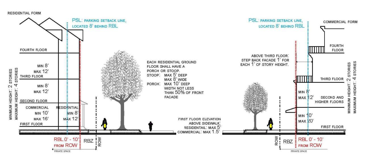 | |
| Building Height 1. Each principal building will be at least two stories in height, but no greater than four stories in height. 2. An additional tower story is allowed above the maximum building story height, within the following parameters. a) The footprint of the tower shall not exceed 300 feet. b) No horizontal façade dimension of the tower shall exceed 20 feet. c) Story height is the same as those for upper stories. d) No attic story is permitted above a tower story. 3. Parking structures shall be limited to three stories in height or 40 feet, measured to the eave or top of parapet. Ground Story Height: Commercial Uses The ground story finished floor elevation shall be equal to, or greater than the exterior sidewalk elevation in front of the building, to a maximum finished floor elevation of 18 inches above the sidewalk. Ground Story Height: Residential Uses The average finished floor elevation shall be no less than two feet and no more than seven feet above the exterior sidewalk elevation at the RBL. Upper Story Height: All Uses Each upper story shall have an interior clear height (floor to ceiling) of at least eight feet and maximum story height of 12 feet. Accessory Structures (other than garages) 1. Any accessory buildings shall be located behind the parking setback line. 2. Accessory buildings shall be no greater than one story or 20 feet, measured to the eave or top of parapet. 3. Accessory buildings shall adhere to the minimum rear yard prescribed in this sub-district. Mezzanines Mezzanines with a floor area greater than one-third of the floor area of the story shall be counted as full stories. Fencing A fence conforming to section 102-211 may be placed on a lot. | Door and Wall Openings 1. Blank lengths of wall exceeding 20 linear feet are prohibited on all RBLs. 2. Door and wall openings shall comprise at least 30 percent, but not more than 90 percent of the ground story façade area per story, and at least 20 percent but not more than 75 percent of the upper story façade area per story. Building Projections 1. Balconies, bay windows and stoops shall not project closer than five feet to a common lot line or more than five feet beyond the RBL. 2. Each residential ground floor unit shall include a stoop of not more than five feet deep or a front porch a maximum of ten feet deep. 3. Awnings that project over the sidewalk portion of a street-space shall maintain a clear height of at least ten feet, and shall be a minimum of six feet wide. 4. No part of any building except overhanging eaves, balconies, bay windows, stoops and porches as specified by the SRFBC shall encroach beyond the RBL. No projections will encroach onto the public right-of-way. Doors/Entries At least one functioning entry door(s) shall be provided along the ground story façade of each building. In addition, doors shall be provided at intervals not exceeding 75 feet. Permitted Uses 1. No single-family detached residential uses shall be permitted. 2. The ground story shall house commercial, residential, multi-family residential, or civic uses as defined. 3. The upper stories shall house residential, multi-family residential, civic, or commercial uses. 4. No restaurant or retail sales uses shall be allowed in upper stories unless they are second story extensions equal to or less than the area of the ground story use. |
| Site Layout | |
 |
(5)
Riverfront—recreation conservation (R-RC).
| Intent | Representative Character |
| This sub-district includes lands located along riverfront and shoreline areas that are preserved for community recreational and conservation purposes and valued for scenic and ecological qualities. The intent is to promote public access and enjoyment of water resources and to protect those same resources through responsible land use practices. The city recognizes the unique physical, economic, and social benefits of riverfront and shoreline properties, and places a priority on their protection for future generations. The riverfront will provide recreation activities and enhance pedestrian and non-motorized connectivity. Public parking facilities should be effectively integrated for convenience. |  |
 | 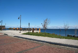 |
| Guiding Principles | |
| No private development permitted. Useable open space should be located where it is visible and easily accessible from public areas (sidewalks, streetscapes). Views and sun exposure should be maximized. New public spaces should contain direct access from adjacent streets. Public spaces should be open along the adjacent sidewalks and allow for multiple points of entry. Public spaces should be visually permeable from the sidewalk, allowing passersby to see directly into the space. | |
;adv=6;(Ord. No. 2015-10-16, Exh. A, 10-5-15)
Sec. 102-806. - Street type specifications.
Illustrative street type specifications for typical, pedestrian-friendly, mixed-use streets are included for each sub-district. These specifications address vehicular traffic lane widths, sidewalk and tree planting area dimensions, and on-street parking configurations. The street typical section also provides a comparative pedestrian crossing distance as a gauge of pedestrian comfort. These specifications provide a basic template for streets in each sub-district. Because the existing and proposed rights-of-way (ROW) vary, the exact street specifications may vary. For ROW widths greater than 66 feet, extra dimension should be given to the pedestrian areas.
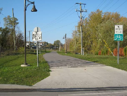
Traditional Neighborhood-Residential (TN-R)
| Representative Street-Space | |
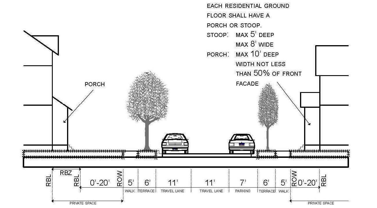 | |
| Guiding Principles | Standards |
| Streets will be kept to as narrow a width as possible while still accommodating on-street parking. This will help to reduce traffic speeds in compact, residential neighborhoods. |
1. There are two drive lanes which are each typically 11 feet wide.
2. A seven-foot wide lane accommodates for on-street parking on one side of the street. 3. A six-foot wide tree planting strip is adjacent to the curb, separating the street from a sidewalk that is a minimum five feet wide. 4. Comparative pedestrian crossing distance is 29 feet. |
Traditional Neighborhood-Commercial Residential (TN-CR)
Corridor-Mixed Use (C-MU)
Riverfront-Mixed Use (R-MU)
| Representative Street-Space | |
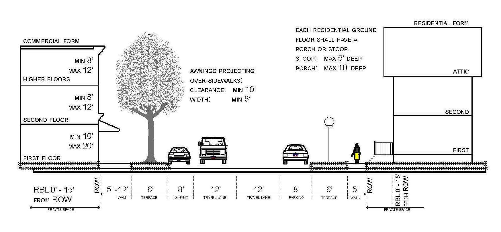 | |
| Guiding Principles | Standards |
| This sub-district is characterized by narrow streets and higher traffic volumes accommodating business customers, residents, and through traffic. On-street parking is important as a buffer between pedestrians and fast-moving traffic, and provides a more pedestrian-friendly environment in this traditional neighborhood. |
1. Two 12-foot wide travel lanes.
2. Two eight-foot wide lanes accommodate on-street parking on each side of the street. 3. A six-foot wide tree planting strip is adjacent to the curb, separating the street from a sidewalk that is a minimum five feet for in front of residential uses. The sidewalk should be widened in front of commercial and multi-family developments. 4. Comparative pedestrian crossing distance is 42 feet. |
;adv=6;(Ord. No. 2015-10-16, Exh. A, 10-5-15)