
Tallahassee City Zoning Code
ARTICLE IV
- ZONING DISTRICTS AND DEVELOPMENT STANDARDS
DIVISION 2. - DOWNTOWN ZONING DISTRICTS AND DESIGN REVIEW DISTRICTS[3]
Editor's note— Ord. No. 10-O-14AA, § 5, adopted February 23, 2011, changed the title of division 2 from "Downtown zoning districts" to "Downtown zoning districts and design review districts."
DIVISION 4. - DOWNTOWN OVERLAY REGULATING PLAN AND MULTI-MODAL TRANSPORTATION DISTRICT (MMTD) STANDARDS[4]
Click here to view a PDF version of DIVISION 4. DOWNTOWN OVERLAY REGULATING PLAN AND MULTI-MODAL TRANSPORTATION DISTRICT (MMTD) STANDARDS.
Editor's note— Ord. No. 13-O-03, § 14, adopted August 28, 2013, amended division 4 in its entirety to read as herein set out. Formerly, division 4 pertained to similar subject matter, and derived from Ord. No. 10-O-14AA, § 7, adopted February 23, 2011.
Sec. 10-161.- Purpose and intent.
This article sets forth a complete description of each zoning district which comports with the 2010 Comprehensive Plan classifications. Within each district is:
(1)
A purpose and intent statement for the district as set forth in the 2010 Comprehensive Plan.
(2)
A list of allowable uses which meet the intent of the zoning district. However, zoning districts may include uses designated as special exception uses which designation does not constitute an authorization or an assurance that such special exception use will be approved at a particular location.
(3)
A series of uses, Schedule A, which includes permitted (P), restricted (R), and special exception (S) uses which more narrowly reflects district intent. If there is not a P, R, or S in a cell, the use is not allowable within the district. Restricted and special exception uses must meet the criteria in article VII of this chapter.
(4)
A series of schedules of land use development criteria relating use types to various factors. These include: Schedule B, Maximum Allowable Floor Area Standards and Schedule C, Minimum Development Standards.
(5)
A section on commercial site location standards as found in the 2010 Comprehensive Plan.
(6)
A description and buffer zone standards (section 10-177) based on adjacencies and intensities.
(7)
A description and development standards as found in the 2010 Comprehensive Plan for compatibility of adjacent uses, transportation requirements, street access requirements, environmental constraints, and infrastructure requirements.
(8)
Subsections (3), (4), (5), and (7) of this section are not applicable to the following zoning districts: RA, R-1, R-2, R-3, R-4, R-5, MH, MR-1, OR-1, OR-2, OR-3, OA-1, C-1, C-2, CM, CP, UP-1, UP-2, IC, M-1, OS, PD, PUD, and DRI, ASN-A, ASN-B, ASN-C, ASN-D, UV, CU-12, CU-18, CU-26, CU-45, and UT.
(9)
Subsection (6) is not applicable to the following zoning districts: ASN-A, ASN-B, ASN-C, ASN-D, and UV. The CU-12, CU-18, CU-26, CU-45 and UT districts provide standards modifying the applicability of subsection (6).
(Code 1984, ch. 27, § 10.3(A); Ord. No. 95-O-0025AA, 9-13-1995; Ord. No. 96-O-0033AA, § 7, 12-11-1996; Ord. No. 97-O-0027AA, §§ 6—12, 7-8-1997; Ord. No. 98-O-0028AA, §§ 3—7, 6-24-1998; Ord. No. 04-O-43AA, § 10, 6-23-2004; Ord. No. 05-O-16AA, § 8, 3-30-2005; Ord. No. 06-O-04AA, § 2, 2-22-2006; Ord. No. 08-O-30, § 1, 7-9-2008; Ord. No. 09-O-31AA, § 15, 10-29-2009)
Sec. 10-162. - Rural zoning district.
(a)
Purpose and intent. The rural zoning district is for undeveloped and nonintensively developed acreage remotely located away from urbanized areas containing the majority of the county's present agricultural, forestry and grazing activities. In the rural zoning district land use intensities associated with urban activity are not anticipated during the timeframe of the 2010 Comprehensive Plan, due to lack of urban infrastructure and services. In the rural zoning district very low residential density (one unit per ten acres) and small scale commercial activities designed to service basic household needs of area residents are allowed as are passive recreational land uses. Industrial and ancillary commercial land uses associated directly with the timbering and/or agribusiness are permitted in the rural zoning district. The rural zoning district is intended to maintain and promote present and future agricultural and silvicultural uses and to prohibit residential sprawl into remote areas lacking basic urban infrastructure and services.
(b)
Allowable uses. For the purpose of this chapter, the following land use types are allowable in the rural zoning district and are controlled by the land use development standards of this chapter, the comprehensive plan and chart of permitted uses.
(1)
Agricultural.
(2)
Minor commercial.
(3)
Low density residential.
(4)
Passive recreation.
(5)
Active recreation.
(6)
Community services.
(7)
Light infrastructure.
(8)
Heavy infrastructure.
(9)
Post secondary.
(c)
List of permitted uses. See schedules of permitted uses, subsection 10-236(1). Nonresidential uses on these schedules are itemized according to the Standard Industrial Code (SIC). Proposed activities and uses are indicated in the schedule. The activity or use may be classified as permitted, restricted, or permitted through special exception, or not allowed. Restricted and special exception uses must meet the criteria in article VII of this chapter. Chapter 9, article II sets forth the development approval process required for allowable uses.
(d)
Development standards. All proposed development shall meet the land use development criteria specified in subsections 10-236(b) and (c); commercial site location standards (section 10-174); buffer zone standards (section 10-177); criteria of the development standards schedule (article IV, division 4 of this chapter); and parking and loading requirements (article VI of this chapter).
(Code 1984, ch. 27, § 10.3; Ord. No. 95-O-0025AA, 9-13-1995; Ord. No. 96-O-0033AA, § 7, 12-11-1996; Ord. No. 97-O-0027AA, §§ 6—12, 7-8-1997; Ord. No. 98-O-0028AA, §§ 3—7, 6-24-1998)
Sec. 10-163. - Urban fringe zoning district.
(a)
Purpose and intent. The urban fringe zoning district is intended to provide for low intensity development that can be accommodated without a full complement of urban services and infrastructure. The urban fringe zoning district is primarily intended to allow low-density residential development of no greater than one unit on three acres of land, agricultural, and silvicultural activities. In the urban fringe zoning district residential development will also be allowed a net density of one unit per acre if clustered on 25 percent or less of the site (allowing a gross density of up to four units per acre on the developable portion of the site). The remaining undeveloped portion of cluster sites shall be preserved as undisturbed open (green) space until such time as these sites are included in the urban service area. Subsequent to these sites inclusion in the urban service area, Type D review may be requested to authorize development of these undisturbed open (green) spaces. This clustering option shall not be permitted in the primary springs protection zone as indicated in section 10-307. To conveniently serve area residents, smaller scale, low intensity commercial development is permitted in the urban fringe zoning district. To maximize efficiency in the development of agricultural and silvicultural resources located within the urban fringe zoning district and surrounding areas, agriculturally and silviculturally related industrial activities such as milling, are permitted. Community facilities are also permitted in the urban fringe zoning district to serve the existing population as well as to accommodate anticipated population growth in areas designated for immediate inclusion (within a period of five years) in the urban service area.
(b)
Allowable uses. For the purpose of this chapter, the following land use types are allowable in the urban fringe zoning district and are controlled by the land use development standards of this chapter, the comprehensive plan and schedules of permitted uses.
(1)
Low density residential.
(2)
Agricultural.
(3)
Silvicultural.
(4)
Light industry—Agriculturally and silviculturally related only.
(5)
Passive recreation.
(6)
Active recreation.
(7)
Minor commercial.
(8)
Neighborhood commercial.
(9)
Community services.
(10)
Light infrastructure.
(11)
Heavy infrastructure.
(c)
List of permitted uses. See schedules of permitted uses, subsection 10-237(1). Nonresidential uses on these schedules are itemized according to the Standard Industrial Code (SIC). Proposed activities and uses are indicated in the schedules. The activity or use may be classified as permitted, restricted or permitted through special exception, or not allowed. Restricted and special exception uses must meet the criteria in article VII of this chapter. Chapter 9, article III of this Code sets forth the development approval process required for allowable uses.
(d)
Development standards. All proposed development shall meet the land use development criteria specified in subsection 10-237(2) and (3); commercial site location standards (section 10-174); buffer zone standards (section 10-177); criteria of the development standards schedule (article IV, division 4 of this chapter); and parking and loading requirements (article VI of this chapter).
(e)
Restricted uses. If uses are restricted according to the schedule of permitted uses, they must follow the general development guidelines for restricted uses as provided in article VII of this chapter. Specific restricted uses are addressed in this subsection and in article VII of this chapter.
(1)
Eating and drinking establishments (SIC 581): No drive-in or drive-thru facilities are permitted within this district.
(2)
Laundry, cleaning and garment services (SIC 721): Does not include dry cleaning plant operations. Pick-up stations only.
(3)
Funeral services and crematoriums (SIC 726): This use requires 100 percent opacity surrounding perimeter with exception of access point.
(Code 1984, ch. 27, § 10.3(C); Ord. No. 95-O-0025AA, 9-13-1995; Ord. No. 96-O-0033AA, § 7, 12-11-1996; Ord. No. 97-O-0027AA, §§ 6—12, 7-8-1997; Ord. No. 98-O-0028AA, §§ 3—7, 6-24-1998; Ord. No. 08-O-68AA, § 3, 2-25-2009)
Sec. 10-164. - Suburban, urban residential and urban residential 2.
(a)
Zoning districts established. The land use element of the city-county comprehensive plan created suburban, urban residential and urban residential 2 future land use categories. The following zoning districts implement the above categories as follows:
(1)
Suburban.
a.
RA Residential Acre
b.
R-1 Single-Family Detached Residential District
c.
R-2 single-Family Detached Residential District
d.
R-3 Single-Family and Two-Family Residential District
e.
R-4 Single-, Two-Family, and Multi-Family Residential District
f.
R-5 Manufactured Home and Single-Family Detached District
g.
MH Manufactured Home Park District
h.
MR Medium Density Residential District
i.
MR-1 Medium Density Residential District
j.
OR-1 Office Residential District
k.
OR-2 Office Residential District
l.
OR-3 Office Residential District
m.
OA-1 Airport Vicinity District
n.
C-1 Neighborhood Commercial District
o.
C-2 General Commercial District
p.
CM Medical Arts Commercial District
q.
CP Commercial Parkway District
r.
UP-1 Urban Pedestrian District
s.
UP-2 Urban Pedestrian District
t.
M-1 Light Industrial District
u.
PD Planned Development
v.
PUD Planned Unit Development District
w.
DRI Development of Regional Impact District
x.
OS Open Space
y.
IC Interchange Commercial
(2)
Urban residential.
a.
R-3 Single Family Detached, Attached Two-Family Residential
b.
R-4 Urban Residential
(3)
Urban residential 2.
a.
RA Residential Acre
b.
R-1 Single Family Detached Residential
c.
R-2 Single Family Detached Residential
d.
R-3 Single Family Detached, Attached Two Family Residential
e.
R-4 Urban Residential
f.
R-5 Manufactured Home and Single Family Detached
g.
MH Manufactured Home Park
h.
MR Medium Density Residential
i.
MR-1 Medium Density Residential
(b)
Uses and locational standards. Allowable uses and locational standards for each of these districts are set forth in article IV, division 4 of this chapter.
(Code 1984, ch. 27, § 10.3(D); Ord. No. 95-O-0025AA, 9-13-1995; Ord. No. 96-O-0033AA, § 7, 12-11-1996; Ord. No. 97-O-0027AA, §§ 6—12, 7-8-1997; Ord. No. 98-O-0028AA, §§ 3—7, 6-24-1998; Ord. No. 05-O-40AA, § 4, 7-13-2005; Ord. No. 09-O-06, § 2, 3-25-2009)
Editor's note— Ord. No. 09-O-06, § 2, adopted March 25, 2009, changed the title of section 10-164 from "Mixed use A, B, and C" to "Suburban, urban residential and urban residential 2."
Sec. 10-165. - Planned unit development (PUD) zoning district requirements and procedures.
(a)
Purpose and intent of district. The planned unit development planned unit development zoning district is intended to provide a method by which proposals for a unique zoning district which are not provided for or allowed in the zoning districts otherwise established by this chapter may be evaluated. The planned unit development district may be located in any future land use category established by the comprehensive plan. The standards and procedures of this district are intended to promote flexibility of design and permit planned diversification and integration of uses and structures, while at the same time retaining in the city commission the absolute authority to establish such limitations and regulations as it deems necessary to protect the public health, safety, and general welfare. In so doing, the planned unit development district is intended to:
(1)
Promote more efficient and economic uses of land.
(2)
Provide flexibility to meet changing needs, technologies, economics, and consumer preferences.
(3)
Encourage uses of land which reduce transportation needs and which conserve energy and natural resources to the maximum extent possible.
(4)
Preserve to the greatest extent possible, and utilize in a harmonious fashion, existing landscape features and amenities.
(5)
Provide for more usable and suitably located recreational facilities, open spaces and scenic areas, either commonly owned or publicly owned, than would otherwise be provided under a conventional zoning district.
(6)
Lower development and building costs by permitting smaller networks of utilities and streets and the use of more economical building types and shared facilities.
(7)
Permit the combining and coordinating of land uses, building types, and building relationships within a planned development, which otherwise would not be provided under a conventional zoning district.
(b)
Eligibility. Urban planned unit developments are encouraged in this district. Please see section 10-200 for detailed criteria and procedures. The planned unit development district is designed to allow an applicant to submit a proposal for consideration, for any uses or any mixture of uses that are consistent with the comprehensive plan, and to allow the city commission to approve any proposal which it determines to be in the best interest of the public health, safety, and welfare, along with any conditions or requirements or limitations thereon which the city commission deems advisable. The approval of planned unit development rezoning requests rests with the city commission. However, no rezoning to a planned unit development zoning district shall be eligible for approval unless the following minimum conditions are met:
(1)
Minimum area for a planned unit development zoning district. The minimum area required for an application to a planned unit development district is three acres with the following exception: properties subject to development which are required by schedule 10.3 development standards and/or comprehensive plan to be filed as a planned unit development or site plan review required. In such cases, there is no minimum size requirement.
(2)
Configuration of the planned unit development zoning district. The tract or tracts of land for which the planned unit development zoning district is made shall be adjoining with sufficient width and depth to accommodate the proposed use. A tract of land within the planned development future land use category that is divided by the dedication of right-of-way from a landowner to, or created through the amicable resolution of a condemnation proceeding by a governmental entity, shall be considered adjoining for purposes of creating a planned unit development zoning district.
(3)
Unified control/ownership. All land included for the purpose of development within a planned unit development district shall be owned by or be under the complete control of the applicant for such zoning designation, whether the applicant be an individual, partnership, corporation, other entity, group, or agency. The applicant shall provide the city all of the necessary documents and information that may be required by the city attorney to assure the city that the development project may be lawfully completed according to the plans sought to be approved. No application shall be considered until the requirements of this section have been fully complied with.
(c)
Review process. An application for a planned unit development zoning district shall consist of a planned unit development concept plan and a planned unit development final development plan. A planned unit development zoning district is established when a planned unit development concept plan is approved by the city commission.
(1)
Planned unit development concept plan. A planned unit development concept plan is a generalized plan which shows the proposed use and maximum density or intensity of all lands within a planned unit development zoning district in accordance with the information set forth in subsection (d) of this section. Once a planned unit development concept plan is approved by the city, the subject properties will be designated planned unit development on the official zoning map of the city.
a.
Preapplication or post-application conference. An application for a preapplication or post-application conference may be submitted to the city in accordance with established policies and procedures.
b.
Planned unit development concept plan application. A planned unit development concept plan application shall be submitted in accordance with the submittal requirements set forth in subsection (d) of this section.
c.
Public notification. Public notice of the development review committee shall be given at least five calendar days in advance of the development review committee meeting by publication in a newspaper of regular and general circulation in the city and the county, as well as in one other newspaper. In addition, written notice shall be mailed within ten calendar days after an application has been determined to be complete to the current address (based on records of the county property appraiser's office) of each property owner and tenant within 1,000 feet of the project and to registered neighborhood associations. Due notice shall be given of the planning commission public hearings consistent with this Code and with the planning commission bylaws, and due notice shall be given of the city commission public hearings consistent with F.S. § 166.041(3). In addition, public notice of the planning commission and city commission public hearings shall be timely given in a second newspaper, and written notice of the planning commission and city commission public hearings shall be mailed to owners and tenants within 1,000 feet of the project in the development review committee notice. In cases in which formal proceedings are conducted under chapter 2, article III, division 2, subdivision II, of this Code, the notice for the public hearing held by the planning commission shall apply only to the public hearing on the recommended order from the administrative law judge.
d.
Development review committee review. The development review committee shall review a planned unit development concept plan application at a regularly scheduled meeting to determine if the application complies with the comprehensive plan and other applicable land development regulations adopted by the city. The development review committee shall prepare an itemized list of written findings of fact which supports a recommendation of approval, approval with conditions, or denial of a planned unit development concept plan. The written findings of the development review committee shall be forwarded to the planning commission. Meetings of the development review committee shall be conducted in accordance with established policies and procedures.
e.
Planning commission review. The planning commission shall review the planned unit development concept plan and the written findings of fact of the development review committee, and conduct a public hearing in order to formulate a recommendation to the city commission on approving, approving with conditions, or denying a planned unit development concept plan. The recommendation of the planning commission shall be supported by written findings of fact. Meetings of the planning commission shall be conducted in accordance with established policies and procedures. Formal proceedings before the planning commission may be requested in accordance with chapter 2, article III, division 2, subdivision II, of this Code.
f.
City commission review. The city commission shall review the planned unit development concept plan, the recommendation and written findings of the development review committee and the planning commission, and conduct a public hearing. The city commission will then approve, approve with conditions, or deny the planned unit development concept plan. The decisions of the city commission shall be final and shall be supported by written findings. Meetings of the city commission shall be conducted in accordance with established policies and procedures.
g.
Revisions to the planned unit development concept plan. The applicant shall have 90 days from the date of the city commission meeting when final action is taken to submit a revised planned unit development concept plan to include any conditions of approval for the planned unit development concept plan imposed by the city commission. Any such changes shall be reviewed for acceptance by the development review committee members or their designees within ten days of receipt and shall bear the signature of the development review committee members or their designees before the planned unit development concept plan can be accepted as the approved planned unit development concept plan. Upon written request from the applicant, one 90-day extension may be granted to the applicant by the planning department director for submittal of the revised planned unit development concept plan. Failure by the applicant to submit a revised site plan within the time frames specified in this section shall deem the site plan null and void.
h.
Amendments to planned unit development concept plan.
1.
Minor amendments. The growth management department may approve minor amendments to the planned unit development concept plan during the review of a planned unit development final development plan. Minor amendments shall be those amendments that do not substantially affect the overall character of the planned unit development concept plan. Proposed amendments which result in the following shall not be considered minor amendments: an increase in the overall number of residential dwelling units or nonresidential building square feet; a substantial decrease in the amount of acres devoted to common open space and/or natural area; or a substantial change in the general location of the proposed land uses, including the common open space and/or natural areas.
2.
Major amendments. Any amendment to the planned unit development concept plan, which does not constitute a minor amendment, shall be reviewed as a new planned unit development concept plan. The property which is the subject of an amendment must be under unified control or ownership as provided by subsection (b)(3) of this section. However, the property which is the subject of an amendment may be under separate ownership or control than the remaining properties within the planned unit development. Each property owner within the planned unit development shall be provided with notice by U.S. mail, mailed at least five calendar days before the hearing, concerning any hearing on a proposed amendment before the development review committee, planning commission or city commission.
(2)
Planned unit development final development plan. A planned unit development final development plan is a detailed development plan which is prepared to scale showing accurately and with complete dimensioning the boundaries of a site and the location of all buildings, structures, land uses, and principal site development features proposed. The submittal requirements, review process, and minimum standards that apply to a planned unit development final development plan are set forth in the site plan review procedures of chapter 9, article III of this Code. At the option of the applicant, a planned unit development concept plan may be reviewed simultaneously with a planned unit development final development plan. The submittal requirements of such a review may be determined at a preapplication conference.
(3)
Consolidated planned unit development concept/final development plan. A unified planned unit development concept/final development plan consists of an application which includes all submittal requirements for a planned unit development concept plan and planned unit development final development plan outlined in subsection (d) of this section and chapter 9, article II, of this Code, submitted for review as a single entity. The unified PUD concept/final development plan is subject to the review process outlined in this subsection (c).
(d)
Submittal requirements.
(1)
Planned unit development concept plan. A planned unit development concept plan shall consist of the graphic or textual information itemized in subsections (d)(1)a. through c. of this section. Adjustments to this information may be made at the preapplication conference.
a.
A general plan for the use of all lands within the proposed planned unit development. Such plans shall indicate the general location of residential areas (including density and unit types), open space, parks, passive or scenic areas, and commercial areas (including building square footage and height).
b.
A plan of vehicular and pedestrian circulation showing the general locations and right-of-way widths of roads, sidewalks, the capacity of the system and access points to the external and internal thoroughfare network. The development plans for a tract of land zoned planned unit development within the planned development future land use category that is considered adjoining even though divided by the dedication of right-of-way from a landowner to, or created through the amicable resolution of a condemnation proceeding by a governmental entity, shall provide pedestrian, bicycle, and vehicular connections across new and existing right-of-way(s).
c.
Quantitative summary of land uses (maximum acres, maximum nonresidential building square feet, maximum number of residential dwelling units). A report shall be submitted to the city that includes a statement indicating how the proposed development complies with the comprehensive plan and a general description of the proposed development including:
1.
The total acreage of the project.
2.
The number of acres proposed to be developed in the various categories of land shown on the concept plan; the percentage of total acreage represented by each category of use and each component of development; and an itemized list of uses proposed for each of the components which shall be the range of uses permitted for that section of the planned unit development.
3.
The number and type of dwelling units proposed for the overall site and for its components, including dwelling unit per acre calculations and population projections for each or for nonresidential projects, gross square footage devoted for each land use.
4.
The establishment of minimum development standards which shall govern the site and development such as lot shape and size, internal streets and pedestrian ways, open space provisions, off-street parking, buffers and landscape areas.
5.
A binding commitment to develop the property in accordance with the approved concept plan and conditions of approval. The commitment shall bind all subsequent owners.
6.
A site conditions map which includes:
i.
Legal description and boundary survey signed and sealed by a registered state land surveyor.
ii.
Name of the planned unit development; owner; subdivider/lessee/optionee (if applicable), and address and phone number of each; surveyor and engineer of record; and date of drawing.
iii.
Scale, date, north arrow, and general location map showing relationship of the site to external uses, structures, and features.
iv.
Boundaries of the subject property, all existing streets, buildings, water courses, easements, section lines, and other important physical features.
v.
Existing topography (latest United States Department of the Interior Geological Survey).
vi.
The location and size of all existing drainage facilities and a utility concept plan.
vii.
Information about the existing vegetative cover and general soil types, and their appropriateness for the proposed project.
viii.
The location and function of all other existing public facilities which would serve the residents of the site including but not limited to schools, parks, and fire stations. The requirements to provide this information may be waived for small projects. If required, notation of this information on a scaled map is acceptable.
7.
An environmental analysis approved by the city growth management department, in accordance with the applicable provisions of chapter 5 of this Code.
8.
A preliminary certificate of concurrency issued by the city of growth management department.
9.
A completed school impact analysis form for projects proposing residential land use or projects located adjacent to residential development.
(2)
Planned unit development final development plan. For information on the submittal requirements for planned unit development final development plans, refer to chapter 9, article III of this Code.
(e)
Review criteria. In evaluating a proposed planned unit development district, the city shall consider the criteria established in this subsection. The consideration of each criteria by the city shall be documented by written findings.
(1)
Consistency with the comprehensive plan. The proposed planned unit development district shall be consistent with the comprehensive plan.
(2)
Consistency with other ordinances. The proposed planned unit development district shall be consistent with all other ordinances adopted by the city, including but not limited to the applicable environmental and concurrency management ordinances.
(3)
Consistency with purpose and intent of planned unit development district. An application for a planned unit development district shall indicate how the proposed planned unit development district meets the purpose and intent of the planned unit development district, as set forth in subsection (a) of this section. The narrative shall address the statements itemized in subsections (a)(1) through (7) of this section.
(4)
School considerations. For projects proposing residential land use or located adjacent to residential development, review and consider the recommendations of the school board and school board staff on the following matters:
a.
Providing school sites and facilities within planned neighborhoods;
b.
Land uses and infrastructure adjacent to existing schools and reserved school sites;
c.
The co-location of parks, recreation and community facilities with school sites;
d.
The linkage of schools, parks, libraries and other public facilities with bikeway trails, and sidewalks;
e.
Traffic circulation plans to serve schools and surrounding neighborhood(s);
f.
Providing off-site signalization, signage, access improvements and sidewalks to serve all schools;
g.
The inclusion of school bus stops and turnarounds in new developments;
h.
Available school capacity or planned improvements to increase school capacity.
(f)
Status of previously approved planned unit developments. Any planned unit development project approved prior to November 1, 1997 shall continue to be governed by the approved planned unit development plan and any agreements, terms, and conditions to which the approval may be subject and shall be designated planned unit development on the official zoning map if it is located in its entirety or in part within a Urban Residential, Urban Residential 2 or Suburban future land use category.
(g)
Creating standards in a planned unit development that vary from certain standards in chapters 7, 9, and 10 of the Land Development Code.
(1)
Sign code. The city commission may approve different standards from the requirements of chapter 7, sign code, article III, requirements and prohibitions provided that the proposed sign standards adopted in the PUD are not less restrictive than would be required pursuant to the existing code. If a PUD deviates from the requirements in chapter 7, sign code, a sign plan must be included with the PUD application which addresses the following elements:
a.
Cite specific sections of chapter 7 which are being deviated from;
b.
Location of each proposed sign;
c.
Description of the types of each proposed sign;
d.
Maximum copy area of each proposed sign;
e.
Any other elements determined necessary by growth management staff.
(2)
Street design. The city commission may approve different standards from the requirements of subsection 9-112(b) street design standards, provided that the applicant can demonstrate to the satisfaction of the city commission that the proposed standards will not adversely impact vehicular circulation within the planned unit development or to adjacent properties and that roadways remain safe and efficient.
(3)
Development standards. If the applicant demonstrates to the satisfaction of the city commission that the imposition of the proposed development standards will not adversely affect the compatibility of the PUD with surrounding land uses and nearby neighborhoods, the city commission may approve different standards from the normal requirements of the following sections in chapter 10, zoning.
a.
Article IV, zoning districts and development standards, for setback standards, height standards, lot coverage standards, building size standards, accessory use standards;
b.
Article VI, off-street parking, loading and vehicular interconnection requirements;
c.
Section 10-177, buffer standards;
d.
Section 10-411, accessory structures;
e.
Section 10-412, accessory uses; and
f.
Section 10-427, lighting standards.
(4)
Site circulation. The city commission may approve different standards from the normal requirements of chapter 10, zoning, for the purpose of improving site circulation, including but not limited to, the widths of drive aisles, turn-around requirements, and onsite sidewalk requirements, provided the applicant can demonstrate to the satisfaction of the city commission that the proposed standards will not adversely impact pedestrian and vehicular circulation within the planned unit development or to adjacent properties and that roadways remain safe and efficient.
(5)
Permitted uses. Any use may be allowed that is consistent with the future land use map category designated under the comprehensive plan, except that communication antenna support structures shall be allowed only when specifically listed as a permitted principal use.
(Code 1984, ch. 27, § 10.3(E); Ord. No. 95-O-0025AA, 9-13-1995; Ord. No. 96-O-0033AA, § 7, 12-11-1996; Ord. No. 97-O-0027AA, §§ 6—12, 7-8-1997; Ord. No. 01-O-28AA, § 7, 10-24-2001; Ord. No. 01-O-64AA, § 4, 10-24-2001; Ord. No. 04-O-28AA, § 4, 3-31-2004; Ord. No. 05-O-57, § 6, 10-26-2005; Ord. No. 08-O-12, § 2, 2-27-2008; Ord. No. 08-O-13AA, § 10, 10-22-2008; Ord. No. 09-O-31AA, § 16, 10-29-2009; Ord. No. 11-O-26AA, § 1, 11-22-2011; Ord. No. 12-O-18AA, § 2, 5-23-2012; Ord. No. 13-O-23, § 1, 10-23-2013; Ord. No. 13-O-25, § 1, 10-23-2013; Ord. No. 18-O-35, §§ 2, 3, 1-30-2019; Ord. No. 19-O-07, § 11, 4-24-2019)
Sec. 10-166. - Development of regional impact zoning district requirements and procedures.
A development of regional impact is a development, which because of its character, magnitude, or location, would have a substantial effect upon the health, safety or welfare of citizens of more than one county. Development standards in the development of regional impact zoning district shall be those approved in the development order for the development of regional impact. If no development standards were approved in the development order for the development of regional impact, then development standards shall be established at the time that site plans and/or subdivision plats are submitted for review for each individual component of the development of regional impact. Such development standards shall be consistent with the development standards of any previously approved site plan and/or subdivision in the development of regional impact and the overall character of the development of regional impact. Procedures for review and standards for approval of developments of regional impact are found in F.S. ch. 380, and the rules promulgated thereunder. Applications for new developments of regional impact shall follow the procedure set forth in section 9-157 of this Code (type D review) of this chapter and F.S. ch. 380. The procedures for review of the individual components of the development of regional impact are set forth in chapter 9, article III of this Code. A Florida Quality Development (FQD) is a type of development or regional impact governed by the procedures and review standards of F.S. § 380.061, and the rules promulgated thereunder. Prior to city commission consideration of any proposed change to an approved development of regional impact, the planning commission shall review the proposed change or request for determination of substantial deviation at a public meeting and transmit its recommendation to the city commission for consideration. Any development of regional impact project approved prior to November 1, 1997, shall continue to be governed by the approved development of regional impact's development order and any agreements, terms, and conditions to which the approval may be subject and shall be designated development of regional impact on the official zoning map for that portion of the development of regional impact located in a suburban, urban residential, or urban residential 2 future land use category.
(Code 1984, ch. 27, § 10.3(F); Ord. No. 95-O-0025AA, 9-13-1995; Ord. No. 96-O-0033AA, § 7, 12-11-1996; Ord. No. 97-O-0027AA, §§ 6—12, 7-8-1997; Ord. No. 09-O-06, § 3, 3-25-2009)
Sec. 10-167. - High intensity urban activity center district.
(a)
Purpose and intent. The purpose and intent of the high intensity urban activity center district is to establish an urban activity center providing for community wide or regional commercial activities located in proximity to multifamily housing and office employment centers. The high intensity urban activity center district is intended to provide large scale commercial activities to serve the retail market of region as well as the community. The intense commercial of the high intensity urban activity center district promotes the efficiency of the transportation system through consolidation of trips and discouragement of the unabated sprawl of commercial activities. Planned, integrated development is required to promote synergy between the different allowable land uses in the high intensity urban activity center district. An integrated pedestrian and bicycle access system shall be provided to afford safe and accessible foot and bike travel between the land uses. The high intensity urban activity center district is intended to facilitate efficient traffic flow by allowing only land uses developed with comprehensively planned access, egress, and internal circulation systems. The high intensity urban activity center district will also allow residential development of complimentary intensity of 16 to 45 dwelling units per acre.
(b)
Allowable uses. For the purpose of this chapter, the following land use types are allowable in the high intensity urban activity center district and are controlled by the land use development standards of this chapter, the comprehensive plan and schedules of permitted uses.
(1)
Minor commercial.
(2)
Neighborhood commercial.
(3)
Community commercial.
(4)
Regional commercial.
(5)
Highway commercial.
(6)
Minor office.
(7)
Major office.
(8)
Office park.
(9)
Medium density residential.
(10)
High density residential.
(11)
Passive recreation.
(12)
Active recreation.
(13)
Community services.
(14)
Light infrastructure.
(15)
Post secondary.
(16)
Light industrial—minor.
(c)
List of permitted uses. See schedules of permitted uses, subsection 10-238(1). Nonresidential uses on these schedules are itemized according to the Standard Industrial Code (SIC). Proposed activities and uses are indicated in the schedules. The activity or use may be classified as permitted, restricted or permitted through special exception, or not allowed. Restricted and special exception uses must meet the criteria in article VII of this chapter. Chapter 9, article III of this Code sets forth the development approval process required for allowable uses.
(d)
Development standards. All proposed development shall meet the land use development criteria specified in subsections 10-238(2) and (3); commercial site location standards (section 10-174); buffer zone standards (section 10-177); criteria of the development standards schedule (article IV, division 4 of this chapter); and parking and loading requirements (article VI of this chapter).
(Code 1984, ch. 27, § 10.3(G); Ord. No. 95-O-0025AA, 9-13-1995; Ord. No. 96-O-0033AA, § 7, 12-11-1996; Ord. No. 97-O-0027AA, §§ 6—12, 7-8-1997)
Sec. 10-168. - Central urban district.
(a)
Purpose and intent. The central urban districts are intended to provide residential (one to 45 du/ac), employment (includes manufacturing), office and commercial activities; encourage infill and intensive development of existing urban areas with readily available services and infrastructure; and actual siting of land uses within category dependent on-site location criteria. Land use intensity in the central urban districts is intended to be higher due to presence of requisite infrastructure and location to employment and activity centers. The central urban districts allow for bonus density or incentives for the creation of low and very low income housing. Emphasis is placed upon the allowance of such complimentary activities and uses as post-secondary institutional, high-density residential, neighborhood commercial, entertainment establishments, and active recreation. The location of such uses in the close proximity of this district maximizes opportunities for pedestrian and bicycle traffic, reducing the need for automobile dependency and the demand for parking.
(b)
Lake Bradford Road commercial corridor.
(1)
Drive-in facilities permitted. The Gaines Street revitalization plan adopted by the city commission by Resolution 00-R-45 implements the Lake Bradford Road commercial corridor. The Lake Bradford Road commercial corridor, depicted on the map below, is hereby designated to permit highway commercial services and related uses, including drive-in facilities for within the Gaines Street districts identified in section 10-428. Drive-in facilities are prohibited in the Gaines Street districts except for those portions within the Lake Bradford Road commercial corridor, as provided in this paragraph.
(2)
Vehicular use areas landscaping required. Subsection 5-85(k) shall apply in the corridor to increase landscaping to enhance the entrance into the Gaines Street districts. Drive-in facilities are prohibited in the Gaines Street districts except as provided in this paragraph.
(c)
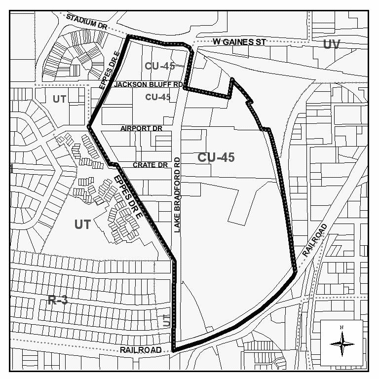
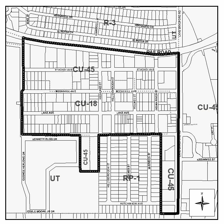
Providence Neighborhood overlay. The Providence Neighborhood Renaissance Plan adopted by the city commission by resolution 03-R-39 implements the Providence Neighborhood overlay. Properties within the Providence Neighborhood Overlay may be zoned central urban-18, central urban-26, or central urban-45 only. The Providence Neighborhood overlay, depicted on the map below, is hereby designated to specify uses that are allowed or prohibited within the overlay, as follows:
(1)
Uses in central urban-45. Allow all uses permitted in section 10-239.4, central urban-45, except for the following uses, which are prohibited:
a.
Cocktail lounge and bar;
b.
Retail package liquor;
c.
Pet day care;
d.
Hotels, motels, inns, SRO hotels, and boarding houses.
(2)
Uses in central urban-18 and central urban-26. Permitted principal uses within the Providence Neighborhood overlay zoned central urban-18 and central urban-26 are limited to the following;
a.
Residential, any dwelling unit type;
b.
Passive recreation;
c.
Active recreation limited to daytime hours;
d.
Community facilities;
e.
Daycare facilities;
f.
Personal services;
g.
Accessory uses as specified in sections 10-239.2 and 10-239.3.
All other uses are prohibited in areas within the overlay zoned central urban-18 and central urban-26.
(3)
Prohibited uses in overlay. Outdoor storage and outdoor display of merchandise overnight shall be prohibited in the overlay.
(d)
Allowable uses. For the purpose of this chapter, the following is a summary of the land use types that are allowed in the different central urban districts. The location of these uses is controlled by the development standards of each district, the comprehensive plan and schedules of permitted uses.
(1)
Low density residential.
(2)
Medium density residential.
(3)
High density residential.
(4)
Minor commercial.
(5)
Neighborhood commercial.
(6)
Community commercial.
(7)
Highway commercial.
(8)
Minor office.
(9)
Major office.
(10)
Office park.
(11)
Passive recreation.
(12)
Active recreation.
(13)
Community services.
(14)
Post secondary.
(15)
Light industrial—minor.
(16)
Light infrastructure.
(e)
List of permitted uses. See each schedule of permitted uses in subsections 10-239.1.(2) central urban-12, 10-239.2 (2). central urban-18, 10-239.3 (2) central urban-26, and 10-239.4 (2) central urban-45. In the central urban districts, permitted uses are listed by use type. Chapter 9, article III sets forth the development approval process required for allowable uses.
(f)
Development standards. In the central urban districts, specific development standards are listed within each district.
(g)
Specific restrictions. Specific restricted uses are addressed below and in article VII.
Eating and drinking establishments: No drive-in or drive-thru facilities are permitted within the central urban districts. However, drive-in facilities are permitted within the Lake Bradford Road commercial corridor as provided in this section. See subsection (b).
(Code 1984, ch. 27, § 10.3(H); Ord. No. 95-O-0025AA, 9-13-1995; Ord. No. 96-O-0033AA, § 7, 12-11-1996; Ord. No. 97-O-0027AA, §§ 6—12, 7-8-1997; Ord. No. 01-O-28AA, § 8, 10-24-2001; Ord. No. 06-O-04AA, § 3, 2-22-2006; Ord. No. 07-O-24AA, § 2, 5-23-2007; Ord. No. 08-O-19AA, § 2, 7-9-2008; Ord. No. 09-O-18, § 2, 5-27-2009)
Sec. 10-169. - Reserved.
Editor's note— Ord. No. 16-O-17, § 1, adopted October 26, 2016, repealed the former section 10-169 in its entirety, which pertained to the lake protection district, and derived from the Code of 1984, ch. 27, § 10.3(I); Ord. No. 95-O-0025AA, adopted September 13, 1995; Ord. No. 96-O-0033AA, § 7, adopted December 11, 1996; Ord. No. 97-O-0027AA, §§ 6—12, adopted July 8, 1997, and Ord. No. 06-O-03, § 1, adopted April 26, 2006.
Sec. 10-170. - Residential preservation district.
(a)
Purpose and intent.
(1)
The residential preservation district is characterized by existing homogeneous residential areas within the community which are predominantly accessible predominantly by local streets. The primary function of the residential preservation district is to protect existing stable and viable residential areas from incompatible land uses and density intrusions. Commercial, retail, office and industrial activities are prohibited in the residential preservation district (certain nonresidential activities may be permitted as home occupations—see article VII of this chapter, supplementary regulations). Single-family, duplex residences, mobile home and cluster housing may be permitted in the residential preservation district within a range of zero to six units per acre. Compatibility with surrounding residential type and density shall be a major factor in the authorization of development approval and in the determination of the permissible density. No development in the residential preservation district shall be permitted which violates the provisions of policy 2.1.1 of the future land use element of the 2010 Comprehensive Plan.
(2)
For residential preservation areas outside the urban service area the density of the nonvested development in residential preservation area shall be consistent with the underlying land use category: no more than one unit per ten acres in the rural category; no more than one dwelling unit per acre (clustered) or one dwelling unit per three acres (not clustered) in the urban fringe category. The residential preservation land use category is divided into five zoning districts based upon existing development patterns and service provision:
a.
RP-1;
b.
RP-2;
c.
RP-MH;
d.
RP-UF; and
e.
RPR.
(3)
The intent of the districts listed in subsections (2)a. through e. of this section are as follows:
a.
The RP-1 district is intended to apply to residential development in areas designated "residential preservation" on the future land use map, preserving single-family residential character, protecting from incompatible land uses, and prohibiting densities in excess of 3.6 dwelling units per acre.
b.
The RP-2 district is intended to apply to residential development in areas designated "residential preservation" on the future land use map, preserving the low density residential character of single-family, two-unit townhouse and duplex residential development, protecting from incompatible land uses, and prohibiting densities in excess of six dwelling units per acre.
c.
The RP-MH district is intended to apply to residential development in areas designated "residential preservation" on the future land use map, preserving the low density residential character of manufactured home, mobile home, and conventional single-family and duplex residential development, providing protection from incompatible land uses and intensities, and prohibiting densities in excess of six dwelling units per acre.
d.
The RP-UF district is intended to apply to residential development in areas designated as both "urban fringe" and "residential preservation" on the future land use map, preserving the low intensity residential character of conventional single-family residential and manufactured home, mobile home, development, protecting from incompatible land uses and intensities, preventing the premature development of land at intensities not supportable by existing infrastructure or services, and prohibiting densities in excess of 3.6 dwelling units per acre in platted subdivisions, one dwelling unit per acre (net) for clustered developments on unplatted lots, or one unit per three acres, for all other developments.
e.
The RP-R district is intended to apply to residential development in areas designated as both "rural" and "residential preservation" on the future land use map, preserving the very low density rural residential character of conventional single-family residential and manufactured home, mobile home, development, protecting from incompatible land uses and intensities, preventing inefficient development patterns, and prohibiting densities in excess of 3.6 dwelling units per acre in platted subdivisions, or one dwelling unit per ten acres on unplatted lots.
(4)
Applications for rezoning to any and all of the residential preservation districts shall include review to ensure compatibility with existing and surrounding residential type and density.
(b)
Allowable uses. For the purpose of this chapter, the following land use types are allowable in the RP-1, RP-2, RP-MH, RP-UF and RP-R zoning districts and are controlled by the land use development standards of this chapter, the comprehensive plan and schedules of permitted uses.
(1)
Low density residential.
(2)
Passive recreation.
(3)
Active recreation.
(4)
Community services.
(5)
Light infrastructure.
(c)
List of permitted uses. See schedules of permitted uses, subsections 10-241(a) and (b). Some of the uses on these schedules are itemized according to the standard industrial code (SIC). Proposed activities and uses are indicated in the schedules. The activity or use may be classified as permitted, restricted or permitted through special exception, or not allowed. Restricted and special exception uses must meet the criteria in article VII of this chapter. Chapter 9, article III of this Code sets forth the development approval process required for allowable uses.
(d)
Development standards. All proposed development shall meet the land use development criteria specified in subsection 10-241(b); commercial site location standards (section 10-174); buffer zone standards (section 10-177); criteria of the land development standards schedule (article IV, division 4 of this chapter); and parking and loading requirements (article VI of this chapter).
(Code 1984, ch. 27, § 10.3(J); Ord. No. 95-O-0025AA, 9-13-1995; Ord. No. 96-O-0033AA, § 7, 12-11-1996; Ord. No. 97-O-0027AA, §§ 6—12, 7-8-1997; Ord. No. 02-O-88AA, § 2, 10-23-2002)
Sec. 10-171. - University transition district.
(a)
Purpose and intent.
(1)
The university transition zoning district is intended to complement three major public post secondary educational institutions; Florida State University (FSU), including Innovation Park; Florida Agricultural and Mechanical University (FAMU); and Tallahassee Community College; allowing for land uses and activities typically required by students, faculty, and other university personnel. The district is also intended to accommodate the growth and expansion of these institutions, as well as the establishment of university-related research and development businesses and industries. The provision of student housing and prevention of housing displacement are integral to the viability of the university transition district. Another function of the university transition district is to provide for a compatible transition between the land uses and activities established within this district and the uses found in the more intensive downtown zoning district and the less intensive single-family residential zoning districts (RP-1, RP-2, R-1, R-2).
(2)
Emphasis in this division is placed upon the allowance of such complementary activities and uses as post-secondary institutional, high density residential at a density of up to 50 dwelling units per acre, neighborhood commercial, entertainment establishments, and active recreational. The location of such uses in close physical proximity maximizes opportunities for pedestrian and bicycle traffic and reduces automobile dependency and the demand for parking. Additionally, multi-family residential and mixed-use projects within the central core, as defined in the comprehensive plan, are allowed up to a 35 percent density bonus in addition to the maximum allowable 50 dwelling units per acre, subject to the provisions of sections 10-200 and 10-280.7.
(3)
It is anticipated that the provisions of the university transition district will be periodically revised and modified to reflect changes in the Florida State University and Florida Agricultural and Mechanical University master plans and the continued revisions of the downtown improvement plan.
(4)
Urban planned unit developments. Urban planned unit developments are encouraged in this district. Please see section 10-200 for detailed criteria and procedures.
(b)
Allowable uses. For the purpose of this chapter, the following land use types are allowable in the university transition zoning district and are controlled by the land use development standards of this chapter, the comprehensive plan and schedules of permitted uses. The uses are listed in order of consistency with the district intent:
(1)
Post-secondary.
(2)
High-density residential.
(3)
Neighborhood commercial.
(4)
Active recreation.
(5)
Medium-density residential.
(6)
Minor office.
(7)
Minor industrial (university research or development related).
(8)
Low-density residential.
(9)
Passive recreation.
(10)
Minor commercial.
(11)
Community services.
(12)
Light infrastructure.
(13)
Major office.
(14)
Community commercial.
(15)
Office park (no residential component).
(c)
List of permitted uses. See permitted uses, section 10-242. The activity or use may be classified as principal accessory, or permitted through special exception. Special exception uses must meet the criteria in article VII. Chapter 9, article III sets forth the development approval process required for allowable uses.
(d)
Development standards. All proposed development shall meet the land use development standards specified in subsections 10-242.5—10-242.19; and parking and loading requirements (article VI).
(e)
Specific restrictions. If uses are restricted according to the permitted use subsection, they must follow the general development guidelines for restricted uses as provided in section 10-242. Specific restricted uses are addressed in article section 10-422.
(Code 1984, ch. 27, § 10.3(K); Ord. No. 95-O-0025AA, 9-13-1995; Ord. No. 96-O-0033AA, § 7, 12-11-1996; Ord. No. 97-O-0027AA, §§ 6—12, 7-8-1997; Ord. No. 01-O-28AA, § 9, 10-24-2001; Ord. No. 05-O-57, § 9, 10-26-2005; Ord. No. 07-O-39, § 2, 11-20-2007; Ord. No. 13-O-03, § 11, 8-28-2013)
Sec. 10-172. - Industrial district—Purpose and intent; permitted and prohibited uses.
(a)
Purpose and intent.
(1)
The purpose and intent of this industrial district is to establish the appropriate location for the manufacturing, distribution, wholesaling, or storage of raw material, partially finished products or finished products characterized by one or more of the following attributes:
a.
Potential for producing detectable off-site impacts—smoke, dust, dispersion of particulate matter, noxious or odorous gases, or any other air pollution;
b.
Potential for producing detectable off-site water pollution, including thermal pollution;
c.
The storage, manufacture, processing or distribution of any radioactive waste, explosive, or flammable materials;
d.
The creation of noise or vibration not compatible with residential, agricultural, or commercial activities; or
e.
Any use generating or storing, whether temporarily or permanently, more than 1,000 kilograms of hazardous waste per month.
(2)
The industrial district will accommodate land uses that have considerable impacts upon infrastructure and utilities; particularly upon: transportation (rail and highway systems), water, natural gas, waste water treatment, and electricity. The location of the industrial district and the standards required by the industrial district will ensure that industrial uses will have access and facilities for truck and/or rail shipment, transfer, or delivery. The industrial district is not intended to facilitate the shipment, transfer, or delivery of goods via passenger automobile traffic.
(3)
The industrial district will also allow industrial parks, transportation and communication facilities, as well as the manufacture, storage, or distribution of products unlikely to cause objectionable impacts to be detected off-site. Ancillary commercial uses, such as offices, restaurants, designed and limited to serve persons working in the district are allowed. Other commercial and residential land uses are not allowed in the industrial district; they would not be compatible with the uses that the industrial district is intended for and would, in addition, have the potential to encroach upon or displace industrial uses, for which appropriate locations are at a premium.
(b)
Allowable uses. For the purpose of this chapter, the following land use type is allowed in the industrial zoning district and is controlled by the land use development standards of this chapter, the comprehensive plan, and list of permitted uses: Industrial.
(c)
Lists of permitted uses.
(1)
Permitted uses: These are the principal uses and activities allowed in the industrial zoning district. This list of uses and activities is composed, to the extent possible, of major group classifications in the Standard Industrial Code (SIC). These major group classifications are very broad; the Standard Industrial Code lists many other more specific industrial activities within these classes; unless specifically prohibited elsewhere in this section, these uses and activities are considered as permitted in this district. Other uses and activities not classified within the Standard Industrial Code, but appropriate for location within the industrial district are also listed as permitted in this district. Further information concerning what uses are considered allowable in the industrial district may be obtained by telephoning the city-county planning department. Chapter 9, article III of this Code sets forth the development approval process required for permitted, restricted, special exception, and planned unit development uses.
a.
The following uses are permitted uses:
#10 Metal mining.
#13 Oil and gas extraction.
#14 Mining and quarrying of nonmetallic minerals.
#15 Building construction—general contractors and operative builders.
#16 Heavy construction other than building construction contractors.
#17 Construction—special trade contractors.
#20 Food and kindred products—processing and manufacture.
#21 Tobacco products—processing and manufacture.
#22 Textile mill products processing and manufacture.
#23 Apparel and other finished products made from fabrics and similar materials—processing and manufacture.
#24 Lumber and wood products, except furniture—cutting, milling, sawing, production, manufacture.
#25 Furniture and fixtures—manufacture.
#26 Paper and allied products—processing and manufacture.
#27 Printing, publishing, and allied industries—publishing and publishing processes.
#28 Chemicals and allied products—production.
#29 Petroleum refining and related industries—processing, refining, manufacture.
#30 Rubber and miscellaneous plastic products—manufacture.
#31 Leather and leather products—processing and manufacture.
#32 Stone, clay, glass, and concrete products—manufacture.
#33 Primary metal industries—smelting, refining, manufacture.
#34 Fabricated metal products, except machinery and transportation equipment—fabricating.
#35 Industrial and commercial machinery and computer equipment—manufacture
#36 Electronic and other electrical equipment and components, except computer equipment—manufacture.
#37 Transportation equipment—assembly and manufacture.
#38 Measuring, analyzing, and controlling instruments; photographic, medical and optical goods; watches and clocks—manufacture.
#39 Miscellaneous manufacturing industries.
#40 Railroad transportation.
#41 Local and suburban transit and interurban highway passenger transportation.
#42 Motor freight transportation and warehousing.
#43 United States Postal Service.
#45 Transportation by air.
#46 Pipelines, except natural gas.
#47 Transportation services.
#48 Communications.
#49 Electric, gas, and sanitary goods.
#50 Wholesale trade—durable goods.
#51 Wholesale trade—nondurable goods.
#5984 Liquefied petroleum gas (bottled gas) dealers.
#7211 Commercial power laundries.
#7212 Garment pressing.
#7213 Linen supply.
#7216 Dry-cleaning plants.
#7217 Carpet and upholstery cleaning.
#7218 Industrial launderers.
#7261 Funeral services and crematories.
#7342 Disinfecting and pest control services.
#7349 Building cleaning and maintenance services.
#735 Miscellaneous equipment rental and leasing.
#7381 Armored car service; rental of dogs for protective services.
#7384 Photo finishing laboratories.
#7389 Auctioneering service on a commission or fee basis.
#7389 Automobile recovery service.
#7389 Field warehousing, not public warehousing.
#7389 Packaging and labeling service; parcel packing.
#7389 Recording studios.
#7389 Repossession service.
#7389 Water softener service.
#7389 Window tinting.
#7513 Truck rental and leasing, without drivers.
#7519 Utility trailer and recreational vehicle rental.
#966 Space research and technology.
Biological research facilities.
Chemical laboratories.
Construction material storage and construction vehicle storage.
Engineering laboratories.
Farm vehicle sales, storage, repair, auction.
Food research/testing facilities.
Incinerators.
Industrial laboratories.
Laboratories, testing of products.
Research laboratories.
Storage yards.
Testing facilities.
Truck, bus, heavy equipment garages: maintenance, repair, motor pools.
Trucking terminals.
Warehouses.
b.
The following uses are permitted as conditional uses: #7389, business services, not elsewhere classified. The commission may add additional uses within the #7389 industry number to the list of uses permitted in this district. These uses may be added through resolution of the commission so long as the use is consistent with the purpose and intent of the industrial district and would not be likely to create incompatibilities with other uses permitted in the industrial district.
c.
The following uses are permitted as accessory uses in the industrial district:
#581 Eating and drinking establishments: Allowed when located adjacent to a nonindustrial zoning district and not adjacent to any residential preservation zoning district or existing residential development, except when that development is a nonconforming land use. Such establishments may be no larger in size than 2,500 square feet; or, may be located within the interior of any permitted use.
#60 Depository institutions (banks/thrifts/credit unions, etc.): Allowed when located adjacent to a nonindustrial zoning district and not adjacent to any residential preservation zoning district or existing residential development, except when that development is a nonconforming land use. Such establishments may be no larger in size than 2,500 square feet; or, may be located within the interior of any permitted use.
#7363 Help supply services: Allowed when located adjacent to a nonindustrial zoning district and not adjacent to any residential preservation zoning district or existing residential development, except when that development is a nonconforming land use. Such establishments may be no larger in size than 2,500 square feet; or, may be located within the interior of any permitted use.
#7381 Security guard services: Allowed when located adjacent to a nonindustrial zoning district and not adjacent to any residential preservation zoning district or existing residential development, except when that development is a nonconforming land use. Such establishments may be no larger in size than 2,500 square feet; or may be located within the interior of any permitted use.
Recreational amenities: Provided as an accessory to a permitted use established within the district for use by employees, management, and their guests.
(d)
Prohibited uses. The following uses are prohibited within the industrial district:
(1)
Landfilling.
(2)
Permanent hazardous or toxic waste storage.
(3)
Deep well injection of waste products.
(4)
Biohazardous, hazardous, or toxic waste incineration.
(5)
Wholesale outlets that sell to the general public are not permissible except for materials manufactured, or warehoused on site. True wholesaling is permitted.
(Code 1984, ch. 27, § 10.3(L); Ord. No. 95-O-0025AA, 9-13-1995; Ord. No. 96-O-0033AA, § 7, 12-11-1996; Ord. No. 97-O-0027AA, §§ 6—12, 7-8-1997)
Sec. 10-173. - Same—Development standards.
(a)
Height limitations. In the industrial zoning district all measurements are from the average base elevation at ground level to highest point, except as noted.
(1)
Habitable space (measured to highest floor elevation): 150 feet.
(2)
Mechanical; water tower: 200 feet.
(3)
Antennae, transmission tower; transponder station: No limitation except, proof of notification of the Administrator of the Federal Aviation Authority is required for proposed construction or alteration of any structure of 200 feet height or greater as required per the Federal Aviation Regulations Part 77, Subchapter B.
(4)
Stack height limitations: 275 feet. A waiver may be obtained if following criteria are met: (i) The height demonstrated by a fluid model or field study required and approved by the Environmental Protection Agency, or the department of environmental regulation which ensures that the emissions from a stack do not result in excessive concentrations of any air pollutant as a result of atmospheric downwash, wakes, or eddy effects created by the source itself, nearby structures, or nearby terrain features ("nearby" shall be defined as per F.A.C. ch. 62-2); and (ii) proof of notification of the Administrator of the Federal Aviation Authority of proposed construction or alteration of any structure of 200 feet in height or greater as required per the Federal Aviation Regulations, Part 77, Subchapter B.
(b)
Setbacks and yard requirements. Setbacks and yard requirements in the industrial zoning district shall be as follows:
(1)
Structures fronting, having a corner side adjacent to or otherwise adjoining streets or roadways that form zoning district boundaries shall be located no less than 50 feet from the property line along such roadway.
(2)
Structures fronting on all other streets intended for public access shall be setback at least 20 feet from the property line along that street/roadway.
(3)
Side setbacks from all other roadways/streets intended for public access should be setback at least 20 feet from the property line along such street/roadway.
(4)
Access facilities intended primarily for loading/delivery of goods/materials and not to provide access by employees, customers and the general traveling public shall not be considered streets/roadways for the purpose of subsections (a)(1), (2) and (3) of this section. Setbacks from such roadway/access facilities shall be sufficient to provide safe access.
(5)
The required setback in all other instances shall be at least eight feet from the nearest property line.
(c)
Minimum lot size. The minimum lot size in the industrial zoning district shall be 3,000 square feet.
(d)
Minimum lot frontage. The minimum lot frontage in the industrial zoning district shall be 30 feet.
(e)
Minimum lot coverage. All development in the industrial zoning district shall conform with applicable landscaping and natural area requirements and standards set forth in the EMO.
(f)
Maximum floor area ratio. Development in the industrial zoning district shall not be required to adhere to a maximum floor area ratio.
(g)
Open space standards. All development in the industrial zoning district shall comply with applicable open space requirements and standards set forth in the EMO.
(h)
Landscaping standards; visibility from other districts.
(1)
Buffering within the interior of the zoning district is not required; the provisions of section 10-177 are not applicable within the district. This district is intended to foster development of industrial uses and is not intended to protect nonindustrial uses from industrial uses.
(2)
Except in those instances described in subsection (h)(3) of this section, land uses in this district shall be required to place buffering between the industrial district land use and the adjoining land use consistent with the standards depicted in section 10-177.
(3)
Land uses in this district adjacent to another zoning district which is undeveloped shall be required to place buffering to at least type C standards (see section 10-177) between the industrial land use and the adjoining district at the time of permitting of the industrial use.
(i)
Parking requirements. For parking requirements in the industrial zoning district see article VI of this chapter.
(j)
Expansion of the district. Land shall be added to the industrial zoning district through rezoning only upon the simultaneous and concurrent amendment of the future land use map of the comprehensive plan to reflect the designation of additional land for industrial use. Additional land may be added to the industrial zoning district only upon the satisfaction of one of the two following requirements:
(1)
The land to be added is adjacent to present district boundaries; or,
(2)
The area to be included is at least 60 acres in size.
The location of new industrial zoning district areas shall be based upon the following criteria: access to electric, natural gas, central water, and central sewer infrastructure; access to the Tallahassee Regional Airport, Interstate 10, rail service, or arterial highways; proximity to institutions of higher learning; proximity to the source of raw product or natural resource; proximity to employment force; low potential for environmental degradation (little or no anticipated impacts upon established biological communities and any "listed" species, minimal need for topographic changes, limited potential for adverse human health impacts); and, minimal potential for creating land use incompatibilities with existing or proposed development.
(Code 1984, ch. 27, § 10.3(M); Ord. No. 95-O-0025AA, 9-13-1995; Ord. No. 96-O-0033AA, § 7, 12-11-1996; Ord. No. 97-O-0027AA, §§ 6—12, 7-8-1997; Ord. No. 01-O-28AA, § 13, 10-24-2001)
Sec. 10-174. - Commercial site location standards.
The provisions of this section are not applicable to the following zoning districts: RA, R-1, R-2, R-3, R-4, R-5, MH, MR-1, MR, OR-1, OR-2, OR-3, OA-1, C-1, C-2, CM, CP, all CU districts, UP-1, UP-2, M-1, IC, OS, PD, PUD, DRI and UT. Commercial sites are determined through the use of site location standards. The intensity of the commercial use is dependent upon the land use category of the potential site and the classification of the immediate adjacent roads. Individual road classifications are depicted on map 14 of the 2010 Comprehensive Plan. The site location standard is intended to group commercial land use toward intersections to provide access and prevent strip commercialization.
(1)
Commercial classifications.
a.
Minor commercial:
1.
Major function: Provide for sale of convenience goods and services to immediate residential area.
2.
Location:
i.
On or near the intersection (within 330 feet of the centerline of the intersection) of local and collector, local and arterial, collector and arterial, arterial and arterial; or
ii.
May be located within planned unit development provided it is located and designed to meet commercial needs of the majority of the residents of the development.
iii.
If on a local street, only one quadrant of the intersection shall be used for commercial purposes.
3.
Trade area: Generally within one mile and not considered as an attractor.
4.
Design standards:
i.
Compatible with adjacent uses.
ii.
Adequate buffering, screening, landscaping and architectural treatment if integrated into the neighborhood.
iii.
Sufficient parking; properly designed and safe internal traffic circulation.
b.
Neighborhood commercial:
1.
Major function: Provide for the sale of convenience goods and personal services such as food, drugs, sundries and hardware items to one or more neighborhoods.
2.
Leading tenants: Supermarket, drugstore and postal substation.
3.
Location: At the intersection of major collector and arterial or arterial and arterial. Only one neighborhood commercial development will be allowed within one-quarter mile of the centerline of the intersection of a major collector and arterial road.
c.
Community commercial:
1.
Major function: Same functions of neighborhood commercial but on a large scale. Provide for sale of retail goods such as clothing, variety items, appliances and furniture, hardware and home improvement items.
2.
Leading tenants: Supermarket, drug store, minor department store, home improvement center, variety or discount center.
3.
Location: Within one-quarter mile of the centerline of the intersection of arterials. Prohibited on designated canopy roads.
4.
Radius of trade area: Five miles or 15 to 20 minutes driving time. Service distinct geographical quadrants of three or more combinations of neighborhoods within the community.
d.
Regional commercial:
1.
Major function: Same functions of community center, provide full range and variety of shopping goods for comparative shopping such as general merchandise apparel, furniture and home furnishings.
2.
Leading tenants: One or more full-time department stores.
3.
Location: Integrated into local transportation system and accessible by combination of arterials, major collectors, expressways and interstate highways. Potential on-site and off-site transportation improvements needed to provide adequate ingress and egress. Prohibited on designated canopy roads.
4.
Radius of trade area: Regional.
5.
Site area: Minimum 35 acres.
6.
Range of gross floor area: Over 200,000 and up to 1,000,000 square feet.
e.
Highway commercial:
1.
Major function: Provide for consumer oriented retail services designed for drive-in convenience.
2.
Leading tenants: Fast food franchise, liquor store, automotive service (i.e., oil change), and convenience stores.
3.
Location: Access via a combination of arterials or major collectors or integrated into transportation network by comprehensive ingress and egress system. Parking within rear is encouraged.
4.
Radius of trade area: May serve immediate area but relies heavily on passerby traffic.
5.
Range of gross floor area: Up to 10,000 square feet.
6.
Design standards:
i.
Adequate setback;
ii.
Aesthetic landscaping;
iii.
Rear parking.
f.
Downtown commercial:
1.
Major function: Provide for a wide variety of commercial opportunities for both working and nonworking hours within the Downtown land use category. Intended to promote downtown activities on an 18-hour basis.
2.
Leading tenants: Restaurants, retail department stores, ancillary business services and small consumer oriented shops.
3.
Location: Located within downtown land use category and accessed by combination of existing streets.
4.
Radius of trade area: Regional trade area in order to attract activities to downtown.
(Code 1984, ch. 27, § 10.3(N); Ord. No. 95-O-0025AA, 9-13-1995; Ord. No. 96-O-0033AA, § 7, 12-11-1996; Ord. No. 97-O-0027AA, §§ 6—12, 7-8-1997; Ord. No. 98-O-0028AA, §§ 3—7, 6-24-1998; Ord. No. 08-O-30, § 2, 7-9-2008; Ord. No. 09-O-18, § 2, 5-27-2009; Ord. No. 09-O-31AA, § 17, 10-29-2009)
Sec. 10-175. - Development standards.
All development within the city shall comply with the land use development standards as shown in the schedule in section 10-178. This schedule is not applicable to the following zoning districts: RA, R-1, R-2, R-3, R-4, R-5, MH, MR, MR-1, OR-1, OR-2, OR-3, OA-1, C-1, C-2, CM, CP, UP-1, UP-2, M-1, IC, OS, PD, PUD, DRI, CU-12, CU-18, CU-26, CU-45, and UT.
(Code 1984, ch. 27, § 10.3(P); Ord. No. 95-O-0025AA, 9-13-1995; Ord. No. 96-O-0033AA, § 7, 12-11-1996; Ord. No. 97-O-0027AA, §§ 6—12, 7-8-1997; Ord. No. 98-O-0028AA, §§ 3—7, 6-24-1998; Ord. No. 05-O-40AA, § 5, 7-13-2005; Ord. No. 08-O-30, § 3, 7-9-2008; Ord. No. 09-O-31AA, § 18, 10-29-2009)
Sec. 10-176. - Development patterns.
The comprehensive plan establishes development patterns within the Suburban future land use category. The chart subsections in this section show the zoning districts which were intended to implement these development patterns.
(1)
The low density residential development pattern shall be implemented through the following zoning districts: RA, R-1, R-2, R-3, R-4, R-5, MH, OS.
(2)
The low density residential office development pattern shall be implemented through the following zoning districts: OR-1, OS.
(3)
The medium density residential development pattern shall be implemented through the following zoning districts: MR, MR-1, and OS.
(4)
The suburban corridor development pattern shall be implemented through the following zoning districts: MR-1, CP, OS, IC, C-2.
(5)
The medium density residential office development pattern shall be implemented through the following zoning districts: OR-2, OS.
(6)
The medium density residential office development pattern shall be implemented through the following zoning districts: OR-3, OA-1, OS.
(7)
The village center development pattern shall be implemented through the following zoning districts: C-1, OS.
(8)
The medical center development pattern shall be implemented through the following zoning districts: CM, OS.
(9)
The urban pedestrian center development pattern shall be implemented through the following zoning districts: UP-1, UP-2, OS, C-2.
(10)
The light industrial development pattern shall be implemented through the following zoning districts: M-1, OS.
(11)
The business park development pattern shall be implemented through the following zoning districts: OR-2, PUD, OS.
(Code 1984, ch. 27, § 10.3(Q); Ord. No. 95-O-0025AA, 9-13-1995; Ord. No. 96-O-0033AA, § 7, 12-11-1996; Ord. No. 97-O-0027AA, §§ 6—12, 7-8-1997; Ord. No. 98-O-0028AA, §§ 3—7, 6-24-1998; Ord. No. 05-O-40AA, § 6, 7-13-2005; Ord. No. 09-O-11AA, § 2, 10-28-2009; Ord. No. 18-O-08, § 1, 2-28-2018)
Sec. 10-177. - Buffer zones.
(a)
Standards. The following buffering standards are intended to implement the provisions of the adopted land use development matrix and applicable policies of the comprehensive plan. Should there be a conflict between the provisions of this chapter and those of the comprehensive plan and chapter 5 of this Code, the most restrictive or that imposing the higher standard shall govern.
(1)
A buffer zone is a landscaped strip along parcel boundaries that serve a buffering and screening function between uses and zoning districts, provides an attractive boundary of the parcel or use, or as both a buffer and attractive boundary. This shall not be interpreted to mean that parcels within a planned mixed use development must meet these requirements.
(2)
The width and degree of vegetation required depends on the nature of the adjoining uses. The standards specified below prescribe the required width and landscaping of all buffer zones.
(3)
The standards for buffer zones are set out in the following illustrations that specify the number of plants required per 100 linear feet. To determine the total number of plants required, the length of each side of the property requiring a buffer shall be divided by 100 and multiplied by the number of plants shown in the illustration. The plants shall be spread reasonably evenly along the length of the buffer.
(4)
The standards of subsections (a)(1) through (a)(3) of this section shall be applied between abutting parcels as follows:
BUFFERING AND SCREENING REQUIREMENTS
KEY:
A, B, C, and D indicate accompanying landscape standards that must be used.
NR indicates that no buffering is required.
NOTES: To determine the required buffer:
(1)
Locate/Existing adjacent use on left side of table;
(2)
Locate "Land Use Code Number" of proposed use at top of table;
(3)
Read Down in row of Existing Adjacent Use in final buffer requirements.
(4)
* A buffer fence shall be provided when a Type C buffer or a 30-foot Type D buffer is required.
(5)
** A Type 2 Urban Buffer as specified in §10-285, Table 11 may be substituted for a Type D Buffer.
Landscape Standard "A"
Landscape Standard "B"
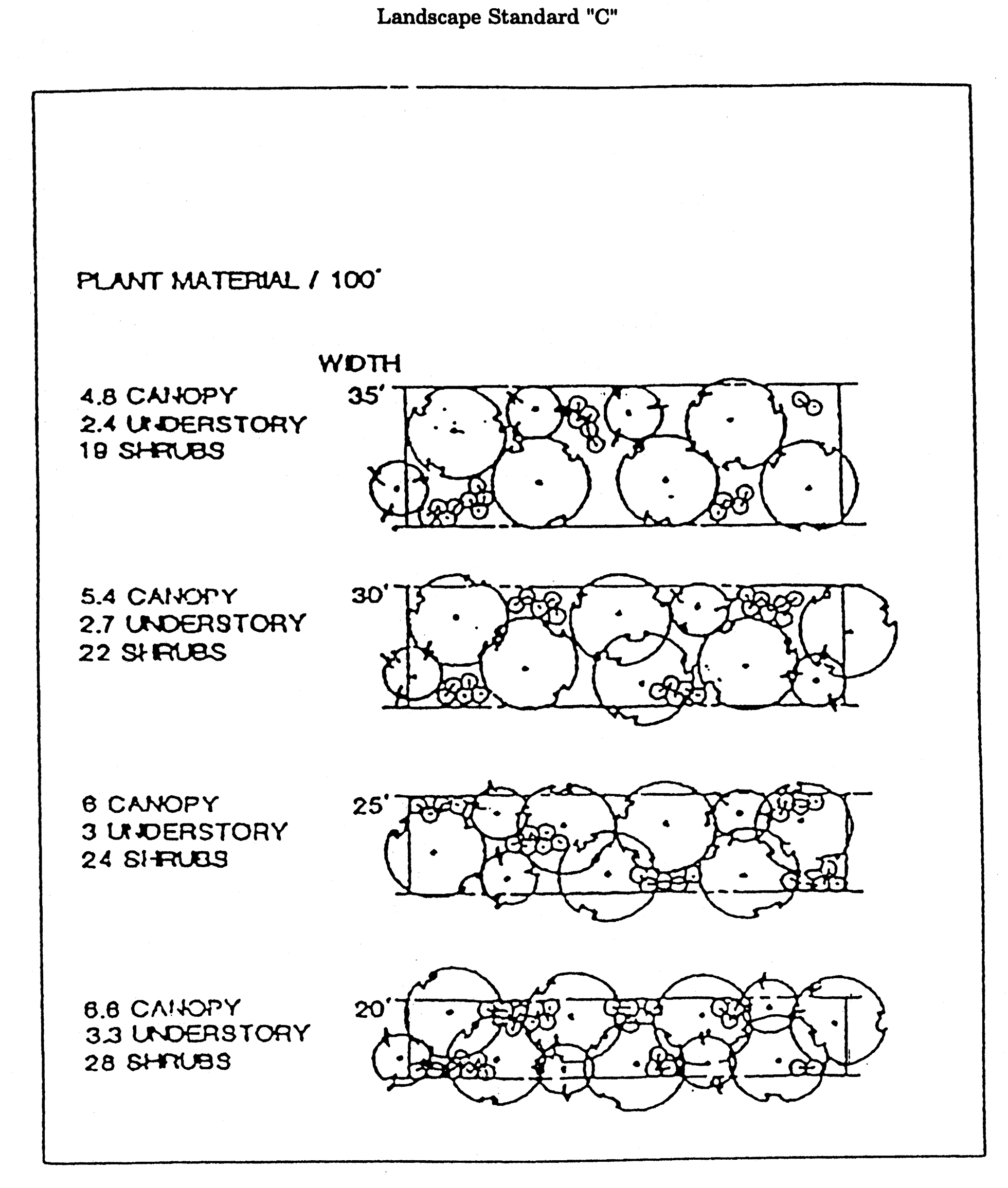
Landscape Standard "C"
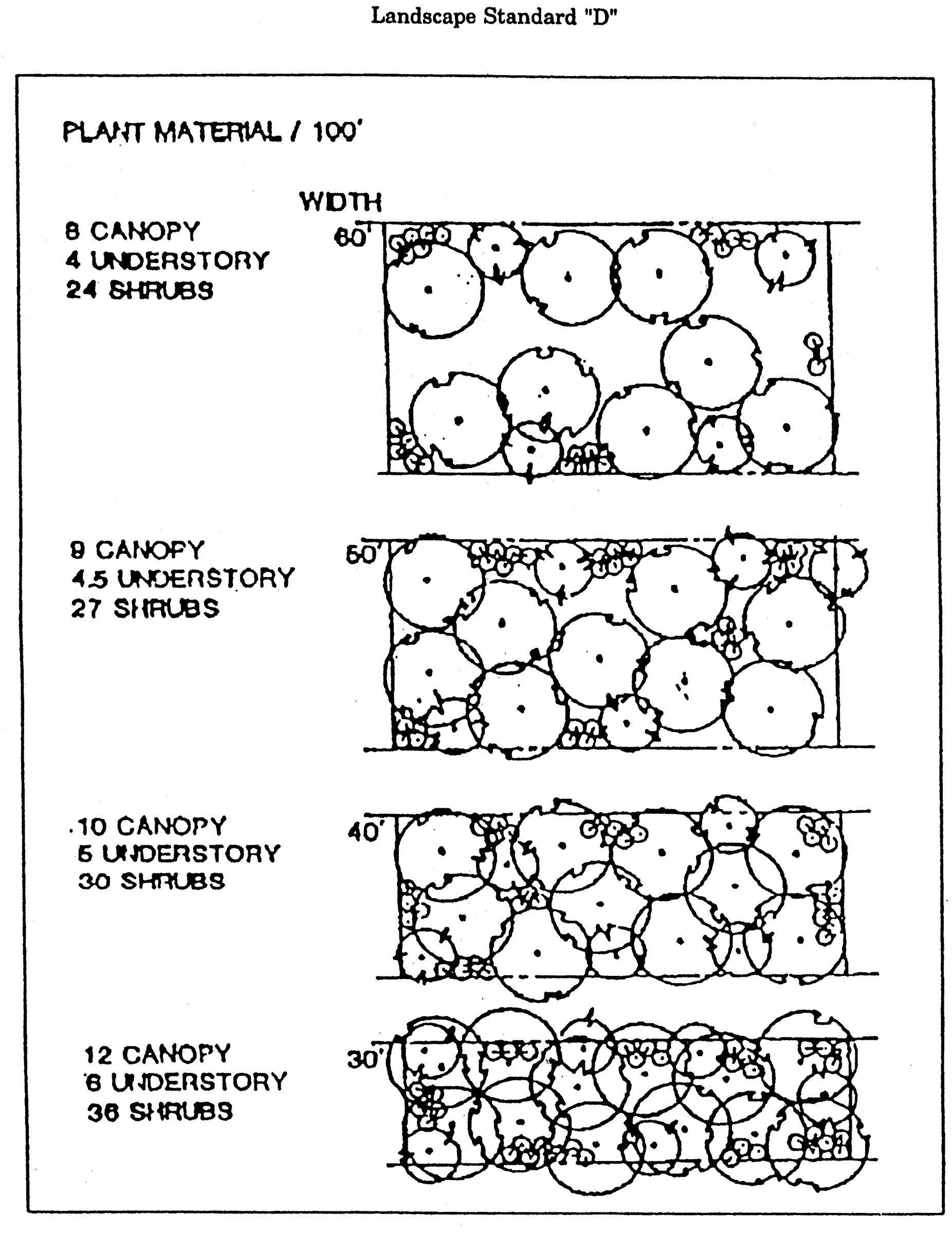
Landscape Standard "D"
(5)
Buffering for mixed use developments shall be based on the more intense use in the building or cluster of buildings.
(6)
The use of existing native vegetation in buffer zones is preferred. If a developer proposes to landscape a buffer zone with existing native vegetation, the staff forester may recommend, and the development review committee may allow, a waiver from the strict planting requirements of this section if:
a.
The waiver is necessary to prevent harm to the existing native vegetation; and
b.
The buffering and/or aesthetic purposes of the buffer zone are substantially fulfilled despite the waiver.
(7)
The desired width of a buffer zone between two parcels is the sum of the required buffer zones of the parcels. Where a new use is proposed next to an existing use that has less than the required buffer zone for that use, the lower standards will be tolerated until the nonconforming parcel is redeveloped and brought into conformity with the buffer zone requirements of this chapter. The developer of the new adjoining use is encouraged, however, to take into account the inadequacy of the adjoining buffer zone in designing the site layout of the new development.
(8)
Buffer alternative for conversions of existing structures and additions to existing structures. As an alternative to providing the landscape buffers required in subsection (a)(4) of this section, proposed conversions of existing structures (with no additions) and proposed additions to existing structures (up to a maximum of 50 percent increase from the size of the existing structure) may choose to install an opaque fence that is a minimum of six feet in height along the entire length of the property line adjoining the affected land use only if the affected adjoining site is in the same or a more intensive zoning district than the subject property. The fence shall be of a finished masonry, wood or natural plant material. For the purposes of this subsection, the relative intensity of zoning districts shall be based on the number and type of permitted uses and the maximum density/intensity allowed in a zoning district. If a question arises as to the relative intensity of zoning districts, the land use administrator shall make the final decision. If the owner of the affected adjoining site and the applicant both agree that a fence is not a desirable alternative, then a fence shall not be provided and the landscape buffer that must be provided is to the greatest extent possible that is reasonable and feasible. In order to enact this provision, written confirmation from both the owner of the adjoining site and the applicant shall be provided to the land use administrator in a form that is acceptable to the city attorney.
(b)
Use of buffer areas. No accessory structures, garbage or trash collection points or receptacles, parking or any other functional use contrary to the intent and purpose of this chapter shall be permitted in a required buffer area. This does not prohibit the combining of compatible functions such as landscaping, drainage facilities, passive recreation areas and preservation areas into an effective and beneficial multiple use of the subject land resource.
(c)
Use of native plants. Forty percent of the total number of individual plants selected from each of the categories of the list of approved species (canopy, understory, shrub, groundcover) and used to satisfy the requirements of this chapter shall be selected from the list of native species in the category.
(d)
Environmental management ordinance. All development must be consistent with chapter 5 of this Code.
(e)
Determination. Determination of applicable buffering standards shall be made at the time of final disposition of the application by the entity with authority to approve the plan of development as specified in chapter 9, article IV of this Code.
(f)
Buffer fence standards. The following standards shall apply:
(1)
Whenever a buffer fence is required it shall be a minimum of eight feet in height, unless the applicant can demonstrate that the intent of this chapter will be met by a fence of lesser height under the particular circumstances.
(2)
The buffer fence installation shall be incorporated as early as possible in the sequence of construction.
(3)
The buffer fence shall be solid opaque, constructed of durable materials consistent with the materials of surrounding neighborhoods and shall include provisions for access to all landscape material.
(4)
The side of a fence facing the less intensive use shall have a finished appearance.
(5)
When residential uses buffer against other uses, the planting materials shall be located on the outside of the fence. When non-residential uses buffer against residential uses, the planting materials shall be located on the inside of the fence.
(6)
Fencing shall be maintained in perpetuity.
(g)
Additional standards for non-residential or dense residential projects adjacent to existing properties which are protected residential. For the purposes of subsection (g), the terms listed below are defined as follows:
Dense residential means a residential building on a parcel larger than one-half acre developed at a density of greater than 14 units per acre.
Protected residential means any property developed with a single-family residence, duplex, or triplex to a density of less than or equal to eight units per acre, and any vacant property that is zoned either RP-1, RP-2, RP-MH, RP-R, RP-UF, R-1, R-2, R-3, R-5, UF, LP, MH, or RA.
These additional buffer standards do not apply to non-residential or dense residential projects located across the street from properties which are protected residential.
(1)
Non-residential or dense residential uses (greater than two stories) adjacent to properties which are protected residential. Subsection (g)(1), applies to a non-residential or dense residential project which is required to obtain site plan review pursuant to sections 9-154—9-157, which is adjacent to three or more contiguous lots which are protected residential, and which is greater than two stories. The adjacency requirement is met if the proposed non-residential or dense residential use shares a common property boundary with any portion of one of the three or more contiguous lots. Such projects must meet two buffer requirements, as listed below. The planting density and planting types shall otherwise be consistent with section 10-177, (if located outside of the MMTD) or in subsection 10-284.3(a)(1) (if located inside of the MMTD).
Any project subject to the regulations contained in this paragraph shall provide the following:
a.
The buffer identified in subsection 10-177(a)(4), if located outside of the MMTD or in subsection 10-284.3(a)(1) if located inside of the MMTD; and
b.
One of the following:
(i.)
Height step back. A height step back is required and shall vary based on the first floor elevation of the non-residential or dense residential use in relation to the first floor elevation of the protected residential use as follows:
The floors identified in the table above, and each successive floor, must be each stepped back a minimum of ten feet from the floor below it where adjacent to a property which is protected residential. If other building elevations face non-residential uses, one additional floor is permitted along the non-residential uses to compensate for the density and/or intensity not permitted due to the building step back along the protected residential elevation. This standard is visually represented by the illustration titled "Height Step Back".
Height Step Back
(ii.)
Tall tree buffer. The project must provide an enhanced landscape buffer with trees chosen from the list in the table below (in lieu of trees otherwise required) that commonly grow to a minimum height of at least 50 feet and are known to succeed in an urban landscape. The trees from the list below comprise the shade tree portion of the buffer that is otherwise defined by subsection (a)(4) (if located outside of the MMTD) or in subsection 10-284.3(a)(1) (if located inside of the MMTD). Understory trees and shrubs are also required by the noted citations.
To be eligible for the tall tree buffer option, projects must provide a minimum 15-foot separation at the time of planting between the tall tree and all buildings and a minimum soil volume of 2,400 cubic feet per tree. The maximum allowable depth for calculating soil volume is three feet. The landscape plan submitted with the site plan must show the planned location of each tall tree, the 15-foot separation, and the undeveloped area committed to the soil volume requirement.
If a property owner opts to satisfy this buffer requirement by utilizing one or more of the tall trees listed in this Section, they shall maintain the tall trees so they do not present an imminent risk to human health or property. Projects that are not able to provide the minimum distance between trees and buildings and the minimum soil volume shall instead provide the height step back identified in subsection (g)(1)b.i.
Trees with Mature Minimum Height of at Least 50 Feet 1
(2)
Site grading. If a non-residential or a dense residential site is graded to reduce the elevation of the developed portion of site below an adjacent property which is protected residential, the perimeter landscaping shall be located as follows:
a.
The perimeter landscape buffer may be provided at the higher, pre-grading elevation;
b.
If an arborist certifies in writing that the degree of the slope, the type of soil, and the drainage patterns do not cause this option to adversely impact the viability of the buffer, the perimeter landscape buffer may start at top of the slope, with all shade trees planted at the higher, pre-grading elevation and understory trees and shrubs planted on the slope; or
c.
The perimeter landscape buffer may be provided at the lower, post-grading elevation, provided it is a tall tree buffer as defined by subsection (g)(1)b.(ii.).
This standard is visually represented by the illustration titled "Perimeter Landscaping at Graded Sites".
(3)
Subsection (g) does not apply to the following:
a.
Proposed non-residential or dense residential developments adjacent to properties which are protected residential that are currently developed and occupied by a legally existing non-conforming use; or
b.
Proposed non-residential or dense residential developments adjacent to isolated properties which are protected residential comprised of less than three units on less than three contiguous lots. For purposes of this section, "isolated" shall mean one or two residential units, which are surrounded by non-residential zoning or uses.
c.
A change of use at an existing non-residential or dense residential development, provided the change of use does not result in a more intense use that is otherwise regulated by subsection (g).
Perimeter Landscaping at Graded Sites
(Code 1984, ch. 27, §§ 13.1—13.5; Ord. No. 95-O-0025AA, 9-13-1995; Ord. No. 99-O-0058AA, § 5, 1-26-2000; Ord. No. 02-O-88AA, § 5, 10-23-2002; Ord. No. 06-O-43, § 5, 7-12-2006; Ord. No. 15-O-17AA, § 3, 8-26-2015; Ord. No. 21-O-15, § 2, 6-16-2021)
Sec. 10-178. - Development standards schedule.
DEVELOPMENT STANDARDS MATRIX
X = Land use is compatible/allowable
O = Land use is incompatible/not allowable
1 = PUD or site plan review required
2 = Planned unit development required, except for cemeteries or for religious facilities to be used solely for religious functions.
3 = Permitted where sufficient stormwater management capacity exists within the basin
4 = Consistent with equifer recharge policies contained within the conservation element
5 = Permitted only at these intersection quadrants which previously have been developed
6 = Cluster development required
7 = Intended for upper level of density range
8 = Agriculture related only
9 = No access to canopy road
10 = Office use permitted if ancillary to industrial use
11 = Intended for lower level of density range
12 = Secondary access only approved in conjunction with site plan, PUD or DRI
13 = Direct access allowed outside urban service area or on previously platted lot
14 = Primary access is canopy road permitted only when alternate access in non-canopy roads is unavailable. Primary access shall be restricted to one driveway designed to mitigate impacts. Planned development required for approval.
15 = Commercial restricted to 50,000 sq. ft.
16 = Commercial limited to one quadrant of the intersection
A = An incompatible land use may be permitted with an adequate buffer when its incompatibility with an adjoining land use is along rear property lines. This does not apply to heavy industrial adjoining residential.
B = Nonresidential uses permitted on all streets and intersections designated as non/residential streets.
C = Applies to the specific environmentally significant area on site and the plan requires site specific assessment of development impact on endangered, threatened, and species of special concern (plants and animals).
D = This portion of the matrix does not apply when existing land use is nonconforming.
E = May be waived pursuant to comprehensive plan land policy 3.1.5 or if commercial contained within mixed PUD or DRI development
F = See transportation policy 1.6.4.
G = Not applicable to properties internal to the activity center district.
H =Access for non-residential uses is prohibited to any local street within a recorded or unrecorded residentially platted subdivision in the activity center. Access is permitted to other local streets and all other streets internal to the activity center.
NA = Not applicable
* = To be used in conjunction with zoning map and applicable standards contained within this Code.
MATRIX DOES NOT APPLY TO AREAS DESIGNATED BRADFORDVILLE MIXED USE, CENTRAL URBAN, PLANNED DEVELOPMENT, VILLAGE MIXED USE, SUBURBAN, URBAN RESIDENTIAL 2, DOWNTOWN, AND UNIVERSITY TRANSITION ON THE FUTURE LAND USE PLAN MAP.
(Code 1984, ch. 27, § 10.3; Ord. No. 95-O-0025AA, 9-13-1995; Ord. No. 01-O-28AA, § 11, 10-24-2001; Ord. No. 08-O-30, § 4, 7-9-2008; Ord. No. 09-O-18, § 2, 5-27-2009)
Sec. 10-179. - Mahan Corridor Ring District and Mahan Corridor Node District.
(a)
Purpose and intent. The Land Use Element of the Tallahassee-Leon County Comprehensive Plan establishes the Mahan Gateway Node future land use map category on the future land use map. The following zoning districts are permitted and are applicable within the Mahan Drive Corridor Study Area (as defined within the Tallahassee Leon County Comprehensive Plan) and also within the Mahan Gateway Node Comprehensive Plan Future Land Use Map category:
(1)
Mahan Gateway Node future land use map category:
a.
Mahan Corridor Ring District (MCR);
b.
Mahan Corridor Node (MCN)
(2)
Reserved.
The Residential Acre (RA), Residential Preservation (RP1 and RP2) and Single-and Two-Family Residential (R-3) zoning districts do not implement the Mahan Gateway Node future land use map category and may not be expanded within this future land use map category. Expansion of these zoning districts shall require a comprehensive plan future land use map amendment. The intent of the Mahan Corridor Ring and the Mahan Corridor Node zoning districts is further established in sections 10-268 and 10-269.
(b)
List of permitted uses. See schedules of permitted uses in sections 10-268 and 10-269 subsections 2 and 3. Proposed activities and uses are indicated in these schedules found in subsections 10-268 and 10-269. Chapter 9, article III sets forth the development approval process required for allowable uses.
(c)
Development standards. All proposed development shall meet the land use development criteria specified in subsections 10-268 and 10-269; commercial site location standards (section 10-174); buffer zone standards (section 10-177); criteria of the land development standards schedule (article IV, division 4 of this chapter); parking and loading requirements (article VI of this chapter); and site lighting requirements (section 10-427).
(d)
Specific restrictions. If uses are restricted according to the schedule of permitted uses, they must follow the general development guidelines for restricted uses as provided in articles IV and V of this chapter.
(Ord. No. 07-O-15, § 7, 3-28-2007; Ord. No. 10-O-49AA, § 5, 2-23-2011)
Editor's note— Ord. No. 10-O-49AA, § 5, adopted February 23, 2011, changed the title of section 10-179 from "Mahan Residential Corridor District and Mahan Residential Corridor Node District" to "Mahan Corridor Ring District and Mahan Corridor Node District." The historical notation has been preserved for reference purposes.
Sec. 10-180. - Neighborhood boundary office.
1.
Purpose and intent. The purpose and intent of this district is to provide minor office opportunities and higher intensity residential land uses up to a maximum of eight dwelling units per acre. The district is intended to be located on the edges of existing or planned single-family neighborhoods fronting on arterial and collector roadways and provides a transition between the residential development and more intensive development. This zoning district is not intended to be applied to the interior of an existing neighborhood nor in areas designated as lake protection on the future land use map of the comprehensive plan, the provisions of this district are intended to allow higher density residential development and non-residential development that is compatible in scale and design with adjoining residential neighborhoods. The maximum amount of non-residential square footage allowed per acre is 10,000 square feet, but additional criteria may further limit that amount. Design guidelines applicable to this district may include building orientation, lighting criteria for non-residential use, street vehicular access requirements, fencing, buffering, and screening requirements, signs, noise source restrictions, and solid waste container restrictions.
2.
Allowable uses. For the purpose of this chapter, the following land use types are allowable in this zoning district and are controlled by the land use development standards of this chapter, the comprehensive plan and schedules of permitted uses.
a.
Low density residential.
b.
Minor office.
3.
List of permitted uses. See schedules of permitted uses, section 10-266. commercial and industrial uses are not permitted. Permitted residential and office activities are indicated in the subsection. The activity or use may be classified as principal, accessory, restricted, or permitted through special exception, or not allowed. Restricted and special exception uses must meet the criteria in article VII of this chapter. Chapter 9, article III sets forth the development approval process required for allowable uses.
4.
Development standards. All proposed development shall meet the land use development criteria specified in subsections 10-266(4)—(13); buffer zone standards (section 10-177); and parking and loading requirements (article VI of this chapter).
5.
Specific restrictions. If uses are restricted according to the schedule of permitted uses, they must follow the general development guidelines for restricted uses as provided in articles IV and V of this chapter.
(Ord. No. 03-O-58, § 3, 12-10-2003; Ord. No. 10-O-14AA, § 4, 2-23-2011)
Editor's note— Ord. No. 10-O-14AA, § 4, adopted February 23, 2011, redesignated the former section 10-202 as section 10-180. The historical notation has been preserved for reference purposes.
Sec. 10-181. - Neighborhood boundary 1 zoning district.
1.
Purpose and intent. The comprehensive plan establishes development patterns within the Neighborhood Boundary future land use category. The Neighborhood Boundary 1 (NB-1) district is intended to be located in areas designated as Neighborhood Boundary on the future land use map of the comprehensive plan and only within the Multi-Modal Transportation District. NB-1 districts shall either serve as a buffer between residential development and more intensive development, or be used to establish mixed-use corridors, or nodes, with neighborhood-scale, non-residential uses and a variety of residential uses where identified in a city coordinated placemaking, sense of place, neighborhood, or sector plan. The maximum gross density allowed for new residential development in the NB-1 district is 18 dwelling units per acre. The maximum gross intensity allowed for new non-residential development is 20,000 square feet per acre. Building footprints for non-residential uses shall be limited to 5,000 gross square feet.
2.
Allowable uses. The NB-1 district is designed to allow low- and medium-density residential, and non-residential development scaled to serve the surrounding neighborhood such as limited retail, office, and community services. To prevent negative impacts from increased vehicular traffic, auto-oriented uses, such as gas stations or drive-through facilities are prohibited.
3.
List of permitted uses. See schedules of permitted uses, section 10-272. Permitted residential and non-residential activities are indicated in the subsection. The activity or use may be classified as principal, accessory, restricted, or permitted through special exception, or not allowed. Restricted and special exception uses must meet the criteria in article VII of this chapter. Chapter 9, article III sets forth the development approval process required for allowable uses.
4.
Development standards. All proposed development shall meet the land use development criteria specified in section 10-272; buffer zone standards (section 10-177); and parking and loading requirements (article VI of this chapter).
5.
Specific restrictions. If uses are restricted according to the schedule of permitted uses, they must follow the general development guidelines for restricted uses as provided in articles IV and V of this chapter.
(Ord. No. 20-O-28, § 1, 2-24-2021)
Sec. 10-196.- Generally.
(a)
Downtown Tallahassee is intended to be a hub of activity for various uses. The purpose of the Downtown Overlay is to clearly demarcate the downtown, remove barriers for high density and intensity development, and provide pedestrian-oriented urban design standards.
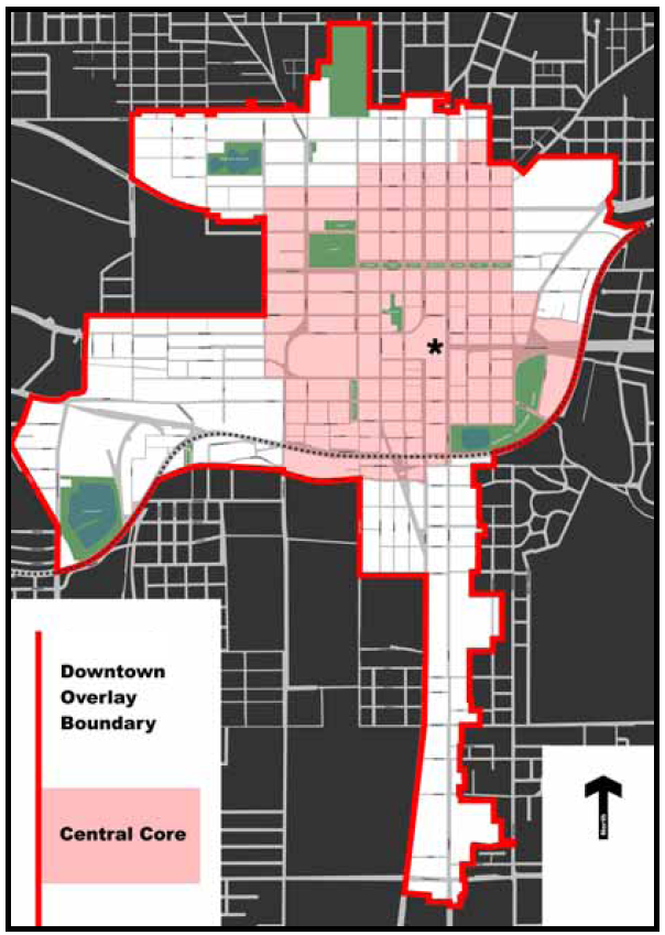
(b)
The following zoning districts are found only within the Downtown Overlay:
1.
CC Central Core.
2.
SCD Special Character District.
3.
ASN-A All Saints Neighborhood Infill/Low Intensity.
4.
ASN-B All Saints Neighborhood Infill/Moderate Intensity.
5.
ASN-C All Saints Neighborhood Corridor Mixed Use District.
6.
ASN-D All Saints Neighborhood Civic Center Corridor Mixed Use District.
7.
UV University Urban Village.
(c)
Specific areas within the Downtown Overlay are subject to review by the planning department. The design review districts promote the conservation, enhancement, and continued vitality of areas of the city with special scenic, architectural, or cultural value, or neighborhood character. This is achieved through the creation of design review districts, development of design guidelines, and requiring design review. In addition, design review ensures that certain types of infill development will be compatible with the neighborhood and enhance the area. The following areas are design review districts:
1.
ASN-A All Saints Neighborhood Infill/Low Intensity.
2.
ASN-B All Saints Neighborhood Infill/Moderate Intensity.
3.
ASN-C All Saints Neighborhood Corridor Mixed Use District.
4.
ASN-D All Saints Neighborhood Civic Center Corridor Mixed Use District.
5.
UV University Urban Village.
6.
Those blocks bounded by Tennessee Street to the north, Macomb Street on the east, Copeland Street on the west, and Madison Street on the south.
(d)
All properties within the Downtown Overlay will be regulated as follows:
1.
The density and permitted uses shall be regulated through the individual zoning districts.
2.
The development and design standards for all properties within the overlay shall adhere to the section 10-282.1 Downtown Regulating Plan map series and other applicable sections of division 4 of this chapter.
3.
Development within the Downtown Overlay shall be eligible for density and intensity bonus provisions of section 10-280.7.
(e)
Additionally, properties within the Downtown Overlay may be rezoned to an Urban PUD pursuant to the requirements of section 10-200 with the following exception:
1.
The area bounded by Tennessee Street on the north, Macomb Street on the east, Copeland Street on the west, and Madison Street on the south is not eligible for Urban PUD zoning.
(Code 1984, ch. 27, § 10.3(O); Ord. No. 95-O-0025AA, 9-13-1995; Ord. No. 96-O-0033AA, § 7, 12-11-1996; Ord. No. 97-O-0027AA, §§ 6—12, 7-8-1997; Ord. No. 98-O-0028AA, §§ 3—7, 6-24-1998; Ord. No. 02-O-43AA, § 2, 7-10-2002; Ord. No. 03-O-10AA, § 3, 2-26-2003; Ord. No. 04-O-43AA, § 11, 6-23-2004; Ord. No. 05-O-16AA, §§ 9, 10, 3-30-2005; Ord. No. 08-O-11, §§ 2, 3, 3-26-2008; Ord. No. 10-O-14AA, § 5, 2-23-2011; Ord. No. 13-O-03, § 12, 8-28-2013; Ord. No. 15-O-04, § 10, 5-27-2015)
Sec. 10-197. - Central Core District.
See the following chart for district intent, permitted uses, and notes for the Central Core Zoning District:
(Ord. No. 10-O-14AA, § 5, 2-23-2011; Ord. No. 16-O-05, § 2(Exh. A), 5-18-2016; Ord. No. 23-O-41, § 1, 12-13-2023)
Editor's note— Ord. No. 10-O-14AA, § 5, adopted February 23, 2011, amended section 10-197 in its entirety to read as herein set out. Formerly, section 10-197 pertained to the RO targeted retail/office growth area, and derived from the Code of 1984, ch. 27, § 10.3(O)(1); Ord. No. 95-O-0025AA, adopted September 13, 1995; Ord. No. 03-O-10AA, § 4, adopted February 26, 2003, and Ord. No. 05-O-57, § 7, adopted October 26, 2005.
Sec. 10-198. - Reserved.
Editor's note— Ord. No. 10-O-14AA, § 5, adopted February 23, 2011, repealed the former section 10-198 in its entirety, which pertained to DI institutional/cultural/university transition areas, and derived from the Code of 1984, ch. 27, § 10.3(O)(2); Ord. No. 95-O-0025AA, adopted September 13, 1995; Ord. No. 01-O-28AA, § 10, adopted October 24, 2001; Ord. No. 03-O-10AA, § 5, adopted February 26, 2003; Ord. No. 05-O-57, § 8, adopted October 26, 2005, and Ord. No. 08-O-11, § 4, adopted March 26, 2008.
Sec. 10-199. - SCD, Special Character District.
See the following chart for district intent, permitted uses, and notes for the Special Character District zoning district:
(Code 1984, ch. 27, § 10.3(O)(3); Ord. No. 95-O-0025AA, 9-13-1995; Ord. No. 96-O-0033AA, § 7, 12-11-1996; Ord. No. 10-O-14AA, § 5, 2-23-2011)
Sec. 10-200. - Urban planned unit development zoning district.
(a)
Purpose and intent of district. An urban planned unit development (U-PUD) zoning district is intended to provide a method by which proposals for high-quality urban developments, which are not provided for or allowed in the zoning districts may be evaluated. The procedures of this district retain the city commission's authority to establish appropriate limitations and regulations to protect the public health, safety, and general welfare, and promote the goals and objectives of the downtown plan and central core. The U-PUD district is intended to:
(1)
Encourage infill and rehabilitation of existing urban areas with readily available services and infrastructure.
(2)
Promote more efficient and economic uses of land, while respecting historic context and landscape features.
(3)
Encourage land uses that reduce transportation needs and that conserve energy and natural resources to the maximum extent possible. Emphasis shall be placed on the integration of mass-transit with new projects.
(4)
Encourage a pedestrian-friendly environment. Emphasis is placed on street level commercial and/or cultural activity along streets where there is heavy pedestrian activity or such activity can be created through appropriate urban design, land use mixture, and transportation facility design. To emphasize the pedestrian oriented character of the district, project entrances will open on to public streets and public walkways.
(5)
Encourage institutional, cultural, office, residential and retail uses in mixed-use development, capable of supporting 18-hour activity in a lively urban setting. Emphasis is placed on the allowance of such complementary activities as high-density residential, neighborhood commercial, and entertainment. The location of such uses in close proximity of each other maximizes opportunities for pedestrian, transit, and bicycle traffic, reducing the need for automobile dependency and the demand for parking.
(6)
Preserve to the greatest extent possible, and utilize in a harmonious fashion, mature trees on the site.
(7)
In addition to the above, adjacent to special character districts (SCD) or properties listed on the national register of historic places, protect the existing scale and architectural character of historic buildings and streets, maintaining in new, compatible buildings, the scale and architectural context of the district and/or surrounding historic properties. A list of properties on the national and local registers of historic places can be obtained from the Tallahassee Trust for Historic Preservation. Consideration of existing scale and architectural context shall be given to properties determined eligible for listing on the national and/or local register of historic places by the Tallahassee-Leon County Architectural Review Board.
(b)
Review criteria. In addition to the above, projects proposed for U-PUD, zoning shall be evaluated by the following criteria. The application narrative shall describe how the concept plan addresses these six criteria:
(1)
Building design shall contribute to making and perceiving downtown and surrounding central core areas as a pattern of spaces and structures rather than a series of unrelated buildings and streets. Projects shall continue an appropriate urban pattern where one is in place; where a pattern is not apparent or inappropriate to an urban setting, projects shall establish high-quality precedent and urban context for future development to follow.
(2)
Height shall be evaluated on a parcel-by-parcel basis, considering the context of the surrounding development and plans and studies for the downtown and central core that have been approved by the city commission.
(3)
Buildings shall replicate the setbacks of existing buildings to create a consistently developed edge, to reinforce the established pattern of development, and to enhance pedestrian orientation. Where existing setbacks coincide with the right-of-way line, active street-level uses shall open into the pedestrian zone.
(4)
On-site parking for nonresidential uses shall be minimized. Use of joint parking facilities for residential and nonresidential uses is encouraged. On-site parking, loading areas, and utilities shall not impair the overall character of the streetscape or pedestrian orientation; and shall meet the design and architectural standards of this chapter. Public parking facilities may be considered under this subsection if it is determined that the overall character of the streetscape is not impaired by such a use and if the facility meets the design and architectural standards of this subsection, including the requirement for active, non-residential street level uses.
(5)
Vehicular access shall not impede pedestrian safety or comfort. Use of alleys and joint drives is encouraged. Projects requiring new street access shall demonstrate why existing access is insufficient and shall also demonstrate how the new access will ensure pedestrian safety and comfort.
(6)
When located within areas designated downtown on the future land use map, project design shall contribute to the area's visual context in a manner that is consistent with the downtown plan. In areas designated Central Urban and University Transition, project design shall promote an attractive pedestrian-oriented urban center that facilitates development of a mixture of compatible medium and high density and intensity land uses.
(7)
Character elements and amenities that shall be considered in determining whether the project design contributes to the public realm include the following:
a.
Use of high quality natural materials, authenticity, and craftsmanship.
b.
Relation to the existing context in building materials, color, massing of building forms, spacing between buildings, and relative proportions of facade openings.
c.
Creates building mass that relates to the scale of the street and steps down to the elevation of streets, enlivens the sidewalk environment and avoids the use of retaining walls (except where historic retaining walls currently exist).
d.
Sculpts and light the tops of towers to reduce the effect of a row of flat-topped high-rises on the skyline. Fluorescent lighting is prohibited on building facades.
e.
Organizes facades into clearly defined base and upper stories with strong horizontal elements separating the two.
f.
Maintains ground floor transparency appropriate to use. All ground floor uses should open to the pedestrian zone in ways appropriate to use. Blank walls or rows of parking facing the street are not allowed.
g.
Utilizes sidewalk coverings in the form of awnings, canopies, galleries, or other similar treatments.
h.
Creates through-block connections via exterior or interior plazas, publicly accessible pedestrian walkways, lobbies, and atria.
i.
Incorporates streetscape, including a regular pattern of street trees and grates, patterned paving, lighting, fountains, sculpture, and seating. The highest quality street furniture and streetscape reasonably affordable should be used.
j.
Provides covered mass-transit stops may be required at the discretion of the Taltran director or their designee. The design of transit stops shall be reviewed with the proposed U-PUD.
(c)
Eligibility. The U-PUD district is designed to allow an applicant to submit a proposal for consideration, for any uses or any mixture of uses that are consistent with the comprehensive plan and subsection (d), and to allow the city commission to approve any proposal which it determines to be in the best interest of the public health, safety, and welfare, and which meets the intent of this section, along with any conditions or requirements or limitations thereon to meet the intent of the comprehensive and downtown plans. The approval of U-PUD rezoning requests rests with the city commission. However, no rezoning to an U-PUD zoning district shall be eligible for approval unless the following minimum conditions are met:
(1)
Applicability. A U-PUD may only be approved within areas within the Downtown Overlay, one of the Central Urban districts, University Transition (UT). A U-PUD shall not be allowed within the Gaines Street revitalization area, the Special Character District (SCD), or those blocks noted in section 10-196(e)1.
(2)
Configuration of the U-PUD zoning district. The tract(s) of land that may be rezoned to U-PUD shall be contiguous, and shall have sufficient width and depth to accommodate the proposed use.
(3)
Unified control/ownership. All land included for the purpose of development within a U-PUD district shall be owned by or be under the complete control of the applicant for such zoning designation, whether the applicant be an individual, partnership, corporation, other entity, group, or agency. The applicant shall provide the city all of the necessary documents and information that may be required by the city attorney to assure the city that the development project may be lawfully completed according to the plans sought to be approved. No application shall be considered until the requirements of this section have been fully met.
(4)
Minimum size. There are no minimum size requirements for a U-PUD district.
(d)
Permitted uses. U-PUDs within the Central Core may allow any use that is consistent with the Future Land Use category and district intent, including, but not limited to:
(1)
Residential: All types of residential uses shall be allowed.
(2)
Manufacturing (permitted only as an accessory use for a permitted commercial use):
25 Furniture and fixtures
27 Printing and publishing
283 Drugs
342 Cutlery, hand tools, and hardware
365 Household audio and video equipment
381 Search and navigation equipment
382 Measuring and controlling devices
384 Medical instruments and supplies
385 Ophthalmic goods
386 Photographic equipment and supplies
387 Watches, clocks, watchcases and parts
391 Jewelry, silverware, and plated ware
393 Musical instruments
394 Toys and sporting goods
395 Pens, pencils, office and art supplies
396 Costume jewelry and notions
(3)
Community facilities related to residential uses, including religious facilities, police/fire stations, post offices, libraries and elementary, middle and high schools, are allowed. Other community facilities may be allowed in accordance with section 10-413.
(4)
Retail uses:
523 Paint, glass and wallpaper
525 Hardware stores
526 Retail nurseries, lawn and garden supply stores
531 Department stores
533 Variety stores
539 Miscellaneous general merchandise
541 Grocery stores
542 Meat and fish markets
543 Fruit and vegetable markets
544 Candy, nut and confectionary stores
545 Dairy products stores
546 Retail bakeries
549 Miscellaneous food stores
553 Auto and home supply
56 Apparel and accessory stores
561-566, 569 Apparel, shoes and accessories
571 Home furniture and furnishings
572 Household appliances
573 Radio, television consumer electronics (including computers and software) and music stores
5736 Musical instrument stores
581 Eating and drinking places
591 Drug stores
592 Liquor stores
593 Used merchandise stores
594 Miscellaneous retail including sporting goods, books, stationery, jewelry, toys, cameras, gifts, luggage, needlework, piece goods
5961 Catalog and mail-order houses
599 Other retail stores (florists, newsstand, tobacco, optical goods, art, etc.), except gravestones, tombstones, swimming pools, hot tubs
(5)
General office, including banks/credit unions (without drive thru), doctors/dentists offices, and governmental offices shall be allowed.
(6)
Personal services:
701 Hotels and motels
721 Laundry, cleaning, and garment services (except cleaning and repair plants, which are industrial land uses)
722 Photographic studios, portrait
723 Beauty shops
724 Barber shops
725 Shoe repair and shoeshine parlors
729 Miscellaneous personal services
731 Advertising
733 Mailing, reproduction and commercial art
734 Services to dwellings and other buildings
736 Personnel supply services
737 Computer and data processing services
738 Miscellaneous business services
752 Automobile parking (lots and structures) (which comply with the intent of the DPUD language)
762 Electrical repair
763 Watch, clock, and jewelry
764 Reupholstery and furniture repair
769 Miscellaneous repair, except welding, septic tank cleaning, farm machinery
781 Motion picture production
782 Motion picture distribution
783 Motion picture theaters
784 Videotape rental
791 Dance studios
792 Theatrical productions
793 Bowling centers
794 Commercial sports, except track operations
799 Miscellaneous amusement and recreation services, except golf courses and amusements parks
805 Nursing and personal care facilities
808 Home health care services
809 Miscellaneous health and allied services
832 Individual and family social services
833 Job training
835 Child day care services
836 Residential care
839 Miscellaneous social services
841 Museums and art galleries
842 Botanical and zoological gardens
864 Civic, social, and fraternal associations
873 Research and testing services
874 Management and public relations
074 Veterinary services
0781 Landscape counseling and planning
(e)
Prohibited uses. Billboards, communication towers, and drive-thrus shall not be allowed within a U-PUD.
(f)
Density and intensity bonus. Up to 35 percent additional density/intensity may be permitted, subject to requirements of section 10-280.7.
(g)
Accessory uses and structures. Accessory uses and structures shall be governed by sections 10-411 and 10-412 of this Code.
(h)
Landscaping and urban forest standards. As part of a U-PUD application in the Central Core area, the applicant shall propose a set of landscaping and urban forest standards unique to the U-PUD. The planning commission shall review the specific amount of landscaping and urban forest proposed by the applicant on a case-by-case basis for consistency with the Comprehensive Plan. If the proposed landscape plan falls below the minimum landscaping and/or urban forest requirements as found in section 5-85, the applicant shall be required to pay a fee-in-lieu for the differential.
(i)
Submittal requirements. An application for an urban planned unit development (U-PUD) zoning district shall be the equivalent of a final planned unit development (PUD) plan. A U-PUD application shall include all information currently required for both Concept and Final PUD applications as found in section 10-165 and chapter 9, article III. Color site plans and elevations or renderings, accurately depicting the site design, scale, building design, massing, and project enhancements shall be submitted and reviewed with the application. Such drawings shall be adopted as a binding attachment to the U-PUD.
(j)
Review process. The U-PUD plan is subject to the review process outlined below:
(1)
Pre-application or post-application conference. An optional application for a pre-application or post-application conference may be submitted to the city in accordance with established policies and procedures.
(2)
Design review. Applications for a U-PUD, located in the downtown area, shall be submitted to the planning department for design review. Design review shall be limited to factors, criteria and requirements as found in this section. Following their review, the planning department shall forward a recommendation for approval, denial, or approval with conditions to the development review committee. U-PUD applications located outside the Downtown area are not subject to this requirement.
(3)
Development review committee. All applications for U-PUD shall be submitted to the development review committee for review and comment. Please note that U-PUD applications for projects located in the downtown area must be reviewed by the planning department prior to submittal to the development review committee. The development review committee shall review all U-PUD applications at a regularly scheduled meeting to determine if the application complies with the comprehensive plan and other applicable land development regulations as adopted by the city. The development review committee shall prepare an itemized list of written findings of fact, which support a recommendation of approval, approval with conditions, or denial of the U-PUD plan. The written findings of the development review committee shall be forwarded to the planning commission. Meetings of the development review committee shall be conducted in accordance with established policies and procedures.
(4)
Public notification. Public notice of the development review committee shall be given at least five calendar days in advance of the development review committee meeting by publication in a newspaper of regular and general circulation in the city and the county. In addition, written notice shall be mailed at least five calendar days in advance of the development review committee meeting to the current address (based on records of the county property appraiser's office) of each property owner within 500 feet of the project and to registered neighborhood associations. Due notice shall be given of the planning commission public hearings consistent with this Code and with the planning commission bylaws, and due notice shall be given of the city commission public hearings consistent with F.S. § 166.041(3). In cases in which formal proceedings are conducted under chapter 2, article III, division 2, subdivision II, of this Code, the notice for the public hearing held by the planning commission shall apply only to the public hearing on the recommended order from the administrative law judge.
(5)
Planning commission review. The planning commission shall review all U-PUD applications and the written findings of fact of the development review committee, and conduct a public hearing in order to formulate a recommendation to the city commission to approve, approve with conditions, or deny the development plan. The recommendation of the planning commission shall be supported by written findings of fact. Meetings of the planning commission shall be conducted in accordance with established policies and procedures. Formal proceedings before the planning commission may be requested in accordance with section 2-134.
(6)
City commission review. The city commission shall review all U-PUD applications, the recommendation and written findings of the development review committee and the planning commission, and conduct a public hearing. The city commission will then approve, approve with conditions, or deny the development plan. The decisions of the city commission shall be final and shall be supported by written findings. Meetings of the city commission shall be conducted in accordance with established policies and procedures. A U-PUD zoning district is established when a the U-PUD plan is approved by the city commission.
(k)
Revisions to urban planned unit developments. The applicant shall have 90 days from the date of the city commission meeting when final action is taken to submit a revised U-PUD to include any conditions of approval for the development plan imposed by the city commission. Any such changes shall be reviewed for acceptance by the development review committee members or their designees within ten days of receipt and shall bear the signature of the development review committee members or their designees before the U-PUD can be accepted as the approved plan. Upon written request from the applicant, one 90-day extension may be granted by the planning department director for submittal of the revised plan. Failure by the applicant to submit a revised site plan within the time frames specified in this section shall deem the U-PUD null and void.
(l)
Amendments to approved urban planned unit developments.
(1)
Major and minor U-PUD amendments. Any significant amendment to an approved U-PUD shall be reviewed as a new U-PUD. Notwithstanding this provision, the growth management director or their designee may approve minor amendments to the U-PUD if the growth management department determines that such amendments are substantially minor in nature and do not affect the overall character or intensity of the development. The criteria that the growth management department shall use to determine if the proposed changes affect the overall character of the U-PUD include, but are not limited to:
a.
A five percent or greater increase in the overall number of residential dwelling units or nonresidential building square feet;
b.
A five percent or greater decrease in the amount of acres devoted to common open space and/or natural area, or:
c.
A substantial change in the general location of the proposed land uses, including the common open space and/or natural areas.
(2)
Design or architectural changes to an approved U-PUD located in the Downtown area. All changes to approved U-PUDs located in the Downtown area shall be submitted to the planning department for review and comment. If such changes are deemed to differ significantly from the site plans, the elevations or renderings approved with the original U-PUD application, then the proposed changes shall be forwarded to the urban design committee for review and approval. Significant changes may include, but are not limited to:
a.
Deletion, addition, or redesign of major architectural elements;
b.
Revisions to building style or exterior finishes;
c.
Relocation of major site or building features such as parking areas, building entrances, public plazas, etc.
Exemptions from design review are found in section 9-182.
(3)
Design or architectural changes to an approved U-PUD located outside the Downtown area. All changes to approved U-PUDs located outside the Downtown area shall be reviewed and approved by the city commission.
(Code 1984, § 10.3(0)(3)4; Ord. No. 02-O-43AA, §§ 2, 3, 7-10-2002; Ord. No. 05-O-57, § 3, 10-26-2005; Ord. No. 09-O-18, § 3, 5-27-2009; Ord. No. 10-O-14AA, § 5, 2-23-2011; Ord. No. 13-O-03, § 12, 8-28-2013; Ord. No. 13-O-25, § 2, 10-23-2013; Ord. No. 15-O-04, § 11, 5-27-2015)
Sec. 10-201. - ASN-A All Saints Neighborhood infill/low intensity district.
(Ord. No. 04-O-43AA, § 13, 6-23-04; Ord. No. 05-O-16AA, § 12, 3-30-2005; Ord. No. 10-O-14AA, § 5, 2-23-2011)
Editor's note— Ord. No. 10-O-14AA, § 5, adopted February 23, 2011, repealed the former section 10-201 in its entirety, which pertained to the downtown retail/entertainment core overlay, and derived from Ord. No. 03-O-10AA, § 6, adopted February 26, 2003. Subsequently, the former section 10-284 was amended and redesignated as section 10-201 herein. The historical notation of section 10-284 has been preserved for reference purposes.
Sec. 10-202. - ASN-B All Saints Neighborhood infill/moderate intensity district.
(Ord. No. 04-O-43AA, § 13, 6-23-2004; Ord. No. 05-O-16AA, § 13, 3-30-2005; Ord. No. 10-O-14AA, § 5, 2-23-2011)
Editor's note— Ord. No. 10-O-14AA, § 5, adopted February 23, 2011, amended and redesignated the former section 10-285 as section 10-202 herein. The historical notation of the former section 10-285 has been preserved for reference purposes. See also editor's note at section 10-180.
Sec. 10-203. - ASN-C All Saints Neighborhood corridor mixed-use district.
(Ord. No. 04-O-43AA, § 13, 6-23-2004; Ord. No. 05-O-16AA, § 14, 3-30-2005; Ord. No. 10-O-14AA, § 5, 2-23-2011)
Editor's note— Ord. No. 10-O-14AA, § 5, adopted February 23, 2011, amended and renumbered the former sections 10-286—10-288 as sections 10-203—10-205. The historical notation has been preserved for reference purposes.
Sec. 10-204. - ASN-D All Saints Neighborhood civic center corridor mixed-use district.
(Ord. No. 04-O-43AA, § 13, 6-23-2004; Ord. No. 05-O-16AA, § 15, 3-30-2005; Ord. No. 10-O-14AA, § 5, 2-23-2011)
Note— See editor's note at section 10-203.
Sec. 10-205. - UV University Urban Village district.
(Ord. No. 05-O-16AA, § 16, 3-30-2005; Ord. No. 10-O-14AA, § 5, 2-23-2011)
Note— See editor's note at section 10-203.
Sec. 10-236.- Rural District.
The following applies to the Rural District:
(1)
Allowable uses; appropriate permit level and applicable development and locational standards.
Rural District
(2)
Maximum allowable gross square footage.*
Rural District
*Maximum 10,000 gross square feet, if located on a local street
(3)
Minimum development standards.
Rural District
(Code 1984, ch. 27, §§ 10.6.A—10.6.C; Ord. No. 15-O-17AA, § 4, 8-26-2015)
Sec. 10-237. - Urban Fringe District.
The following applies to the Urban Fringe District:
(1)
Allowable uses; appropriate permit level and applicable development and locational standards.
Urban Fringe District
(2)
Maximum allowable gross square footage.
Urban Fringe District
* Maximum 10,000 gross square feet, if located on a local street.
** Only one neighborhood commercial site (quadrant) will be permitted at the intersection of a major collector and arterial road. The maximum allowable commercial development permitted at the neighborhood commercial area located at the intersection of two major collectors is 50,000 sq. ft. g.s.l.a.
(3)
Minimum development standards.
Urban Fringe District
* This number applies to the perimeter setback only.
** Maximum percent impervious area of developable portion of site.
*** This height applies to habitable portion of an industrial structure.
(Code 1984, ch. 27, §§ 10.6.D—10.6.F; Ord. No. 15-O-17AA, § 5, 8-26-2015)
Sec. 10-238. - High Intensity Urban Activity Centers District.
The following applies to the High Intensity Urban Activity Centers Districts:
(1)
Allowable uses; appropriate permit level and applicable development and locational standards.
High Intensity Urban Activity Centers District
(2)
Maximum allowable floor area.
High Intensity Urban Activity Centers District
* Maximum 10,000 gross square feet, if located on a local street.
** Only one neighborhood commercial site (quadrant) will be permitted at the intersection of a major collector and arterial road. The maximum allowable commercial development permitted at the neighborhood commercial area located at the intersection of two major collectors is 50,000 sq. ft. g.s.l.a.
(3)
Minimum development standards.*
High Intensity Urban Activity Centers District
* Development standards for properties located within the MMTD are established within Division 4 of this Code.
(Code 1984, ch. 27, §§ 10.6.P—10.6.R; Ord. No. 09-O-31AA, § 19, 10-29-2009; Ord. No. 10-O-14AA, § 6, 2-23-2011)
Sec. 10-239. - Reserved.
Editor's note— Ord. No. 09-O-18, § 4, adopted May 27, 2009, repealed section 10-239 in its entirety, which pertained to the central urban district, and derived from the Code of 1984, ch. 27, § 10.6.S—10.6.U; Ord. No. 01-O-28AA, § 14, adopted October 24, 2001, and Ord. No. 07-O-24AA, § 4, adopted May 23, 2007.
Sec. 10-239.1. - CU-12 Central Urban District.
See the following chart for district intent, permitted uses, dimensional requirements, and notes for the CU-12 Central Urban District:
CU-12 Central Urban District
(Ord. No. 06-O-04AA, § 4, 2-22-2006; Ord. No. 10-O-14AA, § 6, 2-23-2011; Ord. No. 13-O-03, § 13, 8-28-2013)
Sec. 10-239.2. - CU-18 Central Urban District.
See the following chart for district intent, permitted uses, dimensional requirements, and notes for the CU-18 Central Urban District:
CU-18 Central Urban District
(Ord. No. 06-O-04AA, § 4, 2-22-2006; Ord. No. 08-O-19AA, § 3, 7-9-2008; Ord. No. 08-O-42AA, § 1(Exh. A), 11-25-2008; Ord. No. 10-O-14AA, § 6, 2-23-2011; Ord. No. 13-O-03, § 13, 8-28-2013; Ord. No. 15-O-09, § 2(Exh. A), 4-22-2015; Ord. No. 15-O-17AA, § 6(Exh. A), 8-26-2015)
Sec. 10-239.3. - CU-26 Central Urban District.
See the following chart for district intent, permitted uses, dimensional requirements, and notes for the CU-26 Central Urban District:
CU-26 Central Urban District
(Ord. No. 06-O-04AA, § 4, 2-22-2006; Ord. No. 08-O-19AA, § 3, 7-9-2008; Ord. No. 08-O-42AA, § 1(Exh. B), 11-25-2008; Ord. No. 10-O-14AA, § 6, 2-23-2011; Ord. No. 13-O-03, § 13, 8-28-2013; Ord. No. 15-O-17AA, § 7(Exh. B), 8-26-2015; Ord. No. 17-O-30AA, § 1, 7-19-2017; Ord. No. 23-O-41, § 1, 12-13-2023)
Sec. 10-239.4. - CU-45 Central Urban District.
See the following chart for district intent, permitted uses, dimensional requirements, and notes for the CU-45 Central Urban District:
CU-45 Central Urban District
(Ord. No. 06-O-04AA, § 4, 2-22-2006; Ord. No. 08-O-19AA, § 3, 7-9-2008; Ord. No. 08-O-42AA, § 1(Exh. C), 11-25-2008; Ord. No. 09-O-18, § 4, 5-27-2009; Ord. No. 10-O-14AA, § 6, 2-23-2011; Ord. No. 13-O-03, § 13, 8-28-2013; Ord. No. 14-O-46AA, § 1, 1-28-2015; Ord. No. 15-O-17AA, § 8(Exh. C), 8-26-2015; Ord. No. 16-O-05, § 2(Exh. A), 5-18-2016; Ord. No. 16-O-26, § 2(Exh. A), 10-26-2016; Ord. No. 18-O-25, § 1, 1-30-2019; Ord. No. 23-O-41, § 1, 12-13-2023)
Sec. 10-240. - Lake Protection District.
The following applies to the Lake Protection District:
General Notes:
1. Refer to chapter 5, environmental management for information pertaining to the regulation of environmental features (preservation/conservation features), stormwater management requirements, etc.
2. Refer to chapter 4, concurrency management for information pertaining to the availability of capacity for certain public facilities (roads, parks, etc.).
3. For cluster development standards, refer to section 10-426.
(Code 1984, ch. 27, §§ 10.6.V, 10.6.W; Ord. No. 16-O-17, § 2(Exh. A), 10-26-2016)
Sec. 10-241. - Residential preservation district.
The following applies to the Residential Preservation District:
(1)
Allowable uses; appropriate permit level and applicable development and locational standards.
Residential Preservation-1
Residential Preservation - 2
Residential Preservation-MH
Residential Preservation-UF
Residential Preservation-R
(2)
Minimum development standards. (Development standards for properties located within the MMTD are established within division 4 of this Code.)
Residential Preservation-1
Residential Preservation-2
* Zero-lot line construction permitted along common wall of townhouse dwelling units.
Residential Preservation-MH
Residential Preservation-UF
*Subsequent redevelopment, not vested per Leon County Ordinance 90-31 or not addressed by policy 2.1.9 of the future land use element of the comprehensive plan shall conform to the provisions for unplatted lots.
Residential Preservation RP-R
*Subsequent redevelopment, not vested per chapter 2, article IV, and Leon County Ordinance 90-31 or not addressed by policy 2.1.9 of the future land use element of the comprehensive plan shall conform to the provisions for unplatted lots.
(Code 1984, ch. 27, §§ 10.6.X, 10.6.Y; Ord. No. 00-O-54, § 4, 9-27-2000; Ord. No. 02-O-88AA, §§ 3, 4, 10-23-2002; Ord. No. 10-O-14AA, § 6, 2-23-2011; Ord. No. 15-O-17AA, § 9, 8-26-2015)
Sec. 10-242. - UT University Transition District.
(Code 1984, ch. 27, §§ 10.6.Z, 10.6.AA, 10.6.BB; Ord. No. 00-O-54, § 3, 9-27-2000; Ord. No. 01-O-28AA, § 15, 10-24-2001; Ord. No. 07-O-39, § 3, 11-20-2007; Ord. No. 10-O-14AA, § 6, 2-23-2011; Ord. No. 13-O-03, § 13, 8-28-2013; Ord. No. 14-O-46AA, § 1, 1-28-2015; Ord. No. 16-O-05, § 2(Exh. A), 5-18-2016; Ord. No. 23-O-41, § 1, 12-13-2023)
Sec. 10-243. - RA Residential Acre District.
The following applies to the RA Residential Acre District:
RA Residential Acre District
General Notes:
1. If central sanitary sewer is not available, non-residential development is limited to a maximum of 2,500 square feet of building area. Community service facilities are limited to a maximum of 5,000 square feet of building area or a 500-gallon septic tank. Also, refer to Sanitary Sewer Policy 2.1.12 of the Comprehensive Plan for additional requirements.
2. Refer to chapter 5, pertaining to environmental management for information pertaining to the regulation of environmental features (preservation/conservation features), stormwater management requirements, etc.
3. Refer to chapter 4, pertaining to concurrency management for information pertaining to the availability of capacity for certain public facilities (roads, parks, etc.).
4. For cluster development standards, refer to section 10-426.
(Code 1984, ch. 27, § 10.6.CC; Ord. No. 01-O-28AA, § 16, 10-24-2001; Ord. No. 09-O-06, § 4, 3-25-2009)
Sec. 10-244. - R-1 Single-Family Detached Residential District.
The following applies to the R-1 Single-Family Detached Residential District.
R-1 Single-Family Detached Residential District
General Notes:
1. If central sanitary sewer is not available, residential development is limited to a minimum of 0.50 acre lots and non-residential development is limited to a maximum of 2,500 square feet of building area. Community service facilities are limited to a maximum of 5,000 square feet of building area or a 500-gallon septic tank. Also, refer to Sanitary Sewer Policy 2.1.12 of the Comprehensive Plan for additional requirements.
2. Refer to chapter 5, environmental management for information pertaining to the regulation of environmental features (preservation/conservation features), stormwater management requirements, etc.
3. Refer to chapter 4, concurrency management for information pertaining to the availability of capacity for certain public facilities (roads, parks, etc.).
4. For cluster development standards, refer to section 10-426.
(Code 1984, ch. 27, § 10.6.DD; Ord. No. 00-O-54AA, § 4, 9-27-2000; Ord. No. 09-O-06, § 4, 3-25-2009; Ord. No. 10-O-14AA, § 6, 2-23-2011; Ord. No. 15-O-17AA, § 10(Exh. D), 8-26-2015)
Sec. 10-245. - R-2 Single-Family Detached Residential District.
The following applies to the R-2 Single-Family Detached Residential District:
R-2 Single-Family Detached Residential District
General Notes:
1. If central sanitary sewer is not available, nonresidential development is limited to a maximum of 2,500 square feet of building area. Community service facilities are limited to a maximum of 5,000 square feet if building area or a 500-gallon septic tank. Also, refer to Sanitary Sewer Policy 2.1.12 of the Comprehensive Plan for additional requirements.
2. Refer to chapter 5, environmental management for information pertaining to the regulation of environmental features (preservation/conservation features), stormwater management requirements, etc.
3. Refer to chapter 4, concurrency management for information pertaining to the availability of capacity for certain public facilities (roads, parks, etc.).
4. For cluster development standards, refer to section 10-426.
(Code 1984, ch. 27, § 10.6.EE; Ord. No. 00-O-54AA, § 4, 9-27-2000; Ord. No. 09-O-06, § 4, 3-25-2009; Ord. No. 10-O-14AA, § 6, 2-23-2011; Ord. No. 15-O-17AA, § 11(Exh. E), 8-26-2015)
Sec. 10-246. - R-3 Single and Two-Family Residential District.
The following applies to the R-3 Single and Two-Family Residential District:
R-3 Single and Two-Family Residential District
R-3 Single and Two-Family Residential District
General Notes:
1. If central sanitary sewer is not available, nonresidential development is limited to a maximum of 2,500 square feet of building area. Community service facilities are limited to a maximum of 5,000 square feet of building area or a 500-gallon septic tank. Also, refer to Sanitary Sewer Policy 2.1.12 of the Comprehensive Plan for additional requirements.
2. Refer to chapter 5, environmental management for information pertaining to the regulation of environmental features (preservation/conservation features), stormwater management requirements, etc.
3. Refer to chapter 4, concurrency management for information pertaining to the availability of capacity for certain public facilities (roads, parks, etc.).
4. For cluster development standards, refer to section 10-426.
(Code 1984, ch. 27, § 10.6.FF; Ord. No. 07-O-27, § 1, 5-23-2007; Ord. No. 09-O-06, § 4, 3-25-2009; Ord. No. 10-O-14AA, § 6, 2-23-2011; Ord. No. 15-O-17AA, § 12(Exh. F), 8-26-2015)
Sec. 10-247. - R-4 Urban Residential district.
The following applies to the R-4 Urban Residential District:
Urban Residential District
General Notes:
* Cannot exceed the maximum density of ten units per acre.
1. If central sanitary sewer is not available, residential development is limited to a minimum of 0.50 acre lots and non-residential development is limited to a maximum of 2,500 square feet of building area. Community service facilities are limited to a maximum of 5,000 square feet of building area or a 500-gallon septic tank. Also, refer to Sanitary Sewer Policy 2.1.12 of the Comprehensive Plan for additional requirements.
2. Refer to chapter 5, environmental management for information pertaining to the regulation of environmental features (preservation/conservation features), stormwater management requirements, etc.
3. Refer to chapter 4, concurrency management for information pertaining to the availability of capacity for certain public facilities (roads, parks, etc.).
4. For cluster development standards, refer to section 10-426.
R-4 - Urban Residential District
The key provision of the R-4 district to assure that multi-family dwelling maintain the low density residential character of other uses in the district is the prohibition of off-street parking in the front yard.
(Code 1984, ch. 27, § 10.6.GG; Ord. No. 97-O-0027AA, 7-8-1997; Ord. No. 00-O-54AA, § 3, 9-27-2000; Ord. No. 05-O-60AA, § 3(Att. A), 2-22-2006; Ord. No. 09-O-06, § 4, 3-25-2009; Ord. No. 10-O-14AA, § 6, 2-23-2011; Ord. No. 15-O-17AA, § 13(Exh. G), 8-26-2015; Ord. No. 15-O-23AA, § 1, 8-26-2015)
Sec. 10-248. - R-5 Manufactured Home and Single-Family Detached Districts.
The following applies to the R-5 Manufactured Home and Single-Family Detached District:
R-5 Manufactured Home and Single-Family Detached Districts
General Notes:
1. If central sanitary sewer is not available, nonresidential development is limited to a maximum of 2,500 square feet of building area. Community service facilities are limited to a maximum of 5,000 square feet of building area or a 500-gallon septic tank. Also, refer to Sanitary Sewer Policy 2.1.12 of the Comprehensive Plan for additional requirements.
2. Refer to chapter 5, environmental management for information pertaining to the regulation of environmental features (preservation/conservation features), stormwater management requirements, etc.
3. Refer to chapter 4, concurrency management for information pertaining to the availability of capacity for certain public facilities (roads, parks, etc.).
4. For cluster development standards, refer to section 10-426.
(Code 1984, ch. 27, § 10.6.HH; Ord. No. 97-O-0027AA, 7-8-1997; Ord. No. 09-O-06, § 4, 3-25-2009; Ord. No. 10-O-14AA, § 6, 2-23-2011; Ord. No. 15-O-17AA, § 14(Exh. H), 8-26-2015)
Sec. 10-249. - MH Manufactured Home Park District.
The following applies to the MH manufactured home park district.
MH Manufactured Home Park District
General Notes:
1. If central sanitary sewer is not available, residential development is limited to a minimum of 0.50 acre lots and non-residential development is limited to a maximum of 2,500 square feet of building area. Community service facilities are limited to a maximum of 5,000 square feet of building area or a 500-gallon septic tank. Also, refer to Sanitary Sewer Policy 2.1.12 of the Comprehensive Plan for additional requirements.
2. Refer to chapter 5, environmental management for information pertaining to the regulation of environmental features (preservation/conservation features), stormwater management requirements, etc.
3. Refer to chapter 4, concurrency management for information pertaining to the availability of capacity for certain public facilities (roads, parks, etc.).
4. For cluster development standards, refer to section 10-426.
(Code 1984, ch. 27, § 10.6.II; Ord. No. 09-O-06, § 4, 3-25-2009)
Sec. 10-250. - MR-1 Medium Density Residential District.
The following applies to the MR-1 Medium Density Residential District:
MR-1 Medium Density Residential District
General Notes:
1. If central sanitary sewer is not available, residential development is limited to a minimum of 0.50 acre lots and non-residential development is limited to a maximum of 2,500 square feet of building area. Community service facilities are limited to a maximum of 5,000 square feet of building area or a 500-gallon septic tank. Also, refer to Sanitary Sewer Policy 2.1.12 of the Comprehensive Plan for additional requirements.
2. Refer to chapter 5, environmental management for information pertaining to the regulation of environmental features (preservation/conservation features), stormwater management requirements, etc.
3. Refer to chapter 4, concurrency management ordinance for information pertaining to the availability of capacity for certain public facilities (roads, parks, etc.).
4. For cluster development standards, refer to section 10-426.
MR-1 - Medium Density Residential District
Parking areas should be arranged to promote safe and convenient movement between autos and dwellings. While efficient to build, double bay parking separates interior parking from walkways adjacent to dwellings. Breaking parking areas into smaller lots along a driveway promotes pedestrian safety and is more esthetically pleasing.
(Code 1984, ch. 27, § 10.6.JJ; Ord. No. 00-O-54, § 3, 9-27-2000; Ord. No. 01-O-28AA, § 17, 10-24-2001; Ord. No. 05-O-24, § 2, 10-26-2005; Ord. No. 09-O-06, § 4, 3-25-2009; Ord. No. 10-O-14AA, § 6, 2-23-2011; Ord. No. 15-O-32, § 1, 11-24-2015)
Sec. 10-251. - OR-1 Office Residential District.
The following applies to the OR-1 Office Residential District:
OR-1 Office Residential District
General Notes:
1. If central sanitary sewer is not available, residential development is limited to a minimum of 0.50 acre lots and non-residential development is limited to a maximum of 2,500 square feet of building area. Community service facilities are limited to a maximum of 5,000 square feet of building area or a 500-gallon septic tank. Also, refer to Sanitary Sewer Policy 2.1.12 of the Comprehensive Plan for additional requirements.
2. Refer to chapter 5, environmental management for information pertaining to the regulation of environmental features (preservation/conservation features), stormwater management requirements, etc.
3. Refer to chapter 4, concurrency management for information pertaining to the availability of capacity for certain public facilities (roads, parks, etc.).
4. For cluster development standards, refer to section 10-426.
THIS: OR-1- Office Residential District
Preserving the residential character of neighborhoods is essential when residential structures are converted to office use. Maintaining the landscape quality of the front yard is required. Also, note the limited signage, parking to the side or rear, and screening and buffering of parking.
NOT THIS: OR-1- Office Residential District
The residential character of this development is lot in a sea of parking. Building fronts that do no face the street, parking in front of the building and lack of landscaping make this an unacceptable neighbor in a residential area.
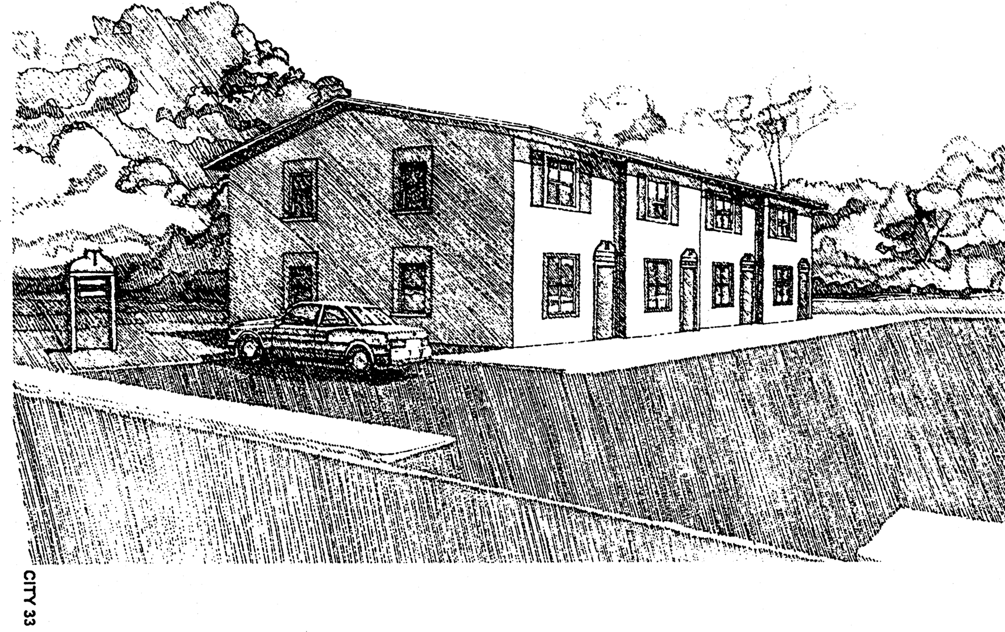
(Code 1984, ch. 27, § 10.6.KK; Ord. No. 97-O-0027AA, 7-8-1997; Ord. No. 99-O-0058AA, § 3, 1-26-2000; Ord. No. 01-O-28AA, § 18, 10-24-2001; Ord. No. 09-O-06, § 4, 3-25-2009; Ord. No. 10-O-14AA, § 6, 2-23-2011; Ord. No. 15-O-17AA, § 15(Exh. I), 8-26-2015)
Sec. 10-252. - OR-2 Office Residential District.
The following applies to the OR-2 Office Residential District:
OR-2 Office Residential District
General Notes:
1. If central sanitary sewer is not available, residential development is limited to a minimum of 0.50 acre lots and non-residential development is limited to a maximum of 2,500 square feet of building area. Community service facilities are limited to a maximum of 5,000 square feet of building area or a 500-gallon septic tank. Also, refer to Sanitary Sewer Policy 2.1.12 of the Comprehensive Plan for additional requirements.
2. Refer to chapter 5, environmental management for information pertaining to the regulation of environmental features (preservation/conservation features), stormwater management requirements, etc.
3. Refer to chapter 4, concurrency management for information pertaining to the availability of capacity for certain public facilities (roads, parks, etc.).
4. For cluster development standards, refer to section 10-426.
(Code 1984, ch. 27, § 10.6.LL; Ord. No. 00-O-54AA, § 3, 9-27-2000; Ord. No. 01-O-28AA, § 19, 10-24-2001; Ord. No. 09-O-06, § 4, 3-25-2009; Ord. No. 09-O-11A, § 4, 10-28-2009; Ord. No. 10-O-14AA, § 6, 2-23-2011; Ord. No. 15-O-17AA, § 16(Exh. J), 8-26-2015; Ord. No. 23-O-41, § 1, 12-13-2023)
Sec. 10-253. - OR-3 Office Residential District.
The following applies to the OR-3 office residential district:
OR-3 Office Residential District
OR-3 Office Residential District
General Notes:
1. If central sanitary sewer is not available, residential development is limited to a minimum of 0.50 acre lots and non-residential development is limited to a maximum of 2,500 square feet of building area. Community service facilities are limited to a maximum of 5,000 square feet of building area or a 500-gallon septic tank. Also, refer to Sanitary Sewer Policy 2.1.12 of the Comprehensive Plan for additional requirements.
2. Refer to chapter 5, environmental management for information pertaining to the regulation of environmental features (preservation/conservation features), stormwater management requirements, etc.
3. Refer to chapter 4, concurrency management for information pertaining to the availability of capacity for certain public facilities (roads, parks, etc.).
4. In properties formerly designated as Mixed Use C in the Future Land Use Map, the maximum non-residential gross building floor area is 40,000 square feet per acre and the maximum building height is six stories, if parking structures are provided for at least 50 percent of the parking spaces.
(Code 1984, ch. 27, § 10.6.MM; Ord. No. 00-O-54AA, § 3, 9-27-2000; Ord. No. 01-O-28AA, § 20, 10-24-2001; Ord. No. 08-O-04AA, § 2, 2-27-2008; Ord. No. 09-O-06, § 4, 3-25-2009; Ord. No. 10-O-14AA, § 6, 2-23-2011; Ord. No. 15-O-17AA, § 17(Exh. K), 8-26-2015; Ord. No. 23-O-41, § 1, 12-13-2023)
Sec. 10-254. - OA-1 Airport Vicinity District.
The following applies to the OA-1 Airport Vicinity District:
OA-1 Airport Vicinity District
General Notes:
1. If central sanitary sewer is not available, non-residential development is limited to a maximum of 2,500 square feet of building area. Community service facilities are limited to a maximum of 5,000 square feet of building area or a 500-gallon septic tank. Also, refer to Sanitary Sewer Policy 2.1.12 of the Comprehensive Plan for additional requirements.
2. Refer to chapter 5, environmental management for information pertaining to the regulation of environmental features (preservation/conservation features), stormwater management requirements, etc.
3. Refer to chapter 4, concurrency management for information pertaining to the availability of capacity for certain public facilities (roads, parks, etc.).
4. For cluster development standards, refer to section 10-426.
(Code 1984, ch. 27, § 10.6.NN; Ord. No. 01-O-28AA, § 21, 10-24-2001; Ord. No. 09-O-06, § 4, 3-25-2009)
Sec. 10-255. - C-1 Neighborhood Commercial District.
The following applies to the C-1 Neighborhood Commercial District:
C-1 Neighborhood Commercial District
General Notes:
1. If central sanitary sewer is not available, residential development is limited to a minimum of 0.50 acre lots and non-residential development is limited to a maximum of 2,500 square feet of building area. Community service facilities are limited to a maximum of 5,000 square feet of building area or a 500-gallon septic tank. Also, refer to Sanitary Sewer Policy 2.1.12 of the Comprehensive Plan for additional requirements.
2. Refer to chapter 5, pertaining to environmental management for information pertaining to the regulation of environmental features (preservation/conservation features), stormwater management requirements, etc.
3. Refer to chapter 4, pertaining to concurrency management for information pertaining to the availability of capacity for certain public facilities (roads, parks, etc.).
4. For cluster development standards, refer to section 10-426.
THIS: C-1- Neighborhood Commercial District
In order to promote neighborhood commercial development that is convenient to residential areas, a 25 percent floor area bonus is available to commercial uses which have a pitched roof, have a uniform exterior and have an appearance compatible with surrounding residences.
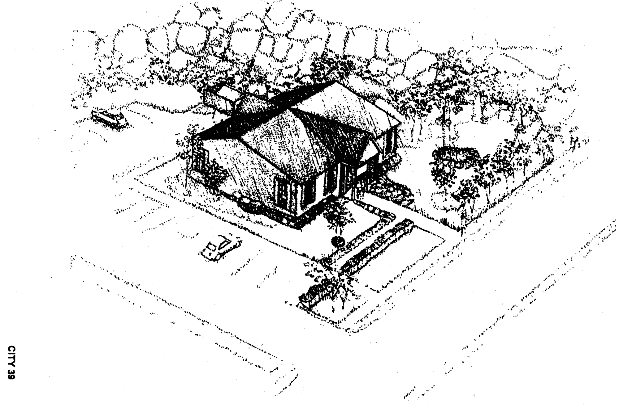
NOT THIS: C-1- Neighborhood Commercial District
While not prohibited in the C-1 district, this type of commercial building is not appropriate in residential areas. The flat roof, various exterior building materials, parking in the front yard and a poorly located, un-screened trash dumpster make this type of commercial an unwelcome neighbor.
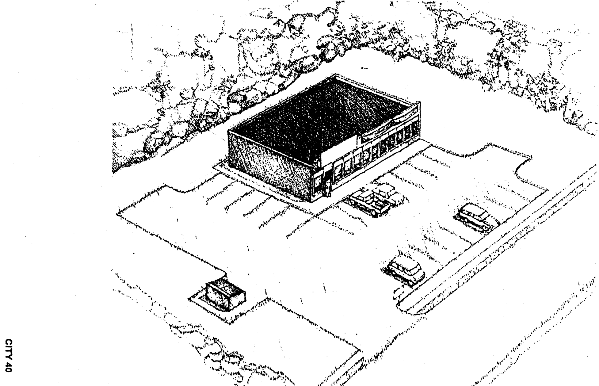
(Code 1984, ch. 27, § 10.6.OO; Ord. No. 97-O-0027AA, 7-8-1997; Ord. No. 99-O-0058AA, § 4, 1-26-2000; Ord. No. 01-O-28AA, § 22, 10-24-2001; Ord. No. 05-O-18AA, § 3, 4-27-2005; Ord. No. 09-O-06, § 4, 3-25-2009; Ord. No. 09-O-11AA, § 3, 10-28-2009; Ord. No. 10-O-14AA, § 6, 2-23-2011; Ord. No. 15-O-17AA, § 18(Exh. L), 8-26-2015; Ord. No. 23-O-41, § 1, 12-13-2023; Ord. No. 25-O-24, § 1(Exh. 1), 12-10-2025)
Sec. 10-256. - C-2 General Commercial District.
The following applies to the C-2 General Commercial District:
C-2 General Commercial District
C-2 General Commercial District
General Notes:
1. If central sanitary sewer is not available, residential development is limited to a minimum of 0.50 acre lots and non-residential development is limited to a maximum of 2,500 square feet of building area. Community service facilities are limited to a maximum of 5,000 square feet of building area or a 500-gallon septic tank. Also, refer to Sanitary Sewer Policy 2.1.12 of the Comprehensive Plan for additional requirements.
2. Refer to chapter 5, pertaining to environmental management, for information pertaining to the regulation of environmental features (preservation/conservation features), stormwater management requirements, etc.
3. Refer to chapter 4, pertaining to concurrency management, for information pertaining to the availability of capacity for certain public facilities (roads, parks, etc.).
4. For cluster development standards, refer to section 10-426.
C-2 - Neighborhood Commercial District
The Neighborhood Commercial district limits arterial street frontage to 100 feet per acre. This provision is intended to promote "nodes" of commercial development rather than "strip" commercial development along arterial streets.
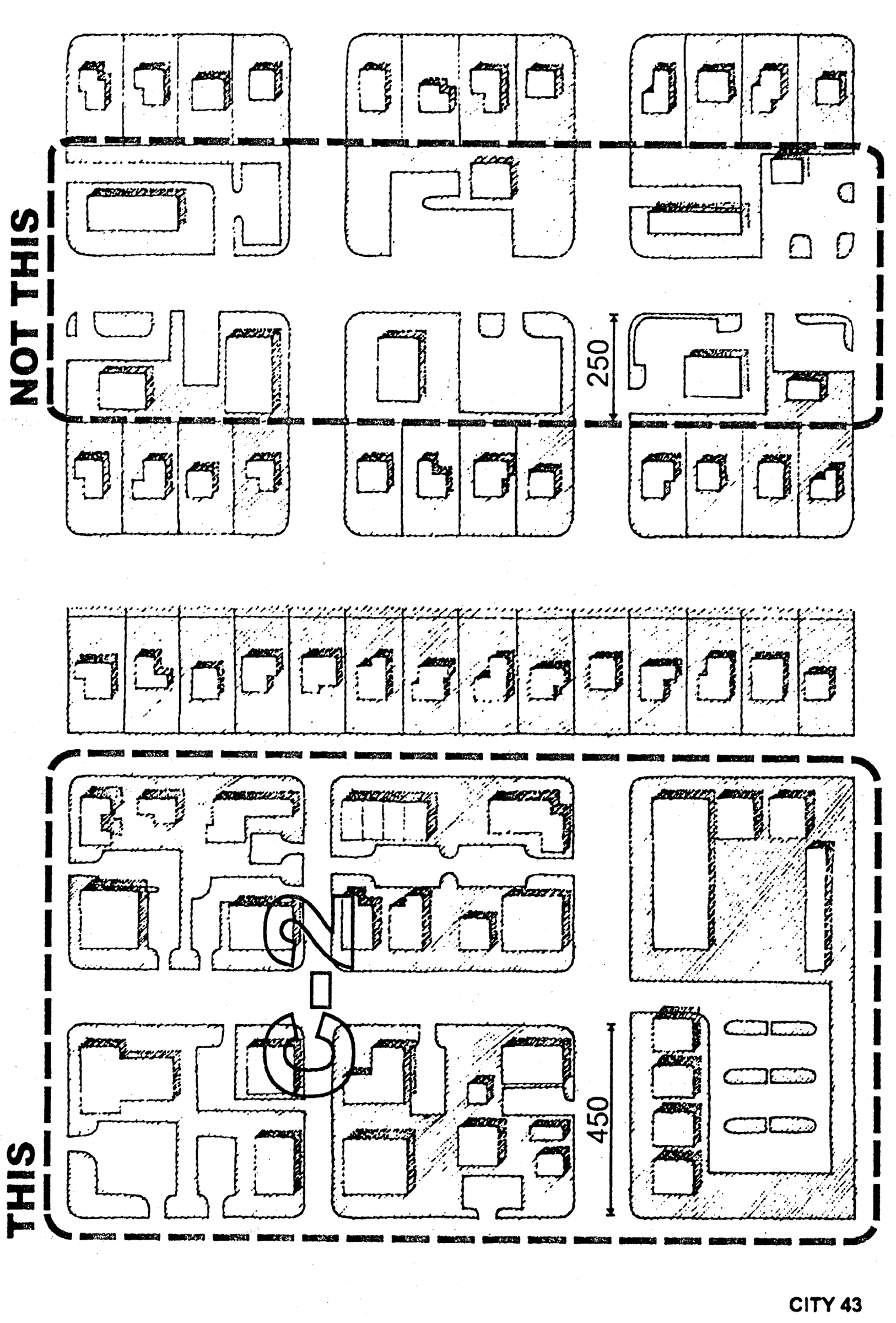
(Code 1984, ch. 27, § 10.6.PP; Ord. No. 97-O-0027AA, 7-8-1997; Ord. No. 01-O-28AA, § 23, 10-24-2001; Ord. No. 05-O-18AA, § 4, 4-27-2005; Ord. No. 05-O-39AA, § 3(Att. 1), 7-13-2005; Ord. No. 09-O-06, § 4, 3-25-2009; Ord. No. 09-O-11AA, § 3, 10-28-2009; Ord. No. 10-O-14AA, § 6, 2-23-2011; Ord. No. 15-O-17AA, § 19(Exh. M), 8-26-2015; Ord. No. 18-O-08, § 2, 2-28-2018; Ord. No. 23-O-41, § 1, 12-13-2023; Ord. No. 25-O-24, § 2(Exh. 2), 12-10-2025)
Sec. 10-257. - CM Medical Arts Commercial District.
The following applies to the CM Medical Arts Commercial District:
CM Medical Arts Commercial District
CM Medical Arts Commercial District
General Notes:
1. If central sanitary sewer is not available, residential development is limited to a minimum of 0.50 acre lots and non-residential development is limited to a maximum of 2,500 square feet of building area. Community service facilities are limited to a maximum of 5,000 square feet of building area or a 500-gallon septic tank. Also, refer to Sanitary Sewer Policy 2.1.12 of the Comprehensive Plan for additional requirements.
2. Refer to chapter 5, environmental management for information pertaining to the regulation of environmental features (preservation/conservation features), stormwater management requirements, etc.
3. Refer to chapter 4, concurrency management for information pertaining to the availability of capacity for certain public facilities (roads, parks, etc.).
4. For cluster development standards, refer to section 10-426.
(Code 1984, ch. 27, § 10.6.QQ; Ord. No. 00-O-54AA, § 3, 9-27-2000; Ord. No. 01-O-28AA, § 24, 10-24-2001; Ord. No. 09-O-06, § 4, 3-25-2009; Ord. No. 10-O-14AA, § 6, 2-23-2011; Ord. No. 14-O-24, § 2(Exh. A), 9-10-2014)
Sec. 10-258. - CP Commercial Parkway District.
The following applies to the CP Commercial Parkway District:
CP Commercial Parkway District
CP Commercial Parkway District
General Notes:
1. If central sanitary sewer is not available, residential development is limited to a minimum of 0.50 acre lots and nonresidential development is limited to a maximum of 2,500 square feet of building area. Community service facilities are limited to a maximum of 5,000 square feet of building area or a 500-gallon septic tank. Also, refer to sanitary sewer policy 2.1.12 of the comprehensive plan for additional requirements.
2. Refer to chapter 5, pertaining to environmental management, for information pertaining to the regulation of environmental features (preservation/conservation features), stormwater management requirements, etc.
3. Refer to chapter 4, pertaining to concurrency management, for information pertaining to the availability of capacity for certain public facilities (roads, parks, etc.).
4. For cluster development standards, refer to section 10-426.
(Code 1984, ch. 27, § 10.6.RR; Ord. No. 99-O-0049AA, § 2, 1-26-2000; Ord. No. 03-O-28AA, § 2, 7-9-2003; Ord. No. 05-O-18AA, § 5, 4-27-2005; Ord. No. 05-O-39AA, § 4(Att. 2), 7-13-2005; Ord. No. 08-O-43AA, § 1, 10-22-2008; Ord. No. 09-O-06, § 4, 3-25-2009; Ord. No. 10-O-14AA, § 6, 2-23-2011; Ord. No. 13-O-29, § 1, 9-25-2013; Ord. No. 14-O-24, § 2(Exh. A), 9-10-2014; Ord. No. 23-O-41, § 1, 12-13-2023; Ord. No. 25-O-24, § 3(Exh. 3), 12-10-2025)
Sec. 10-259. - UP-1 Urban Pedestrian District.
The following applies to the UP-1 Urban Pedestrian District:
UP-1 Urban Pedestrian District
UP-1 Urban Pedestrian District
General Notes:
1. If central sanitary sewer is not available, residential development is limited to a minimum of 0.50 acre lots and non-residential development is limited to a maximum of 2,500 square feet of building area. Community service facilities are limited to a maximum of 5,000 square feet of building area or a 500-gallon septic tank. Also, refer to Sanitary Sewer Policy 2.1.12 of the Comprehensive Plan for additional requirements.
2. Refer to chapter 5, environmental management for information pertaining to the regulation of environmental features (preservation/conservation features), stormwater management requirements, etc.
3. Refer to chapter 4, concurrency management for information pertaining to the availability of capacity for certain public facilities (roads, parks, etc.).
4. For cluster development standards, refer to section 10-426.
(Code 1984, § 10.6.SS; Ord. No. 97-O-0027AA, 7-8-1997; Ord. No. 01-O-28AA, § 25, 10-24-2001; Ord. No. 09-O-06, § 4, 3-25-2009; Ord. No. 10-O-14AA, § 6, 2-23-2011; Ord. No. 14-O-24, § 2(Exh. A), 9-10-2014; Ord. No. 15-O-17AA, § 20(Exh. N), 8-26-2015; Ord. No. 17-O-24AA, § 1, 7-19-2017; Ord. No. 23-O-41, § 1, 12-13-2023)
Sec. 10-259.1. - UP-2 Urban Pedestrian 2 District.
The following applies to the UP-2 Urban Pedestrian 2 District:
UP-2 Urban Pedestrian 2 District
UP-2 Urban Pedestrian District
General Notes:
1. If central sanitary sewer is not available, residential development is limited to a minimum of 0.50 acre lots and non-residential development is limited to a maximum of 2,500 square feet of building area. Community service facilities are limited to a maximum of 5,000 square feet of building area or a 500-gallon septic tank. Also, refer to Sanitary Sewer Policy 2.1.12 of the Comprehensive Plan for additional requirements.
2. Refer to chapter 5, environmental management for information pertaining to the regulation of environmental features (preservation/conservation features), stormwater management requirements, etc.
3. Refer to chapter 4, concurrency management for information pertaining to the availability of capacity for certain public facilities (roads, parks, etc.).
4. For cluster development standards, refer to section 10-426.
(Code 1984, § 10.6.TT; Ord. No. 97-O-0027AA, 7-8-1997; Ord. No. 01-O-28AA, § 26, 10-24-2001; Ord. No. 07-O-11, § 2, 3-28-2007; Ord. No. 09-O-06, § 4, 3-25-2009; Ord. No. 10-O-14AA, § 6, 2-23-2011; Ord. No. 14-O-24, § 2(Exh. A), 9-10-2014; Ord. No. 15-O-17AA, § 21(Exh. O), 8-26-2015; Ord. No. 23-O-41, § 1, 12-13-2023)
Sec. 10-259.2. - Diagrams applicable to UP-1 and UP-2 districts.
(a)
The UP-1 & 2 - Urban Pedestrian Corridor Districts are intended to promote office and residential use above office or commercial use of the first floor. Design standards in the UPC districts require buildings to be built close to the street. Seventy percent of the building facade facing a public street are required to be transparent.
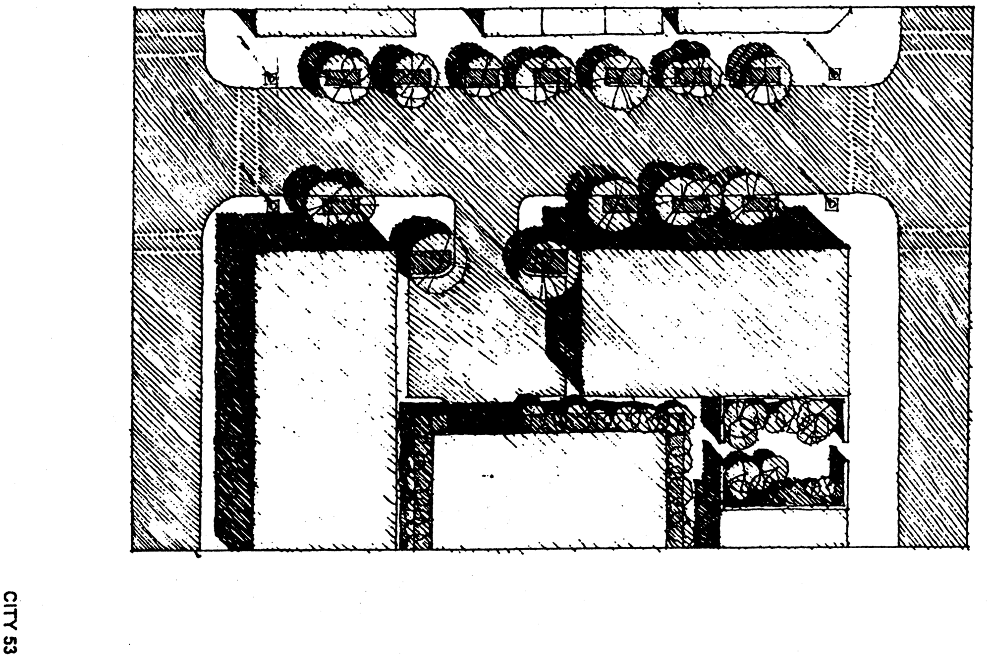
(b)
UP-1 & 2 - Urban Pedestrian Corridor Districts are intended to facilitate the change of older commercial areas from low intensity single use development to higher intensity mixed use development.
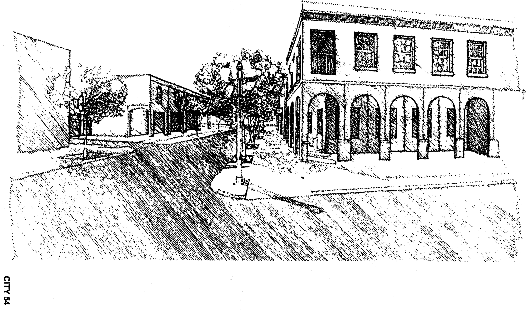
(c)
In order to promote pedestrian activity in the UPC districts building fronts are brought up close to the street. Parking is prohibited in front of building in the UPC districts and can occur to the side or rear. It is intended that most parking will be provided in shared parking structures in the interiors of blocks.
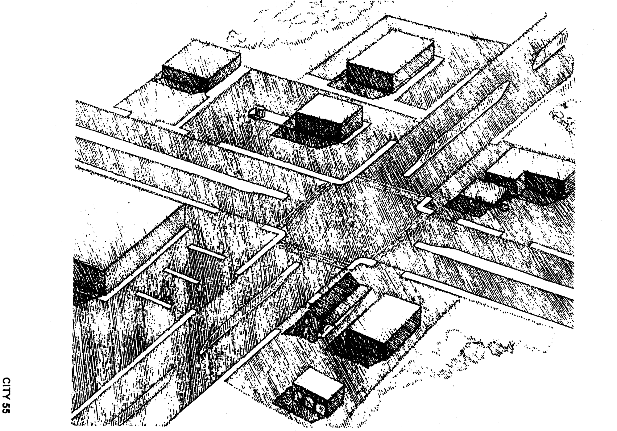
(Code 1984, ch. 27, §§ 10.6.SS, 10.6.TT; Ord. No. 97-O-0027AA, 7-8-1997; Ord. No. 01-O-28AA, §§ 25, 26, 10-24-2001)
Sec. 10-260. - M-1 Light Industrial District.
The following applies to the M-1 Light Industrial District:
M-1 Light Industrial District
General Notes:
1. If central sanitary sewer is not available, residential development is limited to a minimum of 0.50 acre lots and non-residential development is limited to a maximum of 2,500 square feet of building area. Community service facilities are limited to a maximum of 5,000 square feet of building area or a 500-gallon septic tank. Also, refer to Sanitary Sewer Policy 2.1.12 of the Comprehensive Plan for additional requirements.
2. Refer to chapter 5, environmental management for information pertaining to the regulation of environmental features (preservation/conservation features), stormwater management requirements, etc.
3. Refer to chapter 4, concurrency management for information pertaining to the availability of capacity for certain public facilities (roads, parks, etc.).
4. For cluster development standards, refer to section 10-426.
(Code 1984, ch. 27, § 10.6.UU; Ord. No. 01-O-28AA, § 27, 10-24-2001; Ord. No. 06-O-68AA, § 2, 11-21-2006; Ord. No. 09-O-06, § 4, 3-25-2009; Ord. No. 09-O-31AA, § 20, 10-29-2009; Ord. No. 19-O-22, § 1, 11-13-2019)
Sec. 10-261. - PD Planned Development District.
The following applies to the planned development district:
Planned Development District
General Notes:
1. If central sanitary sewer is not available, residential development is limited to a minimum of 0.50 acre lots and non-residential development is limited to a maximum of 2,500 square feet of building area. Community service facilities are limited to a maximum of 5,000 square feet of building area or a 500-gallon septic tank. Also, refer to Sanitary Sewer Policy 2.1.12. of the Comprehensive Plan for additional requirements.
2. Refer to the Environmental Management Act (EMA) for information pertaining to the regulation of environmental features (preservation/conservation features), stormwater management requirements, etc.
3. Refer to the concurrency management ordinance for information pertaining to the availability of capacity for certain public facilities (roads, parks, etc.).
(Ord. No. 09-O-06, § 4, 3-25-2009)
Editor's note— Ord. No. 09-O-06, § 4, adopted March 25, 2009, amended section 10-261 in its entirety to read as herein set out. Formerly, section 10-261 pertained to the CPA critical planning area, and derived from the Code of 1984, ch. 27, § 10.6.VV.
Sec. 10-262. - Reserved.
Editor's note— Ord. No. 09-O-06, § 4, adopted March 25, 2009, repealed section 10-262 in its entirety, which pertained to the TPA target planning area, and derived from the Code of 1984, ch. 27, § 10.6.WW.
Sec. 10-263. - OS Open Space District.
The following applies to the OS Open Space District:
OS Open Space District
General Notes:
1. If central sanitary sewer is not available, residential development is limited to a minimum of 0.50 acre lots and nonresidential development is limited to a maximum of 2,500 square feet of building area. Community service facilities are limited to a maximum of 5,000 square feet of building area or a 500-gallon septic tank. Also, refer to Sanitary Sewer Policy 2.1.12. of the Comprehensive Plan for additional requirements.
2. Refer to chapter 5, pertaining to environmental management, for information pertaining to the regulation of environmental features (preservation/conservation features), stormwater management requirements, etc.
3. Refer to chapter 4, pertaining to concurrency management, for information pertaining to the availability of capacity for certain public facilities (roads, parks, etc.).
4. For cluster development standards, refer to section 10-426.
(Code 1984, ch. 27, § 10.6.XX; Ord. No. 01-O-28AA, § 28, 10-24-2001; Ord. No. 11-O-33, § 1, 12-14-2011)
Sec. 10-264. - IC Interchange Commercial District.
The following applies to the IC Interchange Commercial District:
IC Interchange Commercial District
General Notes:
1. If central sanitary sewer is not available, residential development is limited to a minimum of 0.50 acre lots and non-residential development is limited to a maximum of 2,500 square feet of building area. Community service facilities are limited to a maximum of 5,000 square feet of building area or a 500-gallon septic tank. Also, refer to Sanitary Sewer Policy 2.1.12 of the Comprehensive Plan for additional requirements.
2. Refer to chapter 5, environmental management for information pertaining to the regulation of environmental features (preservation/conservation features), stormwater management requirements, etc.
3. Refer to chapter 4, concurrency management for information pertaining to the availability of capacity for certain public facilities (roads, parks, etc.).
4. Refer to Chapter 7 for information on off-site sign standards.
(Code 1984, ch. 27, § 10.6.YY; Ord. No. 00-O-54AA, § 3, 9-27-2000; Ord. No. 01-O-28AA, § 29, 10-24-2001; Ord. No. 09-O-06, § 4, 3-25-2009; Ord. No. 14-O-24, § 2(Exh. A), 9-10-2014)
Sec. 10-265. - Reserved.
Editor's note— Ord. No. 10-O-14AA, § 6, adopted February 23, 2011, repealed the former section 10-265 in its entirety, which pertained to the Capitol Center Planning District, and derived from Ord. No. 03-O-10AA, § 7, adopted February 26, 2003, and Ord. No. 06-O-66AA, § 2, adopted November 21, 2006.
Sec. 10-266. - NBO Neighborhood Boundary Office.
NBO Neighborhood Boundary Office District
General Notes:
1. If central sanitary sewer is not available, residential development is limited to a maximum of 0.50 acre lots and non-residential development is limited to a maximum of 2,500 square feet of building area. Also, refer to Sanitary Sewer Policies 3.1.6 and 3.1.7 of the Comprehensive Plan for additional requirements.
2. Refer to chapter 5 pertaining to environmental management, for information pertaining to the regulation of environmental features (preservation/conservation features), stormwater management requirements, etc.
3. Refer to chapter 4, pertaining to concurrency management, for information pertaining to the availability of capacity for certain public facilities (roads, parks, etc.).
4. For cluster development standards, refer to section 10-426.
5. If setbacks have been previously established by a preliminary plat or recorded plat, then setbacks that have been established shall apply except where approved by the Development Review Committee.
(Ord. No. 03-O-58, § 4, 12-10-2003; Ord. No. 07-O-18, § 1, 5-23-2007; Ord. No. 10-O-14AA, § 6, 2-23-2011)
Sec. 10-267. - MR Medium Density Residential District.
MR Medium Density Residential District
General Notes:
1. If central sanitary sewer is not available, residential development is limited to a minimum of 0.50 acre lots and non-residential development is limited to a maximum of 2,500 square feet of building area. Community service facilities are limited to a maximum of 5,000 square feet of building area or a 500 gallon septic tank. Also, refer to Sanitary Sewer Policy 2.1.12 of the Comprehensive Plan for additional requirements.
2. Refer to chapter 5, environmental management for information pertaining to the regulation of environmental features (preservation/conservation features), stormwater management requirements, etc.
3. Refer to chapter 4, concurrency management ordinance for information pertaining to the availability of capacity for certain public facilities (roads, parks, etc.).
4. For cluster development standards, refer to section 10-426.
(Ord. No. 05-O-40AA, § 7, 7-13-2005; Ord. No. 15-O-32, § 1, 11-24-2015)
Sec. 10-268. - MCR Mahan Corridor Ring District.
MCR Mahan Corridor Ring District
General Notes:
1. If central sanitary sewer is not available, residential development is limited to a minimum of 0.50 acre lots and non-residential development is limited to a maximum of 2,500 square feet of building area. Community service facilities are limited to a maximum of 5,000 square feet of building area or a 500 gallon septic tank, also, refer to sanitary Sewer Policy 2.1.12 of the Comprehensive Plan for additional requirements.
2. Refer to the Environmental Management Ordinance (EMO) for information pertaining to the regulation of environmental features (preservation/conservation features), stormwater management requirements, etc.
3. Refer to the Concurrency Management Ordinance for information pertaining to the availability of capacity for certain public facilities (roads, schools, parks, etc.).
(Ord. No. 10-O-49AA, § 6, 2-23-2011; Ord. No. 15-O-17AA, § 21(Exh. P), 8-26-2015)
Editor's note— Ord. No. 10-O-49AA, § 6, adopted February 23, 2011, repealed and reenacted section 10-268 in its entirety to read as herein set out. Formerly, section 10-268 pertained to the MCR Mahan Residential Corridor District, and derived from Ord. No. 07-O-15, § 8, adopted March 28, 2007.
Sec. 10-269. - MCN Mahan Corridor Node District.
MCN Mahan Corridor Node District
General Notes:
1. If central sanitary sewer is not available, residential development is limited to a minimum of 0.50 acre lots and non-residential development is limited to a maximum of 2,500 square feet of building area. Community service facilities are limited to a maximum of 5,000 square feet of building area or a 500 gallon septic tank, also, refer to sanitary Sewer Policy 2.1.12 of the Comprehensive Plan for additional requirements.
2. Refer to the Environmental Management Ordinance (EMO) for information pertaining to the regulation of environmental features (preservation/conservation features), stormwater management requirements, etc.
3. Refer to the Concurrency Management Ordinance for information pertaining to the availability of capacity for certain public facilities (roads, schools, parks, etc.).
(Ord. No. 10-O-49AA, § 6, 2-23-2011)
Editor's note— Ord. No. 10-O-49AA, § 6, adopted February 23, 2011, repealed and reenacted section 10-269 in its entirety to read as herein set out. Formerly, section 10-269 pertained to the MRCN Mahan Residential Corridor Node District, and derived from Ord. No. 07-O-15, § 9, adopted March 28, 2007.
Sec. 10-270. - GO-1 Government Operational Office/Light Industrial District.
The following applies to the government operational office/light industrial district:
General Notes:
1. If central sanitary sewer is not available, non-residential development is limited to a maximum of 2,500 square feet of building area. Also, refer to Sanitary Sewer Policy 2.1.12 of the Comprehensive Plan for additional requirements.
2. Refer to Chapter 5 pertaining to environmental management, for information pertaining to the regulation of environmental features (preservation/conservation features), stormwater management requirements.
3. Refer to Chapter 4, pertaining to concurrency management, for information pertaining to the availability for capacity for certain public facilities (roads, parks, etc.)
4. Refer to Chapter 10, Section 413, community services and facilities/institutional uses.
(Ord. No. 09-O-27AA, § 1, 10-28-2009; Ord. No. 10-O-14AA, § 6, 2-23-2011)
Sec. 10-271. - GO-2 Governmental Operational Heavy Infrastructure District.
The following applies to the government operational office/light industrial district:
General Notes:
1. If central sanitary sewer is not available, non-residential development is limited to a maximum of 2,500 square feet of building area. Also, refer to Sanitary Sewer Policy 2.1.12 of the Comprehensive Plan for additional requirements.
2. Refer to Chapter 5 pertaining to environmental management, for information pertaining to the regulation of environmental features (preservation/conservation features), stormwater management requirements.
3. Refer to Chapter 4, pertaining to concurrency management, for information pertaining to the availability for capacity for certain public facilities (roads, parks, etc.)
4. Refer to Chapter 10, Section 413, community services and facilities/institutional uses.
5. New heavy infrastructure development in this district is subject to the Type "D" review process (refer to Section 9-157).
(Ord. No. 09-O-27AA, § 2, 10-28-2009; Ord. No. 10-O-36, § 1, 10-12-2010)
Sec. 10-272. - NB-1 Neighborhood Boundary District.
The following applies to the NB-1 Neighborhood Boundary District:
| PERMITTED AND PROHIBITED USES | |||
|---|---|---|---|
| 1. District Intent | 2. Principal Uses | 3. Prohibited Uses | 4. Accessory Uses |
|
The Neighborhood Boundary 1 (NB-1) district is intended to be located in areas designated
as Neighborhood Boundary on the Future Land Use Map of the Comprehensive Plan and
only within the Multi-Modal Transportation District. NB-1 districts shall either serve
as a buffer between residential development and more intensive development, or be
used to establish mixed-use corridors, or nodes, with neighborhood-scale, non-residential
uses and a variety of residential uses where identified in a City coordinated Placemaking,
Sense of Place, Neighborhood, or Sector Plan.
The NB-1 district is designed to allow low- and medium-density residential, and non-residential development scaled to serve the surrounding neighborhood such as limited retail, office, and community services. To prevent negative impacts from increased vehicular traffic, auto-oriented uses, such as gas stations or drive-through facilities are prohibited. The maximum gross density allowed for new residential development in the NB-1 district is eighteen (18) dwelling units per acre. The maximum gross intensity allowed for new non-residential development is 20,000 square feet per acre. Building footprints for non-residential uses shall be limited to 5,000 gross square feet. |
1. Offices, except those expressly prohibited.
2. Limited retail and service - the below uses are permitted: a. Antique shops b. Laundromats, laundry and dry-cleaning pick-up stations c. Mailing services d. Personal services (barber shops, fitness clubs, etc.) e. Repair services, non-automotive f. Restaurants without drive-through facilities g. Retail bakeries, drug stores, florists, food and grocery, home/garden supply/hardware without outdoor storage, newsstand/books/greeting cards h. Studios for photography, music, art, drama, and voice i. Tailoring 3. Banks and other financial institutions, without drive-through facilities 4. Community facilities related to the permitted principal uses including libraries, religious facilities, and police/fire stations. Other community facilities may be allowed in accordance with Section 10-413 of these regulations. 5. Residential: a. Single-family attached dwellings, not to exceed four attached units b. Single-family detached dwellings c. Two-family dwellings d. Triplexes e. Fourplexes f. Live-work |
The following uses are prohibited in this zoning district:
1. Cocktail lounges, night/dance clubs, and bars 2. Retail package liquor 3. Bail bond agencies/offices 4. Warehouses, mini-warehouses, and self-storage 5. Heavy industrial and light industrial uses 6. Crematoriums 7. Commercial dog kennels 8. Pawn shops 9. Firing ranges 10. Drive-through facilities 11. Rooming houses 12. Motor vehicle fuel sales 13. Pet daycare centers 14. Veterinary services 15. Payday loan offices 16. Automotive repair 17. Car wash 18. Privately owned off-street parking as the sole use 19. Outdoor storage |
(1) A use or structure on the same lot with, and of a nature customarily incidental
and subordinate to, the principal use or structure and which comprises no more that
33 percent of the floor area or cubic volume of the principle use or structure, as
determined by the Land Use Administrator.
(2) Light infrastructure and/or utility services and facilities necessary to serve permitted uses, as determined by the Land Use Administrator. |
| Development within the NB-1 zoning district shall comply with all standards applicable to Transect 3 (T3) of the MMTD Code and the additional Development Standards contained in note 5 herein. |
6. Daycare centers
7. Recreational clubs and lodges, including assembly halls 8. Passive and active recreation facilities 9. Other uses which, in the opinion of the Land Use Administrator, are of a similar and compatible nature to those uses described in this district. Noise and lighting impacts shall be considered when determining the eligibility of additional land uses. | ||
| 5. Development Standards in addition to the MMTD | |||
|
1. Setback and Alternate Non-residential Setback: a. The default front setback in T3 is a minimum of 15 feet from the property line. If the criteria listed below are met, an alternate front setback of 15 feet from the back of the curb is allowed for new non-residential development (see Figures a and b): 1. The space between the back of the landscape strip and the face of the building is a continuously paved area with a consistent sidewalk pattern that includes two components. First, it has a minimum 6, 8, or 10-foot sidewalk between the landscape strip and the property line, depending on whether the adjoining road is functionally classified as a local, a collector, or an arterial road, respectively. Second, it has an adjacent 3-foot paved area between the property line and the face of the building. b. Sites with multiple frontages do not require a front setback deviation for additional frontages if the primary frontage meets the required front setback. This exemption does not apply to corner lots. | |||
Figure a.
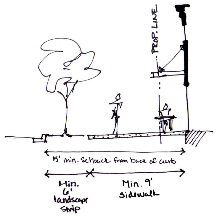 | |||
Figure b.
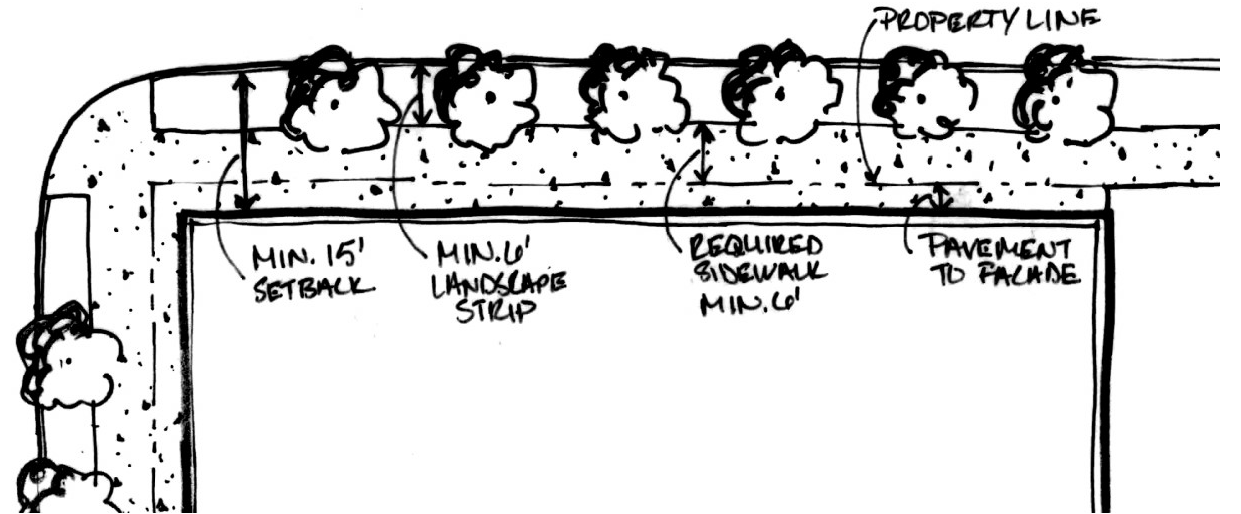 | |||
|
2. Entryways: a. At least one entryway shall be located on the front façade, parallel to the street. Street-facing entries for dwelling units in a duplex, triplex, or fourplex shall be clustered or shared (see Figure c). A dedicated and direct pedestrian path shall be provided from the front entrance to the public sidewalk or street where there is no sidewalk (see Figure d). Driveways do not qualify as a direct pedestrian connection. | |||
Figure c.
Figure d.
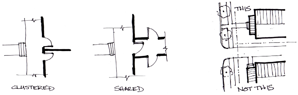 | |||
|
3. Lighting Criteria: Exterior lighting shall include any light source outside a building whether freestanding or on its own pole, attached to a structure, or underneath a roof of an open-sided building and shall meet the following criteria: a. For natural quality, lighting elements shall provide full spectrum light to prevent color distortion. b. Light overspill onto adjacent properties shall be minimized by a combination of placement of light fixtures, mounting height, natural or artificial barriers on the fixture owner's property, shielding of the light source to direct light onto the surface to receive illumination, and other fixture design features. When abutting existing residential uses, lighting shall not exceed zero point five (0.5) footcandles as measured at the property line six (6) feet above grade. c. Motion detector activated lights are permitted and are required to cycle off after five (5) minutes. d. Fixtures shall provide evenly zero point five (0.5) foot-candles at street level and at walkways, bike paths and parks. The light level at parking lots shall be no less than zero point four (0.4) foot-candles and no greater than one (1) foot-candle. e. Light fixtures in parking lots shall be a maximum of 18 feet in height. Light fixtures along pedestrian walkways shall be a maximum of 12 feet in height. f. The use of search lights, laser lighting, or lights that pulse, flash, rotate or simulate motion for advertising or promotions is prohibited. g. The use of internally illuminated awnings or canopies, and wall and roof mounted floodlights or spot-lights used for general grounds illumination, is prohibited. h. Up lighting is prohibited except when used to accent landscaping. i. All exterior lighting shall be full cutoff type (i.e., directed downward and capped), shall be recessed and shielded to conceal the light source, and shall be either LED or metal halide lamps. j. Emergency lighting and traffic control lighting are exempt from these standards. k. Applications for non-residential and multi-family developments shall be accompanied by a photometric plan and manufacturer's cut sheets to demonstrate compliance with these standards. | |||
|
4. Access Management and Parking Location: a. For non-residential properties on corner lots or with multiple frontages, vehicular access shall be limited to the secondary frontage unless the vehicular access along the primary frontage is shared by multiple properties. b. New development of multiple lots shall require shared driveway access and provide access easements to adjacent properties. If there is an existing access easement with the adjacent property, the development shall utilize the easement. c. Driveways serving single-family homes and duplexes shall not exceed ten (10) feet in width (not including the driveway apron - see Figure e). d. Walls of residential garages and carports shall be setback from the principal façade at least four (4) feet. Porches do not qualify as the principal façade (see Figure e). e. Residential front-loading garages and carports shall be setback a minimum of 20 feet from the front property line (see Figure e). | |||
Figure e.
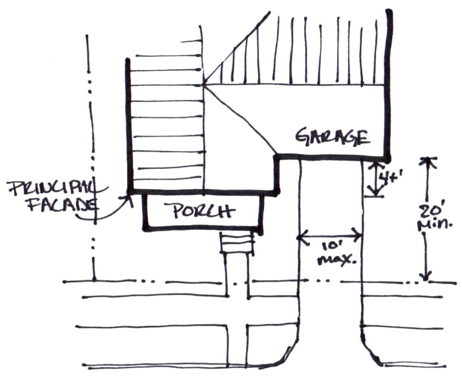 | |||
|
5. Fencing and Perimeter Walls, Buffering and Screening Requirements: a. Prohibitions. Barbed wire, razor wire, and electric fencing are prohibited. Chain link fencing is not permitted for non-residential uses within view of the public right-of-way. b. Height. Fences and perimeter walls shall not exceed six (6) feet in height. Fences within the first layer shall not exceed four (4) feet in height. c. Required Screening. Non-residential uses shall provide an opaque six (6)-foot fence at the property line shared with any residential use, except that the fence shall not be located any closer than 15 feet to the front or street side property line. The finished side of the fence shall face the residential property. | |||
|
6. Solid Waste Restrictions: For new non-residential uses, roll out solid waste containers are required and shall not be placed within the first or second layer or within 30 feet of an adjoining existing residential use. Roll out solid waste containers shall be screened from view from any adjacent right-of-way. Dumpsters shall be prohibited. | |||
7. Neighborhood Character and Architectural Design: a. All roofs for principal structures in residential development shall be hipped
or gabled (see Figure f).
Figure f.
 | |||
(Ord. No. 20-O-28, § 2, 2-24-2021)
Sec. 10-280.- Generally.
The purpose of this division to establish provisions pertaining to zoning, site plan, and design regulations for development within the MMTD (synonymous with the Mobility District as shown on Figure 1) and Downtown Core Area; and to implement the provisions of the Mobility Element within the local comprehensive plan to provide for a safe, energy-efficient, multi-modal transportation system that provides for pedestrians, bicyclists, transit users, motorized vehicle users, users of rail and aviation facilities, supports public health through active living, and is sensitive to the cultural and environmental amenities of Tallahassee and Leon County.
(Ord. No. 13-O-03, § 14, 8-28-2013)
Sec. 10-280.1. - Authority.
(a)
The action of the City of Tallahassee, Florida, in the adoption of this code is authorized under the charter of the City of Tallahassee.
(b)
This code was adopted as one of the instruments of implementation of the public purposes and objectives of the adopted Tallahassee-Leon County 2030 Comprehensive Plan. This code is declared to be consistent with the Tallahassee-Leon County Comprehensive Plan, as required by the local land development statutes, and, furthermore, it is the implementing code for the Multi-Modal Transportation District (MMTD).
(Ord. No. 13-O-03, § 14, 8-28-2013)
Sec. 10-280.2. - Applicability.
(a)
All development proposals shall maintain consistency with the Tallahassee-Leon County Comprehensive Plan. No portion of this code shall be construed to deviate from adopted Comprehensive Plan policies.
(b)
Provisions of this Code are activated by "shall" when required; "should" when recommended; and "may" when optional.
(c)
Notwithstanding the provisions of Chapter 1, Section 1-2, Definitions and Rules of Construction, the provisions of this Division shall take precedence over those of development regulations found in Chapters 9 and 10 of the land development code, regardless of whether more or less restrictive, except the local health and safety codes. In the event the MMTD does not provide a standard, then the applicable general standard shall take precedence. Despite the foregoing, Sections 7-72 (relating to signs on local roads), 10-177(g) (relating to buffer zones), 10-411(b)(3) (relating to accessory structures), 10-412(6) (relating to drive-thru facilities), 10-427(c)(3) (relating to site lighting standards), and 10-429 (relating to Dense Residential uses next to properties which are Protected Residential) will also apply in the MMTD.
(d)
The metrics of Section 10-285 standards and tables are an integral part of this code. However, the illustrations that accompany them should be considered guidelines.
(e)
Where in conflict, numerical metrics shall take precedence over graphic metrics.
(f)
Definitions are found in Section 1-2 and graphic definitions are located in Section 10-285, Table 12.
(g)
Where in conflict, the standards identified in the tables of Section 10-285 shall take precedence over the written standards of this division.
(Ord. No. 13-O-03, § 14, 8-28-2013; Ord. No. 21-O-15, § 3, 6-16-2021)
Sec. 10-280.3. - Intent and purpose.
The intent and purpose of this code is to enable, encourage and qualify the implementation of the following principles:
(a)
The Multi-Modal Transportation District—Tallahassee's Urban Core.
(1)
That neighborhoods and commercial centers should be compact, pedestrian-oriented, and offer a mixture of uses.
(2)
That neighborhoods and commercial centers should be the preferred pattern of development and that districts specializing in a single use should be the exception, meaning compatibility should be achieved through exemplary design rather than complete separation of uses.
(3)
That ordinary activities of daily living should occur within walking distance of most dwellings, allowing independence to those who do not drive.
(4)
That interconnected networks of roadways should be designed to disperse traffic and reduce the length of automobile trips.
(5)
That neighborhoods should provide a range of housing types to accommodate diverse ages and incomes.
(6)
That suburban places should evolve and mature into places that respect the primacy of pedestrians and reflect an urban fabric appropriate for Tallahassee's core.
(7)
That appropriate building densities and land uses should be provided within the pedestrian shed of StarMetro routes.
(8)
That common open spaces and institutional, and commercial activity should be embedded in neighborhoods, not isolated in remote single-use complexes.
(9)
That a range of open space including parks, squares, and playgrounds should be distributed within neighborhoods and downtown, while also preserving exemplary environmental features, such as pristine watercourses and patriarch trees.
FIGURE 1: AREA OF APPLICABILITY - MULTI-MODAL TRANSPORTATION DISTRICT AND THE DOWNTOWN OVERLAY
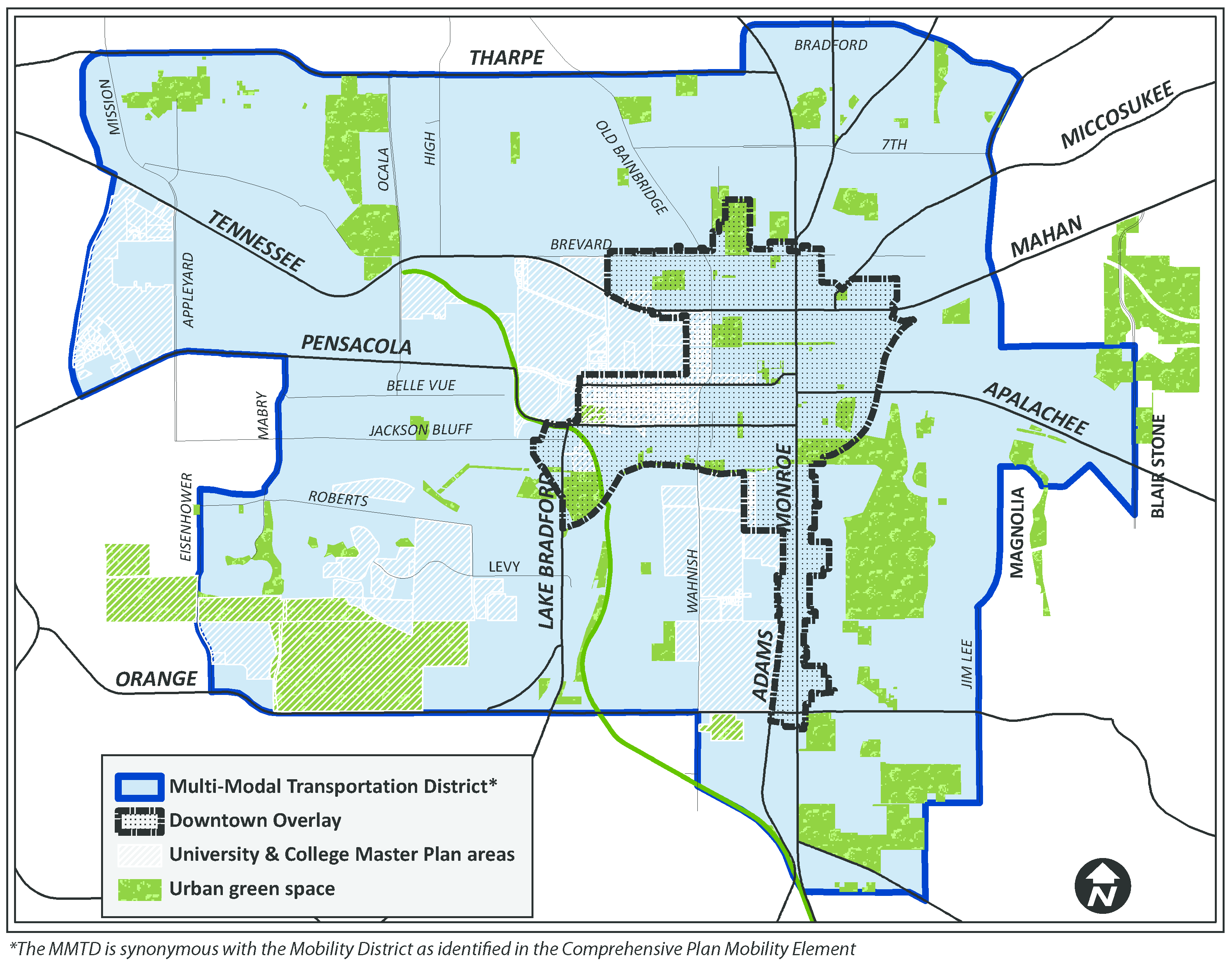
(b)
The Block and the Building.
(1)
That buildings and landscaping should contribute to the physical definition of thoroughfares as civic places.
(2)
That development should adequately accommodate automobiles while respecting the primacy of pedestrians within the MMTD.
(3)
That the design of streets and buildings should reinforce safe pedestrian environments.
(4)
That civic buildings, public gathering places, and the preservation of historic buildings should be recognized as locations that reinforce community identity and character.
(c)
The Transect.
(1)
That communities should provide meaningful choices, both residential options and commercial opportunities, as indicated by the scale and character of distinct physical environments.
(2)
That the City's existing zoning districts shall be assigned to the appropriate Transect for regulation of development standards, with the exception of Open Space (OS), Manufactured Home (MH), Light Industrial (M-1), and Industrial (I), which will be regulated according to the development standards of those specific zoning districts. These zoning district assignments are as follows in Figure 2.
(3)
Activities in each Transect zone shall adhere to the permitted uses of the underlying Zoning Districts, as found in the Tallahassee Land Development Code.
FIGURE 2: TRANSECTS AND APPLICABLE ZONING DISTRICTS
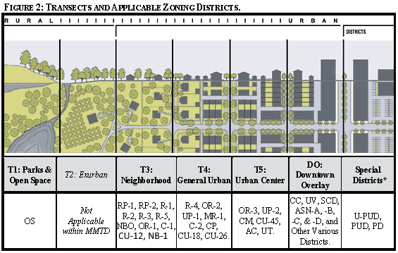
* In the Special District, if development standards are not specifically addressed with in PUD or U-PUD provisions, then the applicable MMTD transect provisions shall apply.
Source: Duany Plater-Zyberk & Co.
(Ord. No. 13-O-03, § 14, 8-28-2013; Ord. No. 20-O-28, § 3, 2-24-2021)
Sec. 10-280.4. - Process.
(a)
All developments within the MMTD shall adhere to the development review procedures of Chapter 9.
(Ord. No. 13-O-03, § 14, 8-28-2013)
Sec. 10-280.5. - Instructions.
(a)
Lots and buildings located within the MMTD shall be subject to the requirements contained herein.
(b)
Site and development plans submitted under this Division shall submit proposals in accordance with Section 9-151 of the Tallahassee Land Development Code.
(c)
Planned Unit Developments (PUD) and Urban Planned Unit Developments (UPUD): Those PUD and UPUD projects approved prior to 2011 that are not subject to specific PUD provisions within this Code shall be governed by the standards of the zoning existing prior to the adoption of the 2011 MMTD standards. PUDs and UPUDs approved after December 31, 2010 located within the MMTD shall use the provisions of Section 10-165 and 10-200, respectively. Proposals will be evaluated for consistency with the intent of the MMTD and the development and design standards set forth herein.
(Ord. No. 13-O-03, § 14, 8-28-2013)
Sec. 10-280.6. - Deviations and variances.
(a)
The standards and requirements contained herein shall be available for deviations, as provided for in Section 9-233.
(b)
The standards and requirements of Section 10-281 shall be available for variances, as provided for in Section 5-126 regarding the Environmental Variance Board.
(Ord. No. 13-O-03, § 14, 8-28-2013)
Sec. 10-280.7. - Incentives.
GENERAL TO ZONES T3, T4, T5, & DOWNTOWN OVERLAY
(a)
Inclusionary Housing.
(1)
Refer to Section 9-240 of the Tallahassee Land Development Code. All developments within the selected census tracts shall adhere to the requirements contained therein. See also specific references to the MMTD in Sections 9-245 and 9-246 for dispersement, creative housing types, and parking.
(b)
Accessory dwelling unit (ADU). A lot with an ADU shall be allowed up to a maximum 25 percent gross density bonus, as applied to the underlying zoning district standards, so long as there [are] no more than two dwelling units on the lot.
(c)
Density Bonuses.
(1)
Bonus density or intensity is available in all zoning districts located within the MMTD, with the exception of the Residential Preservation, R-1 Single-Family Detached Residential, R-2 Single-Family Detached Residential, University Village, and all All Saints Neighborhood districts. In order to receive a bonus credit the development plan shall clearly address provision of the qualifying project enhancement, and the enhancement shall be constructed before issuance of the certificate of occupancy for the principal use. The total land area shall be used in calculation of bonus eligibility.
(2)
Each of the following enhancements is worth a five percent increase in density or intensity, up to a maximum of 35 percent in a U-PUD or 25 percent in other eligible districts within the MMTD:
a.
Mixture of uses - Design project to include at least two of the following:
i.
Medium- or high-density residential;
ii.
Retail trade; or
iii.
Office activities.
b.
Parking - Provide creative parking alternatives, such as shared parking, flex hours, and/or car pool or shared-use vehicle parking spaces.
c.
Public Art - Provide fountains, sculptures or other public art works located external to the building and visible from public right-of-way.
d.
Sidewalk Coverings - Provide continuous sidewalk coverings in the form of awnings, canopies, arcades, colonnades, or verandahs.
e.
Balconies - Provide functional balconies on the second through fourth floors of a building.
f.
Windows - Provide bay windows on the second through fourth floors of a building.
g.
Pedestrian Amenities - Provide pedestrian friendly public outdoor space beyond the requirements for the minimum required green space. These may include interval walkways, plazas, pocket parks, or similar facilities.
h.
Semipublic Outdoor Space - Provide semipublic outdoor space in the form of courtyards, forecourts, or gardens accessible to the public for uses such as dining, including open building facades, at street level.
i.
Atriums - Provide atriums accessible to the public.
j.
Streetscapes - Provide an integrated streetscape design, including trees and seating, throughout the project site. These improvements shall be coordinated with and inclusive of any existing and planned streetscape(s) projects by the City, including those along collector and arterial streets.
k.
Transit Stops - Provide weather protected, and lighted mass transit stops, the design of which shall be approved by StarMetro staff.
l.
Energy Efficiency - Demonstrate that existing or planned on-site structure(s) meet certification for Leadership in Energy and Environmental Design (LEED), Florida Green Building Coalition (FGBC), or similar nationally recognized "green" building standard.
m.
Bicycle Parking - Provide sheltered bicycle parking with weather protection and lighting for all bicycle parking not already required to be secure, enclosed, and covered.
n.
Cyclist Facilities - Provide a minimum of two showers (one for each gender) and ten locker facilities for employees in non-residential uses to support bicycle and pedestrian commuters.
o.
Shared Drives - Provide shared driveways between lots to reduce the total number of drive cuts.
p.
Front Porches - For residential buildings, provide porches with a minimum useable, clear depth of 8' and minimum width along front of structure of 10'. Porches can encroach into building setback up to, but not beyond any easement boundaries such as drainage, utilities, etc., subject to permitting review and approvable. Porches may be screened, but not enclosed as part of conditioned square footage. Any necessary steps shall meet grade outside R.O.W.
q.
Garages - For residential buildings, recess garages such that the main exterior wall of the garages is recessed a minimum of 12' behind the first conditioned wall of the main residence. Garage recess distance may be reduced to 5' from first conditioned wall if a minimum distance of 20' between face of garage to R.O.W. is maintained. Garages placed in the rear of main structure may be located in zero lot line configurations and/or attached to neighboring garages.
r.
Alleys - For residential subdivisions, provide alley(s) to serve lots so that there are no driveway cuts along the ROW. On street parking is to be constructed on all streets with adequate ROW per Sec. 10-284.5(b1).
s.
Walkability - Locate and/or design the project such that at least 50% of dwelling units are within a ¼ mile walk distance of a retail center containing at least four (4) diverse uses.
t.
Recreation - Locate and/or design the project such that a publicly accessible outdoor recreation facility at least one (1) acre in area, or a publicly accessible indoor recreational facility of at least 25,000 square feet, lies within a ½ mile walk distance of 90% of new and existing dwelling units and nonresidential building entrances.
u.
Community Gardens - Dedicate permanent and viable community garden space and/or related facilities (such as greenhouses), no less than ⅛ acre in area in size, within the project. Solar access, fencing, watering systems, garden bed enhancements (such as raised beds), secure storage space for tools, and pedestrian access must be provided. Community garden space and/or related facilities must be owned and managed by an entity that includes occupants of the project in its decision making, such as a community group, homeowners' association, or public body.
v.
Schools - Locate and/or design the project such that 50% of dwelling units are within a ½ mile walk distance of an existing or planned public elementary or middle school or within a 1-mile walk distance of an existing or planned public high school.
w.
Historic Preservation - On sites with at least one historic building, preserve all historic structures or resources through renovation, adaptive re-use, and/or incorporation into new development.
(d)
Single Family and Two-Family Residential Uses. Single family or two-family (duplex) residential uses located within the MMTD that meet both of the following criteria shall be eligible to be rented for valuable consideration to more than three unrelated individuals in a single dwelling unit:
(1)
Property is located within a one-mile distance from a campus master plan boundary.
(2)
Property is located within a quarter mile distance from a transit stop.
The above eligibility shall not apply to fraternity and sorority houses, nor properties in RP-1, RP-2, NBO and NB-1 zoning districts. Where in conflict, the standards identified in this section shall take precedence over the standards within this Article.
(Ord. No. 13-O-03, § 14, 8-28-2013; Ord. No. 15-O-23AA, § 2, 8-26-2015; Ord. No. 17-O-23AA, § 2, 9-27-2017; Ord. No. 24-O-03, § 2, 3-27-2024; Ord. No. 25-O-26, § 2, 11-19-2025)
Sec. 10-281. - Environmental standards and landscaping.
Standards Applicable to T3, T4, and T5, and the Downtown Overlay. Environmental standards and landscaping within the Downtown Overlay and Transects T3, T4 and T5 shall be those identified as follows and all development shall adhere to the procedural and development requirements therein:
(a)
Review and Inspections. Refer to Section 5-51 through 5-65 of the Tallahassee Land Development Code.
(b)
Conservation and preservation features. Refer to Section 5-81 through 5-82 of the Tallahassee Land Development Code, including Downtown Overlay exemption from all significant and severe grade regulations.
(c)
Tree protection. Refer to Section 5-83 of the Tallahassee Land Development Code for tree protection provisions relating to patriarch and exceptional specimen trees and for tree mitigation including any on-site tree debits and credits.
(d)
On-site green space and fee in-lieu. Refer to Section 5-85(d)(4) of the Tallahassee Land Development Code, for minimum urban forest and landscape, and fee-in-lieu mitigation provisions.
(e)
Landscape standards. Refer to Sections 5-83, 5-85, 10-283.3, 10-284.3, and 10-285, Tables 3 and 4, of the Tallahassee Land Development Code, for street trees, landscaping and vegetative buffers.
(f)
Streetscreen For Parking.
(1)
Parking lots shall be masked from the public right-of-way by a liner building or streetscreen. The streetscreen shall include vegetative or structural elements, such as shade trees, shrubs or groundcover, knee walls, decorative fencing, or the preserved walls of former buildings consistent with Section 5-85, and shall include one tree (min. 2-3 inch caliper shade tree), not to conflict with overhead utilities or sight distance triangle, for each 20 linear feet of parking lot, loading area, or drive aisles along the frontage. Along the public right-of-way, the streetscreen shall maintain a minimum of 50 percent transparency, thereby preserving natural surveillance. Shrubs or groundcover shall be spaced between and 6 feet on center.
(2)
Streetscreens shall have full openings no larger than necessary to allow automobile and pedestrian access.
(g)
Stormwater. Refer to Section 5-86 of the Tallahassee Land Development Code, for stormwater provisions.
(h)
Silviculture, Site Grading, Sediment And Erosion Control. Refer to Sections 5-84, 5-87, and 5-88 of the Tallahassee Land Development Code.
(Ord. No. 13-O-03, § 14, 8-28-2013)
Sec. 10-282. - Downtown overlay.
Parcels located within the Downtown Overlay shall adhere to the Downtown Regulation Plan as codified in Section 10-282.1 Downtown Map Series and the general regulations. Maps DT-1 through DT-5 contain dimensional standards for setbacks along the frontages and building heights. The maps also delineate street segments that require sidewalk covering and areas within the Downtown Overlay that have special explicit code requirements stated in following sections.
(Ord. No. 13-O-03, § 14, 8-28-2013)
Sec. 10-282.1. - Downtown regulating plan, and maps.
1.
The Downtown Regulating Plan map series is divided into five maps, as follows:
(a)
DT-1: Central Core
(b)
DT-2: Downtown North
(c)
DT-3: Downtown East
(d)
DT-4: Downtown South; and
(e)
DT-5: Downtown West.
2.
Applicability. Section 10-282 includes development and design standards that promote the creation of a high-quality urban neighborhood environment, and reflects the priorities and principles for the desired character for the Downtown and certain Design Review Districts. Section 10-282.2 applies to specific areas of the Downtown Overlay that require Urban Design Commission Review (Design Review Districts). Sections 10-282.3 and 283.4 include specific provisions for the University Village and All Saints Neighborhoods. Section 10-282.5 applies to developments within the Special Character District and requires Architectural Review Board (ARB) review. Development standards in addition to those in this section that apply throughout the Downtown Overlay are found in Sections 10-283 through 10-285.
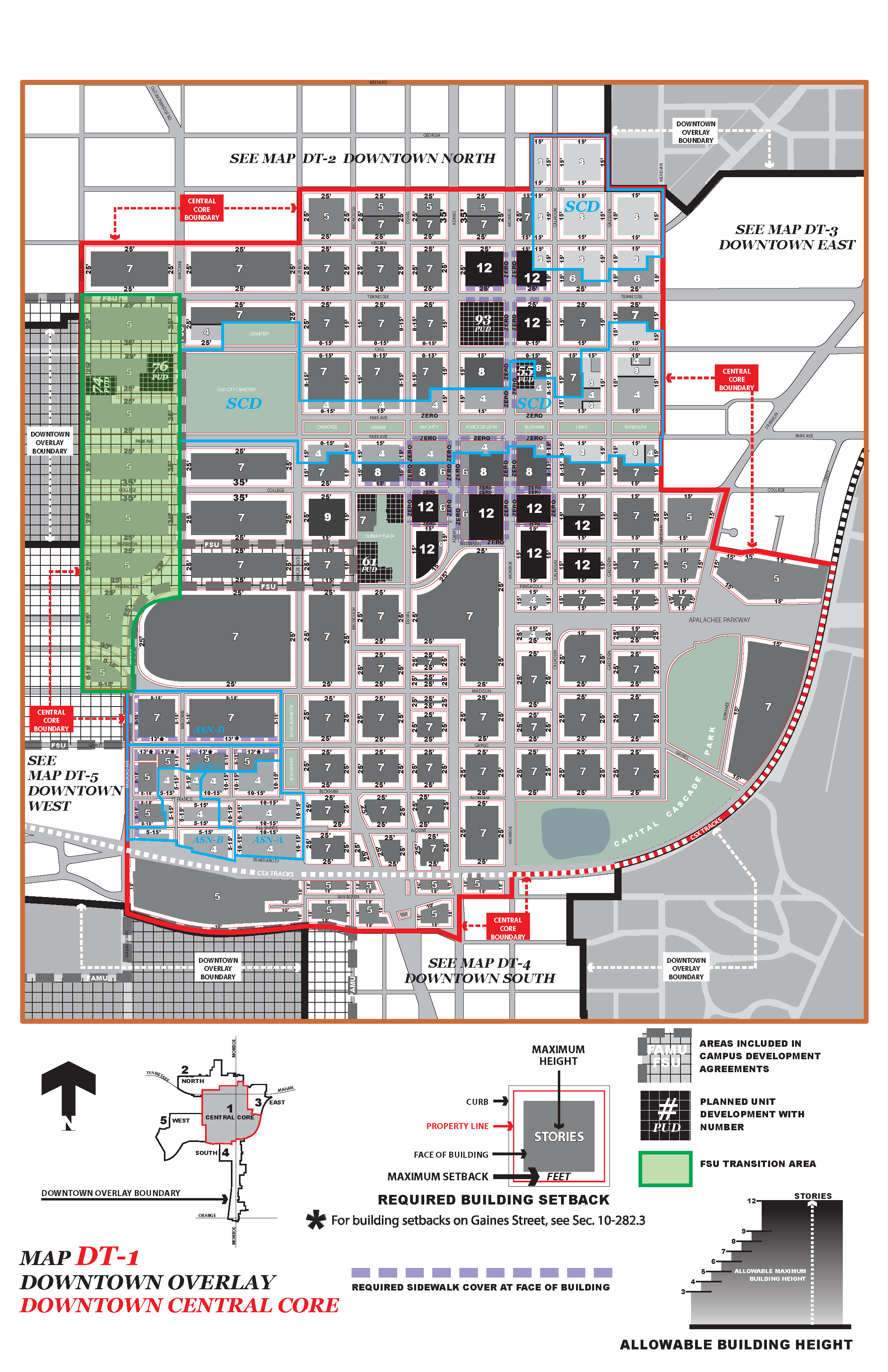
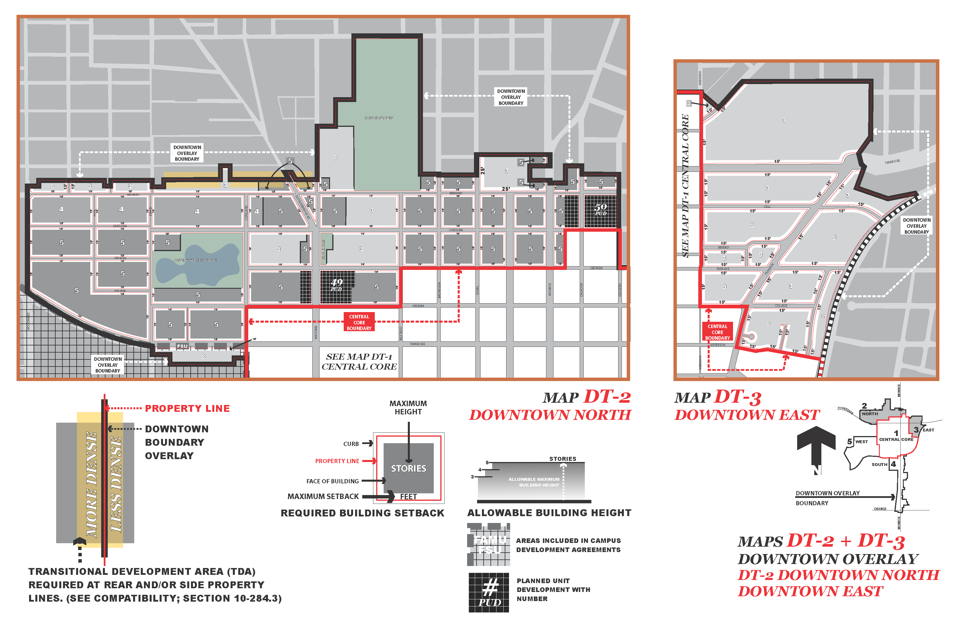
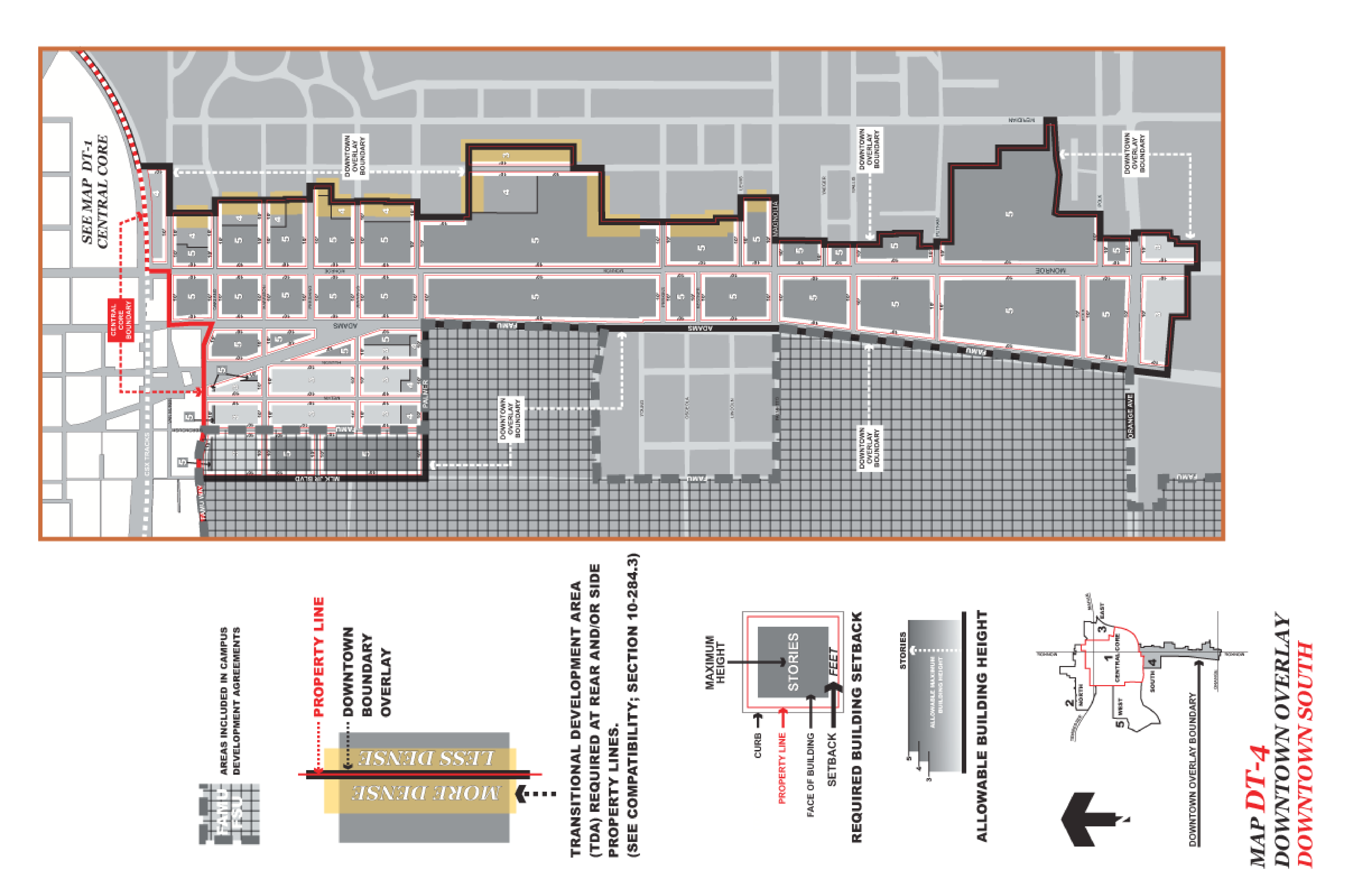
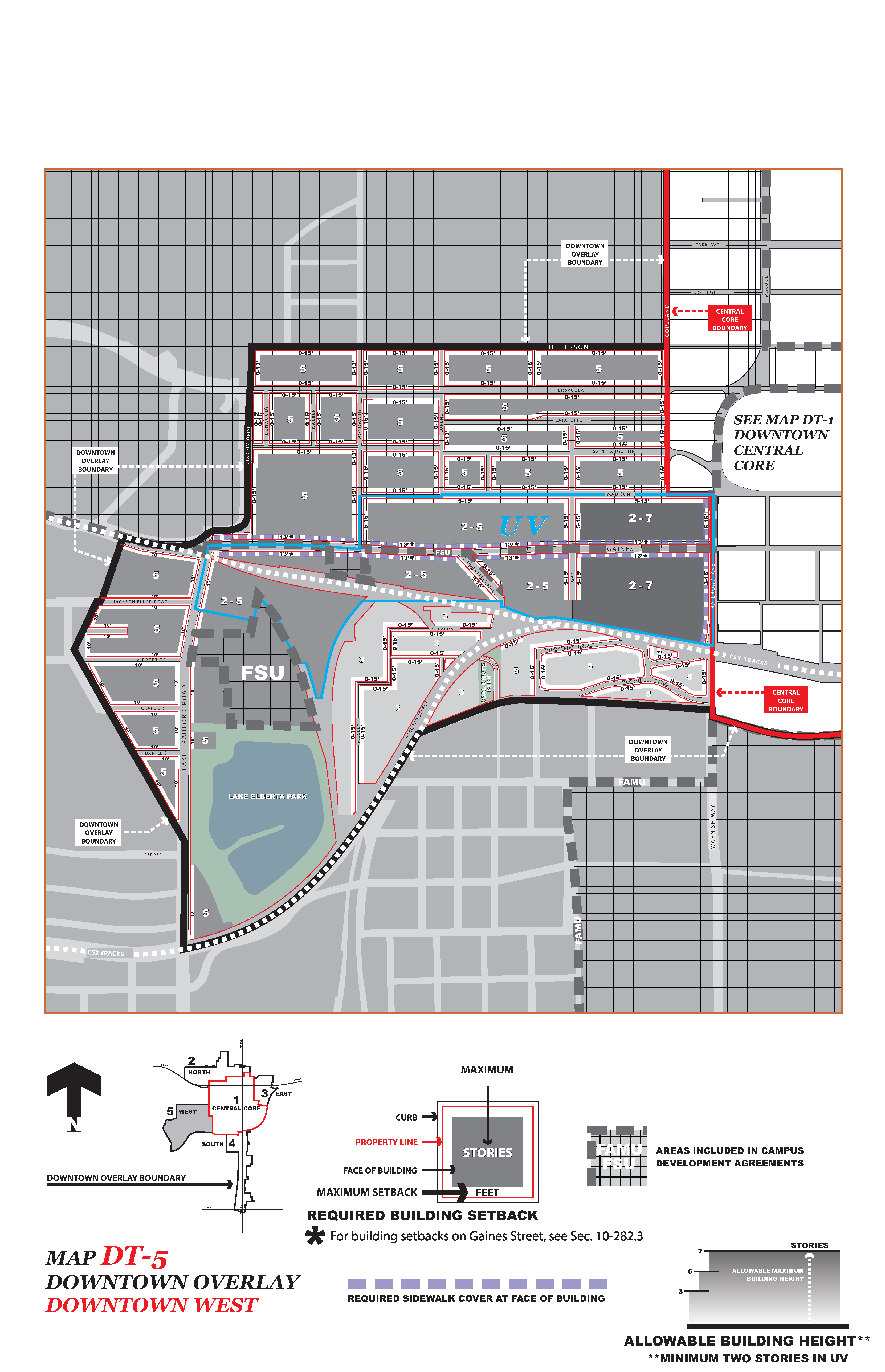
(Ord. No. 13-O-03, § 14, 8-28-2013)
Sec. 10-282.2. - Provisions for Design Review Districts: All Saints Neighborhood (Shown on DT-1), Florida State University Transition Area (Shown on DT-1), and University Village (Shown on DT-5).
(a)
Purpose and intent. The design review districts promote the conservation, enhancement, and continued vitality of areas of the city with special scenic, architectural, or cultural value, or neighborhood character through review by the planning department. Design review ensures that certain types of infill development will be compatible with the neighborhood and enhance the area. The planning department shall review all development plans within the University Village (UV) and ASN All Saints Neighborhood districts, as delineated on maps DT-1 and DT-5, and the FSU Transition Area, which is that area bounded on the north by Tennessee Street, on the east by Macomb Street, on the west by Copeland Street, and on the south by Madison Street, and as shown on DT-1.
The Design Review Districts are envisioned as vibrant in-town neighborhoods that integrate a broad mix of residential and commercial development. The intent of the design review is to implement this vision by facilitating the specific character and type of development that the Gaines Street Revitalization Plan encourages for the corridor and the adjacent All Saints Neighborhood. For the Florida State University Transition area, development shall be facilitated that harmonizes with and complements buildings on the campus and the character of the neighborhood itself. This section establishes criteria to guide future development activities in these districts.
(b)
General principles. The standards and guidelines for the Design Review Districts are intended to encourage flexibility and variety in development through good site and building design, defined in terms of the following principles which shall be applied by the designers and considered by the planning department and plan reviewers through the development approval process:
(1)
Sense of place. All development shall contribute to making the district a distinct and memorable part of the city, unique in spaces, buildings, and street character.
(2)
The public realm. All development shall be oriented and designed to contribute to the street environment intended for each district and shall place priority on pedestrian comfort, convenience, safety, and access.
(3)
Human scale. Human or pedestrian scale and human scale elements refer to buildings and spaces whose dimensions, properties, and components correspond to human occupation and use. Examples include individual, operable windows, seating, and shaded sidewalks.
(4)
Neighborhood fit. All development shall be sited and designed to complement and harmonize with existing or intended neighborhood development patterns, particularly with reference to building scale and orientation.
(5)
Site access. Access to all development shall be sited and designed to have a positive visual impact on the street, and shall provide primary pedestrian access to the public street. Driveways and parking shall not have primacy over pedestrian areas.
(6)
Visual interest. Variety in design elements, transparency, color, texture, signs, and materials creates a visually interesting environment and contributes to the establishment of an architectural character for the neighborhood.
(7)
Compatibility. Defined as the condition in which land uses or conditions can coexist in relative proximity to each other, in a stable fashion over time, such that no use or condition is negatively or indirectly impacted by another use or condition. Architectural compatibility is necessary to visually integrate a mix of uses and building types. All development shall be designed to have an architectural composition of forms that relate well in proportion, scale, geometry, and materials, both to one another and to its context. Architectural compatibility is not limited to any particular style, and contemporary architecture that complies with the design standards and guidelines of each district is encouraged.
(c)
Development and design standards applicable to all properties. These development and design standards are subject to review and final action by the planning department.
(1)
Site planning.
a.
Development pattern. A predominant building type, size of lots, siting of the building on the lot, lot coverage, and relationship of the building to the street determine a development pattern. New development must be harmonious with the predominant development pattern of the district.
b.
Street character. Development consistency in the following qualities lends character and a sense of place to a street:
1.
Types of uses and their relationship with the street, and the liveliness they contribute to the street. A street of ground floor shops and restaurants will have a character different from that of a street of residences.
2.
The degree of enclosure formed by the distance between buildings, across the street, their height, and the openness of spaces between buildings.
3.
The extent of the public realm of the street as defined by progressions from public to private space; there is a discernible and intentional difference between the public places on the street and the private spaces attributable to residences and businesses.
4.
Rhythm established by a predominate repetition of buildings and open spaces, or by a pattern of openings in facades.
5.
The contribution of building and landscape design to the ensemble of buildings on the street.
6.
Human scale as expressed in building size, height, massing, transparency, and detail.
(2)
Building orientation.
a.
All buildings shall be located and designed to be compatible with the predominant development pattern.
b.
Primary entrances shall face the street. At least one public entrance of each principal structure shall be oriented toward the front lot line or street side lot line. Developments are encouraged to provide as many pedestrian connections to the street as feasible.
c.
On corner lots, new buildings shall be oriented toward the streets and shall consider and complement the pattern of existing adjoining development, with the primary facade(s) of the building facing the front lot line and/or the street side lot line.
d.
Corner locations shall be considered opportunities for distinctive architecture.
e.
Accessory structures, if any, shall be located at rear of principal buildings.
(3)
Site and building access.
a.
Whenever feasible, driveway access to a site shall be shared with adjacent properties and parking shall be located internally to the block or at the rear of the site, except where existing garages associated with detached single family residences or duplexes may be accessed from the street.
b.
Service areas associated with multiple family dwellings shall be accessed from the rear of the site wherever feasible.
(4)
Parking and parking garages.
a.
Automobile and bicycle parking spaces for each land use shall be provided in accordance with standards in Section 10-285, Tables 8B and 8C.
b.
Minimum setbacks for front, side, and rear yards shall apply to parking structures and to parking lots, including associated pedestrian accessways adjacent to non-parking structures.
c.
With the exception of off-street parking associated with detached single-family residences or duplexes, all parking areas shall be configured so as to provide adequate maneuvering room and avoid backing motor vehicles directly onto the public street.
d.
All garages or carports shall be set back from the front facade.
(5)
Service areas.
a.
Screening: Service areas shall be screened from public view on all sides with the exception of the vehicle use area by structures, opaque fences, walls, or hedges to a minimum height one foot above the solid waste container or other service container or receptacle. This requirement does not preclude the gating of service areas as a preference of the developer as long as the gate is directed to the service vehicle area. Screening materials can include those identified in Section 10-411(b)3 and the use of chain link, plastic or vinyl fencing as screening materials is prohibited.
b.
General Provisions for access, operation and placement of services:
(1)
Miscellaneous Services Areas: Areas used for primary circulation and for frequent idling of vehicle engines shall be designed and located to minimize impacts on adjoining properties, and shall include provisions for screening or buffering as listed in (5)(a).
(2)
Solid Waste Service Areas:
(a)
Dumpsters and permanently placed refuse receptacles shall be located a minimum of 20 feet from adjacent residential uses, where practical and feasible, and sufficiently screened from public rights of way. To minimize clutter, joint use of waste receptacles within one or more development projects under common management or ownership is required, and between two or more developments not under common management or ownership, where feasible, is strongly encouraged.
(b)
Rollout waste receptacles are permitted. Rollout waste receptacles are required to be stored in screened service areas.
(c)
Use of shared waste collection sites, owned and maintained by the city, may be required. In addition to the above requirements, the following requirements shall apply to shared collection sites:
(i)
Dimensions including turning radii, openings, gates, and pull-throughs, shall be those required by the city solid waste division.
(ii)
Driveways between the curb and the structure at waste collection sites shall be paved with brick, stone, or concrete unit pavers, suitably reinforced.
(3)
Recycling Services: Each building shall dedicate a specific location for recycling separation, storage, and access.
(6)
Off-street loading. There is no required number of off-street loading spaces for uses. On-street loading zones may serve all land uses. The off-street loading space standards in section 10-388 are not applicable in the design review districts. Areas used for loading activities shall be designed and located to minimize impacts on adjoining properties.
(7)
Landscape features. Driveway and walkway paving shall be unit pavers such as brick, stone, asphalt, or concrete pavers installed on a sand bed. Semi-pervious paving materials are encouraged.
(8)
Preservation of historic landscape features. Landscape features identified as "character defining features" of the All Saints Neighborhood, downtown, or the Gaines Street corridor, including existing historic structures, rubble retaining walls, patriarch trees, and historic parks, shall be preserved.
(9)
Building design standards. Individual building design shall defer to the ensemble of buildings on the street rather than call undue attention to itself. New buildings shall contribute to the life of the street, and share the following with existing buildings that exemplify the area's character.
a.
Architectural articulation.
1.
A building's exterior walls shall be articulated using materials, architectural elements, arrangement of openings, design of horizontal and vertical planes, and changes in height to provide substantial massing variations.
2.
Articulation, including but not limited to window casings, eaves, cornices, railings, foundation walls, shutters, downspouts, fascias, gables, and gutters, shall complement the architecture of adjacent buildings while providing variety among building masses and facades of buildings on a street. Eaves, porch and arcade columns, roofs, railings, chimneys, etc. shall be detailed so as to emphasize these architectural features, consistent with the building's architecture.
3.
Long, monotonous roof planes and uninterrupted expanses of blank wall are not allowed along street frontages. Articulated roof forms and wall openings shall be used to add visual interest and contribute to a human scale.
4.
Buildings greater than two stories in height shall delineate clearly the boundary between each floor of the structure with belt courses, material changes, a band of signage (if applicable), or other architectural detailing. Attached buildings in the same block shall maintain consistent cornice lines, plus or minus five (5) feet.
5.
Doorways, windows, storefronts, and other openings in the facades of buildings shall be placed and proportioned to reflect pedestrian scale and movement, and to encourage visual interest at the street level. The use of functional and decorative elements, including weather protection features (i.e., colonnades, arcades, canopies, etc.), signage, and architectural detailing, shall be used to create human scale on a building's principal facade. Elements shall be integral to the architecture of the building, designed so as to not appear to be "tacked on" to the building facade.
6.
Doors and windows shall be compatible with the composition and architectural style of the building.
7.
On any building, a consistent rhythm of openings shall be maintained above street level on all facades facing a street. Openings need not be identical from building to building; small variations from facade to facade will provide visual interest.
8.
Where solid walls are required by building code, the wall shall be articulated and divided into distinct modules, through the use of projections and recesses (e.g., setbacks, reveals, belt-courses, awning, arcades, porches, etc.) within the building envelope or projecting from upper floors.
9.
Functional balconies. Balconies must be useable and accessible through operable full height doors. Balconies must be a minimum of six (6) feet deep.
10.
Commercial buildings and buildings with ground floor commercial uses shall have a ceiling height minimum of twelve (12) feet for the ground floor.
b.
Prohibited Materials and Design Features.
1.
Inoperable or fixed shutters.
2.
Reflective glass or tinted glass at the first and second story with less than 70 percent light transmission.
(10)
Transparency. Building facades along public rights of way shall have non-reflective, transparent areas covering:
a.
Mixed-use/Non-residential uses: A minimum of 70 percent of the first floor facade surface area at pedestrian eye level (between three (3) feet and eight (8) feet above grade), or
b.
Residential uses (single-family detached units exempt): A minimum of 50 percent of the first floor facade surface area at pedestrian eye level (between three feet and eight feet above grade), and
c.
A minimum of 15 percent transparency above the first story.
d.
The area of entrance doors and each facade shall be calculated separately.
(11)
Materials and colors.
a.
To avoid monotonous wall surfaces, all buildings shall use materials that offer texture, including wood, pantile, brick, or stone or high-quality synthetic materials. Materials shall be used consistently on all sides of a structure.
b.
Color shall be an integral element in the design of all structures. A coordinated palette of colors shall be created for each project or development. This palette shall be compatible with those of adjacent developments.
c.
The use of natural and natural-looking roof materials is strongly encouraged, particularly those that contribute texture, pattern, and color. Acceptable roof materials include standing-seam metal, textured shingles, pantile, and slate. High-quality dimensional asphalt shingles are acceptable.
d.
Color variation shall be used to break up the mass of a building and to provide interest. However, the number of color choices in any given building shall be limited to a wall color, roof color, trim color, and accent color.
(12)
Design features for parking structures.
a.
Accessory parking structures if any shall be located to the rear of the building and accessed from the rear or side of the lot.
b.
The ground floor of a parking structure that is the principal use on a site shall be occupied by non-residential uses.
c.
Design standards for parking structures shall also apply to parking located on the ground floor of a building.
d.
Maximum building height for the district is applicable to parking structures. All exterior facades of parking structures shall comply with design standards for massing and density, facade articulation, and materials established for other building types.
e.
The size and proportions of openings in parking structures shall be compatible with neighboring buildings. Openings in parking structures shall be screened so that no cars, headlights, or light fixtures are visible from the surrounding streets and uses. Glazing, perforated metal panels, applied surface elements, landscaping, or combinations of these materials, and materials from adjacent buildings, may be used on the facade to screen openings.
f.
Driveway and pedestrian entries of parking structures shall be integrated with the ground level facade.
g.
Ground floor ceiling height for retail or commercial uses in parking structures along the public street frontage shall be at least twelve (12) feet.
(13)
Streetscape standards.
a.
All areas shall be connected by sidewalks.
b.
All sidewalks in nonresidential areas and mixed-use areas shall provide a continuous, unobstructed clear width area of no less than six (6) feet.
c.
Street furniture and street lighting shall be required to be in conformance with a comprehensive streetscape program that establishes a uniform theme for each area where such streetscape is intended.
d.
Street lighting shall be installed on both sides of the street a maximum of 100 feet apart. The general preference shall be for smaller, but more frequent light fixtures rather than fewer high-intensity lights. All fixtures shall use a metal halide light source. Sodium vapor and similar types of light sources are prohibited. All fixtures, whether wall mounted or freestanding, shall be total cutoff and directed downward to reduce glare on adjacent properties.
e.
Utility service lines shall be provided underground or run through the rear alleyways. Electric meters, antennas, and exterior storage areas shall be screened from public view in a manner compatible with the principal structures and site design. The use of dense landscape plantings for screening is encouraged, appropriate to the district.
f.
Solid waste, recycling, and yard trash containers (except public litter containers); grease containers; and loading docks shall be located in parking areas or other locations remote from the sidewalk.
g.
All outdoor mechanical equipment, including heating, air conditioning, and ventilation systems, shall be placed on the roof, to the rear or side of a building, or be otherwise visually screened from the street. In no case shall mechanical equipment be allowed along the street frontage. Mechanical equipment on the roof shall be screened from abutting streets with parapets or other types of visual screening.
h.
Standpipes or hose bibs are required for cleaning purpose at all commercial street fronts and at all waste collection locations.
(14)
Energy conservation. Building design shall use energy conservation measures including but not limited to self-shading, natural lighting, natural ventilation, outdoor circulation, and reduced dependence on artificial lighting and air conditioning.
(Ord. No. 13-O-03, § 14, 8-28-2013; Ord. No. 15-O-04, § 12, 5-27-2015)
Sec. 10-282.3. - Specific to University Village (Map DT-5. Downtown West).
(a)
Streetscape along Gaines Street and Railroad Avenue.
(1)
Planting areas between arcade columns and openings, and vine planting areas at the face of the buildings, are encouraged.
(2)
Along Gaines Street from its intersection with Martin Luther King Jr. Boulevard in the east to Lake Bradford Road in the west, development shall provide setbacks to accommodate infrastructure, as required here:
a.
A minimum 13-foot setback from the back of curb to the face of the building for appropriate sidewalk width; and
b.
Development is permitted an additional maximum 10-foot setback from the edge of the sidewalk, resulting in 23 feet of hardscape between the curb and face of the structure.
c.
When located on private property, the sidewalk shall be placed in easement to maintain public access.
d.
While sidewalk activity is encouraged, a minimum 6-foot clear zone shall be maintained for pedestrian passage.
(b)
Pedestrian connectivity.
(1)
Publicly accessible pedestrian passageways from the street to and through the interior of the block are encouraged to separate pedestrians from traffic and provide pedestrian access from parking lots at the rear of buildings to the street. Passageways shall be a minimum of eight (8) feet wide and a minimum of twelve (12) feet high. Upper floors are encouraged to continue over the passageway. Pedestrian passageways shall be designed to preclude normal vehicular access and preferably be separate from other emergency vehicle access ways to the interior of the block.
(2)
Driveways to Gaines Street and Railroad Avenue are discouraged.
(c)
Design Features for New Buildings.
(1)
Retail and office building walls along sidewalks shall have non-reflective, transparent areas covering at least seventy-five 75 percent of the first floor facade surface area at pedestrian eye level (between three feet and eight feet above grade). All glazing shall be of a type that permits view of human activities and spaces within. Enclosed security areas, if any, shall be of the mesh type that pedestrians can see through and shall be located behind storefront displays. The area of operable entrance doors and each facade shall be calculated separately.
(2)
Facades with an emphasis on vertical proportions shall be employed to break up continuous building frontages and maintain compatibility with the scale of the historical building pattern of the adjacent buildings. Facade modules shall be no less than twenty (20) feet and no more than thirty-five (35) feet in width.
(3)
Articulation of building facades should establish a rhythm of vertical modules unified by a complementary rhythm of upper floor windows. Upper floor windows of adjacent buildings need not be identical in design or spacing.
(d)
Colonnades and arcades.
(1)
Where a colonnade or arcade is structurally integrated into the facade, the upper floors of the building may be either flush with the setback or be stepped back to a maximum setback of 12 feet from the face of the colonnade or arcade.
(2)
Colonnades and arcades shall have a 12-foot minimum depth. Depth shall not exceed height of openings to the street. Design standards for transparency established for other storefronts shall apply to interior walls of colonnades and arcades.
(3)
The spacing of columns or piers, measured from the centerline of the columns or piers, shall not be greater than the height of the colonnade or arcade. The height of the colonnade or arcade shall be the vertical distance measured from the finished floor to the ceiling of the colonnade or arcade.
(e)
Prohibited Materials.
(1)
Exterior insulation and finish systems (EIFS), also known as synthetic stucco and sheet metal;
(f)
Mixed-use developments. A mix of uses within a single project or structure is encouraged. The following design features are required for vertical mixed-use projects, in which different uses are located on different floors of a single structure:
(1)
Non-residential, commercial uses are required on the ground floor of a vertical mixed-use project. Residential uses are prohibited from being located on a floor below a commercial use in a vertical mixed use project with the exception of lobbies and common circulation areas, which may be located above the ground floor. The intensity of the uses should decrease as the floors go up.
(2)
Residential uses that are part of a vertical mixed-use project shall be permitted as-of-right, provided the project otherwise meets the conditions of (f)(1), above.
(Ord. No. 13-O-03, § 14, 8-28-2013)
Sec. 10-282.4. - Specific to All Saints Neighborhood (Map DT-1. Central Core).
(a)
Orientation.
(1)
New buildings in the All Saints Neighborhood shall turn their most narrow building frontage to the principal street. All buildings shall have covered entrances facing the principal street.
(b)
Screening.
(1)
Screening materials in the ASN-A district shall be wood or hedges. Alternately space exterior and interior boards for air circulation and to block the view. Exterior boards shall be topped with a picket shape.
(c)
Landscape features.
(1)
Walls and fences at the property line are encouraged. Walls, fences, and hedges (if provided) shall have a maximum height of six (6) feet. The opaque portion of a wall or fence shall have a maximum height of four (4) feet.
(2)
Walls and fences shall have piers or newel posts at corners and ends.
(d)
Design features for new buildings.
(1)
In all private buildings, not open to the public or providing public services, the progression of public to private space shall be layered through yards and porches.
(2)
New buildings wider than the average width of adjacent buildings or buildings across the street shall be broken into facade modules comparable to the widths of existing facades.
(3)
Within a zone twenty (20) feet from the back of the sidewalk, the height of a new building shall be no greater than twice the height of adjacent buildings or buildings across the street. Also, the fourth (4th) story in ASN-A shall be built as a 1/2-story with dormers.
(4)
Above the second floor, building masses shall be broken up and modulated, in keeping with a building's style, to reflect the scale of adjacent structures and avoid overwhelming them.
(5)
Along Gaines Street and Martin Luther King, Jr. Boulevard, building heights greater than five (5) stories shall step back twenty-five (25) feet from the top of the fifth floor. Floors above this five story height limit may extend into the step back within a forty-five (45) degree angle struck from the top of the street facade.
(e)
Streetscape standards.
(1)
Street light fixtures shall not exceed twelve (12) feet in height in the ASN-A zoning district and eighteen (18) feet in height in the ASN-B, ASN-C, and ASN-D zoning districts.
(f)
Prohibited design and materials.
(1)
In the ASN-A district, flat roofs are prohibited.
(2)
Exterior insulation and finish systems (EIS), also known as synthetic stucco.
(g)
Mixed-use developments. A mix of uses within a single project or structure is encouraged. The following design features are required for vertical mixed-use projects, in which different uses are located on different floors of a single structure:
(1)
Within the All Saints Neighborhood, residential uses are permitted on the ground floor as part of a live-work unit. Live-work is defined as a use made up of commercial activities that may need accommodations for customer traffic, commercial signage, or freight delivery, while also meeting life-safety regulations for a place where people live. Live-work is distinguished from purely residential use by having work performed in the unit.
(2)
For non-live-work units, residential uses shall never be located on a floor below a commercial use in a vertical mixed-use project. The intensity of the uses should decrease as the floors go up.
(Ord. No. 13-O-03, § 14, 8-28-2013)
Sec. 10-282.5. - Specific to Special Character District (Map DT-1. Central Core).
(a)
Purpose and intent. The Special Character District (SCD) is intended to complement the historical nature of this area. The SCD encourages a mix of uses characterized by a broad range of complementary uses that support eighteen-hour activity in a lively urban setting in harmony with the distinctive vernacular architectural qualities, historic height and scale. The intent is to encourage specialty retail/restaurant/entertainment uses with a primary target market of downtown office workers and visitors. The following are also encouraged to:
(1)
Provide street-level activity in new buildings and discourage parking;
(2)
Maintain consistency of new buildings with the architectural context of the district (not overwhelming or incompatible);
(3)
Protect the existing scale and architectural character of historic areas with the district;
(4)
Promote a pedestrian environment and complement the unique "park-like" setting of Park Avenue; and
(5)
Encourage mixed use: civic, cultural, residential, retail, office, and multiple use projects.
(b)
Design review. All development in the SCD that is within the Historic Preservation Overlay and National Register of Historical Properties Overlay is subject to review by the architectural review board (ARB).
(1)
Intent. To encourage quality design that will protect the historic park system, be compatible with neighboring historic buildings, and promote a pedestrian scale environment within the district.
a.
New development or redevelopment of structures and property identified as not contributing to the historic district may be contemporary in design, but shall respect neighboring historic development in terms of mass, proportion, scale, rhythm, directional orientation, materials, and landscaping elements.
b.
New development or redevelopment of structures and property identified as not contributing to the historic district and which are facing Park Avenue should introduce pedestrian amenities and design features including fenestration relief, entrances, landscaping, etc. On the portion of property facing Park Avenue, open parking facilities and parking lots are prohibited.
(c)
Development standards.
(1)
The special character district shall adhere to the parking regulations of Section 10-285, Tables 8B and 8C and buffer standards specific to the SCD in Section 10-284.3 and depicted in Section 10-285, Table 11.
(2)
Orientation. At least one public entrance of each principal structure shall be oriented toward the front lot line or street side lot line. Pedestrian access from the public sidewalk, street right-of-way or driveway to the public entrance shall be provided via an improved surface. Developments are encouraged to provide as many pedestrian connections to the street as possible.
(3)
Dumpster location. Garbage dumpsters shall be adequately set back from property lines and screened from public view.
(d)
Specific restrictions.
(1)
Massing. Developments fronting roadways in this area shall be compatible with the general character, scale, and mass of the district.
(2)
Coverage. The maximum impervious coverage is 40 percent.
(Ord. No. 13-O-03, § 14, 8-28-2013)
Sec. 10-283. - Block scale standards.
(Ord. No. 13-O-03, § 14, 8-28-2013)
Sec. 10-283.1. - Block sizes.
(a)
General to Zones T3, T4, T5 and Downtown Overlay.
(1)
Existing blocks longer than 800 feet in length, but shorter than 1,200 feet, shall be traversed near the midpoint by a publicly accessible multi-use trail. This requirement is only applicable when 80 percent or more of a block is redeveloped.
(b)
Specific to Zones T3.
(1)
New block faces shall not exceed 800 feet.
(c)
Specific to Zones T4, T5 and Downtown Overlay.
(1)
New block faces shall not exceed 600 feet.
(Ord. No. 13-O-03, § 14, 8-28-2013)
Sec. 10-283.2. - Common open space.
(a)
General to Zones T3, T4, T5 and Downtown Overlay.
(1)
City-owned common open space that is designated Open Space (OS) on the official Zoning Map. Development within this zoning district shall adhere to the development standards of Section 10-263.
(2)
Development plans greater than 5 acres shall aggregate pervious area and configure the space to adhere to the general typologies described in Section 10-285, Table 9.
(3)
A Home Owners Association (HOA) or other responsible maintenance entity shall be identified in the appropriate development order and be responsible for maintaining the common open space.
(4)
The City may, at the discretion of the growth management director, accept dedications of aggregated common open space for use as a park if the land addresses a documented need and the City is capable of responsible maintenance.
(5)
Parking provisions for public open space shall be those identified in Table 8(A) and approved as part of a site plan.
(Ord. No. 13-O-03, § 14, 8-28-2013)
Sec. 10-283.3. - General streetscaping.
(a)
Streetscaping: General to Zones T3, T4, T5 and Downtown Overlay. Streetscaping should complement the scale of the development and its surroundings, formalize public spaces, and provide valuable environmental services. To that end, development shall adhere to the provisions found below. Specific streetscaping requirements, found in Section 282.3(a)(1) and (2), apply to DT-5 in the University Village district along Gaines Street and Railroad Avenue and should be referred to for development in that area.
(1)
Street lights should be pedestrian in scale, and shall be no greater than 25-feet above grade.
(2)
Street trees shall be provided along all public road right-of-way in accordance with the requirements of Section 10-285, Tables 3, 4, 10A, 10B and 12. Trees placed within the right-of-way may be subject to maintenance agreements as determined by public works. Where right-of-way constraints or utility conflicts prohibit placement of trees, they shall be placed, if possible, between the sidewalk and façade (in the first layer) or off-site as approved by the City.
(a)
Within Transects T3 and T4, where trees are placed in the first layer, development shall provide a minimum of one shade tree in the first layer for each 20 feet of frontage.
(b)
Street Trees shall be placed a minimum of 10-feet apart or other length appropriate to the tree species; may be single or multiple species; and may be naturalistically clustered.
(c)
Sidewalk shading shall be accomplished through vegetation (Sec. 10-285, Table 4) or structurally with awnings, galleries, or arcades (Sec. 10-285, Table 5), unless use of either is determined by staff to be impractical given the site configuration.
(d)
Limitations apply to tree placement and structural extensions.
1.
Trees shall not interfere with existing overhead utility lines. Trees species approved for planting under utility lines are identified in Sec. 10- 285, Table 4.
2.
Mature canopy spread shall be considered in relation to street lighting so as not to impede lighting.
3.
Trees shall not be visual impediments in the sight distance triangle for automotive and pedestrian traffic.
4.
Trees shall be trimmed to preserve vertical clearance of at least eight (8) feet above sidewalks.
5.
Provide a 20-foot clear zone around fire hydrants.
(Ord. No. 13-O-03, § 14, 8-28-2013)
Sec. 10-283.4. - Transportation network.
(a)
Pedestrian Circulation: General to Zones T3, T4, T5 and Downtown Overlay.
(1)
Convenient pedestrian circulation systems that minimize conflicts between pedestrians and motor vehicles shall be provided continuously throughout developments.
(2)
Sidewalks shall be developed in accordance with the specifications listed below and follow the general depiction in Section 10-285, Table 3.
a.
Sidewalks shall be provided, free of obstructions in a six foot clearance zone, on all frontages of development sites as determined by public works.
b.
The sidewalk facility shall be based on context, considering existing uses, intended future land use, and the adjacent roadway, and shall, where allowable by all regulating entities, meet the following minimum widths by roadway classification: 1) 10-foot minimum for Major and Minor Arterials; and 2) 8-foot minimum for Major and Minor Collectors. Local roadway sidewalk widths shall be no less than 6 feet.
(b)
Bicycle Circulation: General to Zones T3, T4, T5 and Downtown Overlay.
(1)
Bicycle and pedestrian routes shall be preserved, maintained, or provided adjacent to or through sites as identified in the adopted Prioritization System for Planned Multimodal Projects list and Greenways Master Plan.
(2)
Bicycle and pedestrian interconnections shall be provided, where possible and determined appropriate by public works staff, to all sub-arterial streets stubbed to the property boundary of the development, to existing and programmed multi-use trails, and to existing and programmed public parks.
(c)
Public Transit Access: General to Zones T3, T4, T5 and Downtown Overlay.
(1)
Where transit routes exist, developments greater than 20 dwelling units for residential or 15,000 square feet for non-residential shall provide transit amenities satisfactory to StarMetro.
(2)
Priority in development design shall be given to transit stop amenities that are incorporated into the streetscape and/or adjacent structural design.
(3)
"No parking" zones shall be designated at StarMetro bus stops through one of the following methods:
a.
Curb extensions to prevent on-street parking and expand the waiting area.
b.
"No parking" signage, curb marking, and striping for a minimum of 50-feet adjacent to the stop, particularly along a roadway before and after the stop.
(d)
Vehicular Circulation: General to Zones T3, T4, T5 and Downtown Overlay.
(1)
All development plans shall contribute to creating a local street network, and shall incorporate and continue all sub-arterial streets stubbed to the property boundary of the development plan by previously approved development plans or existing development.
(2)
Dead-end public streets are prohibited, except where:
a.
Necessitated by environmental constraints, or
b.
Deemed temporary extensions to future development.
(3)
Development may have vehicular access to any type of street. However, vehicular access from non-residential and high-density residential development to a local street is prohibited if a low-density zoning district is located on the other side of the local street, directly across from where the vehicular access point is proposed.
(e)
Traffic Calming: General to Zones T3, T4, T5 and Downtown Overlay. Traffic calming shall be used as a retrofit to improve all users' safety and moderate traffic speeds. Vertical deflection is generally discouraged, and only permitted on local roadways as a retrofit. All treatments and locations will be reviewed on a case-by-case basis. City approved traffic calming includes, but is not limited to, the following items.
(1)
Mid-block curb extensions.
(2)
Traffic circles or roundabouts.
(3)
Angled slow points or chicanes.
(4)
Speed pillows.
(5)
Chokers (bumped-out or build-out areas that are intended to give the appearance of and/or physically narrow road lane(s) to reduce automobile speed).
(f)
Intersection Design Treatments: General to Zones T3, T4, T5 and Downtown Overlay. Intersection design should foster the safe movement of all transportation modes. The following design enhancements shall be used as a retrofit to improve all users' safety and movement. All treatments will be reviewed on a case-by-case basis.
(1)
Dual directional ADA ramps.
(2)
Pedestrian refuge islands where medians exist.
(3)
Tight corner radii with mountable curbs.
(4)
Crosswalks, clearly marked with striping and/or contrasting paving materials (i.e. brick pavers), or LED runner lights.
(5)
Bulb-outs, as retrofit treatment to reduce pedestrian crossing distances.
(6)
Prohibited: slip turn lanes.
(Ord. No. 13-O-03, § 14, 8-28-2013)
Sec. 10-284. - Building scale standards.
(Ord. No. 13-O-03, § 14, 8-28-2013)
Sec. 10-284.1. - Building disposition.
(a)
Specific to Zones T3, T4, T5 and Downtown Overlay.
(1)
Newly created subdivision lots shall be dimensioned according to Section 10-285, Tables 10A, 10B, 10C, and 10D.
(2)
Building disposition types shall be as shown in Section 10-285, Table 7 and Tables 10A, 10B, 10C, and 10D.
(3)
Density and intensity standards shall be as shown in Section 10-285, Table 10E.
(4)
Lot coverage (impervious surface) shall not exceed that identified in Section 10- 285, Tables 10A, 10B, 10C, and 10D, unless fee in-lieu provisions of Section 10- 281(d), On-Site Green Space And Fee In-Lieu, are utilized.
(5)
Front facades shall be built parallel to a rectilinear public front property line or to the tangent of a curved public front property line, with the exception of buildings interior to a site that includes buildings that otherwise meet the frontage requirement. Structures that lack frontage on a public right of way may be built parallel to an on-site access easement or drive aisle.
(6)
Front, side, side-corner, and rear setbacks for principal and accessory structures shall be as shown in Section 10-285, Tables 10A, 10B, and 10C. Setbacks may be adjusted by deviation with the following exceptions:
a.
Properties within the Canopy Road Protection Zone having no viable alternative access to a road other than a canopy road shall not be subject to a deviation for the front setback along the canopy road.
b.
An addition of up to 10 feet to the principal frontage setback shall be allowed, as necessary, for public safety to accommodate existing utility lines.
The frontage setbacks shall apply to all principal and double frontages.
(7)
The zero (0) side setback in the Downtown Overlay and Transect 5 is only permitted for contiguous structures along a public street frontage. In all other situations, the side setback shall be five (5) feet minimum.
(8)
New buildings shall implement Leadership in Energy and Environmental Design (LEED) energy efficiency measures for green building standards to the extent practicable.
(Ord. No. 13-O-03, § 14, 8-28-2013)
Sec. 10-284.2. - Building configuration.
(a)
General to Zones T3, T4, T5 and Downtown Overlay.
(1)
The private frontage of buildings shall be in accordance with Section 10-285, Table 5 and Tables 10A, 10B, 10C, and 10D.
(2)
A direct pedestrian connection shall be provided from the front facade to the public right-of-way.
(3)
Building heights and stepbacks shall adhere to Section 10-285, Table 6, Tables 10A, 10B, 10C, and 10D, and Table 11 if applicable.
(4)
Building stories are distinct from total building height and its applicable restrictions. Provisions for building story heights are identified for Transects T3, T4, T5 and the Downtown Overlay on Tables 10(A), (B), (C) and (D); it is intended that the tables supersede where there are potential differences with the text herein.
(5)
Height limits do not apply to attics or raised basements, masts, church spires, clock towers, cupolas, chimneys, or domes not intended for human occupancy, or elevator bulkheads.
(6)
Parking structures shall adhere to the standards of Sec. 10-284.5(c).
(7)
Outdoor spaces — porches, stoops, balconies, and terraces — shall be designed as usable space, with a minimum four (4) feet in width and depth.
(8)
Transparency. Except as specified in Section 10-282.3, for University Village District, all building elevations adjacent to public right-of-way or required pedestrian ways (except for detached single-family dwellings) shall provide transparency at eye level — between three (3) and eight (8) feet above finished grade — in accordance with the following minimum percentages.
a.
Non-Residential or Mixed-Use.
1.
Frontage: 60%
2.
Corner side elevations: 30%.
b.
Residential (Single-family detached units exempt.)
1.
Frontage: 30%
2.
Corner side elevations: 15%.
c.
In all structures, a minimum of 15 percent transparency shall be provided above the first story of facades adjacent to the public right of way.
d.
Reflective glass is prohibited.
e.
Solid rear walls above the first story are prohibited when properties adjoin the Special Character District.
(9)
Fencing. Fences erected around a residential property should be located either even with the building façade or behind the first building of the principal frontage, perpendicular to pedestrian ways, such that pedestrians have convenient and direct access to the street sidewalk, and the property maintains more connection to the streetscape. For secondary frontage, the fence should provide at least one pedestrian access point per building facing the secondary frontage.
(b)
Specific to Zone T3.
(1)
No portion of the private frontage shall encroach the sidewalk.
(2)
Open porches may encroach into the first layer setback 50 percent of its depth. (Sec. 10-285, Table 12)
(3)
Balconies and bay windows may encroach into the first layer 25 percent of its depth except that balconies on porch roofs may encroach as does the porch.
(c)
Specific to Zone T4.
(1)
Open porches, balconies, and bay windows may encroach into the first Layer setback 50 percent of its depth. (Sec. 10-285, Table 12)
(d)
Specific to Zone T5 and Downtown Overlay.
(1)
Awnings, arcades, and colonnades may encroach over the sidewalk to within two (2) feet of the curb but must clear the sidewalk vertically by at least eight (8) feet. No habitable space shall be permitted above public right-of-way.
(2)
Stoops, lightwells, balconies, bay windows, and terraces may encroach the first layer setback 75 percent of its depth. (Sec. 10-285, Table 12)
(Ord. No. 13-O-03, § 14, 8-28-2013)
Sec. 10-284.3. - Compatibility.
(a)
General to Zones T3, T4, T5 and Downtown Overlay.
(1)
Vegetative Buffers.
a.
Urban Buffer 1 or 2, as depicted in Section 10-285, Table 11, shall be provided when a proposed development is:
1.
adjoining a different transect of lesser density or intensity; or
2.
is non-residential or medium [8 to 16 dwelling units per acre] or high density [16 to 50 or greater dwelling units per acre] residential development adjacent to an R-1, R-2, RP-1 or RP-2 zoning district boundary.
b.
No buffers shall be required along public street frontages.
c.
Vegetative buffers as identified herein shall not be required adjacent to open space, greenways, and parks.
(2)
Height.
a.
Any structure, or portion thereof, located within 100 feet of an adjoining R-1, R-2, RP-1 or RP-2 zoning district, as measured from the property line to the closest vertical construction element, shall be limited to a height of three (3) stories.
b.
Urban Buffer 3 which includes stepback provisions shall apply (Sec. 10-285, Table 11), regardless of separation by local or minor collector roadways, when development is:
1.
adjoining R-1, R-2, RP-1 and RP-2 zoning districts along all property boundaries; or
2.
adjoining the Special Character District, along the property boundaries.
(3)
Equipment and service area screening.
a.
Roof-mounted mechanical equipment shall not be visible from adjacent right-of-way.
b.
All mechanical equipment and trash containment devices, including compactors and dumpsters, shall be screened from public right of way and placed in the second (2 nd ) or third (3 rd ) layer. Screening can be vegetative or structural.
(Ord. No. 13-O-03, § 14, 8-28-2013)
Sec. 10-284.4. - Parking calculations.
(a)
General to Zones T3, T4, T5 and Downtown Overlay.
(1)
Vehicular spaces.
a.
Parking shall be provided according to the requirements of Sec. 10-285, Tables 8A and 8B, as applicable.
b.
Required parking may be calculated as that located (1) on-site, (2) on-street, (3) those purchased or leased from a civic or private parking provider, or (4) secured as a result of cross access or parking easement.
(2)
Outside the Central Core, parking shall be provided within the ranges listed below. Requests to vary from the stated requirements, excluding the 25% potential increase for redevelopment projects, must be submitted to the Parking Standards Committee, as per Sec. 10-332.
a.
Downtown Overlay (except Central Core) and Transect 5: Developments shall provide parking at a rate of between 100 and 65 percent of that required by Section 10-285, Table 8A.
b.
Transect 4: Developments in Transect 4 shall provide parking at a rate of between 100 and 75 percent of that required by Section 10-285, Table 8A.
c.
Transect 3: Developments in Transect 3 shall provide parking at a rate of between 100 and 85 percent of that required by Section 10-285, Table 8A.
d.
Redevelopment shall have the right to provide parking at a rate of 25 percent less or 25 percent more if within a parking structure than that required in Section 10-285, Table 8A; for those categories with parking ratio ranges, the calculations will presume reduction or increase from the number of existing spaces on the site. Requests to vary from the stated requirements must be submitted to the Parking Standards Committee, as per Section 10-332.
(3)
Bicycle spaces.
a.
Bicycle parking is required of all uses in the MMTD as specified in Section 10-285, Table 8C.
(Ord. No. 13-O-03, § 14, 8-28-2013; Ord. No. 13-O-29, § 2, 9-25-2013)
Sec. 10-284.5. - Parking location standards.
(a)
General to Zones T3, T4, T5, and Downtown Overlay.
(1)
All parking shall be provided within a 1,000-foot radius of the development site it is intended to serve as long as the use for which the parking was provided exists.
(2)
Parking lots shall be located in the third layer (or interior/internal to the site), and shall not be located between the building facade and all public street frontage. See also Sec. 10-285, Tables 10A, 10B, 10C, and 10D.
(3)
Where parking lots abut public right-of-ways, the development shall adhere to Streetscreen requirements of Section 10-281.6.
(4)
All parking lots shall include a direct improved pedestrian route with a minimum width of four (4) feet to the public street frontage unless that function is already provided by an existing sidewalk.
(5)
Single family detached and duplex homes are permitted a single parking space per dwelling unit in the first layer.
(6)
Vehicular drive aisle entrances shall be a width of 24 feet or less in the first Layer.
(7)
Loading docks and service areas shall be permitted on frontages only by deviation.
(b)
On-Street Parking: General to Zones T3, T4, T5, and Downtown Overlay.
(1)
On-street parking shall be provided on all streets with adequate public right of way (Sec. 10-285, Table 2A).
(2)
Parking shall be applied consistently along entire street segments and block faces.
(3)
On-street parking shall maintain access to fire hydrants.
(4)
On-street parking shall be prohibited within 30 feet of the point of curb return.
(c)
Parking Structures: General to Zones T3, T4, T5, and Downtown Overlay.
(1)
Liner Buildings. When located along public right-of-ways or public open space, a minimum of 50 percent of the ground level of parking garages shall be wrapped by retail, office, or other active uses.
(2)
Height. Structured parking facilities shall adhere to the height standards for the given transect, or when accessory to a primary use (e.g., offices, residences), it shall not exceed the height of the primary structure.
(3)
Entries.
a.
Pedestrian entries shall be clearly visible and provide direct connection to the public frontages, except for underground levels, for which entries and exits may be directly into a building.
b.
Staircases or elevators shall be located near exterior sidewalks to minimize pedestrian-vehicle conflicts.
(4)
Facade.
a.
Along public right-of-ways, parking structure facades shall be compatible in terms of design, height, materials and scale, with the primary structure or liner buildings.
b.
The facade shall be designed to visually screen cars so they are not visible.
(d)
Access and Interconnectivity: General to Zones T3, T4, T5, and Downtown Overlay.
(1)
Commercial/Mixed-Use Sites.
a.
Vehicular access shall be directed to secondary frontages.
b.
Rear oriented cross-access connections shall be given top priority in design.
(2)
Residential Sites.
a.
Vehicular access shall be directed to secondary frontages.
b.
Where development plans are adjacent to existing alleys, the alleys shall be continued through the development. Development plans are encouraged to provide service alleys extending the entire length of each block. (See Sec. 10-285, Tables 2A and 2B)
(3)
Adjacent parking lots shall be interconnected except where existing environmental constraints preclude or where there are already existing sidewalks that serve an interconnection function.
(4)
Shared parking facilities and driveway access should be used to the greatest extent practical, and shall be secured through cross access and parking easements or agreements.
(e)
Bicycle Facilities: General to Zones T3, T4, T5, and Downtown Overlay.
(1)
Bicycle rack placement shall:
a.
Not create sidewalk obstructions,
b.
Required external bicycle parking spaces for multi-family and nonresidential uses shall be located as to provide for visual monitoring from within the structure and should be visible from the right of way,
c.
Be placed as close as practical to the primary entrance, and
d.
Where multiple entrances exist, divide the required spaces among each entrance.
(2)
For multi-family and nonresidential uses, except low-occupancy uses, at least 50 percent of all bicycle parking shall be located as to be secure, enclosed, and covered (e.g., bicycle lockers), protected from theft, vandalism and inclement weather, and intended for residents and employees. The size of individual bike lockers, if used, should be adequate to accommodate a standard bicycle, approximately 50 inches high by 38 inches wide by 75 inches long or deep.
(Ord. No. 13-O-03, § 14, 8-28-2013)
Sec. 10-284.6. - Signage: General to Zones T3, T4, T5.
All provisions of the Tallahassee Land Development Code, Chapter 7, Sign Code, shall be applicable, and where in conflict therein, the stricter provision shall apply.
(Ord. No. 13-O-03, § 14, 8-28-2013)
Sec. 10-284.7. - Lighting.
Lighting shall be governed by applicable standards within this land use code Division, and where in conflict, the stricter provision shall apply.
(Ord. No. 13-O-03, § 14, 8-28-2013)
Sec. 10-284.8. - Design standards for drive-through facilities.
(a)
Applicability. Areas where drive through facilities are allowed in the Multi-Modal Transportation District (MMTD) and on specific segments of roadways in UP-1 zoning districts outside the MMTD.
(b)
Purpose and intent. To provide design standards and site design requirements applicable to drive-through facilities and their associated vehicle stacking and parking areas. These provisions will provide direction during the pre-submittal and site plan approval process to promote, properly assess, and achieve appropriate forms of drive-through development. Furthermore, they will assist in regulating the layout, built form, and appearance of drive-through facilities as well as assist in mitigating any adverse impacts. The intent of these provisions is to promote:
• Compatible development that minimizes impacts on adjacent uses;
• Functional and safe traffic, pedestrian, and bicycle movement;
• Safe stacking lane and site access location;
• Safe and accessible pedestrian connections to the building from both the private and public realms;
• A high quality, pedestrian-supportive urban streetscape.
(c)
Standards.
(1)
The site shall be accessed from an arterial street or major collector street.
(2)
Adequate space shall exist within the lot for vehicles to queue prior to using the drive-through window, as determined by the city traffic engineer, or designee.
(3)
Each drive-through window and queuing lane shall be visually screened from adjacent streets through placement of the building on the site or through the use of vegetation and/or fencing.
(4)
Facilities with a drive-through window shall be sited to prioritize pedestrian traffic. Sidewalks on the site shall provide pedestrian access to the facility and connect to adjacent sidewalks and walkways connecting to the public sidewalk system.
(5)
For any restaurant which is constructed with a drive-through window, there shall be a minimum floor area of 1,800 square feet and interior seating constructed as part of the restaurant, which comprises at least one-fourth of the structure.
(6)
No more than one driveway curb cut shall be provided per street except where shared driveways are used. This shall not apply to UP-1 zoned properties located on specific segments of roadways outside the MMTD.
(7)
At least one public entrance of each separate occupant shall open towards the street, and remain open and operable during business hours, and shall connect to at least one sidewalk that does not intersect with vehicles for pedestrians to safely enter the building.
(d)
Additional standards for drive through facilities in UP-1 outside the MMTD.
(1)
Development proposing a drive through facility shall include more than one occupant.
(2)
The structure shall be one building and shall have a minimum of two stories; or, if the drive-through facility use is single-story, the remainder of the building shall be one and one-half times larger in base floor area than the drive through use and shall have two full and functional stories.
(3)
Gross floor area of the second floor shall be equal to the first floor over which it is located. The first floor and all additional stories shall be fully functional and available for occupancy.
(4)
Development proposing one building, with one occupant is prohibited.
(5)
Drive-through development in UP-1, otherwise meeting the standards of this section, shall also comply with Urban Buffer 2 (10-285, Table 11), at a minimum, if the land use types are determined to be incompatible with an adjoining parcel pursuant to section 10-177 of the Land Development Code.
(Ord. No. 14-O-46AA, § 1, 1-28-2015; Ord. No. 17-O-24AA, § 2, 7-19-2017)
Sec. 10-285. - Graphic standards and tables.
The standards and tables of Section 10-285 are an integral part of this code and are requirements. However, the diagrams and illustrations that accompany them should be considered guidelines. Should there be discrepancies between the general text and tables, the tables shall be used for detail on applicable standards.
TABLE 1: Transect Zone Descriptions. This table provides general descriptions of the character of each transect zone.
| _____ | |||
 | T-3 NEIGHBORHOOD (RP-1, RP-2, R-1, R-2, R-3, R-5, NBO, CU-12 OR-1, C-1, NB-1) | ||
| T-3 Neighborhood consists of primarily low-density residential areas and some medium-density residential adjacent to higher zones that include some mixed use. Home occupations are allowed. Planting is naturalistic and setbacks are deeper. Blocks may be larger and roads irregular to accommodate natural conditions. | General Character: | Lawns, and landscaped yards surrounding single-family houses and townhouses; casual pedestrian traffic, and small scale commercial or retail activity | |
| Building Placement: | Relatively large and variable front and side yard setbacks. | ||
| Frontage Types: | Porches, lawns, small shopfronts, naturalistic tree planting. | ||
| Typical Building Height: | 1- to 2-Story is common, with some 3-Story. | ||
| Type of Civic Space: | Parks, greenways | ||
| _____ | |||
 | T-4 GENERAL URBAN (R-4, UP-1, MR-1, OR-2, C-2, CP, CU-18, CU-26) | ||
| T-4 General Urban consists of a mixed use but primarily residential urban fabric. It may have a wide range of building types: single family, side yard houses (Charleston-style), and townhouses. Setbacks are smaller and landscaping is variable. Streets with curbs and sidewalks define medium-sized blocks, and on-street parking with formal street trees are common. | General Character: | Mix of houses, townhouses & small apartment buildings, with scattered commercial activity; balance between landscape and buildings; trees and planting strip within the public right-of-way; increased presence of pedestrians | |
| Building Placement: | Shallow front and side yard setbacks | ||
| Frontage Types: | Porches, stoops and terraces, shopfronts | ||
| Typical Building Height: | 2- to 3-story with a few taller 4-story mixed use buildings | ||
| Type of Civic Space: | Squares, greens, street trees | ||
| _____ | |||
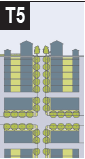 | T-5 URBAN CENTER (UP-2, OR-3, CM, CU-45, UT, AC) | ||
| T-5 Urban Center consists of higher density, mixed use buildings that accommodate retail, offices, rowhouses, and apartments. It has a tight network of streets, with wide sidewalks, formal street tree planting, and buildings set close to the sidewalks | General Character: | Shops mixed with townhouses, larger apartmenthouses, offices, and civic buildings: predominantly attached buildings; tree wells within the public right-of-way; substantial pedestrian activity | |
| Building Placement: | Shallow setbacks or none; buildings oriented to street defining a street wall | ||
| Frontage Types: | Stoops, shopfronts, galleries | ||
| Typical Building Height: | 3- to 5-story with some variation | ||
| Type of Civic Space: | Parks, plazas and squares, street trees and median landscaping | ||
| _____ | |||
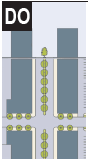 | DO DOWNTOWN OVERLAY (CC, UV, SCD, ASN-A, -B, -C & -D, AND OTHER DISTRICTS) | ||
| DO Downtown Overlay consists of the highest density and height, with the greatest variety of uses, and civic buildings of regional importance. It may have larger blocks; streets have steady street tree planting and buildings are set close to wide sidewalks. (See Section 10-282.1 Downtown Regulating Plan) | General Character: | Medium to high-density mixed use buildings, entertainment, Civic and cultural uses. Attached buildings forming a continuous street wall; trees within the public right-of-way; highest pedestrian and transit activity | |
| Building Placement: | Shallow setbacks or none; buildings oriented to street, defining a street wall | ||
| Frontage Types: | Stoops, shopfronts, galleries, and arcades | ||
| Typical Building Height: | 4-plus story with a few shorter buildings | ||
| Type of Civic Space: | Parks, plazas and squares; median landscaping | ||
| _____ | |||
TABLE 2A. VEHICULAR LANE DIMENSIONS FOR NEW PUBLIC ROADWAYS
1. Roadways within the MMTD shall not exceed 4 travel lanes, and, where right-of-way permits, shall be formalized by planted medians.
2. Tight turning radii shall be employed to control travel speeds and improve pedestrian safety.
3. Mountable curbs shall be used to allow wider turning areas for emergency responders.
4. Roadways shall consist of travel lanes (vehicular and bicycle), parking, amenity zone (trees, lighting), and pedestrian zone (clear sidewalk).
5. Roadway sections shall include curb and gutter, unless creative stormwater solutions are proposed and approved by the City.
6. On-street parking shall be provided along all non-arterial street segments where right of way permits.
1 Curb lanes on arterial roads may be enlarged to 12-feet in width to accommodate larger vehicles.
2 Bike lanes can be reduced to 4' where on-street parking is not provided.
3 As an acceptable retrofit on local streets, tree wells can be placed in the parking lane between parallel parking spaces. Three parking stalls should be located between each tree well.
4 Minimum five-feet wide sidewalks shall be installed in residential areas, 8'-12' sidewalks or greater should be installed in commercial/mixed use areas.
Table 2B: Vehicular lane/parking assemblies. The following street sections are desirable in the MMTD and new roadways shall adhere to these standards. Alternative assemblages will be considered to fit local context, and such alternatives should maintain consistency with the urban intent of Section 10-280.3. Proposed alternatives must be approved by the City.
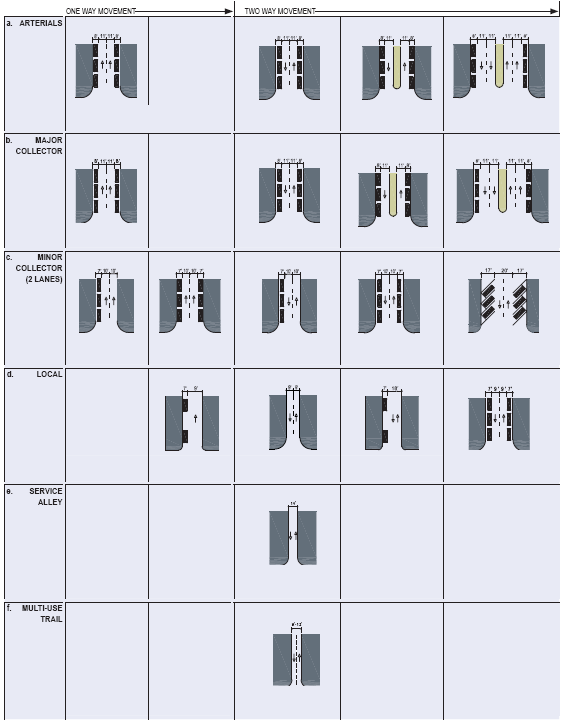
TABLE 3: Public Frontages — Specific: The table depicts requirements and dimensions for public frontage elements — curbs, walkways, and planting areas — relative to specific transect zones. Local context should be considered during design, and thus, the table sets a flexible range of requirements per transect.
1. Tree wells or planters should be provided in mixed-use/commercial areas with on-street parking.
a. Tree wells shall be appropriately sized based on the type of tree(s) proposed and based on the recommendation from the Growth Management Department.
2. Where on-street parking is absent, a continuous planting strip is preferable.
3. The provision of trees, planters, or street furniture shall not result in a pedestrian clear zone of less than 5-feet in width.
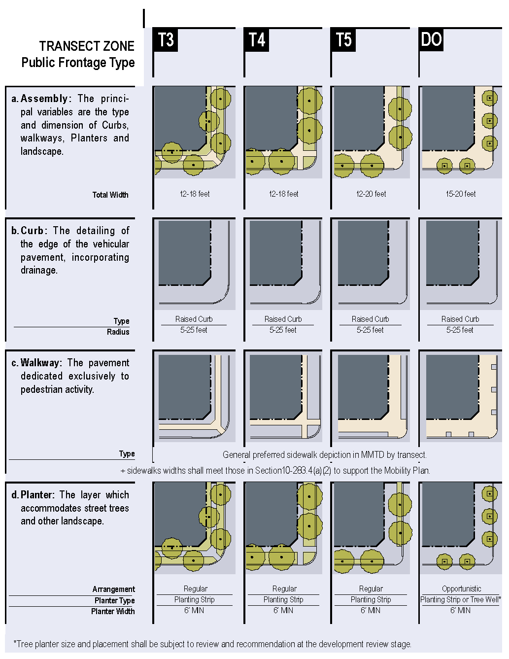
TABLE 4: Public Street Trees. This table lists common street tree species available for Tallahassee climate.
1. The left column is a recommended list, and the City will evaluate all proposed plantings on a case-by-case basis. In determining appropriate plantings, site specific conditions may warrant the use of a certain tree species.
2. The right column lists species permitted to be planted beneath overhead utility lines.
3. The use of cultivars that do not produce seeds, nuts, or fruits is required.
4. The spacing of street trees shall be consistent with Sec. 10-283.3(a)(2).
TABLE 5: Private frontages. The private frontage is the area between the building facade and the public right-of-way line. The following passages provide general descriptions of the frontage types and the specific transect in which each is permitted.
| a.Porch & Lawn: A planted frontage wherein the facade is set back substantially. The front yard created is visually continuous with adjacent yards and an attached porch is permitted to encroach the setback. | 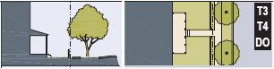 |
| b.Terrace: A frontage wherein the facade is set back by an elevated terrace or a sunken lightwell. This buffers residential uses from urban sidewalks and public encroachment. Also suitable for conversion to outdoor cafes. |  |
| c.Forecourt: A frontage wherein the facade is close to the frontage line, but the central portion is setback. The forecourt is suitable for vehicular drop-off, preservation of large trees, or provision of privacy for residents or restaurant diners. | 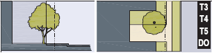 |
| d.Stoop: A frontage wherein the facade is aligned close to the frontage line with an elevated first story to secure privacy for windows. The entrance is usually an exterior stair and landing. Recommended for ground floor residential. | 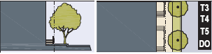 |
| e.Shopfront: A frontage wherein the facade is aligned at the frontage line with the building entrance at sidewalk grade. Conventionally used for retail. Substantial transparency on sidewalk level and an awning should overhang the sidewalk. | 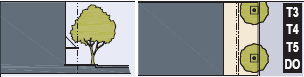 |
| f.Gallery: A frontage wherein the facade is aligned close to the frontage line with a shed roof or lightweight colonnade over the sidewalk. Conventionally used for ground floor retail. |  |
| g.Arcade: A gallery supporting habitable space above the private portion of the sidewalk, and the facade at sidewalk level is recessed from the frontage line. Conventionally used for ground floor retail. |  |
TABLE 6: Building Configuration. The table shows the configuration of different building heights for each Transect zone. Heights vary within the Downtown Overlay, and are controlled by the Sec. 10-282.1 Downtown Regulation Plan map series.
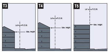
Setbacks/Arcade Heights. The diagram below, at left, shows arcade frontages and clearly prohibits enclosed, habitable space above the public right-of-way.
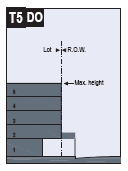
TABLE 7: Building Disposition. This table approximates the location of the structure relative to the boundaries of each individual lot, establishing suitable basic building types for each transect zone.
| a.Edge yard building: Specific Types - single family house, cottage, villa, estate house, urban villa. A building that occupies the center of its lot with setbacks on all sides. This is the least urban of types as the front yard sets it back from the frontage, while the side yards weaken the spatial definition of the public thoroughfare space. The front yard is visually continuous with the yards of adjacent buildings. The rear yard may be accessible by rear alley, and may contain an accessory dwelling unit or detached garage. | 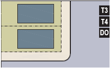 |
| b.Side yard building: Specific Types - Charleston single house, double house or twin, zero lot line house. A building that occupies one side of the lot with the setback to the other side. A shallow front setback defines a more urban condition. If the adjacent building is similar with a nearly blank side wall, the yard can be quite private. This type permits systematic climatic orientation in response to the sun or the breeze. If a side yard house abuts a neighboring side yard house, the type is a duplex or two-unit townhouse. Energy costs, and sometimes noise, are reduced by sharing a party wall in this disposition. | 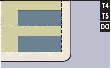 |
| c.Rear yard building: Specific Types - Townhouse, rowhouse, live-work unit, loft building, apartment house, mixed-use block, perimeter block. A building that occupies the full frontage, leaving the rear of the lot as the sole yard. This is a very urban type as the continuous facade steadily defines the public thoroughfare, with occasional breaks for driveways where not served by alleys. The rear elevations may be articulated for functional purposes. In its residential form, this type is the rowhouse. For its commercial form, the rear yard can accommodate substantial parking. | 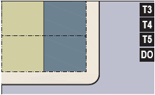 |
| d.Courtyard building: Specific Types - patio house, apartment buildings, urban offices. A building that occupies the boundaries of its lot while internally defining secluded spaces. This is the most urban of types, as it is able to shield the private realm from all sides while strongly defining the public thoroughfare. Because of its ability to accommodate incompatible activities, masking them from all sides, it is recommended for workshops, lodging, and schools. The high security provided by the continuous enclosure is useful for crime-prone areas. | 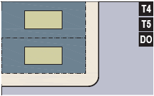 |
| e.Specialized building: A building that is not subject to categorization. Buildings dedicated to manufacturing and transportation are often distorted by the trajectories of machinery. Civic buildings, which may express the aspirations of institutions, may be included. | 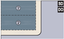 |
TABLE 8A: General Parking Ratios. The table establishes parking requirements for each transect zone. For specific permitted uses, see the zoning district chart (TLDC, Chapter 10).
TABLE 8B: Downtown Overlay Parking Ratios. This table sets parking requirements for areas within the Downtown Overlay.
1 Redevelopment projects are allowed pursuant to Section 10-357 to provide parking within 25 percent of the identified standards, and calculations for those standards that have ranges shall be based on the percentage selected within range.
2 On-street parking may be used to meet the parking requirement.
TABLE 8C: Bicycle Parking Ratios
1 At least 50% of all parking shall be secured, enclosed, and covered (e.g.., bike lockers) and intended for residents or employees.
2 Where the calculation of the number of parking spaces results in a fraction, the number shall be rounded up to the next whole number.
TABLE 9: Open Space Types. The following open space types are recommended for use within the MMTD. The descriptions provide a general definition of the type and where it is most appropriate. For larger developments (>5 acres), it is recommended that on-site green space requirements be achieved through aggregation to create usable open space that serves as an amenity.
| a.Park: A natural preserve available for unstructured recreation, or formal area for organized athletics and active recreation. A park may be independent of surrounding building frontages. Its landscape shall consist of naturalistic passive features or active facilities, such as paths, trails, meadows, water bodies, woodland, open shelters, hard courts, and athletic fields. Parks may be lineal, following the trajectories of natural corridors. The minimum size shall be 5 acres. | 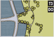 |
| b.Green: An open space available for unstructured recreation. Greens may be spatially defined by landscaping rather than building frontages. Its landscape may consist of open lawn, trees, and formal landscaping. | 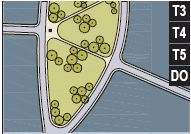 |
| c.Square: An open space available for unstructured recreation and civic purposes. Squares are spatially defined by building frontages. Its landscape may consist of formal paths, lawns, and trees. Squares should be located at the intersection of important roadways. | 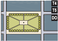 |
| d.Plaza: An open space available for civic purposes and commercial activities. Building frontages spatially defined plazas. Its landscape may consist of pavements with additional formal plantings and trees. | 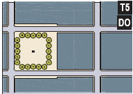 |
| e.Pocket Park: An open space designed and equipped for the recreation of children or adults. A playground should be fenced and may include open shelters or urban active recreation facilities, such as hard courts. Playgrounds should be interspersed within residential areas and may be placed within a block. Pocket parks are commonly the same size as lots in the surrounding residential area. | 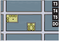 |
TABLE 10A: Development standards for Transect 3 (RP-1, RP-2, R-1, R-2, R-3, R-5, NBO, OR-1, C-1, CU-12, NB-1)
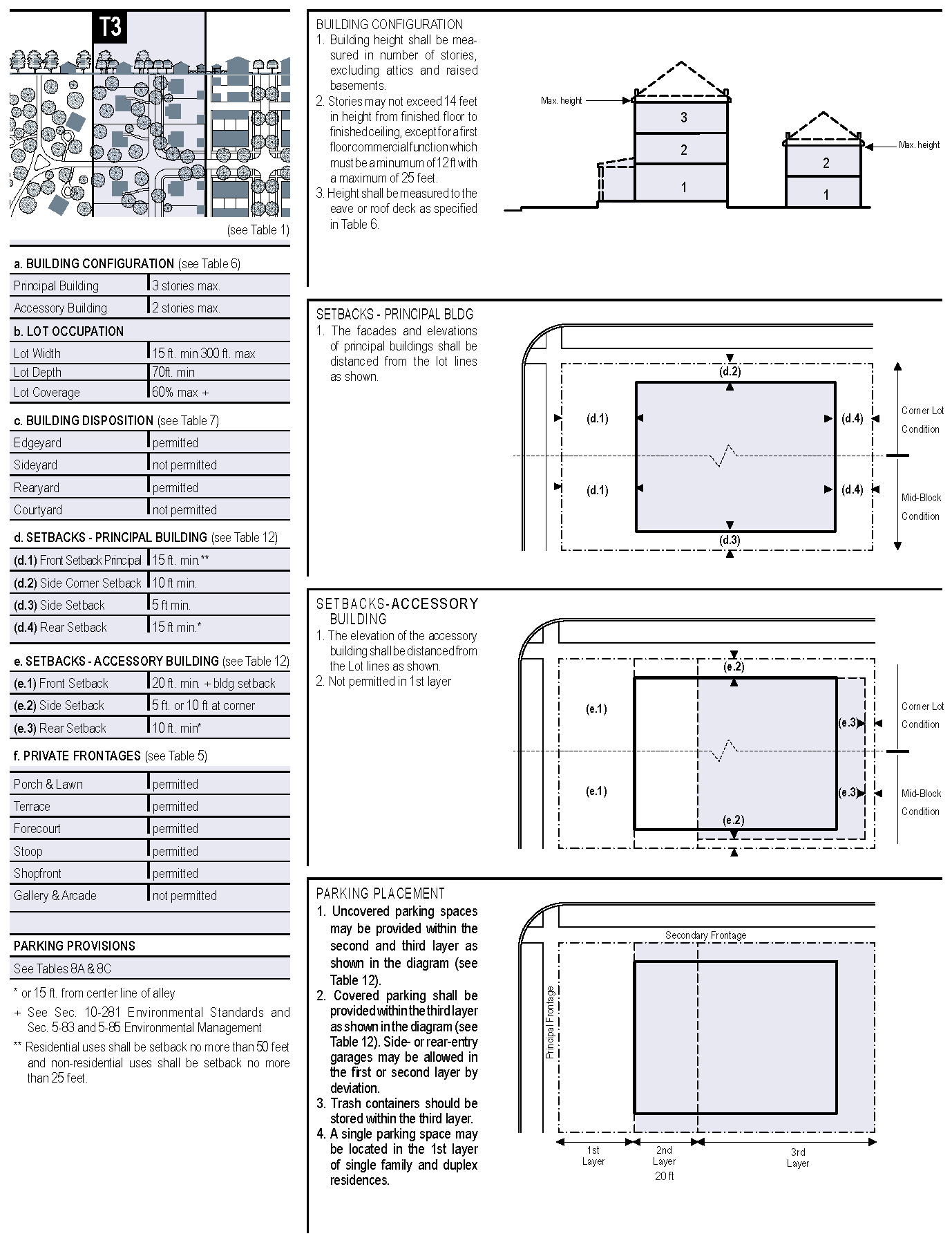
TABLE 10B: Development standards for Transect 4 (R-4, OR-2, UP-1, MR-1, C-2, CP, CU-18, CU-26)
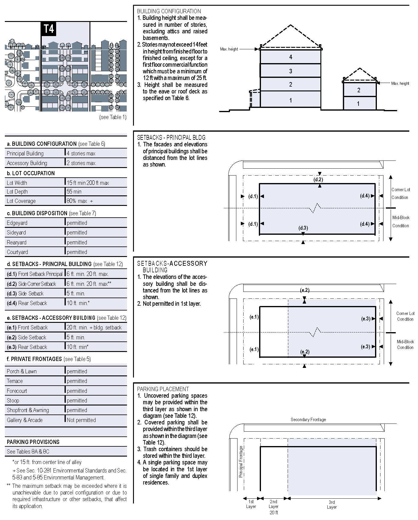
TABLE 10C: Development standards for Transect 5 (OR-3, UP-2, CM, CU-45, AC, UT)
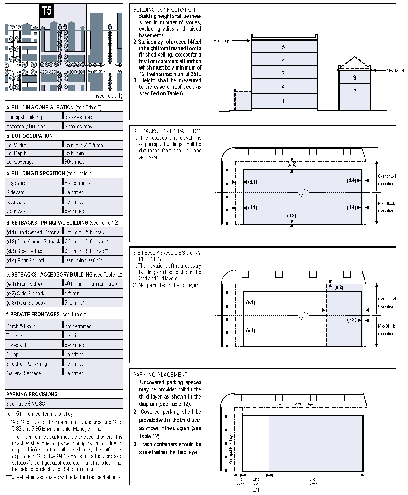
TABLE 10D: Development standards for Downtown Overlay (CC, UV, SCD, ASN-A, -B, -C, D, and other districts that are within the Downtown Overlay boundary.)
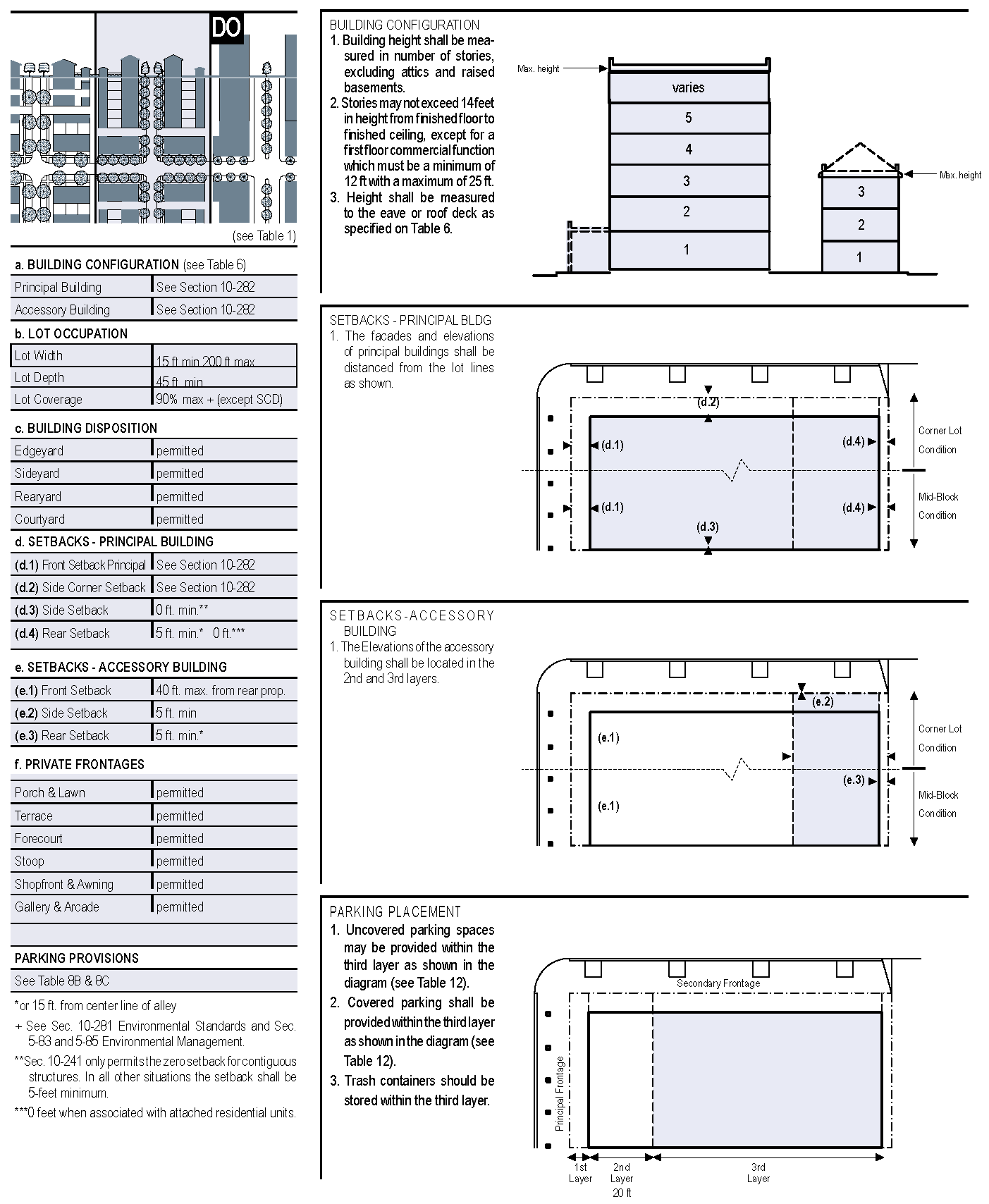
TABLE 10E: Density and Intensity Standards. The table lists density and intensity standards applicable to the various districts within Transects.
General Notes:
1. Minimum densities do not apply to mixed-use projects.
TABLE 11: Compatibility. This table shows vegetative buffers and structural elements intended to maintain compatibility between adjacent uses or transects as required by this Division.
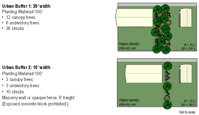
Urban Buffer 3: Structural.
a. Properties adjoining the Special Character District shall step back buildings at
5 stories in height when constructed on the property line, or at 6 stories in height
after a 15-feet setback from the property line. The stepback shall be a minimum of
15-feet wide and then follow a 45-degree angle to the maximum allowable building height.
b. Properties adjoining Residential Preservation zoning districts shall apply Urban Buffer 2, above, and step back buildings at 3 stories in height. The stepback shall be a minimum of 15-feet wide and then follow a 45-degree angle to the maximum allowable building height.
TABLE 12: Definitions Illustrated
Double Frontage parcels shall apply those standards for Principal Frontage including but not limited to setbacks, transparency, landscaping and streetscaping, and sidewalks.
(Ord. No. 13-O-03, § 14, 8-28-2013; Ord. No. 14-O-10, § 2, 4-23-2014; Ord. No. 20-O-28, § 3, 2-24-2021)