
Tallahassee City Zoning Code
ARTICLE V
- SPECIAL REGULATORY OVERLAY DISTRICTS AND AREAS
DIVISION 2. - HISTORIC PRESERVATION, HISTORIC PRESERVATION DISTRICTS, AND HISTORIC PRESERVATION OVERLAY ZONING[6]
Editor's note— Ord. No. 12-O-02AA, § 2, adopted November 28, 2012, amended division 2 in its entirety to read as herein set out. Formerly, division 2, §§ 10-316—10-320, pertained to the Historic Preservation Overlay and National Register of Historic Properties Overlay District (HPO), and derived from the Code of 1984, ch. 27, § 10.4(D)(1, 2, 4—6); Ord. No. 95-O-0025AA, adopted September 13, 1995; Ord. No. 97-O-0027AA, § 13, adopted July 8, 1997; Ord. No. 97-O-0056, § 4, adopted October 22, 1997; Ord. No. 97-O-0062, § 2, adopted January 14, 1998; Ord. No. 99-O-0006, § 1, adopted February 24, 1999; Ord. No. 01-O-28AA, § 12(1), (2), (4), adopted October 24, 2001; Ord. No. 01-O-51, § 1(10.4.D.1, 10.4.D.4—6), adopted October 24, 2001; Ord. No. 02-O-27, § 2, adopted March 20, 2002; Ord. No. 05-O-14AA, § 3, adopted April 27, 2005, and Ord. No. 11-O-14AA, § 10, adopted January 25, 2012.
Sec. 10-301. - General purpose.
(a)
The comprehensive plan sets forth requirements for special regulatory mechanisms to implement the intent of the plan in locations where unique conditions are present. This chapter establishes the special regulatory overlay districts and areas to respond to the set of unique conditions.
(b)
The canopy road and historic preservation overlay districts are depicted on the official zoning map. The conservation and preservation areas are based on presumptive criteria established in the comprehensive plan. The determination that particular lands lie within one of these two areas is dependent upon the presence or absence of environmental constraints on site, confirmed through the environmental analysis required during development application review. The area included in the primary springs protection zone is displayed as a figure in section 10-307.
(c)
Development affecting lands within the canopy road or historic preservation overlay districts or preservation and conservation areas overlay districts or the primary springs protection zone may be approved, approved with conditions, or denied according to the applicable development review procedures.
(d)
Additional development standards and procedures to protect or enhance the particular resource as specifically set forth in this article shall apply to all applicants for development permits. The provisions of this article contain a description of the overlay districts or areas.
(Code 1984, ch. 27, § 10.4; Ord. No. 95-O-0025AA, 9-13-1995; Ord. No. 08-O-68AA, § 1, 2-25-2009)
Sec. 10-302. - Canopy roads overlay district.
(a)
Purpose and intent. The purpose and intent of the canopy roads overlay district is to ensure the preservation and protection of the canopy road trees on the following roads:
(1)
Meridian Road from its intersection with Seventh Avenue to the State Line;
(2)
Magnolia Drive — Centerville Road — Moccasin Gap Road from their intersection with Seventh Avenue to State Road 59;
(3)
Miccosukee Road from its intersection with Capital Circle to Moccasin Gap Road;
(4)
Old St. Augustine Road from its intersection with East Lafayette Street to W. W. Kelley Road;
(5)
Old Bainbridge Road from its intersection with Raa Avenue to Capital Circle.
(b)
Allowable land use. The uses permitted in the canopy road overlay district are those uses permitted in the underlying zoning district.
(c)
Development standards. The canopy road overlay includes all lands within 100 feet from the centerlines of the roadways. The following special restrictions shall apply within the canopy road overlay:
(1)
All structures shall be set back a minimum of 100 feet from the centerline of the canopy road;
(2)
Any structure which exceeds 40 feet in height must be set back an additional one foot for every one foot in excess of 40 feet in height;
(3)
No clearing may occur in the canopy road overlay, (100 feet from the centerline of the road) unless authorized for health, safety or welfare of the public;
(4)
Any part of the canopy road overlay that is cleared or has trees removed from it must be widened in some other location by the same amount that was removed;
(5)
A full analysis of the impact of a development on the affected canopy road shall be submitted by the applicant at the time of development review;
(6)
Joint access to canopy roads shall be required unless there is no alternative. New curb cuts on canopy roads shall be designed to serve more than one development;
(7)
If the site is accessible by roads other than the canopy road, it shall not have direct vehicular access to the canopy road.
(Code 1984, ch. 27, § 10.4(A); Ord. No. 95-O-0025AA, 9-13-1995)
Sec. 10-303. - Conservation areas.
(a)
Purpose and intent. The purpose and intent of the conservation area is to protect areas identified in the 2010 Comprehensive Plan which require special consideration for development due to significant environmental constraints. The conservation area applies to flood plain and floodways, altered watercourses, closed basins, severe grade areas (ten to 20 percent), high quality native successional forests, areas building karst features and a high potential for aquifer recharge, and habitats of species of special concern. Best management practices shall be applied to development in the conservation area to protect sensitive areas and to ensure continued functioning of the ecosystem.
(b)
Allowable land use. The allowable uses permitted in the conservation areas shall be those permitted in the underlying zoning district.
(c)
Land use development criteria. Development shall be limited to the portion of the site that is outside the environmentally sensitive areas. Development density may be transferred to the nonenvironmentally sensitive areas consistent with the overall density or intensity permitted by the underlying zoning district. In no case shall development exceed the allowable density or intensity on the developable portion of the site. The density or intensity transferred to nonsensitive portions of the site may be limited by other applicable requirements, including but not limited to stormwater retention, open space, landscaping, buffers, setbacks, parking and any concurrency requirements. If there is no area on the site suitable for transfer, development may be allowed at one unit per acre. Where open space is required for development, a 50 percent credit may be granted for protection of conservation areas. The following development criteria shall be applied to the respective environmentally sensitive areas:
(1)
Altered floodplain and floodways. Development will be permitted only if it does not impede water flow or displace volume.
(2)
Altered watercourses and improved elements of the primary drainage system. Development shall not be permitted in these areas.
(3)
Closed basins. Development shall be permitted only to the extent that there is sufficient stormwater capacity within the basin.
(4)
Significant grade areas (ten to 20 percent) where soil type presents a threat of erosion. Development will be permitted with the following conditions:
a.
Minimize any topographical changes. Minimal grade changes typically associated with site development include those necessary for the safety of a building, parking area, road right-of-way, handicapped access, or associated utilities, including stormwater management system.
b.
Use best management practices such as off grade construction and the design the building or adjustment of the site plan to take advantage of the slope.
c.
Fifty percent of the site must be left natural (inclusive of the grade areas and shall be best placed to proved downhill buffers, protect forested areas, and buffer more protected features such as wetlands).
(5)
High quality successional forest. Development in high quality successional forests shall be subject to the following requirements:
a.
If the entire site is high quality successional forest, the site may be developed at the permitted density of the underlying zoning district. However, no more than 20 percent of the site shall be disturbed.
b.
Development density may be transferred to nonenvironmentally sensitive areas of the site at the permitted density or intensity of the underlying zoning district.
c.
The development density or intensity of subsections (c)(5)a and b of this section may be limited. The density or intensity transferred to nonsensitive portions of the site may be limited by other applicable requirements, including, but not limited to stormwater retention, open space, landscaping, buffers, setbacks, parking and any concurrency requirements.
d.
If the transfer option is not exercised, development will be limited to a maximum density of one unit per two acres.
(6)
Areas exhibiting active karst features sink holes. No untreated stormwater will be allowed to enter active karst features. Stormwater discharged to active karst features must meet the following criteria:
a.
Runoff must be treated to comply with F.A.C. ch. 62-25.
b.
Discharge rates and volume shall not exceed predevelopment rate and volume.
c.
The area within the uppermost contour of an active sink, as determined by standards geotechnical evidence in consideration of soil types, slopes, vegetation, topography and geologic features shall remain natural. A topography and geologic features shall remain natural. A transitional buffer from the uppermost contour may also be required.
d.
There will be no discharge of water to an active karst feature from any land use which uses, produces or generates as waste any listed Resource Conservation and Recovery Act material or listed Environmental Protection Agency priority pollutant.
(d)
Development standards. All development within the conservation area shall be subject to the review thresholds set forth in this chapter. Development shall be compatible with the environmental conditions of the site and shall provide appropriate setbacks and buffers to protect the environmentally sensitive areas.
(e)
Right reserved. The local government reserves the right to add to or alter best management practices in specific instances as part of development agreements or development orders.
(Code 1984, ch. 27, § 10.4(B); Ord. No. 95-O-0025AA, 9-13-1995)
Sec. 10-304. - Preservation areas.
(a)
Purpose and intent. The purpose and intent of preservation areas is to protect environmentally sensitive areas that would be severely impacted by development. Preservation areas apply to water bodies; lands within or lying under wetlands; land within or lying under natural watercourses; lands impacted with severe grades over 20 percent; lands with native forests thereon; lands within the undisturbed/undeveloped portion of the 100-year floodplain; and areas of exceptional environmental significance; including the habitats of endangered, threatened species, or species of special concern. These areas are unsuitable for all but extremely low density development.
(b)
Allowable land uses and activities. Development in the preservation area shall be limited to residential uses at a density of no greater than one dwelling unit per 40 acres and passive recreational activities designed to be compatible with site features.
(c)
Land use development criteria.
_____
_____
(d)
Development standards. All development within the conservation area shall be subject to the review thresholds set forth in this chapter. Development shall be compatible with the environmental conditions of the site and shall provide appropriate setbacks and buffers to protect the environmentally sensitive areas.
(Code 1984, ch. 27, § 10.4(C); Ord. No. 95-O-0025AA, 9-13-1995)
State Law reference— Regulations to ensure the protection of environmentally sensitive lands required, F.S. § 163.3202(2)(e).
Sec. 10-305. - Special development zones.
(a)
Purpose and intent. The purpose and intent of the special development zones overlay district is to protect environmentally sensitive zones adjacent to watercourses or receiving water bodies and in other environmentally sensitive areas within any watershed. The lakes and basins protected are: (i) Lake Jackson; (ii) Bradford Brook Chain-of-Lakes; (iii) Fred George Basin; and (iv) Lake Iamonia. The special development zones overlay districts shall be depicted on the official zoning map.
(b)
Development standards and allowable uses. The development standards, allowable uses, and the area of each zone for each lake and basin are set forth in chapter 5 of this Code and all of which section is specifically incorporated by reference.
(Code 1984, ch. 27, § 10.4(E); Ord. No. 95-O-0025AA, 9-13-1995)
State Law reference— Regulations to protect environmentally sensitive land required, F.S. § 163.3202(2)(e).
Sec. 10-306. - Southeast sector overlay.
(a)
There is created the southeast sector overlay (SSO), within which development shall occur in accordance with the development standards, land use regulations, and limitations on density and intensity found in the Tallahassee Southeast Sector Planning Study, which is hereby approved by the city commission, and on file with the city as Exhibit A, incorporated by reference and made a part hereof.
(b)
The area which is subject to the southeast sector overlay is that area within the city limits as legally described on Exhibit B, on file with the city, incorporated by reference and made a part hereof, and as generally shown on the map at page 4 of Exhibit B.
(c)
Development within the southeast sector overlay shall be consistent with the recommendations in the Tallahassee Southeast Sector Planning Study, and shall be accomplished pursuant to the city's land development regulations in place at the time approval for development is sought. If any development proposal fails to comply with the city's land development regulations, development shall be accomplished by planned unit developments or by development agreements under F.S. §§ 163.3220—163.3243.
(d)
The official zoning map of the city shall be amended to change those areas within the boundaries described on Exhibit B hereto as follows:
The changes to the official zoning map are hereby found to be consistent with the city's 2010 Comprehensive Plan.
(e)
The city commission makes the following findings in relation to the southeast sector overlay:
(1)
The Tallahassee Southeast Sector Planning Study meets the requirements of comprehensive plan policy 6.1.7, which requires a comprehensive development plan pursuant to policy 6.1.5 prior to subdivision or development. The Tallahassee Southeast Sector Planning Study and this section are consistent with policy 6.1.7.
(2)
The Tallahassee Southeast Sector Planning Study and this section are consistent with policy 6.1.5, which requires properties over 200 acres in size under single ownership or control as of July 17, 1990, inside the urban service area to be included in an approved comprehensive development plan prior to subdivision.
(f)
If any portion of the entire area included in the Southeast Sector Planning Study as depicted in Exhibit A, currently outside the city limits, is annexed pursuant to policy 6.1.8 of the comprehensive plan into the city limits, that portion shall be included in the southeast sector overlay and be developed pursuant to this section and the southeast sector overlay.
(g)
Any development of regional impact within the southeast sector overlay which exists on the date of approval of this section shall be exempt from the provisions of this section so long as the development of regional impact remains in place. Upon the abandonment or termination of the southeast sector overlay, this section shall apply with full force and effect to the area formerly within the development of regional impact.
(h)
In case of conflict between provisions of the Tallahassee Southeast Sector Planning Study and the city land development regulations or this section, the provisions of the Tallahassee Southeast Sector Planning Study shall apply. A policy and procedures manual shall be adopted by resolution of the city commission to implement the southeast sector planning study. Prior to adoption, the policy and procedures manual shall be reviewed by the planning commission which shall make recommendations regarding the manual to the city commission. In lieu of a policy and procedures manual, the city commission may choose to implement the southeast sector planning study by amending the city Code.
(i)
If any portion of this section is held invalid or unconstitutional by any court of competent jurisdiction, such portion shall be deemed a separate, distinct, and independent provision and such holding shall not affect the validity of the remaining portion of the section.
(j)
This section shall become effective October 8, 1996.
(Code 1984, ch. 27, § 10.8; Ord. No. 95-O-0025AA, 9-13-1995; Ord. No. 95-O-0029, § 1, 9-13-1995; Ord. No. 95-O-0047, § 1, 1-10-1996; Ord. No. 96-O-0007, § 1, 3-13-1996; Ord. No. 97-O-0027AA, § 46, 7-8-1997)
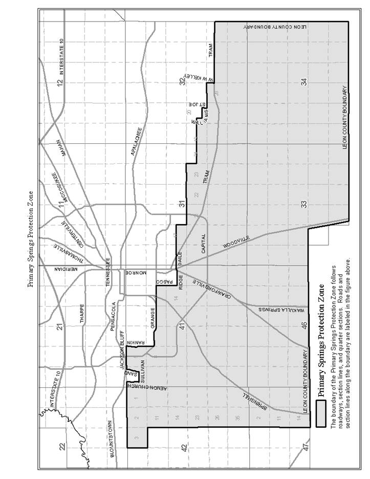
Sec. 10-307. - Primary springs protection zone.
(a)
Purpose and intent. The purpose of establishing a primary springs protection zone (PSPZ) is to identify the region of the city with elevated aquifer vulnerability so that additional regulations may be applied within this zone to minimize the adverse impacts of development on groundwater recharge quality and quantity. This section is intended to implement comprehensive plan policy 4.2.5 [C].
The boundary of the PSPZ is provided in the figure below called primary springs protection zone. All parcels of land inside the city limits that have area located inside the PSPZ are presumed to be wholly within in the area of elevated aquifer vulnerability and shall abide by the development standards provided below.
(b)
Allowable land uses and activities. The allowable uses permitted in the PSPZ shall be those permitted in the underlying zoning district.
(c)
Development standards. All development within the PSPZ shall be executed in accordance with special development and design standards identified below.
The urban fringe clustering provision provided in section 10-163 shall not be allowed within the PSPZ.
(d)
Process for amending the PSPZ. Amendments to the boundary of the PSPZ shall be processed under section 10-52 and shall be based on site-specific aquifer vulnerability data related to the distance to karst features, soil permeability, and thickness of overburden.
(Ord. No. 08-O-68AA, § 2, 2-25-2009)
Sec. 10-316. - Definitions.
In addition to the definitions and rules of construction in section 1-2, the following words, terms and phrases, when used in this division, shall have the meanings ascribed to them in this section, except where the context clearly indicates a different meaning:
1992 downtown plan means the Downtown Plan dated April 14, 1992, prepared by Beyer Blinder Belle, Architects and Planners, approved by the city commission on April 22, 1992, on file with the city's treasurer-clerk.
Architectural review board (ARB) means the ten-member board appointed jointly by the city and county commissions to review exterior changes, excluding routine maintenance, to properties zoned with an historic preservation overlay, and to perform other duties as assigned by the city commission and board of county commissioners.
Calhoun Street special character district means Calhoun Street area properties within the boundary identified in the adopted 1992 downtown plan. This district forms a cohesive concentration of historic resources, many of statewide significance, that reflect outstanding and representative examples of 19th and early 20th century architecture in one of the city's earliest and most historic neighborhoods.
Certificate of appropriateness means a written statement issued by the architectural review board or the historic preservation officer to confirm that the proposed work is approved as appropriate pursuant to the criteria in this division.
Contributing property means a site, building, structure, or object, at least 50 years old, located within the boundaries of a designated historic preservation district or special character district, which, by its location, design, setting, materials, workmanship, feeling, and association adds to a historic preservation or special character district's sense of time and place and historical development. Properties less than 50 years old may be determined to be contributing if a strong justification of their historical or architectural contribution to the district's sense of time and place and historical development is determined to exist, or the historical attributes of the district are considered to be less than 50 years old.
Historic preservation district means a geographically definable area, urban or rural, possessing a significant concentration, linkage, or continuity of sites, buildings, structures, or objects, which are united historically or aesthetically by plan or physical development, which is zoned with a historic preservation overlay.
Historic preservation officer means the director or designee of the director of the Tallahassee Trust for Historic Preservation who shall serve as the principal staff to the city-county architectural review board.
Local register of historic places means a local listing of buildings, structures, sites, objects and districts determined pursuant to the criteria in this division to possess historic and/or architectural significance and which are zoned with a historic preservation overlay.
Noncontributing property means a site, building, structure, or object, within the boundaries of a designated historic preservation district, that does not add to the historic preservation district's sense of time, place and historic development, but which is subject to review as provided in this division because it can impact the historic character of the historic preservation district.
Ordinary maintenance means work which does not require a construction permit and that is done to repair damage or to prevent deterioration or decay of a building or structure or part thereof as nearly as practicable to its condition prior to the damage, deterioration, or decay.
Original appearance means that appearance (except for color) which closely resembles the appearance of either (i) the feature on the building as it was originally built or was likely to have been built, or (ii) the feature on the building as it presently exists so long as the present appearance is appropriate, to the style and materials of the building.
Park Avenue special character district means Park Avenue area properties within the boundary identified in the adopted 1992 downtown plan. This district is linked by the historic Park Avenue chain of parks, and includes most significant historic residential, commercial, and civic landmarks which represent the city's development from its platting in 1825 to the early 20th century. The district is composed of a concentration of small historic residential scale buildings to the east of Calhoun Street, and a mixture of historic, civic, religious, and commercial buildings along with larger scale contemporary buildings to the west of Calhoun Street.
Residential historic preservation district means an area of more than one property designated as a historic preservation district for which the underlying zoning is a low-density residential category.
Variance means a relaxation of the terms of the code or ordinances involved where such variance will not be contrary to the public interest and, where owing to conditions peculiar to the property and not the result of the actions of the applicant, a literal enforcement of the code involved would result in undue hardship.
(Ord. No. 12-O-02AA, § 2, 11-28-2012)
Sec. 10-317. - Purpose and intent.
The purpose of this division is to describe the historic preservation overlay and National Register of Historical Properties overlay district (HPO) used to impose special development restrictions on identified areas to protect the historic resources of the community. The location of overlay zones is established by the city based on the need for special protective measures in that area. The overlay zone applies to: properties listed in the Local Register of Historic Places through the process described in this division, and all other properties previously zoned HC by the city. Properties listed on the National Register of Historical Properties within the downtown special character district are also subject to this special overlay district. The underlying uses in the area remain undisturbed by the creation of the overlay zone. The overlay zone is depicted on the downtown zoning area map. Appropriate development standards are identified in section 10-220. The historic preservation overlay zone may be approved for properties within the boundaries of the capitol center planning district according to the procedures outlined in F.A.C. 60F-3.003, and chapter 2, article III, for zoning changes to the official zoning map of the capitol center planning district.
(Ord. No. 12-O-02AA, § 2, 11-28-2012; Ord. No. 13-O-03, § 15, 8-28-2013)
Sec. 10-318. - Local register of historic places and rezoning to include a historic preservation overlay (HPO) for individual sites, buildings, structures and objects.
(a)
Created. A local register of historic places is hereby created as a means of identifying and classifying various sites, buildings, structures, and objects as historically and/or architecturally significant. The local register will be kept by the architectural review board.
(b)
Initiation of placement on the local register and rezoning with an HPO. The applicant for placement of sites, buildings, structures, or objects on the local register and rezoning with an HPO may be the city or county commission, the planning commission, or the owner(s) of the site, building, structure, or object. Upon written request of an owner, the Tallahassee Trust for Historic Preservation or the architectural review board may initiate placement on the local register of sites, buildings, structures, or objects.
(c)
Placement on the local register and rezoning with an HPO. The following procedure shall be followed for placement of sites, buildings, structures, and objects on the local register and rezoning with an HPO:
(1)
A nomination form, available from the historic preservation officer, shall be completed by the applicant and returned to the architectural review board. If the city commission, county commission, or planning commission is the applicant, the planning department shall complete the nomination and return it to the architectural review board.
(2)
Upon receipt of a completed nomination form, including necessary documentation, the historic preservation officer shall place the nomination on the agenda of the next appropriate regularly scheduled meeting of the architectural review board for a public hearing.
(3)
Adequate notice of the architectural review board's consideration of the nomination at a public hearing shall be provided to the public at large by publication in a newspaper of general circulation in the community, by U.S. Mail to the owner(s) of property within 500 feet of the nominated property, by U.S. Mail to the owner(s) of the nominated property, and by U.S. Mail to the Tallahassee Trust for Historic Preservation, at least 15 days in advance of the meeting at which the nomination will be considered by the architectural review board. The notice shall include a locational map of the affected property(ies) and shall state that the public may appear and comment on the nomination.
(4)
The architectural review board shall, within 30 days from the date of the public hearing, review the nomination and prepare a recommendation thereon. The recommendation shall include specific findings and conclusions as to why the nomination does or does not meet the appropriate criteria for listing on the local register and rezoning with an HPO.
(5)
The nomination form and the architectural review board's recommendation shall be sent to the planning commission. The nomination shall then be processed as a rezoning pursuant to this chapter.
(d)
Criteria for listing on the local register and rezoning with an HPO.
(1)
A site, building, structure, or object must meet the following criteria before it may be listed on the local register and rezoned with an HPO:
a.
It possesses integrity of location, design setting, materials, workmanship, feeling, and association; or
b.
It is associated with events or persons that are significant to local, state, or national history; or
c.
It embodies the distinctive characteristics of a type, period, or method of construction, or represents the work of a master, or possesses high artistic values; or
d.
It has yielded, or may be likely to yield, information important in prehistory or history.
(2)
Examples and explanations of the criteria set forth above are available in the Historic Preservation Property Guidelines Manual, which has been approved by action of the city commission. The historic Preservation Property Guidelines Manual is intended to assist owners of property with an individual historic preservation overlay or in historic preservation zoning districts, and shall be available from the planning department. Upon recommendation of the planning department director, or his/her designee, the Historic Preservation Property Guidelines Manual may be amended from time to time in a manner consistent with this section. Final approval of amendments to the Historic Preservation Property Guidelines Manual is hereby delegated to the planning commission. The planning department may charge a reasonable fee for copies of the publication to recoup the expenses of printing the publication.
(e)
Effect of listing on local register.
(1)
Upon approval of the nomination for listing on the local register and rezoning with an HPO, the architectural review board shall issue an official certificate of historic significance to the owner(s) of sites, buildings, structures, or objects listed individually on the local register.
(2)
Sites, structures, buildings, or objects listed individually on the local register and zoned with an HPO shall be deemed historic and entitled to modified enforcement of the Standard Building Code as provided by Chapter 1, Section 101.5 of the Standard Building Code Congress International, Inc.
(3)
No demolition, alteration, relocation, or construction activities may take place except as provided in this division.
(4)
Sites, structures, buildings, or objects that are certified as historic (i.e., listed on the local register of historic places) or are designated as contributing structures within a historic preservation district shall have concurrency reserved for the portion that is historic. Any addition(s) shall be subject to concurrency for the proposed use.
(5)
The city, in seeking to acquire or lease additional space, shall give preference to the acquisition or lease of properties on the local register of historic places.
(6)
The city will waive permit fees, development review fees, annual fees, and other rehabilitation-related fees for properties on the local register of historic places with an HPO that are privately owned (nongovernmental), including fees for building and fire permits and review, electrical permits, plumbing permits, mechanical permits, gas permits, roofing permits, reinspection, landscape, stormwater permits, variances, tree removal, and rezoning.
(7)
Relaxed development standards as provided in section 10-321 shall apply.
(8)
Historic preservation overlay zoning district properties on the local register of historic places that are privately owned (nongovernmental) shall be eligible to apply for funding from the city historic property grant and loan program.
(Ord. No. 12-O-02AA, § 2, 11-28-2012)
Sec. 10-319. - Local register of historic places and rezoning with historic preservation overlay (HPO) for historic preservation districts.
(a)
Historic preservation districts may be placed on the local register of historic places and rezoned with an HPO pursuant to this section.
(b)
Initiation of placement on the local register and rezoning with an HPO. The applicant for placement of a historic preservation district on the local register and rezoning with an HPO may be the city commission, the planning commission, or the owner(s) of property within the proposed historic preservation district. If the city commission or planning commission is the applicant, the planning department shall prepare the application.
(c)
Placement on the local register and rezoning with an HPO. The following procedure shall be followed for placement of an HPO district on the local register and rezoning with HPO:
(1)
Application for initiation of a historic preservation district viability study. An application form for initiation of a historic preservation district viability study, available from the planning department, shall be completed by the applicant(s) following a pre-application meeting with the planning department, and returned to the planning department.
a.
The application shall include a proposed boundary of the historic preservation district.
b.
The application shall include a list of all property owners within the proposed historic preservation district, based on the latest tax rolls from the county property appraiser's office, and shall include parcel tax identification numbers, names, addresses, telephone numbers, and email addresses if available, with the signatures of property owners in favor of the initiation of a historic preservation district viability study. The planning department shall provide the list of property owners to the applicant at or following the pre-application meeting, but the applicant is responsible for obtaining the signatures.
c.
Prior to completing the application, the applicant shall contact the planning department and arrange a pre-application meeting. The applicant shall meet with technical assistance staff and the historic preservation officer to discuss the application, the procedures for review and approval, and applicable regulations and requirements for historic preservation districts.
(2)
Review of application for initiation of a historic preservation district viability study. Upon receipt of a completed application, the planning department shall calculate the percentage of signatures on the list of properties within the proposed historic preservation district in favor of the initiation of a historic preservation district viability study. For purposes of calculating the percentage of signatures in favor of initiation of the historic preservation district viability study, owners of multiple parcels shall receive one vote for each parcel he/she owns. Likewise, parcels with multiple owners shall have only one vote.
a.
If the signatures reflect approval by 30 percent or more of the owners of the listed parcels, the planning department shall initiate the historic preservation district viability study as set forth below.
b.
If the signatures reflect approval by fewer than 30 percent of the owners of the listed parcels, the application will not move forward unless the applicant(s) request(s), through the planning department, initiation of the historic preservation district viability study by the city commission. The planning department, upon request by the applicant(s), shall prepare an agenda item for the city commission on behalf of the applicant(s). If the city commission denies the request, the planning department shall not initiate a historic preservation district viability study, and the historic preservation district designation process shall not move forward. If the request is approved, the planning department shall initiate the historic preservation district viability study as set forth below.
(3)
Viability study (historic preservation district public outreach and education process). The planning department and the historic preservation officer shall conduct community meetings within the proposed historic preservation district. All property owners within the proposed historic preservation district shall be mailed notice by regular U.S. Mail of each community meeting for discussion of the proposed historic preservation district. The notices shall be mailed at least 15 calendar days prior to each meeting. The following topics shall be discussed in the community meeting(s):
a.
Overview of procedures for establishing a historic preservation district;
b.
Explanation of Secretary of the Interior's Standards for Rehabilitation and Guidelines for Rehabilitating Historic Buildings;
c.
City historic preservation regulations;
d.
Impacts of designation as a historic preservation district, including benefits, responsibilities, and the effect on ownership rights; and
e.
Next steps for the application.
Other topics may be discussed.
(4)
Long range community based planning target issue committee review. The planning department shall, from time to time, update the city's long range community based planning target issue committee.
(5)
Formal vote by owners to initiate application for placement on the local register and rezoning with an HPO. The planning department shall be responsible for conducting a formal vote by owners within the proposed historic preservation district by mailed ballots. The ballots shall be sent to the owner of each parcel within the proposed historic preservation district by both regular U.S. Mail and certified mail, and shall request the owner(s) of each parcel to indicate YES, he/she is in favor of initiating the application for a historic preservation district; or NO, he/she is not in favor of initiating the application for a historic preservation district. Owners of multiple parcels shall have one vote for each parcel he/she owns. If a parcel has multiple owners, the parcel shall have only one vote. Each ballot shall clearly state in a prominent place on the ballot that the ballot must be returned to the planning department by a specified return date, which shall be at least 45 days from the date it was mailed. Ballots not received by the date stated on the ballot shall not be counted.
(6)
Tally of formal vote. After the specified return date stated on the ballot, if at least 50 percent plus one of the mailed ballots have been returned, the planning department shall count the ballots received. One ballot shall be counted for each parcel. A super majority (66.7 percent) of the ballots received must vote in favor of the proposed application in order for the process to designate the historic preservation district to continue. If fewer than 50 percent plus one of the mailed ballots are returned on or before the specified return date stated on the ballot, a tally will not be done and there shall be no application. Likewise, if fewer than 66.7 percent of the returned ballots vote in favor of the proposed application, there shall be no application.
(7)
Processing the application. If the application receives a super majority vote in favor, it shall be deemed to have been initiated and the historic preservation officer and the planning department shall compile the necessary data and prepare an analysis based on the criteria herein for a historic preservation district. A staff report and recommendation shall be prepared by the planning department and presented to the architectural review board for a public hearing. The staff report and recommendation shall include the following information:
a.
A copy of the application;
b.
A finding as to whether each site, building, structure, or object within the boundaries of a proposed historic preservation district is contributing or noncontributing (historic status) under the criteria set forth in this section. The planning department shall consult with the historic preservation officer in making a finding as to whether a structure is contributing or noncontributing; and
c.
Proof that a notice of historic status has been mailed by the planning department to each owner within the proposed historic preservation district of the status of the owner's property as contributing or noncontributing. The notice of historic status shall be sent by regular U.S. Mail to the owner's address as shown on the Leon County Property Appraiser's web site; and shall include a statement of the owner's right to appeal as provided herein.
d.
A record of whether each owner agrees, objects, or fails to respond to the designation of the site, building, structure and/or object on the owner's parcel as contributing or noncontributing.
(8)
Objections. Prior to the architectural review board public hearing on an application, any owner who objects to the designation of the owner's property as contributing or noncontributing may request a hearing on the matter as provided below:
a.
Within 15 days after the mailing of a notice of historic status from the planning department, the owner may request, in writing, a hearing on the status determination. The city commission may require a filing fee by resolution.
b.
Failure to request the hearing as provided herein shall represent a waiver of the objection.
c.
Any hearing requested under this subsection shall be held prior to consideration of the application by the architectural review board.
d.
The hearing(s) shall be conducted by a hearing officer selected by the city, who is an administrative law judge, lawyer or a non-lawyer who is determined by the city attorney to have expertise in historic preservation. The hearing officer shall not be required to follow Florida rules of evidence or procedure, but shall provide a fair opportunity to the owner(s) to present evidence and be heard pursuant to procedures approved by city commission policy. The planning department shall provide staff services to the hearing officer.
e.
The hearing officer may affirm or overturn the planning department's decision on whether a property within the proposed historic preservation district is contributing or noncontributing.
f.
The hearing officer's decision shall be in writing; shall be considered rendered when filed with the planning department; and shall be final. The planning department shall include any decision(s) of the hearing officer in its report and recommendation to the architectural review board.
(9)
Architectural review board public hearing. When all timely filed appeals have been resolved by the hearing officer, the application for designation of a historic preservation district shall be placed on the agenda of the next appropriate regularly scheduled meeting of the architectural review board for a public hearing.
(10)
Notice. Adequate notice of the architectural review board's consideration of the application at a public hearing shall be provided to the public at large by publication in a newspaper of general circulation in the community, by U.S. Mail to the owner(s) of property within the proposed district and within 500 feet of the proposed district, and the Tallahassee Trust for Historic Preservation at least 15 days in advance of the meeting at which the application will be considered by the architectural review board. The notices shall state that the public may appear and comment on the application.
(11)
Architectural review board recommendation. The architectural review board shall, within 30 days from the date of the public hearing, review the application; data; and staff report and recommendation; and shall prepare a recommendation thereon. The recommendation shall include specific findings and conclusions as to why the application does or does not meet the appropriate criteria for designation as a historic preservation district. The recommendation shall note any owners' appeals and the hearing officer's decision on each. If the architectural review board's recommendation is to list the properties on the local register and rezone with an HPO, then the application and the architectural review board's recommendation shall be sent to the planning commission. The nomination shall then be processed as a rezoning. If the recommendation is not to list and rezone with an HPO, the application shall be forwarded to the planning commission with a recommendation for denial.
(12)
Planning commission public hearing. Pursuant to the rezoning procedures in this chapter, a public hearing shall be set before the planning commission on the application. Notice of the public hearing shall also be provided to the Tallahassee Trust for Historic Preservation at least 15 days in advance of the meeting at which the application will be considered by the planning commission.
(13)
Planning commission decision. If the architectural review board's recommendation is for denial of the request for designation as a historic preservation district, the planning commission may affirm the denial; reject the recommendation for denial and remand it to the architectural review board for further proceedings; or reject the recommendation for denial and recommend that the application for designation as a historic preservation district be approved by the city commission and that the district be rezoned with an HPO. If the planning commission affirms the architectural review board's denial, the determination is final. If the planning commission recommends approval by the city commission, its decision shall be placed on the agenda for the next appropriate regularly scheduled city commission meeting. All decisions must be in writing.
(14)
Appeal of a planning commission denial. An applicant may challenge a final decision of the planning commission to deny an application in the circuit court for the second judicial circuit by petition for writ of certiorari filed no later than 30 calendar days after the planning commission's final decision is rendered.
(15)
City commission public hearing. Pursuant to the rezoning procedures in this chapter, a public hearing shall be set before the city commission on the application. Notice of the public hearing shall also be provided to the Tallahassee Trust for Historic Preservation at least 15 days in advance of the meeting at which the application will be considered by the city commission.
(16)
The city commission's designation of a historic preservation district with HPO shall identify contributing and non-contributing properties.
(17)
The city commission's decision on a historic preservation district may be challenged by a person with standing in the circuit court for the second judicial circuit by petition for writ of certiorari filed no later than 30 calendar days after the city commission's final decision is rendered.
(d)
Criteria for listing a historic preservation district on the local register and rezoning with an HPO.
(1)
A historic preservation district may be listed on the local register and rezoned with an HPO if it:
a.
Has significant character, interest, or value as part of the community's development heritage;
b.
Is the site of an historic event with a significant effect upon society;
c.
Exemplifies the cultural, political, economic, social, or historic heritage of the community;
d.
Portrays the environment in an era of history characterized by a distinctive architectural style;
e.
Embodies those distinguishing characteristics of an architectural-type or engineering specimen;
f.
Is the work of a designer whose individual work has significantly influenced the development of Tallahassee;
g.
Contains elements of design, detail, materials, or craftsmanship which represent a significant innovation;
h.
By being part of or related to a square, park, or other distinctive area, should be developed or preserved according to a plan based on an historic, cultural, or architectural motif; or
i.
Owing to its unique location or singular physical characteristic, represents an established and familiar visual feature of the neighborhood, community, or city.
(2)
For sites, buildings, structures, or objects located within potential historic preservation districts located in the city limits, the planning department shall provide examples and definitions of the criteria in a Historic Preservation Property Guidelines Manual to assist applicants. See subsection 10-318(d)(2) in this division.
(e)
Effect of listing on local register.
(1)
Upon approval of the nomination for listing on the local register and rezoning with an HPO, the architectural review board shall issue an official certificate of historic significance to the owner(s) of sites, buildings, structures, or objects within the historic preservation district.
(2)
Sites, structures, buildings, or objects designated as contributing properties in a historic preservation district shall be entitled to modified enforcement of the Standard Building Code as provided by Chapter 1, Section 101.5 of the Standard Building Code Congress International, Inc.
(3)
Any demolition, alteration, relocation, or construction activities within a historic preservation district must be done pursuant to a certificate of appropriateness as provided in this division.
(4)
Sites, structures, buildings, or objects designated as contributing within a historic preservation district shall have their concurrency reserved by the local government.
(5)
The city, in seeking to acquire or lease additional space, shall give preference to the acquisition or lease of properties designated as contributing in a historic preservation district.
(6)
The city will waive permit fees, development review fees, annual fees, and other rehabilitation-related fees for contributing structures within a historic preservation district that are privately owned (nongovernmental), including fees for building and fire permit and review, electrical permits, plumbing permits, mechanical permits, gas permits, roofing permits, reinspection, landscape, stormwater permits, variances, tree removal, and rezoning.
(7)
Relaxed development standards as provided in section 10-321 shall apply.
(8)
As an additional incentive for residential historic districts, the city shall install special street signs and boundary identification markers.
(9)
Properties designated as contributing in a historic preservation district that are privately owned (nongovernmental) shall be eligible to apply for funding from the city historic property grant and loan program.
(Ord. No. 12-O-02AA, § 2, 11-28-2012)
Sec. 10-320. - Certificates of appropriateness.
(a)
Certificates of appropriateness are required as indicated below.
(1)
Alterations. A certificate of appropriateness must be obtained before making certain alterations, described below as regulated work items, to contributing properties and properties listed individually on the local register. A certificate of appropriateness must be issued prior to the issuance of development permits; i.e., building, environmental, etc.
a.
For each of the regulated work items listed below, the following applies:
1.
Ordinary maintenance. If the work constitutes "ordinary maintenance" as defined in this chapter, the work may be done without a certificate of appropriateness.
2.
Staff approval. If the work is not "ordinary maintenance," but will result in the "original appearance" as defined in this chapter, the certificate of appropriateness may be issued by the historic preservation officer for the city.
3.
Architectural review board approval. If the work is not "ordinary maintenance" and will not result in the "original appearance," a certificate of appropriateness must be obtained from the architectural review board before the work may be done.
b.
The following are regulated work items:
1.
Installation or removal of any exterior wall, including the enclosure of any porch or other outdoor area, with any material other than insect screening.
2.
The installation or removal of all fire escapes, exterior stairs, or ramps for the handicapped.
3.
Installation of all decks above the first-floor level and/or on the front of the structure.
4.
Installation of new exterior siding materials, or removal of existing exterior siding materials.
5.
Installation or removal of railings or other wood, wrought iron, or masonry detailing.
6.
Abrasive cleaning of exterior walls.
7.
Painting unpainted masonry including stone, brick, terracotta, and concrete.
8.
Installation of new roofing materials, or removal of existing roofing materials.
9.
Installation of an exterior door or door frame, or the infill of an existing exterior door opening.
10.
Installation of an exterior window or window frame or the infill of an existing exterior window opening.
11.
Installation or removal of exterior skylights.
12.
Installation or removal of metal awnings or metal canopies.
13.
Installation or removal of security grilles, except that in no case shall permission to install such grilles be completely denied.
14.
Installation of exterior screen windows or exterior screen doors.
15.
The installation, relocation, or removal of fences or masonry garden walls.
(2)
New construction within a historic preservation district. A certificate of appropriateness must be obtained from the architectural review board to erect a new building or parking lot within a historic preservation district listed on the local register.
(3)
Demolition. A certificate of appropriateness must be obtained from the architectural review board to demolish a building, structure, or object listed individually on the local register, or designated as contributing to a historic preservation district listed on the local register.
(4)
Relocation. A certificate of appropriateness must be obtained from the architectural review board to relocate a building, structure, or object listed individually on the local register, or designated as contributing to a historic preservation district listed on the local register.
(5)
Exemption. In historic preservation districts, a certificate of appropriateness shall not be required for any alteration to an existing building, whether such property is contributing or noncontributing, which alteration is not clearly visible from a public street. The historic preservation officer shall determine the visibility of the work item at ground level under normal conditions. Prior to construction, installation, or performance of any regulated work item which is not ordinary maintenance, the owner shall file an application with the historic preservation officer as provided below. The historic preservation officer's decision shall be sent to the architectural review board and shall be posted on the property for five calendar days.
(6)
Appeals of historic preservation officer decisions. Any person aggrieved by the decision reached by the historic preservation officer may, within five calendar days of the decision being posted on the property, file a written request for review by the architectural review board. The architectural review board, at its next scheduled meeting, shall review the historic preservation officer's decision and may approve, approve with modifications, or not approve such decision.
(b)
Criteria for issuing. The intent of the following review criteria is to ensure that exterior alterations and additions to historic buildings, and new construction, are compatible to and complement the historic buildings and the character of the immediate area, if within a historic preservation district:
(1)
Alterations and additions to existing historic buildings and to contributing properties within a historic preservation district. Any addition to or alteration of the exterior of a historic building or to a contributing property within a historic preservation district shall be reviewed by the architectural review board for compliance with the recommended approaches to rehabilitation set forth in The Secretary of the Interior's Standards for Rehabilitation and Guidelines for Rehabilitating Historic Buildings (latest edition).
(2)
New construction. The architectural review board shall use the following criteria to review new construction in any historic preservation district:
a.
Proportion, scale, form, and mass.
1.
The proportion of the facades of new buildings—the relationship of a building's width to its height—should be compatible with adjacent historic buildings as seen from the street and publicly accessible areas.
2.
New buildings should be compatible with the height of adjacent buildings in the neighborhood.
3.
New building forms should be compatible with the forms of the historic buildings on the street. For instance, if most of the forms are simple, such as an "I" or "L" plan, the form of new buildings should respect those characteristics.
4.
The roofs of new buildings visible from the street and public areas should relate in shape and pitch to the roofs of adjacent historic buildings.
b.
Relationship of materials and textures. The relationships of materials and textures in a new building should be visually compatible with the historic buildings on the street.
c.
Visual continuity.
1.
Architectural elements such as walls, fences, landscape masses, building facades, or combinations of these should contribute to visual continuity along the street.
2.
The character of the landscaping and predominant materials should contribute to visual continuity along the street.
d.
Building site.
1.
On-site parking should be limited to driveways with parking areas to the side and rear of the new building.
2.
New parking lots should be landscaped to provide screening from the street and publicly accessible areas.
e.
Directional expression and treatment of facades.
1.
New porches, entrances and other projections should be compatible with similar features on historic buildings found along the street and contribute to continuity of features.
2.
The orientation of new buildings should repeat the orientation of other historic buildings on the street to maintain continuity. Orientation refers to the placement of the entrance, the direction of the roof lines, and other prominent features of the building.
(3)
Relocation of historic buildings. In addition to the guidelines provided above, issuance of certificates of appropriateness for relocations shall be guided by the following factors:
a.
The historic character and aesthetic interest the building, structure, or object contributes to its present setting;
b.
Whether there are definite plans for the area to be vacated and the effect of those plans on the character of the surrounding area;
c.
Whether the building, structure, or object can be moved without significant damage to its physical integrity; and
d.
Whether the proposed relocation area is compatible with the historical and architectural character of the building, structure, or object.
(4)
Demolition of historic buildings. Issuance of certificates of appropriateness for demolitions shall be guided by the following factors:
a.
The historic or architectural significance of the building, structure, or object;
b.
The importance of the building, structure, or object to the ambiance of a district;
c.
The difficulty or the impossibility of reproducing such a building, structure, or object because of its design, texture, material, detail, or unique location;
d.
Whether the building, structure, or object is one of the last remaining examples of its kind in the neighborhood, the county, or the region;
e.
Whether there are definite plans for reuse of the property if the proposed demolition is carried out, and the effect of those plans on the character of the surroundings;
f.
Whether reasonable measures can be taken to save the building, structure, or object from collapse; and
g.
Whether the building, structure, or object is capable of earning reasonable economic return on its value.
h.
Failure of the architectural review board to issue a certificate of appropriateness granting demolition approval for any property within the designated historic preservation overlay district shall temporarily stay the property owner's ability to demolish existing improvements for 12 months following action by the architectural review board.
(c)
Procedures.
(1)
A person wishing to undertake any of the actions specified above shall file an application for a certificate of appropriateness, and supporting documents, with the historic preservation officer.
(2)
The applicant shall confer with the historic preservation officer concerning the nature of the proposed action and requirements related to it. The historic preservation officer shall advise the applicant of the nature and detail of the plans, designs, photographs, reports, or other exhibits required to be submitted with the application. If the matter goes to the architectural review board, the historic preservation officer's recommendation shall not preclude the architectural review board from requiring additional material prior to making its determination in the case. Following the conference with the historic preservation officer, a preapplication conference may be held with the architectural review board if requested by the applicant.
(3)
Upon receipt of a completed application and all required submittals, the historic preservation officer shall place the application on the next regularly scheduled meeting of the architectural review board allowing for notice as required in this section. Applications for certificates of appropriateness may be heard at specially called meetings of the architectural review board provided all notice requirements are met. Upon mutual agreement between the applicant and the historic preservation officer, the application may be set for hearing at a meeting later than the next regularly scheduled meeting.
(4)
At least 15 days, but not more than 30 days, prior to the meeting at which the application is to be heard, the historic preservation officer shall give the following notice:
a.
Written notice of the time and place of the meeting shall be sent by regular U.S. Mail to the applicant, any persons or organizations filing written requests with the historic preservation officer, and all property owners within 500 feet of the affected property.
b.
One advertised notice published in a newspaper of general circulation in the community.
(5)
The hearing shall be held at the time and place indicated in the notice. The decision of the architectural review board shall be made at the hearing.
(6)
The architectural review board shall use the criteria set forth in this section to review the completed application and accompanying submittals. After completing the review of the application and the public hearing, the architectural review board shall take one of the following actions:
a.
Grant the certificate of appropriateness with an immediate effective date;
b.
Grant the certificate of appropriateness with special modifications, variances, and conditions; or
c.
Deny the certificate of appropriateness.
(7)
The architectural review board shall make written findings and conclusions that specifically relate to the criteria for granting or denying certificates of appropriateness. The decisions of the architectural review board shall be considered rendered when filed with the historic preservation officer. The decisions of the architectural review board shall notify the applicant of the appeal rights provided in subsection 10-320(c)(10).
(8)
The historic preservation officer shall record and keep records of all meetings. The records shall include the vote, absence, or abstention of each member upon each question, all official actions of the architectural review board, and the findings and conclusions of the architectural review board. All records shall be filed with the planning department.
(9)
Meetings of the architectural review board are administrative in nature and not subject to the quasi-judicial provisions of state statutes. No testimony may be received from any applicant or member of the public during the course of the architectural review board meeting. Notwithstanding the foregoing, an architectural review board member may question the applicant or the applicant's representative present at the meeting on technical issues related to the certificate of appropriateness. Such questions shall be limited to inquiries seeking clarification of material in the application. Any members of the public present at the meeting shall have an opportunity to speak on the same technical issues. All comments by either the applicant or members of the public shall be limited to the question asked by the architectural review board member.
(10)
Quasi-judicial proceedings. For applications on which the architectural review board renders a final decision, the decision of the architectural review board shall become final 30 calendar days after it is rendered unless a person who qualifies as a party under chapter 2, article III, division 2, subdivision II, of this Code pays the filing fee and files a petition for quasi-judicial proceedings in accordance with chapter 2, article III, division 2, subdivision II, of this Code and the bylaws of the planning commission. Failure to pay the filing fee, and/or to file the petition as required is jurisdictional and shall result in the waiver of the right to petition for formal proceedings.
(11)
No work for which a certificate of appropriateness is required may be undertaken unless a certificate of appropriateness authorizing the work is conspicuously posted on the property where the work is to be performed.
(Ord. No. 12-O-02AA, § 2, 11-28-2012)
Sec. 10-321. - Specific development standards.
(a)
Lot coverage waiver for contributing properties. Contributing properties which retain their historic structures are eligible for 30 percent additional lot coverage of development which shall be provided to the rear of the existing structure. The architectural review board may grant an additional variance to this standard, provided that it does not impact the historic character of the property from the public right-of-way.
(b)
Noncontributing properties in residential historic preservation districts. Any alteration of a structure or property identified as noncontributing to the historic district that is described as a regulated work item in subsection 10-320(a)(1) shall respect neighboring historic development in terms of mass, proportion, scale, rhythm, directional orientation, materials, and landscaping element, though it may be contemporary in design. The historic preservation officer shall review such alteration prior to the issuance of any permits, and shall make a recommendation to the director of growth management, but shall not require a certificate of appropriateness or review by the architectural review board, unless requested by the property owner.
(Ord. No. 12-O-02AA, § 2, 11-28-2012)