Tavares City Zoning Code
CHAPTER 9
HISTORIC PRESERVATION OVERLAY DISTRICT AND ARCHITECTURAL AND SITE DESIGN STANDARDS7
Editor's note— Ord. No. 2022-14, § 1(Exh. A), adopted September 21, 2022, amended Chapter 9 in its entirety to read as herein set out. Former Chapter 9, §§ 9-1—9-30, pertained to similar subject matter.
Section 9-1 - Historic Preservation
The purpose of this section is to promote the economic, educational, aesthetic, cultural and general welfare of the City and its residents through:
(A)
The identification, preservation, protection, and enhancement of archaeological sites, buildings, structures, improvements and site features that are reminders of past eras, events, and persons important in local, state or national history;
(B)
The enhancement of property values, the stabilization of neighborhoods and business centers of the City; and,
(C)
The encouragement of new structures, buildings and developments that will be in harmony with existing historic structures.
Section 9-2 - Definitions
The following definitions will apply for the purpose of this ordinance:
(A)
Adjoining or adjacent sites. Any parcel or parcels within 200 feet of all property lines of the subject property.
(B)
Alteration. Any change affecting the exterior appearance of an existing structure or improvement by additions, reconstruction, remodeling, maintenance or structural changes involving changes in form, texture, materials or color or any such changes in appearance in specially designated historic site, or historic interiors.
(C)
Applicant. The record owner or owner's agent of the property and/or improvements located thereon.
(D)
Archaeological site. Earthworks, any subsurface remains of historical, archaeological importance, or any unusual ground formations of archaeological significance.
(E)
Architectural features. Architectural features include, but are not limited to, the architectural style, scale, massing, siting, general design and general arrangement of the exterior of the building or structure, including the type, style and color of roofs, windows, doors and site features. These features will include interior spaces where the interior has been given historic designation.
(F)
Board. The Historic Preservation Board.
(G)
Building. A structure, edifice, or any part thereof, designed to stand permanently and intended for use, occupancy or ornamentation.
(H)
Certificate of Appropriateness. A written document, issued under the terms and conditions of this ordinance, allowing specified alterations, demolition, construction, or other work to a designated historic site, or for a building or structure within a designated historic district.
(I)
Contributing Building. A building contributing to the historic significance of a district which by virtue of its location, design, setting, material, workmanship, or association with local historic events or personalities lends to the district's sense of time and place within the context of the intent of historic preservation.
(J)
Demolition. The act or process of wrecking, destroying, or removing any building or structure, or any exterior or structural part thereof.
(K)
Designated exterior. All outside surfaces of any improvement, building, or structure defined in the historic preservation survey as having significant value to the historic character of the building, district or City.
(L)
Exterior. All outside surfaces of any building or structure.
(M)
Historic District. A geographically defined area with a significant concentration, linkage, or continuity of landmarks, improvements, or landscape features united by historic events or aesthetically by plan or physical development, and which area has been designated as a historic district under the procedures described in these regulations. Any historic district may have within its area non-historic buildings or other structures that contribute to the overall visual character of the district.
(N)
Historic Preservation Officer. The City Administrator, or designee.
(O)
Historic Properties: Buildings, structures, archaeological sites, or districts that have identified historical and architectural merit of a degree warranting their preservation.
(P)
Historic Site. Any site, building, structure, feature or improvement, which has been designated as a "historic site" and listed on the Local Register of Historic Places.
(Q)
Historic Site Survey. A comprehensive survey compiled by the Historic Preservation Board designed to identify, research and document buildings, sites and structures of any historic, cultural, architectural or landmark importance in Tavares, Florida. The Board may compile said survey in cooperation with state and local public and non-profit historic preservation organizations to prevent a duplication of effort.
(R)
Improvement. Any structure, or other part thereof, installed upon real property by human endeavor and intended to be kept at the location of said construction or installed for a period of not less than one hundred-twenty (120) consecutive days.
(S)
Landscape Feature. Any improvement or vegetation including, but not limited to: outbuildings, walls, courtyards, fences, shrubbery, trees, sidewalks, planters, plantings, gates, street furniture or exterior lighting.
(T)
Local Register of Historic Places. A listing and a means by which to identify, classify and recognize various archaeological sites, buildings, structures, improvement, districts and site features as historically and/or architecturally significant.
(U)
National Register of Historic Places. A federal listing maintained by the U.S. Department of the Interior of buildings, structures and districts that have attained a quality of significance as determined by the Historic Preservation Act of 1966, as amended.
(V)
Non-contributing Building. A building within a historic district, which does not add to a historic district's sense of time and place and historical development; or a building where the location, design, setting, materials, workmanship, and association have been so changed, or have so deteriorated that the overall integrity of the building has been irretrievably lost.
(W)
Ordinary Maintenance or Repair. Any work for which a building permit is not required by law, where the purpose and effect of such work is to correct any physical deterioration or damage of an improvement, or any part thereof by restoring it, as nearly as practical, to its appearance prior to the occurrence of such deterioration or damage.
(X)
Preservation. The identification, study, protection, restoration, rehabilitation, or acquisition of cultural resources.
(Y)
Relocation. Relocation of a building or structure will include, but not be limited to, moving a building or structure into or within any historic district, and moving a historic building or structure within or out of the City of Tavares or any historic district.
(Z)
Site features. Appurtenances including but not limited to stone walls, fences, light fixtures, steps, paving, sidewalks, and signs.
(AA)
Structure. A man-made work made up of inter-dependent and interrelated parts in a definite pattern or organization.
(BB)
Undue economic hardship. An exceptional financial burden that might otherwise amount to the taking of property without just compensation, or failure to achieve a reasonable economic return in the case of income-producing properties.
ARTICLE II-B - DESIGNATION PROCEDURES
Historic properties which meet the criteria for historic sites or districts may be designated as historic sites, or districts, and may be listed on the Local Register of Historic Places, according to the procedures set forth in the following sections.
Section 9-24 - Purpose and intent
The City of Tavares is a quaint small town which is home to its residents and enjoyed by its visitors. As reflected in the Downtown Tavares Master Plan, as amended, City residents and stakeholders desire to maintain the quaint nature its residents are so proud of, continue to provide the pleasant environment its visitors return for and ensure the opportunity for economic vitality. Therefore, the City endeavors to enforce design standards which promote the comfort, health, safety, functionality and the aesthetic appearance throughout the public realm.
At the heart of these standards and guidelines is the City's desire to provide support for the physical and social vitality of the City of Tavares. These standards are intended to enhance the City's natural views, create convenient public spaces and safe and comfortable pedestrian amenities, especially those experienced within our downtown.
The purpose of these standards and guidelines is to supplement existing development criteria with specific criteria that apply to the design of commercial buildings and projects. Commercial development depends on high visibility from major public streets. In turn, their design of building(s) and site determines much of the image and attractiveness of the streetscapes and character of a community. Massive and/or generic developments that do not contribute to, or integrate with, the community in a positive manner can be detrimental to a community's image, and sense of place. The goal is to create and maintain a positive ambiance and strong community image and identity by providing for architectural and site design standards that will enhance the visual appearance of commercial development in the City of Tavares, while still providing for design flexibility. These standards are intended to enhance the quality of life in the City of Tavares.
These standards and guidelines incorporate a basic level of architectural design with site design features which incorporate safe and convenient vehicular use areas and pedestrian ways, and landscape intended to result in a comprehensive plan for building design and site development consistent with the goals, policies and objectives of the City of Tavares Comprehensive Plan and the purpose and intent of this code.
Section 9-25 - Definitions
The following terms shall have the following meanings for the purposes of these architectural standards:
"Accent or Specimen Tree" means a decorative or flowering tree which meets the minimum size requirements for an understory tree as set forth in Chapter 11, Landscaping Regulations.
"Arcade" means a covered walkway located entirely on private property along the street facade of a building, which is open to the adjacent street between columns, which may be either weight bearing or cosmetic. Interior building space may be constructed above an arcade. An arcade shall have a minimum clear height of twelve feet (12') from the lowest point of the ceiling and a minimum clear width of ten feet (10').
"Awning" means a roof like cover that projects from the wall of a building for the purpose of shielding a doorway or window from the elements. An awning may be made of fabric, canvas or aluminum type material and shall be constructed separately from the main building and attached independently to the main building.
"Facade" means an exterior wall of a building.
"Outbuilding" means a secondary ancillary building, located on the same development parcel(s) of the principal building.
"Parapet Wall" means a wall, which serves as a guard at the edge of a balcony or roof.
"Primary Street" means a street which has greater commercial importance in relationship to an intersecting street, or secondary street, having less commercial importance. For example Main Street or Alfred Street shall be considered primary streets. Streets which intersect with them shall be considered secondary streets.
"Principle Building" means a building in which is conducted the principal use of the property on which such building is located.
"Setback" means the required front yard, side and rear yard distances between a building or structure and the property line.
Section 9-26 - Applicability
The provisions of these regulations are applicable to all multi-family and commercial development within the City of Tavares with the exception of industrial development located specifically within an industrial zoning district and outside of the Community Redevelopment Area. Certain site design standards apply only to the Historic District and Community Redevelopment Area and are so indicated. These standards shall apply to new development and redevelopment, renovations or reconstruction.
(A)
In the case of additions, renovations to, reconstruction of, or redevelopment of, an existing building or site, where the cost of such addition, renovation, reconstruction or redevelopment exceeds fifty percent (50%) of the appraised valuation of the structure(s), or twenty percent (20%) of the square footage of the existing structures, the provisions of this section shall apply.
(B)
The "cost" of renovation, reconstruction or redevelopment shall mean the fair market value of the materials and services necessary to accomplish such renovation, reconstruction or redevelopment. It shall further mean the total cost of all such intended work, and no person may seek to avoid the intent of this section by doing such work incrementally.
Section 9-27 - Submittal requirements
Compliance with the standards set forth in this section shall be demonstrated by submittal of architectural drawings and a site development plan in accordance with Chapter 4 of this code. No building permit nor site plan approval shall be issued unless the applicant therefore submits, as part of the application, architectural drawings and a site development plan which meet or exceed the standards set forth in sections 9-28 and 9-29, in addition to all other submittals which may be required by this code.
Section 9-28 - Site design standards
(A)
Building Placement.
(1)
Façade orientation. The front building facade shall be constructed parallel to the primary street upon which it is located.
(a)
Corner lots. Buildings on corner lots shall be constructed to have double front facades. The facade facing the primary street shall be considered the primary facade; the facade facing the secondary street shall be considered the secondary facade.
(b)
Principal Streets; Main Street, Ruby Street, and Alfred Street. Any building with frontage on Main Street, Ruby Street, and Alfred Street shall designate these streets as its primary street frontage and shall orient the primary façade to face these streets. Those buildings with frontage on two of these principal streets shall design their buildings with two primary facades.
(2)
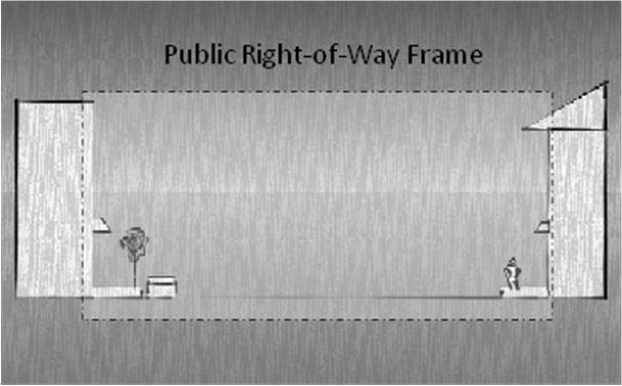
Setbacks. The principal goal of building setbacks is to frame the public right-of-way in a manner which encourages pedestrian activity on the abutting sidewalk. Within the Community Redevelopment Area, buildings shall be placed at the setbacks indicated within this ordinance.
(a)
Properties located within the Historic District and Community Redevelopment Area.
1.
Unless specifically noted herein, the setbacks of all buildings shall be consistent with the zoning district in which the property is located.
2.
Standard for Buildings Fronting on Main Street:
Front: 0'
Internal Side: 0'
Street Side: 7.5'
Rear: 10'
Alternative Setbacks
Front Columns and Rails: 0', and Principal Wall: 10' Front Plaza Indication Line: 0', and Principal Wall: 15'
Front Principal Wall: 0' for 60% of building frontage, and Front Recessed Wall: 10' for the remaining 40% of Buildings frontage
Internal Side Setback: 10'
Street Side Columns and Rails: 5', and Principal Wall: 15' Street Side Plaza Indicated Line: 5', and Principal Wall: 15'
For the purpose of this section an indication line is a clear and distinct line indicated by change in surface material.
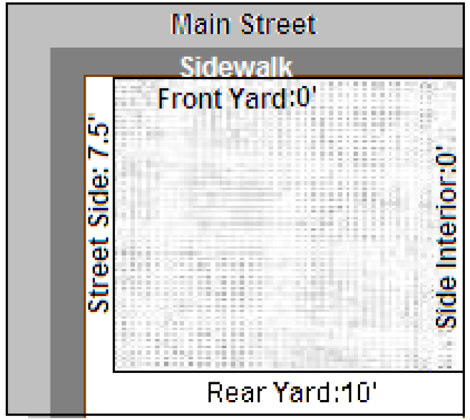
Acceptable design for buildings located on Main Street and within the Commercial Downtown Zoning District.
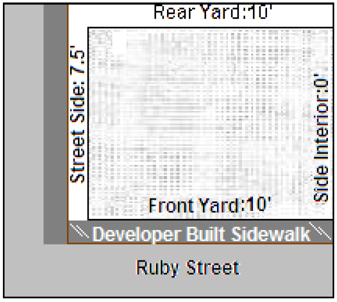
3.
Buildings on Ruby Street:
Front: 10'
Internal Side: 0'
Street Side: 7.5'
Rear: 10'
Alternative Setbacks
Front Columns and Rails: 10', and Principal Wall: 20' Front Plaza Indication Line: 10', and Principal Wall: 25'
Front Principal Wall: 10' for 60% of building frontage, and Front Recessed Wall: 15' for the remaining 40% of Buildings frontage
Internal Side Setback: 10'
Street Side Columns and Rails: 10', and Principal Wall: 20' Street Side Plaza Indicated Line: 10', and Principal Wall: 20'
For the purpose of this section an indication line is a clear and distinct line indicated by change in surface material.
4.
Setback along South Joanna Avenue, South New Hampshire Avenue, South Rockingham Avenue, St. Clair Abrams Avenue and Disston Avenue, N. Texas Ave., S. Lake Ave.:
Front: 7.5'
Side: 5'
Rear: 10'
5.
Buildings within the Mixed Use Zoning District fronting on Alfred Street:
Front: 10'
Side: 10'
Rear: 10' Alternative Setbacks
Front Columns and Rails: 10', and Principal Wall: 20' Front Plaza Indication Line: 10', and Principal Wall: 25'
Front Principal Wall: 10' for 60% of building frontage, and Front Recessed Wall: 15' for the remaining 40% of Buildings frontage
Street Side Columns and Rails: 10', and Principal Wall: 20'
Street Side Plaza Indicated Line: 10', and Principal Wall: 20'
For the purpose of this section an indication line is a clear and distinct line indicated by change in surface material.
(B)
Parking.
(1)
Properties located within the Historic District and Community Redevelopment Area.
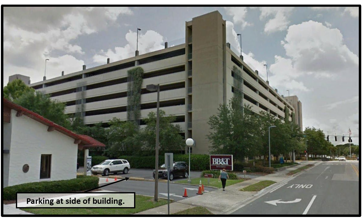
(a)
Unless specifically noted herein, all parking areas shall be located to the rear or side of the building. No parking area shall extend past either the primary or secondary facades towards the street.
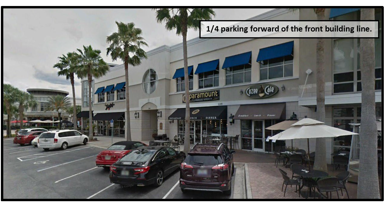
(b)
Properties located along those portions of US Highway 441/Burleigh Boulevard and State Road 19 that are also within the Community Redevelopment Area. One-quarter of the required parking identified in Table 20-A may be provided forward of the front building line. The remaining parking shall be provided to the rear or side of the building.
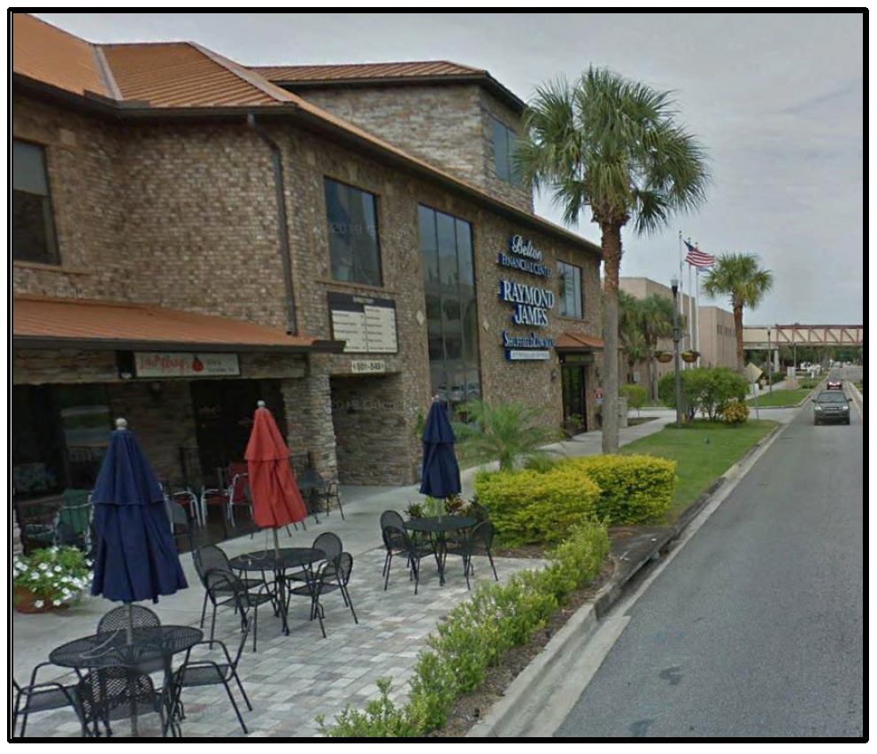
Acceptable design for properties located within the Community Development Area and on US Highway 441 or S.R. 19
Acceptable design for properties located on Alfred Street
(c)
Any portion of a parking area abutting a street shall provide a landscape buffer in accordance with Buffer Type A as outlined within Chapter 11.
(d)
The Community Redevelopment Area with its wide sidewalks, short blocks, relatively slower speed limits and rear and/or side parking lots has been designed to slow traffic, reduce vehicular and pedestrian conflict and increase pedestrian safety. For these reasons, properties located within the Community Redevelopment Area are exempt from the requirement of providing pedestrian pathways as outlined in Chapter 20, Section 20-15.
(e)
The Downtown Parking District is illustrated in the Downtown Parking District Map.
1.
Reduced Parking Requirements within CD (Commercial Downtown) District. All new development and redevelopment of existing uses within the Downtown Parking District within the CD zoning district shall be exempt from meeting the requirements of Table 20-A with the following exceptions:
(i)
Existing buildings as of April 19, 2000, that are used in whole or in part by federal, state, county or city governments for public purposes must provide seventy-five percent (75%) of the required off-street parking spaces identified in Table 20-A of these regulations for that portion of the building used for said purposes.
(ii)
Buildings or additions constructed after April 19, 2000 that are used in whole or in part by the federal, state, county or city governments for public purposes must provide one-hundred percent (100%) of the required off-street parking spaces identified in Table 20-A of these regulations for that portion of the building used for said purpose.
(iii)
Where on-street parking is not available within 60 feet of the development site, seventy-five percent (75%) of the allowable off-street parking spaces identified in Table 20-A shall be provided on site along with one-hundred percent (100%) of any required handicapped parking must be provided.
2.
Reduced Parking Requirements within MU (Mixed Use) District. All new development and redevelopment of existing uses within the Downtown Parking District within the Mixed Use zoning district shall be required to provide fifty percent (50%) of the requirements of Table 20-A, except that one-hundred percent (100%) of any required handicapped parking must be provided.
(i)
Where on-street parking is not available adjacent to the development site, one hundred percent (100%) of the off-street parking spaces identified in Table 20-A shall be provided on site.
(2)
Properties located outside of the Historic District and Community Redevelopment Area. Parking constructed on properties located outside of the Historic District and Community Redevelopment Area shall be in accordance with Chapter 8 Zoning Regulations and Chapter 20 Parking Regulations.
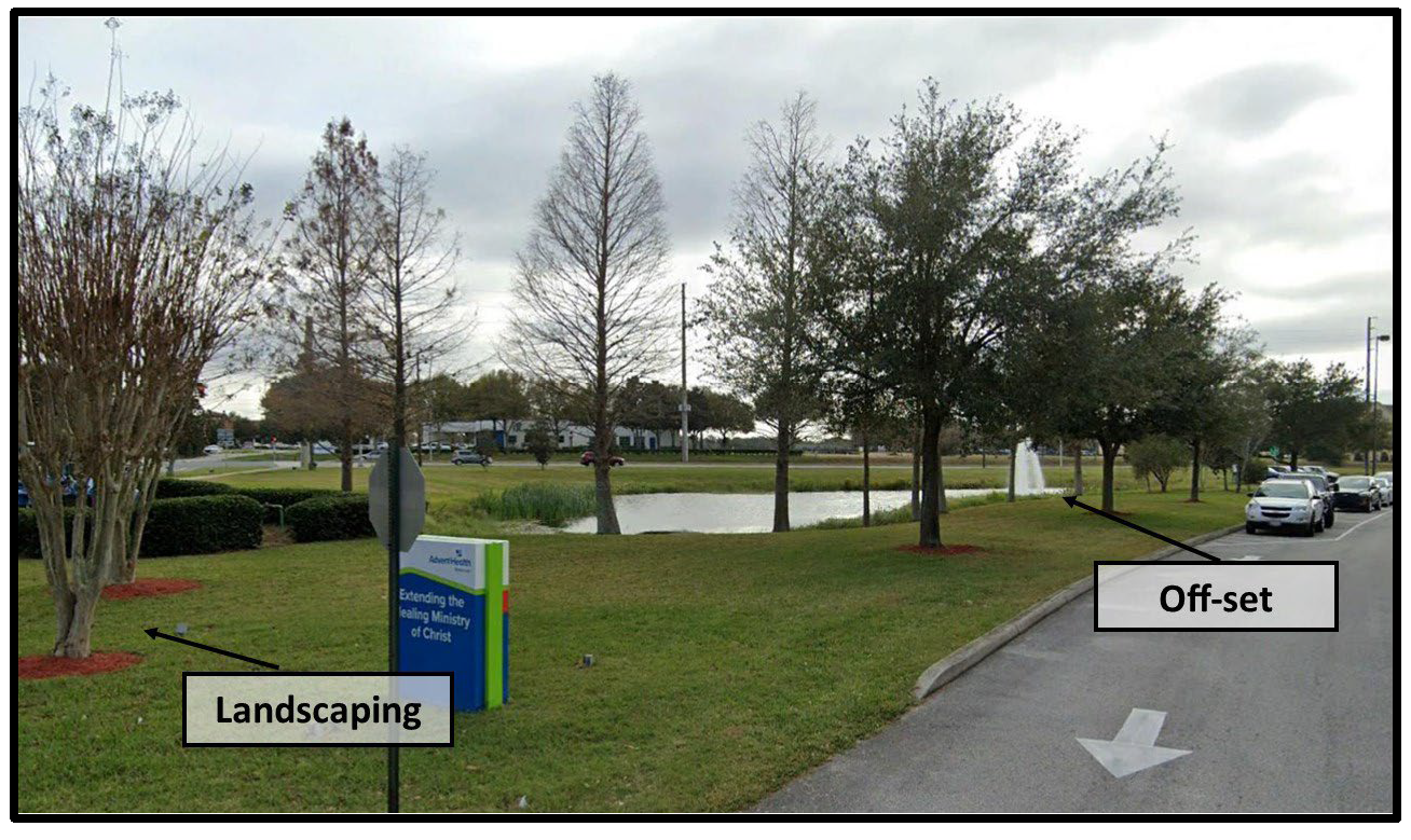
(C)
Stormwater Retention Areas. Wet and dry retention areas are encouraged to be designed so as to appear natural by having off-sets in the edge alignment. A portion of the landscaping that is required by Chapter 11 Landscaping Regulations, section 11- 4, D, shall be placed around the retention area to soften the visual appearance of the pond edges. If due to site conditions, an open vaulted stormwater system is utilized, then a decorative railing with a continuous hedge, vines, ivy, and/or a City acceptable groundcover will be planted along its edge to soften the apparatus. Features such as pedestrian access and seating are encouraged. Fountains are encouraged to accent the ponds and provide adequate aeration to prevent stagnation.
Acceptable design example
(D)
Lighting.
(1)
Exterior lighting shall be designed and installed in a sensitive manner so as to prevent direct glare, light spillage and hazardous interference with automotive and pedestrian traffic on adjacent streets and properties. Site lighting shall not exceed 1.00 foot candles in intensity at any property boundary adjoining residential use.
(2)
Lighting shall be designed in a consistent and coordinated manner for the entire site, including outparcels if applicable. The lighting and lighting fixtures shall be integrated and designed so as to enhance the visual impact of the project by accenting key architectural elements and/or emphasizing landscape features. The light poles and fixtures shall be earth tones in color.
(3)
Electrical wiring to all site lighting shall be provided underground.
(4)
No light fixtures shall be placed in a position where existing or future tree canopy will reduce the illumination levels.
(5)
Lighting fixtures shall be a maximum of thirty feet (30'). Light fixtures shall be a maximum of fifteen feet (15') within non-vehicular pedestrian areas. All site light fixtures including building wall mounted shall be "Dark Sky" compliant, or equipped with shielded or full cut-off luminaries incorporating flush-mounted flat lenses.
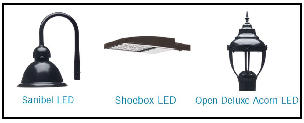
(6)
All lighting fixtures within parking areas and walkways shall be decorative light fixtures similar to the examples provided below. Decorative low light walkway bollards may also be permitted where appropriate.
Acceptable design examples
(E)
Outparcels. Large scale developments that will have a primary building and/or anchor stores and secondary outparcel developments on the same site must conform to the following guidelines.
(1)
A unified architectural design and site planning between outparcel structures and the main structure on the site is required in order to enhance the visual impact of the structures and to provide for safe and convenient vehicular and pedestrian movement within the site.
(2)
All exterior facades of an outparcel structure shall be considered primary facades and shall employ architectural, site and landscaping design elements with are integrated with and common to those used on the primary structure on site. These common design elements shall include colors and materials associated with the main structure.
(3)
When the use of common wall side- by-side development occurs, continuity of facades and consolidated parking for several businesses in one parking lot may be used.
(4)
Out parcels that are adjacent to each other shall have vehicular connection between their respective parking lots and interconnected pedestrian walkways.
(F)
Outbuildings. Outbuildings are permitted as accessory structures in accordance with Chapter 8 Zoning Regulations, Section 8-11.
(G)
Additional Site Design Elements. All commercial sites shall have at least one (1) of the following site design elements:
(1)
Decorative landscape planters or planting areas. The planting/planters shall be at a minimum of 180 square feet of landscape area per side located at the building entryway(s).
(2)
An outdoor trash receptacle (not to be located on public property) near the building entrance or near the outside bench. The trash receptacle shall be commercial grade for the outdoor environment (like metal, etc.).
(3)
Water element(s), a minimum of seventy-five square feet (75') in area and three feet (3') in height.
(4)
Two (2) accent or specimen trees (in addition to the minimum required landscaping) along the front facade. Minimum size requirements shall meet the requirements for sub-canopy trees set forth in Chapter 11, Landscaping Regulations.
(5)
Sculptured art having a minimum height of four feet (4').
(6)
Outdoor seating to include a minimum of one bench (not to be located on public property). The bench shall be commercial grade for the outdoor environment (like metal, concrete, etc.) and bolted onto a cement pad.
(H)
Sidewalks. In the interest of the health and safety of the residents and visitors of the City of Tavares, the City finds its sidewalks to be a vital component of the public infrastructure. Streets, sidewalks and pathways should encourage walking, sitting and other pedestrian activities; buildings should frame the public space and be visually interesting to invite exploration of the area by pedestrians without creating excessive shadow or narrow corridors which provide opportunities for crime and create a perception of danger. Conflicts between pedestrians and motor vehicles should be reduced through design which emphasizes the pedestrian's right-of-way.
(1)
Sidewalks in Commercial Zoning Districts, Industrial Zoning Districts, and along multifamily developments. Developers of such property shall install sidewalks along all public streets adjoining the property being developed. If any damage from installation, defects, or heavy equipment occurs during the development and manifests itself within one (1) year from the date of acceptance by the City, the defects shall be remedied by the developer at the developer's expense.
(2)
Locations. Sidewalks shall be required on both sides of each street type including arterial roadways, collector roadways, local roadways, and cul-de-sacs.
(3)
Sidewalk widths.
a.
Along Main Street, Alfred Street and Ruby Street: 8 feet. In areas where the right-of-way is less than 70 feet in width, the sidewalk width shall be 6 feet. Where physical conditions create an obstacles to meeting this standard, the City administrator or his/her designee shall be authorized to adjust the standard to meet the intent of this ordinance.
b.
Outside of the Community Redevelopment Area. Sidewalks shall be at least five feet (5') feet in width.
(I)
Driveways. In an effort to further facilitate the healthy lifestyles of City residents and visitors, the City of Tavares shall seek to protect and increase the walk-ability of its residential communities by limiting the interruption of its sidewalks by motor vehicle encroachments such as is created by driveways. Where driveways are permitted they shall be limited in width and frequency with the goal of retaining as much landscaping and pedestrian access as possible. Driveway design standards are further outlined in Section 19-15, "Access to homes, subdivisions and planned developments."
(1)
Access.
a.
When a residential development or planned development is proposed that would abut an arterial or major collector roadway, it shall be designed to provide lots abutting the roadway with access from an interior local road or frontage road.
b.
Direct driveway access to individual one and two family dwellings from arterial and major collector roadways shall be prohibited.
(2)
Location.
(a)
Driveways on local, residential streets shall not be located within the corner radius of an intersection. A driveway shall be no closer than 30 feet from an intersection as measured from the edge of the driveway flares to the side right-of-way line or stop bar, if present.
(b)
The maximum width of a driveway shall be 20 feet. The driveway flares may be permitted to add a maximum of 4 feet to the width of the driveway curb cut.
(c)
The minimum space between driveways and/or curb cuts shall be 10 feet.
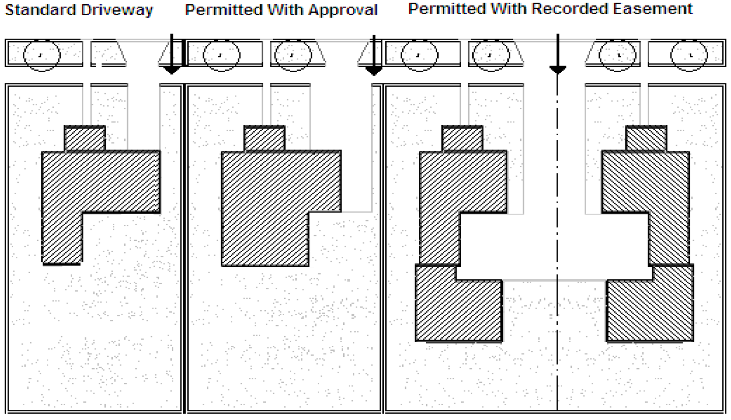
(d)
The minimum distance between a driveway flare and a side property line shall be 2 feet.
(e)
The minimum distance between the driveway and the side property line shall be 5 feet.
(i)
An administrative variance from this standard may be approved by the City Administrator's designee and the City Engineer. The administrative variance is to be requested in writing and reviewed during a development review committee meeting as part of the site plan review process. The review shall be based on a site specific hardship and it must be shown that the variance will not negatively impact the interest of the public by impeding access to infrastructure improvements such as drainage easements, removing a mature approved species trees or other such identified values expressed by the community. If these conditions are met, the administrative variance from this standard may be approved.
(3)
Shared driveways.
a.
Adjacent properties may share or contribute to adjoined driveways with a recorded easement.
Not Acceptable
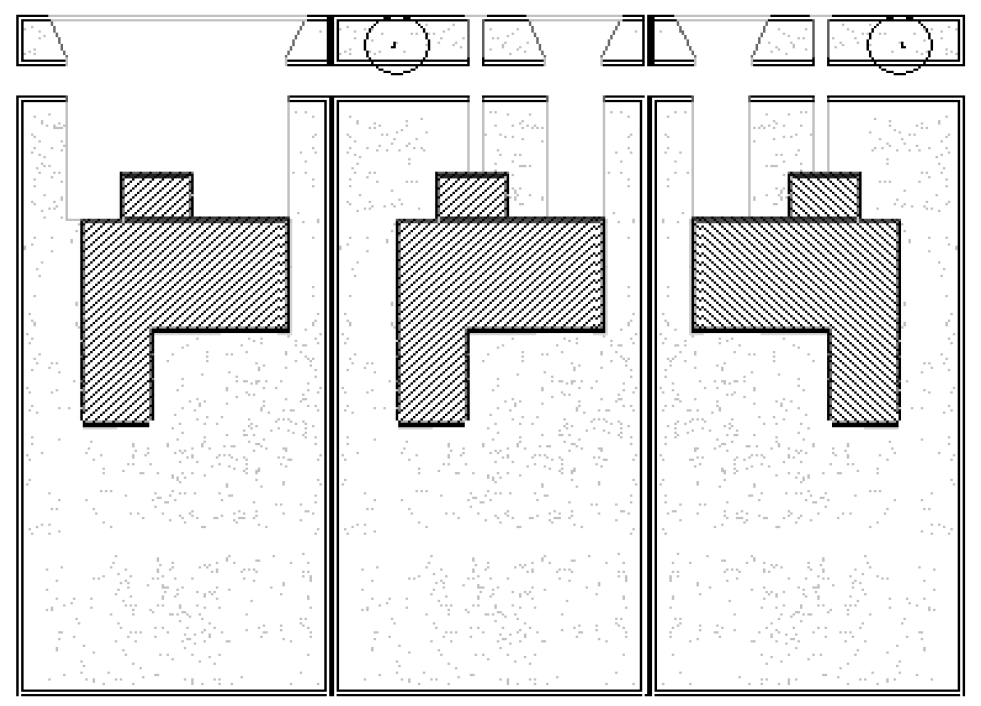
Acceptable design examples
(J)
Signs. Sign regulations are outlined in Chapter 21 of the Land Development Regulations. Unless otherwise noted in this section, Chapter 21 shall guide the standard by which signs are permitted.
1.
Signs in the Community Redevelopment Area.
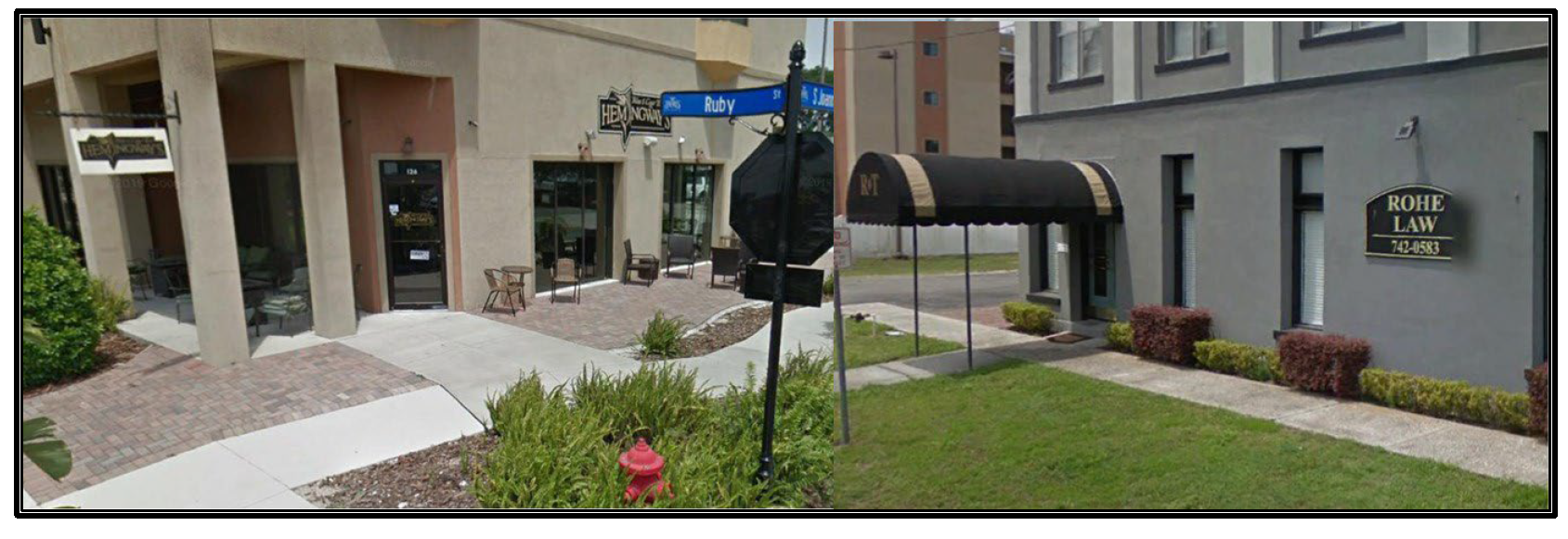
A.
Commercial signage within the Commercial Downtown Zoning District shall be attached to the building face. However, one monument sign may be permitted with an approved petition for special use.
B.
All signage shall consist of dark background colors and light contrasting colored lettering.
C.
All signs shall complement the architectural character of the building.
Acceptable design examples for properties on Main Street, Ruby Street and Alfred Street
(K)
Landscaping. Landscaping and buffer requirements are outlined in Chapter 11 of the Land Development Regulations. Unless otherwise noted in this section, Chapter 11 shall guide the standards by which landscaping is required.
(L)
View to the Lake Dora Waterfront. The view to Lake Dora is a downtown asset cherished by residents and visitors of the City of Tavares. Maintaining the existing view and creating new viewing corridors is essential to the character of the downtown. The following are a list of streets with existing or potential views to Lake Dora. Design elements such as signage and landscaping should seek to avoid interrupting such views to the lake.
The streets include: South Disston Avenue, St. Clair Abrams Avenue, New Hampshire Avenue, Sinclair Avenue, Rockingham Avenue, and Joanna Avenue.
Section 9-29 - Building Design Standards
The purpose of the building design guidelines is to promote architectural treatments that enhance the visual appearance of development, ensure compatibility of buildings, and create a strong community image and identity. Buildings shall have architectural features and patterns that provide visual interest from the perspective of the pedestrian, reduce the massing aesthetic, recognize local character, and be site responsive.
(A)
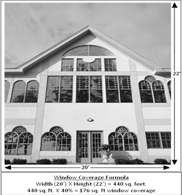
Window standards. Windows and display cases are encouraged along pedestrian corridors. A minimum of forty percent (40%) of each facade facing a public right-of-way shall contain windows. Windows may be false, however such windows shall not appear to be false or applied.
(B)
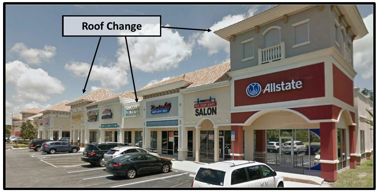
Roof standards. Variations in rooflines shall be used to add interest to, and reduce the massing of buildings. Roof features shall be in scale with the building's mass and complement the character of adjoining and/or adjacent buildings and neighborhoods. Roofing material should be constructed of durable high quality material in order to enhance the appearance and attractiveness of the community. The following standards identify appropriate roof treatments and features.
(1)
Roof line treatment. The height of the roofline and/or parapet line shall have a vertical change from the dominant height a minimum of once every seventy-five linear feet (75'). The height change shall be a minimum of three feet (3'). At least one (1) such change shall be located on a primary facade.
Acceptable design example
(2)
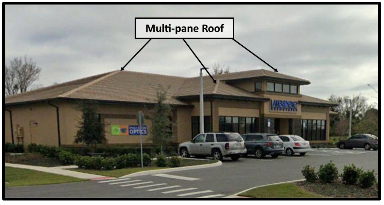
Prohibited roof types.
(a)
Flat roofs, unless disguised by architectural features such as, but not limited to, parapet walls in order that the appearance of the flat roof design is concealed from view at ground level.
(b)
Mansard roofs.
(c)
Single plane roofs.
(d)
Canopy roofs except as an architectural embellishment over doors, windows or arcades.
Acceptable design example
(3)
Mechanical Equipment. Mechanical equipment located on the roof shall be screened from view by use of parapet walls or by recessing equipment into hips, gables or similar features. The equipment shall be fully screened from adjacent properties and roadway corridors at pedestrian level.
(C)
Entrances.
(1)
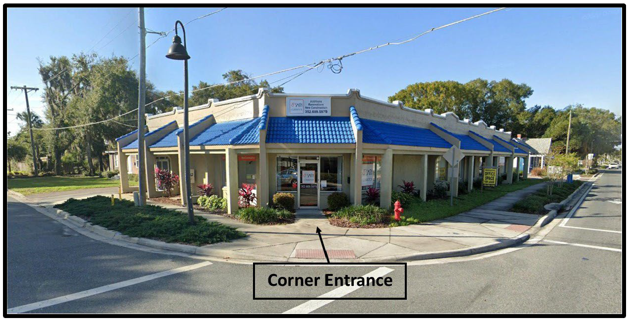
Buildings shall have their primary customer entrance facing the primary street frontage. Where two (2) major streets intersect, customer entrances shall be provided for both streets. A corner entrance will be a permitted exception to this requirement.
Acceptable design example
(2)
Primary customer entrances shall be clearly defined and highly visible through the use of architectural detail for all structures.
(3)
Protection from the sun and adverse weather conditions for patrons should be considered for the entranceways.
i.
Within the Community Redevelopment Area and on Main Street, an awning, canopy, arcade or other entrance way overhang is required. Structural supports for the overhanging awning, canopy or arcade shall be constructed within the property boundaries of the development parcel and shall not be located so as to interfere with pedestrian movement.
ii.
Awnings, canopies and arcades are encouraged. Structural supports for the overhanging awning, canopy or arcade shall be constructed within the property boundaries of the development parcel and shall not be located so as to interfere with pedestrian movement.
(D)
Massing standards. Facades shall be designed to reduce the mass/scale and uniform monolithic appearance of large unadorned walls, while providing visual interest that will be consistent with the community's identity and character through the use of detail and scale.
(1)
All buildings shall provide a minimum of one (1) offset per public street and/or one (1) offset per seventy-five linear feet (75') of street frontage. An offset may be either a projection or recession of the facade and shall have a minimum depth of 3 feet (3') and a minimum width of five feet (5').
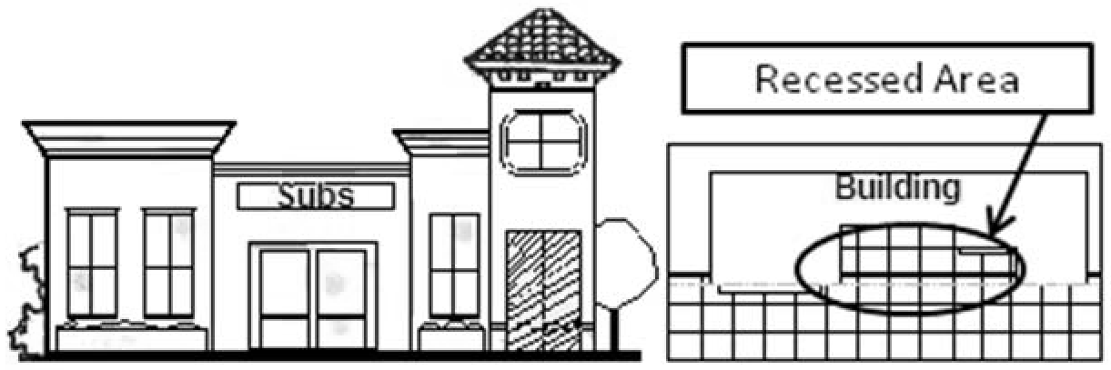
(2)
Blank wall areas. Blank wall areas shall not exceed ten feet (10') in the vertical direction or twenty feet (20') in the horizontal direction of any primary or secondary facade. Windows, architectural embellishments or landscaping may be used to assist in reducing the blank wall area.
(E)
Design Elements. All buildings within the Community Redevelopment Area shall have a minimum of two (2) of the following building design treatments. Buildings located on corner lots shall provide similar facade treatments on each street frontage.
(1)
Canopies or porticos, integrated with the building's massing and style.
(2)
Overhangs, signage and awnings, minimum of three feet (3') in depth may hang over the public right-of-way provided that they do not impede the pedestrian way or require support systems in the right-of-way.
(3)
Arcades, minimum of eight feet (8') in width and five feet (5') in depth.
(4)
Raised cornice or building banding with a minimum of two (2) reliefs.
(5)
Peaked roof forms.
(6)
Arches.
(7)
Reserved.
(8)
Bell towers, dormers, belvederes, cupolas or other such roof treatment.
(9)
Balconies.
(10)
Emphasized building base, minimum of three feet (3') high and minimum projection from the wall of two inches (2");
(11)
Any other treatment that, in the opinion of the City Administrator or designee, meets the intent of this section.
(F)
Building Materials Standard. Exterior building materials contribute significantly to the visual impact of a building on the community. They shall be well designed and integrated into a comprehensive design style for the project.
(1)
Predominant exterior building materials shall include, but are not limited to:
(a)
Stucco.
(b)
Natural brick (unpainted, unstained, and non-tinted).
(c)
Textured, other than smooth or ribbed, concrete masonry units.
(d)
Stone (unpainted, unstained, and non-tinted), excluding an ashlar or rubble construction look.
(e)
Wooden or composite siding.
(f)
Tile.
(2)
Predominant exterior building materials that are prohibited include:
(a)
Plastic or vinyl siding.
(b)
Corrugated or reflective metal panels.
(c)
Smooth or rib faced concrete block.
(d)
Applied stone in an ashlar or rubble look.
(3)
Automotive and other special type service buildings may utilize prefabricated metal buildings under the following conditions:
(a)
The metal building is clearly ancillary to a primary structure which meets the design guidelines of these regulations.
(b)
The metal building is not located adjacent to any residential zoning district and is located more than one-hundred feet (100') from any right-of-way.
(c)
The metal buildings are located directly behind the primary structure so as not to be a dominant façade along the street.
(d)
Reserved.
(e)
At least seventy-five percent (75%) of the front facade of any such metal building must match the design and materials used in the primary structure. The color of the remaining portion of the metal building shall blend with the colors used in the primary structure.
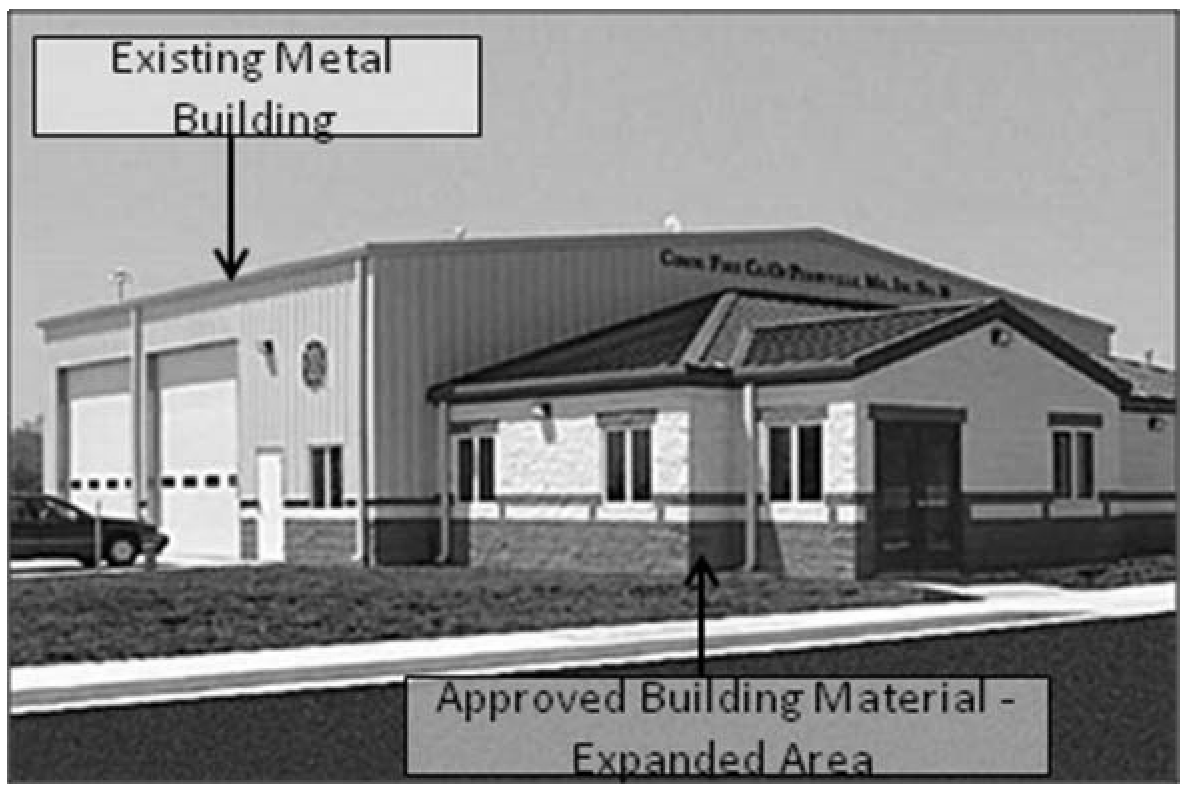
(4)
Existing metal buildings may be expanded and improved only under the condition that the expanded building area has an approved exterior building material for a minimum of seventy percent (70%) of the building's façade as seen from the public right-of-way.
Acceptable design example
(G)
Exterior Colors. Color schemes must be submitted to the Planning and Zoning Department for approval.
(1)
Color has one of the strongest visual effects of all elements of building design. Therefore, painting schemes shall be selected for harmony of the building and with adjacent structures. A wide selection of exterior colors may be considered to promote variety and diversity. The general approved colors shall include earth tones and light pastel colors.
(2)
Building trim and detail colors must be complimentary to the principle building color. The painting scheme shall not be such that it draws attention to the building regardless of the impact on the character of the environment, nor shall the paint scheme act as signage for the building. Bands of bright or bold color shall be prohibited on the building or fenestration.
(3)
The following colors are prohibited:
(a)
Florescent or day glow colors.
(b)
Black as the predominant exterior color.
(c)
Singular color schemes (all one color).
(H)
Ancillary Building Features.
(1)
Drive-through window standards. Drive-through windows and lanes shall be designed to adhere to the following standards:
(a)
Drive-through windows shall not be placed between the right-of-way of the primary street frontage and the associated building.
(b)
A type "B" landscape buffer, unless a greater buffer is required by Chapter 11 Landscaping Regulations, shall be installed along the entire length of the drive-through lane between the drive-through lane and any adjacent right-of-way.
As an alternative to the vegetative buffer, a wall may be placed within the buffer along the entire length of the drive-through lane between the drive-through lane and any adjacent right-of-way. The wall shall be similar in architectural design and materials to the associated building. The wall shall meet the requirements of subsection 9-29(H)(5).
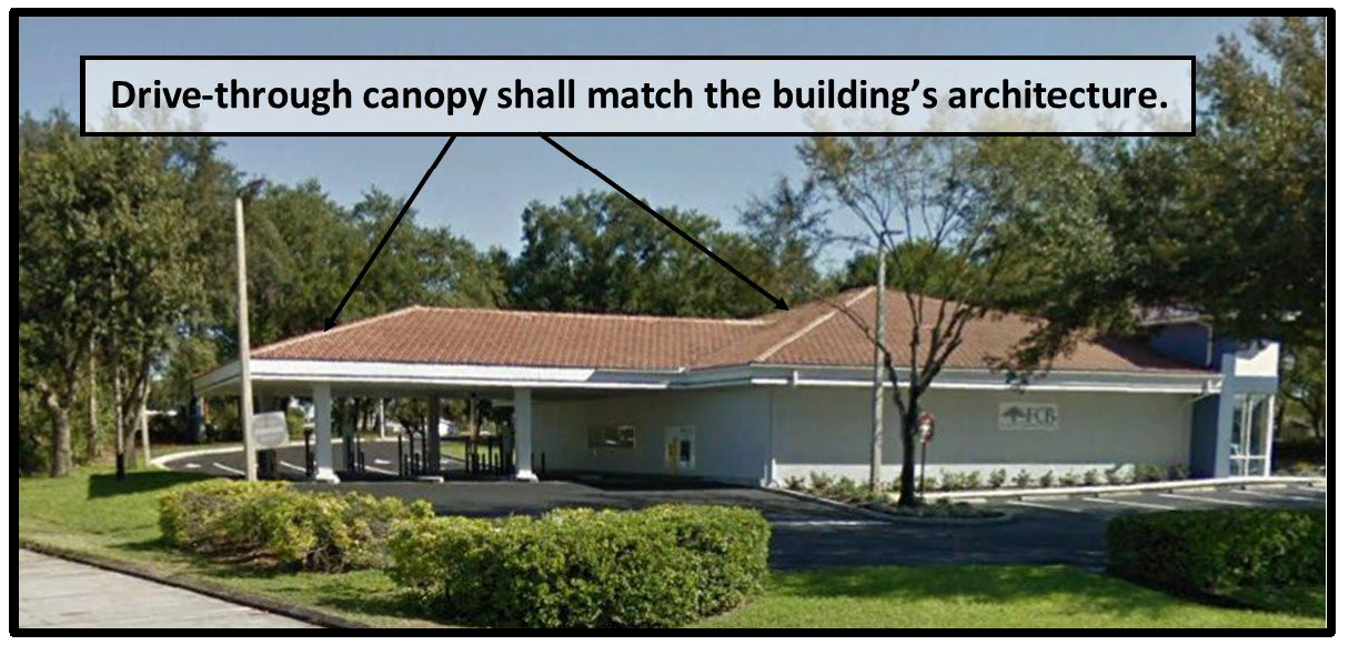
(c)
A permanent covered porte-cochere type structure, other than awning/canvass type structure(s), shall be installed extending the width of the drive-through and covering the service window(s). Such structure shall be integrated structurally and architecturally into the design of the building. Roof treatments must match the roof treatment of the primary structure.
(2)
Fueling Islands. Structural supports for the roof shall match the architectural design and materials used for the primary structure.
(3)
Service Function Areas. Service Function Areas include, but are not limited to, loading, storage, mechanical equipment, and solid waste disposal areas.
(a)
Buffering and screening standards. Loading or docking, outdoor storage, trash collection and/ or compaction, recycling, mechanical equipment, roof top equipment and other service function areas shall be fully screened from adjacent properties and road way corridors at pedestrian level.
(b)
Materials and design standards. Screening material and design shall be consistent with design treatment of the primary facades of the associated building.
(c)
Dumpsters and other trash collection areas shall comply with the regulations specified in Chapter 8, Section 8-12(B) of the Land Development Regulations.
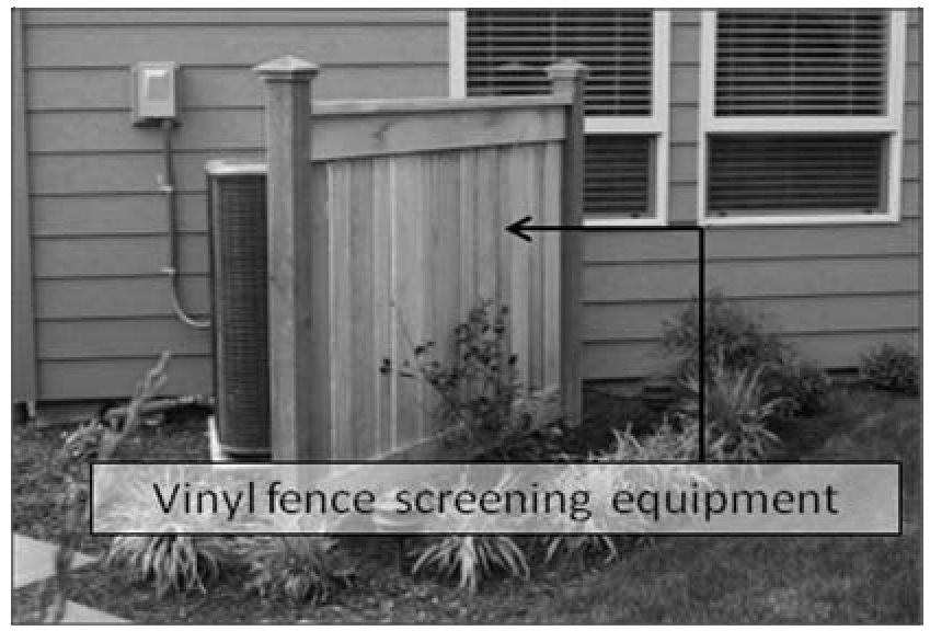
(d)
Mechanical equipment shall not be located to the front or side of a building facing a public right-of-way. All mechanical equipment shall be screened by either a permanent wall consistent with the design and material of the associated building or by landscaping.
(e)
Utilities for all new developments shall be located underground. Utility boxes must be totally screened from view of principal streets, as well as pedestrian walkways and areas.
(4)
Garden Centers. Garden centers are permitted subject to the following:
a.
The garden center must be located in an enclosed building and said building must be attached to and an integral part of the principle structure/building on the site. The enclosed garden center must meet the standard design requirements of this chapter unless otherwise provided in this section.
b.
The garden center must be contained under roof (with certain open sky portions in order to ensure plants health and survival).
c.
The front façade of the garden center must be consistent with the design of the principle building, including at a minimum massing standards, exterior façade features and window coverage.
d.
The sides and rear of the garden center must be enclosed in a wall a minimum of 3 feet in height and constructed of the same exterior building materials as the principle structure.
e.
Windows are not required, however a window like appearance shall be provided utilizing shade cloth panels or decorative wrought iron fence panels between columns. The columns shall extend from the roof to the wall enclosure. Said window-like panels shall be a maximum of 12 feet in width.
f.
Outdoor Storage/Display is permitted for retail garden centers only under the following conditions:
1)
Outside Storage/Display — General Requirements.
a)
Outside storage/display of merchandise shall only be permitted for merchandise directly associated with lawn and garden businesses.
b)
No storage or display of merchandise or equipment shall be permitted in parking areas, vehicular drive isles or pedestrian walkways.
c)
All merchandise stored or displayed on the exterior of the building shall be bagged, boxed, or otherwise self-contained. Uncontained bulk storage of merchandise shall not be permitted.
d)
No more than 500 square feet may be designated and utilized for outside storage/display located in the front of the building.
2)
Outside Storage/Display — Building Front.
a)
All merchandise or equipment must be stored under a covered roof or overhang and designated as a storage/display area on an approved site plan.
b)
Merchandise typically stored on pallets shall not be displayed along the front of the building facing the primary street frontage. This would include but not be limited to such items as mulch, soil, salt, fertilizers, stone, and other items typically transported on top of a pallet. Note that storage of these types of materials without the underlying pallet shall also not be permitted.
c)
The maximum height of any merchandise to be stored in the front of the building shall be 3 feet. The only permissible exception to this height limitation shall be for plant display racks which may be a maximum of 6 feet in height.
3)
Outside Storage/Display — Building Side.
a)
Merchandise/equipment shall be stored/displayed in a designated area adjacent to the primary building, extending no further than 5 feet outward from the building. This area is not required to be located under a roof or overhang.
b)
Merchandise stored on pallets may be stacked no higher than 4 feet in height unless they are screened from view.
c)
No more than 500 square feet may be designated and utilized for outside storage/display located along the building side(s).
(5)
Wall/Fence standards.
(a)
Chain link, chain link with decorative inserts, and barbed wire fencing are prohibited.
(b)
Properties located within the Historic District and Community Redevelopment Area.
1.
Installation of a wall/fence within a required landscape buffer shall not negate the requirement for landscaping. All trees, either canopy or sub-canopy must be planted in accordance with Chapter 11, Landscaping Regulations.
2.
Walls or fences forward of the front primary facades shall be permitted under the following conditions:
a.
The wall/fence shall be a minimum of three feet (3') in height and shall not exceed four feet (4') in height.
b.
The wall/fence style must complement building style through material, color and/or design. Brick, stucco or textured block, wrought iron are acceptable materials.
c.
The fence/wall shall provide either a variation in its height for a minimum of fifteen percent (15%) of its length with a deviation of at least twelve inches (12"); or shall not exceed seventy-five percent (75%) opacity.
(c)
Properties located outside of the Historic District and Community Redevelopment Area. Walls/fences constructed on properties located outside of the Historic District and Community Redevelopment Area shall be in accordance with Chapter 8 Zoning Regulations and Chapter 11 Landscaping Regulations, subject to section H, 5, (a) above.
Section 9-30 - Variance Procedures
A variance to these architectural standards may be requested as set forth in Chapter 4, Section 4-28 where such variance will not be contrary to the public interest and where, owing to special conditions, a literal enforcement of the provisions of these standards would result in unnecessary hardship.
Section 9-3 - Creation and Composition
The Planning and Zoning Board is hereby designated as the Historic Preservation Board of the City of Tavares.
Section 9-4 - Terms of Office
The terms of the Historic Preservation Board shall run concurrent with the terms of the members of the Planning and Zoning Board.
Section 9-5 - Organization
(A)
The Board will elect a Chairman and a Vice-Chairman from its membership. They will serve terms of three (3) years each. Nothing will prevent the Board from electing the Chairman and the Vice-Chairman for an additional term. The Chairman will preside over the Board and will have the right to vote. In the absence or disability of the Chairman, the Vice-Chairman will perform the duties of the Chairman. The City's Administrator's designee shall act as the City Historic Preservation Officer and will serve as Secretary of the Board.
(B)
The Board shall adopt rules providing for the transaction of its business and consideration of applications, for the time and place of regular meetings, and for the calling of special or emergency meetings. All meetings of the Board shall be open to the public and a public record will be kept of the Board's resolutions, proceedings, and actions.
(C)
The Board will hold regular meetings to consider nominations for designation of historic status, review applications for Certificates of Appropriateness for demolition of historic sites, and conduct other such duties and business as the Board is charged with under these regulations.
Section 9-6 - Duties, Functions and Powers of the Historic Preservation Board
The recommendations and findings of the Historic Preservation Board shall be reviewed and considered by the City Council prior to any council action on any matter required to be reviewed by that Board. However, the recommendations and findings of the historic Preservation Board shall be advisory only and the City Council shall not be bound by those recommendations and findings. The Board shall assist in:
(A)
Develop, maintain and update a survey or archaeological sites, properties, buildings, structures and districts of special historic, aesthetic, architectural, cultural or social value or interest;
(B)
Nominate properties for historic designation;
(C)
Participate in the National Register program in Florida;
(D)
Develop guidelines concerning contemporaneous architectural styles, colors, building and materials for historic sites and property within historic districts.
Section 9-7 - Classification of Structures and Buildings
All property in a historic district will be divided into two classes:
(A)
Contributing. Historic properties will posses identified historical and architectural merit of a degree warranting their preservation. Historic properties listed in the Historic Preservation Survey will be considered worthy of preservation and may be designated as a historic site and listed in the Local Register of Historic Places
(B)
Non-contributing. Those buildings and structures, within the historic district, not listed in the City Historic Preservation Survey.
Section 9-8 - Preservation Standards
(A)
To qualify as a historic site or historic district, the buildings will have significant character, interest or value as part of the historical, cultural, aesthetic and architectural heritage of the City, state or nation. To qualify as a historic site or historic district, said property or properties must fulfill one or more of the criteria set forth in paragraphs (1) and (2) below.
(1)
Historic properties or district will be deemed to have historical or cultural significance if it meets the following criteria:
(a)
Is associated in a significant way with the life or activities of a major person important in City, State or national history, or
(b)
Is the site of a historic event with significant effect upon the City, State or Nation, or
(c)
Is associated in a significant way with a major historic event whether cultural, economic, social, military, or political, or
(d)
Exemplifies the historical, political, cultural, economic or social trends of the community in history, or
(e)
Is associated in a significant way with a past or continuing institution which has contributed substantially to the life of the City.
(2)
Historic properties or district are deemed to have architectural or aesthetic significance if it fulfills one or more of the following criteria:
(a)
Portrays the environment in an era of history characterized by one or more distinctive architectural styles, or
(b)
Embodies those distinguishing characteristics of an architectural style, period or method of construction, or
(c)
Is a historic or outstanding work of a prominent architect, designer, landscape architect, or builder, or
(d)
Contains elements of design, detail, material, or adaptation of the Central Florida environment.
(B)
Historic properties or district will be deemed to have historic significance if, in addition to or in the place of the previously mentioned criteria, the building, structure, site or district meets historic development standards as defined by and listed in the regulations of and criteria for the National Register of Historic Places, as prepared by the U.S. Department of the Interior under the Historic Preservation Act of 1966, as amended. Standards for the National Register are hereby incorporated and made part of these regulations by reference.
Section 9-9 - Nomination for Historic Site Designation
(A)
Nominations for historic site status may be initiated:
(1)
By the City Council, or
(2)
By any resident or property owner within the City.
(B)
Nominations for historic district status may be initiated the City Council.
(C)
A property owner, or the City Council, making a nomination for historic site designation, is responsible for completing the application form and submitting it, along with any nomination fee or charges, to the Historic Preservation Board. The Board may require the property owner who initiates a nomination application form to provide any documentation or supporting evidence the Board deems necessary.
(D)
The Board will conduct a preliminary evaluation of the information provided on each nomination application form to make sure it generally conforms with the historic status criteria defined in this Chapter.
(E)
The Board will then prepare a Designation Report, which will contain the following information:
(1)
Proposed legal boundaries of the historic building, archaeological site, structure, or district; and,
(2)
Analysis of historic significance and character of the nominated property.
(F)
Following the setting of a date for a public hearing before the Board for the consideration of a nomination for designation as a historic site or historic district, no permits will be issued by the City for any new construction, alteration, relocation or demolition of the real property included in the nomination. This delay in the issuance of permits will remain in effect until one of the following takes place:
(1)
The Historic Preservation Board recommends denial of the historic site designation, and no appeal is filed with the City Council within 30 days of the Board's denial recommendation; or,
(2)
The City Council formally approves the nomination for historic site or district status.
Section 9-10 - Nomination Notifications and Hearings
(A)
After the Board prepares its Designation Report, it will set and hold the public hearing on each proposed designation with notification as follows:
(1)
A notice of public hearing to the property owner(s) of record as of the date of nomination. This notice must be mailed at least 10 days prior to a public hearing.
(2)
Public Hearing Notification. No additional public hearing notification is required for historic site nominations. Nomination of historic districts must be noticed in a newspaper of general circulation at least 10 days in advance of the public hearing
(B)
If a majority of the Board present and voting agrees that the nomination fulfills the proper designation criteria, it will transmit the nomination and its findings and recommendations for final approval of the designation to the City Council.
(C)
The City Council may, upon recommendation by the Historic Preservation Board, designate historic sites and districts. All designated sites will be added to the Local Register of Historic Places.
Section 9-11 - Appeals
Appeals of City staff actions in regard to historic preservation regulations must be presented to the City Council, in writing, within 30 days of the City staff action. The City Council will then consider the appeal at a public meeting within 30 days of the filing of an appeal, and vote to approve or deny the appeal
Section 9-12 - Local Register of Historical Places
(A)
If the City Council approves the nomination of a property for designation as a historic site or group of properties for designation as a historic district, said property or group of properties will be listed on the Tavares Local Register of Historic Places. The local historic register will be maintained by the City Historic Preservation Officer.
(B)
Upon placement of property or properties on the local register, the Council will cause this designation to be recorded in the official records of Lake County.
(C)
The Council will issue an official Certificate of Historic Significance to the owner of properties listed individually on the local historic register or judged as contributing to the character of a historic district listed on the local historic register. The City Administrator, acting as City Preservation Officer, or his/her appointee, is authorized to issue and place official signs denoting the geographic boundaries of each historic district listed on the local historic register.
Section 9-13 - Purpose of Certificate of Appropriateness
The Certificate of Appropriateness process ensures that construction associated with historic properties and adjoining and adjacent sites is completed in conformance with the design standards required for historic districts.
Section 9-14 - Basic Application Requirements
(A)
Applications for Certificates of Appropriateness must be made on forms provided by the City and shall be submitted with a site plan application and a building permit application. Applications will include required forms and appropriate site plans, architectural drawings, photographs, sketches, descriptions, renderings, surveys, documents or other information needed for City staff to gain a clear understanding of the applicant's planned alteration, construction, reconstruction, relocation, restoration, renovation, or demolition.
(B)
Certificate of Appropriateness Application Requirements.
(1)
No building, structure, site feature, improvement or landscape feature within the City of Tavares, which has been designated a historic site, will be erected, altered, restored, renovated, excavated, relocated, or demolished until a Certificate of Appropriateness has been approved by City staff.
(2)
A Certificate of Appropriateness shall not be required for the erection, alteration, restoration, renovation, excavation, relocation, or demolition of any non-contributing building, structure or site feature within any historic district established by the City of Tavares, except when the non- contributing building is on an adjoining or adjacent site.
(3)
A Certificate of Appropriateness shall be required for historic sites for any material change in existing exterior walls or fences, or construction of new walls and fences.
(4)
A Certificate of Appropriateness shall be required for adjoining and adjacent sites for any material change in existing exterior walls, fences, or construction of new walls and fences.
(5)
No Certificate of Appropriateness will be approved unless the architectural plans for said construction, reconstruction, relocation, alteration, excavation, restoration, renovation, or demolition are approved by the City staff as meeting the design requirements established for the historic district.
A Certificate of Appropriateness will not be required for general, ordinary maintenance of any historic property or other property or structure within the historic district.
Section 9-15 - Review Procedures
(A)
City staff shall review the application for Certificate of Appropriateness and all supporting material and shall approve the application, find the application incomplete or deny the application within ten (10) working days. Applications that request demolition of historic sites shall be referred to the Historic Preservation Board for a recommendation to City Council.
(B)
An application for a Certificate of Appropriateness must be filed no later than ten (10) calendar days prior to any meeting of the Historic Preservation Board at which such application is to be heard. The applicant shall pay a filing fee, the amount of which will be determined by the Board and approved by the City Council, and no application will be accepted by the Board unless it contains all required and pertinent information and is accompanies by the required fee.
Section 9-16 - Demolition of Historic Sites
(A)
The Historic Preservation Board shall consider the following guidelines in providing a recommendation to City Council concerning applications for a Certificate of Appropriateness that propose demolition of designated historic sites:
(1)
Is the structure of such interest or quality that it would reasonably fulfill criteria for designation for listing on the National Register?
(2)
Is the structure of such design, craftsmanship or material that it could be reproduced only with great difficulty and/or expense?
(3)
Is the structure one of the last remaining examples of its kind in the neighborhood, City or designated historic district?
(4)
Would retaining the structure promote the general welfare of the City of Tavares by providing an opportunity to study local history, architecture and design, or by developing an understanding of the importance and value of a particular culture and heritage?
(B)
In connection with any Certificate of Appropriateness for demolition of buildings, structures or site features, the City Council may request the owner, at the owner's expense, to salvage and preserve specified classes of building materials, architectural details and ornaments, fixtures, and the like for reuse in the restoration of other historic properties. The City Council may also request the owner at the owner's expense, to record the architectural details for archival purposes prior to demolition. The recording may include, but will not be limited to, photographs, documents and scaled architectural drawings.
(C)
Condemned structures by the City Building Official do not require a Certificate of Appropriateness.
(D)
Notice of application for demolition shall be posted on the premises of the building, structure or appurtenance proposed for demolition in a location and manner clearly visible from the street. Such notice will be posted within three (3) working days of receipt of the application for demolition by the Council.
Section 9-17 - Amendments to Designations
Applications for amendments to existing designated historic sites or designated historic districts will be processed according to the designation process of these regulations. However, no action resulting from such application for amendment will have the effect of eliminating the requirement for Certificates of Appropriateness.
Section 9-18 - Undue Economic Hardship
In any instance where there is a claim of undue economic hardship the property owner may submit documentation to the City Council necessary for the City Council to evaluate the request for consideration of undue economic hardship.
(A)
The Council may require that an applicant furnish such additional information as the Council believes is relevant to the Council determination of any alleged undue economic hardship. The Council may also require, in appropriate circumstances, that information be furnished under oath.
(B)
In the event that any of the required information is not reasonably available to the property owner and cannot be obtained by the property owner, the property owner shall file with his/her/their affidavit a statement of the information which cannot be obtained and the reasons why such information cannot be reasonably obtained. Where such unobtainable information concerns required financial information, the property owner will submit a statement describing estimates which will be as accurate as are feasible.
Section 9-19 - Violations of This Chapter
Any person who carries out or causes to be carried out any work in violation of this Chapter, shall be required to restore the subject improvement, building, site, structure, appurtenance, or landscape feature, either to its appearance prior to the violation or in accordance with a Certificate of Appropriateness required by the Board. Such person will also be liable for a fine of up to $250 per day per offense. The civil remedy may be obtained through proceedings before the City's Code Enforcement Board.
Section 9-20 - Relationship to Zoning Districts
In all zoning districts in which the historic district is designated, the regulations for both the zoning district and the historic preservation development standards will apply within the historic district. Whenever the regulations of the overall zoning district and the historic preservation development standards conflict, the more restrictive regulation will apply.
Section 9-21 - Historic Preservation Development Standards
The following standards shall apply to all historic sites and other structures subject to the historic preservation standards and shall be used by City staff to evaluate an application for Certificate of Appropriateness:
(A)
A historic site within a historic district will be altered, restored, preserved, repaired, relocated, demolished, or otherwise changed in accordance the most recent U.S. Secretary of the Interior's Standards for the Treatment of Historic Properties.
(B)
Buildings, structures and site features will only be moved, reconstructed, altered or maintained in a manner that will preserve the historical and architectural character of the building, structure, site or district.
(C)
Alterations to the exterior of historic buildings and structures should consider the original design of the building.
(D)
Relocation of historic buildings and structures to other sites shall only occur if the proposed site offers an improved opportunity to preserve the historic buildings or structures.
(E)
Demolition of all or a portion of a historic site requires an approved certificate of appropriateness.
(F)
All improvements to buildings, structures and site features within a designated historic district shall be visually compatible. Visual compatibility will be defined in terms of the following criteria:
(1)
Front Facade Proportion. The front facade of each building or structure will be visually compatible with and in direct relationship to the width of the building and to the height of the front elevation of other adjacent or adjoining buildings within an historic district.
(2)
Proportion of Openings (Windows and Doors). The openings of any building within the historic district will be visually compatible with the openings exemplified by the prevailing historic architectural styles within the district. The relationship of the width to the height of windows and doors among buildings within the district will be visually compatible.
(3)
Rhythm of Solids To Voids in Front Facades. The relationship of solids to voids in the front facade of a building or structure will be visually compatible with the front facades of historic sites within the historic district.
(4)
Relationship of Materials, Texture and Color. The relationship of materials, texture and color of the facade of a building will be visually compatible with the predominant materials used in the historic sites within the historic district.
(5)
Roof Shapes. The roof shape of a building or structure will be visually compatible with the roof shape(s) of historic sites within the historic district.
(6)
Scale of a Building. The size and height of a building, the building mass in relation to open spaces, windows, door openings, balconies and porches will be visually compatible with the building size and building mass of historic sites within the historic district.
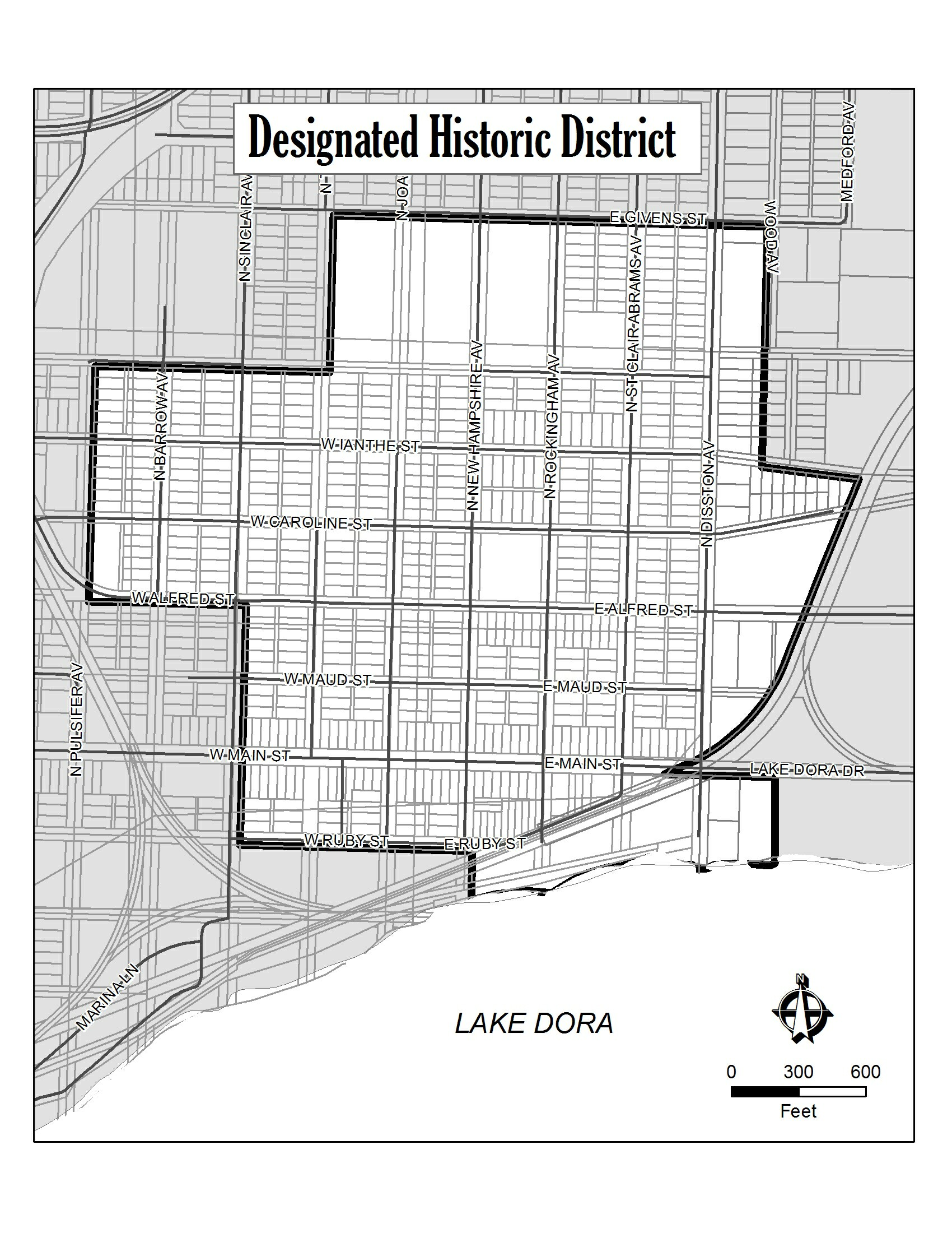
Section 9-22 - Designated Historic District
The historic district is defined as starting at a point of intersection at the southern boundary right-of-way on Texas Avenue and the eastern boundary of Givens Street, proceeding easterly along the southern boundary of the right- of-way of Givens Street to the point of intersection with the western boundary of the right-of-way of Wood Avenue, proceeding southerly along the western boundary of the right-of-way of Wood Avenue to the point of intersection with the southern boundary of the right-of-way of Ianthe Street, proceeding easterly along the southern boundary of the right-of-way of Ianthe Street to the point of intersection with railroad right-of-way, proceeding southeasterly along the western boundary of the railroad right-of-way to a point of intersection with the Lake Dora Drive right-of-way, proceeding southerly to a point of intersection with the southern boundary of the Lake Dora Drive right-of-way, proceeding easterly along the southern boundary of the Lake Dora Drive approximately 300 feet (point of intersection with the eastern boundary of Lot 15, less eastern 15 feet, Block 27 as recorded in OR Book 1272, Page 1238), proceeding southerly along the eastern boundary of Lot 15, less eastern 15 feet, Block 27, approximately 334.8 feet to the northern shore of Lake Dora, proceeding easterly along the shoreline to the eastern boundary of the right-of-way of New Hampshire Avenue, proceeding northerly along the eastern boundary of New Hampshire Avenue to a point of intersection with the southern boundary of the right-of-way of Ruby Street, proceeding westerly along the southern boundary of Ruby Street to a point of intersection of the right-of-way of Sinclair Avenue, proceeding northerly along the eastern boundary of the right-of-way of Sinclair Avenue to a point of intersection with the right-of-way of Alfred Street, proceeding westerly along the southern boundary of the right-of-way of Alfred Street to a point of intersection with the right of way of Pulsifer Avenue, proceeding northerly along the eastern boundary of the right-of-way of Pulsifer Avenue to the point of intersection of Esther Street, proceeding easterly along southern boundary of the right-of-way of Esther Street to the point of intersection with the eastern boundary of the right-of-way of Texas Avenue, proceeding northerly along the eastern boundary of the right-of-way of Texas Avenue to the point of beginning.