
Texarkana City Zoning Code
ARTICLE III
- SPECIFIC DISTRICT REGULATIONS
Sec. 50-59. - Residential districts.
(a)
General description.
(1)
The regulations for the residential zoning districts are designed to:
a.
Protect the residential character of the included areas by excluding commercial and industrial activities;
b.
Encourage a suitable environment for family life by permitting such neighborhood facilities as churches, schools and playgrounds;
c.
Permit certain community facilities and public utilities for the convenience and general welfare of the people; and
d.
Preserve openness of the areas and avoid overcrowding by requiring certain minimum yards, open spaces, and site areas.
(2)
There is herein established five residential zoning districts, which include the R-1 Rural Residential District, R-2 Single-Family Residential District, R-3 Low Density Residential District, RM Manufactured Housing District, and R-4 Medium Density Residential District. The more specific description of these districts are indicated below:
a.
R-1 Rural Residential District. This is a district for single-family homes on large rural lots or acreage, and also provides an area where selected agricultural uses can be accommodated. It is a zone that is generally applied to fringe areas of the city, and such areas may, over time, be converted to higher density residential areas.
b.
R-2 Single-Family Residential District. This is the most restrictive urban residential district. The principal use of land is for detached single-family dwellings and related recreational, religious, and educational facilities normally required to provide the basic elements of a balanced and attractive residential area. These areas are intended to be defined and protected from the encroachment of uses not performing a function necessary to the residential environment. Internal stability, attractiveness, order and efficiency are encouraged by providing for adequate light, air and open space for dwellings and related facilities and through consideration of the proper functional relationship of each element.
c.
R-3 Low Density Residential District. This is a residential district to provide for a slightly higher population density and a greater diversity of housing types, but with basic restrictions similar to the R-1 district. The principal use of land is for single-family attached and detached structures, two-family, and townhouse developments which may have a relatively intense concentration of dwelling units served by large open spaces including common areas and facilities, thereby resulting in relatively low gross densities.
d.
RM Manufactured Housing District. This district recognizes a specific housing type which must be accommodated in the city in either rental park settings or in subdivisions which provide for ownership of structure and lot. The principal use areas may contain either mobile home (post-regulation, June 15, 1976) or manufactured home (post-regulation, June 15, 1976). It is the intent of this district that it be located so as to not adversely affect the established residential development patterns and densities in the city. Such locations, however, shall have necessary public utilities, community facilities, and other public services in order to provide a healthful living environment with the normal amenities associated with residential districts of the city.
e.
R-4 Medium Density Residential District. This is a residential district to provide for medium density dwellings and includes a wide variety of housing types. The principal use of land is for single-family, two-family dwellings, townhouses, multiple-family dwellings, and roominghouses or boardinghouses. Recreational, religious and educational uses normally located to service residential areas are also permitted to provide the basic elements of convenient, balanced and attractive living area.
f.
R-1 Rural Residential Overlay District.
1.
Purpose and intent. The R-1 overlay zoning district is established to provide a neighborhood of the city where multisection manufactured homes (post-regulation, June 15, 1976) may be located outside of mobile home parks and subdivisions on private property and to comply with the Affordable Housing Accessibility Act (Act 624 of 2003), effective October 1, 2003).
2.
Application of district regulations. These regulations shall be in addition to and shall overlay all other zoning districts and other ordinance requirements regulating the development of land so that any parcel of land lying in the R-1 overlay district shall also lie within one or more of the other underlying zoning districts. Therefore, all property within the R-1 overlay zoning district will have requirements of both the underlying zone and the R-1 overlay zoning district in addition to other ordinance requirements regulating the development of land. In case of conflicting standards between these and other city ordinances, the R-1 rural residential overlay zoning district requirements shall control. These regulations shall apply to all post-federal regulation (after June 15, 1976) multisection manufactured homes.
3.
R-1 overlay district boundary description.
(i)
For easy reference by citizens and staff, the R-1 Rural Residential Overlay District is described by both the following narrative text and graphic map:
Begin at the intersection of the centerlines of Genoa Road (State Highway #196) and Hastings Crossing Road;
Proceed east along the centerline of Genoa Road (State Highway #196) through two 90-degree turns to its intersection with Rondo Road (State Highway #237);
Proceed south along centerline of Rondo Road (State Highway #237) to its intersection with Boyd Road;
Proceed northwest along the centerline of Boyd Road to its intersection with Poole Road;
Proceed west along the centerline of Poole Road and across open countryside to Pasley Lane that aligns with but does not connect with Poole Road;
Proceed west along the centerline of Pasley Lane to its intersection with Old Blackman Ferry Road;
Continue west along the centerline of Old Blackman Ferry Road from its intersection with Pasley Lane approximately one-fourth mile to a 90-degree turn to the North for Old Blackman Ferry Road;
Proceed north along the centerline of Old Blackman Ferry Road crossing U.S. Highway #71 where the name changes to Linn Ferry Road;
Continue north along the centerline of Linn Ferry Road to its intersection with Will Grear Road;
Proceed east along the centerline of Will Grear Road approximately one-half mile to a point at the southwest corner of the NE ¼, NE ¼, Section 4, Township-16-S, Range-28-W;
Proceed north along the west side of the SW corner of the NE ¼, NE ¼, Section 4, Township-16-S, Range-28-W across open countryside approximately 330 feet to the Southern Boundary Line of Section 33, T-16-S, R-28-W;
Proceed east along the southern boundary line of Section 33, T-16-S, R-28-W approximately 330 feet to the centerline of Hastings Crossing Road;
Proceed north along the centerline of Hastings Crossing Road to its intersection with the centerline of Genoa Road (State Highway #196) which is the point of beginning.
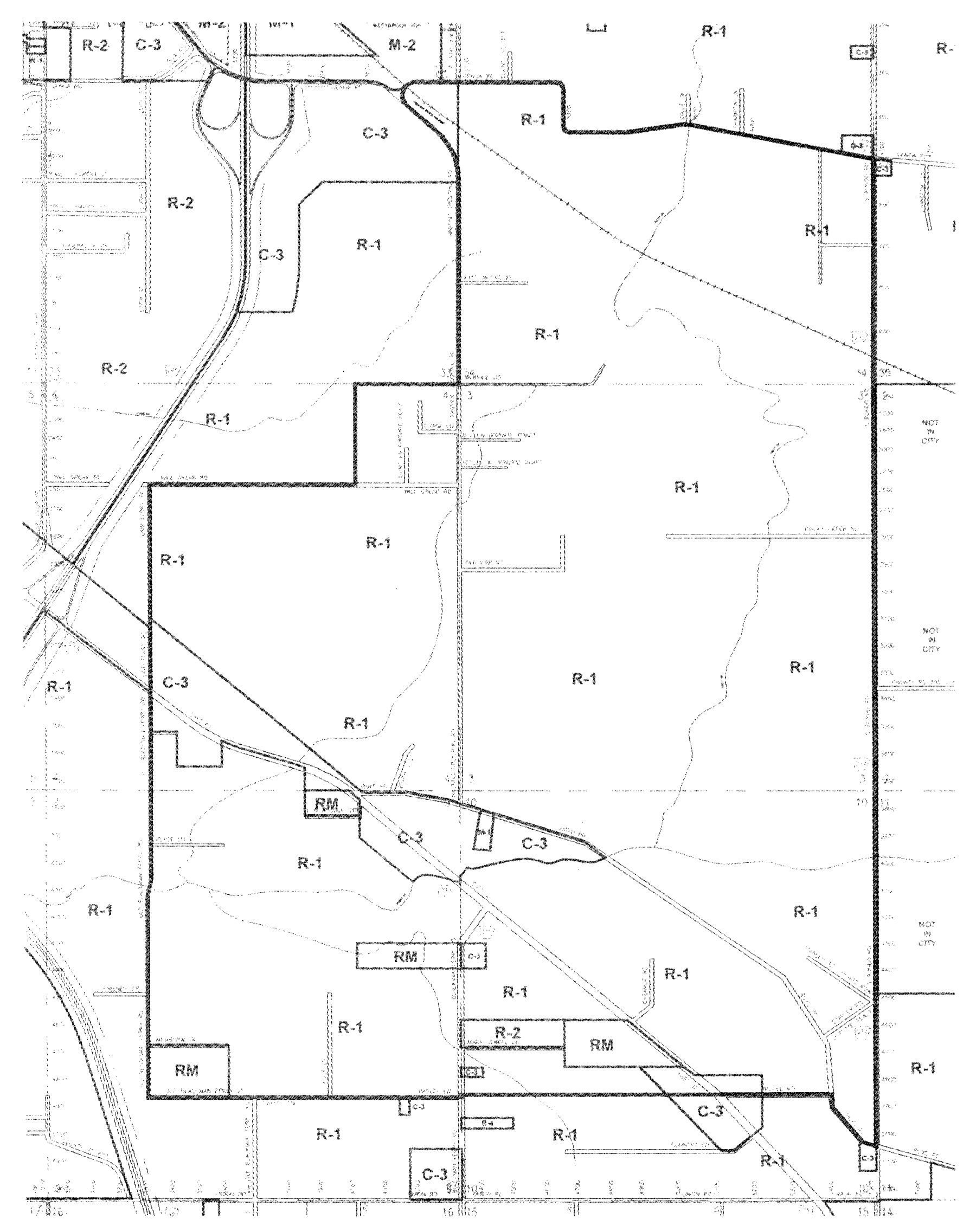
R-1 Overlay District Boundaries
(ii)
Regulations governing manufactured home/site built homes for the R-1 rural residential overlay zone.
A.
Porches and decks. The manufactured home/site-built home shall be served by a covered, recessed entranceway or a permanent covered porch with the porch roof integrated into the roofline of the manufactured home/site-built home and covered in the same shingles or roofing material as the manufactured home/site-built home; uncovered sundecks shall be permitted on the rear of the manufactured home/site-built home.
B.
Off-street parking. Each manufactured home/site-built home shall provide two paved off-street parking spaces located behind the front setback line and a paved driveway.
C.
Minimum width/dimension. Minimum dimension for any side of the manufactured home/site-built home shall be no less than 20 feet, zero inches (a home located in any residential district must be a double-wide or larger multisection unit).
D.
Front door. The manufactured home/site-built home shall be appropriately sited on the lot, with the front door or entry of the manufactured home/site-built home oriented to the front of the lot (narrow dimension of the lot having frontage on the street or road). All required setbacks (front, side, and rear) of the zoning district in which the manufactured home/site-built home is located must shall be met without any exceptions or variances from the city board of adjustment. However, corner lot owners have the option to face the front door of the manufactured home/site-built home toward the street of their choosing.
E.
Foundation. The manufactured home/site-built home shall be attached and anchored to a permanent foundation in conformance with the manufacturer's installation specifications.
F.
Installation. The manufactured home/site-built home shall be constructed or installed in accordance with the installation instructions provided by the manufacturer and the rules and regulations of the state, including site preparation, pier foundations-footings, support-support columns, and anchoring. Towing devices must be removed if possible or concealed in a manner acceptable to the city.
G.
Exterior covering. The manufactured home/site-built home shall be covered with an exterior material customarily used on residential dwellings, and such material shall extend over the top of the foundation unless said foundation is constructed of solid brick, stone, or masonry material.
H.
Roof. The manufactured home/site-built home shall have a roof composed of materials such as fiberglass, shake, asphalt or tile, which shall be installed in compliance with the building code. The roof shall have a minimum pitch of three feet vertical rise for every 12 feet of horizontal run (3:12).
I.
Certificate of occupancy. No manufactured home/site-built home shall be occupied until it has received a certificate of occupancy issued by the building official subsequent to compliance with all provisions of this and other pertinent laws and ordinances.
J.
Construction. The manufactured home/site-built home shall be constructed in compliance with the Federal Manufactured Home/Site-Built Home Code and Safety Standards (24 CFR 3280) and the Arkansas Manufactured Home/Site-Built Home Standards Act (A.C.A. § 20-25-101 et seq.).
K.
Perimeter foundation enclosure (skirting). The manufactured home/site-built home shall have skirting or curtain wall constructed of materials approved by the city that have a useful or life expectancy of 25 years or more. Such enclosure shall be installed and ventilated in accordance with the manufacturer's instructions or the rules and regulations promulgated by the state manufactured commission.
L.
Landing steps. The manufactured home/site-built home shall have permanent landings and steps provided at each exterior doorway from the door threshold to ground level.
(b)
Uses permitted. The permitted uses in the residential districts are set forth below.
(1)
Where the letter "X" appears opposite a permitted use and underneath a residential zoning district, the listed use is permitted in that district, subject to:
a.
The providing of off-street parking in the amount required;
b.
Conformance to the special conditions applying to certain uses as set forth in article V of this chapter; and
c.
The providing of adequate subdivision sites for the appropriate and designed type of dwelling unit or units.
(2)
Where the letters "CU" appear instead of an "X," this use is permitted subject to acquiring a conditional use permit as set forth in article IV of this chapter.
(c)
Lot, yard and height regulations. No lot or yard shall be established or reduced in dimension or area in any residential district that does not meet the minimum requirements set forth in the following table. No building or structure shall be erected or enlarged that will cause the maximum lot coverage or maximum height regulations to be exceeded for such district as set forth in the following table. All uses not specifically listed below, e.g., community facilities, public utilities, etc., shall meet the most restrictive area, yard and height requirements listed below for the zone in which they are located. Lots within subdivisions intended for use as either attached, zero lot line or townhouses must be so indicated directly on the plat, and said lots are restricted solely to those housing types specifically noted on the plat.
Notes:
a. This shall be a minimum side yard requirement on one side of the dwelling. This allows for each detached dwelling unit to be "offset" on the lot to create a more usable side yard. However, where lots are platted for zero lot line use, any lot located adjacent to any other residential zone or use must provide for a side yard of at least five feet on the side directly abutting the other zone.
b. For unattached sides only.
c. This area includes both private and common area.
d. When a side yard is required, the lot width shall be increased by an amount equal to the width of the required side yard.
e. For unattached sides only.
f. Minimum lot width shall be increased by ten feet for each dwelling unit exceeding four, up to a maximum required width of 200 feet.
(d)
Side yard setbacks.
(1)
Interior or exterior lots. On an interior or exterior lot, if a single-family or two-family nonconforming structure exists due to its inability to meet the adopted front and/or side yard setbacks for the zone in which it is located, a building permit may be issued by the building official for expansion to the rear of said nonconforming structure if the expansion conforms to the required side and rear yard setbacks.
(2)
General area exceptions and modifications. Terraces, decks, uncovered porches, and ornamental features may extend into a required side yard; however, these projections shall not exceed three feet above the ground level measured two feet from the adjacent side lot line.
(3)
Townhouses. Single-family dwellings (townhouses) shall observe a five-foot setback on the side of an interior lot line and a ten-foot setback on the side street of an exterior lot. Townhouse developments shall not exceed 200 feet in length without a ten-foot separation.
(4)
Carport or canopy. A carport or canopy may project into a required side yard provided every part of such carport or canopy is unenclosed except for necessary structural supports and not less than three feet from any interior side lot line.
(Code 1983, § 28-21; Ord. No. K-286, § 1(art. III, § 1), 11-21-1988; Ord. No. K-675, § 1, 6-15-1988; Ord. No. K-699, §§ 1, 2, 12-21-1998; Ord. No. K-709, § 1, 4-5-1999; Ord. No. L-51, §§ 2—5, 5-7-2001; Ord. No. L-61, §§ 4, 11, 8-6-2001; Ord. No. L-133, 6-2-2003; Ord. No. L-200, §§ 7, 8, 10—15, 1-3-2005; Ord. No. L-216, §§ 3, 4, 6-6-2005; Ord. No. M-30, § 1(att.), 9-6-2011; Ord. No. M-90, § 1, 10-21-2013; Ord. No. 34-2024, § 2, 12-16-2024)
Sec. 50-60. - Commercial district.
(a)
General description. Commercial zoning districts are intended primarily for the conduct of business and the provision of services essential to support the residents within the city and the surrounding area. Commercial districts provide for the diversity of uses and appropriate locations required for the range of goods and services needed in the city. These include the O-1 Office and Quiet Business District, the C-1 General Commercial District, the C-2 Central Business District, the C-3 Open Display Commercial District, the C-4 Crossroads Business Park District, C-4 Crossroads Business Park Overlay District and micro-business district.
(1)
O-1 Office and Quiet Business District. This district is established to accommodate offices and associated administrative, executive and professional uses, together with specified limited commercial and accessory uses. It is anticipated these office uses will be located in relatively close proximity to apartments and other residential uses; and area regulations are designated to ensure that these uses will be compatible with adjacent residential district. The district is characterized by freestanding buildings and ancillary parking, and should generally be limited to arterial and collector street locations or other carefully selected areas where public utilities, community facilities and other public services are adequate to support general office and limited commercial development.
(2)
C-1 General Commercial District. This district shall be applied to the broad range of retail uses which comprise the commercial function of the city. Permitted uses include most types of retail activity except those involving substantial open displays of merchandise and those which are otherwise incompatible.
(3)
C-2 Central Business District. This district is designed to be the central business district or the downtown shopping and employment are for the community and surrounding trade area. This district is designed to accommodate retailing of all kinds, professional offices, financial institutions, transients facilities, amusement facilities, and limited wholesaling and warehousing.
(4)
C-3 Open Display Commercial District. This district is established in order to provide adequate locations for retail uses which serve the needs of the motoring public and are characterized by a high level of vehicular ingress and egress. Among these uses are automobile and other vehicular service establishments, transient sleeping accommodations, and eating and drinking establishments. The district is also intended to provide a location for the limited amount of merchandise, equipment and material being offered for retail sale that, because of the type of material or transportation requirements, are suitable for display and storage outside the confines of an enclosed building. Such uses are not generally compatible with pedestrian oriented commercial districts and shopping centers since they tend to obstruct and interfere with pedestrian movements. Appropriate locations for this district are along heavily traveled major traffic arterials.
(5)
C-4 Crossroads Business Park District.
a.
General purpose and intent. The anticipated development of the C-4 zoning district offers significant economic opportunities for the city and its citizens. The development standards will make the city a more desirable place to live and conduct business. It is important that development of the C-4 crossroads business district be controlled through careful planning and foresight to achieve the greatest positive benefits for the city. The intent of the C-4 zoning district standards is to ensure that commercial development occurs in a manner which promotes safety while presenting an attractive appearance and ensures compatible land uses according to consistent design guidelines. All nonresidential buildings shall comply with the zoning ordinance, building code, and related construction codes of the city.
b.
Application of regulations. All property within the boundaries of the C-4 crossroads business park zoning district shall adhere to these development standards and conditional uses shall be subject to site plan approval by the planning commission. Routine repairs and maintenance shall not require compliance with this ordinance. Except for construction of improvements in the public right-of-way required by the city, and redevelopment or expansion of existing development, all uses, structures or lots which existed on the effective date of this ordinance which do not conform to the standards and guidelines in this ordinance, shall be treated as nonconforming according to the provisions of article VIII of this chapter.
(6)
C-4 Crossroads Business Park Overlay District.
a.
Purpose and intent. The purpose and intent of the C-4 Crossroads Business Park overlay zone is to encourage mixed-use planned unit developments (PUD) utilizing the existing C-4 conditional and permitted land uses as well as the following residential land uses: multifamily dwellings, assisted living facilities, and nursing homes. This overlay zone is designed for an area of the TIF district that has some of the most challenging topography to work with and is more suited to mixed-use developments, including both sales tax generating commercial land uses combined with the specified residential land uses. These mixed-use planned unit developments (PUD) may consist of multistory structures where the commercial and residential land uses are mixed vertically or the commercial and residential land uses may all be developed and mixed horizontally at grade through unique and pleasing designs. Said mixed-use planned unit developments (PUD) shall conform to section 50-62. The C-4 Crossroads Business Park overlay zone shall overlay the base C-4 crossroads business park zone and comply with its regulations.
b.
Application of C-4 crossroads business park overlay zone regulations. These regulations shall be in addition to and shall overlay the underlying C-4 Crossroads Business Park zone so that any parcel of land lying in the C-4 Crossroads Business Park Overlay zone shall meet the requirements of both the underlying C-4 Crossroads Business Park zone and the C-4 Crossroads Business Park Overlay zone in addition to all other ordinance requirements regulating the development of land. In case of conflicting standards between these and other city ordinances, the C-4 Crossroads Business Park overlay zone shall control.
c.
C-4 Crossroads Business Park overlay zone boundary description. For easy reference by citizens, property owners, and staff, the C-4 Crossroads Business Park overlay zone is hereby described:
Beginning at the southeast corner of the Fractional Section 6, T-15-S, R-28-W, also being the approximate centerline of Jefferson Avenue at the point of intersection with center of Woodway Drive;
Thence west approximately 1,320 feet along the south line of the Fractional Section 6, T-15-S, R-28-W to the west line of the SE ¼ of the SE ¼ of Fractional Section 6, T-15-S, R-28-W;
Thence north approximately 1,610 feet along the west line of the SE ¼ of the SE ¼ of Fractional Section 6, T-15-S, R-28-W;
Thence west approximately 457 feet to a point of intersection of the centerlines of Crossroads Parkway and McDonald Lane;
Thence northwesterly approximately 660 feet along the centerline of the proposed extension of Crossroads Parkway and continuing with a proposed northwesterly centerline of a curve approximately 437 feet for a total distance of 1,097 feet to a point in the west boundary line of the SE ¼ of Fractional Section 6, T-15-S, R-28-W;
Thence north approximately 407 feet to the point of intersection with the NW corner of the SE ¼ of the Fractional Section 6, T-15-S, R-28-W;
Thence east approximately 2,610 feet with the north line of the SE ¼ of the Fractional Section 6, T-15-S, R-28-W; to a point in the centerline of Jefferson Avenue;
Thence south along the centerline of Jefferson Avenue approximately 2,358 feet and continuing with a Southeastern curve of the centerline of Jefferson Avenue 286 feet for a total of 2,644 feet to the point of beginning and containing 100 acres more or less.
(b)
Use regulations. The permitted uses in the commercial district are set forth below.
(1)
Where the letter "X" appears opposite a permitted use and underneath a commercial zoning district, the listed use is permitted in that district subject to:
a.
The providing of off-street parking in the amount required;
b.
Conformance to the special conditions applying to certain uses as set forth in article V; and
c.
The providing of off-street loading in accordance with section 50-209.
(2)
Where the letters "CU" appear instead of an "X," this use is permitted subject to acquiring a conditional use permit as set forth in article IV. All permitted uses shall be inside or enclosed except areas of outdoor dining as specified below and any outdoor-type land uses.
Notes: Use of sidewalks in the 100 to 400 blocks of East Broad Street in the C-2 Central Business District.
(3)
Beginning at the front property line in the 100 to 400 blocks of East Broad Street and extending out approximately five feet on the public sidewalk of existing businesses are allowed:
a.
Displays or performances of cultural activities of art, crafts or music;
b.
Sales of the same merchandise that is for sale in the adjacent business;
c.
Seasonal decorations;
d.
Street enhancements, such as benches, tables, plants, etc.; and
e.
Outdoor dining for restaurants as space allows;
Excepting that in no way may the sidewalk land uses impede three feet of walkway for foot traffic with a minimum of five feet for turning space every 200 feet for built sidewalks as required by the American Disabilities Act (ADA).
(4)
Allowed with conditions:
a.
Temporary awnings and canopies secured to the building or the ground approved by the public works director or his designee; and
b.
Informational kiosks as approved by the public works director or his designee.
(5)
Corners beyond the five-foot extension from buildings and outside the pedestrian walkway are available for public facility use (PFU) subject to the regular process and may be used for wagon-type sales of flowers, hot dogs, souvenirs, ice cream products, etc.
(c)
Lot, yard and height regulations.
(1)
No lot or yard shall be established or reduced in dimension or area in any commercial district that does not meet the minimum requirements set forth in the following tables. No building or structure shall be erected or enlarged that will cause the maximum lot coverage or maximum height regulations to be exceeded for such district as set forth in the following table. There are no lot, yard, or height regulations in the C-2 central business district.
Notes: 1 A building or structure may exceed the maximum heights shown provided each of its front, side, and rear yards are increased an additional foot for each foot such building exceeds the maximum height.
(2)
The following standards are established for the C-4 Crossroads Business Park District:
a.
Minimum lot area (square feet): 20,000 square feet.
b.
Minimum lot width: 100 feet at the front setback.
c.
Maximum lot coverage: 50 percent.
d.
Front yard setback. There shall be a front yard for every structure in the C-4 zoning district having a depth of not less than 45 feet from the property line to the face of the building. No covered porch, covered terrace, or attached accessory building shall project into any required front yard. The front yard setback shall be reduced to 25 feet if the required off-street parking is provided along the side of the building or at the rear of the building. In no case may a structure be built in any street.
e.
Rear yard setback. No setback required except adjacent to property containing single-family detached structures that is zoned residentially. In this case the rear yard shall have a setback of not less than 25 feet.
f.
Side yard setback (interior). Based on fire resistant masonry construction, no setback required except adjacent to property containing single-family detached structures that is zoned residentially. In this case the side yards shall have a setback of not less than 20 feet.
g.
Side yard setback (exterior). There shall be a 25-foot exterior side yard setback where driveways and streets intersect.
h.
Accessory buildings setback. Commercial accessory buildings shall comply with the setbacks required in section 50-146(i).
i.
Height regulations. No building hereafter erected or structurally altered shall exceed a height of 72 feet or six stories.
Note: A building or structure may exceed the maximum height permitted, provided each of its front, side, and rear yards are increased an additional foot for each foot such building exceeds the maximum height.
(d)
Development criteria. Unless otherwise specifically provided in this section, the following development criteria shall apply:
(1)
All commercial districts.
a.
Any lighting shall be placed so as to reflect away from adjacent residential districts. No excessive or unusual noise, odor or vibration shall be emitted so that it constitutes a nuisance which substantially exceeds the general level of noise, odor or vibration emitted by uses adjacent to or immediately surrounding the site. Such comparison shall be made at the boundary of the site.
b.
All trash receptacles and pickup shall be oriented away from the street side of the property and adequately screened by a sightproof fence.
c.
All of the lot used for the parking of vehicles or for the storage or display of merchandise and all driveways used for vehicle ingress and egress shall be paved in accordance with the requirements of this chapter.
(2)
Additional criteria in C-1 general commercial district. All commercial uses shall be restricted to closed buildings except parking lots, plant nurseries, promotional events, and the normal pump island services of service station operations. In addition, outdoor display of merchandise is allowed in an area equal to one-half of the facade area of the front of the building as long as said display of merchandise is stored inside the building or other completely enclosed area after normal working hours.
(3)
Additional criteria in C-3 open display district.
a.
All servicing of vehicles and assembly of equipment carried on as an incidental part of the sales operation shall be conducted within a completely enclosed building.
b.
No article or material stored or offered for sale in connection with the permitted or conditional uses herein shall be stored or displayed outside the confines of a building unless it is so screened by a permanent opaque screening fence or wall so that it cannot be seen from an adjoining lot. The following screening and display criteria shall apply to uses located in the C-3 open display district:
1.
The height of any opaque screening fence or wall shall not be less than six feet.
2.
Automobile, truck, tractor, mobile home, boat or motorcycle sales areas are not required to screen fully assembled merchandise which is ready for sale.
3.
No permanent open display will be permitted on sidewalks or public rights-of-way; and said goods or materials must be set back at least 15 feet from the front property line.
4.
Automobile service stations shall be permitted open display of merchandise commonly sold by such operations as long as the area of said display is not larger than an area equal to one-half of the facade area of the front of the building.
(4)
Additional criteria in C-4 crossroads business district. Unless otherwise specifically provided in this section, the following development criteria shall apply:
a.
Orientation/placement. Buildings shall be oriented to the street containing the front door. Side entrance doors shall be no further than ten feet from the front wall of the building for side entry. The primary entrance of the building shall be at street level. Entrances shall be designed so that the door will not swing beyond the property line.
b.
Exterior walls. Architectural plans and building elevations shall be approved by the public works department (code enforcement division). Consideration shall be given to the architectural styles of themed restaurants and commercial enterprises. Corrugated metal, plywood, wafer board, vertical metal siding, etc., shall not be deemed acceptable exterior wall materials. Whenever the applicant and staff cannot agree regarding the exterior wall materials, the matter shall be submitted to the planning commission for determination.
c.
Outdoor dining. Eating establishments shall be permitted to have an area of outdoor dining subject to the following provisions:
1.
The area of outdoor dining shall not be located in the public right-of-way nor shall it obstruct pedestrian movement, fire lanes, access to any business or areas designated for access by the physically impaired.
2.
The number of seats in the area of outdoor dining shall not exceed 50 percent of the number of seats within the eating establishment.
3.
Compliance with applicable state and county health regulations.
4.
The area of outdoor dining shall not be located between the buildings occupied by the eating place and adjacent residentially zoned properties.
d.
Windows. Reflective glass with an exterior reflectance percentage in excess of 27 percent, as certified through the manufacturer's specifications, shall not be used as an exterior building material on any building or structure. Windows and window walls shall not be glazed or reglazed with mirrored glass.
e.
Lighting.
1.
Parking lot lighting. Standards, poles, and fixtures shall be of a single color, compatible with the architecture of the building. All lighting fixtures shall be restricted to down-lighting or cutoff types. Site lighting is to provide safety and security and enhance the architectural and natural features of the site. Glare and illumination standards shall ensure that the mechanisms providing light do not negatively impact on the appearance of the site and ensure that light is contained to the extent that adjacent residential properties are not detrimentally affected.
2.
Walkway lighting. Walkway lighting with standard, pole, bollard, and wall-mounted fixtures are allowed.
3.
Accent lighting. Floodlighting and spotlighting of architecture, graphics, or natural features shall not create spillage of light onto adjacent properties.
f.
Noise, odor, or vibration. No excessive or unusual noise, odor or vibration shall be emitted so that it constitutes a nuisance, which substantially exceeds that general level of noise, odor, or vibration emitted by uses adjacent to or immediately surrounding the site. Such comparison shall be made at the boundary of the site.
g.
Equipment screening. All ground-mounted mechanical systems, pad-mounted electrical transformers, telephone junction boxes, and trash receptacles and trash pickup shall be oriented away from the primary street side of the property and screened from the public right-of-way. Alternative screening methods and designs may be approved by the building official.
h.
Boundary screening. Boundary screening where the C-4 zone is adjacent to residentially zoned property shall conform to the table in subsection (e) of this section. The basic screening requirement is to construct an opaque fence on all side and rear abutting property lines between residential and commercial zones. Should the commercial developer/owner choose to utilize a nonopaque fence (no more than 20 percent openings), a ten-foot landscaped buffer yard adjacent to the screening fence will be required. The screening fence may be constructed of wood (cedar, redwood, cypress, and pressure-treated types resistant to rot), rock, masonry (brick), construction techniques allowing openings (i.e. basket-weave, louvered, pierced brick and open decorative designs), and combinations of materials (i.e. brick pilasters/wood between the pilasters, concrete block faced with masonry, brick topped with decorative wrought iron or decorative elements).
i.
Trash receptacles. All trash receptacles and trash pickup shall be oriented away from the street side of the property and adequately screened by a sight proof fence.
j.
Utilities. All lighting and other utilities shall be constructed underground and within dedicated utility easements no less than 15 feet in width within the C-4 Crossroads Business Park zoning district. There shall be platted behind and adjacent to the street right-of-way line, a 15-foot utility easement across the entire frontage of each lot or building site.
k.
Landscaping. There shall be installed a ten-foot landscaped buffer strip across the front of the site and adjacent to the street right-of-way exclusive of the required sidewalk. Said landscaped area shall consist of a combination of organic and/or combined man-made/organic features as trees, shrubs, flowers, ground covers, earthen berms, low masonry/rock walls, water features. The landscaped buffer strip will screen required vehicular use areas when they are viewed from an elevation of 42 inches above the elevation of the adjacent street. Landscaped areas shall attempt to incorporate existing on-site trees and shrubbery into the landscaping scheme and the plans shall indicate such incorporation. Erosion retardant vegetation (turfs, ground covers, etc.) shall be used on all cuts and fills.
1.
Landscaped buffer strip (front of lot). The placement of buffer plantings, earthen berms, water features, benches and other man-made improvements shall be at the discretion of the developer, and shall be approved as part of the site plan submitted. Trees or shrubs shall not be planted within five feet of any side property line to ensure maintenance for access and to avoid encroaching onto the adjacent property. Where a setback requirement is less than the buffer requirement, the buffer width shall override the setback width. Where a setback requirement is greater than the buffer requirement, plant material requirements shall still be applied and such plant materials shall be placed within the buffer strip. The tree canopy shall be maintained at least eight feet above the sidewalk.
(i)
Street trees, sometimes called shade trees, shall reach a minimum height and spread of 30 feet at maturity and shall be deciduous. New trees shall have a minimum caliper of 2 ½ inches at planting.
(ii)
Evergreen trees shall reach a typical minimum height of 20 feet at maturity and shall remain evergreen throughout the year. New evergreens shall have a minimum height at planting of six feet.
(iii)
Ornamental trees may be deciduous or evergreen and shall have a distinctive ornamental character such as showy flowers, ornamental fruit, habit, foliage, or bark. New ornamental trees shall have a minimum height of six feet and 1 ½-inch caliper.
(iv)
New large shrubs shall have a minimum height of 36 inches at time of planting.
(v)
Shrubs may be evergreen or deciduous and shall have a minimum height at maturity of four feet to eight feet. New shrubs shall have a minimum height of 18 inches at time of planting.
(vi)
Turf or ground cover plants shall be installed in all areas of the buffer strip not occupied by sidewalks, benches, signage, driveways, and any other man-made improvements.
Buffer Width and Plant Material Requirement
Note: For the purpose of planting a buffer strip, six shrubs shall be considered equivalent to one small or large deciduous or evergreen tree.
2.
Street trees.
(i)
Street trees are required in order to:
A.
Improve the aesthetic quality of the county;
B.
Encourage the preservation of existing trees and vegetation;
C.
Replenish trees and vegetation removed due to development; and
D.
Reduce stormwater runoff, decrease erosion, improve water quality and protect wildlife habitats.
(ii)
Within the dedicated street right-of-way, street trees shall be planted or be existing at least every 50 feet and have a minimum caliper of 2 ½ inches when measured 12 inches from the ground at the time of planting. The street trees shall be planted outside of the dedicated utility easement behind the curb and a minimum of two feet from the edge of the sidewalk and no closer than 30 feet to a street intersection.
3.
All landscaping shall be permanently maintained in a neat and orderly manner, and shall be kept free of trash and litter. Provisions shall be made at the time of installation of such landscaping for an adequate, inconspicuous watering source.
4.
Landscaping plantings shall not be erected or installed in such a manner as to interfere with traffic views or impose safety hazards. Plantings should be selected and located where they will not contribute to conditions hazardous to public safety such as underground and above ground utilities and sight triangle areas required for unobstructed views at street intersections.
5.
Landscaping shall be required on all developments and shall be completed prior to the issuance of the certificate of occupancy.
6.
An effort shall be made to preserve existing trees.
7.
Landscaped areas shall have water sprinkler systems to maintain plant materials. Consideration shall be given to water conservation measures (i.e., rain gauges connected to automatic sprinkler systems, green parking lots, water retention basins, etc.).
8.
An effort shall be made to preserve existing trees.
9.
Suggested buffer strip and parking lots large and small trees, evergreen trees, shrubs, ground cover, and turfs/grasses shall be selected from the following lists of landscaping plant materials:
Deciduous Trees (medium to large)
Evergreen Trees
Small Deciduous Trees
Evergreen Shrubs
Ground Covers
Grass and Turf Species
10.
Earthen berms. When utilized in required landscaped areas for visual interest, earthen berms shall be protected from erosion with suitable plant material, ground cover or grass. Earthen berms shall have a maximum side slope of 3:1 and shall be entirely vegetated with turf or ground cover.
l.
Sidewalks.
1.
A five-foot-wide ADA-compliant concrete sidewalk shall be constructed within the dedicated street right-of-way with the inside edge being located at the property line/right-of-way line. Sidewalks shall remain clear of merchandise, debris, and signage and be maintained with a minimum height clearance of eight feet from the ground.
2.
A seven-foot-wide ADA-compliant concrete sidewalk shall be constructed across the front of and adjacent to all commercial buildings. Up to three feet of the sidewalk may be removed adjacent to the building for landscaping, earthen berms, decorative water features, etc. Exterior corner lots shall not be required to construct the sidewalk along the side of the building facing the side street unless off-street parking is constructed between the building and the side street. Property owners shall install a minimum of one five-foot striped ADA-compliant sidewalk from the front of the building to the public sidewalk within the street right-of-way to create/enhance pedestrian connectivity within the C-4 zoning district.
Additionally, property owners are encouraged to create pedestrian connectivity (sidewalks and/or striping) to the shared bike/pedestrian paths that are typically at the rear of various properties within the C-4 zoning district.
3.
Where right-angle, 60-degree, or 45-degree head-in parking would encroach and overhang the sidewalk at the front of buildings, tire stops shall be installed.
4.
For large parking facilities, property owners are urged to construct a sidewalk at a minimum width of five feet for every third row of double-aisle parking to encourage pedestrian safety, pedestrian connectivity, and to encourage safe onsite traffic movements.
m.
Projections. Awnings may project up to 50 percent over the sidewalk for the protection of citizens while maintaining a minimum clearance of eight feet above the sidewalk.
n.
Exceptions. Property, due to topography, size, irregular shapes, or other constraints, such as adjacent structures or features which significantly affect visibility, and thus cannot be developed without violating the standards of this chapter shall be reviewed, as provided in section 50-62, with the intent to devise a workable development plan which is consistent with the purpose and intent of the C-4 zoning regulations.
o.
Bike and pedestrian paths (shared). Shared bike and pedestrian paths are proposed throughout the C-4 Crossroads Business Park zoning district that encourage healthy lifestyles, extends the existing Nix Creek Trail System, and create safe biking/pedestrian paths. Property owners are encouraged to donate the required 15-foot public right-of-way and construct the ten-foot shared bike/pedestrian path. Locations for the bike/pedestrian paths may be obtained from the city's amendment to the 1988 long-range comprehensive development plan. In lieu of construction of the bike/pedestrian path, property owners may choose to contribute to a regional bike/pedestrian path authority.
p.
Stormwater runoff/drainage. Property owners shall either retain on-site stormwater runoff or contribute a fee to a regional detention facility that would be utilized for parks, soccer fields, and other public amenities as well as the detention basin.
(e)
Screening requirements; all commercial districts. The basic screening requirement is to construct an opaque fence on all side and rear abutting property lines between residential and commercial zones. Should the commercial developer/owner choose to utilize a nonopaque fence (no more than 20 percent openings), a ten-foot landscaped bufferyard adjacent to the screening fence will be required. The following chart defines the screening requirements. The screening fence may be constructed of wood (cedar, redwood, cypress, and pressure-treated types resistant to rot), rock, masonry (brick), construction techniques allowing openings (i.e. basket-weave, louvered, pierced brick and open decorative designs), and combinations of materials (i.e. brick pilasters/wood between the pilasters, concrete block faced with masonry, brick topped with decorative wrought iron or decorative elements).
Notes:
The C-2 Central Business District zoning district is exempt from any screening and/or landscaped bufferyard requirements since 100 percent of the site may be utilized and the city provides the off-street parking.
The lawful use of a building or other development existing at the time of the effective date of these amendments may be continued although such development does not comply with the requirements thereof. However, voluntary compliance with these screening requirements is encouraged.
The commercial owner/developer(s) are encouraged to combine a nonopaque screening fence and a ten-foot landscaped bufferyard.
No off-street parking, mechanical equipment, or accessory buildings may occupy any part of a landscaped bufferyard.
(f)
Materials for solid screening fences.
(1)
Wood, pressure treated-types resistant to rot:
a.
Cedar.
b.
Redwood.
c.
Cypress.
(2)
Masonry (brick):
a.
Rock.
b.
Stone.
(g)
Alternative construction techniques for nonsolid screening fences (with no more than 20 percent in openings).
(1)
Basket-weave.
(2)
Louvered.
(3)
Picket.
(4)
Pierced brick.
(5)
Designs combining brick and/or wood with wrought iron, cast and pierced decorative blocks, or decorative panels.
(h)
Landscaped bufferyard required if nonsolid screening fence is chosen.
(1)
Depth: Ten foot minimum.
(2)
Adjacent to the screening fence on all rear and side property lines of abutting residential and commercial zones.
(3)
Landscaping materials consisting of canopy trees, ornamental trees, shrubs, and ground cover.
(i)
Landscape plan submission. A landscape plan must be submitted, in conjunction with the required site plan, to the code enforcement division of the public works department with the application for a building permit for work on the property. In addition, in conjunction with any rezoning request, a landscape plan must be submitted as part of the required site plan review by the planning commission. The landscape plan can either be a separate print or be included on the required site plan print. The minimum information required on the landscape plan shall include:
(1)
Locations and dimensions of the proposed screening/buffer yards adjacent to the rear and/or side property lines, including a description and location of the trees and plant materials to be placed or retained within the landscaping strip.
(2)
Locations of existing boundary lines and dimensions of the lot.
(3)
The locations of existing and proposed utility easements on or adjacent to the lot and the location of overhead power lines and any underground utilities.
(4)
The location of the proposed water faucet or a note indicating the installation of the irrigation system covering the entire lot.
(5)
A plant schedule listing the name and size of all plant materials. Botanical nomenclature as well as common names shall be listed. All canopy trees shall be identified as containerized or balled and burlapped.
(6)
A statement indicating the total square footage of landscaping area required, including the number of trees and shrubs required, for the proposed development to be in compliance with the requirements of this chapter, and a calculation to verify that the number, size and type vegetation listed on the plant schedule shall render the proposed development to be in compliance with the requirements of this chapter.
(j)
Plant criteria.
(1)
All plant materials planted in order to satisfy the requirements of this section shall be of a species which will conform to the selection criteria of this ordinance.
a.
Plant materials shall be either acceptable native plants to the Texarkana, Arkansas, area, or plants that are known to be acclimated to the West Arkansas/East Texas region.
b.
The selection of individual plant materials shall require that the species chosen be adaptable to the specific environment and condition in which it will be planted; i.e., soils, water availability, height limitations, and shade.
(2)
Trees and shrubs planted in order to satisfy the requirements of this subsection shall conform to the following minimum size specifications:
a.
Canopy trees shall have a minimum caliper of three inches shall have a minimum branching height of six feet; and shall have a minimum overall height of eight feet immediately after planting.
b.
Shrubs shall be a minimum size of two gallons.
(3)
Trees shall be selected so as to avoid this species known to cause damage to public improvements.
(4)
Artificial plants are not acceptable in satisfying any requirements of this subsection.
(5)
Grasses and groundcovers alone shall not constitute adequate landscaping.
(k)
Hose connection. Every development shall install either an irrigation system or have a hose connection within 150 feet all landscaping. A 20 percent reduction in the required landscape area shall be made when an irrigation system is provided for the entire landscaped area.
(l)
Maintenance and/or permanency of fence and buffer area.
(1)
The owner, or his agent, shall be responsible for the maintenance of all fences and landscaping, which shall be maintained in good condition so as to present a healthy, neat and orderly appearance, and shall be kept free from refuse and debris. Any plant that dies should be replaced with another living plant that complies with the approved landscape plan within 30 days after dying, season permitting.
(2)
Replacement of dead landscaping material is the responsibility of the property owner. Replacement must occur within 30 days, season permitting, of notification by the director of public works or his delegate. Replacement material must be of similar character as the dead landscaping material. Failure to replace dead landscaping and maintain the fence, as required by the director of public works, shall constitute a violation of this subsection for which the penalty provision may be invoked.
(3)
Any damage or interference with utility lines or other utility facilities resulting from the negligence of the property owner, his agents or employees in the installation and maintenance of required landscaping, is the responsibility of the property owner. If a utility crew disturbs a landscaped area in a utility easement, they shall make every reasonable effort to preserve the landscaping materials and return them to their prior locations after the utility work is completed. If nonetheless some plant materials die, it is the obligation of the property owner to replace the dead plant materials.
(4)
Nothing in this subsection shall prohibit or restrict a public utility company from trimming or removing trees or other plant materials that are a hazard to its employees, the public or its facilities, or that threaten to interfere with the provision of continuous service by the public utility company.
(m)
Existing developed areas. Unless otherwise noted, all developed property with existing paved ground surface areas on the effective date of the ordinance from which this subsection is derived shall not be required to conform to the requirements of this chapter, unless construction or expansion of improvements on the property requiring a building permit is undertaken that:
(1)
Increases the number of stories in a building on the property;
(2)
Increases by more than ten percent or 10,000 square feet, whichever is less, the combined floor areas of all buildings on the property;
(3)
Increases the nonpermeable coverage on the property by more than 2,000 square feet.
(n)
Voluntary compliance. The lawful use of a building or other development existing at the time of the effective date of the ordinance from which this subsection is derived may be continued although such development does not comply with these requirements. However, commercial developments not undergoing construction or expansion activities are encouraged, although not legally obligated, to meet the screening/buffer yard requirements as stated in this subsection.
(o)
Painted signs and/or advertisements prohibited. All screening fences shall remain free of any signs and/or advertisements painted on them.
(p)
Certificate of occupancy. Whenever a screening fence and/or wall or landscaped bufferyard is required, it shall be completed prior to issuance of any certificate of occupancy and shall thereafter be maintained to provide a screen to abutting property. If the screening fence and/or wall or landscaping cannot be installed because of the season, a temporary certificate of occupancy may be issued provided a bond to cover the cost of the fence and/or landscaping is filed with the building official.
(q)
Additional screening criteria in the C-4 Crossroads Business District.
(1)
All servicing of vehicles and assembly of equipment carried on as an incidental part of the sales operation shall be conducted within a completely enclosed building.
(2)
No article or material stored or offered for sale in connection with the permitted or conditional uses herein shall be stored or displayed outside the confines of a building unless it is so screened by a permanent opaque screening fence or wall so that it cannot be seen from an adjoining lot. The following screening and display criteria shall apply to uses located in the C-3 open display district:
a.
The height of any opaque screening fence or wall shall not be less than six feet.
b.
Automobile, truck, tractor, mobile home, boat or motorcycle sales areas are not required to screen fully assembled merchandise which is ready for sale.
c.
No permanent open display will be permitted on sidewalks or public rights-of-way; and said goods or materials must be set back at least 15 feet from the front property line.
d.
Automobile service stations shall be permitted open display of merchandise commonly sold by such operations as long as the area of said display is not larger than an area equal to one-half of the facade area of the front of the building.
(Code 1983, § 28-22; Ord. No. K-286, § 1(art. III, § 2), 11-21-1988; Ord. No. K-328, § 1, 12-18-1989; Ord. No. K-342, § 1, 3-19-1990; Ord. No. K-646, § 1, 10-20-1997; Ord. No. K-703, §§ 1, 2, 3-1-1999; Ord. No. K-709, § 1, 4-5-1999; Ord. No. L-50, § 1, 4-16-2001; Ord. No. L-51, §§ 1—5, 5-7-2001; Ord. No. L-61, §§ 10, 11, 8-6-2001; Ord. No. L-133, 6-2-2003; Ord. No. L-200, §§ 21, 22, 1-3-2005; Ord. No. L-216, § 5, 6-6-2005; Ord. No. L-309, § 1, 1-22-2008; Ord. No. L-369, 12-7-2009; Ord. No. M-13, §§ 1, 2, 10-18-2010; Ord. No. M-29, § 1, 8-2-2011; Ord. No. M-86, §§ 1—3, 9-3-2013; Ord. No. M-137, §§ II.a, b, 4-4-2016; Ord. No. 23-2017, 7-17-2017; Ord. No. 6-2017, 3-19-2018; Ord. No. 7-2019, §§ 3, 4, 3-4-2019; Ord. No. 9-2024, § 1, 5-6-2024; Ord. No. 4-2025, § 2(28-22), 2-3-2025)
Sec. 50-61. - Industrial districts.
(a)
General description. The industrial zoning districts are intended to provide for the development of light to heavy industrial uses and their related facilities. Appropriate standards for the various districts are designed to ensure compatibility with other similar uses and to ameliorate any conflicts with nonindustrial uses located in close proximity to the industrial use. The zoning chapter hereby establishes three industrial zoning districts to be known as the W-1 Warehousing and Wholesaling District, the M-1 Limited Manufacturing District and the M-2 General Manufacturing District.
(1)
W-1 Warehousing and Wholesaling District. This district is for rail, bus, and truck terminals along with warehousing, wholesaling, packaging, storage, fabrication, display and such limited manufacturing as does not create a nuisance for residential and commercial neighbors. This zone requires access to railroads and highways and it should be near the industrial and commercial areas that it serves.
(2)
M-1 Limited Manufacturing District. This district is for clean, quiet industries on ample landscaped sites with plenty of room for parking and plat expansion. These sites share access to highways and railroads, they are protected from the noise, dirt, and hazards of more objectionable industries and in turn they are good neighbors to nearby commercial, residential and agricultural areas.
(3)
M-2 General Manufacturing District. This zone is for the more intensive industries and those making products from raw materials. Regulations are the minimum for mutual protection between industries.
(b)
Permitted uses. The permitted uses in the industrial districts are set forth below.
(1)
Where the letter "X" appears opposite a permitted use and underneath an industrial zoning district, the use is permitted in that district subject to:
a.
The providing of off-street parking in the amount required;
b.
Conformance to the development criteria applying to uses as set forth in this section; and
c.
The providing of off-street loading in accordance with article VII.
(2)
Where letters "CU" appear instead of "X," this use is permitted subject to acquiring a conditional use permit as set forth in article IV.
(c)
Lot, yard and height regulations. No lot or yard shall be established or reduced in dimension or area in any industrial district that does not meet the minimum requirements set forth in the following tables. No building or structure shall be erected or enlarged that will cause the maximum lot coverage to be exceeded for such district.
Notes:
(1) Where property abuts a railroad where siding facilities are utilized, structures may be built up to railroad property lines.
(2) A building or structure may exceed the maximum heights shown provided each of its front, side, and rear yards are increased an additional foot for each foot such building exceeds the maximum height.
(d)
Standards for outdoor shooting ranges. The design and operation of an outdoor shooting range shall be governed by the following standards:
(1)
The layout of all handgun, rifle, shotgun, trap, and skeet ranges shall conform to National Rifle Association standards with regard to layout and dimensions. The range proper shall be fenced off, and shall have signs posted at 100-foot intervals warning potential intruders of the danger.
(2)
Ranges designed for the use of handguns and rifles shall be provided with berms at least 20 feet high and six feet thick at the top, made of soft earth or other material that is unlikely to cause ricochets, and containing no large rocks. Berms shall be located as follows:
a.
Shotgun ranges: no berms required.
b.
Ranges for handguns and rifles not more powerful than .22: backstop—at least 150 feet from the firing line; lateral—not closer than 30 feet from the firing line.
c.
Ranges for rifles more powerful than .22 long rifles: backstop—at least 300 feet from the firing line; lateral—not closer than 30 feet from the firing line.
(3)
The range shall be located on a site where an uninhabited downrange safety area is available. The required length of the safety area shall be as follows:
a.
Shotgun ranges: 1,500 feet, provided that shot size is limited to #4 or smaller.
b.
Ranges for handguns and rifles not more powerful than .22 long rifles: 7,000 feet.
c.
Ranges for rifles more powerful than .22 long rifles: 13,500 feet.
The safety area should conform to National Rifle Association standards for the shape and width. The safety area shall have signs posted at intervals warning of the potential danger from stray bullets. If a street or road passes through the safety area, both right-of-way lines shall be posted. (Note: The downrange safety area requirement for handgun and rifle ranges may be waived if the firing line is provided with overhead baffling meeting the standards of the National Rifle Association).
(4)
The range shall be provided with toilet facilities.
(e)
Standards for indoor shooting ranges. The design and operation of an indoor shooting range shall be governed by the following standards:
(1)
The layout of all indoor handgun, rifle, shotgun, trap, and skeet ranges shall conform to National Rifle Association standards with regard to layout, dimensions, warning signs, wall thickness, etc.
(2)
The indoor shooting range shall be provided with toilet facilities.
(f)
Nonconforming outdoor shooting ranges. Any existing outdoor shooting ranges not meeting these requirements may remain operation as a legal nonconforming use until such time that a platted residential subdivision is constructed within the required downrange safety zone, then the correct berms, warning signs, permanent perimeter enclosure, etc. shall be installed.
Notes:
"CU"=Conditional use;
X=Permitted use in conjunction with an indoor or outdoor shooting range; and
"—"=Not allowed.
(g)
Development criteria. Unless otherwise specifically provided in this section, the following development criteria shall apply:
(1)
All industrial districts:
a.
Any lighting visible from outside the site shall be designed to reflect away from adjacent residential districts. No noise, odor or vibration shall be emitted so that it constitutes a nuisance which substantially exceeds the general level of noise, odor or vibration emitted by uses adjacent to or immediately surrounding the site. Such comparisons shall be made at the boundaries of the site.
b.
Outdoor storage of trash receptacles shall be at the sides or rear of the site and shall be totally encircled or screened by a sightproof fence, planting or other suitable visual barrier.
c.
A permanent opaque screening fence or wall shall be constructed along any side or rear property line which abuts property zoned for residential purposes. The height of this screen or wall shall be six feet and shall be constructed of wood, masonry or other durable opaque material, and finished in a manner appropriate to the appearance and use of the property. Such wall or fence shall be maintained in good condition without any advertising thereon.
d.
No loading or storage of material shall be permitted in the required front yard.
(2)
Additional criteria in W-1 and M-1 districts.
a.
Every use, or any part thereof, that is not conducted within a building completely enclosed on all sides shall be screened by a permanent opaque screening fence or wall so that it cannot be seen from an adjoining lot.
b.
The following screening and display criteria shall apply:
1.
The height of any opaque screening fence or wall shall not be less than six feet.
2.
Automobile, bus, truck, tractor, mobile home, boat or motorcycle, and wheeled and/or tracked industrial vehicle storage areas are not required to screen fully assembled merchandise which is ready for sale.
3.
Other business uses shall be permitted open display of merchandise commonly sold by such operations as long as the area of said display is not larger than an area equal to one-half of the facade area of the front of the building.
(Code 1983, § 28-23; Ord. No. K-286, § 1(art. III, § 3), 11-21-1988; Ord. No. K-390, § 1, 7-15-1991; Ord. No. K-709, § 1, 4-5-1999; Ord. No. L-216, § 6, 6-6-2005; Ord. No. M-62, 9-4-2012; Ord. No. M-85, § 5, 8-19-2013; Ord. No. M-137, § II.b, 4-4-2016; Ord. No. 23-2017, 7-17-2017; Ord. No. 7-2019, §§ 5, 6, 3-4-2019)
Sec. 50-62. - Planned Unit Development District.
(a)
General description. The PUD Planned Unit Development District regulations are designed to provide for small- and large-scale developments incorporating a single type or a variety of residential, commercial, and related uses which are planned and developed as a unit. Such development may consist of individual lots or it may have common building sites. Private or public common land and open space should be an essential and major element of the plan which is related to and affects the long-term value of the homes and other development. A planned unit shall be a separate entity with a distinct character and harmony with surrounding development.
(b)
Standards of development.
(1)
Ownership control. The land in a planned unit development district shall be owned, leased, or otherwise controlled by a person, firm, group of individuals, partnership, corporation, or trust, provided assurances are given through the procedures contained herein that the project can be successfully completed.
(2)
Minimum district area. The minimum area for a PUD Planned Unit Development District shall be two acres. In calculating the minimum area for a PUD district, the measurements shall include the area of all dedicated streets entirely within the boundary of the proposed PUD and one-half of the area of all boundary or perimeter streets.
(3)
Uses permitted.
a.
In order to increase creativity and flexibility in the development of areas suitable for a planned unit development, there are no specifically prescribed uses which are permitted within the boundaries of a planned unit development. The developer shall be responsible for preparation of a list of permitted uses within the specific planned unit development requested. At the time of zoning application and consideration of the preliminary plat, a specific written list of uses to be "permitted by right" shall be submitted for review by the planning commission. Following approval by the planning commission and city board of directors, the list of specific uses permitted by right shall serve as the control list in issuance of building permits and certificates of occupancy.
b.
In addition to the above permitted uses that are established by right, certain other uses may be prescribed by the developer in accordance with the restrictions included herein and said uses are designated as conditional uses. These uses more intensely dominate the area in which they are located than do other uses which might be permitted in the PUD district and, as such, they require special considerations and restrictions. If the developer and/or planning commission agree that certain conditional uses should be included within the PUD district, the applicant shall precisely indicate the specific use, its location, area to be included, maximum building square footage, and such other information as required by the planning commission to properly and comprehensively evaluate the nature and impact of such conditional uses. When such conditional uses are approved at the time of rezoning, they shall not be subsequently changed to any other use until and unless they are changed to another use that is permitted by right, or the new proposed use if not permitted by right in a PUD district is resubmitted for rezoning approval.
(4)
Parking and off-street loading. All uses established within a planned unit development district shall comply with the off-street parking and loading requirements as established in article VII of this chapter. However, the requirements for individual structures or lots may be met through either provision of adequate parking on the lot on which such structure is so located or upon adjacent property which is under the control of a property owners' association, to which said lot is an automatic participant. In no case, however, shall the cumulative requirements for all parking and off-street loading requirements be less than if said uses were individually established and located in any other zoning district within the city.
(5)
Perimeter requirements. In order to ensure compatibility with surrounding development, the developer shall submit specific information as to the setbacks, building height, coverage factors and other elements necessary for all perimeter lots that are adjacent to the boundary of the PUD district or adjacent to any boundary or perimeter street right-of-way. While no specific setback requirements are herein established, the planning commission shall consider the nature, extent and character of the adjacent development and shall take into consideration the types of area regulations applicable to adjacent properties.
(6)
Residential density standards. The maximum number of dwelling units permitted within a PUD district is dependent upon both the type and number of each type of residential units intended to be included in the PUD district. Microdensities within certain areas of the PUD may be beyond the overall limits through a transfer of density. However, overall project densities shall not be exceeded in accordance with the following schedule:
a.
Six dwelling units per net residential acre for single-family attached and detached houses and two-family dwellings.
b.
12 dwelling units per net residential acre for triplexes, fourplexes, and row or terrace housing.
c.
18 dwelling units per net residential acre for low-rise (three stories or less) apartments.
d.
24 dwelling units per net residential acre for high-rise (four stories or more) apartments.
For purposes of calculating densities, net residential acres are defined as gross acres of the PUD site minus all public rights-of-way, and less the area of all parcels or lots devoted to commercial, industrial, or institutional uses not of a residential nature. Common open space that is owned and maintained by a property owners' association shall be included in calculating the net residential acres available for all dwelling units that automatically belong to such an association. Where more than one property owners' association is to be created, then each common open space can only be attributed to the lot or dwellings which have automatic membership for that specific common open area.
(7)
Open space requirements. Common open space constitutes an essential ingredient in a planned unit development and is one of the most basic and important design elements. Open space should be distributed more or less equitably throughout the PUD district in relationship to the dwelling units and other use areas that are intended to be served by the common open space. Adequate guarantees must be provided that the common open space areas as contained in the plan for the PUD district are preserved and maintained for those purposes only. A property owners' association shall be required, if other arrangements satisfactory to the planning commission have not been made, for improving, operating and maintaining all such common open space areas. At the time the final plan and plat is submitted, the articles of incorporation and bylaws of the property owners' association shall be reviewed and approved by the planning commission. Additionally, the restrictive covenants which run with the land must be submitted and include similar provisions to preserve all open space areas.
(c)
Procedures for obtaining PUD zoning. A three-step review procedure is required for obtaining PUD zoning. These steps are outlined as follows with respect to the procedure followed and submission requirements at each step:
(1)
Preapplication plan and conference.
a.
Procedure.
1.
A preapplication plan shall be submitted to the city planning commission for review of the area and proposed uses relative to the compatibility of a planned unit development project with existing development in the surrounding area and the comprehensive development plan of the city.
2.
Each applicant shall confer with interested department heads in connection with the preparation of the planned unit development application. It shall be the responsibility of the city planner to contact and invite interested department heads and other parties to a joint meeting. The general outlines of the proposal, evidenced schematically by the preapplication plan and such other information as may be desired, are to be considered before submission of the planned unit development application.
3.
Upon review of the site plan and general area, and following completion of the preapplication conference, the city planner shall furnish the applicant with written comments regarding the conference, including appropriate recommendations to inform and assist the applicant prior to preparing the components of the planned unit development application.
b.
Submission requirements. The applicant shall submit a site plan and such other narrative or graphic information the applicant deems pertinent to the city's initial review and evaluation. The preapplication plan shall include the following:
1.
Boundaries of the property involved;
2.
Existing zoning of the area and zoning of adjoining properties;
3.
Existing roadways, easements, and waterways;
4.
Indication of availability of all utilities;
5.
General plan of development at a level of detail sufficient to indicate to the city the nature and scope of the project as to its magnitude in terms of approximate number and types of dwelling units, location and extent of nonresidential elements, proposed locations of major open space areas, and major circulation facilities.
(2)
Zoning application and preliminary plat.
a.
After receiving written comments following the preapplication conference, the applicant may proceed in preparing a formal application. The application shall consist of a simultaneous submission of a preliminary plat and a rezoning application. The preliminary plat shall conform to all requirements contained in the city subdivision regulations with the exception of certain design requirements regarding lot, setbacks, etc. that are specifically exempted or modified by provisions of this chapter. The application shall be processed following the procedure for a change of zone district boundary as contained in article X of this chapter.
b.
Submission requirements. The applicant shall simultaneously submit both a preliminary plat and a rezoning application. To form the basis for the rezoning application, a preliminary site plan shall be submitted and it shall include at least the following information:
1.
Proposed title of the project and name of any engineer, architect, land planner, land surveyor, landscape architect, or company responsible for various elements of the plan.
2.
North point, graphic scale, and date.
3.
Boundaries of the properties involved, all existing easements, section lines and property lines, existing streets, existing buildings, water courses, waterways or lakes, and other existing physical features in and adjoining the property.
4.
Location and sizes of sanitary and storm sewers, water mains, culverts and other underground structures in and adjacent to the project.
5.
Topography of the project area with appropriate contour intervals.
6.
General land use development plan of the area indicating the location of different land uses, dwellings by types and numbers, areas designated for commercial uses and other nonresidential uses, and areas proposed for open space and recreational use. For all residential areas, the site plan shall clearly indicate the type and number of dwellings to be located per parcel, lot, or block in accordance with the preliminary plat. For all commercial or other nonresidential uses, the areas shall clearly be indicated in accordance with lots, parcels, or blocks and each such parcel shall indicate the type of building proposed, number of stories, and gross square footage to be included on each parcel. The boundaries of all open space areas shall be clearly indicated along with the form of proposed ownership, that is, by property owners' association or public park or other legal entity, and in such case where more than one property owners' association is being created, documentation shall be clearly submitted as to which areas will have automatic membership into said associations. This requirement, however, shall not be interpreted as requiring a detailed site development plan which includes the exact boundaries and locations of all structures proposed for construction.
7.
All setback lines for all properties shall be shown.
8.
If the project is to be developed in more than one phase, the boundaries of each proposed phase map shall be clearly indicated on the site plan map.
9.
Calculations shall be submitted of the total number of gross acres in the project, and the acres and percentage thereof, proposed to be devoted to the several dwelling types, commercial uses, other nonresidential uses, streets, parks, schools, and other reservations.
10.
Tabulation of the total number of dwelling units by various types in the project and the total number of net residential acres within the project, or if the project is to be developed in phases, by each phase within the project. The tabulations shall so indicate conformance of the proposed project or each phase within the project to the residential density standards for the PUD district.
(3)
Final plan and plat. Upon approval of the rezoning request by the city board of directors, the applicant may proceed with the preparation of the final plan and plat. The final plat shall meet all applicable requirements of the city subdivision regulations and shall be processed in accordance with those regulations. The applicant shall submit a written and graphic description of any modifications made to the final plan from the approved preliminary plan. If it is determined that no changes have been made from the preliminary plan, or if only minor plan changes have been made in accordance with subsection (d)(1) of this section, then the review by the planning commission may proceed and the plat may be submitted to the planning commission for approval. If approved, the plat shall be filed in the county recorder's office.
(d)
Amendments. Amendments may be required either to the preliminary site plan or the final development plan. The procedure governing the disposition of amendments shall be as follows:
(1)
Amendments to preliminary plan.
a.
At the time a final plan is submitted for review, it shall be determined whether or not any amendments have been made to the approved preliminary plan. If amendments have been made, then a determination shall be required as to whether or not said amendments constitute a major or minor plan change. Modifications from the previously approved preliminary plan shall be deemed to be minor plan changes if any and all modifications by the applicant of the plan does not:
1.
Vary the total number of dwelling units by more than five percent;
2.
Involve a reduction of the area set aside for common open space nor the substantial relocation of such area;
3.
Increase by more than five percent the total floor area proposed for any nonresidential use; and
4.
Does not substantially change the location of any nonresidential areas as shown on the preliminary plan.
b.
Additionally, modifications in the location or design of minor streets, culs-de-sac, alleys, or facilities for water and for disposal of stormwater and sanitary sewage shall not be considered as major modifications.
c.
All other changes in the planned unit, including changes in the site plan and development schedule, must be made under the procedures that are applicable to the initial approval of a planned unit development project.
(2)
Amendments to final development plan. The final development plan as submitted and approved may be amended in accordance with this subsection. Minor changes may be authorized by the city planner in such cases where changes are required by engineering or other circumstances not foreseen at the time the final development program was approved. No change authorized by the city planner under this subsection, however, may either increase that total area devoted to any and all nonresidential uses, or decrease the amount of area devoted to common open space or increase the total number of dwelling units located on any lot, block, or parcel as approved in the final development plan. Notwithstanding any of these conditions, the city planner may not permit changes beyond the minimum or maximum requirements set forth in this chapter. All other changes in the planned unit, including changes in the site plan or the development schedule, must be made under the procedures that are applicable to the initial approval of a planned unit development.
(e)
Administration and enforcement.
(1)
Review standards. The planning commission shall investigate and ascertain that the plans for a planned unit development meet the following conditions:
a.
That the tract of land for the entire project comprises not less than two acres.
b.
That the project is in conformity with the requirements and standards of development of the planned unit development district and is consistent with the intent and purpose of this section.
c.
That the proposed project constitutes an environment of sustained desirability and stability, and that it is in harmony with the character of the surrounding neighborhood.
d.
That the property adjacent to the proposed development will not be adversely affected.
(2)
Recorded plat and plot plan required. The proposed development shall follow all applicable procedures, standards, regulations, and laws governing the subdivision of land. No building permit for any structure shall be issued until a final plat of the proposed development or part thereof is approved and recorded and an approved plot plan has been submitted in accordance with this article.
(3)
Phasing and development schedule.
a.
The applicant shall clearly indicate on the site plan map the boundaries of each proposed phase. If the sequence of construction of various portions of the development is to occur in phases or stages, then the open space and/or recreational facilities should be developed or committed thereto in proportion to the number of dwelling units intended to be developed during any given stage of construction.
b.
Additionally, the applicant shall submit a schedule of construction for the project or for each phase within the project indicating the sequence of development according to residential type and other nonresidential construction within the project. Upon adoption of the schedule of construction, the building inspector shall be responsible for enforcing this schedule. If the building inspector determines that the rate of construction of residential units or nonresidential structures differs from the construction schedule, he/she shall so notify the developer in writing. Thereafter, the building inspector may issue such orders to a developer as necessary to correct said schedule, and upon continued violation of this subsection may suspend the developer from further construction of dwelling units or nonresidential structures until compliance is achieved.
(4)
Guarantee of completion. Before approval of the final development plan, the planning commission shall require a contract with safeguards satisfactory to the commission guaranteeing completion of the development plan for any single phase in a period to be specified by the commission, but which period shall not exceed five years unless extended by the commission.
(5)
Causes for revocation.
a.
The planning commission may recommend to the city board of directors that any previous planned unit development approval be revoked and all building permits be voided under the following circumstances:
1.
If the applicant has not submitted a final development plan to the city within one year of preliminary plan approval. Where an optional staged development plan is utilized, the affected portion of the approved preliminary plan may be revoked in its entirety or to the extent of that portion on which a final development plan/plat has not been submitted and approved.
2.
If no building permit has been issued within two years from the recording date of the final development plan/plat, or initial plan of a staged final development plan/plat and the applicant has not been granted an extension.
3.
If the applicant does not adhere to the phased development schedule as stated in the approved preliminary development plan.
4.
If the construction and provision of all common open spaces and public and recreational facilities which are shown on the final development plan/plat are proceeding at a substantially slow rate than other project components.
b.
From time to time, the planning commission shall compare the actual development accomplished with the approved development schedule. If the commission finds that the rate of construction of dwelling units or other structures is substantially greater than the rate at which common open spaces and public recreational facilities have been constructed and provided, then the planning commission may initiate revocation action or cease to approve any additional final development plan/plats if preceding phases have not been finalized. The city may also issue a stop work order or discontinue issuance of building permits, or revoke those previously issued.
(Code 1983, § 28-24; Ord. No. K-286, § 1(art. III, § 4), 11-21-1988; Ord. No. L-180, § 1, 10-4-2004)
Sec. 50-63. - A-1 Limited Mixed Use Rural District.
(a)
Purpose. The purpose and intent of this district is to encourage and allow development of limited commercial land use in rural settings. It is primarily intended for the outskirts of the city where large rural residential tracts of land are located are ideal locations for agriculture related businesses and outdoor family venues. The land uses allow for both traditional land use of livestock and truck gardening and new land uses such as corn mazes, pumpkin patches and outdoor wedding venues with carriage rides. The majority of the land uses are set as conditional when animals are included and require site plans, showing appropriate suitable fencing at the time of zoning or rezoning application so the conditional uses can be approved at the same time as the zoning. The existing animal density restrictions to one head of large livestock per acre is standard to protect the health, safety and nuisance concerns of neighboring properties.
(b)
Use regulations. The permitted uses in the commercial and mixed use district are set forth below.
(1)
Where the letter "X" appears opposite a permitted use and underneath a commercial zoning district, the listed use is permitted in that district subject to:
a.
The providing of off-street parking in the amount required;
b.
Conformance to the special conditions applying to certain uses as set forth in article V; and
c.
The providing of off-street loading in accordance with section 50-209.
(2)
Where the letters "CU" appear instead of an "X," this use is permitted subject to acquiring a conditional use permit as set forth in article IV. All permitted uses shall be inside or enclosed except areas of outdoor dining as specified below and any outdoor-type land uses.
(c)
Lot, yard, and height regulations.
Notes:
(1) A building or structure may exceed the maximum heights shown provided each of its front, side, and rear yards are increased an additional foot for each foot such building exceeds the maximum height.
(d)
Notes (addition). A-1 mixed use rural zone may be approved to use gravel or similar material in parking areas for business activities when appropriate if the site plan is approved by the chief building official (examples: parking for produce stand, outdoor wedding venues).
(e)
Screening requirements; all commercial and mixed-use districts. The basic screening requirement is to construct an opaque fence on all side and rear abutting property lines between residential and commercial zones. Should the commercial developer/owner choose to utilize a nonopaque fence (no more than 20 percent openings), a ten-foot landscaped buffer yard adjacent to the screening fence will be required. The following chart defines the screening requirements. The screening fence may be constructed of wood (cedar, redwood, cypress, and pressure-treated types resistant to rot), rock, masonry (brick), construction techniques allowing openings (i.e. basket-weave, louvered, pierced brick and open decorative designs), and combinations of materials (i.e. brick pilasters/wood between the pilasters, concrete block faced with masonry, brick topped with decorative wrought iron or decorative elements). A-1 zone screening requirements apply only to areas immediately adjacent to commercial structures.
(Code 1983, § 28-25; Ord. No. 27-2021, § 2, 9-7-2021)