
Troutdale City Zoning Code
CHAPTER 4
ZONING DISTRICT OVERLAYS
4.500 - FLOOD MANAGEMENT AREA (FLMA)
Ordinance 851 repealed this Section in its entirety and relocated the Flood Management Area standards previously contained in this Section to Chapter 14 of this Code.
4.010 - Purpose.
The purpose of this district is to promote the public health, safety, and general welfare, all in accordance with applicable state statutes, administrative rules, the statewide planning goals and the City's Comprehensive Land Use Plan. The regulation of uses within this district is designed to:
A.
Recognize mineral and aggregate resource extraction as a land use influenced largely by the location of the natural resource and the location of the market;
B.
Provide maximum flexibility for location of the extraction process within a variety of underlying zones, while at the same time minimizing potentially adverse effects on the public and property surrounding the extraction site;
C.
Recognize the potential for future changes in the character of the area in which the extraction site may be located, and allow for periodic modification of restrictions which may be placed upon the extraction operations in recognition of these changes; and
D.
Recognize mineral and aggregate extraction as a temporary use dependent to a large degree upon market conditions and resource size, and that reclamation and the potential for future use of the land for other activities must also be considered.
4.012 - Permitted Uses.
No building, structure, or land shall be used, and no building or structure shall be hereafter erected, altered, or enlarged in this district, except for the following uses:
A.
Any use permitted in the underlying district.
B.
Extraction of mineral or aggregate resource including the storage, stockpiling, distribution, and sale thereof.
C.
Installation and operation of plants, or apparatus for rock crushing and cement treatment of minerals excavated at the site, including screening, blending, washing, loading, and conveying of materials.
D.
Mining and processing of geothermal resources.
E.
Structures and facilities for the repair, maintenance, and storage of equipment or supplies, office spaces, or guards, as are reasonably necessary for the conduct of the proposed use.
4.013 - Approval Criteria.
An applicant may seek approval of an Aggregate Resource Overlay Zone pursuant to the Type III process. The applicant shall demonstrate that the following standards are met:
A.
An economic deposit of the mineral resource proposed to be extracted exists.
B.
Adverse impacts on the surrounding areas with regard to each of the following have been, or can be mitigated:
1.
Access and traffic.
2.
Screening, landscaping, lighting, and visual appearance.
3.
Air, water, and noise pollution.
4.
Insurance and liability.
5.
Excavation depths, lateral support, and slopes.
6.
Blasting and other vibration causing actions.
7.
Safety and security.
8.
Phasing program.
9.
Reclamation, so as to permit development of the site in accordance with the underlying zone.
C.
The proposed operations will not result in the creation of a geologic hazard to surrounding properties, such as through slumping, sliding, or drainage modifications, and have been certified by a registered soils or mining engineer, or engineering geologist as meeting this requirement.
D.
Setbacks for the proposed operations are appropriate for the nature of the use and the area where the use is to be conducted.
E.
Conditional or preliminary approval for all phases of the proposed operation, including reclamation, has been received from all governmental agencies regulating mineral extraction. If local land use approval is required to obtain such approval, the applicant must demonstrate that such approval is feasible and likely and the land use approval may be conditioned on issuance of all required approvals or permits. No extraction shall occur until all required permits are obtained.
4.014 - Additional Requirements.
A.
Setbacks. The minimum setback shall be the setbacks required in the underlying district unless the approval authority determines that greater setbacks are necessary to protect the health, safety, and general welfare.
B.
Water Pollution Control. Contamination or impairment of the groundwater table, streams, rivers, or tributary bodies thereto shall not be permitted as a result of the extraction or processing activities. All operations and related activities shall be subject to the applicable laws, rules, and regulations of the Department of Environmental Quality.
C.
Air Pollution Control. Control of air, dust, odors, and other pollutants shall be subject to the laws, rules, and regulations of the Department of Environmental Quality.
D.
Excavation. Excavation made to a water-producing depth creating lakes and ponds shall be deep enough or otherwise designed to prevent stagnation and development of an insect breeding area or back-filled with a material that will not impair the groundwater quality.
E.
Control of Operation Time. Operation times shall be limited from 7:00 a.m. to 6:00 p.m., except for such activities as office operations, machinery repair, and equipment upkeep. However, in time of public or private emergency, as determined by the City Council, the operating time limits may be waived.
F.
Access Roads. All access to the site shall be by route approved by the approval authority.
G.
Screening. Screen planting, masonry walls, or fencing shall be provided to screen objectionable views, where possible, within five (5) months after extraction activities commence. Views to be screened include, but are not limited to, garbage and trash collection stations, truck loading areas, stockpiles, and washing and loading equipment.
H.
Off-Street Parking. Off-street parking and loading shall be provided in accordance with the requirements of Chapter 9, Off-Street Parking and Loading, of this Code.
I.
Design Review. Design review is required for all proposed land uses within this district.
J.
Underlying District. Unless expressly provided otherwise in this Section 4.000, other restrictions and limitations shall be as required in the underlying district.
4.015 - Compliance with State Requirements.
4.110 - Purpose.
In order to carry out the provisions of this overlay district, there are hereby created and established certain zones which include all of the land lying beneath the airport imaginary surfaces as they apply to the Portland-Troutdale Airport. Such zones are shown on the current Airport Approach and Clear Zone Map. Further, this overlay district is intended to prevent the establishment of air space obstructions in airport approaches and surrounding areas through height restrictions and other land use controls as deemed essential to protect the health, safety, and welfare of the people of the City of Troutdale and Multnomah County.
4.111 - Compliance.
In addition to complying with the provisions of the primary zoning district, uses and activities shall comply with the provisions of this overlay district. In the event of any conflict between any provisions of this overlay district and the primary zoning district, the more restrictive provision shall apply.
4.112 - Permitted Uses Within the Airport Approach Safety Zone.
A.
Farm uses, excluding the raising and feeding of animals which would be adversely affected by aircraft passing overhead.
B.
Landscape nurseries, cemeteries, or recreation areas which do not include buildings or structures.
C.
Roadways, parking areas, and storage yards located in such a manner that vehicle lights will not make it difficult for pilots to distinguish between landing lights and vehicle lights or result in glare, or in any way impair visibility in the vicinity of the landing approach. Approach surfaces must clear these areas by a minimum of 15 feet.
D.
Pipelines.
E.
Underground utility wires.
4.113 - Conditional Uses.
The following uses are permitted as conditional uses within the airport approach safety zone:
A.
A structure or building accessory to a permitted use.
B.
Single-family dwellings, mobile homes, duplexes, and multiple-family dwellings, when authorized in the primary zoning district, provided the landowner signs and records in the Deed and Mortgage Records of Multnomah County a Hold Harmless Agreement and Navigation and Hazard Easement, and submits them to the airport sponsor and City.
C.
Commercial and industrial uses, when authorized in the primary zoning district, provided the use does not result in the following:
1.
Creation of electrical interference with navigational signals or radio communication between the airport and aircraft.
2.
Difficulty for pilots to distinguish between airport lights or others.
3.
Impairment of visibility.
4.
Creation of bird strike hazards.
5.
Endangerment or interference with the landing, taking off, or maneuvering of aircraft intending to use the airport.
6.
Attraction of a large number of people.
D.
Buildings and uses of a public works, public service, or public utility nature.
4.114 - Additional Requirements and Limitations.
A.
To meet the standards and reporting requirements established in FAA Regulations, Part 77, no structure shall penetrate into the airport imaginary surfaces as defined in Section 1.030, Airport Overlay Definitions, of this Code.
B.
No place of public assembly shall be permitted in the airport approach safety zone.
C.
No structure or building shall be allowed within the clear zone.
D.
Whenever there is a conflict in height limitations prescribed by this overlay zone and the primary zoning district, the lowest height limitation fixed shall govern; provided, however, that the height limitations here imposed shall not apply to such structures customarily employed for aeronautical purposes.
E.
No glare-producing materials shall be used on the exterior of any structure located within the airport approach safety zone.
F.
New development shall demonstrate compliance with applicable provisions of the Troutdale Airport Wildlife Hazard Management Plan.
G.
Additional Submission Requirements — Conditional Uses.
1.
Map showing property boundary lines as they relate to the airport imaginary surfaces.
2.
Map showing location and height of all existing and proposed buildings, structures, utility lines, and roads.
3.
Statement from the Oregon Aeronautics Division indicating that the proposed use will not interfere with operating of the landing facility.
4.210 - Purpose.
The purpose of this Section is to provide procedures to identify, designate, and preserve historic resources including buildings, structures, sites, objects, or districts, which are of historical, architectural, or cultural significance to the community, and to provide appropriate means for their protection and preservation consistent with state preservation laws. The City and the Historic Landmarks Commission shall support the enforcement of all state laws relating to historic preservation.
4.220 - Applicability.
The historic landmark protection standards of this Chapter apply to designated historic landmarks listed in the table of Section 4.230 of this Chapter and to historic resources listed on the National Register of Historic Places whether or not that resource is designated a historic landmark by the City. No provision of this Chapter shall be construed to prevent the ordinary repair or maintenance of a historic landmark or historic resource on the National Register of Historic Places when such action does not involve a change in design, materials, or appearance. No provision in this Chapter shall be construed to prevent the alteration, demolition, or relocation of a historic landmark or historic resource listed on the National Register of Historic Places when the Building Official certifies that such action is required for the public safety. At his or her discretion, the Building Official may find that a historic landmark or historic resource on the National Register of Historic Places does not meet current building Code but is not dangerous as defined by that Code.
4.230 - Troutdale Historic Resource Inventory.
The Troutdale historic resource inventory is kept in a City database compatible with the State Historic Preservation Office system. Additions to the historic resource inventory may be made by City staff and the Historic Landmarks Commission at any time.
CRH = Columbia River Highway
NRHP = National Register of Historic Places
1 Added by action of the HLC on April 30, 2014
2 Added by action of the HLC on April 30, 2014
3 Added by action of the HLC on April 30, 2014
(Ord. No. 894, § 3, 12-10-2024)
4.310 - Purpose.
The purpose of these standards is to promote the public health, safety, and general welfare. Provisions under this Chapter are designed to:
A.
Restrict or prohibit uses, activities, or development which is damage-prone or damage-inducing to the land or water quality.
B.
Require uses vulnerable to landslides, including public facilities which serve such uses, to be protected at the time of initial construction.
C.
Maintain land and water quality by minimizing erosion and sedimentation, and by restricting or prohibiting development, excavation, and vegetation removal on vegetation corridors and slopes associated with primary and secondary protected water features, and on slopes of twenty-five percent (25%) or greater not directly associated with a protected water feature.
D.
To comply with the provisions of Title 3 of the Metro Urban Growth Management Functional Plan and Statewide Planning Goal 6, Air, Water, and Land Resources Quality, and Statewide Planning Goal 7, Areas Subject to Natural Disasters and Hazards.
E.
Substantially comply with the provisions of Title 13 of the Metro Urban Growth Management Functional Plan to protect regionally significant fish and wildlife habitat in compliance with Statewide Planning Goal 5, Open Spaces, Scenic and Historic Areas, and Natural Resources, as it pertains to natural resources.
4.311 - Applicability.
These standards apply to all development in the Vegetation Corridor and Slope District as defined in Section 1.040, Vegetation Corridor and Slope District, and Water Quality and Flood Management Definitions, of this Code and to the Metro Title 13 Habitat Conservation Areas of all City-owned and Metro-owned parks and greenspaces as shown on the Metro Title 13 Habitat Conservation Area map. The vegetation corridor, inclusive of the wetland areas identified on the U.S. Department of the Interior, Fish and Wildlife Service National Wetland Inventory 1988 (NWI), are generally mapped on the Metro Title 3 map. Metro's Title 3 and Title 13 maps are used as reference only. Not all wetlands recognized by the Oregon Division of State Lands are mapped on either the NWI or Title 3 map.
A.
Specific determination of the vegetation corridor and slope district shall be made at the time of a development proposal. The final boundary shall be based on a topographical and slope analysis provided by a professional licensed surveyor in the State of Oregon, and a wetland delineation, if applicable, submitted by a qualified wetland specialist. The Oregon Division of State Lands must approve delineations of wetlands under their jurisdiction. The City will keep a record of all surveys and wetland delineations as revisions to the local copy of the Title 3 map. The survey will be used instead of the Title 3 map to determine the vegetation corridor width. The City will submit this information to Metro for future updates of the Title 3 map.
1.
The vegetation corridor is the minimum buffer width to be established between development and a protected water feature as defined in Section 1.040, Vegetation Corridor and Slope District, and Water Quality and Flood Management Definitions, of this Code. The vegetation corridor width is determined by following the methods established in Sections 4.316, Width of Vegetation Corridor, and 4.317, Method for Determining Vegetation Corridors Next to Primary Protected Water Features, of this Chapter.
2.
The slope district consists of slopes of twenty-five percent (25%) or greater that have a horizontal distance of 50 feet or greater in any area of the City.
3.
Exceptions:
a.
Engineered slopes associated with public streets.
b.
Development of lots within subdivisions platted with conservation easements and/or buffers specified on that plat that are less than those specified in Section 4.316, Width of Vegetation Corridor, of this Chapter. Development on the lot within said subdivision shall still be subject to all other applicable development standards of this Code.
B.
Properties within the vegetation corridor and slope district may also be within Chapter 4.500, Flood Management Area, of this Code, and subject to the development standards therein.
C.
Warning and Disclaimer of Liability. The degree of landslide protection required by this Chapter is considered reasonable for regulatory purposes and is based on common engineering and scientific practices. Landslides may occur notwithstanding compliance with these standards and may occur in areas outside the vegetation corridors and on slopes less than twenty-five percent (25%). This Chapter does not imply that compliance with these standards will assure that property will be free from significant mass movement or landslide damage. This Chapter shall not create City liability for damage resulting from reliance on the provisions of this Chapter or any administrative decision lawfully made thereunder.
4.312 - Uses Within the Vegetation Corridor and Slope District.
A.
Permitted Uses within the Vegetation Corridor and Slope District
1.
Low-impact outdoor recreation facilities, including but not limited to: multi-use paths, accessways, trails, picnic areas, or interpretive and educational displays and overlooks that include benches and outdoor furniture as designated by the Troutdale Parks Plan, or as approved with a land use application, and in compliance with Subsection 4.315.A or 4.315.B of this Chapter, as applicable.
2.
Removal of refuse and unauthorized fill.
3.
Removal of nuisance or invasive plant species, or planting of approved vegetation species on the Metro Native Plant List subject to the approval of a removal/revegetation plan prepared by a licensed landscape architect, landscape designer, botanist, or arborist with specific knowledge of native plant species, planting and maintenance methods, survival rates, and their ability to control erosion and sedimentation in compliance with Chapter 5.600, Erosion Control and Water Quality Standards, of this Code. The Metro Native Plant List will be kept on file at the Community Development Department.
4.
Removal of trees in compliance with Subsection 4.315.A.3 of this Chapter.
5.
Expansion of existing streets and public utility facilities or construction of new streets and public utility facilities necessary to support permitted development outside the vegetation corridor and on slopes less than twenty-five percent (25%) in compliance with Subsection 4.315.C of this Chapter.
6.
Routine repair and maintenance of existing structures (conforming and nonconforming uses), streets, driveways, utilities, accessory uses, and other existing development on the site (including landscaped yards, decks, patios, boat ramps, etc.) if the development existed prior to the effective date of these standards.
7.
Any permitted use in the underlying zoning district developed in compliance with Section 4.315, Development Standards, of this Chapter. For City-owned or Metro-owned parks and greenspaces, any use consistent with an adopted master plan for that park or greenspace and developed in compliance with Section 4.315, of this Code.
8.
Construction of stormwater quality facilities in compliance with the standards of Section 5.700, of this Code.
9.
Engineered retaining walls, or similar man-made walls are allowed to protect existing structures upon a determination from a licensed engineer that earth movement threatens the structural integrity of the building. Engineered retaining walls are not allowed to create land for new construction, or to prevent the earth movement of property that is not developed.
10.
Rehabilitation or replacement of a structure that is damaged or destroyed to any extent, whether it is partially or fully within the vegetation corridor and slope district, in compliance with Subsection 4.315.E of this Chapter. Any structure or use deliberately removed or demolished may not be rehabilitated or replaced except as provided for in Subsection 4.315.A of this Chapter.
11.
Any development that must implement a Federal Aviation Administration (FAA) compliant wildlife hazard management plan on property owned by the Port of Portland or within ten thousand (10,000) feet of an Aircraft Operating Area, as defined by the FAA, and removal of trees that interfere with the landing or takeoff flight path of aircraft at the Troutdale Airport or otherwise interferes with the safe operation of the airport as determined by the Port of Portland. The removal of trees that interfere with the operation of the Troutdale Airport is only subject to implementation of either an on-site or off-site mitigation plan in accordance with the standards of TDC 4.315A.3.c.
12.
Development identified in an approved District Plan, including, but not limited to development within the Troutdale Riverfront Renewal Area, in compliance with Metro Code Section 3.07.1330.b.4(a).
B.
Prohibited Uses Within the Vegetation Corridor and Slope District, Unless Specifically Permitted Under Subsection (A) of This Section.
1.
Man-made structures.
2.
Vegetation removal, except as allowed in Subsection (A.3) of this Section.
3.
Private utility and road construction, including development of individual sewage disposal systems including, but not limited to, septic tanks.
4.
Excavation.
5.
No new partitions, subdivisions, or property line adjustments within the industrial, commercial, or residential zoning districts shall be approved on land that is exclusively within the vegetation corridor and slope district, or that results in creating a new lot exclusively within the district unless the new lot is approved and accepted for public ownership.
6.
Outside storage of hazardous materials as defined by the Department of Environmental Quality.
7.
Expansion of nonconforming uses.
C.
Exempt Development. The following uses and activities are exempt from the requirements of this Chapter:
1.
Water dependent development.
2.
The following activities conducted by the Sandy Drainage Improvement Company (SDIC) or its successor or designee: Routine operations, repair, maintenance, reconfiguration, rehabilitation, or replacement of existing drainage and flood control facilities, and existing related facilities, including any structures, pump stations, water control structures, culverts, irrigation systems, roadways, utilities, accessory uses (such as off-load facilities that facilitate water-based maintenance), erosion control projects, levees, soil and bank stabilization projects, dredging and ditch clearing, including tree removal and tree cutting, within the hydraulic cross-section in existing stormwater conveyance drainageways, or other water quality and flood storage projects applicable to existing facilities and required to be undertaken pursuant to ORS Chapters 547 or 554, or Titles 33 or 44 of the Code of Federal Regulations, shall be exempt from these standards, provided that:
a.
These activities are conducted by the Sandy Drainage Improvement Company (SDIC) or its successor or designee;
b.
The activities are consistent with all other applicable local, state, and federal laws and regulations;
c.
The activities do not encroach closer to a surface stream or river, wetland, or other body of open water than existing operations and development;
d.
Disturbed areas are replanted with vegetation and no bare soils remain after project completion. The planting of native vegetation and removal of invasive non-native or noxious vegetation is encouraged; invasive non-native or noxious vegetation shall not be planted; and
e.
The SDIC or its successor submits an annual report to all local permitting agencies in which the district operates describing the projects the district completed in the previous year and how those projects complied with all applicable federal and state laws and requirements.
3.
Operation, maintenance, and repair of man-made water control facilities such as irrigation and drainage ditches, constructed ponds or lakes, wastewater facilities, and stormwater pretreatment facilities.
(Ord. No. 894, § 3, 12-10-2024)
4.313 - Approval Procedures.
Permits are required for all uses within this district.
A.
Administrative Review. A Type I site development application shall be obtained for uses listed in Subsection 4.312.A of this Chapter not requiring a building, plumbing, electrical, or right-of-way permit.
B.
Type II Procedure. A single-family dwelling within the vegetation corridor and slope district shall be reviewed under the Type II procedure and comply with the following:
1.
That development standards are met as prescribed under Section 4.315, Development Standards, of this Chapter and provisions are made for vegetation corridors as provided for in Sections 4.316, Width of Vegetation Corridor, and 4.317, Method for Determining Vegetation Corridors Next to Primary Protected Water Features, of this Chapter.
2.
That adequate protection is utilized to minimize landslide and erosion hazards, consistent with Chapters 5.600, Erosion Control and Water Quality Standards, and 5.700, Stormwater Management, of this Code, and that the reports as required in Section 4.314, Submission Requirements, of this Chapter have been certified by a licensed engineer.
C.
Type II Procedure. The Site and Design Review Committee or Director shall review plans for any permitted use in the underlying zoning district requiring a building permit, plumbing, electrical, or right-of-way permit, other than a single-family dwelling, under the Type II site and design review land use application.
D.
Type III Procedure. A variance from the standards of this Chapter shall be a Type III procedure. The Planning Commission shall review variances to this Chapter pursuant to Section 6.1300, Type III Variance, of this Code. An affirmative finding must be made, with or without conditions, for each variance criteria.
4.314 - Submission Requirements.
An application for a development approval shall include the following information:
A.
Site Development Application. A site development application, for the purpose of implementing this Chapter, shall consist of a grading and erosion control plan and a water quality plan. The applicant shall be responsible for submitting such information with a land use application.
1.
Grading and Erosion Control Plan. The grading and erosion control plan for the development shall comply with the City's Construction Standards for Public Works Facilities, appropriate standards of the Sandy Drainage Improvement Company, this Chapter, and Chapter 5.600, Erosion Control and Water Quality Standards, of this Code. The grading plan shall include information on terrain (2 foot contours), drainage, direction of drainage flow, location of surface and subsurface devices, retaining walls, water wells, dams, sediment basins, storage reservoirs, gas pipeline easements, or other in-ground utilities, either public or private, which may be affected by the proposed grading operations.
a.
A current topographical survey shall be prepared for the entire site. The contours shall be at 2 foot intervals.
b.
At least three (3) slope measurements along the affected water feature shall be made, at no more than 100-foot increments.
c.
The contour maps identifying slope percentages shall be prepared and certified by a licensed professional. The mapping shall depict the width of the vegetation corridor as established in Sections 4.316, Width of Vegetation Corridor, and 4.317, Method for Determining Vegetation Corridors Next to Primary Protected Water Features, of this Chapter. The vegetation corridor width will vary from site to site.
d.
The grading plan shall also include a construction phase erosion control plan and a schedule of operations, and shall be prepared by a professional engineer registered in Oregon.
2.
Water Quality Plan. The applicant's engineer shall provide a water quality plan, consistent with the provisions of Chapter 5.600, Erosion Control and Water Quality Standards, of this Code and with the State of Oregon Department of Environmental Quality's National Pollutant Discharge Elimination System (NPDES) program.
B.
A hydrology, geology, and soils report of the site in accordance with the following:
1.
Prepared by a qualified, licensed professional such as a geotechnical engineer, and certified by the same.
2.
Includes information on the hydrological activities of the site, the effect of hydrologic conditions on the proposed development, and any hydrological or erosion hazards.
3.
Quantifies the current stormwater volume and rate that leaves the site and shows direction of flow within the site and toward adjoining properties.
4.
Includes recommendations for the engineering and location of onsite detention facilities to meet the standards of Chapter 5.700, Stormwater Management, of this Code.
5.
Depicts all stormwater facilities (swales, detention or retention ponds) existing or proposed, and shows the finished contours and elevations, including all cut and fill slopes and proposed drainage channels.
6.
Describes how the site is suitable for the proposed use, and why there is no practicable alternative to the site.
7.
Includes geological characteristics of the site and identifies any geological hazard that might present a hazard to life and property, or adversely affect the use or stability of a public facility or utility.
8.
Includes information on the nature, distribution, and strength of existing soils and an assessment of grading procedures required to impose the minimum disturbance to the existing topography and native vegetation.
C.
Vegetation Report. This report shall consist of a survey of existing vegetative cover, whether it is native or introduced. Measures for enhancement or revegetation with approved plant species will be clearly stated, as well as methods for immediate and long-term stabilization of slopes and control of soil erosion. The revegetation plan shall be prepared by a licensed landscape architect, landscape designer, botanist, or arborist with specific knowledge of native plant species, planting and maintenance methods, survival rates, and their ability to control erosion and sedimentation, in compliance with Chapter 5.600, Erosion Control and Water Quality Standards, of this Code.
4.315 - Development Standards.
Permitted uses in the vegetation corridor and slope district are to be developed in compliance with the following development standards unless there is an approved District Plan in accordance with Metro Code Section 3.07.1330.b.4(a) for the site. A District Plan shall be prepared and approved prior to, or in conjunction with, the preparation and approval of a master plan for the eventual development of the specific site. The approval criteria for the District Plan are those of Metro Code Section 3.07.1330.b.3.
A.
New Development.
1.
The applicant shall demonstrate that no reasonably practicable alternative design or method of development exists that would have a lesser impact on the vegetation corridor and slope than the one proposed.
2.
If no such reasonably practicable alternative design or method of development exists, new structures and development shall be limited in scale, as specified in this Section, so that the impacts on the vegetation corridor and slope district are the least necessary and the plans shall include restoration, replacement, or rehabilitation of the vegetation corridor and/or slope associated with the site:
a.
Notwithstanding the provisions of Chapter 6.1300, Type II Variance, of this Code, a maximum of thirty percent (30%) of the total area of the vegetation corridor and slope district on the lot may be used for the development, inclusive of any walkways, driveways, patios, decks, accessory buildings, and similar impervious features.
b.
Notwithstanding the provisions of Chapter 6.1300, Type II Variance, of this Code, where necessary to avoid construction within the vegetation corridor and slope district, the following provisions are available for lots of record affected by the vegetation corridor and slope district:
i.
Setbacks may be reduced up to fifty percent (50%) from the underlying zoning district setback dimension where necessary to avoid construction on slopes of twenty-five percent (25%) or greater or within the required vegetation corridor, and otherwise meet the standards of this Chapter.
ii.
The maximum allowed height within the HDR zoning district may be increased to thirty-five (35) feet for apartment construction.
iii.
In order to retain the density allowed within the underlying residential zoning district, the minimum lot area may be reduced up to three thousand (3,000) square feet in area if:
(a)
No buildable lot created is within the vegetation corridor and slope district.
(b)
That portion of the original lot remaining within the vegetation corridor and slope district is platted as a separate lot and preserved as open space.
(c)
Covenants, conditions, and restrictions are recorded for the maintenance of the open space lot created exclusively within the vegetation corridor and slope district as provided in this Section.
iv.
If more than fifty percent (50%) of the lot being developed, partitioned or subdivided is affected by the Vegetation Corridor and Slope District, then the minimum density standard of this Code does not apply.
3.
The applicant shall provide mitigation to ensure that impacts to the functions and values of the vegetation corridor and integrity of the slope will be mitigated or restored to the extent practicable.
a.
The existing tree canopy and understory comprised of native plants shall be retained wherever possible outside of the building envelope. A tree preservation and maintenance plan is required to be submitted with the land use application as part of the landscaping plan, or in the case of a single-family dwelling, with the building permit. Only those trees approved for removal by the approval authority may be removed.
b.
Any disturbed portions of the site shall be restored and enhanced by removing nonnative plants and noxious weeds, and restoring the vegetation corridor with native plant species listed on the Metro Native Plant List. Only native grass varieties will be permitted.
c.
A mitigation and restoration plan shall be submitted with the land use application and shall be implemented prior to issuance of a Certificate of Occupancy, a Certificate of Completion for a subdivision, or the final building inspection, as applicable.
i.
Required plants and plant densities. An applicant must meet Mitigation Option 1, 2 or 3.
Option 1. Number and type of trees and shrubs that must be planted to qualify as mitigation.
Option 2. The mitigation is calculated based on the size of the area disturbed within the Vegetation Corridor and Slope District. Native trees and shrubs are required to be planted at a rate of one (1) tree and five (5) shrubs for every one hundred (100) square feet of disturbance area. All fractions are rounded to the nearest whole number. Bare ground must be planted or seeded with native grasses or herbs.
Option 3. Discretionary Review. This mitigation plan varies the required number and size of trees and shrubs under Option 1 or Option 2.
(a)
An applicant shall submit the following:
(i)
A calculation of the number of trees and shrubs that would be required under Option 1 or Option 2.
(ii)
The number and size of trees and shrubs that the applicant proposes to plant.
(iii)
An explanation of why the proposed number and size of trees and shrubs to be planted will achieve, at the end of the fifth year after initial planting, comparable or better mitigation results than the number and size required under Option 1 or Option 2. Such explanation shall be prepared and signed by a qualified, licensed natural resource professional or a licensed landscape architect and shall include discussion of site preparation including soil additives and removal of invasive and noxious vegetation, plant diversity, plant spacing, planting season and immediate post planting care including mulching, irrigation, wildlife protection and weed control.
(iv)
A monitoring and reporting plan for the mitigation site.
(b)
Approval Criteria for Option 3. A request to vary the number and size of trees and shrubs to be planted may be approved if the applicant demonstrates that the proposed planting will achieve, at the end of the fifth year after initial planting, comparable or better mitigation results than the number and size required under Option 1 or Option 2.
ii.
On-site mitigation area. All vegetation planted on the applicant's site must be within the Vegetation Corridor and Slope District or in an area contiguous to the Vegetation Corridor and Slope District; provided, however, that if the vegetation is planted outside of the Vegetation Corridor and Slope District of the site, then the applicant shall preserve the contiguous area by executing a deed restriction, such as a restrictive covenant.
iii.
Off-site mitigation area. Some or all of the vegetation may be planted off-site subject to the following requirements.
(a)
The off-site property must lie within the City limits of Troutdale or the Troutdale Urban Planning Area, except for mitigation as a result of development on property owned by the Port of Portland within ten thousand (10,000) feet of an Aircraft Operating Area, as defined by the FAA, in which case the Port may be permitted to mitigate in the U.S. Forest Service Sandy River Delta Recreation Area, provided that the Port can demonstrate that it is not practicable for the mitigation to occur within the City limits of Troutdale or the Troutdale Urban Planning Area and has entered into a written agreement with the U.S. Forest Service which permits such plantings.
(b)
The applicant shall submit a map and accompanying narrative that details the following:
(i)
The number of trees and shrubs that can be planted on-site;
(ii)
The on-site location where those trees and shrubs can be planted;
(iii)
An explanation of why it is not practicable for mitigation to occur on-site;
(iv)
The proposed location for off-site mitigation; and
(v)
Documentation that the applicant can carry out and ensure the success of the mitigation, including documentation that the applicant possesses legal authority to conduct and maintain the mitigation, and, if the mitigation is not within the Vegetation Corridor and Slope District, documentation that the mitigation site will be protected after the monitoring period expires, such as through the use of a restrictive covenant.
iv.
Mitigation Planting Standards.
(a)
All trees, shrubs, groundcovers, and grasses shall be from the Metro Native Plant List.
(b)
Conifers shall be replaced with conifers.
(c)
Plant size. Replacement trees must be at least one-half (½) inch in caliper, measured at six (6) inches above the ground level for field grown trees or above the soil line for container grown trees (the one-half (½) inch minimum size may be an average caliper measure, recognizing that trees are not uniformly round), unless they are oak or madrone which may be one (1) gallon size. Shrubs must be in at least a one (1) gallon container or the equivalent in ball and burlap and must be at least twelve (12) inches in height.
(d)
Plant spacing. Trees shall be planted between eight (8) and twelve (12) feet on center and shrubs shall be planted between four (4) and five (5) feet on center, or clustered in single species groups of no more than four (4) plants, with each cluster planted between eight (8) and ten (10) feet on center. When planting near existing trees, the dripline of the existing tree shall be the starting point for plant spacing measurements.
(e)
Plant diversity. Shrubs must consist of at least two (2) different species. If ten (10) trees or more are planted, then no more than fifty percent (50%) of the trees may be of the same genus.
(f)
Invasive vegetation. Invasive non-native or noxious vegetation must be removed within the mitigation area prior to planting.
(g)
Tree and shrub survival. A minimum of eighty percent (80%) of the trees and shrubs planted must remain alive on the fifth anniversary of the date that the mitigation planting is completed. Plants that die within five (5) years of the date of planting must be replaced in kind and of sufficient quantity to meet this minimum eighty percent (80%) coverage standard.
(h)
Monitoring and reporting. Monitoring of the mitigation plantings is the ongoing responsibility of the property owner. Monitoring shall continue during the first five (5) years of the date of planting. Monitoring shall consist of the submission of color photographs of the mitigation plantings immediately following completion of the initial planting and then annually between September 1st and 21st for the next five (5) years. Photographs shall be dated and a north arrow included on the photographs. The photographs shall be submitted to the Community Development Department with a cover letter that includes the name and contact information for the current property owner, the land use file number, and the address of the property.
(i)
To enhance survival of tree replacement and vegetation plantings, the following practices are recommended:
(i)
Planting season. Plant bare root trees between December 1st and February 28th, and potted plants between October 15th and April 30th.
(ii)
Wildlife protection. Use plant sleeves or fencing to protect trees and shrubs against wildlife browsing and resulting damage to plants.
(iii)
Irrigation. Water new plantings one (1) inch per week between June 15th to October 15th, for three (3) years following planting.
(iv)
Weed control. Remove or control non-native or noxious vegetation throughout maintenance period.
(v)
Mulching. Mulch new plantings a minimum of three (3) inches in depth and eighteen (18) inches in diameter to retain moisture and discourage weed growth.
d.
The portion of the vegetation corridor and slope district that is not disturbed with the use shall be conserved and maintained as open space. This may occur through private ownership; private conditions, covenants, and restrictions; conservation easements enforceable by the City, other public or private nonprofit agency, or where approved by the City Council; dedication to the City; or donation to other appropriate public or private nonprofit agency.
4.
The use satisfies all applicable standards of Chapters 14, Flood Management; 5.600, Erosion Control and Water Quality Standards; and 5.700, Stormwater Management, of this Code.
5.
All excavation over three (3) feet in depth shall require submission of an engineering report addressing the hydrology, geology, and soils of the site as specified in this Chapter. The siting, engineering, erosion control, water quality, and enhancement or revegetation of the site shall comply with the standards of this Chapter. The applicant's engineering plans shall certify that runoff from the site will not increase above pre-development quantity and rate, and that visible and measurable erosion is prevented.
B.
Addition or alteration of development in the vegetation corridor and on slopes of twenty-five percent (25%) and greater may be allowed provided that it meets the standards of Subsections (A)(1)—(3) of this Section, as applicable, and the following:
1.
The addition or alteration is allowed in the underlying zoning district.
2.
The addition or alteration does not encroach closer to the protected water feature than the existing structures, roadways, driveways, or accessory uses and development.
3.
The addition or alteration satisfies the other applicable standards of this Chapter, and Chapters 5.600, Erosion Control and Water Quality Standards, and 5.700, Stormwater Management, of this Code.
C.
Construction of public utilities and public streets not included in the review of the tentative plat shall be processed as a Type II site and design review land use application and shall be subject to the following approval criteria, provided that it meets the standards of Subsections (A)(1)—(3) of this Section, as applicable, and the following:
1.
The application shall declare a need for a public street or public utility crossing of the vegetation corridor and slope district.
2.
All grading and improvement plans for such public street, including necessary accessory engineered slopes and utility extensions underneath the street, shall be submitted with the application.
3.
The location of the public street or public utilities is proper in relation to adjacent uses, the development of the community, and to the various elements and objectives of the Comprehensive Land Use Plan and the Transportation System Plan.
4.
The public street or public utility will not be materially detrimental to the character of the neighborhood, nor will it endanger the public health, safety, and general welfare.
5.
It has been demonstrated that the public street will improve and enhance traffic circulation in a manner advantageous to the public convenience and welfare.
6.
The establishment of the proposed public street will not impede the normal and orderly development and improvement of surrounding property for permitted uses.
7.
Adequate drainage devices, landscaping, and other necessary appurtenances will be provided to City standards.
8.
Alternative designs for street access have been evaluated and examined, and have been determined to be infeasible.
D.
Approval Standards for Walkways and Bike Paths and other Low-Impact Outdoor Recreation Facilities.
1.
Within the VECO of any property other than City-owned or Metro-owned parks and greenspaces.
a.
A gravel walkway or bike path shall not be constructed closer than ten (10) feet from the boundary of the protected water feature. Walkways and bike paths shall be constructed so as to minimize disturbance to existing vegetation. Where practicable, a maximum of ten percent (10%) of the trail may be within thirty (30) feet of the protected water feature.
b.
A paved walkway or bike path shall not be constructed closer than ten (10) feet from the boundary of the protected water feature. For any paved walkway or bike path, the width of the vegetation corridor must be increased by a distance equal to the width of the path. Walkways and bike paths shall be constructed so as to minimize disturbance to existing vegetation. Where practicable, a maximum of ten percent (10%) of the trail may be within thirty (30) feet of the protected water feature.
c.
A walkway or bike path shall not exceed ten (10) feet in width.
2.
Within the VECO or within mapped Habitat Conservation Areas of City-owned or Metro-owned parks and greenspaces:
a.
Shall contain less than five hundred (500) square feet of new impervious surface or such other area as may be proposed to obtain federal funding or to comply with AASHTO standards; and,
b.
Trails for pedestrians or bicycles shall be constructed using non-hazardous, pervious materials, with a maximum width of not to exceed:
i.
The width necessary for federal funding, if utilized, (which is currently ten (10) feet) for regionally significant or federally funded trails;
ii.
On other trails, the greater of the width recommended under applicable AASHTO standards for the expected type and volume of use, or four (4) feet.
E.
Prescribed Conditions for the Rehabilitation or Replacement of Pre-Existing Structures.
1.
The structure was in existence prior to November 24, 2000.
2.
The use is allowed in the underlying zoning district at the time the application is made to rehabilitate or replace the structure.
3.
The rehabilitation or replacement is rebuilt on the same footprint of the original structure.
4.
The rehabilitation or replacement satisfies the applicable standards of Chapters 4.500, Flood Management Area; 5.600, Erosion Control and Water Quality Management; and 5.700, Stormwater Management, of this Code, and other applicable federal, state, or county standards.
5.
A site development application is submitted in accordance with Section 4.314, Submission Requirements, of this Chapter.
(Ord. No. 894, § 3, 12-10-2024)
4.316 - Width of Vegetation Corridor.
1 At least three (3) slope measurements, evenly spaced along the frontage adjacent to the protected water feature, shall be made, at no more than one hundred (100) foot increments.
2 These minimum setbacks may be affected by other overlay standards.
3 Vegetation corridors in excess of fifty (50) feet for primary protected water features, on in excess of fifteen (15) feet for secondary protected water features, apply on steep slopes only in the uphill direction from the protected water feature.
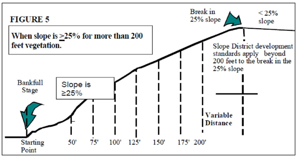
4 Where the protected water feature is confined by a ravine or gully, the top of the ravine is the break in the slope that is less than or equal to twenty-five percent (≥25%) (see Figures 4 and 5 in Section 4.317 of this Chapter). If a slope of less than or equal to twenty-five percent (≥25%) continues beyond two hundred (200) feet, the development standards of this Chapter continue to apply until the break in slope.
5 A maximum reduction of twenty-five (25) feet may be permitted in the width of vegetation corridor beyond the break in slope if a geotechnical report demonstrates that the slope is stable. The establish the width of the vegetation corridor, measure in twenty-five (25) feet increments from the minimum setback away from the water feature until the slope is less than twenty-five percent (25%) (top of ravine).
(Ord. No. 894, § 3, 12-10-2024)
4.317 - Method for Determining Vegetation Corridors Next to Primary Protected Water Features.
Figure 1. How to measure slopes. Measure fifty (50) feet horizontally (L1) from the bankfull stage and determine the slope (H1/L1 is the difference in elevation divided by the difference in horizontal distance multiplied by one hundred (100)).
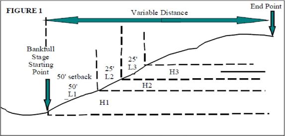
Figure 2. If the slope in this fifty (50) foot area is less than twenty-five percent (25%), the corridor width is fifty (50) feet from the bankfull stage.
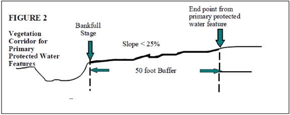
Figure 3. If the slope adjacent to the protected water feature is twenty-five percent (25%) or greater for less than one hundred fifty (150) feet, measure horizontally in increments of twenty-five (25) feet until the slope is less than twenty-five percent (25%) (H2/L2 <25%) and add fifty (50) feet. This is a variable end point. The vegetation corridor may be 50-, 75-, 100-, 125-, or 150-feet in width.
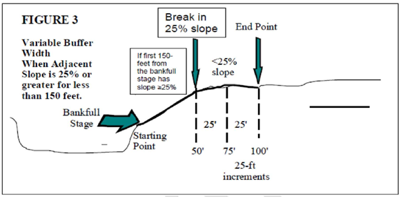
Figure 4. If the slope is greater than twenty-five percent (25%) in this incremental twenty-five (25) foot area for more than one hundred fifty (150) feet, continue measuring the slope every twenty-five (25) feet (H/L) until you find a slope less than twenty-five percent (25%). When you find a slope less than twenty-five percent (25%), the vegetation corridor equals the distance from the bankfull stage to the end point of the last surveyed twenty-five (25) foot increment with a slope greater than twenty-five percent (25%) plus an additional fifty (50) feet up to a distance of two hundred (200) feet from the top of the bank. If the slope continues beyond two hundred (200) feet, refer to Figure 5.
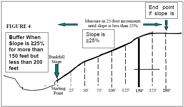
Figure 5. When you reach two hundred (200) feet from the top of the bank and the slope continues to be less than or equal to twenty-five percent (>25%) beyond the two hundred (200) feet, continue measuring until the break in the less than or equal to twenty-five percent (>25%) slope. No additional setback will be required beyond the break in slope.
Advantages:
1.
Provides protection for slopes of twenty-five percent (25%) and greater, yet corridor widths can be varied to fit a number of different situations. Development on slopes in excess of twenty-five percent (25%) beyond the vegetation corridor as determined by the table in Section 4.316, Width of Vegetation Corridor, of this Chapter and the preceding methods, are still protected under the provisions of this Chapter pursuant to Section 4.311, applicability, of this Chapter.
2.
Provides flexibility. The end point will be unique for each property based upon an actual topographical survey.
(Ord. No. 894, § 3, 12-10-2024)
4.318 - Delineation of Habitat Conservation Areas.
Habitat Conservation Areas (HCAs) are generally shown on the Metro Title 13 maps. For purposes of development within the HCAs on City-owned and Metro-owned parks and greenspaces, delineation of on-the-ground HCA boundaries shall be established by a professional and verified by the City of Troutdale using the best available information.
(Ord. No. 894, § 3, 12-10-2024)
4.410 - Purpose.
The purpose of this district is to provide more flexibility in the development of land; encourage variety and creativity in the development pattern of the community; conserve natural land features; facilitate aesthetic and efficient use of open space; create public and private open space; encourage the application of new techniques and technology to community development which contribute to superior living or development patterns; use land efficiently in order to reduce the costs of housing, maintenance, street systems, and utility networks; promote energy conservation and crime prevention; and relate development to the natural environment and its users.
4.411 - Permitted Uses.
A.
For Residential Districts.
1.
Uses permitted in the underlying district.
2.
Housing concepts may include, but are not limited to, single-family residences, duplexes, rowhouses, townhouses, cluster units, multiple-family dwellings, or mobile homes.
3.
Related commercial uses as part of the development.
4.
Related community service uses designed to serve the development.
5.
Accessory buildings and uses.
B.
For Commercial and Industrial Districts.
1.
Uses permitted in the underlying district.
2.
Community service uses.
3.
Accessory buildings and uses.
4.412 - Areas of Application.
Commercial, Industrial, and Residential. Planned Development approval may be sought for uses allowed in the underlying zone. Creation of lots or parcels shall be governed by Chapter 7, Land Divisions, except as expressly provided for herein.
4.413 - Dimensional Standards.
A.
Lot Width, Depth, and Frontage Requirements. Minimum lot size, width, depth, and frontage requirements for lots in a Planned Development may be less than the minimums specified in the underlying district if in accordance with the approved general plan and program, and the density standards of this Chapter.
B.
Minimum Site Size. A Planned Development shall be established on a parcel of land that is suitable for the proposed development, and shall not be established on less than two (2) acres of contiguous land.
4.414 - General Requirements.
A.
Peripheral Setbacks. Peripheral yards of a Planned Development site shall be at least as deep as those required by the yard regulations of the adjoining district, unless the Planning Commission finds that equal protection will be accorded through specific features of the approved plan.
B.
Open Space.
1.
Open space in a Planned Development means the land area to be used for scenic, landscaping, or open recreational purposes within the development. It shall not include street rights-of-way, driveways, or open parking areas.
2.
Adequate open space shall be provided for the recreational and leisure use of the individuals occupying the Planned Development, and designed to enhance the development.
3.
To the maximum extent practicable, natural features of the land shall be preserved and landscaping provided.
4.
In order to assure that open space will be permanent, dedication of development rights to the City may be required.
5.
Instruments guaranteeing the maintenance of open space shall be reviewed and approved by the Planning Commission. Documents dedicating development rights and provisions for maintenance of open space shall be approved as to form by the City Attorney.
6.
The Planning Commission may require that instruments of conveyance provide that in the event the open space is permitted to deteriorate, or is not maintained in a condition consistent with the approved plan, the City may, at its option, cause such maintenance to be done and assess the costs to the affected property owners.
C.
Residential Density.
1.
In a residential Planned Development, the density permitted is the same as that of cumulative number of dwellings permitted by the underlying district or districts, except for the HDR zoning district, which shall be based on the density per dwelling unit established in Goal 2 of the Comprehensive Land Use Plan for the High Density Residential Planning area.
a.
Density shall be allowed consistent with the general plan and program throughout the Planned Development area without regard to zoning district boundaries.
b.
In a mixed-use Planned Development, the number of allowable units is based on net residential area. The net residential area for a Planned Development shall be calculated by taking the total area of the development less streets, commercial, industrial, community service, and other non-residential uses; area constrained for development under the provisions of this Code; and any existing residential uses that are being retained as part of the Planned Development. Recreational trails, open space, etc., shall be included in the net residential area, unless these open spaces are preserved and protected through conditions, covenants, and restrictions; conservation easements; or where approved by the City Council, dedication, or conveyance to the City. The number of dwelling units permitted in a Planned Development shall be calculated by dividing the net residential area by the minimum lot size required in the underlying residential district or districts, except for the HDR zoning district which shall be a minimum of two thousand (2,000) square feet per dwelling unit.
c.
Outside of the Town Center Overlay District in a commercial or industrial zoning district, when limited residential use is determined to be appropriate by the Planning Commission, there is no minimum or maximum density, but density will be allowed consistent with an approved development plan.
2.
Greenways, streams, and steep topography areas will be counted as contributing to the net area only to the extent that it can be shown, through a Planning Commission review, that a typical development could be accommodated on the site with realistic street configuration, grades, and standard lot sizes. The number of dwellings yielded from such a tentative subdivision review process shall be used as a base in determining the overall density for the site.
3.
An increase of up to twenty five percent (25%) in the number of dwelling units beyond the maximum density of the underlying zone or zones may be permitted upon a finding by the Planning Commission that such increased density will contribute to:
a.
Satisfaction of the need for additional urban area housing of the type proposed;
b.
The provision of housing which is convenient to commercial, employment, and community services and opportunities;
c.
The creation of a land use pattern which is complementary to the community and its identity, and to the community design process;
d.
The conservation of energy;
e.
The efficient use of transportation facilities; and
f.
The effective use of land and available utilities and facilities.
D.
Staging.
1.
The applicant may elect to develop the site in successive stages in a manner indicated in the development plan. Unless otherwise provided in the Planned Development approval, each such stage shall be substantially complete within itself. Unless otherwise provided in the Planned Development approval, each stage is subject to the time limits provided for in Chapter 7 for preliminary and final subdivision plats.
2.
The Planning Commission may require that development be done in stages if public facilities are not adequate to service the entire development initially.
(Ord. No. 894, § 3, 12-10-2024)
4.417 - Planned Development Process.
Planned Development shall be reviewed in the same two-stage process as provided for a Type III subdivision, regardless of whether a land division is proposed.
4.419 - Preliminary Plan.
A.
Submission Requirements. The preliminary plan shall consist of twenty (20) copies of all plans, maps, and diagrams drawn in sufficient detail to indicate the nature of the plan elements and a written narrative description.
B.
Submission Materials. The tentative plan need not be a finished drawing, but it should present all relevant graphic data, drawn on a sheet 18"x24" in size, and at a scale of 1"=100'. The information shall include, but is not limited to, the following:
1.
Proposed land uses and residential densities.
2.
Building types and locations.
3.
Means of access, circulation, and parking.
4.
Parks, playgrounds, paths, and open spaces.
5.
Land division plan if the land is to be divided.
6.
Applicant's statement of the goals and objectives of the planned development.
7.
Tables showing overall density of any proposed residential development with density of dwelling types and intensity of any commercial, industrial, or other employment-related uses.
8.
Applicant's statement of how the proposed Planned Development complies with the applicable Troutdale Development Code requirements.
9.
That the proposal incorporate a commitment to provide a legal instrument or instruments acceptable to the City setting forth a plan for the permanent care and maintenance of common space, including streets and greenways, recreational areas, and all community-owned facilities.
10.
General timetable of development.
4.421 - Final Plan.
Final plan approval shall be a Type I process to confirm that it is consistent with the approved preliminary plan. The final plan may be approved notwithstanding minor changes such as minor shifting of the location of buildings, proposed streets, public or private ways, utility easements, parks, public open spaces, or other features of the preliminary plan based on final engineering, design or similar final detail work but shall not increase the residential densities, change zone boundaries or the perimeter boundary of the PD, change any use or change the location of amount of land devoted to a use specified in the preliminary plan. Changes other than permitted minor changes shall require a new application.
A.
All public site dedications, development rights to open spaces, or other dedications for the entire site or approved staged portion shall be recorded prior to the issuance of any building permit.
B.
Final copies of all approved articles governing operation and maintenance shall be placed on file with the Planning Division prior to the issuance of any building permit.
4.423 - Application of Development Standards; Conflict of Planned Development Standards and Zoning District Standards.
In cases of conflict between standards of the underlying district and the Planned Development, the standards of the Planned Development shall apply.
4.605 - Applicability.
The regulations and standards of this overlay district apply to land within the boundaries of the Town Center Planning as established in the Town Center Plan except they shall not apply to those properties designated Low-Density Residential/Open Space in the Plan. In the instance of conflicts between the provisions of this Section and provisions found in Chapters 3 or 8 of this Code, the provisions in Chapters 3 or 8 shall govern.
4.610 - Purpose and Intent.
The purpose of this district is to encourage the downtown Troutdale area to grow as a diverse and viable town center. The Troutdale Town Center is envisioned as the district that provides shopping, employment, cultural, and recreational opportunities that serve the Troutdale area. In addition, the district allows for continued housing opportunities close to commercial activities. The intent of specific design standards for buildings, streetscapes, and parking within the TC district is to achieve development that is consistent with the design concepts outlined in the Town Center Plan. These design concepts include, but are not limited to, attractive pedestrian-oriented streets, providing a complementary mix of commercial and residential development, a connected network of streets and accessways to reduce automobile dependency, and avoiding walled streets.
4.620 - Permitted and Conditional Uses.
Permitted and conditional uses are contained in the land use tables located in Chapter 3 of this Code.
4.630 - Town Center Residential Densities.
Density standards are contained in provisions located in Chapter 3 of this Code.
4.640 - Dimensional Standards.
Dimensional standards shall be the same as those listed in the underlying zone except as follows:
A.
Community Commercial (CC).
1.
The MU-1 standards for lot width, lot depth, and lot area shall apply for residential development.
2.
No front yard or street side yard setback is required.
B.
General Commercial (GC).
1.
The MU-1 standards for lot width, lot depth, and lot area shall apply for residential development.
2.
Minimum street frontage: Twenty feet.
3.
No front yard or street side yard setback is required.
4.650 - Commercial Design Review.
A Type II site development review shall be required for all commercial uses within the TC district. Site and design review shall be conducted in accordance with Chapters 6 and 8 of this Code.
A.
MU-1 Design Standards. The Design Standards for CBD, listed in Appendix A of this Code shall apply to the MU-1 zoning district with the following exception: If a design standard refers to the relationship of a site or building to Historic Columbia River Highway, but the subject property does not abut Historic Columbia River Highway, then the standard shall be applied to at least one (1) street frontage that can be used by pedestrians.
B.
Development adjacent to SW Halsey Street shall install decorative streetlights within the Halsey Street right-of-way as part of any half-street improvements required of the development.
C.
Outlet Mall/Former Treatment Plant Site. New commercial development on the former sewage treatment plant site shall meet the following design standards:
1.
The drive or street through the outlet mall site to the former sewage treatment plant site shall be a public street.
2.
Sidewalks at least 5 feet in width shall be provided on both sides of the street.
4.660 - Residential Design Review.
All residential development shall be subject to relevant development and design standards specified in Chapter 8 of this Code.
4.680 - Street Design and Streetscapes.
The following design standards shall apply within the Town Center district:
A.
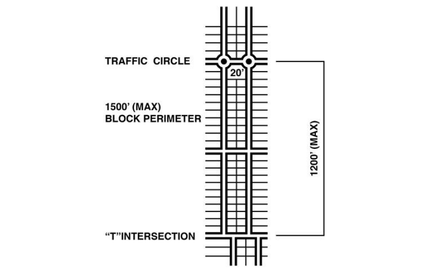
Blocks and Access. The perimeter of blocks shall not exceed 1,500 feet. Blocks along arterial and collector streets shall be designed to allow streets to intersect in a manner that allows the side yards of development to abut the arterial or collector street. In general, development should not be designed with rear yards abutting arterials and collectors.
B.
Street Termination. Unless impractical due to efficiency of street layout and design, topography, or other site constraints of the property being developed, new street sections shall be no longer than 1,200 feet without providing a jog, a deflected view, traffic island, or a point of termination, such as a "T" intersection.
C.
Streetscapes. To encourage pedestrian-oriented streetscapes, the following standards shall apply:
1.
Fences and walls greater than 3 1/2 feet in height shall be prohibited in front yards. If fences or walls greater than 3 1/2 feet in height are provided along street side yards or rear yards abutting streets, the fence shall be buffered from the public right-of-way by a landscaped strip no less than 5 feet wide.
2.
Garages.
a.
For single-family detached, duplex, and zero lot line dwellings on lots of 3,000 square feet or greater in area or 30 feet or wider at the front setback line, garages shall be subordinate to the main dwelling by being set back a minimum of 5 feet behind the front door of the residence or by compliance with the following standards:
i.
The garage door width is fifty percent (50%) or less of the width of the street facing elevation and does not extend beyond the front door; or
ii.
The garage door is behind or even with the front door and the dwelling has a roofed front porch, which is at least 1/3 as wide as the front elevation and at least 5 feet deep. The porch may encroach within the required front yard setback a maximum of 5 feet without a variance provided the foundation for the dwelling complies with the minimum front setback standard; and
iii.
The street facing wall of the dwelling contains at least one (1) window on the ground floor that allows visibility of the street.
b.
Garages on lots less than 3,000 square feet in area, or on lots less than 30 feet wide at the front setback line, or on lots having a slope of twenty percent (20%) or greater at the street access shall be set back a minimum of 5 feet behind the front door or shall comply with the following standards:
i.
The garage door does not extend beyond the front door; and
ii.
The dwelling has a roofed front porch. The porch may encroach within the required front yard setback a maximum of 5 feet without a variance provided the foundation for the dwelling complies with the minimum front setback standard; and
iii.
There is at least one (1) window on any floor that faces the street and allows visibility of the street.
c.
For all other residential uses, garages shall comply with the standards within relevant residential development and design sections of Chapter 8 of this Code.
3.
Street trees are required along public streets in accordance with the City's Tree Ordinance, Troutdale Municipal Code, Chapter 13.10.
4.
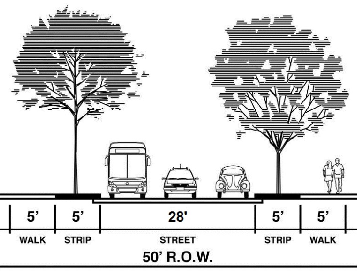
Local residential streets shall have a pavement width of 28 feet, with sidewalks set back and separated from the street by a planting strip of 5 feet in width. The street shall provide on-street parking on both sides of the street.
5.
Development adjacent to SW Halsey Street shall install decorative streetlights within the Halsey Street right-of-way as part of any half-street improvements required of the development.
D.
Alleys. Alleys shall be a minimum of 20 feet in width and shall be encouraged as a means of providing vehicle access to development.
4.690 - Off-Street Parking and Loading.
Off-street parking and loading shall be provided in accordance with the requirements of the underlying zoning district, Section 8.150, and Chapter 9 of this Code as applicable. Except for residential units on individual lots, no use shall be permitted to exceed the required minimum amount of off-street parking by more than ten percent (10%); however, each use shall be allowed at least one (1) parking space in excess of the minimum amount required. When the underlying zoning district requires no off-street parking spaces, no use shall be permitted to exceed the minimum number of parking spaces as indicated for that use within Chapter 9 of this Code by more than ten percent (10%). In computing the maximum number of off-street parking spaces allowed, if the ten percent (10%) figure contains a fraction, then the number shall be rounded up to the next higher whole number.
4.695 - Authority to Adjust Standards.
A.
Because of the diverse topography and parcel configurations within the TC district, it is neither practical nor feasible to uniformly apply these design standards to all development projects. The Director shall use reasonable discretion in determining whether the standards in Sections 4.650—4.680 of this Chapter are practical for individual developments. The Director is authorized to grant administrative adjustments to these design standards upon making the following written findings:
1.
The adjustment is justified due to unique site conditions.
2.
The proposal will be consistent with the desired character of the area.
3.
Any impacts from the adjustment are mitigated to the extent practical.
B.
When, in the Director's opinion, an adjustment to a design standard is not justified, the request shall be handled as a variance in accordance with the procedures of Section 6.1300 of this Code. The Director's decision to adjust specific standards is a Type II decision under Section 2.055 of this Code.