
Troutdale City Zoning Code
CHAPTER 5
MISCELLANEOUS USES AND STANDARDS
5.010 - Accessory Structures.
Accessory structures are defined in Section 1.020 of this Code and include frame-covered accessory structures. The provisions of this Section apply only to accessory structures affiliated with residential uses. Accessory dwelling units are regulated in Section 8.170 of this Code.
For purposes of these regulations, portable swimming pools less than twenty-four (24) inches in depth are not considered accessory structures and are not subject to the provisions of this Section. Solariums, greenhouses, garages, or other enclosed areas which are attached to the residential structure shall not be considered accessory and shall be subject to the regulatory requirements of the underlying zoning district.
A.
Building Permit — When Required. A building permit shall be required as provided in Title 15, Building Code, of the Troutdale Municipal Code.
B.
Regulatory Requirements. No accessory structure, regardless of whether the structure requires a building permit, shall be erected or maintained, and no existing residential accessory structure shall be altered, converted, enlarged, moved, or maintained unless the structure complies with the following:
1.
Cargo shipping containers are not permitted as accessory structures.
2.
No accessory structure shall be located:
a.
Within the front yard setback or between the street and the front building plane of the dwelling;
b.
Less than three (3) feet from the rear property line;
c.
Less than three (3) feet from the side property line;
3.
No accessory structure shall exceed:
a.
One thousand (1,000) square feet in floor area for any single accessory structure.
b.
Twenty-five percent (25%) of the gross lot area, or fifty percent (50%) of the area of the required rear yard for all accessory structures cumulatively.
c.
Twenty (20) feet in height.
d.
Ten (10) feet in height or two hundred (200) square feet in size if located within a side or rear yard setback.
4.
Private Vehicle Storage on Corner Lot. Notwithstanding any other provision of this Section, residential accessory structures for private vehicle storage on a corner lot that have an entrance from the street side yard shall have a minimum street side yard setback of eighteen (18) feet. Vehicle access from the side street must be approved by the Public Works Director and constructed to City standards.
5.
Height shall be measured in accordance with Section 1.020 of this Code. Setbacks shall be measured from projecting features, including but not limited to eaves and gutters.
(Ord. No. 894, § 4, 12-10-2024)
5.020 - Exceptions to Yard Requirements.
A.
Established Building Lines. If a previous building line has been established, the minimum front yard for interior lots shall be the average of the setbacks of the main structures on abutting lots on either side if both lots are occupied. If one (1) lot is occupied and the other vacant, the setback shall be the setback of the occupied lot, plus one-half (½) the remaining distance to the required setback. Corner lots shall not be included in the averaging.
B.
Projecting Building Features. Except for accessory structures, the following may project into required yards, as listed below:
1.
Architectural appendages including, but not limited to, bay windows, planters, awnings, eaves, decks less than twenty-four (24) inches high or other similar features may project into required front and rear yard setbacks no more than five (5) feet, and into side yard setbacks no more than two and one-half (2½) feet. Architectural appendages may project no more than eighteen (18) inches into inactive easements alongside and rear property lines, provided required building setbacks approved. In no case shall any architectural appendage encroach on an active easement of record. An active easement is an easement containing one (1) or more public utilities. An inactive easement contains no public utilities within it.
2.
Unroofed landings and stairs may project into required front and rear yard setbacks no more than five (5) feet.
3.
Open fire escapes may project into required front and rear yard setbacks no more than five (5) feet and into side yard setbacks no more than two and one-half (2½) feet.
4.
Chimneys shall not project more than two and one-half (2½) feet into any required yard.
5.
Windscreens shall not extend more than eight (8) feet into a required front yard setback area.
(Ord. No. 894, § 4, 12-10-2024)
5.030 - Vertical Projections.
Except as provided in the Airport Landing Field (ALF) district, height limitations shall not apply to projections extending vertically from buildings other than accessory structures, including but not limited to penthouses, stairways, tanks, ventilating fans, or similar equipment required to operate and maintain the building; roof structures used for elevators, fire or parapet walls; skylights; windmills; towers; steeples; flagpoles; chimneys; smokestacks; radio and television antennae; telecommunication towers or poles or water tanks. No projection above the height limitation shall be allowed for the purpose of providing additional floor space. No vertical projection shall be located less than twenty (20) feet from any property line.
5.040 - Clear Vision Areas.
A.
A clear vision area shall be maintained as provided below.
B.
The clear vision area is a triangle that is measured according to the following:
1.
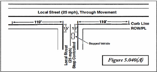
A clear vision area at intersections of local streets with local streets shall consist of a triangular area, two (2) sides of which are the curb lines extended in a straight line to a point of intersection and so measured as defined and illustrated in Figure 5.040(A), and the third side of which is a line joining the non-intersecting ends of the other two (2) sides. Where no curb exists, the edge of street pavement shall be used in lieu of the curb line.
2.
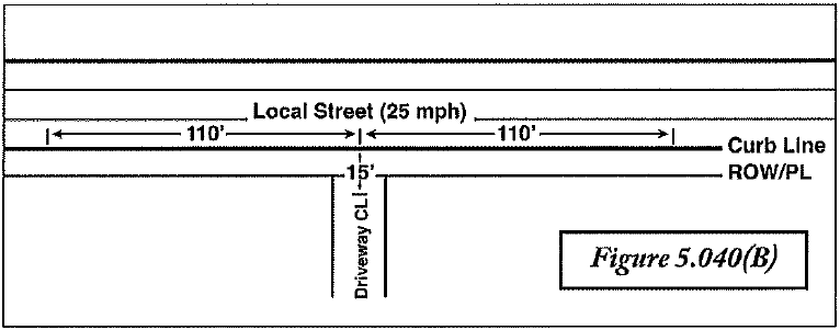
Driveways and alleys intersecting with local public streets shall have and maintain a clear vision triangle with its base measured along the face of curb parallel to the public way for one hundred ten (110) feet in both directions from the center of the driveway, and the other sides extending toward the apex of the triangle in the center of the driveway fifteen (15) feet from the street curb line (see Figure 5.040(B)). Where no curb exists, the edge of street pavement shall be used in lieu of the curb line.
3.
The clear vision area for local streets, alleys, and driveways intersecting with a county or state road shall comply with jurisdictional standards.
4.
Alternatively, a clear vision triangle may be established by a site-specific analysis conducted by an Oregon Design Professional in accordance with the standards set forth in the most current edition of "A Policy on Geometric Design of Highways and Streets" published by the American Association of State Highway and Transportation Officials.
C.
Except as provided below, within clear vision areas, no vehicle, fence, wall, hedge, or other planting or structure (temporary or permanent) shall be parked, erected, planted, placed, located, or maintained above three (3) feet in height measured from the top of the curb or, where no curb exists, from the established street centerline grade of the intersecting streets and from the driveway centerline at a driveway intersection, except for occasional tree trunks, mail boxes, street sign posts, or utility poles, so as to impede visibility within the clear vision area.
D.
The foregoing provisions shall not apply to the following:
1.
A public utility pole, signal pole, light pole, or other utility appurtenances.
2.
Trees, provided that the tree is trimmed (to the trunk) to a line at least eight (8) feet above the level of the intersection.
3.
Another plant species of open growth habit that is not planted in the form of a hedge and which is so planted and trimmed as to leave, at all seasons, a clear and unobstructed cross-view.
4.
A supporting member or appurtenance to a permanent building lawfully existing on the date this document becomes effective.
5.
An official warning sign or signal.
6.
A place where the natural contour of the ground is such that there can be no cross-visibility at the intersection.
7.
A sign mounted ten (10) feet or more above the ground with supports that do not obstruct the clear vision area.
8.
A signalized intersection.
9.
Lots for which no setback is required.
E.
Lawful structures or vegetation in existence prior to December 9, 1986 may continue as lawful nonconforming uses as specified in Chapter 5.300, Nonconforming Uses, of this Code.
F.
Any obstruction maintained in violation of this Section shall be abated pursuant to Chapter 17, General Provisions, of this Code.
(Ord. No. 894, § 4, 12-10-2024)
5.050 - Fences, Walls and Windscreens.
A.
Fences and retaining walls on lots zoned residential shall comply with the following:
1.
The clear vision standards of Section 5.040 of this Code.
2.
Shall not exceed four (4) feet in height if located in a required front yard setback, except the height limit shall be six (6) feet for a dwelling that existed prior to June 9, 1987 and which fronts a major arterial.
3.
Shall not exceed seven (7) feet in height if located in a required side or rear yard setback area.
4.
Fences and retaining walls shall be constructed of wood, brick, masonry cement, chain link, plastic, wrought iron or similar residential-type materials. The use of barbed wire, electric fences, sheet metal or other non-residential materials is prohibited.
B.
Fences, retaining walls on lots zoned commercial or industrial shall comply with the following:
1.
The clear vision standards of Section 5.040 of this Code.
2.
Shall not exceed three and one-half (3½) feet in height if located in a required front yard setback.
3.
Shall not exceed six (6) feet in height if located in a required side or rear yard setback area.
C.
Fences, walls and windscreens shall be measured from the ground on which the fence, wall or windscreen is located to the top of the fence or retaining wall, or any the combination thereof.
D.
Any recreational court may be enclosed by a wire fence not exceeding twelve (12) feet in height, provided that no part of the court fence is within twenty (20) feet of any street.
E.
A swimming pool, hot tub, or other manmade outside body of water, which has a depth greater than twenty-four (24) inches shall be enclosed with a fence not less than four (4) feet, and not more than six (6) feet in height. The fence shall not have any openings, holes, or gaps larger than three (3) inches square, except for doors or gates. The fence gates shall be equipped with a self-closing, self-latching device. A dwelling unit and/or accessory building may form part of the enclosure.
F.
Security fencing is permitted for agricultural, community service, commercial, or industrial uses when the wire is employed on the top of any other type of fencing, is a minimum of six (6) feet above the finished ground surface, and does not extend over a public way. The total height shall not exceed eight (8) feet from grade.
G.
Electric fencing is permitted only in the Light Industrial (LI) and General Industrial (GI) zoning districts and shall meet the following criteria:
1.
Reserved.
2.
Electric fencing shall not be installed within ten (10) feet of a public right-of-way.
3.
Electric fencing shall not be installed within an easement without the written consent of the rights holder.
4.
Electric fencing shall be a pulsed charge system that shall not exceed eight thousand (8,000) volts of voltage and one hundred fifty (150) milliamps of amperage, or shall demonstrate that shock levels and duration are medically safe for humans through a manufacturer's certification.
5.
Any required Building Division permits shall be obtained prior to installation and shall be inspected upon completion of installation.
6.
Any required fire approvals or acknowledgements for the installation, operation and maintenance of the electric fence shall be obtained prior to completion of installation.
7.
Warning signs that indicate hazard shall be installed at intervals of not less than thirty (30) linear feet of fencing, indicating an electric fence exists. Signage shall be approved by the Director upon completion of installation.
8.
The total height shall not exceed ten (10) feet from grade.
H.
Windscreens. A windscreen may be constructed on the north or east side of a residential building only. The screen shall not exceed six (6) feet in height nor extend more than eight (8) feet into a required front yard setback area.
(Ord. No. 894, § 4, 12-10-2024)
5.060 - Decks.
Detached decks over twelve (12) inches in height are deemed accessory structures. Decks of twenty-four (24) inches or more in height attached to a structure require a building permit.
(Ord. No. 894, § 4, 12-10-2024)
5.070 - Street Side Sales.
Street side sales of products including, but not limited to, flowers, fruits, vegetables, firewood, arts and crafts, seafood, fireworks, and Christmas trees are permitted within commercial or industrial zoning districts, or on sites with a community service use, subject to the following provisions:
A.
All activity related to street side sales, including signage, must be within the boundaries of the property, and is not permitted on any public right-of-way, including sidewalks.
B.
Signage shall be limited to one (1) sign per street frontage of the property on which the street side sales is located. Signs shall not exceed twenty-four (24) square feet in size.
C.
Street side sales shall not exceed sixty (60) days in any calendar year. Any structure (including any mobile unit) from which the street side sales is conducted, shall be removed from the property on cessation of sales.
D.
A business license must be obtained, and must include written permission of the property owner.
E.
Automobile drive-up window service is not permitted.
(Ord. No. 894, § 4, 12-10-2024)
5.080 - Transportation Facilities.
Public transportation facilities constructed or approved by the City shall be permitted outright in all zoning districts. Transportation facilities shall include construction, operation, and maintenance of travel lanes, bike lanes and facilities, curbs, gutters, drainage facilities, sidewalks, bus stops, landscaping, lighting, signage, signalization and related improvements located within rights-of-way controlled by a public agency, consistent with the Troutdale Transportation System Plan. When the transportation facilities to be constructed are located entirely within public right-of-way, no land use review is required unless construction occurs within the flood hazard area or the Vegetation Corridor Overlay District. Transportation facilities which are located outside of an existing right-of-way are subject to land use review pursuant to Section 6.800 of this Code.
5.110 - Purpose.
The purpose of this Section is to provide for occupations in residential districts in a manner that will ensure they are utilized only as uses incidental to the primary residential use of the premises upon which they are located. Home occupations must obtain a City business license as provided in Chapter 5.04 of the Troutdale Municipal Code.
5.120 - General Requirements for Home Occupations.
A.
There shall be no additional signage other than that permitted in a residential zone.
B.
No home occupation shall emit or produce noise, smoke, dust, odor, glare, traffic, vibration, or other impacts greater than that of a typical residential dwelling.
C.
Use and storage of hazardous materials in conjunction with a home occupation must be approved by the local fire and emergency service agency.
5.130 - Operational Standards for Home Occupations.
Home occupations shall be operated entirely within a dwelling or accessory structure by a resident of the dwelling unit as a clearly secondary and incidental use of such property. The home occupation shall comply with all of the following conditions:
A.
No employees or any persons other than residents of the dwelling shall engage in a home occupation therein.
B.
Customer and client contact shall be primarily by telephone, mail, or in their homes and places of business, or by appointment at the premises of the home occupation. No retail sale of merchandise shall be made on the premises.
C.
No more than twenty-five percent (25%) of the gross floor area of the residence shall be used for the home occupation. If a home occupation is conducted within an accessory structure, the home occupation shall not exceed the gross floor area of the residence.
D.
Must comply with all other City, County, and State requirements.
E.
No additional signage other than that permitted in the zone.
5.140 - Revocation/Expiration.
Home occupations are renewed annually in conjunction with business licenses. Business licenses for home occupations may be revoked at any time for noncompliance with the provisions of this Code.
5.210 - Purpose and Intent.
These provisions are to provide a framework for the operation of food vendors as defined in TDC 1.020.54. The intent is to allow such uses in appropriate locations and with reasonable regulations designed to minimize negative impacts on surrounding areas.
5.220 - Standards for Location and Development.
Mobile Food Vendors as defined in Section 1.020, and when possessing the required and valid City business license, are allowed in accordance with the following use and operational standards:
1 Parking on gravel surfaces limited to a maximum of ninety (90) days in any three hundred sixty-five (365) day period.
2 Subject to approval through Site Development Review process.
3 No discharge of liquids onto the ground or into the storm water system allowed.
4 See parking standards.
5 Business operations for a food stand or food cart shall only be conducted between seven a.m. (7:00) and seven p.m. (7:00) except the hours can be extended earlier or later by the Planning Director upon finding the extended hours will not create negative impacts on surrounding properties due to noise, light, traffic, and/or similar factors.
6 Ninety (90) days in any one hundred eighty (180) day period.
(Ord. No. 894, § 4, 12-10-2024)
5.305 - Purpose and Intent.
Within the zoning districts established by this Code, or amendments that may later be adopted, there may exist lots, uses, structures, or other developments of the land which were lawful before this Code was adopted or amended, but because of the application of this Code, they no longer conform to the provisions and standards of the district in which they are located or of this Code in general. This Chapter provides for the regulation of these legal nonconforming lots, uses, structures, and developments and specifies those circumstances, conditions, and procedures under which such nonconformities shall be permitted to continue and expand. It is the intent of this Chapter to permit legal nonconforming lots, uses, structures, or developments to continue until they are removed by economic forces or otherwise. Legal nonconforming lots, uses, structures, or developments may also be expanded or reconstructed as provided in this Code.
5.310 - Reconstruction of a Damaged Residential Nonconforming Use.
A residential nonconforming use, or a structure containing a residential nonconforming use, that has been damaged by any cause may be reconstructed provided a building permit to reconstruct the structure is obtained within one (1) year of the destruction and further the reconstruction is completed within one (1) year of commencing construction. Notwithstanding the requirements of construction in the Flood Management Area, Section 1.040 and Section 4.500. If reconstruction does not occur within these timeframes, the nonconforming use shall be considered terminated and shall not be reestablished.
5.315 - Reconstruction or Destruction of a Non-Residential Nonconforming Use.
A.
A non-residential nonconforming use or a structure containing a non-residential nonconforming use that has been damaged by any cause to an extent the reconstruction costs are less than seventy-five percent (75%) of the real market value may be reconstructed provided a building permit to reconstruct the structure is obtained within one (1) year of the destruction and further the reconstruction is completed within one (1) year of commencing construction. Notwithstanding the requirements of construction in a flood plain, Section 1.040 and Section 4.500. If reconstruction does not occur within these timeframes, the nonconforming use shall be considered terminated and shall not be reestablished.
B.
When a non-residential nonconforming use, or a structure containing a non-residential nonconforming use, is damaged by any cause to an extent the reconstruction costs would equal or exceed seventy-five percent (75%) of the real market value as indicated by the records of the County Assessor, the nonconforming use or structure containing the nonconforming use shall be considered terminated and shall not be reestablished. Reconstruction costs shall be based on the cost to restore the use or structure to meet current building Code and development Code standards, not simply the cost to restore the use or structure to the condition it existed in prior to it being destroyed.
5.320 - Discontinuance of a Nonconforming Use.
When a nonconforming use or any part thereof is discontinued for a period of at least twelve (12) months, the nonconforming use or part thereof shall be considered terminated and further use of the property upon which the use or part thereof was located shall conform to the regulations of the zoning district in which it is located. Discontinuance of the use shall be determined by information such as termination of any lease or contract under which the nonconforming use has occupied the site; discontinuation of water or electric services; expiration of business license; absence of any outwardly visible activity associated with the nonconforming use; demolition or removal of a structure in which the nonconforming use is located; or similar indications that the use or occupancy has ceased. When a nonconforming use is superseded by a permitted use, the nonconforming use shall not be resumed.
5.325 - Expansion of a Nonconforming Structure or Development.
A structure conforming as to use but nonconforming as to height, setback, or similar dimensional standards, or development of property conforming as to use, but nonconforming as to parking, landscaping, architectural features, or similar standards, may be expanded provided the expansion does not increase the degree of nonconformity. A land use permit not otherwise required by this Code is not required to expand a nonconforming structure or development if the expansion does not increase the degree of nonconformity.
5.330 - Reconstruction of a Damaged Nonconforming Structure or Development.
A structure conforming as to use but nonconforming as to height, setback, or similar dimensional standards, or a development of property conforming as to use, but nonconforming as to parking, landscaping, architectural features, or similar standards, that has been damaged by any cause may be reconstructed if the reconstruction costs are less than seventy-five percent (75%) of the real market value as indicated by the records of the County Assessor, except if the nonconforming structure is a residential structure it may be reconstructed regardless of the reconstruction costs. Reconstruction costs shall be based on the cost to restore the structure or development to meet current Building Code and development Code standards, not simply the cost to reconstruct the structure or development to the condition it existed in prior to it being damaged. Reconstruction shall begin within twelve (12) months of the date the damage was done and shall be completed within twelve (12) months of the date the reconstruction began. Notwithstanding the requirements of construction in the Flood Management Area, Section 1.040 and Section 4.500. If reconstruction does not occur within these timeframes, the nonconforming structure or development shall be considered terminated and shall not be reestablished.
5.335 - Destruction of a Nonconforming Structure or Development.
When a structure conforming as to use but nonconforming as to height, setback, or similar dimensional standards, or a development of property conforming as to use, but nonconforming as to parking, landscaping, architectural features, or similar standards, is damaged by any cause to an extent the reconstruction costs would equal or exceed seventy-five percent (75%) of the real market value as indicated by the records of the County Assessor, the nonconforming structure or development shall be considered terminated and shall not be reestablished without conforming to the regulations of this Code, except if the nonconforming structure is a residential structure it may be reconstructed regardless of the reconstruction costs. Nonconforming structures or development within the Vegetation Corridor and Slope District or within the Flood Management Area are subject to the provisions of those Chapters in this Code that regulate Vegetation Corridors, Slope Districts, and Flood Management Areas.
5.340 - Repairs and Maintenance.
Normal repairs and maintenance activities including, but not limited to, replacement of non-bearing walls, fixtures, wiring, or plumbing may be performed on any nonconforming structure or portion of a nonconforming structure, or on any structure or portion thereof that contains a nonconforming use.
5.345 - Sale of Nonconforming Use or Structure.
The ownership of property classified as nonconforming may be transferred without affecting the right to continue such nonconformity.
5.350 - Nonconforming Lot.
If a lot, or the aggregate of contiguous lots or parcels of land held in a single ownership, has an area or dimension which does not meet size requirements, the lot or aggregate holdings may be developed subject to all other requirements. If there is an area deficiency, residential use shall be limited to a single-family dwelling.
5.410 - Concept Development Plan.
A proponent for any development in a Master Plan/Mixed Use (MPMU) designated area shall submit an application with applicable fees to the Planning Commission for approval in principle. The concept development plan shall include all areas designated as MPMU owned by the applicant. The application shall include copies of all plans, maps, and diagrams drawn in sufficient detail to indicate the nature of the plan elements and a written narrative description. Approval of the concept development plan shall be processed as a Type IV land use decision. A specific site plan may be submitted for approval as a joint concept development plan/specific site plan through a Type IV process when:
A.
It does not involve a shifting of any zoning district boundaries.
B.
The application meets the more stringent requirements of the specific site plan approval.
5.420 - Procedures.
A.
The Citizen Advisory Committee (CAC) shall meet to review the concept development plan. The CAC will provide comments pertaining to the proposed development, compatibility with adjacent land uses, and compliance with the City's Comprehensive Land Use Plan. These comments shall be forwarded to the Planning Commission for consideration at a public hearing.
B.
The Planning Commission shall review the concept development plan at a regular meeting and may recommend approval, approval with modifications, or denial of the application. Such recommendation shall be based upon the Comprehensive Land Use Plan, this Code, other regulations, and the suitability of the proposed development in relation to the character of the area.
C.
The City Council shall consider the concept development plan at a public hearing and take action based upon the recommendation of the Planning Commission.
D.
Approval of the concept development plan shall be limited to the tentative acceptability of the land uses proposed and their interrelationships, and shall not be construed to endorse precise location of uses nor engineering feasibility.
E.
Concept development plan expiration date. Within two (2) years following the effective date of approval of a tentative plan, the specific site plan and program shall be submitted pursuant to Section 2.050, Submission of Application, of this Code, and shall incorporate any modification or condition required by approval of the concept development plan. The Director may, upon written request by the applicant, grant an extension of the expiration date of up to six (6) months upon a written finding that the facts upon which the approval was based have not changed to an extent sufficient to warrant refiling of the concept development plan, and after finding that no other development approval would be affected.
5.430 - Submission Materials.
The concept development plan need not be a finished drawing, but it should present all relevant graphic data, (generally) drawn on a sheet 18"x24" in size, and at a scale of 1"=100'. The information shall include, but is not limited to, the following:
A.
Proposed land uses and residential densities.
B.
Building types and locations.
C.
Means of access, circulation, and parking.
D.
Parks, playgrounds, paths, and open spaces.
E.
Site analysis diagram.
F.
Land division plan if the land is to be divided.
G.
Proposed ownership pattern.
H.
An applicant's statement addressing the following issues:
1.
Statement of the goals and objectives of the proposed development.
2.
Operation and maintenance proposal, i.e., homeowners association, co-op, or other similar organization.
3.
Tables showing overall density of any proposed residential development with density of dwelling types and intensity of any commercial, industrial, or other employment-related uses.
4.
Applicant's statement of how the proposed development complies with the applicable Comprehensive Land Use Plan policies.
5.
Applicant's demonstration of substantial contractual interest in the land.
6.
That adequate financing can be demonstrated to be available to the applicant to assure substantial completion of the proposal.
7.
That the proposal incorporate a commitment to provide a legal instrument or instruments acceptable to the City, setting forth a plan for the permanent care and maintenance of common space, including streets, greenways, recreational areas, and all community-owned facilities.
8.
General timetable of development, including proposed phasing lines and areas to be submitted for specific site plan approved.
5.440 - General Requirements.
A.
Compatibility with Neighborhood. The concept development plan shall present an organized arrangement of buildings, facilities, open spaces, and improvements such as recreation facilities, landscaping, and fencing to insure compatibility with the Comprehensive Land Use Plan and the area in which it is to be located.
B.
Open Space.
1.
Open space in an MPMU designated area means the land area to be used for scenic, landscaping, or open recreational purposes within the development. It shall not include street rights-of-way, driveways, or open parking areas.
2.
Open space shall be provided for the recreational and leisure use of the residents of the development. These areas shall be designed to enhance the present and future value of the development.
3.
To the maximum extent possible, natural features of the land shall be preserved and landscaping provided.
4.
In order to assure that open space will be permanent, dedication of development rights to the City for other than open space use may be required.
C.
Residential Density.
1.
In a residential zoning district of an MPMU designated area, the number of allowable units is based on net residential area. The net residential area shall be calculated by taking the total area of the development less streets, commercial, industrial, community service, and other non-residential uses. Recreational trails, streets, open space, etc., shall be included in the net residential area. The number of dwelling units permitted shall be calculated by dividing the net residential area by the minimum lot size required in the underlying residential district or districts.
2.
Greenways, streams, and steep topography areas will be counted as contributing to the density only to the extent that it can be shown, through a Planning Commission review, that a typical development could be accommodated on the site with realistic street configurations, grades, and standard lot sizes. The number of dwellings yielded from such a tentative subdivision review process shall be used as a base in determining the overall density for the site.
3.
An increase of up to twenty percent (20%) in the number of dwelling units may be permitted upon a finding by the Planning Commission that such increased density will contribute to:
a.
Satisfaction of the need for additional urban area housing of the type proposed;
b.
The provision of housing which is convenient to commercial, employment, and community services and opportunities;
c.
The creation of a land use pattern which is complementary to the community and its identity, and to the community design process;
d.
The conservation of energy;
e.
The efficient use of transportation facilities;
f.
The effective use of land, and available utilities and facilities; and
g.
The addition of design features and amenities including neo-traditional plan elements.
5.450 - Specific Site Plan Approved.
Upon approval of an overall concept development plan, specific site plans may be submitted for approval. Phases or portions of the overall MPMU designated area may be approved for development as long as they conform to the approved concept development plan for the property. An application shall be filed with appropriate fees and twenty (20) copies of all plans, maps, and diagrams indicating in sufficient detail the specific development proposed. Approval of specific site plans for development shall be processed as a Type III land use decision.
5.460 - Specific Site Plan Submission Requirements.
Specific site plans shall be specific to building locations, land uses, land divisions, and street locations. It should be drawn on a sheet 18"x24" in size, and at a scale no smaller than 1"=100'. An application for specific site plan approval shall address the following when applicable:
A.
The specific site plan shall be in conformance with the approved concept development plan for the property.
B.
Existing and proposed contour map or maps of the site to a scale commensurate with the size of the development.
C.
Location, width, and names of all existing or platted streets or other public ways, railroad, and utility rights-of-way, parks, or other public open spaces and land uses within 500 feet of the boundaries of the development.
D.
Existing sewers, water mains, and other underground facilities within and adjacent to the development and their certified capacities.
E.
Proposed sewers or other disposal facilities, water mains, and other underground utilities.
F.
A tentative subdivision plan if the property is proposed to be divided.
G.
A land use plan indicating the uses planned for the development.
H.
Areas proposed to be dedicated or reserved for interior circulation, public parks, playgrounds, schools sites, public buildings, or other uses dedicated or reserved to the public, if any.
I.
Open space that is to be maintained and controlled by the owners of the property and the proposed uses thereof.
J.
A traffic flow map showing the circulation pattern within, and adjacent to, the proposed development.
K.
Location and dimensions of pedestrian walkways, malls, trails, or easements.
L.
Location, arrangement, number, and dimensions of automobile garages and parking spaces, width of aisles, bays, and angle of parking, if any.
M.
Location, arrangement, and dimensions of truck loading and unloading spaces, and docks, if any.
N.
Tentative architectural plans and elevations of typical buildings and structures, indicating the general height, bulk, appearance, and number of dwelling units, if applicable. (Not applicable to single-family uses)
O.
A tentative tree planting and landscaping plan, including areas of groundcover and approximate finished grades, slopes, banks, and ditches. All existing trees over 6 inches in diameter and groves of trees shall be shown. Trees to be removed by development shall be so marked.
P.
The approximate location, height, and materials of all walls, fences, and screen plantings. Elevation drawings of typical walls and fences shall be included.
Q.
The stages, if any, of the development construction. Such stages shall be clearly marked on the specific site plan.
R.
Narrative statement of the goals and objectives of the proposed development.
S.
A completed market analysis, if required by the Planning Commission.
T.
Evidence of resources available to develop the project.
U.
Tables showing the total number of acres, the distribution of area by use, the percentage designated for each dwelling type, off-street parking, streets, parks, playgrounds, schools, and open spaces as shown on the proposed development plan.
V.
Tables showing the overall density of the proposed residential development, and showing density by dwelling types and any proposals for the limitation of density.
W.
Drafts of appropriate restrictive covenants, and drafts of documents providing for the maintenance of any common open space, required dedications or reservations of public open spaces, and any dedications of development rights.
5.470 - Approval of Specific Site Plan and Program.
The Planning Commission may approve a specific site plan, with or without modifications, after conducting a public hearing.
5.480 - Expiration.
If substantial construction or development, as determined by the Director, has not taken place within four (4) years from the date of approval of a specific site plan, the Planning Commission shall review the specific site plan at a public hearing to determine whether or not its continuation, in whole or in part, is in the public interest, and if found not to be, shall rescind the approval of the specific site plan.
5.485 - Construction Plans.
Following approval of a specific site plan by the Planning Commission, the applicant shall prepare a final plan which shall be submitted to the Planning Division to check for compliance with the approved specific site plan.
A.
If the final plan is found to be in compliance, it shall be so certified by the Planning Division. The final plat with all documents relating to dedications, improvements, agreements, restrictions, and associations which shall constitute the final plan, shall be recorded at Multnomah County Deed Records.
B.
Land division regulations shall be met if the property is to be divided or streets are to be dedicated.
C.
All public site dedications, development rights to open spaces, or other dedications for the entire site or approved staged portion shall be recorded prior to the issuance of any building permit.
D.
Final copies of all approved articles governing operation and maintenance shall be placed on file with the Planning Division prior to the issuance of any building permit.
5.490 - Changes and Modifications.
A.
Major Changes. Major changes in a specific site plan after adoption shall be considered the same as a new petition and shall be made in accordance with the procedures specified in this Section.
B.
Minor Changes. Minor changes in the specific site plan may be approved by the Director, provided that such changes:
1.
Do not increase the residential densities.
2.
Do not change boundaries.
3.
Do not change any use.
4.
Do not change the location or amount of land devoted to specific land uses.
C.
Such changes may include minor shifting of the location of buildings, proposed streets, public or private ways, utility easements, parks, public open spaces, or other features of the plan.
5.495 - Application of Development Standards.
In cases of conflict between standards of the underlying district and the approved site plan, the standards of the approved specific site plan shall apply.
5.510 - Purpose.
The purpose of this Section is to provide standards for the establishment of a bed and breakfast inn. This Section is intended to enable homeowners to open their homes to the traveling public by providing rooms for rent on a daily basis to overnight guests.
5.520 - Review Procedures.
Bed and breakfast inns shall be processed through a Type II site and design review procedure.
5.530 - Standards for Bed and Breakfast Inns.
Bed and breakfast inns (referred herein as "inns") are not subject to the home occupation operational standards provided in Section 5.130 of this Chapter but shall comply with the following standards:
A.
Inns shall comply with the requirements of the underlying zone and overlay zone, if applicable.
B.
Inns must be an accessory use to the primary single-family residence.
C.
Inns shall be owner-occupied and shall maintain the characteristics of a single-family dwelling. No separate structures shall be allowed.
D.
Inns shall be operated so as not to give the appearance of being a business.
E.
Inns may have a maximum of two (2) non-resident employees.
F.
A maximum of four (4) bedrooms shall be used as part of the inn accommodations. Only rooms designed as bedrooms shall be used as guestrooms. The number of guestrooms shall not be increased through any exterior additions or modifications to the structure.
G.
The duration of each guest's stay at an inn shall not exceed fifteen (15) consecutive days.
H.
In addition to the provisions of Chapter 9 of this Code pertaining to parking standards for single-family dwellings, one (1) additional off-street parking space shall be provided for each guestroom. Required off-street parking shall not be located in a required front or side yard setback area abutting a public street unless located in front of a garage.
I.
Signage shall be that provided for in residential zones except that one (1) additional non-illuminated or exteriorly illuminated on-premise sign not to exceed 6 square feet in area is permitted. All signage shall be in keeping with the residential character of the neighborhood.
J.
The inn shall obtain and maintain a City Business License and is subject to City Transient Lodging Tax. In addition, inns shall obtain and maintain all applicable state licenses and permits. The business license may be terminated for failure to comply with this Chapter or any conditions of approval.
K.
The inn shall meet all applicable health, fire safety, and building codes.
L.
The use of a bed and breakfast facility, not located in a commercial zone, for public events, wedding receptions, and similar activities is prohibited.
5.610 - Purpose.
The purpose of this Section is to establish, by reference, erosion control requirements and standards applicable to development activity within the City of Troutdale.
5.620 - Applicability.
This Section is applicable to ground disturbing activities associated with development, subject to the limitations and thresholds set forth in the reference standards specified in Section 5.630.
5.630 - Reference Standards.
The erosion control standards and requirements set forth in the most current edition of Chapter 12.09 of the Troutdale Municipal Code and the most current edition of the Construction Standards for Public Works Facilities are hereby incorporated by reference.
5.710 - Purpose.
The purpose of the stormwater management standards is to protect surface and ground water quality by providing adequate facilities for the management of stormwater or floodwater runoff, and to prevent the degradation of, and promote the enhancement of, primary or secondary protected water features, floodplains, wetlands, and groundwater.
5.720 - Reference Authority.
A.
The current edition of the City of Troutdale Construction Standards for Public Works Facilities is adopted into this Code by reference. Where conflict exists between this Code and any of these documents, the more restrictive shall apply.
B.
Other publications or maps adopted by reference to implement the standards of this Chapter are the Metro Title 3 Water Quality and Flood Management Area Map, the Sandy Drainage Improvement District or designee, the Federal Emergency Management Agency's Flood Insurance Rate Maps and Flood Insurance Studies published for the City and the City's Urban Planning Areas, and the National Wetlands Inventory Map.
C.
Wetland determinations made by the Oregon Department of State Lands record in the Community Development Department.
D.
The current edition of the City of Troutdale's Troutdale Storm Drainage Master Plan(s).
5.730 - Applicability.
No land use action shall be approved which does not make adequate provisions for stormwater or floodwater runoff. The stormwater drainage system shall be separate and independent of any sanitary sewer system. Water quality treatment for stormwater is required as indicated in the City's Construction Standards for Public Works Facilities.
5.810 - Purpose.
The purpose of this Section is to establish procedures and standards for installation of public improvements. No public improvements shall be constructed prior to approval of formal construction plans by the Director of Public Works or the Director's designee.
5.820 - Applicability.
These standards apply to any land division or development requiring public improvements and any other development requiring public improvements valued at $25,000 or more.
5.830 - Standards.
A.
Public improvements as part of an approved land division shall be constructed in accordance with the provisions of Chapter 7 of this Code and the current edition of the adopted Construction Standards for Public Works Facilities.
B.
Whenever a development other than a land division includes public improvement(s) valued at $25,000 or more, the developer must submit construction drawings for the public improvements in accordance with the requirements set forth in Section 7.130 of this Code, a permit application in accordance with the adopted Public Works Design Standards Chapter 12 of the Troutdale Municipal Code, and the Construction Standards for Public Works Facilities.
C.
Construction may not begin on the public improvements until the construction drawings are approved and an Authorization to Commence Construction or Public Works Permit is issued by the Public Works Department.
D.
The public improvements shall be completed prior to issuance of building permits for the site.
E.
Acceptance of the public improvements shall occur only after the requirements in Sections 7.150 and 7.170 of this Code and the Construction Standards for Public Works Facilities have been met. Responsibility for the operation, maintenance, and repair of the public improvements remains with the developer until their improvements are acceptance accepted by the City.