
Twentynine Palms City Zoning Code
ARTICLE 1
General Provisions
19.02.010 - Title
This Title shall be known as the "City of Twentynine Palms Development Code," hereinafter referred to as the "Development Code."
(Ord. No. 321, § 4(Exh. A), 5-13-2025)
19.020.020 - Purpose
The purpose of this Development Code is to protect and promote the public health, safety and welfare of the citizens of Twentynine Palms; implement the goals and objectives of the General Plan in guiding future growth of the City; safeguard and enhance the appearance and quality of development of the City; and protect the physical, social and economic stability resulting from comprehensive and orderly planned development.
(Ord. No. 321, § 4(Exh. A), 5-13-2025)
19.02.030 - Constitutional Authority
This Development Code is adopted pursuant to the authority granted to the City of Twentynine Palms by the California Constitution, and pursuant to the California Planning and Zoning Law (Government Code Section 65000 et seq.), the State Subdivision Map Act (Government Code Section 66410 et seq.), the California Environmental Quality Act (Public Resources Code 21000 et seq.), and other applicable state and local requirements.
(Ord. No. 321, § 4(Exh. A), 5-13-2025)
19.02.040 - Effect of Development Code
The standards, criteria, policies and requirements contained in this Development Code shall be considered the minimum necessary to promote the health, safety and welfare of the City.
(Ord. No. 321, § 4(Exh. A), 5-13-2025)
19.02.050 - Rules of Interpretation
A.
Development Code Regulations. Where uncertainty exists regarding the interpretation of any provision of this Title or its application to a specific site, the Community Development Director shall determine the intent of the provision. The determination of the Director may be appealed in accordance with the provisions of Section 19.28.120 (Appeals).
B.
Zoning Map. Where uncertainty exists regarding the boundary of a land use/zoning district, the following rules shall apply:
1.
District boundaries shown as approximately following the property line of a lot or an open space line shown on a map shall be construed to follow such lines.
2.
Where a district boundary divides a lot, the location of the district boundary shall be determined by the Director. Such determinations shall not constitute amendment of the Zoning Map.
3.
District boundaries shown as approximately following right-of-way lines of highways, streets or other identifiable boundary lines shall be construed to follow such right-of-way or boundary lines.
4.
District boundaries shown as lying within right-of-way lines of highways, streets, defined natural features or other identifiable boundary lines shall be construed to follow the centerline of such right-of-way or boundary lines.
5.
District boundaries shown as lying at the edge of a mapped floodplain boundary line shall be construed to follow the adopted FEMA or DWR floodplain boundary or contour for the watercourse, as determined by the Director.
6.
If any uncertainty remains as to the location of a district boundary or other feature shown on the Zoning Map, the location shall be determined by the Director. Such determinations shall not constitute amendment of the Zoning Map.
C.
Record of Interpretation. The Director shall keep a record of interpretations made pursuant to this Section that shall be available to the public.
(Ord. No. 321, § 4(Exh. A), 5-13-2025)
19.02.060 - Prior Approvals
Any project approved by the City prior to the effective date of this Development Code, which includes a use or improvement that does not conform to the regulations set forth herein, may nevertheless be developed to the extent authorized by the approval, provided the approval has not expired. Such uses and improvements shall be deemed legal nonconforming.
(Ord. No. 321, § 4(Exh. A), 5-13-2025)
19.02.070 - Status of Covenants and Agreements
The provisions of this Development Code are not intended to abrogate any legally adopted easements, covenants or other agreements which are more restrictive than the provisions of this Development Code.
(Ord. No. 321, § 4(Exh. A), 5-13-2025)
19.02.080 - Conflicting Ordinances
In the event the provisions of this Development Code conflict with any other City ordinance or regulation, the more restrictive shall govern.
(Ord. No. 321, § 4(Exh. A), 5-13-2025)
19.02.090 - Status of Specific Plans
Where a specific plan has been adopted containing specific development standards, the development standards contained in this Development Code shall not apply to the degree that they are not consistent with the development standards contained in the specific plan.
(Ord. No. 321, § 4(Exh. A), 5-13-2025)
19.02.100 - Planning Commission
A.
Purpose. The purpose of this Section is to establish the Planning Commission for the City of Twentynine Palms and identify the membership, powers and duties of the Planning Commission.
B.
Membership. The Planning Commission shall consist of five members, each of whom shall be appointed by and serve at the pleasure of the City Council.
1.
The Planning Commission shall represent differing segments of the community. The members of the Planning Commission shall be residents of the City and shall be registered voters. When a person serving on the Planning Commission ceases to be a resident of the City of Twentynine Palms, the City Council shall declare vacant such person's position on the Planning Commission and shall nominate another eligible person to the unexpired term.
2.
No members of the Planning Commission shall hold any other remunerative office or position with the City. No member of the City Council shall be eligible for membership on the Planning Commission.
3.
Planning Commissioners may, at the discretion of the City Council, be reappointed to subsequent terms of office upon the expiration of their term.
4.
Members of the Planning Commission shall receive compensation for their attendance at each meeting of the Commission as deemed appropriate by the City Council by Resolution.
C.
Term of Office. The term of office for Planning Commissioners shall be four years, or until their successor is sworn into office. Terms shall be staggered with three terms expiring at the first meeting March following a three-person City Council election and two terms expiring at the first meeting in March following a two-person City Council election.
1.
To be considered for reappointment to the Planning Commission at the conclusion of each Planning Commissioner's term, Planning Commissioners shall be required to reapply for consideration of reappointment.
2.
Any member of the Planning Commission may be removed by a majority vote of the City Council at a duly noticed public meeting.
D.
Absence from Meetings. If a member of the Planning Commission is absent from three successive regular meetings of the Planning Commission, without cause, the office of such member shall be deemed vacant and the Director shall immediately inform the City Council of such vacancy. An absence due to illness is an unavoidable absence and written or verbal notice thereof to the Community Development Director on or before the day of any regular meeting of the Commission shall be deemed absence for cause.
E.
Selection of Chair and Vice Chair. At the first meeting of March each year or as soon thereafter as practical, the Planning Commission shall elect its Chair from among the appointed members. The term of office as Chair shall be for one year. Upon selection and seating of the Chair, the Planning Commission shall elect a Vice Chair from among the four remaining members.
F.
Planning Commission Meetings. The Planning Commission shall hold regular meetings. The meeting schedule shall be determined by the Planning Commission after selection of the Chair and Vice Chair. Such determination shall include the dates, time and place of such meetings.
1.
The Commission may hold additional adjourned or special meetings as may be called in accordance with the law.
2.
If any regular meeting falls on a holiday, it may be held on the next scheduled business day. All meetings otherwise scheduled or noticed to be held on a regular meeting day falling on a holiday may be held at the meeting of the next business day without additional noticing requirements.
G.
Powers of the Planning Commission.
1.
The Planning Commission shall perform the following functions and shall have the power, except as otherwise provided by law, to:
a.
Act as the planning agency for the City of Twentynine Palms.
b.
Prepare and implement the General Plan. Such duties to include:
i.
Review public works projects for consistency with the General Plan.
ii.
Review discretionary projects and determine consistency with the General Plan.
iii.
Promote public interest in the General Plan regarding its implementation.
2.
Provide an annual report to the City Council on the status of the General Plan.
3.
Recommend regulations for the future growth, development and beautification of the City, in respect to its public and private buildings and works, streets, schools, parks, grounds and vacant lots.
4.
Recommend plans, consistent with the future growth and development of the City, to secure sanitation, proper service of public utilities, and transportation facilities.
5.
Recommend to the City Council approval, conditional approval or disapproval of tentative maps of proposed subdivision of land.
a.
The City Council hereby designates the Planning Commission as its advisory agency with respect to the design and improvement of proposed subdivisions.
b.
Every such map or plat shall, prior to its final approval or disapproval by the Council, be submitted to the Commission for action thereon.
6.
Hold public hearings to review and approve or deny, or make recommendation to the City Council on, development and land use applications as identified on Table 19.28.110-1 (Approving Authority for Land Use Permits) of the Development Code.
7.
Perform other duties as shall be necessary to carry out the provisions of this Article and the provisions of the Conservation and Planning Act of the state, amendments or any act substituted therefore.
(Ord. No. 321, § 4(Exh. A), 5-13-2025)
19.02.110 - Development Code Administration
Administration of the Development Code shall be consistent with federal, state and local laws.
(Ord. No. 321, § 4(Exh. A), 5-13-2025)
19.02.120 - Severability
Should any section, chapter, paragraph, phrase or any portion of this Development Code be declared unconstitutional or invalid or set aside by any court of competent authority, such action shall not affect other sections, chapters, paragraphs, phrases or parts hereof as adopted or amended.
(Ord. No. 321, § 4(Exh. A), 5-13-2025)
19.04.010 - Purpose
The purpose of this Chapter is to establish guidelines and procedures for the adoption, maintenance and administration of the General Plan. The General Plan and these procedures are to be consistent with state planning laws (California Government Code Section 65300 et seq.) and state General Plan Guidelines.
(Ord. No. 321, § 4(Exh. A), 5-13-2025)
19.04.020 - Adoption
The Community Development Director (Director) shall prepare, the Planning Commission shall recommend, and the City Council shall adopt a comprehensive, long-term General Plan for orderly physical development and the preservation of resources and open space in the City according to Section 65300 et seq. of the California Government Code, the state General Plan Guidelines and any other applicable state statutes.
A.
Form. The General Plan shall constitute an integrated, internally consistent, and compatible statement of land use policies, consisting of:
1.
Maps covering the incorporated area of the City and designating existing and proposed land uses and public facilities.
2.
Text stating citywide goals, objectives, policies, standards and implementation programs.
B.
Content. The General Plan shall include background data and analysis, required elements and other optional elements, and related planning studies to be utilized for interpretation, explanation and support of the plan's policies and designations.
(Ord. No. 321, § 4(Exh. A), 5-13-2025)
19.04.030 - Interpretation
The General Plan shall be applied and interpreted under the direction of the Director. Where disputes arise over the interpretation of General Plan policies or mapping designations, such interpretation shall be resolved by a majority vote of the Planning Commission based on a report by the Director. Determinations made by the Planning Commission shall be final unless appealed to the City Council in accordance with the procedures of Section 19.28.120 (Appeals).
(Ord. No. 321, § 4(Exh. A), 5-13-2025)
19.04.040 - Consistency
A.
Land Use Regulation. All land use regulations including building, zoning, subdivision and environmental protection regulations shall be consistent with the adopted General Plan.
B.
Public Works Project. Pursuant to California Government Code Section 65402, no real property shall be acquired by dedication or otherwise for street, square, park or other public purpose, and no real property shall be disposed of, no street shall be vacated or abandoned, and no public building or structure shall be constructed or authorized, until such project has been submitted to, and reported upon, as to conformity with the General Plan by the Director.
C.
Reviewing Agency. Pursuant to California Government Code Sections 65401 and 65403, the Community Development Department is designated as the planning agency to review and report on, and the Planning Commission is designated as the body to make a finding of consistency with, the General Plan for public works and capital improvement programs.
(Ord. No. 321, § 4(Exh. A), 5-13-2025)
19.04.050 - Amendment
Any proposal to update or otherwise amend any element of the General Plan shall be processed in accordance with Chapter 19.50 (General Plan Amendment) of this Development Code.
(Ord. No. 321, § 4(Exh. A), 5-13-2025)
19.04.060 - Annual Review
A.
Pursuant to Government Code Section 65400, on or before April 1 of each year, the Director shall prepare, and the Planning Commission shall review and submit to the City Council an annual report on the status of the General Plan and progress in its administration and implementation. The report shall be considered at a public meeting by the Planning Commission and City Council and shall include, but not be limited to, a summary of the following information:
1.
A summary of General Plan amendments processed during the preceding year and those pending review.
2.
A report on progress in administering and implementing the General Plan including progress in meeting the City's fair share of regional housing needs pursuant to California Government Code Section 65584.
3.
A review of significant policy issues which may have arisen regarding provisions of the General Plan.
4.
Recommendations for amendments to be initiated to maintain an effective, up-to-date General Plan, including policy changes, clarifications and changes in land use allocations and maps.
B.
Pursuant to Government Code Section 65401, the Director shall request from each City department and each special district or school district, whose jurisdiction lies wholly or partially within the City, a list of the proposed public works projects recommended for planning, initiation or construction during the ensuing fiscal year. The Director shall list and classify all such projects and prepare a coordinated program of public works projects for the ensuing fiscal year.
C.
The Director shall report to the City Council as to the coordinated program of public works projects' conformity with the General Plan.
(Ord. No. 321, § 4(Exh. A), 5-13-2025)
19.06.010 - "A" Definitions
Abandonment. A discontinuance of any use with intent to permanently discontinue such use.
Abatement. The method of reducing the degree and intensity of pollution, nuisances or violations.
Abut. To physically touch or border upon; to share a common property line.
Access. A way or means of physical entry to a property.
Accessory Use/Structure. A use of land or building, or portion thereof, customarily incidental and subordinate to the primary use of the land or building and located on the same lot with the primary use or building.
Acre. A measure of land area containing 43,560 square feet.
Acre, Gross. The entire acreage of a site, calculated to the centerline of bounding streets.
Acre, Net. The portion of a site not reserved for public use. The following are not included in the net acreage of a site: public or private road rights-of-way, common or public open space, and floodways.
Action. A decision on a permit application or other land use matter, made by the approval authority, including, where applicable, appropriate findings, environmental determination and Conditions of Approval.
Adaptive Reuse. The conversion of obsolete or historic buildings from their original or most recent use to a new use; for example, the conversion of a former hospital or school building to residential use, or the conversion of a historic single-family home to office use.
Addition. (1) A structure added to the original structure after the completion of the original; (2) an extension or increase in floor area or height of a building or structure.
Administrative Office. An establishment primarily engaged in overall management and general supervisory functions, such as executive, personnel, finance, legal and sales activities.
Administrative Site Plan Review. The process established to provide for administrative review of projects that, because of their limited size and scope, have minor aesthetic, land use or traffic implications and do not create any significant impact on public utilities or services.
Adult-oriented Business. See Section 19.100.030 (Definitions).
Adverse Impact. A condition that creates, imposes, aggravates or leads to inadequate, impractical, unsafe, unsightly or unhealthy conditions.
Advertisement. The publication of a public hearing in a paper of general circulation and through other media sources, indicating the time, place and nature of a public hearing and location where the application and pertinent documents may be inspected.
Affordable Housing. See Section 19.72.030 (Definitions).
Agriculture. Use of land for the production of food and fiber, including the growing of crops and/or the grazing of animals on natural or improved pastureland.
Airport or Heliport. Any area designated and set aside for the landing and taking off of any aircraft regulated by the Federal Aviation Administration.
Aisle. The traveled way by which cars enter and depart parking spaces.
Alcoholic Beverage. Alcohol, spirits, liquor, wine, beer and every liquid or solid containing alcohol, spirits, wine or beer and which contains one-half (½) of one percent (1%) or more of alcohol by volume and which is fit for beverage purposes either alone or when diluted, mixed or combined with other substances.
Alcoholic Beverage Sales. An activity or business engaged primarily in the sale of alcoholic beverages for on-site consumption.
Alley. A service roadway providing a secondary means of public access to abutting property and not intended for general traffic circulation.
Alluvial Fan. A geomorphologic feature characterized by a cone- or fan-shaped deposit of boulders, gravel and fine sediments that have been eroded from mountain slopes, transported by flood flows and then deposited on the valley floors, and which is subject to flash flooding, high velocity flows, debris flows, erosion, sediment movement and deposition, and channel migration.
Alteration. Any change or rearrangement in the supporting members of an existing building, such as bearing walls, columns, beams, girders and all interior partitions; any change in doors, windows or means of ingress or egress; any enlargement to or diminution of a building or structure, whether horizontally or vertically; or the moving of a building or structure from one location to another. Also see Change of Use.
Amenity. Aesthetics or other characteristics of a development that increase its desirability to the community, such as swimming pools, tennis courts, security systems, views, landscaping or enhanced open space.
Amortization. A method of eliminating nonconforming uses or structures by requiring the termination of the nonconforming use or structure after a specified period of time.
Amusement Arcade. A building or part of a building in which five or more amusement devices occupying more than 10 percent of the public floor area are displayed and available for use by the public.
Ancillary Use. A use incidental to and customarily associated with a specific primary use, located on the same lot or parcel.
Animal. For the purposes of this Development Code, animals are categorized as follows:
A.
Small Animals. Pygmy goats, potbelly pigs, poultry, rabbits, domestic dogs and cats and other comparably sized animals distinguished from those defined as medium or large animals.
B.
Medium-Sized Animals. Swine, pygmy horses, goats, sheep and other comparably sized animals distinguished from those defined as small or large animals.
C.
Large Animals. Horses, cows and other animals so categorized by their size, weight and/or appearance to be large animals.
Animal Hospital. A place where animals or pets are given medical or surgical treatment and care.
Annexation. The incorporation of a land area into an existing city or district resulting in a change in the boundaries of the city or district.
Antenna. A device used to transmit and/or receive radio or electromagnetic waves between terrestrially and/or orbitally based devices.
Apartment. A separate suite comprising one or more rooms of living space, which includes kitchen facilities, and is designed for and rented as a home or residence, and located in a building containing at least one other unit used for the same purpose.
Apex. The point of highest elevation on an alluvial fan, which on undisturbed fans is generally the point where the major stream that formed the fan emerges from the mountain front.
Apiary. A facility for the keeping of bees.
Appeal. A request for a review of a decision or interpretation of any provision of the Development Code.
Appeal Authority. The agency, board, group or legally designated individual empowered to review and approve an appeal of an action taken by an approval authority.
Applicant. The owner(s) or lessee(s) of property, or their authorized agent(s), or person(s) who have contracted to purchase property contingent upon their ability to obtain the required entitlements, and who requests in writing, on the appropriate forms, the approval of a permit, license, certificate or other entitlement from the City.
Approval Authority. The agency, board, group or other legally designated individual empowered to review and approve permit applications.
Approved Plan. A final plan that has been approved by the appropriate jurisdictional authority.
Area of Shallow Flooding. A designated AO Zone on the Flood Insurance Rate Map (FIRM). The base flood depths range from 1 to 3 feet, a clearly defined channel does not exist, the path of flooding is unpredictable and indeterminate, and velocity flow may be evident. Such flooding is characterized by ponding or sheet flow.
Area of Special Flood Hazard. See Special Flood Hazard Area.
Athletic Fields. Open space areas designed for participatory sports, games and events, along with ancillary minor facilities to support the use.
Attached. Any structure that has an interior wall or roof in common with another structure.
Automobile Rental Agency. A business enterprise engaged in the rental of cars, light trucks, trucks, motorcycles and/or recreational vehicles.
Automotive Repair, Major. A facility which provides heavy repair of automobiles and/or trucks including but not limited to body and fender repair, automotive painting, transmission and/or engine rebuilding, or other repair services which include the removal of major automotive mechanical components of a vehicle.
Automotive Repair, Minor. A facility which provides light repair of automobiles and/or light trucks, including but not limited to engine tune-up, oil change, brake repair and replacement, muffler replacement, and the sale and/or installation of tires, batteries and accessories.
Awning. A roof-like cover attached to and extending from the wall of a building to provide shielding of windows and/or entrances.
(Ord. No. 292, § 4(Exh. A), 3-10-2020)
19.06.020 - "B" Definitions
Balcony. A platform that projects from the wall of a building, typically above the first level, and is surrounded by a rail, balustrade or parapet.
Bar. Premises used primarily for the dispensing of alcoholic beverages by the drink for on-site consumption.
Base Flood. A flood which has a 1 percent chance of being equaled or exceeded in any given year (also called the 100-year flood). Base flood is the term used throughout this Code.
Basement. Any area of the building having its floor subgrade—i.e., below ground level—on all sides.
Bed and Breakfast Use. A business operated in a dwelling unit offering overnight accommodations and a morning meal. See Section 19.106.030 (Definitions).
Bedroom. A private room for sleeping, separated from other rooms, and accessible to a bathroom without crossing another bedroom.
Berm. A mound of earth or the act of pushing earth into a mound.
Blind. Any person who has not more than 20/200 central vision acuity in the better eye after correction, or a person who has visual acuity greater than 20/200 but with a limitation in the fields of vision such that the widest diameter of the visual field subtends an angle no greater than 20 degrees.
Boarding House. A dwelling unit or part thereof in which, for compensation, lodging and meals are provided.
Borrow Pit/Site. Any place or premises where dirt, soil, sand, gravel or other material is removed below the natural grade for any purpose other than that necessary and incidental to site grading or building construction.
Buffer Area. A strip of land established to protect one type of land use from another land use. A buffer may include a physical separation in the form of a specified distance, landscaping, berms or other screens which block vision, noise or other negative impacts.
Buildable Area/Building Envelope. The area of a lot remaining after the minimum setback and open space requirements have been met; the area within which primary and accessory structures may be located, unless an encroachment into the setback is otherwise permitted.
Building. Any structure having a roof supported by columns or walls and intended for the shelter, housing or enclosure of any individual, animal, process, equipment or materials of any kind.
Building, Accessory. See Accessory Use/Structure.
Building Height. The distance measured vertically from finished grade to the highest point of any gable, gambrel, hip, shed or similar pitched roofline, parapet or other structural feature that is an essential and integral portion of the structure.
Building Permit. Written permission issued by the City for the construction, repair, alteration or addition to a structure or building.
Building, Primary. A building in which the principal use is conducted.
Bus Stop Shelter. A small, roofed structure, usually having three walls, located near a street and designed primarily for the protection and convenience of bus passengers.
Business Services. Rendering services to business establishments on a fee or contract basis, including printing and copying, blueprint services, advertising and mailing, equipment rental and leasing, commercial research, development and testing, photo finishing and model building. This classification excludes maintenance and repair and accounting, advertising, architectural design, City planning, environmental analysis, insurance, interior design, investment, landscape design, law, management consulting, title companies and real estate offices.
19.06.030 - "C" Definitions
Campground. Land used or rented for camping purposes by persons in trailers, tents or other movable or temporary dwelling units.
Cannabis. All parts of the plant Cannabis sativa Linnaeus, Cannabis indica, or Cannabis ruderalis, whether growing or not; the seeds thereof; the resin, whether crude or purified, extracted from any part of the plant; and every compound, manufacture, salt, derivative, mixture, or preparation of the plant, its seeds, or resin. The term "cannabis" also means the separated resin, whether crude or purified, obtained from marijuana. The term "cannabis" also means "marijuana" as defined by Section 11018 of the California Health and Safety Code as enacted by Chapter 1407 of the Statutes of 1972. The term "cannabis" shall also have the same meaning as set forth in Section 19300.5(f) of the California Business and Professions Code, as may be amended from time to time. The term "cannabis" does not include the mature stalks of the plant, fiber produced from the stalks, oil or cake made from the seeds of the plant, any other compound, manufacture, salt, derivative, mixture, or preparation of the mature stalks (except the resin extracted therefrom), fiber, oil, or cake, or the sterilized seed of the plant which is incapable of germination. For the purpose of this Code. The term "cannabis" does not mean "industrial hemp" as defined by Section 81000 of the California Food and Agricultural Code or Section 11018.5 of the California Health and Safety Code.
Canopy. A fixed roofed structure of any material projecting from and connected to a building, column or post or supported by a frame extending from a building and/or posts.
Capital Improvement. When pertaining to government, the acquisition of real property or equipment, or the construction of major projects.
Capital Improvements Program. A timetable or schedule for all future capital improvements to be carried out during a specific period and listed in order of priority, together with cost estimates and the anticipated means and sources of financing each project.
Caretaker Housing. Separate or attached living quarters, usually including kitchen facilities, for employees living on-site, and accessory to the primary use.
Carport. A roofed structure, enclosed on not more than three sides, providing space for the parking of motor vehicles.
Cemetery, Mausoleum, Crematory. Property used for the preparation and/or interring of the dead.
Centerline, Street. The right-of-way centerline as established by the County Surveyor, the City Engineer, or the California Department of Transportation. If no such centerline has been established or in the event the foregoing definition is not applicable, the approval authority shall designate the centerline.
Certificate of Compliance. A document issued by the City and recorded by the County Recorder certifying that a specified real property complies with the provisions of the Subdivision Map Act (Government Code Sections 66410 et seq.).
Certificate of Use/Occupancy. A document issued by a governmental authority allowing the occupancy or use of a building and certifying that the structure has been constructed in compliance with all the applicable municipal codes and ordinances.
Certified Farmers' Market. A location operated in accordance with Chapter 10.5 (commencing with Section 47000) of Division 17 of the Food and Agricultural Code and any regulations adopted pursuant to that Chapter, or any successor chapter.
Change of Use. A conversion of use that substantially differs from the previous use of a building or land.
Charitable Organization. Any nonprofit organization to administer charity, consistent with existing laws, for the benefit of an indefinite number of persons by bringing their minds or hearts under the influence of education or religion; by relieving their bodies from disease, suffering or constraint; by assisting them to establish themselves in life; by erecting or maintaining public buildings or works; or by otherwise lessening the burden of government in providing services to the needy.
Charity. An effort or act intended to relieve the plight of individuals or groups of people in need of assistance who do not have the ability or resources to attend to the normal needs of daily living.
Child Day Care Center. A child day care facility other than a family day care, and which includes infant centers, preschools and extended day care facilities. Includes employer-sponsored child care centers, which are facilities at an employer's site of business operated directly or through a provider contract by any person or entity having one or more employees, and available exclusively for the care of children of that employer and of the officers, managers and employees of that employer.
Child Day Care Facility. A child day care facility provides nonmedical care for children under 18 years of age in need of personal services, supervision or assistance essential for sustaining the activities of daily living or for the protection of the individual on less than a 24-hour basis. Child day care facilities are categorized as either child day care centers, large family day care or small family day care.
Church. A building or structure, or groups of buildings or structures, that are primarily intended for conducting organized religious services and associated accessory uses. Church includes mosque, temple, synagogue, cathedral or similar religious institutions.
City. City of Twentynine Palms.
City Council. The legislative body that governs the City.
City Engineer. The City Engineer of the City of Twentynine Palms or authorized representative(s), as designated by the City Manager.
Citywide Street Improvement Fund. An account into which all revenue raised as a result of dedications and improvements (see Chapter 19.90), other than that designated for the Local Street Improvement Fund, shall be placed. The Citywide Street Improvement Fund shall be used solely for the purpose of constructing curbs, gutters, sidewalks and connecting pavement on City streets in accordance with the General Plan Circulation Element. Because development subject to this fee will have traffic impacts on a citywide basis, the fees are not required to be used to construct street improvements on the same street from which they are received.
Clear Sight Triangle. The area within the triangle formed by connecting the points 30 feet from the intersection of two right-of-way lines or 10 feet from the intersection of a driveway and right-of-way line as shown in Figure 19.06.030-1 (Clear Site Triangle). The 90-degree angle of the clear sight triangle is measured and located from the outermost edge of the right-of-way, without regard to whether all or part of the right-of-way is improved, or from the outermost edge of a private driveway or alley.
Figure 19.060.030.1
Clear Site Triangle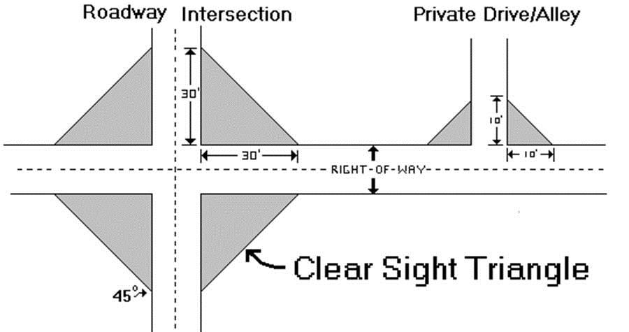
Clinic. A facility that provides outpatient medical services.
Club. A group of people organized for a common purpose to pursue common goals, interests or activities and usually characterized by certain membership qualifications, payment of fees and/or dues, regular meetings, and a constitution and bylaws.
Cluster Development. Development in which a number of dwelling units are placed in closer proximity than usual, or are attached, with the purpose of retaining an open space area.
College. An educational institution authorized by the state, awarding associate or higher degrees.
Commercial Recreation Facility. Facilities or uses that provide participant or spectator recreation. This classification includes sports stadiums and arenas, amusement parks, bowling alleys, billiard parlors, golf driving ranges, pool rooms, dance halls, ice/roller skating rinks, golf courses (daily fee), miniature golf courses, scale-model courses, shooting galleries, tennis/racquetball courts, pinball arcades or electronic games centers; it also includes health and fitness clubs, gymnastic facilities and similar uses.
Commercial Solar Field. A solar facility which is developed for purposes of generating solar power for purchase or sale, regardless of size or scale. Power generated from such fields is supplied to an electric distribution system for use by a utility service or energy provider with electric energy for wholesale or retail sale or use. A commercial solar field can be one of several solar technologies including but not limited to concentrating solar power (CSP), photovoltaics (PV) or concentrating photovoltaics (CPV). A commercial solar field does not include small-scale solar systems designed to provide electricity directly to a user on the same site, where the system is designed only to service the peak energy demand of the on-site user.
Commercial Use. An activity involving the sale of goods or services.
Commercial Vehicle. A vehicle customarily used as part of a business for the transportation of goods or people.
Commission. The Planning Commission of the City of Twentynine Palms.
Common Open Space. Land within or serving as a part of a development, not individually owned or dedicated for public use, which is designed and intended for the common use or enjoyment of the occupants of the development and may include such accessory structures and improvements as are necessary and appropriate.
Communication Facility. The antenna, antenna support structures, and buildings used for purposes of transmitting or receiving telecommunication signals.
Community Care Facility. A facility licensed to provide a living environment for unrelated residents who operate as the functional equivalent of a family, or in a group setting, including such supervision and care by support staff as may be necessary to meet the physical, emotional and social needs of aged persons, physically disabled or handicapped persons, developmentally disabled persons, nondangerous mentally ill persons, or children as defined in the appropriate statutes. Community care facilities include but are not limited to the following: residential facility, adult day care facility, therapeutic day services facility, foster family agency, foster family home, small family home, social rehabilitation facility, community treatment facility, full service adoption agency, noncustodial adoption agency and transitional shelter care facility.
Community Center. (1) A building used for recreational, social, educational and cultural activities, open to the public or a designated part of the public, usually owned and operated by a public or nonprofit group or agency; (2) a building or structure owned and operated by a governmental agency and used to provide a governmental service to the public.
Community Development Director. The City Community Development Director or his/her designee.
Complete Application. An application form completed as specified by the rules of the governmental agency and all required accompanying documents.
Conditional Use. A use permitted in a particular zoning district upon showing that such use will comply with all the conditions and standards as specified in the Development Code and authorized by the approval authority.
Conditional Use Permit. A permit for land use classifications with unusual site development features or operating characteristics requiring special consideration so that they may be designed, located and operated compatibly with uses on adjoining properties and the surrounding area.
Condominium. A building, or group of buildings, in which dwelling units, offices or floor area are owned individually, and the structure, common areas and facilities are owned by all the owners on a proportional, undivided basis.
Congregate Care Facility. A facility licensed by the California Department of Public Health, the California Department of Social Welfare, or the County of San Bernardino Department of Public Health, which provides bed and ambulatory care for patients for postoperative convalescent, chronic illness or dietary problems and persons unable to care for themselves. Such patients do not include alcoholics, drug addicts, or persons with mental or contagious affliction.
Construction Office. A temporary structure or a portion of an existing structure used as the primary management location of construction activities.
Contiguous Property. Those properties which touch property lines of any parcel, including those properties which touch said property lines of a subject parcel when such lines are projected across public or private rights-of-way, easements, roads or streets.
Convalescent Facility. A facility licensed by the California Department of Public Health, the California Department of Social Welfare or the San Bernardino County Department of Public Health, which provides bed and ambulatory care for persons unable to care for themselves. Such facilities do not include treatment of alcoholism, drug addiction, or mental or contagious diseases or afflictions.
Convenience Store. Any small retail establishment offering for sale prepackaged food products, household items, newspapers, magazines, sandwiches and/or prepared foods for off-site consumption.
Council. The Mayor and City Council members of the City of Twentynine Palms.
County. Unless otherwise specified, the County of San Bernardino, California.
Covenants, Conditions, and Restrictions (CC&Rs). A term used to describe restrictive limitations that may be placed on property and its use, and which usually are made a condition of holding title or lease.
Cul-de-sac. The turnaround at the end of a dead-end street.
Curb Face. The vertical or sloping surface on the roadway side of the curb.
(Ord. No. 292, § 4(Exh. A), 3-10-2020)
19.06.040 - "D" Definitions
Day Care Facility See Family Day Care.
Days. Shall always be consecutive calendar days, unless otherwise stated.
Dedication. The transfer of property, such as streets and roads or other public usage, to a public agency or utility for specific purposes.
Density. The number of dwelling units, households or housing structures per unit of land.
Density Bonus. See Section 19.72.030 (Definitions).
Density Transfer. The transfer of all or part of the permitted density from one parcel to another parcel.
Detached. Any building or structure that does not have a wall or roof in common with any other building or structure.
Developer. The legal or beneficial owner or owners of property to be developed or being developed, including the holder of an option or contract to purchase or other person(s) having enforceable proprietary interests in such property.
Development. Any man made change to improved or unimproved real estate, including but not limited to buildings or other structures, mining, dredging, filling, grading, paving, excavation or drilling operations, or storage of equipment or materials.
Development Agreement. A contract between the City and a developer through which the developer receives vested rights to construct a project subject to specific requirements benefiting the community.
Development Code. A set of land use regulations, as contained in Title 19 of the Twentynine Palms Municipal Code, adopted by the City which prescribes standards and regulations for land use and development.
Development Permit. A land use permit required for any man-made change to improved or unimproved real estate, including but not limited to buildings or other structures, mining, dredging, filling, grading, paving, excavation or drilling operations.
Development Rights. The legally established right to develop land by a party.
Director. The Community Development Director of the City of Twentynine Palms or his/her designee.
Discretionary Decision. An action taken by a governmental agency that calls for the exercise of judgment in deciding whether to approve and/or how to carry out a project.
District. A zone or geographic area in the municipality within which certain zoning or development regulations apply.
Drainage. (1) Surface water runoff; (2) the removal of surface water or groundwater from land by drains, grading or other means, which include runoff controls to minimize erosion and sedimentation during and after construction or development.
Drainage Area. A geographical area, formed by topography, which collects and directs surface runoff from precipitation to natural or man-made channels.
Drive-through. Any portion of a building or development intended to allow service direct from the building through a window, kiosk or automated delivery system to vehicle occupants. Such facilities include but are not limited to food service windows, automatic teller machines or similar service systems.
Driveway. A roadway providing direct access for vehicles between a street or highway and an area containing parking spaces, loading, storage or refuse collection areas.
Drug Abuse/Alcohol Recovery Facility. A care facility that provides 24-hour residential nonmedical services to adults who are recovering from problems related to alcohol and/or drug use.
Duplex. A building with two single-family dwelling units separated from each other by a common wall.
Dwelling, Attached. A dwelling joined to one or more other dwellings by common vertical walls.
Dwelling, Detached. A dwelling that is not attached to any other dwelling by any physical means.
Dwelling, Multiple-Family. A building on a single lot containing two or more dwelling units, offered for rent or lease on a monthly (or longer) basis, each of which is totally separated from the other by a wall extending from ground to roof or a ceiling and floor extending from exterior wall to exterior wall, except for a common stairwell exterior to both (or multiple) dwelling units.
Dwelling, Single-Family Detached. A building containing one dwelling unit that is not attached to any other dwelling by any means, is surrounded by open space and yards, is located on a single lot and is designed to house not more than one family.
Dwelling, Townhouse. A single-family dwelling in a row of at least three such units in which each unit has its own front and rear access to the outside, no unit is located over another unit, and each unit is separated from any other unit by one or more vertical common fire-resistant walls.
Dwelling, Triplex. A building containing three dwelling units, each of which has direct access to the outside or to a common hall.
Dwelling Unit. One or more rooms, designed, occupied or intended for occupancy as a separate living quarter, with cooking, sleeping and sanitary facilities.
Dwelling Unit, Efficiency. A dwelling unit consisting of not more than one habitable room together with kitchen or kitchenette and sanitary facilities.
19.06.050 - "E" Definitions
Easement. A right to cross or otherwise use land for a specified purpose.
Eave. The projecting lower edges of a roof overhanging the wall of a building.
Elevation. (1) A vertical distance above or below a fixed reference level; (2) a dimensioned drawing of the front, rear or side of a building showing features such as windows, doors and relationship of grade to floor level.
Emergency Shelter. See Section 19.116.030 (Definitions).
Emergency Vehicle Access. The roadway path or other surface that provides police or fire safety vehicular access from the dispatched point of origin to a facility, building, parcel, park or portion thereof. Emergency vehicle access includes, but is not limited to, fire lanes, public and private streets, parking lot lanes, access roadways, and walkways.
Emission. A discharge of pollutants into the air or water.
Encroachment. The placement or construction of a fence, building, structure or other improvement or use on another's property or on a public right-of-way.
Encroachment (Floodplain). The advance or infringement of uses, plant growth, fill, excavation, buildings, permanent structures or development into a floodplain which may impede or alter the flow capacity of a floodplain.
Equestrian Facilities. Facilities providing support to horses or the raising and use of horses for sport or pleasure. Such facilities may include riding clubs, corrals, stables, training arenas, trails, and equipment storage.
Excavation. Removal or recovery by any means of soil, rock, minerals, mineral substances, or organic substances, other than vegetation.
Existing Manufactured Home Park or Subdivision. See Section 19.62.020 (Definitions).
Exotic Animal. Any warm- or cold-blooded animal of the biological family Animalia, generally considered as wild, exotic, dangerous, venomous or not normally domesticated.
Expansion. The creation or use of additional land or floor area for a specific use or commercial activity.
Expansion to an Existing Manufactured Home Park or Subdivision. See Section 19.62.020 (Definitions).
Extension. An increase in the amount of time that a permit or approval may be valid.
(Ord. No. 292, § 4(Exh. A), 3-10-2020)
19.06.060 - "F" Definitions
Façade. The exterior walls of a building exposed to public view.
Family Day Care. A home that regularly provides care, protection and supervision for 14 or fewer children, at the provider's own home, for periods of less than 24 hours per day, while the parents or guardians are away, and is either a large family day care or a small family day care. Family day care homes are classified by the number of persons receiving care:
A.
Small Family Day Care. A home that provides family day care for eight or fewer children, including children under the age of 10 years who reside at the home.
B.
Large Family Day Care. A home that provides family day care for 9 to 14 children, including children under the age of 10 years who reside at the home.
Farmers Market Uses. Activities that involve the sale of merchandise, including but not limited to fruit and produce, on a temporary or recurring basis. Farmers market uses include certified farmers markets, open air markets and craft fairs.
Fence. An exterior physical barrier erected to enclose, screen or separate areas.
Fiscal Impact Analysis. An analysis of the costs and revenues associated with impacts to a public agency of a specific development proposal.
Flag. The symbol, insignia or display of a governmental or nonprofit organization when not displayed in connection with a commercial promotion or used as an advertising mechanism.
Flood, Flooding, Flood Water. A general and temporary condition of partial or complete inundation of normally dry land areas from the overflow of inland waters; the unusual and rapid accumulation or runoff of surface waters from any source.
Flood Insurance Rate Map (FIRM). The official map on which the Federal Emergency Management Agency or Federal Insurance and Mitigation Administration has delineated both the areas of special flood hazards and the risk premium zones applicable to the community.
Flood Insurance Study. The official report provided by the Federal Insurance and Mitigation Administration that includes flood profiles, the Flood Insurance Rate Map, the Flood Boundary and Floodway Map, and the water surface elevation of the base flood.
Floodplain or Flood-prone Area. Any land area susceptible to being inundated by water from any source. See Flood.
Floodplain Administrator. The individual appointed to administer and enforce the floodplain management regulations.
Floodplain Management. The operation of an overall program of corrective and preventive measures for reducing flood damage and preserving and enhancing, where possible, natural resources in the floodplain, including but not limited to emergency preparedness plans, flood control works, floodplain management regulations and open space plans.
Floodplain Management Regulations. Chapter 19.62 of the Development Code and other zoning ordinances, subdivision regulations, building codes, health regulations, special purpose ordinances (such as grading and erosion control) and other application of police power which control development in flood-prone areas. This term describes federal, state or local regulations in any combination thereof which provide standards for preventing and reducing flood loss and damage.
Flood Proofing. Any combination of structural and nonstructural additions, changes or adjustments to structures which reduce or eliminate flood damage to real estate or improved real property, water and sanitary facilities, structures and their contents.
Floodway. The channel of a river or other watercourse and the adjacent land areas that must be reserved in order to discharge the base flood without cumulatively increasing the water surface elevation more than 1 foot. Also referred to as Regulatory Floodway.
Floodway Fringe. That area of the floodplain on either side of the regulatory floodway where encroachment may be permitted.
Floor Area, Gross. The sum of all areas of the floors of a building or structure from the exterior face of exterior walls, or from the centerline of a wall separating two buildings, but excluding any space where the floor-to-ceiling height is less than 6 feet.
Floor Area, Net. The total of all floor areas of a building, excluding stairwells and elevator shafts, equipment rooms, interior vehicular parking or loading, and all floors below the first or ground floor, except when used or intended to be used for human habitation.
Floor Area Ratio. The gross floor area of all buildings or structures on a lot divided by the total lot area.
Food. Any item provided in Health and Safety Code Section 113781, or any successor section.
Footprint, Building. The outline of a building at all of those points where it meets the ground.
Fraternal Organization. A group of people formally organized for a common interest, usually cultural, religious or entertainment, with regular meetings, rituals and formal written membership requirements.
Fraud and Victimization. As used in Chapter 19.62 (Flood Management Regulations) of this Code, means that the variance granted must not cause fraud on or victimization of the public. In examining this requirement, the City will consider the fact that every newly constructed building adds to government responsibilities and remains a part of the community for 50 to 100 years. Buildings that are permitted to be constructed below the base flood elevation are subject during all those years to increased risk of damage from floods, while future owners of the property and the community as a whole are subject to all the costs, inconvenience, danger, and suffering that those increased flood damages bring. In addition, future owners may purchase the property, unaware that it is subject to potential flood damage, and can be insured only at very high flood insurance rates.
Frontage. See Lot Frontage orYard, Front. As used in signage calculation, seeBuilding Frontage in Section 19.88.020 (Definitions).
Functionally Dependent Use. As used in Section 19.62.190 (Conditions for Variances) of this Code, a use which cannot perform its intended purpose unless it is located or carried out in close proximity to water. The term includes only docking facilities, port facilities that are necessary for the loading and unloading of cargo or passengers, and shipbuilding and ship repair facilities, and does not include long-term storage or related manufacturing facilities.
Funeral Home, Mortuary. A building used for the preparation of the deceased for burial or cremation and the display of the deceased and ritual connected therewith before burial or cremation.
(Ord. No. 292, § 4(Exh. A), 3-10-2020)
19.06.070 - "G" Definitions
Garage. A building or a parking structure, or part thereof, used or intended to be used for the parking and storage of vehicles.
Garage, Private. A garage used exclusively for the parking and storage of vehicles owned by residents of nearby dwelling units and their guests, which is not operated as a commercial enterprise and is not available to the general public and which is owned, leased or cooperatively operated by such residents.
Gated Community. A residential development enclosed by a perimeter wall and secured at each entry point with a gate, typically accessible only to residents of the development and their guests.
General Plan. The City of Twentynine Palms General Plan as adopted by the City Council.
Glare. The effect produced by brightness sufficient to cause annoyance, discomfort or loss of visibility.
Golf Driving Range. A commercial recreational use, or accessory use to a golf course, where persons may practice long distance shots. Such facilities are generally outdoor uses.
Governing Body. The local governing unit empowered to adopt and implement regulations to provide for the public health, safety and general welfare of its citizenry.
Government Agency. Any department, commission, independent agency or instrumentality of the United States, or a state, county, incorporated local municipality, authority, district or any other agency so recognized as a governmental unit.
Government Facility. Offices and support facilities for any seat of any federal, state, county or City agency, or special district providing services to the general population.
Grade. (1) The average elevation of the land around a building; (2) the percentage of rise or descent of a sloping surface.
Grade, Finished. The final elevation of the ground level after development.
Grade, Natural. The elevation of the ground level in its natural state, before grading.
Grading. Any stripping, cutting, filling or stockpiling of earth or land, including the land in its cut or filled condition, to create new grades.
Greenhouse. A building with roof and sides made largely of transparent or translucent material used for the cultivation of plants.
Ground Floor. The first floor of a building other than a cellar or basement.
Group Home or Quarters. See Residential Care Facility.
Guest House. An attached or detached accessory building or space located on the same parcel with the primary building, for use by temporary guests of the occupants of the premises.
Gymnasium. A recreational facility providing indoor athletic activities and events.
19.06.080 - "H" Definitions
Habitable Structure. A structure which includes habitable space for living, sleeping, eating and cooking. Closets, halls, storage or utility space, and similar areas are not considered habitable space.
Handicapped Person. A person who may be classified as having a physical impairment that manifests itself in one or more of the following ways: non-ambulatory; semi-ambulatory; visually impaired, deaf or hard of hearing; having faulty coordination; and having reduced mobility, flexibility, coordination or perceptiveness due to age or physical or mental conditions.
Hardship. As used in Section 19.62.170 (Variance Procedure) of this Code, the exceptional hardship that would result from a failure to grant the requested variance. The City requires that the variance be exceptional, unusual and peculiar to the property involved. Mere economic or financial hardship alone is not exceptional. Inconvenience, aesthetic considerations, physical handicaps, personal preferences or the disapproval of one's neighbors likewise cannot, as a rule, qualify as an exceptional hardship. All of these problems can be resolved through other means without granting a variance, even if the alternative is more expensive, or requires the property owner to build elsewhere or put the parcel to a different use than originally intended.
Haul Road/Route. A road along which material is transported from the area of excavation to the processing plant, construction site or stock pile area.
Health Care Facility. A public or private facility principally engaged in providing services for health maintenance and the treatment of mental or physical conditions. This includes establishments providing support to the medical profession and patients, such as medical and dental laboratories, blood banks, or oxygen, and other similar types of medical supplies and services.
Health Club. An establishment that provides exercise facilities for use on-site.
Heating Element. Any device used to create heat for food preparation.
Highest Adjacent Grade. The highest natural elevation of the ground surface prior to construction next to the proposed walls of a structure.
Historic Preservation. The protection, rehabilitation and restoration of districts, sites, buildings, structures and artifacts significant in history, architecture, archaeology or culture.
Historic Structure. Any structure that is:
A.
Listed individually in the National Register of Historic Places (a listing maintained by the Department of the Interior) or preliminarily determined by the Secretary of the Interior as meeting the requirements for individual listing on the National Register;
B.
Certified or preliminarily determined by the Secretary of the Interior as contributing to the historical significance of a registered historic district or a district preliminarily determined by the Secretary to qualify as a registered historic district;
C.
Individually listed on a state inventory of historic places in states with historic preservation programs which have been approved by the Secretary of the Interior; or
D.
Individually listed on a local inventory of historic places in communities with historic preservation programs that have been certified either by an approved state program as determined by the Secretary of the Interior or directly by the Secretary of the Interior in states with approved programs.
Home Occupation. Any commercial or service activity carried out for gain by a resident and conducted as a customary, incidental and accessory use in a dwelling unit.
Homeowners Association. An association of owners in a condominium, planned unit development or residential subdivision established to provide management of property in which they own an undivided, common interest.
Hospital. A building providing primary health services and medical or surgical care, including facilities for overnight care, and the related facilities, medical offices and staff residences.
Hotel. A lodging facility offering transient accommodations to the general public, typically on a less than monthly basis, and which may provide additional services, such as restaurants, meeting rooms and recreational facilities.
(Ord. No. 292, § 4(Exh. A), 3-10-2020)
19.06.090 - "I" Definitions
Idle. To curtail, for a period of one year or more, surface mining operations by more than 90 percent of the operation's previous maximum annual mineral production, with the intent to resume those surface mining operations at a future date (Public Resources Code Section 2727.1).
Impact. The effect of any direct man-made actions or indirect repercussion of man-made actions on existing physical, social or economic conditions.
Impervious Surface. A surface through which water cannot penetrate, such as roof, road, sidewalk or paved parking lot.
Industrial. The manufacture, production and/or processing of consumer goods. Industrial is often divided into "heavy industrial" uses, such as construction yards, quarrying and factories, and "light industrial" uses such as research and development and less intensive warehousing assembly and/or manufacturing.
Infill Development. Development of vacant land in areas that are largely developed.
Infrastructure. Public facilities needed to sustain industry, residential, commercial and other land use activities.
Institutional Use. A nonprofit, religious or public use, such as a church, library, public or private school, hospital, or government-owned or -operated building, structure or land.
Intensification of Use. A change to the existing use of a property which results in a change or increase in vehicular or pedestrian traffic or an increase in parking requirement, or induces additional environmental impacts, including but not limited to noise, light, glare, vibration, traffic, water quality, air quality or aesthetics.
Intensity of Use. The number of dwelling units per acre for residential development and floor area ratio (FAR) for residential or nonresidential development such as commercial, office and industrial development.
Intersection. The location where two or more roadways cross at the same grade.
19.06.100 - "J" Definitions
Junk. Any scrap, waste, reclaimable material or debris, whether or not stored, for sale or in the process of being dismantled, destroyed, processed, salvaged, stored, baled or disposed of.
Junk and Salvage Facility. Structures and/or land used for storage, dismantling and/or selling of cast-off, unused, scrap or salvage material of any sort.
19.06.110 - "K" Definitions
Kennel. A commercial establishment in which dogs and/or domesticated animals are housed, groomed, bred, boarded, trained or sold.
Kitchen. Any room, all or part of which is designed and/or used for storage, refrigeration, cooking and the preparation of food.
19.06.120 - "L" Definitions
Land Clearing. Removal of vegetation by any means.
Landscape Plan. A component of a development plan on which is shown: proposed landscape species (such as number, spacing, size at time of planting, and planting details), proposals for protection of existing vegetation during and after construction, proposed treatment of hard and soft surfaces, proposed decorative features, grade changes, buffers and screening devices, and any other information that can reasonably be required in order that an informed decision can be made by the approval authority.
Land Use. A description of how land is occupied or utilized.
Land Use Application. A request for approval of a discretionary permit that is subject to one of the permit processes specified by this Code.
Land Use Decision. Any decision to approve, approve with conditions, modify or deny a request to develop, divide or otherwise utilize land or to alter or establish land use regulations.
Land Use District. A designation established by the General Plan and Development Code containing applicable rules and regulations necessary to guide development and use of all land within the district.
Legal, Nonconforming. See definitions for Nonconforming Lot, Nonconforming Structure or Building andNonconforming Use.
Legislative Act. The means by which the legislative arm of government renders decisions, such as minute actions, resolutions and ordinances.
Levee. A man-made structure, usually an earthen embankment, designed and constructed in accordance with sound engineering practices to contain, control or divert the flow of water so as to provide protection from temporary flooding.
Levee System. A flood protection system which consists of a levee, or levees, and associated structures, such as closure and drainage devices, which are constructed and operated in accord with sound engineering practices.
Living Area. The area that is air conditioned/heated. Does not include the garage, patios or screened enclosures.
Loading Space. An off-street space or berth used for the loading or unloading of cargo, products or materials from vehicles.
Local Street Improvement Fund. An account into which all fees assessed in connection with the issuance of permits for construction of a new single-family residence or new second dwelling unit with a kitchen are placed. The Local Street Improvement Fund is used solely for the purpose of constructing curbs, gutters, sidewalks and connecting pavement on streets fronting residentially zoned property in accordance with the General Plan Circulation Element. Because development subject to this fee has traffic impacts on a citywide basis, the fees are not required to be used to construct street improvements on the same street from which they are received.
Lodge. A place where members of a local chapter of an association or fraternal, cultural or religious organization hold their meetings.
Lot, Corner. A lot or parcel of land abutting upon two or more streets at their intersection or upon two parts of the same street forming an interior angle of less than 135 degrees.
Lot, Flag. A lot which utilizes a narrow strip as its means of providing frontage on a street and/or providing access to the lot.
Lot, Interior. A lot other than a corner lot.
Lot, Reverse Frontage. A through lot that is not accessible from one of the parallel or nonintersecting streets upon which it fronts.
Lot, Substandard. A parcel of land that has less than the required minimum area or dimensions.
Lot, Through. A lot that fronts upon two streets that do not intersect at the boundaries of the lot.
Lot Area, Gross. The total area within the lot lines of a lot, including any adjacent street rights-of-way.
Lot Area, Net. The total area within the lot lines of a lot, excluding any street rights-of-way.
Lot Coverage. That portion of the lot that is covered by buildings, sidewalks, driveways or other impervious surface.
Lot Depth. The average distance measured from the front lot line to the rear lot line.
Lot Frontage. The length of the front lot line measured at the street right-of-way line. For flag lots, that portion of a lot, not including the pole portion, that is generally parallel to the access street.
Lot Line. A line of record bounding a lot that divides the lot from another lot or from a public or private street or any other public space.
Lot Line Adjustment. The relocation of an interior lot line between two or more adjacent parcels, where the land taken from one parcel is added to an adjacent parcel, and where a greater number of parcels than originally existed is not thereby created.
Lot Line, Front. On an interior lot, the line separating the parcel from the street right-of-way. On a corner or through lot, the lot line abutting the street providing the primary access to the lot. On a flag lot, the interior lot line most parallel to the nearest street from which access is obtained.
Lot Line, Interior. A lot line which does not abut a street.
Lot Line, Rear. The lot line which intersects a side lot line and which is most distant from and most closely parallel to the front lot line. In the case of a triangular or otherwise irregularly shaped lot, a line within the lot having a length not less than 10 feet, parallel to and most distant from the front lot line, shall be interpreted as the rear lot line for the purpose of determining required setbacks and other provisions of this Development Code.
Lot Line, Side. Any lot line other than a front or rear lot line.
Lot Merger. The joining of two or more contiguous parcels of land under one ownership into one parcel.
Lot of Record. A lot that exists as shown or described on a recorded plat or deed in the records of the County Recorder.
Lot Width. The horizontal distance between the side lines, measured at the required front setback line.
Lowest Floor. The lowest floor of the lowest enclosed area, including basement (also see Basement). An unfinished or flood-resistant enclosure below the lowest floor that is usable solely for parking of vehicles, building access or storage in an area other than a basement area, is not considered a building's lowest floor, provided it conforms to applicable non-elevation design requirements, including but not limited to standards for the following:
A.
Wet flood proofing
B.
Anchoring
C.
Construction materials and methods
D.
Utilities
For residential structures, all subgrade enclosed areas are prohibited, as they are considered to be basements (also see Basement). This prohibition includes below-grade garages and storage areas.
19.06.130 - "M" Definitions
Manufactured Home. A factory-built structure, transportable in one or more sections, that meets the National Manufactured Home Construction and Safety Standards Act, commonly known as the U.S. Department of Housing and Urban Development (HUD) code. The termmanufactured home does not include arecreational vehicle.
Manufactured Home Park or Subdivision. A parcel (or contiguous parcels) of land divided into two or more manufactured home lots for rent or sale.
Manufacturing. The mechanical or chemical transformation of materials or substances into new products, including the assembling of component parts, the creation of products and the blending of materials.
Marquee. Any hood, canopy, awning or permanent construction that projects from a wall of a building, usually above an entrance.
May. For the purpose of this Development Code, "may" is generally used to indicate a standard or requirement that is permitted or allowed.
Mean Sea Level. For purposes of the National Flood Insurance Program, the National Geodetic Vertical Datum of 1929 or other datum, to which base flood elevations shown on a community's Flood Insurance Rate Map are referenced.
Median. An island in the center of a street, highway or other surface intended for vehicle circulation that separates opposing traffic flows.
Medical Marijuana Dispensary or Facilities. Any association, cooperative, affiliation, collective, facility, clinic or location where qualified patients and/or primary caregivers, as those terms may be defined in state law, are organized to provide education, referral or network services, and facilitate or assist in the retail distribution of medical marijuana. Also means any facility or location that is used, in full or in part, as a place at or in which marijuana is sold, traded, exchanged, bartered for in any way, made available, located, stored, placed or cultivated, including any of the foregoing if used in connection with the delivery of marijuana. Also includes mobile sales and/or establishments from which marijuana is delivered to patients who cannot obtain it from a dispensary due to physical or mental disability, for medical purposes in compliance with Health and Safety Code Sections 11362.5 through 11362.83, inclusive.
Merchandise. Any item(s) that can be sold and immediately obtained, excluding food. Items for rent shall not be considered merchandise.
Mineral Resources. A collective term for all mineral deposits of a particular kind or for mineral deposits in general.
Minerals. Any naturally occurring chemical element or compound, or groups of elements and compounds, formed from inorganic processes and organic substances, including but not limited to coal, peat and bituminous rock, but excluding geothermal resources, natural gas and petroleum (14 California Code Regulations, Section 3501). For the purposes of this Code, minerals shall also include but not be limited to sand, gravel, aggregate, cinders, diatomaceous earth, shale, limestone, flagstone and decorative stone.
Mining. The act or process of extracting mineral from the earth.
Mini-Storage. A storage facility in which individual units are rented to the public. The term includes self-storage and mini-warehouse.
Mitigation. Methods used to alleviate or lessen the impact of development.
Mobile Food Truck. A motorized vehicle or vehicle-towed trailer in which food is cooked, prepared, and/or prepackaged to order and is served to walk-up customers.
Mobile Food Truck Vending; Mobile Food Truck Activities; Mobile Food Truck Vending Activities. Actions that qualify a person as a mobile food truck vendor.
Mobile Food Truck Vendor. A person who sells food, drinks or any other consumables from a motorized vehicle or vehicle-towed trailer in which food is cooked, prepared, and/or prepackaged to order and is served to walk-up customers.
Mobile Home. A movable or transportable vehicle, other than a motor vehicle, designed as a permanent structure intended for occupancy by one family.
Mobile Home Park. Any area or tract of land where two or more lots are rented or leased, held out for rent or lease, or were formerly held out for rent or lease and later converted to a subdivision, cooperative, condominium or other form of resident ownership, to accommodate manufactured homes, mobile homes or recreational vehicles used for human habitation.
Model Home Complex. Residential units and a temporary sales office used to illustrate the design of the units to potential homebuyers.
Motel. An establishment providing transient sleeping accommodations with most rooms having direct access to the outside without the necessity of passing through the main lobby of the building.
Museum. A building or room, or any grouping thereof, open to the public, used to exhibit works of art or displays of historic objects, scientific objects or memorabilia.
(Ord. No. 292, § 4(Exh. A), 3-10-2020)
19.06.140 - "N" Definitions
New Construction. For floodplain management purposes, means structures for which the start of construction commenced on or after the effective date of floodplain management regulations adopted by this community, and includes any subsequent improvements to such structures.
New Manufactured Home Park or Subdivision. See Section 19.62.020 (Definitions).
Nightclub. An establishment dispensing liquor with or without meals and in which music, dancing or entertainment is featured.
Noise Attenuation. Reduction of noise level using a substance, material or surface, such as earth berms and/or solid concrete walls.
Nonconforming Lot. A lot, the area or dimensions of which was lawful prior to the adoption, revision or amendment of the Development Code but that fails by reason of such adoption, revision or amendment to conform to the present requirements of the Code.
Nonconforming Structure or Building. A structure or building, the size, dimension or location of which was lawful, prior to the adoption, revision or amendment of the Development Code but that fails by reason of such adoption, revision or amendment to conform to the present requirements of the Code.
Nonconforming Use. A use or activity that was lawful prior to the adoption, revision or amendment of the Development Code, but that fails by reason of such adoption, revision or amendment to conform to the present requirements of the Code.
Nuisance. An interference with the enjoyment and legal use of property, including any act, condition or thing that is illegal and/or interferes with the rights of the public generally.
19.06.150 - "O" Definitions
Obstruction. As used in Chapter 19.62, includes but is not limited to any dam, wall, wharf, embankment, levee, dike, pile, abutment, protection, excavation, channelization, bridge, conduit, culvert, building, wire, fence, rock, gravel, refuse, fill, structure, vegetation or other material in, along, across or projecting into any watercourse which may alter, impede, retard or change the direction and/or velocity of the flow of water, or due to its location, its propensity to snare or collect debris carried by the flow of water, or its likelihood of being carried downstream.
Occupancy or Occupied. The residing of an individual(s) overnight in a dwelling unit or the storage or use of equipment, merchandise or machinery in any building.
Occupancy Permit. SeeCertificate of Use/Occupancy.
Off-site. Located outside the lot lines of the lot in question.
Off-site Improvements. Improvements required as a result of development and including but not limited to curb, gutter, sidewalk, road widening and upgrading, stormwater facilities and traffic improvements.
Off-site Parking. Parking provided for a specific use but located on a site other than the one on which the specific use is located.
One Hundred Year Flood. See Base Flood.
Organizational Camp. Land or premises which is owned by an organization and used or intended to be used, let or rented for occupancy by members of the organization or campers attending camp on the premises.
Outdoor Events. Activities conducted outside for public benefit and participation including but not limited to parades, concerts, rallies and sports competitions.
Outdoor Sales. The display and sale of products and services outside of a building or structure.
Outdoor Storage. The keeping, in an unenclosed area, of any goods, junk, material, merchandise or vehicles in the same place for more than 24 hours.
Overburden. Soil, rock or other materials that lie above a natural mineral deposit or in between mineral deposits, before or after their removal by surface mining operations (Public Resources Code Section 2732).
19.06.160 - "P" Definitions
Parapet. The extension of the main walls of a building above the roof level.
Parcel Map. A map showing a subdivision of four or fewer parcels, as required by the Subdivision Map Act, prepared in accordance with the provisions of the Subdivision Map Act, and designed to be filed for recordation in the Office of the County Recorder. This excludes a remainder parcel and may be greater than four parcels if certain exceptions apply.
Park. A tract of land, designated and used by the public for active and/or passive recreation.
Park and Ride. A system where participants drive to a central location to carpool or gain access to public transportation to another location.
Parking, Commercial Lot. A business enterprise engaged in providing the service of parking space of vehicles for short-term use, typically less than 24 hours in duration.
Parking Lot. An off-street, ground-level open area, usually improved, for the temporary storage of motor vehicles.
Parking, Shared. Joint use of a parking area for more than one use.
Parking Space. A clearly defined location for the parking of a motor vehicle in a public or private parking area.
Parking Space, Covered Parking. An accessible and usable covered space of not less than 10 by 20 feet for storage of automobiles. Such covered parking space to be so located on the lot as to meet the requirements of this Title for an accessory building or, if attached to the main building, to be so located as to meet all the requirements of this Title for a main building.
Parkway. The area of a public street between the curb and the adjacent property line or physical boundary definition such as fences or walls, which is used for landscaping and/or passive recreational purposes.
Pathway. A paved or unpaved path or walkway for pedestrian travel, other than a sidewalk.
Peddler. A person who goes from house to house, from business to business, or otherwise from place to place, within the City, without prior invitation, appointment or consent, and offers the immediate sale of services or merchandise. Peddling does not include selling upon a public sidewalk or other pedestrian path, which is defined under sidewalk vending.
Peddling. Selling merchandise which is transported from place to place in the course of approaching prospective customers or selling merchandise or services from door to door.
Peddling Activities. Actions that qualify a person as a peddler.
Performing Arts Center. A building or group of buildings designed to permit the staging and conduct of theater arts and performances including music, dance and/or drama.
Permit. Written governmental permission issued by an authorized official, empowering the holder thereof to do some act not forbidden by law but not allowed without such authorization.
Permitted Use. Any use allowed in a zoning district and subject to the restrictions applicable to that zoning district.
Physically Disabled. A person who has a permanent loss of, or loss of use of, a part of the body, or permanent impairment of a body function, resulting in actual disability and a diminished ability to compete in an open market.
Planning Department/Agency. An administrative and professional division within the municipal structure charged with the responsibility of providing long-range and short-term planning services and zoning administration to the community, as established by the City.
Planning Director. The Community Development Director of the City of Twentynine Palms or authorized representative(s), as designated by the City Manager. See also Community Development Director.
Plat. (1) A map representing a tract of land showing the boundaries and location of individual properties and streets; (2) a map of a subdivision or site plan.
Plaza. An open space which is improved and landscaped, usually surrounded by streets and/or buildings.
Plot. (1) A single unit parcel of land; (2) a parcel of land that can be identified and referenced to a recorded plat or map.
Pocket Park. A small park, under one (1) acre, or outdoor area for public leisure, recreation or open space needs.
Porch. A roofed open area, which may be screened, usually attached to or part of and with direct access to or from a building.
Porte-cochere. A large entrance gateway into a courtyard, or a kind of porch roof projecting over a driveway at an entrance.
Prezoning. The process or action by which cities are able to designate that portion of an unincorporated area for future annexation, with specific zoning districts which will apply upon annexation of the property to the City.
Primary Building. See Building, Primary.
Primary Use. See Use, Primary.
Private Recreational Facilities. Facilities including but not limited to country clubs, tennis and swim clubs, golf courses, racquetball and handball facilities, and commercial uses which are commonly associated and directly related to these uses.
Professional Office. The office of a member of a recognized profession maintained for the conduct of that profession.
Prohibited Use. See Use.
Projection. That part of a building or structure which extends beyond the main wall of a building.
Public Areas. Parks, playgrounds, trails, paths, recreation areas, open spaces, scenic and historic sites, schools and other buildings and structures for public use.
Public Improvement. Any improvement or facility, together with the right-of-way necessary to provide transportation, drainage, utilities or other facilities that are usually owned, operated and/or maintained by a government agency.
Public Property. All property owned or controlled by the City, County, State, or federal government, including, but not limited to, alleys, parks, pathways, streets, parking lots, sidewalks, and walking trails.
Public Right-of-Way. An area or strip of land, either public or private, on which an irrevocable right of passage has been recorded for the use of vehicles or pedestrians or both.
Public Safety and Nuisance. As used in Chapter 19.62 (Flood Management Regulations), means that the granting of a variance must not result in anything which is injurious to safety or health of an entire community or neighborhood, or any considerable number of persons, or unlawfully obstructs the free passage or use, in the customary manner, of any navigable lake, or river, bay, stream, canal or basin.
Public Safety Uses and Facilities. Public safety uses and facilities are those facilities and uses operated by public and private organizations to protect the public health and safety including utility service providers, law enforcement agencies, fire departments, rescue squads, ambulance services and similar related uses. Public safety uses and facilities include those accessory facilities that are necessary to support the emergency response operations of public safety providers as described above.
Public Utility. See Utility.
(Ord. No. 292, § 4(Exh. A), 3-10-2020)
19.06.170 - "Q" Definitions
Quarry. A place where rock, ore, stone and similar mineral materials are excavated and processed for sale or off-site use.
19.06.180 - "R" Definitions
Ramp. (1) A sloping walkway, roadway or passage used to join and provide a smooth transition between two levels of different elevations; (2) driveways leading to parking aisles.
Reclamation. The combined process of land treatment that minimizes water degradation, air pollution, and damage to wildlife habitat, flooding, and erosion caused by either surface mining operations or adverse surface effects incidental to underground mines. Mined lands are reclaimed to a usable condition when they are readily adaptable for alternate land uses and create no danger to public health or safety. The process may extend to affected lands surrounding mined lands, and may require backfilling, grading, resoiling, revegetation, soil compaction, stabilization or other measures (Public Resources Code Section 2733).
Recreation, Active. Leisure-time activities, usually of a formal nature and often performed with others, requiring equipment and taking place at prescribed places, sites or fields.
Recreation, Commercial. See Commercial Recreation Facility.
Recreation, Passive. Activities that involve relatively inactive or less energetic activities, such as walking, sitting, picnicking, card games, chess, checkers and other table games.
Recreational Vehicle. A vehicle which is either:
A.
A motor home, travel trailer, truck camper or camping trailer, with or without motive power, designed for human habitation for recreational, emergency or other occupancy, that meets all of the following criteria:
1.
It contains less than 320 square feet of internal living room area, excluding built-in equipment, including but not limited to wardrobe, closets, cabinets, kitchen units or fixtures, and bath or toilet rooms.
2.
It contains 400 square feet or less of gross area measured at maximum horizontal projection.
3.
It is built on a single chassis.
4.
It is self-propelled, truck-mounted or permanently towable on the highways without a permit.
B.
A park trailer, as defined in California Health and Safety Code Section 18009.3.
Recreational Vehicle Park. See Special Occupancy Park.
Recyclable Material. Reusable material, including but not limited to metals, glass, plastic, paper and wood, intended for reuse, remanufacture or reconstitution for the purpose of being used in an altered form. Recyclable material does not include hazardous or potentially hazardous material as may be defined by the County of San Bernardino Division of Environmental Health Services, California Department of Toxic Substances Control and/or U.S. Environmental Protection Agency. Recyclable materials may include used motor oil.
Recycling Center/Recycling Collection Facility. A facility for the acceptance, by donation, redemption or purchase, of recyclable materials from the public. Collection facilities may include the following:
A.
Reverse vending machine(s).
B.
A small recycling collections facility, occupying a maximum area of 500 square feet which may include:
1.
A mobile unit
2.
Bulk reverse vending machines(s)
3.
Kiosk-type units
4.
Unattended containers placed for donation of recyclable materials
C.
Large collection recycling facility. A recycling facility occupying an area of more than 500 square feet, with or without permanent buildings.
Recycling Processing Facility. A facility for the collection and processing of recyclable material. Processing means the preparation of material for efficient shipment, or to an end-user's specifications, by such means as baling, briquetting, compacting, flattening, grinding, crushing, mechanical sorting, shredding, cleaning and remanufacturing.
Regulatory Floodway. The channel of a river or other watercourse and the adjacent land areas that must be reserved in order to discharge the base flood without cumulatively increasing the water surface elevation more than 1 foot.
Rehabilitation Facilities. A residential facility which provides 24-hour, nonmedical services to adults. Rehabilitation facilities include nonmedical alcoholism or drug abuse recovery, treatment or detoxification services to adults.
Remedy a Violation. As used in Chapter 19.62 (Flood Management Regulations), to bring the structure or other development into compliance with state or local floodplain management regulations, or, if this is not possible, to reduce the impacts of its noncompliance. Ways that impacts may be reduced include protecting the structure or other affected development from flood damages, implementing the enforcement provisions of Chapter 19.62 or otherwise deterring future similar violations, or reducing state or federal financial exposure with regard to the structure or other development.
Residential. Any area zoned exclusively as residential in Title 19 of this Code, including without limitation RL, RS, RE, RM, R-HD, and OSR zoning districts and all categories included therein and specific plan areas.
Residential Care Facility. Residential care facilities include intermediate health care facilities, residential care facilities for the elderly, alcoholism recovery facilities, facilities for the mentally disordered and facilities for dependent and neglected children. A residential care facility is a facility that is maintained and operated to provide nonmedical and intermediate health residential care, day treatment and/or adult day care. These facilities may operate 24 hours per day. See also Community Care Facility.
Resorts, Group Quarters, Group Camp. Any facility, place or building for the purpose of recreational activities, which may include overnight accommodations or camp areas.
Restaurant. An establishment where food and drink are prepared and served.
Restaurant, Full Service. A restaurant that includes the sale of beer and/or wine (for restaurants selling other alcoholic beverages, see Bar).
Rest Home. A facility for the housing and care of the aged and infirmed, including convalescent care not involving a physician or nurse residing on the premises and where no surgery, physical therapy or other similar activities are involved.
Retail Sales. Establishments engaged in selling goods or merchandise to the general public for personal or household consumption and rendering services incidental to the sale of such goods.
Reverse Vending Machine. An automated mechanical device which accepts one or more types of empty beverage containers and issues a cash refund or other type of redemption bonus. A reverse vending machine may sort and process containers mechanically provided that the entire process is enclosed within the machine.
Review Authority. The agency, board, group or legally designated individual that reviews development applications and makes recommendations to the approval authority.
Rezoning. (1) An amendment to the map and/or text of a zoning ordinance to effect a change in the nature, density, intensity or regulation of uses allowed on a designated parcel or land area; (2) an amendment to procedures regarding implementation of zoning regulations.
Right-of-Way. See Public Right-of-Way.
Riparian Lands. Riparian lands are composed of the vegetative and wildlife area adjacent to perennial and intermittent streams. Riparian areas are delineated by the existence of plant species normally found near fresh water.
Riverine. Relating to, formed by or resembling a river (including tributaries), stream, brook, etc.
Roaming Sidewalk Vendor. A sidewalk vendor who moves from place-to-place and stops only to complete a transaction.
19.06.190 - "S" Definitions
Satellite Dish. Any apparatus or device designed for the purpose of receiving satellite transmissions.
School. Any institution of learning for public or private, which offers instruction in those courses of study required by the California Education Code or which is maintained pursuant to standards set by the California Board of Education. This definition includes a nursery school, kindergarten, elementary school, junior high school, senior high school or any special institution of education.
School, Commercial. Any building or part thereof which is designed, constructed or used for education or instruction in any branch of knowledge or art form for commercial purposes.
School, Private. Any building or group of buildings the use of which meets state requirements for elementary, secondary or higher education and which use does not secure the major part of its funding from any governmental agency.
School, Secondary. Any school licensed by the state, authorized to award diplomas for secondary education.
School District. A district that serves as a unit for state financing and administration of elementary and secondary schools.
Scrap Metal Processing Facility. An establishment maintained, used or operated solely for the processing and preparing of scrap metals for remelting.
Screening. A method of visually shielding or obscuring a structure or use from another by fencing, walls, berms or densely planted vegetation.
Second Dwelling Unit. A self-contained living unit, either attached to or detached from, and in addition to, the primary residential unit on a lot.
Security Quarters. A dwelling unit, commercial coach or travel trailer utilized to provide temporary quarters to security personnel hired to guard part or all of the property on which the security quarters are located.
Senior Center. An assembly building intended to provide nonresidential services for senior citizens.
Senior Citizen. Any retired person over the age of 55 or any person over the age of 62 years.
Setback, Building. The required distance between the building and any lot line.
Setback, Rear. That portion of a parcel opposite the front setback.
Setback, Streetside. That portion of a parcel adjacent to a public right-of-way, exclusive of rear or side yards for residential properties in which the rear yard is both adjacent to a public right-of-way.
Setback Line. The line that establishes the area of the property within which structures or other designated uses may be erected or placed.
Shall. For the purposes of this Code, the word "shall" is used to indicate a requirement or standard that is mandatory.
Sheet Flow Area. See Area of Shallow Flooding.
Should. For the purposes of this Development Code, the word "should" is used to indicate the preferred option.
Sidewalk. That portion of a highway, other than the roadway, set apart by curbs, barriers, markings or other delineation for pedestrian travel.
Sidewalk/Parking Lot Sale. An outdoor promotional sales event conducted by one or more businesses.
Sidewalk Vending Receptacle. A pushcart, stand, display, pedal-driven cart, wagon, showcase, rack, or non-motorized conveyance used for sidewalk vending activities.
Sidewalk Vendor. A person who sells food or merchandise from a pushcart, stand, display, pedal-driven cart, wagon, showcase, rack, or other nonmotorized conveyance, or from one's person, upon a public sidewalk or other pedestrian path.
Sidewalk Vendor Activities; Sidewalk Vending; Sidewalk Vending Activities. Actions that qualify a person as a sidewalk vendor or actions done in anticipation of becoming a sidewalk vendor such as, but not limited to, installation, placement, or maintenance of any sidewalk vendor receptacles.
Sign. See Section 19.88.020 (Definitions).
Similar Use. A use that has the same characteristics as the specifically cited uses in terms of the following: trip generation and type of traffic, parking and circulation, utility demands, environmental impacts, physical space needs and clientele.
Single-Family. See Dwelling, Single-Family Detached.
Site. A parcel of land or contiguous parcels where land alterations or activities, including grading, clearing or construction, are performed or proposed.
Site Plan. The development plan for one or more lots on which is shown the existing and proposed condition of the lot, including any information that may be required for an informed decision to be made by the approval authority.
Site Plan Review. The Site Plan Review process is intended to examine proposed development to ensure a high standard of quality for buildings, landscaping, parking and general site design. Such review enables the City to maintain stability in property values and prevent deterioration of property and aesthetics throughout the community. The Site Plan Review process is more fully described in Chapter 19.36.
Slope. The land gradient described as the vertical rise divided by the horizontal run, and expressed in terms of percentage.
Slope percentage = Rise x 100 = % Run
Slope Ratio = Run = (x) ft. run to 1 ft. rise = x: 1 Rise
Soliciting. The act of asking or inviting persons to pay money in return for merchandise or services to be delivered in the future, or asking for charitable donations.
Soliciting Activities. Actions that qualify a person as a solicitor.
Solicitor. A person who goes from house to house, from business to business, or otherwise from place to place, within the City, without prior invitation, appointment or consent, and takes, or attempts to take, orders for the sale of services or merchandise for future performance or delivery.
Special Event. Any temporary permitted event approved by the City.
Special Flood Hazard Area (SFHA). An area having special flood risk, shown on an FHBM or FIRM as Zone A, AO or AE.
Special Occupancy Park. Any area or tract of land where one or more lots are rented or leased for short periods of times to owners or users of recreational vehicles.
Specific Plan. A plan for the long-range development of properties, consistent with the local general plan, regulating such things as uses permitted, density allowances, and distribution of uses and services, and including a program for the implementation of the plan.
Stable. A building designed for the housing or shelter of horses.
Staff. The staff of the various departments or divisions of the City of Twentynine Palms.
Standard. (1) A rule or measure establishing a level of quality or quantity that must be complied with or satisfied; (2) requirements of this Code regarding building and development specifications such as minimum lot area, height limit, frontage, landscaping and floor area ratio.
Start of Construction. Substantial improvement and other proposed new development and means the date the Building Permit was issued, provided the actual start of construction, repair, reconstruction, rehabilitation, addition, placement or other improvement was within 180 days from the date of the permit. The actual start means either the first placement of permanent construction of a structure on a site, such as the pouring of slab or footings, the installation of piles, the construction of columns, or any work beyond the stage of excavation; or the placement of a manufacture home on a foundation. Permanent construction does not include land preparation, such as clearing, grading and filling; nor does it include the installation of streets and/or walkways; nor does it include excavation for a basement, footings, piers, or foundations or the erection of temporary forms; nor does it include the installation on the property of accessory buildings, such as garages or sheds not occupied as dwelling units or not part of the main structure. For a substantial improvement, the actual start of construction means the first alteration of any wall, ceiling, floor or other structural part of a building, whether or not that alteration affects the external dimensions of the building.
Stationary Sidewalk Vendor. A sidewalk vendor who vends from a fixed location.
Story. That portion of a building included between the upper surface of any floor and the upper surface of the floor next above, except that the topmost story shall be that portion of a building included between the upper surface of the topmost floor and the ceiling or roof above. If the finished floor level directly above a usable or unused under-floor space is more than 6 feet above grade, as defined herein, for more than 50 percent of the total perimeter or is more than 12 feet above grade at any point, such usable or unused under-floor space shall be considered a story.
Story, First. The lowest story in a building which qualifies as a story, as defined herein, except that a floor level in a building having only one floor level shall be classified as a first story, provided such floor level is not more than 4 feet below grade for more than 50 percent of the total perimeter, or not more than 8 feet below grade at any point.
Street. A way or place of whatever nature, publicly maintained and open to the use of the public for purposes of vehicular travel.
Street Improvement Impact Fee. A fee that may be paid in lieu of requiring the construction of the street improvements required by Chapter 19.90 (Dedications and Improvements), at the discretion of the City Engineer, in connection with the issuance of a development permit for new construction.
Street Improvements. Any or all concrete curbs, gutters, sidewalks, driveway approaches and drainage structures; asphalt curbs; asphalt paving; connecting pavement; and related improvements such as back-filling and preparation of the road surface to rough grade, and the placement of paving.
Street, Private. A street that has not been accepted by the City or other governmental entity.
Structure. A walled and roofed building that is principally above ground; this includes a gas or liquid storage tank or a manufactured home.
Subdivision. The division, by any subdivider, of any unit or units of improved or unimproved land, or any portion thereof, as defined in Section 66424 of the Subdivision Map Act.
Substandard Housing Unit. A dwelling unit which is either dilapidated or unsafe or does not have adequate plumbing or heating facilities, thus endangering the health or safety of the occupant.
Substantial Damage. Damage of any origin sustained by a structure whereby the cost of restoring the structure to its before-damaged condition would equal or exceed 50 percent of the market value of the structure before the damage occurred.
Substantial Improvement. Any reconstruction, rehabilitation, addition or other proposed new development of a structure, the cost of which equals or exceeds 50 percent of the market value of the structure before the start of construction of the improvement. This term includes structures which have incurred substantial damage, regardless of the actual repair work performed. The term does not, however, include either:
A.
Any project for improvement of a structure to correct existing violations of state or local health, sanitary, or safety code specifications which have been identified by the local Code Enforcement Official and which are the minimum necessary to ensure safe living conditions, or
B.
Any alteration of a historic structure, provided that the alteration will not preclude the structure's continued designation as a historic structure.
Supportive Housing. Housing with no limit on length of stay, that is occupied by the target population, and that is linked to an on-site or off-site service that assists the supportive housing resident in retaining the housing, improving his/her health status, and maximizing his/her ability to live and, when possible, work in the community.
Surface Mining Operations. All, or any part of, the process involved in the mining of minerals on mined lands by removing overburden and mining directly from the mineral deposits, open-pit mining of minerals naturally exposed, mining by the auger method, dredging and quarrying, or surface work incidental to an underground mine. Surface mining operations shall include, but are not limited to:
A.
In place distillation, retorting or leaching
B.
Production and disposal of mining waste
C.
Prospecting and exploratory activities (Public Resources Code Section 2735)
D.
The creation of borrow pits, streambed skimming, segregation and stockpiling of mined materials, and recovery of same (14 California Code of Regulations, Section 3501)
Swap Meet. A location operated in accordance with Article 6 (commencing with Section 21660) of Chapter 9 of Division 8 of the Business and Professions Code, and any regulations adopted pursuant to that Chapter, or any successor chapter, including any indoor or outdoor place, location, or activity where new or used goods are offered for sale or exchange to the general public by a multitude of vendors, usually in compartmentalized spaces. The term swap meet is interchangeable with and applicable to flea markets, auctions, open air markets or other similar activities, but the term does not include a supermarket, department store or typical retail operations.
Swim Club. A public or private organization encouraging and supporting aquatic sports or performances.
(Ord. No. 292, § 4(Exh. A), 3-10-2020)
19.06.200 - "T" Definitions
Target Population. Persons with low incomes who have one or more disabilities, including mental illness, HIV or AIDS, substance abuse, or other chronic health condition, or individuals eligible for services provided pursuant to the Lanterman Developmental Disabilities Services Act (Division 4.5 (commencing with Section 4500) of the Welfare and Institutions Code) and may include, among other populations, adults, emancipated minors, families with children, elderly persons, young adults aging out of the foster care system, individuals exiting from institutional settings, veterans and homeless people.
Temporary Structure. A structure without a foundation which is capable of being moved.
Temporary Use. A use established for a limited duration.
Tennis Club. A public or private organization encouraging and supporting the participation in the game of tennis.
Tentative Map. A map made for the purpose of showing the design improvements of the proposed subdivision and the existing conditions in or around it.
Terminal. (1) A place where transfer between modes of transportation takes place; (2) a terminating point where goods are transferred from a truck to a storage area or to another form of transportation.
Terrace. A level, landscaped and/or surfaced area, also referred to as a patio, directly adjacent to a primary building at or within 3 feet of finished grade and not covered by a permanent roof.
Tot Lot. An improved and equipped play area for small children usually up to elementary school age.
Townhouse; Townhome. See Dwelling, Townhouse.
Toxic Substances. Any combination of contaminants, including disease-carrying agents, that, after discharge and upon exposure, ingestion, inhalation or assimilation into any organism, can cause death or disease, mutations, deformities or malfunctions in such organisms, or their offspring, and that adversely affect the environment.
Tract Map. A map showing a subdivision of five or more parcels for which a tentative and final map are required by the Subdivision Map Act, prepared in accordance with the provisions of the Subdivision Map Act, and designed to be filed for recordation in the Office of the County Recorder.
Transient Seller. A person who sells seasonal goods or merchandise from a fixed location in the City and who, in furtherance of such purpose, hires, leases, uses or occupies any building structure, room, apartment, lot, or parking lot, in the City, for the exhibition and sale of such goods and merchandise, and who does not remain at the same location for a period in excess of 90 days. Examples of seasonal goods or merchandise include Christmas trees, pumpkins, other holiday merchandise, firewood, and farm products.
Transient Selling Activities. Actions that qualify a person as a transient seller.
Transit. The conveyance of persons or goods from one place to another by means of a public transportation system.
Transitional Housing. Buildings configured as rental housing developments, but operated under program requirements that require the termination of assistance and recirculating of the assisted unit to another eligible program recipient at a predetermined future point in time that shall be no less than six months from the beginning of the assistance.
Transportation Demand Management Plan. (1) A system of actions and timetables to alleviate traffic problems through improved management of vehicle trip demand; (2) strategies aimed at reducing the number of vehicle trips, shortening trip lengths and changing the timing of trips out of peak hours.
Truck Terminal. An area and building where trucks load and unload cargo and freight and where the cargo and freight may be aggregated into smaller or larger loads for transfer to other vehicles or modes of transportation.
(Ord. No. 292, § 4(Exh. A), 3-10-2020)
19.06.210 - "U" Definitions
Use. The purpose or activity for which land or buildings are designed, arranged or intended or for which land or buildings are occupied or maintained.
Use, Primary. The principal or predominant use of any lot or parcel.
Utility. An agency that provides electricity, gas, communications, transportation, water, sewage collection or other similar service deemed necessary for the public health, safety and welfare.
Utility Facility, Major. Facilities owned or leased and operated by public, quasi-public and private utility providers including stations, substations, pumping stations, sewage and lift stations, and water storage tanks or reservoirs of 100,000 gallons or more.
Utility Facility, Minor. Facilities owned or leased and operated by public, quasi-public and private utility providers, including transmission lines, pipelines, vaults and pressure control stations, and water storage tanks under 100,000 gallons.
Utility Services. The generation, transmission and/or distribution of electricity, gas, communications and water; the collection and treatment of sewage and solid waste; and the provision of mass transportation.
19.06.220 - "V" Definitions
Variance. A grant of relief from the requirements of this Code which permits construction in a manner that would otherwise be prohibited by this Code.
Vehicle Body Repair, Paint or Restoration. A commercial use often referred to as a body and fender shop through which damaged or wrecked vehicles are repaired or restored.
Vehicle Dismantling. See Vehicle Wrecking.
Vehicle Leasing and Rental. A business whose primary purpose is to provide vehicles to serve customer transportation needs. Such vehicles may include automobiles, trucks, bicycles, motorcycles, trailers and/or recreational vehicles.
Vehicle Repair. See Automotive Repair, Major or Automotive Repair, Minor.
Vehicle Sales. A facility for the display and sale of new or used automobiles, light trucks, vans, trailers or recreation vehicles and including any vehicle preparation or repair work conducted as an accessory use in designated buildings.
Vehicle Storage Lot. A parcel or parcels of land utilized for long-term or short-term vehicle storage, including cars, motorcycles, trucks, light trucks and/or recreational vehicles.
Vehicle Wrecking. The dismantling and parting out of motor vehicles or trailers, or the storage and/or sale of dismantled or wrecked motor vehicles or their parts.
Vesting Tentative Map. A tentative map which shall have printed conspicuously on its face the words "vesting tentative map" at the time it is filed. Consistent with Sections 66498.1(b) and 66474.2(a) of the Subdivision Map Act, approval of a vesting tentative map confers a vested right to proceed with development in substantial compliance with the ordinances, policies and standards in effect at the time the vesting tentative map application is complete.
Veterinary Clinic. A place where animals are given medical care and where the boarding of animals is limited to short-term care incidental to the medical care.
Violations. The failure of a structure or other development to be fully compliant with this Code. As used in Chapter 19.62, the failure of a structure or other development without the elevation certificate, other certifications or other evidence of compliance required in this Code is presumed to be in violation until such time as that documentation is provided.
19.06.230 - "W" Definitions
Wall. (1) The vertical exterior surface of a building; (2) vertical interior surfaces that divide a building's space into rooms; (3) fences made of block or stucco, or similar permanent material.
Warehouse. A building used primarily for the storage of goods and materials.
Watercourse. A lake, river, creek, stream, wash, arroyo, channel or other topographic feature on or over which waters flow at least periodically. Watercourse includes specifically designated areas in which substantial flood damage may occur.
Water Surface Elevation. The height, in relation to the National Geodetic Vertical Datum of 1929 (or other datum, where specified) of floods of various magnitudes and frequencies in the floodplains or riverine areas.
Wheel Stops. Permanent devices that block the front wheels of a vehicle in a parking stall.
Wireless Telecommunications Facility. A land use that sends and/or receives radio frequency signals, including antennas, microwave dishes or horns, structures or towers to support receiving and/or transmitting devices, accessory development and structures. For the purposes of this Code, wireless telecommunication facilities shall refer to the non-broadcast services identified in the rules and regulations promulgated pursuant to the Federal Telecommunication Act of 1996 as amended. Non-broadcast services require special equipment for transmissions and/or reception and serve specific users. Such services include commercial wireless CRS (Cellular Radiotelephone Services), ESMR (Enhanced Specialized Mobile Radio Service), PCS (Personal Communication Services), fixed-point microwave and satellite services, private land mobile radio services, public safety radio systems and amateur users. Commercial radio and television systems are considered "broadcast services" and shall not be included in this definition.
19.06.250 - "Y" Definitions
Yard. The open space between a lot line and the required building setback line within which no structure shall be located except as otherwise provided in this Code.
Yard, Front. That portion of a parcel adjacent to a public right-of-way. In the event of multiple adjacent rights-of-way in residential land use districts (RS, RL, RM, OSR), the front shall be that portion of the lot adjacent to the lowest classification of roadway as established in the General Plan Circulation Element. For all other land use districts, the front of a lot with multiple adjacent rights-of-way shall be that portion of the lot adjacent to the highest classification of roadway as established in the General Plan Circulation Element (unless otherwise established by the General Plan). In the event that more than one adjacent right-of-way are of the same classification, building orientation shall determine the front yard in all land use districts.
Yard, Rear. That portion of a lot opposite the front yard as defined herein.
Yard, Side. That portion of a lot adjacent to a property line that is not a front or rear yard as defined herein.
Yard, Streetside. A side yard adjacent to a public right-of-way.
Youth Group. Any organization whose purpose is to provide services for children under 17 years of age.
19.06.260 - "Z" Definitions
Zero Lot Line. The location of a structure on a lot in such a manner that one or more of the structure's sides rest directly on or abut a lot line.
Zones AE or A1-30. Areas subject to inundation by the 1 percent annual chance flood event determined by detailed methods. Base flood elevations are shown. Mandatory flood insurance purchase requirements and floodplain management standards apply.
Zoning. The delineation of districts and the establishment of regulations governing the use, placement, spacing and size of land and buildings.
Zoning District. A designated section of the City for which prescribed land use requirements and building and development standards are uniform. See also Land Use District.
Zoning Map. The map or maps that are a part of a zoning ordinance that delineate the boundaries of zone districts.
Zoning, Exclusionary. Development regulations that result in the exclusion of low- and moderate-income families from a community.
Zoning, Inclusionary. Regulations that provide the opportunity to construct more affordable, diverse and economical housing to meet the needs of low- and moderate-income families.
19.06.270 - Undefined Terms
For any term not defined in this Chapter, or for any term used as part of a definition that is not defined elsewhere in this Chapter, the applicable dictionary definition of the term shall apply.