
Twentynine Palms City Zoning Code
ARTICLE 7
- Subdivision Regulations
19.150.010 - Purpose
This Chapter establishes general regulations for subdivisions as governed by the Subdivision Map Act. The regulations set forth in this Chapter are necessary for the preservation of the public health, safety and general welfare and for the implementation of the goals and policies of the adopted General Plan. The purpose of this Chapter is multifaceted as follows:
A.
Conform to the City's General Plan. To create lots of reasonable utility and livability in conformance with the goals and policies of the adopted General Plan.
B.
Orderly Growth. To provide for the orderly growth and harmonious development of the City through the regulation and control of the division of land for the purpose of sale, lease or financing, wholly or partially within the City.
C.
Implement the Subdivision Map Act. To supplement and implement the provisions of Government Code Section 66410 et seq. (the Subdivision Map Act) pertaining to the design, improvements and survey data of subdivisions.
D.
Establish Procedures. To establish procedures to be followed in securing the official approval of the reviewing authority, which may be the City Engineer, the Community Development Director (Director), the Planning Commission and/or the City Council.
E.
Ensure Adequate Traffic Circulation. To implement the Circulation Element of the General Plan by ensuring adequate traffic circulation through coordinated street systems in relation to major thoroughfares, adjoining subdivisions and public facilities.
F.
Comply with Health and Safety Requirements. To secure adequate provisions for water supply, drainage, sewage disposal, traffic control and other health and safety requirements.
G.
Consider Public Facilities. To ensure consideration of adequate sites for schools, recreation areas and other public facilities.
H.
Conserve Resources. To promote open space; conservation of resources, energy and land; and the protection and proper use of land.
I.
Conveyance of Land. To promote the conveyance of land by accurate legal description.
19.150.020 - Applicability
This Chapter applies to any division of real property wholly or partially within the incorporated area of the City except as specifically excluded by the Subdivision Map Act, this Chapter, or a development agreement adopted by Ordinance of the City Council. Divisions of land in unincorporated territory adjacent to the City are subject to these provisions to the extent permitted by the Subdivision Map Act, Section 66454, Pre-annexation Filing of Tentative Maps.
19.150.030 - Conformance
No land shall be subdivided and developed for any purpose unless it is in conformance with the goals and policies of the adopted General Plan and any applicable specific plan, and unless it is in compliance with this Development Code. The type and intensity of land use shown in the General Plan shall determine the type of street improvements, utilities and other public services that shall be provided by the developer.
19.150.040 - Subdivisions Creating Four or Fewer Parcels
A.
A Tentative Parcel Map and Final Parcel Map are required for all subdivisions creating four or fewer parcels, including condominium, townhouse, stock cooperative apartment or community apartment projects containing four or fewer parcels.
B.
Exceptions. A Parcel Map is not required when the subdivision:
1.
Is for the construction of a condominium project on a single parcel; or
2.
Creates only parcels that are more than 40 gross acres or are not less than a quarter of a quarter section; or
3.
Is created for the purpose of creating a water well site of less than 1,200 square feet; or
4.
Is a portion of the operating right-of-way of a railroad corporation defined as such by Section 230 of the Public Utilities Code which is created by short-term leases (terminable by either party on not more than 30 days' notice in writing); or
5.
Is for land conveyed to or from a governmental agency, public entity or public utility; however, land conveyed to a subsidiary of a public utility for conveyance to such public utility for rights-of-way shall not be considered a division of land for purposes of computing the number of parcels; or
6.
Complies with the requirements of the Subdivision Map Act and this Chapter as to parcel size, improvements and design, flood water drainage control, improved public roads, sewage disposal facilities, water supply availability, environmental protection and other requirements of the Subdivision Map Act and this Chapter, and provided that the boundaries of the parcels are adequately monumented. In such cases the Director, in consultation with the City Engineer, may waive the requirement for a Parcel Map, including those Parcel Maps required by Section 66426 of the Subdivision Map Act and Chapter 19.154 of this Ordinance. Such waiver automatically constitutes approval for the issuance of a Certificate of Compliance as specified in Section 66499.35 of the Subdivision Map Act. When the Parcel Map requirement has been waived, the Director shall, within 90 days and without further application and proceedings, file the Certificate of Compliance with the County Recorder.
19.150.050 - Subdivisions Creating Five or More Parcels
A.
A Tentative and Final Map are required for all subdivisions creating five or more parcels, including condominiums, townhouses, stock cooperative apartment units, or a community apartment project containing five or more parcels.
B.
For the subdivisions listed below, a Tentative Parcel Map and Final Parcel Map may be submitted in place of the Tentative and Final Map.
1.
The land before division contains less than 5 acres, each parcel created by the division abuts a maintained public street or highway and no dedications or improvements are required; or
2.
Each parcel created by the division has a gross area of 20 acres or more and has an approved access to a maintained public street or highway; or
3.
The land consists of a parcel or parcels of land having approved access to a public street or highway, which comprises part of a tract of land zoned for industrial or commercial development, and which has the approval of the governing body as to street alignments and widths; or
4.
Each parcel created by the division has a gross area of 40 acres or more or is larger than a quarter of a quarter section.
19.150.060 - Remainder Parcels
A remainder parcel is that portion of a map that is not divided for the purpose of sale, lease or financing. The parcel shall be identified on the map as "remainder parcel" and shall not be given a parcel or lot number. Alternatively, the subdivider may omit entirely that portion of land of improved or unimproved land that is not divided for the purpose of sale, lease or financing. If the subdivider elects to designate a remainder, the following requirements shall apply:
A.
The remainder parcel shall not be counted as a parcel for the purpose of determining whether a Parcel or Final Map is required.
B.
The fulfillment of construction requirements for improvements, including the payment of fees associated with any deferred improvements, shall not be required until a permit or other grant of approval for development of the remainder parcel is issued, or as otherwise agreed to between the subdivider and the City. In the absence of an agreement, the City may require fulfillment of the construction requirements, including the payment of fees associated with any deferred improvements, within a reasonable time following approval of the Final Map and prior to the issuance of a permit or other grant of approval for the development of a remainder parcel based upon a finding by the City that fulfillment of the construction requirements is necessary for reasons of:
1.
The public health and safety; or
2.
The required construction is a necessary prerequisite to the orderly development of the surrounding area.
C.
The deferral of the payment of fees associated with any deferred improvements shall not apply if the designated remainder or omitted parcel is included within the boundaries of a benefit assessment district or community facilities district.
D.
A designated remainder or any omitted parcel may subsequently be sold without any further requirement of the filing of a Parcel Map or Final Map, but the City may require a certificate of compliance or conditional certificate of compliance.
19.150.070 - Processing Fees
A fee, established by Resolution of the City Council, is required for all applications or other filings required or permitted by this Chapter or the Subdivision Map Act. A list of current fees is available from the Planning Division.
19.150.080 - Community Apartment, Condominium, Townhouse and Stock Cooperative Projects
The requirements of the Subdivision Map Act and this Chapter shall apply to all community apartment, condominium, townhouse, stock cooperative and similar projects, except those excluded by the Subdivision Map Act and Section 19.150.090 (Exclusions). Applications for the above projects are to be processed according to the requirements of the Development Code.
19.150.090 - Exclusions
A.
No Tentative Map, Parcel Map or Final Map is required for the following:
1.
The financing or leasing of apartments, offices, stores or similar space within apartment buildings, industrial buildings, commercial buildings, mobile home parks or trailer parks.
2.
Mineral, oil or gas leases.
3.
Land dedicated for cemetery purposes under the Health and Safety Code.
4.
Lot line adjustments as specified in the Subdivision Map Act.
5.
Any separate assessment under Section 2188.7 of the Revenue and Taxation Code.
6.
The conversion of a community apartment project as specified in the Subdivision Map Act.
7.
The conversion of a stock cooperative project as specified in the Subdivision Map Act.
8.
The leasing of, or the granting of an easement to, a parcel of land, or any portions thereof, in conjunction with the financing, erection, and sale or lease of a wind-powered electrical generation device on the land.
9.
The financing or leasing of any parcel of land, or any portion thereof, in conjunction with the construction of commercial or industrial buildings on a single parcel.
10.
The financing or leasing of existing separate commercial or industrial buildings on a single parcel.
11.
The construction, financing or leasing of a second dwelling unit under Government Code Sections 65852.1 and 65852.2; however, this Development Code shall apply to the sale or ownership transfer of the second dwelling unit.
12.
Leases of land for agricultural purposes; cultivation of food or fiber or the grazing or pasturing of livestock.
13.
Subdivisions of four parcels or less for the construction of removable commercial structures having a floor area of less than 100 square feet.
14.
The subdivision of a portion of the operating right-of-way of a railroad corporation (defined in Public Utilities Code Section 230) which is created by a short-term lease (terminable by either party on not more than 30 days notice in writing).
15.
Land conveyed to or from a governmental agency, public entity or public utility, or land conveyed to a subsidiary of a public utility for right-of-way, unless a showing is made in individual cases, upon substantial evidence, that public policy necessitates a parcel map. "Land conveyed to or from a governmental agency" includes a fee interest, a leasehold interest, an easement or a license.
16.
The leasing or licensing of a portion of a parcel, or the granting of an easement, Conditional Use Permit, or similar right to a telephone corporation exclusively for the placement and operation of cellular radio transmission facilities, if the action is subject to discretionary action by the City.
17.
Any other exclusions provided by the Subdivision Map Act and this Chapter.
19.150.100 - Review and Approval Authority
The various types of subdivisions shall be approved by the specified approving authority as designated in Table 19.150.100-1.
Table 19.150.100-1
Review and Approval Authority
19.152.010 - Purpose
The purpose of this Chapter is to establish development standards for the design of subdivisions.
19.152.020 - Applicability
The standards contained in this Chapter shall apply to new subdivisions.
19.152.030 - Circulation
A.
The street pattern of the proposed subdivision shall conform to the Circulation Element of the City's General Plan.
B.
The street system in the proposed subdivision shall be designed and constructed to coordinate with the existing streets in the area adjoining the proposed subdivision.
C.
The proposed street pattern shall consider the future land division and use of adjoining undivided property.
D.
Part-width boundary streets in a subdivision adjacent to undivided land shall have a minimum right-of-way width of 40 feet.
19.152.040 - Lot Design
A.
Lot size is determined by the land use district classification and the General Plan designation of the subject property.
B.
City, county, school, other district, or other taxing agency boundary lines may not divide a lot.
C.
All required lot dimensions shall be as established in this Development Code for the land use district.
D.
For pie-shaped or other irregular lots (nonrectangular), the frontage shall be measured as the straight line drawn between the terminuses of the side property lines at their intersection with the street right-of-way. For such lots, depth shall be the average of the two side lot lines.
E.
Side lot lines are to intersect street right-of-way lines at right angles wherever practicable.
19.152.050 - Access
All subdivisions shall abut a public street or have an approved access as follows:
A.
Each lot or unit in the subdivision shall have approved direct access to a public or private street.
B.
No new direct driveway access from individual residential lots onto expressways, arterials, or secondary streets shall be permitted unless approved in writing by the City Engineer.
C.
When direct access to residential property from expressways, arterials, or secondary streets is unavoidable, a circular driveway or turnaround shall be provided.
D.
Access to residential property along expressways, arterials, secondary streets (unless no reasonable alternative exists), or flood control channels shall be provided by either a frontage road or a street separated by a tier of lots (reverse frontage lots) in accordance with Section 19.152.070 (Reverse Frontage Lots). When determined necessary by the City Engineer, the City may require the location of a street approximately parallel to and on each side of such right-of-way at a distance suitable for efficient development and use of the intervening land. Such distance shall be determined with due regard to approach grades, drainage, bridges or future grade separation.
E.
For private streets, the subdivider shall provide an appropriate method for permanent maintenance subject to the approval of the City Engineer and the City Attorney.
F.
A Tentative Tract or Parcel Map shall provide at least two different standard routes of ingress and egress. Access to the project shall be subject to review and approval by the City Engineer. A standard route is a road dedicated to the City and paved to City standards.
19.152.060 - Street Layout
A.
Street layout and design shall be consistent with the Circulation Element of the General Plan and surrounding developments.
B.
Cross sections shall be in compliance with standards established by the City Engineer.
C.
Intersections shall be a minimum of 150 feet apart.
D.
All proposed new cul-de-sac streets shall not exceed 600 feet in length, unless approved in writing by the Fire Department and City Engineer.
E.
All local streets shall conform to the dimensions depicted in Figure 19.152.060-1 (Local Street).
F.
Upon the written approval of the City Engineer, the dimensions depicted in Figure 19.152.060-2 (Modified Local Street) may be allowed for cul-du-sacs in new subdivisions, in lieu of the "Local Street, 60' Right-of-Way." The "Modified Local Street, 50' Right-of-Way" may also be utilized, upon written approval of the City Engineer, for existing cul-du-sacs or a dead-end street, if, due to physical constraints, natural features or other limitations, the cul-du-sac has no potential to be connected to any other public right(s)-of-way or planned and/or anticipated public right(s)-of-way.
Figure 19.152.060-1
Local Street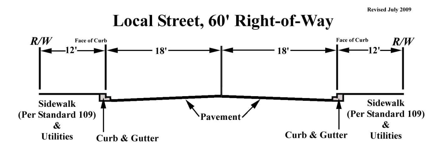
Figure 19.152.060-2
Modified Local Street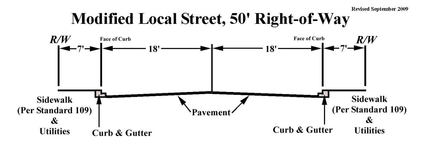
19.152.070 - Reverse Frontage Lots
When access to residential property along expressways, arterials, secondary streets or flood control channels is provided by a street separated by a tier of lots (reverse frontage lots), such lots shall not front on said right-of-way except on secondary streets where no reasonable alternative exists, and:
A.
Access to the reverse frontage lots shall be from the interior street.
B.
The subdivider shall provide a minimum 1-foot vehicular nonaccess easement (waiver of access) along the rear of the lots.
C.
The subdivider shall provide improvements as specified in Chapter 19.90 (Dedications and Improvements) of this Development Code.
19.152.080 - Energy Conservation
The design of the subdivision shall provide, to the extent feasible, opportunities for passive or natural heating and cooling opportunities to each of the proposed lots. Such opportunities may include, but are not limited to:
A.
Siting of structures to take optimum advantage of passive cooling and heating opportunities.
B.
Providing additional opportunities through land use controls for the use of solar energy systems.
C.
Adjusting of building setback lines to promote the optimum spacing of structures to create adequate solar access.
19.154.010 - Purpose
The purpose of this Chapter is to establish requirements and procedures for Tentative Parcel Maps and Tentative Maps.
19.154.020 - Applicability
Subdivisions subject to this Chapter are described in Sections 19.150.040 (Subdivisions Creating Four or Fewer Parcels) and 19.150.050 (Subdivisions Creating Five or More Parcels).
19.154.030 - Tentative Parcel Maps and Tentative Maps
A.
Procedures. This phase of the subdivision process includes the preliminary design of the subdivision and public improvements, and the submittal of the subdivision map for review and action by the Planning Commission or Community Development Director (Director) through the Community Development Department. The following procedures shall apply to requests for Tentative Parcel Map and Tentative Map processing:
1.
Submittal. The submittal of a formal application with all required supporting materials and fees.
2.
Preliminary review. Preliminary review by the Planning and Engineering Divisions to determine completeness of the project application and to prepare preliminary conditions. Section 65943 of the California Government Code requires that an application for a development permit be accepted as complete, or rejected as incomplete, in writing within 30 days after receipt of the application.
B.
Formal Review. Formal review will be conducted by the Community Development Department for the purpose of making a recommendation to the Planning Commission or Director and determining final conditions.
C.
Approval Authority Review. The Planning Commission may approve, conditionally approve or disapprove the Tentative Map at a public hearing. Tentative Parcel Maps are reviewed by the Director and do not require a public hearing.
D.
Time Limits for Tentative Map Review. The Planning Commission shall review the proposed Tentative Map within the time limits specified by applicable provisions of CEQA and the Subdivision Map Act, as follows:
1.
If an environmental impact report (EIR) is required, the EIR shall be adopted within one year of the project application being accepted as complete, subject to such limited extension as permitted by the Subdivision Map Act.
2.
If a negative declaration is required, the negative declaration shall be adopted within 105 days of the project application being accepted as complete, subject to such limited extension as permitted by the Subdivision Map Act.
3.
The Planning Commission shall approve, conditionally approve or disapprove the Tentative Map within 50 days of the adoption of the environmental document.
4.
Items (1) and (3), or (2) and (3) above may be accomplished concurrently.
E.
Soils and Geology Reports. A preliminary soils report, prepared by a qualified engineer registered in this state and based on adequate test borings, may be required for use in evaluating and reporting the environmental impact that the subdivision may have on the City. The requirement for a preliminary soils report may be waived by the City Engineer if he finds that, due to the qualities of the soils in the subdivision, no preliminary analysis is necessary.
1.
The preliminary soils report shall describe the nature of the subsurface soils and any soil conditions which would affect the geometrics of the proposed subdivision.
2.
The soils report shall state whether the proposed subdivision is feasible and provide general solutions for all known hazardous conditions or problems.
3.
The soils report shall include the locations and logs of any test borings, percolation test results and a hydrological evaluation if on-site sewage disposal is proposed.
4.
If the soils report indicates, or the City Engineer has knowledge of, the presence of critically expansive soils or other soils problems which, if not corrected, could possibly lead to structural defects or hazardous conditions, a soils investigation of each lot of the proposed subdivision may be required. The soils report shall recommend corrective action to eliminate the hazardous conditions.
5.
For hillside or other geologically hazardous areas, an engineering geology evaluation defining the geologic conditions of the site shall be submitted.
6.
The soils and geologic reports shall designate a suitable building site for each lot which is safe from settlement, landsliding, mudsliding and flood hazards and which has reasonable legal access.
7.
The Planning Commission may approve a subdivision where such soils problems exist, as identified by the City Engineer, if it finds that the recommended corrective action is likely to prevent structural damage, and eliminate other hazardous conditions, to any structure to be constructed. As a condition to the issuance of any Building Permit, the Planning Commission may require that the approved recommended corrective action be incorporated in the construction of each structure.
F.
Staff Reports and Recommendations. Any staff report or recommendations on a Tentative Map shall be in writing and a copy shall be given to the subdivider or applicant at least three days prior to any hearing or action on such map.
G.
Required Findings for Approval. No Tentative Map shall be approved unless the Planning Commission or other approval authority makes all the following findings:
1.
The proposed subdivision, together with the provisions for its design and improvement, is consistent with the goals and policies of the adopted General Plan and any applicable specific plan.
2.
The Planning Commission has considered the effects of its action upon the housing needs of the region and has balanced these needs against the public service needs of its residents and available fiscal and environmental resources.
3.
The design of the subdivision provides, to the extent feasible, for future passive or natural heating or cooling opportunities in the subdivision.
4.
The Planning Commission shall determine that adequate septic facilities are, or can be, installed for the development of the subdivision, or that a sewer system sufficient to provide for the development of the subdivision can be provided. In either case, the Planning Commission must determine whether the discharge of waste from the proposed subdivision would result in or add to a violation of the requirements as set forth in Section 13000 et seq., of the California Water Code, in which case the Planning Commission may disapprove the subdivision.
H.
Mandatory Denial of Tentative Maps. The Tentative Map shall be denied by the Planning Commission if any of the following findings are made:
1.
That the proposed subdivision is not consistent with the goals and policies of the adopted General Plan or any applicable specific plan.
2.
That the design or improvement of the proposed subdivision is not consistent with the goals and policies of the adopted General Plan or any applicable specific plan.
3.
That the site is not physically suitable for the proposed type of development.
4.
That the site is not physically suitable for the proposed density of development.
5.
That the design of the proposed subdivision or the proposed improvements is likely to cause substantial environmental damage or substantially and unavoidably injure fish or wildlife or their habitat.
6.
That the design of the proposed subdivision or the type of proposed improvements is likely to cause serious public health or safety problems.
7.
That the design of the proposed subdivision or the type of proposed improvements will conflict with easements, acquired by the public at large, for access through or use of property within the proposed subdivision or with public access to public resources as defined and regulated by the Subdivision Map Act. In this connection, the Planning Commission may approve a Tentative Map if it finds that alternate easements, for access or for use, will be provided, and that these will be substantially equivalent to the ones previously acquired by the public. This subsection shall apply only to easements of record or to easements established by judgment of a court of competent jurisdiction; no authority is hereby granted to the Planning Commission to determine that the public at large has acquired easements for access through or use of property within the proposed subdivision.
8.
That the design of the proposed subdivision does not provide to the extent feasible for future passive or natural heating or cooling opportunities pursuant to the Subdivision Map Act.
9.
That the Planning Commission has not considered the effect of its action on the housing needs of the region or has not balanced those needs against the public service needs of its residents and available fiscal and environmental resources with favorable results pursuant to the Subdivision Map Act.
I.
Appeals to the City Council. The subdivider or any other interested person may appeal the decision of the Planning Commission of the City by filing such appeal with the City Clerk within 10 days of said decision. The appeal shall be filed in writing, stating the basis for the appeal, and be accompanied by the applicable application and fee.
1.
The City Clerk shall schedule the appeal for a hearing within 30 days of the date of the filing of the appeal or such longer period of time as may be agreed to by the appellant. The City Council may sustain, modify, reject or overrule any recommendations or rulings of the Planning Commission and may make such findings as are not inconsistent with this Chapter, the goals and policies of the adopted General Plan, the Subdivision Map Act or any other applicable regulations.
J.
Expiration and Extension.
1.
Expiration of Approved Tentative Parcel Map and Tentative Maps. The approval or conditional approval of a Tentative Map or phases of a Tentative Map shall expire 36 months from the date of such approval. Failure to cause a Final Map to be officially acceptable to the City within 36 months after approval shall terminate all proceedings. Any subsequent subdivision of the same land shall require the submittal and processing of a new Tentative Map. The subdivider shall be responsible for keeping a record of the expiration date of a Tentative Map without further notice by the City beyond the written notice of approval, which shall state the expiration date.
2.
Extension of Approved Tentative Parcel Maps and Tentative Maps. The subdivider may request an extension of the Tentative Map approval by written application to the Planning Division. Such application shall be submitted and the applicable fees paid prior to its expiration. The subdivider shall attach a statement of the reasons for requesting the time extension. The application for a time extension shall be reviewed by the Director who may approve or deny the time extension request as long as there are no changes to the previously approved tentative map. Decisions of the Director may be appealed pursuant to Chapter 19.28.120 (Appeals) within 10 consecutive calendar days following the date of the action.
3.
Time Limit of Extensions. Any extension(s) of a Tentative Map approval shall not exceed the time limits established pursuant to the Subdivision Map Act (Government Code Section 66452.6). These extensions are in addition to the initial 24-month approval and any automatic extensions allowed by state law.
4.
Effect of Tentative Map Modifications on Time Extensions. A modification of a Tentative Map after its original approval shall not extend the time limits imposed by this Section.
19.154.040 - Vesting Tentative Maps
A.
Procedures and Requirements. This Section shall apply only to residential developments. Vesting Tentative Maps shall comply with the requirements of Section 19.154.030 above in addition to the following:
1.
The first step in the review process of a Vesting Tentative Map shall be a preapplication review meeting with the Planning and Engineering Divisions. All appropriate materials and fees shall be submitted with this application.
2.
At the preapplication meeting staff will identify, based on review of the materials provided, additional materials required to be submitted with the proposed Vesting Tentative Map.
3.
At the time a Vesting Tentative Map is filed, it shall have the words "Vesting Tentative Map" printed conspicuously on its face.
4.
All data included on, or any materials submitted with, the proposed Vesting Tentative Map shall be in final form, not approximate or preliminary.
B.
Development Rights.
1.
When a Vesting Tentative Map is approved or conditionally approved, that approval confers a vested right to proceed with the development in compliance with the ordinances, policies, and standards in effect at the time the application was deemed to be complete.
2.
Notwithstanding (1) above, the Planning Commission may condition or require an amendment to the map or disapprove a permit, approval, extension or entitlement, if one of the following applies:
a.
Failure to do so will put the residents of the subdivision and/or the immediate community in a condition dangerous to their health or safety.
b.
Action is required to comply with state or federal law.
3.
The rights referred to herein shall expire if a Final Map is not approved and recorded prior to the expiration of the Vesting Tentative Map. If a Final Map is approved, these rights shall remain in effect for the following time periods beyond the recording of the Final Map:
a.
An initial time period of one year. Where multiple Final Maps are to be recorded, this initial time period shall begin for each phase when the Final Map for that phase is recorded, provided it is recorded prior to the expiration of the Vesting Tentative Map.
b.
The subdivider may apply for a one year extension of the initial time period in Subsection 19.154.040.B(3)(a) above, pursuant to the provisions in Subsection 19.154.030.J (Expiration and Extension) of this Chapter. Appeals of the results of the request for an extension of time are subject to the provisions of Subsection 19.154.030.I (Appeals to the City Council) of this Chapter, provided that the subdivider may appeal the Planning Commission's denial of an extension within 15 days.
c.
Upon submittal of a complete application for a Building Permit during the time periods specified in subsections (a) and (b) above, the rights referred to herein shall continue until the expiration of that permit, or any approved extension of that permit.
4.
Required Findings for Approval of a Vesting Tentative Map. No Vesting Tentative Map shall be approved unless the approval authority makes all of the findings described in Subsection 19.154.030.G (Required Findings for Approval) of this Chapter.
5.
Required Findings for Denial of a Vesting Tentative Map. No Vesting Tentative Map shall be approved if the approval authority makes any of the findings described in Subsection 19.154.030.H (Mandatory Denial of Tentative Maps) of this Chapter.
19.154.050 - Environmental Review
A.
Environmental Impact. No Tentative Map filed in accordance with the provisions of this Chapter shall be approved until an environmental impact evaluation has been prepared, processed and considered in compliance with the provisions of CEQA. The subdivider shall submit such data and information, as required by the Director, to allow a determination of environmental review to be made in compliance with CEQA.
B.
Significant Natural Resources. Whenever a proposed subdivision contains significant natural resources, a plan for their protection and management shall be required as a condition of approval of the Tentative Map. Said plan shall be submitted for review and shall be approved prior to recordation of the Final Map.
19.154.060 - Grading and Erosion Control
All maps approved in accordance with this Chapter shall comply with the requirements for grading and wind and water erosion control, including the prevention of sedimentation or damage to off-site property, as set forth by the City Engineer and building official. Grading and erosion control plans shall be submitted to the Division of Building and Safety for review and shall be approved prior to recordation of the Final Map.
19.156.010 - Purpose
This Chapter establishes requirements and procedures for Final Parcel Maps and Final Maps. This phase of the subdivision process includes the final design of the subdivision, engineering of public improvements, and the submittal of the subdivision to the City for review and action by the City Council.
19.156.020 - Applicability
A Final Map is required for all Tentative Parcel Maps and Tentative Maps, unless waived by this Chapter or the Subdivision Map Act.
19.156.030 - Final Map Procedures
A.
Approvals.
1.
City Engineer. The subdivider shall submit the original tracing of the Final Map, prepared in accordance with the provisions of this Chapter and the Subdivision Map Act, corrected to its final form and signed by all parties required by this Chapter and the Subdivision Map Act, to the City Engineer. After review, the City Engineer shall sign the Final Map and forward it to the City Clerk within 20 days of its submittal if all the following findings can be made:
a.
He/she has examined the map.
b.
The subdivision shown is substantially the same as it appeared on the Tentative Map, including any approved alterations.
c.
All provisions of this Chapter, the Subdivision Map Act applicable at the time of approval of the Tentative Map, and the conditions of approval for the Tentative Map have been complied with.
d.
The improvement agreement and subdivision guarantee have been filed with the City.
e.
The map is technically correct.
2.
City Council. Final Maps shall be filed with the City Council upon the City Engineer's final approval of the findings pursuant to Section 19.156.030.A(1) above. If the required findings have been made, the Council shall accept and approve the Final Map and the improvement agreements at the meeting at which it receives them or at its next regular meeting. No Final Map shall be approved without prior or concurrent approval of its associated improvement agreement.
3.
Filing with County Recorder. Upon approval of the Final Map by the City Council and receipt of the improvement security by the City Engineer, the City Clerk shall execute the appropriate certificate on the map and forward it to the County Recorder for recording.
B.
Multiple Final Maps (Section 66456.1 of the Subdivision Map Act). Multiple Final Maps relating to an approved Tentative Map may be filed prior to the expiration of the Tentative Map if:
1.
The Community Development Director (Director) is informed in writing of the subdivider's intention to file multiple Final Maps prior to approval of the Tentative Map; or
2.
In the event that the intention to file multiple Final Maps is not disclosed prior to Tentative Map approval, multiple Final Maps may be filed if both the developer and the City Engineer agree on the phasing, and the proposed phasing plan does not substantially affect the conditions of approval as established by the approving authority or alter the implementation of any environmental mitigation measures established by the project CEQA determination and approval. The subdivider shall not be required to define the number or configuration of the proposed multiple Final Maps. However, the City may impose reasonable conditions, such as the sequence of map approvals, relating to the filing of multiple Final Maps.
19.156.040 - Final Map Requirements
A.
Preparation. After approval of a Tentative Map and prior to its expiration, the subdivider may submit a Final Map of the subdivision or any portion of it. The Final Map shall be prepared by a licensed land surveyor or state-registered civil engineer and shall be in substantial compliance with the approved Tentative Map. If the Final Map does not include the entire area of the approved Tentative Map, the subdivider shall obtain a suffix number to the tract number from the City Engineer.
1.
Size and Materials. Final Maps shall be clearly and legibly drawn, printed or reproduced by a process guaranteeing a permanent record in black ink on tracing cloth or polyester base film. All signatures shall be made in waterproof opaque ink and coated to ensure permanent legibility. The size of each sheet shall be 18 inches by 26 inches. A line shall be drawn around each sheet leaving a blank margin of 1 inch. The scale of the map shall be large enough to show details clearly, but not less than 1 inch equals 100 feet with all lettering a minimum of 1/8 inch in height. A different scale may be used with the approval of the City Engineer.
2.
Boundary Line. The exterior boundary lines of a subdivision shall be clearly shown on the Final Map. The map shall show the definite location of the subdivision, and particularly its relation to surrounding surveys.
3.
Title Sheets. The title sheet shall contain the certificates required by the Subdivision Map Act and a title block with the parcel or tract number.
4.
Key Map. When the Final Map consists of more than two sheets exclusive of the title sheet, a key map showing the relation of the sheets shall be placed on the first map sheet. Also a location map at a scale of 1 inch equals 800 feet and indicating the geographical location and tract access roads of the proposed subdivision shall be placed on the first map sheet. Every sheet shall be numbered with a sheet number and the total number of sheets, e.g., 1 of 5, 2 of 5.
5.
Survey Data. Final Maps shall show the bearing and distance of the centerline of all streets; arc length, tangent, radius and central angle of all curves; the bearings of radial lines to each lot corner on a curve; the total width of each street, the width of the portions offered for dedication, the width of the existing right-of-way and the width on each side of the centerline; the width of right-of-way of drainage channels; and any other easements appearing on the map. The basis for bearings referred to on the Final Map shall be approved by the City Engineer and shall be clearly delineated and identified on the map. At least one exterior boundary line shall be monumented prior to recording the Final Map. Other monuments shall be set as required by the City Engineer.
6.
Data for Lots. Sufficient data shall be shown to determine readily the bearing and length of each lot line on the Final Map. Each lot shall be shown entirely on one sheet and to scale. Distances and bearings on the lot lines of a lot which are cut by an easement shall be shown to clearly indicate the actual length of the lot line. No ditto marks may be used.
7.
Easements. Easements including but not limited to public utilities, private sewers, television cable and drainage shall be shown on the Final Map by means of broken lines, together with the name of the vestee, the use of the easement and the record reference, if any. The length, width and bearings of easement lines shall be shown with sufficient ties to locate the easement and shall be clearly labeled and identified on the Final Map. A statement of the easements of record shall appear on the title sheet.
8.
Monuments. All monuments required by the Subdivision Map Act and this Chapter shall be clearly shown and identified on the Final Map together with sufficient information to readily locate each monument. Whenever the City Engineer has established a centerline for a street or alley, that data shall be used in the survey and in preparing the Final Map. All monuments found shall be indicated and proper references made to field notes or maps of public record relating to the monuments. If points were reset by ties, that fact shall be stated.
9.
City Boundaries. City boundaries crossing or adjoining the subdivision shall be clearly designated on the Final Map.
10.
Watercourses. Any unimproved natural watercourses wholly or partially within the proposed subdivision shall be indicated on the Final Map. The map shall also show areas within the subdivision that are subject to inundation or flood hazard.
11.
Parcel Numbers and Lot Numbers. Lots shall be numbered consecutively, commencing with the number "1" with no omissions or duplications. Lots used for streets, alleys or other uses shall be lettered.
12.
Additional Information. The following information shall be included on the Final Map:
a.
Date of preparation, north arrow and scale
b.
Location and names of all existing and proposed streets and alleys, and adjoining streets and alleys
c.
Dimensions in feet and hundredths of a foot
d.
Dimensions of all lots or parcels
e.
Centerline data, including bearings and distances
f.
Radius, tangent, arc and central angle of all curves
g.
Suitable primary survey control points
h.
All required certifications
i.
The area of all lots or parcels
B.
Standard Practices. All surveys and all drafting done in connection with the preparation of a Tentative Map, a Final Map and/or improvement plans to be submitted in compliance with this Chapter shall be done in conformance to the standard practices and principles of land surveying and drafting.
C.
Final Map Preparation; Field Survey. All Final Maps shall be based on a field survey made in conformity with the Land Surveyors Act. This requirement may be waived if the City Engineer determines that sufficient survey information exists on filed maps to locate and retrace the exterior boundary lines of the map and if at least one of the exterior boundary lines can be established from an existing monumented line.
D.
Final Parcel Map Dedications; Acceptance or Rejection. At the time the City Council approves a Final Map, it shall also accept, accept subject to improvement, or reject any offer of dedication. The City Clerk shall certify on the map the action of the Council.
E.
Information to be Submitted with Final Map:
1.
Improvement Plans. Improvement plans and specifications required by this Chapter along with calculations and additional information to assist the City Engineer in properly checking the improvement plans shall be submitted with the Final Map.
2.
Improvement Agreement. All agreements and securities required by the Subdivision Map Act and this Chapter shall be submitted with the Final Map.
3.
Preliminary Engineering Geology Report. A preliminary engineering geology report shall be prepared in compliance with Subsection 19.154.030.E (Soils and Geology Reports).
4.
Preliminary Soil Report. A preliminary soil report prepared in compliance with Subsection 19.154.030.E (Soils and Geology Reports).
5.
Tax Lien Letter. A current letter from the San Bernardino County Tax Assessor's Office, certifying that there are no tax liens against the subdivision or any part of it for unpaid state, county, or City taxes or special assessments, shall be submitted with the Final Map. The letter is deemed to be current if it is no more than 30 days old when submitted.
6.
Subdivision Guarantee. A Preliminary Subdivision Guarantee and a Title Report containing the legal description of the land being subdivided shall be submitted with the Final Map. The Subdivision Guarantee shall show the names of all persons having any record title interest in the subdivision together with the nature of their respective interests. The Subdivision Guarantee shall be for the benefit of the City in an amount of at least $1,000.00 and shall cover all lands to be dedicated for public use.
7.
Deeds. Whenever land, easements or rights-of-way are to be dedicated for public use or whenever access to land, easements or rights-of-way are to be granted to public agencies, all such land, easements or rights-of-way not dedicated or granted by the owner's certificate on the Final Map shall be granted by deeds submitted with the Final Map.
8.
Off-site Easements. Written evidence of rights-of-entry or permanent easements on or across private property not within the proposed subdivision shall be submitted with the Final Map. Rights-of-entry or permanent easements are required to allow performance of the work necessary to improve the subdivision, to allow for the maintenance of the subdivision improvements after completion, to allow for permanent public access to the proposed subdivision and to grant necessary slope rights.
9.
Utility Statements. A statement from each utility system and cable television company stating that the easements shown on the Final Map are satisfactory for service to the proposed subdivision shall be submitted with the Final Map.
10.
Fire District Clearance. A statement from the Twentynine Palms Fire Department stating that adequate fire protection facilities have been planned for the proposed subdivision shall be submitted with the Final Map.
11.
Dedication of Easements for Public Use. All title, rights and easements, including any necessary off-site title, rights and easements, shall be offered for dedication at the time the Final Map is offered for approval. The City Clerk shall certify on the map the action of the City Council.
12.
Covenants, Conditions and Restrictions (CC&Rs). Any CC&Rs shall be reviewed and approved by the City Attorney prior to approval of the Final Map. The CC&Rs shall include liability insurance and methods of maintaining open space, recreation areas, parking areas, private roads and the exterior of all buildings, if appropriate.
13.
Assessment Districts. Prior to recordation of the Final Map, the subdivision shall be annexed, at the owner's expense, to the appropriate assessment district to provide for street light, landscaping and/or other applicable maintenance. Such maintenance may be performed by a homeowners association formed by the owner/developer; in such case the owner/developer shall enter into an agreement with the City which provides that if the homeowners association does not perform any required maintenance, then the City may activate the assessment district to provide such maintenance.
19.158.010 - Purpose
This Chapter establishes procedures for processing requests for reversions to acreage in accordance with Chapter 6 of the Subdivision Map Act. Requests for reversions to acreage shall be reviewed and acted upon by the Planning Commission. Appeals may be made pursuant to the provisions of this Chapter.
19.158.020 - Initiation of Proceedings
Proceedings for reversions to an acreage map may be initiated by either of the following:
A.
By Owner(s). A petition of all the owners of record in the form prescribed by and containing the information required by this Chapter and the Subdivision Map Act.
B.
By City Council. A Resolution of the City Council at the request of any person or on its own motion.
19.158.030 - Data Required for a Reversion to Acreage
A.
Adequate evidence of title to the real property in the subdivision shall be provided and one or more of the following:
1.
Evidence of the consent of all the owners of any interest in the property; or
2.
Evidence that none of the improvements required to be made have been made within two years from the date the Final Map was recorded, or within the time allowed by the improvement agreement, whichever is later; or
3.
Evidence that no lots shown on the Final Map have been sold within five years from the date the Final Map was recorded, or as otherwise may be determined appropriate by the City Council.
B.
A Final Map shall be provided with the petition, prepared in accordance with Chapter 19.156 (Final Parcel Map and Final Map) of this Code, which delineates the dedications which are not proposed to be vacated, as well as any dedications which are required as a condition to the proposed reversion to acreage.
19.158.040 - Fees
All petitions for reversion to acreage shall be accompanied by the applicable fees for processing; such fees are nonrefundable. Fees for a reversion to acreage through Resolution of the City Council shall be paid by the person requesting such resolution.
19.158.050 - Required Findings for Approval
Subdivided real property may be reverted to acreage only if the Planning Commission finds that:
A.
Dedications or offers of dedication to be vacated or abandoned by the reversion to acreage are unnecessary for present or prospective public purposes; and
B.
Either:
1.
All owners of an interest in the real property within the subdivision have consented to reversion; or
2.
None of the improvements required to be made have been made within two years from the date the Final or Parcel Map was filed for record, or within the time allowed by agreement for completion of the improvements, whichever is the later; or
3.
No lots shown on the Final or Parcel Map have been sold within five years from the date such map was filed for record, except that the required period may be modified by the City Council where it is determined that such modification is in the best interest of the public.
19.158.060 - Required Conditions of Approval
As conditions of reversion to acreage, the Planning Commission shall require:
A.
Dedications or offers of dedication necessary for the public purposes specified in the General Plan, Development Code or other applicable ordinance.
B.
Retention of previously paid fees if necessary to accomplish the purpose of this Chapter and the General Plan.
C.
Retention of any portion of required improvement security or deposits if necessary to accomplish the purpose of this Chapter.
19.158.070 - Filing Reversion Map with County Recorder
The proposed reversion to acreage shall be effective upon the recording of the Final Map by the County Recorder.
19.158.080 - Return of Fees, Deposits; Release of Securities
When a reversion to acreage is effective, fees and deposits shall be returned and improvement security released, except those retained in accordance with Section 19.158.060.B-C above. A tax bond shall not be required as part of reversion proceedings.
19.160.010 - General
Lot line adjustments modify the boundary line between two or more adjacent legal parcels where the modification complies with the following:
A.
The land taken from one parcel is added to an adjacent parcel, and where a greater number of parcels than originally existed is not thereby created.
B.
The modified parcels are consistent with or more closely compatible with the minimum lot size and area requirements of this Development Code, the goals and policies of the adopted General Plan and any applicable specific plan.
C.
The modified lot lines do not alter an existing right-of-way, except with written approval of the City Engineer.
19.160.020 - Purpose
Lot line adjustments are the relocation of existing property lines for any of the following purposes:
A.
To eliminate an existing encroachment.
B.
To meet or more closely meet the minimum lot size and area requirements of the land use district in which the subject property is located.
C.
To meet building setback requirements.
D.
To better recognize topographic features.
E.
Other purposes approved by the Community Development Director (Director).
19.160.030 - Filing Requirements
A.
Application Submittal Requirements. Applications for lot line adjustments shall be filed with the Planning Division on a form prescribed by the Director and shall contain such information and reports as may be required by the application submittal package, other applicable ordinances or the Director in order to make the required findings.
B.
Application Fee. The application shall be accompanied by a fee established by Resolution of the City Council to cover the cost of handling and processing the application as prescribed in this Development Code.
19.160.040 - Procedures
A.
The Director shall notify the applicant, within 30 days of receipt of the application, that the request does or does not meet the requirements for a lot line adjustment.
B.
The Director shall, within 30 days of the application being accepted as complete, approve, conditionally approve or disapprove the request and so notify the applicant in writing. Director approval shall only be given if it is found that the project complies with this Development Code, the goals and policies of the adopted General Plan, building codes and any applicable specific plan.
C.
Following the Director's approval, the applicant shall submit a Certificate of Compliance for each modified parcel. The Certificate of Compliance shall describe the new parcel boundaries as approved by the Director and shall be prepared by a licensed land surveyor or professional engineer qualified to prepare such documents. The original Certificate of Compliance shall be submitted to the City (along with the appropriate review fees) for review and approval by the City Engineer. Any Certificate of Compliance for parcels that are tax delinquent shall not record.
D.
Lot line adjustments shall be reflected in a recorded deed within 90 days after recordation of the Certificate of Compliance, or the lot line adjustment shall be void.
19.162.010 - General
Lot mergers combine, through elimination of existing boundary line(s), two or more adjacent parcels where the modification complies with the following:
A.
The land taken from one parcel is added to an adjacent parcel, and where a lesser number of parcels than originally existed is thereby created.
B.
The modified parcels are consistent with or more closely compatible with the minimum lot size and area requirements of this Development Code, the goals and policies of the adopted General Plan and any applicable specific plan.
C.
The action does not alter an existing right-of-way.
19.162.020 - Purpose
A.
Lot mergers are the elimination of existing property line(s) for any of the following purposes:
1.
To eliminate an existing encroachment.
2.
To meet or more closely meet the minimum lot size and area requirements of the land use district in which the subject property is located.
3.
To meet building setback requirements.
4.
To better recognize topographic features.
5.
Other purposes approved by the Community Development Director (Director).
19.162.030 - Filing Requirements
A.
Application Submittal Requirements. Applications for lot mergers shall be filed with the Planning Division on a form prescribed by the Director and shall contain such information and reports as may be required by the application submittal package, other applicable ordinances or the Director in order to make the required findings.
B.
Application Fee. The application shall be accompanied by a fee established by Resolution of the City Council to cover the cost of handling and processing the application as prescribed in this Development Code.
19.162.040 - Procedures
A.
The Director shall notify the applicant, within 30 days of receipt of the application, that the request does or does not meet the requirements for a lot merger.
B.
The Director shall, within 30 days of the application being accepted as complete, approve, conditionally approve or disapprove the request and so notify the applicant in writing. Director approval shall only be given if it is found that the lot merger complies with this Development Code, the goals and policies of the adopted General Plan, building codes and any applicable specific plan.
19.162.050 - Certificate of Compliance
A.
Upon approval, the Director may require that the applicant submit a Certificate of Compliance for each modified parcel. The Certificates of Compliance shall describe the subject parcel(s) boundaries as approved by the Director and shall be prepared by a licensed land surveyor or professional engineer qualified to prepare such documents. The original Certificates of Compliance shall be submitted to the City (along with the appropriate review fees) for review and approval by the City Engineer.
B.
A Certificate of Compliance for a parcel that is tax delinquent shall not record. In the event a Certificate of Compliance, where required, is not recorded, the lot merger shall become void.
19.164.010 - Purpose
This Chapter establishes requirements and procedures for correcting and amending Tentative and Final Maps.
19.164.020 - Tentative Maps
A.
Minor corrections or amendments to approved Tentative Maps or conditions of approval may be granted by the Community Development Director (Director) provided that all of the following are true:
1.
No lots, units or building sites are added.
2.
The proposed changes are consistent with the original Tentative Map intended findings, approval and conditions of approval.
3.
The proposed changes are consistent with the Development Code, the goals and policies of the adopted General Plan and the Subdivision Map Act.
B.
Approval of minor corrections or amendments shall not change any expiration dates. Corrections and amendments to Tentative Maps and conditions of approval which are not deemed by the Director to be minor shall be reviewed at a public hearing by the Planning Commission upon submittal of the appropriate application, materials and fees by the subdivider.
19.164.030 - Final Maps
A.
Correction. After a Final or Parcel Map is filed in the office of the County Recorder, the recorded Final Map may be modified by a Certificate of Correction or an Amending Map in order to:
1.
Correct an error in any course or distance shown; or
2.
Show any course or distance that was previously omitted; or
3.
Correct an error in the description of the real property shown on the map; or
4.
Indicate monuments set after the death, disability or retirement from practice of the engineer or surveyor charged with responsibilities for setting monuments; or
5.
Show the proper location or character of any monument which originally was shown at the wrong location or incorrectly as to its character; or
6.
Correct any other type of map error or omission as approved by the County Surveyor or the City Engineer which does not affect any property right. Such errors and omissions may include, but are not limited to, lot numbers, acreage, street names and the identification of adjacent record maps. As used in this Section, "error" does not include changes in courses or distances from which an error is not ascertainable from the data shown on the Final Parcel or Tract Map.
B.
Form and Content. The Amending Map or Certificate of Correction shall be prepared and signed by a registered civil engineer or licensed land surveyor. An Amending Map shall conform to the requirements of Chapter 19.156 (Final Parcel Map and Final Map). The Amending Map or Certificate of Correction shall set forth in detail the corrections made and the names of the present fee owners of the property affected by the corrections.
C.
Submittal and Certification.
1.
Submittal. The application for an Amending Map or Certificate of Correction shall be submitted to the City Engineer upon payment of appropriate fees and on forms provided by the City Engineer.
2.
Certification. The City Engineer shall examine the Amending Map or Certificate of Correction and if the only changes made are those set forth in Subsection 19.164.030.A above, he/she shall certify to this fact on the Amending Map or Certificate of Correction. Such certification shall not change any expiration dates.
3.
Filing with County Recorder. After the Amending Map or Certificate of Correction has been certified by the City Engineer, it shall be filed in the office of the County Recorder.
D.
Amendment. In addition to the corrections authorized by Subsection 19.164.030.A above, the recorded Final or Parcel Map may be modified by an Amendment of Final Map.
E.
Application. The subdivider may apply for an Amendment of Final Map upon submittal of the appropriate application, materials and fees to the City Engineer.
F.
Findings. No Amendment of Final Map shall be approved unless all the following findings can be made:
1.
There are changes in circumstances which make any or all of the conditions of the Final Map no longer appropriate or necessary.
2.
The modifications do not alter any right, title, or interest in the real property reflected on the recorded map.
3.
The City Engineer finds that the map, as modified, conforms to the provisions of this Chapter, the goals and policies of the adopted General Plan and the Subdivision Map Act.
G.
Notice of Hearing. The City Engineer shall set the matter for public hearing in accordance with Subsection 19.154.020.B of this Chapter. The hearing shall be confined to consideration of and action on the proposed modifications. Approval of the proposed modifications shall not change any expiration dates.
19.166.010 - Purpose
This Chapter establishes regulations for dedications and improvements.
19.166.020 - Dedication Requirements
The subdivider, as a condition of approval of a Tentative Map, shall dedicate, or make an irrevocable offer of dedication, of all parcels of land within the subdivision that are needed for streets and alleys, including access rights and abutter's rights, drainage, public open space, trails, scenic easements, public utility easements and other public easements, in accordance with the Subdivision Map Act, the goals and policies of the adopted General Plan and adopted standards. All dedications to the City for public purposes shall be made in fee title unless otherwise determined by the City Council; at the City's discretion, a grant of an easement may be accepted for open space, scenic easements, trails, parks, public utility easements or other interests as may be determined by the City Council. All dedications and grants in fee of easements shall be free of liens and encumbrances except those which the City finds would not conflict with the intended use. The City may accept an irrevocable offer of dedication in place of dedication when appropriate.
A.
Waiver of Direct Access Rights. Dedications or offers of dedications of streets may include a waiver of direct access rights to any such street from any property shown on the Final Map as abutting the street. If the dedication is accepted, any provision for waiver of direct access rights shall become effective in accordance with its provisions.
B.
Reservations. Subject to and in accordance with applicable provisions of law, including the Subdivision Map Act, the subdivider, as a condition of approval of a Tentative Map, may be required to dedicate areas of real property for parks, recreational facilities, fire stations, libraries or other public uses.
C.
School Site Reservations. Subject to and in accordance with applicable provisions of law, including the Subdivision Map Act, the subdivider, as a condition of approval of a Tentative Map, may be required to dedicate real property for the construction of an elementary school to assure the residents of the subdivision adequate public school service.
19.166.030 - Improvement Regulations
A.
The following are improvement requirements for Parcel Maps for detached single-family projects:
1.
Parcel Maps which subdivide lots for the development of those lots for single-family residences shall provide the following:
a.
One point of paved access to an existing paved road and interior street paving shall be required as a condition of Final Map approval for Parcel Map projects when any of the resulting parcels are less than 2.5 gross acres in size.
b.
Paved access to an existing paved road and interior street paving shall not be required as a condition of Final Map approval for Parcel Map projects when all of the resulting parcels are equal to or greater than 2.5 gross acres in size, or the Planning Commission finds that given the particular location and circumstances of the project such paving would be unreasonable based on the following standards: the primary public access road is unpaved for a distance greater than 1,000 feet; or such access road is farther than 1,000 feet from a paved public road, and such public access road is not identified on the City's Capital Improvement Program for paving. In all such cases the developer shall comply with (i), (ii), (iii) or (iv) below, as approved by the City Engineer:
i.
An in-lieu fee as approved by the City Engineer is paid to the City prior to map recordation to cover the particular development's fair share obligation for paving the access road; or
ii.
The owner of the property being developed executes an agreement with the City not to protest the formation of an assessment district created for the purpose of constructing paved roads; or
iii.
The property being developed is within the boundaries of an assessment district created for the purpose of paving and maintaining the local roads, which will provide direct access to the site being developed; or
iv.
The improvements have been deferred in accordance with Subsection 19.166.030.D.
2.
Parcel Maps which subdivide the land into parcels larger than the range of minimum lot sizes permitted in the land use district shall be required to install improvements as a condition of Final Map approval, except where the improvements have been deferred in accordance with Section 19.166.030.D.
B.
The following are improvement requirements for the following parcel maps. Street improvements for commercial, industrial and/or multi-family developments, or Parcel Maps which are used as a financing vehicle for new development or described in paragraph 2 above, may be deferred and/or phased by the approval authority on a case-by-case basis subject to the criteria below. Improvements for such projects shall be required when a building permit is issued unless a deferral agreement is approved and recorded against the property which guarantees performance at the time determined necessary by the City Engineer.
C.
Parcel Maps which are used as a financing vehicle shall be defined for purposes of this Section as a Parcel Map which is processed in conjunction with or subsequent to another type of land use approval (e.g., subdivision, site plan review, Conditional Use Permit, Specific Plan) under which improvements are required to be installed.
D.
The approval authority may grant approval for a deferral of improvements or a partial deferral of improvements with good cause. The approving authority shall direct that a deferral agreement be executed in such cases. The approval authority may grant approval of deferral of improvements only when a finding can be made that the parcel or subject property is in reasonable proximity to existing improvements and infrastructure and that the necessary improvements to serve development of the property can or will be feasibly provided.
E.
Improvement Agreement. Prior to submitting a Final Map for approval, the subdivider shall execute an improvement agreement, in a form approved by the City Engineer and City Attorney, specifying the time by which the required improvements will be completed. The improvement agreement shall be reviewed by the City Council and, if approved, executed by the City Manager. The improvement agreement shall be secured as provided for in Subsection 19.166.030.G (Improvement Security) of this Chapter.
F.
Improvement Agreement; Time Extensions. The completion date specified in the improvement agreement, or as specified in paragraph (E) above, may be extended by the City Council for subdivisions of five or more parcels and by the City Engineer for subdivisions of four or fewer parcels upon a written request by the subdivider. The request for said time extensions, along with the appropriate application, materials and fees, shall be submitted at least 30 days prior to the expiration of the improvement agreement or the time specified in paragraph (E) above.
G.
Improvement Security. Improvement securities are required to be submitted as a guarantee of the completion of improvements required as a condition of approval of any Final Map. Acceptable forms of security, subject to approval by the City Engineer, are limited to one of the following:
1.
A bond or bonds by one or more duly authorized corporate sureties.
2.
A deposit, either with the local agency or a responsible escrow agent or trust company, of money or negotiable bonds of the kind approved for securing deposits of public monies.
3.
An irrevocable instrument of credit from one or more financial institutions subject to regulation by the state or federal government pledging that the funds necessary to carry out the agreements are on deposit, guaranteed for payment, and constitute a trust fund which is not subject to levy or attachment by any creditor of the depositor until released by the City.
H.
Completion of Improvements. Unless a different time period is specified by an approved improvement agreement, the subdivision improvements shall be completed by the subdivider within 12 months of the approval of the Final Map, unless a time extension is granted by the City Council.
I.
Amount of Security. Security to guarantee the construction or installation of all improvements shall be required in the following amounts for all subdivisions:
1.
For "Faithful Performance," an amount determined by the City Engineer to be 100 percent of the full cost of the improvements to guarantee faithful completion of the work; and
2.
For "Materials and Labor," an amount determined by the City Engineer to be 50 percent of the cost of the improvements to guarantee payment to contractors, subcontractors, vendors and laborers furnishing materials, equipment or labor in connection with the improvements; and
3.
For "Guarantee, Warranty, and Maintenance of Work," an amount determined by the City Engineer to be 50 percent of the cost of the improvements to guarantee and warrant the work for a period of 12 months following completion and acceptance of said work by the City against any defective work or labor done or defective materials.
J.
Improvement Plans. The subdivider shall prepare plans and specifications for the required improvements in accordance with this Chapter, the Subdivision Map Act, any adopted standards and the regulations of any other agency having jurisdiction over said improvements.
1.
Preparation. Improvement plans shall be prepared in accordance with standard engineering practices and to the standards of the City and any other agency having jurisdiction. Improvement plans shall be prepared under the direction of and be signed by a state-registered civil engineer. Said plans shall show the complete plans, profiles and details for all improvements necessary to serve the proposed subdivision, including but not limited to, the following:
a.
All street improvements
b.
Curbs, gutters and sidewalks
c.
Drainage channels and structures
d.
All underground utilities including all appurtenances located in the right-of-way
e.
Underground utilities not within the right-of-way that may control the location and elevation of storm drains or culverts
f.
Retaining walls and other improvements to support cut slopes and embankments
g.
Structures and drainage facilities necessary to control slides
h.
Bridges
i.
Required fences, walls and gates
j.
Other improvements required to complete the work, including off-site improvements
2.
Scale. The improvement plans shall be legibly drawn to a scale of 1 inch equals 40 feet or to a different scale approved by the City Engineer.
3.
Grading. Improvement plans shall also include complete grading plans. These plans shall show proper grading and erosion control, including prevention of sedimentation damage to off-site property.
4.
Approval. The City Engineer shall review the improvement and grading plans and if such plans comply with this Chapter, the Subdivision Map Act, adopted standards and any other applicable regulations, the City Engineer shall sign the plans.
5.
Changes. No changes shall be made to approved improvement and grading plans without prior approval of the City Engineer. Requests for changes shall be accompanied by the appropriate application, materials and fee.
6.
Cost Estimates. An estimate of the cost of the improvements for the proposed subdivision shall be prepared and submitted by the subdivider with each submittal (or resubmittal) of the improvement plans. After consideration of the estimates provided, the City Engineer shall make the final determination of the cost of the improvements for the proposed subdivision.
7.
Commencement of Improvements; Staged Grading. Grading of the proposed subdivision and construction of any improvements shall not begin until the grading and improvement plans have been approved by the City Engineer and the Final Map is recorded. Staged grading (prior to recording the Final Map) may be permitted if the City Engineer finds that such grading will not be detrimental to the subdivision improvements or the surrounding properties. Such approval, if granted by the City Engineer, shall be in writing.
19.166.040 - Remainder Parcel - Improvement Requirements
The fulfillment of construction requirements for improvements for remainder parcels shall not be required until a permit or other grant of approval for development is issued by the City or until the construction of the improvements is required by an agreement between the subdivider and the City. In the absence of such an agreement, the City may require construction of improvements within a reasonable time following approval of the Final Map and prior to the issuance of a permit or other grant of approval for development of the remainder parcel if the City Council finds that:
A.
Construction of the improvements is necessary for the public health and safety; or
B.
Construction of the improvements is prerequisite to the orderly development of the surrounding area.
19.166.050 - Supplemental Off-site Improvements
A.
Supplemental Off-site Improvements Required. When the subdivider is required to install supplemental off-site improvements in addition to those required to serve the needs of the subdivision, the City shall, at the subdivider's request, enter into an agreement with the subdivider for reimbursement of the costs to install such supplemental improvements. Supplemental off-site improvements include, but are not limited to, supplemental size, capacity, number or length for the benefit of property not within the subdivision. Supplemental off-site improvements shall be dedicated to the public.
B.
Reimbursement Agreement. The reimbursement agreement shall be for that portion of the improvements in excess of the construction required for the subdivision, to be reimbursed from monies collected for that purpose from future developments benefitting from the supplemental off-site improvements.
C.
Method of Reimbursement. The City Council may, at its discretion, select one of the following methods of reimbursement to the subdivider:
1.
Immediately reimburse the subdivider for the entire cost of the supplemental off-site improvements and levy a charge on the real property benefitted by said improvements.
2.
Collect a reasonable use charge for the subdivider's account from persons not within the subdivision using the improvements.
3.
Establish and maintain local benefit districts for the levy and collection of the charge attributable to the properties benefitted by the supplemental off-site improvements.
4.
Establish a reimbursement agreement and lien on undeveloped properties benefitting from said improvements whereby, upon development, those properties shall pay their fair share of the improvements to the City for the City's transmittal to the subdivider who constructed the improvements; or to reimburse the City funds in the event the City has already reimbursed said subdivider pursuant to Subsection 19.166.050.C(1).
D.
Cost of Drainage and Sewer Facilities. Subject to the provisions of the Subdivision Map Act, as a condition of approval of any Tentative or Final Map and provided such map is filed at least 30 days after the adoption of any applicable drainage or sewer plan, or as a condition of issuing a building permit if a benefit area has been established, the subdivider may be required to pay fees, or other consideration in lieu of fees, to defray the cost of constructing the planned drainage or sewer facilities.
E.
Cost of Bridges and Major Thoroughfares. Subject to the provisions of the Subdivision Map Act, as a condition of approval of any Tentative or Final Map or as a condition of issuing a building permit and if a benefit area has been established, the subdivider may be required to pay fees, or other consideration in lieu of fees, to defray the cost of constructing bridges over waterways, drainage areas, or canyons and/or the cost of constructing major thoroughfares.
19.166.060 - Work in Conformance with Specifications - Exceptions
All work shall be done in conformance with adopted standards. As an alternative, the City Engineer may permit work to be performed under less restrictive specifications than standard specifications if all the following findings can be made:
A.
That the work permitted to be done under less restrictive specifications is interim in nature.
B.
That full compliance with standard specifications will be achieved when future planned improvement work is completed.
C.
That circumstances make it unsound to require strict adherence to standard specifications during the interim.
D.
That the interim exception to full compliance with standard specifications will not adversely affect the public health, safety and welfare.
E.
That there has been adequate compliance, approved by the City Attorney, with all the financial security requirements to guarantee performance of the obligation to faithfully complete the improvements.
19.166.070 - Construction Inspections
A.
General. All improvement work is subject to inspection by the City Engineer to be in compliance with the City's standard specifications.
B.
Preconstruction Conference. Prior to commencing any improvement construction, the subdivider shall arrange for a preconstruction conference with the City Engineer or his/her representative.
C.
Final Inspection. When the improvements are complete, the subdivider shall apply in writing to the City Engineer for a final inspection. The final inspection shall then be scheduled by the City Engineer.
D.
Deficiency List. If necessary, a deficiency list will be compiled during the final inspection noting all corrections and any additional work required. When the corrections and any additional work required are completed, the subdivider shall apply in writing for a reinspection. If the City Engineer finds that all corrections and any additional work are satisfactorily completed and as-built plans received, the subdivision will be placed on the City Council agenda for acceptance.
E.
As-Built Plans. Prior to acceptance of the subdivision by the City Council and the release or reduction of the improvement security, the subdivider shall submit as-built plans to the City Engineer. As-built plans shall consist of two sets of prints and the original ink tracing modified to reflect the improvements as built.
19.168.010 - Purpose
This Chapter establishes requirements and procedures for issuance of Certificates of Compliance.
19.168.020 - Lawful Parcels Created before March 4, 1972
A.
For purposes of this Chapter, any parcel created prior to March 4, 1972, shall be conclusively presumed to have been lawfully created if the parcel resulted from a division of land in which fewer than five parcels were created and if, at the time of the creation of the parcel, the County did not have an ordinance in effect which regulated divisions of land creating fewer than five parcels.
B.
For the purposes of this Chapter, any parcel created prior to March 4, 1972, shall be conclusively presumed to have been lawfully created if any subsequent purchaser acquired that parcel for valuable consideration without actual or constructive knowledge of a violation of the County ordinance.
C.
Owners of parcels or units of land affected by the provisions of this Chapter shall be required to obtain a Certificate of Compliance or a conditional Certificate of Compliance pursuant to Sections 19.168.030 (Unconditional Certificate of Compliance) or 19.168.040 (Conditional Certificate of Compliance) of this Chapter prior to obtaining a permit or other grant of approval for development of the parcel or unit of land.
D.
A parcel shall not be deemed created on or before March 4, 1972, if it was:
1.
Solely the result of a right-of-way dividing parcels; or
2.
Shown solely on a record of survey, unless the subject parcel was shown on a record of survey map filed between January 1, 1937, and January 1, 1955, on the basis of a Tentative Map approved for a subdivision of five or more lots; or
3.
Shown solely on an unrecorded Subdivision Map or unrecorded Parcel Map; or
4.
For subdivisions creating five or more parcels, the subject parcel did not meet the minimum parcel size of the zoning applicable at the time the subject parcel was originally created; or
5.
The subject parcel was described as a "parcel" on one deed, but the owner is unable to document its conveyance by a separate deed on or before March 4, 1972; or
6.
The subject parcel was created under circumstances which demonstrate an intent to circumvent the Subdivision Map Act and other applicable regulations.
19.168.030 - Unconditional Certificate of Compliance
The subject parcel qualifies for an unconditional Certificate of Compliance if:
A.
The subject parcel was conveyed by a separate document on or before March 4, 1972. Written evidence in the form of a contract of sale, grant deed, or deed of trust which was recorded on or before March 4, 1972, or other documentation is required to support a bona fide conveyance of the subject parcel on or before March 4, 1972; and
B.
The subject parcel complied with the Subdivision Map Act at the time of its creation; and
C.
At the time of its creation, the subject parcel was in compliance with all local applicable ordinances including lot size; and
D.
The subject parcel has been "approved for development" in accordance with Section 66499.34 of the Subdivision Map Act by:
1.
The issuance of a permit or a grant of approval for development of the subject parcel; or
2.
Improvements that were completed prior to the time a permit or grant of approval for development was required by regulations in effect at the time of the improvement; or
3.
Improvements that were completed in reliance upon a permit or grant of approval for development.
19.168.040 - Conditional Certificate of Compliance
The subject parcel qualifies for a conditional Certificate of Compliance if:
A.
The applicant is the current owner of record and was the owner of record at the time of the initial creation of the subject parcel in violation of the Subdivision Map Act or other applicable regulations. In such cases a conditional Certificate of Compliance shall be issued, imposing such conditions as would have been applicable to a current division of the property.
B.
The applicant was not the owner of record at the time of the initial creation of the subject parcel in violation of the Subdivision Map Act or other applicable regulations. In such cases a conditional Certificate of Compliance shall be issued, imposing such conditions as would have been applicable to the division of the property at the time the applicant acquired his/her interest in the property.
19.168.050 - Application
Any owner of real property may file an application for a Certificate of Compliance. The application shall be made to the City Engineer and be accompanied by any required materials and the appropriate fee for each parcel requested to be certified. Each application for a Certificate of Compliance shall be accompanied by all the information required by the City Engineer.
19.168.060 - Requirements for Review
A.
Unconditional Certificate of Compliance:
1.
Review. The City Engineer shall, within 50 days of the acceptance of a complete application, materials and fee, review and make a final determination as to whether or not an unconditional Certificate of Compliance can be issued for the subject real property.
2.
Finding. The City Engineer, in consultation with the Community Development Director (Director), shall determine if the subject real property complies with the provisions of the Subdivision Map Act and this Chapter, and if the proposed development of the subject property will not be detrimental to the public health, safety and welfare.
3.
Recordation. If the above determination is so made, the City Engineer shall cause a Certificate of Compliance to be filed for record with the County Recorder.
B.
Conditional Certificate of Compliance:
1.
Review. The City Engineer shall, within 50 days of the acceptance of a complete application, materials and fee, review and make a final determination as to whether or not a conditional Certificate of Compliance can be issued for the subject real property.
2.
Finding. If the City Engineer, in consultation with the Director, finds that the subject real property was divided in violation of the Subdivision Map Act or the provisions of this Chapter, but that the proposed development may be approved as being not detrimental to the public health, safety and welfare, a Certificate of Compliance may be issued by the City Engineer contingent upon the completion of specific conditions.
3.
Conditions. Conditions as would have been applicable to the division of real property at the time that the current owner of record acquired the property may be imposed. Where the applicant was the owner of record at the time of the initial violation, who by a grant of the real property created a parcel or parcels in violation, and such person is the current owner of record of one or more of the parcels that were created as a result of the grant in violation, then conditions as applicable to the current division of land may be imposed:
a.
When conditions are imposed, they shall be filed for recordation with the County Recorder on a conditional Certificate of Compliance.
b.
The conditions shall be fulfilled and implemented by the owner who has applied for the Certificate of Compliance or any subsequent owner.
c.
Compliance with the conditions shall not be required until such time as a permit or other grant of approval for the development or use of the property is issued by the City, unless the property is subsequently included as a part of a legal subdivision of real property in accordance with the provisions of this Title.
d.
The owner shall notify the City Engineer when the conditions are completed. If compliance with the conditions is satisfactory, the City Engineer shall issue and record a final Certificate of Compliance.
C.
Certificate of Compliance and Waiver of Parcel Map. A Certificate of Compliance is required on all Parcel Maps for which the Final Map has been waived or for all land divisions for which the Parcel Map has been waived. Since there is no Final Map to record, a certificate is necessary to record a legal description of the property that has been divided.
19.170.010 - Purpose
This Chapter establishes enforcement procedures for subdivisions.
19.170.020 - Indemnification
As a condition of approval of a Tentative, Parcel or Final Map application, the subdivider and his/her agent, as applicable, shall defend, indemnify and hold harmless the City, and its agents, officers and employees, from any claim, action or proceeding against the City as a result of the action or inaction of the City, Community Development Director (Director), City Engineer, Planning Commission, and/or City Council in reviewing, approving or denying the Map, and from any claim, action or proceeding against the City, its agents, officers or employees to attack, set aside, void or annul an approval of the City, Director, City Engineer, Planning Commission, and/or City Council concerning a subdivision. The City will promptly notify the subdivider of any claim, action or proceeding made known to the City, and will fully cooperate in the defense.
19.170.030 - Enforcement
The conditions of approval may be enforced by the City at the expense of the owner/developer or his/her successor if the owner/developer or his/her successor fails to enforce the provisions contained in such conditions of approval.
19.170.040 - Remedies
A.
Any deed of conveyance, sale or contract to sell real property which has been divided, or which has resulted from a division in violation of the provisions of this Development Code or the Subdivision Map Act, is voidable at the sole discretion of the grantee, buyer or person contracting to purchase, his/her heirs, personal representative or trustee in insolvency or bankruptcy, within one year of the date of discovery of the violation. The deed of conveyance, sale or contract to sell is binding upon any successor in interest of the grantee, buyer, or person contracting to purchase, other than those enumerated above and upon the grantor, vendor or person contracting to sell, his/her assignee, heir or devisee.
B.
Any grantee, or his/her successor in interest, of real property which has been divided, or which has resulted from a division in violation of the provisions of this Chapter or the Subdivision Map Act may, within one year of the date of discovery of the violation, bring an action in the Superior Court to recover any damages he/she has suffered by reason of such division of property. The action may be brought against the person who divided the property in violation and against any successors in interest who have actual or constructive knowledge of such division of property.
C.
The provisions of this Section shall not apply to the conveyance of any parcel of real property identified in a Certificate of Compliance filed in accordance with this Development Code and Section 66499.35 of the Subdivision Map Act, and shall not apply to any parcel of real property identified in a recorded Parcel Map or Final Map, from and after the date of recording. The provisions of this Section shall not limit or affect the rights, in any way, of a grantee or his/her successor in interest under any other applicable law.