Twentynine Palms City Zoning Code
ARTICLE 8
- Adopted Overlays and Specific Plans
Chapter 19.175 - Specific Plan 6 Downtown Economic Revitalization Specific Plan[1]
Editor's note—Ord. No. 315, § 4(Exh. A), adopted Dec. 12, 2023, repealed the former Ch.19.175, §19.175.010, and enacted a new Ch. 19.175 as set out herein. The former Ch. 19.175 pertained to similar subject matter and derived from original codification.
19.172.010 - Intent and Purpose of the Overlay
The overlay shall be that area depicted on Figure 19.172.010-1 (Overlay District for the Mesquite Dunes, Mesquite Dunes Bosque, and Playa Lakebed). The intent and purpose of this overlay district is to establish development regulations to protect the natural beauty and biological resources of the Mesquite Dunes, Mesquite Dunes Bosque, and Playa Lakebed.
19.172.020 - Development Requirements
Proposed developments having portions of areas within the overlay may credit this area for requirements related to landscaping and permeable surface. To preserve the open space resources and prevent destruction of the Mesquite Dunes, Mesquite Dunes Bosque, and Playa Lakebed, the following restrictions shall apply:
A.
Grading shall be limited to that necessary for approved building foundations, parking, and access driveways. A Grading Permit for grading of land in excess of this limitation shall not be issued unless specifically approved by the Planning Commission, at a noticed public hearing, with specific findings that the proposed permit will not degrade the integrity of the open space resources.
B.
Proposed developments with views of the dunes shall be encouraged to be designed so that the configuration and placement of buildings benefit from views of the dunes (e.g., orientation of windows, main building entries, major drive aisles and courtyards).
C.
Development shall be designed and located to avoid or minimize disturbance to the dunes and other prominent natural features.
D.
Sand extraction is not permitted.
E.
A comprehensive hydrogeological investigation addressing historic depth of the water table shall be performed prior to the approval of any Use Permit in the Overlay District, with minimum separation of 40 feet from the historic water table to the bottom of any leaching trench or pit.
19.172.030 - Biological Resources
The Mesquite Bosque on the southwestern shore of Mesquite Lake represents an important habitat, due to the limited nature of such woodland habitat in this region. Although the site has been severely devastated by woodcutting, sufficient tree cover persists to constitute a sensitive habitat.
The flat playa of Playa Lakebed represents a wetland habitat. The desert playa wetlands are unusual in that they contain fairy shrimp, clam shrimp, tadpole shrimp and water fleas. These animals are adapted to the cyclic wet and dry conditions of this habitat—a condition similar to that of the vernal pool habitat of more coastal areas.
The following planning measures shall be implemented to maintain the Mesquite Bosque and Playa Wetlands sensitive habitat:
A.
Parcel sizes for land subdivisions shall be no smaller than 20 net acres in area.
B.
Development shall provide for the preservation of existing trees. Specific measures to be implemented will be determined as part of the development review process. Such measures may include but are not limited to biological studies and clearance surveys, structure setbacks from trees with trunks 8 inches or greater in diameter, replanting plants or other measures designed to preserve or replace trees.
C.
Prior to the issuance of any Building Permit or Grading Permit, a detailed clearance survey must be provided by the applicant to indicate honey mesquite (Prosopis glandulosa) trees.
D.
No removal of the honey mesquite trees may be permitted without approval of the Planning Commission.
E.
A detailed clearance survey for the presence of desert tortoises shall be required prior to issuance of any Grading Permit or Building Permit.
F.
Any Conditional Use Permit in the Overlay District requires approval by the Planning Commission at a noticed public hearing and shall only be approved if the Planning Commission makes the following findings in addition to any findings that may normally be required:
1.
The proposal will not result in a significant adverse environmental impact on endangered species or sensitive habitats, plants or animals.
2.
The design and physical improvements associated with the proposal minimize disturbance to the Mesquite Dunes, Mesquite Bosque or Playa Lakebed.
3.
The proposal will not degrade the scenic and open space resources of the site or areas in the vicinity of the site.
Figure 19.172.010-1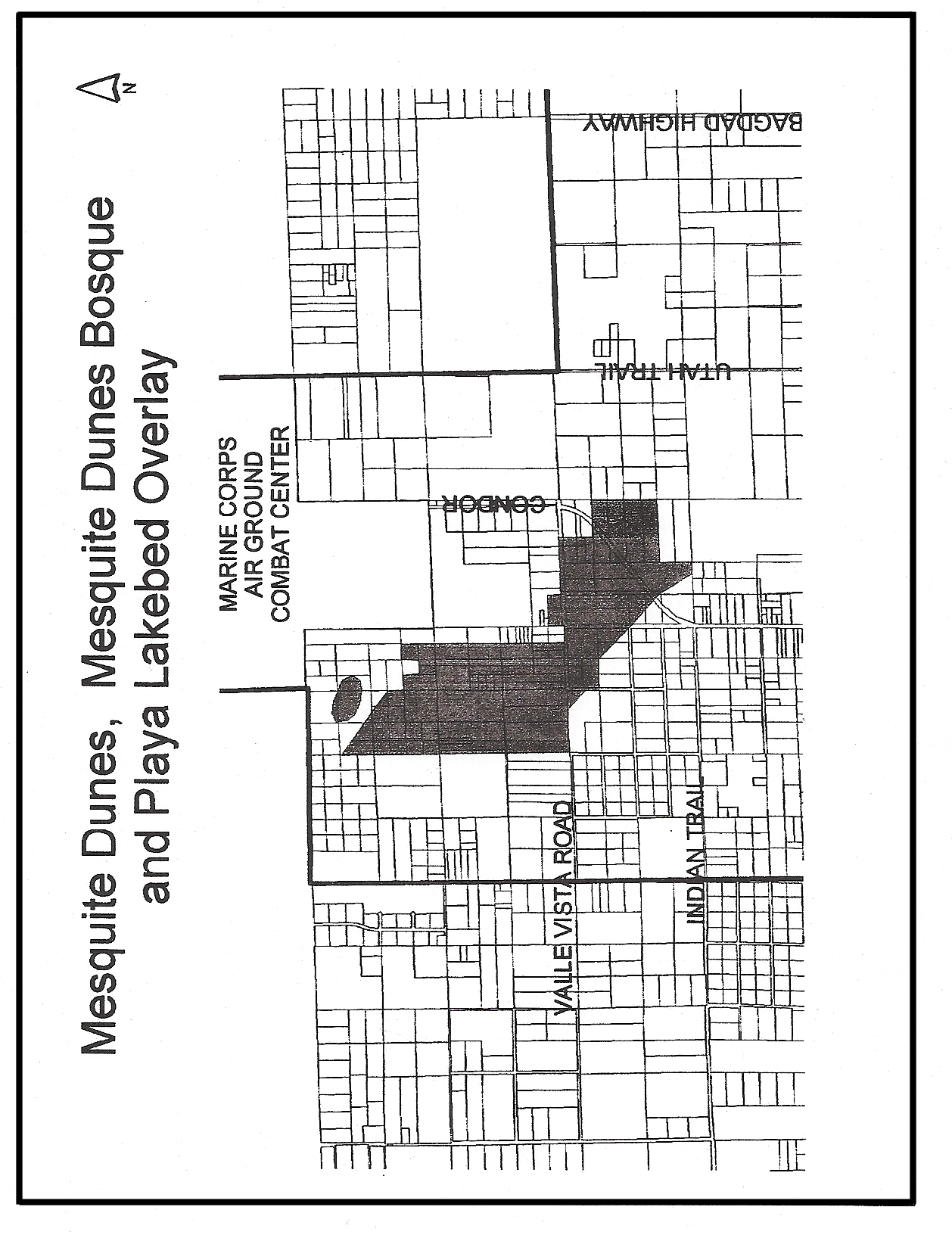
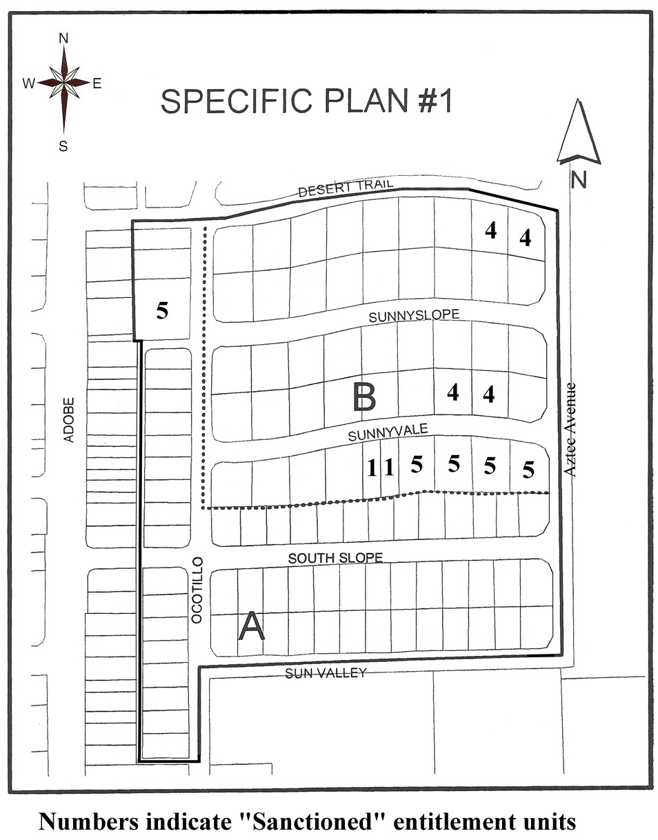
19.174.010 - Specific Plan # 1
A.
Purpose. The purpose of Specific Plan # 1 is to reclassify a land use designation of RM 3,000, which is inconsistent with the General Plan and Community Plan, to an entitlement in compliance with said General Plan and Community Plan.
B.
Recitals.
1.
Except as otherwise noted, the property in Specific Plan # 1 shall be governed by the regulations of the RM land use designation.
2.
The maximum number of units permitted on the parcels shall be as designated on the specific plan map wherein a number is designated on such lots.
a.
In block(s) A, unless otherwise designated, the maximum entitlement shall be two units per lot.
b.
In block(s) B, unless otherwise designated, the maximum entitlement shall be three units per lot.
3.
Those lots designated as having a "sanctioned entitlement" are considered legal nonconforming lots, except that should a unit or units be destroyed by earthquake, fire or other Act of God, the entitlement designated on the map may be reinstated provided that such reinstatement is commenced within one year. Commencement entails construction in addition to grading with permits issued and vertical construction substantially begun.
4.
Short duration (stays of less than 30 days) residential/semi commercial land uses may be established within Specific Plan # 1 subject to the following:
a.
Any property developed with a short duration residential use must conform to the underlying Multi-family Residential (RM) density and development standards as defined within the City of Twentynine Palms Development Code.
b.
Any property developed with a short duration residential use must encompass a single, legal lot consisting of at least 1.0 acre in size.
c.
Any property developed with a short duration residential use shall have a minimum of 20 individual rental units to a maximum of 50 individual rental units.
d.
A short duration residential use must first receive Planning Commission approval of a Conditional Use Permit unless it can be proven to the City that such use existed prior to the effective date of the ordinance that set forth these standards.
e.
Any such short duration residential use may be allowed signage, with a Sign Permit issued by the Community Development Department, as detailed herein. The maximum total area of all commercial signs on any one site (whether wall-mounted or freestanding monument) shall not exceed a cumulative total of 125 square feet. One monument sign of not more than 6 feet in height shall be permitted. The monument sign may be internally or externally lit. If externally lit, all such lighting shall be shielded and conform to the City's night sky lighting standards. A wall sign(s) may be placed upon the exterior of any building on-site, provided such sign(s) are not placed in a manner so that any portion of said sign(s) extend above the roof or parapet line of the structure face to which they are attached and provided that such sign(s) are not internally lit. Wall signs may be externally lit provided such lighting is shielded and conforms to the City's night sky lighting standards. Physical alterations to structures on-site solely to allow the placement of signage shall be reviewed by the Planning Commission. Ancillary signage which does not identify commercial activities or products may be permitted when in character with the theme of the short duration residential use on-site as determined by the Planning Commission.
C.
This Specific Plan renders the territory encompassed herein consistent with the General Plan and Community Plan of the City of Twentynine Palms.
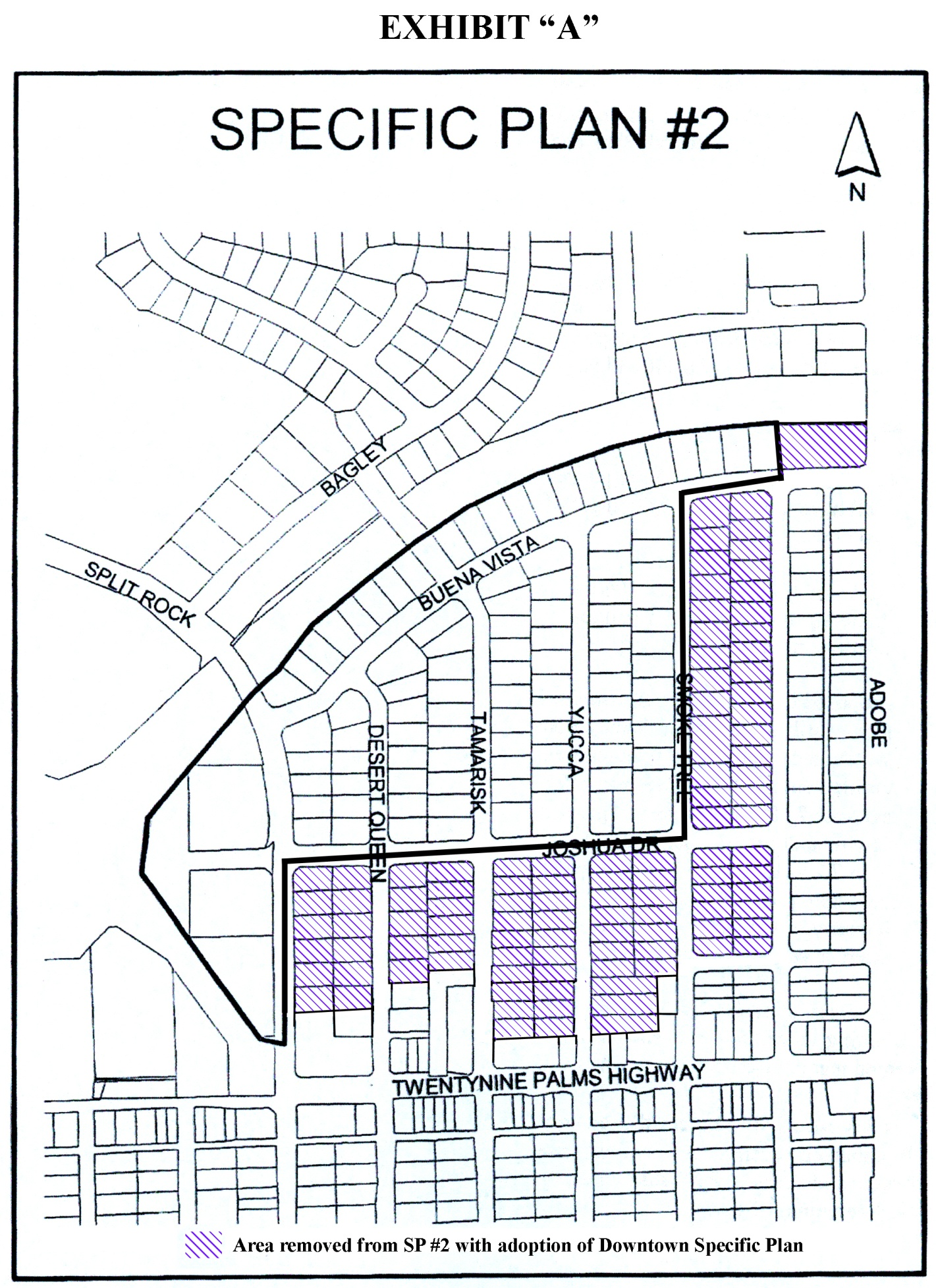
19.174.020 - Specific Plan # 2
A.
Purpose. The purpose of Specific Plan # 2 is to reclassify a land use designation of RM 3,000, which is inconsistent with the General Plan and Community Plan, to an entitlement in compliance with said General Plan and Community Plan.
B.
Recitals.
1.
The remaining parcels shall be governed by the regulation of the RM Land Use District except as otherwise noted in this Specific Plan.
2.
Each lot 7,200 square feet in size or greater in the Specific Plan RM designation may have a minimum entitlement of two units. Lots smaller than 7,200 square feet or combination of the lots shall have an entitlement of one unit per 5,000 square foot or property (gross).
3.
Those lots smaller than 7,200 square feet containing two or more units shall be deemed legal nonconforming use.
C.
This Specific Plan renders the territory encompassed herein consistent with the General Plan and Community Plan of the City of Twentynine Palms.
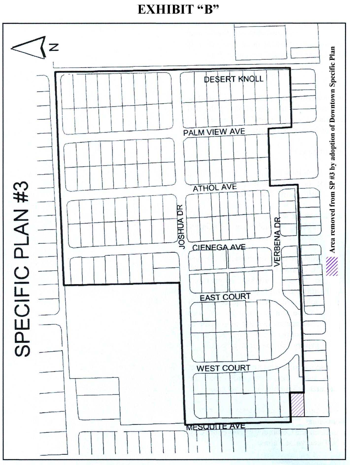
19.174.030 - Specific Plan # 3
A.
Purpose. The purpose of Specific Plan # 3 is to reclassify a land use designation of RM 3,000, which is inconsistent with the General Plan and Community Plan, to an entitlement in compliance with said General Plan and Community Plan.
B.
Recitals.
1.
The territory in Specific Plan #3 shall be governed by the regulations of the RM land use classification except as otherwise stated in this Specific Plan.
2.
Entitlement.
a.
Each lot of 7,200 square feet or greater shall have a minimum entitlement of two units.
b.
Each lot with a net area less than 7,200 square feet shall have a maximum entitlement of one unit.
c.
Proposed developments that combine lots or utilize lots larger than 10,000 square feet net shall have a maximum entitlement of 1) two units per lot for each lot 7,200 square feet net or greater in size and one unit per each lot less than 7,200 square feet net in size; or 2) one unit per 5,000 square feet net of territory, whichever of the two alternatives is greater.
C.
Those lots smaller than 7,200 square feet net containing more than one unit shall be deemed legal nonconforming uses.
D.
This Specific Plan renders the territory encompassed herein consistent with the General Plan and Community Plan of the City of Twentynine Palms.
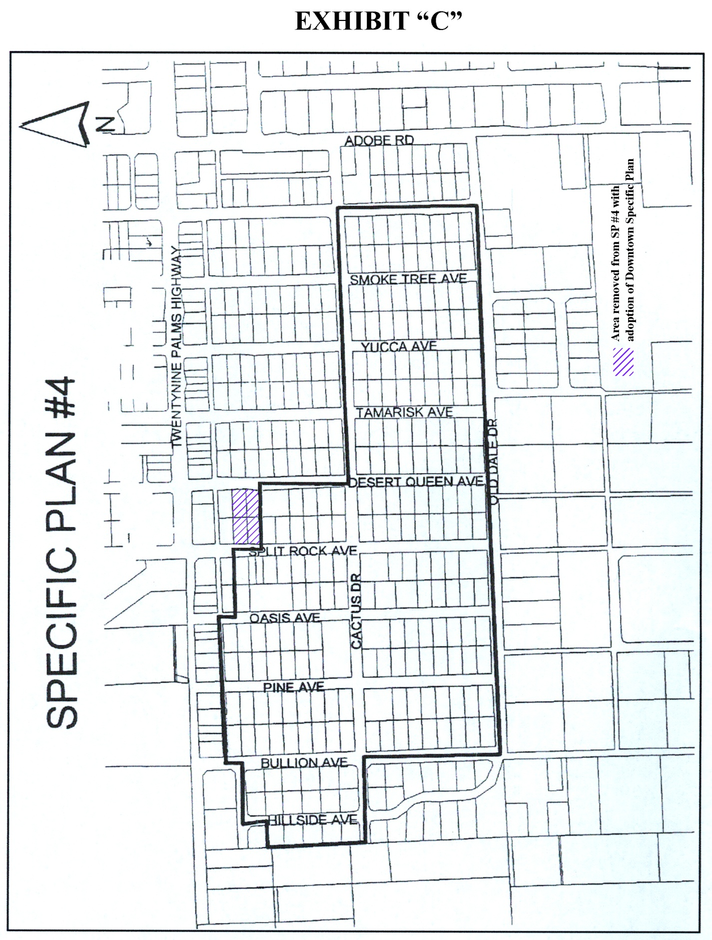
19.174.040 - Specific Plan # 4
A.
Purpose. The purpose of Specific Plan # 4 is to reclassify a land use designation of RM 3,000, which is inconsistent with the General Plan and Community Plan, to an entitlement in compliance with said General Plan and Community Plan.
B.
Recitals.
1.
The territory in Specific Plan # 4 shall be governed by the regulations of the RM land use classification except as otherwise stated in this Specific Plan.
2.
Entitlement.
a.
Each lot with a net area of 7,200 square feet or greater shall have a minimum entitlement of two units.
b.
Each lot with a net area of less than 7,200 square feet shall have a maximum entitlement of one unit.
c.
Proposed developments that combine or utilize lots larger than 10,000 square feet net shall have a maximum entitlement of 1) two units per lot for each lot of 7,200 square feet net or greater in size and one unit per each lot less than 7,200 square feet net in size; or 2) one unit per 5,000 square feet of net territory, whichever is greater.
C.
Those lots smaller than 15,000 square feet net with more than two units shall be deemed legal nonconforming uses.
D.
This Specific Plan renders the territory encompasses herein consistent with the General Plan and Community Plan of the City of Twentynine Palms.
19.175.010 - Specific Plan #6
A.
Purpose. The purpose of Specific Plan #6 is to provide a clear land use regulatory mechanism in the development of Downtown.
B.
Recitals.
1.
Parcels located within the Planning Area of Specific Plan #6 shall be governed by the land use regulations and zoning provisions of the Downtown Specific Plan, where applicable.
2.
This Specific Plan renders the territory encompassed herein, consistent with the General Plan of the City of Twentynine Palms.
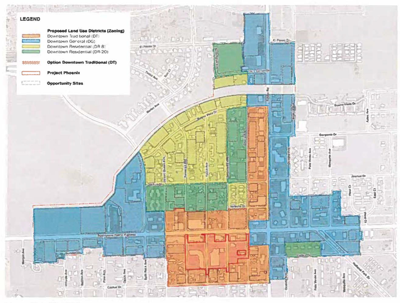
C.
Allowed Uses and Permit Requirements
Allowed uses and permit requirements for the Rural Living Land Use District are listed in Table 19.08.030-1 (Allowed Land Uses and Permit Requirements). The table lists all permissible uses and use-related permits for primary and accessory uses that are permanent in nature. Additional permit requirements are listed in Chapters 19.28 through 19.64 related to permits and procedures. Allowed temporary uses are listed in Chapter 19.34 (Temporary Use Permit and Standards). Allowed accessory uses are listed in Chapter 19.70 (Accessory Uses and Structures).
(Ord. No. 315, § 4(Exh. A), 12-12-2023)
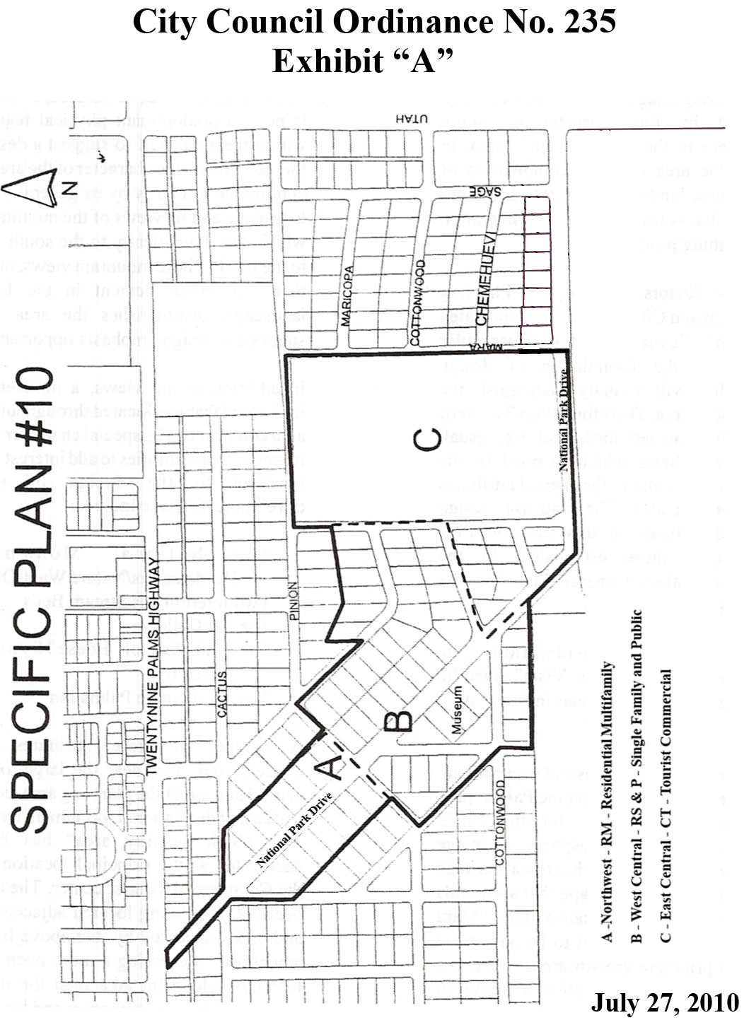
19.176.010 - Introduction
A.
Intent and Purpose. The intent and purpose of Specific Plan # 10 is as follows:
1.
To enhance the economic base of the City.
2.
To establish land uses that are compatible with the Joshua Tree National Park and comply with appropriate low-profile, natural tourist-oriented facility and amenity purposes.
3.
To provide adequate land use area for a cultural center incorporating Tourist Commercial (CT) public and institutional uses as accommodated in the text of the General Plan's Land Use Element.
4.
To contribute to the community goal of becoming as relatively self-sufficient as possible by attracting commercial tourist facilities to complement the economic impact of the Marine Base.
5.
To establish and preserve an appropriate design theme for the area that represents the historical and desert environmental setting of the community; such theme to represent an "adobe" and/or other southwestern theme.
B.
Legal Setting. Specific Plan # 10, "Mara Vista," is created as a Specific Plan pursuant to the California Government Code Section 65450 and City of Twentynine Palms Ordinance 42.
This Specific Plan is consistent with the General Plan as amended, and accompanied by a certified Environmental Impact Report (EIR) prepared for a portion of this Specific Plan and for the Land Use Element of the General Plan.
Due to the uniqueness of this special area, it is the specific intent of the City to have the best, highest quality project eventually established in this area. The City is expected to hold out for the ideal project(s), even if it extends the time of development into the future and even if it means not establishing a lesser desired project in the immediate future.
C.
Preparatory Work. The area immediately north of the Oasis of Mara has historically been a focal area of proposed activity. Due to the historical value of the oasis, real estate promotions were proposed as long ago as the 1920s.
Prior to City incorporation in 1987, an apartment project was approved by the County on the large parcel west of Mara Avenue, north of the National Monument headquarters. However, this project never materialized. At the same time frame, the Rotary Club of the community proposed a beautification project focused on the median of National Monument Drive. Due to the unresolved engineering status of that street, the plan was relegated to an inactive status; however, the idea has been kept alive.
The City has since processed a plan, known as Monument Plaza, that proposed a well-designed commercial center on the large lot formerly proposed for the apartments. This plan, also, never materialized and is now null and void. The plan processing did arouse the citizens of the general area and the business community at large into taking an interest in the area. Although coming from different points of view and having different primary objectives, all parties recognized the strategic importance and potential of the area.
The City, by directive of the City Council, processed a Specific Plan for the area embraced within this Specific Plan. Although the proposal had many good points, the citizens of the immediate area expressed concerns that it was not precise enough for their satisfaction and that potential technicalities might produce a less desirable product than what was envisioned. As recommended by the Planning Commission, the City Council deferred action on the staff-proposed Specific Plan and directed that an ad hoc committee meet with staff to work out details and compromises that would provide for a more acceptable plan. This proposal is a result of that effort.
The name "Mara Vista" evolved from the history of the immediate area. The original proposed name was "Monument Vista," or view of the National Monument headquarters area. However, Joshua Tree National Monument was elevated in national status and renamed Joshua Tree National Park in 1994, thereby rendering the "Monument" nomenclature obsolete. Since the area in question is also known as the Oasis of Mara, and is the site of the original twenty-nine palm trees that eventually became the name identification for the community, the term "Mara" was substituted for the term "Monument." Hence, the name "Mara Vista" was selected as the official name of the Specific Plan area.
D.
Overall Land Use Concept.
1.
The use of desert agricultural uses, nurseries, churches, private clubs, etc., may be established, expanded or continued as permitted uses. In the proposed commercial areas, mixed use of commercial and commercial tenant residential is permitted.
2.
Nonconforming uses shall not be permitted to expand.
3.
Accommodation for a community/tourist, cultural performance and exhibit facility shall be incorporated in the potential commercial areas of the Specific Plan.
E.
Goals.
Goal 1. Provide the City with a planned commercial tourist center which is visually distinctive and readily discernible.
Goal 2. Develop and enhance the unique qualities and identity for National Monument Drive.
Goal 3. Enhance, preserve and showcase the natural beauty and diversity of the area's existing open desert spaces and views.
Goal 4. Assure that new development occurs in a phased and logical manner.
19.176.020 - Land Use and Design
A.
Background. Since Mara Vista is envisioned to be one of the City's principal centers for cultural and commercial tourist expansion areas over the next decade, the City's evolving image will be determined in large part by the character of future development in the Mara Vista area. In addition, the area offers a combination of visual values, landscape features, and other amenities that warrant special consideration in the planning process.
With those factors in mind, the Planning Commission and City Council have determined that this Specific Plan should place particular emphasis on design policies that will visually distinguish the Mara Vista area. Therefore, this Section of the Specific Plan sets forth land use, visual, and design policies which respond to the City's objectives and to the special attributes of the planning area. The land use, design goals, and policies in this Specific Plan expand upon those established in the Twentynine Palms General Plan for the Mara Vista area.
B.
General Design Considerations. The development of the Mara Vista Specific Plan design policies has been influenced by the following factors:
1.
Community perceptions and expectations. The residents of Twentynine Palms share a strong appreciation for the City's distinctive desert atmosphere, an image derived from its unique historical heritage and the rugged landscape that surrounds the community. Because the Mara Vista area is expected to be one of the City's principal growth areas, there is a strong desire to establish a sense of identity and make the area a source of community focus and pride. The plan calls for establishing a unique identity for the cultural/commercial center, enhancing the diversity of the desert open areas, and creating a distinct, identifiable locale. The community also seeks to avoid monotony and sameness, while promoting diversity and ecologically sound practices in the new development.
2.
Existing Special Features. The Mara Vista area has a subtle landscape. There is no one predominant physical feature in the area itself to suggest a design theme. Instead, the character of the area is determined primarily by its general open landscape and its views of the mountains which rise dramatically to the south and to the north. These mountain views, more than any other element in the local landscape, distinguish the area and suggest a design emphasis opportunity.
In addition to the views, a number of individual features contribute to the area's special character and represent opportunities to add interest and meaning to the design of new development. These include:
• The National Park Headquarters/Nature Walk/Oasis
• Two intermittent stream beds
• The Twentynine Palms Art Gallery
• The Old School House/Historical Museum
• The Twentynine Palms Inn
A number of these attributes are concentrated in or near the large, open central portion of the planning area, north and east of the National Monument Drive. This high-amenity area has been designated as the principal location for the commercial tourist center. The area benefits from being located adjacent to, and easily accessed by, the above-listed amenities; possessing a larger, more open development area than the other portions of the planning area; and having direct views toward all the area's mountains.
The use of solar energy is advisable, but shall not visually interfere with the historic character or image of the building in question. Passive solar energy is encouraged using calculated overhangs to allow the winter sun in but shade from the hot summer sun.
3.
Land Use Designations. Each of the three sections below describes a portion of the Specific Plan area and subdivides the plan into distinct subsections that require special design considerations.
a.
Northwest Section. This area is the gateway to the park headquarters for travelers coming from the west. A well-designed entry feature is envisioned at the intersection of Twentynine Palms Highway (SR 62) and National Monument Drive. The area also includes the private property that fronts National Monument Drive that is presently zoned Multiple Family Residential (RM). The objective of this plan is to encourage a higher-quality, attractive, architecturally compatible development of rental units, condominium units, or time share condominiums to complement the other developments in the plan. Using the provisions of Section 19.176.050 (Implementation), integrated and compatible commercial tourist (CT) uses may be approved.
For standard RM development, in addition to the provisions of the RM zone, the following additional standards shall be applied:
i.
All residential buildings shall be to the front of the lots, with parking areas to the rear.
ii.
All elevations shall reflect a western adobe theme and be approved by the Planning Commission at a public hearing.
iii.
The height limit in this area shall be 1.5 stories or 18 feet, whichever is lesser.
iv.
All mechanical equipment, including swamp coolers, shall be visually screened from view.
v.
All residential units shall have a minimum size as follows:
• One-bedroom units = 900 sq. ft.
• Two-bedroom units = 1,200 sq. ft.
• Three-bedroom units = 1,500 sq. ft.
b.
West Central Section. This portion of the Specific Plan is the area between the Northwest RM area and the significant drainage course that crosses National Monument Drive. It includes the Single Family Residential (RS) zoned property with frontage on National Monument Drive, and some of the RS property fronting on Inn Avenue, Cottonwood Drive and the paper street Maricopa Drive.
The West Central section also contains the Twentynine Palms Art Gallery and the Twentynine Palms Museum; both are Public (P) uses.
The plan objectives for this area are to protect and enhance the existing single-family residences that have been and may be established and to provide and maintain a quiescent and attractive entry to the commercial tourist area. Integrating the public uses as a buffer between the residential and the commercial areas is also an objective. The public uses should be pedestrian active during the day and quiet and closed in the later evenings. Pursuant to Section 19.176.050 (Implementation), select CT uses may be integrated into the area provided that the permitted use will be compatible with the objectives of this area.
Due to the nature of institutional buildings that, depending on the function, require basically a custom design where possible and feasible, the community ideal of "adobe" or other "southwest" theme is required. The theme should be adhered to but not to the extent where all buildings look alike. In large-scale projects, a variety within the spirit of the design theme should be employed to reflect an image of the portions of the project having being built at different times. Tourist facilities may also capitalize on the community cultural and historic resources, such as the museum, the art gallery, the Twentynine Palms Inn and the park headquarters.
In addition to the RS or P development standards, the following additional standards shall apply:
i.
Western style architecture is required.
ii.
Bed and breakfast operations, subject to the conditions of the Development Code, permitted subject to approval of a Modified Site Development Plan. Any existing single-family residence of sound structure shall be eligible to be converted to a bed and breakfast facility, subject to a Modified Site Development Plan, which also includes potential additions to the structure.
iii.
Parking areas, mechanical equipment and private recreational areas shall be visibly screened from view from National Monument Drive.
iv.
The height limit in this area shall be 1.5 stories or 18 feet, whichever is lesser.
c.
East Central Section. It is a goal of this plan that the East Central section become the area's primary commercial center and focus of civic activity, and be one of the principal identity elements for the planning area. The design character will have a significant bearing on the overall image of the planning area. The area presently is vacant and zoned RS. The objective of this area is to provide high-quality, attractive and compatible CT uses with integrated pedestrian access to the Oasis of Mara and the public uses in the West Central section of the Specific Plan. This section is to receive the most intense development scrutiny. The following conditions shall apply to this section:
i.
All development proposals in this section shall be required to process a Site Development Plan. The uses permitted in the CT (Tourist Commercial) Zone may be permitted in this section; destination resorts, tourist boutiques, quaint restaurants, cultural theaters and educational facilities are examples of encouraged uses. Automotive service commercial shall not be permitted in the East Central area. All land use activities shall be conducted entirely within an enclosed building, except specified recreational activities and similar uses (activities) usually and customarily conducted outside of a building.
ii.
In addition to the standards of the CT Zone, all design and development standards of this Specific Plan shall be applicable to all proposed developments in this section.
iii.
Commercial design shall not conflict with the established institutional uses in the abutting areas. Resorts and retreat facilities, ideally, should take advantage of the Joshua Tree National Park, the art gallery, the museum and the Twentynine Palms Inn.
iv.
Commercial projects shall contain synergistic uses that mutually support each other. Chain restaurants shall be required to comply with the design theme and not disrupt the design integrity of the area. Drive-through take-out shall be prohibited.
v.
Accommodation for a community/tourist, cultural performance and exhibit facility shall be incorporated in this or the Northeast or Northwest Section.
C.
Major Design Policies. The following policies have been formulated in response to the principal design considerations previously described:
1.
Design Review. Special design reviews shall be held for all development proposals within the boundaries of the Specific Plan. The policies set forth in this Chapter shall be used in that process as a design review checklist.
The City Planning Commission and City Council, in reviewing Site Development Plans in the territory of the Specific Plan, shall apply consistent design standards to ensure high-quality, attractive and functional projects.
All buildings shall be so constructed and screened, and equipment shall be so installed and maintained and all activities shall be so conducted, that all noise, glare, vibration, dust, odor and other deleterious factors shall be confined and reduced to the extent that no annoyance or injury will result to persons residing in the vicinity of the use or activity or to the public using the natural area of the Joshua Tree National Park Headquarters.
2.
Design Quality. A high level of design quality shall be consistently required of all developments in the planning area in order to create a pleasant living environment, establish a distinctive image and sense of identity for the area, and create a source of community pride.
3.
Identity and Unification. Consistent design themes for the area's activity centers and common elements should be formulated through the use of consistent landscaping, building design, signage, street lighting, and other design standards and elements, to visually distinguish and unify the area.
4.
Mountain Views. In planning the development of Mara Vista, special efforts shall be made to preserve and take advantage of the mountain views.
5.
Special Features. The design and development of Mara Vista shall incorporate and capitalize upon the area's special existing landscape features, visual attributes, and historic values.
The special topographic, vegetative and view features of the Central Section shall be capitalized upon to create one of the City's most desirable areas.
The permanent open spaces shall be treated as principal design and identity elements for the area. These elements shall be preserved, enhanced and incorporated into the overall design effort.
View protection shall include perspectives from National Monument Drive, the Oasis of Mara headquarters property and the residences to the east of Mara Avenue.
6.
Open Spaces. The overall goal is to maintain and enhance the existing open space in the East Central area to act as buffer space between elements in and adjacent to the site; to provide natural desert views from National Monument Drive, the commercial center, and the park headquarter's natural walk, as well as the properties that surround the project site; to function as rainwater runoff channels/control measures; and to maintain the unique spacious, natural desert qualities that presently distinguish the area and contribute to the site's special character.
The open spaces shall follow the two general drainage courses that run along the east and north sides of the East Central area, and the area immediately adjacent to the north side of National Monument Drive.
Pedestrian access into and throughout the open spaces shall be unencumbered to the greatest extent practicable. The area should present an open and inviting appearance without unnatural intervening visual or physical barriers.
7.
Weir Walls. The open spaces are intended to remain in a natural desert state, but may be enhanced with the construction of low weir walls throughout the site to control water runoff, permit greater water absorption, and promote a greater variety and development of desert habitat.
The general purpose of the weirs is to slow the flow of rainwater runoff to prevent erosion; to retain small quantities, in series, of this runoff, to control flooding; and to spread this water over a greater surface area, allowing it to soak into the ground instead of being carried off and evaporating elsewhere. This detention, in turn, generates a greater capacity for the area to sustain desert plant and wildlife species.
The weir walls shall be constructed of stone and mortar; be low, level walls, 1 foot thick and placed perpendicular to the stream's centerline; be 1 foot above grade at their highest point; and be placed at every 1 foot change in ground elevation. The ends of the weirs shall be feathered into the side slopes and the grades restored to a natural appearance.
The construction of the weirs shall be noninvasive. Every effort shall be made to preserve and protect the existing desert plant life during construction. Existing trails and eroded washes shall be used to access the weir sites.
8.
The Commercial Center. The primary design goal with respect to the commercial center is to create a distinctive, high quality commercial/civic cluster which is visually and physically harmonious with the character of its surroundings and the overall image sought for in the Mara Vista Specific Plan.
The commercial center shall be master planned; unplanned piecemeal development on individual properties will not be allowed. Once the Master Plan is completed, however, incremental development of that plan may occur on individual properties.
D.
Corridors and Gateways.
1.
National Monument Drive. Establishing and maintaining a highly distinctive character for National Monument Drive is a major goal of this Specific Plan. The route will provide the vantage point from which most people will view and form their primary and most lasting impressions of the Mara Vista community.
a.
National Monument Drive shall be enhanced to establish a strong and positive image and personality for the area.
b.
Visual stimulus along the drive shall convey a sense of cohesiveness and unique identity.
c.
Construction details for the drive shall include design specifications detailing improvements to be made within the public rights-of-way. These rights-of-way design specifications shall include:
i.
Pedestrian walkways, planting strips, bike lanes, median strips, transit shelters and other street furniture.
ii.
A detailed planting plan and specifications for the median, roadside and other landscape zones.
iii.
A detailed irrigation plan.
iv.
A signage plan.
v.
A street lighting plan.
d.
The National Monument Drive design shall specify roadside and median landscaping that will create visual continuity along the corridor and establish the route's status as a primary arterial through the community.
e.
The drive shall provide for a continuous system of pedestrian and bicycle paths along the corridor. Every attempt shall be made to provide a more attractive design than the traditional monolithic configuration typical of usual City sidewalks.
f.
Pedestrian walks shall be located several feet away from the roadway paving.
g.
Landscaping along the drive and in its median strip shall emphasize low maintenance native species and drought-tolerant ornamental species.
h.
All roadway signage shall be of a single distinctive format to enhance the unified appearance desired for the area.
i.
Special attention shall be given to the design of a distinctive, compatible, yet subdued street lighting system.
2.
Gateways.
a.
There are two principal entrance points, or gateways, to the Specific Plan area, located at the extremes of National Monument Drive. The two gateways are:
i.
The Twentynine Palms downtown gateway, which is the northwest entry point intersecting the Twentynine Palms Highway. This entry connects the Specific Plan area with the heart of the City's downtown.
ii.
The Utah Trail Gateway, which is the southeast entry point and intersects Utah Trail. This entry ties into the entrance to the Joshua Tree National Park.
b.
The goal of these gateways is to identify the Specific Plan area and create a strong initial sense of arrival and place.
c.
Gateways shall receive special attention in the National Monument Drive design so that a formal sense of entry is created.
3.
General Design Objectives.
a.
Building Design in Mara Vista. The following criteria shall be applied to designs for any buildings within the boundaries of the Mara Vista Specific Plan.
b.
Architectural Treatment.
i.
All individual structures shall be designed to be harmonious with the local setting. Building designs shall reflect a high standard of architectural quality and shall be coordinated and unified through the use of complementary forms, materials, colors and other architectural treatments.
ii.
All building surfaces in direct public view shall receive integrated design treatment.
c.
Building Form and Setting.
i.
The design and setting of the commercial component shall emphasize creation of a perceived complex of buildings rather than individual, separate structures.
ii.
Spaces between buildings shall be used to create interior pedestrian plazas, courtyards, outdoor eating areas, and view corridors toward the mountains.
d.
Building Height. No structure shall exceed 18 feet in height at the required setback lines. For each additional foot of setback, for architectural features, an additional 6 inches in building height may be allowed up to the maximum height permitted in the zone. Additional height may be permitted under stringent site development. Rooftop equipment and related screening shall be included in these building height restrictions.
4.
Building Facades.
a.
Building elevations exposed to direct view from local streets, parking areas, or adjacent residential areas shall be of high architectural quality and visually compatible with nearby buildings.
b.
Large facades shall be designed to provide visual variety and human scale. Long, straight facades without changes in wall planes or distinct openings shall be avoided.
c.
Building facade detailing shall be integral to the building design.
5.
Building Materials. The goal of these regulations is to achieve design harmony and cohesiveness.
a.
The number and type of exterior materials should be limited in number.
b.
Materials shall be genuine rather than simulated and shall be reflective of materials used in surrounding developments.
6.
Building Colors. Color palettes used on various individual buildings shall be complementary and subdued, rather than competitive and garish.
7.
Building Roofs. The goal of these regulations is to use the character of the building roofs in the Specific Plan area to visually integrate the buildings.
a.
Rooflines, styles, materials, and colors shall be compatible with other roofs in the complex and in the vicinity. The roofs shall also be consistent in character from various vantage points.
b.
Applied roof forms shall be avoided.
c.
Rooftop equipment shall be screened from direct view or integrated into the roof design.
8.
Mechanical Equipment. All rooftop and other outdoor mechanical equipment shall be fully screened from ground view in a manner that is architecturally integrated with related structures.
9.
Parking Lot Locations.
a.
Principal parking areas shall be located behind or along the sides of buildings.
b.
Parking areas shall be separated into smaller components.
c.
The conventional practice of locating parking adjacent to the street in front of the business shall be avoided.
d.
Combined driveways and vehicle access points from National Monument Drive are encouraged and shall be required wherever reasonably possible.
e.
Reciprocal vehicle parking and pedestrian access shall be required between adjacent parcels whenever feasible.
10.
Commercial Building Setbacks. The setbacks from National Monument Drive, as shown on the Specific Plan, may be adjacent to the sidewalk provided that the landscaped insets are provided to break up a linear frontage design; also entrances to the facilities shall be inset with wide access containing natural landscaping. All other setbacks shall be in compliance with the setbacks of the CT land use classification of the Community Plan (or its successor in interest), unless specifically modified at a public hearing.
Under unusual circumstances, the Planning Commission may modify the setbacks. Examples of such unusual circumstances include location of the earthquake fault or open space shown on the Specific Plan, or other features that would prohibit building on those portions of the property. In granting the modification, no reduction in required pervious or landscaped areas may be granted.
11.
Special Height Regulations. The preferred height of the buildings shall be 1.5 stories high or 18 feet, whichever is lesser, unless additional height for towers or architectural features is approved through Site Development Plan review by the Planning Commission at a hearing wherein the notice states the nature of the additional height that is to be considered, provided, further, that the height does not impact the scenic backdrop view from the National Park property, from National Monument Drive, or from Mara Drive.
E.
East Central Area Landscaping and Building Design Policies.
1.
General. The goal is to have a set of specifications formulated to organize and unify the East Central area.
a.
Existing residential land uses adjoining or in the Specific Plan shall be buffered from adjacent commercial or public institutional development through the use of special treatment landscape and/or architectural barriers.
b.
A detailed combination of planting, lighting, signage and parking specifications shall describe the manner in which the project design will enhance pedestrian spaces, soften paved areas, link the various components, and coordinate all elements into a cohesive whole complex.
c.
At least 20 percent of the property of any project shall be permeable surface, either landscaped or natural as required by the CT Zone; additional permeable surface is encouraged. A greater percentage of permeable area will be required for projects that are approved for additional height.
2.
Materials. The goal is to use a limited planting palette to create cohesive and distinctive East Central area and corridors.
a.
Native and low-maintenance, drought-resistant plant species are required. A list of approved plants is attached as Appendix A. Landscaped areas shall be required to comply with the Twentynine Palms Water District Ordinance related to water conservation. Landscaping shall reflect the native, drought-resistant, desert varieties that are found in the general nearby area, and avoid the use of water-consuming and/or exotic species.
b.
Plant materials shall be installed in a manner which achieves most of the desired visual effects within two years of planting.
3.
Irrigation.
a.
Street trees and parking lot plantings shall have automatic irrigation systems. The irrigation systems shall be set to operate at night when air temperatures are lower to reduce evaporation losses.
b.
The irrigation systems shall use subsurface water delivery techniques to encourage deep root watering and less waste through evaporation and runoff.
4.
Street Trees. The general goal is to replicate, on the north side of National Monument Drive, the landscaping and walking path pattern that exists on the south side of the park headquarter's nature path.
a.
The East Central area landscaping specifications shall provide for Washingtonian filifera palms, clustered, as street trees along the north side of National Monument Drive.
5.
Paving.
a.
The East Central area landscaping specifications shall include paving treatments which add visual interest and human scale. These treatments shall also serve to organize and unify the area.
b.
Attractive but subdued combinations of paving materials, patterns and colors shall be used to direct pedestrian movements, identify pedestrian crossings, and break up large areas of pavement.
c.
Permeable nonasphalt surfaces shall be used wherever possible.
6.
Outdoor Lighting.
a.
Exterior lighting shall be designed and located in a manner which identifies and accents pedestrian areas, avoids light intrusion into adjacent residential areas, and does not exceed the amount of illumination required for safety considerations.
b.
Overly bright or flat and even lighting over large areas shall be avoided.
c.
Area lighting shall be directed downward and light sources shall be kept as low to the ground as possible.
d.
The commercial uses shall be sufficiently lighted for security purposes, but screened or, preferably, completely buffered from abutting residential neighborhoods. Ground-mounted lights are preferred to overhead light poles.
e.
Lighting proposals shall comply with the objective of protecting a desert sky, and the environmental assets related thereto. The following definitions provide perspective and guidance on this matter:
i.
A "desert sky" is a clear open sky with few or no clouds with abundant sunshine during the daytime and with visible stars at night.
ii.
A "night sky" is a clear sky, with visible stars, despite necessary or desired illumination of private and public property.
iii.
"Minimal lighting" means only the illumination necessary for safety and identification purposes, e.g., for street intersections and natural hazards.
F.
East Central Area and Other Commercial Signage.
1.
General. The goal of these regulations is to produce simple, attractive, easy-to-read signs, compatible and complementary with the desired character of the center and the overall Specific Plan area.
a.
East Central area development and all developments for commercial projects applied for pursuant to procedures of Section 19.176.050 (Implementation) shall include detailed signage specifications.
b.
Freestanding or monument signs in the East Central area shall be used only to identify the center itself and not various businesses within it.
c.
Signs shall not be used as advertisements.
d.
Sign messages shall be limited to the name of the business, the business activity or the business logo.
2.
Sign Style.
a.
Commercial signage shall be designed to conform to the character of the East Central area center's architecture.
b.
Signs should adequately identify the business in question; however, they are also to be high-quality, neat and not garish. Individual tenant freestanding pole signs shall not be permitted; pedestrian scale signs are the preferred practice with a design similar to the complex it represents.
c.
Signs separated from the buildings shall be low-profile monument style, not more than 5 feet high above the street-abutting surface.
d.
All signs in the center shall be coordinated in terms of size, shape, materials, height, lettering type, style and lighting.
e.
The sign regulations shall be that of the CT Land Use District unless otherwise stated in this Section. However, the Planning Commission may modify the standards if the size of the project warrants such a modification for reasonable identification exposure.
3.
Miscellaneous.
a.
Signage shall be subtle and unobtrusive. Rotating, flashing and animated signs are expressly forbidden.
b.
Sign area shall be limited to the minimum amount necessary to clearly identify each business.
c.
Sign illumination shall conform to the provisions of the City Development Code, but in any event shall not be unnecessarily bright or harsh.
d.
The City shall establish a "master sign criteria" for the commercial areas stating acceptable materials, ratios of sign to building, height and locations with respect to the businesses they advertise. These criteria may be based on the criteria of approved projects that exhibit acceptable and desirable appearance consistent with a design theme and the intent of this Specific Plan. When established, the sign criteria shall be published in the Specific Plan Appendix as Appendix B.
e.
No sign may block sight distance necessary for traffic safety and pedestrian visibility.
G.
East Central Area and Commercial Parking.
1.
General. The goal of these provisions is to reinforce the quality image of the Mara Vista East Central Area by deemphasizing the physical prominence of parking facilities.
a.
Reciprocal parking throughout the East Central area shall be required in order to promote a cohesive appearance and efficiency of use.
b.
Parking facilities shall be separated into smaller components, and shall be segregated from National Monument Drive through the use of landscaping elements.
c.
There shall be two access points to the East Central area complex from National Monument Drive. One access shall be at the Cottonwood intersection, and the other access shall be at the southwest portion of the East Central area.
d.
Alternatives to asphalt paving, such as crushed stabilized granite, shall be strongly encouraged. Energy conservation, environmentally sound practices, and the creation of a less imposing appearance of the parking area are the general objectives.
e.
Employee parking areas separated from customer parking areas may be surfaced with gravel. Other permeable surfaces that meet the intent of this Specific Plan are encouraged.
f.
All projects over 10 acres in size, or that will employ more than 20 people on one shift, shall provide a public transit shelter located in such a manner to encourage use of public transportation as it may be made available.
g.
If RV parking is to be provided, it shall be located in screened areas or other areas, such as hotel parking sections.
2.
Parking Area Landscaping. The overall appearance of the center's parking area is of major importance to the character of the center. The goal is to establish a balanced design providing both utilitarian use and an extension of the natural growth of the surrounding area.
a.
Parking area landscaping shall include perimeter and interior planting to soften parking area appearances, to link parking with other components in the center, and to improve shade.
b.
Protected planting strips and tree wells shall be incorporated in the parking area design to accommodate trees, shrubs, and ground cover.
3.
Parking Area Lighting.
a.
Illumination shall be concentrated on pedestrian ways and intersections.
b.
Skillful and imaginative use of a minimum level of illumination is the overall goal.
H.
Auto Bridges.
1.
Entrances to the East Central area should be designed to span stream channels using bridges, as opposed to culverts, in order to emphasize their importance as a design element.
2.
If concrete culverts must be used, rectangular box or bridge culverts shall be employed.
I.
Pedestrian Bridges. Similarly with auto bridges, pedestrian/bicycle bridges are encouraged as special design elements.
J.
Access.
1.
Access to the businesses on National Monument Drive shall be designed to encourage pedestrian access from National Monument Drive with the off-street parking provided behind the commercial building areas. Project design shall endeavor to screen parking and loading areas from view from the National Park headquarters property and the National Park view areas where there will be significant accumulation of pedestrian shoppers, and from abutting residentially zoned areas.
2.
Combined driveways between parcels is encouraged and to be required when and where reasonable. Reciprocal vehicle parking and pedestrian access between neighboring parcels is likewise required.
3.
Parcels over 5 acres in size shall have at least two accesses to a public street. No development shall be approved that land locks another parcel or denies a neighboring property required or necessary access.
4.
A designed pedestrian access between the Oasis of Mara and the private commercial development(s) and other public institutional uses shall be established.
19.176.030 - Specific Plan Streets and Circulation
The major streets shall be as shown on the Specific Plan map. The standards for National Monument Drive shall be flexible to permit the creation of a commercial street that both is conducive to tourist pedestrian traffic and protects the natural ambience of the Oasis of Mara area of the park headquarters property. The City shall prepare and adopt a specific alignment and elevation for the street, with special and unique provisions for pedestrian-crossing standards, alternatives to standard curb and gutter, median treatment and driveway approaches. Materials such as textured and/or colored concrete, a variety of native desert landscaping, minimal street lighting that preserves the visibility of a starry sky at night, entrance features on the street median, and bicycle trails and parking facilities shall be used. Special consideration shall be given to provide a natural appearing solution to drainage and stormwater control. Unique design of the median development alternatives is envisioned.
All other public streets not shown on the Specific Plan shall be approved as part of a development proposal, or as otherwise may be approved at a noticed public hearing.
A.
Traffic.
1.
The street shall be designed with bicycle pathways, pedestrian crossings and streetscape to create a traffic environment that causes slow traffic.
2.
The proposed projects shall be designed so as not to require traffic signals in the Specific Plan.
B.
Intersections. The intersections of streets and/or streets and driveways shall have clear sight triangles.
C.
Transit Services. Large projects will provide compatibly designed transit shelters.
D.
Bicycles. Parking facilities for bicycles shall be provided. Bicycle paths shall be designed into the projects and be connected to the City system.
19.176.040 - Municipal Services
A.
Storm Drainage. All altered drainage courses shall flow to a public street or an approved drainage facility. Drainage facilities should be kept natural in appearance and be integrated into the design of the project. Concrete channels should be avoided where possible.
B.
Water. The water purveyor shall be the Twentynine Palms Water District. Meters shall be visually screened and not conspicuous. Water lines in the area may need to be upgraded from an 8-inch line to a 12-inch line, depending on proposed uses.
C.
Electric. The area is serviced by Southern California Edison (SCE); all new service will be placed underground. Transformers and vaults shall either be underground or designed to architecturally integrate with the design of the buildings. Fuse boxes shall be visually screened and not conspicuous.
D.
Gas. The area is/will be serviced by Southern California Gas Company; all new service will be placed underground. Meters shall be visually screened and not conspicuous.
E.
Communication. All new or relocated service will be placed underground. Vaults shall either be underground or designed to architecturally integrate with the design of the buildings. Wires shall be visually screened and not conspicuous.
F.
Sanitation. Depending on the elevation of the project, the Planning Commission may require a "dry sewer" for future connection. Septic systems and leach lines may not be under impervious surfaces; seepage pits may be under paved areas.
All properties in the Specific Plan area shall be required to obtain and maintain service from the City's franchised disposal service provider.
G.
Fire Protection. All new habitable structures or structures housing flammable material shall be equipped with sprinklers for maximum fire safety.
Sufficient public land shall be made available for a fire substation, if determined to be necessary at Site Development Plan review.
H.
Police. Sufficient public land shall be made available for a police substation, if determined to be necessary at Site Development Plan review.
The concept of "defensible space" shall be considered in the design of all projects.
I.
Building and Safety. No structures intended for human occupancy may be constructed on an earthquake fault as may be discovered or may be indicated on the City's hazard map.
Adequate provisions shall be made to diminish the influence of erosion from any project area.
All building pads shall be either elevated or floodproofed to prevent damage from flash flooding in the area.
J.
Wildlife and Archaeological Review. Prior to the approval of a Site Development Plan for any vacant land portion of this Specific Plan, a biological study may be made for the development site with a special emphasis on investigation for desert tortoise habitat.
Known and discovered areas containing Native American artifacts may, at the Planning Commission's discretion, be left natural and isolated to discourage pedestrian traffic.
19.176.050 - Implementation
A.
Regulatory. The land uses permitted shall be those uses permitted by this Specific Plan for territory shown on the City General Plan Land Use Element as CT Tourist Commercial pursuant to the regulations and uses for the CT designation as contained herein, except as follows:
1.
Where the land use (zoning) designation is shown as RS or RM, the property owner or authorized agent may apply for a development pursuant to the CT designation as enumerated in Subsections 5.1 and 5.2 of this Specific Plan consistent with the CT designation of the official General Plan map.
5.1. Procedure to apply for a commercial tourist/institutional development located in the RS or RM zones:
5.1.1 An application for reclassification shall be submitted, found complete, and found consistent with the General Plan and this Specific Plan.
5.1.2 A fee pursuant to Section 19.176.050.B shall be paid to reimburse the City for administrative cost of processing the application.
5.1.3 A complete and detailed Site Development Plan (Conditional Use Permit) shall be filed in conjunction with the reclassification request with the appropriate fee as adopted by the City for the processing of Site Development Plans; the notice of hearing shall include the affected area (i.e., 300-foot radius) of the Specific Plan area.
5.1.4 The proposal may qualify for an environmental negative declaration or an exemption if the scope of the project was evaluated in the EIR prepared for the General Plan or any specific project located in this Specific Plan.
5.1.5 The Site Development Plan submittal shall include a design package including a detailed design theme, consistent with an adobe or other southwestern theme, and a detailed sign criteria consistent with this theme; the Planning Commission in approving and conditioning any Site Development Plan shall include in its deliberations the specifics of the design theme of the proposed project. The City shall create a design policy for the Specific Plan area based on acceptable proposals to ensure compatibility of new projects with approved and/or established projects.
5.1.6 The Site Development Plan will otherwise be processed according to the regulations of Municipal Code Ordinance No. 38 except as follows:
a.
The Site Development Plan shall also be approved by the City Council; however, unless the plan is being heard as an appeal, the Council need not hold a public hearing.
b.
The Site Development Plan and the land use reclassification shall be consolidated in that should the Site Development Plan expire, the land use designation shall remain as it was previous to the request for reclassification.
c.
Upon final approval of a Site Development Plan wherein all conditions have been met, a Building Permit may be applied for and issued upon building plan check approval.
d.
Upon building inspection sign-off with any building or portion of a building as being legal for occupancy, that lot or portion of such a lot shall be deemed reclassified to CT.
5.2 The Tourist Commercial (CT) Designation:
5.2.1 The setback and other development conditions shall be as established by this Specific Plan or by the Planning Commission at a public hearing if not so specified in the regulations of the CT Land Use District, or its successor in interest. The CT Zone regulations shall apply as well as other City ordinances or County ordinances adopted by the City by reference.
5.3 Prior to the approval of any final parcel map, subdivision map, site development plan or grading plan other than that for agriculture, all of the serving utilities shall certify that the arrangements, satisfactory to the agency, have been made to provide service to the area in question.
5.4 No parcel map or subdivision map shall be approved unless public streets abutting the development are dedicated to at least half the required street width and improvements are constructed or guaranteed across the frontage of the said lots, including improvements necessary to connect said abutting street to the existing improved City public street system.
5.5 Adequate facilities provisions for projects in the Specific Plan, including but not limited to signalized intersections, storm drainage improvements, necessary utilities and road improvements, shall be accounted for:
5.5.1 All properties, other than existing operations, in the Specific Plan area are required to construct major infrastructure, as determined necessary to serve development, including reasonable off-site facilities outside the plan boundary, as specified by the City Engineer and pursuant to requirements of all serving agencies.
5.5.2 Required major infrastructure pursuant to this Specific Plan may qualify for reimbursement if an appropriate agreement is approved by the City.
5.5.3 Any party benefiting from existing constructed infrastructure may be required to pay a reimbursement for a fair share of construction cost prior to development of such property.
5.5.4 Required construction of major infrastructure pursuant to this Specific Plan may occur by any of the following methods or combinations thereof:
a.
Participation in an improvement district or project that will construct all of the required infrastructure.
b.
Payment in full for the fair share of construction cost as determined to be an equitable assessment for benefits received. Such cost share may be established by formulas duly adopted by the City Council.
c.
Payment for the construction of major required infrastructure where the cost exceeds the individual properties' equitable assessment for benefit received and the project sponsor is willing to execute a reimbursement agreement providing that subsequent development of other benefiting properties shall be obligated to pay assessments prior to using such facilities.
d.
Entering into a development agreement with the City to form a mutually acceptable method to satisfy the conditions of public service and infrastructure provisions utilizing combinations of alternatives a, b, and c and/or different innovations that may be suitable for this purpose.
5.6 Certificate of Permitted Use(s). In order to ensure compliance with the intent and purpose of the Specific Plan, no occupancy of any commercial, office or institutional building or suite shall be permitted until a certificate of permitted use is issued by the City of Twentynine Palms.
The applicant shall submit the name of the company and a detailed, specific description of the business intended to be located in the building or in a suite of a project in the CT designated area. The Community Development Director shall be authorized to approve, conditionally approve, deny or refer applications to the Planning Commission, or defer decision for not more than 10 working days pending the submittal of further detail, investigation or response from other responsible agencies. If a certificate is denied, the applicant shall be given the reason or basis of the denial in writing.
The applicant may appeal any denial or any condition imposed by the Community Development Director or the Planning Commission to the City Council, whose decision is final. Unless the appeal is a companion case with a public hearing item, a public hearing is not required to consider such an appeal. The applicant shall, however, submit with the appeal the appropriate fee adopted by the City Council for appeals.
When an approval is granted, the business is authorized to operate only under the stipulations of the description contained on the certificate as approved by the City. Any activity not stipulated in the certificate is unauthorized until amendment is duly applied for and approved by the City.
The granting of a certificate of permitted use does not imply approval of any other action required for the business such as sign permits or tenant improvements, which need to be applied for separately and approved or denied on their merits.
Conducting a business without an approved certificate of permitted use shall constitute a violation of City code and may be prosecuted as such. Under a situation where a business is operating in violation of this requirement, the City may withhold issuance of permits or business licenses, checking of plans or inspections of the project in which the violation is located until the violation is corrected.
(Ord. No. 293, § 4(Exh. A), 6-9-2020)
19.176.060 - Appendices
Appendix A List of approved species for landscape use.
A palette of appropriate plants for the Specific Plan is attached.
Appendix B Sign Criteria for the Specific Plan.
Prior to the establishment of any sign for a business in the Specific Plan area, the developer of a project shall submit a sign package designating the colors, the style, size and location of all signs contemplated in the project. Signs shall be sufficient to identify the business without clashing with the design of the project or creating a sign competition with other businesses in the Specific Plan area.
As a project is approved, the approved sign criteria shall be incorporated into this Specific Plan and shall be a basis for review of subsequent sign proposals in the Specific Plan.
Appendix C Environmental Analysis
This Specific Plan, map and text is deemed to be consistent with the General Plan of the City of Twentynine Palms and within the scope of the EIR prepared for the Land Use Element of the General Plan and the Overriding Considerations adopted for the impacts that could not be mitigated at the time of the adoption of this Land Use Element.
Individual projects will be individually assessed as to its potential impacts on traffic, drainage, aesthetic and view influence to or from the National Park Headquarters and the Oasis of Mara or from abutting residential areas, impacts on Native American artifacts, or impacts on the biological setting of the area. It is anticipated that most small-scale projects will be noticed for intent to grant a Mitigated Negative Declaration, with possible studies or amended existing studies on record as possible mitigation requirements.