
Venice City Zoning Code
SECTION 1
- ADMINISTRATION
1.1. - Review Entities
1.1.1. City Council (Council)
A.
General Authority. City Council, referred to in this LDR as "Council", shall have all authority and powers necessary to implement and enforce the provisions of this LDR and as prescribed by Florida general and local law, including the City Charter, and as described in this LDR and in the City Code of Ordinances.
B.
Specific Review Authority.
1.
Final Decision Authority. The Council shall, in public hearings, have final decision authority for all legislative applications to include Annexations, Comprehensive Plan Text Amendments, Comprehensive Plan Future Land Use Map Amendments, and Land Development Regulation Text Amendments. The Council shall also have final decision authority for certain quasi-judicial applications including Zoning Map Amendments and Height Exceptions.
C.
Appeal Authority. Any final decision rendered by a city board or commission in accordance with the LDR may be appealed by the city or any person aggrieved by the decision to Council as provided for herein. The appeal shall be heard and decided at a regular meeting of the Council, unless otherwise provided by Council.
1.1.2. Planning Commission (Commission)
A.
Establishment and Purpose. The Planning Commission is established and referred to in this Code as the "Commission", and/or Local Planning Agency (LPA) pursuant to and in accordance with F.S. § 163.3174, and shall exercise all powers as herein described in this LDR and perform duties as lawfully directed by the Council.
B.
Membership. The Commission shall consist of seven members who are residents of the City of Venice. An eighth member of the Commission may be appointed by the Sarasota County School Board (hereinafter "school board"), in accordance with F.S. § 163.3174(1), and need not be a resident of the City. The school board appointee shall be a non-voting member and may participate in Comprehensive Plan amendments and rezoning agenda items that would, if approved, increase residential density on the property that is the subject of the application. The school board appointee attendance shall not be considered when determining a quorum.
C.
Knowledge Requirements. Commission members should have experience or knowledge of the City's Comprehensive Plan, LDR, and City government operations.
D.
Appointment and Removal. Commission members shall be appointed by Council. Any member of the Commission may be removed from office by a majority vote of the entire Council unless otherwise provided by the City Charter.
E.
Terms and Reappointments. Members of the Commission shall have overlapping terms for three years. The term of office for the school board appointee shall be determined by the school board. Members can be reappointed to the Commission for an indefinite number of terms; these reappointments will follow the same process as the initial appointment. A member shall hold over after the expiration of his or her term until a successor is duly appointed.
F.
Compensation and Expenses. Members of the Commission shall receive no salaries or fees for their services. They may receive per diem and reimbursement for other expenses while on official business for the City.
G.
Conflicts of Interest. No person shall be appointed with private or personal interest likely to conflict with the general public interest. If any member finds they have a voting conflict pursuant to F.S. § 112.3143 in any matter coming before the Commission, they shall recuse themselves from participation in the matter.
H.
Officers. The commission shall annually select a chair and vice chair from its membership consistent with the approved rules of procedure.
I.
Meetings. All meetings shall conform to the requirements of F.S. Ch. 286. Meetings shall be held as necessary to meet the general duties and responsibilities set out herein. Unexcused absence of a member from more than three consecutive meetings or from a total of six meetings in a 12-month period shall be cause for the member's replacement.
J.
Quorum Requirements. A majority of the Commission shall constitute a quorum.
K.
Rules of Procedure. The Commission may adopt rules of procedure necessary for governance and transaction of its business.
L.
General Duties and Responsibilities.
1.
Local Planning Agency Designation. Pursuant to and in accordance with F.S. § 163.3174, the Commission is hereby designated and established as the local planning agency for the city.
2.
Comprehensive Plan. In connection to the City Comprehensive Plan, the Commission shall:
a.
Acquire and maintain in current form such basic information as is necessary to an understanding of past trends, present conditions, and forces at work to cause change in these conditions.
b.
Prepare and keep current a comprehensive general plan for meeting present requirements and such future needs as may be foreseen.
c.
Propose principles and policies for guiding action affecting development in the city and its environs.
d.
Recommend to the Council ordinances, regulations and other proposals promoting orderly development as indicated by the Comprehensive Plan.
e.
Determine whether specific proposed developments conform to the principles and requirements of the Comprehensive Plan.
f.
Gather information necessary for drafting, establishing and maintaining the Comprehensive Plan and ordinances and regulations related to it.
g.
Perform other duties which may be lawfully assigned to it, or which may have a bearing on the preparation or accomplishment of the Comprehensive Plan.
h.
Keep the Council informed and advised as to these matters.
3.
Special Studies. In connection with its duties and within the limit of its funds, the Commission may make, cause to be made, or obtain maps, aerial photographs, surveys and special studies on the location, condition, and adequacy of specific facilities of the city and, as appropriate, its environs, including, but not limited to: studies on development, parks, playgrounds and other recreational facilities, public and private utilities, and traffic, transportation and parking.
4.
Commission Has Powers of Zoning Administrator on Appeals; Reversing Decision of Zoning Administrator. In exercising the powers mentioned in this section, the Commission may, so long as such action is in conformity with the terms of this chapter, reverse or affirm, wholly or partly, or may modify the order, requirement, decision or determination of the Zoning Administrator appealed and may make such order, requirement, decision or determination as ought to be made, and to that end shall have the powers of the Zoning Administrator from whom the appeal is taken. In matters of review, the concurring votes of a majority of the Commission shall be necessary to reverse any order, requirement, decision or determination of the Zoning Administrator, or to decide in favor of the petitioner on any matter upon which it is required to pass under this chapter. Appeals to the Commission concerning interpretation or administration of this chapter or for variance under this chapter may be taken by any person aggrieved or by any officer, agency or board of the City affected by any decision of the Zoning Administrator.
M.
Specific Review Authority.
1.
Review and Recommendation Authority. The Commission shall, in public hearings, review and make recommendations for approval, denial or modification in whole or in part, to the Council on all legislative processes to include Annexations, Comprehensive Plan Text Amendments, Future Land Use Map Amendments, LDR Text Amendments except those proposed for Chapter 88, and on quasi-judicial Zoning Map Amendments.
2.
Final Decision Authority. The Commission shall, in public hearings, have final decision authority for Preliminary Plat, Site and Development Plan, Conditional Use, Design Alternative, and Variance applications.
3.
Appeals from Decisions of Planning Commission. Wherever in this code the Commission is required to make a final decision, such decision may be appealed to Council in accordance with the provisions of this chapter.
1.1.3. Historic and Architectural Preservation Board (HAPB)
A.
Establishment and Purpose. There is hereby established a Historic and Architectural Preservation Board (HAPB) that shall conduct studies and make recommendations on matters of historical and architectural interest and preservation; process requests for inclusion of properties, structures, and landmarks to the local historic register; establish local historic architectural control districts; administer historic preservation, architectural, and aesthetic standards to apply in appropriate areas or districts of the city; and further public awareness of the city's past and of preservation in general and to develop programs to stimulate public involvement in historic, architectural, and cultural preservation.
B.
Transitional Language. Until Council has appointed the initial members of the HAPB and the Architectural Review Board and Historic Preservation Board have been dissolved, the Architectural Review Board and Historic Preservation Board shall remain in existence with their respective powers and authorities from Chapter 86 of the City's previous Land Development Code.
C.
Membership. The HAPB shall be composed of seven members. All HAPB members, other than the members who are registered architects (as listed in D. below), shall be city residents or the owners of real property located within the city.
D.
Knowledge Requirements. At least two HAPB members shall be architects registered to practice in the state. It is preferred, but not required, that at least one HAPB member be a member of Venice MainStreet, Inc. HAPB members shall have a demonstrated commitment to historic preservation and, to the extent possible, shall be professionals or retired professionals from the disciplines of:
1.
Historic preservation;
2.
History, archaeology, folklore, or anthropology;
3.
Architecture, historic architecture, or architectural history;
4.
Land use planning or historic preservation planning;
5.
Real estate, land development, general or building contracting;
6.
Landscape architecture or historic landscape architecture;
7.
Conservation, curation, or museology;
8.
Preservation law;
9.
Professional engineering; or
10.
Finance.
E.
Appointment and Removal. Members must be appointed within sixty (60) days of the creation of the HAPB. HAPB members shall be appointed by Council. Any member of the HAPB may be removed from office by a majority vote of the entire Council unless otherwise provided by the City Charter.
F.
Terms and Reappointments. Members of the HAPB shall have overlapping terms of three years. Members can be reappointed to the HAPB for an indefinite number of terms; these reappointments will follow the same process as the initial appointment. A member shall hold over after the expiration of his or her term until a successor is duly appointed.
G.
Compensation and Expenses. Members of the HAPB shall receive no salaries or fees for their services. They may receive per diem and reimbursement for other expenses while on official business for the City.
H.
Conflicts of Interest. No person shall be appointed with private or personal interest likely to conflict with the general public interest. If any person appointed finds their private or personal interests are involved in any matter coming before the HAPB, they shall recuse themselves from taking part in action on the matter.
I.
Officers. The HAPB shall annually select a chair and vice chair from its membership.
J.
Meetings. All meetings shall conform to Florida Open Meetings Law, FS. Ch. 286. Meetings shall be held as required to fulfill the duties and responsibilities in Section 7 of this Code. Unexcused absence of a member from more than three consecutive meetings or from a total of six meetings in a 12-month period shall be cause for the member's replacement.
K.
Quorum Requirements. A majority of the HAPB shall constitute a quorum.
L.
Rules of Procedure. The HAPB may adopt rules of procedure necessary for governance and transaction of its business.
M.
Specific Review Authority. The specific duties and responsibilities of the HAPB are detailed in Section 7: Historic Architectural Preservation Controls and Standards.
1.1.4. Planning and Zoning Director (Director)
A.
General Duties and Responsibilities. The Planning and Zoning Director (or designee), referred to in this LDR as the "Director" or "Zoning Administrator", is an administrative official that leads the City's Planning and Zoning Department. The Director is authorized to act through aides and assistants and shall administer and enforce this LDR and may request the assistance of any appropriate officer, board, or agency of the City.
B.
Specific Review Authority. The Director shall have the authority to administer and coordinate the City's development review process with the following departments: Planning and Zoning, Building, Engineering, Public Works, Historic Resources, Utilities, Police, Fire, Airport, and any Sarasota County Agency or department having jurisdiction over the development area or where County permits are required. The Director shall have the authority to ensure timely processing and review of all land development applications. The Director has final decision authority on administrative approvals according to Table 1.2 including assignment to the respective Board and/or City staff.
C.
Enforcement Responsibilities. The Community Resource Unit shall promptly investigate complaints of violations, reporting findings and actions to the appropriate City department, and shall use best endeavors to secure the correction of violations, including the discontinuance of illegal use of land, buildings or structures; removal of illegal buildings or structures or of illegal additions, alterations or structural changes; or discontinuance of any illegal work being done; or shall take any other lawful action authorized by this chapter necessary to ensure compliance with or to prevent violation of this chapter.
D.
Records. The Zoning Administrator shall maintain written records of all official actions with relation to administration, and of all complaints and actions taken with regard thereto, and of all violations discovered, by whatever means, with remedial action taken and disposition of all cases, and the records shall be a public record.
1.1.5. City Engineer
A.
General Duties and Responsibilities. The City Engineer (or designee) is an administrative official that leads the City's engineering department. The City Engineer is authorized to act through aides and assistants and is responsible for the review of engineering and stormwater provisions included and referenced in this LDR. The City Engineer may request the assistance of any appropriate officer, board, or agency of the City.
B.
Specific Review Authority. The City Engineer shall review construction plans, final plats, and engineering permits. The City Engineer shall also have the authority to administer and coordinate the City's development review process with the following departments: Planning and Zoning, Building, Engineering, Public Works, Utilities, or other department having jurisdiction over the development area or where City permits are required. The City Engineer has final decision authority on administrative approvals according to Table 1.2.
1.1.6. Summary of Review Authority Tables
Tables 1.1 and 1.2 summarize the various decision authorities of the City's review entities.
Table 1.1. Summary of Decision Authority by Application Types
The following table provides for approvals by the Director and City Engineer. Other departments are also involved in the review and recommendation of administrative approvals.
Table 1.2. Summary of Application Types with Administrative Approvals
1.1.7. Inactive or Repealed District Application Processes
A.
Where an application in an inactive or repealed district utilizes a process or regulation no longer available or one that has been renamed or changed, the Director shall determine the most similar process or applicable regulation in this LDR. For example, building height shall be consistent with the height indicated under Sec. 1.12: Height Exceptions, rather than following the former conditional use process for height.
(Ord. No. 2022-15, § 3(Exh. B), 7-12-22; Ord. No. 2023-05, § 2(Exh. A), 2-28-23; Ord. No. 2023-12, § 2(Exh. A), 5-23-23; Ord. No. 2024-16, § 2(Exh. A), 9-10-24; Ord. No. 2025-02, § 2(Exh. A), 1-28-25; Ord. No. 2025-35, § 2(Exh. A), 10-28-25; Ord. No. 2025-45, § 2, 1-13-26)
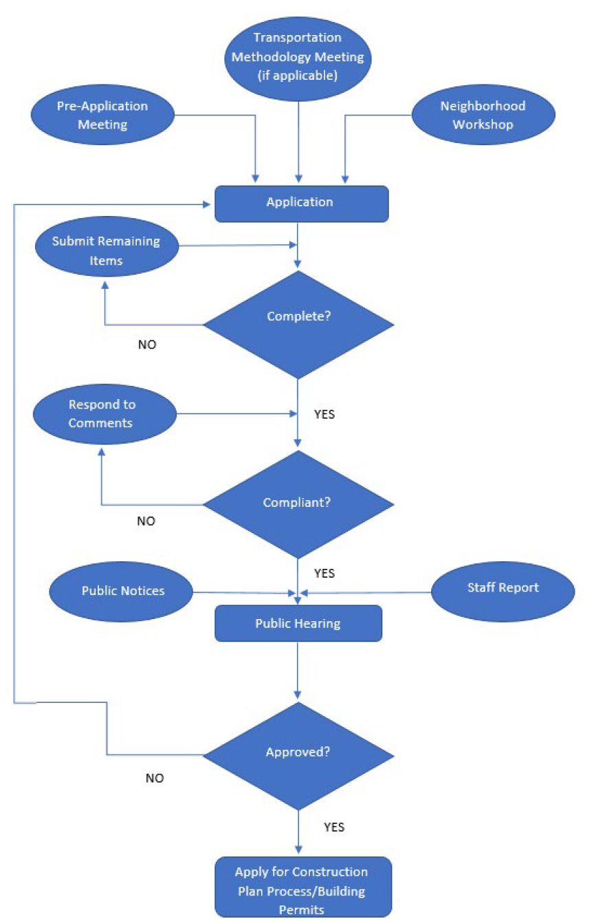
1.2. - Common Review Procedures
A.
Applicability. The requirements below are common to all applications contained in this Section. Additional provisions may also be required as specified in each application.
B.
Schedule of Fees. Council shall establish, and may amend, a schedule of fees and charges for matters pertaining to this chapter by resolution. It is the intent of this chapter that the City shall not be required to bear any part of the cost of applications or petitions under this chapter and that the fees and charges represent the actual costs involved in the processing of petitions for development approval and directly associated expenses including, but not limited to, advertising, mailing and professional and legal fees.
1.
Review Deposit. For the review and processing of the applications described in this LDR, in addition to the non-refundable application fee, a review deposit shall be submitted to the Planning and Zoning Department by the applicant to be drawn upon by the City as payment for advertising and mailing expenses, professional services and reviews, and legal fees pertaining to the review and processing of the application. This deposit shall be payable at the time of filing of the application. The application shall not be reviewed or processed by the City or presented to the Commission or Council until such time as the application fees and review deposit have been paid in full. When the account balance for a particular application is reduced to 25 percent of the review deposit, a supplemental fee shall be required to be paid before any further review and processing of the application continues, unless the City Clerk's office and Planning and Zoning Department determine that the remaining amount is adequate to secure payment for the remaining costs. Otherwise, the Director shall notify the applicant, in writing, that the review and processing of the application will cease unless an additional amount equal to 50 percent of the review deposit, or more if deemed necessary by the Director, is provided by the applicant within five days from the date of mailing said notice. This process shall be repeated each time the account balance is reduced to 25 percent of the review deposit.
a.
Upon completion of the review and processing of the application, any sums remaining in the account shall be refunded to the applicant. Similarly, if the application is withdrawn by the applicant, the applicant shall be eligible for a refund of the review deposit paid minus the directly associated expenses as determined by the Director. No interest shall be paid to the applicant on the review deposit or the amount refunded.
2.
Fee Increases. The schedule of fees and charges shall be automatically increased by two and one-half percent each October 1 to account for the rate of inflation.
C.
Application Requirements. All applications regulated by this LDR shall be submitted in accordance with the rules provided herein and be filed with City Planning and Zoning Department per their procedures and forms. Each application form shall clearly state all items required for review. Specific application requirements contained in each subsection must be provided, unless such requirement is clearly not applicable to the application under consideration, in which case, the Director, after making such a finding, may, in writing, waive the inapplicable requirement. All the following items are required for all applications, unless deemed not applicable by the Director:
1.
Completed application and applicable fees.
2.
Narrative.
3.
General location map, showing the relation of the site to major streets, schools, important landmarks or other physical features in and adjoining the project.
4.
Summary of the neighborhood workshop (if applicable) per Section 1.2.F including mailing list, list of attendees, and a summary of comments provided and applicant responses.
5.
Accurate survey, reflecting existing conditions, no more than two years old and the corresponding legal description in a copyable electronic format.
6.
Agent authorization (if applicable).
7.
Statement of ownership and control.
8.
Land Use Compatibility Analysis.
a.
Demonstrate that the character and design of infill and new development are compatible with existing neighborhoods. The compatibility review shall include the evaluation of the following items with regard to annexation, rezoning, height exception, conditional use, and site and development plan petitions:
i.
Land use density and intensity.
ii.
Building heights and setbacks.
iii.
Character or type of use proposed.
iv.
Site and architectural mitigation design techniques.
b.
Considerations for determining compatibility shall include, but are not limited to, the following:
i.
Protection of single-family neighborhoods from the intrusion of incompatible uses.
ii.
Prevention of the location of commercial or industrial uses in areas where such uses are incompatible with existing uses.
iii.
The degree to which the development phases out nonconforming uses in order to resolve incompatibilities resulting from development inconsistent with the current Comprehensive Plan.
iv.
Densities and intensities of proposed uses as compared to the densities and intensities of existing uses.
D.
Pre-Application Meeting (Optional). Before submitting an application, it is recommended an applicant schedule a pre-application meeting with the Director or designated staff to discuss the procedures, standards and regulations for approval. Although not required, the pre-application meeting is intended to assist with identifying potential items for consideration and general expectations from the City.
E.
Public Notice Requirements. Applicants shall pay the cost of public notice requirements. The City shall perform the notices.
1.
Mailed Notice Requirements. Notice of the time and place of the public hearing by the Commission and Council shall be sent at least 15 days in advance of the hearing by mail to the owner of the subject property or his designated agent or attorney, if any, and to all owners of property within 250 feet of the property lines of the subject property, or within 250 feet of the centerline of any right-of-way or waterbody adjacent to the subject property, whichever distance is greater; provided, however, that, where the applicant is the owner of land not included in the applicant's application, and such land that is not included in the application is a part of or adjoins the parcel for which the request is made, the 250-foot requirement shall be measured from the boundaries of the applicant's ownership, including the land not covered by the applicant's application up to a maximum of 600 feet. Mailed notice shall also be provided to registered neighborhood associations in the City. For purposes of this requirement, the names and addresses of property owners shall be deemed those appearing on the latest tax rolls of the county. Failure of a property owner to receive mail notice shall not invalidate the hearing or subsequent action related thereto. The city clerk shall execute and file a certificate that shall contain the names and addresses of those persons notified, and the dates the notice was mailed. The certificate shall be signed by the city clerk and the official seal affixed. The certificate shall be prima facie evidence of the fact that notice was mailed. Public hearings for Comprehensive Plan map and text amendments shall be held in compliance with F.S. § 163.3184, as amended, and the provisions of this LDR.
2.
Posted Notice Requirement. Posted notices are required for all applications except for text amendments to the Comprehensive Plan and LDR. A sign shall be posted on the land that is the subject of the application at least 15 calendar days prior to the date of the public hearing. The sign shall be at least 10 inches by 16 inches and contain (substantially) the following language: "A PUBLIC HEARING CONCERNING THE (INSERT ITEM) ON/FOR THIS PROPERTY WILL BE HELD BY THE (APPLICABLE REVIEW PARTY) ON (DATE) AT (TIME). CALL (PHONE NUMBER) FOR INFORMATION." The posted notice shall be erected on each nearest street right-of-way and be clearly visible from the right-of-way. Where the subject property is landlocked, the signs shall be erected on the nearest street right-of-way, with an attached notation indicating generally the distance and direction to the subject property. It shall be a violation of this chapter for any person to remove or deface any such posted sign until the applicable reviewing party has acted on the petition.
3.
Publication Requirement. For all applications, a notice of the time and place of the public hearing shall be published in a newspaper of general circulation in the city at least 15 calendar days in advance of the public hearing except as otherwise required by state law.
4.
Continued Hearings. If a public hearing that has been properly noticed pursuant to subparagraphs 1—3. above, is continued by the Commission or Council on the record to a date certain, re-notice shall not be required.
F.
Neighborhood Workshop. These workshops are required for all applications except Annexations, Comprehensive Plan Text Amendments, LDR Text Amendments, Vested Rights, Variances, and Administrative Applications in Section 1.15. Notice of the time and place of the workshop shall be given at least 15 calendar days in advance of the neighborhood workshop. The owner of land (or designated agent) shall be responsible for the notification and security measures as needed. A neighborhood workshop is required to be advertised both by mailed notice and publication according to the same procedures indicated in Sections 1.2.E.1 and 1.2.E.3. Both the mailed notice and published advertisement must include a description of the scope, nature, and purpose of the proposal(s) to be discussed. A workshop may be in-person, performed virtually over the internet, or in a hybrid format and must occur within one year prior to the application date. Neighborhood workshops are not a public hearing, but must be conducted in the following manner:
1.
The owner of land (or their agent) must provide a general overview of the project at a location within the City limits.
2.
The workshop shall not start before 5:00 p.m. or after 8:00 p.m. and shall be held on a weeknight, not on a holiday.
3.
At the workshop, materials shall be provided to interested attendees, including summary of the request; any proposed design alternatives, conditional uses, height exceptions and or variances; recent aerial of site and surrounding area; adopted zoning map and designation; adopted FEMA floodplain map; and adopted future land use map.
4.
Upon completion of the neighborhood workshop, the applicant must include in their application materials a neighborhood workshop summary that contains the date, time and location, mailing list, list of attendees, summary of the questions or issues raised and applicant responses, and written documentation that demonstrates the neighborhood workshop notification was provided in compliance with this section.
5.
Exemptions. When a neighborhood workshop has been held in accordance with this section, no additional workshop is required for subsequent applications for the same property when the project scope and nature remain substantially unchanged.
G.
Completeness Reviews. Completeness shall be defined to mean that an application package includes required fees and all information, documents, and analysis required to allow City staff and the review authorities to make the necessary determinations under the Comprehensive Plan and LDR.
1.
Each application shall include all information required for the specific application type, any other concurrent required applications, and any other information deemed necessary by the Director or designee. The City has ten (10) business days to perform the completeness review. For final plats, the procedure in Sec. 1.15.5.B shall apply.
2.
Once completeness review begins by the City, if the applicant wishes to submit additional materials or information, or make changes to the application, the review timeframe for completeness may restart.
3.
If the application is determined to be complete, the application is accepted by the City and the Director will begin the compliance review process and timeframes.
4.
For incomplete applications, the Director shall notify the applicant in writing stating the reasons why the application is incomplete. The applicant has thirty (30) business days from the receipt of an incomplete notification to provide all missing information. The City may extend the 30-day timeframe upon written request by the applicant. If the applicant believes the request for additional information is not authorized by ordinance, statute, or other legal authority, the applicant may submit a written request to proceed to the compliance review notwithstanding the identified deficiencies.
5.
If the applicant does not resubmit an application for completeness review within the timeframe or does not request that the application be reviewed for compliance notwithstanding the identified deficiencies, the Director shall notify the applicant in writing that the application has been deemed withdrawn.
H.
Compliance Review. Following completeness review, a compliance review is conducted to determine whether the application contains the necessary analysis addressing the requirements for approval contained in the Comprehensive Plan, LDR or implementing regulations, to enable a determination to be made by the review authority.
1.
For each application reviewed, the City must determine if an application meets all relevant standards contained in the LDR, Comprehensive Plan and other applicable rules and regulations. The City shall have fifteen (15) business days to complete the compliance review; however, if additional time is needed by the City it shall so notify the applicant.
2.
If an application is deemed non-compliant, the Director shall provide notification to the applicant indicating all required revisions. An applicant shall then be required to modify the application within twenty (20) business days. The city may extend the 20-day timeframe upon written request by the applicant.
3.
Upon resubmittal of a previously non-compliant application, the City has ten (10) business days to complete an additional compliance review. Resubmitted applications shall provide a listing of each City comment and the applicant response to each comment. Per F.S. § 166.033, if the applicant for a development order or development permit (as defined in F.S. § 163.3164) is a certified professional listed in F.S. § 403.0877, the City may only request additional information three (3) times during the review of the application, unless the applicant waives this limitation in writing.
4.
For applications that remain non-compliant, the applicant has another twenty (20) business days from the receipt of notification of required revisions to provide all revised documents. The City may extend the 20-day timeframe upon written request by the applicant. If the applicant believes the request for revisions is not authorized by ordinance, statute, or other legal authority, the applicant may submit a written request to the City to proceed to scheduling a public hearing.
5.
Should any City Department fail to respond to a request for compliance review, the Director retains the authority to deem the application compliant on the City's behalf.
6.
If an applicant does not revise a non-compliant application within the required timeframes, the Director shall request in writing that the applicant provide a status update. If no update is received by the City within fifteen (15) days, or no agreement is reached as to a reasonable extension of time for the applicant to revise a non-compliant application, the Director shall notify the applicant in writing that the application has been deemed withdrawn.
7.
Any requests by the applicant for additional time to respond to compliance issues which are granted by the City shall also be deemed an agreement to reasonably extend the timeframes within F.S. § 166.033(1) for final action by the City on the application.
8.
Once the compliance review is completed, the Director shall so notify the applicant, a staff report shall be created and provided to the appropriate decision-making or recommending body, and a hearing shall be scheduled.
I.
Public Hearings.
1.
Planning Commission. When required, the Commission shall hold an advertised public hearing on an application. If reviewing and recommending, the Commission may recommend approval, approval with stipulations, or denial for specific reasons and provide the recommendation to Council. If the Commission acts as the final decision maker, Commission may grant or deny such application and may make the granting conditional with appropriate stipulations and safeguards as it may deem necessary. If the application is denied, the Commission shall give written notice to the applicant that includes a citation to the applicable portions of an ordinance, rule, statute, or other legal authority for the denial.
2.
City Council. When required, the Council shall hold an advertised public hearing on an application. The Council may grant or deny such application and may make the granting conditional upon such restrictions, stipulations and safeguards as it may deem necessary. If denied, the Council shall give written notice to the applicant that includes a citation to the applicable portions of an ordinance, rule, statute, or other legal authority for the denial. When an application for a zoning map amendment is denied, no other application for a rezoning to the same zoning district shall be considered for any part or all of the same property for a period of 12 months from the date of such denial. City Council may waive this requirement upon request.
3.
Stipulations. In cases where conditions, stipulations, or restrictions are attached, all representations of the owner or its agents at public hearings shall be deemed contractual and may be enforced by suit for injunction or other appropriate relief and the conditions, restrictions, and stipulations shall be deemed contractual and may be enforced by suit for injunction or other appropriate relief.
J.
Expiration of Approvals.
1.
Site and Development Plans expire two years from the date of approval if a building permit has not been issued for the development.
2.
Conditional Use petitions expire one year from the date of approval if the use has not begun.
3.
Variance petitions expire one year from the date of approval if an associated building permit has not been issued.
4.
Where subordinate petitions (including Conditional Use, Height Exception, and Design Alternative petitions) are approved concurrently with major petition types, development approvals for all related petitions will be granted the same expiration date.
5.
Written requests for extension may be submitted to the approving body for each petition type, as indicated in Tables 1.1 and 1.2, and may be approved for up to twelve months beyond the expiration date, provided that the property owner can demonstrate by competent and substantial evidence that financial or legal constraints or other events beyond the control of the applicant prevented application for a building permit.
(Ord. No. 2022-15, § 3(Exh. B), 7-12-22; Ord. No. 2023-05, § 2(Exh. A), 2-28-23; Ord. No. 2023-09, § 2(Exh. A), 5-9-23; Ord. No. 2023-12, § 2(Exh. A), 5-23-23; Ord. No. 2023-51, § 2(Exh. A), 1-9-24; Ord. No. 2024-16, § 2(Exh. A), 9-10-24; Ord. No. 2025-35, § 2(Exh. A), 10-28-25)
1.3. - Legislative and Quasi-Judicial Applications
A.
A legislative decision is one in which a law or policy is made, for example, amending a local ordinance or code. In legislative actions constituents may speak directly with their elected or appointed officials. A legislative action can be denied without competent substantial evidence based merely on any legitimate public purpose or concern. For the purpose of this section, legislative applications shall include Annexations, Future Land Use Map Amendments, Comprehensive Plan Text Amendments, and LDR Text Amendments.
B.
Quasi-judicial hearing(s) are similar to a court hearing. Decisions reached on these applications must be consistent with the Comprehensive Plan and LDR and they must be supported by competent, substantial evidence. Ex parte communications (discussion with a side or party outside of the hearing) are discouraged. An elected (e.g., City Council member) or appointed (e.g., Planning Commission member) official must disclose any ex parte communications, including who it was with, what was said and when, on the record at the beginning of the quasi-judicial hearing.
(Ord. No. 2022-15, § 3(Exh. B), 7-12-22)
1.4. - Annexations (Legislative Application)
1.4.1. Purpose and Intent
A.
Annexation is the incorporation of real property into the corporate boundaries of the City, thereby making the real property in every way a part of the City. The City has entered into a Joint Planning and Interlocal Service Boundary Agreement (JPA/ILSBA) with Sarasota County (adopted on October 30, 2010 and as amended) that identifies all properties that are eligible for annexation into the City. Any property identified as a potential annexation area within the JPA/ILSLBA or determined to be an enclave is eligible for annexation. Annexed property will be governed by the ordinances of the City and will be served by the City's services and systems unless otherwise indicated in the JPA/ILSBA. All annexations shall meet the requirements of F.S. Ch. 171. A pre-annexation agreement is required to be executed before annexation of a property.
1.4.2. Specific Application Requirements
A.
At minimum, an annexation request shall include the following, as part of or in addition to the requirements set out in Section 1.2:
1.
Verification of the subject property's inclusion in the JPA/ILSBA or enclave status.
2.
Legal description of subject property.
3.
Signed and sealed survey.
4.
Property Information and Title Report (Ownership & Encumbrance Report).
5.
A detailed narrative including:
a.
Reason for the Annexation;
b.
Whether the request is voluntary;
c.
Proposed City future land use designation and implementing City zoning designation;
d.
Statement of all existing uses, their locations on the subject property, and whether they will be in conformance with the proposed City future land use and zoning designations (uses not in conformance will be required to cease upon approval of the rezoning application or must be addressed through the annexation ordinance); and
e.
Potential impact to City or applicable County public facilities for the existing use/development of the property, the proposed development (if any), and the potential development permissible under the proposed future land use and zoning designations. This includes a Level of Service analysis of the potential increase in demand for public facilities against the current facility capacities and/or future year capacity of anticipated build out of property.
6.
Statement and corresponding map addressing any potential creation of enclaves (if any);
7.
Map showing property location and confirmation of contiguity to the existing City limits and reasonable compactness;
8.
Map(s) depicting the existing Sarasota County future land use designation, and existing Sarasota County zoning designation, along with the jurisdiction, future land use, and zoning designations of adjacent property;
9.
Revenue estimates for taxes and estimates for revenues for public facilities corresponding to Section A.4.e above; and
10.
Draft pre-annexation agreement between the City and the applicant.
B.
No annexation will be processed by the City without the joint submission of a Comprehensive Plan Future Land Use Map Amendment petition, a Comprehensive Plan Text Amendment (if applicable), and a Zoning Map Amendment petition.
1.4.3. Decision Criteria
A.
Applications for annexation must demonstrate:
1.
Consistency with state statute regarding annexation;
2.
Contiguousness and compactness of the property;
3.
That the annexation does not create an enclave;
4.
That the property is included in the annexation areas of the JPA/ILSBA or has been determined to be an existing enclave;
5.
That the property has access to a public right-of-way; and
6.
That a pre-annexation agreement addresses existing uses and any other relevant matters has been executed.
(Ord. No. 2022-15, § 3(Exh. B), 7-12-22; Ord. No. 2023-51, § 2(Exh. A), 1-9-24)
1.5. - Future Land Use Map and/or Text Amendments (Legislative Application)
1.5.1. Purpose and Intent
A.
A Comprehensive Plan map amendment is the process to modify the future land use of a property as designated in the Comprehensive Plan or as may be necessary to designate the future land use for properties annexed into the City. A Comprehensive Plan text amendment is the process to modify the Visions, Intents, and/or Strategies of the Comprehensive Plan. All amendments to the Comprehensive Plan shall be consistent with F.S. § 163.3177 and with the overall Visions, Intents, and Strategies of the Plan. All Comprehensive Plan amendments are processed in accordance with F.S. § 163.3184 and 163.3187.
1.5.2. Specific Application Requirements
A.
Any person, board, agency or their authorized representative affected by the city's Comprehensive Plan may apply to amend the plan text. An application to amend the future land use plan map may only be filed by the City Council, Planning Commission, staff, or an owner of property, or their designated agent, subject to the amendment. At minimum, the application shall require, as part of or in addition to the requirements set out in Section 1.2:
1.
All data, maps, and text required to meet the submittal requirements for a Comprehensive Plan amendment as defined in F.S. § 163.3177. Data, maps, and text must be provided in strikethrough/underline format and in an editable electronic format.
2.
Applicant responses to F.S. §§ 163.3177(6)(a)(2), 163.3177(6)(a)(8), and 163.3177(6)(a)(9).
3.
Narrative justification for the future land use map amendment and its consistency with the Comprehensive Plan.
4.
A transportation analysis of three planning periods consistent with Strategy TR 1.2.2.a and Sec. 5.2.2.A.1 of this LDR (map amendments only).
5.
Any additional information deemed necessary by the Zoning Administrator to conduct a full analysis of the impact of the proposed amendment on the Comprehensive Plan.
6.
Any amendment to create a new future land use designation shall be supported by additional data and analysis in accordance with F.S. § 163.3177.
1.5.3. Decision Criteria
A.
The City shall consider the impacts to the adopted level of service standards when considering any proposed Comprehensive Plan amendment.
B.
The City shall consider the compatibility matrix in the Comprehensive Plan and its subsequent impact on possible implementing zoning designations.
C.
The application must be found in compliance with all other applicable elements in the Comprehensive Plan and F.S. Ch. 163, Part II.
(Ord. No. 2022-15, § 3(Exh. B), 7-12-22; Ord. No. 2023-05, § 2(Exh. A), 2-28-23)
1.6. - LDR Text Amendments (Legislative Application)
1.6.1. Purpose and Intent
A.
An LDR text amendment is undertaken when changes are proposed to the text of the Code that are necessary in light of changed conditions or changes in public policy or that are necessary to implement the Comprehensive Plan, to resolve issues of interpretation, or to advance the general welfare of the City.
1.6.2. Specific Application Requirements
A.
An amendment to the LDR may be proposed by City Council, Planning Commission, City Manager, any other department or board of the City, or a member of the public. The application must contain the following, as part of or in addition to the requirements set out in Section 1.2:
1.
A narrative describing the need and justification for the change.
2.
The consistency of the proposed text amendment with the Comprehensive Plan with reference to specific Visions, Intents, and Strategies.
3.
A copy of the original text language, a strike-through and underline of original and proposed text language, and a clean copy of the proposed new text language.
1.6.3. Decision Criteria
A.
The Commission and Council must find that the proposed amendment is consistent with all applicable elements of the Comprehensive Plan and promotes the public health, safety and welfare, in order to adopt the proposed amendment as proposed, or with such modifications as are necessary to assure the foregoing.
(Ord. No. 2022-15, § 3(Exh. B), 7-12-22)
1.7. - Zoning Map Amendments (Quasi-Judicial Application)
1.7.1. Purpose and Intent
A.
A zoning map amendment is undertaken to accommodate changes to the official zoning map for changed conditions or changes in public policy, to implement the Comprehensive Plan, or to advance the general welfare of the City.
1.7.2. Specific Application Requirements
A.
At minimum, a zoning map amendment application shall include, as part of or in addition to the requirements set out in Section 1.2:
1.
Narrative explaining justification for the zoning map amendment.
2.
All data and maps required to support conclusions made in responses to specific findings in Sec. 1.7.4.
3.
Any additional information deemed necessary by the Zoning Administrator to conduct a full analysis of the impact of the proposed amendment on the LDR.
1.7.3. Planned District Zoning Amendments
A.
Purpose and Intent. The planned district zoning district shall be utilized to promote efficient and economical land use, appropriate and harmonious variety in physical development, creative design, and the protection of adjacent and nearby existing and future city development. Regulations for planned district zoning districts are intended to accomplish the purpose of zoning, subdivision regulations and other applicable city regulations on a unified development approach rather than on a lot by lot basis. In view of the substantial public advantages of the planned zoning district, it is the intent of the city to promote and encourage development in this form where tracts suitable in size, location and character for the uses and structures proposed are to be planned and developed as a unified and coordinated development.
B.
Additional Application Requirements.
1.
Evidence of unified control as required by subsection E, herein.
2.
The applicant shall, by ordinance or separate written, signed, and notarized Development Agreement, agree to:
a.
Proceed with the proposed development according to the provisions of this chapter and such conditions as may be set forth as a condition of approval for the development;
b.
Provide agreements, contracts, deed restrictions and sureties acceptable to Council for completion of the development according to the provisions and plans approved at the time of acceptance of the area for a Planned District, and for continuing operation and maintenance of such areas, functions and facilities as are not to be provided, operated or maintained at public expense;
c.
Bind successors in title to any commitments made under subsections (2)a and (2)b, above.
3.
Concurrency application:
a.
School (when required).
b.
Public facilities:
i.
Water;
ii.
Wastewater;
iii.
Solid waste;
iv.
Parks;
v.
Stormwater.
4.
Transportation Analysis. If the proposed project generates 50 or more new or net PM peak hour trips, then a traffic study shall be submitted per Section 5.2: Mobility. Prior to the study being performed, a methodology meeting must be held with the applicant, City staff and Sarasota County staff (if applicable).
5.
A statement of the land use density/intensity sought for the Planned District and supporting evidence or documentation justifying the request.
6.
A Binding Master Plan depicting the zoning standards and requirements of the proposed planned district zoning district, including the following at a minimum:
a.
Location Information and Site Data:
i.
The title of the project and the names of the professional project planner and the developer.
ii.
Scale, date, north arrow and general location map.
iii.
Boundaries of the property involved, including tabulations for gross acreage and depictions of all existing streets, buildings, watercourses, easements, section lines and other existing important physical features in and adjoining the project.
iv.
Density/intensity of land uses (number of dwelling units per dwelling type and/or non-residential square footage by use type).
v.
Location of landscaped areas and typical cross sections.
vi.
Location of buffers including typical cross sections.
vii.
Location of fencing and berms including typical cross sections.
viii.
Tabulations and location of open space, common use areas, and amenities (if any).
ix.
Location of stormwater areas.
x.
Location of vehicular use areas and access.
xi.
Utilities by type and connection points to the public systems.
xii.
Environmental Assessment Report consistent with Chapter 89.
xiii.
Street network.
xiv.
Pedestrian and multimodal systems.
xv.
Location of land use areas with corresponding permitted uses.
xvi.
A resource management plan that incorporates the facility design, types, size, location, and sidewalk access into an overall development plan, and addresses issues of mobility, pedestrian accessibility and connectivity, architectural standards, and landscaping/hardscaping components.
b.
Zoning Standards. The following standards may be standalone or, if clearly defined, combined documents or plan sheets:
i.
Permitted uses by land use area, accessory uses, and use restrictions.
ii.
Maximum nonresidential square footage (if permitted) in floor area ratio format.
iii.
Maximum number of dwelling units (if permitted).
iv.
Type and number of dwelling units.
v.
Maximum heights of all proposed structures.
vi.
Setbacks and lot/tract dimensions.
vii.
Mobility Plan including street types and identifying circulation elements including driveways, transit, vehicular, pedestrian and bicycle components, as applicable.
viii.
Open space plan including standards for functional and conservation (minimum percentage/acreages by type).
ix.
Compatibility plan, consistent with Section 4: Compatibility.
x.
Parking plan providing standards for all use types.
xi.
Signage plan.
xii.
Architectural plan (if applicable).
xiii.
Landscaping plan.
xiv.
Outdoor Lighting plan.
c.
The standards contained in this LDR will be the default for any area where the application does not indicate standards specific to the proposed planned development zoning district.
C.
Amendments to Approved Planned Districts.
1.
An amendment to an approved Planned District shall be classified as either a minor or major amendment. The following criteria shall be used to identify a major amendment:
a.
A change which would add a non-residential land use classification (e.g., commercial, office, institutional) to a residential area of the Planned District;
b.
A change wherein an additional use is added to an already approved use classification within the Planned District (e.g., adding multifamily to the list of permitted residential uses, adding convenience store to the list of permitted commercial uses);
c.
A change to the conditions of approval or development standards for the Planned District, unless expressly allowed as a minor amendment;
d.
A change which would add new property to or remove property from an approved Planned District;
e.
Changes to access points or buffers on the perimeter of the Planned District site;
f.
Any proposed change in the type, location or size (except reduction in the number of units) of a multi-family land use in the Planned District except those deemed a minor amendment in subsection D.1.f. herein; or
g.
Any amendment that will result in a reduction of open space (including both functional and conservation open space as defined by the City Code and/or Comprehensive Plan, and including but not limited to any common areas, recreational areas, drainage tracts, submerged lands, greenways, greenspaces, trails, or similar, as may be designated on the original binding master plan).
2.
The determination of whether an amendment is major or minor shall be made by the Director. The determination shall be in writing and may be appealed by the applicant within 30 days of its issuance by the Director. Alternatively, the Director may opt to refer the determination to the Commission for a final decision.
3.
An applicant proposing an amendment determined to be a major amendment must submit plans and support data for review by staff in accordance with the applicable requirements of subsection B herein.
4.
Any minor or major amendment approved for a Planned District subsequent to the recording of a final plat that modifies said plat shall require the approval and recording of an amended final plat.
D.
Minor Amendments to Approved Planned Districts.
1.
Minor amendments, shall include the following:
a.
Signage. Relocation of a permitted sign due to engineering or design considerations.
b.
Utilities. Relocation and/or redesign of utilities subject to applicable permitting.
c.
Dwelling Units. A decrease in total residential units up to 10% or 25 units, whichever is greater.
d.
Drainage and Submerged Areas. Minor revisions to drainage tracts, ponds, stormwater areas, lakes or other similar areas, provided such revision does not decrease the amount of open space within the approved binding master plan and does not impact any compatibility standard requirements.
e.
Lot Dimensions. Alterations to lot width and length, provided that there is no additional density created and provided further that such revisions do not decrease the amount of open space within the approved binding master plan.
f.
Changes to List of Permitted Uses. Residential uses added to the list of permitted uses in non-residential net developable land areas of the Planned District.
E.
Unified Control.
1.
Initial Planned District Approval: Prior to approval of a planned district zoning district, the applicant shall furnish the City with sufficient evidence to the satisfaction of the City Attorney that the applicant is in the complete, unified and otherwise-unencumbered control of the entire area of the proposed planned district zoning district, whether the applicant be an individual, partnership, corporation, other entity, group or agency. The applicant shall provide the City all necessary documents and information that may be required by the City Attorney to assure the City that the development project may be lawfully completed according to the plans sought to be approved. No application shall be considered until the requirements of this section have been fully complied with.
2.
Planned District Major Amendment Approval (up to 50% Buildout): After a site has been rezoned to Planned District, and up to the point at which fifty percent (50%) of the net developable land area in the Planned District has been developed, major amendments to the Planned District shall only be initiated by a property owner(s) who can furnish the City with evidence satisfactory to the City Attorney of unified control of more than 50% of the net developable land area of the entire Planned District at the time of filing the application for a Planned District amendment.
3.
Planned District Major Amendment Approval (After 50% Buildout): After a site has been rezoned to Planned District, and after more than fifty percent (50%) of the net developable land area in the Planned District has been developed, major amendments to the Planned District may only be initiated by:
a.
The property owner, if the proposed change is applicable to only the given lot, tract or parcel which is the subject of the major amendment, and only if said lot, tract or parcel is designated net developable land in the binding master plan; or
b.
Petition by the owners of more than sixty percent (60%) of the net developable land area within the Planned District for all other amendment applications, provided however, that the forgoing shall not be construed to allow any change of land use to any property contained within the Planned District without the consent of said property owner; or
c.
Council, where necessary to preserve the health, safety and welfare of the property owners in the Planned District or adjacent areas outside the Planned District.
F.
Definitions.
1.
Developed, for purposes of this section shall mean that unexpired building permits and/or certificates of occupancy have been issued by the City for lots, tracts, or other legally recognized parcels within the approved binding master plan.
2.
Net Developable Land Area, for purposes of this section shall mean land area which forms the footprint for vertical development within an approved planned district and does not include any open space of any kind, including but not limited to wetlands, right of way, trails, greenspace, greenways, drainage tracts, recreational tracts, common areas, or other similar land areas within an approved planned district.
3.
Major Amendments and Minor Amendments, shall mean those changes to an approved planned district as determined by the process and guidelines in Sections 1.7.3 and 1.7.4 of the City Code.
1.7.4. Decision Criteria
A.
Council and the Commission shall consider, as applicable, the following:
1.
Whether the zoning map amendment is compatible with the existing development pattern and the zoning of nearby properties.
2.
Changes in land use or conditions upon which the original zoning designation was based.
3.
Consistency with all applicable elements of the Comprehensive Plan.
4.
Conflicts with existing or planned public improvements.
5.
Availability of public facilities, analyzed for the proposed development (if any) or maximum development potential, and based upon a consideration of the following factors:
a.
Impact on the traffic characteristics related to the site.
b.
Impact on population density or development intensity such that the demand for schools, sewers, streets, recreational areas and facilities, and other public facilities and services are affected.
c.
Impact on public facilities currently planned and funded to support any change in density or intensity pursuant to the requirements of the Comprehensive Plan and applicable law.
6.
Effect on health, safety and welfare of the neighborhood and City.
7.
Conformance with all applicable requirements of this LDR.
8.
Findings of the Environmental Assessment Report, consistent with Chapter 89.
9.
For a proposed major amendment to an adopted Planned District the following additional criteria shall be considered:
a.
Whether the amendment is consistent with the reasonable expectations of other residents within the Planned District with regard to how the Planned District would be built out over time.
b.
The extent to which the amendment deviates from the approved binding master plan, including whether any proposed change of use can be accommodated by any conversion, flex use or related similar Planned District allocation chart included in the binding master plan.
c.
The extent to which the alteration to the Planned District will service and/or benefit other uses within the Planned District.
d.
Whether the amendment is compatible with the common scheme of development contemplated in the binding master plan.
10.
Any other applicable matters pursuant to this LDR, the Comprehensive Plan or applicable law.
B.
The cost of land or other economic considerations pertaining to the applicant shall not be a consideration in reviewing the request.
(Ord. No. 2022-15, § 3(Exh. B), 7-12-22; Ord. No. 2022-31, § 2(Exh. A), 12-13-22; Ord. No. 2023-05, § 2(Exh. A), 2-28-23; Ord. No. 2024-16, § 2(Exh. A), 9-10-24; Ord. No. 2025-02, § 2(Exh. A), 1-28-25)
1.8. - Conditional Uses (Quasi-Judicial Application)
1.8.1. Purpose and Intent
A.
A conditional use application is required whenever a proposed use is defined as conditional in Section 2.2.7: Traditional Districts Use Table or Section 2.3.13: Mixed-Use Districts Use Table. A Conditional Use is a use that would not be appropriate generally or without restriction within a zoning district but which, if controlled as to area, location, or relation to the neighborhood is acceptable and meets the intent of this LDR. Where the rezoning of land as well as grant of conditional use is requested simultaneously for the same parcel of land, both petitions may be processed concurrently in accordance with the procedures set forth in this section.
1.8.2. Specific Application Requirements
A.
Applications for a conditional use shall include all of the following as part of or in addition to the requirements set out in Section 1.2:
1.
A site plan at an appropriate scale showing proposed placement of structures on the property, and provisions for ingress and egress, off-street parking and off-street loading areas, refuse and service areas, and required yards and other open spaces;
2.
Proposed landscaping, screening, and buffering, including provisions for trees protected by City regulations; and
3.
Proposed signs and lighting, including type, dimensions and character.
1.8.3. Decision Criteria
A.
Before any conditional use shall be approved, the Commission shall make a finding that the granting of the conditional use will not adversely affect the public interest and that satisfactory provision and arrangement has been made concerning the following matters, where applicable:
1.
Compliance with all applicable elements of the Comprehensive Plan.
2.
General compatibility with adjacent properties and other property in the district.
3.
Any special requirements set out in Section 2 in this chapter for the particular use involved.
1.8.4. Attainable Housing Density Bonus
A.
Applicability. Zoning Map Amendment, Preliminary Plat, and Site and Development Plan applications for properties in Residential Multi-Family zoning districts and all mixed use zoning districts may request an attainable housing density bonus based on the level of affordability provided, which request shall be processed as a conditional use.
B.
Additional Application Requirements. All development applications proposing to use a density bonus for attainable housing shall provide the following:
1.
Responses to each of the nine locational considerations in Comprehensive Plan Strategy HG 1.2—Targeted Attainable Housing Locations;
2.
A detailed narrative describing the level of affordability proposed and the number of additional units sought through the density bonus incentive, including calculations confirming that the requested number of additional units meet the standards set by the Housing Element of the Comprehensive Plan and the corresponding categories set by the United States Department of Housing and Urban Development; and
3.
Documentation of a binding commitment to maintain attainability for at least ten (10) years, or a longer timeframe if required by Council at the time of approval, including information about how the project will be monitored and by whom.
4.
Concurrency application.
a.
School (when required).
b.
Public facilities:
i.
Water;
ii.
Wastewater;
iii.
Solid waste;
iv.
Parks;
v.
Stormwater.
5.
Transportation Analysis. If the proposed project generates 50 or more new or net PM peak hour trips, then a traffic study shall be submitted per Section 5.2: Mobility. Prior to the study being performed, a methodology meeting must be held with the applicant, City staff and Sarasota County staff (if applicable).
C.
Amount of Bonus Units. Comprehensive Plan Strategy HG 1.5.3. details the availability of additional units for Affordable and Community Housing development applications, and Comprehensive Plan Table HG-2 provides the maximum number of units available per project. An applicant seeking to apply the density bonus to a project should use this strategy and associated table to explain the desired density as required by B.2. above.
D.
Decision Criteria. The Commission shall make a recommendation to Council based on the availability of units in the reserve density established through Comprehensive Plan Strategy HG 1.5.3 and the criteria applied to all Conditional Use applications through Section 1.8.3 of this LDR.
(Ord. No. 2022-15, § 3(Exh. B), 7-12-22; Ord. No. 2023-05, § 2(Exh. A), 2-28-23; Ord. No. 2023-19, § 2(Exh. A), 6-27-23)
1.9. - Site and Development Plan (Quasi-Judicial Application)
1.9.1. Purpose and Intent
A.
Site and development plans are designed to ensure that development is carried out in compliance with this LDR, other applicable codes and ordinances, and the Comprehensive Plan.
1.9.2. Applicability
A.
A site and development plan is required for development and redevelopment of property if any of these criteria are met, unless otherwise permitted or exempted in this chapter (see Section 1.15.3: Minor Site and Development Plan).
1.
Development of land that is vacant or substantially vacant.
2.
Substantial redevelopment of a property in which multiple components (e.g., buildings, parking, access, landscaping and buffering, drainage, etc.) of the site will be altered.
3.
A project that will result in an increase in residential density.
4.
New buildings or expansion to buildings that increases the existing building square footage on a site by more than 15 percent at ground level.
5.
Any project that increases the height of the habitable portion of a building.
6.
A change in the use of a property for which site improvements are required to bring the new use into compliance with this chapter. For the purpose of this section, a change in use shall be defined as a change in occupancy classification per the Florida Building Code.
1.9.3. Specific Application Requirements
A.
A site and development plan including all subsequent required documentation and associated plans shall be signed and sealed by the appropriate state licensed engineer, architect, landscape architect, surveyor, or practicing land planner for the applicable items.
B.
The application shall, at minimum, include the following items, as part of or in addition to the requirements set out in Section 1.2:
1.
Site plan that contains the overall project layout, includes the title of the project and the name and contact information for the developer, property owner, and all applicable engineers, architects, planners, and any other professionals providing information as part of the project documents; date and north arrow; and is based on an exact survey of the property drawn to a scale of sufficient size to show existing and proposed information:
a.
Boundaries of the project, any existing streets, buildings or other structures, watercourses, easements and section lines;
b.
Access and traffic flow, including depictions of how vehicular traffic will be separated from pedestrian and other types of traffic;
c.
Off-street parking and off-street loading areas with typical cross sections;
d.
Recreational facilities locations (if applicable);
e.
Landscaped areas with standards and typical cross sections;
f.
Sign location;
g.
Location of compatibility requirements with typical cross sections(if any);
h.
Refuse collection areas;
i.
Access to utilities and points of utility hookups;
j.
Future land use and zoning designations of adjacent properties;
k.
Overlay of flood zones on an aerial map of the project; and
l.
Environmental Assessment Report consistent with Chapter 89, which addresses potential contamination on the site and evaluates whether the site is a brownfield.
2.
Tabulation of total gross acreage in the project and the percentages thereof proposed to be devoted to:
a.
The various permitted uses;
b.
Ground coverage by structures; and
c.
Impervious surface coverage.
3.
Tabulations showing:
a.
The number of proposed off-street parking and off-street loading spaces and a calculation of the minimum number of such spaces required by this chapter; and
b.
Total project density in dwelling units per acre or total project intensity as a floor area ratio.
4.
If common facilities, such as recreation areas or structures, private streets, common open space, parking areas, access drives, etc., are to be provided for the development, statements as to how such common facilities are to be provided and permanently maintained. Such statements may take the form of proposed deed restrictions, deeds of trust, homeowners' associations, surety arrangements or other legal instruments providing adequate guarantee to the city that such common facilities will not become a future liability for the city.
5.
Common use improvements regulated by the city standard details shall meet the minimum design standards established in the city standard details and subdivision design standards.
6.
Storm drainage, potable water and wastewater collection system plans.
7.
Color architectural elevations for all façades of each building in the development; and exact number of dwelling units, sizes and types, together with typical floor plans of each type.
8.
Plans for signs, if any, including dimensions and design. For ground signs, architectural elevations will be required.
9.
An exterior lighting plan, including location, dimensions, design, and photometric analysis.
10.
A landscaping plan, including types, sizes and location of vegetation and decorative shrubbery, showing provisions for irrigation and maintenance, and showing all existing trees, identifying those trees to be removed. All calculations for landscaping and trees, per Chapter 87, must be included in the landscaping plan. A separate sheet should be provided in the landscape plan set that shows a utility overlay to ensure there are no conflicts with the proposed landscaping.
11.
Plans for recreation facilities, if any, including buildings for such use.
12.
An addressing plan per Section 3.4.1.C.
13.
Vehicle turning path analysis (using design-based software) to confirm safe and efficient access for large vehicles, such as emergency vehicles, solid waste collection vehicles, delivery vehicles, and others.
14.
Concurrency application (if applicable; see Section 5):
a.
School (when required);
b.
Public facilities;
c.
Water;
d.
Wastewater;
e.
Solid waste;
f.
Parks;
g.
Stormwater.
15.
Transportation Analysis. If the proposed project generates 50 or more new or net PM peak hour trips, then a traffic study shall be submitted per Section 5.2: Mobility. Prior to the study being performed, a methodology meeting must be held with the applicant, City staff and Sarasota County staff (if applicable).
16.
Such additional data, maps, plans or statements as may be determined by the Director to be required for the particular use or activity involved.
1.9.4. Decision Criteria
A.
In reaching a decision regarding the site and development plan as submitted, the Commission shall be guided in its decision to approve, approve with conditions, or to deny by the following considerations:
1.
Compliance with all applicable elements of the Comprehensive Plan;
2.
Compatibility consistent with Section 4 of this LDR;
3.
General layout of the development including access points, and on-site mobility;
4.
General layout of off-street parking and off-street loading facilities;
5.
General layout of drainage on the property;
6.
Adequacy of recreation and open spaces;
7.
General site arrangement, amenities, convenience, and appearance; and
8.
Other standards, including but not limited to, architectural requirements as may be required.
(Ord. No. 2022-15, § 3(Exh. B), 7-12-22; Ord. No. 2023-05, § 2(Exh. A), 2-28-23; Ord. No. 2024-16, § 2(Exh. A), 9-10-24)
1.10. - Subdivisions
A.
Applicability. A subdivision of land is the division of real property into more than two lots, parcels, tracts, tiers, blocks, sites, units or any other division of land, and/or the establishment of new streets and alleys, additions and re-subdivisions creating a recorded final plat; provided, however, that the sale or exchange of small parcels of land to or between adjoining property owners, where such sale or exchange does not create additional lots, shall not be considered as a subdivision of land (see lot reconfiguration requirements in Section 1.15.4). It shall be unlawful for any person, being the owner, agent or person having control of any land within the city, to subdivide or lay out such land in lots unless by a plat, in accordance with the regulations contained in this chapter and the applicable laws of the state. Subdivision plans submitted for code compliance review shall be in accordance with the requirements of technical codes and other applicable laws and ordinances. Subdivision plans shall be prepared by a state-licensed land surveyor, professional engineer, architect or certified land planner as may be appropriate to the particular item or as required by state law. A subdivision of land is a two-step process: Preliminary Plat and Final Plat. See Section 1.15.5 for the final plat review process.
1.10. Preliminary Plat (Quasi-Judicial Application)
A.
Purpose and Intent. The preliminary plat provides the City the opportunity to review, and the public an opportunity to comment on, a proposed subdivision layout prior to construction of infrastructure and other physical improvements. A preliminary plat provides the map or delineated representation indicating the proposed layout of a subdivision consistent with the Comprehensive Plan and zoning for the subject property.
B.
Application Requirements. Site improvements such as parking lot improvements, utility design (stormwater, reclaimed water, water and wastewater), paving and grading plan, and best management plans shall be signed and sealed by a state-licensed professional engineer on each sheet. Landscaping plan shall be signed and sealed by a state-licensed landscape architect. The application shall, at minimum, include the following, as part of or in addition to the requirements set out in Section 1.2:
1.
A preliminary plat plan set containing the title of the project and the names, addresses and telephone numbers of the project planner, utility suppliers, the engineer of record and the surveyor of record, and date and north arrow. The preliminary plat plan set must be based on an exact survey of the property drawn to a scale of sufficient size to show:
a.
Boundaries of the project, along with any existing streets, buildings, watercourses, easements, and section lines;
b.
Location of all existing and proposed buildings and structures;
c.
Location of proposed use areas;
d.
Natural features, such as lakes, marshes, swamps, watercourses, land subject to flooding and wooded areas;
e.
The proposed location and width of streets, alleys and easements; all lot dimensions proposed street names; and cross-sections of each street type;
f.
Access and traffic flow and how vehicular traffic will be separated from pedestrian and other types of traffic;
g.
Overlay of flood zones on an aerial map of the project;
h.
Tracts or parcels for off-street parking and off-street loading areas;
i.
Tracts or parcels dedicated for recreation use or amenities;
j.
Landscaping plan, including types, sizes and location of vegetation and decorative shrubbery, showing provisions for irrigation and maintenance, and showing all existing trees, identifying those trees to be removed, including calculations for required tree inches, protections, and mitigation consistent with Chapter 89 of this LDR, and including a separate sheet showing the landscape plan with a utility overlay;
k.
Analysis of compatibility requirements demonstrating compliance with Section 4 of this LDR;
l.
Refuse collection areas (if applicable);
m.
Existing and proposed utility lines including access and fire hydrants;
n.
Future land use and zoning for all adjacent properties;
o.
Plans for signs, if any, including dimensions and design. For ground signs, architectural elevations;
p.
An exterior lighting plan, including location, dimensions, design, and photometric analysis; and
q.
An addressing plan per Section 3.4.1.C.
2.
The preliminary plat application must include the following items, whether addressed in the plan set, narrative, or by separate document, with a key provided for locations of each item:
a.
A narrative describing in detail the character and intended use of the development.
b.
The title under which the proposed subdivision is to be recorded and the name of the owner platting the tract.
c.
If common facilities such as recreation areas or structures, private streets, common open spaces, etc., are to be provided for the development, statements as to how such common facilities are to be provided and permanently maintained. Such statements may take the form of proposed deed restrictions, deeds of trust, surety arrangements or other legal instruments providing adequate guarantee to the city that such common facilities will not become a future liability for the city.
d.
A topographical survey signed and sealed by a state-licensed professional land surveyor indicating the property boundary, existing improvements, natural features, section lines, and topographic elevations of the tract to be subdivided and the property immediately adjacent to the parcel. The map indicating ground elevations of the tract to be subdivided shall show contours with an elevation interval of one foot based on the NAVD88. Datum basis must be stated on the survey.
e.
Proposed elevations or land contours at 0.5-foot intervals based on the NAVD88. Datum basis must be clearly stated.
f.
General location map, showing the relation of the site to major streets, schools, existing utilities, shopping areas, important physical features in and adjoining the project and other applicable items.
g.
Aerial image of proposed site area, labeling all adjacent waterways, roads, alleys, and neighboring subdivisions.
h.
Tabulation of the total gross acreage in the project and the percentages devoted to the various permitted uses, ground cover by structures, and other impervious surface coverage. Designation of impervious surfaces should be designated such as pavement, pool, pond, etc. Open space uses should be designated as either Conservation or Functional.
i.
Tabulations showing the derivation of numbers for off-street parking and off-street loading spaces and the total project density in dwelling units per acre.
j.
Representative architectural elevations demonstrating compliance with architectural requirements, where applicable.
k.
If the proposed project generates 50 or more new or net PM peak hour trips, then a traffic study shall be submitted per Section 5.2: Mobility. Prior to the study being performed, a methodology meeting must be held with the applicant, City staff and County staff, where applicable.
l.
Vehicle turning path analysis (using design-based software) to confirm safe and efficient access for large vehicles, such as emergency vehicles, solid waste collection vehicles, delivery vehicles, and others.
m.
Stormwater drainage, potable water, reclaimed water and wastewater collection plans. Any existing wastewater collection systems, storm sewers, water mains, reclaimed water lines, and culverts within the tract or immediately adjacent and within 150 feet thereof must be shown. The location, size and invert elevations of the nearest water main, wastewater collection system, reclaimed water lines, storm sewer or outlet are to be indicated on the plat.
n.
General information and specifications regarding the grades of proposed streets, the facilities for stormwater drainage, proposed finished floor elevations, and any other proposed improvements within the subdivision. If a drainage well for the disposal of surface drainage water is proposed, a written statement from the Florida Department of Health shall be submitted indicating that agency's approval.
o.
A flood hazard report including the location of the proposed project boundary and the flood designations from the Federal Emergency Management Agency Flood Insurance Rate Map.
p.
A soil investigation report including the following information:
i.
Location and results of soil boring tests with relation to subsurface soil, rock and groundwater conditions.
ii.
Recommendations as to suitability for development purposes by a state-licensed professional engineer based on the results of these tests. Land determined by a state-licensed professional engineer to be unsuitable for development due to poor soil quality, flooding, inadequate drainage or other unacceptable characteristics shall not be subdivided.
3.
Concurrency application (if applicable; see Section 5):
a.
School (when required).
b.
Public facilities:
i.
Water;
ii.
Wastewater;
iii.
Solid waste;
iv.
Parks;
v.
Stormwater.
4.
Transportation Analysis. If the proposed project generates 50 or more new or net PM peak hour trips, then a traffic study shall be submitted per Section 5.2: Mobility. Prior to the study being performed, a methodology meeting must be held with the applicant, City staff and Sarasota County staff (if applicable).
5.
Such additional data, maps, plans or other documentation as may be determined by the Director to be required.
C.
Decision Criteria. In reaching a decision regarding a preliminary plat as submitted, the Commission shall be guided in its decision to approve, approve with conditions, or to deny by the following considerations:
1.
Compliance with all applicable elements of the Comprehensive Plan;
2.
Compatibility, consistent with Section 4 of this LDR;
3.
General layout of the development including streets, access points, and onsite mobility;
4.
General layout of drainage on the property;
5.
Adequacy of recreation and open spaces uses;
6.
General site arrangement, amenities, convenience, and appearance; and
7.
Other standards including, but not limited to, architectural requirements as may be required.
D.
Minor Preliminary Plat Amendment. Minor changes to a preliminary plat may be approved by the Director if the proposed changes are consistent with Section 1.15.4.
(Ord. No. 2022-15, § 3(Exh. B), 7-12-22; Ord. No. 2022-31, § 2(Exh. A), 12-13-22; Ord. No. 2023-05, § 2(Exh. A), 2-28-23; Ord. No. 2024-16, § 2(Exh. A), 9-10-24; Ord. No. 2025-35, § 2(Exh. A), 10-28-25)
1.11. - Design Alternatives (Quasi-Judicial Application)
1.11.1. Purpose and Intent
A.
It is recognized that because of the individual unique characteristics or circumstances of any given development, flexibility in the application of development requirements may be warranted in certain situations. To facilitate flexible design options, a design alternative for the standards provided in this LDR may be requested where the LDR specifies a design alternative is permissible. If not specified, a design alternative may not be requested. If an applicant requests multiple design alternatives, each design alternative shall be evaluated independently.
1.11.2. Specific Application Requirements
A.
As part of the application for a design alternative, a site plan shall be required, showing the overall project and identifying in detail the plans for and location of any structure or development activity that will feature a design alternative. A design alternative request must pertain to a standard for which design alternatives are permitted, in accordance with Section 2.3.2.D and Section 3: Development Standards. In addition to the common requirements set out in Section 1.2, a detailed narrative shall be provided containing the following:
1.
Citation of specific LDR section(s) from which a design alternative is being requested,
2.
Justifications for each proposed alternative, and
3.
Any additional information to facilitate review of the design alternative being sought required by the Director.
1.11.3. Decision Criteria
A.
Proposed design alternatives may be approved or denied separately or have stipulations imposed deemed appropriate for the request. The reviewing body shall consider the following criteria in making its determination:
1.
Whether the design alternative is consistent with the stated purpose and intent of this LDR and with the Comprehensive Plan;
2.
Whether the design alternative will have a material negative impact on adjacent uses, and if so, whether the applicant proposes to mitigate the negative impact to be created by the proposed design alternative;
3.
Whether the design alternative will permit superior design, efficiency, and performance;
4.
If applicable, whether the design alternative is necessary to preserve or enhance significant existing environmental or cultural features, such as trees, scenic areas, historic or archeological sites, public facilities, or similar; and
5.
Whether the design alternative will result in a negative impact to the adopted level of service of public facilities.
(Ord. No. 2022-15, § 3(Exh. B), 7-12-22)
1.12. - Height Exceptions (Quasi-Judicial Application)
1.12.1. Purpose and Intent
A.
Height exceptions are the process for requesting additional height of structures for a specific proposed building or buildings on a specific property in zoning districts that allow for such exceptions. A request for a height exception may only be proposed when specifically allowed and only for up to the additional height permitted by the zoning district.
1.12.2. Specific Application Requirements
A.
An application for height exception shall, at minimum, include the following, as part of or in addition to the requirements set out in Section 1.2:
1.
General Locations. The application shall provide a site plan to scale with graphical depiction of the following:
a.
Existing future land use and zoning of the subject property;
b.
Existing future land use and zoning of adjacent properties;
c.
Existing and proposed buildings with notation for the building(s) where the height exception is being sought;
d.
Tabulations for density/intensity consistent with the zoning district allowance;
e.
Compliance with compatibility standards with cross sections depicting compatibility: buffers, setbacks, and step-backs;
f.
Access to and from the site;
g.
Adjacent street network and street types; and
h.
Location of functional and conservation open space (when the height exception is requested within a Planned District).
1.12.3. Decision Criteria
A.
In reaching a decision regarding the height exception as submitted, the Council shall be guided in its decision to approve, approve with conditions, or to deny by the following considerations:
1.
Compliance with all applicable elements of the Comprehensive Plan;
2.
General compatibility with adjacent properties and other properties in the district;
3.
Scale of development. The relationship of the project or development in terms of its size, height, bulk, massing, intensity, and aesthetics, to its surroundings;
4.
Required yards and other open space;
5.
Screening and buffering, with reference to type, dimensions and character;
6.
Any special requirements set out in Section 2 of this chapter for the particular use involved.
1.12.4. Conditions of Approval
A.
The city may impose conditions that are found necessary to ensure that the height exception is compatible with adjacent properties, and that minimize the negative impact of the height exception on the surrounding uses and public facilities. These conditions may include, but are not limited to, the following:
1.
Larger setback areas;
2.
Limiting the building structure height, size or lot coverage, and/or location on the site;
3.
Requiring additional landscaping, screening, and buffering;
4.
Requiring additional fences and/or walls; and
5.
Requiring additional standards for the location, design, and/or intensity of outdoor lighting and signage.
(Ord. No. 2022-15, § 3(Exh. B), 7-12-22)
1.13 - Variances (Quasi-Judicial Application)
1.13.1. Purpose and Intent
A.
The purpose of a variance is to provide limited relief from the requirements of this LDR where a design alternative is not permitted and in those cases where strict application of LDR requirements will create a practical difficulty or unnecessary hardship, or where the requirements of this LDR render the land difficult to use because of some rare and unique physical attribute of the property itself or some other factor unique to the property for which the variance is requested.
B.
Variances may not be requested for use; Sections 2.2.7 and 2.3.14 indicate where conditional uses may be permitted and which uses may be requested on such conditional basis.
1.13.2. Specific Application Requirements
A.
In addition to the requirements set out in Section 1.2, variance applications shall, at minimum, include a narrative justifying the need for a variance, referencing the standards from which the variance is requested, and responding to the items identified as decision criteria in Section 1.13.3.
1.13.3. Decision Criteria
A.
The Commission shall, based upon substantial and competent evidence, make an affirmative finding on each of the following in granting a variance application or find that the variance will correct a bona fide staff error that has led to design or construction that does not comply with the LDR:
1.
The particular physical surroundings, shape, topographical condition, or other physical or environmental condition of the specific property involved would result in a particular hardship upon the owner, as distinguished from a mere inconvenience, if the strict letter of the regulations were carried out;
2.
The conditions upon which the request for a variance is based are unique to the parcel and would not be applicable, generally, to other property within the vicinity;
3.
The variance is not based on any conditions, including financial, occupational, or ability, which are personal to the applicant as applied to the property involved in the application;
4.
The alleged hardship has not been created by any person presently having an interest in the property or, if it was, it was created as a result of a bona fide error;
5.
The granting of the variance will not be detrimental to the public welfare or injurious to other property or improvements in the vicinity;
6.
The variance granted is the minimum variance that will make possible the reasonable use of the property; and
7.
The property cannot be put to a reasonable use which complies fully with the requirements of the Code unless the variance is granted.
1.13.4. Limitations on Power to Grant Variances
A.
In granting any variance, the Commission may prescribe additional conditions and safeguards to mitigate the required variance. Under no circumstances shall the Commission grant a variance to permit the establishment or expansion of a use not permitted under the terms of this chapter in the zoning district.
B.
In granting a variance, the decision shall be based upon the specific request, information, and testimony, and any variance granted shall not be grounds for establishing a precedent for any other variance request.
C.
No nonconforming use of neighboring lands, structures, or buildings in the same zoning district, and no permitted use of lands, structures or buildings in any other district, shall be considered grounds for the granting of a variance.
(Ord. No. 2022-15, § 3(Exh. B), 7-12-22)
1.14. - Vested Rights (Quasi-Judicial Application)
1.14.1. Purpose and Intent
A.
An application for vested rights may be submitted if an applicant believes property rights have been affected by the adoption of the Comprehensive Plan or LDR or amendments thereto. Nothing contained in the Comprehensive Plan or this LDR shall be construed as affecting existing vested rights.
1.14.2. Specific Application Requirements
A.
In addition to the requirements set out in Section 1.2, at minimum, the property owner shall submit a written petition for a vested rights determination to the Director. The petition shall state the grounds on which the request is based, with complete responses to the decision criteria in section 1.14.3, and any additional information as required by the Director.
1.14.3. Decision Criteria
A.
It shall be the duty and responsibility of any person alleging vested rights to affirmatively demonstrate to Council the following:
1.
A reliance in good faith upon some act or omission of the government; and
2.
A substantial change in position or the incurrence of such extensive obligations and expenses that it would be highly inequitable and unjust to destroy the rights that have been acquired.
B.
In granting vested rights, the decision shall be based upon the specific request, information, and testimony and shall not be grounds for establishing a precedent for any other alleged vested rights.
C.
Notwithstanding anything herein to the contrary, any person alleging vested rights may not rely upon an erroneous act of the City that the person asserting vested rights could have discovered with reasonable diligence and effort. Further, the City may deny a requested vested rights determination if the City shows that a peril to the health, safety, morals or general welfare of the residents or property in the City has arisen subsequent to the approval of any development order on the subject property.
(Ord. No. 2022-15, § 3(Exh. B), 7-12-22)
1.15. - Administrative Applications
A.
Applicability. Administrative applications include all review processes which are approved administratively by City staff.
1.15.1. Construction Plan
A.
Purpose and Intent.
1.
Construction plan drawings, which provide detailed technical information on all site improvements prior to actual construction, are required to ensure that development will be in conformance with city codes and any conditions of the approved development. All improvements must be constructed in compliance with the latest version of the City Standard Details whether intended for public or private use.
B.
Applicability. Construction plans must be obtained for all proposed improvements that require site and development plan review under this Chapter or other applicable city regulations. Construction plans shall not be required when no improvements are required by this LDR or when only rights-of-way, drainage or utility easements are required by this LDR, unless deemed necessary by the City Engineer. Required procedures for construction plan review are outlined in the latest version of the City Standard Details. Construction plan review procedures may be updated during the annual update of the City Standard Details or when deemed necessary by the City Engineer. Construction plans will not be accepted for review until all required items, including applicable fees, have been submitted.
1.
Applicability for Non-Residential Development. Non-residential development projects (with no dwellings) may be issued the following construction permits prior to the completion of plan review and approval: silt fence permit, clearing and grubbing permit, and grading permit. Projects having at least one structure that requires deep foundations may be issued foundation permits prior to plan review and approval. Prior to the issuance of any such construction permits or deep foundation permits, the city manager shall require security satisfactory to the city in the form of a deposit in cash or cashier's check or a bond or irrevocable letter of credit that, at a minimum, covers the cost of restoring the property and removing the improvements to ensure mitigation of potential offsite impacts due to site disturbance and grading. Any cost estimates necessary to establish an agreeable amount for the security shall be prepared and provided by the applicant.
2.
Applicability for Residential Development. Residential subdivision and multiple-family dwelling projects may be issued the following construction permits prior to the completion of plan review and approval: silt fence, clearing and grubbing, and grading. Prior to the issuance of any such permit, the city manager shall require security satisfactory to the city in the form of a deposit in cash or cashier's check or a bond or irrevocable letter of credit that, at a minimum, covers the cost of restoring the property and removing the improvements to ensure mitigation of potential offsite impacts due to site disturbance and grading. Any cost estimates necessary to establish an agreeable amount for the security shall be prepared and provided by the applicant.
C.
Specific Application Requirements. The following contents are required for all construction plans:
1.
Vicinity map showing the site in relationship to its surroundings;
2.
Location to property in respect to contiguous development;
3.
Zoning of adjoining properties;
4.
Name, location and width of existing and platted rights-of-way within or contiguous to the site;
5.
Location and width of easements within and contiguous to the site;
6.
Topographic contours at one-half-foot intervals provided by a professional land surveyor;
7.
Existing onsite features including fences/walls, buildings, and physical features;
8.
Floodplains, water bodies, wetlands and other natural features;
9.
Street layout;
10.
Typical cross sections of streets;
11.
Utility details, including connections to existing and proposed utility systems;
12.
Storm drainage details;
13.
Safety details for proposed buildings and structures;
14.
Names of all streets;
15.
Location of proposed buildings and structures, parking areas, loading areas, vehicular use areas, yards, and open space;
16.
Drainage basin plan, including surface water flow to the development and within the development, and including impact after exiting the development cross referenced with drainage calculations (historic drainage patterns must be accommodated);
17.
Traffic site distances for all intersections;
18.
Types and location of erosion and sedimentation controls;
19.
Plans and calculations for potable water supply and wastewater;
20.
Landscape plan with utility overlay; and
21.
Signature and seal of a state-licensed professional engineer on each sheet, although the landscape plan may be signed and sealed by a state-licensed landscape architect.
D.
Timing of Submittal. Construction plans may be submitted when a site and development plan or preliminary plat is deemed compliant according to Section 1.2.H of this LDR. Application documents submitted for construction plan review shall be consistent with those approved by the Commission in quasi-judicial hearings.
1.15.2. Temporary Use Permit (Private Property)
A.
Purpose and Intent. Certain uses are temporary in nature but require a temporary use permit to ensure potential incompatibilities are mitigated and/or to affix certain conditions. The Zoning Administrator may grant or deny a temporary use permit, may grant a temporary use permit subject to suitable conditions, safeguards and stipulations or may refer the application to the Commission as provided for in Section 1.15.2.E.
B.
Applicability. Temporary uses on private property that require a temporary use permit shall comply with the following:
1.
A developer may request a temporary use permit in any zoning district for necessary commercial, promotional, storage, construction, or fabrication activities at the development site that occur during construction of the project and that terminate upon completion of the project. The following activities in connection with such a project require a temporary use permit, which may be approved consistent with the timeline for completion of the project:
a.
Offices for sale of real estate or for persons engaged in the development.
b.
Construction trailers, fences, and equipment storage.
c.
Model homes, use of which shall be limited in duration so that the use ceases when ninety percent of the residential units in the development have been issued certificates of occupancy.
d.
Off-site construction activities associated with an approved development.
e.
Signs, as described in Sec. 3.5.3.A.2.
2.
Certain other temporary uses require permits as follows:
a.
Special events on private property in any zoning district.
b.
Model homes or sample apartments in any zoning district.
c.
Portable storage containers in any zoning district.
i.
No signage other than the container company name and/or logo may be displayed on the container.
ii.
Portable storage containers on residential lots must be placed on the driveway.
iii.
Portable storage containers must be no larger than 18 feet long, 10 feet wide, and 10 feet in height.
iv.
No portable storage containers are permitted in the right-of-way.
v.
Portable storage containers within the Venice Avenue (VA) Zoning District may be approved by the Zoning Administrator for a maximum of ninety (90) consecutive days only between the months of December and April.
vi.
In all districts other than VA, the use may not extend beyond seven (7) consecutive days. However, requests for up to thirty (30) consecutive days may be approved by the Zoning Administrator if accompanied by additional narrative justification.
d.
Signs, as described in Sec. 3.5.3.
e.
Other uses of a temporary nature where the period of use will not extend beyond 30 days. An alternative timeframe may be approved by the Director.
C.
Specific Application Requirements. All applications for temporary use permits, whether issuable by the Zoning Administrator or requiring approval by the Commission, shall contain, as applicable:
1.
Detailed narrative including the requested duration of the temporary use permit;
2.
Site plan or survey indicating the precise area where the temporary uses and structures proposed will be located; and
3.
Drawings of all proposed signage and promotional elements.
4.
Signature of the property owner.
D.
Decision Criteria.
1.
Temporary use permits related to construction projects (including, but not limited to, construction trailers, fencing, model homes, and signage) are limited to the duration of the project.
2.
Temporary use permits shall not be permitted to impede ingress/egress, parking and loading, or pedestrian access.
3.
Temporary use permits shall not cause excessive vehicular traffic on residential streets.
4.
Adequate parking shall be provided for any temporary use and any existing use; vehicular parking or circulation problems shall not be created.
5.
Temporary use permits shall be consistent with the Comprehensive Plan and zoning designation and shall not authorize a temporary use not permitted within the zoning district of the property.
6.
All improvements authorized under a temporary permit shall be removed upon the expiration of the permit.
E.
Referral of applications to Planning Commission. Any application for a temporary use permit may be referred to the Commission by the Zoning Administrator. The Commission may grant or deny such temporary use permit, or may grant such temporary use permit subject to suitable conditions, safeguards and stipulations. A public hearing, with due notice, shall be required before the Commission grants any temporary use permit.
1.15.3. Minor Site and Development Plan
A.
Purpose and Intent. Minor site and development plans are designed to ensure that development is carried out in compliance with this LDR, other applicable codes and ordinances, and the Comprehensive Plan. The limited nature, scope, and impact of such development activities are deemed to be minimal and may be administratively processed by staff.
B.
Applicability.
1.
A minor site and development plan is required for development and redevelopment of property, or to amend an approved site and development plan when all of the following apply:
a.
The thresholds of Section 1.9 are not met.
b.
The requirements of the Comprehensive Plan and LDR are clearly met.
c.
It is unlikely, in the opinion of the Director, to have an impact on neighboring properties.
2.
Minor revisions to approved landscape plans may be approved administratively by the Director.
3.
Owing to the nature, scope, or possible cumulative impacts of a land development project, the Director may require any project to be processed as a major site and development plan application to be reviewed and acted upon by the Commission, consistent with Section 1.9. If there is doubt as to which category is applicable, the category requiring greater review shall be required.
C.
Specific Application Requirements. In addition to the requirements set out in Section 1.2, at minimum, an application for a minor site and development plan must contain the following:
1.
Site plan that contains the overall project layout; includes the title of the project and the name and contact information for the developer, property owner, and all applicable engineers, architects, planners, and any other professionals providing information as part of the project documents; date and north arrow; and is based on an exact survey of the property drawn to a scale of sufficient size to show existing and proposed information:
a.
The boundaries of the project, any existing streets, buildings or other structures, watercourses, easements and section lines;
b.
Access and traffic flow and how vehicular traffic will be separated from pedestrian and other types of traffic;
c.
Off-street parking and off-street loading areas with typical cross sections;
d.
Landscaped areas with standards and typical cross sections;
e.
Typical lighting components and photometric plan;
f.
Location of compatibility requirements with typical cross sections (if any);
g.
Refuse collection areas;
h.
Access to utilities and points of utility hookups; and
i.
Environmental Assessment Report consistent with Chapter 89.
2.
Tabulation of total gross acreage in the project and the percentages thereof proposed to be devoted to:
a.
The various permitted uses;
b.
Ground coverage by structures; and
c.
Impervious surface coverage.
3.
Tabulations showing:
a.
The number of proposed off-street parking and off-street loading spaces and a calculation of the minimum number of such spaces required by this chapter; and
b.
Total project density in dwelling units per acre or intensity as floor area ratio.
4.
If common facilities, such as recreation areas or structures, private streets, common open space, parking areas, access drives, etc., are to be provided for the development, statements as to how such common facilities are to be provided and permanently maintained. Such statements may take the form of proposed deed restrictions, deeds of trust, homeowners' associations, surety arrangements or other legal instruments providing adequate guarantee to the city that such common facilities will not become a future liability for the city.
5.
Common use improvements regulated by the city standard details shall meet the minimum design standards established in the city standard details and subdivision design standards.
6.
Color architectural elevations for all façades of each building in the development; and exact number of dwelling units, sizes and types, together with typical floor plans of each type.
7.
Storm drainage, potable water and wastewater collection system plans.
D.
Decision Criteria. In reaching a decision regarding a minor site and development plan, the Director shall consider:
1.
Whether intensity of use and/or purpose of the proposed development is compatible in relation to adjacent properties and the effect thereon and proposed mitigation with respect to buffers and setbacks and/or building step-backs;
2.
Whether general layout of the development including access points and onsite mobility meets the standards of the LDR;
3.
Whether the layout of off-street parking and off-street loading facilities meets the standards of the LDR;
4.
Whether the general layout of drainage on the property meets the standards of the LDR;
5.
Whether adequate recreation and open spaces are provided;
6.
Whether the general site arrangement, amenities, convenience, and appearance meet the intent and standards of the LDR; and
7.
Other standards, including, but not limited to, architectural requirements, as may be required.
1.15.4. Minor Preliminary Plat Amendment
A.
Purpose and Intent. The purpose of a minor preliminary plat amendment permit is to allow for changes in an approved subdivision without requiring a replat. All changes resulting from a minor amendment must be compliant with the applicable Binding Master Plan or zoning district requirements.
B.
Applicability. A minor preliminary plat amendment shall be required for changes to lot size, street layout/design, lakes, open space, and land use areas associated with an approved preliminary plat. Revisions and adjustments to these features may be permitted by the Director upon a determination that the proposed revisions or adjustments are minor and would not necessitate a public hearing before the Commission.
1.15.5. Final Plat and Replats
A.
Purpose and Intent. Final plats are the second of the two-step process to subdivide land in the city. The final plat is the official survey instrument to be recorded. It shall provide all surveying data necessary for the accurate and legal transfer of property. The recorded plat and statements of approval by all appropriate agencies, including access approval, comprise the final plat submission package. Engineering or surveying certification shall also be included. The City Engineer shall act as the final decision maker for all final plats. No changes, erasures, name changes, modifications, phase lines, or revisions shall be made on any final plat after approval has been given, unless the plat is resubmitted for review and approval. Replats follow the same approval process as original final plats. This shall not affect the right to file an affidavit confirming an error on a recorded plat, as provided by law.
B.
Review Process. Within 7 business days after receipt of a final plat submittal, the Engineering Department shall provide written notice to the applicant acknowledging receipt of the final plat submittal and identifying any missing documents or information necessary to process the final plat submittal for compliance with F.S. Sec. 177.091. The written notice must also provide information regarding the final plat approval process, including requirements regarding the completeness of the process and applicable timeframes for reviewing, approving, and otherwise processing the plat submittal. Unless the applicant requests an extension of time, the Engineering Department shall approve, approve with conditions, or deny the final plat submittal within sixty (60) days of receipt of a complete application.
C.
Specific Application Requirements.
1.
Upon satisfactory completion of any required improvements, or the posting of a developer's bond as required, the applicant shall present two copies of the final plat to the City Engineer for processing review and approval.
2.
Upon acceptance by the City Engineer, the applicant shall provide the city with four prints (one reproducible, signed and sealed Mylar and three black-on-white prints). Upon approval of the final plat, it shall be forwarded to the City Clerk for recording together with any other related legal documents.
3.
All costs associated with final plat review not included as part of any application fee shall be borne by the applicant.
4.
The final plat is to be drawn at a scale of not more than 100 feet to the inch unless written approval is received from the City Engineer for a smaller scale. If more than two sheets are required, an index sheet of the same dimensions shall be filed, showing the entire subdivision on one sheet of the areas shown on the other sheets. The final plat shall be prepared in accordance with the requirements of F.S., Ch. 177, Land Boundaries, Part I, Platting, as amended. The original signed and sealed Mylar is required for recording; the applicant is responsible for all recording fees. The final plat shall show:
a.
The boundary lines of the area being subdivided, with accurate distances and bearings. The correct legal description of the property being subdivided shall be shown on the plat with the area of the subdivision. The legal description will use calls for defining all rights-of-way, centerlines and all boundary lines that are fractions of a section or of previously recorded subdivisions.
b.
The lines of all proposed streets, rights-of-way and alleys, with their width. Street names shall be shown as approved by the Zoning Administrator and the Commission. All streets that are to be private shall be labeled as such.
c.
The accurate outline of any portions of the property intended to be dedicated or granted for public use.
d.
The lines of adjoining streets and alleys, with their width, names, and ownership.
e.
The names of adjoining subdivisions and abutting boundaries thereof shown in correct location and all adjoining unplatted land so marked.
f.
All lot lines together with an identification system for all lots and blocks. All lots are to be consecutively numbered, and all blocks are to be consecutively lettered.
g.
The location of all easements provided for public use, services or utilities.
h.
All dimensions, linear and angular, necessary for locating the boundaries of the subdivision, lots, streets, alleys, easements, and any other areas for public or private use. Linear dimensions are to be given to the nearest 1/100 of a foot.
i.
The radii, arcs, chords, points of tangency and central angles for all curvilinear streets and radii for rounded corners.
j.
The location of all survey monuments and benchmarks, together with their descriptions.
k.
The name of the subdivision or planned district, the scale of the plat (numerical and graphic), north point, the names of the owners, both legal and beneficial, and the date of the final plat.
l.
Subdivision deed restrictions, except where such restrictions are too lengthy to be shown on the plat, they shall be referred to on the plat and submitted (fully executed) for City review and approval.
m.
Area of nonrectangular lots, shown on the plat or provided by separate instrument and certified by a state-licensed land surveyor.
n.
Signature and acknowledgement of the owners to the plat and restrictions, including dedication to public use of all streets, alleys, parks or other open spaces shown thereon and the granting of easements. The dedication must be executed by all persons, corporations, or entities whose signature would be required to convey record fee simple title to the lands being dedicated in the same manner in which deeds are required to be executed. All mortgagees having a record interest in the lands subdivided shall execute, in the same manner in which deeds are required to be executed, either the dedication contained on the plat or a separate instrument joining in and ratifying the plat and all dedications and reservations thereon.
o.
Certificate of consent to dedication demonstrating consent of the mortgage owner.
p.
Signature lines for the Mayor, City Attorney, and City Engineer.
q.
The certificate of the surveyor attesting to the accuracy of the survey and the correct location of all monuments shown. Applicants shall reimburse the City for outside surveyor review.
r.
The plat must be signed and sealed by a professional surveyor and mapper, who must state on the plat that the plat was prepared under his or her direction and supervision and that the plat complies with all applicable survey requirements. Every plat must also contain the printed name and registration number of the professional surveyor and mapper directly below the required statement, along with the printed name, address, and certificate of authorization number of the legal entity, if any.
s.
Certificate of approval of the County Clerk.
t.
Any additional requirements that may be prescribed by the laws of the state relating to maps and plats proposed for public recording.
D.
Decision Criteria. The City Engineer shall coordinate the review of the final plat with appropriate City departments for the purpose of determining its compliance with applicable City rules and regulations and state laws and for conformance with the approved preliminary plat. Upon determining such compliance, the City Engineer shall request a Mylar of the final plat from the applicant, including all required signatures from the applicant. Upon approval by the City Engineer, the City Clerk shall obtain signatures from the Mayor, City Attorney, and City Engineer. The applicant's failure to present the applicant-executed Mylar to the City within 60 days of City Engineer approval will require the final plat to be resubmitted in compliance with the regulations that are in effect at the time of resubmission. No documentation from the previous submission will be carried over from the City's files and all fees for submission of final plats shall apply.
E.
Recording. The approved final plat shall be recorded by the applicant with the Sarasota County Clerk of the Circuit Court within 15 days of applicant receiving the approved plat from the City, unless an extension of time has been agreed to in writing by the City. After recordation of the plat, the applicant shall provide to the City Engineer a full-size certified copy of the recorded plat. If a final plat is not timely recorded, administrative approval of the final plat shall expire and the final plat must be resubmitted.
1.15.6. Lot Boundary Change/Lot Split Permit
A.
Purpose and Intent. The purpose of a lot boundary change/lot split permit is to allow for an applicant to legally split a lot or combine lots provided the development standards for density and lot requirements in this LDR can be met. Before any lot of record (platted or metes and bounds) is divided or combined within the City, the land owner shall acquire a permit from the Planning and Zoning Department.
B.
Applicability. The alteration of property lines existing as of the adoption of this LDR, not subject to Section 1.10, shall require a lot boundary change/lot split permit. The combination or recombination of one or more entire lots or portions of previously platted lots where no new parcels or residual parcels result in lots of less area, width or depth than allowed by the zoning district and no increase in the number of lots occurs shall require a lot boundary change/lot split permit. Lot splitting shall mean dividing or splitting unplatted land into no more than two lots, both of which are buildable per the current zoning of the proposed parcel(s) and consistent with the LDR and Comprehensive Plan. The following requirements are applicable to lot boundary change/lot split permits:
1.
Not involving the establishment of a new street;
2.
Not involving the extension of any public facility mains within the rights-of-way or creation of any new general public improvements involving the review or approval of construction drawings; and
3.
Not in conflict with any provision of the Comprehensive Plan, LDR, or Building Code.
a.
Each new lot shall be a legal conforming lot of sufficient size to meet minimum zoning requirements as required by the LDR. Flag lots shall not be permitted.
b.
Each lot must have access to a public right-of-way and any existing public services.
C.
Specific Application Requirements. In addition to the requirements set out in Section 1.2, at minimum, the application shall include a survey showing the results of the proposed lot changes.
1.15.7. Zoning Permit
A.
Purpose and Intent. The purpose of a zoning permit is to ensure all development within the City not subject to a site and development plan review complies with the standards of this LDR.
B.
Applicability. Zoning permits shall be required for all development not subject to site and development plan review, including nonelectrical signs, fences, and walls. The Director shall act as final decision maker on all zoning permits.
C.
Specific Application Requirements. Zoning permit applications shall contain:
1.
A statement describing in detail the project or improvement;
2.
A survey, if applicable; and
3.
A site plan, if applicable, containing the overall project layout including the name and contact information for the property owner, date, north arrow, boundary lines, and tabulation of proposed structures.
1.15.8. Zoning Determination
A.
Purpose and Intent. The purpose of a zoning determination is to provide a written response to a request for interpretation of the Land Development Code.
B.
Applicability. Zoning determinations may be requested for such items as permitted uses, nonconforming uses, applicability of code provisions to a specific property or proposal, and other situations requiring interpretation.
C.
Specific Application Requirements. The application for a zoning determination shall include a written request containing the code provisions to be interpreted and any details about the property or development proposal pertinent to those sections of the code. The Zoning Administrator may request additional information as needed to provide a specific determination.
1.15.9. Certificate of Concurrency
A.
Purpose and Intent. The purpose of a certificate of concurrency is to ensure compliance with Section 5: Concurrency Management and Mobility. Certificates of concurrency are issued through the Planning and Zoning Department and are reviewed through the land development petition process.
B.
Applicability. A certificate of concurrency is required for any rezoning, conditional use, preliminary plat, and site and development plan. A certificate of concurrency shall be required to confirm that such activity complies with all applicable requirements of Section 5: Concurrency Management and Mobility.
C.
Specific Application Requirements. Certificate of concurrency applications shall contain:
1.
A statement describing in detail compliance with all applicable requirements of Section 5.1.5: Concurrency Certificate Required and Section 5.1.6: Minimum Requirements for Concurrency.
1.15.10. Engineering Permit
A.
Purpose and Intent. The purpose of an engineering permit is to ensure compliance with this LDR and the latest version of the City Standard Details. Examples include right-of-way permits, site preparation permit, and similar permits.
(Ord. No. 2022-15, § 3(Exh. B), 7-12-22; Ord. No. 2022-31, § 2(Exh. A), 12-13-22; Ord. No. 2023-09, § 2(Exh. A), 5-9-23; Ord. No. 2023-12, § 2(Exh. A), 5-23-23; Ord. No. 2023-51, § 2(Exh. A), 1-9-24; Ord. No. 2024-07, § 2, 5-28-24; Ord. No. 2025-35, § 2(Exh. A), 10-28-25)
1.16. - Appeals Applications (Quasi-Judicial)
A.
Purpose and Intent. Final actions identified within this Chapter may be appealed consistent with this section.
B.
Applicability. The City or any person aggrieved by a final decision rendered in accordance with this LDR by a City board or commission, Zoning Administrator, or City Engineer may submit an appeal with the appropriate review body, per Section 1.1.6.
C.
Specific Application Requirements. Any appeal must be submitted in writing and filed with the City Clerk within 15 calendar days of rendition of the decision. The appeal shall contain the following:
1.
Completed appeal form;
2.
A full explanation of the alleged error committed in the interpretation or application of this LDR;
3.
Payment of the required filing fee; and
4.
Any other pertinent information.
D.
Decision Criteria. The appeal shall be conducted by the reviewing body as a de novo review. No party may advance at the de novo review any material alteration to the application or petition that was ruled upon by the staff, city board or commission. The reviewing body shall hear testimony and argument from all parties and the public and shall then either approve, approve with conditions or deny the appeal.
E.
Stay Pending Appeal. An appeal stays all proceedings in furtherance of the action appealed unless such action would cause imminent peril to life and property. In such case, proceedings shall not be stayed other than by an order granted by the reviewing body or by a court of record, on notice to the City staff, and on due cause shown.
(Ord. No. 2022-15, § 3(Exh. B), 7-12-22)