
Ventura County Unincorporated
City Zoning Code
City Zoning Code
ARTICLE 6
- Lot Area and Coverage, Setbacks, Height and Related Provisions
8106-0 - Purpose.
The purpose of this Article is to set forth specific development standards which are applicable to the zones specified, and to delineate certain instances where exceptions to the requirements are allowed. Section 8106-1 lists in matrix form specific development standards applicable to specific zones.
(Ord. No. 4618, § 3, 7-25-2023)
8106-1 - Schedules of specific development standards by zone and exceptions thereto.
The following tables indicate the lot area, setback, height and building lot coverage standards which apply to individual legal lots in the zones specified.
(Am. Ord. 3730—5/7/85; Am. Ord. 3759—1/14/86; Am. Ord. 3995—3/24/92; Am. Ord. 4054—2/1/94; Ord. No. 4455, § 4, 10-22-2013; Ord. No. 4479, § 5, 9-22-2015; Ord. No. 4618, § 3, 7-25-2023)
8106-1.1 - Development standards for uses and structures in open space, agricultural exclusive, and residential zones.
1. Minimum lot area shall be determined by lot area suffix pursuant to Section 8103-1, which in some cases may be greater than the minimum lot area specified in Section 8106-1.1. For additional lot area exceptions see Section 8103-2.
2. Exceptions to required minimum setback requirements can be found in Sections 8106-5, 8106-6, 8107-1.7 and 8107-20. For minimum setbacks for flag and irregularly shaped lots see Section 8106-4.3.
3. Exceptions to height limits see Sections 8106-5, 8106-8 and 8107-1.7.
4. Minimum lot area per dwelling unit: 3,500 square feet.
5. Exceptions for "swing driveways" see Section 8106-5.11.
6. Section 65583.2(h) of the California Planning and Zoning Laws prescribes a minimum sixteen (16) units per site.
7. Minimum density of one (1) dwelling unit per acre; maximum density of thirty (30) dwelling units per acre.
(Add Ord. 3730—5/7/85; Am. Ord. 4054—2/1/94; Am. Ord. 4092—6/27/95; Am. Ord. 4216—10/24/00; Ord. No. 4436, § 5, 6-28-2011; Ord. No. 4479, § 5, 9-22-2015; Ord. No. 4618, § 3, 7-25-2023; Ord. No. 4625, § 4, 1-9-2024; Ord. No. 4639, § 5, 12-17-2024)
8106-1.2 - Development standards for uses and structures in commercial, industrial and special purpose zones.
1. Exceptions to required minimum setback requirements can be found in Sections 8106-5 and 8106-6. For minimum setbacks for flag and irregularly shaped lots see Section 8106-4.3.
2. See Section 8109-4.3.6.
3. A 30-foot setback, in conjunction with appropriate opaque screening, may be required (1) when the industrial site is adjacent to or across the street from an R-zone; (2) to maintain uniformity with existing adjacent development; or (3) on the basis of the configuration of the industrial site.
(Add Ord. 3730—5/7/85; Am. Ord. 4018—12/15/92; Ord. No. 4479, § 5, 9-22-2015; Ord. No. 4618, § 3, 7-25-2023)
8106-1.3 - Measurement of building heights.
The heights of buildings and structures shall be measured in accordance with the following subsections and as illustrated in Figure 1 that follows.
8106-1.3.1 - Building heights on flat grades.
The height of any building located on a flat grade is the vertical distance from the grade to the highest point of the roof; this includes A-frame buildings, Quonset huts, geodesic domes and other such buildings that have the roof and walls forming a continuous architectural unit. In the case of a pitched roof, height is measured to the "averaged midpoint" of the roof. This "averaged midpoint" is arrived at by identifying two points ("midpoints") along the roof which are midway between the peak of the highest finished main ridge line(s) and the intersection of the outermost portion of the roof with the upward extensions of the two exterior finished walls running parallel to the main ridge line(s), measuring the distance from these two points to the grade, adding together the two vertical heights from grade to the midpoints, and dividing the result by two.
(Add Ord. 4092—6/27/95; Am. Ord. 4123—9/17/96)
8106-1.3.2 - Building heights on sloping grades.
The height of any building located on a sloping grade is the vertical distance from the "averaged grade," which is arrived at by finding the midpoint of the lowest and highest grade at each building elevation (meaning side view or face of the structure), to the highest point of the roof or (in the case of a pitched roof) to the "averaged midpoint," as described in Section 8106-1.3.1 of this Chapter and illustrated in Figure 1 (Section 81061.3). These sums are then divided by the number of elevations. If the site has compound grades, height should be measured at each building face.
(Add Ord. 4092—6/27/95; Am. Ord. 4123—9/17/96; Ord. No. 4618, § 3, 7-25-2023)
Figure 1
(Section 8106-1.3)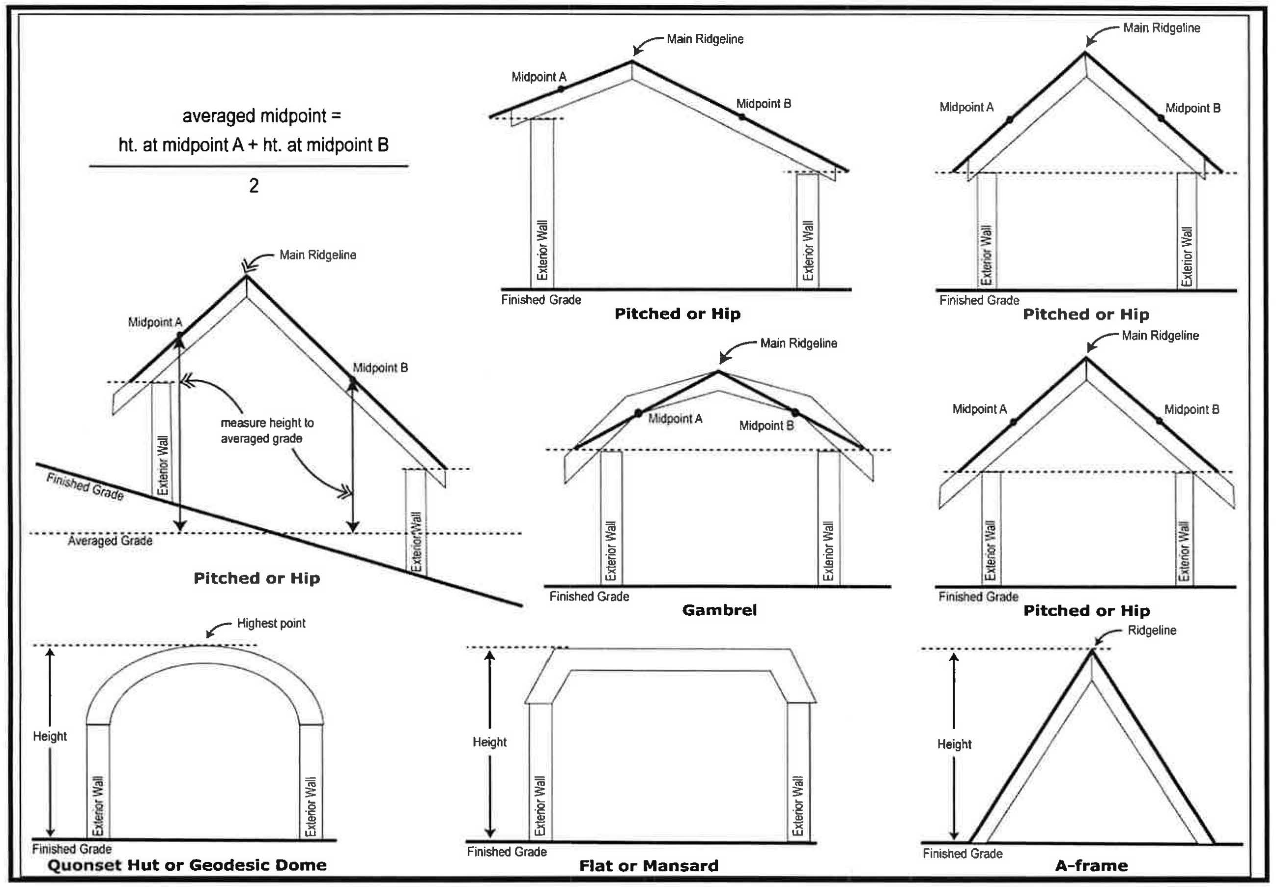
(Ord. No. 4618, § 3, 7-25-2023)
8106-1.4 - Building lot coverage.
a.
Purpose: The purpose of this Section 8106-1.4 et seq. is to provide the maximum percentage of building lot coverage for: (1) lots subject to an area plan; (2) lots within a mapped existing community designated area boundary and not subject to an area plan; (3) lots outside of a mapped existing community designated area boundary and not subject to an area plan; and (4) lots that meet certain exceptions and exclusions.
b.
Definitions: Definitions for all italicized terms in this Section 8106-1.4 et seq. are set forth in Article 2 of this Chapter. For terms not defined, refer to Section 8102-0(c).
(Ord. No. 4618, § 3, 7-25-2023; Ord. No. 4639, § 5, 12-17-2024)
8106-1.4.1.1 - Maximum percentage of building lot coverage for lots subject to an area plan.
The maximum percentage of building lot coverage for lots subject to an area plan shall be as specified below in subsections 8106-1.4.1.1.1 to 8106-1.4.1.1.8. If any provision of this Section 8106-1.4.1.1 conflicts with the applicable area plan standards, the latter shall govern.
(Ord. No. 4618, § 3, 7-25-2023)
8106-1.4.1.1.1 - El Rio/Del Norte Area Plan.
Table 1
(Sec. 8106-1.4.1.1.1)
El Rio/Del Norte Area Plan Maximum Percentage of Building Lot Coverage
(Ord. No. 4618, § 3, 7-25-2023)
8106-1.4.1.1.la - El Rio/Del Norte Area Plan building lot coverage exceptions and exclusions.
(1)
The following exceptions and exclusions apply to the OS 80, OS 40 and AG Area Plan Land Use Designations:
(a)
Structures used for growing plants such as greenhouses, hothouses, and agricultural shade/mist structures are excluded from building lot coverage standards. This exclusion does not include structures used for preliminary packing, storage and preservation of produce and similar structures.
(b)
Maximum building lot coverage of lots less than ten (10) acres (nonconforming) in area shall be two thousand five hundred (2,500) square feet plus one (1) square foot for each 22.334 square feet of lot area over five thousand (5,000) square feet.
(c)
Greater building lot coverage may be allowed with the approval of a discretionary permit for structures and uses listed under the heading of "Crop and Orchard Production" in Article 5.
(d)
Greater building lot coverage may be allowed with the approval of a discretionary permit for Farmworker Housing Complexes.
(2)
The following exception applies to the RR 5, UR1-2, UR2-4, UR-4-6, UR 6-10, UR 10-15, and UR 20 Area Plan Land Use Designations:
(a)
Maximum building lot coverage for lots of less than one (1) acre (nonconforming) in area shall be as specified in Section 8106-1.4.1.1.1, or two thousand five hundred (2,500) square feet plus one (1) square foot for each 4.596 square feet of lot area over five thousand (5,000) square feet, whichever is greater.
(Ord. No. 4618, § 3, 7-25-2023)
8106-1.4.1.1.2 - Lake Sherwood/Hidden Valley Area Plan.
Table 2
(Sec. 8106-1.4.1.1.2)
Lake Sherwood/Hidden Valley Area Plan Maximum Percentage of Building Lot Coverage
(Ord. No. 4618, § 3, 7-25-2023)
8106-1.4.1.1.2a - Lake Sherwood/Hidden Valley Area Plan building lot coverage exceptions and exclusions.
(1)
The following exceptions and exclusions apply to the Lake, Parks & Rec., OS 80, OS 40, OS 20, and OS 10 Area Plan Land Use Designations:
(a)
Structures used for growing plants such as greenhouses, hothouses, and agricultural shade/mist structures are excluded from building lot coverage standards. This exclusion does not include structures used for preliminary packing, storage and preservation of produce and similar structures.
(b)
Maximum building lot coverage of lots less than ten (10) acres (nonconforming) in area shall be two thousand five hundred (2,500) square feet plus one (1) square foot for each 22.334 square feet of lot area over five thousand (5,000) square feet.
(c)
Greater building lot coverage may be allowed with the approval of a discretionary permit for structures and uses listed under the heading of "Crop and Orchard Production" in Article 5.
(d)
Greater building lot coverage may be allowed with the approval of a discretionary permit for Farmworker Housing Complexes.
(2)
The following exception applies to the RR 5, RR 2, UR 1, UR 1-2 and UR 2-4 Area Plan Land Use Designations:
(a)
Maximum building lot coverage for lots of less than one (1) acre (nonconforming) in area shall be as specified in Section 8106-1.4.1.1.2, or two thousand five hundred (2,500) square feet plus one (1) square foot for each 4.596 square feet of lot area over five thousand (5,000) square feet, whichever is greater.
(Ord. No. 4618, § 3, 7-25-2023)
8106-1.4.1.1.3 - North Ventura Avenue Area Plan.
Table 3
(Sec. 8106-1.4.1.1.3)
North Ventura Avenue Area Plan Maximum Percentage of Building Lot Coverage
(Ord. No. 4618, § 3, 7-25-2023)
8106-1.4.1.1.4 - Oak Park Area Plan.
Table 4
(Sec. 8106-1.4.1.1.4)
Oak Park Area Plan Maximum Percentage of Building Lot Coverage
(Ord. No. 4618, § 3, 7-25-2023)
8106-1.4.1.1.4a - Oak Park Area Plan building lot coverage exclusion.
The following exclusion applies to the POS, R/1-2, R/2-4, R/4-6, R/6-8, R/8-12 and R/16-20 Area Plan Land Use Designations:
(a)
Structures used for growing plants such as greenhouses, hothouses, and agricultural shade/mist structures are excluded from building lot coverage standards. This exclusion does not include structures used for preliminary packing, storage and preservation of produce and similar structures.
(Ord. No. 4618, § 3, 7-25-2023)
8106-1.4.1.1.5 - Ojai Valley Area Plan.
Table 5
(Sec. 8106-1.4.1.1.5)
Ojai Valley Area Plan Maximum Percentage of Building Lot Coverage
(Ord. No. 4618, § 3, 7-25-2023)
8106-1.4.1.1.5a - Ojai Valley Area Plan building lot coverage exceptions and exclusions.
(1)
The following exceptions and exclusions apply to the OS 80, OS 40, OS 20 and OS 10 Area Plan Land Use Designations:
(a)
Structures used for growing plants such as greenhouses, hothouses, and agricultural shade/mist structures are excluded from building lot coverage standards. This exclusion does not include structures used for preliminary packing, storage and preservation of produce and similar structures.
(b)
Maximum building lot coverage of lots less than ten (10) acres (nonconforming) in area shall be two thousand five hundred (2,500) square feet plus one (1) square foot for each 22.334 square feet of lot area over five thousand (5,000) square feet.
(c)
Greater building lot coverage may be allowed on non-conforming (less than applicable minimum lot size) lots by discretionary permits for existing structures and uses listed under the heading of "Crop and Orchard Production" in Article 5.
(d)
Greater building lot coverage may be allowed with the approval of a discretionary permit for Farmworker Housing Complexes.
(2)
The following exception applies to the RR 5, RR 2, UR 1-2, UR 2-4, UR 4-6 and UR 6-10 Area Plan Land Use Designations:
(a)
Maximum building lot coverage for lots of less than one (1) acre (nonconforming) in area shall be as specified in Section 8106-1.4.1.1.5, or two thousand five hundred (2,500) square feet plus one (1) square foot for each 4.596 square feet of lot area over five thousand (5,000) square feet, whichever is greater.
(Ord. No. 4618, § 3, 7-25-2023)
8106-1.4.1.1.6 - Piru Area Plan.
Table 6
(Sec. 8106-1.4.1.1.6)
Piru Area Plan Maximum Percentage of Building Lot Coverage
(Ord. No. 4618, § 3, 7-25-2023)
8106-1.4.1.1.6a - Piru Area Plan building lot coverage exceptions and exclusions.
(1)
The following exceptions and exclusions apply to the Open Space, Agricultural, R-4, R-6, R-15, RHD, SFE, SFT, MSP and CR Area Plan Land Use Designations:
(a)
Structures used for growing plants such as greenhouses, hothouses, and agricultural shade/mist structures are excluded from building lot coverage standards. This exclusion does not include structures used for preliminary packing, storage and preservation of produce and similar structures.
(b)
Maximum building lot coverage of lots less than ten (10) acres (nonconforming) in area shall be two thousand five hundred (2,500) square feet plus one (1) square foot for each 22.334 square feet of lot area over five thousand (5,000) square feet.
(c)
Greater building lot coverage may be allowed with the approval of a discretionary permit for structures and uses listed under the heading of "Crop and Orchard Production" in Article 5.
(d)
Greater building lot coverage may be allowed with the approval of a discretionary permit for Farmworker Housing Complexes.
(2)
The following exception applies to the C, RMU, I and CF Area Plan Land Use Designations:
(a)
Maximum building lot coverage for lots of less than one (1) acre (nonconforming) in area shall be as specified in Section 8016-1.4.1,1.6, or two thousand five hundred (2,500) square feet plus one (1) square foot for each 4.596 square feet of lot area over five thousand (5,000) square feet, whichever is greater.
(3)
The following exception applies to the C Area Plan Land Use Designation:
(a)
Deviations may be allowed under the provisions of the Community Business District Overlay Zone.
(Ord. No. 4618, § 3, 7-25-2023)
8106-1.4.1.1.7 - Thousand Oaks Area Plan.
Table 7
(Sec. 8106-1.4.1.1.7)
Thousand Oaks Area Plan Maximum Percentage of Building Lot Coverage
(Ord. No. 4618, § 3, 7-25-2023)
8106-1.4.1.1.7a - Thousand Oaks Area Plan building lot coverage exceptions and exclusions.
(1)
The following exceptions and exclusions apply to the OS 20 Area Plan Land Use Designation:
(a)
Structures used for growing plants such as greenhouses, hothouses, and agricultural shade/mist structures are excluded from building lot coverage standards. This exclusion does not include structures used for preliminary packing, storage and preservation of produce and similar structures.
(b)
Maximum building lot coverage of lots less than ten (10) acres (nonconforming) in area shall be two thousand five hundred (2,500) square feet plus one (1) square foot for each 22.334 square feet of lot area over five thousand (5,000) square feet.
(c)
Greater building lot coverage may be allowed with the approval of a discretionary permit for structures and uses listed under the heading of "Crop and Orchard Production" in Article 5.
(d)
Greater building lot coverage may be allowed with the approval of a discretionary permit for Farmworker Housing Complexes.
(2)
The following exception applies to the RR-2, UR-1, UR-2, UR-4, UR-8 and UR-16 Area Plan Land Use Designations:
(a)
Maximum building lot coverage for lots of less than one (1) acre (nonconforming) in area shall be as specified in Section 8106-1.4.1.1.7, or two thousand five hundred (2,500) square feet plus one (1) square foot for each 4.596 square feet of lot area over five thousand (5,000) square feet, whichever is greater.
(Ord. No. 4618, § 3, 7-25-2023)
8106-1.4.1.1.8 - Saticoy Area Plan.
(1)
For lots subject to the Saticoy Area Plan and within the Old Town Saticoy mapped area, allowable uses and development standards are set forth in Appendix B, Section 8119-1 of the NCZO - Old Town Saticoy Development Code.
(2)
For lots subject to the Saticoy Area Plan and within the West and South Industrial mapped areas, maximum building lot coverage shall be fifty (50) percent of the lot area. For all other development standards for the South and West Industrial Sections, refer to Article 6 of this ordinance.
(Ord. No. 4618, § 3, 7-25-2023)
8106-1.4.1.2 - Maximum percentage of building lot coverage for lots within a mapped existing community designated area boundary and not subject to an area plan.
The maximum percentage of building lot coverage for lots located within a mapped existing community designated area and not subject to an area plan shall be determined in accordance with this Section 8106-1.4.1.2. The following existing community designated areas, as mapped in the Ventura County General Plan, shall be governed by this Section 8106-1.4.1.2:
1.
Bell Canyon
2.
Box Canyon
3.
Camarillo Heights
4.
East Santa Paula
5.
Home Acres
6.
La Cumbre Road
7.
Las Posas Estates
8.
Lewis Road
9.
Matilija Canyon
10.
Mission Rock Road
11.
North Fork Springs
12.
North Santa Paula
13.
North Simi
14.
Santa Rosa Valley
15.
Santa Susana
16.
Saticoy Country Club
17.
Somis
18.
Tapo Canyon
19.
Thomas Aquinas College
20.
Ventura Avenue
21.
West Santa Paula
22.
West Simi
(Ord. No. 4618, § 3, 7-25-2023)
Table 8
(Sec. 8106-1.4.1.2)
Maximum Building Lot Coverage for Lots Within a Mapped Existing Community
Designated Area Boundary and Not Subject to an Area Plan
(Ord. No. 4618, § 3, 7-25-2023)
8106-1.4.1.2a - Exception to building lot coverage development standards for lots within the Las Posas Estates Existing Community.
For lots within the Las Posas Estates Existing Community zoned RE-20Ac, structures used for growing plants such as greenhouses, hothouses, and agricultural shade/mist structures are excluded from building lot coverage standards. This exclusion does not include structures used for preliminary packing, storage and preservation of produce and similar structures.
(Ord. No. 4618, § 3, 7-25-2023)
8106-1.4.1.3 - Maximum percentage of building lot coverage for lots outside of a mapped existing community designated area boundary and not subject to an area plan.
The maximum percentage of building lot coverage for lots located outside of a mapped existing community designated area boundary, and not subject to an area plan, shall be as specified in the General Plan for the applicable land use designation. The maximum building lot coverage standards that apply to each land use designation pursuant to the General Plan are set forth below. If any provision of this Section 8106-1.4.1.3 conflicts with the General Plan, the latter shall govern.
(Ord. No. 4618, § 3, 7-25-2023)
Table 9
(Sec. 8106-1.4.1.3)
Maximum Building Lot Coverage for Lots Outside of a Mapped Existing Community Designated
Area Boundary and Not Subject to an Area Plan
(Ord. No. 4618, § 3, 7-25-2023)
8106-1.4.2 - Exceptions and exclusions to maximum percentage of building lot coverage.
The exceptions and exclusions established by this Section 8106-1.4.2 are in addition to those established in Sections 8106-1.4.1.1 and 8106-1.4.1.2. If any provision of Section 8106-1.4.2 conflicts with the exceptions and exclusions established by Sections 8106-1.4.1.1 and 8106-1.4.1.2, the more permissive exception and/or exclusion shall govern.
(Ord. No. 4618, § 3, 7-25-2023)
8106-1.4.2.1 - Maximum building lot coverage for nonconforming lots with a rural land use designation.
Maximum building lot coverage for lots of less than one (1) acre (nonconforming) in area shall be as specified in the General Plan for the Rural land use designation, or two thousand five hundred (2,500) square feet plus one (1) square foot for each 4.596 square feet of lot area over five thousand (5,000) square feet, whichever is greater ([(Square Feet of Lot Area - 5,000) ÷ 4.596] + 2,500 = Maximum Square Footage of Building Lot Coverage).
(Ord. No. 4618, § 3, 7-25-2023)
8106-1.4.2.2 - Maximum building lot coverage for nonconforming lots with an agricultural land use designation.
a.
Maximum building lot coverage of lots of less than ten (10) acres (nonconforming) in area shall be as specified in the General Plan for the Agricultural land use designation, or two thousand five hundred (2,500) square feet plus one (1) square foot for each 22.334 square feet of lot area over five thousand (5,000) square feet, whichever is greater ([(Square Feet of Lot Area - 5,000) ÷ 22.334] + 2,500 = Maximum Square Footage of Building Lot Coverage).
b.
Greater building lot coverage may be allowed with the approval of a discretionary permit for structures or uses listed under the heading of "Crop and Orchard Production" in Article 5.
c.
Greater building lot coverage may be allowed with the approval of a discretionary permit for Farmworker Housing Complexes.
(Ord. No. 4618, § 3, 7-25-2023)
8106-1.4.2.3 - Maximum building lot coverage for nonconforming lots with an open space land use designation.
a.
Maximum building lot coverage of lots of less than ten (10) acres (nonconforming) in area shall be as specified in the General Plan for the Open Space land use designation, or one thousand five hundred (1,500) square feet plus one (1) square foot for each 22.334 square feet of lot area over five thousand (5,000) square feet, whichever is greater ([(Square Feet of Lot Area - 5,000) ÷ 22.334] + 2,500 = Maximum Square Footage of Building Lot Coverage).
b.
Greater building lot coverage may be allowed with the approval of a discretionary permit for structures or uses listed under the heading of "Crop and Orchard Production" in Article 5.
c.
Greater building lot coverage may be allowed with the approval of a discretionary permit for Farmworker Housing Complexes.
(Ord. No. 4618, § 3, 7-25-2023)
8106-1.4.2.4 - Maximum lot coverage for non-conforming lots with a residential land use designation.
Maximum building lot coverage for lots of less than one (1) acre (nonconforming) in area shall be as specified in the General Plan for the Residential land use designation, or two thousand five hundred (2,500) square feet plus one (1) square foot for each 4.596 square feet of lot area over five thousand (5,000) square feet, whichever is greater ([(Square Feet of Lot Area - 5,000) ÷ 4.596] + 2,500 = Maximum Square Footage of Building Lot Coverage).
(Ord. No. 4618, § 3, 7-25-2023)
8106-1.4.2.5 - Exclusion of structures used for growing plants on lots with an agriculture land use designation.
Structures used for growing plants such as greenhouses, hothouses, and agricultural shade/mist structures shall be excluded from the maximum building lot coverage standards applicable to lots with an Agricultural land use designation. This exclusion does not include structures used for preliminary packing, storage and preservation of produce and similar structures.
(Ord. No. 4618, § 3, 7-25-2023)
8106-3 - Purpose and use of setbacks.
a.
The setback regulations are intended to prevent the overcrowding of land, provide privacy, preclude narrow, unusable spaces between buildings and provide clear areas for fire safety purposes, both to retard the spread of fire and to enable emergency personnel to reach side and rear areas of buildings.
b.
The setback regulations apply to buildings with foundations, and other structures such as those for parking and storage, whether or not they have foundations, and to open storage.
c.
No required setback shall be used for parking or storage of any vehicles, nor for open storage or garages or any other structures except as allowed by Sections 8106-5.3, 8106-8.6, 8107-1.6.1, or otherwise specifically provided in this Chapter.
(Am. Ord. 3730—5/7/85; Am. Ord. 3810—5/5/87; Am. Ord. 4092—6/27/95; Am. Ord. 4282—5/20/03; Ord. No. 4618, § 3, 7-25-2023)
8106-4.1 - Measurement of rear setback from an alley.
In computing the depth of a rear setback for any lot abutting an alley, the setback may be measured from the midpoint of the rear alley.
8106-4.2 - Setbacks from easements.
If the only means of access to one or more lots is by way of an easement, the easement shall be considered as a street for purposes of determining setbacks on lots over which the easement passes.
(Am. Ord. 3730—5/7/85)
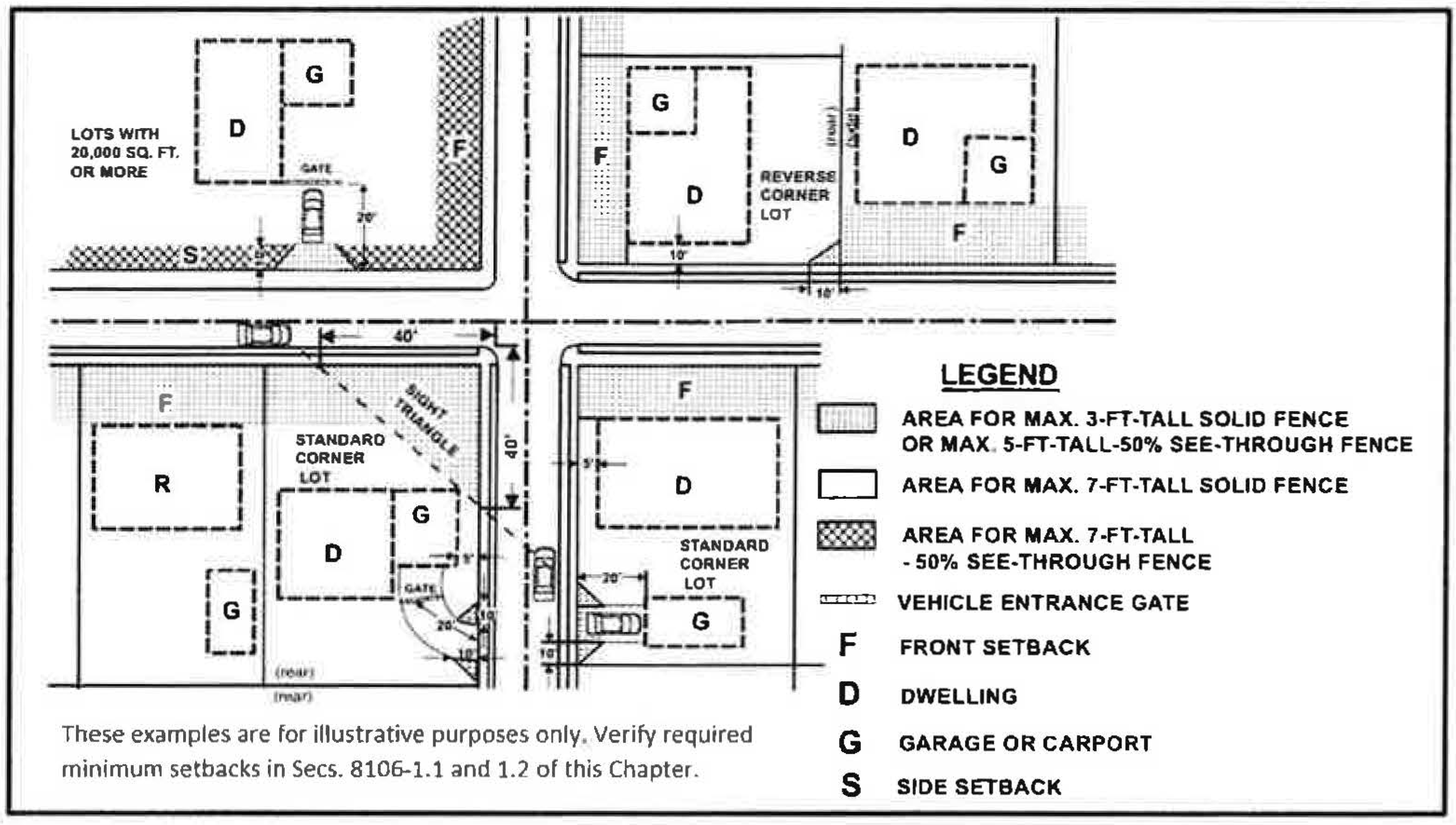
8106-4.3 - Determination of setbacks for flag lots and irregularly shaped lots.
In the case of "flag lots" and "irregularly shaped lots", the setbacks shall be measured from the applicable front (F), rear (R) and side (S) of the lot as designated in the diagrams illustrated below.
a.
In cases involving flag lots or irregularly shaped lots of a type not represented in any of the following diagrams, the Planning Director shall determine the minimum setbacks utilizing good planning practices.
b.
Any portion of a flag tot or irregularly shaped lot that is adjacent to a street is a "required setback adjacent to a street" for purposes of fence regulations.
Illustration of Setbacks for Flag Lots
(Section 8106-4.3)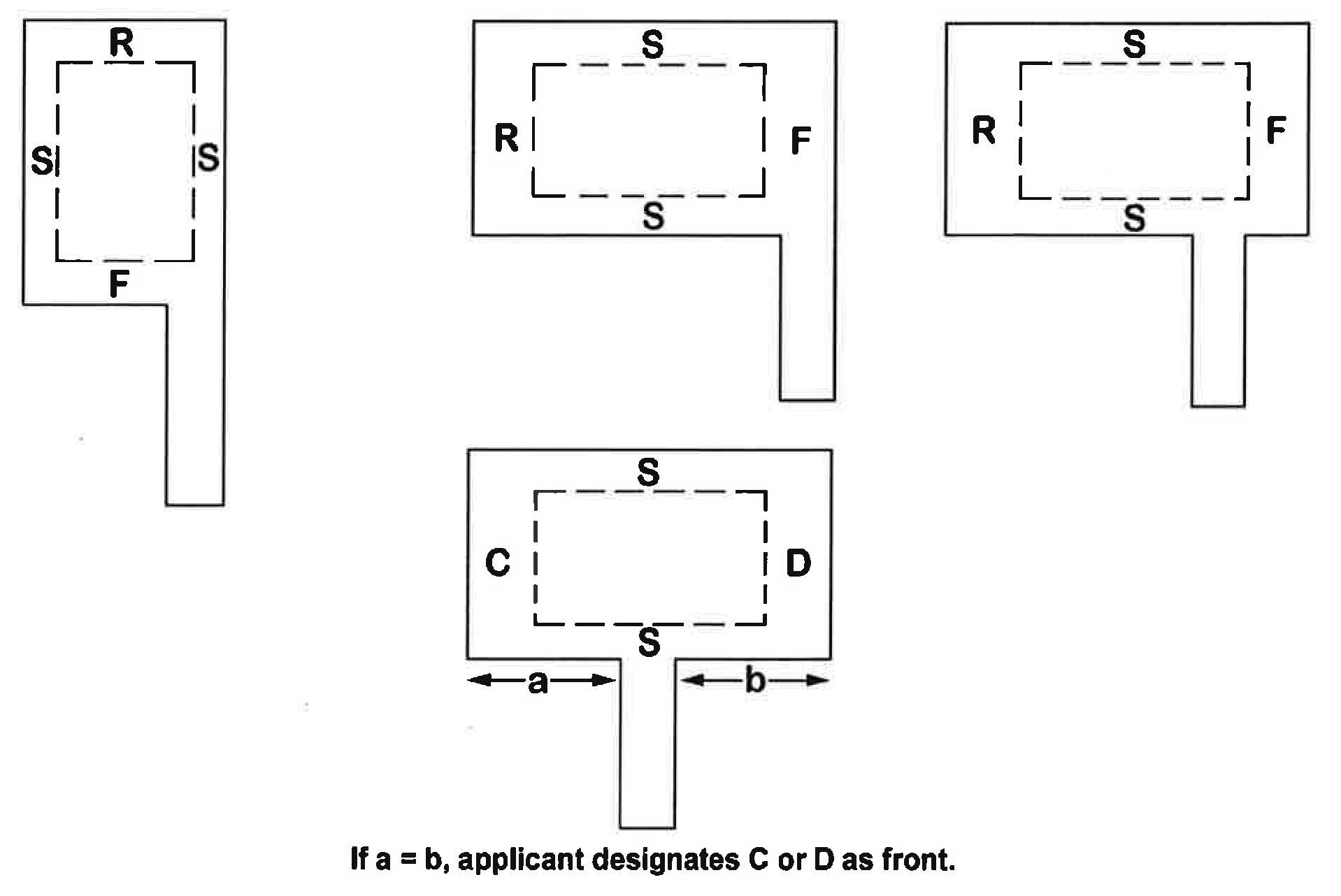
Illustration of Setbacks for Irregularly Shaped Lots
| Rear lot lines for triangular and irregularly shaped lots - A line ten (10) feet long within the lot, opposite and most distant from the front lot line, which is parallel to the front lot line or parallel to the chord of a curved front lot line, where such chord is drawn perpendicular to the mean direction of lot depth. | 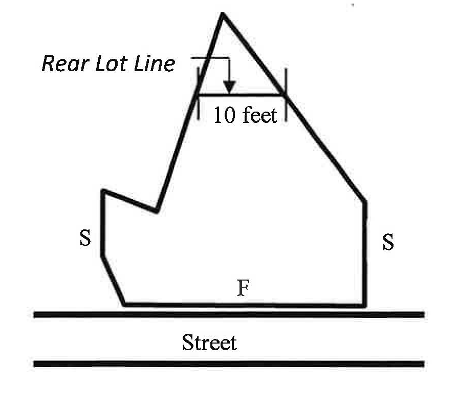 |
(Am. Ord. 3810—5/5/87; Am. Ord. 4216—10/24/00; Ord. No. 4618, § 3, 7-25-2023)
8106-4.4 - Determination of setbacks for through lots.
a.
If the area of a through lot is less than twice the minimum lot area for the zone, one street frontage shall be designated as the front, and the other frontage shall be the rear.
b.
If the lot area is two or more times the minimum area for the zone, each street frontage shall be considered a front for purposes of determining setbacks.
(Add Ord. 3810—5/5/87)
8106-5 - Exceptions to required setbacks and height.
The following are exceptions to the standards set forth in Section 8106-1 of this Chapter:
(Ord. No. 4618, § 3, 7-25-2023)
8106-5.1 - Accessory structures in certain setback areas.
Detached accessory structures (e.g., gazebo, garages, storage shed), not used for human habitation, shall not be located closer than three (3) feet from interior and rear lot lines, provided that:
a.
Any such accessory structure(s) shall not occupy more than forty (40) percent of the rear setback area. This standard does not apply to below-grade, uncovered swimming pools, spas, hot tubs, and similar structures (having a water depth of eighteen (18) inches or more).
b.
Setback areas adjacent to a street shall be maintained as set forth in Section 8106-1 of this Chapter.
(Ord. No. 4618, § 3, 7-25-2023; Ord. No. 4639, § 5, 12-17-2024)
8106-5.2 - Accessory structures in front setbacks on through lots.
A detached accessory structure not used for human habitation and not exceeding fifteen (15) feet in height may be located in one (1) of the required front setbacks on a large through lot, as described in Section 8106-4.4 of this Chapter, provided that every portion of such detached accessory structure is at least ten (10) feet from the nearest front property line.
(Am. Ord. 3810—5/5/87; Ord. No. 4618, § 3, 7-25-2023)
8106-5.3 - Parking in setbacks.
Parking in a required setback is prohibited except in the following circumstances:
a.
Fully operative, licensed and registered motorized vehicles may be parked in the front or street-side setback when located in a driveway leading to a garage, carport, or other required parking space for single- and two-family dwellings. Said motorized vehicles and operative non-motorized vehicles (e.g., bicycles, boat or vehicle trailers), accessory to a dwelling, may be parked on a paved area (no wider than ten (10) feet) adjacent to the driveway, except as provided elsewhere in this Chapter.
b.
No required setback may be used for the provision of required parking spaces, except as specifically provided in this Chapter.
c.
In the M1 and M2 Zones, required off-street parking spaces may be located in required street-side setbacks, provided that such parking spaces are located behind required landscaping and screening and any other required improvements, such as sidewalks.
d.
On interior lots, a minimum three-foot-wide area adjacent to one (1) side lot line shall be kept free of operative motorized vehicles and open storage. (See Section 8107-1.6 of this Chapter.)
(Am. Ord. 3730—5/7/85; Am. Ord. 3749—10/29/85; Am. Ord. 3810—5/5/87; Ord. No. 4407, § 4, 10-20-2009; Ord. No. 4618, § 3, 7-25-2023)
8106-5.4 - Architectural features.
Eaves, cornices, canopies, belt courses, sills, buttresses and other similar architectural features that do not create additional floor area or living space, may project a maximum of two hundred twelve (212) feet into required front setbacks, two (2) feet into side setbacks and four (4) feet into rear setbacks, and may not be closer than two (2) feet from any side or rear property line. Such features shall not be closer than two (2) feet to a line midway between the exterior walls of buildings located on the same lot.
(Am. Ord. 3810—5/5/87; Ord. No. 4618, § 3, 7-25-2023)
8106-5.5 - Heating and cooling equipment and the like.
Accessory equipment such as heating, cooling, filtering and circulation pumps, emergency backup generators, backup battery packs, and other necessary appurtenances may be located to within three (3) feet of any side or rear lot line. Such equipment is exempt from a Planning Division entitlement pursuant to Sections 8105-4 and 8105-5 of this Chapter. Unless otherwise determined by the Planning Director, equipment that is accessory to a use with an underlying discretionary entitlement will require a permit adjustment or modification to the approved entitlement.
(Am. Ord. 4216—10/24/00; Ord. No. 4606, § 3, 11-1-2022)
8106-5.6 - Balconies, fire escapes and stairways.
Open, unenclosed stairways or balconies not covered by roofs or canopies may extend into required rear setbacks not more than four (4) feet, and into required front setbacks not more than two and one-half (2½) feet.
(Am. Ord. 3810—5/5/87; Am. Ord. 4092—6/27/95; Ord. No. 4618, § 3, 7-25-2023)
8106-5.7 - Chimneys, bay windows, and fireplaces.
Masonry chimneys, bay windows, and fireplaces may project into required setbacks or required common open space not more than two (2) feet provided that such structures shall not be closer than three (3) feet to any side lot Une. Where more than one (1) building is located on the same lot, such structures shall not be closer than three (3) feet to a line midway between the main walls of such buildings.
(Ord. No. 4618, § 3, 7-25-2023)
8106-5.8 - Depressed ramps.
Open-work fences, hedges, guard railings or other landscaping or architectural devices for safety protection around depressed ramps, designed to permit access to parts of buildings that are below average ground level, may be located in required setbacks or required common open space, provided that such devices are not more than three and one-half (3½) feet in height.
(Ord. No. 4618, § 3, 7-25-2023)
8106-5.9 - Uncovered, unenclosed landings and porches.
Uncovered porches, platforms or landings which do not extend above the level of the first floor of the building may extend into required front setbacks not more than six (6) feet, and into required side and rear setbacks no closer than three (3) feet from the property line. An open-work railing not more than three and one-half (3½) feet tall may be installed or constructed on such porch, platform or landing.
(Ord. No. 4618, § 3, 7-25-2023; Ord. No. 4639, § 5, 12-17-2024)
8106-5.10 - Decks.
When constructed at or below the level of the first floor of the building, a deck may extend into required side or rear setbacks, but may not occupy more than forty (40) percent of a required rear setback, nor be located closer than three (3) feet to a side or rear lot line. This does not apply to hardscape directly on grade and/or to decks on grade adjacent to swimming pools.
(Am. Ord. 3730—5/7/85; Ord. No. 4618, § 3, 7-25-2023)
8106-5.11 - Front setback with "swing" driveways.
In the R1 and R2 Zones, dwellings constructed with carports or garages having a curved or "swing" driveway, with the entrances to the carports or garages facing the side lot line, may have a minimum front setback of fifteen (15) feet.
(Add Ord. 3730—5/7/85; Ord. No. 4618, § 3, 7-25-2023)
8106-5.12 - Temporary housing during construction.
A recreational vehicle (RV) used for temporary housing during construction shall be set back at least five (5) feet from lot lines on which it is placed.
(Add Ord. 3730—5/7/85; Ord. No. 4532, § 3, 10-30-2018; Ord. No. 4618, § 3, 7-25-2023)
8106-5.13 - Swimming pools and spas.
Swimming pools, spas, hot tubs and similar structures may be constructed to within three (3) feet of rear and interior side lot lines, provided that they do not intrude into any front or street-side setback. Pools designed to hold less than eighteen (18) inches of water depth are exempt from setback requirements.
(Add Ord. 3749—10/29/85; Am. Ord. 3810—5/5/87; Ord. No. 4618, § 3, 7-25-2023)
8106-5.14 - Miscellaneous exceptions.
These regulations are not intended to apply to trees or other natural vegetation, nor to construction that does not extend above grade level, nor to such things as outdoor furniture or unenclosed play structures for children (except if designed for use by non-motorized wheeled conveyances of any kind), provided that such items are placed so as not to hinder setback objectives (as described in Article 6).
(Am. Ord. 4092—6/27/95)
8106-5.15 - Building additions.
Horizontal or vertical additions to legally existing principal buildings that do not meet current side setback requirements may be constructed with the same side setbacks as the existing construction, provided that:
a.
The existing side setback is at least three (3) feet on the side of the expansion; and
b.
The linear front-to-rear dimension of any such forward or rearward expansion, or combination thereof, does not exceed seventy-five (75) percent of the existing linear front-to-rear dimension of the nonconformity; and
c.
New construction that is directly adjacent to existing conforming construction complies with current setback requirements; and
d.
No new setback nonconformity is created in a side setback that does not have an existing setback nonconformity; and
e.
Except for architectural features and similar setback intrusions that have no floor area and are allowed elsewhere in this Article, new construction over ten (10) feet in height shall conform to current setback requirements.
(Add Ord. 4123—9/17/96; Ord. No. 4618, § 3, 7-25-2023)
8106-5.16 - Mailboxes.
Structures that support mailboxes with curbside mail delivery may be placed in the front setback, provided that they do not exceed a height of fifty (50) inches, and are not larger than twenty-four (24) inches on each side.
(Add Ord. 4123—9/17/96; Ord. No. 4618, § 3, 7-25-2023)
8106-6.1 - Distance between structures on the same lot.
a.
The minimum distance between structures on the same lot shall be six (6) feet, except that:
(1)
Below-grade, uncovered swimming pools, spas, hot tubs and similar structures (having a water depth of eighteen (18) inches or more) shall be sited at least three (3) feet from any other structure, and shall be structurally designed and engineered in compliance with the Ventura County Building Code. Gazebos, patio covers and similar above-grade shade structures that are part of the swimming pool, spa, and/or hot tub shall be sited at least six (6) feet from any other structure;
(2)
Detached dwellings shall be sited no closer than ten (10) feet from any other detached dwelling; and
(3)
Prefabricated sea cargo/metal storage containers used solely for storage of non-hazardous materials, are not structurally modified, do not include any utilities, and are not used or converted to mechanical rooms may be located closer than six (6) feet from each other. These containers shall not be stacked except when permitted in a discretionary entitlement.
b.
The setback requirements refer to minimum distances between exterior walls or other supports.
(Am. Ord. 3810—5/5/87; Ord. No. 4580 § 3, 4-13-2021; Ord. No. 4639, § 5, 12-17-2024)
8106-6.2 - Garages and carports.
Except as otherwise provided in this Chapter, garages and carports shall be set back sufficiently from streets from which they take access to provide for at least twenty (20) linear feet of driveway apron, as measured along the centerline of the driveway from the lot line to the garage or carport.
(Add Ord. 3730—5/7/85; Ord. No. 4618, § 3, 7-25-2023)
8106-6.3 - Setbacks from existing oil/gas well sites.
No dwelling should be constructed within 800 feet of an existing oil/gas well site unless it is unavoidable. No dwelling shall be built within 500 feet of an existing well site unless the owner records with the title to the property a statement, acceptable to the County Counsel, acknowledging the presence of the well site and the fact that operations associated therewith, including well drilling and redrilling, may disturb the occupants, even though said operations are being conducted in accordance with specific permit conditions, the best accepted practices incident to the exploration of oil and gas, and the provisions of this Chapter. If such an acknowledgement is recorded, the dwelling may be located less than 500 feet from an existing oil well site, but in no case less than 100 feet from said well site. For purposes of this section, 'well site' means the area around a well, which may contain production facilities.
(Add Ord. 3810—5/5/87)
8106-6.4 - Buildings and structures for the growing of crops.
Greenhouses, hothouses, shade/mist structures and similar buildings and structures shall be set back at least twenty (20) feet from all lot lines. (See Section 8107-20.)
(Add Ord. 4092—6/27/95; Ord. No. 4618, § 3, 7-25-2023; Ord. No. 4639, § 5, 12-17-2024)
8106-6.5 - Wildlife crossing structures and setback areas (northern unincorporated area).
The purpose of this Section 8106-6.5 is to establish setbacks for certain development, land uses, and activities adjacent to wildlife crossing structures in the northern portion of the Ventura County unincorporated area to improve functional connectivity for terrestrial and aquatic wildlife across road barriers in the landscape by preserving vegetation cover and minimizing disturbances immediately adjacent to the entry and exit points of wildlife crossing structures.
(Ord. No. 4619, § 2, 9-12-2023)
8106-6.5.1 - Wildlife crossing structures.
The regulations within this Section 8106-6.5 shall apply to wildlife crossing structures identified in Tables 1 and 2 (below), and the 200-foot setback area set forth in Section 8106-6.5.4.
Table 1
Ventura County Wildlife Crossing Structures Located Within
the Northern Portion of the Ventura County Unincorporated Area
Table 2
California Department of Transportation (Caltrans) Wildlife Crossing Structures
Located Within the Northern Portion of the Ventura County Unincorporated Area
(Ord. No. 4619, § 2, 9-12-2023)
8106-6.5.2 - Prohibited development, structures, land uses and activities.
Unless otherwise exempt by Section 8106-6.5.3, or excepted pursuant to Section 8106-6.5.5, the following types of new development, structures, land uses, and activities constructed or occurring after September 12, 2023 shall be prohibited from occurring within the 200-foot setback area described in Section 8106-6.5.4 of any wildlife crossing structure identified in Tables 1 and 2 of Section 8106-6.5.1 above.
a.
Any new structure, land use, or activity that requires a zoning clearance or other permit under Article 5, including any associated new fuel modification authorized or required by the Ventura County Fire Protection District.
b.
Any expansion or enlargement of an existing structure that requires a permit under Article 5, including any associated new fuel modification authorized or required by the Ventura County Fire Protection District.
c.
New or replacement wildlife impermeable fencing within the bank or bed of a stream or river.
d.
Any vegetation modification.
e.
New or modified landscape areas.
f.
New or replacement outdoor lighting.
g.
New indoor luminaires within translucent or transparent enclosed structures for agricultural operations.
(Ord. No. 4619, § 2, 9-12-2023)
8106-6.5.3 - General exemptions.
The following types of development, land uses, structures and activities are not subject to Section 8106-6.5.
a.
Vegetation modification that is:
(1)
Required to comply with any federal or state law, or requirement of any permit, approval or order issued by a federal or state agency.
(2)
Carried out as part of a habitat preservation, restoration or enhancement project when specified by an agency approved mitigation plan, habitat conservation plan, or similar plan.
(3)
Conducted by a conservation organization for the purpose of maintaining or enhancing biological habitat or wildlife movement.
(4)
Reasonably required to maintain, repair or replace existing transportation, utility, and public safety infrastructure performed by a public agency or contracted designee. Examples include roads, bridges, pipelines, utility lines, flood control improvements, and drainage and utility ditches.
(5)
Performed by a public agency on publicly owned or maintained property.
(6)
Associated exclusively with vegetation that has been intentionally planted within a landscape area.
(7)
Conducted in accordance with one (1) or more of the following: (i) as required or authorized by the Ventura County Fire Protection District (VCFPD) pursuant to VCFPD Fire Code, as may be amended; (ii) pursuant to a Community Wildfire Protection Plan or similar fuel modification/wildfire protection plan adopted and/or amended by VCFPD; or (iii) pursuant to a burn permit approved by VCFPD.
(8)
Conducted to construct or maintain a driveway or road internal to a legal lot that is utilized to plant or harvest a crop or orchard that will be commercially sold.
b.
The following structures, development, land uses, and activities:
(1)
Repair or maintenance of an existing, legally establishedstructure or fence.
(2)
The installation of wildlife impermeable fencing that is required to comply with any federal or state law, or any condition or requirement of any permit, approval or order issued by a federal or state agency.
(3)
Structures involuntarily damaged or destroyed by fire, flood, landslide, or natural disaster rebuilt to their original state and in their original location if (i) less than fifty percent (50%) of the structure is damaged or destroyed and (ii) a complete building permit application is submitted to the County within three (3) years of the date that the damage occurred, and the permit once approved is diligently pursued to completion prior to expiration. Notwithstanding any other provision of this Chapter, the rebuilding of structures following fire, flood, landslide or natural disaster not meeting the above requirements shall comply with the requirements of this Section 8106-6.5.
(4)
Land, fences, or improvements other than structures involuntarily damaged or destroyed by fire, flood, landslide, or natural disaster restored or rebuilt to their original state and in their original location if a complete building permit application is submitted to the County within three (3) years of the date that the damage occurred, and the permit once approved is diligently pursued to completion prior to expiration, or if no permit is required, the rebuilding commences within the aforementioned three-year period and is diligently pursued to completion. Notwithstanding any other provision of this Chapter, the restoration of land, or rebuilding of fences, or improvements following fire, flood, landslide or natural disaster not meeting the above requirements shall comply with the requirements of this Section 8106-6.5.
(5)
Structures,wildlife impermeable fencing or improvements that are temporary, or are located entirely or substantially underground (e.g., pipelines, cables, individual sewage disposal systems). Pools are considered to be in-ground, not underground and do not qualify for this exemption.
(6)
Planting or harvesting of crops or orchards that will be commercially sold.
(7)
Livestock grazing.
(8)
Bee hives used for apiculture activities.
(9)
Surface mining operations, including but not limited to associated structures, fuel modification, fencing and lighting, that are authorized by an approved conditional use permit.
(10)
Structures, development, land uses and activities which are protected by vested right or to the minimum extent necessary to avoid a constitutional taking of property, provided they comply with the following to the maximum extent feasible: (1) are sited the furthest distance from the entry or exit points of a wildlife crossing structure; and (2) any outdoor lighting is fully-shielded, directed downward, and maintained in such a manner to avoid light trespass beyond the bank of a stream or river. If light trespass occurs beyond the bank of a stream or river, the lighting shall be operated by motion sensor or a timer switch and shall be programmed to turn off no more than five (5) minutes after activation.
c.
The following outdoor lighting and related activities:
(1)
Temporary lighting for road and utility construction.
(2)
Temporary emergency lighting.
(3)
Temporary lighting associated with a use authorized by this Chapter or a permit granted pursuant to this Chapter.
(4)
Temporary or intermittent outdoor night lighting necessary to conduct agricultural activities including outdoor lighting used during weather events such as frosts, and temporary or intermittent outdoor night lighting used for oil and gas exploration and production regardless of the location or number of lights used. As used in this Section 8106-6.5.3, the term "intermittent" means a period of between thirty-one (31) and ninety (90) calendar days within any 12-month period. For example, the use of intermittent lighting in cases where it is used simultaneously to illuminate multiple, discreet facilities (well sites, multiple tanks, etc.) is not limited provided that each individual location is illuminated no longer than ninety (90) calendar days within any 12-month period.
(5)
Seasonal or festive lighting.
(6)
Outdoor lighting with a maximum output of sixty (60) lumens or less that is fully shielded and directed downward, including solar lights.
(7)
Outdoor lighting on public and private streets.
(8)
Outdoor lighting used for any facility, equipment, or activity that is required to comply with any federal or state law, or any condition or requirement of any permit, approval or order issued by a federal or state agency.
(9)
Replacement of outdoor essential luminaires for existing legally permitted structures that utilize the minimum output necessary for safety and security purposes, with a correlated color temperature of two thousand seven hundred (2700) Kelvin or less, that are directed downward and fully shielded to the maximum extent possible, and controlled by a motion detector and timer that are programmed to turn off no more than five (5) minutes after activation.
(Ord. No. 4619, § 2, 9-12-2023)
8106-6.5.4 - Wildlife crossing structure setback area.
The 200-foot setback area surrounds the entry and exit point of each identified wildlife crossing structure and shall be measured as follows:
a.
The setback for culverts that span less than or equal to ten (10) feet in diameter or width shall be measured from the center of the entry and exit point, as shown in the diagram below;
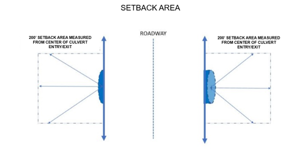
b.
The setback for bridge structures and culverts with widths or diameters greater than ten (10) feet, shall be measured from the outside perimeter of the opening, as shown by the red arrows in the diagram below.
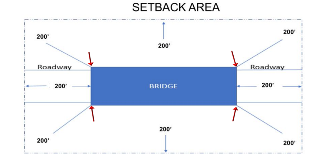
(Ord. No. 4619, § 2, 9-12-2023)
8106-6.5.5 - Nonconforming structures.
Section 8113-1 shall apply to nonconforming structures located partially or wholly within the 200-foot setback area that existed as of September 12, 2023. For purposes of Section 8113-1, an expansion or enlargement of a nonconforming structure shall be deemed in conformance with this Section 8106-6.5 if the expansion or enlargement, including any associated new fuel modification, is located completely outside of the 200-foot setback area or does not increase the footprint of the nonconforming structure, provided that the expansion does not increase any nonconformity with the prohibitions set forth in Section 8106-6.5.2, subdivisions (c) through (g).
(Ord. No. 4619, § 2, 9-12-2023)
8106-7 - Exceptions to height limits.
The following are exceptions to the height limits stated in Section 8106-1 of this Chapter:
(Ord. No. 4618, § 3, 7-25-2023)
8106-7.1 - Non-commercial antennas, ground-mounted.
Ground-mounted citizens' band and amateur radio transmitting and receiving antennas, intended for private, non-commercial use accessory to a dwelling, may be erected up to a maximum height of forty (40) feet from the grade. Ground-mounted non-commercial antennas may be erected above the height limit of forty (40) feet, under the permit prescribed by this Chapter, provided that no antenna or mast shall exceed seventy-five (75) feet in height and the design of such antennas shall be in accordance with Section 8107-1.1.
(Am. Ord. 3810—5/5/87; Ord. No. 4470, § 3, 3-24-2015)
8106-7.2 - Roof structures.
Roof structures may be erected above the height limits prescribed in this Chapter, provided that no additional floor space is thereby created.
(Ord. No. 4618, § 3, 7-25-2023)
8106-7.3 - Airport height limits.
Height limits as set forth in Federal Aviation Administration (FAA) regulations shall be adhered to within the approach and turning areas of any Ventura County airport.
8106-7.4 - Accessory structures.
Provided that an accessory structure is set back 20 feet from all property lines, it may exceed 15 feet in height, but it shall not exceed the maximum allowed height of the principal structure unless a discretionary permit is issued pursuant to Article 5.
(Add Ord. 4092—6/27/95; Am. Ord. 4123—9/17/96)
8106-7.5 - Wireless communication facilities.
Wireless communication facilities may be installed at a height that exceeds the height limit of the zone, provided that the facility does not exceed the maximum height limits prescribed in Section 8107-45.4(f). All wireless communication facilities shall be designed, constructed and operated in accordance with the development standards stated in Section 8107-45.4.
(Ord. No. 4470, § 3, 3-24-2015; Ord. No. 4618, § 3, 7-25-2023)
8106-7.6 - Retaining walls.
Structural retaining walls may be installed above the fence height limits prescribed in Section 8106-8.1 of this Chapter, provided that no retaining walls shall be installed above three (3) feet in height within a ten-foot by ten-foot right triangle on each side of a driveway adjacent to a street. See Section 8106-8.1.7 of this Chapter regarding retaining walls.
(Ord. No. 4606, § 3, 11-1-2022)
8106-8.1.1 - Solid fences.
a.
A maximum seven-foot-tall solid fence may be located on lots, including in the locations listed in Section 8106-8.1.1(b)(3) below, except that no solid fence over three (3) feet tall may be placed in a:
(1)
Required sight triangle,
(2)
Required setback adjacent to a street, or
(3)
Ten-foot by ten-foot right triangle on each side of a driveway on a side property line. (See Sec. 8106-8.4.)
b.
Notwithstanding subsection (a) above, the following standards apply to the specified situations:
(1)
A see-through fence of up to five (5) feet tall may be located in a front setback or a required setback adjacent to a street.
(2)
A see-through fence of up to seven (7) feet tall may be located anywhere on a lot of twenty thousand (20,000) square feet or more.
(3)
A maximum seven-foot-tall solid fence may also be located:
i.
In a rear setback adjacent to a street on a through lot (see Section 8106-4.4).
ii.
In a rear setback, when a lot is bounded on three (3) sides by a street, one (1) of which is a rear lot line.
iii.
In a side setback adjacent to a street of a corner lot.
iv.
On a reverse corner lot within a side setback adjacent to a street provided that, at the street-side setback at the rear corner of the lot within a ten-foot by ten-foot 45-degree triangle, a maximum three (3) feet tall solid fence or five (5) feet tall see-through fence is allowed.
v.
In a rear setback adjacent to a street, when the lot is a flag lot or irregularly shaped lot that has no street frontage along the front lot line.
(4)
A maximum eight-foot-tall solid fence may be located in the following locations except within a required sight triangle or setback adjacent to a street:
i.
Anywhere on a vacant or developed lot zoned OS, AE, or RA, or on any vacant or developed lot in a commercial or industrial zone; or
ii.
On any vacant or developed lot zoned RE, RO, R1, R2 or RPD that abuts or is across the street from a lot in a commercial or industrial zone or a lot zoned OS, AE or RA, provided that such fence is located at or near the boundary line separating such lots.
(5)
Pilasters, columns, and support structures and the decorative elements thereon associated with a fence or gate located on or within required setbacks may exceed the height limit provided that they meet the following criteria:
i.
They do not exceed eight (8) feet in height, and
ii.
They are not located closer than sixteen (16) feet on center, and
iii.
The fencing materials do not cumulatively exceed the see-through fence standard, and
iv.
They do not interfere with the sight triangle associated with any driveway or intersections with no traffic controls.
(6)
A maximum twelve-foot-tall see-through fence may be located around a sport's court (e.g., tennis, basketball, volleyball, or similar ball sport) accessory to a dwelling anywhere on a lot, except in a required setback adjacent to a street.
(c)
Vehicle entrance gates (whether automatic or manual) shall be located a minimum of twenty (20) feet from the front or street-side property line to minimize sidewalk blockage and interference with traffic flow. For sloped or angled vehicle entrances, the 20-foot setback may be measured at an angle from the front or street-side property line to the closest gate opening. Such vehicle entrance gates shall not swing within the 20-foot setback.
Example of Typical Fences and Walls
(Am. Ord. 4123—9-17-1996; Ord. 4216—10-24-2000; Ord. No. 4606, § 3, 11-1-2022; Ord. No. 4639, § 5, 12-17-2024)
8106-8.1.2 - Required permits.
(a)
Prior to the construction of any of the following, a Zoning Clearance is required:
(1)
Fences that are over seven (7) feet in height measured from grade to the top of fence.
(2)
Any fence that requires electricity for light fixtures and/or to power an entry gate.
(3)
Any retaining wall that is over three (3) feet in height measured from grade on the lower side, to the top of the wall, and/or supporting a surcharge.
(b)
A separate tree permit may be required for the construction of a fence or gate that alters any protected tree pursuant to Section 8107-25 of this Chapter.
(c)
All fencing within the HCWC Overlay Zone must be installed in compliance with the standards of Section 8109-4.8 of this Chapter.
(d)
All fencing within the CWPA Overlay Zone must be installed in compliance with the standards of Section 8109-4.9 of this Chapter.
(Ord. No. 4606, § 3, 11-1-2022)
8106-8.1.3 - Prohibited fencing.
No barbed wire, razor-edge wire, electric wire or similar type of fencing (see photographic examples below) is permitted in urban residential zones or commercial zones (see Article 4), or on properties in industrial zones which abut or are across the street from urban residential zoned properties, if such fencing would be visible from the urban residential zoned property or properties.
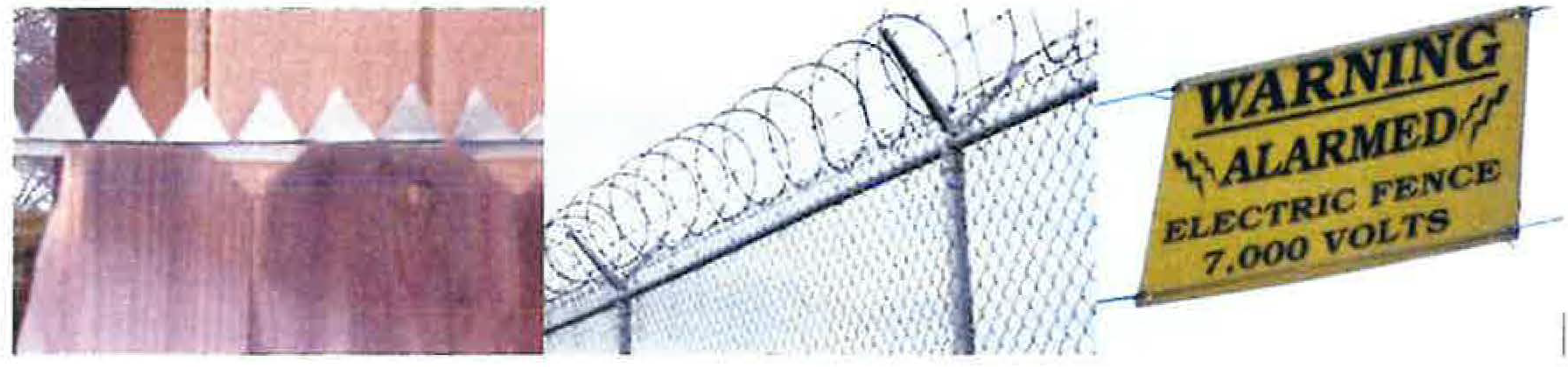
Examples of Prohibited Fencing
(Ord. No. 4606, § 3, 11-1-2022)
8106-8.1.4 - Fence and retaining wall height measurements.
The height of fences and retaining walls shall be measured in accordance with the following subsections and as illustrated in Figure 1 below.
(a)
For purposes of this section, "grade" shall be the lowest level parallel to and five (5) feet from the fence or retaining wall.
(b)
Height of a fence or retaining wall shall be measured from grade to the highest point of the fence or retaining wall.
(c)
Where there is a difference in grade levels on the two (2) sides of a fence, the height of such fence shall be measured from the higher grade, provided that the distance from the lower grade to the top of the fence shall not exceed ten (10) feet, and further provided that in a required setback adjacent to a street, the fence height shall be measured from adjacent grade of the street side of the fence. See Section 8106-8.1.7 below for additional regulations pertaining to structural retaining walls.
Figure 1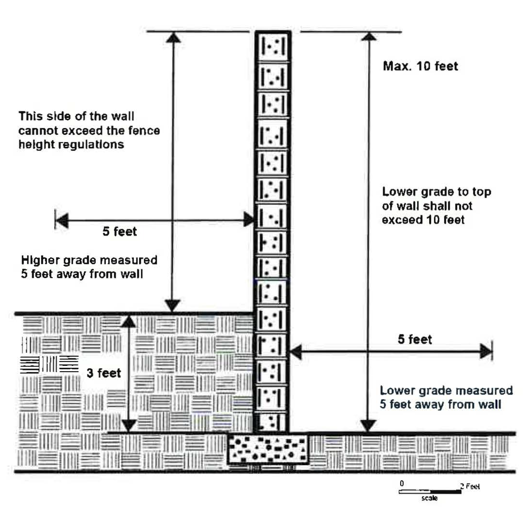
(Am. Ord. 3730—5-7-1985; Ord. 4216—10-24-2000; Ord. No. 4606, § 3, 11-1-2022)
8106-8.1.5 - Fences required by law.
The provisions of Section 8106-8.1 et seq. shall not apply to a fence required by any law or regulation of a federal, state or local governmental entity.
(Ord. 3810—5-5-1987; Ord. 4092—6-27-1995; Ord. No. 4606, § 3, 11-1-2022)
8106-8.1.6 - Protected trees.
For purposes of this Section 8106-8.1 et seq., protected trees (listed in Table 1 of Section 8107-25) do not constitute a fence. Any alterations to a protected tree shall be in compliance with the tree protection regulations of Section 8107-25 et seq. of this Chapter.
(Ord. 3993—2-25-1992; Ord. No. 4606, § 3, 11-1-2022)
8106-8.1.7 - Retaining walls.
Structural retaining walls to stabilize a bank or protect a cut below grade do not have a height limit, unless the walls are located within a ten-foot by ten-foot right triangle on each side of a driveway adjacent to a street, in which case the retaining wall cannot exceed three (3) feet tall as measured in accordance with Section 8106-8.1.4 of this Chapter. Notwithstanding the foregoing, structural retaining walls are not subject to the setback regulations of Sections 8106-1.1 and 8106-1.2 of this Chapter. Where a fence is installed on top of a retaining wall, the total combined height of the retaining wall and the fence shall not exceed ten (10) feet tall as measured from the side of the fence with the lower grade to the top of the fence. Fences installed on top of retaining walls shall meet the setback regulations of Sections 8106-1.1 and 8106-1.2 and the fence regulations of Section 8106-8.1 of this Article. See photographic examples and Figure 2 below.
Figure 2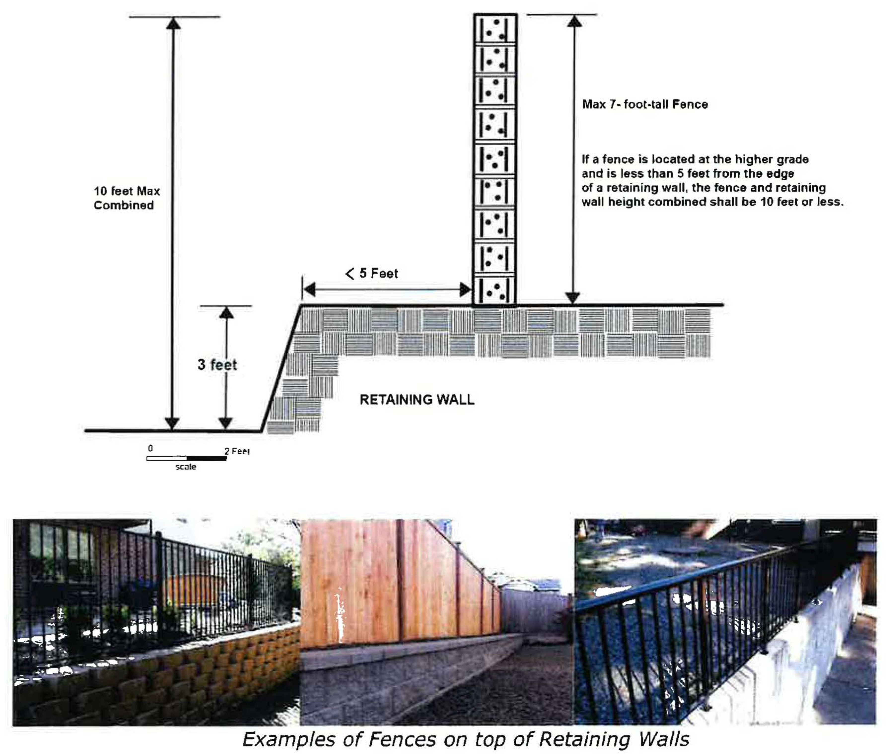
(Ord. No. 4606, § 3, 11-1-2022)
8106-8.2.1 - Applicability.
(a)
Section 8106-8.2 applies to all discretionary development projects that include or are required to include landscaping in the following zones:
(1)
CO Zone
(2)
C1 Zone
(3)
CPD Zone
(4)
M Zones
(5)
RPD Zone
(6)
RHD Zone
Sections 8109-0.6, 8109-1.2 and 8109-1.3 contain additional landscape requirements by zone.
(b)
Any ministerial or discretionary development project that meets one (1) or more of the criteria listed below is subject to the State Model Water Efficient Landscape Ordinance (MWELO):
(1)
New construction projects with an aggregate landscape area equal to or greater than five hundred (500) square feet requiring a building permit, building plan check, or landscape plan.
(2)
Retrofitted landscape projects with an aggregate landscape area equal to or greater than two thousand five hundred (2,500) square feet requiring a building permit, building plan check, or landscape plan.
(3)
Existing landscapes are limited to complying with Sections 493, 493.1 and 493.2 of the MWELO.
(4)
Cemeteries: New and retrofitted cemetery development is subject to Sections 492.4, 492.22 and 492.12 of the MWELO and existing cemetery development is subject to Sections 493, 493.1 and 493.2 of the MWELO.
(5)
Any project with an aggregate landscape area of two thousand five hundred (2,500) square feet or less is required to comply either with the performance requirements of the MWELO or conform to the prescriptive compliance provisions contained in Appendix D of the MWELO.
(6)
Graywater/Rainwater Capture: Any lot that with less than two thousand five hundred (2,500) square feet of landscape area that meets the lot's landscape water requirement using entirely graywater or stored rainwater captured on site is subject only to the prescriptive compliance provisions contained in Appendix D of the MWELO.
(7)
Notwithstanding the foregoing, the MWELO does not apply to:
a.
Registered local, state or federal historical sites;
b.
Ecological restoration projects that do not require a permanent irrigation system;
c.
Mined-land reclamation projects that do not require a permanent irrigation system; and
d.
Existing plant collections, as part of botanical gardens and arboretums open to the public.
(c)
Discretionary development projects subject to the MWELO pursuant to subsection (b) above shall also be subject to Section 8106-8.2.
(d)
All discretionary development projects subject to landscaping requirements that require permanent irrigation, including those not otherwise subject to the MWELO, shall be subject to MWELO, Appendix D, subsections (b)(5) and (6), as may be amended.
(e)
All development projects subject to landscaping requirements for parking areas pursuant to Section 8108-5.14 shall comply with Sections 8106-8.2.2, 8106-8.2.3, and 8106-8.2.8. Section 8106-8.2.7 shall apply to any parking areas containing manufactured slopes.
(f)
Where conformance to the standards and requirements of this Section 8106-8.2 would create practical difficulties or undue hardship for the project applicant, the Planning Director or designee may grant modifications to the requirements of this Section, provided the proposed modifications are the minimum necessary to alleviate the practical difficulties or undue hardship. This provision does not apply to standards and requirements imposed by the MWELO.
(g)
Where the landscaping standards conflict with one another, the more restrictive landscaping standard shall apply. The applied standard shall meet or exceed minimum standards required by the MWELO.
(Ord. No. 4577 § 2, 3-9-2021)
8106-8.2.2 - Landscape plans.
(a)
Applications for development projects with proposed landscaping not subject to the MWELO shall submit a landscape plan that meets the following standards:
(1)
The landscape plan shall clearly illustrate compliance with all landscape requirements set forth or referenced in the NCZO applicable to the project.
(2)
All landscape plans shall be drawn to scale and be consistent with the project's site plan.
(3)
Landscape plans containing greater than five hundred (500) square feet of landscape area shall be designed by and bear the signature of a licensed landscape architect.
(4)
When an applicant chooses to retain native vegetation to reduce the amount of required landscaping in accordance with Section 8106-8.2.4 or to incorporate insect nesting habitat into the landscape area, these areas shall be shown within the landscape plan.
(b)
Development projects subject to the requirements of the MWELO (see Section 8106-8.2.1(b)) shall submit a Landscape Documentation Package that includes a water efficient landscape worksheet, soil management report, landscape design plan, irrigation design plan and grading design plan pursuant to, and as described in, Sections 492.3 through 492.8 of the MWELO, as may be amended.
(Ord. No. 4577 § 2, 3-9-2021)
8106-8.2.3 - General landscape standards.
(a)
No land use may be inaugurated, or structure occupied, until a final inspection has been completed verifying that the landscape area has been installed as required by the approved entitlement.
(b)
All existing invasive and watch list species as inventoried by the California Invasive Plant Council shall be properly disposed of and removed from the landscape area before the installation of the approved landscaping.
(c)
Landscaping installed within a Hazardous Fire Area, Wildland Urban Interface Zone, or Fire Hazard Severity Zone shall be subject to all applicable Ventura County Fire Protection District landscaping requirements.
(d)
Landscape Design Elements.
(1)
Vines, shrubs, and other trees shall be used to visually soften and deter graffiti on walls and fences. Vines shall not be used where they will cause structural damage to walls or obstruct traffic safety sight area when adjacent to a roadway or driveway.
(2)
Plants shall be grouped according to hydrozones and other environmental conditions (soil, slope, sun exposure) that are appropriate for their survival.
(3)
Trees shall be planted in all parkway areas between curbs and sidewalks or in sidewalk tree wells as follows:
(4)
Sizes for mature trees as used in this Section 8106-8.2 are defined as follows: "small trees" will reach thirty (30) feet or less in height; "medium trees" will reach between thirty (30) to seventy (70) feet in height; and "large trees" will reach seventy (70) feet or more in height.
(5)
Trees should not be planted under existing tree canopies unless required for habitat restoration purposes. New trees shall be installed using the following setback distances from an existing tree at mature tree size: small trees require a 20-foot setback; medium trees require a 30-foot setback; and, large trees require a 40-foot setback.
(6)
Trees and shrubs shall be planted so that at maturity they do not interfere with service lines, sewer lines or on-site wastewater treatment system areas, traffic safety sight areas, public works facilities and rights-of-way, or safety lighting.
(7)
Trees that typically grow taller than twenty (20) feet in height at maturity are not permitted under utility wires and shall not be planted under utility pole guy wires anchored to the ground.
(8)
Landscape areas shall include permanent irrigation systems and may contain water features and pedestrian walkways. Notwithstanding the foregoing, permanent irrigation systems shall not be required for native vegetation retained through the native vegetation credit program pursuant to Section 8106-8.2.4, provided that the overall hydrologic regime that supports the vegetation remains unaltered or permanent irrigation is unnecessary for the type of vegetation community retained. Temporary irrigation systems may still be required to establish native plantings.
(9)
Landscape projects not otherwise subject to the MWELO, shall design and install any permanent irrigation system pursuant to MWELO, Appendix D(b)(5) and (6).
(e)
Plant and Landscaping Materials.
(1)
Mulch should support plantings within the landscape area but should not substitute for plant material. Water-efficient landscape designs that contain large areas of mulch shall be reviewed on a case-by-case basis to ensure adequate plant material is present for the purpose of reducing heat island effects, erosion control, or other factors. To the maximum extent feasible, mulch shall be free of weed seeds and deleterious materials such as plastic, trash, and toxic leachates.
(2)
The use of native host plants for butterfly and moth caterpillars, and native plants and landscape features which create habitat for other beneficial invertebrates and vertebrates (including birds) is strongly encouraged. The Ventura County Pollinator-Friendly Guidelines and other organizations provide lists of native host plants for pollinators and recommendations for other pollinator-friendly, beneficial invertebrate-friendly, and vertebrate-friendly landscape design practices.
(3)
Native vegetation must comprise at least fifty (50) percent of the plant types in new or retrofitted landscape areas. Where feasible, existing native vegetation should be retained within the landscape area.
(4)
To provide year-round food resources for pollinator diversity, the landscape area shall contain at least eight (8) different plant species with bloom times that are sequential or overlap throughout the year (e.g., two (2) to three (3) plant species for each spring, summer/fall, and winter). To the extent feasible, selected plant species should differ in color, structure, size, and scent.
(5)
Native vegetation retained pursuant to Section 8106-8.2.4 may be included in native and plant diversity calculations in Section 8106-8.2.3(e).
(6)
When the required size, number and types of plant specimens cannot be met due to factors such as a small landscape area, unusual site conditions or Area Plan design standards, the Planning Director or designee may waive or modify such requirements. However, a written explanation by the landscape architect shall be required to describe how the proposed size, number and types of proposed plants meet the standards above to the maximum extent feasible.
(7)
The following plant types are prohibited from use in landscape plantings:
a.
Tropical milkweed (Asclepias curassavica), due to its transmission of a debilitating parasite (Ophryocystis elektroscirrha) to Western monarch butterflies; and
b.
Invasive and watch list species as inventoried by the California Invasive Plant Council.
(8)
The largest mature tree size shall be planted wherever feasible with respect to the current uses of the site, pedestrian circulation, vehicle circulation, safety, and standard setbacks. To the maximum extent feasible, native trees should be selected.
(9)
Irrigation equipment or incompatible landscaping material (e.g., weed fabric) shall not be sited or installed within any oak tree (Quercus spp.) dripline unless approved by the Planning Division. All permanent irrigation systems shall be kept a minimum of ten (10) feet from the drip line of any existing oak species, except when recommended by a certified arborist under extreme drought conditions. In such circumstances, a targeted irrigation schedule and maintenance plan for these areas shall be included with the landscape plan (see Section 8106-8.2.8).
(10)
Any landscaping within the dripline of oak trees shall consist of plant species compatible with the water and soil requirements of the oak. Plants installed within the dripline should serve as accents rather than as a groundcover. Where possible, natural leaf mulch should not be removed. To protect the long-term health of established oak trees, landscaping or earth disturbance shall not occur within ten (10) feet of the tree trunk.
(Ord. No. 4577 § 2, 3-9-2021)
8106-8.2.4 - Voluntary native plant preservation incentive.
(a)
Purpose. The purpose of this voluntary incentive is to preserve and integrate existing mature, healthy, unprotected native vegetation into required landscape areas within the project site. This approach will promote pollinator-friendly landscapes, reduce water use, reduce landscape installation costs for the applicant, and reduce long-term landscape maintenance costs for the landowner. Native vegetation retained pursuant to this Section 8106-8.2.4 shall help to meet the purpose of the landscaping requirements (e.g., screening).
(b)
Applicability. This native vegetation preservation incentive is only available to discretionary projects that require an Initial Study Biological Assessment (ISBA). This incentive is not applicable to parking lot landscaping (Section 8108-5.14) or stormwater landscaping requirements required by the Ventura County Watershed Protection District.
(c)
Incentive Calculations.
(1)
Landscape credit for preserved native vegetation community alliances and native plant specimen(s) shall be granted at a 1:1 ratio (one (1) square foot of retained native vegetation, including root zone, will count for one (1) square foot of landscape area required in Sections 8109-0.6, 8109-1.2 or in landscape screening requirements).
(2)
The above-stated 1:1 ratio may be increased to 1:2 (one (1) square foot of retained native vegetation, including root zone, will count for two (2) square feet of landscape area required in Sections 8109-0.6, 8109-1.2 or in landscape screening requirements) when the preservation area is located:
a.
Within two hundred (200) feet of a verified mapped hydrological feature (USFWS National Wetlands Inventory or USGS National Hydrographic Data Sets) or an identified sensitive biological resource area;
b.
Within the Habitat Connectivity and Wildlife Corridor Overlay Zone; or
c.
Immediately adjacent to a legally protected native vegetation community that is both greater than two thousand (2,000) square feet and meets the requirements of Section 8106-8.2.4(e)(3) and (4) below). To receive preservation credit under these criteria, the edge of the vegetation canopies between preserved area and the adjacent native vegetation community must be within thirty (30) feet of one another with no obstructions or barriers for wildlife movement.
(3)
If the preservation area is greater than thirty (30) percent of the landscape area using this preservation credit, the Planning Director or designee may require additional landscaping to meet screening or other visual quality requirements as set forth in the NCZO.
(d)
Documentation. Applicants seeking a preservation credit shall provide a Planning Division-approved Initial Study Biological Assessment (ISBA) for the site that includes a map and table showing the location, native plant specimen(s) species or native vegetation community alliance (if a plant community is retained), size (area and height), easements/right(s)-of-way/utility lines, fuel modification zones, invasive or watch list species, and the health of each native plant specimen(s) or native vegetation community alliance retained for credit. Photos of each unprotected native plant specimen(s) proposed for retention must also be provided. County staff may request a site visit to determine the suitability of the area for preservation credit.
(e)
Native Plant Characteristics. The native vegetation used for preservation credit must meet the following standards when surveyed for the ISBA and before the final Certificate of Occupancy is issued:
(1)
The native vegetation is not required to be preserved by local, state, or federal law.
(2)
The root system, and surrounding microclimate area that is outside the native plant dripline, shall be retained intact and unaltered (includes natural or man-made means), unless such alterations are compatible and support the long-term health of the native vegetation (e.g., companion planting, mulching, etc.) depicted in the approved final landscape plan.
(3)
The native vegetation community alliance or native plant specimen(s) and their buffer area(s) are not dominated by invasive or watch list species, as inventoried by the California Invasive Plant Council, or otherwise deemed not ecologically suitable as recommended by a qualified biologist, and are approved by the Planning Director or designee.
(4)
There are no areas proposed for preservation where the soil was previously compacted, graded, or cultivated where it is no longer suitable for the original native vegetation community.
(f)
Standards for Landscaping with Existing Native Plants.
(1)
Any existing invasive or watch list species must be removed and properly disposed of as part of the site preparation process prior to the issuance of the Zoning Clearance for Construction or Use Inauguration (as applicable to the project);
(2)
The preservation area (existing native vegetation including root zone(s)) must be clearly marked and identified for protection on all project site plans, grading plans, outdoor lighting plans, and conceptual and final landscape/restoration plans. The preservation area must be physically identified on-site prior to any site disturbance.
(3)
The native vegetation is not damaged, dead, dying, diseased, or infested with harmful insects. Any damaged vegetation within the preservation areas shall be replaced with vegetation equivalent to the vegetation that was destroyed. Site alterations that may cause the decline or death of the native vegetation in the preservation area (e.g., alterations to drainage or runoff, damage to plant root systems, exposure to sun and wind due to loss of vegetation cover in buffer area) shall be corrected to ensure the long-term health of the preserved native vegetation.
(4)
The preservation area shall be maintained or enhanced pursuant to the landscape maintenance standards of Section 8106-8.2.8.
(Ord. No. 4577 § 2, 3-9-2021)
8106-8.2.5 - Landscape screening.
(a)
Plant Material Spacing for Visual Screening.
(1)
Trees shall be planted at a minimum rate of one (1) for each thirty (30) linear feet of the landscape area. Shrubs shall be installed as needed to adequately screen the development, but no less than one (1) for every five (5) linear feet of landscape area.
(2)
Plants may be used as the main screening element only if a minimum of fifty (50) percent of the plants are of 15-gallon container size when planted, the remaining plants are of 5-gallon container size, and the plants will form a dense hedge that adequately screens the development year-round.
(b)
Visual Screening Using Berms, Walls, Fencing and Art.
(1)
Landscaping is the preferred method to soften the screening of storage areas, trash enclosures, parking areas and public utilities. Visual screens composed of a berm, fence, or solid wall shall include plant material that softens the look and breaks up the expanse of the screen. When the berm, fence, or wall is installed along the street side of a property line, the fence or wall is to be placed along the interior side of the landscaped area relative to the street.
(2)
Where earth berms are used, the berm slope shall be a maximum of one (1) foot of rise for every three (3) feet of linear distance (3:1 horizontal to vertical).
(3)
Public art may be incorporated into screening materials that are viewable by the public, in lieu of two (2) required trees. Such art shall meet the provisions of Section 8108-5.14.2(b)(2)(ii).
(Ord. No. 4577 § 2, 3-9-2021)
8106-8.2.6 - General stormwater landscape design.
(a)
Stormwater management landscaping shall meet the following standards:
(1)
The minimum coverage of plant species meets water quality improvement plans.
(2)
Plant types shall be selected to withstand periodic inundation of water, survive seasonal drought, and be capable of pollutant uptake. Irrigation shall be used to allow for the establishment of the selected plants and cuttings.
(3)
When mulch is used within stormwater management landscaping, it shall be non-floatable and well-aged to prevent clogging of storm drain infrastructure.
(4)
Required trees shall be planted above the flow line of basins or channels;
(5)
The landscaping does not reduce or negatively affect the number, type, size, location, or health of required and protected trees.
(Ord. No. 4577 § 2, 3-9-2021)
8106-8.2.7 - Landscaping on manufactured slopes.
Manufactured (i.e., human-made) slopes shall be planted pursuant to the following standards:
(a)
Slopes steeper than 3:1 shall include erosion control blankets, soil stabilizers or other means approved by the Public Works Agency to prevent erosion.
(b)
Groundcover. Manufactured slopes shall be planted with groundcover to minimize erosion and blend with the adjacent natural slopes. The type of groundcover selected shall be compatible with soils and climatic conditions, adjacent native vegetation or landscaping, irrigation requirements, and fire-retardant requirements.
(c)
Trees and Shrubs. Manufactured slopes shall have a mixture of trees and shrubs incorporated with groundcover to assure soil stabilization, blend with adjacent native vegetation or landscaping, and promote varying height and mass of landscaping. Shrubs are not required for sloped areas less than three (3) feet high created by the deposition of material (e.g., artificial berm). Trees are not required for sloped areas less than five (5) feet high created through the excavation of material (e.g., cut bank).
(d)
Slope Irrigation. Soil type and percolation rate shall be considered when designing slope irrigation. Properly designed and installed sprinklers or drip irrigation systems may be necessary to promote slope stability.
(Ord. No. 4577 § 2, 3-9-2021)
8106-8.2.8 - Landscape maintenance.
(a)
Landscaping shall be maintained by the permittee according to the approved landscape plan and any permit conditions for the life of the permitted land use. Maintenance activities shall include the following:
(1)
Routine inspections to guard against runoff and erosion and to detect plant or irrigation system failure. Failure to maintain required landscaping or irrigation systems shall constitute a violation of the permit pursuant to Article 14.
(2)
Landscape areas with installed irrigation shall maintain these areas pursuant to MWELO, Section 492.11, as may be amended, regardless of whether the MWELO otherwise applies.
(3)
Shrubs and groundcovers shall be pruned to keep plants within planting beds. Pruning for all plants shall be conducted in accordance with the American National Standard for Tree Care Operations — Tree, Shrub, and Other Woody Plant Maintenance-Standard Practices ANSI A300 (Part 1) 2001 Pruning, ISA ANSI A300 1995, as may be amended.
(4)
Weeds and litter shall be removed from the landscape area.
(5)
Dead, dying, diseased or severely damaged plant material shall be replaced. Tree replacement shall be subject to Section 8107-25.
(6)
Tree supports shall be inspected frequently and removed when the tree can withstand high winds unsupported.
(7)
Mulch shall be monitored and replenished as needed.
(8)
Plants shall be fertilized and watered at such intervals as are necessary to promote optimum growth.
(b)
Areas with native vegetation that are retained for preservation credit pursuant to Section 8108-8.2.4 shall be maintained according to an approved Invasive Species Management Plan that is submitted with the landscape plan.
(c)
Non-toxic methods of pest control within the landscape area are strongly encouraged.
(Ord. No. 4577 § 2, 3-9-2021)
8106-8.2.9 - Permit modifications for landscape plans.
Proposed modifications to an existing, approved landscape plan shall be processed in accordance with Article 11, except that minor adjustments that comply with the following requirements shall be approved through the issuance of a Zoning Clearance:
(a)
The proposed adjustments are not subject to the MWELO.
(b)
Replacement plant materials shall substantially conform with the original purpose and intent of the landscape regulations and must be recommended by a licensed landscape architect, landscape designer, or qualified biologist.
(c)
Replacement plant materials shall conform to the water, soil, slope, and sun exposure requirements of accompanying plantings.
(d)
Replacement plant materials shall not: (1) be an invasive or watch list species identified by the California Invasive Plant Council; or (2) increase the overall landscape water usage.
(e)
Changes to impervious surface area shall not cause the total impervious surface area on the lot to exceed more than five thousand (5,000) square feet.
(f)
The hydraulic line and grade within site drainage patterns shall not be altered.
(g)
A minor adjustment shall not:
(1)
Reduce or negatively affect the number, size, or health of required trees in the approved landscape plan;
(2)
Reduce or negatively affect the number, type, size, location, or health of existing protected trees; or
(3)
Impair compliance with landscape screening or storm water management requirements.
(Ord. No. 4577 § 2, 3-9-2021)
8106-8.3 - Connection of structures.
An accessory structure will be considered to be attached to the principal structure if:
a.
The distance between the principal structure and the accessory structure is no greater than fifteen (15) feet and the roof connecting the two (2) structures complies with all of the following:
(1)
It is essentially a continuation of the roof of the principal structure;
(2)
It resembles the roof of the nearest enclosed, habitable area of the principal structure in terms of pitch, materials, architectural design, etc.; and
(3)
It is imperforate; or
b.
The space between such structures is completely enclosed by walls attached to each structure and constitutes "internal access" and the ratio of this access-way width to length is no greater than 1:3.
(Am. Ord. 3810—5/5/87; Ord. No. 4618, § 3, 7-25-2023)
8106-8.4 - Sight triangle.
Where there are no traffic controls (i.e., stop signs or traffic signals) on either street at an intersection, a sight triangle must be provided on each corner adjacent to the intersection. No structures or landscaping over three (3) feet tall that could block the view of approaching traffic on either street shall be located or constructed within any required sight triangle.
(Add Ord. 3730—5/7/85; Am. Ord. 3810—5/5/87; Am. Ord. 4092—6/27/95; Ord. No. 4639, § 5, 12-17-2024)
8106-8.5 - Sight distance.
Adequate sight distance shall be provided at intersections. In cases where the minimum setback requirements of Sec. 8106-1 do not provide such sight distance, particularly where streets intersect at less than ninety (90) degrees and traffic is controlled (e.g., by stop signs) on only one of the streets (the 'minor street'), setbacks for discretionary projects must be adjusted to provide adequate sight distance in accordance with the following table. The sight distance shall be measured from a point in the center of the minor street eight feet behind the designated stopping point for vehicles on such street, or behind a continuation of the intersecting curb line, to the center of the nearest (curbside) driving lane on the intersecting ('major') street. No structures or landscaping over three feet in height which could block the view of approaching traffic on the major street shall be constructed or located on the street side of the line connecting the two points. Curb cuts on discretionary projects should be considered minor streets for purposes of this section.
(Add Ord. 3810—5/5/87)
8106-8.6 - Light fixtures.
The following regulations apply to light fixtures:
a.
A Zoning Clearance is required for freestanding light fixtures over two (2) feet up to twenty (20) feet tall on property with a zoning designation of open space, agricultural, or residential. Such light fixtures may be added to an existing developed lot in a commercial or industrial zone with a Zoning Clearance if the Planning Director or designee determines that the light fixtures are consistent with the existing approved entitlement for the property and otherwise meets all other standards of this Chapter; otherwise, a modification to the existing approved entitlement shall be required.
b.
A freestanding light fixture over twenty (20) feet up to thirty-five (35) feet tall requires a Planning Director-approved Planned Development Permit. In commercial and industrial zones, the maximum height of freestanding light fixtures shall be specified in a discretionary permit that approved the new development.
c.
Freestanding light fixtures shall not be placed in any side setbacks.
d.
Lights in excess of one hundred fifty (150) watts (for incandescent light bulbs) or two thousand two hundred fifty (2250) lumens shall be shielded, directed downward, and installed and maintained in such a manner to avoid light trespass beyond the lot line.
See Section 8109-4 of this Chapter for additional lighting regulations in overlay zones.
(Add Ord. 3810—5/5/87; Am. Ord. 4123—9/17/96; Ord. No. 4618, § 3, 7-25-2023; Ord. No. 4639, § 5, 12-17-2024)
8106-8.7 - Recycling and refuse storage areas.
All commercial, industrial, institutional, or residential buildings having five (5) or more living units, shall provide recycling and refuse storage areas in accordance with the County of Ventura's most recently adopted "Space Allocation for Recycling and Refuse Collection Design Criteria and Specifications Guidelines" in effect at the time of the development approval.
(Add Ord. 4054—2/1/94; Am. Ord. 4092—6/27/95; Ord. No. 4618, § 3, 7-25-2023)