
Village Of Grosse Pointe Shores
City Zoning Code
City Zoning Code
ARTICLE II
ZONING DISTRICTS2
Editor's note— Ord. No. 252, adopted Oct. 19, 2010, amended art. II in its entirety to read as herein set out. Former art. II consisted of §§ 40-41, 40-42, 40-61, 40-62, 40-81—40-84, 40-111—-40-115, 40-141—40-147, pertained to the same subject matter and derived from Ord. No. 200, adopted July 7, 1997; Ord. No. 209, adopted July 19, 2000; Ord. No. 215, adopted Sept. 18, 2001; Ord. No. 224, adopted Apr. 15, 2003; Ord. No. 226, adopted Apr. 15, 2003; Ord. No. 228, adopted Apr. 15, 2003; Ord. No. 233, adopted Feb. 17, 2004; Ord. No. 239, adopted Aug. 15, 2006; and Ord. No. 240, adopted Nov. 21, 2006.
Sec. 40-41. - Classes of use districts.
A.
For the purpose of regulating and restricting the location of uses, regulating and limiting the height and bulk of buildings, and regulating and determining the density of population and the area of yards, courts and other open spaces surrounding erected buildings, the city is hereby divided into the following classes of use districts:
(1)
R-12 residence district.
(2)
R-10 residence district.
(3)
Vernier residence district.
(4)
Colonial residence district.
(5)
Residence lakefront district.
(6)
Philanthropic district.
(7)
Park/club district.
B.
In addition, a residence planned district has been created, which is an overlay zone as referred to in division 7 of this article.
(Ord. No. 252, § I, 10-19-2010)
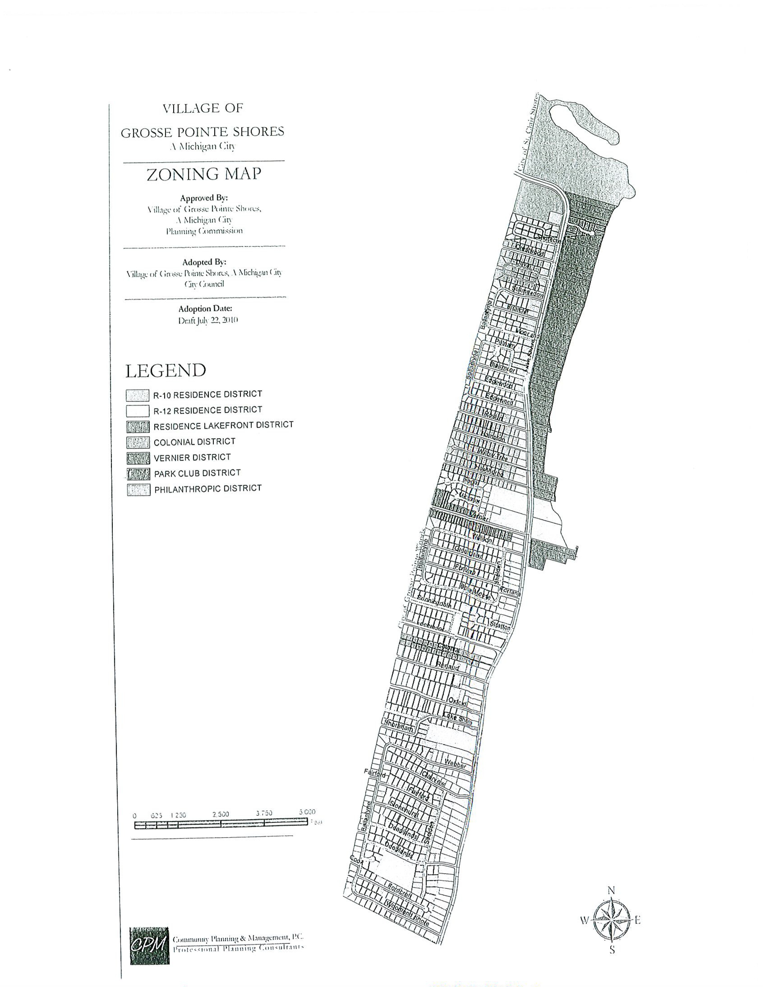
Sec. 40-42. - Zoning use district map.
The boundaries of the use districts are shown on the 2010 zoning use district map which accompanies this chapter and is certified as such and is hereby declared to be a part of this chapter. The use district designations which accompany the zoning use district map and all other legends on such map are hereby declared to be a part of this chapter.
(Ord. No. 252, § I, 10-19-2010)
Sec. 40-51. - Permitted uses.
In the R-12 residence district, no building, structure or land shall be used, and no building or structure shall be erected or altered, which is arranged, intended or designed to be used for a purpose other than one or more of the following purposes:
(1)
One-family dwellings.
(2)
Gardens.
(3)
Municipal buildings owned, occupied or controlled by the city.
(4)
Accessory uses customarily incident to any of the permitted uses as set forth in subsections (1)—(3) of this section, as regulated by section 40-231.
(5)
Other uses required to be permitted by law.
(Ord. No. 252, § I, 10-19-2010)
Sec. 40-52. - Area, height and placement requirements.
Area, height and placement requirements in the R-12 residence district shall be as follows:
(1)
Minimum lot area: 12,000 square feet.
(2)
Minimum lot width: 100 feet.
(3)
Maximum height: 30 feet (not to exceed two stories) on all buildable lots of 120 feet or less in lot width. Thirty-three feet on all buildable lots in excess of 120 feet in lot width, provided that the lot contains at least 12,000 square feet, and provided further that the portion of the roof above 30 feet (measured horizontally as viewed from the street or in the case of a corner lot as viewed from the streets), cannot exceed 30 percent of the width of the structure (measured at the level of the second story), as viewed from the street.
a.
The regulations in this subsection (3) are deemed maximum height limitations and the total height of structures shall also be subject to section 40-173, pertaining to illustrative neighborhood design standards, which may mandate a lower height consistent with the appropriate design guidelines. Further, no new building shall be constructed, nor shall an addition or other modification to an existing building be constructed, which results in the maximum height of such building being greater than the average height of neighboring buildings plus 25 percent of that "average height", subject to the maximum heights set forth in this subsection 40-62(3). This average height provision shall not apply to houses on the east or west side of Lake Shore Road. For the purpose of this section, the term "average height of buildings" means:
1.
With respect to a building not on a corner lot, the average height of the buildings on either side of the building being constructed or modified.
2.
With respect to a building on a corner lot, the average of the height of the two buildings on the same side of the street on which the front facade of the building being constructed or modified is located which are nearest to such building being constructed or modified. If the side of the street on which such front facade of building being constructed or modified does not have two other buildings, the average height of neighboring buildings shall be defined as the average of the height of the two buildings nearest to the building being constructed or modified, regardless of the street or side of street such buildings are located upon.
b.
Architectural embellishments, such as, but not limited to, decorative railings/fences, statuary, artwork, decorative balustrades, weather vanes, finials, etc., shall be prohibited above the maximum permitted height of the structure as defined by subsection (3) of this section unless such is approved by the planning commission as an integral part of the overall architecture of the facade.
c.
When the height limitations in subsection (3) of this section result in an unusual situation where the application of the standards set forth in subsection (3) of this section would create an architectural incongruity because of peculiar circumstances of the lot in question and the neighboring lots and structures thereon, the planning commission and city council may consider approval of a special land use to create architectural compatibility. In reviewing whether to grant a special land use approval for an increase in the total maximum height permissible, the planning commission and city council shall take into account the following:
1.
Whether the request is the least impactful to the subject property and those which surround it while accommodating appropriate expansion or alteration of the residence.
2.
Proximity of those portions of the building exceeding the height requirements to adjacent property lines and residential structures.
3.
The percentage of building or roofline above the permitted height.
4.
Architectural character and building massing of the adjacent residence as well as the proposed residence.
5.
The overall proposed building height measured from the final approved grade of the lot compared to the overall height of adjacent residences measured in the same manner on the adjoining lots.
(4)
Maximum lot coverage: 25 percent.
(5)
Minimum total floor area: 2,100 square feet.
(6)
Minimum front yard:
a.
Lots abutting the westerly side of Lake Shore Road, south of Vernier Road, shall have a minimum setback of 145 feet.
b.
Lots abutting the westerly side of Lake Shore Road, north of Vernier Road, shall have a minimum setback of 85 feet.
c.
On all other lots in the residence districts the minimum setback shall be 30 feet.
d.
The intent of this section is to create a uniform streetscape along all roadways within the city, to create an environment where individual views and privacy are maintained between residences, and to minimize the impacts of building massing. Therefore, notwithstanding the requirements pertaining to minimum front yard set forth in subsections (6)a, (6)b, and (6)c of this section, no building or accessory building shall be set back from the roadway further than the average of the closest two most immediate principal buildings. With respect to corner lots and double frontage lots, additional setback requirements shall be as set forth in subsections 40-256(b)—(d). No presently existing building or accessory building intruding into the above-described front yard setback shall be considered nonconforming, and all such building shall enjoy the rights conferred by this chapter as a legal structure.
(7)
Minimum side yards: Ten percent of the lot width on one side and 15 percent of lot width on the other side; provided, however, that no side yard shall be less width than six feet in width, nor shall the combination of two side yards be less than 16 feet in width.
If the above-noted requirements cannot be met, the planning commission and city council may reduce the required setback through special land use approval.
In reviewing whether to recommend or grant a special land use approval for a reduction in side yard setback, the planning commission and council shall take into account the following:
a.
Ability to reconfigure the building layout or addition to allow for appropriate construction, expansions, or alterations without the granting of special land use approval.
b.
Whether the request is the least impactful to the subject property and those which surround it while accommodating appropriate expansion or alteration of the residence.
c.
Proximity of adjacent residences, their windows and other openings, outdoor spaces, and the setback from the mutual property line.
d.
Architectural character and building massing of the adjacent residence as well as the proposed residence.
e.
Building materials, proposed landscaping materials, and other hardscapes proposed along the property line.
(8)
Minimum rear yard:
a.
One-story buildings: 25 feet.
b.
More than one-story buildings: 30 feet.
(9)
On all lots of 100 feet of width or greater, the amount of impervious surface permitted in the front yard area shall be limited to a maximum of 30 percent of the front yard area measured from one side of the lot to the other and from the front facade of the residence to the front lot line. On lots of less than 100 feet in width, the amount of impervious surface areas shall be a maximum of 35 percent of the front yard area as measured from the side lot lines and the front facade of the residence to the front lot line.
(Ord. No. 252, § I, 10-19-2010)
Sec. 40-61. - Permitted uses.
In the R-10 residence district, no building, structure or land area shall be used, and no building or structure shall be erected or altered, which is arranged, intended or designed to be used for a purpose other than one or more of the following purposes:
(1)
One-family dwellings.
(2)
Gardens.
(3)
Municipal buildings owned, occupied or controlled by the city.
(4)
Accessory uses customarily incidental to any of the permitted uses as set forth in subsections (1)—(3) of this section, as regulated in section 40-231.
(5)
Other uses required to be permitted by law.
(Ord. No. 252, § I, 10-19-2010)
Sec. 40-62. - Area, height and placement requirements.
Area, height and placement requirements in the R-10 residence district shall be as follows:
(1)
Minimum lot area: 10,000 square feet.
(2)
Minimum lot width: 80 feet.
(3)
Maximum height: 30 feet (not to exceed two stories).
a.
The regulations in this subsection (3) are deemed maximum height limitations and the total height of structures shall also be subject to section 40-173, pertaining to illustrative neighborhood design standards, which may mandate a lower height consistent with the appropriate design guidelines. Further, no new building shall be constructed, nor shall an addition or other modification to an existing building be constructed, which results in the maximum height of such building being greater than the average height of neighboring buildings plus 25 percent of that "average height", subject to the maximum heights set forth in this subsection. For the purpose of this section, the term "average height of buildings" means:
1.
With respect to a building not on a corner lot, the average height of the buildings on either side of the building being constructed or modified.
2.
With respect to a building on a corner lot, the average of the height of the two buildings on the same side of the street on which the front facade of the building being constructed or modified is located which are nearest to such building being constructed or modified. If the side of the street on which such front facade of building being constructed or modified does not have two other buildings, the average height of neighboring buildings shall be defined as the average of the height of the two buildings nearest to the building being constructed or modified, regardless of the street or side of street such buildings are located upon.
b.
Architectural embellishments, such as, but not limited to, decorative railings/fences, statuary, millwork, decorative balustrades, weather vanes, finials, etc., shall be prohibited above the maximum permitted height of the structure as defined by subsection (3) of this section unless such is approved by the planning commission as an integral part of the overall architecture of the facade.
c.
When the height limitations in subsection (3) of this section result in an unusual situation where the application of the standards set forth in subsection (3) of this section would create an architectural incongruity because of peculiar circumstances of the lot in question and the neighboring lots and structures thereon, the planning commission and city council may consider approval of a special land use to create architectural compatibility. In reviewing whether to grant a special land use approval for an increase in the total maximum height permissible, the planning commission and city council shall take into account the following:
1.
Whether the request is the least impactful to the subject property and those which surround it while accommodating appropriate expansion or alteration of the residence.
2.
Proximity of those portions of the building exceeding the height requirements to adjacent property lines and residential structures.
3.
The percentage of building or roofline above the permitted height.
4.
Architectural character and building massing of the adjacent residence as well as the proposed residence.
5.
The overall proposed building height measured from the final approved grade of the lot compared to the overall height of adjacent residences measured in the same manner on the adjoining lots.
d.
Regardless of the requirements set forth above, all residences within the district shall be permitted to construct a residence up to a height of 22 feet.
(4)
Maximum lot coverage: 25 percent.
(5)
Minimum total floor area (all floors): 2,100 square feet.
(6)
Minimum front yard:
a.
On all lots in the R-10 residence district the minimum setback shall be 30 feet.
b.
The intent of this section is to create a uniform streetscape along all roadways within the city, to create an environment where individual views and privacy are maintained between residences, and to minimize the impacts of building massing. Therefore, notwithstanding the requirements pertaining to minimum front yard set forth in subsection (6)a of this section, no building or accessory building shall be set back from the roadway further than the average of the closest two most immediate principal buildings. With respect to corner lots and double frontage lots, additional setback requirements shall be as set forth in subsections 40-256(b)—(d). No presently existing building or accessory building intruding into the above-described front yard setback shall be considered nonconforming, and all such building shall enjoy the rights conferred by this chapter as a legal structure.
(7)
Side yard setback:
a.
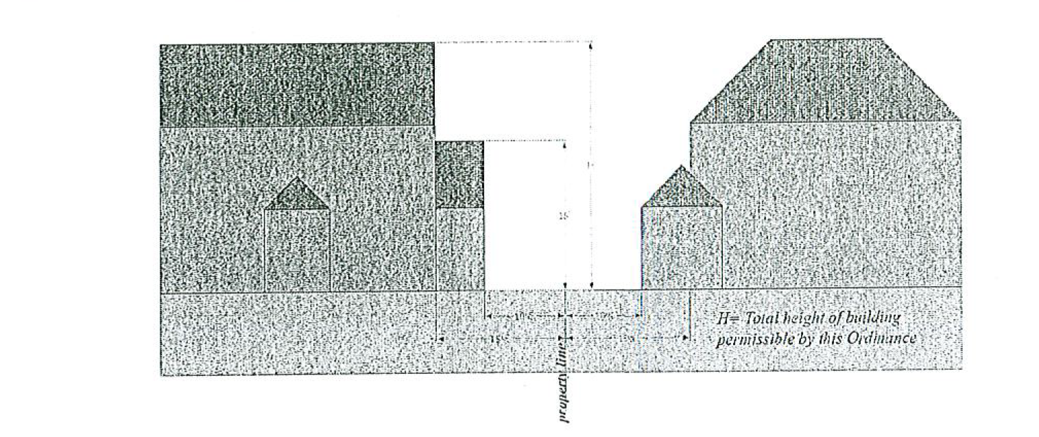
That portion of the structure one story or less (no more than 18 feet) in height shall be set back a minimum of ten percent of the total lot width from the abutting property line.
b.
That portion of the structure over one story (over 18 feet) in height shall be set back a minimum of 15 percent of the total lot width from the abutting property line.
c.
A minimum of one side yard shall be equal to at least 15 percent of the total lot width, regardless of height.
d.
Any existing structure which does not meet this requirement at the time of adoption of this article, shall not be considered a nonconforming structure. However, any addition to such structure shall meet the requirements above.
e.
If the above-noted requirements cannot be met, the planning commission and city council may reduce the required setback through special land use approval. In reviewing whether to recommend or grant a special land use approval for a reduction in side yard setback, the planning commission and council shall take into account the following:
1.
Ability to reconfigure the building layout or addition to allow for appropriate construction, expansions, or alterations without the granting of special land use approval.
2.
Whether the request is the least impactful to the subject property and those which surround it while accommodating appropriate expansion or alteration of the residence.
3.
Proximity of adjacent residences, their windows and other openings, outdoor spaces, and the setback from the mutual property line.
4.
Architectural character and building massing of the adjacent residence as well as the proposed residence.
5.
Building materials, proposed landscaping materials, and other hardscapes proposed along the property line.
(8)
Minimum rear yards:
One-story buildings: 25 feet
More than one story buildings: 30 feet.
(9)
The amount of impervious surface area within the front yard shall be a maximum of 35 percent, as measured from the side lot lines and the front facade of the residence to the front lot line.
(Ord. No. 252, § I, 10-19-2010)
Sec. 40-71. - Permitted uses.
In the Vernier Residence District, no building, structure or land area shall be used, and no building or structure shall be erected or altered, which is arranged, intended or designed to be used for a purpose other than one or more of the following purposes. This district shall only be applied to those properties fronting Vernier Road.
(1)
One-family dwellings.
(2)
Gardens.
(3)
Municipal buildings owned, occupied or controlled by the city.
(4)
Accessory uses customarily incidental to any of the permitted uses as set forth in subsections (1)—(3) of this section, as regulated in section 40-231.
(5)
Other uses required to be permitted by law.
(Ord. No. 252, § I, 10-19-2010)
Sec. 40-72. - Area, height and placement requirements.
Area, height and placement requirements in the Vernier Residence District are set forth below. It is recognized that a number of properties along Vernier Road do not comply with the following standards. It is the intent of this district to recognize those lots existing at the time of adoption of this article which do not conform to the minimum lot area and lot width of this section as being conforming lots provided the remainder of the standards can be met.
(1)
Minimum lot area: 7,000 square feet.
(2)
Minimum lot width: 50 feet.
(3)
Maximum height: 30 feet (not to exceed two stories).
a.
The regulations in this subsection (3) are deemed maximum height limitations and the total height of structures shall also be subject to section 40-173, pertaining to illustrative neighborhood design standards, which may mandate a lower height consistent with the appropriate design guidelines. Further, no new building shall be constructed, nor shall an addition or other modification to an existing building be constructed, which results in the maximum height of such building being greater than the average height of neighboring buildings plus 25 percent of that "average height", subject to the maximum heights set forth in this subsection. For the purpose of this section, the term "average height of buildings" means:
1.
With respect to a building not on a corner lot, the average height of the buildings on either side of the building being constructed or modified.
2.
With respect to a building on a corner lot, the average of the height of the two buildings on the same side of the street on which the front facade of the building being constructed or modified is located which are nearest to such building being constructed or modified. If the side of the street on which such front facade of building being constructed or modified does not have two other buildings, the average height of neighboring buildings shall be defined as the average of the height of the two buildings nearest to the building being constructed or modified, regardless of the street or side of street such buildings are located upon.
b.
Architectural embellishments, such as, but not limited, to decorative railings/fences, statuary, artwork, decorative balustrades, weather vanes, finials, etc., shall be prohibited above the maximum permitted height of the structure as defined by subsection (3) of this section unless such is approved by the planning commission as an integral part of the overall architecture of the facade.
c.
When the height limitations in subsection (3) of this section result in an unusual situation where the application of the standards set forth in subsection (3) of this section would create an architectural incongruity because of peculiar circumstances of the lot in question and the neighboring lots and structures thereon, the planning commission and city council may consider approval of a special land use to create architectural compatibility. In reviewing whether to grant a special land use approval for an increase in the total maximum height permissible, the planning commission and city council shall take into account the following:
1.
Whether the request is the least impactful to the subject property and those which surround it while accommodating appropriate expansion or alteration of the residence.
2.
Proximity of those portions of the building exceeding the height requirements to adjacent property lines and residential structures.
3.
The percentage of building or roofline above the permitted height.
4.
Architectural character and building massing of the adjacent residence as well as the proposed residence.
5.
The overall proposed building height measured from the final approved grade of the lot compared to the overall height of adjacent residences measured in the same manner on the adjoining lots.
d.
Regardless of the requirements set forth above, all residences within the district shall be permitted to construct a residence up to a height of 22 feet.
(4)
Maximum lot coverage: 25 percent.
(5)
Minimum total floor area (all floors): 2,100 square feet.
(6)
Minimum front yard:
a.
On all lots in the Vernier Residence District the minimum setback shall be 30 feet.
b.
The intent of this section is to create a uniform streetscape along all roadways within the city, to create an environment where individual views and privacy are maintained between residences, and to minimize the impacts of building massing. Therefore, notwithstanding the requirements pertaining to minimum front yard set forth in subsection (6)a of this section, no building or accessory building shall be set back from the road way further than the average of the closest two most immediate principal buildings. With respect to corner lots and double frontage lots, additional setback requirements shall be as set forth in subsections 40-256(b)—(d). No presently existing building or accessory building intruding into the above-described front yard setback shall be considered nonconforming, and any such building shall enjoy the rights conferred by this chapter as a legal structure.
(7)
Side yard setback:
a.
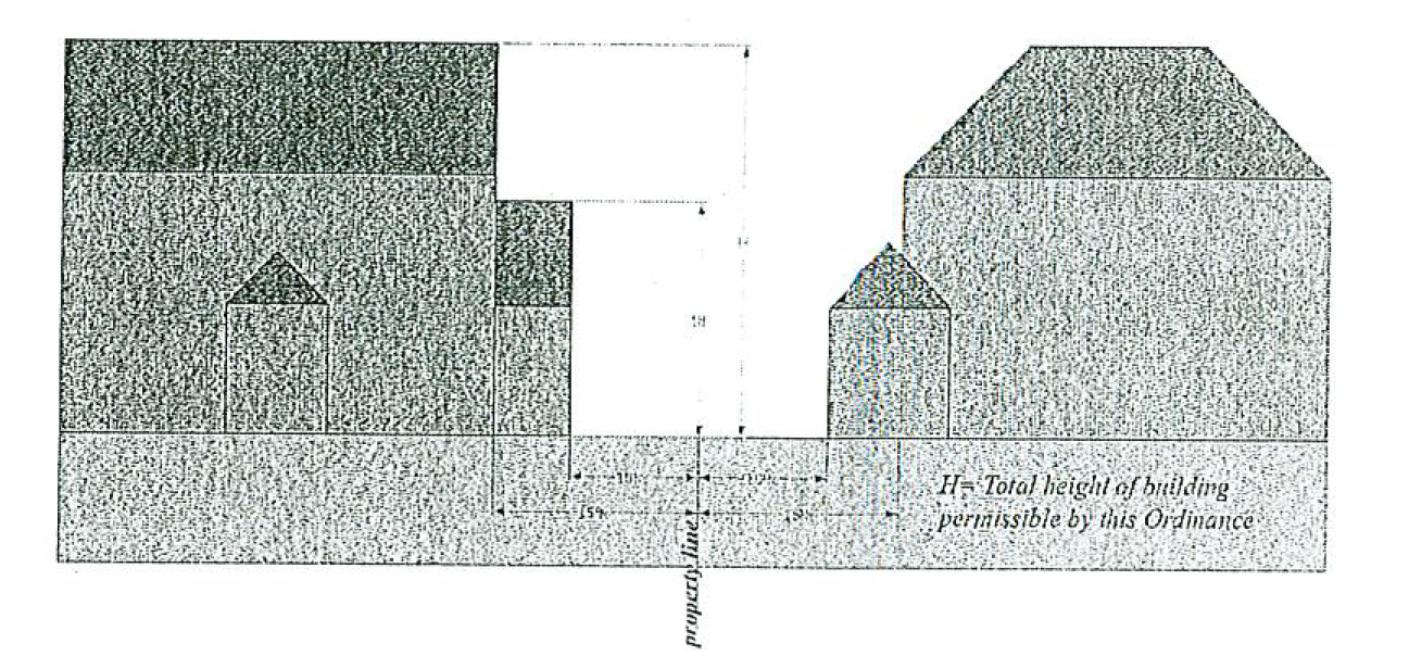
That portion of any new structure one story or less (no more than 18 feet) in height shall be set back a minimum of ten percent of the total lot width from the abutting property line.
b.
That portion of any new structure over one story (over 18 feet) in height shall be set back a minimum of 15 percent of the lot width from the abutting property line.
c.
A minimum of one side yard shall be equal to at least 15 percent of the lot width, regardless of height.
d.
Any existing structure which does not meet this requirement at the time of adoption of this article, shall not be considered a nonconforming structure. However, any addition to such structure shall meet the requirements above.
e.
If the above noted requirements cannot be met, the planning commission and city council may reduce the required setback through special land use approval. In reviewing whether to grant or recommend a special land use approval for a reduction in side yard setback, the planning commission and council shall take into account the following:
1.
Ability to reconfigure the building layout or addition to allow for appropriate construction, expansions, or alterations without the granting of special land use approval.
2.
Whether the request is the least impactful to the subject property and those which surround it while accommodating appropriate expansion or alteration of the residence.
3.
Proximity of adjacent residences, their windows and other openings, outdoor spaces, and the setback from the mutual property line.
4.
Architectural character and building massing of the adjacent residence as well as the proposed residence.
5.
Building materials, proposed landscaping materials, and other hardscapes proposed along the property line.
(8)
Minimum rear yards:
One-story buildings: 25 feet
More than one story buildings: 30 feet.
(9)
[Impervious surface area:] The amount of impervious surface area within the front yard shall be a maximum of 35 percent as measured from the side lot lines and the front facade of the residence to the front lot line.
(Ord. No. 252, § I, 10-19-2010)
Sec. 40-81. - Permitted uses.
In the colonial residence district, no building, structure or land area shall be used, and no building or structure shall be erected or altered, which is arranged, intended or designed to be used for a purpose other than one or more of the following purposes. This district shall only apply to those properties along Colonial Road.
(1)
One-family dwellings.
(2)
Gardens.
(3)
Municipal buildings owned, occupied or controlled by the city.
(4)
Accessory uses customarily incidental to any of the permitted uses as set forth in subsections (1)—(3) of this section, as regulated in section 40-231.
(5)
Other uses required to be permitted by law.
(Ord. No. 252, § I, 10-19-2010)
Sec. 40-82. - Area, height and placement requirements.
Area, height and placement requirements in the colonial residence district shall be as follows:
(1)
Minimum lot area: 9,000 square feet.
(2)
Minimum lot width: 100 feet.
(3)
Maximum height: 30 feet (not to exceed two stories).
a.
The regulations in this subsection (3) are deemed maximum height limitations and the total height of structures shall also be subject to section 40-173, pertaining to illustrative neighborhood design standards, which may mandate a lower height consistent with the appropriate design guidelines. Further, no new building shall be constructed, nor shall an addition or other modification to an existing building be constructed, which results in the maximum height of such building being greater than the average height of neighboring buildings plus 25 percent of that "average height," subject to the maximum heights set forth in this subsection. For the purpose of this section, the term "average height of buildings" means:
1.
With respect to a building not on a corner lot, the average height of the buildings on either side of the building being constructed or modified.
2.
With respect to a building on a corner lot, the average of the height of the two buildings on the same side of the street on which the front facade of the building being constructed or modified is located which are nearest to such building being constructed or modified. If the side of the street on which such front facade of building being constructed or modified does not have two other buildings, the average height of neighboring buildings shall be defined as the average of the height of the two buildings nearest to the building being constructed or modified, regardless of the street or side of street such buildings are located upon.
b.
Architectural embellishments, such as, but not limited to, decorative railings/fences, statuary, artwork, decorative balustrades, weather vanes, finials, etc., shall be prohibited above the maximum permitted height of the structure as defined by subsection (3) of this section unless such is approved by the planning commission as an integral part of the overall architecture of the facade.
c.
When the height limitations in subsection (3) of this section result in an unusual situation where the application of the standards set forth in subsection (3) of this section would create an architectural incongruity because of peculiar circumstances of the lot in question and the neighboring lots and structures thereon, the planning commission and city council may consider approval of a special land use to create architectural compatibility. In reviewing whether to grant a special land use approval for an increase in the total maximum height permissible, the planning commission and city council shall take into account the following:
1.
Whether the request is the least impactful to the subject property and those which surround it while accommodating appropriate expansion or alteration of the residence.
2.
Proximity of those portions of the building exceeding the height requirements to adjacent property lines and residential structures.
3.
The percentage of building or roofline above the permitted height.
4.
Architectural character and building massing of the adjacent residence as well as the proposed residence.
5.
The overall proposed building height measured from the final approved grade of the lot compared to the overall height of adjacent residences measured in the same manner on the adjoining lots.
d.
Regardless of the requirements set forth above, all residences within the district shall be permitted to construct a residence up to a height of 22 feet.
(4)
Maximum lot coverage: 25 percent.
(5)
Minimum total floor area (all floors): 2,100 square feet.
(6)
Minimum front yard:
a.
On all lots in the colonial residence district the minimum setback shall be 25 feet.
b.
The intent of this section is to create a uniform streetscape along all roadways within the city, to create an environment where individual views and privacy are maintained between residences, and to minimize the impacts of building massing. Therefore, notwithstanding the requirements pertaining to minimum front yard set forth in subsection (6)a of this section, no building or accessory building shall be set back from the roadway further than the average of the closest two most immediate principal buildings. With respect to corner lots and double frontage lots, additional setback requirements shall be as set forth in subsections 40-256(b)—(d). No presently existing building or accessory building intruding into the above-described front yard setback shall be considered nonconforming, and all such building shall enjoy the rights conferred by this chapter as a legal structure.
(7)
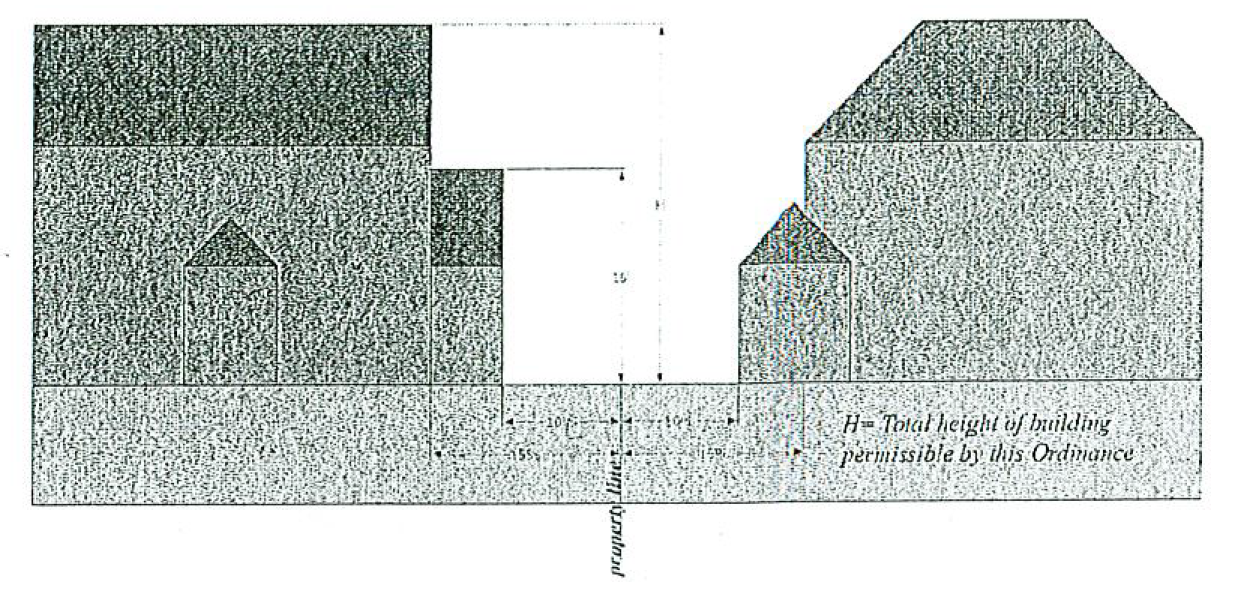
Side yard setback:
a.
That portion of the structure one story or less (no more than 18 feet) in height shall be set back a minimum of ten percent of the total lot width from the abutting property line.
b.
That portion of the structure over one story (over 18 feet) in height shall be set back a minimum of 15 percent of the total lot width from the abutting property line.
c.
A minimum of one side yard shall be equal to at least 15 percent of the total lot width, regardless of height.
d.
Any existing structure which does not meet this requirement at the time of adoption of this article, shall not be considered a nonconforming structure. However, any addition to such structure shall meet the requirements above.
e.
If the above-noted requirements cannot be met, the planning commission and city council may reduce the required setback through special land use approval. In reviewing whether to recommend or grant a special land use approval for a reduction in side yard setback, the planning commission and council shall take into account the following:
1.
Ability to reconfigure the building layout or addition to allow for appropriate construction, expansions, or alterations without the granting of special land use approval.
2.
Whether the request is the least impactful to the subject property and those which surround it while accommodating appropriate expansion or alteration of the residence.
3.
Proximity of adjacent residences, their windows and other openings, outdoor spaces, and the setback from the mutual property line.
4.
Architectural character and building massing of the adjacent residence as well as the proposed residence.
5.
Building materials, proposed landscaping materials, and other hardscapes proposed along the property line.
(8)
Minimum rear yards:
One-story buildings: 25 feet
More than one story buildings: 30 feet.
(9)
[Impervious surface area:] The amount of impervious surface area within the front yard shall be a maximum of 35 percent, as measured from the side lot lines and the front facade of the residence to the front lot line.
(Ord. No. 252, § I, 10-19-2010)
Sec. 40-91. - Permitted uses.
In the residence lakefront district, no building or land shall be used, and no building shall be erected or altered, which is arranged, intended or designed to be used for a purpose other than one or more of the following purposes:
(1)
One-family dwellings.
(2)
Gardens.
(3)
Municipal buildings owned, occupied or controlled by the city.
(4)
Accessory uses customarily incident to any of the permitted uses as set forth in subsections (1)—(3) of this section, as regulated by section 40-231.
(5)
Other uses required to be permitted by law.
(Ord. No. 252, § I, 10-19-2010)
Sec. 40-92. - Special land use.
Private nonprofit institutions of a philanthropic nature, except such institutions whose chief activity is a service customarily carried out as a business, may be permitted as a special land use in the residence lakefront district, upon approval of the city council, only after proper notice has been given as required by state law, and after review and recommendation has been received from the planning commission, subject to the standards and requirements of section 40-423.
(Ord. No. 252, § I, 10-19-2010)
State Law reference— Special land uses, MCL 125.584a.
Sec. 40-93. - Area, height and placement requirements.
Area, height and placement requirements in the residence lakefront district shall be as follows:
(1)
Minimum lot area: 20,000 square feet.
(2)
Minimum lot width: 100 feet.
(3)
Maximum height:
a.
Thirty feet (not to exceed two stories) on lots with widths of less than 120 feet.
b.
Thirty-five feet (not to exceed 2½ stories) on lots with widths of 120 feet or more, but less than 150 feet.
c.
On lots with widths of 150 feet or more, the planning commission may permit a maximum height of 40 feet, provided that there shall be at least eight additional feet above 150 feet in lot width at the front building line for each one foot of increase in height above 35 feet.
d.
When the height limitations in subsection (3) of this section result in an unusual situation where the application of the standards set forth in subsection (3) of this section would create an architectural incongruity because of peculiar circumstances of the lot in question and the neighboring lots and structures thereon, the planning commission and city council may consider approval of a special land use to create architectural compatibility. In reviewing whether to grant a special land use approval for an increase in the total maximum height permissible, the planning commission and city council shall take into account the following:
1.
Whether the request is the least impactful to the subject property and those which surround it while accommodating appropriate expansion or alteration of the residence.
2.
Proximity of those portions of the building exceeding the height requirements to adjacent property lines and residential structures.
3.
The percentage of building or roofline above the permitted height.
4.
Architectural character and building massing of the adjacent residence as well as the proposed residence.
5.
The overall proposed building height measured from the final approved grade of the lot compared to the overall height of adjacent residences measured in the same manner on the adjoining lots.
(4)
Maximum lot coverage: 25 percent.
(5)
Minimum total floor area: 2,100 square feet, excluding any second or third floor areas.
(6)
Minimum front yard: 145-foot minimum setback from the front property line.
(7)
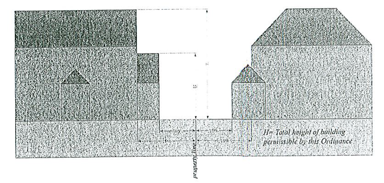
Minimum side yards: Ten percent of the lot width on one side and 15 percent of the lot width on the other side; provided, however, that no side yard shall have a width less than six feet, nor shall the combination of two side yards be less than 16 feet.
a.
If the above-noted requirements cannot be met, the planning commission and city council may reduce the required setback through special land use approval. In reviewing whether to recommend or grant a special land use approval for a reduction in side yard setback, the planning commission and council shall take into account the following:
1.
Ability to reconfigure the building layout or addition to allow for appropriate construction, expansions, or alterations without the granting of special land use approval.
2.
Whether the request is the least impactful to the subject property and those which surround it while accommodating appropriate expansion or alteration of the residence.
3.
Proximity of adjacent residences, their windows and other openings, outdoor spaces, and the setback from the mutual property line.
4.
Architectural character and building massing of the adjacent residence as well as the proposed residence.
5.
Building materials, proposed landscaping materials, and other hardscapes proposed along the property line.
(8)
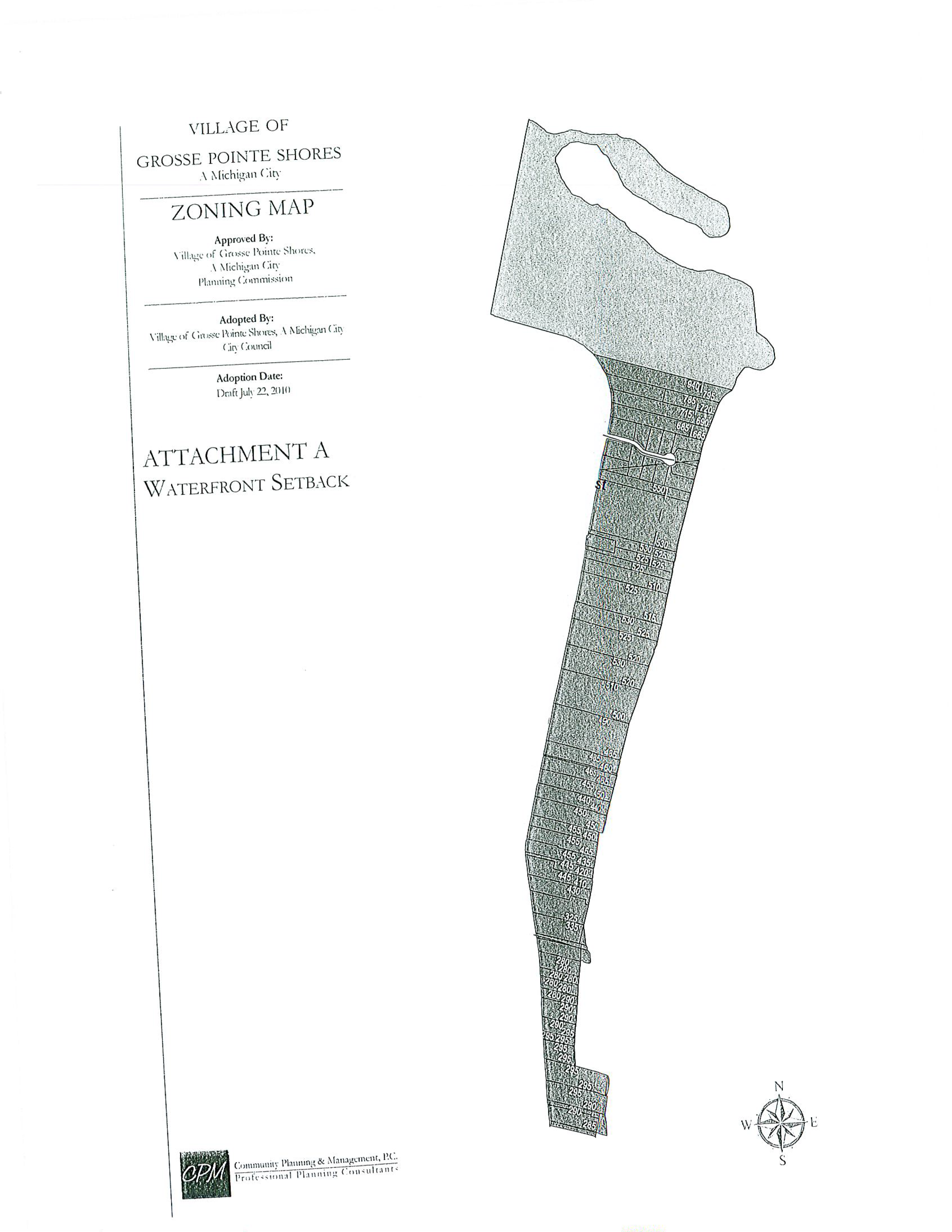
Minimum rear or lakefront yards: The zoning use district map indicates the required lake shore setback line. The minimum lake front yard shall be measured so that no principal structure shall be closer to the shoreline than:
a.
Its present location;
b.
The average of the closest of two out of three of the most immediate neighboring principal buildings; or
c.
The lake shore setback line as shown on the zoning use district map.
No existing principal building intruding into the described yard setback shall be considered nonconforming, and all such buildings shall enjoy the rights conferred by this chapter as a legal structure. The minimum setbacks for rear yards not abutting the water shall be the same as in the residence district.
(9)
[Impervious surface area.] On all lots of 100 feet of width or greater, the amount of impervious surface permitted in the front yard area shall be limited to a maximum of 30 percent of the front yard area measured from one side of the lot to the other and from the front facade of the residence to the front lot line. On lots of less than 100 feet in width, the amount of impervious surface areas shall be a maximum of 35 percent of the front yard area as measured from the side lot lines and the front facade of the residence to the front lot line.
(Ord. No. 252, § I, 10-19-2010)
Sec. 40-94. - Lots with restricted use.
Lots abutting the easterly side of Lake Shore Road, south of Vernier Road, shall never be used for any other purpose than as a sloping embankment to the shore of Lake St. Clair, as presently used.
(Ord. No. 252, § I, 10-19-2010)
Sec. 40-111. - Purposes.
The residence planned district regulations set forth in this division are designed to accomplish the objectives of this chapter through a land development project review process based on the application of site planning criteria to achieve integration of the proposed development so as to be harmonious with the village's residential character. The residence planned district is a planned unit development district and reflects the purposes of the state enabling act and the following local purposes:
(1)
To encourage innovation in land use and variety in design, layout and type of structure.
(2)
To achieve economic and efficient use of land, natural resources, energy and the provision of public services and utilities.
(3)
To encourage the provision of useful open space, where appropriate.
(4)
To provide retirement housing particularly suited to the needs of residents of the village.
(Ord. No. 252, § I, 10-19-2010)
Sec. 40-112. - Permitted uses.
In the residence planned district, no building or land shall be used, and no building shall be erected or altered, which is arranged, intended or designed to be used for a purpose other than one or more of the following purposes:
(1)
Existing one-family residences.
(2)
Attached or detached one-family retirement dwellings.
(3)
Gardens (small plantings).
(4)
Municipal buildings owned, occupied or controlled by the city.
(5)
Accessory uses customarily incidental to the permitted uses set forth in subsections (1)—(4) of this section.
(6)
Other uses required to be permitted by law.
(Ord. No. 252, § I, 10-19-2010)
Sec. 40-113. - Qualification requirements.
In order to qualify for development, the commission and city council must first determine, based on documentation prepared by a registered architect, professional community planner, landscape architect, engineer or similar professional in planning and design, that the proposed use and development is compatible with the residential character of the city.
(Ord. No. 252, § I, 10-19-2010)
Sec. 40-114. - Site design requirements.
All developments within the residence planned district shall conform to the following restrictions:
(1)
The regulations governing the maximum allowable height of buildings, the minimum lot area and lot width, the maximum lot coverage, and the minimum side and rear yards are hereby established as set forth in section 40-62.
(2)
A minimum of 15 percent of the total parcel within such district shall be devoted to suitable recreation and other approved activities. Roads included in the total parcel area shall be excluded from the recreation and activities area calculations.
(3)
The placement of housing units and other improvements shall be designed, to the extent practical, to preserve wooded areas contained on the site.
(4)
In order to provide an orderly transition where the district abuts another residential district, the abutting residential district shall be effectively buffered by providing one or more of the following forms of transition within the development, as determined to be appropriate by the commission:
a.
Natural stand of trees.
b.
Effective landscape buffering.
c.
Constructed fences, walls and berms.
d.
Compatible structures.
(5)
If one-family dwelling units are attached, such attachment shall be by means of an approved architectural wall detail or a common wall that assures maximum isolation of adjoining structures. The maximum number of units which may be attached together in each cluster in the manner set forth in this subsection shall be four. Variety in the design of individual units shall be provided by the use of design details which do not appear to be continuous or repetitious. A building pattern which is repetitious throughout a development shall not be used. Each dwelling must have a two-car attached garage used for private automobile storage only.
(6)
Yard requirements shall be provided as follows:
a.
Minimum spacing between ends of buildings shall be determined by the number of living units that are arranged in any building group, as follows:
b.
Between the ends of two buildings having a different number of attached living units, the minimum distance, in feet, will be as follows:
Between a two-unit and three-unit building: 15 feet
Between a two-unit and four-unit building: 20 feet
Between a three-unit and four-unit building: 30 feet
c.
All buildings and parking areas shall have a setback of at least 110 feet from the centerline of any major thoroughfare, and at least 65 feet from any local street as shown on the village master plan.
d.
All parking areas shall be set back a minimum of 20 feet from an adjoining residence district or property.
e.
Building setbacks from internal streets shall be as follows:
1.
Private streets/general circulation.
i.
Living areas, 40-foot minimum clear area from paving;
ii.
Nonliving areas, 20-foot minimum clear area from paving.
2.
Private streets/limited circulation. Living and nonliving areas, 20-foot minimum clear area from paving.
(7)
At least two deciduous or evergreen trees per dwelling unit (at least a 2.5-inch caliper) shall be planted in the project area, in addition to existing vegetation. Location of such trees, as well as existing trees, shall be indicated on the site plan in accordance with an approved detailed landscape plan.
(8)
An undulating landscaped berm, with a maximum height of four feet, or equivalent natural buffer, shall be provided along the entire property to the extent it abuts a major road as classified in the village master plan. Slopes of such berm shall be gentle enough so as not to erode when planted with grass, and berm locations shall be designed so that the view of oncoming traffic is not obscured at the intersection. The village engineer shall review the proposed berm to determine that adequate drainage is provided.
(9)
Sidewalks may be required along all public streets or roads. A pedestrian circulation plan that meets commission requirements shall be required within the development.
(10)
Fencing shall not be permitted on the interior of the development, except brick walls for privacy or decorative purposes may be approved by the commission.
(11)
The applicant shall make provision, satisfactory to the village, to assure that the amenities and the areas shown on the plan for use by the occupants of the development will be, or have been, irrevocably committed for such purpose. The village may require that conveyances or other documents be placed in escrow to accomplish such purpose and that a performance guarantee, as prescribed in subsection (13) of this section, be filed with the village.
(12)
The applicant shall deposit a cash deposit or certified check with the village equaling 120 percent of the estimated cost of common area improvements associated with the project, as verified by the village, for which approval is sought. The performance guarantees shall be deposited at the time of the issuance of the permit authorizing the activity or project. When all improvements have been completed, the village shall release the cash deposit.
(13)
Subject to commission approval, in all parcels designated as residence planned districts, there shall be allowed a total unit count up to, but not exceeding, a density of up to twice the dwelling units per acre, consistent with conventional residential platted development of the abutting residential district. A design plan shall be submitted specifying the maximum number of units that the site could yield if platted.
(Ord. No. 252, § I, 10-19-2010)
Sec. 40-115. - Submittal procedures.
The two distinct steps required to develop a parcel of land under the residence planned district are the qualification of the concept, and site plan approval (final review). Both steps shall require public hearings preceded by notice as required by this chapter.
(1)
Residence planned district development concept review shall include a preliminary application and concept plan in accordance with the following outline. The filing of a preliminary plan will provide an opportunity for the applicant and commission to become generally acquainted with the proposed project and conduct discussions about the features of the proposed concept. An application for preliminary plan consideration shall comply with, and include, the following requirements and standards:
a.
A plan showing the entire project area in a preliminary form and at a clearly understandable scale, indicating proposed land use areas, their relationship to each other, circulation patterns, and existing site features and characteristics.
b.
The existing topography shall be depicted at two-foot contour intervals for the subject area and all nearby areas. If the land is generally flat, grade shots shall be provided at intervals necessary to indicate any grade differential.
c.
A map of the village, indicating the parcel and surrounding vicinity area and the site's relationship to existing roads, streets and use districts within and immediately adjacent to the city.
d.
Preliminary architectural plans for all buildings, including the basic building scale and style and the number of units per building, shall be clearly set forth.
e.
Preliminary architectural elevations for typical buildings, including the style and exterior facing materials.
f.
Preliminary landscape plan of the types and sizes of proposed vegetation.
g.
Density of residential use and total number of units by type shall be clearly set forth.
h.
Existing and proposed land use and development features as they impact neighboring properties.
i.
Existing utilities, including storm drain facilities, shall be located and noted.
j.
Adequacy of public and private services/infrastructures shall be described.
k.
Methods of buffering and screening from existing housing.
The commission shall recommend preliminary approval to the village council if the commission agrees that the proposal has sufficient merit to warrant further consideration and has potential to meet the requirements of this section and the applicable requirements of this chapter. If the council concurs, an application may be filed for final review in conformance with the requirements of the subsections (2)—(10) of this section. If the commission does not find the proposed plan or approach acceptable, it shall recommend denial of the request at such point and provide the reasons for denial in the commission minutes and submit their recommendation and supporting materials to the village council.
(2)
An application for residence planned district development final review may be made only if the village council has agreed by motion that the preliminary application and concept plan have potential to meet the requirements set forth in this section. Upon receipt of a complete application for final review, the commission shall schedule such review for the next regular meeting. The applicant's presentation at such meeting shall include drawings, exhibits, narratives and draft covenants and agreements identified for reference by letter or number. If the application for final review complies with the objectives of the applicable sections set forth in this division for the residence planned district, and the commission and village council further find the following standards to have been met, the application may be approved:
a.
All applicable provisions of this chapter and other applicable ordinances shall have been met. If any provision of this division is in direct conflict with the provisions or authority of any other article of this chapter, the provisions included within this division shall apply to land included within the residence planned district.
b.
All minimum requirements pertaining to residential or other uses shall be subject to the general requirements applicable in the residence district, except as may be specifically varied by the commission and village council.
c.
Adequate, well designed and properly planned areas shall be provided for all walkways, recreation, parking, access, screening and isolation, and other open areas to be used by the residents of the development.
d.
Adequate sanitary sewage disposal, water supply, and road and other stormwater drain systems shall be provided. Water, sewer and storm drains shall be subject to applicable village standards and ordinances.
e.
Efficient and desirable use of all areas in harmony with the physical character of the village and surrounding residential areas and uses.
f.
Assurances that areas shown on the plan for use by the occupants shall be, or have been, irrevocably committed for such purpose. The village shall have the right to require conveyances or other documents to be placed in escrow.
g.
Assurance of financial support for, and maintenance of, all improvements indicated on the plan for open space areas and common use areas. Assurances may require posting of bonds as determined by the commission and approved by the village council.
h.
Upon recommendation of the village engineer, the commission may waive or modify requirements for utilities with respect to all, or part of, the particular plan when strict application would result in practical problems.
(3)
In addition to compliance with the applicable requirements for site plan review contained in section 40-422, the final review application shall include the following:
a.
A boundary survey of the exact acreage, performed by a registered land surveyor or civil engineer, at a scale of one inch equals 30 feet.
b.
A physical features map of the area and its vicinity, including topography, drawn as contours, with an interval of at least two feet, or grade shots, where applicable. The map shall indicate all trees and unbuildable areas due to soil conditions, wetlands or similar conditions, at a scale of one inch equals 50 feet.
c.
A legal description of the property.
d.
An aerial photograph, not more than five years old, of the area, at a minimum scale of one inch equals 100 feet.
e.
Existing and proposed streets and other developments within and surrounding the proposed area.
f.
A plan for the entire area, indicating the specific use areas and dwelling unit types being requested (floor plans and building elevations with specific exterior materials and architectural features included); densities proposed; street, road, traffic and pedestrian circulation; public utilities; building locations, driveways, walkways, parking areas, landscaping and natural areas (woodlands); areas reserved for public service activities; recreation areas and other open spaces; and areas used for occupants.
g.
A preliminary estimate of contemplated total stormwater flow and sanitary sewage volume. Each utility shall be shown as a one-line diagram, with flow direction indicated on the proposed street layout and shown on the topographic map as required in subsection (3)b. of this section.
h.
A schedule indicating the proposed timing of the development, including phasing, if appropriate.
i.
A written impact statement, detailing the intent of the developer and types of dwelling units contemplated. The impact statement shall also include support documentation, such as soil data; land use impacts; changes in traffic volume on adjacent streets; impacts of proposed development on wetlands, air and water quality (ground and surface); noise; and the scale of development and surrounding environment and all information appropriate to a phase one audit.
j.
Statement of covenants, grants of easements and other restrictions to be imposed upon the uses of land and structures.
k.
Any other data, plans or drawings considered by the commission or village council to be necessary for the consideration of the proposal.
All materials required to be submitted as part of the application shall be submitted in the required number of copies for distribution to the commission, village council and appropriate reviewing agents and advisors.
(4)
The commission shall review the application materials and reviewing agencies' comments. In the process of review, the commission shall consider the following:
a.
Specific development requirements set forth in this chapter.
b.
The location and design of service roads or drives and driveways providing vehicular ingress to, and egress from, each building, in relation to streets giving access to the site and pedestrian traffic.
c.
The traffic circulation features within the site and the location of automobile parking areas, including:
1.
Safety and convenience of both vehicular and pedestrian traffic, both within the site and in relation to access streets.
2.
Satisfactory and harmonious relationships between the development on the site and the existing and prospective development of surrounding land and adjacent parcels and districts.
3.
Accessibility afforded to emergency vehicles.
d.
The arrangement of use areas on the site and design of the buildings in relation to functional, efficient and compatible arrangements within the site, and also to adjacent uses and the following:
1.
Harmony with the character of the village and surrounding properties.
2.
Treatment of open space.
3.
Availability of sewer and water capacity and the capacity of other utilities.
4.
Adequate screening and/or buffering.
5.
Impact on environmental quality.
6.
Potential noise from development and traffic sources.
e.
The proposal's compatibility and harmony with the character of the surrounding properties and that it will not substantially interfere with the safety, light, air and convenience of neighboring uses.
f.
Any other matters that are within the jurisdiction of village departments or the commission or council.
(5)
Only applications properly prepared and submitted with all required fees, deposits and/or bonds, paid in full, will be processed. Review and processing of the application shall be subject to the requirements and procedures contained within this chapter and as administered and finally approved by the commission and village council. Initial approval shall be valid for a period of two years, with one-year extensions possible with the approval of the commission and village council, upon proper application. If development of the site has lapsed for a period exceeding one year, the applicant shall be required to return to the village for reconsideration of the plan, following the procedure outlined in this division for original approval.
(6)
Wherever a proposed plan in total meets the standards and expectations of the village, the commission and village council may consider minor deviations from regulations.
(7)
In the course of instituting the plan, minor plan adjustments, including the minor shifting of buildings, service areas and other features requested by the applicant, may be authorized by the commission and processed as site plan supplements or clarifications. The village manager shall make the determination as to whether a change is minor or if an amendment is required. Amendments that significantly impact factors considered by the commission and village council in approving the area plan, such as changes to circulation systems or densities, or changes in buffering, exterior appearance and significant building rearrangements, shall require the applicant or the applicant's successors to return to the commission and village council for approval of an amended plan. The procedure outlined in this division for original approval shall be followed when submitting an amended plan.
(8)
Once a plan is approved by the commission and village council, no zoning board of appeals' variances shall be permitted. Any requested changes in the plan shall conform to the revision procedures contained within this division.
(9)
It is expressly understood that a residence planned district plan will not be allowed to proceed until the final plan or subsequent amended plan shall have received official approval of the commission and village council, where applicable.
(10)
A final certificate of occupancy and any construction bonds or letter of credit shall not be released to the developer/owner until the as-built mylar has been reviewed and accepted by the village.
(Ord. No. 252, § I, 10-19-2010)
Sec. 40-121. - Intent.
The intent of this division is to allow for specialized philanthropic type facilities which are nonresidential in nature and which will likely service not only the city and the immediate Grosse Pointe area but a larger, more regional area. Recognizing that these nonresidential uses may cause substantial impact to adjoining residences and the community as a whole, special attention must be given to the size and placement of buildings, structures and parking areas as well as the screening and buffering of these sites. It is further the intent of this article to limit the number of properties in which this type of activity may occur.
(Ord. No. 252, § I, 10-19-2010)
Sec. 40-122. - Permitted uses.
The following uses have been deemed appropriate and do not require additional review or approval by the city:
(1)
Building and premises tours.
(2)
Public and private gatherings and events (no overnight).
(3)
Public and private meetings, seminars, retreats, and educational activities (no overnight).
(4)
Office and administrative facilities.
(5)
Maintenance, storage, and repair facilities (for grounds equipment).
(6)
Existing residential facilities.
(7)
Existing banquet facilities.
(8)
Existing retail or commercial activities such as gift shops, restaurant and beverage sales and other incidental sales.
(9)
Existing parking areas and facilities.
(Ord. No. 252, § I, 10-19-2010)
Sec. 40-123. - Special land uses.
The following uses have been deemed appropriate only after special land use approval as regulated by section 40-423 of this article:
(1)
The construction of any new building.
(2)
The enlargement of any existing building onsite which increases usable floor area or offers the potential for additional uses or intensity of uses.
(3)
Additional lodging facilities or rooms for persons staying on the grounds.
(4)
Any retail commercial activities (excluding any existing retail uses).
(5)
Any new or expansion of existing hard surface parking areas.
(6)
Any other uses deemed similar or compatible with the above-noted permitted uses.
(Ord. No. 252, § I, 10-19-2010)
Sec. 40-124. - Area, height and placement requirements.
Area, height and placement requirements in the philanthropic district shall be as follows:
(1)
Minimum lot area: Ten acres or 435,600 square feet.
(2)
Minimum lot width: 500 feet.
(3)
Maximum height: On the east side of Lakeshore, the maximum height shall not exceed 40 feet and/or three stories. On the west side of Lakeshore, the maximum height shall not exceed 30 feet and/or two stories.
The existing structures shall not be deemed nonconforming based on height.
(4)
Maximum lot coverage: 25 percent.
(5)
Minimum front yard: 145 feet.
The existing structures shall not be deemed nonconforming based on front yard location.
(6)
Minimum side yards: 30 feet.
The existing structures shall not be deemed nonconforming based on side yard location. Further, depending on the type of use proposed, the city may require additional setbacks to lessen impacts generated by such uses.
(7)
Minimum rear yard: 30 feet or as shown on the zoning use district map by the lakeshore setback line, whichever is greater. Further, depending on the type of use proposed, the city may require additional setbacks to lessen impacts generated by such uses.
(Ord. No. 252, § I, 10-19-2010)
Sec. 40-125. - Screening requirements.
The planning commission shall review the necessity for landscape screening between the proposed building(s) and/or use(s) and any adjoining non-like use district or abutting public thoroughfare depending on the type of building/use proposed, the proximity to the non-like district or public thoroughfare as well as the presence of existing landscape and hardscape.
(Ord. No. 252, § I, 10-19-2010)
Sec. 40-126. - Parking standards.
One parking space shall be provided for each six persons permitted within the maximum occupancy of the principal building, as determined by the fire marshal. For large scale or outdoor events, adequate parking shall also be provided either onsite or offsite. If provided offsite, the applicant shall provide a plan for transferring of patrons to and from the event and parking areas. This plan shall be reviewed by the department of public safety as necessary. The parking area for large scale and/or outdoor events may be allowed to be grass as deemed appropriate by the city.
(Ord. No. 252, § I, 10-19-2010)
Sec. 40-127. - Reconstruction of existing buildings or structures.
Notwithstanding the requirements of section 40-362 of this article, the reconstruction or repair of buildings or structures existing at the time of passage of this article from which this section is derived or thereafter constructed with approval as required by this chapter shall be permissible upon a determination by the planning commission that the location, size, scale and architectural character of the reconstructed or repaired building or structure is comparable to that which previously existed.
(Ord. No. 252, § I, 10-19-2010)
Sec. 40-128. - Waiver or modification of requirements.
In approving a special land use within the philanthropic district under section 40-423 of this Code, the city council may waive or modify any of the above area, height, coverage and placement requirements or parking standards, if it determines that such waiver or modification is consistent with the architectural character of the proposed construction and the overall use of the site upon which such proposed construction is located, and will not unduly and adversely impact adjoining properties.
(Ord. No. 252, § I, 10-19-2010)
Sec. 40-141. - Intent.
The intent of this division is to allow for community-type facilities which are nonresidential in nature and which will likely service not only the Village and the immediate Grosse Pointe area but potentially a larger, more regional area. Recognizing that these nonresidential uses may cause substantial impact to adjoining residences and the community as a whole, special attention must be given to the size and placement of buildings, structures and parking areas as well as the screening and buffering of these sites.
(Ord. No. 252, § I, 10-19-2010)
Sec. 40-142. - Permitted uses.
(1)
In the park/club district, no building or lot shall be erected or used except for the purpose of a public park, or recreational or private club, as at present.
(2)
Placement of cellular antennae on existing structures in accordance with the village's wireless communication ordinance.
(3)
Construction in the park/club district (including, without limitation, new construction or expansion or alteration of existing construction) shall be a "special land use," and shall require approval in accordance with the village's special land use provisions, as set forth in this division. Generally, and in accordance with the consideration required for special land uses generally, the following uses will be permitted in the park/club district:
(a)
Development or expansion of marinas, boat slips and the like.
(b)
Development of parking areas including surface parking, parking decks, or subgrade parking.
(c)
Development or expansion of eating, banquet, or other gathering areas.
(d)
Development of indoor or outdoor recreation areas.
(e)
Other uses similar to those listed above.
(Ord. No. 252, § I, 10-19-2010)
Sec. 40-143. - Setbacks and density.
Area, height and placement requirements in this district shall be as follows:
(1)
Minimum front yard: 145 feet.
(2)
Minimum side yards: 30 feet.
(3)
Minimum rear yard: 30 feet.
(4)
Maximum building height: 35 feet. Existing structures in the district that exceed such height shall not be considered nonconforming uses under this division.
(5)
Maximum building coverage: 25 percent.
(6)
Maximum impervious surface: 85 percent.
(Ord. No. 252, § I, 10-19-2010)
Sec. 40-144. - Reconstruction of existing buildings or structures.
Notwithstanding the requirements of section 40-143, the reconstruction or repair of existing buildings or structures shall be permissible upon a determination by the planning commission that the location, size, scale and architectural character of the reconstructed or repaired building or structure is comparable to that which previously existed.
(Ord. No. 252, § I, 10-19-2010)
Sec. 40-145. - Screening requirements.
For park/club district properties which abut non-like zoning districts (i.e., residence district, residence lakefront district, and residence planned district) screening shall be provided consistent with the following:
(1)
Evergreens (a minimum of ten feet in height at the time of planting) shall be planted along the mutual property line at a rate of one tree for each ten feet of such property line. These trees shall be planted in a natural manner and shall be evenly planted along the entire property line. The planning commission may approve other alternatives upon a finding that the intent of the ordinance is maintained.
(2)
In addition, low-level shrubbery shall be planted throughout the screening area(s). This shrubbery shall be planted at a rate of one shrub for each five feet of such property line. These trees shall be planted in a natural manner and shall be evenly planted along the entire property line. The planning commission may approve other alternatives upon a finding that the intent of the ordinance is maintained.
(Ord. No. 252, § I, 10-19-2010)
Sec. 40-146. - Parking standards.
One parking space shall be provided for each six persons permitted within the maximum occupancy of the principal building, as determined by the fire marshal.
(Ord. No. 252, § I, 10-19-2010)
Sec. 40-147. - Waiver or modification of requirements.
In approving a special land use within the park/club district under section 40-423 of this Code, the council may waive or modify any of the above area, height, coverage and placement requirements or parking standards, if it determines that such waiver or modification is consistent with the architectural character of the proposed construction and the overall use of the site upon which such proposed construction is located, and will not unduly and adversely impact adjoining properties.
(Ord. No. 252, § I, 10-19-2010)

