
Waldport City Zoning Code
CHAPTER 16
70 Significant Natural Resources Overlay Zone
16.70.010 Purpose
The Significant Natural Resources Overlay Zone is intended to provide protection for identified significant natural resources within the City of Waldport as designated under Statewide Planning Goal 5 and Goal 17. For the purpose of this overlay zone, significant natural resources are designated as Significant Wetlands and Riparian Corridors under Goal 5, and Major Marshes and Riparian Vegetation under Goal 17. These resources have been inventoried within the City of Waldport according to procedures, standards and definitions established under Goal 5 and Goal 17 and are identified on the Significant Natural Resources Map as adopted in the Comprehensive Plan.
The Significant Natural Resources Overlay Zone is intended to ensure reasonable economic use of property while protecting valuable natural resources within the City of Waldport's Urban Growth Boundary. This title establishes clear and objective standards to protect these resources.
Significant wetlands and riparian areas provide valuable fish and wildlife habitat, including habitat for anadromous salmonids; improve water quality by regulating stream temperatures, trapping sediment, and stabilizing streambanks and shorelines; provide hydrologic control of floodwaters; and provide educational and recreational opportunities. It is recognized that not all resources will exhibit all of these functions and conditions.
16.70.020 Definitions
As used in this section the following words and phrases shall mean:
"Bankfull Stage" means the elevation at which water overflows the natural banks of the stream.
"Bioengineering" means a method of erosion control and landscape restoration using live plants, such as willows.
"Building Envelope" means the land area, outside of all required setbacks, which is available for construction of a primary structure on a particular property.
"Delineation" means an analysis of a resource by a qualified professional that determines its boundary according to an approved methodology.
"Excavation" means removal of organic or inorganic material (e.g. soil, sand, sediment, muck) by human action.
"Fill" means deposition of organic or inorganic material (e.g. soil, sand, sediment, muck, debris) by human action.
"Impervious Surface" means any material (e.g. rooftops, asphalt, concrete) which reduces or prevents absorption of water into soil.
"Lawn" means grass or similar materials usually maintained as a ground cover of less than 6 inches in height. For purposes of this title, lawn is not considered native vegetation regardless of the species used.
"Major Marsh" means a wetland designated as significant under Statewide Planning Goal 17.
"Mitigation" means a means of compensating for impacts to a Significant Natural Resource or its buffer including: restoration, creation, or enhancement. Some examples of mitigation actions are construction of new wetlands to replace an existing wetland that has been filled, replanting trees, removal of nuisance plants, and restoring streamside vegetation where it is disturbed.
"Native Vegetation" means plants identified as naturally occurring and historically found within the City of Waldport.
"Natural Resource Enhancement" means a modification of a natural resource to improve its quality.
"Natural Resource Overlay" means a designation given to all Significant Wetlands and Riparian Corridors indicated on the Significant Natural Resources Map.
"Non-conforming" means a structure or use that does not conform to the standards of this title but has been in continuous existence from prior to the date of adoption of this title up to the present. Non-conforming uses are not considered violations and are generally allowed to continue, although expansion, reconstruction, or substantial improvements are regulated.
"Non-Significant Wetland" means a wetland mapped on the City of Waldport Local Wetlands Inventory which does not meet the primary criteria of the Oregon Division of State Lands Administrative Rules, OAR Chapter 141 (July, 1996 or as amended), for Identifying Significant Wetlands. For additional criteria information please refer to Statewide Planning Goal 5 and Goal 17, City of Waldport Periodic Review Report Task 2C, pages 22 and 25.
"Qualified Professional" means an individual who has proven expertise and vocational experience in a given natural resource field. A qualified professional conducting a wetland delineation must have the delineation approved by the Oregon Division of State Lands.
"Review Authority" means the City of Waldport.
"Riparian Area" means the area adjacent to a river, lake, or stream, consisting of the area of transition from an aquatic ecosystem to a terrestrial ecosystem. For purposes of this title, riparian areas are identified on the Significant Natural Resource Overlay Zone Map # 8-1664, as set forth by the Statewide Planning Goal 5 and Goal 17 City of Waldport Periodic Review Report Task 2C, pages 22 and 25.
"Riparian Corridor" means a Goal 5 Resource that includes the water areas, fish habitat, adjacent riparian areas, and wetlands within the riparian area boundary. For purposes of this title, riparian corridors are identified on the Significant Natural Resource Overlay Zone Map #8-1664, as set forth by the Statewide Planning Goal 5 and Goal 17 City of Waldport Periodic Review Report Task 2C, pages 22 and 25, and incorporated by this reference.
"Riparian Boundary" means an imaginary line that is a certain distance upland from the top bank and encompasses everything within the area between the wetland and the upper edge of the riparian area. The City of Waldport has adopted safe harbor setback methodology for identification.
"Shrubs" means woody vegetation usually greater than 3 feet but less than 20 feet tall, including multi-stemmed, bushy shrubs and small trees and saplings.
"Significant Natural Resources" means Significant Wetlands and Riparian Corridors, Major marshes and Significant Riparian Vegetation within the City of Waldport Urban Growth Boundary and designated on the Significant Natural Resources Map.
"Significant Wetland" means a wetland mapped on the City of Waldport Local Wetlands Inventory which meets the primary criteria of the Oregon Division of State Lands Administrative Rules, OAR Chapter 141 (July 1996 or as amended), for Identifying Significant Wetlands. For additional criteria information refer to Statewide Planning Goal 5 and Goal 17 City of Waldport Periodic Review Report Task 2C, Pages 22 and 25.
"State and Federal Natural Resource Agency" means Oregon Division of State Lands, Oregon Department of Fish and Wildlife, U.S. Army Corps of Engineers, U.S. Department of Agriculture Natural Resources Conservation Service, U.S. Fish and Wildlife Service, U.S. Environmental Protection Agency, and Department of Environmental Quality.
"Stream" means a channel such as a river or creek that carries flowing surface water, including perennial streams and intermittent streams with defined channels, and excluding man-made irrigation and drainage channels. For purposes of this title, streams are identified on the Significant Natural Resource Overlay Zone Map #8-1664, as set forth by the Statewide Planning Goal 5 and Goal 17 City of Waldport Periodic Review Report Task 2C, pages 22 and 25 and incorporated by this reference.
"Structure" means a building or other major improvement that is built, constructed or installed, not including minor improvements, such as fences, utility poles, flagpoles, or irrigation system components that are not customarily regulated through zoning ordinances.
"Substantial Improvement" means any repair, reconstruction, or improvement of a structure, the cost of which equals or exceed 50 percent of the market value of the structure either:
- Before the improvement or repair is started, or
- If the structure has been damaged and is being restored, before the damage occurred. For the purposes of this definition "substantial improvement" is considered to occur when the first alteration of any wall, ceiling, floor, or other structural part of the building commences, whether or not that alteration affects the external dimensions of the structure. The term does not, however, include either:
- Any project for improvement of a structure to comply with existing State or local health, sanitary, or safety code specifications which are solely necessary to assure safe living conditions, or
- Any alteration of a structure listed on the National Register of Historic Places or a State Inventory of Historic Places.
"Tree" means a woody plant 5 inches or greater in diameter at breast height and 20 feet or taller.
"Top of Bank" means a distinct break in slope between the stream bottom and the surrounding terrain which corresponds with the bankfull stage (the elevation at which water overflows the natural banks) of the stream.
"Variance" means a grant of relief from the requirements of this title which permits activity in a manner that would otherwise be prohibited by this title.
"Wetland" means those areas that are inundated or saturated by surface or ground water at a frequency and duration sufficient to support, and that under normal circumstances do support, a prevalence of vegetation typically adapted for life in saturated soil conditions. Based on the above definition, three major factors characterize a wetland: hydrology, substrate, and biota. For purposes of this title, wetlands are identified on the Significant Natural Resource Overlay Zone Map #8-1664, as set forth by the Statewide Planning Goal 5 and Goal 17 City of Waldport Periodic Review Report Task 2C, pages 22 and 25, and incorporated by this reference.
"Wetland Boundary" means the edges of a wetland as delineated by a qualified professional.
16.70.030 Applicability
- Affected Property: The procedures and requirements of the Significant Natural Resources (SNR) Overlay Zone:
- Apply to any parcel designated as having a Significant Natural Resource as mapped in the comprehensive plan;
- Apply in addition to the standards of the property's underlying zone;
- Supersede the property's underlying zone where the underlying zone does not provide the level of Significant Natural Resource protection afforded by the SNR Overlay Zone.
- Activities Subject To Review: Activities subject to the review shall include all development on properties outlined in 16.70.030 (A) and not specifically exempted from review as outlined in Section 16.70.030 (C), including:
- Partitioning and subdividing of land;
- New structural development;
- Exterior expansion of any building or structure, or increase in impervious surfaces or storage areas;
- Site modifications including grading, excavation or fill (as regulated by the Oregon Division of State Lands and the Army Corps of Engineers), installation of new above or below ground utilities, construction of roads, driveways, or paths;
- Removal of trees or the cutting or clearing of any native vegetation within the Significant Natural Resource beyond that required to maintain landscaping on individual lots existing on the effective date of this title, and removal of diseased or damaged trees that pose a hazard to life or property;
- Planting of native plants only within the Significant Natural Resource Area and related setbacks. A list of native plants can be obtained at City Hall and/or from a source approved by the Waldport Planning Commission.
- Exemptions: Activities exempt from this title include:
- The sale of property;
- Temporary emergency procedures necessary for the safety or protection of property;
- Commercial forest practices regulated by the Oregon Forest Practices Act;
- Normal and accepted farming practices other than the construction of buildings, structures, or paved roads;
- All water-related and water-dependent uses as described respectively in Chapter 16.44 and Chapter 16.48 of the Waldport Municipal Code.
- Agency Review: Decisions made by the City of Waldport under this title do not supersede the authority of the State or Federal agencies which may regulate or have an interest in the activity in question. It is the responsibility of the landowner to ensure that any other necessary State or Federal permits or clearances are obtained. In particular, State and Federal mitigation requirements for impacts associated with approved water-related or water-dependent uses may still be required.
16.70.040 General Development Standards
- The City of Waldport has adopted safe harbor setback methodology for the identification of the wetland riparian boundary. Wetlands that are hydrologically connected to streams have setbacks from the wetland riparian area a certain distance upland from the top bank and encompasses everything within the area between the wetland and the upper edge of the riparian area. Properties adjacent to significant Riparian Areas/Corridors and Riparian Wetlands are subject to setback requirements. The property owner is responsible for having a qualified professional do a delineation to determine the riparian and riparian wetland boundary. It will only be the riparian and riparian-related wetlands that safe harbor setbacks apply to. Riparian and riparian-related wetlands have been identified on the Significant Natural Resource Overlay Zone Map #8-1664, as set forth by the Statewide Planning Goal 5 and Goal 17 City of Waldport Periodic Review Report Task 2C, Pages 22 and 25, and incorporated by this reference. Significant and Non-significant non-riparian wetlands are not subject to a safe harbor setback. Property owners are responsible for having a qualified professional identify the wetland boundary interfacing their property. Figure One below is a cross section illustrating terms used in discussion of wetland riparian setbacks as defined by Oregon Statewide Planning Goal 5.
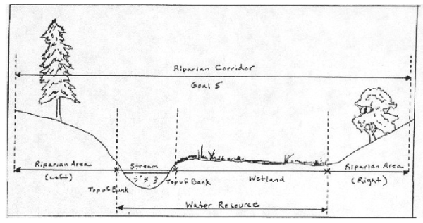
Figure 1: Cross section illustrating terms used in Statewide Planning Goal 5. Source: Urban Riparian Inventory and Assessment Guide. Oregon Division of State Lands 1998. - The permanent alteration of the Significant Natural Resource by grading, by excavation or fill, by the placement of structures or impervious surfaces, or by the removal of native vegetation is prohibited, except for the following uses provided they are designed to minimize intrusion into the significant natural resource, and no other options or locations are feasible:
- Streets, roads, paths, and driveways: Public or private streets, driveways, or paths may be placed within a Significant Natural Resource to access development activities if it is shown to the satisfaction of the reviewing authority that no other practicable method of access exists. If allowed, the applicant shall comply with the following requirements:
- Demonstrate to the reviewing authority that no other practicable access to the buildable area exists or access from an off-site location through the use of easements is not possible.
- Design roads, driveways, and paths to be the minimum width necessary and for the minimum intrusion into the Significant natural Resource while also allowing for safe passage of vehicles and/or pedestrians consistent with the transportation component of the Waldport Comprehensive Plan.
- Use bridges, arched culverts, or box culverts with a natural bottom for crossing of a Significant Natural Resource if the crossing is found unavoidable. The lower lip of any culvert must meet the channel bed at or below grade. The number of channel crossings shall be minimized through use of shared access for abutting lots and access through easements for adjacent lots.
- Consider the need for future extensions of shared access, access easements, or private streets to access potential new building sites at the time of this application in order to avoid subsequent encroachments into the Significant Natural Resource.
- During construction, no stockpiling of fill materials, parking, or storage of equipment shall be allowed within the Significant Natural Resource.
- Erosion control measures, such as silt fences and biofilter bags, shall be used to reduce the likelihood of sediment and untreated stormwater entering the Significant Natural Resource.
- Permanent alteration of the Significant Natural Resource by the placement of public or private streets, driveways, or paths is subject to the mitigation requirements of Section 6.
- Utilities and drainage facilities: Public and private utilities or drainage facilities may be placed within a Significant Natural Resource when it is shown to the satisfaction of the review body that no other practicable alternative location exists. If a utility or drainage facility is allowed within a Significant Natural Resource the following standards shall apply:
- Demonstrate to the reviewing authority that no other practicable access exists or access from an off-site location through the use of easements is not possible.
- The corridor necessary to construct utilities shall be the minimum width practical to minimize intrusion into the Significant Natural Resource. Removal of trees and native vegetation shall be avoided unless absolutely necessary. The existing grade of the land shall be restored after construction. Native vegetation shall be used to restore the vegetative character of the construction corridor.
- No stockpiling of fill materials, parking, or storage of equipment shall be allowed within the Significant Natural Resource.
- Replacement of existing structures with structures in the same location that do not disturb additional surface area.
- Structures or other non-conforming alterations existing fully or partially within the Significant Natural Resource may be expanded provided the expansion occurs outside of the Significant Natural Resource. Substantial improvement of a non-conforming structure in the Significant Natural Resource shall require compliance with the standards of this title.
- Existing lawn within the Significant Natural Resource may be maintained, but not expanded within the limits of the Significant Natural Resource. Development activities shall not justify replacement of native vegetation, especially riparian vegetation, with lawn.
- Existing shoreline stabilization and flood control structures may be maintained. Any expansion of existing structures or development of new structures shall be evaluated by the Planning department and appropriate State or Federal natural resource agency. Such alteration of Significant Natural Resources shall be approved only if less-invasive or non-structural methods, such as bioengineering, will not adequately meet stabilization or flood control needs.
- Streets, roads, paths, and driveways: Public or private streets, driveways, or paths may be placed within a Significant Natural Resource to access development activities if it is shown to the satisfaction of the reviewing authority that no other practicable method of access exists. If allowed, the applicant shall comply with the following requirements:
- Removal of vegetation from the Significant Natural Resource is prohibited, except for:
- Removal of non-native vegetation and replacement with native plant species. The replacement vegetation shall cover, at a minimum, the area from which vegetation was removed, shall maintain or exceed the density of the removed vegetation, and shall maintain or improve the shade provided by the vegetation.
- Removal of vegetation necessary for the development of approved water-related or water-dependent uses or for the continued maintenance of dikes, drainage ditches, or other stormwater or flood control facilities. Vegetation removal shall be kept to the minimum necessary.
- Trees in danger of falling and thereby posing a hazard to life or property may be removed, following consultation and approval from the Community Development Director. If no hazard will be created, the department may require these trees, once felled, to be left in place in the Significant Natural Resource.
- The control or removal of nuisance plants should primarily be by mechanical means (e.g. hand-pulling). If mechanical means fail to adequately control nuisance plant populations, a federally approved herbicide technology for use in or near open water is the only type of herbicide that can be used in a Significant Natural Resource area. Pre-emergent herbicides or auxin herbicides that pose a risk of contaminating water shall not be used. Herbicide applications are preferred to be made early in the morning or during windless periods at least 4 hours before probable rainfall. Any herbicide use must follow the label restrictions, especially the cautions against use in or near open water.
16.70.050 Natural Resource Enhancement
Enhancement of natural resources, such as riparian enhancement, in-channel habitat improvements, non-native plant control, and similar projects which propose to improve or maintain the quality of a Significant Natural Resource is encouraged, however, no enhancement activity requiring the excavation or filling of material in a wetland shall be allowed unless all applicable State and Federal wetland permits have been granted.
16.70.060 Variances
A variance to the provisions of this title is permitted only as a last resort and is only considered necessary to allow reasonable economic use of the subject property. The property must be owned by the applicant and not created after the effective date of this title.
- A variance shall only apply to:
- Lots on which the location of a Significant Natural Resource results in a building area depth for a single-family dwelling of 50 feet or less or a building envelope of 1600 square feet or less.
- Lots where strict adherence to the standards and conditions of Section 16.70.040 would effectively preclude a use of the parcel that could be reasonably expected to occur in the zone, and that the property owner would be precluded a substantial property right enjoyed by the majority of landowners in the vicinity.
- Permanent alteration of the Significant Natural Resource by an action requiring a variance is subject to the procedures and criteria of Chapter 16.92 and the mitigation requirements of Section 16.70.070.
16.70.070 Mitigation Standards
When approved impacts to any identified Significant Natural Resource occurs, mitigation will be required. For impacts to Significant Wetlands or Major Marshes, the standards and criteria of Section 16.70.070(A) shall apply. For impacts to Riparian Corridors or Riparian Vegetation, the standards and criteria of Section 16.70.070(B) shall apply.
- When mitigation for impacts to a Significant Wetland or a Major Marsh is proposed, the mitigation plan shall comply with all Oregon Division of State Lands and U.S. Army Corps of Engineers wetland regulations. The City may approve a development but shall not issue a building permit until all applicable State and Federal wetland permit approvals have been granted and copies of those approvals have been submitted to the City.
- When mitigation for impacts to a non-wetland riparian area is proposed, a mitigation plan prepared by a qualified professional shall be submitted to the review authority. The mitigation plan shall meet the following criteria:
- Mitigation for impacts to a non-wetland riparian area shall require a minimum mitigation area ratio of 1:1;
- The mitigation plan shall document the location of the impact, the existing conditions of the resource prior to the impact, the location of the proposed mitigation area, a detailed planting plan of the proposed mitigation area with species and density, and a narrative describing how the resource will be replaced;
- Mitigation shall occur on-site and as close to the impact area as possible. If this is not feasible, mitigation shall occur within the same drainage basin as the impact.
- All vegetation planted within the mitigation area shall be native to the region. Species to be planted in the mitigation area shall replace those impacted by the development activity;
- Trees shall be planted at a density of not less than 5 per 1000 square feet. Shrubs shall be planted at a density of not less than 10 per 1000 square feet.
16.70.080 Plan Amendment Option
Any owner of property affected by the SNR Overlay Zone within the Goal 5 planning area, as designated in the comprehensive plan, may apply for a quasi-judicial comprehensive plan amendment. This amendment must be based on a specific development proposal. The effect of the amendment would be to remove the SNR Overlay Zone from all or a portion of the property. The applicant shall demonstrate that such an amendment is justified by completing an Environmental, Social, Economic and Energy (ESEE) consequences analysis prepared in accordance with OAR 660-23-040. If the application is approved, then the ESEE analysis shall be incorporated by reference into the Waldport Comprehensive Plan, and the Waldport Significant Natural Resources Map shall be amended to remove the Significant Natural Resource Overlay Zone from the inventory.
The ESEE analysis shall adhere to the following requirements:
- The ESEE analysis must demonstrate to the ultimate satisfaction of the Waldport City Council that the adverse economic consequences of not allowing the conflicting use are sufficient to justify the loss, or partial loss, of the resource. The City should confer with the Department of Land Conservation and Development prior to making their ultimate decision.
- The ESEE analysis must demonstrate why the use cannot be located on buildable land outside of the Significant Natural Resource and that there are no other sites within the City of Waldport that can meet the specific needs of the proposed use.
- The ESEE analysis shall be prepared by a qualified professional experienced in the preparation of Goal 5 ESEE analyses, with review by DLCD.