Westlake Village City Zoning Code
CHAPTER 9
24.- WESTLAKE NORTH SPECIFIC PLAN
9.24.010.- Introduction.
A.
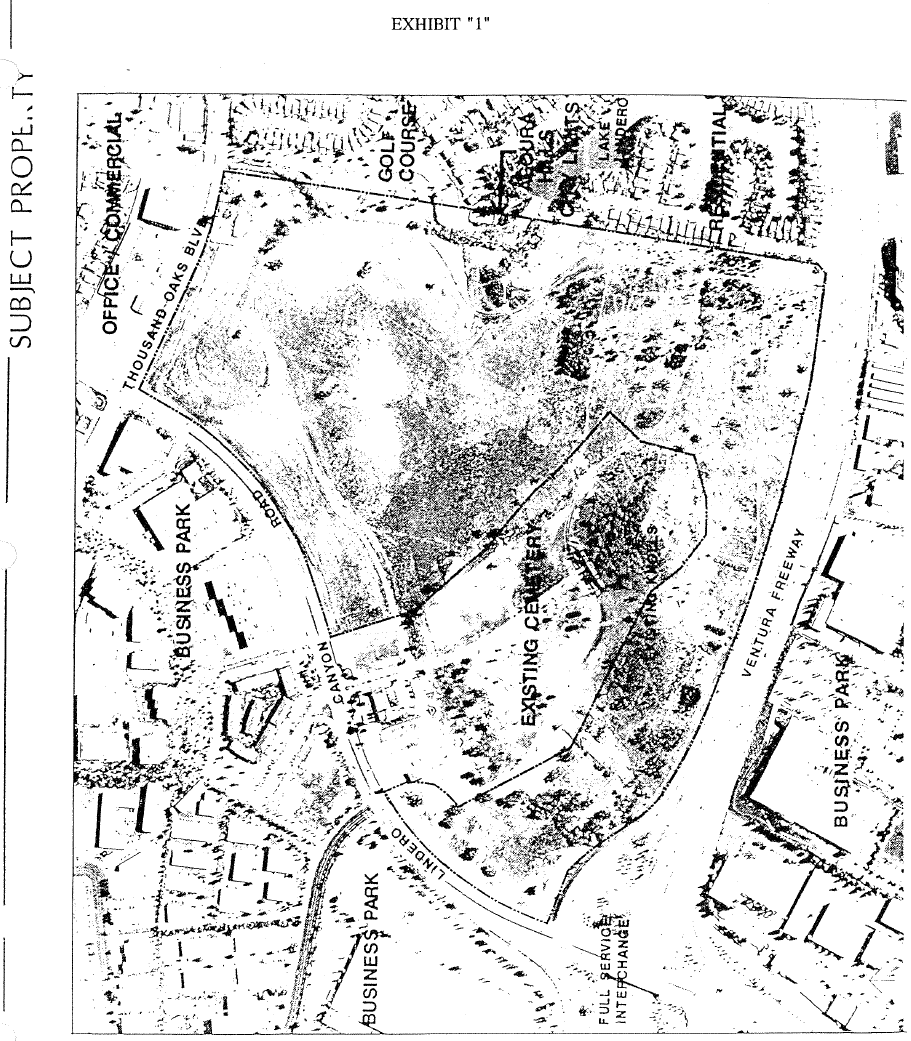
Subject Property. The Westlake North Specific Plan encompasses an area approximately 129 acres in size, bordered by the Ventura Freeway on the south, Lindero Canyon Road on the west, Thousand Oaks Boulevard on the north, and the Westlake Village/Agoura Hills corporate boundary on the east. The U-shaped property surrounds the Valley Oaks Memorial Park on three sides. A 155-foot Southern California Edison Easement and 66Kv power line traverses the entire eastern perimeter of the parcel. The subject property is more specifically depicted by Exhibit 1.
B.
Specific Plan Overview and Objectives. This Specific Plan provides for the coordinated development of a mixed use project including hotel, restaurant, office, business park, commercial, high density residential and recreational open space uses. The Plan sets forth development standards and a design review process necessary to ensure that the long term development of Westlake North occurs in a manner that is compatible with surrounding land uses and consistent with the high quality of design established within the City of Westlake Village.
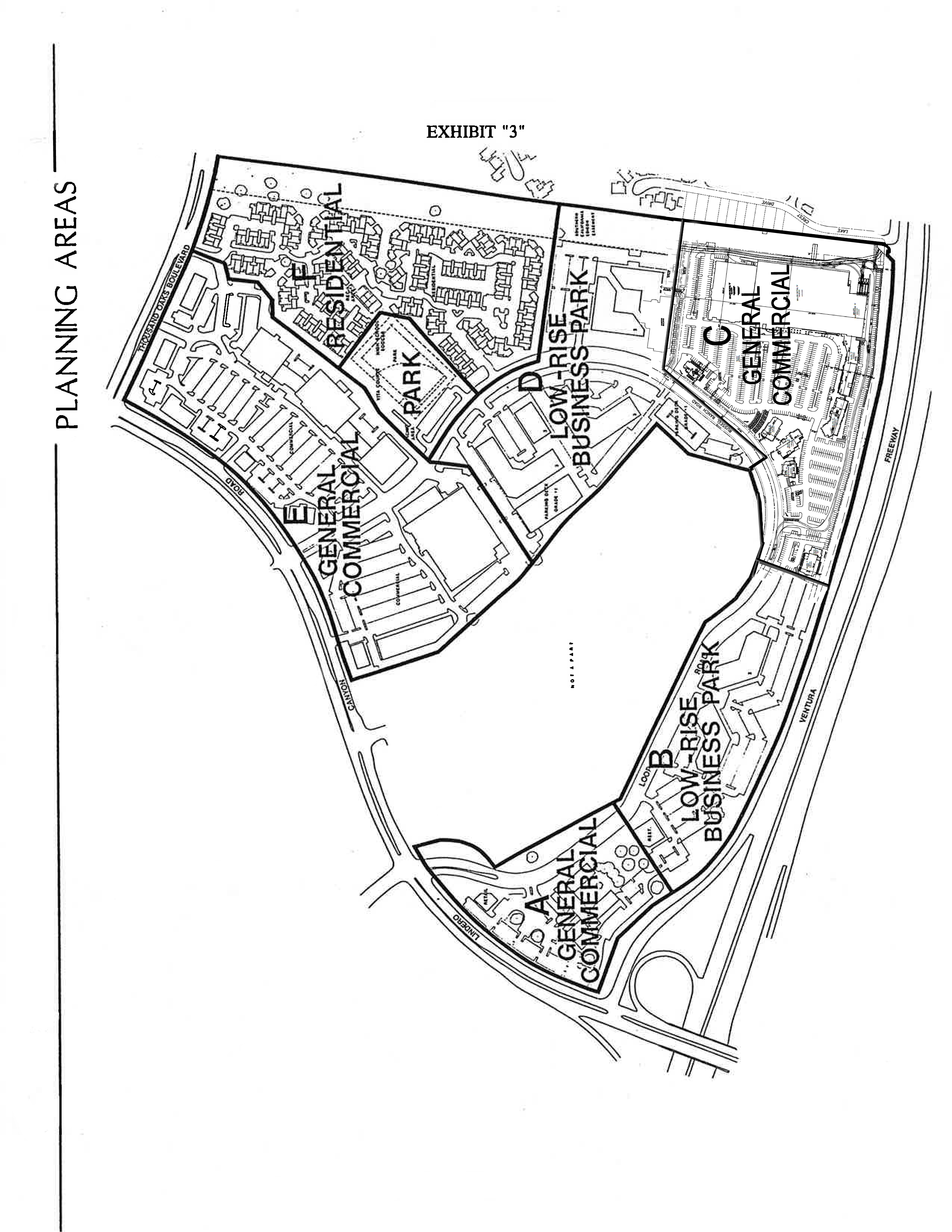
Exhibit 2 depicts a Conceptual Site Plan, illustrating the general distribution, location and orientation of future land uses. All future construction projects shall comply with development standards and criteria set forth herein for each Planning Area, as identified by Exhibit 3.
(Ord. No. 58, Enacted, 08/14/85; Ord. No. 97, Amended, 12/06/89)
9.24.020. - Relation to General Plan.
A.
California Government Code. The Westlake North Specific Plan has been prepared and adopted by ordinance in compliance with the requirements of the California Government Code (Sections 65450 through 65507), and addresses all issues and topics specified therein. As such, the Specific Plan constitutes a comprehensive program for implementing applicable goals and policies of the Westlake Village General Plan.
B.
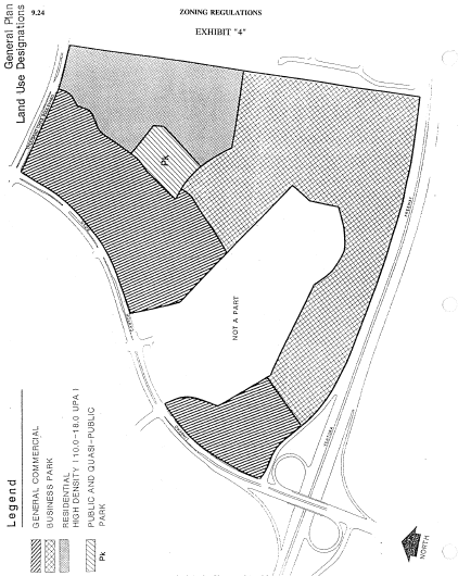
General Plan Consistency. The General Plan of the City of Westlake Village designates the area covered by this Specific Plan for a mixture of General Commercial, Business Park, High Density Residential and Open Space uses as depicted by Exhibit 4. As required by Section 65454 of the California Government Code, the land use entitlements and development standards set forth in this Specific Plan are consistent with applicable goals, policies and programs of the Westlake Village General Plan. As further required by Section 65455, all public works projects, tentative or parcel maps and zoning permits approved subsequent to the adoption of this Specific Plan shall be consistent with the regulations, standards and criteria set forth herein.
C.
City Zoning Ordinance. Unless otherwise provided by specific provisions of this Section, permitted land uses and activities within the area covered by this Specific Plan shall comply with all applicable requirements of Article 9 of the Westlake Village Municipal Code (Planning and Zoning Regulations).
(Ord. No. 58, Enacted, 08/14/85; Ord. No. 97, Amended, 12/06/89)
9.24.025. - Planning Area C.
Conditions and requirements administratively imposed on Planning Area C in the implementation of this Chapter shall apply only to the extent such conditions and requirements are consistent with Development Agreement No. 10-001. This Section shall be of no further force or effect upon the expiration or termination of Development Agreement No. 10-001.
(Ord. No. 219-12, s;; 2, 5-23-2012)
9.24.030. - General Development Regulations.
A.
Summary Chart. General building entitlements and development standards for each Planning Area of the Westlake North Specific Plan are as follows:
* Net acreage excludes Loop Road, residual open space between Loop Road and Cemetery, and SCE easement.
** Minor reallocation of Allowable Bldg. Sq. Footage may be permitted between Planning Areas provided that total Allowable Bldg. Sq. Footage is not increased.
B.
Design and Architecture
1.
Standards and Criteria. Development within the Specific Plan area shall be subject to any and all architectural design standards and criteria imposed by the City, to the extent such standards and criteria do not preclude or conflict with the development entitlements set forth in Section A. above.
2.
Design Review Required. All specific construction projects within the Westlake North Specific Plan Area shall be subject to the site/design review process set forth in Section 9.25 — Planned Development Permit.
C.
Backbone Landscaping
1.
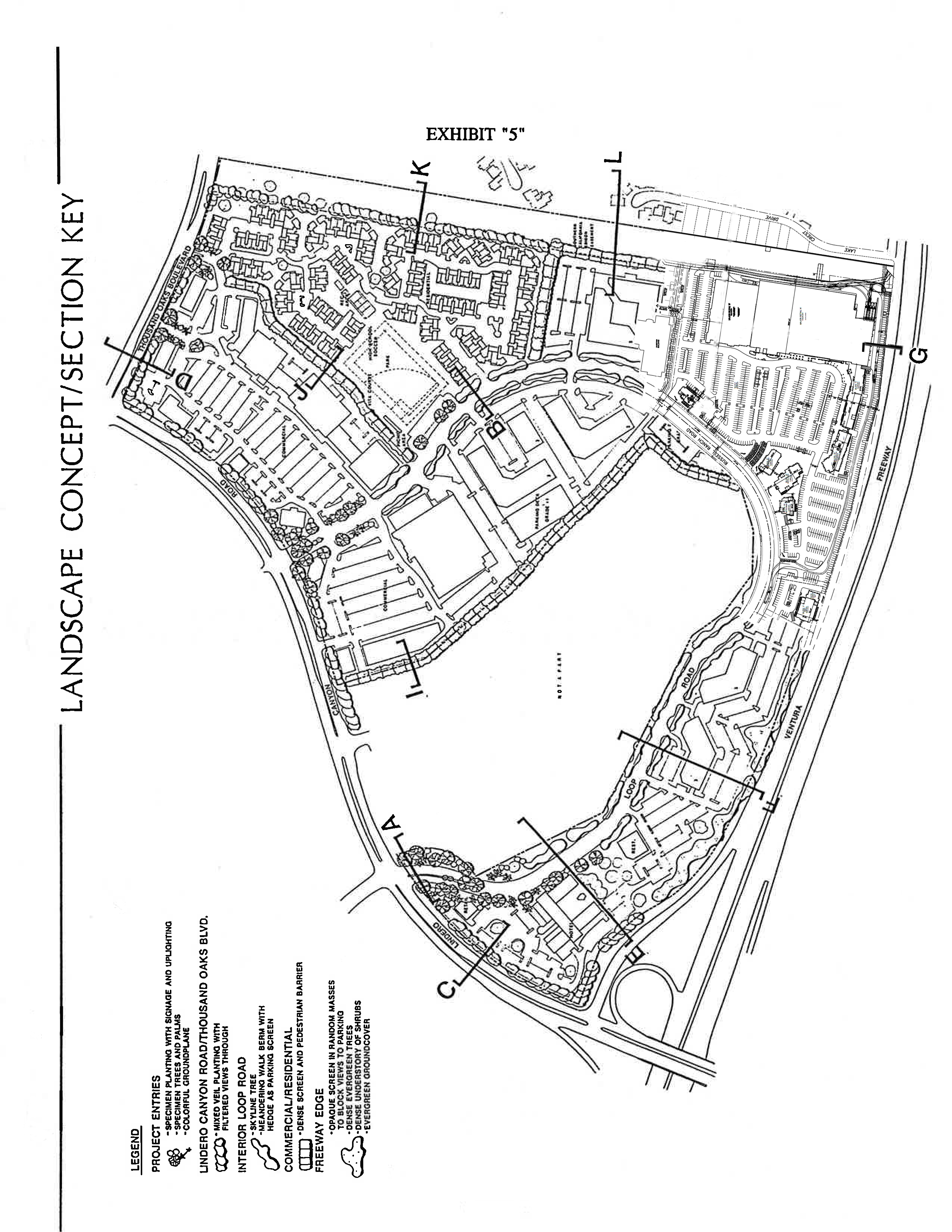
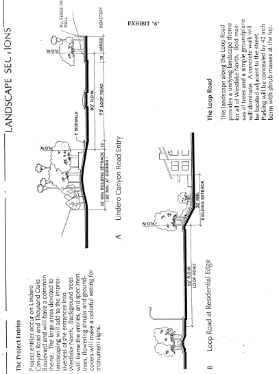
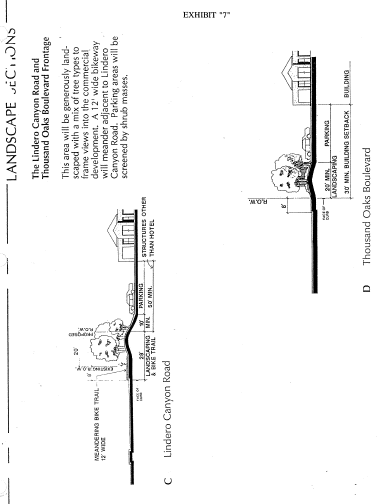
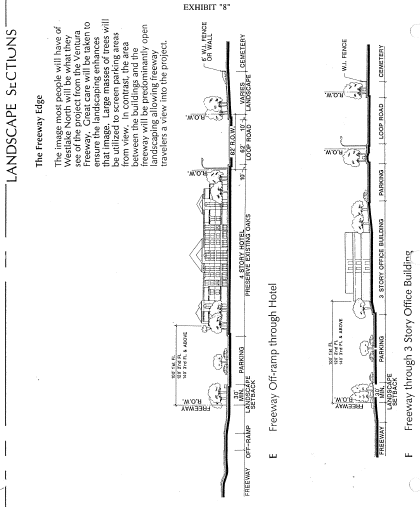
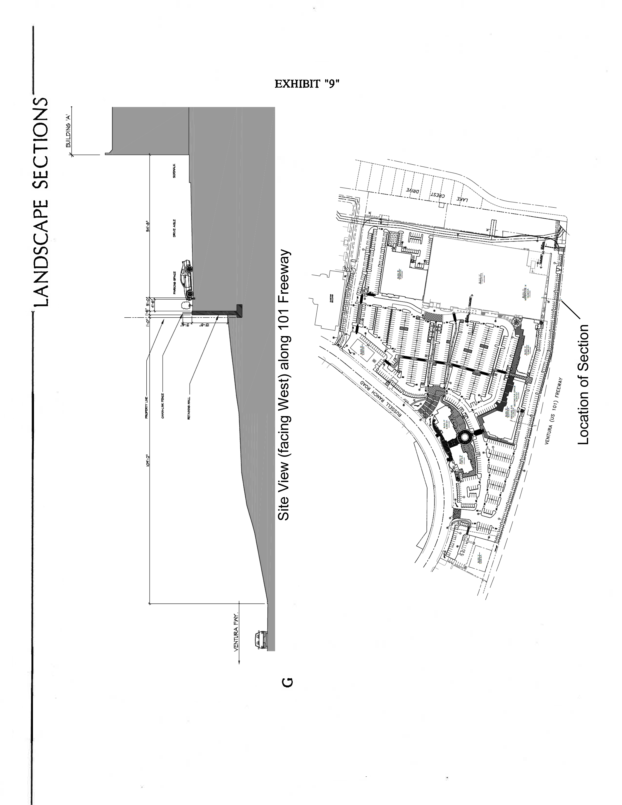
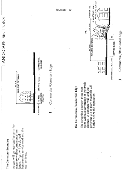
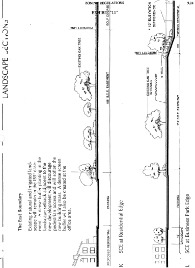
Landscape Concept. The conceptual backbone landscape plan for the Westlake North Specific Plan is divided into seven components, including Project Entryways, the Loop Road, Lindero Canyon Road and Thousand Oaks Boulevard Frontage, the Freeway Frontage, the Cemetery Perimeter, the Residential/ Commercial Interface and the SCE Easement Area. Exhibit 5 indicates the location of conceptual landscape section drawings which follow as Exhibits 6 through 11.
Exhibits 6 through 11 are intended to illustrate required landscaping treatments and objectives at key locations. Prior to the issuance of grading permits within any portion of the Westlake North Specific Plan Area, detailed planting and irrigation plans for all backbone landscape components shall be submitted for City review and approval, and shall reflect the treatments and objectives described herein. Within 90 days of completion of rough grading within each Planning Area of the Specific Plan, backbone landscaping within the Planning Area shall be installed. The project landscape architect shall certify to the satisfaction of the City that said landscaping and irrigation has been installed in compliance with approved plans.
2.
Plant Materials. Appropriate plant materials for each component of the Westlake North backbone landscape plan are listed below. Plant materials may be added or deleted from those listed below subject to review and approval by the City. Minimum tree size shall be fifteen gallon. Specimen trees at project entryways shall be 36-inch box or larger. Minimum shrub size shall be 5 gallon.
3.
Site-specific Landscape Plans Required. As part of the design review process for site-specific construction projects required by Section 9.25 of this Article, detailed landscape and irrigation plans shall be submitted for City review and approval. Prior to the issuance of occupancy permits, the project landscape architect shall certify to the satisfaction of the City that all landscaping and irrigation have been installed in compliance with approved plans.
(Ord. No. 58, Enacted, 08/14/85; Ord. No. 97, Amended, 12/06/89)
(Ord. No. 219-12, § 3, 5-23-2012)
9.24.040. - Planning Area Development Standards.
A.
Planning Area A
1.
Permitted Uses
- one, full service, 250 room hotel and accessory commercial uses
- restaurants (excluding free standing fast food establishments)
- office
- professional, medical and financial services
2.
Maximum Building Coverage (all structures excluding subterranean parking)
- 35% (net area)
3.
Maximum FAR
- 0.50 (net area)
4.
Maximum Building Height
- Hotel: 55 feet (four stories maximum), plus 10 additional feet for sloped roof or approved architectural features
- Other Structures (excluding parking decks): 35 feet (two stories maximum)
5.
Minimum Setbacks:
(* See Section 9.24.100(B)(1): Freeway Frontage - Setback/Height Standard. Hotel setback requirements from Freeway offramp right-of-way may be modified based upon specific site plan review.)
6.
Minimum Building Separation
- 70 feet for first story, plus 10 additional feet for each additional story
7.
Required Parking
- Parking required per Section 9.19 of this Article (Off-Street Parking and Loading Standards). Parking located adjacent to the project loop road to be screened from view by a landscaped berm, at least 42 inches in height
- One-level (Grade + 1 level) parking decks permitted subject to compliance with criteria set forth in Section 9.24.070(A): Parking Decks
- Subterranean parking permitted subject to compliance with criteria set forth in Section 9.24.070(B): Subterranean Parking
8.
Specific Design Concerns. The following design concerns shall be addressed in the processing of specific Planned Development Permits for construction within Planning Area A.
- Oak trees shall be preserved to the greatest extent feasible within open, landscaped areas
- An open space, view corridor shall be maintained through the oak woodland/riparian area separating Planning Areas A and B as depicted on the Illustrative Site Plan
- Tilt-up construction shall be prohibited
- Hotel facilities shall be designed and oriented in such a manner to avoid a massive and overbearing appearance from adjacent public roadways
- Banquet facilities shall be provided within the hotel sufficient to accommodate gatherings of at least 300 people
- Shared parking by adjacent office and hotel uses shall be permitted subject to compliance with the applicable provisions of Section 9.19 of this Article (Off-Street Parking and Loading Standards)
B.
Planning Area B
1.
Permitted Uses
- office and accessory commercial uses
- professional, medical and financial services
- restaurants (excluding free standing fast food establishments)
2.
Maximum Building Coverage (all structures excluding subterranean parking)
- 35% (net area)
3.
Maximum FAR
- 0.40 (net area)
4.
Maximum Building Height
- Office: 47 feet (three stories maximum), plus 10 additional feet for sloped roof or approved architectural features
- Restaurant and other structures (excluding parking decks: 35 feet (two stories)
5.
Minimum Setbacks:
(*) See Section 9.24.100(B)(1): Freeway Frontage - Setback/Height Standard
6.
Minimum Building Separation
- 70 feet for first story, plus 10 additional feet for each additional story
- reduced separation may be approved for "paired" or "clustered" buildings sharing a common entry court, or where such clustering substantially increases visible, landscaped open space areas
7.
Required Parking
- Parking required per Section 9.19 of this Article (Off-Street Parking and Loading Standards). Parking located adjacent to the project loop road to be screened from view by a landscaped berm, at least 42 inches in height. Landscaped setbacks shall not be required between parking areas on abutting lots, where such parking areas have been commonly designed and share mutual access and egress rights
- One-level (Grade + 1 level) parking decks permitted subject to compliance with criteria set forth in Section 9.24.070(A): Parking Decks
- Subterranean parking permitted subject to compliance with criteria set forth in Section 9.24.070(B): Subterranean Parking
8.
Specific Design Concerns. The following design concerns shall be address in the processing of specific Planned Development Permits for construction within Planning Area B.
- Office buildings shall be designed and oriented in a manner that avoids a long, planar appearance from the adjacent freeway corridor
- Entrances to tuck-under and/or subgrade parking shall be screened from view by bermed landscaping to the satisfaction of the City
- Tilt-up construction shall be prohibited
- Shared parking by adjacent office and restaurant uses shall be permitted subject to compliance with the applicable provisions of Section 9.19 of this Article (Off-Street Parking and Loading Standards)
C.
Planning Area C
1.
Permitted Uses
• general retail services
• personal and convenience services
• medical services
• consumer repair services
• dining establishments (excluding free standing fast food establishments, except with the issuance of a Conditional Use Permit)
• professional, business and financial services
• such other permitted uses as set forth in Section 9.08.020 of this Article (CPD Zone)
2.
Conditionally Permitted Uses
• such conditionally permitted uses as set forth in Section 9.08.030 of this Article (CPD Zone)
3.
Maximum Building Coverage
• 0.35 (net area)
4.
Maximum FAR
• 0.35 (net area)
5.
Maximum Building Height
• 41 feet, excluding architectural "tower" elements, which shall not exceed 52 feet.
6.
Minimum Setbacks
7.
Required Parking. A minimum of nine hundred seventy-five (975) parking spaces are required. If compact spaces are provided then a minimum of one thousand five (1,005) parking spaces are required. Compact parking spaces, of a minimum length of sixteen (16) feet and a minimum width of eight (8) feet, may be utilized for no more than thirty (30) percent of the number of spaces provided, subject to the review and approval of the City Council. Valet parking shall be provided for all sit down, table service restaurant uses to the satisfaction of the City, if determined necessary by the Planning Director. Parking located adjacent to Russell Ranch Road or the Ventura Freeway shall be screened from view by landscaping, a landscaped berm, or decorative masonry wall (or combination thereof) at least forty-two (42) inches in height measured from the parking lot elevation. Landscaped areas shall not be required between parking areas on abutting lots, where such parking areas have been commonly designed and share mutual access and egress rights.
8.
Specific Design Concerns. The following design concerns shall be addressed in the processing of specific Planned Development Permits for construction within Planning Area C.
• All new buildings shall reflect authentic, high quality design including the use of appropriate materials, colors, facade and roof treatments, landscape and hardscape improvements, decorative lighting, and pedestrian amenities.
• Delivery access driveways, loading areas, and other commercial service activities at the northerly and easterly perimeters of the subject site shall be effectively screened from adjacent residential areas and office uses by a decorative masonry wall, at least six (6) feet in height as measured from the driveway surface, in combination with trees and other appropriate landscaping.
• A landscape or masonry screen shall be maintained between any parking areas and the Ventura Freeway.
• Subject to approval of the Southern California Edison Company, landscape improvements shall be installed within the SCE Easement Area as necessary to achieve a neat and well maintained appearance.
9.
Anchor Store. For purposes of these development standards, the term "anchor store" means a retail use sixty thousand (60,000) square feet or more in size. In issuing a planned development permit for any anchor store on Planning Area C, the City shall classify the permitted retail use according to the following categories: (i) discount retail; (ii) electronics retail; (iii) furniture retail; (iv) general retail; (v) grocery retail; and (vi) home improvement retail. For illustrative purposes only, the following are examples of each retail use category:
An anchor store authorized by an existing planned development permit shall not be replaced with an anchor store that is a different retail use category unless a new planned development permit for the substitute retail use category is first obtained pursuant to Chapter 9.25 of this Article (Planned Development Permits).
D.
Planning Area D
1.
Permitted Uses
- office and accessory commercial uses
- professional, medical and financial services
- business park, R & D and light industrial uses (excluding outdoor storage) as provided for by Section 9.10.020 of this Article (BP Zone - Permitted Uses)
- wholesale trade
2.
Maximum Building Coverage (all structures excluding subterranean parking)
- 35% (net area)
3.
Maximum FAR
- 0.55 (net area)
4.
Maximum Building Height
- 47 feet (three stories maximum), plus 10 additional feet for sloped roof or approved architectural features
5.
Minimum Setbacks:
6.
Minimum Building Separation
- 70 feet for first story, plus 10 additional feet for each additional story
- Reduced separation may be approved for "paired" or "clustered" buildings sharing a common entry court, or where such clustering substantially increases visible landscaped open space areas
7.
Required Parking
- Parking required per Section 9.19 of this Article (Off-Street Parking and Loading Standards). Parking located adjacent to the project loop road to be screened from view by a landscaped berm, at least 42 inches in height. Landscaped setbacks shall not be required between parking areas on abutting lots where such parking areas have been commonly designed and share mutual access and egress rights
- One-level (Grade + 1 level) parking decks permitted subject to compliance with criteria set forth in Section 9.24.070(A): Parking Decks
- Subterranean parking permitted subject to compliance with criteria set forth in Section 9.24.070(B)
8.
Specific Design Concerns. The following design concerns shall be addressed in the processing of specific Planned Development Permits for construction within Planning Area D.
- Buildings within Planning Area D shall be designed and oriented so as to respect the privacy an serenity of adjacent cemetery uses
- Subject to approval by the Southern California Edison Company, a decorative concrete block wall and appropriate landscaping shall be installed along the easterly boundary of Planning Area D in order to mitigate visual impacts of business park development on adjacent residential properties
- Subject to approval of the Southern California Edison Company, landscaping shall be installed within the SCE Easement Area as necessary to achieve a neat and well maintained appearance
- A landscaped berm and decorative concrete block wall shall be constructed along the interface of Planning Area F and adjacent development lots within Planning Area D, sufficient to provide positive separation and visual screening between residential and business park areas
- Parking lot lighting within the eastern portion of Planning Area D shall be designed and shielded as necessary to avoid adverse impacts on adjacent residential neighborhoods
E.
Planning Area E
1.
Permitted Uses
- general retail services
- personal and convenience services
- medical services
- consumer repair services
- dining establishments
- professional, business and financial services
- such other permitted and conditionally permitted uses as set forth in Section 9.08.020 and 9.08.030 of this Article (CPD Zone)
2.
Maximum Building Coverage
- 35% (net area)
3.
Maximum FAR
- 0.35 (net area)
4.
Maximum Building Height
- 35 feet (two stories maximum)
5.
Minimum Setbacks:
6.
Minimum Building Separation
- 70 feet (free standing buildings only - excluding commercial buildings sharing common walls)
7.
Required Parking
- Parking required per Section 9.19 of this Article (Off-Street Parking and Loading Standards). Parking adjacent to Lindero Canyon Road and/or Thousand Oaks Boulevard to be screened from view by a landscaped berm, at least 42 inches in height. Landscaped setbacks shall not be required between parking areas on abutting lots where such parking areas have been commonly designed and share mutual access and egress rights
8.
Specific Design Concerns. The following design concerns shall be address in the processing of specific Planned Development Permits within Planning Area E.
- The signalized entry to Planning Area E from Thousand Oaks Boulevard shall be designed in a manner that provides separate and distinctive entrances to adjacent commercial and residential areas
- Generous landscaped setback area, in excess of the minimum setbacks set forth above shall be required at the intersection of Thousand Oaks ;hg;Boulevard and Lindero Canyon Road
- Freestanding anchor tenant building(s) located south of the Loop Road shall be designed and landscaped in such a manner to avoid a massive, box-like appearance
- A meandering, two way bikeway, at least 12 feet in width, shall be provided along the east side of Lindero Canyon Road within a 20-foot wide, landscaped easement
- Storefronts shall be adequately separated from parking areas and aisles by landscaped areas and covered pedestrian paseos
- Building architecture shall reflect an Early California Spanish theme
- The interface between commercial and residential areas shall be designed to address and mitigate noise and visual impacts
- Fast food drive through facilities shall be designed and oriented so as to avoid traffic conflict points within off-street parking areas. Such drive through facilities shall include stacking lane capacity sufficient to accommodate seven automobiles, and shall be screened with appropriate landscaping
F.
Planning Area F
1.
Permitted Uses
- townhome, condominium dwelling units
2.
Maximum Building Coverage
- 50% (net area, except that common recreation buildings may be excluded from the building coverage limitation)
3.
Maximum Density
- 14.1 dwelling units per net acre (250 DUs maximum)
4.
Maximum Building Height
- 35 feet (two stories maximum, except that enclosed tuck-under parking may be permitted)
5.
Minimum Setbacks
6.
Minimum Building Separation
- As established by conditions of approval for required Planned Development Permit
7.
Required Parking
- Two enclosed, attached parking spaces for each one or two bedroom dwelling unit
- Two enclosed, attached parking spaces, and one unenclosed parking space for each three bedroom dwelling unit
- Plus, one guest parking space for each dwelling unit
8.
Specific Design Concerns. The following design concerns shall be addressed in the processing of the Planned Development Permit authorizing construction within Planning Area F.
- Adequate on-site circulation shall be provided, including two primary points of access and egress
- Decorative fencing or wall shall be provided at the perimeter of the subject site
- On-site oak trees shall be preserved to the maximum extent feasible
- On-site recreation facilities shall be provided sufficient to accommodate the needs of residents and their guests
- Compatibility between residential uses and adjacent commercial and business park areas shall be achieved through the use of decorative walls, berms, lush landscaping and grade differentials
- Effective drainage and desiltation devices shall be incorporated into the project plan to protect Lake Lindero from adverse impacts both during and after project construction
- Prior to the recordation of a condominium tract map, CC&Rs shall be prepared and submitted for review and approval by the City. Said CC&Rs shall establish a homeowners association responsible for maintenance of common areas and facilities within the residential area, and shall otherwise conform to applicable provisions of Section 9.06.100 of this Article (RPD Design Standards)
(Ord. No. 58, Enacted, 08/14/85; Ord. No. 97, Amended, 12/06/89)
(Ord. No. 219-12, § 4, 5-23-2012; Ord. No. 223-13, § 2, 1-23-2013)
9.24.050. - Infrastructure.
A.
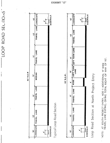
Circulation Plan. The Circulation Plan component of the Westlake North Specific Plan includes a conceptual alignment for the major loop road collector street, as well as typical roadway sections. This collector street shall be a dedicated public roadway, with a minimum 82-foot right-of-way. Typical sections (Exhibit 12) reflect a median divided roadway, with two travel lanes in each direction. The roadway shall be designed and improved in compliance with all City standards for public streets. The improved roadway shall be completed and offered for dedication to the satisfaction of the City upon the completion of rough grading within each Planning Area of the Specific Plan.
The Plan further includes a 12-foot wide bikeway, extending along the western perimeter of the subject property, i.e., Lindero Canyon Road, from the westbound Lindero Canyon freeway offramp to Thousand Oaks Boulevard. The bikeway shall be improved within a publicly dedicated, landscaped easement, 20 feet in width. Said improvements shall meet all applicable City requirements.
B.
Drainage. Prior to the issuance of any and all grading permits within the Westlake North Specific Plan area, interim erosion control plans shall be submitted for City review and approval. Such plans shall include all necessary features and measures, including but not limited to temporary desiltation basins, storm drain protection devices and interim planting programs, designed to minimize adverse impacts on Westlake Lake and Lake Lindero. Approved interim measures shall be installed and maintained by the developer until permanent drainage facilities and siltation protection devices are constructed in compliance with plans reviewed and approved the City and the Los Angeles County Flood Control District. Permanent drainage facilities shall be maintained by the developer until accepted for maintenance by the Los Angeles County Flood Control District.
The project developer(s) shall further agree to remedy any adverse impact on Westlake Lake and Lake Lindero resulting from grading and construction within the Westlake North Specific Plan area. The form and content of such agreement(s) shall be subject to City review and approval.
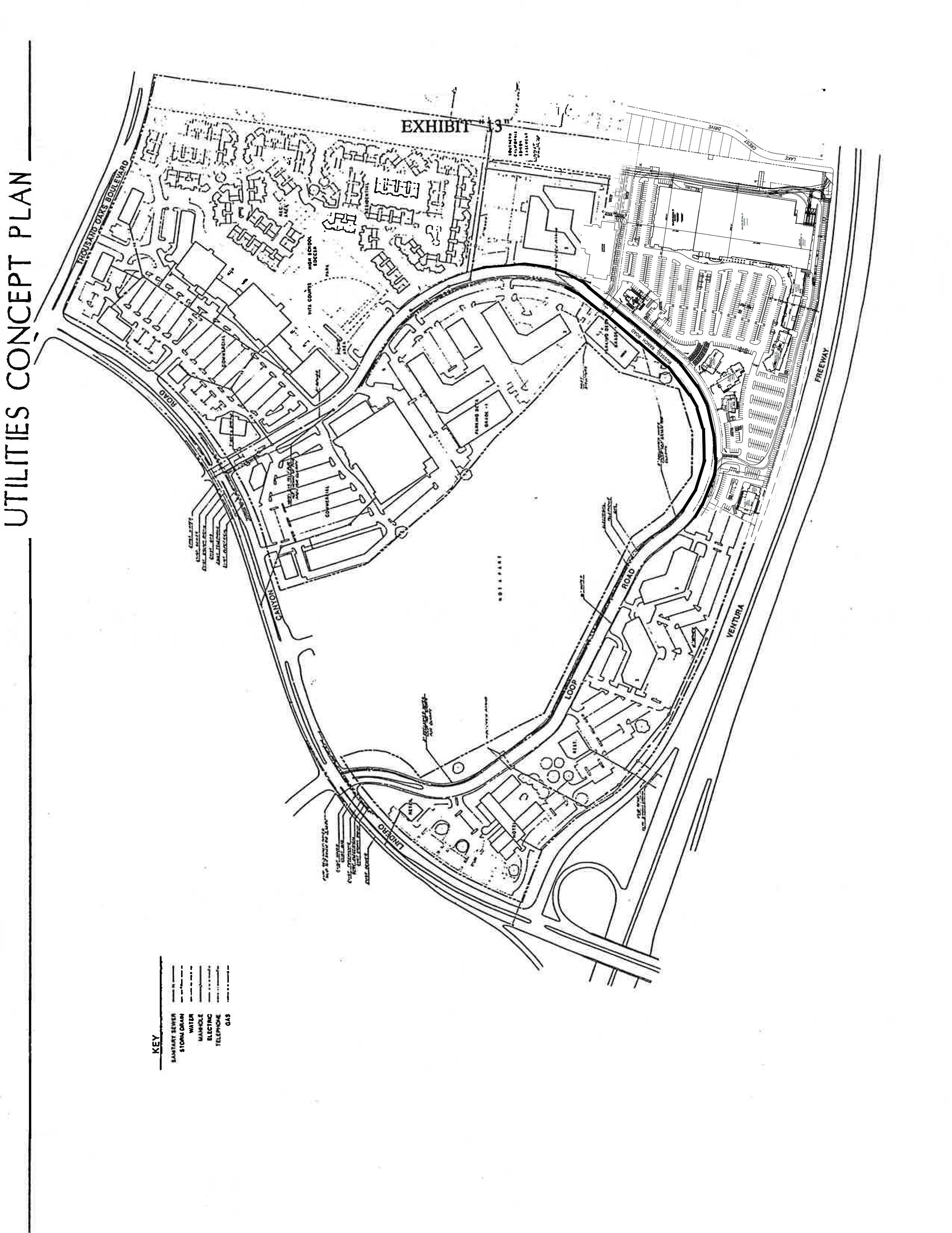
C.
Utilities. The Utilities Concept Plan (Exhibit 13) depicts the backbone system of utilities serving the Westlake North Specific Plan area, and is further elaborated below.
Water: Existing water mains currently serve development surrounding the Specific Plan Area, including a 16-inch main within the Lindero Canyon Road right-of-way and a 14-inch main within the Thousand Oaks Boulevard right-of-way. The ultimate size and location of lines serving the Specific Plan area may vary slightly from that indicated on the Utilities Concept Plan as precise water system requirements are determined by engineering design studies. Final water distribution system design shall be subject to subject to review and approval by the City and the Las Virgenes Municipal Water District.
Reclaimed water shall be used to irrigate landscaped areas. The use of reclaimed water shall comply with all applicable governmental agency requirements.
Wastewater: The existing wastewater collection system shall be extended and expanded to serve all portions of the Specific Plan Area. The precise size and location of collector lines will be based upon the specific needs of each planning area. Final plans for the wastewater collection system shall be subject to review and approval by the City and the Las Virgenes Municipal Water District.
Electricity: Westlake North is within the service jurisdiction of the Southern California Edison Company, and will be served by the existing, underground electrical system located within the Lindero Canyon Road right-of-way. The existing system will be extended into the Loop Street and other easement areas as required to conform to final development plans within the Specific Plan area.
Prior to the issuance of occupancy permits within any portion of the Specific Plan area, the existing above ground electrical lines located along the east side of Lindero Canyon Road shall be placed underground, and all related utility poles shall be removed.
Natural Gas: The Specific Plan area is within the service jurisdiction of the Southern California Gas Company. Natural gas service will extended from existing distribution lines within the rights-of-way of Lindero Canyon Road and Thousand Oaks Boulevard via the Loop Road and other easement areas in conformance with final project development plans.
Telephone: The Pacific Bell Telephone Company will provide service to the Specific Plan area via the existing underground system located in the west parkway of Lindero Canyon Road and the south parkway of Thousand Oaks Boulevard. This underground system will be extended in the Loop Road and other easement areas in conformance with final project development plans.
Television: An existing branch of the Ventura County Cablevision distribution system extends along Thousand Oaks Boulevard adjacent to the Specific Plan area. The system will be extended within streets and easement areas as necessary to serve the subject property in accordance with the requirements of the Franchise Agreement.
(Ord. No. 58, Enacted, 08/14/85; Ord. No. 97, Amended, 12/06/89)
9.24.060. - Signage.
A.
Except as otherwise stated in this section, all signage within the Specific Plan Area shall be regulated by the provisions of Section 9.18 of this Article (Signs).
B.
Specific signage programs shall be submitted for each Planning Area, and shall be subject to City review and approval. Signage plans for specific development projects shall conform to City approved Sign Programs.
C.
A single off-site directional sign is permitted for the benefit of the retail project at Planning Area C. This sign shall be placed at the northeast corner of Lindero Canyon Road and Russell Ranch Road (Loop Road) on private property within Planning Area A. Acquisition of the consent to the placement this sign from the property owner of Planning Area A is the responsibility of the developer of Planning Area C. This provision does not obligate the owner of Planning Area A to provide consent to the placement.
(Ord. No. 58, Enacted, 08/14/85; Ord. No. 97, Amended, 12/06/89)
(Ord. No. 219-12, § 5, 5-23-2012)
9.24.070. - Structured Parking.
A.
Parking Decks. Where permitted, parking decks shall conform to the following design requirements.
1.
The lowest level of a permitted parking deck shall be recessed one half level below grade, or screened with a landscaped berm (including trees) one half level in height.
2.
Visible decked parking areas shall be landscaped in accordance with City landscape requirements for off-street parking.
3.
Parking decks shall be designed with perimeter planters installed on the top deck to allow cascading landscaping to screen exposed side wall facades.
4.
Parking decks shall be of a material and color compatible with adjacent structures. Color shall diminish the visual mass of the structure and shall be either integral or applied to the surface (top) level of all decks in order to reduce glare and minimize visual obtrusion.
5.
Parking decks shall be designed to screen automobile grills from view.
B.
Subterranean Parking. Where permitted, subterranean parking shall conform to the following design requirements.
1.
Subterranean parking structures shall maintain a minimum vertical clearance of 9 feet, 2 inches, and shall be fully equipped with a fire suppression sprinkler system.
2.
Access/egress ramps shall not exceed a maximum slope of 12%, with top and bottom transitional ramps not exceeding 7 ½% slope.
3.
Security surveillance and emergency telephone service shall be installed to the satisfaction of the City.
4.
Elevator waiting areas shall be design in such a manner to maximize public safety and security.
5.
Interior lighting shall be maintained at minimum level of 3 foot candle, evenly distributed throughout the intended area of illumination.
6.
Mechanical ventilation shall be installed in compliance with all building code requirements.
(Ord. No. 58, Enacted, 08/14/85; Ord. No. 97, Amended, 12/06/89)
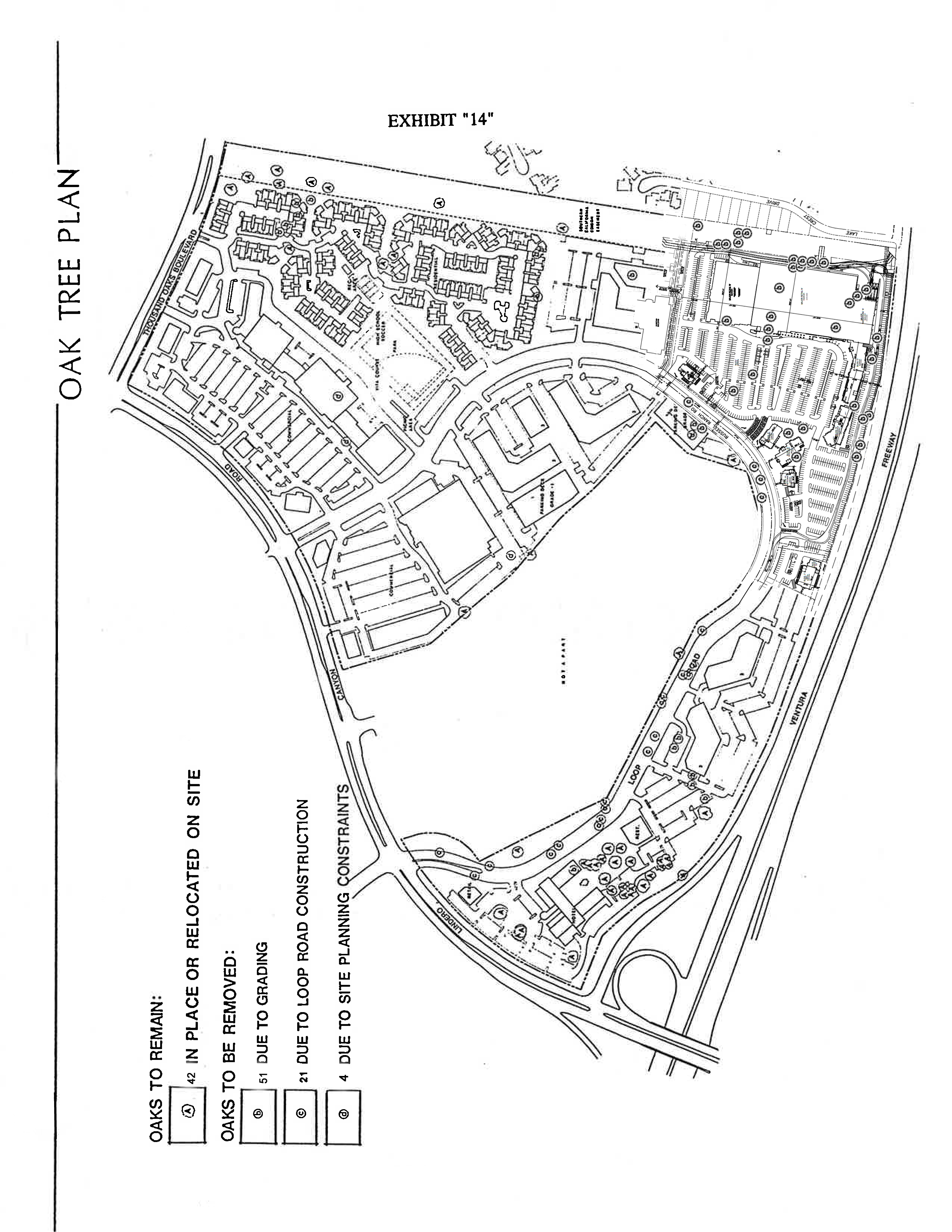
9.24.080. - Oak Trees.
A.
Oak Tree Protection Program. The purpose of the Oak Tree Protection Program is to ensure that site alterations within the Westlake North Specific Plan Area do not adversely affect oak trees intended to be preserved. Prior to the issuance of grading and/or site specific development permits, an Oak Tree Protection Program will be required. All necessary mitigation will take place in accordance with Section 9.21 - Oak Tree Preservation Standards. The required program shall be prepared by a qualified arborist and shall contain the following provisions.
1.
Grading, trenching and construction shall be prohibited within the dripline, or within ten feet of the trunk of any oak tree, whichever is greater.
2.
No landscaping or irrigation shall be installed within ten feet of any oak tree trunk.
3.
Drainage shall be directed away from the trunks of oak trees to ensure that water will not stand at the root crown.
4.
Structures in the vicinity of oak trees shall be designed and oriented to avoid the need for excessive pruning.
5.
Oak trees within a construction area shall be protected from damage by the installation of temporary barriers or fencing at the dripline.
6.
Equipment, building materials, debris and/or excess soil shall not be stored within the dripline of any oak tree.
7.
Trenches for utilities or irrigation shall be routed outside the dripline wherever possible. Trenches necessary within the dripline shall be hand excavated.
8.
Any roots greater than one inch in diameter that are damaged during construction shall be cut back to healthy wood and appropriately treated.
9.
All areas where roots are exposed as a result of trenching or grading shall be watered and covered immediately with mulch or appropriate protection.
10.
No oak tree shall be pruned substantially to alter its size or formation, except as necessary to mitigate potential safety hazards.
11.
Oaks shall be maintained free of dead or diseased wood.
12.
Supplemental irrigation shall be required as necessary to provide adequate water to oak trees in areas impacted by development. Said water shall be applied no closer that ten feet from the trunk.
13.
Insect and disease control measures shall be performed as necessary by a qualified arborist or plant pathologist.
14.
All grading and construction activity adjacent to a protected tree shall be supervised by a qualified, on-site arborist.
B.
Oak Tree Plan. The Westlake North Oak Tree Plan (Exhibit 14) identifies those trees to be retained and protected, as well as those authorized for removal.
(Ord. No. 58, Enacted, 08/14/85; Ord. No. 97, Amended, 12/06/89)
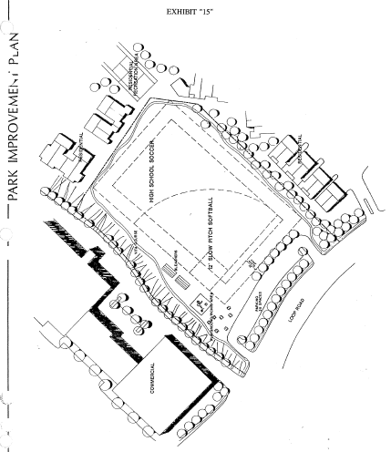
9.24.090. - Park/Playing Fields.
Prior to the issuance of occupancy permits for any dwelling unit within Planning Area F, a 4.0 acre (net) park shall be improved and dedicated to the City. Improvements shall be constructed in compliance with a Park Improvement and Landscaping Plan, submitted to and approved by the City. Minimum improvements shall include:
- turf playing field area, sufficient in size to accommodate overlapping softball and senior high school level soccer fields;
- softball diamond backstop and fencing as necessary to protect spectator areas;
- landscaped picnic areas, including appurtenant tables, benches and trash receptacles;
- vita course and associated exercise stations;
- landscaped off-street parking areas sufficient to accommodate anticipated parking demand; and,
- perimeter fencing and night security lighting as required by the City.
Final park improvement plans shall reflect the general development concept depicted by Exhibit 15.
(Ord. No. 58, Enacted, 08/14/85; Ord. No. 97, Amended, 12/06/89)
9.24.100. - Special Areas.
A.
SCE Easement Area. Subject to approval by the Southern California Edison Company, the Easement Area shall be landscaped as necessary to achieve a neat and well maintained appearance. Decorative security fencing or landscaped barriers shall be installed as necessary to deter trespass by unauthorized individuals and vehicles. New development adjacent to the Easement Area shall be arranged and oriented in a manner that facilitates normal police and/or security service patrol and surveillance.
B.
Freeway Frontage
1.
Setback/Height Standard
- Minimum parking setback: 30 feet (Parking areas adjacent to freeway shall be screened by a landscaped berm, at least 42 inches in height. Entrances to tuck-under parking and subgrade parking decks shall be suitably screened with earthen berms and landscaping.)
- Minimum building setback (including parking decks):
first floor .....100 feet
second floor .....120 feet
third floor & above .....140 feet
2.
Building Orientation. Building facades shall be undulated to avoid long, planar surfaces. Primary building elevations shall be oriented at an angle (not parallel) to the freeway.
C.
Cemetery Perimeter. A decorative masonry wall/wrought iron fence and landscape buffer shall be installed along the entire interface of the Westlake North Specific Plan Area and adjacent cemetery. Details of the wall, fencing and landscape buffer shall be shown on the required backbone landscape plan, and shall be subject to review and approval by the City. In conjunction with rough grading and construction of the loop road servicing the Specific Plan area, required walls and landscaped buffers shall be installed along the effected cemetery perimeter in compliance with approved plan, and shall thereafter be maintained by the property owner.
(Ord. No. 58, Enacted, 08/14/85; Ord. No. 97, Amended, 12/06/89)
9.24.110. - Modification of Standards.
Development standards set forth in this Section governing construction projects within each Planning Area of the Westlake North Specific Plan Area may be modified upon request by a project applicant if it is determined by the City Council of the City of Westlake Village, after a duly noticed public hearing, that:
1.
Imposition of one or more of the applicable development standards set forth herein would prevent or substantially frustrate achievement of development entitlements otherwise authorized by this Specific Plan;
2.
Modified standards, imposed as conditions of approval of a Planned Development Permit, will achieve a high quality of project design consistent with the intent of this Specific Plan;
3.
Approval of the requested Modification will not be contrary to, or in conflict with the general purposes and intent of this Specific Plan, nor with goals, policies and programs of the Westlake Village General Plan; and,
4.
Approval of the requested Modification will not be detrimental to the public interest, safety, health or general welfare, and will not be detrimental or injurious to property or improvements located adjacent to, or within the same vicinity as the property for which said Modification is granted.
(Ord. No. 58, Enacted, 08/14/85; Ord. No. 97, Amended, 12/06/89)
9.24.120. - Conditions, Covenants & Restrictions (CC&R's) Required.
A.
Master CC&R's. Prior to the recordation of a tract map within the Specific Plan area, master CC&Rs applicable to all privately held parcels within the Specific Plan area shall be prepared and submitted for City review and approval. The master CC&Rs shall include the following provisions in addition to other applicable standards and guidelines set forth elsewhere herein.
1.
A property owners association shall be formed and shall be responsible for maintenance of common landscaped areas and overall enforcement of master CC&R provisions. The association or individual property owners within the Specific Plan area shall not, without the express written approval of the City, amend the approved Declaration of Conditions, Covenants and Restrictions, as related to maintenance requirements, assessments and management of the association.
2.
The City and the Carlton Browne Company and its successors, shall have the right, but not the duty, to enter upon private property for the purpose of performing maintenance and repairs in the event the association fails to do so or correcting or abating any nuisance or violation of State Law or the Westlake Village Municipal Code.
3.
A procedure shall be established for the collection of costs incurred by the City in performing any of the acts authorized by the master CC&Rs.
4.
The City shall have the right, but not the duty, to enforce the provisions contained in the master CC&Rs as a third-party beneficiary to them, or in connection with the maintenance, repair or utilization of any easement or other property rights held by the City, either upon, appurtenant to, or nearby the Specific Plan area.
5.
The City shall be entitled to an award of reasonable legal expenses in any action to enforce the provisions of the master CC&Rs.
6.
The master CC&Rs shall set forth all other provisions that are necessary and reasonable for ensuring compliance with this Specific Plan and other applicable provisions of the Westlake Village Municipal Code.
B.
Site-Specific CC&Rs. Site-specific CC&Rs may be required as a condition of approval for each Planned Development Permit authorizing development within the Specific Plan area. If required, said site-specific CC&Rs shall be prepared and submitted for City review and approval prior to the issuance of building permits.
(Ord. No. 58, Enacted, 08/14/85; Ord. No. 97, Amended, 12/06/89)
9.24.130. - Mitigation Reporting and Monitoring Program.
A.
Purpose. This Mitigation Reporting and Monitoring program is intended to provide reasonable assurance that the Westlake North Specific Plan project complies with the adopted mitigation measures and project revisions during implementation of the project.
B.
Effective Period. The program shall be in force and effect at all times during implementation of the development projects contemplated within the Westlake North Specific Plan. The program shall not expire until final occupancy clearance for the last project within Westlake North has been granted and the last off-site mitigation measure identified in the Final EIR has been implemented.
C.
Applicant's Reporting Duties. The applicant shall prepare and submit to the City written status reports demonstrating good faith compliance with those conditions of project approval which have been identified as mitigation measures. These reports shall be submitted to the Planning Director semi-annually. The Planning Director shall specify more frequent reporting intervals when warranted based upon any of the following situations:
1.
The project is in an active development phase, or
2.
Seasonal environmental conditions require more frequent reporting, or
3.
Specific project activities, such as grading or Oak Tree removal and relocation, require more frequent reporting, or
4.
The Planning Director has reason to believe there is threatened or actual non-compliance with mitigation measures, or
5.
The City Council, in the exercise of its judgment, determines that more frequent reporting is necessary or desirable.
D.
City's Monitoring Duties. The Planning Director or his or her designee shall independently review and take reasonable steps to verify the applicant's efforts to comply with identified mitigation measures. Such actions shall include, at a minimum, arranging and conducting site inspections by the public officials with jurisdiction over the mitigation measure and/or impact, preparation of written reports or memoranda as needed to document mitigation measure compliance, and preparing periodic compliance reports to the City Council.
E.
Enforcement. The applicant shall comply with all adopted mitigation measures. In the event the City determines, based upon substantial evidence, that there has been non-compliance with any adopted mitigation measure, it shall notify the applicant of the situation and direct that immediate steps be taken to cure the non-compliance. In the event the applicant fails to comply with such notice, the City shall take all available legal steps to compel the applicant to comply with the adopted mitigation measures, including, but not limited to, actions to enforce building code provisions, actions to revoke or suspend permits, and referral of the matter to the Attorney General and District Attorney, if appropriate.
(Ord. No. 58, Enacted, 08/14/85; Ord. No. 97, Amended, 12/06/89)

(Ord. No. 219-12, 5-23-2012)
(Ord. No. 219-12, 5-23-2012)
(Ord. No. 219-12, 5-23-2012)
(Ord. No. 219-12, 5-23-2012)
(Ord. No. 219-12, 5-23-2012)
(Ord. No. 219-12, 5-23-2012)