
Windermere City Zoning Code
ARTICLE III
HISTORIC DISTRICTS AND INFILL DEVELOPMENT
Sec. 3.00.00.- Purpose.
The purpose of this article is to impose special development restrictions on identified areas. The location is established by the town based on the need for special protective measures in that area. The underlying uses in the area, as determined in article II of this Land Development Code, remain undisturbed. This merely imposed additional or different development standards than those that would otherwise apply.
(Ord. No. 91-6, § 3(3.00.00), 2-11-1992)
Sec. 3.01.00. - Historic districts and landmarks.
3.01.01
Definitions. The following words, terms and phrases, when used in this section, shall have the meanings ascribed to them in this subsection, except where the context clearly indicates a different meaning:
Building means a structure created to shelter any form of human activity. This may refer to a house, barn, garage, church, hotel or similar structure. The term "building" may refer to a historically or architecturally related complex, such as a courthouse and jail, or a house and barn. Parking lots and garages are hereby deemed to be buildings.
Cultural resource means a site, object, structure, building or district listed on the town's survey of cultural resources or in the historic preservation portion of the town comprehensive plan or on the local register of historic and archaeological places.
Demolition means the tearing down or razing of 25 percent or more of a structure's external walls.
District means a geographically definable area, possessing a significant concentration, linkage or continuity of sites, buildings, structures, objects or areas, which are united historically, archaeologically aesthetically by plan or physical development. A district may be comprised of individual resources which are separated geographically but are linked by association or history.
Landmark means any site (including significant trees or other plant life located thereon), building or structure of particular historic or aesthetic significance to the town, the state or the nation. Landmarks include sites, building or structures where cultural, political, spiritual, economic, social or artistic history of the community, state or nation is reflected or exemplified or which are identified with historic personages or which important events in local, state or national history, or which embody the distinguishing characteristics of an architectural specimen, inherently valuable for a representation of a period, style or method of construction, or a notable work of construction, or a notable work by a master designer or architect.
Ordinary maintenance means work which does not require a construction permit and that is done to repair damage or to prevent deterioration or decay of a building or structure, or part thereof as nearly as practicable to its condition prior to the damage, deterioration or decay.
Original appearance means that appearance (except for color) which, to the satisfaction of the town manager, closely resembles the appearance of either:
(1)
The feature on the building as it was originally built or was likely to have been built; or
(2)
The feature on the building as it presently exists so long as the present appearance is appropriate, in the opinion of the manager, to the style and materials of the building.
Site means the location of a significant event, activity, building, structure or archeological resource where the significance of the location and any archeological remains outweighs the significance of any existing structures.
3.01.02
Local register of historic places.
(1)
Created. A local register of historic places is hereby created as a means of identifying and classifying various sites, buildings, structures, objects, and districts as historic, archeological and/or architecturally significant. The local register will be kept by the town manager.
(2)
Initiation of placement on the local register. Placement of sites, buildings, structures, objects or districts on the local register may be initiated by the town council or the historic preservation board. In addition, placement may be initiated by the owner of the site, building, structure, object or area; or, in the case of a district, by the owner of a site, building, structure, object or area within the proposed district.
(3)
Placement on the local register. The following procedure shall be followed for placement of sites, buildings, structures, objects, areas and districts on the local register:
a.
A nomination form, available from the town clerk, shall be completed by the applicant and returned to the town manager.
b.
Upon receipt of a completed nomination form, including necessary documentation, the town manager shall place the nomination on the agenda of the next regularly scheduled meeting of the historic preservation board. If the next regularly scheduled meeting of the board is too close at hand to allow for the required notice to be given, the nomination shall be placed on the agenda of the succeeding regularly scheduled meeting.
c.
Adequate notice of the historic preservation board's consideration of the nomination shall be provided to the public at large, and to the owners of the nominated property, at least 15 days in advance of the meeting at which the nomination will be considered by the board.
d.
The board shall, within 90 days from the date of the meeting at which the nomination is first on the board's agenda, review the nomination and write a recommendation thereon. The recommendation shall include specific findings and conclusions as to why the nomination does or does not meet the appropriate criteria for listing on the local register. The recommendation shall also include any owner's objection to the listing. If the nomination is of a district, the recommendation shall also clearly specify, through the use of maps, lists or other means, those buildings, objects or structures which are classified as contributing to the historical significance of the district. If the 90-day period runs and the board has not prepared and sent a recommendation, and the period has not been extended by mutual consent of the applicant and the board, the nomination may be submitted by the applicant directly to the town council.
e.
The nomination form and the board's recommendation shall be sent to the town council. The nomination shall then be handled as any other rezoning/amendment to land use element.
(4)
Criteria for listing on the local register.
a.
A site, building or district must meet the following criteria before it may be listed on the local register:
1.
The site, building or district possesses integrity of location, design setting, materials, workmanship, archeological significance, feeling and association; and
2.
The site, building or district is associated with events that are significant to local, state or national history; or the district site, building, structure or object embodies the distinctive characteristics of a type, period or method of construction, or represents the work of a master, or possesses high artistic values, or represents a significant and distinguishable entity whose components may lack individual distinction.
b.
A site or building located in a local register of historic places district shall be designated as contributing to that district if it meets the following criteria:
1.
The property is one which, by its location, design, archeological significance, setting, materials, workmanship, feeling and association adds to the district's sense of time and place and historical development.
2.
A property should not be considered contributing if the property's integrity of location, design, setting materials, workmanship, feeling and association have been so altered that the overall integrity of the property has been irretrievably lost.
3.
Structures that have been built within the past 50 years shall not be considered to contribute to the significance of a district, unless a strong justification concerning their historical or architectural merit is given or the historical attributes of the district are considered to be less than 50 years old.
(5)
Effect of listing on local register.
a.
The town may issue an official certificate of historic significance to the owner of properties listed individually on the local register or judged as contributing to the character of a district listed on the local register. The town manager is authorized to issue and place official signs denoting the geographic boundaries of each district listed on the local register.
b.
Structures and buildings listed individually on the local register or judged as contributing to the character of a district listed on the local register shall be deemed historic and entitled to modified enforcement of the Florida Building Code.
c.
No demolition, alteration, relocation or construction activities may take place except as provided in this subsection 3.01.03 of this section.
3.01.03
Certificates of appropriateness.
(1)
When required.
a.
A certificate of appropriateness must be obtained before making certain alterations, described in subsections 3.01.03(1)b and c of this section as regulated work items, to contributing structures and structures listed individually on the local register.
b.
For each of the regulated work items listed in subsection 3.01.03(1)c of this section, the following applies:
1.
Ordinary maintenance. If the work constitutes "ordinary maintenance," as that term is defined in this Land Development Code, the work may be done without a certificate of appropriateness.
2.
Staff approval. If the work is not ordinary maintenance, but will result in the "original appearance," as that term is defined in this Land Development Code, the certificate of appropriateness may be issued by the town manager.
3.
Board approval. If the work is not ordinary maintenance and will not result in the original appearance, a certificate of appropriateness must be obtained from the historic preservation board before the work may be done.
c.
The following are regulated work items:
1.
Installation or removal of metal awnings or metal canopies.
2.
Installation of all decks above the first-floor level and/or on the front of the structure.
3.
Installation of an exterior door or door frame, or the infill of an existing exterior door opening.
4.
Installation or removal of any exterior wall, including the enclosure of any porch or other outdoor area with any material other than insect screening.
5.
The installation or relocation of wood, chainlink, masonry (garden walls) or wrought iron fencing, or the removal of masonry (garden walls) or wrought iron fencing.
6.
The installation of removal of all fire escapes, exterior stairs or ramps for the handicapped.
7.
Painting unpainted masonry, including stone, brick, terra-cotta and concrete.
8.
Installation or removal of railings or other wood, wrought iron or masonry detailing.
9.
Abrasive cleaning of exterior walls.
10.
Installation of new roofing materials, or removal of existing roofing materials.
11.
Installation or removal of security grilles, except that in no case shall permission to install such grilles be completely denied.
12.
Installation of new exterior siding materials, or removal of existing exterior siding materials.
13.
Installation or removal of exterior skylights.
14.
Installation of exterior screen windows or exterior screen doors.
15.
Installation of an exterior window or window frame or the infill of an existing exterior window opening.
16.
Any change in an archeological site.
d.
A certificate of appropriateness must be obtained from the historic preservation board to erect a new building or parking lot within a district listed on the local register.
e.
A certificate of appropriateness must be obtained from the historic preservation board to demolish a building, structure or object listed individually on the local register, or designated as contributing to a district listed on the local register.
f.
A certificate of appropriateness must be obtained from the historic preservation board to relocate a building, structure or object listed individually on the local register, or designated as contributing to a district listed on the local register.
(2)
Criteria for issuing.
a.
The decision on all certificates of appropriateness, except those for demolition, shall be guided by the Secretary of the Interior's Standards For Rehabilitation and Guidelines for Rehabilitating Historic Buildings and the following visual compatibility standards:
1.
Height. Height shall be visually compatible with adjacent buildings.
2.
Proportion of building, structure or object's front facade. The width of the building, structure or object to the height of the front elevation shall be visually compatible to buildings and places to which it is visually related.
3.
Proportion of openings within the facility. The relationship of the width of the windows in a building, structure or object shall be visually compatible with buildings and places to which the building, structure or object is visually related.
4.
Rhythm of solids to voids in front facades. The relationship of solids to voids in the front facade of a building, structure or object shall be visually compatible with building and places to which it is visually related.
5.
Rhythm of buildings, structures or objects on streets. The relationship to the buildings, structures or objects to open space between it and adjoining buildings, and places shall be visually compatible to the buildings and places to which it is visually related.
6.
Rhythm of entrance and/or porch projection. The relationship of entrances and projections to sidewalks of a building, structure or object shall be visually compatible to the buildings and places to which it is visually related.
7.
Relationship of materials, texture and color. The relationship of materials, texture and color of the facade of a building, structure or object shall be visually compatible with the predominant materials used in the building to which it is visually related.
8.
Roof shapes. The roof shape of the building, structure or object shall be visually compatible with the building to which it is visually related.
9.
Walls of continuity. Appurtenances of a building, structure or object, such as walls, fences, landscape masses, shall, if necessary, form cohesive walls of enclosure along a street, to ensure visual compatibility of the building, structure, or object to the building and places to which it is visually related.
10.
Scale of a building. The size of the building, structure or object, the building mass of the building, structure or object in relation to open space, the windows, door openings, porches and balconies, shall be visually compatible with the buildings and places to which it is visually related.
11.
Directional expression of front elevation. A building, structure or object shall be visually compatible with the buildings and places to which it is visually related in its directional character.
b.
In addition to the guidelines provided in subsection 3.01.03(1)a of this section, issuance of certificates of appropriateness for relocations shall be guided by the following factors:
1.
The historic character and aesthetic interest the building, structure or object contributes to its present setting;
2.
Whether there are definite plans for the area to be vacated and the effect of those plans on the character of the surrounding area;
3.
Whether the building, structure or object can be moved without significant damage to its physical integrity; and
4.
Whether the proposed relocation area is compatible with the historical and architectural character of the building, structure or object.
c.
Issuance of certificate of appropriateness for demolitions shall be guided by the following factors:
1.
The historic or architectural significance of the building, structure or object;
2.
The importance of the building, structure, or object to the ambience of a district;
3.
The difficulty or the impossibility of reproducing such a building, structure or object because of its design, texture, material, detail or unique location;
4.
Whether the building, structure or object is one of the last remaining examples of its kind in the neighborhood, the county or the region;
5.
Whether there are definite plans for reuse of the property if the proposed demolition is carried out, and the effect of those plans on the character of the surrounding;
6.
Whether reasonable measures can be taken to save the building, structure or object from collapse; and
7.
Whether the building, structure or object is capable of earning reasonable economic return on its value.
(3)
Procedure.
a.
A person wishing to undertake any of the actions specified in subsection 3.01.03(1) of this section shall file an application for a certificate of appropriateness, and supporting documents, with the town manager.
b.
The prospective applicant shall confer with the manager concerning the nature of the proposed action and requirements related to it. The manager shall advise the applicant of the nature and detail of the plans, designs, photographs, reports or other exhibits required to be submitted with the application. Such advise shall not preclude the historic preservation board form requiring additional material prior to making its determination in the case. Following the conference with the manager, a preapplication conference shall be held with the historic preservation board if requested by the applicant.
c.
Upon receipt of a completed application and all required submittals and fees, the manager shall place the application on the next regularly scheduled meeting of the historic preservation board allowing for notices as required herein. Applications for certificates of appropriateness may be heard at specially called meetings of the historic preservation board provided all notice requirements are met. Upon mutual agreement between the applicant and the manager, the application may be set for hearing at a meeting later than the next regularly scheduled meeting.
d.
At least 15 days, but not more than 30 days, prior to the meeting at which the application if to be heard, the town manager shall give the following notice:
1.
Written notice of the time and place of the meeting shall be sent to the applicant and all persons or organizations filing written requests with the town manager.
2.
One advertised notice in a newspaper of general circulation.
e.
The hearing shall be held at the time and place indicated in the notice. The decision of the historic preservation board shall be made at the hearing.
f.
The historic preservation board shall use the criteria set forth in subsection 3.01.03(2) of this section to review the completed application and accompanying submittals. After completing the review of the application and fulfilling the public notice and hearing requirements set forth above, the board shall take one of the following actions:
1.
Grant the certificate of appropriateness with an immediate effective date;
2.
Grant the certificate of appropriateness with special modifications and conditions;
3.
Deny the certificate of appropriateness.
g.
The historic preservation board shall make written findings and conclusions that specifically relate the criteria for granting certificates of appropriateness. All parties shall be given the opportunity to present evidence through documents, exhibits, testimony or other means. All parties shall be given the opportunity to rebut evidence through cross examination or other means.
h.
The town clerk shall record and keep records of all meetings. The records shall include the vote, absence or abstention of each member upon each question, all official actions of the historic preservation board, and the findings and conclusions of the board. All records shall be filed in the town.
i.
Any person aggrieved by the decision reached by the historic preservation board may appeal the decision to the town council.
j.
No work for which a certificate of appropriateness is required may be undertaken unless a certificate of appropriateness authorizing the work is conspicuously posted on the property where the work is to be performed.
3.01.04
Certified local government added requirements. The following requirements are added so as to comply with state and national certified local government requirements:
(1)
The board may grant a certificate of appropriateness for demolition which may provide for a delayed effective date up to six months from the date of the board's action. The effective date of the certificate will be determined by the board based on the relative significance of the structure and the probable time required to arrange a possible alternative to demolition. In general, the board may delay the demolition of designated historic sites and contributing buildings within historic districts for up to six months, while demolition of noncontributing buildings within historic districts may be delayed for up to three months. During the demolition delay period, the board may take such steps as it deems necessary to preserve the structure concerned. Such steps may include, but not be limited to, consultation with community groups, public agencies and interested citizens, recommendations for acquisition of property by public or private bodies or agencies, and exploration of the possibility of moving one or more structures or other features.
(2)
The board may consider any request for National Register status after approval of local register status. The applicant or owner of record of any non-town property shall be given a minimum of 30 days and not more than 75 days prior to a board meeting in which to comment and/or object to the listing of their property in the National Register of Historic Places.
(3)
Site file data and other appropriate material will be provided by the state historic preservation office.
(4)
Provide the state preservation officer at least 30 days notice prior to any board meeting, and submit the minutes of each meeting within 30 days of the meeting which provides a record of attendance of the board members as well as public attendance figures.
(5)
Notify the state of any changes in board membership within 30 days of a change.
(6)
Notify the state of any new historic designations or of any alterations to existing designated properties.
(7)
Submit the required annual report by November 1 of each year covering through September 30.
(8)
Board meetings will be announced to the public as required by state law.
(Ord. No. 91-6, § 3(3.01.00), 2-11-1992; Ord. No. 94-1, 1-5-1994; Ord. No. 94-2, § 1(d), 2-8-1994; Ord. No. 2009-03, § 4(3.01.02E2), 6-9-2009)
Sec. 3.02.00. - Infill development.
3.02.01
Generally.
(1)
Purpose. It is the intent of this section to provide for compatibility in the construction of new residential units in areas approved for development prior to enactment of this Land Development Code.
(2)
Definitions. The following words, terms and phrases, when used in this section, shall have the meanings ascribed to them in this subsection, except where the context clearly indicates a different meaning:
Abut means to physically touch or border upon; or to share a common property line.
Infill development means to do any construction on vacant lots within a previously established portion of the town or previously approved developments that have one or more vacant lots available for the construction of new structures.
Lot means a designated parcel, tract or area of land established by plat, subdivision or as otherwise allowed by law.
3.02.02
Development standards.
(1)
For a structure in a development with a final development order, an application for building and/or other necessary permits shall be filed pursuant to the development permit provisions of article XII of this Land Development Code. However, if the request involves two or more lots, requires platting, replatting or any deviation from the infill standards as established below, the development shall apply for development plan review pursuant to the provisions of article XII of this Land Development Code.
(2)
Proposed structures shall conform to those standards or regulations in force at the time of development approval for the lot and its surrounding area.
(3)
Determination of standards in effect at the time of approval shall include, but may not be limited to, the following:
a.
Recorded subdivision plats, provided that the approval of the plat constitutes a final development order.
b.
Approved master plans or site plans which have received a final development order from the town council.
c.
The town zoning ordinance in effect at the time of development approval may be used to specify appropriate standards.
d.
Unrecorded subdivision plats, lawfully established pursuant to town ordinances prior to the adoption of this Land Development Code.
(4)
Applicable development standards include those imposed upon the initial development except standards for development in a floodplain and standards for stormwater management. The following initial development standards shall be followed if contained in the original approval (pre-Code standards):
a.
Minimum lot dimensions and area.
1.
No real estate shall be subdivided in the town in such manner that there is hereby constituted, created or established a lot having less than the minimum frontage and areas hereinafter provided.
2.
The location, minimum width and minimum area of lots or parcels in the town which can be used or subdivided shall be as follows:
(i)
Each lot or parcel shall have a minimum width of 130 feet at the site where the building is or will be located. However, three or more lots: (i) that are contiguous; (ii) that each have a width, at the front yard setback of no less than 50 feet; (iii) that were all platted or conveyed of record before June 10, 1975; (iv) that are under common ownership of one entity; and (v) that in the past have not had constructed upon any one or more of them, a dwelling unit or units or other principal structure or structures, may be subdivided or resubdivided and platted or replatted so as to create two or more lots, each with a width, at the front yard setback, of no less than 75 feet. Thereafter, those platted lots will each be deemed to have the minimum width required for construction of a single-family residence.
(ii)
Each interior lot shall have a minimum area of not less than 32,670 square feet and each lakefront or canal lot shall have a minimum area of not less than 43,560 square feet.
(iii)
Each lot or parcel must abut, be contiguous and be adjacent to road frontage of record for a contiguous distance of 25 feet where the lot or parcel abuts the road.
(iv)
This section shall not be construed to prevent the use of any platted lot having less than the minimum frontage and area hereinabove provided if:
(a)
Such lot was platted or conveyed of record prior to June 10, 1975.
(b)
In the case of property annexed into the town on or after June 10, 1975, if such lot was platted or conveyed of record prior to such property being annexed into the town.
(c)
However, the "grandfather" provisions in this subsection (iv) shall not apply to two or more contiguous nonconforming platted or conveyed of record lots as to width and/or area as set forth in subsections (i) and (ii) above, and on which a dwelling unit or other principal structure is constructed after the effective date of this Ordinance No. 2016-02, and crosses a lot or parcel line of such contiguous nonconforming lots. Such contiguous nonconforming platted or conveyed of record lots shall be deemed bound together to create one single lot that shall not thereafter be reduced in width or area in such a way as to create or increase a nonconformity.
3.
All unplatted property annexed into the town shall be subject to the following requirements:
(i)
Any plat approved by the town shall have a density no less than one unit per acre with each lot having a minimum width at the building site of 130 feet.
(ii)
A developers' agreement between the town and the owner and his successors shall require execution and recording of a restrictive covenant, which prohibits subdivision of any platted lot.
4.
No parcel or lot shall be subdivided to reduce its area to less than that of similar neighboring properties.
5.
A request to subdivide property shall be treated as a minor replat as provided in division 12.03.00 of this Land Development Code or as a subdivision plat as provided in division 12.02.00 of this Land Development Code. Notwithstanding the foregoing, the town manager may administratively approve a request to subdivide property when:
(i)
The resulting lots or parcels comply with the minimum requirements of this Land Development Code and does not result in the creation of more than two lots or parcels; and each lot or parcel abuts an existing public or private street and does not require any shared infrastructure such as stormwater or roadways; or
(ii)
The property was platted or conveyed of record before June 10, 1975 and the resulting lots are the same as the originally platted lots or conveyed lots of record.
6.
No building permit shall be issued to any person to build, construct, erect or place any building or structure on any lot or parcel which has less than the minimum width; frontage or area hereinabove provided.
b.
Minimum building size.
1.
Waterfront homes shall have at least 1,500 square feet of living space. Two bedroom homes or those on a 50-foot interior lot shall be at least 1,000 square feet and all other interior lots shall have homes of at least 1,500 square feet living space.
2.
Mobile homes of at least 1,000 square feet and regulated as real property not personal property shall be permitted on interior lots.
3.
No residential structure shall exceed 2½ stories or 35 feet in height, whichever is less, and all other structures shall be limited to two stories or 35 feet in height, whichever is less, as measured from the elevation of the average undisturbed existing lot grade at the front setback.
c.
Minimum yard setbacks.
1.
Definitions. As used in this subsection 3.02.02(4)c, the following terms shall have the following meanings:
Corner lot means a lot with more than one contiguous front yard.
Front yard means any yard abutting a street or right-of-way.
Rear yard means any yard adjacent to a side yard, but not adjacent to a front yard.
Side yard means any yard adjacent to a front yard.
2.
Commercial. No front yard setback is required unless the street has residential zoning on either side within the affected block, in which case, a 25-foot front yard setback is required. A 20-foot rear yard setback is required. No open storage is permitted. Structures shall be at least 100 feet from the 101-foot mean sea level (MSL) contour. No side yard setback is required unless there is abutting residential zoning, in which case a side yard setback of 15 feet is required.
3.
Residential. The front yard setback shall be 25 feet, the side yard setback shall be not less than ten feet or 12½ percent of the lot width, whichever is greater, with a maximum of 15 feet, and the rear yard setback shall be 35 feet; however, no structure other than a boathouse or dock shall be less than 50 feet from the normal high-water elevation on lake or canal lots. Width of the lot for determining the 12½ percent shall be measured at the widest portion of the structure, to include wing or other walls. See section 6.07.06(k) on eaves and cornices in yards and see section 5.05.03.
4.
Residential contiguous corner lots. There shall be two options for minimum yard setbacks in residential zoning districts for contiguous corner lots as follows:
(i)
Option A. The front yard setback shall be 25 feet, the side yard setback shall be 15 feet and, if applicable, the rear yard setback shall be 35 feet.
(ii)
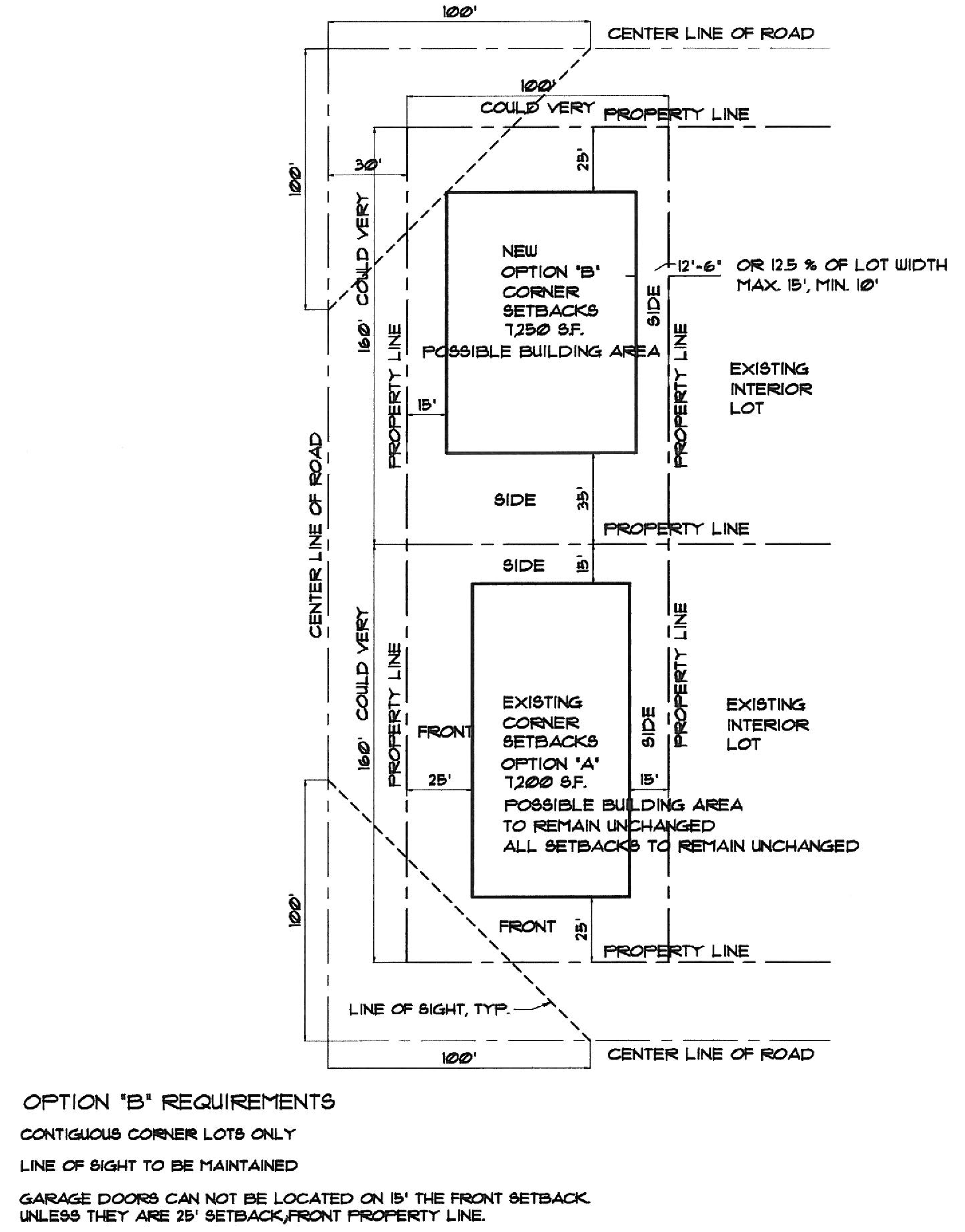
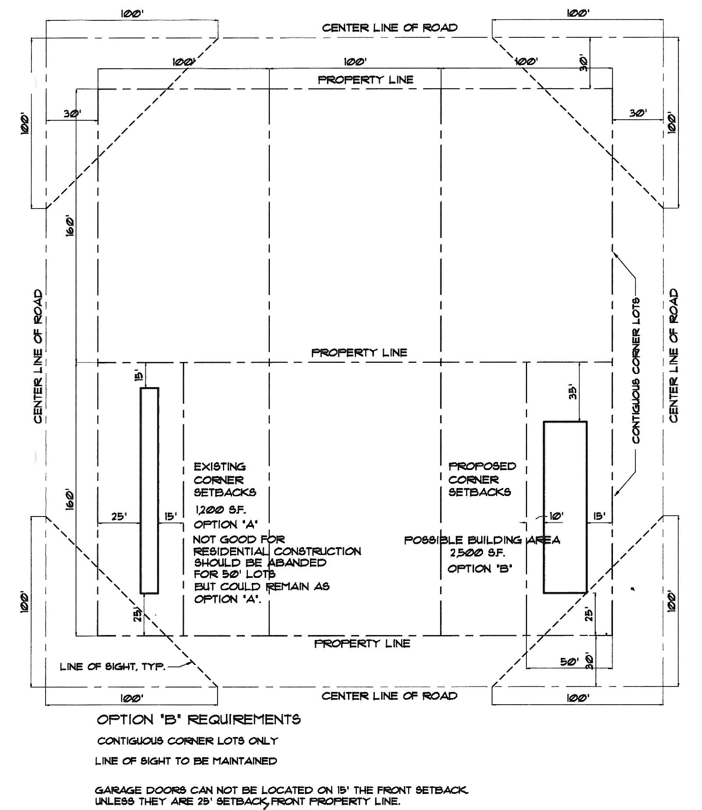
Option B. The front yard setback shall be 25 feet, except a front yard that is contiguous with an adjacent corner lot shall have a front yard setback of 15 feet. The side yard setback for a side yard that is contiguous with an adjacent corner lot shall be 35 feet. All other side yard setbacks shall be not less than ten feet or 12½ percent of the lot width, whichever is greater, with a maximum of 15 feet. Garage doors for vehicle access shall be located at least 25 feet from the property line. If applicable, rear yard setbacks shall be 35 feet.
The required setbacks for options A and B are illustrated in the drawings attached as exhibits A-1 and A-2 to this article. The drawings are illustrative only. In the event of conflict between this subsection and the drawings, this subsection shall prevail.
5.
Residential noncontiguous corner lots. The minimum yard setbacks in residential zoning districts for noncontiguous corner lots (i.e. corner lots which do not abut another corner lot) are as follows: The front yard setback shall be 25 feet, the side yard setback shall be 15 feet and, if applicable, the rear yard setback shall be 35 feet.
6.
Septic tank or drainfield. No septic tank or drainfield shall be placed within 150 feet of the normal high-water elevation of any lake, canal or run unless approved in writing by the county health department.
7.
Nonconforming lots. Lots platted before April 11, 1989, that cannot meet the 150-foot setback requirement set forth in subsection 3.02.02(4)c.6 or this section due to lot size limitation or location or neighboring well must provide documented proof of this fact; however, the state requirements of 75-foot setback must be met.
d.
Reserved.
e.
Other. Where frontage roads are available, no additional access points shall be permitted between established intersections.
(5)
No documentation available. Where no documentation is available concerning the standards in effect at the time of initial development, the following procedures shall be used:
a.
All developed lots that abut the lot proposed for development shall be considered in determining the standards for development.
b.
Actual setbacks, lot dimensions, building heights, etc. (refer to list in subsection 3.02.02(4) of this section) shall be determined for purposes of calculating an average (mean) for each standard to be imposed.
c.
These average standards shall be the minimum standards required for proposed development.
d.
Where there is any uncertainty on an applicable standard, the decision shall be in favor of the stricter standard.
(6)
Maximum building height and building floor area.
a.
Definitions. The following words, terms and phrases, when used in this subsection 3.02.02(6), shall have the meanings ascribed to them in this subsection, except where the context clearly indicates a different meaning:
Basement means the portion of a building between two floor levels that is partly underground. A basement having three feet or more of its height above natural grade at any point shall be counted as a full story. A basement having less than three feet of its height above natural grade shall be counted as a half-story.
Building height means the vertical distance of a building measured from the elevation of the average undisturbed existing lot grade at the front setback to the highest point of the building, including any structure, equipment or appurtenance located above the roof level. Exceptions for chimneys, church spires, etc., shall be considered by the development review board. The average undisturbed existing lot grade at the front setback shall be calculated by taking the average of the undisturbed existing lot grade at each point of intersection of the property line with the front setback line.
Floor area means the sum of the gross horizontal areas of the several floors of a building or buildings measured from the exterior surface of the walls. Basement areas or other below grade floor areas shall be excluded from the calculation of floor area when more than one-half of that basement or floor height is below the average elevation at the front setback (as described in the term "building height," in this subsection). The area of stairways, elevators, multi-story rooms or atriums shall be counted on each floor level and included in the calculation of floor area. The area contained within garages, carports, screened or roofed porches and balconies shall be included in the calculation of floor area. The floor area of a single-family building shall further include the area of atriums and volume ceiling spaces on each floor when the interior floor to ceiling height of such rooms exceeds 17½ feet.
Floor area ratio means the ratio of floor area to the total square footage of the lot upon which construction is contemplated. The floor area ratio on lakefront lots shall only be computed using the site area used for the building; land located across a road, street or highway and separated from the building site shall not be included as available land in the calculation.
Story means that portion of a building included between the surface of any finished floor and the surface of the next finished floor above it, or if there be no floor above it, then the space between such floor and ceiling next above it, unless such space is less than 5.5 feet in height. Wherever the height between two finished floors (or finished floor and ceiling) exceeds 17½ feet, each height of 15 feet or portion greater than 5.5 feet thereof shall be construed to be one story.
Story, half, means a space under a sloping roof which has the line of intersection of roof decking and wall face not more than three feet above the top floor level, and in which space not more than two-thirds of the floor area is finished off for use. A half story containing independent apartment or living quarters shall be counted as a full story.
b.
Maximum height. No residential structure shall exceed 2½ stories or 35 feet in height, whichever is less, and all other structures shall be limited to two stories or 35 feet in height, whichever is less, as measured from the elevation of the average undisturbed existing lot grade at the front setback.
c.
Maximum floor area ratio. Buildings and accessory structures constructed in residential zones shall not exceed a floor area ratio of 38 percent.
d.
Size, height, bulk and architecture of adjoining properties. The size, height, bulk and architecture of adjoining properties shall be considered so as to adequately protect surrounding properties. Excessively massive buildings or buildings which dominate neighborhood structures should be avoided. Inequitable loss of private views resulting from excessively tall or poorly planned structures shall not be permitted.
3.02.03
Additional historical definition. The term "object" means a material thing of functional, aesthetic, cultural, archaeological, historical or scientific value that may be by nature of design movable, yet related to a specific setting or environment.
(Ord. No. 91-6, § 3(3.02.00), 2-11-1992; Ord. No. 2007-01, §§ 2, 3, 2-13-2007; Ord. No. 2007-07, § 1, 11-13-2007; Ord. No. 2007-08, § 1, 11-13-2007; 2008-02, § 1, 6-10-2008; Ord. No. 2009-03, § 4(3.02.02D3(F), 3.02.02D4), 6-9-2009; Ord. No. 2010-09, § 2, 12-14-2010; Ord. No. 2016-01, §§ 10, 11, 7-12-2016; Ord. No. 2016-02, § 1, 10-25-2016)
Sec. 3.03.00. - Planned unit development.
3.03.01
Intent and purpose of PUD district. The intent and purpose of the planned unit development district (PUD district) is as follows:
(1)
To implement the Town Center District approved in the comprehensive plan and to guide development located outside the Town Center District.
(2)
To provide maximum opportunity for application of innovative concepts of site planning in the creation of aesthetically pleasing living, shopping and working environments on properties of adequate size, shape and location, both within and outside the Town Center District.
(3)
To ensure that development will occur according to limitations of use, design, density, coverage and phasing stipulated on an approved development plan.
(4)
To preserve the natural amenities and environmental assets of the town by encouraging the preservation and improvement of scenic and functional open areas.
(5)
To allow diversification of uses, structures and open spaces in a manner compatible with existing and permitted land uses on abutting properties.
(6)
The PUD district is a flexible zoning district, which is intended to provide an appropriate balance between the intensity of development and the ability to provide adequate capacity within the support services and facilities available.
(7)
To provide compatible commercial, residential and other mixed uses in accordance with an approved development plan outside the Town Center District.
(8)
The PUD districts shall include detailed design guidelines which will be used to guide developers and evaluate PUD submissions.
(9)
The PUD districts located outside the designated Town Center District shall be created in compliance with the general site development standards, as set forth in section 3.04.00, and any other design guidelines to be adopted and implemented at a later date.
3.03.02
Land uses permitted. The following uses shall be permitted in the PUD planned development district if designated on an approved development plan:
(1)
Town Center District. Complementary and compatible commercial, office, public and quasi-public land uses may be included consistent with the adopted land uses in the town comprehensive plan, future land use element, policy 4.2.6.
(2)
Planned residential communities (outside of the Town Center District). Complementary and compatible commercial and recreational uses may be included if they are compatibly and harmoniously designed into the total residential community within a planned development district.
(3)
Mixed use centers (outside of the Town Center District). Complementary and compatible residential, commercial and office uses may be included if they are compatibly and harmoniously designed into the total commercial center within a planned development district.
a.
Other uses which are similar or compatible or identified within section 2.02.02 of this Land Development Code, which would promote the intent and purpose of the PUD district. Determination shall be made by the town council.
b.
A PUD zoning application may be filed and considered for approval simultaneously with a request for voluntary annexation, as long as the applicable terms and conditions of the PUD district are met, and the design guidelines necessary to implement the PUD zoning application are adopted and in place.
3.03.03
Approval process.
(1)
Introduction. The approval process involves three steps for PUD zoning approval. The concept plan provides a generalized plan of development. This plan is nonbinding on the developer. The preliminary development plan is a more detailed plan which conveys the PUD zoning to the parcel. The final development plan is a detailed site plan and it represents the last step in the PUD approval process prior to the approval of construction plans. Due to the small staff employed by the town, the town reserves the right to employ outside experts to evaluate all PUD applications and provide analysis and recommendations to the town. The applicant will be responsible for paying a review deposit as required by article XIII of this Land Development Code, and otherwise reimbursing to the town the consultant and legal fees and other out-of-pocket costs the town incurs as a direct result of processing the PUD application.
(2)
Preapplication conference and concept plan submission.
a.
The applicant shall submit an application and seven copies of the concept plan to the town manager at least 15 working days prior to a preapplication conference, which shall be scheduled by the applicant with the town manager or designees.
b.
The purpose of this meeting will be to acquaint the development review board (DRB) members with the proposed project and to provide the prospective applicant with preliminary review comments to identify major concerns or the need for additional support data. The concept plan shall be prepared in accordance with subsection 3.03.04 of this section.
c.
A copy of the concept plan shall be delivered to each member of the DRB. The members shall review the concept plan and submit comments, if any, in writing to the town manager within ten working days of receipt of the plan. At the option of the town manager, the DRB members may participate in the preapplication conference with the applicant.
d.
The DRB, town staff and town consultants shall consider:
1.
Characteristics of the site and surrounding area, including important natural and manmade features, and existing mature trees, the size and accessibility of the site, and surrounding land uses.
2.
Whether the concurrency requirements of article IV (consistency and concurrency requirements) of this Land Development Code could be met if the development were built.
3.
The nature of the proposed development, including land use types and densities; the placement of proposed buildings and other improvements on the site; the location, type and method of maintenance of open space and public use areas; the preservation of natural features; proposed parking areas; internal traffic circulation system, including trails; the approximate total ground coverage of paved areas and structures; types of water and sewage treatment systems; and a stormwater management plan for the proposed development.
4.
Conformity of the proposed development with the comprehensive plan, the Code of Ordinances and other applicable regulations.
5.
The need for additional information from the applicant regarding the site for development or the proposed development plan and program.
Within five working days after the preapplication conference, the town manager, or designee shall send a letter to the applicant/consultants summarizing the major points of the meeting. In addition, the town will identify in the letter additional information needed from the applicant with the formal rezoning application materials to be submitted to the town. The concept plan shall not be binding on the applicant.
(3)
Preliminary development plan (PDP). The applicant shall submit to the town manager, after payment of an application fee to the town, 14 copies of the preliminary development plan with supporting data. The town manager shall schedule the project for the next regular meeting of the development review board (DRB) for a review hearing, which hearing shall be held no later than 30 days after a determination of sufficiency of the PDP application, plan and supporting documentation.
a.
Prior to scheduling the PDP before the DRB, and within 15 days of receiving the application, the town will review all the materials to determine sufficiency. The town may request additional information or clarification from the applicant. All requests will be submitted in writing to the applicant.
b.
The DRB shall review the proposed preliminary development plan prior to a recommendation, the DRB may request additional information or clarification from the applicant. All requests will be submitted in writing to the applicant. Upon satisfactory review of the requested material, the DRB will issue a written recommendation to the town council within 14 days. A copy of the DRB recommendation shall be sent to the Applicant at least five days prior to the town council public hearing.
c.
Upon receipt of the DRB's written recommendation, the town council shall hold a public hearing to review the application and recommendation (which may include conditions of approval) for its official action. Public notice to consider the preliminary development plan shall include a generalized list of the proposed land uses and shall indicate that the town council will hold a public hearing to consider the project. The initial public hearing (first reading) shall be held at least 30 days after the DRB final review hearing on the preliminary development plan. A second public hearing (second reading) will occur at least 30 days after the initial public hearing.
d.
Approval of the preliminary development plan by the town council conveys PUD zoning to the property.
e.
The applicant may request an extension of the time frame at any point in the PDP process.
(4)
Final development plan (FDP). The applicant shall submit to the town manager, after payment of application fees to the town, 14 copies of the final development plan with supporting data. Prior to scheduling the FDP before the DRB, and within 15 days of receiving the application, the town will review all the materials to determine sufficiency. The town may request additional information or clarification from the applicant. All requests will be submitted in writing to the applicant. The town manager shall schedule the project for the next regular meeting of the development review board (DRB) which meeting shall be held no later than 30 days after a determination of sufficiency of the FDP application, plan and supporting documentation.
a.
The final development plan may cover all or a portion of the approved preliminary development plan approved for the site. The town manager shall review the plans to determine if all appropriate data and information has been properly provided.
b.
The final development plan shall be reviewed by the DRB in order to determine that:
1.
Consistency with the preliminary development plan and all applicable ordinances, regulations and policies is considered;
2.
If the project is phased, the phase of development proposed for approval in the final development plan can exist as a stable independent unit; and
3.
Existing or proposed utility services and roadway capacity are adequate for the uses proposed.
c.
The DRB shall either recommend approval or denial of the final development plan (which may include technical conditions consistent with applicable town ordinances, regulations and policies) based upon specific findings, which shall be stated. The decision of the DRB may be appealed to the town council. The applicant may appeal the DRB decision by filing a notice of appeal within 15 days of the rendition of the DRB decision.
d.
If the applicant or developer proposes to create a subdivision, a preliminary subdivision plan should be processed concurrently with the final development plan and shall be subject to approval by the town council.
e.
The applicant may request an extension of the time frame at any point in the FDP process.
Upon receipt of the DRB's written recommendation, the town council shall review the recommendations for its official action at the next scheduled meeting of the town council.
3.03.04
Concept plan requirements.
(1)
The concept plan shall consist of a generalized sketch showing the proportion and locations of land uses, and the following items, where applicable:
a.
Contact information on the owner, developer or consultants involved in the project.
b.
Plan legend, including north arrow, scale and date.
c.
Preliminary survey information showing the site topography, existing tree dimensions and locations, and current utilities serving the site.
d.
Boundary of the subject property, identified by a heavy line.
e.
Major natural features, such as water bodies and conservation areas.
f.
Existing or proposed streets abutting the project and other major streets and intersections within 100 feet of access points to the subject property.
g.
Generalized location map and legal description, including acreage.
h.
Proposed land use types, buildings and their locations on the site.
i.
Gross residential density, if applicable.
j.
Approximate floor area for nonresidential use.
k.
Approximate minimum lot size.
l.
Approximate number of units.
m.
Adjacent zoning.
n.
Anticipated internal major road network, if applicable.
o.
Anticipated maximum building height.
p.
Anticipated phasing plan.
q.
Preliminary parking layout and parking space count.
r.
Proposed method of providing:
1.
Water service (including fire protection).
2.
Sewage disposal.
3.
Stormwater management.
4.
Parks/recreation facilities.
e.
Schools, if applicable.
(2)
The plan shall include all information known by the applicant at the time of submission. Review of the plan shall be based on the data submitted.
3.03.05
Preliminary development plan requirements. The preliminary development plan shall include properly identified exhibits and support materials. All plans shall be drawn to a scale acceptable to the town manager. The plan shall clearly indicate the following:
(1)
The project name, legal description, total acreage and location map.
(2)
Contact information for the owners, developers and the consultants involved in the preliminary development plan.
(3)
Plan legend including north arrow, scale and date.
(4)
Preliminary survey information showing the existing tree dimensions and locations on the site. For six inches or greater caliper trees, a tree impact plan must be provided.
(5)
A traffic study may be requested by the town manager.
(6)
Existing topography at one-foot contours and other natural features including lakes, water bodies, conservation area, soils and flood hazard areas.
(7)
Existing and proposed land uses, with each phase of the total development identified, if applicable. Town center: types of uses, gross floor area, floor area ratio, building height, setbacks, open space, parking spaces, service access and landscape buffers.
(8)
Identify the phasing of development and the manner in which each phase of development will exist as an independent development unit.
(9)
The location of local streets proposed in the development, right-of-way widths, street setbacks, planned rights-of-way, the location of access points to abutting streets and projected traffic generation based on established International Traffic Engineer (ITE) standards. A traffic study may be required at the discretion of the town manager.
(10)
Buffer treatment to adjacent uses.
(11)
All building elevations and architectural character. Sketches at appropriate scale to provide sufficient detail for review.
(12)
Proposed method of providing the following services:
a.
Water service (including fire flows), plus gallons per day requirement.
b.
Sewage disposal, plus gallons per day generated, unless septic systems are used.
c.
Stormwater management concept.
d.
Parks/recreation facilities.
(13)
Waivers from this Land Development Code or the site development standards of the PUD district shall be indicated on the preliminary development plan and/or submitted in writing.
3.03.06
Final development plan. The final development plan for the entire project or any phase, including properly identified exhibits and support materials, shall include the following:
(1)
Project name (indicate if different than approved preliminary development plan).
(2)
Contact information for the owners, developers and the consultants involved in the final development plan.
(3)
Legal description and the gross acreage of the proposed development, including identifying land and water bodies.
(4)
A location map identifying the relationship of the final development plan to the approved preliminary development plan.
(5)
Preliminary subdivision plan if the applicant proposes to subdivide the project.
(6)
Waivers from this Land Development Code or site development standards of the PUD district shall be indicated on the final development plan or submitted in writing.
(7)
The final development plan, drawn at an appropriate scale with all dimensions provided, shall follow the Town Center Design Guidelines and shall identify:
a.
Certified topography drawn at one-foot contours using county datum and showing natural features.
b.
Existing street intersections or rights-of-way within 200 feet of access points.
c.
Surface improvements of all streets and parking serving the project.
d.
Proposed uses.
e.
Number of dwelling units, density, minimum square footage of living area and minimum net lot area.
f.
Total square footage of all nonresidential uses and floor area ratio.
g.
Maximum building height (stories and feet).
h.
Maximum building coverage.
i.
Acreage, types and percent of open space and recreation area.
j.
Pedestrian/bike path facilities.
k.
Stormwater management plan, including direction of surface drainage flow.
l.
On-site soils based upon the U.S. Soil Conservation Service classification system (if muck soils exist, their depth and extent must be identified).
m.
On-site vegetation and location of all mature trees over six-inch-caliper.
n.
Method of providing support utilities, including water, sewer, septic tank, fire flows and refuse storage areas.
o.
Existing or proposed easements.
p.
Parking spaces and location, in accordance with division 6.03.00 and sections 3.04.00, general site development standards and 3.05.00, Town Center Design Guidelines of the PUD district, as applicable. For areas located outside the Town Center District, division 6.03.00 along with sections 3.04.00, 3.06.00, commercial site development standards and 3.07.00, residential site development standards, of the PUD district are applicable.
q.
Exterior lighting, including photometric studies.
(8)
Recreation area plan, if residential land uses are proposed.
(9)
Landscape, tree planting and screening concept plan. A final plan will be prepared consistent with subsection 3.04.03. If the proposed land use is located within the Town Center District, the plan must demonstrate compliance with the adopted Town Center Design Guidelines identified in section 3.05.00.
(10)
Design elevations of all proposed buildings at scale of one-eighth-inch.
(11)
Sign plan, including scaled plans of proposed signs.
(12)
Preliminary engineering plans for the provisions of road, utilities and stormwater management for the proposed phase and its relationship to the master stormwater concept.
(13)
Proposed covenants, conditions, restrictions, agreements and grants which govern the use, maintenance and continued protection of building structures, drainage systems and landscaping within the planned development.
(14)
Areas to be conveyed or dedicated and improved for roadways, parks, playgrounds, school sites, utilities, public buildings and other similar public and public service uses. Improvement bonds for facilities to be owned and maintained by the town and not completed shall be posted before the issuance of building permits.
3.03.07
Alterations to the preliminary development and final development plans.
(1)
Alterations to the approved preliminary development or final development plans shall be classified as either minor or major amendments. The following criteria shall be used to identify a major amendment:
a.
A change which would include a land use not previously permitted under the approved PUD zoning.
b.
A change which would alter the land use type adjacent to a property boundary.
c.
A change which would require an amendment to the town council's conditions of approval.
d.
A change which would increase the land use intensity within any development phase without a corresponding decrease in some other portion of the overall PUD.
e.
An amendment to the phasing which would propose a land use in advance of the development it was designed to support.
(2)
The determination of a minor or major alteration shall be made by the town manager.
(3)
Where the applicant proposes to reduce the number of units or floor area in one phase of the project, a corresponding increase in the number of units of floor area in another phase may be considered, if other conditions of approval are not adversely affected, nor any other change is proposed which would be considered a major change as described in this subsection 3.03.07.
(4)
The applicant must submit plans and support data (utilizing the requirements outline in this section) for review by the DRB. A public hearing before the town council will be required if the alterations to the preliminary development plan are determined to be major.
(5)
Minor alterations must be submitted for review, including plans and support data, as applicable. These alterations must be reviewed and approved by the DRB.
(6)
When partial amendments are requested to the final development plan, the overall project shall be evaluated in conjunction with the proposed amendment, to determine compatibility with the remaining portion of the PUD. Amendments which the DRB considers to be incompatible or conflict with the preliminary development plan or conditions of approval will require the final development plan to be updated and will be subject to town council approval.
3.03.08
Control of development following approval.
(1)
Upon the approval of the final development plan or any phase thereof, the use of land and the construction or modification of any buildings or structures within the PUD shall be in accordance with the approved final development plan, rather than with the other provisions of this article.
(2)
The town manager shall be responsible for certifying that all aspects of the PUD, including conditions of approval (applicable to the subject portion of the project) have been satisfactorily completed prior to the issuance of a certificate of occupancy for the project or phase.
(3)
After certification, no changes may be made in the approved final development plan except under the procedures provided as follows:
a.
Any structural extension, alteration or modification of existing building structures which are consistent with the approved development plan must be authorized by the town manager.
b.
A building or structure that is partially destroyed may be reconstructed only in compliance with the final development plan, unless an amendment to the final development plan is approved under the provisions of this section 3.03.00.
3.03.09
Other requirements.
(1)
Off-site improvements may be required in conjunction with the development plan approval in order to offset the impacts created by the proposed development. All projects shall be required to provide an adequate level of facilities and services to accommodate the project as proposed in the development plan.
(2)
At the time of development the PUD, or any phase proposed for development, shall comply with all regulations and ordinances.
(3)
Those projects which the town council considers to be inconsistent with the provisions of the PUD zoning may be required to update the preliminary development plan and be subject to a public hearing and town council approval.
(Ord. No. 2004-09, § 1(3.03.00), 9-14-2004)
Sec. 3.04.00. - General site development standards.
3.04.01
Purpose. Site development standards are established for planned development to ensure adequate levels of light, air and density, to maintain and promote functional compatibility of uses, to promote the safe and efficient circulation of pedestrian and vehicular traffic, to provide for orderly phasing of development, and to otherwise protect the public health, safety and general welfare.
3.04.02
Variances. Variances from the minimum general development standards set forth in this section may be granted by the town council. Variances requested after approval of the final development plan must be approved at a public hearing after notification of abutting property owners.
3.04.03
Planned development requirements. The following planned development requirements shall apply to site development standards for planned developments unless specifically waived by the town council:
(1)
Natural features. Buildings and recreation areas should be situated to take advantage of natural airflow, sun angles, views and significant existing trees over six-inch-caliper.
(2)
Circulation, access and parking.
a.
Streets and driveways in the development should be designed to provide optimum conditions for the free movement and safety of vehicular traffic, and to provide safe, efficient and convenient access to land uses within the development and to roadways adjacent to the development.
b.
Local streets shall provide access to each parcel of land within the planned development in a manner that will discourage through traffic and is consistent with access points in the design guidelines identified in section 3.05.00.
c.
Public streets shall be constructed in accordance with standards in article VI, section 6.02.02.
d.
The entrances to parking areas should be easily accessible and identifiable from public streets, and should not interfere with traffic movement on adjoining streets or drives.
e.
All parking areas should be designed and landscaped to be visually and functionally integrated with other land uses.
f.
Parking and loading facilities requirements shall meet the minimum requirements set forth in article VI, division 6.03.00, except as follows:
1.
Remote parking areas should be located within 1,000 feet from the uses they serve.
2.
Parking areas must be paved and designed with regard to pedestrian safety. Alternative parking surfaces may be permitted where frequency of use is appropriate for the proposed surface.
3.
Parking ratios for all land uses within the Town Center District are hereby established at four spaces/1,000 gross square feet.
4.
Parking ratios may be reduced from four spaces/1,000 gross square feet to 3.5 spaces/1,000 gross square feet if the PDP plan adequately addresses the existing mature trees on the site.
5.
Prior to approving a reduction in parking ratio, the applicant will furnish the DRB with a tree study for consideration. The DRB will consider the tree sizes, location, relocation and/or mitigation plan proposed in the tree study prior to approving a reduction in the parking ratio applied to the parcel and the use.
g.
Wherever practicable, vehicular and pedestrian passageways should be separated.
h.
A system of walkways between buildings, common open spaces, recreation areas, community facilities and parking areas should be carefully designed and adequately lighted where appropriate for nighttime use.
(3)
Utilities.
a.
All utilities should be supplied through underground networks.
b.
Encourage the careful placement of utility elements so they can be dealt with in an aesthetically pleasing way through coordination with the appropriate agencies.
c.
A planned development shall connect to an existing central sewer system, where available, which is adequate to serve the anticipated needs of the development, or a private sewer system shall be constructed according to regulations prevailing at the time construction is begun. The sewage treatment and disposal system shall be approved by the town and state health departments.
d.
Water pipelines shall be of sufficient size and located appropriately to provide adequate fire protection for all structures in the planned development.
(4)
Stormwater management. All development shall meet the stormwater management criteria set forth in division 6.05.00, including the criteria set forth by the South Florida Water Management District.
(Ord. No. 2004-09, § 1(3.04.00), 9-14-2004)
Sec. 3.05.00. - Town Center Design Guidelines.
(a)
The Town Center Design Guidelines prepared by Canin Associates and dated July 2004, are hereby adopted and incorporated herein by reference.
(b)
The July 2004 Town Center Design Guidelines adopted herein are modified as follows: page 10, under the heading, building height, lines 2 through 5 are hereby stricken. Also, the drawings illustrating a balcony and "jumba" located in the middle of the page are modified to include the notation "35' Max. Height" with a line indicating the distance from the ground to the highest portion of the illustrated structures. See the following exhibit A in subsections (b)(1) and (2):
(1)
Balconies. For the protection of pedestrians on the storefront level, a cantilevered balcony may be carefully substituted for an awning or canopies in some situations. This balcony cantilevered at the second level acts as a shading device for the storefront below. It may be incorporated as an expression line. The design principles for balconies include the following:
a.
This device lends itself to short-length applications of less than 50 feet of frontage. The balcony will appear ill-proportioned if used in long unbroken applications.
b.
The cantilevered balcony should project no more that five feet from the principal facade. The balcony may encroach upon the public right-of-way, but shall project no closer than 18 inches from the face of the curb.
c.
The balcony may be supported structurally or visually by decorative brackets or angle supports. These supports should be positioned so that they do not interfere with the free movement of pedestrians on the sidewalk.
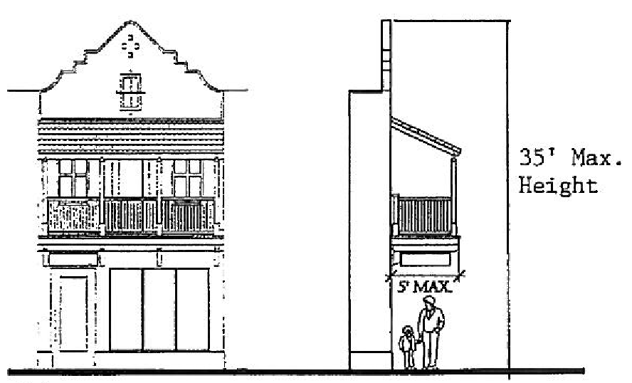
Balcony
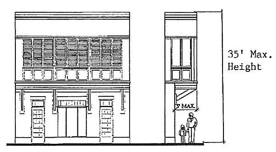
Jumba
d.
The cantilevered balcony may be roofed or framed by columns. In special, limited applications, balcony space could be enclosed to form a "jumba," but such enclosures require a special, site specific design approval by the town. A jumba may no exceed 15 feet in length.
(2)
Building height. Maximum two-story is 35 feet in height.
a.
Encroachment. Building elements that are attached to a building are permitted to exist within a front or side street setback. Typical building elements include balconies, porches, arcades and other architectural elements that are intended to bring the public realm closer to the street.
b.
Build-to line. The build-to line is the line where the facade of the main building or structure must be placed.
c.
Permitted encroachments. Balconies, colonnades, arcades, jumbas.
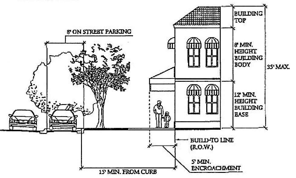
Encroachment and Build-To Line
Exhibit A. Town Center Design Guidelines
(c)
The town center design district master plan excludes both 111 W 5th Avenue (Plat of Windermere G/36 the E 80 feet of Lot 289 and E 80 feet of Lot 290) and 119 W 5th Avenue (Plat of Windermere G/36 LOTS 289 and 290 (less E 80 feet thereof)).
(Ord. No. 2004-09, § 1(3.05.00), 9-14-2004; Ord. No. 2006-01, §§ 1, 2, 8-8-2006; Ord. No. 2019-02, § 1, 9-10-2019)
Sec. 3.06.00. - Commercial site development standards.
(RESERVED)
(Ord. No. 2004-09, § 1(3.06.00), 9-14-2004)
Sec. 3.07.00. - Residential site development standards.
(RESERVED)
(Ord. No. 2004-09, § 1(3.07.00), 9-14-2004)