
Windermere City Zoning Code
ARTICLE V
RESOURCE PROTECTION STANDARDS
Sec. 5.00.00.- Purpose.
The purpose of this article is to establish those resources or areas of a development site that must be protected from harmful affects of development. A developer should apply the provisions of this article to a proposed development site before any other development design work is done. Application of the provisions of this article will divide a proposed development site into areas that may be developed and areas that must generally be left free of development activity. The proposed development should then be designed to fit within the areas that may be developed.
(Ord. No. 91-6, § 3(5.00.00), 2-11-1992)
DIVISION 5.01.00. - TREES[1]
Editor's note— Ord. No. 2014-16, § 1, adopted December 9, 2014, repealed the former division 5.01.00, §§ 5.01.01—5.01.06, and enacted a new division 5.01.00 as set out herein. The former division 5.01.00 pertained to similar subject matter and derived from Ord. No. 91-6, adopted February 11, 1992 and Ord. No. 99-6, adopted October 12, 1999.
State Law reference— Invasive nonnative plants; F.S. § 369.251.
DIVISION 5.02.00. - ENVIRONMENTALLY SENSITIVE LANDS[2]
State Law reference— Environmentally sensitive areas, mangroves and wetlands, F.S. § 403.9321 et seq.
DIVISION 5.03.00. - GROUNDWATER AND WELLHEADS[3]
State Law reference— Elements of the comprehensive plan, F.S. § 163.3177; water supply, F.S. § 403.850 et seq.
Sec. 5.01.01. - Purpose.
The purpose of this division is to:
(1)
Sustain the forest canopy and the urban forest of the town for future generations.
(2)
Establish rules and regulations governing the protection of trees within the town.
(3)
Preserve the proliferation of trees as well as their replacement within the town.
(4)
Maintain public and private trees in a healthy and non-hazardous condition through good arboricultural practices.
(5)
Establish and maintain appropriate diversity in tree species and age classes to provide a stable and sustainable urban forest.
(6)
Minimize the removal of protected trees.
(7)
Require compensation for the loss of protected, heritage and historic trees in all stages of maturity on public and private property.
(8)
Preserve the community's character and quality of life well into the future.
(Ord. No. 2014-16, § 1, 12-9-2014)
Sec. 5.01.02. - Intent of Tree City USA Program.
The Town of Windermere desires to be an active participant of the Tree City USA program and to achieve the standards set forth by the Arbor Day Foundation. The Town shall adopt and enact administrative policies, regulations, standards and procedures necessary to ensure the town, which has been declared a "Tree City USA" community, will continue to be a recognized participant in this program.
(Ord. No. 2014-16, § 1, 12-9-2014)
Sec. 5.01.03. - Definitions.
ANSI means the American National Standards Institute.
Best management practices (BMP) means the best-available, industry-recognized courses of action, in consideration of the benefits and limitations, based on scientific research and current knowledge.
Buildable area means the portion of the site on which a structure or improvement may be erected.
Caliper means a nursery standard measurement of a tree's trunk diameter as measured at a predetermined point of measurement. Trunk caliper for trees up to four inches shall be measured six inches above the soil line. Trees greater than four inches in caliper shall be measured 12 inches above the soil line. Caliper measurements shall be used when measuring replacement trees.
Canopy means collective branches and foliage of a tree or group of trees' crowns. A canopy can be closed or partially closed as in a forest or woodland stand, or composed of both individual trees and closed canopy groups as in an urban forestry canopy.
Certified arborist means a professional who possesses the technical competence gained through experience, related training and professional certification to provide for or supervise the management of trees and other woody plants in residential, commercial, and public landscapes. These arborists must be licensed by the State of Florida and certified by the International Society of Arboriculture.
Crown means the upper part of tree, measured from the lowest branch, including all the branches and foliage.
Dead or beyond recovery means that more than 50 percent of the tree is dead, the tree is a hazardous tree as defined herein, or the tree is in a state of irrecoverable decline.
Deteriorated tree or deterioration means a tree, which is degenerated or damaged by a biological pathogen, or pest to the point of death of the tree is imminent.
Development means any land disturbing activities including but not limited to: building construction, paving, landscaping, and creation of drainage or water catchment areas, grading, earth filling, utility installation or any other activity which may adversely affect trees either above or below ground.
Diameter at breast height (DBH) means the diameter of a tree as measured four feet, six inches above the soil line, and when using the Guide for Plant Appraisal (9th Ed.) For multi-trunked trees the DBH shall mean the cumulative diameter of the two largest trunks. The Guide for Plant Appraisal (9th Ed.) or as amended will be the resource standard for measuring trees.
Drip line means a vertical line that runs from the outermost circumference of the tree branches and extends to the ground. For trees with canopies set off center, the drip line will be projected based on the average diameter of the existing drip-line using the tree trunk as its point of origin.
Drought tolerant means various plant species that survive on natural rainfall without the need for supplemental irrigation after establishment.
Exempt tree means a tree less than eight inches in diameter and palm trees with less than four and one-half feet of clear trunk. Exempt trees do not require a permit for removal. Exempt trees may not be used to calculate required canopy and may not be used as replacement trees.
Hazardous tree means a tree or part of a tree that is irreparably diseased or presents a danger of falling that cannot be controlled or remedied through reasonable preservation and/or preventative procedures and pesticides such that the public health or safety requires its removal.
Historic tree means any protected tree(s) which is 36 inches in DBH or greater and has such unique and intrinsic value to the general public because of its size, age, historic association, or ecological value as to justify this classification. Any tree in the town selected and duly designated a Florida State Champion, United States Champion or a World Champion by the American Forestry Association shall likewise be deemed a historic tree.
Indigenous means species of plant or vegetation which is native to the State of Florida.
Invasive species means any non-indigenous species that crowds out or takes over native species habitats.
Landscaping means any of the following or combination thereof: Living material such as but not limited to, grass, ground covers, shrubs, vines, hedges, and trees. Landscaping may include, for accent purposes, nonliving material such as, but not limited to, rocks, mulch, pebbles, decorative walls or fences, but excluding paving.
Noxious means any non-indigenous species that crowds out or takes over native species habitats.
Palm tree means a monocotyledonous plant of the Palmacea family. With some exceptions, it has an unbranched trunk; its leaves group at the end of the trunk and form a type of tuft. Care, maintenance and pruning of palm trees will be governed by and all related ANSI publications as they relate to trees and landscape, adopted by the International Society of Agriculture (ISA), American Consulting Arborists (ASCA) and Tree Care Industry Association (TCIA) formerly the National Arborists Association (NAA). Palm trees shall be measured according to Florida grades and standards.
Park trees means trees, shrubs, bushes, and all other woody vegetation in public parks and all areas owned by the town.
Person means an individual, partnership, corporation, association, or other legal entity, and shall include the plural as well as the singular.
Private trees means trees, shrubs, bushes, and all other woody vegetation in areas owned by private, residential or commercial property owners.
Protected tree means any self-supporting woody or fibrous perennial plant/tree of a species that normally grows to a mature height of 25 feet or greater and has a tree trunk DBH of eight inches or greater and is not an exempt tree. Includes palm trees with more than four and one-half feet of clear trunk, any replacement tree, any non-exempt tree that is represented in a planning document for the purposes of securing an approved building or demolition permit, and all trees on Town property.
Pruning means removing or reducing tree limbs to benefit the overall health and safety of a tree. Care, maintenance and pruning shall be done according to current standards established by the American National Standards Institute (ANSI) A-300, Part 1, and all related ANSI publications as they relate to trees and landscape, adopted by the International Society of Agriculture (ISA), American Consulting Arborists (ASCA) and Tree Care Industry Association (TCIA) formerly the National Arborists Association (NAA).
Removal of a tree means either actually removing a tree from the ground which it grew, transplanting a tree, or effectively removing a tree through damage to the trunk, topping, damaging, or removing major limbs, roots, or enough canopy volume so that the tree dies, declines beyond recovery, or becomes a hazard to public safety and must be removed. The term "removal" includes removal, removing, or actual displacement or effective displacement through damaging.
Replacement tree means any tree planted as a condition of approval of a tree removal permit or as may be required to meet the conditions of an approved plan for development. Any tree planted as a requirement for tree replacement mitigation due to an illegal removal.
Right-of-way means land which is owned by a governmental entity or has an easement devoted to for use as a transportation facility or street. The storm water areas associated with the transportation facility shall be included in this definition.
Site means that parcel of land for which any permit from the town is sought.
Size means the tree's DBH or caliper.
Specimen tree means any tree, except undesirable, noxious or invasive, with a DBH of 18 inches or larger.
Stop work order means notice stating the reason(s) for stopping work, in writing, given to the owner of the property, or to his/her agent, or to the person doing the work, or a notice posted at the property upon which the tree work is being performed requiring that all work cease.
Street trees means trees, shrubs, bushes, and all other woody vegetation on rights-of-way on either side of all lanes, streets, avenues, or ways within the town.
Tree means a woody or fibrous perennial usually having one dominant trunk which normally grows, or is capable of growing, in the central and north-central area of Florida to a mature height of a minimum of 15 feet and to a minimum DBH of not less than four inches as measured four feet, six inches above the existing grade.
Top or topping means the severe cutting back of limbs or trunks within the crown of a tree (25 percent or more) so as to remove the normal canopy and alter the natural growth habit of the tree, inappropriate pruning technique to reduce tree size, or cutting back a tree to a predetermined crown limit, often at internodes.
Tree protection zone/area (TPA) means the defined area within which certain activities are prohibited or restricted to prevent or minimize potential injury to designated trees, especially during construction or development. This shall mean an area surrounding a tree encompassed by a tree's drip line or projected drip line. The minimum TPA shall be three feet or TPA radius per 12 inches of DBH. For example, a 12-inch DBH tree would have a TPA of three feet radius; a 60-inch DBH will have a TPA of 15 feet radius. Factor DBH in inches/4. The maximum required tree protection area shall be 25 feet radius from the trunk of the tree.
Trenching means linear or curved open excavation often used to install utilities or structural footings.
Yard means the open space on the same lot with a principal building which is unoccupied by buildings or paving.
(Ord. No. 2014-16, § 1, 12-9-2014)
Sec. 5.01.04. - Applicability.
The terms and provisions of this division shall apply to all protected trees, located on real property within the town.
(Ord. No. 2014-16, § 1, 12-9-2014)
Sec. 5.01.05. - Exceptions.
(a)
The following are exempt from the provisions of this division:
(1)
Trees located in state-licensed, governmental and commercial plant or tree nurseries or botanical gardens in which the trees are planted for the sale or intended sale to the general public in the ordinary course of business.
(2)
Trees in active commercial operation for bona fide agricultural purposes.
(3)
Trees, which due to natural circumstances and reviewed by a licensed and certified arborist, are no longer viable and are in danger of falling.
(4)
Trees, which due to natural circumstances and reviewed by a licensed and certified arborist are determined to be too close to existing structures so as to endanger such structures.
(5)
Trees that interfere with utility services, create unsafe vision clearance, or constitute a safety hazard as determined by the town manager or his designee.
(6)
Trees that occur in the location of planned or future public utility services or public roads.
(7)
Trees with a DBH of less than eight inches.
(8)
Trees located within buildable area or yard area where a structure or improvement is to be placed and it unreasonably restricts the permitted use of the property.
(9)
Trees on residential property if the property owner obtains documentation from an arborist certified by the International Society of Arboriculture or a Florida licensed landscape architect that a tree presents a danger to persons or property. The town will not require: (i) a notice, application, approval, permit, fee or mitigation for the pruning, trimming, or removal of such tree, or (ii) a property owner to replant such tree that was pruned, trimmed, or removed. For action taken under this subsection, the town may require some or all of the following documentation; the arborist's or the landscape architect's identity and proof of certification; the arborist's or the landscape architect's written report; pictures of the tree prior to any action to prune, trim or remove; and a written description of the particular danger to persons or property presented by the tree.
(b)
Any property zoned or used for agriculture, which is effectively cleared of trees under the above exemptions, shall not be eligible for changes to a more intensive land use for a period of three years after the site is cleared.
(c)
The following exempt trees are considered undesirable, invasive and shall be exempt from the provisions of this division. No tree removal permit is required to remove the following species:
(1)
Australian Pine (Casuarina species);
(2)
Brazilian Pepper or Christmasberry Tree (Schinus terebinthifloius);
(3)
Cajeput Punk or Melaleuca Tree (Melaleuca quinquenervia/leucadendra);
(4)
Chinaberry (Melia azedarach);
(5)
Chinese Tallow Tree (Triadica sebiferum);
(6)
Ear Tree (Enterlobium species);
(7)
Eucalyptus (Eucalyptus);
(8)
Mimose (Albizzia julibrissin);
(9)
Paper Mulberry (Broussonetia papyrifora);
(10)
Poisonwood or Florida Poison Tree (Metopium toxiferum);
(11)
Silk Oak (Grevillea robusta);
(12)
Any other tree defined as undesirable, noxious or invasive by the State of Florida.
(Ord. No. 2014-16, § 1, 12-9-2014; Ord. No. 2019-09, § 2, 1-14-2020)
Sec. 5.01.06. - Special exceptions due to emergencies.
During a period of an emergency such as a hurricane, tropical storm, tornado, or flood, as declared by the town manager or his designee, the removal of all trees destroyed or harmed during such an emergency by natural forces which are beyond saving or which are a hazard to public safety shall be exempt from the provisions of this division for a period of 14 days following such occurrence.
(Ord. No. 2014-16, § 1, 12-9-2014)
Sec. 5.01.07. - Trees requiring tree removal permits.
No person, directly or indirectly, shall cut down, destroy, top, abusively prune, remove, move, or effectively destroy through damaging, any protected tree, replacement tree, or historic tree within the town without first applying for and receiving a tree removal permit approving such act or acts. This requirement does not apply to exempt trees.
(Ord. No. 2014-16, § 1, 12-9-2014)
Sec. 5.01.08. - Tree permit application.
Permits required by this division for the removal of protected or historic trees shall be obtained by filing an application for the permit with the town manager or his designee. The application shall include a written statement specifying the location of the property and indicate the reasons for the removal, relocation, or replacement of trees thereon. The application shall be accompanied by two copies of a legible site plan drawn to a minimum scale of one-inch equals 20-feet unless, in the discretion of the town manager or his designee, it has been determined that a lesser detailed scale site plan of the area, either in whole or in part, will be sufficient for the purposes of this division, in which case an appropriate substitution shall be acceptable.
(Ord. No. 2014-16, § 1, 12-9-2014)
Sec. 5.01.09. - Site plan information.
Site plans submitted in connection with an application for permits required by this division shall include the following information, summarized in legend form on the site plan:
(1)
Location of all existing or proposed structures, improvements, and site uses, properly dimensioned, and referenced to property lines, setback and yard requirements, and spatial relationships.
(2)
Existing and proposed site elevations, grades, and major contours.
(3)
Location of existing and proposed utility services.
(4)
The common or botanical names, sizes, and locations of all trees on the site, designating those as well as areas of native vegetative cover which are respectively to be retained, removed, relocated, or replaced.
(5)
Except specimen or historic trees, which are all within close proximity may be designated as "clumps" with the predominate type, estimated number and average DBH noted. Specimen trees eighteen inches or larger and historic trees inches or larger must be designated individually by type and DBH.
(Ord. No. 2014-16, § 1, 12-9-2014)
Sec. 5.01.10. - Criteria for issuance of tree removal permits.
Each application for a tree removal permit shall be reviewed and a decision rendered on approval or denial (in whole or in part) on the basis of the following criteria:
(1)
The health of the tree, i.e. whether the tree is deemed dead or beyond recovery, deteriorated or hazardous.
(2)
The topography of the land and the effect of the tree removal upon erosion, soil retention and the diversion or increased flow of surface waters.
(3)
The number, species, size, location and canopy of existing trees in the area and the effect the removal would have upon lakes, shade, sunlight, privacy, scenic beauty, wildlife, noise, air quality, wind, health, safety, prosperity, historic values and general welfare of the area and the town as a whole.
(4)
Whether structural improvements have been designed and located to minimize the removal of protected trees.
(5)
Whether the denial of the permit would create an unreasonable hardship on the property owner by severely limiting the use of the property in a manner not typically experienced by owners of similarly zoned and situated properties. A minor reduction of the potential number of residential units or building size due to the tree location does not represent a severe limit of the economic enjoyment of the property.
(Ord. No. 2014-16, § 1, 12-9-2014)
Sec. 5.01.11. - Application processing and approval process.
(a)
Upon receipt of a completed application, the town manager or his designee shall examine, review, and respond. A field inspection of the site will be performed if deemed necessary. The application shall also be referred to other town departments, town boards, or other governmental agencies as may be necessary or required in order to determine whether any adverse effects will be incurred as to the general welfare of the public, adjacent properties or public services and facilities. Following any necessary on-site inspections by the town manager or his designee and comments received from appropriate departments, boards, or other governmental agencies, the permit application will be approved, disapproved, approved with conditions, or deemed not required in accordance with the provisions of this division.
(b)
The town manager or his designee may, in his sole discretion, require the applicant to provide supportive data from a licensed certified arborist and/or other licensed professional such as a certified landscape architect to substantiate the information provided on the application or to provide additional information deemed necessary by the town.
(c)
In the event that a tree planting is approved on public property or town right-of-way, maintenance fees as established by the town may be assessed as part of the permit process.
(Ord. No. 2014-16, § 1, 12-9-2014)
Sec. 5.01.12. - Tree relocation, replacement or mitigation fee requirements.
(a)
The applicant is encouraged and allowed, where practical, to relocate a tree to an appropriate new location on the site. The relocation of a tree shall be performed in accordance with accepted forestry practices after evaluating the species, size, quality, and number of trees.
(b)
Conditions for approval of a tree removal permit shall include tree replacement and/or mitigation fees.
(1)
Tree replacement: Protected trees of any DBH requested to be removed because they are deemed to be dead or beyond recovery, hazardous, or deteriorated shall be replaced with one approved replacement tree having a minimum caliper of three inches. Or, the applicant may be required to replace a tree being removed with another tree to be located elsewhere on the site. All replacement trees shall be of a type that will attain an overall height at maturity of at least 15 feet and a DBH of at least four inches, and shall be a minimum of eight feet in overall height with a DBH of two inches when planted.
(2)
Tree mitigation fees: Caliper inches not planted as replacement trees shall require the applicant to pay mitigation fees to the tree replacement trust Fund at a rate per caliper inch per the financial mitigation costs established by resolution by the Windermere Town Council. Replacement of live oak trees shall be based upon an inch per inch ration. Replacement of historic trees shall be based upon a 3:1 ratio. For every one inch, three inches must be replaced.
(c)
All replacement trees must be indigenous to the State of Florida and selected from the list of "Official Tree and Palm Species" as set forth in Section 5.01.18.
(Ord. No. 2014-16, § 1, 12-9-2014)
Sec. 5.01.13. - Tree replacement trust fund.
(a)
The town council hereby creates a tree replacement trust fund. All funds collected as tree mitigation fees shall be administered by the town manager or his designee with the advice of the Windermere Tree Board.
(b)
Disbursements from the tree replacement trust fund shall be made only for the following purposes:
(1)
Purchasing trees for planting and any associated costs in accordance with the town's tree planting program.
(2)
Purchases necessary for improvements (specifically urban forestry vehicles and equipment) including contract services for the town's urban forestry program.
(3)
Protection of trees and enforcement of this division.
(4)
Tree conservation and educational programs.
(5)
Matching funds for urban forestry grant projects for the Town of Windermere.
(Ord. No. 2014-16, § 1, 12-9-2014; Ord. No. 2018-02, § 1, 7-10-2018)
Sec. 5.01.14. - Penalty.
(a)
Any agent or representative, including without limitation a contractor or subcontractor, who applies for a tree removal permit on behalf of a property owner or, who on behalf of a property owner removes a tree or otherwise violates this division without appropriate permits or town approval, is jointly and severally liable with the property owner for resulting costs, fees, or fines. The town may pursue, in its sole discretion, one or more liable parties to recover said costs, fees or fines.
(b)
Any person or entity who is liable for unpaid costs, fees or fines under this division is subject to the placement of a "stop work" order on any project involving said person or entity until such time as the costs, fees or fines are paid and such is certified as having occurred by the town. No person or entity that is liable for unpaid costs, fees, or fines under this division shall be entitled to obtain or perform work under any other permits until such time as the costs, fees, or fines are paid and such is certified as having occurred by the town. No person or entity that is liable for unpaid costs, fees, or fines under this division shall be entitled to obtain a certificate of occupancy until such time as the costs, fees, or fines are paid and such is certified as having occurred by the town.
(c)
If it is determined that the property owner or agent failed to receive the proper permits prior to removal of trees, the registered property owner will be fined twice the amount due for mitigation purposes. If payment is not received within 30 days of the determination of the penalty, the town may seek a lien on the property and assess legal and filing fees in addition to the penalty amount.
(Ord. No. 2014-16, § 1, 12-9-2014)
Sec. 5.01.15. - Appeals.
(a)
Upon denial of permit, or conditions placed thereon for tree removal permit, the grounds for such action shall be given to the applicant in writing. Applicants may appeal the denial decision or specific conditions placed on the approval.
(b)
All appeals of tree mitigation fees, replacement requirements, and penalties shall be submitted in writing to the town manager within ten days after the permit is issued or after a penalty is imposed.
(c)
Following the receipt of a written request to appeal a denial of a tree removal permit or a request to appeal conditions placed on the approval of a tree removal permit the town manager shall consider the appeal within 30 days or as soon as possible thereafter and make a final decision. The final decision of the town manager shall be sent to the applicant by certified and regular mail within ten days.
(d)
The applicant may appeal the decision of the town manager to the town council if a further appeal is filed within 15 days of the date of the decision by the town manager. The town council may reverse, modify or uphold the decision of the town manager at its next available regular scheduled meeting or at a later meeting if requested by the applicant or the town.
(e)
Except in the event of an emergency as declared by the town manager, removal of a protected tree without a permit, except as allowed under this division, shall make void any appeals.
(f)
Removal of protected trees requested on the tree removal permit application is regarded as the applicant's acceptance of the conditions for removal as stated on the application and voids any appeals.
(Ord. No. 2014-16, § 1, 12-9-2014)
Sec. 5.01.16. - Dead or diseased trees on private property.
The town shall have the right to cause the removal of any dead or diseased trees on private property within the town, when such trees constitute a hazard to life and property, or harbor insects or disease which constitute a potential threat to other trees within the town. The town will notify in writing the owners of such trees. Said owners, at their own expense, shall comply with removal within 60 days after the date of service of notice. In the event of failure of owners to comply with such provisions, the town shall have the authority to remove such trees and charge the cost of removal and disposal to the owners or otherwise recoup costs in accordance with the provisions of the Town's Code of Ordinances or Land Development Code.
(Ord. No. 2014-16, § 1, 12-9-2014)
Sec. 5.01.17. - Development site tree protection standards.
(a)
During construction and development, all reasonable steps necessary to prevent destruction or damage to trees and native vegetation shall be taken. All tree and landscape work shall be governed by the American National Standards Institute (ANSI) A-300 Series and the best management practices. Unless otherwise authorized by a tree removal permit, trees and native vegetation destroyed or receiving major damage must be replaced by trees and vegetation of equal environmental value, as specified by the town manager or his designee (permitting authority), before occupancy or use.
(b)
Approved tree removal permits are to be posted on site, legible, and visible from the street prior to commencement and throughout completion of the work.
(c)
During construction, unless otherwise authorized by a tree removal permit, no excess soil, additional fill, equipment, liquids, or construction debris shall be placed within the drip line of any tree that is required to be preserved in its original location.
(d)
No attachments or wires other than those of a protective and non-damaging nature shall be attached to any tree during construction or development.
(e)
Unless otherwise authorized by the tree removal permit, no soil shall be removed from within the drip line of any tree that is to remain in its original location.
(f)
Prior to construction, the permit applicant is required to have the following protective barriers and measures put in place:
(1)
All protective barriers shall be installed and maintained for the period of time beginning with the commencement of any land clearing or building operations and ending with the completion of the permitted clearing or building construction work on the site.
(2)
The applicants for a tree removal permit shall, at the time of application, designate an on-site representative for the installation and maintenance of all tree and shrub protective barriers.
(3)
The circumference of an area to be preserved shall be protected during land development and construction by placing two-inch by two-inch wood stakes a maximum of 20 feet apart around the tree protection zone and by tying fluorescent ribbon, survey flagging, etc., from stake to stake along the perimeter of the areas to be preserved.
(4)
When protection of individual trees is required, a protective barrier shall be placed around the perimeter of the base at a distance not less than the drip line.
(5)
A tree protection sign shall be a minimum of two feet wide by three feet high consisting of durable rigid, plastic or metal material with non fading lettering, legibly printed in characters a minimum of one and one-half inches high on its face. Tree protection signs and barriers are to be maintained through job completion or as otherwise required by the town manager or his designee. A minimum of one sign is required per barrier. Sign text shall be include in English and Spanish and shall read:
Tree Protection Area
Prohibited within this area:
1.
Parking of use of vehicles, equipment or machinery.
2.
Storage or dumping of any materials or liquids.
3.
Construction, excavation or trenching.
Area de Protection de Árboles
Prohibido dentro de esta area:
1.
Aparcar o uso de vehiculo, equipamiento, o maquinaria.
2.
Almacenar o tirar de liquidos o materiales.
3.
Construcciòn, excavaciòn o zanjas.
(6)
Unless prior approval is granted by the town manager or his designee, the following activities are prohibited within the drip-line of a protected tree or within ten feet of its trunk, whichever is greater: (i) parking or use of vehicles, equipment or machinery, or (ii) storing or dumping any material of liquids, or (iii) construction, excavation or trenching.
(Ord. No. 2014-16, § 1, 12-9-2014)
Sec. 5.01.18. - Official tree and palm species.
The following list constitutes the official tree and palm species for the Town of Windermere, Florida. The goal is to plant the right tree in the right place. No species other than those included in this list may be planted as street trees or palms, park trees or palms or as trees or palms planted in other public places. Trees and palms not included in the official tree species list will be considered by the town manager or his designee for use in landscaping on private property provided they are indigenous, drought tolerant and are not invasive or noxious:
(Ord. No. 2014-16, § 1, 12-9-2014)
Sec. 5.02.01. - General provisions.
(a)
Relationship to other requirements relating to the protection of environmentally sensitive lands. In addition to meeting the protection of environmentally sensitive lands requirements set forth in this division, development plans shall comply with applicable federal, state and water management district regulations relating to environmentally sensitive lands. In all cases, the strictest of the applicable standards shall apply and these land and waters shall be maintained at an optimum quality.
(b)
Conservation element incorporated by reference. The conservation element of the town comprehensive plan, as from time-to-time amended, is hereby incorporated by reference into this Land Development Code.
(c)
Compliance when subdividing land. Each lot of a proposed subdivision must include a site suitable for constructing a structure in conformity with the standards of the following protection of environmentally sensitive lands regulations:
(1)
To the maximum extent practicable swales, natural systems, terrain, vegetation and landscape barriers shall be used and preserved to accommodate stormwater and provide filtration of runoff so as to provide an optimum quality of all waters.
(2)
Waterfront properties shall install berm and swale systems so that storm runoff is slowed and traps pollutants before they reach the lake or canal. Newly developed property must install a system prior to construction and existing properties must install a system by December 1994 so as to not lower water quality.
(3)
Seawalls shall not be constructed and those properties with existing seawalls shall provide a berm at least one foot from the seawall and necessary swales so as to prevent direct discharge of impure runoff.
(4)
Yard clipping shall not be permitted to reach a lake or canal so as to not lower water quality.
(5)
Where alteration of wetlands is necessary in order to allow reasonable use of property, either the restoration of disturbed wetlands shall be provided or additional wetlands shall be created to mitigate any wetland destruction. Lands designated "preservation" or "conservation" as a part of a development shall be identified as such in a legal agreement which ensures their protection and maintenance in perpetuity. Additional wetlands will only be created as a last resort.
(6)
Land to be annexed shall be inventoried for native vegetative communities, forests, wetlands, wildlife habitats, natural reservations and environmentally sensitive land and provisions made for their protection prior to annexation and during any subsequent site plan review.
(7)
Development shall be in areas that do not demonstrate significant environmental constraints and are compatible with environmentally sensitive areas.
(8)
Public facilities shall not be located within the 100-year floodplain or in a floodprone area unless the facilities are water related, such as boat ramps, docks or surface water management structures or are not adversely affected by periodic flooding or standing water such as bridges and construction is clearly in the public interest.
(9)
Newly created mitigated areas, preservation or conservation areas as a part of a development shall be identified in a legal agreement which ensures their protection and maintenance in perpetuity.
(Ord. No. 91-6, § 3(5.02.01), 2-11-1992)
Sec. 5.02.02. - Definitions.
The following words, terms and phrases, when used in this division, shall have the meanings ascribed to them in this section, except where the context clearly indicates a different meaning:
Accessory buildings or structures mean a separate subordinate building or structure located on the same lot or parcel as the principal building, the use of which is incidental to that of the dominant use of the principal building.
Adjacent to a protected environmentally sensitive area means any location within 500 feet of the boundary of any protected environmentally sensitive area, whether the location is on or off the development site.
Adverse effects means any modifications, alterations or effects on waters, associated wetlands, or shorelands, including their quality, quantity, hydrology, surface area, species composition or usefulness for human or natural uses which are or may potentially be harmful or injurious to human health, welfare, safety or property to biological productivity, diversity or stability or which unreasonably interfere with the reasonable use of property, including outdoor recreation. The term "adverse effects" includes secondary and cumulative as well as direct impacts.
Associated wetlands means any wetland that is adjacent or contiguous to waters, or which has a direct hydrologic connection to waters.
Beneficial functions of a protected environmentally sensitive area means those functions described in the conservation element of the comprehensive plan that justify designating an area as environmentally sensitive.
Clearing means the removal of trees and brush from the land, not including the ordinary mowing of grass.
Direct hydrologic connection means a surface water connection which, under normal hydrological conditions, occurs on an average of 30 or more consecutive days per year. In the absence of reliable hydrologic records, a continuum of wetlands may be used to establish a direct hydrologic connection.
Pollutant means any substance, contaminant, noise or manmade or man-induced alteration of the chemical, physical, biological or radiological integrity of air or water in quantities or at levels which are or may be potentially harmful or injurious to human health or welfare, animal or plant life, or property, or which unreasonably interfere with the enjoyment of life or property, including outdoor recreation.
Protected environmentally sensitive area means an environmentally sensitive area designated for protection in the conservation element of the town council plan.
Significant adverse effect means any modification, alteration or effect upon a protected environmentally sensitive area which measurably reduces the area's beneficial functions, as delineated in the conservation element of the town comprehensive plan.
Water or waters includes, but is not limited to, water on or beneath the surface of the ground or in the atmosphere, including natural or artificial watercourses, streams, rivers, lakes, ponds or diffused surface water and water percolating, standing or flowing beneath the surface of the ground.
Water body means any natural or artificial pond, lake, reservoir or other area with a discernible shoreline which ordinarily or intermittently contains water.
Water's edge and wetland's edge shall be determined by whichever of the following indices yields the most landward extent of waters or wetlands:
(1)
The boundary established by the average annual high-water mark;
(2)
The landward boundary of hydric soils; or
(3)
The landward boundary of wetland vegetation, based on the wetland vegetation index.
Watercourse means any natural or artificial channel, ditch, canal, stream, river, creek, waterway or wetland through which water flows in a definite direction, either continuously or intermittently, and which has a definite channel, bed, banks or other discernible boundary.
Wetland means a topographically low-lying area which is inundated with water either permanently, frequently or seasonally, and characterized by wetland hardwood, cypress bayheads, domes or strands, wet prairie and/or freshwater marsh vegetation, and soils normally rated as very low potential or unsuitable for development.
(Ord. No. 91-6, § 3(5.02.02), 2-11-1992; Ord. No. 2016-01, § 12, 7-12-2016)
Sec. 5.02.03. - Creation of protected environmentally sensitive zones.
(a)
Wetlands protection zone.
(1)
There is hereby created a wetlands protection zone in which special restrictions on development apply.
(2)
The boundaries of this zone shall be the most landward extent of the following:
a.
Areas within the dredge and fill jurisdiction of the department of environmental protection as authorized by F.S. ch. 403.
b.
Areas within the jurisdiction of the U. S. Army Corps of Engineers as authorized by section 404, Clean Water Act, or section 10, River and Harbor Act.
c.
Areas within the jurisdiction of the South Florida Water Management District pursuant to the Florida Administrative Code.
d.
Areas subject to Orange County Lakeshore Protection Regulations, Ordinance No. 83-25 requirements.
(b)
Conservation zone (area). The future land use map conservation establishes a conservation area which includes all areas shown on the flood insurance rate map (FIRM) by FEMA in the 100-year flood area which shall serve as a conceptional indicator of conservation, wetland, floodplain and environmentally and ecological sensitive areas. The precise delineation of each area must be through specific studies and field determination. Other conservation zones may be established from time to time on plats which will be adopted as the FLU map-conservation is amended.
(c)
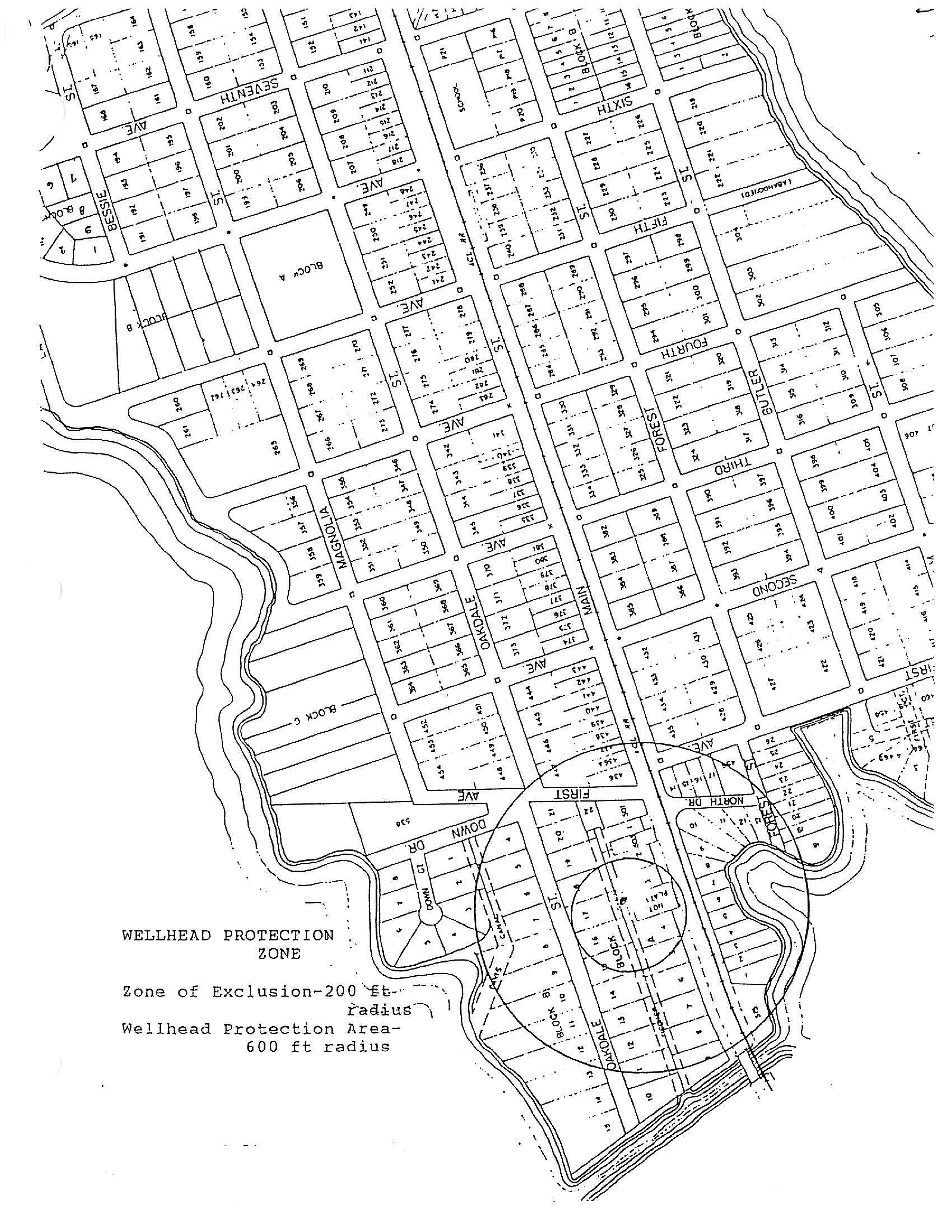
Cone of influence. A cone of influence has been established by the town, a zone of exclusion, where no development activity is permitted at the Utilities Inc., well and where any other public well is located. This cone shall be 300 feet in diameter. A zone of protection 600 feet in diameter shall be created that prohibits:
(1)
Landfills;
(2)
Facilities for the bulk storage, handling or processing of materials on the Florida Substance List;
(3)
Activities that require the storage, use or transportation of restricted substances, agricultural chemicals, petroleum products, hazardous toxic waste, medical waste, etc.;
(4)
Feedlots or other commercial animal facilities;
(5)
Wastewater treatment plants, percolation ponds, and similar facilities;
(6)
Mines; and
(7)
Excavation of waterways or drainage facilities which intersect the water table. Should the county or South Florida Water District enact other or additional regulations, these shall be incorporated into the town's regulations.
(d)
Request for determination of boundaries. A developer may obtain a determination of the boundaries of a protected environmentally sensitive zone by submitting to the town manager by certified mail or hand delivery a request for determination of boundaries. The request must, at a minimum, set forth an adequate description of the land the developer wishes to develop, the nature of the developer's right to ownership or control of the land, and other information needed to make the determination. The town shall make the determination within 15 working days of receiving the needed information from the developer. Any survey or environmental engineering costs shall be paid by the developer.
(Ord. No. 91-6, § 3(5.02.03), 2-11-1992; Ord. No. 2009-03, § 5(5.02.03), 6-9-2009)
State Law reference— Wetlands protection, F.S. ch. 403.
Sec. 5.02.04. - Development activities within protected environmentally sensitive zones.
(a)
Generally. Except as expressly provided herein, no development activity shall be undertaken in a protected environmentally sensitive zone.
(b)
Activities presumed to have an insignificant adverse effect on protected environmentally sensitive zones.
(1)
Certain activities are presumed to have an insignificant adverse affect on the beneficial function of protected environmentally sensitive zones. Notwithstanding the prohibition in subsection (a) of this section, these activities may be undertaken unless it is shown by competent and substantial evidence that the specific activity would have a significant adverse effect on the protected environmentally sensitive area.
(2)
The following uses and activities are presumed to have an insignificant adverse effect on wetlands protection zones:
a.
Scenic, historic, wildlife or scientific preserves.
b.
Minor maintenance or emergency repair to existing structures or improved areas.
c.
Cleared walking trails having no structural components.
d.
Timber catwalks and docks four feet or less in width.
e.
Recreational fishing.
f.
Cultivating agricultural or horticultural products that occur naturally on the site.
g.
Constructing fences where no fill activity is required and where navigational access will not be impaired by construction of the fence.
h.
Developing an area that no longer functions as a wetland, except a former wetland that has been filled or altered in violation of any rule, regulation, statute or this Land Development Code. The developer must demonstrate that the water regime has been permanently altered, either artificially or naturally, in a manner to preclude the area from maintaining surface water or hydroperiodicity necessary to sustain wetland structure and function. If the water regime of a wetland has been artificially altered, but wetland species remain the dominant vegetation of the area, the department shall determine the feasibility of restoring the altered hydrology. If the wetland may be restored at a cost that is reasonable in relation to benefits to be derived from the restored wetland, the developer shall, as a condition of development, restore the wetland and comply with the requirements of this Land Development Code.
i.
Developing a wetlands stormwater discharge facility or treatment wetland in accordance with state permits received under F.A.C. chs. 17-25 and 17-6.
(3)
The following uses and activities are presumed to have an insignificant adverse effect on shoreline protection zones and conservation areas:
a.
Scenic, historic, wildlife or scientific preserves.
b.
Minor maintenance or emergency repair to existing structures or improved areas.
c.
Clearing or removal of shoreline vegetation waterward of the water's edge, so as to provide a corridor not to exceed 15 feet in width of sufficient length from the shore to allow access for a boat or swimmer to reach open water, and landward of the water's edge so as to provide an open area not to exceed 20 percent of lot width or 30 linear feet, whichever is more, or as required by future revisions of the county regulations.
d.
Timber catwalks, docks and trail bridges that are less than or equal to four feet wide, provided that no filling, flooding, dredging, draining, ditching, tiling or excavating is done, except limited filling and excavating necessary for the installation of pilings and provided approval or approvals from state and local regulatory agencies, if required, and from the town are all received.
e.
Constructing fences where no fill activity is required and where navigational access will not be impaired by construction of the fence.
f.
Developing a wetlands stormwater discharge facility or treatment wetland in accordance with state permits received under F.A.C. chs. 17-25 and 17-6.
(c)
Design standards for special uses.
(1)
Generally. In addition to the standards listed in section 5.02.05(b), the standards set forth in this subsection apply to special uses allowed in the protected environmentally sensitive zones.
(2)
Special uses allowed.
a.
The development shall be designed to:
1.
Allow the movement of aquatic life requiring shallow water;
2.
Maintain existing flood channel capacity;
3.
Ensure stable shoreline embankments.
b.
Development that encroaches shall not be located:
1.
On unstable shorelines where water depths are inadequate to eliminate or minimize the need for offshore or foreshore channel construction dredging, maintenance dredging, spoil disposal, filling, beach feeding, and other river, lake and channel maintenance activities;
2.
In areas where there is inadequate water mixing and flushing;
3.
In areas which have been identified as hazardous due to high winds of flooding.
c.
Access roads, parking lots and similar structures shall be located on upland sites.
d.
Nondeveloped portions that are damaged during construction shall be restored or replaced through replanting of vegetation, restocking of fish, shellfish and wildlife, reestablishment of drainage patterns, and the like. To the maximum extent possible, the restored areas shall match their prior ecological functioning.
(d)
Mitigation.
(1)
Generally.
a.
Compensatory mitigation, by which environmentally sensitive lands are purchased, created, enhanced and/or restored to compensate for the loss of such lands, is required whenever a special use is allowed under subsection (c) of this section.
b.
The purchased, created, enhanced or restored environmentally sensitive land must be of the same type as that destroyed or degraded.
c.
Compensatory mitigation shall not be the basis for approving a project that could not otherwise be approved.
d.
A developer of a compensatory mitigation plan shall grant a conservation easement under F.S. § 704.06, on the newly purchased, created, enhanced or restored environmentally sensitive lands to protect them from future development.
e.
Where alteration of wetlands is necessary in order to allow reasonable use of property, it should be clearly in the public interest and there is no practical alternative which reduces or avoids impacts to wetlands. Mitigation shall only be a last resort action to be used only after other measures such as nonapproval of a development, reconfiguring of the development to avoid sensitive areas, reduction of density, etc. have been considered and shown not to be feasible. There shall be no net loss of sensitive lands. Any mitigation shall avoid impact to ecologically valuable uplands.
(2)
Wetlands. Compensatory wetland mitigation shall require that the amount of wetlands purchased, created, enhanced or restored be large enough to ensure that the amount of wetlands destroyed or degraded will be completely and successfully replaced. The following ratios of replacement to destroyed wetlands shall be presumed to provide reasonable assurances for type-for-type mitigation:
a.
Swamp hammock: 2.5:1.
b.
Hardwood swam: 2.5:1.
c.
Bayheads and bogs: 2.5:1.
d.
Riverine cypress: 2.0:1.
e.
Cypress pond: 2.0:1.
f.
Wet prairie: 1.5:1*.
g.
Freshwater marsh: 1.5:1*.
Note— *If the wetland creation proposed depends extensively on natural recolonization the ratio may be 3.0:1—4.0:1.
(Ord. No. 91-6, § 3(5.02.04), 2-11-1992; Ord. No. 2009-03, § 5(5.02.04), 6-9-2009)
Sec. 5.02.05. - Restricted development zone.
(a)
Generally. There is hereby created a restricted development zone adjacent to each protected environmentally sensitive area. This zone shall encompass all land within 500 feet of the boundary of the protected environmentally sensitive zone.
(b)
Development activities within restricted development zone.
(1)
All development in a restricted development zone shall be designed, constructed and maintained to avoid significant adverse effects on the adjacent environmentally sensitive zone.
(2)
The acreage within a protected environmentally sensitive zone may be used to determine the total allowable units or square footage of development that will be allowed on a site containing all or part of such a zone. This development potential may be transferred from the protected environmentally sensitive zone to the restricted development zone, as provided for in the clustering provisions in article X of this Land Development Code. Allowable development potential may not, however, be transferred from without the area encompassed by the restricted development zone and protected environmentally sensitive zone to within such area.
(3)
The following special design standards apply within restricted development zones adjacent to wetlands protection zones:
a.
Wherever possible, natural buffers shall be retained between all development and all protected environmentally sensitive zones. If a natural buffer does not exist, an equivalent buffer shall be created. The size of the buffer shall be the minimum necessary to prevent significant adverse effects on the protected environmentally sensitive area. The factual basis of the decision as to the size of the buffer shall be stated as a finding on the written record.
b.
The developer shall completely restore any portion of a protected environmentally sensitive zone damaged during construction. Complete restoration means that the damaged area shall, within five years, be operating as effectively as the natural system did prior to being destroyed.
c.
Other reasonable protective measures necessary to prevent significant adverse effects on a protected environmentally sensitive zone may be required. The factual basis of the decision to require the measure shall be stated as a finding in the written record. Protective measures may include, but are not limited to:
1.
Maintaining natural drainage patterns.
2.
Limiting the removal of vegetation to the minimum necessary to carry out the development activity.
3.
Expeditiously replanting denuded areas.
4.
Stabilizing banks and other unvegetated areas by siltation- and erosion-control measures.
5.
Minimizing the amount of fill used in the development activity.
6.
Disposing of dredged spoil at specified locations in a manner causing minimal environmental damage.
7.
Constructing channels at the minimum depth and width necessary to achieve their intended purposes, and designing them to prevent slumping and erosion and allow revegetation of banks.
8.
Dredging wetlands at times of minimum biological activity to avoid periods of fish migration and spawning, and other cycles and activities of wildlife.
9.
Designing, locating and constructing and maintaining all development in a manner that minimizes environmental damage.
10.
Prohibiting septic tanks in excess of one per two acres within the restricted development zone or locating them away from high groundwater areas and peaty soils.
11.
Using deed restrictions and other legal mechanisms to require the developer and successors to protect the environmentally sensitive areas and maintain the development in compliance with the protective measures.
(4)
The following special design standards applying within restricted development zones adjacent to conservation areas:
a.
All development shall be setback greater than or equal to 50 feet from the landward boundary of the conservation area.
b.
Total impervious surface, including, but not limited to, buildings, houses, parking lots, garages, accessory buildings and structures, driveways, pools and walkways is limited to 25 percent of the land area of the entire site.
c.
The development shall leave a minimum of 50 percent of the site as trees, shrubs or other natural vegetation, or replace existing trees at a minimum ratio of 2:1.
d.
Point source and nonpoint source discharges are prohibited, except for stormwater, which may be discharged only if it meets the following minimum standard. Stormwater discharges shall include an additional level of treatment equal to 50 percent of the treatment criteria specified in rules of the South Florida Water Management District, and shall provide offline retention or off-line detention with filtration of the first one-half inch of runoff of the total amount required to be treated. If the county or any state agency has a stormwater rule which is stricter than this standard, then the stricter rule or combination of rules shall apply.
e.
Siltation and erosion control measures shall be applied to stabilize banks and other unvegetated areas during and after construction. Sediment settling ponds shall be installed for stormwater runoff prior to the creation of any impervious surfaces. For lots or parcels that are cleared, silt screens shall be placed between the construction site and the water body to prevent erosion and siltation.
f.
Any channels constructed shall be of a minimum depth and width capable of achieving the intended purposes. Sides of channels shall reflect an equilibrium shape to prevent slumping and erosion and to allow revegetation.
g.
Any dredging shall be conducted at times of minimum biological activity to avoid fish migration and spawning, and other cycles and activities of wildlife.
h.
Any spoil that results from dredging shall be disposed of at upland sites and stabilized within 30 days, unless the spoil is causing turbidity or other problems, in which case the developer must stabilize the spoil immediately.
i.
If dredging changes the littoral drift processes and causes adjacent shores to erode, the developer shall periodically replenish these shores with the appropriate quantity and quality of aggregate.
j.
Septic tanks shall not be located closer than 150 feet from the normal high water. If septic tanks are allowed, there may be no more than one septic tank per acre of land.
k.
Environmental swales shall be constructed landward from any conservation area as prescribed by the development review (zoning) board.
(Ord. No. 91-6, § 3(5.02.05), 2-11-1992; Ord. No. 2016-01, § 13, 7-12-2016)
Sec. 5.02.06. - Prohibited ongoing activities.
The following standards apply to post-development activities taking place within any restricted development zone or protected environmentally sensitive zone:
(1)
Point source and nonpoint source discharges. Absent an amendment to the development order, point source and nonpoint source discharges shall continue to meet the standards applicable to the original development. When identified such sources shall be eliminated or reduced so as to preclude harmful impacts on the natural environment.
(2)
Clearing. Absent an amendment to the development order, no person shall clear more vegetation than was permitted for the original development.
(3)
Handling and storage of fuel, hazardous and toxic substances and wastes.
a.
Development where fuel or toxic substances will be stored, transferred or sold shall employ the best available facilities and procedures for the prevention, containment, recovery and mitigation of spillage of fuel and toxic substances. Facilities and procedures shall be designed to prevent substances from entering the water and soil, and employ adequate means for prompt and effective cleanup of spills that do occur.
b.
No toxic or hazardous wastes or substances shall be stored in outdoor containers.
c.
Storage or disposal of all types of wastes is prohibited on shorelines.
(4)
Prohibited uses. The long-term storage of equipment or materials and the disposal of wastes shall be prohibited.
(5)
Fertilizers, herbicides or pesticides.
a.
Fertilizers, herbicides or pesticides shall not be applied in a protected environmentally sensitive zone except for projects conducted under the authority of F.S. §§ 373.451—373.4595, the Surface Water Improvement and Management Act, and governmentally authorized mosquito control programs.
b.
Fertilizers, pesticides and herbicides used in restricted development zones shall be applied sparingly and at appropriate rates and time intervals.
(6)
Spray vehicles. Vehicles used for mixing or spraying chemicals are prohibited from withdrawing water directly from waters.
(7)
Pump-out, holding and treatment facilities for wastes from mobile sources. Sewage, solid waste and petroleum waste generated by vessels or vehicles on the site shall be properly collected and disposed of.
(Ord. No. 91-6, § 3(5.02.06), 2-11-1992)
Sec. 5.03.01. - Purpose and intent.
The purpose of groundwater protection standards is to safeguard the health, safety and welfare of the citizens of the town. This is accomplished through ensuring the protection of the principle source of water for domestic and agricultural use. The availability of adequate and dependable supplies of good quality water is of primary importance to the future of the town. Therefore, standards are described in this division with the intent of protecting both the quantity and quality of the groundwater supply. It is further the intent of this division to control development, in and adjacent to, designated wellheads to protect water supplies from potential contamination. The public interest test shall be applied in determining whether, and the extent to which, a proposed development or occupational use must be located within the wellfield protection area.
(Ord. No. 91-6, § 3(5.03.01), 2-11-1992; Ord. No. 93-2, § 1(5.03.01), 5-11-1993)
Sec. 5.03.02. - Definitions.
The following words, terms and phrases, when used in this division, shall have the meanings ascribed to them in this section, except where the context clearly indicates a different meaning:
Cone of influence. See Zone of exclusion.
Mapping means the wellhead protection zone map available at the town office is included herein and may be amended from time to time by the town manager as updated information becomes available.
Map Wellhead Protection Zone
Pollution means the presence of any substance (organic, inorganic, radiological or biological) or physical condition in water which degrades the quality so as to constitute a hazard or impair the use of the water.
Protected wellhead means a public potable water well.
Wellhead protection area means the area designated by the local government to protect the groundwater source for public potable water systems and includes the surface and subsurface area surrounding the public potable water wellfield where contaminants have historically degraded or are likely to degrade, the quality of the potable water supply below the groundwater standards established by the state department of environmental protection. The wellhead protection area may include all or part of the zone of exclusion. The area includes all land within a 600-foot radius of a protected wellhead.
Zone of exclusion means all land within a 200-foot radius of an existing or designated protected wellhead.
(Ord. No. 91-6, § 3(5.03.02), 2-11-1992; Ord. No. 93-2, § 1(5.03.02), 5-11-1993)
Sec. 5.03.03. - Restrictions on development.
(a)
Within the zone of exclusion. No commercial development shall take place. No septic tank, drainfield or drainfield expansion shall be permitted within 200 feet of a public potable water well or within 75 feet of a private potable well nor within 75 feet of a high-water line of a lake or canal.
(b)
Prohibited uses and development activities within the wellhead protection zone. The following land uses are prohibited within wellhead protection zone:
(1)
Landfills.
(2)
Facilities for the bulk storage, handling or processing of materials on the Florida Substance List (F.S. ch. 442).
(3)
Activities that require the storage, use, handling, production or transportation of restricted substances: agricultural chemicals, petroleum products, hazardous/toxic wastes, industrial chemicals, medical wastes, etc.
(4)
Feedlots or other concentrated animal facilities.
(5)
Wastewater treatment plants, percolation ponds and similar facilities.
(6)
Mines.
(7)
Excavation of waterways or drainage facilities which intersect the water table.
(c)
Special restrictions.
(1)
References.
a.
40 CFR 122.21, Permits to discharge pollutants.
b.
40 CFR 261, Hazardous wastes.
c.
40 CFR 264, Operating hazardous waste storage sites.
d.
40 CFR 302, (table 302.4) Reportable quantities of hazardous substances.
e.
40 CFR 355, appendix A and B, Extremely hazard substances.
f.
F.A.C. ch. 381, 30.003, Florida Substance List.
(2)
The following activities or uses are exempt from these provisions:
a.
The transportation of any hazardous substance through the wellhead protection area, provided the transporting vehicle is in continuous transit.
b.
The commercial or residential application on residential lawn or commercial landscaping of those regulated substances used as pesticides, herbicides, fungicides, and rodenticides in recreation, agriculture, pest control and aquatic weed control activities shall be exempt from the provisions of this division provided that:
1.
In the protection area, the application is in strict conformity with the use requirement as set forth in the substances EPA registries and as indicated on the containers in which the substances are sold;
2.
In the protection area, the application is in strict conformity with the requirements as set forth in F.S. chs. 482 and 487, and F.A.C. chs. 5E-2 and 5E-9; and
3.
Regulated substances shall also include the generic items listed below and byproducts, reaction products and waste products generated from the use, handling, storage or production of these items.
(i)
Acid and basic cleaning solutions.
(ii)
Antifreeze and coolants.
(iii)
Arsenic and arsenic compounds.
(iv)
Batteries.
(v)
Bleaches, peroxides.
(vi)
Brake and transmission fluid.
(vii)
Oils/greases/lubricants.
(viii)
Brine solution.
(ix)
Casting and foundry chemical.
(x)
Caulking agents and sealants.
(xi)
Cleaning solvents.
(xii)
Corrosion and rust prevention.
(xiii)
Cutting fluids.
(xiv)
Degreasing solvents.
(xv)
Disinfectants.
(xvi)
Electroplating solutions.
(xvii)
Explosives.
(xviii)
Fertilizers.
(xix)
Fire extinguishing chemicals.
(xx)
Food processing wastes.
(xxi)
Fuels and additives.
(xxii)
Glues, adhesives and resins.
(xxiii)
Greases.
(xxiv)
Hydraulic fluid.
(xxv)
Industrial and commercial janitorial supplies.
(xxvi)
Industrial sludges and stillbottoms.
(xxvii)
Inks, printing and photocopying chemical.
(xxviii)
Laboratory chemicals.
(xxix)
Medical, pharmaceutical, dental, veterinary and hospital solutions.
(xxx)
Metal finishing solutions.
(xxxi)
Oils (petroleum base).
(xxxii)
Paints, primers, thinners, dyes, stains, wood preservatives, paint solvents and paint removing compounds.
(xxxiii)
Pesticides and herbicides.
(xxxiv)
Plastic resins, and catalysts.
(xxxv)
Plasticizers.
(xxxvi)
Photo development chemicals.
(xxxvii)
Pool chemicals.
(xxxviii)
Roofing chemicals.
(xxxvix)
Solders and fluxes.
(xl)
Tanning industry chemicals.
(xli)
Transformer and capacitor oils/fluids.
4.
Discharge prohibited.
(i)
Under no conditions shall a person allow the discharge or disposal of a regulated substance into the soils, groundwater or surface water within said zones.
(ii)
Any discharge of a regulated substance of five gallons (liquid) or 25 pounds (solid) to the soils, surface water or groundwater in the town shall be reported by the facility owner or operator to the town manager or the police department. Any person knowing or having evidence of a discharge shall report such information. If the substance discharged is known, the owner, operator or person providing notification shall inform the town manager or the police department of the substance discharged and the hazard potential, if known.
(iii)
If during inspection by town personnel, a facility is found to have visible signs of contamination or if a reportable discharge occurs that may affect soil, surface water or groundwater, the facility owner shall conduct an investigation which may include soil boring, soil sampling and analysis, and monitoring well installation following the provisions of this section.
A.
Applicable rules and guidelines. Petroleum and petroleum product contamination shall follow the procedures established in F.A.C. ch. 17-770. Established state department of environmental protection (DEP) enforcement cases shall follow DEP's "Model Orders for Corrective Action" or the procedures established by consent order. All other Regulated Substances shall follow procedures set forth by the county environmental protection department on a case-by-case basis. Sampling procedures and laboratory analysis shall meet the requirements of F.A.C. ch. 17-160.
B.
Immediate corrective actions. Whenever it is determined by the inspector or town manager that a discharge of regulated substances is within 1,000 feet of a public potable water well or is resulting in danger to life or property, the town may require immediate corrective action. Initiation of any required clean-up activities shall commence within 24 hours and shall be completed within a time specified by the town. Failure to take such immediate corrective action is a violation of this Land Development Code. If immediate corrective measures are not taken and there is danger or hardship to the public, the inspector or town manager may enter upon lands, take corrective actions and place a lien on the real property of such person or persons to recover the costs of the corrective measures.
5.
Remediation.
a.
Any discharge of a regulated substance that is proven to contaminate a public or private potable well shall be remediated by the regulated substance property owner or operator at their own expense including but not limited to costs associated with reporting, technical report preparation, providing alternative potable water sources, monitoring groundwater contamination in public, private and monitoring wells, and any action taken by local officials to respond to, and provide assistance to, the responsible party.
b.
Any affected groundwater or surface water must be remediated to drinking water standards or background water quality.
c.
Affected soils shall be remediated using the best available technologies for the particular contaminant that has been released. The disposal option should be identified if soils are to be removed from the site. Stockpiling contaminated soil indefinitely is not an option within 1,000 feet of a public supply well.
d.
If any soil work is to be performed, all stormwater sedimentation erosion controls must be in place and approved by the town manager.
6.
The discharge of any regulated substance to a septic system or sewage system shall be considered a violation of this ordinance.
7.
Contractor or property owner responsible party.
a.
The general contractor, or if none, the property owner, shall be responsible for ensuring that each contractor or subcontractor evaluates each site before construction is initiated to determine if any site conditions may pose particular problems for the handling of any regulated substances. For instance, handling regulated substances in the proximity of water bodies or wetlands may be improper.
b.
If any regulated substances are stored on the construction site, including fuel storage containers and dispenser, during the construction process, they shall be stored in a location and manner which will minimize any possible risk of release to the environment. Any storage container of 55 gallons (liquid) or 440 pounds (solid), or more, containing regulated substances shall have constructed below them an impervious containment system constructed of material of sufficient thickness, density and composition that will prevent the discharge to the land, groundwater or surface water of any pollutant which may emanate from said storage tank or tanks. Each containment system shall be able to contain 150 percent of the contents of all storage containers above the containment system.
c.
Each contractor shall familiarize himself with the manufacturer's safety data sheet supplied with each material containing a regulated substance and shall be familiar with procedures required to contain and clean up any releases of the regulated substance. Any tools or equipment necessary to accomplish same shall be available in case of a release.
d.
Upon completion of construction, all unused and waste regulated substances and containment system shall be removed from the construction site by the responsible contractor and shall be disposed of in a proper manner as prescribed by law.
e.
Contractors shall be responsible for preventative measures that could discourage vandalism which causes releases of regulated substances from containers or vehicles on the construction site.
f.
Extreme care should be taken when performing maintenance or fueling equipment so that spillage of fuels, oils and greases does not occur.
g.
If a discharge occurs, it should be the responsibility of the general contractor or the property owner to follow the provisions of this regulation. It shall be considered a violation of this regulation if a discharge of regulated substances occurs and no cleanup is performed. The town reserves the right to deny the approval of a certificate of occupancy until all provisions regarding this regulation have been met.
8.
Waterwell abandonment, etc.
a.
The construction, repair, use or abandonment of any waterwell must be performed in accordance with the appropriate regulations of federal, state and regional agencies including but not limited to F.S. ch. 373, part III and F.A.C. chs. 17-20, 17-21, 17-22, 17-28 and 17-61.
b.
Any excavation (well) that is not being used for removing groundwater from an aquifer; recharge; determining quantity, quality, level or movement of groundwater; and removing or exchanging heat shall be properly abandoned at the property owner's expense following the guidelines established by the South Florida Water Management District (SFWMD).
9.
Vehicular and lawn maintenance fuels and lubricants. The use in a vehicle or lawn maintenance equipment of any regulated substance solely as fuel in that vehicle or equipment fuel tank or as lubricant in that vehicle or equipment is not regulated; however, extreme care must be taken to prevent spillage or discharging fuels and lubricants to soils, groundwater or surface water.
10.
Where public potable water wells are on property to be developed, are proposed to be added or are within 1,000 feet of any property line of the new development, the applicant shall submit information which shall include but not be limited to site hydrology, geology, geologic maps, surficial aquifer characteristics, confining unit definitions, water table contour map, direction and rate of groundwater flow, maximum/minimum recorded water table elevations, aquifer relationship to local geology, location of local discharge features, background water quality, suitability for irrigation and wastewater reuse, aquifer characteristics, and potentiometric surface map.
It is the responsibility of the applicant to submit sufficient information for the town engineer to evaluate the environmental characteristics of the affected areas. The potential and predicted impacts of the proposed activity on groundwater and the effectiveness and acceptability of those measures proposed by the applicant on reducing adverse impacts on groundwater and natural groundwater aquifer recharge areas shall be shown.
(Ord. No. 91-6, § 3(5.03.03), 2-11-1992; Ord. No. 93-2, § 1(5.03.03), 5-11-1993)
Sec. 5.03.04. - Water shortage plan.
(a)
Intent and purpose. It is the intent and purpose of this section to protect the water resources of the Town of Windermere from the harmful effects of overutilization during periods of water shortage by assisting the district in the implementation of its water shortage plan, or issued water shortage orders, under Chapter 40E-21, F.A.C.
(b)
Definitions. For the purpose of this section, the following terms, phrases, words, and their derivatives shall have the meaning listed below. When not inconsistent with the context, words used in the present tense include the future, words in the plural include the singular, and words in the singular include the plural. The word "shall" is always mandatory and not merely directory.
(1)
District means the South Florida Water Management District, a government entity created under F.S. ch. 373.
(2)
Law enforcement officials means Town of Windermere police officer, code enforcement officer, or other official designated by the town manager.
(3)
User means any person, individual, firm, association, organization, partnership, business trust, corporation, company, agent, employee or other legal entity whether natural or artificial, the United States of America, and the State and all political subdivisions, regions, districts, municipalities, and public agencies thereof, which directly or indirectly takes water from the water resource, including uses from private or public utility systems, uses under water use permits issued pursuant to Chapter 40E-2, F.A.C., or uses from individual wells or pumps.
(4)
Water resource means any and all water on or beneath the surface of the ground, including natural or artificial water courses, lakes, ponds, or diffused surface water, and water percolating, standing, or flowing beneath the surface of the ground.
(5)
Water shortage means when the district determines there is the possibility that insufficient water will be available to meet the present and anticipated needs of the users, or when conditions are such as to require temporary reduction in total use within a particular area to protect water resources from serious harm.
(6)
Water shortage emergency means when the district has determined that the provisions listed in Part II of Chapter 40E-21, F.A.C., are not sufficient to protect the public health, safety, or welfare, the health of animals, fish, or aquatic life, a public water supply, or commercial, industrial, agricultural, recreational, or other reasonable beneficial uses.
(c)
Applicability. The provisions of this section shall apply to each user, as defined in subsection (b)(3), using the water resource, as defined in subsection (b)(4), within the geographical areas subject to the water shortage condition or water shortage emergency, as defined in subsection (b)(6), as determined by the district, whether from publicly or privately-owned water utility systems, private wells, or private connections with surface water bodies. This section shall not apply to users using reclaimed water or saltwater.
(d)
Declaration of water shortage or water shortage emergency.
(1)
A declaration of a water shortage condition and/or water shortage emergency in accordance with Part II of Chapter 40E-21, F.A.C., within all or parts of the Town of Windermere by the district's governing board or executive director, shall invoke the provisions of this section.
(2)
A water shortage, as defined in subsection (b)(5), or water shortage emergency order shall supersede mandatory year-round water irrigation measures until the more restrictive measure is rescinded by the district.
(3)
Upon the district issuing a water shortage order, all water use restrictions or other measures adopted by the district applicable to Town of Windermere, or any portion thereof, shall be subject to enforcement action by the Town of Windermere officials pursuant to subsection (f) of this section. Any violation of Chapter 40E-21, F.A.C., or any order issued pursuant thereto, shall be a violation of this section.
(e)
Variances. The Town of Windermere recognizes all variances issued by the District pursuant to Rule 40E-21.275, F.A.C.
(f)
Enforcement. The Town of Windermere authorizes law enforcement officials having jurisdiction in the area governed by this section to enforce the provisions of this section. In addition, the town manager may delegate this section's enforcement responsibility to agencies and departments within the Town of Windermere government.
(g)
Penalties.
(1)
Violation of any provision of this section shall be subject to the following penalties:
a.
First violation, a written warning.
b.
Second violation, a fine not to exceed $25.00.
c.
Subsequent violations, a fine not to exceed $500.00.
(2)
Each day a violation of this section occurs shall be a separate offense. Law enforcement officials, and others as delegated, may provide violators with no more than one written warning. In addition to civil penalties the Town of Windermere may take any other appropriate legal action, including but not limited to injunctive action to enforce the provisions of this section.
(Ord. No. 91-6, § 3(5.03.04), 2-11-1992; Ord. No. 95-1, § 1(5.03.04), 1-4-1995; Ord. No. 2001-05, § 1, 5-8-2001; Ord. No 2020-03, §§ 1—8, 7-14-2020)
Sec. 5.04.01. - Generally.
(a)
Purpose and intent. It is the purpose of this division to provide standards necessary to protect the habitants of species, both flora and fauna, of endangered, threatened or special concern status in the town. It is the intent of this division to require that an appropriate amount of land shall be set aside to protect habitat for rare, endangered or special concern plant and animal species. No net loss of habitat shall result of development.
(b)
Applicability. Areas subject to the standards of this division shall be those identified in the conservation element of the town comprehensive plan as habitat for rare and endangered species, threatened species or species of special concern.
(Ord. No. 91-6, § 3(5.04.01), 2-11-1992)
Sec. 5.04.02. - Habitat management plan.
(a)
When required. A habitat management plan shall be prepared as a prerequisite to the approval of any development proposed on a site containing areas subject to this division.
(b)
Contents. The habitat management plan shall be prepared by an ecologist, biologist or other related professional. The plan shall document the presence of affected species, the land needs of the species that may be met on the development site, and shall recommend appropriate habitat management plans and other measures to protect the subject wildlife.
(c)
Conformity of final development plan. The final development plan approved for a development shall substantially conform to the recommendations in the habitat management plan.
(d)
Preservation of land. Where land on a proposed development site is to be preserved as habitat for rare, endangered or special concern species, such land shall be adjacent to existing viable habitat, a significant wetlands system, floodplain or wildlife corridor. If such lands are not adjacent to the development site, land to be set aside shall be of such quantity and quality as to provide viable habitat, as documented in the study required in subsection (b) of this section.
(e)
Fee in lieu. As an alternative to preservation of land, the town may establish a fee-in-lieu of land program, whereby the town can purchase land which will provide a significant habitat.
(Ord. No. 91-6, § 3(5.04.02), 2-11-1992)
Sec. 5.05.01. - General provisions.
Chapter 16, flood damage prevention; chapter 24, planning and development; part II, Code of Ordinances; Charter and general ordinances of the town are incorporated into these regulations by reference including findings, statement of purpose, objectives, definitions, procedures, standards and penalties as required by the National Insurance Program and the town shall remain in that program as amended.
(Ord. No. 91-6, § 3(5.05.01), 2-11-1992)
Sec. 5.05.02. - Other.
(a)
All preliminary subdivision proposals shall identify the area of special flood hazard and the elevation of the base flood.
(b)
All final development plans shall identify the elevation of proposed structures and pads. If the site is filled above the base flood, the final pad elevation shall be certified by a registered professional engineer or surveyor.
(c)
All public utilities and facilities in subdivisions shall be located and constructed to minimize flood damage, and shall be adequately drained to reduce exposure to flood hazards.
(d)
Each lot must include a site suitable for constructing a structure in conformity with the standards of these flood damage prevention regulations.
(e)
All agreements for deed, purchase agreements, leases or other contracts for sale or exchange of lots within an area of special flood hazard and all instruments conveying title to lots within an area of special flood hazard must prominently publish the following flood hazard warning in the document:
Flood Hazard Warning
This property may be subject to flooding. You should contact local building and zoning officials and obtain the latest information about flood elevations and restrictions before making plans for the use of this property.
(f)
Channelization, diversion or damming of natural rivers, streams or ditches shall be discouraged.
(g)
No fill is permitted within the 100-year floodplain unless proper compensatory storage is provided and any county and state regulations are complied with.
(h)
No public facility shall be located within the 100-year floodplain or in a floodprone area unless county, state and ECFRPC regulations are complied with.
(Ord. No. 91-6, § 3(5.05.02), 2-11-1992)
Sec. 5.05.03. - Structures near lakes, canals or runs.
No structure to include accessory buildings and structures shall be erected or placed within 50 feet of the normal high-water elevation, unless otherwise provided within the Land Development Code, and no fill shall be permitted below that normal high-water elevation. In addition, as required in section 16-69 of the Code of Ordinances and this division, residential finished floor construction of Lake Down or its canals, Lake Butler and Wauseon Bay shall be no lower than 104-foot MSL and/or Lake Bessie no lower than 105-foot MSL.
(Ord. No. 91-6, § 3(5.05.03), 2-11-1992; Ord. No. 2016-01, § 14, 7-12-2016)
Sec. 5.05.04. - Inspection of drainage systems.
The town shall inspect all drainage systems within the town annually and a report of the findings filed with the required five-year evaluation and appraisal report.
(Ord. No. 91-6, § 3(5.05.04), 2-11-1992)
Sec. 5.06.01. - Generally.
The provisions of this section shall apply to any lake or canal front property in addition to any other provision of this Land Development Code.
(Ord. No. 91-6, § 3(5.06.01), 2-11-1992)
Sec. 5.06.02. - Definitions.
Unless specifically defined as follows, words or phrases used in this article shall be interpreted so as to give this article its most reasonable, liberal application:
Clearance means the alteration of or removal of vegetation by the deposition of sand, dirt or other material, or by uprooting and removal by mechanical or non-mechanical means or by chemical treatment.
Fill means the addition of materials including, but not limited to dirt, sand, gravel, stone, crushed stone, cement, cement rubble, mulch, wood or railroad ties which result in changes to the topography or vegetation that exists on the shoreline and waterfront areas of waterfront properties.
Normal high-water elevation, in this division of this Land Development Code, is set at 97.5 feet MSL for Lake Bessie and 99.5 feet MSL for other Butler Chain water bodies.
Reestablish means the regrowth of shoreline vegetation, where the average growth height is more than 14 inches above the shore or water surface, as appropriate.
Retaining wall means the same as seawall.
Revegetation means the planting and establishment of terrestrial and aquatic grasses and plants, both emergent and nonemergent, associated with waterfront and shoreline environments.
Seawall means any structure involving stone, brick, concrete, metal or wood intending to stabilize the shoreline as protection against erosion or water action.
Shoreline means the land area which exists between the normal high-water elevation during typical hydrological conditions and the point measured ten feet landward of said normal high-water elevation.
Shoreline alteration means, for purposes of these regulations, the clearing or removal of shoreline vegetation or any substances or materials (except water) existing at or below the normal high-water elevation. This definition shall not be construed as limiting the town's jurisdiction pursuant to general and special law to regulate and permit other types of shoreline alterations or other activities.
Shoreline vegetation means vegetation which grows or exists at or below the normal high-water elevation, and includes terrestrial and aquatic plants, both emergent and nonemergent, associated with wetlands.
Trimming means the pruning or clipping of shoreline vegetation with hand-powered tools which does not result in the removal of three inches of the stem and root of the plant.
Waterfront means the water area of occasional land area which exists between the normal high-water elevation during typical hydrological conditions and the point measured 30 feet out seaward of said normal high-water elevation.
Waterfront vegetation means vegetation which grows or exists at or below the normal high-water elevation, and includes terrestrial and aquatic plants, both emergent and non-emergent, associated with wetlands.
Waterway means any waters, lake, canal, stream, lagoon or connecting waters, whether natural or manmade, partially or wholly within the boundaries of the town.
(Ord. No. 91-6, § 3(5.06.02), 2-11-1992)
Sec. 5.06.03. - Requirements.
(a)
All persons desiring to perform or cause to be performed any shoreline alteration involving the alteration, clearance, fill or construction of a seawall, which involves changes to the shoreline or waterfront vegetation shall be required to obtain a permit from the town unless exempt by these regulations. The permit shall be submitted to the town manager.
(b)
The town manager shall be empowered to grant a permit only if the applicant demonstrates that this shoreline or waterfront clearing or alteration will not be adverse to the public purposes and benefits of maintaining lake water quality and fish and wildlife habitat and reducing nutrient loading by maintaining shoreline and waterfront vegetation necessary for the health and viability of a lake system. The applicant must further demonstrate that the proposed removal of vegetation will not degrade water quality below the standards set forth in F.A.C. ch. 17. Each applicant for a shoreline alteration permit shall submit a site plan, photographs and materials containing information and addressing the following items:
(1)
The percentage, area and types of shoreline and waterfront vegetation proposed to be removed and to be maintained;
(2)
A plan showing any proposed changes in shoreline contour to include existing and proposed topographic elevations. Also included shall be the quantities of material to be removed and filled in cubic yards;
(3)
A plan showing the proposed method for controlling erosion, filtering run-off and reducing nutrient concentration;
(4)
The means for minimizing and controlling erosion;
(5)
The means for stabilizing soils at and below the normal high-water elevation;
(6)
The justification for the replacement vegetation and its ability to protect and improve water quality. All mechanically cleared or trimmed vegetation shall be removed from the lake and the normal high-water elevation within 24 hours of clearing or trimming. Failure to do so will constitute a violation of these regulations; and
(7)
The reasons for such request and an explanation of the hardship expected if a permit is not granted.
(c)
If the town manager determines that any alteration or filling is occurring or has occurred without prior approval or is not in accordance with these regulations or approved permit, a written notice of violation shall be issued promptly to the property owner. The notice of violation shall include the description of the property involved, the provisions of these regulations or other applicable regulations which have been violated, and the remedial action to be taken. Such remedial action may include restoration to the existing conditions, revegetation of the shoreline or waterfront, application for permit, payment of permit fees or other action consistent with these regulations. If any person commences any shoreline alteration or the removal of any shoreline or waterfront vegetation before obtaining the necessary permit, he shall be subject to a penalty of triple the permit fees. If any person fails to apply for the necessary permit within 30 days of receipt of written notice of violation, such person shall also be subject to an additional penalty of triple the permit fees for each month or portion thereof occurring, commencing 30 days from the date of receipt of written notice of violation and continuing until proper application for the necessary permit is made.
(d)
The town manager may include such provisions, terms and conditions in any permit issued hereunder as it may determine reasonable and necessary. Any permit issued hereunder may be revoked by the town for violation or noncompliance with the provisions of said permit, this article, and general or special law, mistake of fact, or mistake of law.
(e)
The permit fee for applications for shoreline or waterfront vegetation removal shall be as established by the town council and on file in the town clerk's office to cover the administrative cost of processing such application and for inspection to ensure the clearing, if approved, is done in accordance with the permit and these regulations.
(f)
Nothing in the regulations set forth in subsections (a) through (e) of this section is intended to relieve a property owner or contractor of any obligation under state law or county regulations to obtain required permits from the state department of environmental regulation, department of natural resources or other governmental authorities having jurisdiction, when applicable.
(g)
Exemptions. These regulations and the requirement to obtain a permit hereunder shall not apply to the following:
(1)
Any person or property owner hand clearing less than 20 percent or 30 feet, whichever is greater, of lands at or below the normal high-water elevation.
(2)
Emergency repairs on public or private projects necessary for the preservation of life, health or property, where taken to implement and accomplish the beneficial purposes of these regulations as set forth herein under such circumstances where it would be impractical to obtain approval from the town manager prior to making such emergency repairs.
(3)
Maintenance of publicly or privately owned portions of a structural stormwater or drainage control system which does not constitute major construction or rebuilding.
(4)
Any person or property owner clearing shoreline vegetation which is within the physical confines of a dock, gazebo or boathouse construction approved by the town.
(5)
Lawn mowing, trimming of vegetation, and other lawn maintenance activities which will not result in the clearance of shoreline vegetation.
(6)
All cleared or trimmed vegetation shall be removed from the lake and/or lakefront for off-site disposal. Any permit issued may be revoked by the town for violation or noncompliance with the provisions of said permit, these regulations, mistake of fact or conflict with other town county or state regulations.
(7)
The changing of any shoreline by digging or adding fill, which alters or changes the shoreline or existing topography of the shoreline or waterfront of any water body within the town shall be prohibited, unless done in accordance with an approved shoreline alteration permit. A permit shall also be required to pump or withdraw sand or any other material from lake bottoms.
(8)
A property owner whose shoreline has previously been cleared where the clearing is continuous maintained. If shoreline vegetation is allowed to reestablish, this exemption from permitting shall not apply.
(h)
The county boat ramp ordinance applies to any construction or alteration of private boat ramps in town. However, boat ramp construction and alteration of private boat ramps is allowed only if approved by permit issued by the town upon authorization from the town council.
(i)
Liberal construction. The provisions of this article shall be liberally construed to the effect of its purpose.
(Ord. No. 91-6, § 3(5.06.03), 2-11-1992; Ord. No. 94-2, § 1(g), 2-8-1994; Ord. No. 2015-03, § 1, 4-14-2015)