
Windermere City Zoning Code
ARTICLE VI
DEVELOPMENT DESIGN AND IMPROVEMENT STANDARDS
Sec. 6.00.01. - Purpose.
(a)
Provide standards. The purpose of this article is to provide development design and improvement standards applicable to all development activity within the town.
(b)
Design regulation and goals. The goals and objectives of the design review evaluation process for new construction or improvements are as follows:
(1)
Preserve the natural beauty of the town and protect the character of the town from the effects of inharmonious and out of scale developments.
(2)
Encourage originality, flexibility and innovation in site planning and development.
(3)
Discourage monotonous, drab, unsightly, dreary and inharmonious developments.
(4)
Conserve the town's natural beauty and visual character and charm by ensuring that structures and other improvements are properly related to their sites, and to surrounding sites and structures, with due regard to the aesthetic qualities of the natural terrain and landscaping and that proper attention is given to exterior appearances or buildings, structures and other improvements.
(5)
Protect and enhance the town's aesthetic and natural appeal.
(6)
Maintain and improve property values.
(7)
Achieve the beneficial influence of pleasant environments for living and working.
(8)
Foster citizen participation in local government and in community growth, change and improvements.
(9)
Sustain the comfort, health, tranquility and contentment of residents by reason of the town's favorable environment.
(c)
Design regulation objectives. In order to provide guidance to builders, property owners and residents, the following objectives shall be used in the review of buildings, structures and other improvements in the design review process:
(1)
Site design. Good site design is essential to good building design. Site improvements should be compatible with, and sensitive to, the natural features of the site and of the surrounding area. Design solutions should relate to and take advantage of site topography, trees, vegetation and slope. Designs should recognize the limitations of the land and work with these limitations rather than ignoring them or trying to override them.
(2)
Neighborhood design. Site improvements should be compatible with structures existing on neighboring parcels and should be sensitive to their designs and neighboring property rights. Designs which conflict with the use and enjoyment of any property should be avoided. Buildings should be designed in scale with the neighborhood and should complement the character of the neighborhood rather than conflict with it.
(3)
Scale. Buildings should relate to a human scale in their forms, elements and in the detailing of doors, windows and walkways. Oversized elements make structures appear dominating, massive and monumental. This out-of-scale character represents a poor fit to the human form, violates the charm and character of the town and should therefore be avoided.
(4)
Mass and bulk. Buildings should not present excess visual mass or bulk to public view or to adjoining properties. Large box-like buildings and buildings with large, blank or continuous, unrelieved surfaces can appear massive. When viewed from the public right-of-way, excessive mass detracts from the character of the town's individual neighborhoods. When viewed from adjoining properties, excess mass can effectively act as a wall that dominates neighboring structures and interferes with the enjoyment of open space and the free passage of light and air. The use of natural materials, the breaking up of building planes and the creative use of landscaping can all be used to avoid excess mass.
(5)
Boxed-in neighbors. Designs should protect and preserve the light, air and open space of surrounding properties, when considered cumulatively with other buildings in the neighborhood. Designs incorporating tall or bulky building elements located near the property line of an adjoining site that is already partially boxed-in by previous development should be avoided.
(6)
Architectural style. The town contains an eclectic mix of architectural styles including virtually all of the traditional architectural styles, in whole or in part. Compatibility with neighborhood character demands the use of architectural styles and elements that are commonly found in the town and within the state. Unique architectural styles that are uncommon in residential environments should be avoided.
(7)
Privacy. Design should respect the privacy of neighbors. The placement of windows, doors, balconies and decks should be sensitive to similar improvements on neighboring properties.
(8)
Private views. Designs should respect views enjoyed by neighboring parcels. It is the intent of this objective to balance the private rights to views from all parcels that will be affected by a proposed building or addition. No single parcel should enjoy a greater right than other parcels except the natural advantages of each site's topography. Buildings which substantially eliminate an existing view enjoyed on another parcel should be avoided.
(9)
Solar access. Designs should preserve the rights to reasonable solar access on neighboring parcels. Excessively tall buildings, particularly those near a north property line, which would block the free passage of the sun onto neighboring solar collectors or south-facing windows should be avoided.
(10)
Equity. Design controls should be fair and not grant privileges to some sites while withholding them from other sites, the design study process should be fair and decisions should be reached in an unbiased manner.
(11)
Structure. Anything constructed, erected or placed, the use of which requires more or less permanent location on or in the ground or attached to something having a permanent location on or in the ground. Among other things, the term "structure" includes buildings, swimming pools, antennas, tanks, pumps, air condition units, walls, fences and signs; but does not include paving and sidewalks.
(d)
Additional guidelines. These additional guidelines are provided to assist developers and town officials in the preparation and review of development submissions.
(1)
Upland sites should be chosen for the location of residential, commercial and industrial buildings.
(2)
Normally, isolated wetlands tend to fill and then overflow during floods. Flowage areas should be protected from incompatible development. The construction of roads across such areas should be limited, for example, and any roads that are built should be constructed on pilings or with adequate culverts to allow the passage of floodwaters.
(3)
Runoff shall not be discharged directly into open waters. Instead, vegetated buffers, swales, vegetated watercourses, wetlands, underground drains, catchbasins, ponds, porous pavements and similar systems for the detention, retention, treatment and percolation of runoff should be used as appropriate to increase time of concentration, decrease velocity, increase infiltration allow suspended solids to settle and remove pollutants.
(4)
Natural watercourses should not be filled, dredged, cleared, deepened, widened, straightened, stabilized or otherwise altered.
(5)
Intermittent watercourses, such as swales, should be vegetated.
(6)
Vegetated buffer strips should be created or, where feasible, retained in their natural state along the banks of all watercourses, water bodies or wetlands. The width of the buffer should be sufficient to prevent erosion, trap the sediment in overland runoff, provide access to the water body and allow for periodic flooding without damage to buildings, roads or other structures.
(7)
The first one-inch of runoff shall be retained on site.
(8)
Runoff from parking lots shall be treated to remove oil and sediment before it enters receiving waters.
(9)
Detention and retention areas should be designed so shorelines are sinuous rather than straight and so the length of the shoreline is maximized, thus offering more space for the growth of littoral vegetation.
(10)
The banks of detention and retention areas should slope at a gentle grade into the water as a safeguard against personal injury, to encourage the growth of littoral vegetation and allow the alternate flooding and exposure of areas along the shore.
(11)
The use of drainage facilities and vegetated buffer zones as open space, recreation and conservation areas should be encouraged.
(12)
Although the use of wetlands for storing and purifying water is encouraged, care should be taken not to overload their capacity, thereby harming the wetland and transitional vegetation. Wetlands should not be damaged or replaced by the construction of detention ponds unless equivalent wetlands are created.
(13)
Erosion shall be minimized and sediment shall be retained on the site of development.
(14)
The area of land disturbed by development shall be the minimum feasible. Those areas which are not to be disturbed should be protected by an adequate barrier from construction activity. Whenever possible, retain and protect natural vegetation.
(15)
Erosion and sedimentation control devices shall be installed between the disturbed area and water bodies, watercourses and wetlands before grading, cutting or filling is begun.
(16)
Land which has been cleared for development and upon which construction has not commenced shall be protected from erosion by appropriate techniques designed to stabilize soil and revegetate the area.
(17)
Wetlands and other natural water bodies shall not be used as sediment traps during development.
(18)
Erosion and sedimentation facilities should receive regular maintenance to ensure they continue to function properly.
(19)
Artificial watercourses should be designed, considering the soil type, so the velocity of flow is low enough to prevent erosion.
(Ord. No. 91-6, § 3(6.00.01), 2-11-1992)
Sec. 6.00.02. - Responsibility for improvements.
All improvements required by this article shall be designed, installed and paid for by the developer so as to maintain an established level of service standards. At such time as impact fees are imposed, applicable credits if any, shall be determined and established by the town council.
(Ord. No. 91-6, § 3(6.00.02), 2-11-1992)
Sec. 6.00.03. - Principles of development design.
(a)
The provisions of this article are intended to ensure functional and attractive development. Development design shall first take into account the protection of natural resources as prescribed in article V of this Land Development Code. All development shall be designed to avoid unnecessary impervious surface cover; to provide adequate access to lots and sites; and to avoid adverse effect of shadow, glare, noise, odor, traffic, drainage and utilities on surrounding properties.
(b)
Generally.
(1)
All new construction shall comply with chapter 89-97, General Laws of Florida, 1989, (F.S. § 553.48) relating to accessibility by handicapped persons.
(2)
Energy-efficient and water saving measures shall be required in all new construction to include low volume plumbing fixtures. At 80 psi the following standards shall be required:
a.
Toilets: 1.6 gallons per flush.
b.
Shower heads: 2.5 gallons per minute.
c.
Faucets: 2.0 gallons per minute.
(3)
Any redevelopment and renovation activities shall remain in harmony with surrounding residential properties.
(4)
Sound engineering practices shall be required with respect to the topography and soil conditions in and adjacent to any development.
(5)
All development shall minimize rises in lake levels and preclude lowering of water quality.
(6)
Solar systems orientation and access, natural ventilation, and use of shade trees and other vegetation shall be considered in review of all development plans.
(7)
Public facilities and services intended to serve future development needs that are inconsistent with the comprehensive plan shall not be permitted or provided without an amendment to the comprehensive plan.
(8)
Developments that maximize the use of existing public facilities and that enhance the quality of life in the town shall be considered for bonus points or relaxation of density restrictions.
(Ord. No. 91-6, § 3(6.00.03), 2-11-1992)
Sec. 6.01.01. - Minimum lot area requirements.
(a)
Requirements for all developments. All developments shall have a total land area sufficient to meet all development design standards in this Land Development Code, including, but not limited to, land required to provide setbacks from abutting rights-of-way, buffers, stormwater management, off-street parking and circulation, protection of environmentally sensitive land and any other provisions which may require land area to be set aside.
(b)
Specific requirements for residential development. There is no minimum lot area for individual lots within a residential development that will be served by both a central water and central sewer system, provided that all of the following requirements are met:
(1)
The land area for the total project is sufficient to meet standards of this Land Development Code, as stated in subsection (a) of this section.
(2)
Gross density of the area shall not exceed that specified in section 2.02.04, table of density and dwelling unit types for residential uses.
(3)
Land, exclusive of individual lots to be conveyed in fee simple ownership, shall be controlled and maintained through a property owners' association, or other similar provision, or may be conveyed to governmental or not-for-profit organizations. Recordable instruments providing for these common ownership lands shall be submitted for review with the application for development plan review.
(c)
Specific requirements for areas without central utilities. All proposed development in areas that will not be served by central water and central sewer systems shall have the following minimum lot areas:
No structure septic tank or other individual waste water treatment system shall be permitted in an area deemed environmentally unsuitable for their proper and continued functioning.
(Ord. No. 91-6, § 3(6.01.01), 2-11-1992)
Sec. 6.01.02. - Impervious surface coverage.
(a)
Generally. Impervious surface on a development site shall not exceed the ratios provided in the table in subsection (e) of this section.
(b)
Ratio calculation. The impervious surface ratio is calculated by dividing the total impervious surface by the gross site area. Water bodies are impervious and shall be included as such in the impervious surface ratio calculation.
(c)
Treatment of cluster development. Because the impervious surface ratio is calculated for the gross site, cluster development or other site design alternatives may result in individual lots within a development project exceeding the impervious surface ratio, while other lots may be devoted entirely to open space. The development review board may require, as a condition of approval, deed restrictions or covenants that guarantee the maintenance of such open space in perpetuity.
(d)
Alternative paving materials. If porous paving materials are used then the area covered with porous paving materials shall not be counted as impervious surface. Standard engineering coefficients of permeability may be used for mixed surfaces.
(e)
Land use district maximum impervious surface ratio.
(1)
The maximum impervious surface ratio is given for each district, regardless of the type of use proposed and allowable pursuant to article II of this Land Development Code.
(2)
The impervious surface ratio is the percentage of the lot or site covered with buildings, accessory structures, swimming pools, patios, decks, driveways, parking areas and any other area covered with impervious materials.
(3)
Lot coverage on lakefront lots shall only be computed using the site area used for the building. Land area located across a street and separated from the building site shall not be included in any available land area calculation.
(Ord. No. 91-6, § 3(6.01.02), 2-11-1992)
Sec. 6.01.03. - Building setback requirements.
(a)
Minimum setback on side and rear yards. There are no minimum setbacks required for side and rear yards (those sides of a building which do not abut a right-of-way), provided that one of the following requirements shall be met:
(1)
If the distance from the exterior wall and any air conditioner, pump, heater or other structural element is less than five feet, the applicant must show evidence of a maintenance easement granted by adjacent property owners.
(2)
The structure may be built on the property line provided the owner shall grant an attachment easement to the adjacent property owners, but to only one adjacent side owner. Where structures are built on a property line, a rear yard of 35 feet is required for fire vehicles (turn around, movement.)
(b)
Minimum setbacks for buildings exceeding 25 feet in height. When a building exceeds 25 feet in height, the minimum distance from an adjacent building or property line shall be increased by two feet for each story or half story above two.
(c)
Other.
(1)
No principal building or accessory building or structure, other than a boathouse or dock or potable water or irrigation well shall be permitted within 50 feet of the normal high-water elevation of any water body.
(2)
No septic tank or drainfield shall be placed within 150 feet of the normal high-water elevation of any water body unless a variance is applied for and approved by the town council.
(Ord. No. 91-6, § 3(6.01.03), 2-11-1992; Ord. No. 2009-03, § 6(6.01.03), 6-9-2009; Ord. No. 2010-06, § 1, 9-14-2010; Ord. No. 2016-01, § 15, 7-12-2016)
Sec. 6.01.04. - Height and floor area limitations.
(a)
Definitions. The following words, terms and phrases, when used in this section, shall have the meanings ascribed to them in this subsection, except where the context clearly indicates a different meaning:
Basement means the portion of a building between two floor levels that is partly underground. A basement having three feet or more of its height above natural grade at any point shall be counted as a full story. A basement having less than three feet of its height above natural grade shall be counted as a half-story.
Building height means the vertical distance of a building measured from the elevation of the average undisturbed existing lot grade at the front setback to the highest point of the building, including any structure, equipment or appurtenance located above the roof level. Exceptions for chimneys, church spires, etc., shall be considered by the development review board. The average undisturbed existing lot grade at the front setback shall be calculated by taking the average of the undisturbed existing lot grade at each point of intersection of the property line with the front setback line.
Floor area means the sum of the gross horizontal areas of the several floors of a building or buildings measured from the exterior surface of the walls. Basement areas or other below grade floor areas shall be excluded from the calculation of floor area when more than one-half of that basement or floor height is below the average elevation at the front setback (as described in the term "building height" in this section). The area of stairways, elevators, multi-story rooms or atriums shall be counted on each floor level and included in the calculation of floor area. The area contained within garages, carports, screened or roofed porches and balconies shall be included in the calculation of floor area. The floor area of a single-family building shall further include the area of atriums and volume ceiling spaces on each floor when the interior floor to ceiling height of such rooms exceeds 17½ feet.
Floor area ratio (FAR) means the ratio of floor area to the total square footage of the lot upon which construction is contemplated. The floor area ratio on lakefront lots shall be computed using only the portion of the lot upland of the normal high-water line. Also, land located across a road, street or highway from the building site shall not be included as available land in the calculation.
Story means that portion of a building included between the surface of any finished floor and the surface of the next finished floor above it, or if there is no floor above it, then the space between such floor and ceiling next above it, unless such space is less than 5.5 feet in height. Wherever the height between two finished floors (or finished floor and ceiling) exceeds 17½ feet, each height of 15 feet or portion greater than 5.5 feet thereof shall be construed to be one story.
Story, half, means a space under a sloping roof which has the line of intersection of roof decking and wall face not more than three feet above the top floor level, and in which space not more than two-thirds of the floor area is finished off for use. A half-story containing an independent apartment shall be counted as a full story.
(b)
Maximum height. No residential structure shall exceed 2½ stories or 35 feet in height, whichever is less, and all other structures shall be limited to two stories or 35 feet in height, whichever is less, as measured from the elevation of the average undisturbed existing lot grade at the front setback.
(c)
Maximum floor area ratio. Principal and accessory buildings and accessory structures constructed in residential zones shall not exceed a floor area ratio of 38 percent.
(d)
Adjoining properties to be considered. The size, height, bulk and architecture of adjoining properties shall be considered so as to adequately protect surrounding properties. Excessively massive buildings or buildings which dominate neighborhood structures should be avoided. Inequitable loss of private views resulting from excessively tall or poorly planned structures shall not be permitted.
(Ord. No. 91-6, § 3(6.01.04), 2-11-1992; Ord. No. 2007-01, § 1, 2-13-2007; Ord. No. 2012-04, § 1, 6-12-2012; Ord. No. 2016-01, § 16, 7-12-2016)
Sec. 6.02.01. - General provisions.
(a)
Purpose. This division establishes minimum requirements applicable to the development transportation system, including public and private streets, bikeways, pedestrian ways, parking and loading areas, and access control to and from public streets. The standards in this division are intended to minimize the traffic impacts of development, to ensure that all developments adequately and safely provide for the storage and movement of vehicles consistent with good engineering and development design practices.
(b)
Compliance with technical construction standards. All required elements of the transportation system shall be provided in compliance with the engineering design and construction standards of the state department of transportation (DOT).
(Ord. No. 91-6, § 3(6.02.01), 2-11-1992; Ord. No. 2009-03, § 6(6.02.01), 6-9-2009)
Sec. 6.02.02. - Streets.
(a)
Street classification system established.
(1)
Streets in the town are classified and mapped according to function served in order to allow for regulation of access, road and right-of-way widths, circulation patterns, design speed and construction standards.
(2)
Private streets and streets that are to be dedicated to the town are classified in a street hierarchy system with design tailored to function. The street hierarchy system shall be defined by road function and average daily traffic (ADT), calculated by trip generation rates prepared by the Institute of Transportation Engineers. Trip generation rates from other sources may be used if the developer demonstrates the alternative source better reflects local conditions.
(3)
When a street continues an existing street that previously terminated outside the subdivision, or is a street that will be continued beyond the subdivision or development at some future time, the classification of the street will be based upon the street in its entirety, both within and outside of the subdivision or development.
(4)
The following streets hierarchy is established: local, collector and arterial. Each street type is divided into subcategories. All development proposals containing new streets or taking access from existing streets shall conform to the standards and criteria contained in this division.
(b)
Residential (local) streets.
(1)
Residential local streets are primarily suited to providing direct access to residential development, but may give access to limited nonresidential uses, provided average daily traffic (ADT) volume generated by the nonresidential use does not exceed applicable standards for the affected streets. All residential streets should be designed to minimize unnecessary and/or speeding traffic. Each residential street shall be classified and designed for its entire length to meet the minimum standards for one of the following street types.
a.
Residential access street. This is the lowest order street in the hierarchy. A residential access street is a frontage street which provides direct access to abutting properties and is designed to carry no more traffic than is generated on the street itself. Residential access streets may take access from any higher order street type. Both ends of a residential loop street must take access from a single higher order street. The design speed for residential access streets is 20 miles per hour. Residential access streets shall have a maximum ADT of 500. Cul-de-sacs shall have a maximum ADT of 200. Loop streets shall have a maximum ADT of 400.
b.
Residential subcollector street. This is the middle order street in the residential street hierarchy. It will collect traffic from residential access streets and provide direct access to abutting properties. Residential subcollector streets shall have a design speed of 25 miles per hour. Residential subcollector streets may take access from any higher street type and may give access to residential access streets and may provide direct access to limited nonresidential uses. Loop streets carrying more than 500 ADT must have two intersections with higher order streets. Lots of less than 40 feet in width may not take access from a residential subcollector. Residential subcollector streets shall have a maximum ADT of 1,000.
c.
Residential collector street. This is the highest order street that can be classified as residential. In larger developments, this class of street may be necessary to carry traffic from one neighborhood to streets connecting to other areas in the community. It will collect traffic from residential access and subcollector streets and may provide direct access to limited nonresidential uses. Residential collector streets shall have a design speed of 30 miles per hour. No individual residential uses shall take direct access from residential collector streets except where no feasible alternative exists. All residential collector streets shall take access from at least two equal or higher order street types or give access to residential access and subcollector streets. Residential collector streets shall have a maximum ADT of 2,000.
(2)
Where an enhanced level of service or other benefits can be shown to benefit landowners abutting a local paved street, accruing from resurfacing or other improvements, the town, by ordinance, may assess those owners a proportionate share of the costs.
(c)
Collector roads. Collector roads provide access to nonresidential uses and connect lower order streets to arterial streets. Design speeds and average daily traffic volumes will be higher than for lower order streets. There are three types of collector streets.
(1)
Minor collector. These are local collector streets giving direct access to commercial and industrial uses and to residential projects, but not to individual dwelling units. Minor collectors may take access from other collector streets, minor arterials or arterials. Minor collectors may give access to any residential street type. Minor collectors shall have a design speed of 30 miles per hour. Minor collectors shall have a maximum ADT of 3,000.
(2)
Collector. Collector roads may serve commercial and industrial uses as well as some through traffic. Collector streets may take access from other collector streets, major collector, minor arterials or arterials and may give access to any lower order street. Collector streets shall have a design speed of 35 miles per hour. Collector streets shall have an ADT of no greater than 7,000 nor less than 3,000.
(3)
Major collector. These streets serve major community or regional facilities and carry through traffic. Major collector streets may take access from other major collectors, minor arterials and arterials and may give access to any same or lower order street type. Major collectors shall have a design speed of 35 miles per hour. Major collector shall have a minimum ADT of 7,000. No parking is allowed on major collectors.
(d)
Special purpose streets. Under special circumstances a new local street may be classified and designed as one of the following:
(1)
Alley. An alley is a special type of street which provides a secondary means of access to lots. It will normally be on the same level in the hierarchy as a residential access street, although different design standards will apply.
(2)
Divided streets. For the purpose of protecting environmental features or avoiding excessive grading, the town may require that the street be divided. In such a case, the design standards shall be applied to the aggregate dimensions of the two street segments.
(e)
Official street map. The future traffic circulation map and any amendments thereto, adopted by the town as a part of the comprehensive plan, is hereby made a part of this Land Development Code. All existing roadways within the jurisdiction of the town shall be designated according to the foregoing classification scheme. Any street abutting or affecting the design of a subdivision or land development which is not already classified on the map shall be classified according to its function, design, and use by the town at the request of the applicant or during plan review. The map shall be the basis for all decisions regarding required road improvements, reservation or dedication of rights-of-way for required road improvements, or access of proposed uses to existing or proposed roadways. The names of any streets and the numbering of properties shall be approved by the county 911 director.
(f)
Street classification standards. Table 6.02.02A set forth in section 6.02.04, specifies the number of lanes and pavement and right-of-way widths for residential, collector and arterial streets. These requirements should be read in conjunction with the street type descriptions set forth in this section.
(Ord. No. 91-6, § 3(6.02.02), 2-11-1992)
Sec. 6.02.03. - Rights-of-way.
(a)
Right-of-way widths. Right-of-way requirements for road construction shall be as specified by the town. The right-of-way shall be measured from lot line to lot line.
(b)
Future rights-of-way. Future right-of-way requirements will be identified in the traffic circulation element of the town comprehensive plan. Where roadway construction, improvement or reconstruction is not required to serve the needs of the proposed development project, future rights-of-way shall be acquired for future use.
(c)
Protection and use of right-of-way.
(1)
Use of the right-of-way for public or private utilities, including, but not limited to, sanitary sewer, potable water, telephone wires, cable television wires, gas lines or electricity transmission, shall be allowed only if authorized by the town.
(2)
Permitting and authorization by the town manager is required for all encroachments into and uses of the rights-of-way except for communication facilities, which further require registration, agreement and approval by the town council consistent with Chapter 32, Article III, of the Code of Ordinances of the Town of Windermere, Florida.
(3)
Sidewalks and bicycle ways shall be placed within the right-of-way.
(d)
Vacation of rights-of-way. Application to vacate a right-of-way shall be approved upon a finding that all of the following requirement are met:
(1)
The requested vacation is consistent with the traffic circulation element of the town comprehensive plan.
(2)
The right-of-way does not provide the sole access to any property. Remaining access shall not be by easement.
(3)
The vacation would not jeopardize the current or future location of any utility.
(4)
The proposed vacation is not detrimental to the public interest, and provides a positive benefits to the town.
(Ord. No. 91-6, § 3(6.02.03), 2-11-1992; Ord. No. 2009-03, § 6(6.02.03), 6-9-2009; Ord. No. 2018-09, § 2, 12-11-2018)
Sec. 6.02.04. - Street design standards.
(a)
General design standards.
(1)
All streets in a new development shall be designed and constructed pursuant to the standards of the town. Streets shall be dedicated to the town upon completion, inspection, and acceptance by the town.
(2)
The street system of the proposed development shall, to the extent practicable, recognize the sensitivity of the natural environment, conform to the natural topography of the site, preserving existing hydrological and vegetative patterns, and minimizing erosion potential, runoff and the need for site alteration. Particular effort should be directed toward securing the flattest possible grade near intersections. Impervious surface coverage and roads shall be minimized so as to preclude reducing the flow of good quality water to the recharge area and on-site retention of stormwater runoff shall be maximized so as to prevent pollution of the lakes.
(3)
Streets shall be laid out to avoid environmentally sensitive areas or conservation resource areas.
(4)
Private streets may be allowed within developments that will remain under common ownership, provided they are designed and constructed pursuant to the standards of the town. Emergency vehicles, government and utility vehicles shall be permitted access at all times.
(5)
The street layout in all new development shall be coordinated with and interconnected to the street system of the surrounding area.
(6)
Streets in proposed subdivisions shall be connected to rights-of-way in adjacent areas to allow for proper inter-neighborhood traffic flow. If adjacent lands are unplatted, stub outs in the new development shall be provided for future connection to the adjacent unplatted land.
(7)
Residential streets shall be arranged to discourage through traffic and four-way intersections should be avoided.
(8)
Streets shall intersect as nearly as possible at right angles and in no case shall be less than 75 degrees.
(9)
New intersections along one side on an existing street shall, where possible, coincide with existing intersections. Where an offset (jog) is necessary at an intersection, the distance between centerlines of the intersecting streets shall be no less than 150 feet.
(10)
No two streets may intersect with any other street on the same side at a distance of less than 250 feet measured from centerline to centerline of the intersecting street. When the intersected street is an arterial, the distance between intersecting streets shall be no less than 600 feet.
(11)
Streets and driveways in the development should be designed to provide optimum conditions for the free movement and safety of vehicular traffic, and to provide safe, efficient and convenient access to land uses within the development and to roadways adjacent to the development.
(12)
No mailbox or other structure shall be erected, placed or maintained in any street right-of-way and no planting or fencing shall be permitted on street rights-of-way except when approved by the chief of police and development review board based on a written study and finding that no safety hazard will result and a waiver submitted by the owner.
(13)
Energy efficiency shall be a consideration in any improvement or expansion of town streets.
(14)
Older neighborhood streets shall not be widened to accommodate through traffic so as to create hardships on established areas.
(15)
No untreated stormwater runoff shall be permitted to enter any lake or canal from any new street or road.
(b)
Paving widths. Paving widths for each street classification shall be as provided by the town.
(c)
Curbing requirement.
(1)
Curbing shall be required for the purposes of drainage, safety and delineation and protection of pavement edge along streets in the following cases:
a.
Along designated parking lanes.
b.
Where the surface drainage plan requires curbing to channel stormwater.
c.
Where narrow lots averaging less than 40 feet in width take direct access from a street upon which no on-street parking is allowed.
(2)
All curbing shall conform to the construction standards of the town.
(d)
Shoulders. Shoulders, where required, shall measure at least four feet in width and shall be required on each side of streets and shall be located within the right-of-way. Shoulders shall consist of stabilized turf or other material permitted by the town. Shoulders and/or drainage swales are required as follows:
(1)
Shoulders are required on residential access and residential subcollector streets only where necessary for stormwater management or road stabilization.
(2)
All residential collector streets shall provide two four-foot-wide shoulders. Shoulders should be grass surfaced, except in circumstances where grass cannot be expected to survive. In no case shall the shoulders be paved.
(3)
Where shoulders are required by the state department of transportation.
(4)
Collector streets where curbing is not required.
(5)
Arterial streets where curbing is not required.
(e)
Acceleration, deceleration and turning lanes.
(1)
Deceleration or turning lanes may be required by the town along existing and proposed streets as determined by a traffic impact study required or where the town can justify the need.
(2)
Deceleration lanes shall be designed to the following standards:
a.
The width shall be the same as the required width of the roadway moving lanes.
b.
The lane shall provide the full required lane width for its full length. It shall not be tapered.
c.
The minimum lane length shall be as follows:
(3)
Acceleration lanes are only required when indicated as needed by a traffic impact study. The design shall be pursuant to the recommendation of the town's traffic engineer, or a county traffic engineer. Where needed, a paved taper shall be provided for right-hand turns.
(f)
Cul-de-sac turnarounds. An unobstructed 12-foot wide moving lane with a minimum outside turning radius of 38 feet shall be provided at the terminus of every permanent cul-de-sac.
(g)
Stub streets.
(1)
Residential access and subcollector stub streets may be permitted only within substances of a phased development for which the proposed street, in its entirety, has received final site plan approval.
(2)
Residential collector and higher order stub streets may be permitted or required by the town, provided that the future extension of the street is deemed desirable by the town or conforms to an adopted town transportation plan.
(3)
Temporary turnarounds shall be provided for all stub streets providing access to five or more lots or housing units. Where four or fewer units or lots are being served, a sign indicating a dead-end street shall be posted.
(h)
Clear visibility triangle. In order to provide a clear view of intersecting streets to the motorist, there shall be a triangular area of clear visibility formed by two intersecting streets or the intersection of a driveway and a street. The following standards shall be met:
(1)
Nothing shall be erected, placed, parked, planted or allowed to grow in such a manner as to materially impede vision between a height of two feet and ten feet above the grade, measured at the centerline of the intersection.
(2)
The clear visibility triangle shall be formed by connecting a point on each street centerline, to be located at the distance from the intersection of the street centerlines indicated in subsection (h)(3) of this section, and a third line connecting the two points. See figure 6.02.04A as follows:
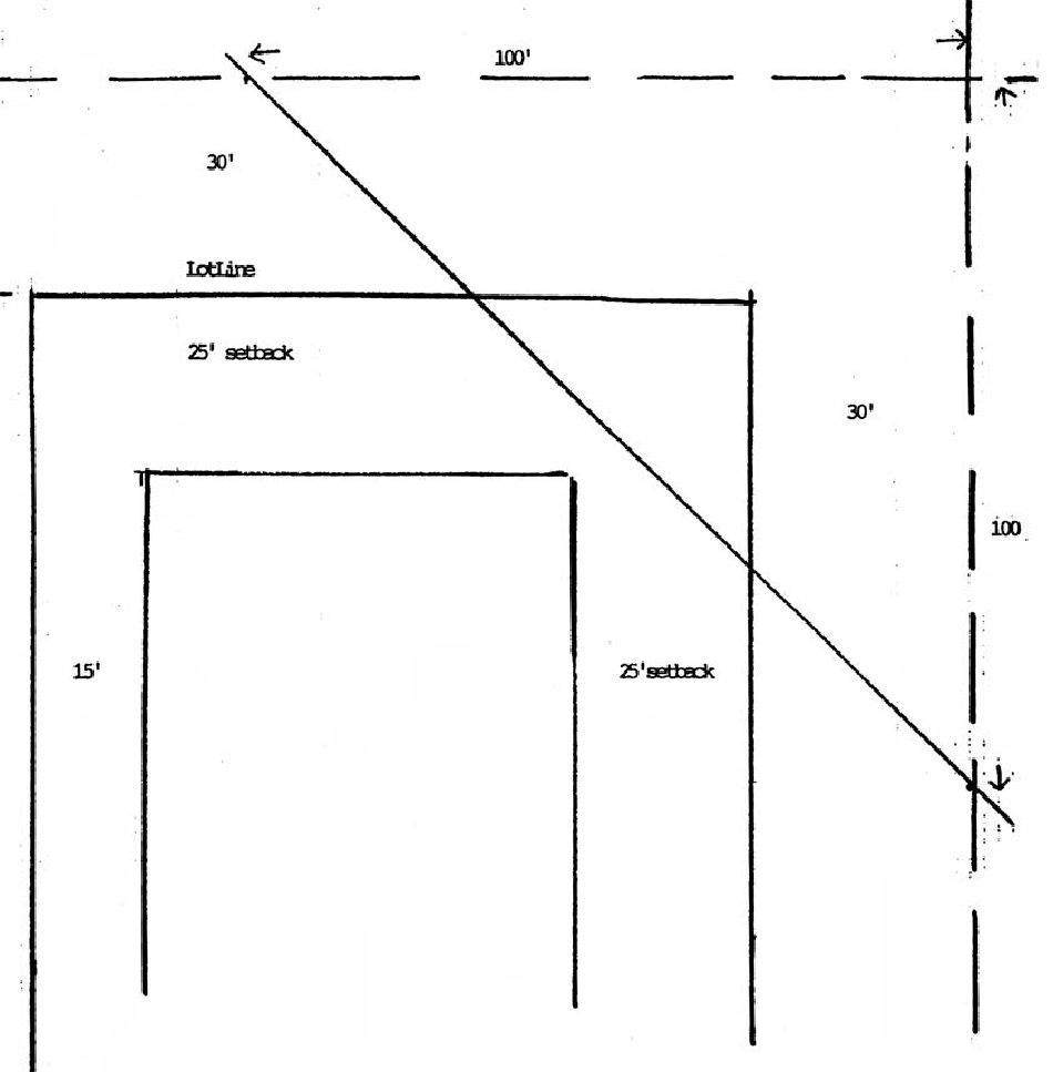
Figure 6.02.04A Example of clear visibility triangle
(3)
The distance from the intersection of the street centerlines for the various road classifications shall be as follows:
(i)
Signage and signalization. The development shall deposit with the town sufficient funds to provide all necessary roadway signs and traffic signalization as may be required by the town, based upon town or state traffic standards. At least two street name signs shall be placed at each four-way street intersection, and one at each T-intersection. Signs shall be installed under light standards (if installed) and free of visual obstruction. The design of street name signs shall be consistent, of a style appropriate to the community, and of a uniform size and color.
(j)
Street trees.
(1)
Street trees shall be provided in accordance with the standards established in section 6.06.02(c).
(2)
No development shall be approved without reserving an easement authorizing the town or developer to plant shade trees within five feet of the required right-of-way boundary. No street shall be accepted for dedication until the easement required by this subsection has been provided.
(k)
Blocks.
(1)
Where a tract of land is bounded by streets forming a block, said block shall have sufficient width to provide for two tiers of lots of appropriate depths.
(2)
The lengths, widths and shapes of blocks shall be consistent with adjacent areas. In no case shall block lengths in residential areas exceed 2,200 feet nor be less than 400 feet in length.
(Ord. No. 91-6, § 3(6.02.04), 2-11-1992; Ord. No. 2009-03, § 6(6.02.04), 6-9-2009)
Sec. 6.02.05. - Transit stops.
(a)
When required. Any development with a parking requirement of more than 350 vehicles shall provide and be dedicated to the town land area for a transit stop.
(b)
Size and design. The land area dedicated shall be sufficient to provide a transit stop with shelter and a separate paved transit lane 100 feet from the bus stop. Design of the transit lane shall be as specified by the town.
(c)
Located. With the approval of the development review board, transit stops may be located at an appropriate site within the development project.
(Ord. No. 91-6, § 3(6.02.05), 2-11-1992; Ord. No. 2009-03, § 6(6.02.05), 6-9-2009)
Sec. 6.02.06. - Sidewalks and bikeways.
(a)
When required.
(1)
Projects abutting collector or arterial facilities shall provide sidewalks adjacent to the collector or arterial roadway. Location of sidewalks shall be consistent with planned roadway improvements.
(2)
Sidewalks shall be provided on one side of all residential streets where the average lot width at the street is greater than 60 feet, as appropriate.
(3)
Where a proposed development includes improvements or new construction of collector or arterial facilities, facility designs shall include provision for sidewalks and bikeways within the right-of-way.
(4)
Residential projects adjacent to, or in the immediate vicinity of, an activity center comprised of commercial, office, service or recreation activities shall provide pedestrian and bicycle access from the development to the activity center.
(5)
Sidewalks/bikeways shall connect schools, the town center, parks and recreational areas with bicycle parking facilities at appropriate locations.
(6)
Pedestrian ways or crosswalks, not less than ten feet wide with a sidewalk meeting the requirements of this Land Development Code, may be required by the development review board to be placed in the center of blocks more than 800 feet long where deemed necessary to provide circulation or access to schools, playgrounds, shopping centers, transportation and other community facilities.
(7)
The maximum possible, not the minimum, amount of sidewalks and bike paths shall be constructed in new developments so as to reduce the potential for automotive emission pollution.
(8)
Bike paths shall be provided by the developer in new developments and the town shall solicit matching funds from the residents for expansion of paths in other portions of the town.
(b)
Design and construction standards. Design and construction of sidewalks, bikeways or other footpaths shall conform to the requirements of the town, including provisions for access by physically handicapped persons. Sidewalks on arterial highways shall be seven feet wide; on collector roads, five feet wide and on local streets, at least four feet wide.
(Ord. No. 91-6, § 3(6.02.06), 2-11-1992; Ord. No. 2009-03, § 6(6.02.06), 6-9-2009)
Sec. 6.02.07. - Access.
All proposed development shall meet the following standards for vehicular access and circulation:
(1)
Number of access points.
a.
All projects shall have access to a public right-of-way. The number of access points shall be as follows:
b.
Notwithstanding the provisions in subsection (1)a of this section:
1.
A nonresidential development, or a multifamily residential development, on a corner lot may be allowed two points of access. However, no more than one access shall be onto an arterial.
2.
Schools may have one additional access, provided that the additional access drive is limited to school bus use only.
(2)
Separation of access points.
a.
The separation between access points onto arterial and collector roadways, or between an access point and an intersection of an arterial or collector roadway with another road, shall be as shown in the following table:
b.
The distance between access points shall be measured from the centerline of the proposed driveway or roadway to the centerline of the nearest adjacent roadway or driveway.
(3)
Frontage on service roads and common driveways.
a.
Projects proposed on arterial and major collector roadways shall include frontage or service roads, and shall take access from the frontage road rather than the arterial or major collector. Frontage road design shall conform to FDOT standards. This access requirement may be met through the use of interconnecting parking lots which abut the arterial or major collector facility. The maximum number of parking lots that may be so interconnected, however, is three.
b.
Adjacent uses may share a common driveway, provided that appropriate access easements are granted between or among the property owners.
(4)
Alternative designs. Where natural features or spacing of existing driveways and roadways cause the foregoing access requirements to be physically infeasible, alternative design may be approved.
(5)
Access to residential lots.
a.
Access to nonresidential uses shall not be through an area designed, approved or developed for residential use.
b.
All lots in a proposed residential subdivision shall have frontage on and access from an existing street meeting the requirements of this Land Development Code except that rural residential subdivisions of one unit per 20 acres or lower density may take access from a private graded road.
c.
Access to all lots in a proposed residential subdivision shall be by way of a residential access or residential subcollector street.
d.
Houses constructed on existing platted lots shall be permitted a single access point on collector roads. Houses on local streets should have a single access point.
Houses on the existing frontage road (Main Street) shall be permitted access points onto the frontage road and not onto the collector road (Main Street).
(Ord. No. 91-6, § 3(6.02.07), 2-11-1992)
Sec. 6.02.08. - Standards for drive-up facilities.
(a)
Generally. All facilities providing drive-up or drive-through service shall provide on-site stacking lanes in accordance with the standards set forth in subsection (b) of this section.
(b)
Standards.
(1)
The facilities and stacking lanes shall be located and designed to minimize turning movements in relation to the driveway access to streets and intersections.
(2)
The facilities and stacking lanes shall be located and designed to minimize or avoid conflicts between vehicular traffic and pedestrian areas such as sidewalks, crosswalks or other pedestrian access ways.
(3)
A bypass lane shall be provided.
(4)
Stacking lane distance shall be measured from the service window to the property line bordering the furthest street providing access to the facility.
(5)
Minimum stacking lane distance shall be as follows:
a.
Financial institutions shall have a minimum distance of 200 feet. Two or more stacking lanes may be provided which together total 200 feet.
b.
All other uses shall have a minimum distance of 120 feet.
(6)
Alleys or driveways in or abutting areas designed, approved or developed for residential use shall not be used for circulation of traffic for drive-up facilities.
(7)
Where turns are required in the exit lane, the minimum distance from any drive-up station to the beginning point of the curve shall be 34 feet. The minimum inside turning radius shall be 25 feet.
(8)
Construction of stacking lanes shall conform to the specifications in the Technical Construction Standards Manual.
(Ord. No. 91-6, § 3(6.02.08), 2-11-1992)
Sec. 6.03.01. - Generally.
(a)
Applicability. Off-street parking facilities shall be provided for all development within the town, pursuant to the requirement of this Land Development Code. The facilities shall be maintained as long as the use exists that the facilities were designed to serve.
(b)
Computation.
(1)
When determination of the number of off-street spaces required by this Land Development Code results in a fractional space, the fraction of one-half or less may be disregarded, and a fraction in excess of one-half shall be counted as one parking space.
(2)
In churches and other places of assembly in which those in attendance occupy benches, pews or other similar seating facilities, and/or which contains an open assembly area, the occupancy shall be based on the maximum occupancy rating given the building by the fire marshal or other appropriate official.
(3)
Gross floor area shall be the sum of the gross horizontal area of all floors of a building measured from the exterior faces of the exterior walls.
(c)
Parking study. A parking study, when required by this Land Development Code, shall include, but not be limited to:
(1)
Estimates of parking requirements based on recommendations in studies such as those from ULI, ITE or the Traffic Institute, and based on data collected from uses or combinations of uses which are the same or comparable to the proposed use. Comparability shall be determined by density, scale, bulk, area, type of activity and location. The study shall document the source of data used to develop recommendations.
(2)
An analysis of the extent to which a transportation system management program and/or use of alternative forms of transportation lessen the parking requirement.
(Ord. No. 91-6, § 3(6.03.01), 2-11-1992)
Sec. 6.03.02. - Number of parking spaces required.
(a)
Requirements in matrix. The matrix in subsection (g) of this section specifies the required minimum number of off-street automobile and bicycle parking spaces, the percentage of automobile spaces that must be allotted for compact vehicles, and, in the notes, any special requirements that may apply.
(b)
Uses not specifically listed in matrix. The number of parking spaces required for uses not specifically listed in the matrix shall be determined by the development review board. The board shall consider requirements for similar uses and appropriate traffic engineering and planning data, and shall establish a minimum number of parking spaces based upon the principles of this Land Development Code.
(c)
When parking study required. For several uses, as listed in the matrix, the parking requirement is to be determined by the development review board. These uses have a large variability in parking demand, making it impossible to specify a single parking requirement. A development proposing to develop or expand one of these uses must submit four copies of a parking study, as described in section 6.03.01(c), to the town that provides justification for the requirement proposed. The development review board will review this study along with any traffic engineering and planning data that is appropriate to the establishment of a parking requirement for the use proposed.
(d)
Treatment of mixed uses. Where a combination of uses is developed, parking shall be provided for each of the uses as prescribed by the matrix, unless a reduction is granted pursuant to subsection (i) of this section.
(e)
Tandem parking spaces. The term "tandem parking space," used in the matrix, means a parking space that abuts a second parking space in such a manner that vehicular access to the second space can be made only through the abutting (tandem) space.
(f)
Other. Small camping trailers, boats and other small trailers plus recreational vehicles may be stored/parked in residential side or rear yards and not in street rights-of-way, public places or front yards. Corner lot owners require written permission of the town manager for parking on one front yard.
(g)
Matrix. The following matrix shows requirements parking and bicycle spaces and the ratio of full-size to compact cars:
(h)
Special parking spaces.
(1)
Any parking area to be used by the general public shall provide suitable, marked parking spaces for handicapped persons. The number, design and location of these spaces shall be consistent with the requirements of F.S. §§ 316.1955, 316.1956 or succeeding provisions. All spaces for the handicapped shall be paved.
(2)
A portion of the parking spaces required by this Land Development Code may be designated as exclusively for motorcycle parking if the following conditions are met:
a.
The town manager recommends that the spaces be so designated, based upon projected demand for them and lessened demand for automobile spaces.
b.
The development review board approves the recommendation and the designated spaces are shown on the final development plan.
c.
The designated spaces are suitably marked and striped.
d.
The designation does not reduce the overall area devoted to parking so that if the motorcycle spaces are converted to automobile spaces the minimum requirements for automobile spaces will be met.
The approval may later be withdrawn, and the spaces returned to car spaces, if the town manager finds that the purposes of this Land Development Code would be better served thereby, based upon actual demand for motorcycle and automobile parking.
(3)
The following applies to bicycle parking:
a.
The town shall maintain a list of approved bicycle parking facilities. Other bicycle parking devices may be used if it is established to the satisfaction of the town that the standards in subsection (h)(3)b of this section are met.
b.
The rack or other facility shall:
1.
Be designed to allow each bicycle to be supported by its frame.
2.
Be designed to allow the frame and wheels of each bicycle to be secured against theft.
3.
Be designed to avoid damage to the bicycles.
4.
Be anchored to resist removal and solidly constructed to resist damage by rust, corrosion and vandalism.
5.
Accommodate a range of bicycle shapes and sizes and to facilitate easy locking without interfering with adjacent bicycles.
6.
Be located to prevent damage to bicycles by cars.
7.
Be consistent with the surroundings in color and design and be incorporated whenever possible into building or street furniture design.
8.
Be located in convenient, highly visible, active, well-lighted areas.
9.
Be located so as not to interfere with pedestrian movements.
10.
Be located as near to the principal entrance of the building as practicable.
11.
Provide safe access from the spaces to the right-of-way or bicycle lane.
(i)
Parking deferral.
(1)
To avoid requiring more parking spaces than actually needed to serve a development, the development review board may defer the provision of some portion of the off-street parking spaces required by this Land Development Code if the conditions and requirements of this section are satisfied.
(2)
As a condition precedent to obtaining a partial deferral by the development review board, the developer must show any one or more of the following:
a.
A parking study, as described in section 6.03.01(c), indicating that there is not a present need for the deferred parking.
b.
Public transportation satisfies transportation demands for a portion of the users of the facility that corresponds to the amount of parking sought to be deferred.
c.
The developer has established or will establish an alternative means of access to the use that will justify deferring the number of parking spaces sought to be deferred. Alternative programs that may be considered by the development review board include, but are not limited to:
1.
Private and public carpools and vanpools.
2.
Charging for parking.
3.
Subscription bus services.
4.
Flexible work-hour scheduling.
5.
Capital improvement for transit services.
6.
Ride sharing.
7.
Establishment of a transportation coordinator position to implement carpool, vanpool and transit programs.
d.
The percentage of parking spaces sought to be deferred corresponds to the percentage of residents, employees and customers who regularly walk, use bicycles and other nonmotorized forms of transportation, or use mass transportation to come to the facility.
e.
Transportation system management.
f.
Transportation demand management.
(3)
If the developer satisfies one or more of the criteria in subsection (i)(2) of this section, the development review board may approve a deferred parking plan submitted by the developer. The number of parking spaces deferred shall correspond to the estimated number of parking spaces that will not be needed because of the condition or conditions established.
(4)
A deferred parking plan:
a.
Shall be designed to contain sufficient space to meet the full parking requirements of this Land Development Code, shall illustrate the layout for the full number of parking spaces, and shall designate which are to be deferred.
b.
Shall not assign deferred spaces to areas required for landscaping, buffer zones, setbacks or areas that would otherwise be unsuitable for parking spaces because of the physical characteristics of the land or other requirements of this Land Development Code.
c.
Shall include a landscaping plan for the deferred parking area.
d.
Shall include a written agreement with the town that, one year from the date of issuance of the certificate of occupancy, the deferred spaces will be converted to parking spaces that conform to this Land Development Code at the developer's expense should the development review board determine from experience that the additional parking spaces are needed.
e.
Shall include a written agreement that the developer will cover the expense of a traffic study to be undertaken by the town transportation engineer to determine the advisability of providing the full parking requirement.
(5)
When authorized by the development review board upon a preliminary finding that the parking is inadequate, but not sooner than one year after the date of issuance of the certificate of occupancy for the development, the department shall undertake a study to determine the need of providing the full parking requirement to satisfy the proven demand for parking, again at the developer's expense.
(6)
Based upon the study and the recommendations of the transportation engineer and the town manager, the development review board shall determine if the deferred spaces shall be converted to operable parking spaces by the developer or retained as deferred parking area.
(7)
The developer may, at any time, request that the development review board approve a revised development plan to allow converting the deferred spaces to operable parking spaces.
(j)
Reduction for mixed or joint use of parking spaces. The development review board shall authorize a reduction in the total number of required parking spaces for two or more uses jointly providing off-street parking when their respective hours of need of maximum parking do not normally overlap. Reduction of parking requirements because of joint use shall be approved if the following conditions are met:
(1)
The developer submits sufficient data to demonstrate that hours of maximum demand for parking at the respective uses do not normally overlap.
(2)
The developer submits a legal agreement approved by the town attorney guaranteeing the joint use of the off-street parking spaces as long as the uses requiring parking are in existence or until the required parking is provided elsewhere in accordance with the provisions of this Land Development Code.
(k)
Reduction for low percentage of leasable space. The requirements of subsection (a) of this section ensure an average percentage of gross leasable building to total gross building area (approximately 85 percent). If a use has a much lower percentage of leasable space because of cafeterias, athletic facilities or covered patios; multiple stairways; atriums; conversion of historic residential structures to commercial use; or for other reasons; the development review board may reduce the parking requirements if the following conditions are met:
(1)
The developer submits a detailed floor plan describing how all of the floor area in the building will be used.
(2)
The developer agrees, in writing, that the usage of the square footage identified as not leasable shall remain as identified, unless and until additional parking is provided to conform fully with this Land Development Code.
(l)
Special parking districts. The town council may designate special parking districts where parking or transit facilities may be provided by the town, thus lessening the demand for on-site parking. For development proposed in these districts, the development review board may allow the developer to pay a fee in lieu of providing some or all the spaces required by this Land Development Code. The fee shall be a one-time, nonrefundable fee per parking space avoided, paid to the town prior to the issuance of a certificate of occupancy. The amount of the fee shall be determined by the town council and shall be equal to the land acquisition, construction and maintenance cost of parking spaces that are deferred by this provision. These fees shall be used by the town solely for the purchase, construction, operation and maintenance of parking or transit facilities serving the area of the development. The town council may, at the time of accepting the fee, enter into an agreement with the developer to construct or provide parking or transit facilities.
(m)
Historic preservation exemption. The preservation of any property that has been placed on the local register of historic places, or that is located in a historic district and contributes to the historic character of the district, shall be grounds for a grant, by the development review board, of a reduction in, or complete exemption from, the parking requirements in subsection (a) of this section. The reduction or exemption needed to allow a viable use of the historic structure shall be granted unless a severe parking shortage or severe traffic congestion will result.
(n)
Increase in requirements. The number of required parking spaces may be increased by the development review board if a parking study demonstrated that the proposed use would have a parking demand in excess of the requirement in subsection (a) of this section. The development review board may require the developer to provide a parking study, as described in section 6.03.01(c), when the transportation engineer presents preliminary data indicating that an increase in the number of parking spaces may be warranted.
(Ord. No. 91-6, § 3(6.03.02), 2-11-1992; Ord. No. 98-3, §§ F, G, 3-10-1998)
Sec. 6.03.03. - Off-street loading.
(a)
Generally. Spaces to accommodate off-street loading or business vehicles shall be provided as required in subsection (b) of this section.
(b)
Spaces required.
(1)
Schools, nursing homes and other similar institutional uses shall provide one loading space for each 100,000 square feet of gross floor area or fraction thereof.
(2)
Auditoriums, gymnasiums, theaters, churches and other buildings for public assembly shall provide one space for the first 20,000 square feet or gross floor area or fraction thereof, and one space for each additional 50,000 square feet.
(3)
Offices of financial institutions shall provide one space for the first 75,000 square feet of gross area or fraction thereof, and one space for each additional 25,000 square feet.
(4)
Other commercial and public service uses shall provide one space for the first 10,000 square feet of gross floor area, and one space for each additional 20,000 square feet.
(c)
Adjustments to requirements. The development review board may, upon the recommendation of the transportation engineer, require that a study be done to determine the actual number of loading spaces needed for a proposed use. The transportation engineer shall recommend the need for a study when it appears that the characteristics of the proposed use require a greater or lesser number of loading spaces than that required or proposed.
(Ord. No. 91-6, § 3(6.03.03), 2-11-1992)
Sec. 6.03.04. - Alteration of conforming development.
(a)
Decreased demand for parking or loading. The number of off-street parking or loading spaces may be reduced if the town manager or development review board finds that a diminution in floor area, seating capacity or other factor controlling the number of parking or loading spaces would permit the site to remain in conformity with this Land Development Code after the reduction.
(b)
Increase demand for parking or loading. The number of off-street parking or loading spaces must be increased to meet the requirements of this Land Development Code if the town manager or development review board finds that an increase in floor area, seating capacity or other factor controlling the number of parking or loading spaces required by this Land Development Code causes the site not to conform with this Land Development Code. Failure to promptly provide needed spaces is a violation of this Land Development Code.
(Ord. No. 91-6, § 3(6.03.04), 2-11-1992)
Sec. 6.03.05. - Design standards for off-street parking and loading areas.
(a)
Location.
(1)
Except as provided herein, all required off-street parking spaces and the use they are intended to serve shall be located on the same parcel.
(2)
The development review board may approve off-site parking facilities as part of the parking required by this Land Development Code if:
a.
The location of the off-site parking spaces will adequately serve the use for which it is intended. The following factors shall be considered:
1.
Proximity of the off-site spaces to the use that they will serve.
2.
East of pedestrian access to the off-site parking spaces.
3.
Whether or not off-site parking spaces are compatible with the use intended to be served, e.g., off-site parking is not ordinarily compatible with high turnover uses such as retail.
b.
The location of the off-site parking spaces will not create unreasonable:
1.
Hazards to pedestrians.
2.
Hazards of vehicular traffic.
3.
Traffic congestion.
4.
Interference with access to other parking spaces in the vicinity.
5.
Detriment to any nearby use.
c.
The developer supplies a written agreement, approved in form by the town attorney, assuring the continued availability of the off-site parking facilities for the use they are intended to serve.
(3)
All parking spaces required by this Land Development Code for residential uses should be located no further than the following distances from the units they serve:
a.
Resident parking: 200 feet.
b.
Visitor parking: 250 feet.
Distances shall be measured from a dwelling unit's entry to the parking space. Where a stairway or elevator provides access to dwelling units, the stairway or elevator shall be considered to be the entrance to the dwelling unit. For purposes of measuring these distances, each required parking space shall be assigned to a specific unit on the development plan, whether or not the developer will actually assign spaces for the exclusive use of the specific unit.
(b)
Size.
(1)
Standard and compact parking spaces shall be sized according to figure 6.03.05A, set forth in section 6.03.05(c)(3).
(2)
Parallel parking spaces shall be a minimum of eight feet wide and 22 feet long. If a parallel space abuts no more than one other parallel space, and adequate access room is available, then the length may be reduced to 20 feet.
(3)
Tandem parking spaces must be a minimum of nine feet wide and 20 feet long.
(4)
A standard motorcycle parking space shall be 4¼ feet wide and 9¼ feet long.
(5)
Spaces for handicapped parking shall be the size specified in F.S. § 316.1955.
(6)
The standard off-street loading space shall be ten feet wide, 25 feet long, provide vertical clearance of 15 feet, and provide adequate area for maneuvering, ingress and egress. The length of one or more of the loading spaces may be increased up to 55 feet if full-length tractor-trailers must be accommodated. Developers may install spaces that are larger than the standard, but the number of spaces shall not be reduced on that account.
(7)
The development review board may modify these requirements where necessary to promote a substantial public interest relating to environmental protection, heritage conservation, aesthetics, tree protection or drainage. The transportation engineer shall certify that the modification does not create a serious hazard or inconvenience, and the development review board shall submit a written statement of the public interest served by allowing the modification.
(c)
Layout.
(1)
Pedestrian circulation facilities, roadways, driveways and off-street parking and loading areas shall be designed to be safe and convenient.
(2)
Parking and loading areas, aisles, pedestrian walks, landscaping and open space shall be designed as integral parts of an overall development plan and shall be properly related to existing and proposed buildings and adequately lighted for nighttime use.
(3)
Building, parking and loading areas, landscaping and open spaces shall be designed so that pedestrians moving from parking areas to buildings and between buildings are not unreasonably exposed to vehicular traffic.
(4)
Landscaped, paved and gradually inclined or flat pedestrian walks shall be provided along the lines of the most intense use, particularly from building entrances to streets, parking areas and adjacent buildings. Pedestrian walks should be designed to discourage incursions into landscaped areas except at designated crossings.
(5)
Each off-street parking space shall open directly onto as aisle or driveway that, except for single-family and two-family residences, is not a public street.
(6)
Aisles and driveway shall not be used for parking vehicles, except that the driveway of a single-family or two-family residence shall be counted as a parking space for the dwelling unit, or as a number of parking spaces as determined by the town manager based on the size and accessibility of the driveway.
(7)
The design shall be based on a definite and logical system of drive lanes to serve the parking and loading spaces. A physical separation or barrier, such as vertical curbs, may be required to separate parking spaces from travel lanes.
(8)
Parking spaces for all uses, except single-family and two-family residences, shall be designed to permit entry and exit without moving any other motor vehicle.
(9)
No parking space shall be located so as to block access by emergency vehicles.
(10)
Compact car spaces should be located no more and no less conveniently than full size car spaces, and shall be grouped in identifiable clusters
(Ord. No. 91-6, § 3(6.03.05), 2-11-1992)
Sec. 6.04.01. - Requirements for all developments.
(a)
Generally. The basic utilities set forth in this section are required for all developments subject to the criteria listed herein.
(b)
Electricity. Every principle use and every lot within a subdivision shall have available to it a source of electric power adequate to accommodate the reasonable needs of such use and every lot within such subdivision.
(c)
Telephone. Every principal use and every lot within a subdivision shall have available to it a telephone service cable adequate to accommodate the reasonable needs of such use and every lot within such subdivision.
(d)
Water and sewer. New development and any new commercial user shall tie into the county water system and any central sewer system when available. Any development or commercial user dependent on a central water or sewer system shall not be permitted until such system is available. Residential users shall tie into centralized waste water facilities within one year of its availability to their property. Until such time as this subsection is revised, residential users may connect into any central water system or use a county approved well.
(e)
Illumination. All streets, driveways, sidewalks, bikeways, parking lots and other common areas and facilities in developments shall provide illumination. Lighting devices for the illumination of the ground, driveways, walkway, signs, parking areas and building exteriors, shall be installed and maintained in such a manner as to confine direct rays to the premises and prevent direct ray and glare onto adjacent properties or rights-of-way. Exterior lighting poles shall not exceed 30 feet in height.
(f)
Fire hydrants. All developments served by a central water system shall include a system of fire hydrants consistent with the standards of the Ocoee Fire Department.
(Ord. No. 91-6, § 3(6.04.01), 2-11-1992; Ord. No. 2009-03, § 6(6.04.01), 6-9-2009)
Sec. 6.04.02. - Design standards.
(a)
Compliance with technical construction standards. All utilities required by this Land Development Code shall meet or exceed the minimum standards required by the county.
(b)
Placement of utilities underground.
(1)
All electric, telephone, cable television and other communication lines (exclusive of transformers or enclosures containing electrical equipment, including, but not limited to, switches, meters or capacitors which may be pad mounted), and gas distribution lines shall be placed underground within easements or dedicated public rights-of-way.
(2)
Lots abutting existing easements or public rights-of-way where overhead electric, telephone or cable television distribution supply lines and services connections have previously been installed may be supplied with such services from the utilities overhead facilities provided the service connection to the site or lot are placed underground.
(3)
Screening of any utility apparatus placed above ground shall be required.
(Ord. No. 91-6, § 3(6.04.02), 2-11-1992)
Sec. 6.04.03. - Utility easements.
When a developer installs or causes the installation of water, sewer, electrical power telephone or cable television facilities and intends that such facilities shall be owned, operated or maintained by a public utility or any entity other than the developer, the developer shall transfer to such utility or entity the necessary ownership or easement rights to enable the utility or entity to operate and maintain such facilities.
(Ord. No. 91-6, § 3(6.04.03), 2-11-1992)
Sec. 6.05.01. - Definitions.
The following words, terms and phrases, when used in this division, shall have the meanings ascribed to them in this section, except where the context clearly indicates a different meaning:
Alter or alteration means work done on a stormwater management system other than that necessary to maintain the system's original design and function.
Detention means the collection and storage for surface water for subsequent gradual discharge.
Existing, for purposes of the stormwater management provisions of this Land Development Code, means the average condition immediately before development or redevelopment commences.
Impervious surface means a surface that has been compacted or covered with a layer of material so that it is highly resistant to infiltration by water. The term "impervious surface" includes, but is not limited to, semi-impervious surfaces such as compacted clay, as well as, most conventionally surfaced streets, roofs, sidewalks, parking lots and other similar structures.
Maintenance means that action taken to restore or preserve the original design and function of any stormwater management system.
Natural systems means systems which predominantly consist of, or are used by, those communities of plants, animals, bacteria and other flora and fauna which occur indigenously on the land, in the soil or in the water.
Owner means the person in whom is vested the fee ownership, domain or title of property, i.e., the proprietor. The term "owner" may also include a tenant, if chargeable under his lease for the maintenance of the property, and any agent of the owner or tenant including a developer.
Percolation means the downward movement of surface rainwater and stormwater through surface vegetation and soils so as to become integrated into the natural groundwater or aquifer.
Person means any and all persons, natural or artificial, and includes any individual, firm, corporation, government agency, business trust, estate, trust, partnership, association, two or more persons having a joint or common interest, or any other legal entity.
Rate means volume per unit of time.
Retention means the collection and storage or runoff without subsequent discharge to surface waters.
Runoff coefficient means ratio of the amount of rain which runs off a surface to that which falls on it; a factor from which runoff can be calculated.
Sediment means the mineral or organic particulate material that is in suspension or has settled in surface water or groundwater.
Site means generally, any tract, lot or parcel of land or combination of tracts, lots or parcels of land that are in one ownership, or in diverse ownership but contiguous, and which are to be developed as a single unit, subdivision or project.
Stormwater means the flow of water which results from, and that occurs immediately following, a rainfall.
Stormwater management system means the system, or combination of systems, designed to treat stormwater, or collect, convey, channel, hold, inhibit or divert the movement of stormwater on, through and from a site.
Stormwater runoff means that portion of the stormwater that flows from the land surface of a site either naturally, in manmade ditches or in a closed conduit system.
Surface water means water above the surface of the ground whether or not flowing through definite channels, including the following:
(1)
Any natural or artificial pond, lake, reservoir or other area which ordinarily or intermittently contains water and which has a discernable shoreline;
(2)
Any natural or artificial stream, river, creek, channel, ditch, canal, conduit, culvert, drain, waterway, gully, ravine, street, roadway, swale or wash in which water flows in a definite direction, either continuously or intermittently, and which has a definite channel, bed or banks; or
(3)
Any wetland.
Wetland means land that is inundated or saturated by surface water or groundwater at a frequency and duration sufficient to support a prevalence of vegetation typically adapted for life in saturated soil conditions. The term "wetland" includes, but is not limited to, swamp hammocks, hardwood swamps, riverine cypress, cypress ponds, bayheads and bogs, wet prairies, freshwater marshes and mangrove swamps.
(Ord. No. 91-6, § 3(6.05.01), 2-11-1992)
Sec. 6.05.02. - Relationship to other stormwater management requirements.
In addition to meeting the requirements of this Land Development Code, the design and performance of all stormwater management systems shall comply with applicable state regulations (F.A.C. ch. 17-25) or rules of the South Florida Water Management District or Orange County. In all cases, the strictest of the applicable standards shall apply.
(Ord. No. 91-6, § 3(6.05.02), 2-11-1992)
Sec. 6.05.03. - Exemptions.
The following development activities are exempt from these stormwater management requirements, except that steps to control erosion and sedimentation must be taken for all development:
(1)
Any development within a subdivision if each of the following conditions have been met:
a.
Stormwater management provisions for the subdivision were previously approved and remain valid as part of a final plat or development plan; and
b.
The development is conducted in accordance with the stormwater management provisions submitted with the final plat or development plan.
(2)
Bona fide agricultural activity, including forestry, provided farming activities are conducted in accordance with the requirements set forth in an approved Soil Conservation Service conservation plan and forestry activities are conducted in accordance with the Silviculture Best Management Practices (BMP) Manual (1979) published by the state division of forestry. If the conservation plan and forestry BMPs are not implemented accordingly, this exemption shall become void and a stormwater permit shall be required.
(3)
Maintenance activity that does not change or affect the quality, rate, volume or location of stormwater flow on the site or of stormwater runoff.
(4)
Action taken under emergency conditions to prevent imminent harm or danger to persons, or to protect property from imminent fire, violent storms, hurricanes or other hazards. A report of the emergency action shall be made to the town as soon as practicable in writing.
(Ord. No. 91-6, § 3(6.05.03), 2-11-1992; Ord. No. 94-2, § 1(a), 2-8-1994)
Sec. 6.05.04. - Stormwater management requirements.
(a)
Performance standards. All development must be designed, constructed and maintained to meet the following performance standards:
(1)
While development activity is underway and after it is completed, the characteristics of stormwater runoff shall approximate the rate, volume, quality and timing of stormwater runoff that occurred under the site's natural unimproved or existing state, except that the first inch of rainfall shall be retained on site and no discharge shall exceed the predevelopment pollutant level or runoff rate from the property.
(2)
Stormwater as a result of a 25-year, 24-hour storm shall be retained on the property and any excess filtered prior to release. No discharge shall exceed the predeveloped runoff.
(3)
So as to preclude pollution of the Butler Chain of Lakes or Lake Bessie, storm runoff shall be treated and direct pollutant discharge shall not lower ambient (existing) water quality and indirect discharges will not significantly degrade the lakes.
(4)
Vacant, unimproved land is exempt from these regulations. Land made vacant after removal of a structure or after demolition must conform to this Land Development Code and other regulations.
(5)
Nothing in this Land Development Code is intended to relieve any property owner or developer from any obligations under state or county law or regulation to obtain any required permits.
(6)
The proposed development and development activity shall not violate the water quality standards as set forth in F.A.C. ch. 17-3. All stormwater facilities must meet the standards in F.A.C. chs. 17-25 and 17-302, and rules of the South Florida Water Management District. Stormwater discharge facilities must be designed so as to not degrade the receiving water body below the minimum conditions necessary to ensure the suitability of water for the designated use of its classification as established in F.A.C. ch. 17-302. All standards in these citations are to apply to all new development and redevelopment and that exemptions, exceptions or thresholds in these citations, including project size thresholds, are not applicable.
(b)
Design standards. To comply with the performance standards set forth in subsection (a) of this section, the proposed stormwater management system shall conform to the following design standards:
(1)
Detention and retention systems shall be designed to comply with this Land Development Code and, if applicable, county regulations.
(2)
The stormwater management requirement for development and redevelopment on properties within residential districts shall include some method or methods of on-site retention for the building, parking and driveway areas. These methods shall include, but not be limited to, the provision of swales or other retention areas, the sloping of parking areas and drives to landscaped areas versus directly to the street, the guttering of building runoff to landscaped open areas where setbacks limit the amount of pervious area available and other such methods which provide opportunities for the percolation of stormwater.
(3)
The proposed stormwater management system shall be designed to accommodate the stormwater that originates within the development and stormwater that flows onto or across the development from adjacent lands.
(4)
The proposed stormwater management system shall be designed to function properly for a minimum 20-year life.
(5)
The design and construction of the proposed stormwater management system shall be certified as meeting the requirements of this Land Development Code by a professional engineer registered in the state.
(6)
No surface water or road runoff may be channeled or directed into a sanitary sewer or into the Butler Chain of Lakes or Lake Bessie.
(7)
The proposed stormwater management system shall be compatible with the stormwater management facilities on surrounding properties or streets, taking into account the possibility that substandard systems may be improved in the future.
(8)
The side slopes and bottoms of all retention areas shall have a grass or other landscape material cover. The maximum side slopes of retention areas shall not exceed 3:1.
(9)
Spillways or other entrance channels to retention areas shall be designed to prevent the flushing of these retention areas by heavy rains.
(10)
Dry bottom retention areas shall be designed and function such that all retained water is removed after the third day. If this is not accomplished by percolation and evaporation, the retention area must be improved to include an underdrain system or other bottom materials that will accomplish this requirement.
(11)
Dredging, clearing of vegetation, deepening, widening, straightening, stabilizing or otherwise altering natural surface waters shall be minimized.
(12)
Natural surface water shall not be used as sediment traps during or after development.
(13)
For aesthetic reasons and to increase shoreline habitat, the shorelines of detention and retention areas shall be sinuous rather than straight.
(14)
Water reuse and conservation shall, to the maximum extent practicable, be achieved by incorporating the stormwater management system into irrigation systems serving the development.
(15)
Vegetated buffers of sufficient width to prevent erosion shall be retained or created along the shores, banks or edges of all natural or manmade surface waters.
(16)
In phased developments the stormwater management system for each integrated stage of completion shall be capable of functioning independently as required by this Land Development Code.
(17)
All detention and retention basins, except natural water bodies used for this purpose, shall be accessible for maintenance from streets, public rights-of-way, parking lots or other open areas.
(18)
Stormwater with wet bottom ponds shall be designed, operated and maintained so as to resemble a natural pond to the greatest extent practicable.
(19)
Any development which includes multifamily, commercial, restricted commercial or institutional uses shall provide for treatment of any storm runoff so as to preclude pollution of the Butler Chain of Lakes or Lake Bessie.
(20)
Stormwater must be disposed of in a manner that will not cause personal or property damage to up or down stream property and will not cause a rise in lake levels above the flood levels set by county, state or federal regulations.
(21)
Lake front areas are required to preserve the intact natural communities which provides filtration of stormwater runoff within 50 feet of the waters edge with only a narrow path to the water.
(c)
Other.
(1)
New or improved streets/roads shall use vegetated swale drainage and properties adjoining new or improved streets/roads shall be required to come into compliance with the town's stormwater regulations concurrent with the completion on the road construction. Where improvements are not completed by the property owner, the town, 20 days after notifying the owner, shall make such necessary improvements and bill the owner. Should payment not be made within 60 days of transmittal of the bill, a lien shall be filed by the town.
(2)
It shall be the duty of the property owner to provide proper maintenance of any stormwater system, to include swales along streets in front of their property so as to meet the requirement of this Land Development Code. This includes not filling swales with grass, dirt, sand, or grass clippings. The town shall have the power to inspect systems, facilities and swales and to require maintenance, repair and replacement of facilities as necessary. Should required correction not be made within 20 days, the town may make needed improvements and bill the owner and as stated in subsection (c)(1) of this section, a lien shall be filed.
(3)
Swimming pools or other water storage facilities shall not be drained into streets, canals or lakes without permission of the town manager.
(Ord. No. 91-6, § 3(6.05.04), 2-11-1992; Ord. No. 94-2, § 1(c, j), 2-8-1994; Ord. No. 2006-03, § 6(6.05.04), 6-9-2009)
Sec. 6.05.05. - Dedication or maintenance of stormwater management systems.
(a)
Dedication. To comply with the performance standards set forth in section 6.05.04 the proposed stormwater management system shall conform to the following design standards: Detention and retention systems shall be designed to comply with this Land Development Code and, if applicable, county regulations.
(b)
Maintenance by an acceptable entity.
(1)
All stormwater management systems that are not dedicated to the town shall be operated and maintained by one of the following entities:
a.
A local governmental unit including a county, municipality or municipal service taxing unit, special district or other governmental unit.
b.
An active water control district created pursuant to F.S. ch. 298 or drainage district created by special act, or community development district created pursuant to F.S. ch. 190, or special assessment district created pursuant to F.S. ch. 170.
c.
A state or federal agency.
d.
An officially franchised, licensed or approved communication, water, sewer, electrical or other public utility.
e.
The property owner or developer if:
1.
Written proof is submitted in the appropriate form by either letter or resolution, that a governmental entity or such other acceptable entity as set forth in subsections (b)(1)a through d of this section, will accept the operation and maintenance of the stormwater management and discharge facility at a time certain in the future.
2.
A bond or other assurance of continued financial capacity to operate and maintain the system is submitted.
3.
That the system is for a single-family residence, legal duplex or for a commercial structure on Main Street which is maintained by the owner in accordance with this Land Development Code.
f.
For-profit or nonprofit corporations including homeowners' associations, property owners' associations, condominium owners' associations or master associations if:
1.
The owner or developer submits documents constituting legal capacity and a binding legal obligation between the entity and the town affirmatively taking responsibility for the operation and maintenance of the stormwater management facility.
2.
The association has sufficient powers reflected in its organizational or operational documents to:
(i)
Operate and maintain the stormwater management system as permitted by the town.
(ii)
Establish rules and regulations.
(iii)
Assess members.
(iv)
Contract for services.
(v)
Exist perpetually, with the articles of incorporation providing that if the association is dissolved, the stormwater management system will be maintained by an acceptable entity as described in this subsection (b)(1)f.
(2)
If a project is to be constructed in phases, and subsequent phases will use the same stormwater management facilities as the initial phase of phases, the operation/maintenance entity shall have the ability to accept responsibility for the operation and maintenance of the stormwater management systems of future phases of the project.
(3)
In phased developments that have an integrated stormwater management system, but employ independent operation/maintenance entities for different phases, the operation/maintenance entities, either separately or collectively, shall have the responsibility and authority to operate and maintain the stormwater management system for the entire project. That authority shall include cross easements for stormwater management and the authority and ability of each entity to enter and maintain all facilities, should any entity fail to maintain a portion of the stormwater management system within the project.
(4)
The applicant shall be an acceptable entity and shall be responsible for the operation and maintenance of the stormwater management system from the time construction begins until the stormwater management system is dedicated to and accepted by another acceptable entity.
(Ord. No. 91-6, § 3(6.05.05), 2-11-1992; Ord. No. 2009-03, § 6(6-05-05), 6-9-2009)
Sec. 6.06.01. - Exemption.
Lot or parcels of land on which a single-family home is used as a residence shall be exempt from all provisions of these landscaping regulations, except as prescribed elsewhere in this Land Development Code. This shall not be construed to exempt any residential developments that requires the approval of a development plan by the development review board.
(Ord. No. 91-6, § 3(6.06.01), 2-11-1992)
Sec. 6.06.02. - Required landscaping.
(a)
Vehicle use areas.
(1)
A vehicle use area is any portion of a development site used for circulation, parking and/or display of motorized vehicles, except junk or automobile salvage yards.
(2)
All vehicle use areas containing more than 1,000 square feet shall be landscaped in accordance with figures 6.06.02A, 6.06.02B and 6.06.02C as set forth in subsection (a)(4) of this section which identifies the areas of landscaping that may be counted towards fulfilling the vehicle use area landscaping requirement.
(3)
Proportional amounts of landscaping shall be provided for fractional areas.
(4)
Vehicle use areas designed to accommodate vehicles that are larger or smaller than automobiles, or that do not have designated parking areas, shall meet the requirements of the following figures except that in place of 24 parking spaces, the square footage of 4,800 square feet shall be used.
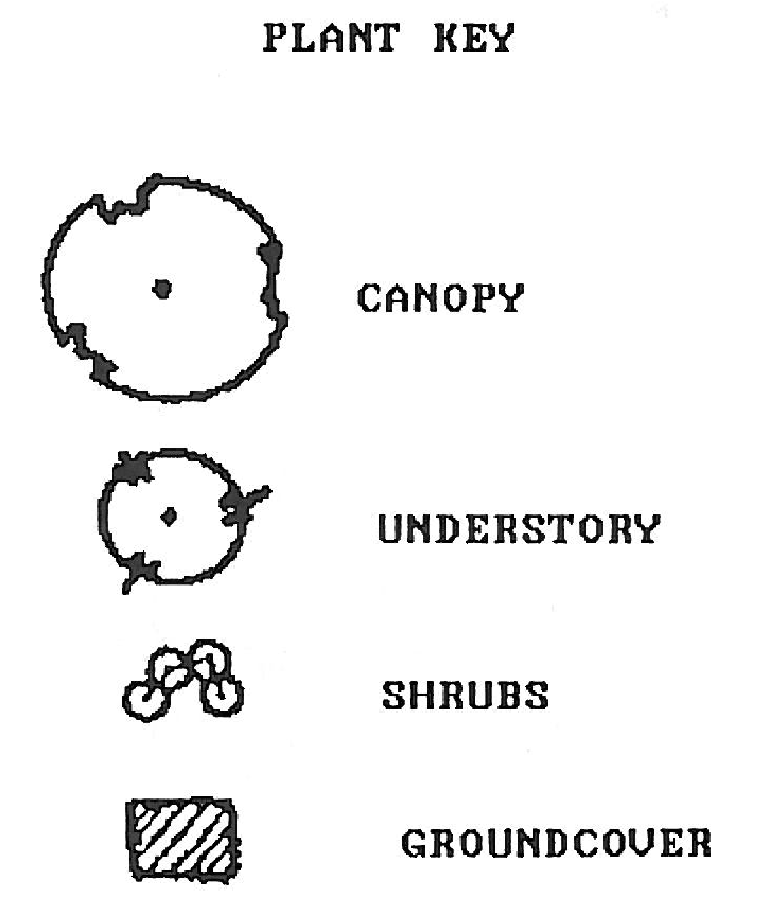
Figure 6.06.02A Plant Key for Vehicle Use Area Landscaping Standards
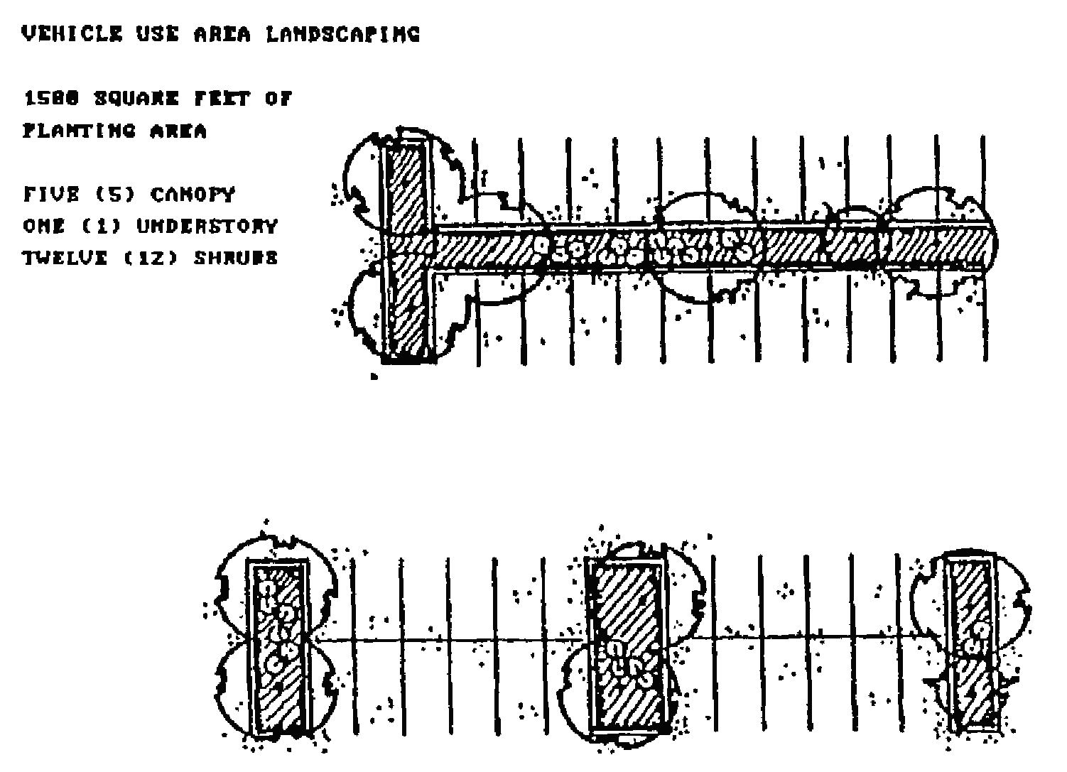
Figure 6.06.02B Landscaping Standard
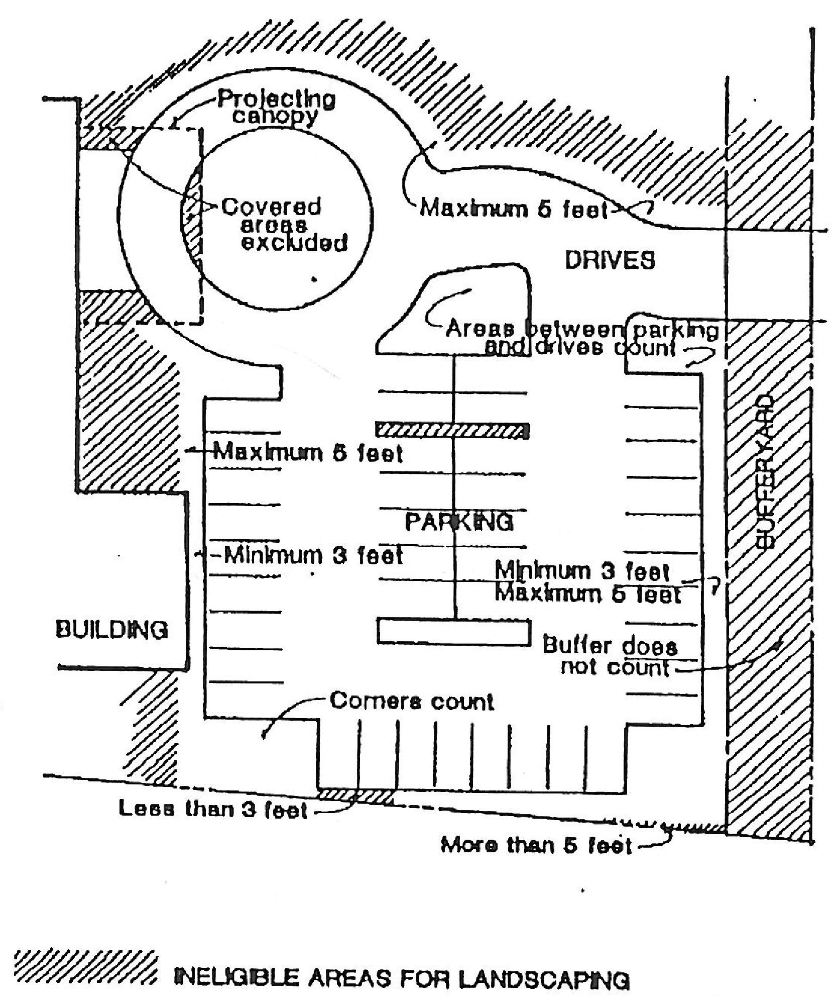
Figure 6.06.02C Areas Eligible to be Counted to Meet Vehicle Use Area Landscaping
Requirements
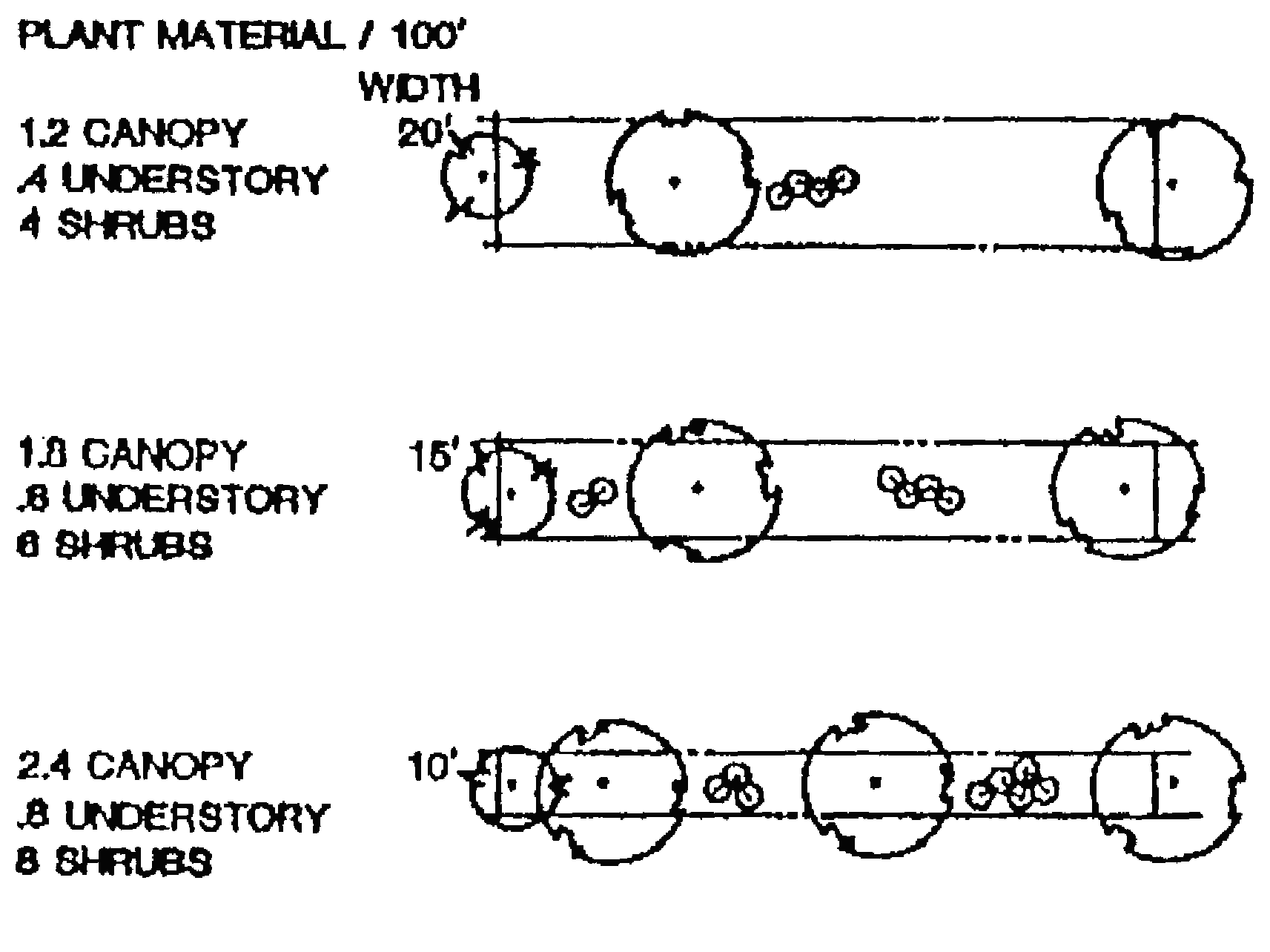
Landscape Standard A
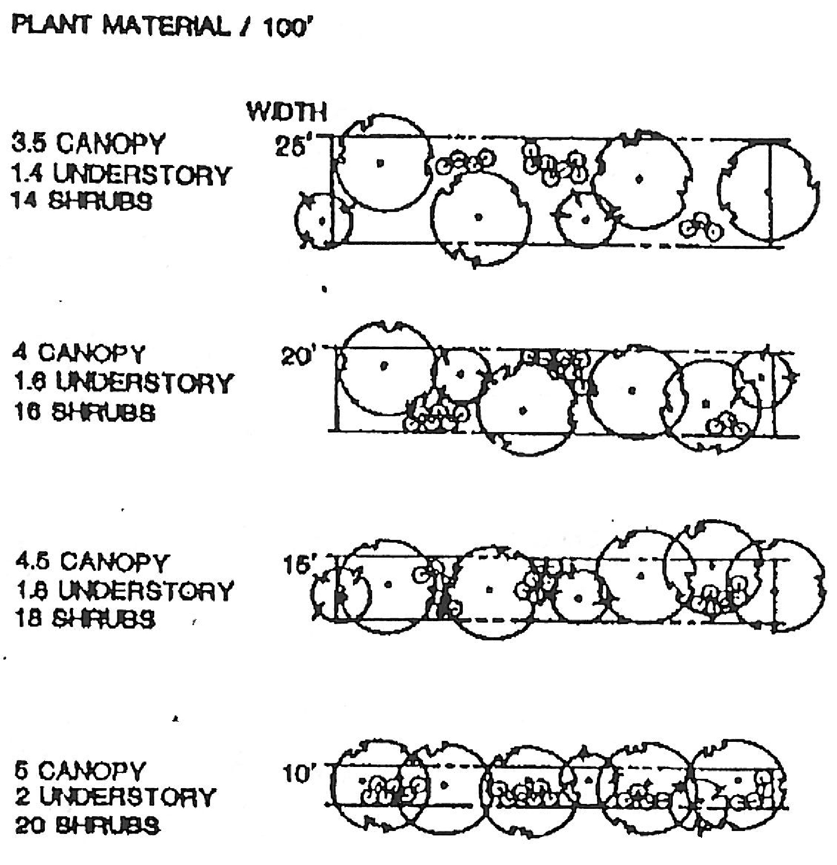
Landscape Standard B
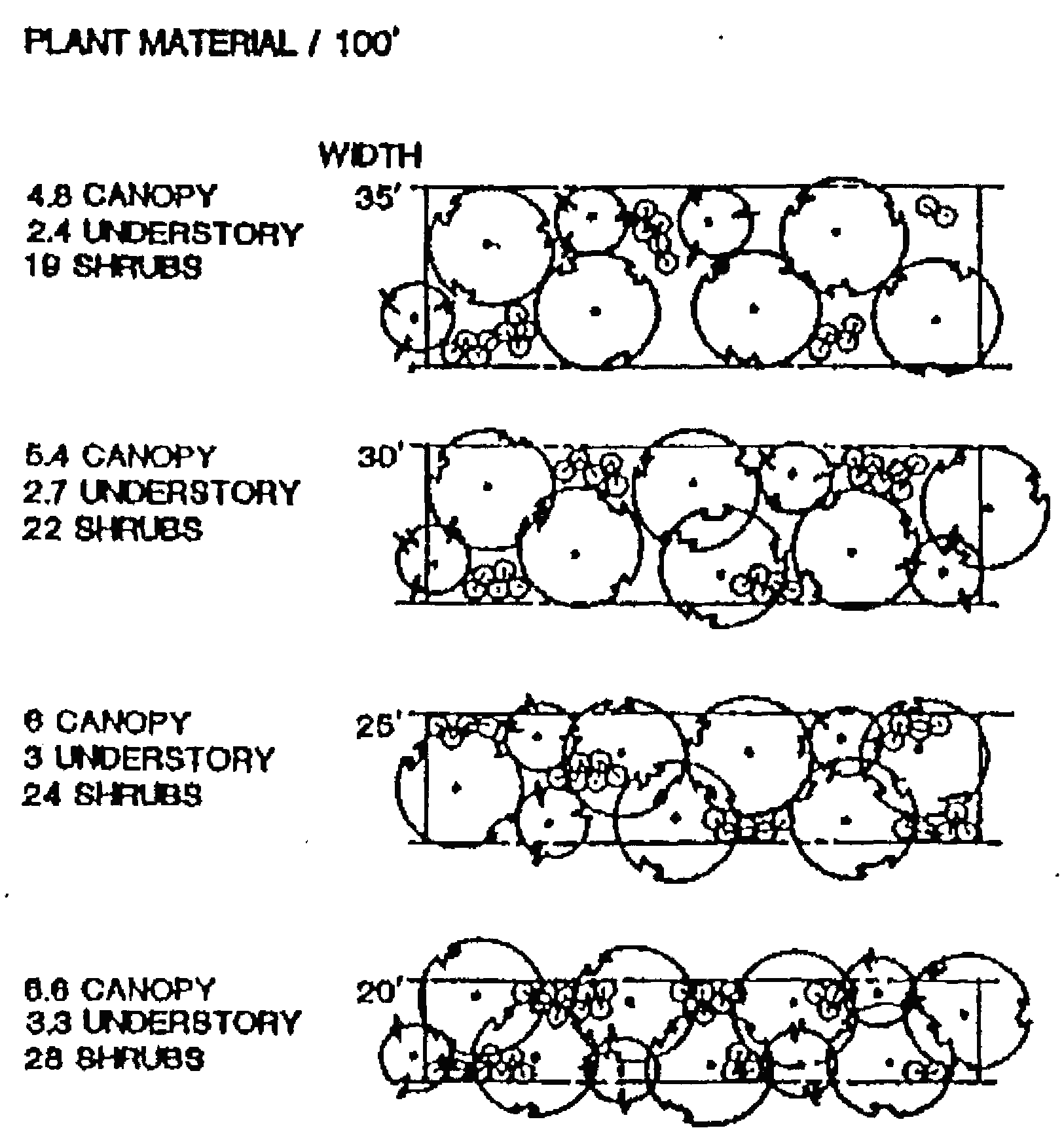
Landscape Standard C
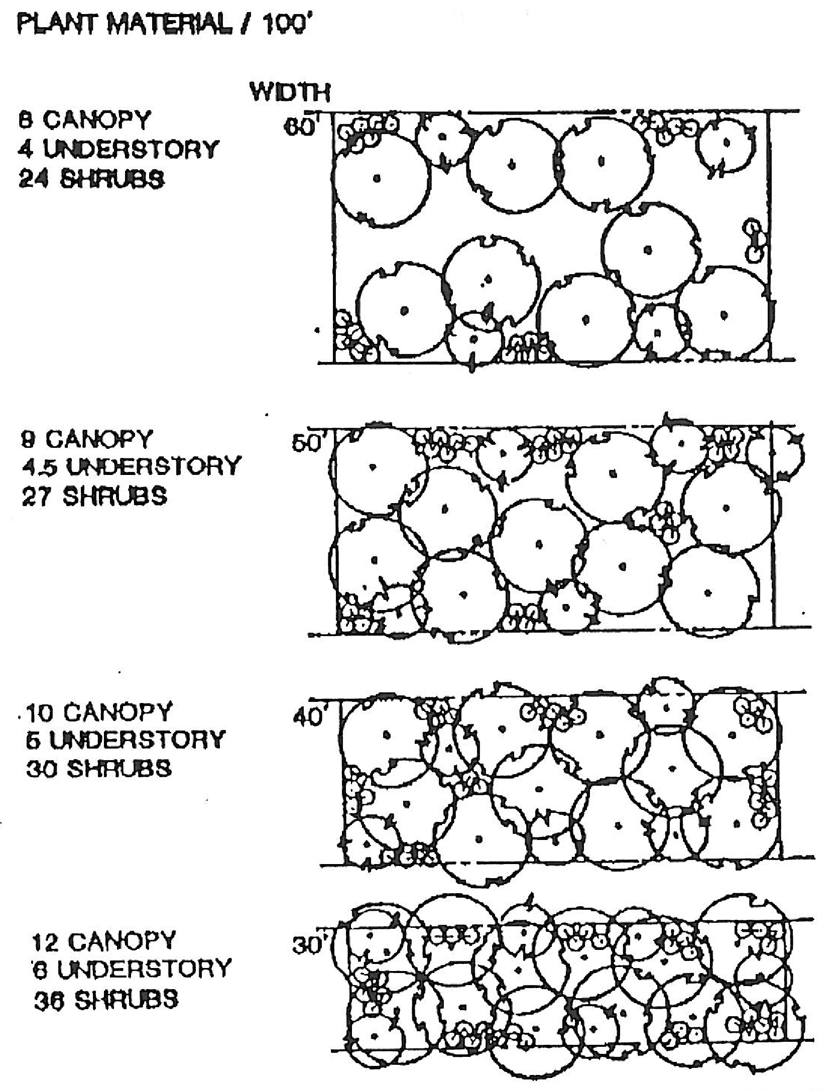
Landscape Standard D
(b)
Buffer zones.
(1)
A buffer zone is a landscaped strip along parcel boundaries that serves as a buffer between incompatible uses and zoning districts, around parks, open spaces, recreation and conservation areas, or as both a buffer and attractive boundary. This shall not be interpreted to mean that parcels within a planned mixed use development must meet these requirements.
(2)
The width and degree of vegetation required depends on the nature of the adjoining thoroughfares and uses. The standards of subsections (b)(3) and (4) of this section prescribe the required width and landscaping of all buffer zones.
(3)
The standards for buffer zones are set out in the following illustrations that specify the number of plants required per 100 linear feet. To determine the total number of plants required, the length of each side of the property requiring a buffer shall be divided by 100 and multiplied by the number of plants shown in the illustration. The plants shall be spread reasonably evenly along the length of the buffer.
(4)
The standards set forth in this section shall be applied between abutting parcels as follows:
(5)
The standards set forth in this section shall be applied along thoroughfares as follows:
(6)
Wherever the principal structure of a site abuts a vehicle use area on the same site, a buffer zone between the vehicle use area and the principal structure shall be provided as follows:
(7)
Buffering for mixed used developments shall be based on the more intense use in the building or cluster of buildings.
(8)
In addition to any required buffer, a fenced stormwater retention facility shall be screened from the public right-of-way by a continuous hedge or berm, or combination of both. Berms may be utilized to provide screening, provided they are a minimum, of three feet in height and no more than five feet in height. Berms shall be supplemental with landscaping in order to provide a minimum 36-inch high screen.
(9)
Solid waste refuse facilities shall be screened by a six-foot high masonry wall if located within the building setback areas. Such walls shall screen the refuse receptacle on three sides with the access side oriented towards the interior of the site. Refuse receptacles which are located in areas visible by the patrons of the site or abutting properties shall be screened in accordance with the criteria in this subsection. Such walls shall be landscaped with shrubs planted adjacent to the wall at a standard of 25 per 100 feet of wall. The wall and hedge shall not be located within the required buffer zone.
(10)
Open storage of articles, goods or materials shall not be permitted unless totally screened from the public right-of-way and adjacent properties. Utility fixtures and mechanical equipment, when outside a structure, shall be screened with dense plant materials or berms or a combination of both, or within a completely enclosed area.
(11)
A landscaped area shall be provided around the base of all buildings, oriented toward public rights-of-way and equal to 50 percent of the linear length of the building oriented toward the right-of-way, with a minimum width of four feet.
(12)
Accessory structures shall be screened from view by fencing or landscape materials.
(13)
The use of existing native vegetation in buffer zones is preferred (see division 5.01.00 of article V of this Land Development Code for tree protection requirements), If a developer proposes to landscape a buffer zone with existing native vegetation, the town manager may recommend, and the development review board may allow, a variance from the strict planting requirements of this division if:
a.
The variance is necessary to prevent harm to the existing native vegetation; and
b.
The buffering and/or aesthetic purposes of the buffer zone are substantially fulfilled despite the variance.
(14)
Responsibility for buffer zones.
a.
The desired width of a buffer zone between two parcels is the sum of the required buffer zones of the parcels. Where a new use is proposed next to an existing use that has less than the required buffer zone for that use, an inadequate buffer zone will be tolerated, except as provided in subsection (b)(14)b of this section, until the nonconforming parcel is redeveloped and brought into conformity with the buffer zone requirements of this Land Development Code. The developer of the new adjoining use is encouraged, however, to take into account the inadequacy of the adjoining buffer zone in designing the site layout of the new development.
b.
Where a residential use is proposed next to an existing nonresidential use, or a nonresidential use is proposed next to an existing residential use, and the existing use does not have a conforming buffer zone abutting the property proposed for development, the proposed use shall provide 80 percent of the combined required buffer zones of the two uses. Where the existing use has a buffer zone, but such zone does not meet the requirements of this Land Development Code, the proposed use may provide less than 80 percent of the combined required buffer zones if the provision of such lesser amount will create a buffer zone meeting 100 percent of the combined required buffer zone of the two uses. The development review board shall determine which areas may be counted as buffer zones of the existing use based on the buffering qualities of the areas.
(c)
Street trees.
(1)
The developer shall plant, within five feet of the right-of-way of each street within a residential development, one shade tree for every 35 linear feet of right-of-way. Except where property on one side of the right-of-way is not owned by the developer, the trees shall be planted alternately on either side of the street. Existing trees and native tree species that need less water and maintenance are preferred. (See division 5.01.00 of article V of this Land Development Code for tree protection requirements.)
(2)
Trees planted pursuant to this section shall be selected from the approved list of canopy trees below and shall have a minimum overall height of ten to 12 feet at time of planting. The town manager should be consulted in selecting appropriate tree species and planting procedures. Existing trees and native tree species that need less water and maintenance are preferred.
(d)
Use of required landscape areas. No accessory structures, garbage or trash collection points or receptacles, parking or any other functional use contrary to the intent and purpose of this Land Development Code shall be permitted in a required landscape area. This does not prohibit the combining of compatible functions such as landscaping and drainage facilities.
(e)
Residential building lots. All residential building lots, whether in newly proposed developments or in older portions of the town shall, prior to issuance of a certificate of occupancy, plant or preserve for every 2,000 square feet of lot area or fraction thereof, a canopy or citrus tree with a minimum DBH of two inches and eight feet in height. For every preserved tree with a DBH of eight inches, on the property after construction, two less new trees are required.
(f)
Nuisance trees listed in section 5.01.02(b) or those that are dead, dying, diseased or infected with harmful insects shall not be counted in meeting the requirement set forth in this section.
(Ord. No. 91-6, § 3(6.06.02), 2-11-1992)
Sec. 6.06.03. - Landscape design and materials.
(a)
Design principles. Designs should coordinate structural elements with landscaping to achieve a pleasing overall site design. Landscaping can achieve other design objectives such as breaking up mass and bulk, and protecting privacy, but such use of landscaping should not substitute for good building design in conformance with all design objectives. The following principles of xeriscape landscaping shall be used in new developments or for new houses in older portion's of the town:
(1)
Appropriate planning and design;
(2)
Use of soil amendments;
(3)
Efficient irrigation;
(4)
Practical turf areas;
(5)
Use of drought tolerant plants;
(6)
Use of mulches;
(7)
Appropriate maintenance.
Any required landscape plan for a single-family residence may be drawn by the owner or his agent, all others shall bear the seal of a landscape architect or person authorized in F.S. ch. 481, part II.
(b)
Conformance to principles. All landscaped areas required by this Land Development Code should conform to the following general design principles:
(1)
Landscaping should integrate the proposed development into existing site features through consideration of existing topography, hydrology, soils and vegetation.
(2)
The functional elements of the development plan, particularly the drainage systems and internal circulation systems for vehicles and pedestrians, should be integrated in the landscaping plan.
(3)
Landscaping should be used to minimize potential erosion through the use of ground covers or any other type of landscape material that aids in soil stabilization.
(4)
Existing native vegetation and on site natural areas should be preserved and used to meet landscaping requirements. (See division 5.01.00 of article V of this Land Development Code for tree protection requirements.)
(5)
Landscaping should enhance the visual environment through the use of materials that achieve variety with respect to seasonal changes, species of living material selected, textures, colors and size at maturity.
(6)
Landscaping design should consider the aesthetic and functional aspects of vegetation, both when initially installed and when the vegetation has reached maturity. Newly installed plants should be placed at intervals appropriate to the size of the plant at maturity, and the design should use short- and long-term elements to satisfy the general design principles of this section over time.
(7)
Landscaping should enhance public safety and minimize nuisances.
(8)
Landscaping should be used to provide windbreaks, channel wind and increase ventilation.
(9)
Landscaping should maximize the shading of streets, vehicle use areas and buildings.
(10)
The selection and placement of landscaping materials should consider the effect on existing or future solar access, of enhancing the use of solar radiation and of conserving the maximum amount of energy.
(11)
Vegetative buffer strips and/or landscaped berms shall be installed so as to reduce the potential for automotive emission pollution.
(12)
Where potable water is proposed for landscape irrigation, native vegetation or drought resistant plants shall be used.
(c)
Installation of plants.
(1)
All plants shall be healthy and free of diseases and pests, and shall be selected from the list of approved species in subsection (e) of this section. The town manager may authorize the use of an appropriate species not shown on the lists. The manager should take steps to have the substituted species added to the lists.
(2)
Plants shall be installed during the period of the year most appropriate for planting the particular species. If compliance with this subsection requires that some or all of the landscaping be planted at a time after the issuance of a certificate of occupancy, the developer shall post a performance bond sufficient to pay the costs of the required, but not yet installed, landscaping before the certificate shall be issued.
(3)
Landscaping shall be protected from vehicular and pedestrian encroachment by means of raised planting surfaces, depressed walks, curbs, edges and the like.
(4)
The landscaping shall not interfere, at or before maturity, with power, cable television, or telephone lines, sewer or water pipes, or any other existing or proposed overhead or underground utility service.
(5)
All plants shall be installed according to standards adopted by the town manager.
(6)
The developer shall provide sufficient soil and water to sustain healthy growth of all plants.
(7)
All landscaping shall be installed according to accepted commercial planting procedures. Soil, free of limerock, pebbles or other construction debris shall be provided. If curbing is used abutting landscaped areas, it shall be perforated to permit drainage from the paved ground surface area onto the landscaped areas.
(d)
Use of native plants. Forty percent of the total number of individual plants selected from each of the categories of the list of approved species in subsection (e) of this section (canopy, understory, shrub, groundcover) and used to satisfy the requirements of this Land Development Code shall be selected from the list of native species in the category. (See division 5.01.00 of article V of this Land Development Code for tree protection requirements.) All existing trees with a DBH of eight inches or larger shall be identified on the landscape plan and incorporated, where possible, into the overall landscape concept. Those trees which are proposed for removal should be identified. Preference shall be given to the preservation of existing trees over the strict interpretation of the minimum standards set forth herein, provided the proposed design will produce a more unique or aesthetically pleasing design.
(e)
Approved plants.
(1)
The documents set forth in this subsection and on file at the town hall, or available from the county extension office provide lists of plants suggested for use in the town. Plants shown as "very drought tolerant" should be given first priority with those as "moderately drought tolerant" as the secondary consideration. Those not designated are not recommended for use.
a.
Xeriscape Plant Guide II, South Florida Water Management District.
b.
Basic List of Ornamental Plants from Landscaping Florida Homes.
c.
Recommended Trees for Central Florida, Greater Orlando Chamber of Commerce, 1984.
d.
Florida Horticulture Pamphlets by Department of Ornamental Horticulture.
1.
OH25, Native Florida Plants.
2.
OH28, Ornamental Trees for Central Florida.
3.
OH30, Ground Covers for Florida Homes.
4.
OH60, Ornamental Palms for Central Florida.
e.
Selected shrubs for Central Florida, Circular 499, Florida Cooperative Extension Service.
(2)
The following are designated canopy trees:
a.
Cherry laurel.
b.
Chinese tallow.
c.
Laurel oak.
d.
Live oak.
e.
Southern magnolia.
f.
Red maple.
g.
Slash pine.
h.
Sweet gum.
i.
Sycamore.
j.
Water oak.
k.
Bold cypress.
l.
Chinese elm.
m.
Pine.
(3)
The following are designated understory trees:
a.
Orchid tree.
b.
Butia palm.
c.
Fishtail palm.
d.
Redbud.
e.
Loquat.
f.
Goldenrain tree.
g.
Chinese fan palm.
h.
Wax myrtle.
i.
Sour cabbage palmetto.
j.
Jerusalem thorn.
k.
Senegal date palm.
l.
Sweet viburnum.
(4)
Approved shrubs are listed in subsection (e)(1)e of this section, shown proper for Central Florida.
(5)
Ground covers, which are plants, other than turfgrass which at maturity normally reach an average maximum height of 24 inches are listed in subsection (e)(1)d.3 of this section, shown proper for Central Florida.
(6)
Plant material specifications. The following specifications shall be utilized for all landscape materials on the project site: The quality of plant materials used shall meet or exceed grade 1, as established in "Grades and Standards For Nursery Plants," part I, 1963, State of Florida, Department of Agriculture, Tallahassee, Florida, and amendments thereto.
(f)
Prohibited plants. Plants listed in section 5.01.02(b) shall not be installed as landscape material.
(g)
Irrigation. All landscaped areas shall be provided with an appropriate irrigation system to be provided by the developer. Said system shall provide at least one outlet for irrigation water within 150 feet of the plant material. If a landscaped area contains primarily species native to the immediate region, or plants acceptable for xeric landscaping, the town manager or development review board, as applicable, may waive or modify the requirement for installation of an irrigation system. Consideration of a waiver of the irrigation requirement shall include, in addition to the area covered by native vegetation, such local conditions as sun or shade, use of fill soil, and depth to water table.
(1)
Any restrictions shall not apply to handwatering using a self-canceling nozzle or low volume irrigation systems.
(2)
Any restrictions shall not apply to irrigation systems for which the sole source is treated wastewater effluent.
(3)
Any person, resident or developer who purchases or installs an automatic lawn sprinkler system shall install a rain sensor device or switch which will override the irrigation cycle of the sprinkler system when adequate rainfall has occurred. Enforcement of this section is covered in F.S. § 166.048.
(4)
The operation of any irrigation system or device in a manner causing water to be wasted is prohibited.
(5)
Irrigation systems can be operated outside any restricted hours for the purpose of system repair and maintenance as well as landscape maintenance activities. Such operations shall be limited to the minimum amount necessary.
(6)
The town manager may issue temporary verbal waivers or permanent written waivers.
(h)
Nonliving materials. Mulches shall be a minimum depth of two inches and plastic surface covers shall not be used.
(i)
Maintenance and replacement of plants.
(1)
All required plants shall be maintained in a healthy, pest-free condition.
(2)
Within six months of a determination by the town manager that a plant is dead or severely damaged or diseased, the plant shall be replaced by the developer in accordance with the standards specified in this Land Development Code.
(3)
The owner of any property shall be responsible for the maintenance of all landscaping in good condition so as to present a neat, healthy, and orderly appearance free of refuse and debris.
Periodic inspections shall be conducted by the town manager or his representative to ensure compliance with this section. Notice of noncompliance may be given by the town manager by certified mail and a reinspection will be made 30 days after the first notice. Continued violation after 30 days will be referred to the special magistrate. Deteriorated and destroyed materials must be replaced with plant material consistent as to quantity and quality of other material on the property or with any original landscape plan for the property or as approved by the town manager.
(Ord. No. 91-6, § 3(6.06.03), 2-11-1992)
Sec. 6.07.01. - Generally.
Certain uses have unique characteristics that require the imposition of development standards in addition to those minimum standards which may pertain to the general group of uses encompassing the use. These uses are listed in this division together with the specific standard that apply to the development and use of land for the specified activity. These standards shall be met in addition to all other standards of this Land Development Code, unless specifically exempted.
(Ord. No. 91-6, § 3(6.07.01), 2-11-1992)
Sec. 6.07.02. - Recreational vehicle parks.
Recreational vehicle parks are not permitted.
(Ord. No. 91-6, § 3(6.07.02), 2-11-1992)
Sec. 6.07.03. - Junkyards.
Junkyards are not permitted.
(Ord. No. 91-6, § 3(6.07.03), 2-11-1992)
Sec. 6.07.04. - Recreation parks and sites.
(a)
Generally. Recreation areas in the form of usable land shall be provided to serve the variety of needs for age groups included in the resident populations of the development. Both active and passive recreation areas shall be provided at a ratio of 2 5/10 -acre per 1,000 projected population. Population shall be calculated on the basis of persons per single-family unit. The following guidelines should be considered in designing these areas:
(1)
Active recreation. Typical facilities would include playgrounds, athletic fields, various types of courts (tennis, basketball, racquetball) swimming pools, exercise trails and clubhouse.
(2)
Passive recreations. Typical facilities would include picnic areas, benches, trails and water feature.
All recreation areas should be easily accessible by all residents of the community and include, where appropriate, sidewalk/bike path facilities, as well as parking areas for both autos and bicycles. Attention should be given to screening and buffering light and noise from adjacent residents. All land shown on the development plan as common open space, private recreational areas and facilities shall be subject to covenants and restrictions which ensure the payment of future taxes and the maintenance of areas and facilities for a safe, healthful and attractive living environment.
(b)
Specifics. Whether a town operated site or one operated by a homeowner or other entity they shall be governed by the following:
(1)
The town shall encourage the use of innovative site design and development techniques in order to maximize the provision of usable recreational facilities and open space areas at a minimum cost.
(2)
Should additional parks be needed or acquired, emphasis shall be placed on developing activity-type facilities.
(3)
As conservation areas are located within the town, they shall be so designated and used for active and/or passive recreational uses where it can be demonstrated that such uses will not have any significant adverse environmental impact and are compatible with other surrounding land uses.
(4)
All beaches, parks and recreational facilities shall be maintained at their existing level of access or improved, available and accessible to all residents and their guests.
(5)
The town or operating entity shall clearly identify, designate and provide sign identification of all recreational facilities.
(6)
Strict safety rules and procedures shall be adopted and posted at each facility by appropriate signage.
(7)
Regular monitoring of each facility shall be maintained during open hours.
(8)
Proper lighting shall be provided or the facility shall be closed at sunset.
(9)
Efficient maintenance activities shall be conducted in all recreational facilities so as to maintain them in an accident free condition and to correct or improve existing deficiencies.
(10)
Appropriate rails or fences shall be installed at each recreational facility.
(11)
Children's play areas shall be at least 50 feet from streets, parking areas or vehicular access points or be separated by a fence.
(12)
Barrier-free access shall be provided at all recreation facilities.
(13)
No new recreational facility shall contain architectural barriers to access.
(14)
Accessibility to recreational facilities shall be provided without the destruction of the unique character and quality of these areas.
(15)
Developments under 40 gross acres shall not be required to provide recreation sites. Developments over 60 gross acres in size must provide at least a 2.5-acre recreation site. The town will consider incentives to developers who provide sites in excess of the required amount. Sites shall be deemed "in perpetuity."
(Ord. No. 91-6, § 3(6.07.04), 2-11-1992)
Sec. 6.07.05. - Open spaces.
(a)
Definitions. The following words, terms and phrases, when used in this section, shall have the meanings ascribed to them in this subsection, except where the context clearly indicates a different meaning:
Open spaces means any land or water surface that affords unobstructed physical movement and is relatively free of manmade structural mass and shall be provided for their aesthetic, health, environmental and economic benefits to the community in any new development.
(b)
Requirements for developments exceeding five acres. Open space areas shall be provided within developments in order to enhance the living and working environment.
(1)
Classifications. Open space areas are described as areas serving any one of the following four basic functions:
a.
Shapes urban patterns. Areas which define and delimit urban concentration on a large scale. They can be used to separate or consolidate development and prevent development in undesirable locations.
b.
Production. Lands which are utilized for the production of products which contribute to the county's and the town's economy. This includes croplands (vegetable and citrus), pasture, commercial forests and plant nurseries.
c.
Recreation. Lands which support a specified recreation pursuit, whether it is an active or passive form of recreation.
d.
Conservation. Areas with unique natural qualities or physical benefits which need protection or preservation from man-built developments.
(2)
Two percent of land area required. All developments shall provide open space in the form of greenbelts and buffer zones at a ratio of two percent of the gross land area.
(3)
Prior phases of development. Open space in the form of greenbelts or buffers provided within the legal description portion of the proposed phase or project may be included to meet the minimum open space criteria. Excess open space committed in prior phases adjacent to a proposed development phase may be considered to meet up to 75 percent of the open space criteria.
(4)
Category A open space. All of the following uses shall count 100 percent towards meeting the total open space required:
a.
Buffer zones and greenbelts.
b.
Recreational areas (active and passive).
c.
Landscaped areas.
d.
All other permanently undeveloped uplands.
(5)
Category B open space. All of the following uses may be credited towards meeting the minimum open space requirements if the performance standards are met, but shall not account for more than 50 percent of the total open space required:
a.
Wet bottom stormwater management ponds.
1.
Minimum of 1.0 acres;
2.
5:1 side slopes;
3.
Sodded or an equivalent ground cover;
4.
Unfenced;
5.
Curvilinear in shape rather than angular;
6.
Landscaped in accordance with the following criteria:
(i)
2.5 acres. At least ten percent of the land above the design high-water level, excluding maintenance berms, shall be landscaped with at least 50 percent of the required area with plant materials other than ground cover (the use of native plant species is encouraged); or a littoral zone band of at least five feet in width for at least 50 percent of the shoreline established with native aquatic or semi-aquatic plant species;
(ii)
5-5.0 acres. At least five percent of the land above the design high-water level, excluding maintenance berms, shall be landscaped with at least 50 percent of the required area landscaped with plant materials other than ground cover (the use of native plant species is encouraged); or a littoral zone band of at least five feet in width for at least 35 percent of the shoreline established with native aquatic or semi-aquatic plant species;
(iii)
More than 5.0 acres. A littoral zone band of at least five feet in width for at least 20 percent of the shoreline established with native aquatic or semi-aquatic plant species:
A.
Access provided for all residents/employees;
B.
100 feet minimum width.
b.
Dry bottom stormwater management ponds.
1.
Sodded;
2.
Unfenced;
3.
Must be dry within 72 hours after a 25-year storm event;
4.
A skimmer must be provided to minimize the accumulation of trash and pollutants;
5.
At least five percent of the area above the peak stage elevation must be landscaped with at least 50 percent of the required area landscaped with plant materials other than ground cover (the use of native plant species is encouraged).
c.
Easements.
1.
Minimum 25-foot wide;
2.
Accessible for public use;
3.
Written verification from the easement holder authorizing unrestricted access.
d.
Plazas/hardscapes.
1.
20 percent landscaped;
2.
Seating areas;
3.
30 percent pedestrian accessible (excluding sidewalks) for area remaining after landscaping and water features/sculptures.
e.
Natural lakes. Only lakes which are totally within the legal description of the land use plan shall be credited towards open space.
(6)
Category C open space. Areas within a project, phase or tract, which are classified as conservation areas including mitigation areas, pursuant to the conservation element of plan and article V of this Land Development Code, shall be identified at the time of development plan submission. Conservation areas shall qualify as open space. However, to ensure that conservation areas or mitigation areas which comprise a high percentage of a project or tract do not constitute the only open space for the project, the amount of open space credit shall be limited to no more than 50 percent of the total open space required.
(7)
Percentage provided in categories B and C. Open space categories B and C cannot count for more than 75 percent of the total open space required for the project, phase or tract.
(Ord. No. 91-6, § 3(6.07.05), 2-11-1992; Ord. No. 2009-03, § 6(6.07.05), 6-9-2009)
Sec. 6.07.06. - Other restrictions in any area or district.
(a)
Mining and extractions of natural resources shall not be permitted.
(b)
County and state regulations concerning new existing or abandoned pollutant storage tanks; the disposal of waste tires and the prohibition of storage of waste tires out of doors; the proper disposal of solid waste, lead and batteries, used oil, trash and white goods, refrigerators, freezers, water heaters, etc.; the prohibition of compost facilities (except that backyard composting is permitted); and all hazardous waste shall be in accord with current regulations and not placed on any lands or water in the town and local area. Only permitted county sites may be used.
(c)
No person shall dig, damage, destroy, alter, change or deface the banks or shoreline, or any part thereof, of any lake or canal without a development permit.
(d)
Natural river systems shall not be channelized, diverted or damned.
(e)
Septic tank system regulations.
(1)
No structure, septic tank systems (including small package plants) or other individual wastewater treatment systems shall be used or installed in areas deemed environmentally unsuitable for their proper and continual functioning and which may have potential impacts to significant natural resources or in areas likely to be inundated by a 100-year flood event.
(2)
The continuing use of mal functioning septic systems shall not be permitted and needed improvement must be taken immediately or the county health department or the special magistrate will be requested to take proper actions.
(3)
All state and county regulations shall be followed in permitting of any wells or septic systems as well as their closure and abandonment.
(4)
Septic systems shall be:
a.
75 feet from a private well;
b.
100 feet from multifamily wells; and
c.
200 feet from public wells.
(f)
Water conservation.
(1)
The use of the lowest quality water to include grey water (if determined to be ecologically permissible) shall be required in all new developments so as to conserve potable water supplies.
(2)
Emergency water or general conservation plans, as required by the South Florida Water Management District, shall be complied with and necessary enforcement regulations enacted.
(3)
Upon receipt of an air/water heat pump ordinance, such regulation shall be adopted or included as a part of this Land Development Code.
(g)
Service station pumps shall be set back from the lot line on each street at least 65 feet from the right-of-way line or major street setback line, as applicable.
(h)
Owners shall maintain and conserve all structures in a satisfactory condition. Where properties deteriorate into a substandard condition, the special magistrate shall act promptly. Buildings should be rehabilitated if it can be restored to a standard condition at a cost not to exceed 50 percent of the value of the structure after rehabilitation. Where the cost of repairs exceeds 50 percent of the value of the structure after repair, it shall be demolished or removed. 24 CFR 882.109 may the used as a guide to determine if a residential structure is in standard condition. The regulation can be used as a guide for commercial structures.
(i)
Littering and unauthorized dumping is prohibited and a violation of this Land Development Code.
(j)
Hazardous waste. The town shall cooperate with the county, state and federal governments in enforcement of this division and other parts of the Code.
(1)
All persons who handle, store or transport hazardous waste or materials within the town shall register with the police department and provide such details about their operation as is required and comply with directives of that department concerning the handling, storage and transport of hazardous waste or materials.
(2)
Vehicles transporting hazardous waste or materials shall use County Road 439 and not local streets.
(3)
Secondary containment vessels or systems will be required in all tanks used for storage of hazardous material.
(4)
Septic tanks shall not be used by any new generator of hazardous/toxic waste and such waste shall not be entered into central sewage systems. Current generators must dispose of any such wastes in a permitted county site.
(5)
Construction and demolition debris shall be disposed of in proper, permitted sites as required by F.A.C. Rule 17-701-061.
(6)
All persons shall comply with state law, concerning the storage and handling of biomedical materials and wastes. They shall provide the town police chief and Ocoee fire chief a copy of their storage, transport and handling contingency plan, a copy of any changes to their plan and a recertification of their plan by January 1 each year.
(k)
Cantilevered or nonsupported eaves and cornices may project over the required front, side or rear yard a maximum of 48 inches.
(l)
No construction material, waste or waste/trash disposal containers will be placed/stored on town property, streets or private property not owned by the owner/builder/developer of a property during any construction/development/repair activity without permission of the town manager or the owner of the storage site.
(Ord. No. 91-6, § 3(6.07.06), 2-11-1992; Ord. No. 94-2, § 1(e, k), 2-8-1994)
Sec. 6.07.07. - Dog-friendly dining.
(a)
The purpose and intent of this part is to implement the option established by F.S. § 509.223, by permitting public food service establishments within the Town of Windermere, Florida, subject to the terms and contained herein, to become exempt from certain portions of the United States Food and Drug Administration Food Code, as amended from time to time, and as adopted by the State of Florida Division of Hotels and Restaurants of the Department of Business and Professional Regulation, in order to allow patrons' dogs within certain designated outdoor portions of their respective establishments.
(b)
Pursuant to F.S. § 509.233(2), there is hereby created in the Town of Windermere, Florida, a local exemption procedure to certain provisions of the United States Food and Drug Administration Food Code, as amended from time to time, and as adopted by the State of Florida Division of Hotels and Restaurants of the Department of Business and Professional Regulation, in order to allow patrons' dogs within certain designated outdoor portions of public food service establishments, which exemption procedure may be known as the Town of Windermere Dog-Friendly Dining.
(c)
The following words, terms and phrases, when used in this article, shall have the meanings ascribed to them in this section, except where the context clearly indicates a different meaning:
Division means the Division of Hotels and Restaurants of the State of Florida Department of Business and Professional Regulation.
Dog means an animal of the subspecies Canis lupus familiaris.
Outdoor area means an area adjacent to a public food service establishment that is predominantly or totally free of any physical barrier on all sides and above.
Patron has the meaning given to "guest" by F.S. § 509.013.
Public food service establishment has the meaning given it by F.S. § 509.013.
(d)
In order to protect the health, safety, and general welfare of the public, a public food service establishment is prohibited from having any dog on its premises unless it possesses a valid permit issued in accordance with this part.
(e)
Applications for a permit under this part shall be made to the town manager, on a form provided for such purpose by the town manager, and shall include, permit fees as determined by the town council, along with any other such information deemed reasonably necessary by the town manager in order to implement and enforce the provisions of this part, the following:
(1)
The name, location, and mailing address of the subject public food service establishment.
(2)
The name, mailing location, and telephone contact information of the permit applicant.
(3)
A diagram and description of the outdoor area to be designated as available to patrons' dogs, including dimensions of the designated area; a depiction of the number and placement of tables, chairs, and restaurant equipment, if any; the entryways and exits to the designated outdoor area; the boundaries of the designated area and of any other areas of outdoor dining not available for patrons' dogs; any fences or other barriers; surrounding property lines and public rights-of-way, including sidewalks and common pathways; and such other information reasonably required by the town manager. The diagram or plan shall be accurate and to scale but need not be prepared by a licensed design professional.
(4)
A description of the days of the week and hours of operation that patrons' dogs will be permitted in the designated outdoor area.
(5)
All application materials shall contain the appropriate division issued license number for the subject public food service establishment.
(6)
The town manager shall have authority to approve or deny applications.
(7)
Permits issued under this part shall be valid for one year from the date of issuance and must be renewed each year.
(f)
In order to protect the health, safety, and general welfare of the public, and pursuant to F.S. § 509.233, all permits issued pursuant to this part are subject to the following requirements:
(1)
All public food service establishment employees shall wash their hands promptly after touching, petting, or otherwise handling any dog. Employees shall be prohibited from touching, petting, or otherwise handling any dog while serving food or beverages or handling tableware or before entering other parts of the public food service establishment.
(2)
Patrons in a designated outdoor area shall be advised that they should wash their hands before eating. Waterless hand sanitizer shall be provided at all tables in the designated outdoor area.
(3)
Employees and patrons shall be instructed that they shall not allow dogs to come into contact with serving dishes, utensils, tableware, linens, paper products, or any other items involved in food service operations.
(4)
Patrons shall keep their dogs on a leash at all times and shall keep their dogs under reasonable control.
(5)
Dogs shall not be allowed on chairs, tables, or other furnishings.
(6)
All table and chair surfaces shall be cleaned and sanitized with an approved product between seating of patrons. Spilled food and drink shall be removed from the floor or ground between seating of patrons.
(7)
Accidents involving dog waste shall be cleaned immediately and the area sanitized with an approved product. A kit with the appropriate materials for this purpose shall be kept near the designated outdoor area.
(8)
At least one sign reminding employees of the applicable rules, including those contained in this part, and those additional rules and regulations, if any, included as further conditions of the permit by the town manager, shall be posted in a conspicuous location frequented by employees within the public food service establishment. The mandatory sign shall be not less than eight and one-half inches in width and 11 inches in height and printed in easily legible typeface of not less than 20-point font size.
(9)
At least one sign reminding patrons of the applicable rules, including those contained in this part, and those additional rules and regulations, if any, included as further conditions of the permit by the town manager, shall be posted in a conspicuous location within the designated outdoor portion of the public food service establishment. The mandatory sign shall be not less than eight and one-half inches in width and 11 inches in height and printed in easily legible typeface of not less than 20-point font size.
(10)
At all times while the designated outdoor portion of the public food service establishment is available to patrons and their dogs, at least one sign shall be posted in a conspicuous and public location near the entrance to the designated outdoor portion of the public food service establishment, the purpose of which shall be to place patrons on notice that the designated outdoor portion of the public food service establishment is currently available to patrons accompanied by their dog or dogs. The mandatory sign shall be not less than eight and one-half inches in width and 11 inches in height and printed in easily legible typeface of not less than 20-point font size.
(11)
Dogs shall not be permitted to travel through indoor or undesignated outdoor portions of the public food service establishment, and ingress and egress to the designated outdoor portions of the public food service establishment shall not require entrance into or passage through any indoor or undesignated outdoor portion of the public food service establishment.
(12)
Without exception, any dog that has been classified as a "dangerous dog" as defined by F.S. § 767.11, or for which Orange County's Animal Services Division has record of its propensity toward aggressive behavior, shall not be permitted within any portion of a public food service establishment.
(13)
A permit issued pursuant to this part shall not be transferred to a subsequent owner upon the sale or transfer of a public food service establishment but shall expire automatically upon such sale or transfer. The subsequent owner shall be required to reapply for a permit pursuant to this part if such owner wishes to continue to accommodate patrons' dogs.
(14)
In accordance with F.S. § 509.233(5), the town manager shall accept, and document complaints related to dog-friendly dining within the Town of Windermere, Florida, and shall timely report to the division all such complaints and the town's enforcement response to such complaint. The town manager shall also timely provide the division with a copy of all approved applications and permits issued pursuant to this part.
(15)
Any public food service establishment that fails to comply with the requirements of this part shall be guilty of violating this part of the Town of Windermere Code and shall be subject to any and all enforcement proceedings consistent with the applicable provisions of the Town of Windermere Code and general law. Each day a violation exists shall constitute a distinct and separate offense.
(Ord. No. 2018-10, § 1, 12-11-2018)