
Winter Park City Zoning Code
Sec. 58-83
Orange Avenue Overlay District OAO.
(a)
Establishment of Orange Avenue Overlay District. The Winter Park City Commission adopts this overlay district as needed in order to implement specific purposes, intents, and design standards based upon the adopted comprehensive plan goals, objectives and policies for the Orange Avenue Overlay District, which shall be applied as additional standards to other regulations required by the city. Such overlay district shall be made a part of this section of the Land Development Code. Upon adoption, the boundaries of such overlay district shall be shown on the Winter Park Zoning Map.
(b)
Applicability. An overlay district acts as an additional layer of zoning over the base (or underlying) zoning district. All development projects located within this overlay district shall adhere to the requirements of this section and other applicable provisions of the Land Development Code. The provisions of this section shall prevail to govern the development of property within the overlay district over conflicting provisions found in other parts of the Land Development Code, including the provisions of the applicable base zoning district.
(c)
Orange Avenue Overlay District. The provisions and regulations for the Orange Avenue Overlay District within the City of Winter Park are outlined below.
(1)
Orange Avenue Overlay District. It is the intent of the Orange Avenue Overlay District ("OAO") to provide enhanced standards to protect and promote the unique characteristics of the Orange Avenue area and create a distinct gateway into Winter Park. This OAO is used to create a sense of place established through specific architectural styles, streetscape design, open space areas, setbacks, site design, block structure, landscaping and other regulatory controls. The following provisions and regulations apply to all properties located within the OAO unless expressly provided otherwise.
a.
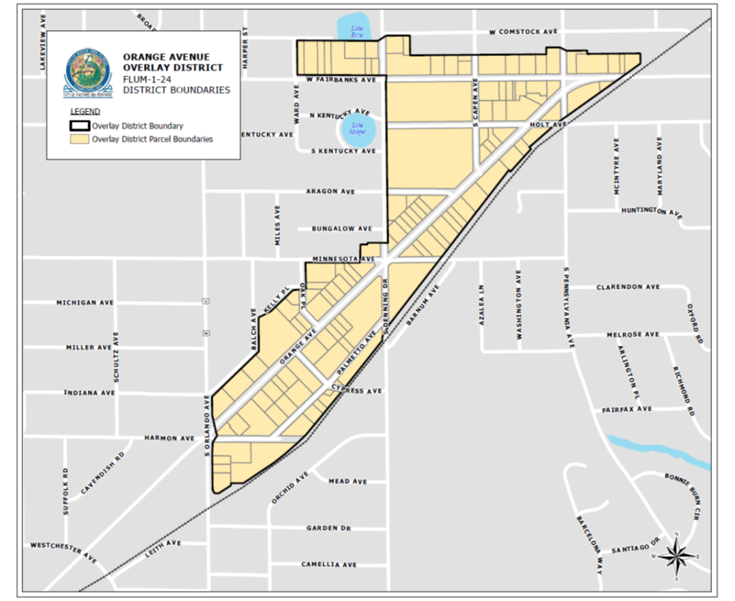
Location and boundaries. The OAO boundaries are identified on map FLUM 1-24, shown below. The provisions and regulations found herein shall only apply to the properties located within this defined area. Each parcel of property within the OAO is identified by tax parcel identification number on exhibit "A" attached to the ordinance adopting this section, and each Parcel, in addition to retaining its underlying zoning classification (as modified by these OAO regulations and provisions), shall reflect an "OAO" designation on the city's zoning map.
b.
Purpose.
1.
Encourage sustainable development, redevelopment, and adaptive reuse that will become a long-term asset to Winter Park;
2.
Create and enhance connectivity to the surrounding neighborhoods and promote connectivity to all of Winter Park;
3.
Utilize and incentivize private development and/or redevelopment to create solutions for the existing problems that small properties and business-owners in the Orange Avenue area face;
4.
Create public improvements that will benefit all residents and visitors of Winter Park;
5.
Provide the opportunity for existing businesses and properties to improve their structures, their businesses and their building facades;
6.
Restrict uses and create regulations that promote the development of the Orange Avenue area as a special place within Winter Park that promotes an environment of arts, healthy-living, cuisine, culture, heritage, social interaction, healthcare, local business, education, connectivity and community;
7.
Create better connectivity to and the promotion of Mead Botanical Garden;
8.
Meet the goals of the community redevelopment agency (CRA) in the areas of the OAO that fall within the CRA boundary;
9.
Protect and encourage development of an area that represents a significant opportunity for public and private investment, which is important to the long-term economic health of Winter Park;
10.
Establish regulations that protect the investment of existing and new businesses from unattractive, unsustainable and non-compatible uses;
11.
Ensure the area is visually pleasing and creates place that encourages community and is developed in a coordinated fashion;
12.
Follow the principles of the Vision Winter Park, comprehensive plan and sustainability plan documents;
13.
Encourage mixed-use development, shared parking and shared stormwater management;
14.
Give special attention to landscaping, architectural detail, meaningful open space, buffering, signage, lighting, and building setbacks;
15.
Encourage architectural creativity, quality and variation to create a unique district with its own identity;
16.
Promote the history of Winter Park and the Orange Avenue area, including the area known as Designers Row;
17.
Keep the traditional scale within the OAO;
18.
Create an arts and cultural corridor;
19.
Protect and promote historic architecture, where it exists in the area;
20.
Attract new businesses, retain small businesses and encourage locally-owned businesses in the Orange Avenue area; and
21.
Enhance pedestrian walkability, connectivity and safety and to create a safe, comfortable and convenient pedestrian experience with shaded sidewalks, interesting business fronts, connected destinations and walkable block sizes.
c.
Permitted uses. Any use not listed specifically as an allowed use herein shall be deemed to be prohibited in the OAO. The following uses up to 10,000 square feet shall be allowed by-right on any property within the OAO, unless otherwise specified within the applicable subarea policies:
1.
Antique stores
2.
Bars, taverns, cocktail lounges (with food sales and 51 percent of revenue must been from food sales)
3.
Blueprinting, photocopying and printing offices
4.
Bicycle shop
5.
Boutique hotel with 100 rooms or less.
6.
Breweries/distilleries (with food sales)
7.
Corner store (up to 5,000 square feet and excluding convenience store)
8.
Dry cleaning (drop-off only, with off-site processing and no drive-thru)
9.
Financial institutions, including banks, savings and loan associations and credit unions (with a maximum of two drive-thru lanes, which are screened from view)
10.
Fine arts museums, fine arts instruction, dance instruction and music instruction
11.
Fitness facility, exercise or health club (up to 5,000 square feet)
12.
Food halls
13.
Government services
14.
Grocer (not including convenience store), up to 10,000 square feet.
15.
Health and wellness studios (up to 5,000 square feet)
16.
Mixed-use development (can be vertical or horizontal) refer to section 58-83(c)(u) for the definition of mixed-use.
17.
Nonprofit organization offices
18.
Personal services (spa, barber shop, hair salon, nail salon, massage, cosmetic treatment) cannot be a standalone massage parlor, must be part of a spa or cosmetology salon
19.
Pet supply shop, pet grooming, pet daycare (provided that there shall be no outside kennels, pens or runs. No overnight or weekend boarding of animals)
20.
Photography studio
21.
Professional offices (including medical and dental offices)
22.
Recreational facilities up to 5,000 square feet
23.
Residential uses such as condominiums, townhomes, apartments, lofts, studios unless not allowed by the applicable subarea restrictions. If more than four units is proposed as a part of any new development, remodel or addition, each of the units shall be a minimum of 750 square feet of living area
24.
Restaurants/fast-casual dining/fine-dining
25.
Retail businesses involving the sale of merchandise on the premises (excluding pawn shops) within enclosed buildings a maximum size of 10,000 square feet.
26.
Specialty food/beverage market (up to 5,000 square feet and excluding convenience store)
27.
Theater for film, music and/or performing arts
28.
Shared office space
d.
Conditional uses. The following uses shall be allowed only with approval of a conditional use on any property within the OAO, unless otherwise specified within the applicable subarea policies:
1.
Bars, taverns, cocktail lounges (without food sales)
2.
Breweries/distilleries (without food sales)
3.
Fitness facility, exercise or health club over 5,000 square feet, but less than 10,000 square feet
4.
Recreational facilities over 5,000 square feet, but less than 10,000 square feet
5.
Buildings or permitted uses within this section over 10,000 square feet in size
6.
Boutique hotel with 100 rooms or less. Projects proposing banquet/meeting facilities or onsite food-service.
7.
Resale/stores
e.
Prohibited uses. All uses not permitted or conditionally permitted within the OAO are prohibited. Without limiting the uses that are prohibited in the OAO, the following uses shall be prohibited in the OAO:
1.
Adult-oriented businesses
2.
Automotive-related businesses (i.e., auto sales, auto repair, auto rental, body shops, auto wash, auto audio, auto glass, auto tinting, auto parts sales). This section shall apply to any form of motorized personal transportation devices that are not for medical use.
3.
Firearm sales
4.
Standalone massage parlors (not part of a health spa)
5.
Fast food (with or without drive-thru)
6.
Gas stations/convenience stores
7.
Liquor stores
8.
Pawn shops/check cashing
9.
Tattoo parlors
10.
Vape/smoke shops/hookah parlor
11.
Pain management clinics
12.
Medical marijuana dispensaries, processing, growing, etc.
13.
Billboards
f.
Non-conforming uses/structures. Existing but non-conforming properties uses and non-conforming structures, which existed as of the date the OAO became effective, shall be allowed to continue as legally non-conforming in the same manner after the adoption of the OAO as existed prior to the effective date of the OAO except as provided herein. Nonconforming uses and non-conforming structures shall be subject to and comply with the provisions of this OAO when any of the conditions below occur that cause the non-conforming use or non-conforming structure to be deemed abandoned and become illegal unless otherwise allowed to remain pursuant to a special permit granted by the city commission pursuant to section 58-64(f).
1.
A non-conforming principal use on the property is discontinued for a period of three consecutive calendar months then such non-conforming use shall be deemed abandoned and become an illegal use;
2.
A non-conforming structure is destroyed or significantly altered by 50 percent or greater then such structure shall be brought into compliance with the OAO requirements; or
3.
Enlargements of any existing non-conforming structures and/or uses are made to the property that increases the gross square footage then such property shall be brought into compliance with the OAO requirements.
Discontinuance of a non-conforming use will be determined by any of the following: (i) if the business relocates, (ii) if there is an interruption in utility service, (iii) a failure to pay applicable local business taxes or the expiration of a local business tax receipt, (iv) the absence of signage indicating the existence of the nonconforming use on the property, or (v) any other relevant evidence indicating discontinuation of the nonconforming use for the requisite time period. In determining the date of discontinuance, the date of the first indication of abandonment will be relied upon. A nonconforming use shall also be considered to be abandoned if a permitted use moves in place of a non-conforming use.
g.
Residential uses within the overlay district. The OAO shall not apply to existing residential uses or structures developed prior to the effective date of this section. Protections of existing residential uses shall be implemented. Properties currently used as and developed as residential prior to the effective date of this section shall continue to be subject only to current Land Development Code standards and protections governing such properties' underlying zoning designation and not those set forth in the OAO, unless and until such properties redevelop. Any change of use or redevelopment on the property shall require compliance with OAO standards. In order to protect existing structures that are used as a residence, new non-residential or mixed use development within the OAO shall have its structures setback at least 35 feet from the property boundaries of parcels with existing residential structures used as a residence that are not intended to be part of the proposed development, unless a written consent can be obtained from owner(s) of the affected existing residential structure(s) consenting to the waiver of such minimum setback requirement of this subsection. Parking garages shall be setback at least 100 feet from the property boundary of parcels used and developed as single-family or low-density residential.
h.
Landscaping requirements. Development and or redevelopment in the OAO shall comply with all landscaping requirements of other provisions of the Land Development Code and future corridor landscape plans, unless specifically addressed within the OAO. In addition to other requirements of section 58-334 of the Land Development Code, all street frontages within the OAO shall contain at least one shade tree for every 50 feet of linear lot line. Side yards and rear yards not facing streets shall contain at least one understory tree for every 30 linear feet of side or rear lot lines.
i.
Block structure and circulation requirements.
1.
The OAO is designed to enhance pedestrian walkability, connectivity and safety and to create a safe, comfortable and convenient pedestrian experience. Towards this end, the OAOs transportation system is based on inter-connected streets forming small blocks similar to successful patterns of the more walkable areas of the city such as the Park Avenue Corridor.
2.
Block configuration/lot standards. Any additional development or redevelopment of parcels in excess of one and one-half acres within the OAO shall be required to create a block structure and pedestrian corridors conducive to pedestrian safety, comfort, and vehicular circulation as outlined below: New or redeveloped buildings within the OAO shall have building widths of between a minimum of 50 feet and a maximum of 200 feet wide for buildings and 300 feet wide for parking structures where they interface with pedestrian oriented street frontage.
i.
Development shall provide a continuous driveway or alley that connects to adjacent parcels and roadways and provides access for emergency vehicles and city services, where possible.
ii.
To the extent possible, given the size and shape of the parcel, new or redeveloped blocks shall be between a minimum perimeter of 1,000 linear feet and a maximum perimeter of 1,500 linear feet. The city goal is to encourage walkability based upon successful Park Avenue Corridor block perimeters of 1,300 linear feet. Where existing block perimeters are smaller than 1,500 linear feet, no further breakdown is required. Where block perimeters are larger than 1,500 linear feet, new development shall be organized to break the land mass into walkable blocks.
iii.
Driveways or alleys shall be constructed at widths adequate for dumpsters, trash compactors and circulation of solid waste collection vehicles, large truck delivery and allow emergency vehicles to maneuver past parked delivery vehicles and waste receptacles.
3.
Street realignment and parallel Orange Avenue access. Where Palmetto Drive, Vivian Drive and Harmon Drive provide secondary and primary access to properties within the OAO area, portions of these roadways may be considered to be closed, vacated or re-aligned subject to city commission approval, so long as a parallel public access road and approved by the city commission, is dedicated and maintained to allow vehicular access between Orlando Avenue and Denning Drive. Protection of on-street parking, maximizing ease of traffic flow for Palmetto Avenue and maintaining the existing 50-foot public right-of-way shall be matters of priority concern should the roadway be re-aligned. Any road shall be constructed with a minimum street travel lane width of 24 feet unobstructed and shall have unobstructed vertical clearance per National Fire Protection Act (NFPA) codes, shall replace all existing on-street parking and maintain the existing 50-foot public right-of-way.
4.
Street sections. Any new, realigned, or redesigned street sections within the OAO shall be designed to create and maintain a comfortable walking environment encouraging the use of multimodal transit options including:
i.
On-street parking is to be provided to the maximum extent possible to buffer pedestrians from vehicular traffic. Parking space dimensions shall be not less than nine feet × 18 feet for perpendicular spaces and no less than eight feet × 22 feet for on-street parallel spaces.
ii.
Vehicular traffic lanes on streets with bus routes shall be designed at not less than 12 feet to support safe circulation of busses and transit.
iii.
When a project frontage is adjacent to a bus stop, the developer shall install benches and a covered bus shelter for resting and waiting for public transit.
iv.
Care shall be taken to minimize curb cuts and maximize visibility surrounding curb cuts. The city traffic engineer (and FDOT for state roads) shall determine where curb cuts and driveways are allowed for projects.
v.
New development in conjunction with the city shall pursue approval from FDOT to utilize the FDOT rail right-of-way for pedestrian/bicycle trails where appropriate, prior to submission of project plans for city approval.
5.
Sidewalks. All buildings, parking areas, public spaces, amenity features, and adjoining developments of similar use shall be linked with sidewalks. Sidewalks shall be provided along public streets that provide access to the development. A minimum 17-foot sidewalk is to be provided along Orange Avenue. Fairbanks Avenue and Orlando Avenue shall provide sidewalks at least ten feet wide with an additional minimum five-foot buffer along the back of curb, between the roadway and sidewalk. All other sidewalks in the OAO shall be eight feet in width with an additional minimum four-foot buffer on the back of curb. If sufficient right-of-way is not available, the building may need to be set back to accommodate these wider sidewalks and the additional space required to create the required sidewalks as defined herein shall be dedicated to public access through easement. Sidewalks shall be constructed in accordance with the standards for sidewalks set forth in City of Winter Park engineering standards and landscape standards and constructed at the sole cost of the developer.
Example of Sidewalk/Streetscape For Fairbanks Ave & 17-92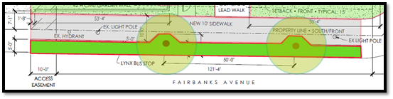
i.
Restaurants and cafes with seating within the public right-of-way shall be subject to the regulations contained in Chapter 90, Article VI - Sidewalk Cafes, of the Winter Park Code of Ordinances.
6.
New streetscapes. In order to improve the pedestrian experience, new development or redevelopment shall provide the streetscape area including sidewalks, lighting, landscape and street furniture and will dedicate pedestrian easements over this area prior to certificate of occupancy.
7.
Access standard.
i.
All city services including utility access, utility equipment, solid waste containers shall be placed at the rear of lots and accessed by driveways or alleys opening to side streets, where possible.
ii.
Garage and parking shall be accessed through driveways or alleys opening to side streets, where possible.
j.
Architectural standards. Development within all subareas defined later in this section shall meet the following architectural standards.
1.
Building height. To allow for flexibility in design, but preserving development standards that will reduce building massing, buildings shall be measured in stories. For parking garages, levels visible on the exterior of the building shall be counted towards building height (ex. A three-story building wraps around a four-level interior parking garage, only the three stories would count as they are the only part visible).
The first story of any building shall be allowed to be a maximum of 18 feet in height. When mezzanines, balconies or lofts are provided, first story heights of 20 feet may be allowed. Mezzanine, balcony or loft levels shall be allowed within the first story, as long as they do not cover more than 30 percent of the first-story area and stay within the maximum 20-foot first story height area. Interior mezzanines, balconies or lofts shall not be allowed above the first story. Each story above the first story shall have a maximum height of 12 feet. These building story maximums may not be achievable in all subareas based on the specific subarea overall height limit. Unused building story height may be transferred between stories.
For multi-story buildings over two stories in height, there shall be terracing and/or additional setbacks to accomplish vertical articulation is mandated to create relief to the overall massing of the building facades, as discussed later in this section.
2.
Setbacks/stepbacks. For any building over two stories in height that is built up to the allowable building line or "build-to" line, each additional story shall be setback a minimum of ten feet, or shall be within the allowable envelope as depicted in the figures below. The build to line is established by the greater of setback or sidewalk requirement. All setbacks are measured from the property line. Setbacks greater than the established "build-to" line require a variance. The required building stepbacks only apply to street frontages.
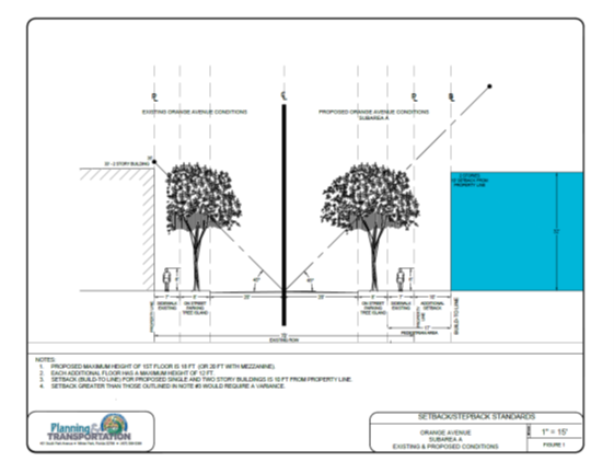
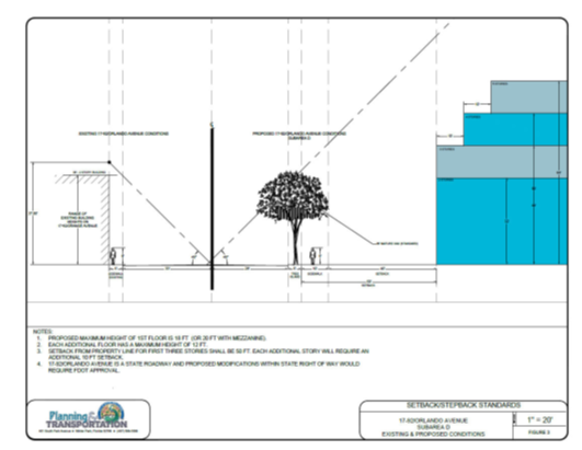
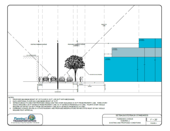
If a building is constructed within the allowable building envelope as depicted above, the first story shall always be defined and articulated as addressed later in this chapter. Additionally, the building shall not exceed more than two stories of vertical wall without a setback/stepback, cornice, balcony or other major façade breakup, which shall create visual and massing relief. All walls shall provide two or three of the articulation options listed below, offset a minimum of four feet.
Each subarea of the OAO may define additional required setbacks for that area that may differ from what is defined in this section. The defined building envelope depicted above shall be maintained, regardless of any setbacks.
All setbacks and/or stepbacks shall provide space for the healthy development of shade tree crowns. The city arborist shall review and recommend species selection and positioning to ensure compliance.
Rear building setbacks/stepbacks as defined herein shall not be required for properties abutting the railroad right-of-way.
3.
Architectural towers, spires, green roof features, solar panels, chimneys, or other architectural appendages. Any architectural tower, spire, chimney, flag pole or other architectural appendage to a building shall conform to the underlying subarea height limit. However, when necessary to meet the building code requirements, chimneys may exceed the height by the minimum required.
4.
Mechanical penthouses, rooftop mechanical and air-conditioning equipment, stair tower enclosures, elevators and parapets. Mechanical penthouses, mechanical and air-conditioning equipment, stair tower enclosures, or elevators on rooftops of buildings shall not exceed a total height of six feet (building code official shall have the ability to give administrative variances to this requirement based on life-safety or equipment needs for elevation) above the allowable building height. Any penthouses shall only be used for mechanical equipment to serve the building. Parapets, or mansard roofs serving as parapets, may extend a maximum of five feet above the height limit in the underlying zoning district unless other parapet heights are more restrictive for the respective underlying zoning district. In addition, mechanical equipment and air-conditioning equipment on rooftops shall be screened from view from ground level on all buildings in all zoning districts and shall be located to the maximum extent possible so that they are not visible from any street.
k.
Parking requirements and access management. The planning and transportation director or city traffic engineer or their respective designee may require the property owner to provide a site-specific traffic study to determine the potential impacts of the proposed changes to uses or structures as part of the site development plan.
1.
To the extent net street parking, over and above that currently existing within the OAO, is provided by the developer prior to certificate of occupancy, such net new parking directly adjacent to the development lot may count towards satisfying Code parking requirements.
2.
Parallel Orange Avenue access. Where Palmetto Drive, Vivian Drive and Harmon Drive provide secondary and primary access to properties within the OAO area, portions of these roadways may be considered to be closed, vacated or re-aligned, so long as a parallel access road, as approved by the city commission, is dedicated and maintained to allow public vehicular access between Orlando Avenue and Denning Drive. Protection of on-street parking, maximizing ease of traffic flow for Palmetto Avenue and maintaining the existing 50-foot public right-of-way shall be matters of priority concern should the roadway be re-aligned. Any road shall be constructed with a minimum street travel lane width of 12 feet unobstructed and shall have unobstructed vertical clearance per National Fire Protection Act (NFPA) codes, shall replace all existing on-street parking and maintain the existing 50-foot public right-of-way. No on-street parking shall be permitted along a curved roadway segment where the curve exceeds 60 degrees.
3.
Off-street parking requirements. Unless specifically provided within the OAO, parking spaces, parking management plans and parking leases shall be provided in accordance with Land Development Code requirements.
i.
General business and retail commercial: One parking space for each 333 square feet of gross floor space.
ii.
Office, professional or public buildings: One parking space for each 333 square feet of gross floor space.
iii.
Medical office: One parking space per 200 square feet of gross floor space.
iv.
Hotel: One parking space for each guest room shall be provided. Other ancillary uses in the hotel (restaurant, spa, retail, meeting space, etc.) shall be required to provide parking in accordance with the off-street parking requirements defined in section 58-86 subject to a credit of 50 percent of the rooms.
v.
Restaurants, food service establishments, nightclubs, taverns or lounges: One space for every four seats.
vi.
Multi-family residential:
A.
Each one-bedroom or studio unit shall be required to provide 1.25 dedicated parking spaces per unit.
B.
Each two-bedroom unit shall be required to provide 2.0 dedicated spaces per unit.
C.
Each three-bedroom or above unit shall be required to provide 2.5 dedicated parking spaces per unit.
4.
Off-street parking access design. Parking access to properties along Orange Avenue, Orlando Avenue and Fairbanks Avenue shall be through an alley originating from side streets or from a side street if frontage is available on a side street. In mid-block locations without existing alleys, new alleys shall be provided and accessed from the frontage street. Garages shall not be located in front of the primary building. If side street frontage is not available, access from cross-access easements preferably in the form of shared rear alleys shall be utilized. If cross-access is not available, a driveway will be allowed from Orange Avenue, Orlando Avenue, or Fairbanks Avenue, provided the driveway and building gap surrounding it is not more than 20 feet. Any new driveways or curb cuts along Fairbanks Avenue or Orlando Ave shall require City of Winter Park Traffic Engineer and FDOT coordination prior to submittal. Throughout the OAO, cross-access agreements, preferably in the form of shared rear alleys are required, to reduce the number of curb cuts and driveways. The intent is to maintain the building street wall without large voids for access driveways and improve traffic circulation by providing rear access for services and deliveries. The goal in this parking arrangement is to decrease the visibility of parking from the street as much as possible, by having parking behind the building and to reduce the turning movements with limited visibility across multiple lanes of traffic.
5.
Off-site parking. Required parking may be located within 750 feet of the building, or within the closest parking lot or parking structure, where excess parking is available for lease. In the event of new construction, addition, or change of use of the principal building or property being serviced by the remote parking lot, all existing parking spaces located on such remote lot shall be allocated to the existing building or principal use to meet the minimum requirements of this article, and any additional spaces may then be allocated to that portion of the building or property which is the subject of the new construction, addition, or change in intensity of use.
6.
Bicycle parking requirements. Unless specifically provided within the OAO, bicycle parking shall be required in accordance with other Land Development Code standards. Where large projects provide parking garages, a minimum of 20 percent of the required bike parking shall be provided onsite. The other 80 percent of required bike parking may be located within city right-of-way, along bike paths, or within greenspace areas throughout the OAO. The director of planning and transportation shall determine where the off-site bicycle parking shall be located.
7.
Parking exclusion. A parking exclusion shall apply only to existing square footage or floor space. Parking shall be provided as required by the OAO parking standards or other provisions of the Land Development Code, where not specifically addressed herein. These standards shall apply for any net new building or net new floor space created by redevelopment, new construction, additions, alterations, or remodeling or for any change in use requiring additional parking such as an office or retail space conversion to restaurant. Existing parking spaces may be counted to satisfy this requirement only where such existing spaces are in excess of the parking space requirements of this section for any existing floor space.
Floor area ratio for parking structures. In subareas where the city encourages the use of structured parking, an opportunity to achieve increased floor area ratio (FAR) is included in the subarea development standards. Parking structures shall count towards the floor area ratio (FAR) for any property within the OAO (except for underground level, open top level, or other exemption as defined within this chapter). The following conditions shall apply to parking structures:
i.
Provide for multi-property parking collectives. For smaller-scale garages, multiple property owners may create a collective where parking can be built on a property that can serve multiple properties that do not have adequate available parking.
ii.
Provide level-two electric vehicle charging stations for a minimum of two percent of all spaces within the structure.
iii.
Provide and construct parking spaces at least ten percent above what is required to meet Code minimum requirements. This excess parking must be available for lease at or below fair market value (based on comparable area parking leases) to small businesses in the OAO located in Subarea A. When parking spaces to satisfy the ten percent requirement are located on the primary parcel as part of structured parking, the square footage associated with those spaces shall not be included in FAR calculations. At the discretion of the city commission, a portion of this additional parking may be provided in another location of verified parking deficiency within the OAO. Any parking spaces provided under this provision shall be constructed in conformance with the standards of the Subarea in which they are constructed, subject to an approved Parking Management Plan and supported by a recorded instrument acceptable to the city attorney. Provision of parking spaces shall run concurrent with the primary development use. The city's preference is structured parking. Should the city commission agree to accept surface parking spaces as part of the required ten percent additional parking, the number of spaces will be adjusted to reflect the comparable value of surface versus structured parking based on current market values as determined by the office of management and budget.
iv.
Stairwells required for parking garages shall be designed to have open walls, visible to the outside of the garage.
v.
Parking structures shall be designed to allow sufficient airflow to ensure that all structured parking remain "open-air." Mechanical ventilation shall not be allowed for structured parking within the OAO, unless the parking structure is located below ground.
vi.
Parking structures shall be screened at least 50 percent on all visible sides with green walls, living walls, liner buildings (with adequate spacing to allow air and light to enter garage), murals (that do not include advertising of any type), mature shade trees or vegetative screening, or designed with architectural details to match the primary structure that soften the appearance from looking like a stark parking garage wall.
vii.
Subarea A properties shall be offered priority for parking spaces that are required to be available for purchase or lease. Parking spaces shall also be eligible for purchase by other properties. The first opportunity to purchase or lease shall be given to Subarea A.
viii.
Parking structures shall meet height, building setback, allowable building envelope area and screening requirements as outlined in the OAO.
ix.
Parking garages shall be set back from the Orange Avenue, Fairbanks Avenue or Orlando Avenue frontages in accordance with requirements of section 58-83(c)(1)j.2. setbacks allowable building envelope cross-section based on height. Parking structures shall be screened as required in the OAO. Parking shall be accessed from private drives or public/private alleys originating and terminating on side streets to the maximum extent feasible. They shall be designed in an architectural style that is compatible with its building counterpart and shall also conform to the city's parking garage design guidelines, be subject to parking management plans and standards in section 58-84 and section 58-86.
x.
Parking structures shall not be permitted on the north side of Fairbanks Avenue.
l.
Meaningful open space requirements. It is the intent of the OAO to ensure that the development and enhancement of properties includes the creation of meaningful, useable, accessible, green and beautiful open space that invites the public to relax, interact, recreate, unwind and stimulate social connection. Where properties are planned for redevelopment, meaningful open space and the design of structures around these open spaces is the most important consideration. At a minimum, each property one and one-half acres in size and above, or any project covering one and one-half acres, that is redeveloped shall provide at least 25 percent meaningful open space, which is predominately visible from public rights-of-way, open to and available to the public. At least 50 percent of open-space areas provided shall be greenspace. Pervious areas such as retention ponds, parking lot islands or landscape planting areas around building bases shall not be counted as open space. Existing park space shall not count towards open space requirements. Open space shall be areas that are open and inviting to the public. Open space can include green areas, hardscape areas, semi-pervious areas, balcony or roof areas that are open to the public and other similar-type spaces. At least 90 percent of the open space shall be provided at ground level. The intent is that each of these areas create the opportunity for social interaction, relaxation, recreation and reflection.
m.
Signage requirements. Signage within the OAO with frontage along Orange Avenue shall comply with the following requirements:
1.
Each occupant shall be permitted a maximum of two signs indicating the business, commodities, service or other activity sold, offered or conducted on the premises. Where one occupancy has two signs, only the following combinations of sign types shall be permitted: One wall or canopy sign; one projecting sign and one wall or canopy sign; one canopy sign and one under-canopy sign. These signs shall also comply with the applicable provisions of sections 58-125 through 58-128.
2.
Projecting signs on properties or buildings within the OAO shall be limited to an area of each face of 20 square feet and shall have a minimum clearance of seven feet.
3.
The maximum copy area of canopy signs shall be two square feet per linear foot of canopy front and sides. These signs should also comply with applicable provisions of section 58-128.
4.
Signs attached to the underside of a canopy (under-canopy signs) shall have a copy area no greater than six square feet, with a maximum letter height of nine inches, subject to a minimum clearance of seven and a half feet from the sidewalk.
5.
OAO properties may not have digital, electronic, and/or internally-illuminated signs, such as backlit plastic, acrylic or glass. Front lighting of signs is encouraged. External illumination must be provided by a light source that is installed to prevent direct light from shining onto the street or adjacent properties. Flashing or moving lights are not permitted. Backlit halo-type opaque sign lettering is permitted; however, the light color must be white or subdued and muted such as a pastel shade. Sign faces and sides may not be translucent and must be an opaque material such as metal or wood.
6.
Ground signs or monument signs (excluding pole and pylon signs) are only permitted within the Subareas C, D, E, I, J and K. Ground signs within these subareas are limited to 30 square feet in size, and shall be located as to prevent interference with pedestrian and vehicular traffic. The design and location of such signs shall be subject to the approval of the planning and transportation director or building official via a sign location and design plan to ensure that the sign does not interfere with pedestrian traffic, parking or does not create excessive signage in one area.
n.
Sidewalk design and utilization. All buildings, parking areas, public spaces, amenity features, and adjoining developments of similar use shall be linked with sidewalks. Sidewalks shall be provided along public streets that provide access to the development. A minimum 17-foot sidewalk is to be provided along Orange Avenue. Fairbanks Avenue and Orlando Avenue shall provide sidewalks at least ten (10) feet wide with a minimum five-foot buffer along the back of curb, between the roadway and sidewalk. All other sidewalks in the OAO shall be at least eight feet in width with a minimum four-foot buffer. If sufficient right-of-way is not available, the building may need to be set back to accommodate these wider sidewalks and the additional space required to create the sidewalks as defined herein shall be dedicated to public access through public access easement. Sidewalks shall be constructed in accordance with the standards for sidewalks set forth in City of Winter Park engineering standards and landscape standards and constructed at the sole cost of the developer. Restaurants and cafes with seating within the public right-of-way shall be subject to the regulations contained in the Winter Park Code of Ordinances.
o.
Display of merchandise outside of commercial buildings. Only properties within the OAO with frontages along Orange Avenue are allowed one display of merchandise to be located outside of a commercial business exclusive of beautification elements such as plants (that are not for sale), benches, etc. This display must be placed within two feet of the front wall or window of the building. This display must not block or impede pedestrian traffic or be placed on the public sidewalk and at least six feet of clear sidewalk width must remain for pedestrian traffic. This display must be no more than six feet in height and no more than two feet in width. The display must be safely secured and removed under windy conditions. The display must be removed when the business is not open. An outside display is not permitted if the business chooses to place an outdoor portable sign.
p.
Stormwater management. To increase efficiency of land use, at the discretion of the director of planning and transportation or the director of public works, stormwater management systems serving multiple building developments may be considered, provided such systems are made available before certificate of occupancy (C/O) and recorded with a legal instrument acceptable to the city with review and advice from the city attorney.
q.
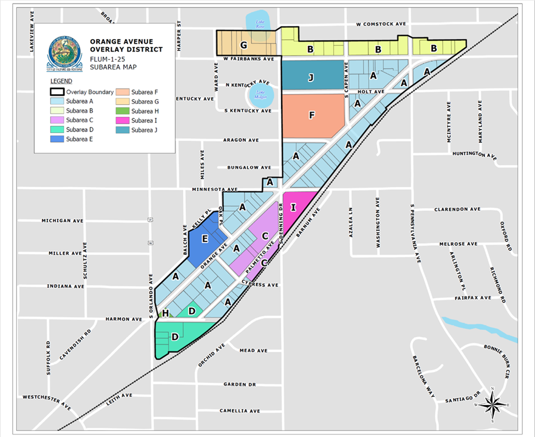
Orange Avenue Overlay District subareas and standards for development. The subarea map depicted below delineates the different subareas and their specific development standards. Changes to the subarea map shall not be allowed unless initiated at the direction of, or otherwise authorized by, the planning and zoning board, making recommendation to the city commission. Each area has unique characteristics, issues and opportunities. The base and maximum achievable floor area ratio (FAR), height and residential densities (if applicable) for each subarea are defined herein. An incentive menu system is established for certain properties within the Orange Avenue Overlay District to possibly earn additional FAR up to their maximum achievable FAR, by providing certain public improvements and area-wide solutions, as outlined in this chapter.
After the adoption of the OAO, no administrative changes to the subarea map shall be allowed. Variances to height, number of stories, FAR, permitted/prohibited uses, required open space or maximum residential density shall not be granted for any property or development within the Orange Avenue Overlay District. Variances to other development standards shall be considered, with sufficient showing of reasoning and hardship, as outlined in sections 58-90 and 58-92.
The standards detailed in the OAO are the maximum density and intensity parameters permitted in each respective subarea. These maximum standards are not an entitlement and are not achievable in all situations. Many factors may limit the achievable FAR including limitations imposed by the maximum height, physical limitations imposed by property dimensions and natural features as well as compliance with applicable Code requirements such as, but not limited to parking, setbacks, block structure, lot coverage and design standards.
Parcels to be developed or redeveloped within Subareas D, I and J shall contain at least 25 percent of the cumulative gross floor area as mixed-use, ensuring that no single-use developments occur that may not create the vibrant mixed-use district that is desired. Mixed-use can be vertical or horizontal.
Residential units are not allowed on the first story frontage along Orange Avenue for all subareas. Limited residential use of the first story of such buildings may be permitted when limited to the functions of entrance lobby/elevator/stair access, leasing or management office or residential amenity spaces such as health/fitness, meeting/activity room or storage.
1.
Subarea A. In order to allow for the remodeling and renovation of the buildings within this subarea and to enhance the OAO, these properties shall not be required to comply with those Land Development Code standards listed below, as long as additional square footage is not added to the buildings. If additional square footage is added, as to parking requirements, the properties shall be required only to provide the required parking for the new net square footage of the structure. Any additional impervious surface created shall meet all City of Winter Park stormwater requirements for the new impervious area. All remodels, renovations or reconstructions that are allowed to remain as legally non-conforming under other Land Development Code requirements, shall still be required to meet applicable building and life safety codes as determined by the city building official, zoning official and fire official. If the use of the building is changed (i.e., office conversion to café), additional parking shall be provided as required by Code.
i.
Exemptions. The following Land Development Code requirements shall not be required to be met for renovation or remodel of existing structures that will maintain the existing use, gross square footage, impervious coverage, number of stories and conditions of the property:
A.
Floor area ratio (to the extent existing structure already exceeds FAR)
B.
Minimum parking requirements
C.
Stormwater retention
D.
Impervious surface percentage
E.
Setbacks
F.
Landscaping
G.
Height (no increase in stories)
ii.
Reconstruction of buildings. Given the age of buildings within Subarea A, the properties within this subarea shall be allowed to reconstruct the same building footprint (and square footage) when the building on the site is completely demolished, regardless of non-conforming status, on the site without being required to meet all development standards. Reconstruction of buildings shall be required to provide stormwater retention and the sidewalk widths as described herein. All building and life safety codes shall be met with all reconstruction.
iii.
Subarea A development standards:
A.
Base floor area ratio (FAR): 45%
B.
Maximum achievable FAR with residential: 60%
C.
Maximum height: 2 stories for any properties abutting Orange Avenue and Minnesota Avenue, and three stories for all other properties within the subarea.
D.
Maximum impervious coverage: 85%
E.
Setbacks: Maximum front setback is zero feet, but must allow for at least a 17-foot wide sidewalk along Orange Avenue. Fairbanks Avenue and Orlando Avenue and other streets in the OAO shall each be designed to provide for a ten-foot wide sidewalk with a minimum five-foot buffer on the back of curb. Where the building requires an additional setback to achieve the required sidewalk, landscape buffer or street tree canopy clearance, the area shall be dedicated as a public access easement. Side setback is a minimum of zero feet, and rear setback is a minimum of ten feet.
F.
Maximum residential density: 17 units per acre
G.
Historic preservation: It is a purpose of the OAO to protect and promote historic resources within the OAO. Towards that end, the CRA, in conjunction with the city, shall make available the potential financial incentive funds or matching grant funds, providing professional technical assistance to property owners to submit applications for designation on the local and National Register of Historic Places. Additionally, discounts on license and permit fees shall be offered to incentivize registration on the local register of Historic Places. Applications for façade grants from historic assets shall be given prioritization.
2.
Subarea B.
i.
Subarea B development standards:
A.
Base floor area ratio: 45%
B.
Maximum achievable FAR with residential: 60%
C.
Maximum height: 3 stories. The third story shall be set back an additional ten feet from front and rear setback lines. Third floors shall only allow residential uses.
D.
Maximum impervious coverage: 85%
E.
Setbacks:
(i)
Fairbanks Avenue and Orlando Avenue and other streets in the OAO shall each be designed to provide for a ten-foot wide sidewalk with a minimum five-foot buffer on the back of curb. Where the building requires an additional setback to achieve the required sidewalk, landscape buffer or street tree canopy clearance, the area shall be dedicated as a public access easement. Side setback is a minimum of zero feet, and rear setback is a minimum of 35 feet.
(ii)
Side: 0 feet
(iii)
Rear: 35 feet
(iv)
Third stories shall require an additional ten-foot setback from the front and rear setbacks.
F.
Maximum residential density: 17 units per acre
ii.
Additional development regulations. For properties within this Subarea B with an underlying zoning of single-family residential, these properties shall only be used for single-family residential use, open space, or transportation improvements.
3.
Subarea C.
i.
Subarea C development standards:
A.
Base floor area ratio: 10%
B.
Bonus FAR exclusively for structured parking: 65%
C.
Maximum achievable FAR with parking structure: 75%
D.
Total FAR must be divided between multiple buildings
E.
Maximum height: 2 stories or 35 feet (including any awnings or shade structures) for commercial structures and parking garage shall be allowed up to four levels of parking including the rooftop deck, with a maximum height of 35 feet to the top of the parapet wall.
F.
Maximum impervious coverage: 75%
G.
Setbacks: 0-foot front setback along Orange Avenue, Denning Drive, or Palmetto Avenue, except front setbacks on Orange must allow for at least a 17-foot wide sidewalk and setbacks on Denning and Palmetto must allow for a ten-foot wide sidewalk and two-foot buffer on back of curb.
H.
Maximum residential density: Residential uses shall not be permitted.
ii.
Palmetto re-alignment. Palmetto Avenue may be relocated to allow for different development scenarios on the site. Protection of on-street parking, maximizing ease of traffic flow for Palmetto Avenue and maintaining the existing 50-foot public right-of-way shall be matters of priority concern should the roadway be realigned.
iii.
Additional development requirements.
A.
A monument sign at least three feet in height and five feet in width, set in a landscaped bed, shall be required to be provided at the intersection of Denning Drive, Minnesota Drive and Orange Avenue, which directs the public to Mead Botanical Garden. The city shall approve the design and location of the sign.
B.
Include one and one-half acres of contiguous park space plus bicycle/pedestrian trail.
C.
City to retain ownership of this parcel in perpetuity.
D.
Stormwater requirements to exceed code.
E.
Contribute to parking needs of small businesses in the area.
F.
Walkways that are at least five feet wide (paved or bricked) must exist between buildings onsite and extend from the park area to Cypress Ave.
4.
Subarea D.
i.
Subarea D Development Standards:
A.
Base Floor Area Ratio (FAR): 60%
B.
Maximum achievable FAR with enhancements: 100%
C.
Maximum height: 5 stories and up to 56 feet
D.
Maximum impervious coverage: 75%
E.
Setbacks:
(i)
Street: Minimum 50 feet along Orlando Avenue. Setbacks must allow for at least a ten-foot wide sidewalk and five-foot landscape buffer area on the back of curb along Orlando Avenue and Palmetto Avenue. The bike trail may substitute for applicable sidewalk requirements on one side of realigned Palmetto, at the discretion of the Director of Planning and Transportation. Where the building requires an additional setback to achieve the required sidewalk, landscape buffer, or street tree canopy clearance, the area shall be dedicated as a public access easement.
F.
Rear: 35 feet
G.
Side: 10 feet
H.
Maximum residential density: 17 units per acre
(i)
Residential uses shall only be allowed above the ground floor fronting Orange Avenue. Up to a 20 percent residential density increase may be permitted when such allowances are used exclusively for the construction of workforce housing maintained for a period of not less than 20 years. An agreement with terms acceptable to the city and with city attorney review shall be executed as part of the conditional use approval.
ii.
Required development enhancements. In order to be eligible for any development enhancement bonuses, any future development of the property within Subarea D shall include structured parking and the following item(s) from the development enhancement menu: CT.1.
iii.
Road realignment. Realignment of the Harmon Avenue or Vivian Avenue right-of-way shall be considered, subject to city commission approval and shall require dedication of equivalent right-of-way for the re-alignment of Palmetto Ave. Harmon Avenue currently serves as access to businesses on Palmetto Avenue. Replacement of on-street parking and maximizing ease of traffic flow for Palmetto Avenue shall be matters of priority concern should the city commission approve closing or vacation of Harmon Ave or Vivian Avenue. No on-street parking permitted along a curved roadway segment where the curve exceeds 60 degrees.
5.
Subarea E.
i.
Subarea E development standards:
A.
Base floor area ratio: 45%
B.
Maximum achievable floor area ratio with structured parking: 60 percent. This additional 15 percent achievable far shall only be used for the construction of onsite parking structures to serve the subject property.
C.
Maximum height: Maximum 2 stories
D.
Maximum impervious coverage: 85%
E.
Setbacks:
(i)
Zero-foot front setback along Orange Avenue, except front setbacks must allow for at least a 17-foot wide sidewalk and five-foot buffer at back of curb. All other street frontages must allow for a ten-foot sidewalk and five-foot buffer at back of curb. Where the building requires an additional setback to achieve a 17-foot sidewalk, the area shall be dedicated as a public access easement. Where the building requires an additional setback to achieve the required sidewalk, buffer, or street tree canopy clearance, the area shall be dedicated as a public access easement.
(ii)
Side: 5 feet
(iii)
Rear: 20 feet
F.
Maximum residential density: 17 units per acre
6.
Subarea F.
i.
Subarea F development standards:
A.
Base floor area ratio: 20%
B.
Maximum achievable floor area ratio: 20%
C.
Maximum height: 2 Stories
D.
Maximum impervious coverage: 50%
E.
Setbacks: Maximum front setback is 0 feet, but must allow for at least a 17-foot wide sidewalk along Orange Avenue. Setbacks on Capen Avenue, Aragon Avenue and Denning Drive must allow for at least a ten-foot wide sidewalk and two-foot buffer area on the back of curb. Where the building requires an additional setback to achieve the required sidewalk, buffer, or street tree canopy clearance, the area shall be dedicated as a public access easement.
F.
Maximum residential density: No residential uses allowed
ii.
Additional subarea requirements: Any use other than public space, recreation, open sports/recreation facilities, including ancillary structures, or the parking needed to support these uses shall be prohibited. No offices, classrooms, residences or other college uses shall be allowed on the property.
7.
Subarea G.
i.
Subarea G development standards:
A.
Base floor area ratio: 45%
B.
Maximum achievable floor area ratio: 45%
C.
Maximum height: 2 stories at max of 35 feet
D.
Maximum impervious coverage: 85%
E.
Setbacks: Front setback shall be 25 feet. Setbacks must allow for at least a ten-foot wide sidewalk and five-foot landscape buffer area along Fairbanks Avenue. Where the building requires an additional setback to achieve the required sidewalk, landscape buffer, or street tree canopy clearance, the area shall be dedicated as a public access easement. Side setback is a minimum of five feet, and rear setback is a minimum of ten feet.
F.
Maximum residential density: 17 units/acre. Residential uses shall only be allowed above the ground floor fronting Orange Avenue.
ii.
Additional development requirements. This Subarea G represents an opportunity to expand Martin Luther King, Jr. Park to create an increased greenway connection to Mead Botanical Garden, for cleanup of environmental hazards threatening water quality, educational opportunities regarding karst formation (sinkholes) and to improve traffic flow. It is the intent of the City of Winter Park to acquire these properties for the extension of Martin Luther King, Jr. Park and to provide for transportation improvements.
8.
Subarea H.
i.
Subarea H development standards:
A.
Base floor area ratio: 0%
B.
Maximum achievable floor area ratio: 0%
C.
Maximum height: N/A
D.
Maximum impervious coverage: N/A
E.
Setbacks: N/A
F.
Maximum residential density: N/A
9.
Subarea I.
i.
Subarea I development standards:
A.
Base floor area ratio (FAR): 45%
B.
Maximum FAR with residential: 60%
C.
Maximum achievable FAR with enhancements: 100%
D.
Maximum height: 3 stories
E.
Maximum impervious coverage: 75%
F.
Setbacks: Orange Avenue zero front setback, except front setbacks must allow for at least a 17-foot wide sidewalk. On Denning Drive, a 20-foot setback shall allow for the multi-use trail and Minnesota Avenue setback must allow for at least a ten-foot-wide sidewalk and a five-foot buffer from the back of curb. Where the building requires an additional setback to achieve the required sidewalk, trail, buffer, or street tree canopy clearance, the area shall be dedicated as a public access easement.
G.
Maximum residential density: 17 units per acre. Up to a 20 percent residential density increase may be permitted when such allowances are used exclusively for the construction of workforce housing maintained for a period of not less than 20 years. An agreement with terms acceptable to the city and with city attorney review shall be executed as part of the conditional use approval.
ii.
Required development enhancements. In order to be eligible for any development enhancement bonuses, any future development of the property within Subarea I shall include structured parking and the following item(s) from the development enhancement menu: CT.4. The City of Winter Park shall determine the area required to be dedicated for intersection improvements.
iii.
Intersection and open space viewshed. Due to the unique shape of the property and proximity to a unique intersection, this additional requirement creating a viewshed shall apply. The viewshed area is bounded by the lines described as follows: start where the property lines of Subarea I meet at the intersection of Denning Drive and Minnesota Avenue; then travel 50 feet east along Minnesota Avenue's southern right-of-way line; thence south westerly to the point on the east boundary of S. Denning Drive that is 30 feet south of the starting point; then north to the starting point ("viewshed"). This viewshed shall be an open space area not available for the construction of structures or storage or placement of equipment, material or items otherwise allowed in the OAO. This viewshed is in addition to other setback requirements for Subarea I.
10.
Subarea J.
i.
Subarea J development standards:
A.
Base floor area ratio: 60%
B.
Maximum achievable floor area ratio with enhancements: 100%
C.
Maximum height: 3 stories fronting on Fairbanks Avenue and/or Denning Drive, increasing to four stories when setback 80 feet from Fairbanks Avenue and/or Denning Drive, four stories fronting on Holt and Capen Avenues.
D.
Maximum impervious coverage: 75%
E.
Setbacks: 35 feet from the back of sidewalk on Fairbanks Avenue. Setbacks must allow for at least a ten-foot wide sidewalk and five-foot landscape and pervious buffer area at the back of curb along Fairbanks Avenue. On Holt Avenue, Denning Drive and Capen Avenue setbacks must allow for at least a ten-foot wide sidewalk and a five-foot buffer from the back of curb. Where the building requires an additional setback to achieve the required sidewalk, buffer, or street tree canopy clearance, the area shall be dedicated as a public access easement.
F.
Maximum residential density: 17 units per acre. Residential uses shall only be allowed above the ground floor. Residential uses shall only be allowed above the ground floor fronting Orange Avenue. Up to a 20 percent residential density increase may be permitted when such allowances are used exclusively for the construction of workforce housing maintained for a period of not less than 20 years. An agreement with terms acceptable to the city and with city attorney review shall be executed as part of the conditional use approval.
G.
Vehicle access to the property shall only be allowed from Capen Avenue or Holt Avenue, unless otherwise allowed by the city traffic engineer and the fire marshal.
ii.
Required development enhancements: In order to be eligible for any development enhancement bonuses, any future development of the property within Subarea J shall include structured parking and the following item from the development enhancement menu: CT.4 Land donation for transportation improvements. The City of Winter Park shall determine the area required to be dedicated for transportation improvements and the required land may be property under common ownership located offsite from Subarea J within the OAO boundaries.
r.
Orange Avenue Overlay District development enhancements/bonuses. Enhanced development entitlements shall be considered for the OAO developments including structured parking, but shall be earned based upon a project meeting certain established criteria, rather than simply granted.
1.
Square-foot-based development enhancement menu. A square-foot-based upgrade system for properties with new developments or redevelopments that include parking dedicated to the public in perpetuity within the OAO is hereby established. For properties to obtain additional development entitlements, floor area ratio (FAR) beyond what is provided in the relevant subarea or underlying zoning, the following provisions and Tables are established.
2.
Property owners or developers providing parking dedicated to the public in perpetuity may use any combination of the development enhancement menu to obtain up to the maximum achievable floor area ratio. Certain subareas shall require certain Enhancements to be met. Each development enhancement utilized shall be required to be designed and shown on any development plans submitted for development of a property. Off-site improvements shall require plan submittal for the area where the improvements are proposed. Any enhancement or improvement shall be designed by a licensed professional (architect, civil engineer, landscape architect, structural engineer, etc.) as determined by the planning director.
3.
For physical improvements from the development enhancement menu, the city may require a development agreement with terms acceptable to the city setting forth the ownership, operation, maintenance and replacement responsibilities for such enhancement(s). Unless otherwise stated in the development enhancement menu or a development agreement, the property owner/developer is obligated, at its expense, to operate, maintain, and replace with comparable product at the end of the enhancements' useful life based on industry standards and best practices any physical improvement enhancement made within or upon the development project for the life of the development project. For physical improvement(s) from the development enhancement menu made to city-owned property or other public property, the city may require the property owner/developer, at its expense, to cause the operation, maintenance and replacement of such improvement(s) for up to 20 years from completion in the manner set forth in a development agreement. For any amenities placed upon private property intended to be accessed and/or used by the public, the property owner/developer may be required to grant easements to the city permitting public access and use of such amenities without subjecting the city to any operation, maintenance and replacement responsibilities or liability arising from such public access or use.
4.
The following OAO development enhancement menu was created to address the wide-ranging issues affecting the Orange Avenue area, while meeting the goals of the comprehensive plan, the Vision Winter Park plan and the Winter Park Sustainability Plan. To ensure that the intent of the development enhancement menu is met, any project that utilizes this menu shall be reviewed by the planning and zoning board in order to make a recommendation to the city commission as to whether and to what extent an increase in FAR is allowed.
5.
Where the city requires multi-modal impact fee, affordable housing or parks usage fees, those fees are separate from enhancements proposed in the following enhancement/incentives menu. Unless otherwise stated within this section, enhancements are not eligible to serve as credits against otherwise required fees.
6.
The relationship between the enhancements that will benefit the community and the incentive that will benefit the developer is based on the following components:
i.
The "enhancement cost" to be borne by the developer.
ii.
The "incentive" to the developer expressed as additional floor area allowed over and above the baseline FAR.
iii.
The value of each additional square foot of floor area, the "FAR Value."
iv.
The "multiplier" as established by commission policy.
7.
The calculation of the incentive relative to the enhancement is expressed as follows:
Incentive (in square feet) = Enhancement Cost (dollars) times Multiplier (set by Policy) divided by FAR Value (Dollars per SF)
Example: For an Enhancement with a cost of $10,000.00, FAR Value of $70.00 per SF of FAR and a Multiplier of 2.0, the Incentive is calculated as follows:
Incentive (SF) = $10,000.00 × 2.0 / ($70.00/SF) = 400 Additional SF of FAR
Check: 400 Additional SF of FAR × $70.00/SF = $20,000.00 of Value to Developer (i.e., a $10,000.00 profit on a $10,000.00 cost; or 100% profit)
8.
The "enhancement cost" shall be the installation cost plus the present value of the 20-year maintenance requirement, if applicable. Enhancement cost shall be determined by staff as directed by the city manager in their sole discretion. Staff (at the direction of city manager) may consider actual costs, estimated costs, comparable market values, consultant estimates or any other means or methods that staff may choose.
9.
The value of each additional square foot allowed by increasing the FAR, "FAR Value," shall initially be [$70.00] per SF. FAR Value shall be subject to approval by the commission, upon recommendations from staff, but as a minimum shall increase two and one-half percent per year. Staff shall make recommendations to increase the FAR Value not less than every ten years. Staff recommendations shall primarily consider recent sale comparisons expressed as the sales price divided by the greater of the SF permissible under the baseline FAR or the actual SF approved at the time of the sale closing.
10.
The "multiplier" is set as a policy matter by the commission to provide a range of profit on cost or a risk premium over the cost of the enhancement.
Examples of multipliers and the policy may include:
i.
"Threshold Enhancements" or "Permissible Enhancements" = [1.25 times] (e.g., 25% profit on cost or risk premium)
ii.
"Encouraged Enhancements" = [1.5 times] (e.g., 50% profit on cost or risk premium)
iii.
"Strongly Encouraged Enhancements" = [2.0 times] (e.g., 100% profit on cost or risk premium)
s.
Definitions.
1.
Affordable housing: Affordable housing means a dwelling unit, with regard to a unit for sale, which costs less than 80 percent of the median price of the single-family homes sold the previous year in the Orlando metropolitan area; and with regard to a unit for rent, one which rents monthly for less than 80 percent of the median monthly cost of similar sized units for the previous year in the Orlando metropolitan area and for which the purchaser's or renter's income or combined family income does not exceed 80 percent of the median family income for the Orlando metropolitan area.
2.
Boutique hotel: A boutique hotel typically has 100 rooms or less. It is largely characterized by its smaller size, personalized service and local personality, which can vary dramatically depending on where the property is located. They cater to the individual, providing very personalized, intimate service. These properties are designed to blend into the community and reflect the neighborhoods and cultures around them. These hotels have minimal food and beverage operations and no banquet facilities.
3.
Building story: Building story means a section of a building between the surface of a floor and the top of the floorplate of the floor above it.
4.
EIFS: Exterior insulation and finish system. A non-load bearing exterior wall cladding system consisting of a thermal insulation board, adhesively and/or mechanically attached to the substrate, base coat with reinforced fiberglass mesh and a textured finish coat.
5.
Fast casual restaurant: Fast casual restaurants offer consumers freshly-prepared, higher-quality food in an informal setting, with counter service to keep things speedy.
6.
Floor area ratio (FAR): The gross floor area divided by the land area of the building site excluding land areas across a public street under the same ownership. The gross floor area ratio is the square footage of the building or buildings on the property (and contiguous properties being used in connection with such building(s)) divided by the area of such property in square feet. This mathematical expression (gross floor area ÷ land area = floor area ratio) shall determine the maximum building size permitted. The floor area of parking structures is included in the calculation of the floor area ratio with the exception of underground parking, open-air top-level parking and the ten percent parking in excess of Code required in accordance with section 58-83(c)(1)k.7.
7.
Food hall: Unlike food courts made up of fast food chains, food halls typically mix local artisan restaurants, butcher shops and other food-oriented boutiques under one roof.
8.
Green roof: A green roof or living roof is a roof of a building that is partially or completely covered with vegetation and a growing medium, planted over a waterproofing membrane. It may also include additional layers such as a root barrier and drainage and irrigation systems. Green roofs serve several purposes for a building, such as absorbing rainwater, providing insulation, creating a habitat for wildlife, increasing benevolence and decreasing stress of the people around the roof by providing a more aesthetically pleasing landscape, and helping to lower urban air temperatures and mitigate the heat island effect.
9.
Green wall/living wall: Living walls or green walls are self-sufficient vertical gardens that are attached to the exterior or interior of a building. They differ from green façades (e.g., ivy walls) in that the plants root in a structural support which is fastened to the wall itself. The plants receive water and nutrients from within the vertical support instead of from the ground.
10.
Impervious area: Impervious areas are man-made areas that cannot absorb water from rain or snow. Impervious area examples: roofs; roads; sidewalks; driveways; parking lots.
11.
Meaningful open space: Privately-owned property that is not a part of the inside of a building. These areas are intended to provide for the use and benefit of the general public, and are legally accessible by the general public. These areas are accessible and designed for outdoor living, gathering, landscaping, recreation, pedestrian activity, meaningful, useable, accessible, green and beautiful open space that invites the public to relax, interact, recreate, unwind and stimulate social connection. Open space shall not be retention ponds, parking lot islands or landscape planting areas around building bases. Meaningful opens spaces are areas that are open and inviting to the public. Open space can include green areas, hardscape areas, semi-pervious areas, balcony or roof areas that are open to the public and other similar-type spaces. The intent is that each of these areas create the opportunity for social interaction, relaxation, recreation and reflection.
12.
Mixed-use: Mixed-use development combines two or more types of use in a building or set of buildings that are physically and functionally integrated and mutually supporting. This must be some combination of residential, restaurant/food service, personal service such as salon/spa/fitness, retail, and business office/financial services. The form of mixed-use development can be vertical or horizontal. Vertical mixed-use occurs when different uses inhabit the same building and sit atop one another, such as residential or office uses over ground floor retail. Horizontal mixed-use occurs when uses are placed next to each other in a building or on the subject property, such as an apartment building that is adjacent to offices, restaurants, or retail shops. Mixed-use areas often create the main street/downtown, activity center, or commercial corridor of a local community, district, or neighborhood. They frequently involve stacking uses — residential or office above retail, for example, in low or midrise buildings, but are predominately made up of a variety of individual buildings arranged around streets and around public squares or other open spaces. The mix of uses shall be from separate use categories outlined above, a combination of two uses from the same category (for example two residential uses, two different types of office uses, or two commercial uses) shall not be deemed a "mixed-use" development. The intent is to combine two different land use categories (for example residential and office, office and commercial).
13.
Multi-modal transportation: This concept is that all modes of transportation should have equality and there shouldn't be the typical hierarchy where private automobiles have more opportunities at the cost of pedestrians, cyclists, public transportation users and handicapped persons.
14.
Overlay district: An area where certain additional requirements are mapped upon an underlying zoning district(s). The district modifies or supplements the underlying zoning regulations and allows for flexibility in design and the ability to apply more area specific requirements including, but not limited to, architecture, height, setbacks, use, open space, landscaping, historic preservation, floor area ratio, parking, public improvements, access, stormwater, etc. In the instance of conflicting requirements, the stricter shall apply.
15.
Pervious area: A pervious surface is a surface that allows the percolation of water into the underlying soil. Pervious surfaces include grass, mulched groundcover, planted areas, vegetated roofs, permeable paving as well as porches and decks erected on pier foundations that maintain the covered lot surface's water permeability.
16.
Placemaking: As both an overarching idea and a hands-on approach for improving a neighborhood, city, or region, placemaking inspires people to collectively reimagine and reinvent public spaces as the heart of every community. Strengthening the connection between people and the places they share, placemaking refers to a collaborative process by which we can shape our public and private realm in order to maximize shared value. More than just promoting better urban design, placemaking facilitates creative patterns of use, paying particular attention to the physical, cultural, and social identities that define a place and support its ongoing evolution. With community-based participation at its center, an effective placemaking process capitalizes on a local community's assets, inspiration, and potential, and it results in the creation of quality public spaces that contribute to people's health, happiness, and well-being.
17.
Public improvements: Any drainage facility, roadway, parkway, pedestrian way, off-street parking area, lot improvements, sidewalk, bike lane, park, public facility, pedestrian crossing, boulevard or other facility which benefits the public.
18.
Residential density: Measured in dwelling units per gross acre. Maximum densities determine the number of single-family, apartment, townhome, condominium or other units allowed.
19.
Walkability: A measure of how well streets are designed to incorporate pedestrian scale elements and to create equal access for pedestrians. A walkable area has health, environmental, and economic benefits. It keeps pedestrians interested, safe and engaged with the built environment around them. With community-based participation at its center, an effective placemaking process capitalizes on a local community's assets, inspiration, and potential, and it results in the creation of quality public spaces that contribute to people's health, happiness, and well-being.
20.
Workforce housing: A dwelling unit, with regard to a unit for sale, which costs less than 120 percent of the median price of the single-family homes sold the previous year in the Orange County metropolitan area; and with regard to a unit for rent, one which rents monthly for less than 120 percent of the median monthly cost of similar sized units for the previous year in the Orange County metropolitan area, and for which the purchaser's or renter's income or combined family income does not exceed 120 percent of the median family income for the Orange County metropolitan area.
t.
Vested rights.
1.
In order to not adversely affect development projects that are actively in the process of being developed for which expenditures have been made in reliance upon the previously existing land development regulations prior to the effective date of this section as evidenced by such development project's site and building floor plans and/or conditional use having been received and approved by the city prior to the effective date of this section, the city will allow such development projects to proceed subject to compliance with the underlying zoning and future land use of the property existing prior to the adoption of this section, other applicable land development regulations and conditions of approval without the need to comply with the development standards of this section and the Comprehensive Plan Future Land Use Element Goal 1-9 and its corresponding objectives and policies for which this section implements. Provided however, a conditional use approval or other development order that has been approved by the city which subsequently expires, whether prior to or after adoption of this section, does not create a vested right to develop a property without compliance with this section and the comprehensive plan future Land Use Element Goal 1-8 and its corresponding objectives and policies which this section implements. The city commission will not approve any conditional use extensions of those development projects within the OAO that have been approved prior to the effective date of this section.
2.
If a property owner believes that this section and/or the Comprehensive Plan Future Land Use Element Goal 1-9 (and its corresponding objectives and policies which this section implements) creates an inordinate burden on an existing use of real property or a vested right to a specific use of real property, the property owner may apply for a vested rights determination by the city commission to allow development of such real property within the OAO subject to the underlying zoning and future land use of the property existing prior to the adoption of this section and compliance with other applicable land development regulations. The director of planning and transportation is authorized to develop a vested rights determination application, the minimum submittal requirements for such application and a reasonable fee associated with the review and processing of such application. The property owner requesting a vested rights development under this subsection has the burden of proof to show that the property owner has a vested right to develop its real property without being subject to the provisions of this section and the Comprehensive Plan Future Land Use Element Goal 1-9 and its corresponding objectives and policies which this section implements. The city commission will conduct a quasi-judicial public hearing on the vested rights determination request to consider whether to approve or disapprove the property owner's request for a vested rights determination. If the city commission approves the vested rights determination, the applicable real property will be able to develop subject to compliance with the underlying zoning and future land use of the property existing prior to the adoption of this section and other applicable land development regulations without compliance with or benefitting (including benefitting from any increased densities or intensities allowed by the OAO) from the development standards of this section and the Comprehensive Plan Future Land Use Element Goal 1-9 and its corresponding objectives and policies which this section implements. An approval of a vested rights determination may be subject to a requirement that the property owner and city execute an agreement, with terms acceptable to the city, specifying the uses, densities and intensities allowed and other applicable restrictions upon the development of the real property at issue.
3.
Upon the city's receipt of a written claim of an inordinate burden on an existing use of real property or a vested right to a specific use of real property caused by the provisions of this section and/or the Comprehensive Plan Future Land Use Element Goal 1-9 (and its corresponding objectives and policies which this section implements), the city commission shall have the authority, but not the obligation, to authorize the applicable property to develop subject to compliance with the underlying zoning and future land use of the property existing prior to the adoption of this section and other applicable land development regulations without compliance with or benefitting (including benefitting from any increased densities or intensities allowed by the OAO) from the development standards of this section and the Comprehensive Plan Future Land Use Element Goal 1-9 and its corresponding objectives and policies which this section implements. This provision shall not be construed as a limitation on the city's authority to make, accept and implement settlement offers and settlement agreements pursuant to applicable law.
(Ord. No. 3228-21, § 1, 12-8-21; Ord. No. 3296-24, § 1, 4-24-24; Ord. No. 3349-25, § 9, 7-9-25)