
Ypsilanti Charter Township
City Zoning Code
City Zoning Code
ARTICLE V
- FORM BASED DISTRICTS
Sec. 500.- Intent and purpose:
1.
Intent: The Master Plan identified development areas within the Township that place greater emphasis on regulating urban form and character of development. Within these development areas the Township encourages development with a mix of uses, including public open space, in order to provide transit-oriented development in a sustainable way. The Form-Based Mixed-Use Districts are intended to implement the vision, goals, and objectives of the Township Master Plan, the E. Michigan Avenue and Ecorse Road Placemaking Plan, and the Re-Imagine Washtenaw Plan.
Located along Township corridors, the purpose is to transform the corridors into a vibrant, dynamic area through placemaking and the attraction of new investment. Development of buildings and sites, including retrofitting and redevelopment of existing sites and buildings, can include residential, retail, office, and service uses. The redevelopment of corridors will help diversify the Township housing and commercial stock and incorporate architecturally interesting buildings.
2.
Purpose: The general purpose of these regulations is as follows:
A.
Promote new investment opportunities by allowing a wide range of potential uses and techniques to expand the employment and economic base.
B.
Ensure that development is of human scale, primarily pedestrian-oriented, and designed to create attractive streetscapes and pedestrian spaces.
C.
Ensure that development is designed for all modes of transportation.
D.
Promote mixed-use development.
E.
Ensure reasonable transition between higher intensity development and adjacent neighborhoods.
F.
Improve mobility options and reduce the need for on-site parking by encouraging all modes of transportation, through shared parking, and through on-street parking.
G.
Provide predictable development approval process.
H.
Encourage lot consolidation to provide for larger developable sites.
Sec. 501. - Factors for regulation:
These regulations are based on three (3) significant factors: corridor type identified in the Master Plan, site context, and building features.
1.
The Township Master Plan has identified two (2) types of corridors:
A.
Neighborhood Mixed-Use Corridors are located along high traffic areas and intended for local businesses to serve daily needs and services of the adjacent residential areas; and
B.
Regional Mixed-Use Corridors areas are located along the busiest corridors, which support a high volume of both local and regional traffic.
2.
Site context is derived from existing and desired characteristics of an area and recognizes the inherent conditions of the areas where these regulations are applied. Regulated site types are organized by shape, size, orientation, and location.
3.
Building features address the manner in which buildings and structures relate to their lots, surrounding buildings, and street frontage. The shape of the building, the land area to volume ratio, and the orientation of the building has a significant impact upon the character of an area. Building form standards control height, placement, building configuration, parking location, and building transparency applicable to the site context.
(Ord. No. 2022-498, 12-23-21)
Sec. 502. - Applicability and organization:
1.
Applicability:
A.
Any new use or expansion of existing use that requires site plan review shall comply with the requirements of this Article and other applicable requirements of this ordinance.
B.
The requirements of this Article shall not apply to:
(1)
Continuation of a permitted use within an existing structure.
(2)
Changes of use within existing structures that do not require increased parking.
(3)
Normal repair and maintenance of existing structures that do not increase its size or parking demand.
2.
Regulating plan: The Form Based District shall be governed by a Regulating Plan that is specific to the area.
A.
The Regulating plan based on the site type determines building form and allowable use for each property within a form-based district.
B.
The Regulating plan is based on four (4) factors: Corridor Type, Site Type; Building Form; and Use Group.
(1)
Corridor Type: Corridor types are identified as Neighborhood, Regional, or Town Center as determined by the Master Plan.
(2)
Site Types: Site Types are determined by street orientation, lot size, lot configuration, location, and relationship to neighboring sites. Site type provides the basis for building forms and authorized use groups.
(3)
Building Form Standards and Types: Building form standards and types establish the parameters for building form, height, and placement; specifically applied to each district based upon the regulating plan.
(4)
Authorized Use Groups: Authorized land uses are organized by use groups. Authorized use groups are specifically applied to each District based upon the regulating plan.
C.
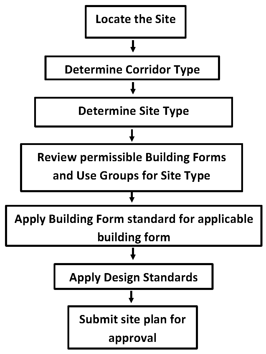
The steps to determine the regulations that apply to a specific property within a form-based district are as follows:
(1)
Find the site in question on the regulating plan map.
(2)
Identify the corridor type: Corridors will be classified Neighborhood, Regional, or Town Center.
(3)
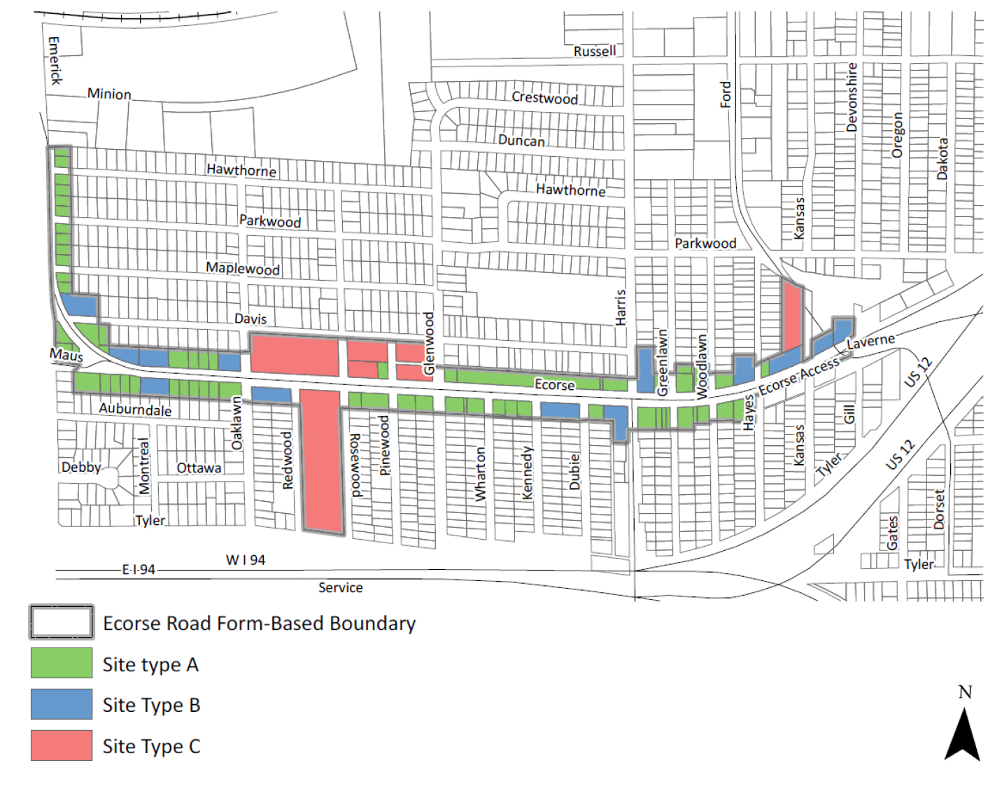
Identify the site type for the site in question. Sites will be classified Site Type A, B, or C.
(4)
Consult the Use Groups and Building Forms Permitted table in which the site is located. The table will identify if a use group or building form is permitted, permitted with conditions, or not permitted for the site type and street type combination of the site in question.
(5)
Follow the regulations for the chosen building form when designing the development application.
(6)
Follow the design standards as listed in Section 507.
(7)
Obtain site plan approval or special use approval for the chosen building form and use, as appropriate.
3.
Design standards: General design standards, set forth in Section 507, are supplementary to other requirements of the Ordinance. Generally, the design standards regulate building placement, parking orientation, landscaping, and other site design requirements.
4.
Modification of district boundaries: Any modification to the boundaries of any form-based district shall require rezoning, in accordance with the provisions of Article 18.
5.
Modification of regulating plan: Specific building form, use group, and design standards applied within each regulating plan are based upon the designation of site type. Any modification of site type may be determined by the Planning Commission, notice and after conducting a public hearing in accordance with Article 18.
The Planning Commission shall consider the following in making a determination to modify a site type or street type designation:
A.
The applicant's property cannot be used for the purpose permitted in the form-based district.
B.
Area has been added to or deleted from the subject property in question, requiring the modification.
C.
The proposed modification and resulting development will not alter the essential character of the area.
D.
The proposed modification meets the intent of the district.
E.
Existing streets have been improved and/or new streets constructed that may result in the modification of a specific site type.
F.
Modification to the Regulating Plan is in conformance to the Master Plan and Placemaking Plan.
6.
Nonconformities: Nonconformities shall be regulated in accordance with Article 16 of this ordinance.
(Ord. No. 2022-498, 12-23-21)
Sec. 503. - Standards:
1.
Corridor types:
A.
Neighborhood: Neighborhood Mixed-Use Corridors are located along high traffic areas and intended for local businesses to serve daily needs and services of the adjacent residential areas. Buildings are set close the street with parking in back. Generally, the sites and buildings are of a smaller scale that can be accessed by pedestrians with as much ease as vehicles.
B.
Regional: Regional Mixed-Use Corridors areas are located along the busiest corridors, which support a high volume of both local and regional traffic. This area may include large national chains, regional retailers, and auto oriented uses that draw customers both regionally and locally. Compared to Neighborhood Mixed-Use Corridors areas they are high intensity and feature the largest scale of commercial development.
C.
Town Center: The Town Center is intended to be the central core of the Township. It includes the governmental center of the Township with the Civic Center, County Courthouse, and the district library. Huron Street and the immediately surrounding area is meant to host a mix of uses from multiple-family residential to commercial to light industrial.
2.
Site types: Site types are determined by a number of factors including size, access, length of frontage, location, and context. Not all site types are located in every corridor.
A.
Site Type A:
Site Type A is composed of lots one-half (0.5) acre or smaller and is reserved primarily for residential use and for smaller non-residential use which is compatible with a residential setting. Site Type A is generally located in areas which serve as a transition between the street and neighboring residential areas. Site Type A lots are typically mid-block and not located on a corner. The building form selected for these sites must consider both the front elevation that fronts on the street but also the rear/side elevation that is adjacent to residential in order to maintain compatibility with adjacent uses. These sites are intended for small sized neighborhood residential, commercial/office, or mixed-use sites.
B.
Site Type B:
Made up mostly of lots mostly between one-half (0.5) and one (1) acre in area, the Site Type B category may include free standing single-use sites developed for residential, commercial, and office uses serving the surrounding neighborhood or mixed-use developments. Size and character may vary based on the unique characteristic of each parcel. Small retail and food service uses would often be found in this category, as well as small single or multi-tenant commercial or office buildings.
C.
Site Type C:
The sites in Site Type C are mostly larger than one (1) acre in area. Site Type C size and character may vary based on the unique characteristic of each parcel. This category can include free standing single-use or mixed-use developments that are designed to serve a broader community-wide market. These sites are intended for community commercial/office, multiple family residential, and mixed-use sites.
D.
Site Type D:
The sites in Site Type D are very large sites are generally two (2) acres or greater in area. Site Type D size and character may vary based on the unique characteristic of each parcel. This category is intended for light industrial, mixed-use sites, large scale retail, and campus style developments. Site Type D are large lots with the potential for out lots of smaller building types on same parcel.
3.
Building form standards:
A.
The form-based districts permit a series of building forms, dependent on the site context. The building forms are designated within the district location based on the regulating plan. Building forms are classified in the following manner:
(1)
Permitted building forms: These building forms are permitted as of right in the locations specified.
(2)
Prohibited building forms: Building forms that are not identified as permitted in the locations specified are prohibited.
(3)
Exceptions: For all building forms in all locations, awnings, signs, other projections (architectural projections, bay windows, etc.) may project into the required building line by up to five (5) feet. Projections will be reviewed by the Township to ensure public safety.
B.
The regulating plan dictates the site type for each individual property in the district. Building forms are identified within each district as permitted or not permitted based upon the site type.
C.
Non-residential development shall follow the height, setback, and greenbelt provisions below when adjacent to any residentially zoned or used property:
(1)
Setback and greenbelt:
a.
Site Type A and B: The following setback and greenbelt shall be provided for any parcel zoned Site Type A or B that is adjacent to a residentially zoned or used parcel.
i.
When a parcel is abutting or adjacent to a residentially zoned or used parcel without an intervening constructed alley or street, the building setback from the property line of the residentially zoned or used parcel shall be no less than the height of the building on the parcel zoned form-based.
ii.
When a parcel is abutting or adjacent to a residentially zoned or used parcel without an intervening alley or street, a minimum ten (10) foot landscaped greenbelt shall be maintained from the property line of the residentially zoned or used parcel. The greenbelt shall be landscaped and screened with a solid fence or decorative wall up to six (6) feet in height erected parallel to any common lot line, with a ten (10) foot wide planting strip along the base of the wall or fence that consists of one (1) evergreen tree and one (1) canopy tree per thirty (30) lineal feet along the property line.
iii.
The Planning Commission may deviate from these setback and greenbelt provisions in the course of its site plan review process; however, the Planning Commission shall not permit a setback or greenbelt that is less than required in the building form. In the review of the deviation, the Planning Commission shall consider the standards as set forth in Section 503.c.2.a.
b.
Site Type C and D: The following setback and greenbelt shall be provided for any parcel zoned Site Type C and D that is adjacent to a residentially zoned or used parcel.
i.
When a property is abutting or adjacent to a residentially zoned or used parcel without an intervening alley or street, the setback from the property line of the residentially zoned or used parcel shall be no less than one and a half (1.5) times the height of the building on the non-residential parcel.
ii.
When a property is abutting or adjacent to a residentially zoned or used parcel without an intervening alley or street, a minimum twenty (20) foot landscaped greenbelt shall be maintained from the property line of the residentially zoned or used parcel. The greenbelt shall be landscaped in accordance with Section 1301.3.H.
iii.
The Planning Commission may deviate from these setbacks and greenbelt provisions in the course of its site plan review process; however, the Planning Commission shall not permit a setback or greenbelt that is less than required in the building form. In the review of the deviation, the Planning Commission shall consider the standards set forth in Section 503.c.2.a.
(2)
Deviation Standards:
a.
Height, setback, and greenbelt deviations may be granted by the Planning Commission if the following is found:
i.
The deviation shall not adversely impact public health, safety, and welfare.
ii.
The deviation shall maintain compatibility with adjacent uses.
iii.
The deviation shall be compatible with the Master Plan and in accordance with the goals and objectives of the Master Plan and any associated subarea and corridor plans.
iv.
The deviation shall not adversely impact essential public facilities and services, such as: streets, pedestrian or bicycle facilities, police and fire protection, drainage systems, refuse disposal, water and sewage facilities, and schools.
v.
The deviation shall be in compliance with all other standards in this ordinance.
vi.
The deviation shall not adversely impact any on-site or off-site natural features.
4.
Building form types:
| Building Form A.1 | ||
|---|---|---|
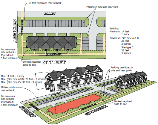
| Building Form A.1: Small, generally single-purpose buildings for residential. Typically situated on a smaller lot, adjacent to single family residential. | ||
| Building Height | ||
| Minimum 1 story, 14-foot height. Max.: 2 stories, 28-foot height (Site type A & B), Max.: 3 stories, 38-foot height (Site type C & D) | ||
| Building Placement | ||
| Front Yard: 10-foot required build-to line 1 75% of the building façade must meet the required build-to line, while up to 25% of the façade can be setback to allow for architectural consideration. | Side Yard: No minimum side setback
If provided, minimum 5 feet. For corner lots, side street yard, minimum 5 feet. | Rear Yard: Minimum 10-foot rear setback |
| Lot | ||
| Impervious Surface: Maximum 80%
Access and circulation: Driveways may access the site from any side, pedestrian pathways must be provided from the right-of-way. | Parking location: Parking shall be located in a side or rear yard; when located in a side yard and abutting the required build-to line adjacent to the right-of-way, parking shall be screened with a minimum 30-inch masonry wall on the required build-to line, or within 5 feet of the required build-to line, provided that a landscape treatment is added between the wall and the required build-to line. | |
| 1 The Planning Commission may adjust the required build-to line to a maximum of 30 feet beyond the property line for projects incorporating a permanent space for an outdoor café, public space, or a cross access drive with an adjacent parcel. Outdoor cafés or public spaces must be developed as part of the primary building and must incorporate a permanent wall or landscaping area along the required build-to line. | ||
 | ||
| Building Form A.2 | ||
|---|---|---|
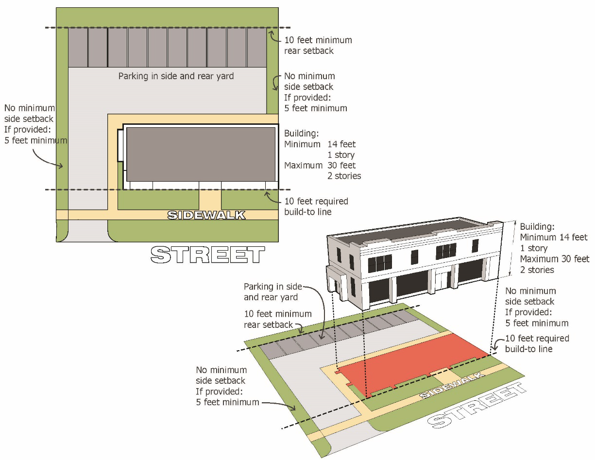
| Building Form A.2: Small, generally single-purpose buildings for retail, office, restaurant, or service uses. Typically situated on a smaller lot within the district. Adjacent to single-family residential. | ||
| Building Height | ||
| Minimum 1 story, 14-foot height, Maximum 2 stories, 30-foot height | ||
| Building Placement | ||
| Front Yard: 10-foot required build-to line 1 75% of the building façade must meet the required build-to line, while up to 25% of the façade can be setback to allow for architectural consideration | Side Yard: No minimum side setback
If provided, minimum 5 feet For corner lots, side street yard, minimum 5 feet. | Rear Yard: Minimum 10-foot rear setback |
| Lot | ||
| Impervious Surface: Maximum 80%
Access and circulation: Driveways may access the site from any side, pedestrian pathways must be provided from the right-of-way. | Parking location: Parking shall be located in a side or rear yard; when located in a side yard and abutting the required build-to line adjacent to the right-of-way, parking shall be screened with a minimum 30-inch masonry wall on the required build-to line, or within 5 feet of the required build-to line, provided that a landscape treatment is added between the wall and the required build-to line. | |
| 1 The Planning Commission may adjust the required build-to line to a maximum of 30 feet beyond the property line for projects incorporating a permanent space for an outdoor café, public space, or a cross access drive with an adjacent parcel. Outdoor cafés or public spaces must be developed as part of the primary building and must incorporate a permanent wall or landscaping area along the required build-to line. | ||
 | ||
| Building Form B | ||
|---|---|---|
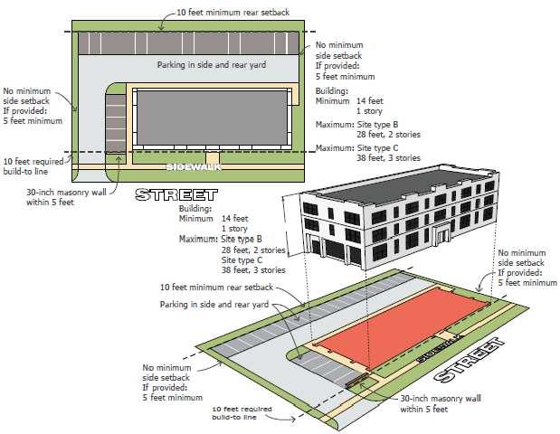
| Building Form B: Medium-sized, single- or multiple-purpose buildings for retail, office, restaurant, or service uses. Typically situated in an out lot of a larger classification building form, or on a smaller, more remote site location within the district. | ||
| Building Height | ||
| Minimum 1 story, 14-foot height, Maximum 2 stories, 28-foot height (Site type B), Max: 3 stories, 38 foot height (Site type C, D) | ||
| Building Placement | ||
| Front Yard: 10-foot required build-to line 1 75% of the building façade must meet the required build-to line, while up to 25% of the façade can be setback to allow for architectural consideration | Side Yard: No minimum side setback
If provided, minimum 5 feet | Rear Yard: Minimum 10-foot rear setback |
| Lot | ||
| Impervious Surface: Maximum 80%
Access and circulation: Driveways may access the site from any side, pedestrian pathways must be provided from the right-of-way. | Parking location: Parking shall be located in a side or rear yard; when located in a side yard and abutting the required build-to line adjacent to the right-of-way, parking shall be screened with a minimum 30-inch masonry wall on the required build-to line, or within 5 feet of the required build-to line, provided that a landscape treatment is added between the wall and the required build-to line. | |
| 1 The Planning Commission may adjust the required build-to line to a maximum of 30 feet beyond the property line for projects incorporating a permanent space for an outdoor café, public space, or a cross access drive with an adjacent parcel. Outdoor cafés or public spaces must be developed as part of the primary building and must incorporate a permanent wall or landscaping area along the required build-to line. | ||
 | ||
| Building Form C | ||
|---|---|---|
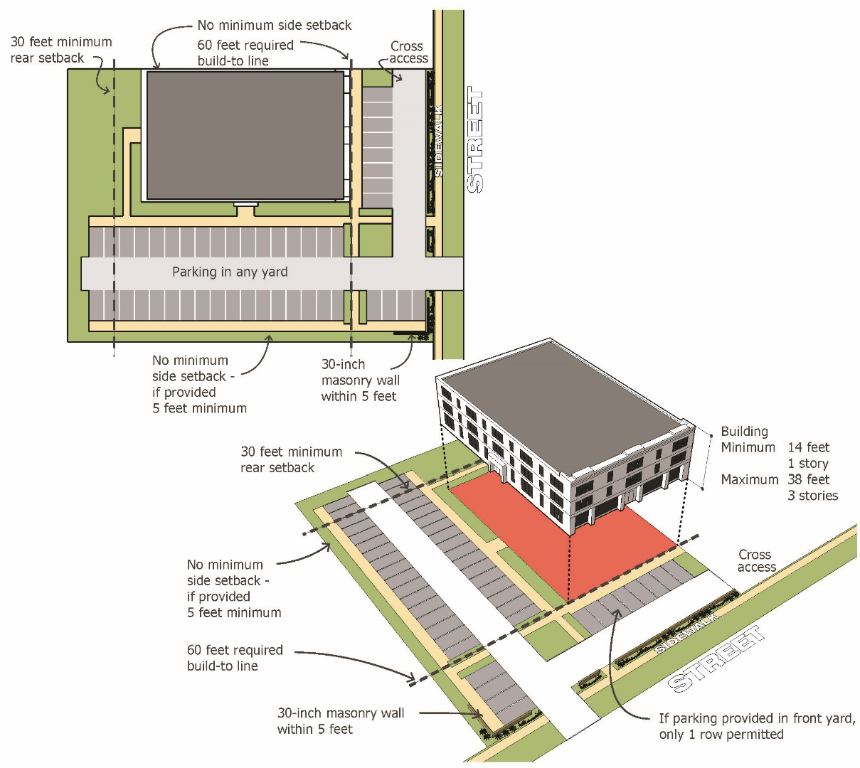
| Building Form C: Medium sized single- or multiple-tenant buildings for retail, restaurant, office, service, or residential uses. This category also includes multiple-tenant development, although it requires a second story to encourage a mix of use. | ||
| Building Height | ||
| Minimum 2 stories, Ground floor 14-foot minimum height, Maximum 3 stories, 38-foot height, Ground floor 14-foot min. height | ||
| Building Placement | ||
| Front Yard: Maximum 60-foot required build-to line. | Side Yard: No minimum side setback
If provided, minimum 5 feet | Rear Yard: Minimum 30-foot rear setback |
| Lot | ||
| Impervious Surface: Maximum 80%
Access and circulation: Driveways may access the site from any side, pedestrian pathways must be provided from the right-of-way. | Parking location: Parking may be located in any yard; when located in a front or side yard adjacent to the primary building and abutting the right-of-way, parking shall be screened with a minimum 30-inch masonry wall on the required build-to line, or within 5 feet of the required build-to line, provided that a landscape treatment is added between the wall and the required build-to line; if parking is provided in the front yard only 1 row is permitted | |
 | ||
| Building Form D | ||
|---|---|---|
| Building Form D: This category is primarily designed for attached residential, however, non-residential use may be included in the ground floor. Townhouses and urban-style residential developments that are compatible with the Master Plan identified higher-density and more urban character of this area. | ||
| Building Height | ||
| Minimum: 2 stories, no minimum height, Maximum: 4 stories, 45-foot height, Ground floor: No minimum height | ||
| Building Placement | ||
| Front Yard: 10-foot required build-to line 1 75% of the building façade must meet the required build-to line, while up to 25% of the façade can be setback to allow for architectural consideration. | Side Yard: No minimum side setback
If provided, minimum 5 feet. | Rear Yard: Minimum 10-foot rear setback |
| Lot | 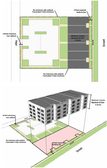 | |
| Impervious Surface: Maximum 60%
Access and circulation: Parking may be accessed from right-of-way (ROW) or alley; detached garages or multi-garage structures are permitted only in a rear yard, or behind primary buildings; pedestrian pathways shall be provided from the right-of way. Parking location: Parking shall be located in a rear yard; parking may also be provided in integrated garages or detached garages; on-street parking within private roads in developments is highly encouraged | ||
1 The Planning Commission may adjust the required build-to line to a maximum of 30 feet beyond the property line for projects incorporating a permanent space for an outdoor café, public space, or a cross access drive with an adjacent parcel. Outdoor cafés or public spaces must be developed as part of the primary building and must incorporate a permanent wall or landscaping area along the required build-to line. | ||
| Building Form E | ||
|---|---|---|
| Building Form E: This category provides an opportunity for large-format retail or entertainment uses within the district. They directly abut the right-of-way, provide parking in the rear or side yards, and contribute to the street atmosphere by providing a consistent street front with other, more pedestrian-oriented projects. They may be set back from the right-of-way, but only when they provide out-lots within the same project for category B, C, or D building forms on the same or on separate lots. | ||
| Building Height | ||
| Rear Building: Minimum 14-feet minimum ground floor; Maximum 38 feet, 3 stories
Front Buildings: Minimum 14-feet minimum ground floor; Maximum 30 feet, 2 stories | ||
| Building Placement | ||
| Front Yard: 10-foot required build-to line 1 | Side Yard: No minimum side setback; if provided, minimum 5 feet | Rear Yard: Minimum 10 feet rear setback |
| Lot | 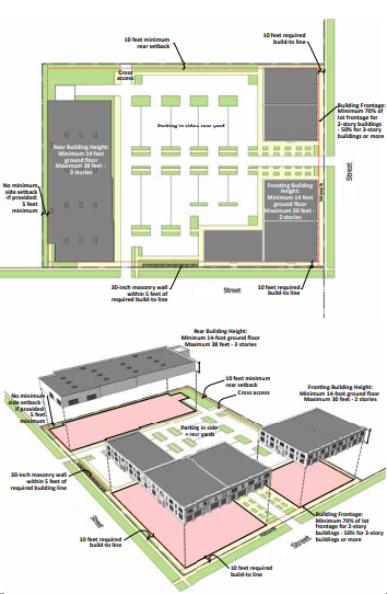 | |
| Building Frontage: Minimum 70% of lot frontage for 2-story buildings and 50% for 3-story buildings or
more
Impervious Surface: Maximum 90% Access and circulation: Driveways may access the site from any side, pedestrian pathways must be provided from the right-of-way, and cross access shall be provided in instances where a development is within an out lot of a higher classified building form. Parking location: Parking shall be located in a side or rear yard; when located in a side yard and abutting the required build-to line adjacent the primary building, parking shall be screened with a minimum 30-inch masonry wall on the required build-to line, or within 5 feet of the required build-to line, provided that a landscape treatment is added between the wall and the required build-to line. | ||
| 1 The Planning Commission may eliminate the required build-to line for projects incorporating a permanent series of additional lots or smaller buildings in the A, B, C, or D building form categories, provided that those additional lots and/or buildings make up the entire frontage of the overall development along the required build-to line, with the exception of access drives. The required build-to line frontage minimum for the additional lots and/or other buildings forms along the required build-to line shall apply for each individual additional lot and/or building. | ||
(Ord. No. 2022-498, 12-23-21)
Sec. 504. - Neighborhood corridors:
1.
Authorized use groups:
A.
Authorized uses are categorized by use groups. Use groups generally contain similar types of uses in terms of function, character, and intensity.
B.
Use groups are designated in locations within each district based on the regulating plan. Use groups are classified in the following manner:
(1)
Permitted Use Groups. These use groups are permitted as of right in the locations specified.
(2)
Special Use Groups. These use groups are permitted after review and approval by the Planning Commission, in accordance with the procedures set forth in Article 10 and the standards in this ordinance.
(3)
Prohibited Use Groups. These use groups not indicated as permitted are prohibited in the locations specified.
(4)
Uses permitted in all locations include public parks and essential public services.
(5)
Similar Uses. If a use is not listed but is similar to other uses within a use group, the Zoning Administrator may make the interpretation that the use is similar to other uses within a use group.
The Zoning Administrator may also make the determination whether the use is permitted as of right, permitted in upper stories only, or permitted as a special use. The Zoning Administrator may obtain a recommendation from the Planning Commission as to whether or not the proposed use is similar to a use permitted as of right, permitted in upper stories only, or permitted as a special use.
2.
Use groups by category-neighborhood corridors:
A.
Uses are subject to Specific Use Standard set forth in Article 11 when applicable.
3.
Ecorse Road:
A.
Ecorse Road Form Based Code District Regulating Plan:
B.
Ecorse Road Form Based Code District Regulating Plan Table:
4.
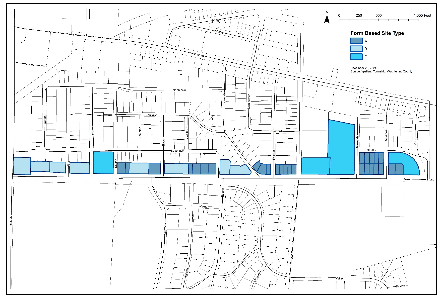
Packard Road:
A.
Packard Road Form Based Code District Regulating Plan:
B.
Packard Road Form Based Code District Regulating Plan Table:
(Ord. No. 2022-498, 12-23-21; Ord. No. 2023-506, 11-21-23; Ord. No. 2025-513, 12-16-25)
Sec. 505. - Regional corridors:
1.
Authorized use groups:
A.
Authorized uses are categorized by use groups. Use groups generally contain similar types of uses in terms of function, character, and intensity.
B.
Use groups are designated in locations within each district based on the regulating plan. Use groups are classified in the following manner:
(1)
Permitted use groups: These use groups are permitted as of right in the locations specified.
(2)
Special use groups: These use groups are permitted after review and approval by the Planning Commission, in accordance with the procedures set forth in Article 10 and the standards in this ordinance.
(3)
Prohibited use groups: These use groups not indicated as permitted are prohibited in the locations specified.
(4)
Uses permitted in all locations include public parks and essential public services.
(5)
Similar Uses: If a use is not listed but is similar to other uses within a use group, the Zoning Administrator may make the interpretation that the use is similar to other uses within a use group.
The Zoning Administrator may also make the determination whether the use is permitted as of right, permitted in upper stories only, or permitted as a special land use. The Zoning Administrator may obtain a recommendation from the Planning Commission as to whether or not the proposed use is similar to a use permitted as of right, permitted in upper stories only, or permitted as a special use.
2.
Use groups by category-regional corridors:
A.
Uses are subject to Specific Use Standard set forth in Article 11 when applicable.
3.
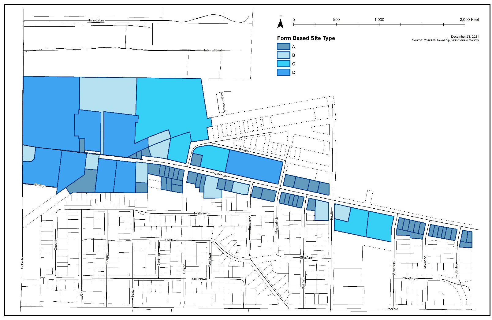
Washtenaw Avenue:
A.
Washtenaw Avenue Form Based Code District Regulating Plan:
B.
Washtenaw Avenue Form Based Code District Regulating Plan Table:
4.
Reserved.
5.
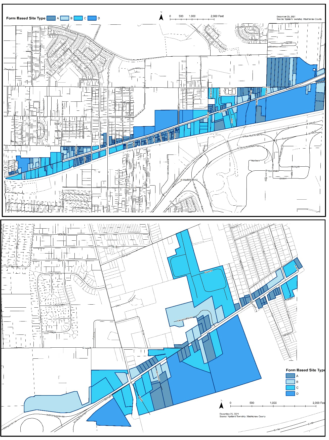
Michigan Avenue:
A.
Michigan Avenue Form Based Code District Regulating Plan:
B.
Michigan Avenue Road Form Based Code District Regulating Plan Table:
(Ord. No. 2022-498, 12-23-21; Ord. No. 2023-506, 11-21-23; Ord. No. 2025-513, 12-16-25)
Sec. 506. - Town center:
1.
Authorized Use Groups:
A.
Authorized uses are categorized by use groups. Use groups generally contain similar types of uses in terms of function, character, and intensity.
B.
Use groups are designated in locations within each district based on the regulating plan. Use groups are classified in the following manner:
(1)
Permitted Use Groups: These use groups are permitted as of right in the locations specified.
(2)
Special Use Groups: These use groups are permitted after review and approval by the Planning Commission, in accordance with the procedures set forth in Article 10 and the standards in this ordinance.
(3)
Prohibited Use Groups: These use groups not indicated as permitted are prohibited in the locations specified.
(4)
Uses permitted in all locations include public parks and essential public services.
(5)
Similar Uses: If a use is not listed but is similar to other uses within a use group, the Zoning Administrator may make the interpretation that the use is similar to other uses within a use group.
The Zoning Administrator may also make the determination whether the use is permitted as of right, permitted in upper stories only, or permitted as a special land use. The Zoning Administrator may obtain a recommendation from the Planning Commission as to whether or not the proposed use is similar to a use permitted as of right, permitted in upper stories only, or permitted as a special use.
2.
Use Groups by Category-Town Center:
A.
Uses are subject to Specific Use Standard set forth in Article 11 when applicable.
3.
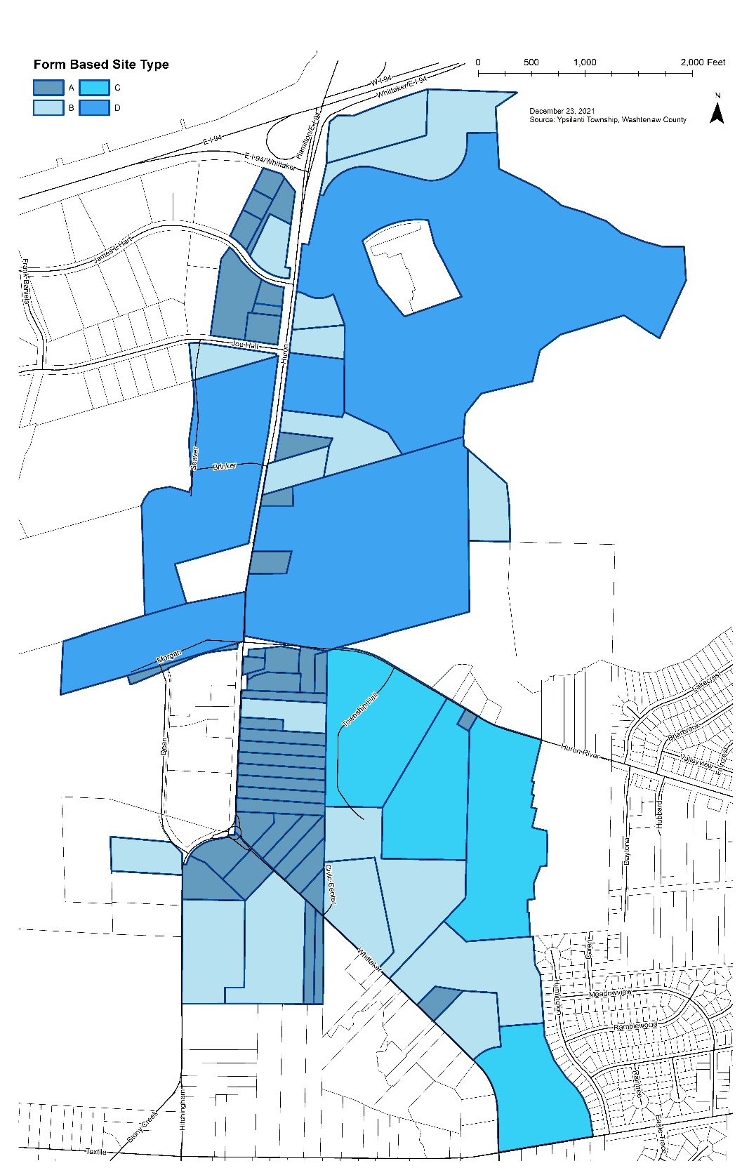
Town Center:
A.
Town Center Form Based Code District Regulating Plan:
B.
Town Center Avenue Form Based Code District Regulating Plan Table:
(Ord. No. 2022-498, 12-23-21; Ord. No. 2023-505, 8-15-23; Ord. No. 2025-513, 12-16-25)
Sec. 507. - Design standards:
1.
Design standards: In addition to standards set forth in this ordinance, all proposed development shall comply with the standards set forth herein.
A.
Pedestrian/non-motorized access:
(1)
Intent: To ensure that site layout and building design provides safe and convenient pedestrian and bicycle access both to and within a site and between adjacent sites.
(2)
Standards:
a.
A pedestrian connection shall provide a clear connection between the primary street upon which the building fronts and the building. Connection may include pavement striping.
b.
Pedestrian access shall be clearly identified from parking areas and all entrances to a building.
c.
Where appropriate, sidewalks fronting the public right-of-way should be designed to accommodate space for activities such as outdoor dining.
d.
All sites shall provide a bike rack for at least two (2) bicycles within fifty (50) feet of the building entrance.
B.
Building placement and orientation:
(1)
Intent: To require building placement that provides a strong visual and functional relationship with its site, adjacent sites, and the primary street upon which the site is located. Ensure consistency within sites and to adjacent sites to provide distinct building groups which exhibit similar orientation, scale, and proportion.
For a corner lot, no more than twenty-five percent (25%) of the site's cumulative linear feet along the required building lines or sixty (60) feet, whichever is less, shall be occupied by parking. The building shall be located in the corner of the lot adjacent to the intersection.
(2)
Standards:
a.
Setbacks and building orientation shall reinforce a consistent pattern of siting.
b.
Primary building entrances shall be located so that they are easily identifiable with convenient public access.
c.
Buildings should enhance street corners through the use of prominent architectural or site features.
C.
Parking placement, orientation, and screening:
(1)
Intent: To provide a circulation system that efficiently moves vehicles in a well-defined manner, while reducing the visual impact of parking areas and mitigating conflict between pedestrians, bicycles, and automobiles.
(2)
Standards:
a.
Required Parking: Off-street parking shall be provided for a principal use erected, altered, or expanded after the effective date of this ordinance in accordance with the standards set forth in Section 1205.
i.
The Form Based districts are intended to encourage pedestrian and friendly design and compact mixed-use developments. Applicants are encouraged to consider the provisions for shared parking and flexibility in application set forth in Section 1205.
ii.
The placement and design of parking areas and structures shall foster safe pedestrian access and circulation and clearly identifiable public access and visitor parking. Pedestrian access shall be provided between all parking areas and public building entrances.
b.
Location:
i.
When parking is located in a side yard (behind the front building line) but fronts on the required building line, no more than twenty-five percent (25%) of the total site's linear feet along the required building line or sixty (60) feet, whichever is less, shall be occupied by parking.
ii.
Where off-street parking is visible from a street, it should be screened in accordance with the standards set forth in Section 1301.3.D.
D.
Architectural design and building materials:
(1)
Intent: To create a character for the form-based district that encourage the greatest amount of visual interest, architectural consistency, and high-quality material use. The standards are not intended to limit imagination, innovation, or variety.
(2)
Building materials: Building material should be of high quality and durable, such as but not limited to stone, brick, glass, and metal. E.I.F.S. or material equivalent shall only be used as an accent material.
(3)
Architectural design standards:
a.
Building massing and scale:
i.
Rooflines and pitches shall be proportionate to nearby structures so as to provide transition or mitigation of significant changes to scale. Variety in massing can occur though step-backs as a building ascends upward.
ii.
Buildings shall maintain a consistent street wall with the longest edge of the buildings oriented parallel to the roadway, where possible.
iii.
Buildings within the same development shall be designed to provide a unified and easily identifiable image. Methods to achieve this include using similar architectural styles and materials, complementary roof forms, signs, and colors.
b.
Façade variation:
i.
Façade articulation or architectural design variations for building walls facing the street are required to ensure that the building is not monotonous in appearance, using the following architectural techniques: Building wall offsets (projections and recesses); cornices, varying building materials or pilasters used to break up the mass of a single building; staggering of vertical walls; recessing of openings; providing upper-level roof overhangs; contrasting compatible building materials; use of variety and rhythm of window and door openings; use of horizontal and vertical architectural elements, use of horizontal bands of compatible colors; and providing changes in roof shape or roof-line.
ii.
Materials shall be selected for suitability to the type of buildings and the architectural design in which they are used.
iii.
Material selection shall be consistent with architectural style in terms of color, shades, and texture; however, monotony shall be avoided.
E.
Transparency:
(1)
Intent: The first floors of all buildings shall be designed to encourage and complement pedestrian-scale activity and crime prevention techniques. It is intended that this be accomplished principally by the use of windows and doors arranged so that active uses within the building are visible from or accessible to the street and parking areas are visible to occupants of the building.
(2)
Transparency standards:
a.
Façade transparency shall be defined as the use of glass or transparent material that provides from the building exterior a view into the building of interior habitation and human scale. Signs covering windows, and the use of tinted, reflective, or opaque glass do not meet the definition of façade transparency.
b.
The first floors of all buildings shall be designed to encourage and complement pedestrian-scale activity and crime prevention techniques. It is intended that this be accomplished principally by the use of windows and doors arranged so that active uses within the building are visible from or accessible to the street, and parking areas are visible to occupants of the building. The first floor of any front façade facing a right-of-way shall be no less than fifty percent (50%) windows and doors, and the minimum transparency for facades facing a parking area shall be no less than thirty percent (30%) of the façade.
c.
First-floor transparency is measured between two (2) and eight (8) feet above the first-floor elevation.
d.
Nothing shall be placed on or inside window to reduce transparency less than the fifty percent (50%) requirement.
e.
For multiple tenant buildings, the minimum transparency requirement must be met by each suite or tenant.
(3)
Transparency alternatives. The following alternatives may be used singularly or in combination for any side or rear facing facade which requires transparency. If used in combination, they may count toward no more than 50% of the transparency requirement. Transparency alternatives may be used but cannot be counted towards the transparency requirements for facades that face on a right-of-way.
a.
Wall design. Wall designs must provide a minimum of three of the following elements, occurring at intervals no greater than 25 feet horizontally and 10 feet vertically:
i.
Expression of structural system and infill panels through change in plane not less than three inches.
ii.
System of horizontal and vertical scaling elements, such as: belt course, string courses, cornice, pilasters.
iii.
System of horizontal and vertical reveals not less than one inch in width/depth.
iv.
Variations in material module, pattern, and/or color.
v.
System of integrated architectural ornamentation.
b.
Outdoor dining/seating: inclusion of outdoor dining/seating located between the building and the primary street lot line.
c.
Permanent art: noncommercial art or graphic design of sufficient scale and orientation to be perceived from the public right-of-way and rendered in materials or media appropriate to an exterior, urban environment and permanently integrated into the building wall.
F.
Landscaping:
(1)
Intent: To incorporate appropriate landscaping to enhance visual appearance, provide transitions between properties, and screen unsightly areas.
(2)
Landscaping standards:
a.
In addition to the standards set forth in Section 1301, Landscaping requirements, the following standards shall be met.
b.
Landscaping shall conform and incorporate existing landscape and topographic features.
c.
Landscaping within courtyards, patios, and pedestrian realm may include hardscape and softscape materials.
d.
Landscaping shall maintain adequate sight lines for visual safety, visibility, and efficient security.
e.
Landscaped areas, including landscaped parking islands and medians, shall be separated from vehicular and pedestrian encroachment by curbs and raised planting areas.
G.
Loading and storage areas:
(1)
Intent: To ensure that loading, storage, and other building utility features are designed to be a part of the overall building as so to reduce the visual impact.
(2)
Standards:
a.
Utilities and mechanical screening:
i.
Utility structures located between the building and the public right-of-way shall be screened as set forth in Section 805, Essential services. Utility. screening may include walls, fencing, or landscaping that is consistent with the character and materials of the development.
ii.
Trash enclosures shall be placed adjacent to the rear wall of corresponding buildings or shall be located away from portions of the site which are highly visible from public roadways or private properties with dissimilar improvements. Trash enclosures shall be screened as set forth in Section 1302, Trash, and recycling receptables with walls, fencing or landscaping that are consistent with the character and materials of the development.
b.
Loading:
i.
Service areas shall be designated by markings and/or signage to delineate them from pedestrian access and limit conflicts between service/delivery vehicles and patrons (e.g., pedestrians, bicyclists, and transit users).
ii.
Loading and service areas shall be located on the sides or rears of the buildings.
iii.
Loading and service areas shall be screened from the public right-of-way with the use of fencing, landscaping, or walls.
(Ord. No. 2022-498, 12-23-21; Ord. No. 2023-506, 11-21-23)

