
Anderson City Zoning Code
CHAPTER 17
33 - VINEYARDS AT ANDERSON PLANNED DEVELOPMENT PD
17.33.010 - Applicability.
• The regulations in this chapter shall only apply to land zoned PD, planned development, in the Vineyards at Anderson specific plan area (Vineyards SP) and enable implementation of the land use, open space, recreation, infrastructure and financing elements of the Vineyards SP.
• The planned development district is required to be consistent with the SPA, "special planning area," land use designation of the Anderson General Plan.
• The provisions of the Vineyards at Anderson specific plan are applicable to all development subject to this chapter.
• All proposed structures shall comply with the standards of this chapter as determined applicable by the planning director.
• If there is any conflict between the Vineyards SP and this chapter, the provisions of this chapter shall apply.
(Ord. No. 766, § 2(Exh. B), 6-15-2010)
17.33.020 - Purpose of PD ordinance.
A.
Purpose.
1.
The provisions of this chapter are intended to ensure that new development promotes city general plan goals and objectives, that the new development is consistent with the Vineyards at Anderson specific plan and PD zoning, and that it is compatible with neighboring land uses.
2.
The PD ordinance includes flexible development guidelines and uses a comprehensive development approach; thus avoiding piecemeal development and incompatible land use patterns.
3.
The target average plan density is 2.5 dwelling units per acre, with a minimum of 2.2 dwelling units per acre, to ensure that trip reduction, infrastructure financing, open space conservation, and affordable housing goals can be achieved. Any proposed development plan shall comply with this requirement.
B.
Overall Objectives of Vineyards SP.
1.
To create a comprehensive pattern of development and land uses integrating transportation, water supply, sewerage, energy provision and other public facilities and utilities into project planning and implementation, and ensuring funding of infrastructure and amenities when needed.
2.
To ensure an attractive and active community environment which promotes a healthy economy, and provides high-quality mixed-use urban forms by encouraging jobs-housing-recreation balances, complementary and integrated land uses, compact urban forms, a pedestrian- and family-friendly environment, and attractive streetscapes and open spaces.
3.
To minimize automobile congestion by designing and funding safe and effective traffic circulation patterns and infrastructure, integrating pedestrian-friendly features, providing adequate parking facilities and providing and encouraging alternative travel modes.
4.
To ensure compatibility between different types of development, land uses and neighborhoods.
5.
To fully integrate the SP area with the remainder of the city.
(Ord. No. 766, § 2(Exh. B), 6-15-2010)
17.33.030 - Application process.
A.
Project Initiation.
1.
Project proponents shall obtain a design review application from the city planning department.
2.
Applicants should meet with the planning department staff prior to completing the application to reduce processing problems and help streamline the application process.
3.
Applicants shall submit completed applications to the planning department and pay all fees before application processing can begin.
B.
Application Requirements. As appropriate to the type, scale and phase of the development, the application package may include any or all of the following:
1.
Maps indicating existing and proposed general plan and specific plan land use designations (if amendments are proposed) and existing and proposed land uses.
2.
A legal description of the project site, and maps indicating legal boundaries.
3.
A plot plan of the land and area to be developed, indicating the location of adjacent streets, all private rights-of-way existing and proposed.
4.
Copies of proposed tentative maps prepared consistent with state law.
5.
A topographical map indicating drainage features, trees, and other natural features such as creeks or streams, floodplain demarcations, wetlands, cultural resources, and location of existing structures (if any).
6.
A project map indicating parcel sizes, location and type of proposed structures, number of dwelling units, parking areas, driveways, vehicular and pedestrian features, loading facilities, location of all entrances, height and gross floor area of buildings, usage by type and square footage.
7.
A map indicating location of off-site improvements, such as parking, loading facilities, bicycle paths, bus stops, and traffic signals.
8.
A map or maps indicating the extent, location and general arrangement of all building, open space and landscaping plans, plans for vesting of open space, if applicable, the nature and location of any proposed agricultural uses, and plans for maintenance of open space.
9.
Architectural drawings to demonstrate the concept and character of the proposed development; including aesthetics, neighborhood compatibility features, elevations, type of roofing and siding materials, lighting methods or fixtures, garbage containers, type of signs including location and other thematic illustrations.
10.
Such additional information as may be required by the planning commission or staff.
(Ord. No. 766, § 2(Exh. B), 6-15-2010)
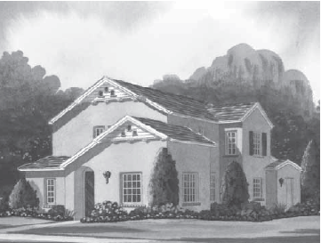
17.33.040 - Very low-density and low-density residential.
A.
Uses Permitted. The following uses are permitted in areas designated for single-family uses in the Vineyards specific plan, subject to a building permit, provided that all other Municipal Code requirements are met:
1.
Single-family dwelling and typical ancillary structures such as a detached garage.
2.
Accessory uses normally incidental to single-family residences where there is a single-family residence on the lot provided that the following conditions are met:
a.
Except as modified in this chapter, accessory structures shall be located outside any required setback.
b.
No accessory structure shall be permitted within twenty feet of the front property line.
c.
The appearance of accessory structures should be compatible with the main structure, particularly where visible from the street.
3.
Home occupations (Section 17.60.020).
4.
Attached second units (Section 17.60.020).
5.
Small family care home (Section 17.040.350)
6.
Small child day care use (Section 17.04.240).
7.
Gardening, horticulture and family pets.
8.
No provision is to be construed as permitting any commercial use, including the storage or parking of commercial vehicles in excess of one and one-half ton carrying capacity, except private-passenger type vehicles where there is a single-family residence on the lot.
B.
Uses Permitted Subject to a Conditional Use Permit. The following uses may be allowed in areas designated for single-family uses in the Vineyards SP subject to acquisition of a conditional use permit approved by the planning commission:
1.
Public parks, public schools and public playgrounds.
2.
Churches, private schools, public buildings and utility substations.
3.
Golf courses, country clubs and private residential recreation centers.
4.
Commercial nurseries, commercial agriculture including vineyards and orchards over 0.25 acres and raising or maintaining livestock subject to provision of mitigation measures to ensure neighborhood compatibility or as an interim use prior to development.
C.
Requirements. Residential development in the Vineyards SP must be consistent with the adopted land use plan.
1.
Minimum and average lot width. The planning director may grant a ten percent exception to lot width requirements to provide for unique lot shapes or building orientation. Otherwise, minimum lot width must be sixty feet measured at the front yard setback line, and minimum lot depth one hundred feet. The average lot width shall be sixty-five feet as measured at the front yard setback line for each block.
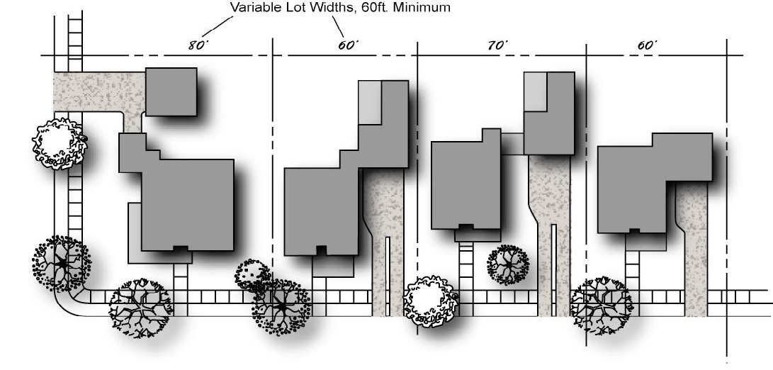
Figure 1 Minimum Lot Width
2.
Maximum building height. Thirty-five feet high for two-story homes; thirty feet high for accessory buildings.
3.
Minimum square footage. One thousand five hundred thirty square feet of enclosed living area except that twenty percent of the units in any phase may be a minimum of one thousand three hundred square feet.
4.
Setbacks. Figure 2 illustrates setback requirements.
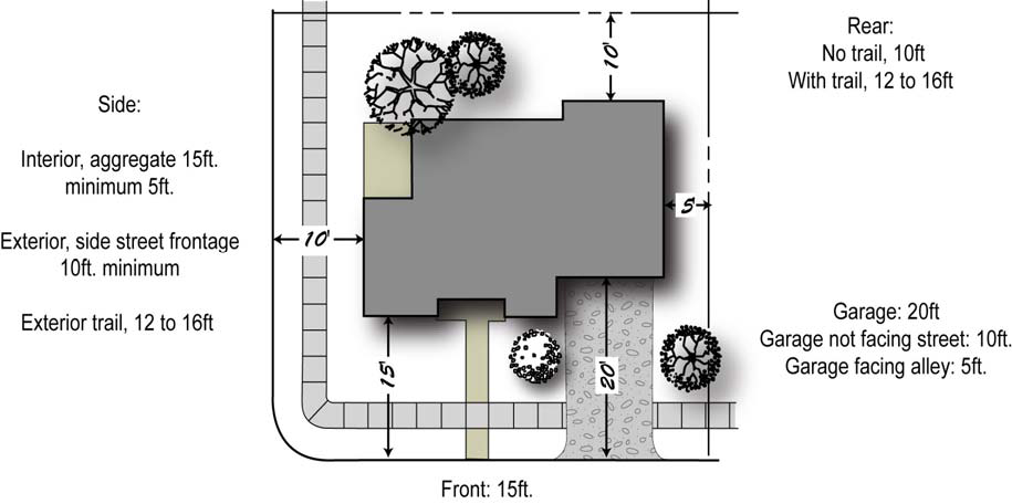
Figure 2 Required Setbacks
D.
Design Objectives.
• To create variety along local streets.
• To provide variety in building placement and street scenes.
• To provide visual interest and aesthetic diversity.
• To create a sense of neighborhood uniqueness.
1.
Varied Setbacks. Distance between adjoining homes, garages, or between homes and fences, shall be varied to create visually interesting patterns of open space and landscaping, to add diversity to the view and to promote "front porch" interaction with pedestrians thus enhancing a sense of community and belonging, encouraging walking, and serving as a deterrent to crime. (SP Policies 8.4.6, 8.4.8)
2.
Varied Lot Widths.
a.
Strive to vary lot widths to provide different amounts of open areas between structures.
b.
Vary placement, shapes and sizes of homes.
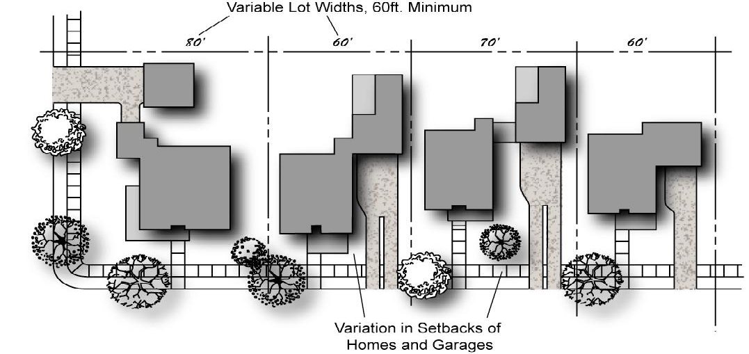
Figure 3 Variations in Lot Widths, Setbacks and Garage Placement
3.
Varied Garage Placement and Orientation (See Figure 5) (SP Policy 8.4.21).
a.
Garages may be accessed by alleys or shared driveways and shall be set back behind the front façade of the residence and shall be architecturally integrated with the main house façade. (SP Policy 8.4.16)
b.
The location and size of garage shall not dominate the street view of the structure.
c.
The garage shall not be larger than thirty-three percent of the living area.
4.
Parking and Garage Doors.
a.
A minimum of two garaged off-street parking spaces shall be provided for each housing unit.
b.
Garage doors shall be recessed into the walls and not be built flush with the exterior wall of the garage. (SP Policy 8.4.23)
c.
The design of the garage door shall complement the particular architectural style selected for the home.
d.
For garages accessed from the street, the garage face shall be recessed a minimum of five feet from the primary living areas façade.
5.
Driveways.
a.
One parking space per residence shall be required in each driveway.
b.
Direct access shall be provided to accessory units.
c.
Driveways shall be varied including using colored concrete, stamped concrete or paver-stone insets for low-density lots. Very low-density lots, as well as low-density flag lots, are exempt from this requirement.
d.
Single-car driveways that widen to two-car aprons at a recessed or detached garage are encouraged to reduce the amount of pavement.
e.
Fences and landscaping should be used to screen and soften exposed parking areas where feasible.
Figure 4 Garages on Alley

Figure 5 Garage Access and Configuration

Figure 6 Garage Recess Treatments
6.
Façade Design Elements.
a.
Design façades and placement of structures to give them richness, variability and appropriate scale.
b.
Long exterior house walls shall be varied to create an interesting blend with landscape, adjacent structures, and from the casting of shadows.
c.
Each house shall have a clearly defined entry.
d.
"Keyhole entries" (hidden from view on the side or within deep recess of the building) are not permitted unless safety features have been incorporated to the satisfaction of the planning director.
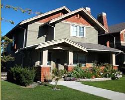
Figure 7 Varied Residence Design
7.
Roof Design Objectives (SP Policy 8.4.6).
a.
Varied roof designs and materials that create visual interest are required. Varied roof design may be achieved by changes in plane such as the use of gables and dormers.
b.
For sloped roofs, both vertical and horizontal elements are required.
c.
A-frame roofs should be used only when appropriate to the architectural style.
d.
Flat roofs are not permitted.
e.
Roof-mounted heating and air-conditioning is not allowed.
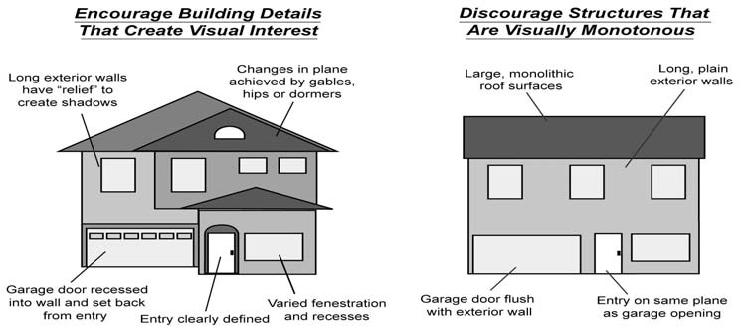
Figure 8 Roof and Façade Design Elements
8.
Varied Structure Design.
a.
The design of residences shall be varied to create visual interest.
b.
The massing and composition of homes (not just finish materials) within each block shall vary.
c.
Single-story homes and multistory homes shall be distributed throughout the neighborhood to provide varied visual interest, affordable housing and a more diverse neighborhood. (SP Policy 8.4.6)
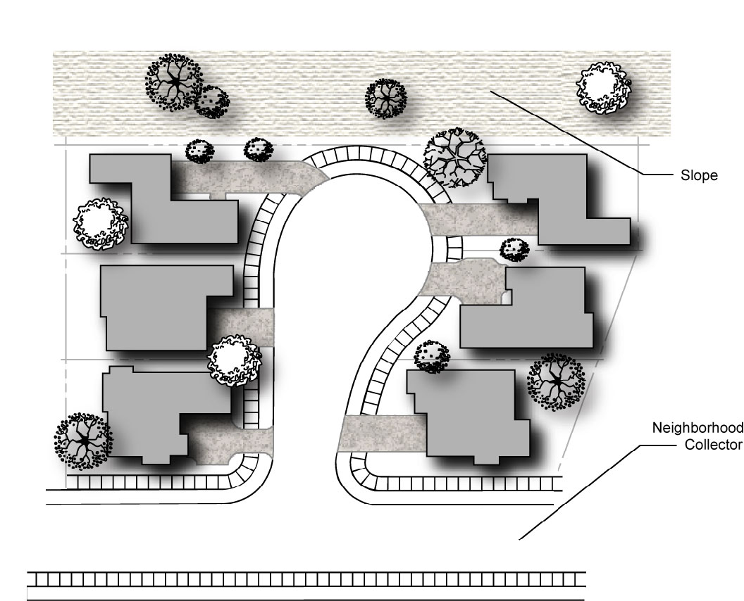
Figure 9 Varied Residence Design on Cul-de-Sac
9.
Exterior Lighting.
a.
Lighting placement, intensity, and potential glare shall be provided or described on all building plans and shall conform to Section 17.04.466.
b.
Outdoor lighting shall be positioned so no direct light extends onto neighboring properties.
c.
Landscape lighting shall be low-level from unobtrusive fixtures.
d.
Landscape lighting shall be reserved for significant landscape features.
e.
Light fixtures shall be compatible with the architectural style of the project.
10.
Walls, Fences and Entry Features. The design of walls and fences, as well as the materials used, shall be consistent with the overall development's design and shall conform to Section 8.10 of the Vineyards SP.
11.
Open Space Areas.
a.
Developments shall be designed to provide views into open-space areas at strategic locations.
b.
Safe and attractive pedestrian connections to public open space are required (See Figure 12).
c.
Access through narrow-fenced connections is not allowed.
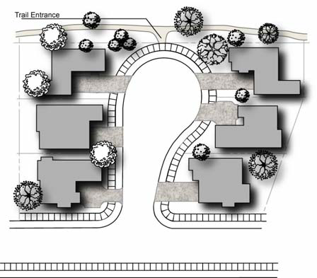
Figure 10 Residential Connection to Open Space
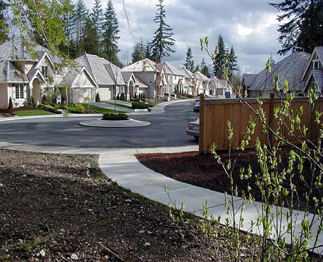
Figure 11 Trail Connection to Cul-de-Sac
12.
Streets. Right-of-way widths shall be required consistent with Chapter 4, Circulation, of the Vineyards specific plan and table 2.
(Ord. No. 766, § 2(Exh. B), 6-15-2010)
17.33.050 - Medium-density and high-density residential areas.
A.
Purpose. Medium-low density, medium-density and high-density housing shall be built with an average minimum density of six units per acre for medium-low density housing, ten units per acre for medium-density and twenty units per acre for high-density housing and shall conform to the Vineyards SP. Multiple-family housing shall provide housing for all income levels and shall use principles of universal design to make housing suitable for all age groups. Multiple-family housing in the Vineyards SP shall face the street. (SP Policy 8.4.28)
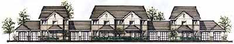
Figure 12 Multiple-Family Dwelling Facing Street
B.
Uses Allowed.
1.
Smaller multiple-family dwellings are allowed such as a duplex, triplex or fourplex provided that the medium-density residential requirements of the Vineyards SP are met.
2.
Multiple-family dwellings, five or more units, are allowed. (SP Policy 8.4.29)
3.
Home occupations shall be limited to office uses only.
4.
Cluster homes as defined in this chapter.
5.
Small family care home (Section 17.040.350).
6.
Small child day care use (Section 17.04.240).
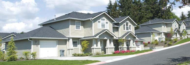
Figure 13 Duplex
C.
Conditional Uses.
1.
Single-family dwelling unit.
2.
Senior residential care facility—Seven or more clients.
3.
Public facilities including utility substations.
D.
Cluster Homes. Cluster homes are a type of housing where two to eight single-family houses on individual small lots are arranged around a common driveway. Cars are parked inside garages to allow the other residents driveway access and egress. (SP Policies 8.4.5, 8.4.18, Figure 8-4) The common driveway should function as an alley with the primary entry to the unit from the public street or from a common walkway between clusters.
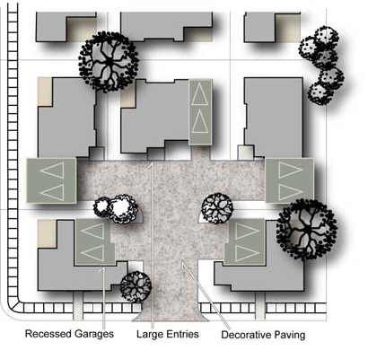
Figure 14 Examples of Cluster Homes
1.
Setbacks.
a.
Units fronting on the public street.
1)
Units fronting on the public street shall have a six-foot-deep front porch.
2)
No garage entry is allowed from the public street; all garages must be accessed from the common driveway.
3)
Setbacks from the public street are as follows:
• Twenty feet at grade.
• Fifteen feet with house sixteen inches above grade.
• Ten feet with house twenty-four inches above grade.
• Five feet with house thirty-two inches above grade.
4)
Attached garage (nonentry side) shall be set back twenty feet from the public street.
b.
Separation between building faces. The minimum separation between building faces of units on one cluster and those on another cluster shall be sixteen feet.
c.
Separations between adjacent buildings. Separations between adjacent buildings in the same cluster shall be at least ten feet. Zero lot lines are allowed.
d.
On corner sides, clear vision at the public street intersections shall be maintained.
e.
On sides that back up to a public street, all buildings shall be set back fifteen feet from the property line.
f.
For privacy, second-floor windows, except for clerestory windows, should be avoided on elevations which overlook private open space area of adjacent units. In instances where second-floor windows are unavoidable, they should be set back at least fifteen feet from property lines and separated from adjacent areas by tall shrubs or trees.
g.
Minor architectural projections, such as fireplaces and bay windows, may project into setback or separation by up to two feet for a length not to exceed ten feet or twenty percent of the building elevation length, with minimum three-foot clearance.
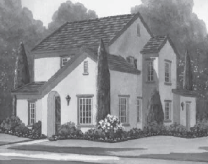
Figure 15 Examples of Cluster Homes—A and B
2.
Houses adjacent to a local residential street or park shall face the street or park.
3.
No more than three clusters shall be placed adjacent to each other unless separated by common open space, a pedestrian pathway, a public street and/or guest parking.
E.
Cluster Homes Design.
1.
Number of Units per Cluster and Design.
a.
The maximum number of units accessed from a common driveway should not exceed six and shall be limited to a maximum of eight units. (SP Figure 8-4)
b.
Private open space is required for each unit and shall be a minimum of ten feet by ten feet.
c.
All units in a cluster shall share a common architectural theme.
d.
Variation of building types and elevations on end units is encouraged.
e.
House entries shall be enlarged with porches to accent corners and interior vista.
f.
House entries shall not be directly opposite the entry of another house but shall be staggered and differentiated by changes in elevation and/or angles.
g.
Each entry to a common walkway shall have a unique and distinguishing entry feature such as an arbor or gateway.
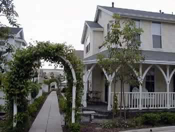
Figure 17 Cluster Home Entry Feature
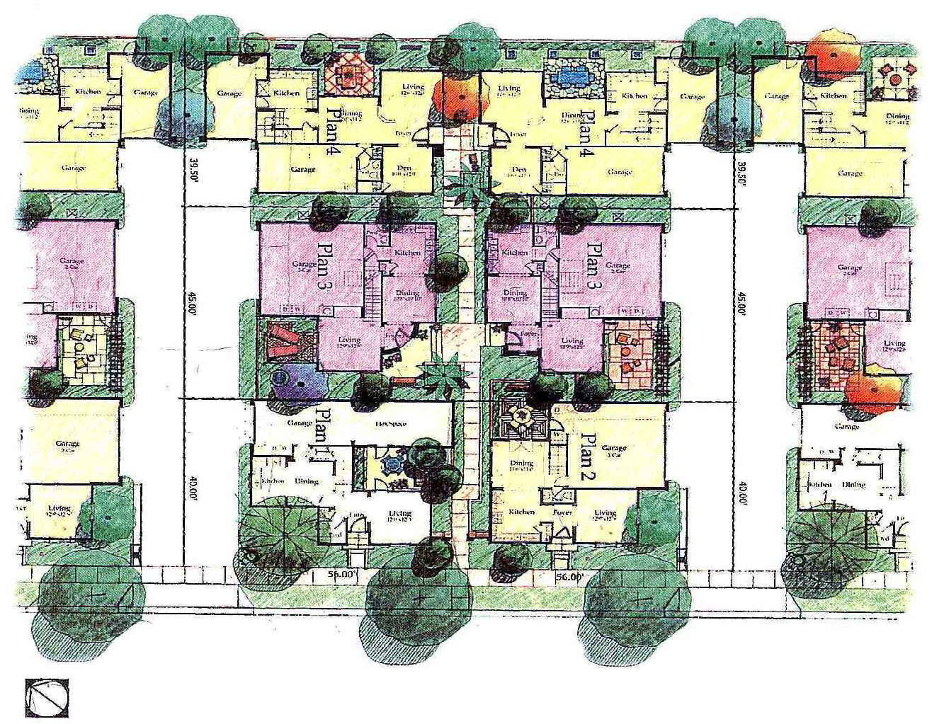
Figure 18 Cluster Homes with Six Units
2.
Common Driveway Requirements.
a.
The paved circulation portion of the common driveway shall have a minimum width of twenty-two feet.
b.
The entrance to the common driveway, at the street, shall be a minimum of twenty feet in width.
c.
Decorative paving shall be provided in fifty percent of the common driveway.
3.
Garage Design.
a.
Two garaged parking spaces for each residence shall be required. Tandem parking is allowed for up to one-half of the units in a cluster.
b.
Recess garages behind the main dwelling unit to minimize the visual impact of the garage door and parking apron.
c.
Use roll-up doors for garages.
d.
Design the layout so that the terminating vistas from the street will not be garage dominated.
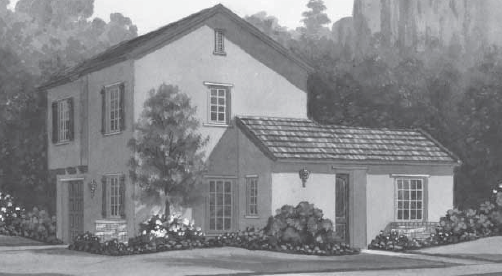
Figure 19 Example of Cluster Home—C
4.
Parking Apron.
a.
Garage aprons shall be either less than six feet deep or more than eighteen feet deep.
b.
Parking aprons allowing parking in front of the garage should be limited to the rear units not visible from the street.
c.
Paved areas in front of garage doors should have a minimum width of twenty-five feet in front of the garage door.
d.
Asphalt concrete paving shall not be used for more than fifty percent of the common driveway.
e.
Use of permeable paving, reinforced sod is encouraged.
5.
Guest Parking. At least two guest parking spaces shall be provided for each common driveway (cluster).
6.
Landscaping.
a.
Trees and large landscape fingers between parking aprons shall be required to break up the expanse of paving and view of garages.
b.
Two hundred square feet of landscaping per unit shall be provided.
c.
Trees shall be provided at the rate of one front yard tree at each interior lot minimum.
d.
No part of the access street setback area may be counted toward the two-hundred-square-foot requirement.
e.
Green space should be placed at the end of the cluster as a focal point.
f.
A homeowners' association shall be established to maintain all common areas including yards, driveways, landscaping and vehicle storage areas within the project.
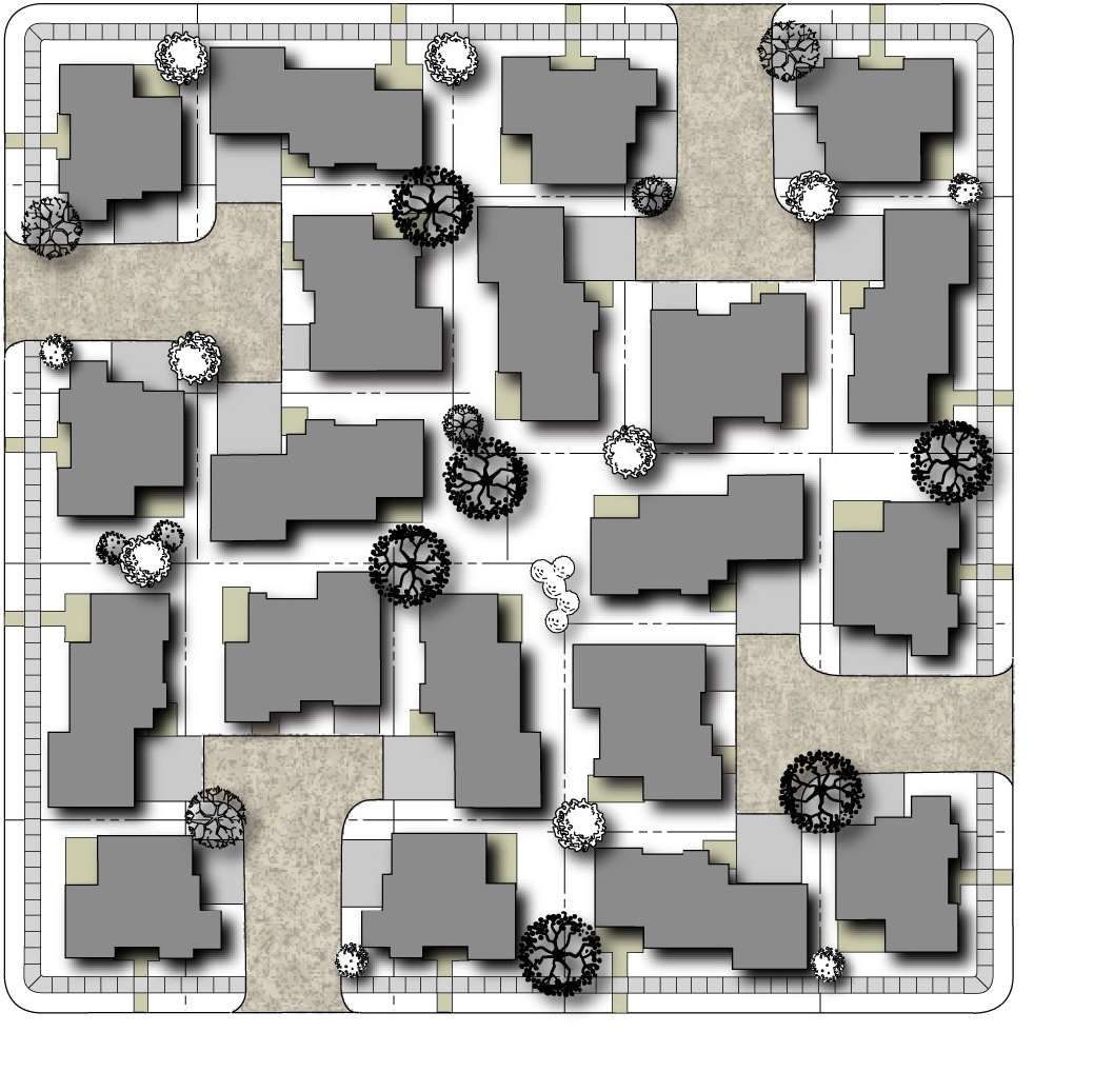
Figure 20 Cluster Homes City Block
F.
Façade and Roof Design Elements.
1.
The following design elements shall be used to create visually interesting, as well as functional, multiple-family dwellings: various front setbacks within the same structure, staggered and jogged unit planes, use of reverse building plans to add variety, a maximum of two adjacent units with identical wall and roof lines, balconies, porches, and cross gables.
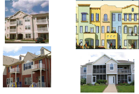
Figure 21 Multiple-Family Units with Balconies
2.
The following layout elements shall be used to create an interesting neighborhood: a variety of orientations to avoid the monotony of garage door corridors, curvilinear driveways, landscape and clustering of units.
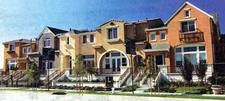
Figure 22 Variable Roof and Facade Design
G.
Open Space. All multifamily residential projects in high-density areas shall provide permanently maintained outdoor open space for a total thirty-five percent of the entire area. This outdoor open space shall not include the site coverage. The site coverage is the percentage of total site area occupied by structures and paving for vehicle use. Structure/building coverage includes the primary structure, all accessory structures (e.g., carports, garages, patio covers, storage sheds, trash dumpster enclosures, etc.) and architectural features (e.g., chimneys, balconies, decks above the first floor, porches, stairs, etc.). Structure/building coverage is measured from exterior wall to exterior wall. Pavement coverage includes areas necessary for the ingress, egress, outdoor parking, and circulation of motor vehicles.
For each dwelling unit private open space such as patios or balconies shall be provided at a minimum of ten percent open space per net square foot of living space. (SP Policy 8.4.26)
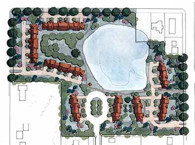
Figure 23 Multiple-Family Units with Open Space
H.
Solar Design (SP Policies 8.4.10, 8.4.27).
1.
Building and rooftops shall be oriented and designed, to the extent that site conditions allow, to accommodate active solar and night cooling technologies.
2.
Landscape around buildings shall be designed to provide fifty percent shading in the summer months and solar access during the winter months. Not to interfere with any photovoltaic or other solar devices, yet provide maximum shading in summer months.
3.
Site plans and landscape designs shall provide for shaded usable outdoor spaces including a variety of gardens and informal natural areas.
I.
Parking (Section 17.46.040).
1.
Parking for multiunit developments shall be designed to minimize distance to units and may include structured or underground parking where feasible. (SP Policy 8.4.30)
2.
Alleys should be considered as a way to accommodate parking behind or under housing units, so that porches, pedestrian entries, and gardens may front the public street.
3.
Trees shall be planted and maintained to provide a fifty percent shade canopy of all parking areas.
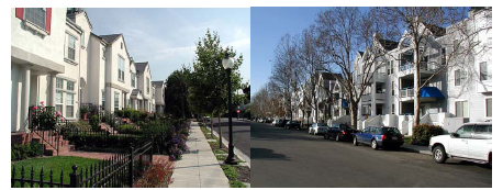
Figure 24 Examples of Multiple-Family Homes Facing Street, Garages in Rear
J.
Garages.
1.
Garages for multifamily housing shall not dominate the front of the units, but may be allowed to take up twenty-five percent or less of the frontage.
2.
Windows from active living spaces, including dining, living, kitchen and family rooms, shall provide views of front yard areas and the public street.
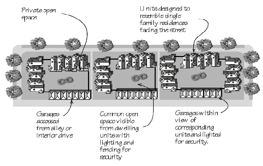
Figure 25 Multiple-Family Layout
K.
Utilities (SP Policy 8.4.34).
1.
Service areas and utilities, including gas and electric meters, and cable panels shall be completely screened from public view and integrated into the architecture.
2.
All air conditioning/heating equipment, soft water tanks, pool and spa equipment and electric self-timer boxes for sprinklers or exterior landscape/lighting shall be screened and shall not be roof-mounted.
3.
Trash storage shall be screened from public view by an enclosed screening structure and located away from main public rights-of-way. Trash containers must be setback at least twenty feet from residential structures on adjacent properties.
4.
Design of trash enclosures shall be compatible with the architectural character of the buildings they serve and shall consist of solid block or masonry construction with solid steel doors.
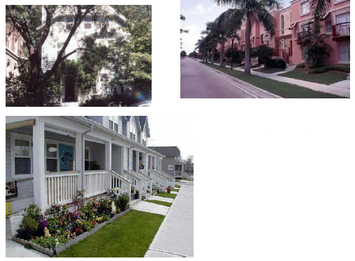
Figure 26 Multiple-Family Buildings
(Ord. No. 766, § 2(Exh. B), 6-15-2010)
17.33.060 - Village Center mixed use.
A.
Purpose. The mixed-use designation is applied to the Village Center of the Vineyards SP which is intended to serve as a vibrant self-contained community core as well as the active focal point for surrounding residential areas. The mixed-use community core area provides opportunities for people to meet, work and recreate without a car. It includes higher-density, multistory residential buildings, second- and third-story apartments and lofts over ground floor commercial and office uses, convenience shopping, personal services, entertainment, office and civic functions, and neighborhood cafes. The community core is also within walking distance of some neighborhoods, and easily accessible to more distant neighborhoods by electric cart, bicycle, automobile and transit. Figure 27 shows a possible schematic design consistent with the Vineyards SP, which may be altered as individual sites are developed.
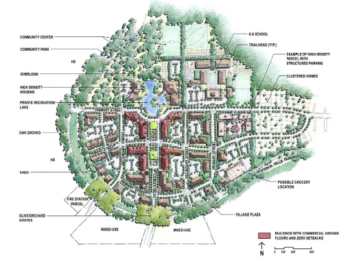
Figure 27 Vineyards at Anderson Village Center
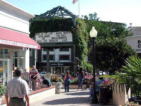
Figure 28 Village Center
B.
Requirements. Design components shall be consistent with the Vineyards SP as described in Section 8.5. Development will provide a concentrated pedestrian-scaled urban setting by building to the sidewalk, making building fronts "permeable" and interesting with windows and doors every twenty-five feet, and encouraging sidewalk uses and patios along streets rather than narrow sidewalks and parking.
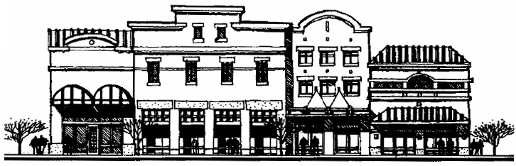
Figure 29 Mixed-Use Buildings
C.
Allowed Uses.
1.
Residential uses are permitted including high-density multiple-family uses.
2.
Ground floor commercial uses in multifamily units are preferred in the core area and on entry streets.
3.
Permitted recreation and entertainment uses are clubs, lodges, private meeting halls, health and fitness facilities, play facilities, nightclubs and bars, movie theaters, restaurants, small outdoor stages, restaurants with live music, stages and other small-scale uses.
4.
Permitted shopping uses are art, antique, collectible and gift sales; grocery stores, general retail, plant nurseries and garden supply stores; furniture, furnishings and equipment stores; and auto parts stores.
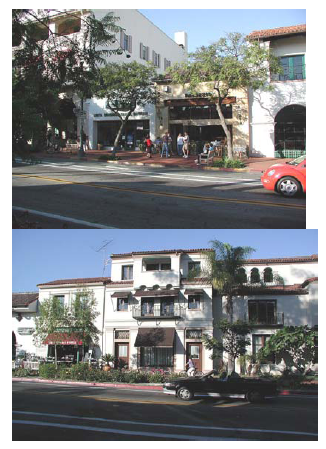
Figure 30 Mixed-Use Projects
5.
Permitted office uses are focused on smaller businesses and include medical/dental services, insurance, finance, accounting, optical, real estate, and other neighborhood-oriented uses.
6.
Permitted services include banks and financial services, bed and breakfast inns, business support services, child day care facilities, equipment rental, and repair services (excluding auto repair).
7.
Permitted civic functions are community centers, libraries, museums, religious facilities, educational facilities, and government offices.
D.
Conditional Uses.
1.
Use of a commercial building for residential use in areas designated mixed use on the Vineyards specific plan. (SP Policy 8.5.4)
2.
Street vendors.
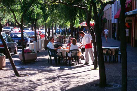
Figure 31 Outdoor Eating
E.
Building Use.
1.
Buildings surrounding the "village plaza" may consist of ground-floor commercial (retail and/or office) uses with one to three stories of housing and/or office space above.
2.
The ground floors of buildings located on the entry street and fronting the village plaza are reserved for commercial uses.
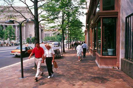
Figure 32 Pedestrian-Friendly Development
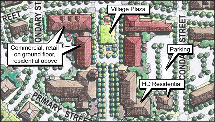
Figure 33 Mixed-Use Layout
F.
Building Design.
1.
Street Edge (SP Policies 8.5.11, 8.5.13).
a.
Site design and building orientation shall provide easy pedestrian access from streets to stores, with continuity of storefronts and no major gaps caused by location of parking lots.
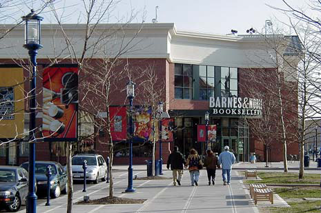
Figure 34 Mixed-Use Building
b.
Buildings in the mixed-use area shall maintain a continuity and consistency of design in terms of character, materials and architectural detail.
c.
Retail/dining activity shall engage the street through architectural and artistic features, sidewalk vendors and cafes, benches and other outdoor seating.
d.
Development along primary streets in the mixed-use area shall maintain a distinctive urban character, with storefronts oriented to streets.
e.
Buildings shall use awnings, canopies, and trellises to provide visual interest, to shelter pedestrians from rain and to add interest for the pedestrian.
f.
Buildings should be sited to provide frequent and convenient connections to rear or underground parking areas.
g.
Buildings, parking and landscaping shall be configured and designed to create a well-defined street edge.

Figure 35 Benches and Outdoor Seating
2.
Building Entries and Doors (SP Policies 8.5.14, 8.5.15, 8.5.16).
a.
Principal building addresses and entries shall be clearly defined.
b.
Building doors and windows facing street frontages shall be fully functional.
c.
Buildings shall present a "front face" to primary streets to establish building presence and identity.
3.
Setbacks.
a.
Maximum setback lines set the location of building walls, help to define streets and open spaces, and ensure safe and active streets and paths.
b.
Where buildings are set back or open space fronts primary streets or entries, landscape features such as strong planting treatments, trellises, arcades, or decorative walls shall reinforce the street edge.
c.
Maximum setback lines are measured from the edge of the dedicated right-of-way line of streets.
d.
Setbacks establish minimum or maximum distance between a building and another building at the edge of adjacent dedicated right-of-way or other property lines.
e.
Setbacks shall be proportionate to the scale of the building, and building façades may be staggered for visual and functional variety and to create usable public spaces.
f.
Setbacks and building regulations are shown in Table 1 at the end of this section.
4.
Building Height and Massing.
a.
Height. Two-story buildings are required on the entry street and primary streets. See Table 1 at the end of this section.
b.
Variety. Building heights and spacing may be varied to prevent continuous "walls" of closely-spaced masses that block views or create wind tunnels and shadowy "canyons". Variation may be used to contribute to the architectural character and "skyline" of the mixed use area. (SP Policy 8.5.19)
c.
Horizontal Lines. Boxy, monolithic appearances shall be avoided by visually breaking up the horizontal mass of wide buildings.
d.
Sun Angles. Sun angles shall be considered in the design and placement of buildings and structures to allow sunlight into deep spaces and to provide for both shaded and sunlit public spaces. (SP Policy 8.5.21)
e.
Fire Protection. Multistory development shall consider the necessity for providing adequate fire protection. Elevator access shall be provided to upper floors as necessary to meet ADA and building code.
5.
Building Elevations.
a.
Front/street-facing façades shall reinforce the human scale and distinct character of building through the rhythm and modulation of façade elements, and shall be designed to convey a sense or order and richness through the interplay of light, shadow, color, texture and materials. (SP Policy 8.5.22)

Figure 36 Mixed-Use Stores
b.
The façades of long buildings visible from public streets shall be designed to incorporate a rhythm that is not repetitious but serves to lend a sense of scale. (SP Policy 8.5.24)
c.
High-quality building materials shall be used for all building elevations including side and rear façades and a consistent set of materials shall be used for all façades of a building. (SP Policy 8.5.25)
d.
Recessed window and door openings should be used to create shadow lines and to express differences in materials. (SP Policy 8.5.23)
e.
Large unrelieved flat surfaces, flush windows and flush doors should be avoided.
f.
Blank or opaque walls or other edge treatments that present a hostile or impermeable face or appear to be "walling out" the surroundings should be minimized.
6.
Roofing.
a.
Individual building roof forms should be integral to the architecture and contribute to the over[all] character of the mixed-use area "skyline." (SP Policy 8.5.26)
b.
Angled or arc-form rooflines, material/detail variations and/or iconic features are encouraged to articulate the building profile. (SP Policy 8.5.27)
c.
Boxy, monolithic buildings with flat tops should be minimized, as should color changes between roof and the rest of the building.
d.
Roof materials should be high quality and nonreflective, and may not consist of galvanized steel or similar materials. (SP Policy 8.5.28)
7.
Parking. Parking shall conform to Section 8.5.4 of the Vineyards SP and Table 1 at the end of this section.
8.
Signs (Section 17.44.050).
a.
General Requirements. Signs shall conform to Section 8.9 of the Vineyards SP. Signs act as a component of the streetscape and affect the overall perception and ambience of the public realm. Thus, signs should not only communicate the type and quality of goods and services a business provides, or the type of activity(ies) being conducted within a building, but also contribute to, and be an integral part of, the streetscape design and ambience. Signs shall include generally recognized logos rather than printed text whenever possible. The architecture and design of a building typically suggests appropriate locations for signage based on the layout and composition of the building façade.
Signs shall:
• Be architecturally compatible with the proposed development style and compatible with the surrounding physical and visual character of the area;
• Promote the "individuality" of establishments;
• Identify the business clearly and attractively;
• Enhance the building on which it is located; and
• Reduce the amount of visual clutter caused by excessive and poorly placed signage.
Location and Placement.
• Avoid sign placements that obstruct building details.
• Signs that extend beyond, or above, a building façade (except as part of an architectural feature, awning, or other design feature of a building) shall be discouraged unless such signs are designed to integrate with the architecture of a building and the building façade.
(Ord. No. 766, § 2(Exh. B), 6-15-2010)
17.33.070 - Commercial areas.
A.
Purpose. Most commercial uses in the Vineyards SP will be located in the mixed-use areas. The neighborhood commercial areas designated in the Vineyards SP are intended for convenience stores, mini-storage, RV storage and other uses not allowed in the mixed-use area. Thus, landscaping to buffer these areas is of prime importance. (SP Section 8.6) Placement of structures should consider topography of the site, trees to be saved and the adjacent land uses.
B.
Uses Allowed. The uses allowed will be governed by the Vineyards SP Section 8.6. The plan allows different types of commercial uses in the different areas depending on the size and location within the community. Uses which are necessary for the community according to the Vineyards SP will be allowed as long as they are properly landscaped and unpleasant views are screened.
C.
Site Planning.
1.
Clustering creates plazas or pedestrian malls and can prevent long "barracks-like" rows of structures; therefore, clustering of buildings should be considered in larger, multibuilding commercial area developments.
2.
Where clustering is impractical, a visual link between separate structures should be established through the use of an arcade system, trellis, or other open structure and by pavement and landscape treatments.
3.
Public plazas and landscape areas should reflect careful planning and not simply be "leftover" areas.
4.
Public plazas and landscape areas shall provide pedestrian amenities such as shade, benches, and fountains.
5.
Freestanding, singular commercial structures should be oriented with their major entry toward the street where access is provided, as well as having their major façade parallel to the street unless located on a plaza.
6.
Façades facing a street shall incorporate windows, trellises, wall articulation, landscape, or other features and shall not be a blank wall.
7.
Buildings should be oriented to pedestrians by placing buildings closer to the street and incorporating a storefront appearance with ample windows, transparent doors and similar storefront techniques.
D.
Parking and Circulation.
1.
Pedestrian access shall be an integral part of the site plan and there should be distinct pedestrian access from parking areas to residential, commercial and office uses and between such uses.
2.
Pedestrian walkways shall parallel driveways in parking areas if possible.
3.
Pedestrian walkways from building entries shall be provided for pedestrian access to public sidewalks.
4.
Parking aisles shall be separated from vehicle circulation routes.
5.
Parking spaces shall not directly abut the commercial structure and parking areas shall be separated from structures by either a raised concrete walkway or landscaped strip, preferably both.
6.
An opaque wall, berm, topographical difference or landscape shall be used to screen any parking at the street periphery. (SP Policy 8.6.4)
7.
Commercial parking access points, whether located on front or side streets, shall be located a minimum safe distance from street intersections so that adequate stacking room is provided.
8.
The number of access points shall be limited to the minimum amount necessary to provide adequate circulation, and shall be at least one hundred feet apart.
9.
Common driveways which provide vehicular access to more than one site and shared parking facilities are encouraged.
10.
Parking stalls which are perpendicular to a driveway of first aisle juncture shall be set back a sufficient distance from the curb to avoid traffic obstruction.
11.
Large parking lots should be divided into a series of smaller lots for one hundred or fewer vehicles. The planning director shall review and approve any deviation from this standard.
12.
Loading facilities should be located at the rear of the building and shall be screened by walls and/or planting. (SP Policy 8.6.4)
13.
Loading facilities shall be offset from driveway openings to provide safe maneuvering areas for vehicles accessing the property.
E.
Landscape.
1.
Landscape for commercial and office uses shall define entrances to buildings and parking lots, define the edges of various land uses, provide transition between neighboring properties (buffering) and provide screening for loading and equipment areas.
2.
At maturity, trees shall provide a fifty percent shade canopy for parking areas.
3.
Landscape shall not obstruct visibility at drive-aisle intersections.
4.
Landscape shall be protected from vehicular and pedestrian encroachment by raised planting surfaces, walks, or the use of curbs.
5.
Plants in boxed, clay, or similarly durable containers should be used for enhancement of sidewalk shops, plazas, and common driveways.
6.
The use of vines and climbing plants on trellises and perimeter garden walls is strongly encouraged.
F.
Walls and Fences.
1.
When walls are used, they shall be designed to blend with the site's architecture.
2.
Security fencing and long expanses of fence or wall surfaces shall include offsets or landscape or architectural features that break up the mass and prevent monotony.
Figure 37 Wall with Landscaping
G.
Screening.
1.
Where storage yards are allowed, exterior storage should be confined to portions of the site least visible to public view and noise effects on adjacent residential areas shall be mitigated.
2.
Where screening is required, a combination of elements, such as solid masonry walls or similar opaque, durable material, berms, landscape; and elements of the building extending into screening shall be used.
3.
Chain-link fencing with wood or metal slating shall not be used when visible from the public right-of-way.
4.
Screening for outdoor equipment on the ground shall be architecturally integrated with the adjacent structure in terms of materials, color, shape, and size.
H.
Building Massing.
1.
Planes of the exterior building walls shall be varied in depth and/or direction.
2.
The height of the buildings shall be varied so that it appears to be divided into distinct massing elements. (Good example: Figure 22)
3.
Elements of a building's façade shall be differentiated by use of color, arrangement of façade elements, or a change in materials.
4.
Blank walls longer than twenty feet at the ground-floor levels are not permitted.
5.
Windows, trellises, wall feature definition, arcades, changes in materials, landscape, or other features shall be used to lessen the impact of a bulky building.
6.
The rear and side elevations shall incorporate some of the architectural features of the main façade.
Figure 38 Coffee Shops
(Ord. No. 766, § 2(Exh. B), 6-15-2010)
17.33.080 - Open space.
With respect to the common areas as set out in the final development plan, there shall be provided, either in the body of the application or plan or appended thereto as exhibits, a subdivision plat showing the dedicated areas, covenants and other deed restrictions, plan of maintenance, and lot assessment procedures, which, among other things, shall include the following:
1.
The form of document or covenant that will legally create an automatic membership nonprofit homeowner's association.
2.
The extent and type of title of homeowners in the common property area, or give definite assurance that it automatically will be so placed within a reasonable period of time.
3.
Limitations on use of common property.
4.
The extent and right of each lot owner to the use and enjoyment of common property.
5.
Responsibility for the operation and maintenance of the common property.
6.
The amount of charge or assessment on each lot for the maintenance of common property, which will do the following:
a.
Assure sufficient funds to maintain the common property and provide that such assessment shall be a lien on the property; and
b.
Provide adequate safeguards for the lot owners against undesirable high charges.
7.
All documents required by this section shall be in a form that may be enforced by the city and in a form that shall be first approved by the city attorney.
(Ord. No. 766, § 2(Exh. B), 6-15-2010)
17.33.090 - Trees.
A.
Blue Oaks. Blue oak woodlands provide a substantially diverse habitat and shall be preserved to the extent feasible.

Figure 39 Blue Oak
B.
Development Criteria.
1.
Development plans should be designed to minimize adverse impacts on blue oaks and on any tree species trees [greater than thirty inches diameter at breast height (dbh)].
2.
Blue oak and heritage trees should be designed into landscaping plans where feasible.
3.
The design and siting of structures and driveways should be planned to minimize tree removal or damage, and avoid unneeded pruning and watering within drip lines of trees.
4.
Development plans should include provision for a tree habitat preservation plan.
C.
Tree Assessment.
1.
Prior to issuance of any grading or building permits for a site with blue oaks or heritage trees, a forester, certified arborist, licensed landscape architect, or qualified specialist and shall review the proposed tree and habitat preservation plan.
2.
The tree and habitat preservation plan shall include the following information:
• A map indicating the number, size, type and location of oak or heritage trees with ten-inch or greater dbh and tree canopies, and indicating any trees proposed for removal.
• A description of the condition of all such trees.
• An evaluation of the effect of the proposed project on such trees.
• A mitigation plan, if applicable, which addresses other requirements included in this section.
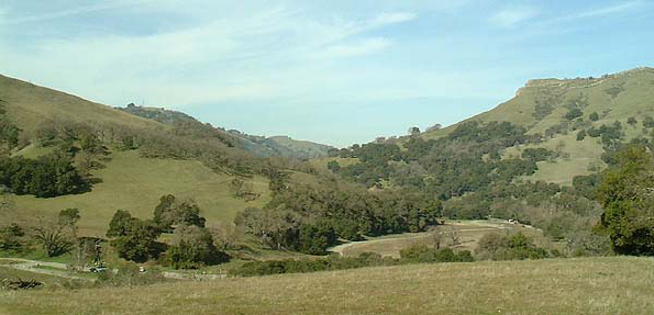
Figure 40 California Oak Woodland Hills
D.
Tree Removal Mitigation.
1.
Prior to the start of construction of any phase involving oak or heritage tree removal, the tree removal shall be mitigated through either a tree mitigation plan and/or a tree replacement plan as described below.
2.
Tree Mitigation Plan. A tree mitigation plan shall be reviewed by the planning director and may include a combination of mitigation strategies such as the following:
a.
Conservation easements,
b.
Habitat restoration along project drainages,
c.
Tree replacement,
d.
Off-site plantings,
e.
Replacement of restoration at an approved mitigation site.
3.
Tree and Habitat Preservation Plan. A tree and habitat preservation plan may include the following elements:
a.
Statement of the amount of mitigation required and the number of replacement trees.
b.
Identification of species, size and locations of all replacement plantings.
c.
Description of method of ensuring plant survival such as irrigation, planting and maintenance schedules.
d.
A maintenance agreement to provide of the trees for a five-year period. The agreement shall include a provision to replace any plants which do not survive the five-year period.
e.
No replacement trees or deep pots shall be planted within fifteen feet of the drip lines of oak trees or heritage trees, which are retained on site, or within fifteen feet of a building foundation, ultimate road right-of-way, or utility easement unless measures are taken to ensure that future activities will not be harmful to the trees.
f.
The plan shall specify the appropriate spacing of replacement based on tree species/natural conditions.

Figure 41 Blue Oak with Multiple Trunks
E.
Replacement Factors.
1.
Removal of Blue Oak/Quercus douglasii, and other oaks and any tree species with a diameter at breast height (dbh) of greater than ten inches, trees (thirty inches dbh or greater), or any native tree or native with a diameter at breast height (dbh) of greater than eighteen inches, shall be compensated for by planting one fifteen-gallon tree or five-gallon shrub for every tree lost.
2.
Reserved.
3.
Replacement plantings shall be made on the project site except as provided in subsection D. above.
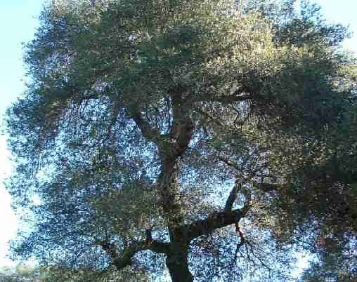
Figure 42 California Live Oak

Figure 43 Oaks
F.
Tree Protection During Construction.
1.
The area beneath the drip line is a critical portion of the root zone and defines the minimum protected area of each tree. A circle with a radius measurement from the trunk of the tree to the tip of its longest limb shall be measured and constitute the drip line protection area of each tree. The location, size and drip line of affected trees shall be indicated in tree reports and on the construction plans. Removing limbs that make up the drip line does not change the protected area.
2.
Temporary protective fencing shall be installed at least six inches outside the drip lines of the trees prior to the start of construction work, to avoid damage to the trees and their root systems. No vehicles, construction equipment, mobile homes/offices, supplies, materials or facilities shall be driven, parked, stockpiled or located within the drip lines of protected trees.
3.
No substantial grading (grade cuts or fills) or trenching shall be allowed within the drip lines of protected trees. If the engineer determines to the satisfaction of the planning director, that a utility line cannot feasibly be routed to avoid the drip line protection zone, then the line shall be bored at a minimum four-foot depth through the entire protection zone area unless a satisfactory alternative that protects the tree can be identified.
4.
Drainage patterns on the site shall not be modified so that water collects or stands within, or is diverted across, the drip line of any protected tree. However, diversion is permitted if the planning director determines that no damage will occur.
5.
No signs, ropes, cables (except those installed to provide limb support) or other items shall be attached to protected trees although numbering tags for the purpose of preparing tree reports are allowed.
6.
Any protected trees on the site that require pruning to enable construction shall be pruned in accordance with the American National Standards Institute (ANSI) "A300 Pruning Standards" and the International Society of Arboriculture (ISA) "Tree Pruning Guidelines."
Figure 44 Oak Woodland
(Ord. No. 766, § 2(Exh. B), 6-15-2010)
17.33.100 - Streets.
A.
Circulation System Design.
1.
The street system shall be designed to be consistent with the Vineyards SP; to permit the safe, efficient, and orderly movement of traffic; to meet the needs of present and future population served; to have a simple and logical pattern; to respect natural features and topography; and to present an attractive streetscape.
2.
In residential subdivisions, the street systems shall be designed to serve the needs of the neighborhood and to disperse through traffic.
3.
Right-of-way widths. Except as modified by the city public works director to ensure safe and efficient traffic circulation through the district, the requirements of right-of-way widths for the Sanderson Subdivision shall be as shown in Table 2 and as follows:
a.
Roundabouts, seventy-five-foot radius.
b.
Cul-de-sac, fifty-two feet.
c.
Alley, sixteen feet (SP Figure 4-9).
d.
Trail access, fifteen feet.
e.
All roadside curbs shall be vertical curbs.
B.
Streets and Highways—Conformity to Requirements.
1.
The general street design criteria and standards contained in this Chapter are to be considered as minimum design requirements.
2.
All streets shall conform to the Vineyards SP.
3.
If site conditions, such as topography, dictate, the planning director may approve deviations from these standards; but in no case will such modifications lead to the creation of unsafe designs as determined by the city.
4.
The street and highway design shall conform both in width and alignment, where applicable, to the circulation element of the general plan and to any plan line adopted by the city council or other legally constituted body of the county or state.
5.
The right-of-way for any such street or highway so designated within or benefiting the subdivision shall be dedicated for public use at the time of recording of any final or parcel map.
C.
Public Street Standards. The definitions, classifications and functions of urban streets are provided in the general plan. The following sections and the provisions of Table 1 constitute the minimum requirements for street design in the Vineyards SP along with Chapter 4 (Circulation) of the SP. The streets are the element that will visually and practically allow the development to meet the goals of being integrated with the city of Anderson and adhering to prudent engineering and planning principles including the following:
1.
All streets shall, as far as practicable, be in alignment with existing adjacent streets by continuations of the centerline thereof or by adjustments by curves and shall be in general conformity with the circulation element of the general plan.
2.
Streets shall be required to intersect one another at right angles or as near to a right angle as practicable in each specific case.
3.
Right-of-way requirements (See Table 1) are based on a functional street and highway classifications system which are hierarchical in nature.
4.
On-Street Parking.
a.
No parking shall be permitted on divided main road from the north property line for the first roundabout. Parking shall only be allowed on one side of Pleasant Hills Drive.
b.
All other roads shall allow on-street parking except as modified at the recommendation of the public works and planning directors.
c.
Parking shall be restricted between two a.m. and five a.m. seven days a week.
d.
Recreational vehicles may not be parked more than eight hours in any twenty-four-hour period.
5.
Center turn lanes may be required at the discretion of the planning director and/or city engineer when necessary to facilitate turning movements.
6.
Streets shall extend to the boundary of the property where necessary to provide access or permit a satisfactory future subdivision of adjoining land.
7.
When a street is temporarily "dead ended," a barricade, temporary turnaround, or temporary connection to another street may be required by the planning commission.
8.
A turnaround meeting city requirements shall be provided for any barricaded street exceeding four hundred feet in length.
9.
Reserved strips controlling the access to public ways will not be approved unless the strips are necessary for the protection of the public welfare or substantial property rights or both and, in no case, unless the control and disposal of the land comprising the strips is placed within the jurisdiction of the city under conditions approved by the planning commission.
10.
All major highways, state highways, expressways, and arterial streets shall have access rights dedicated to the city or other public agency, controlling access between intersections, except where the city planning commission determines that access should be permitted to allow vehicular circulation due to topographic conditions and/or development concepts.
11.
Where required by the city engineer, slope easements shall be granted to the city, corresponding to the construction area creating the disturbed slope area.
12.
When the side or rear of any lot borders on any state highway, expressway, major arterial, or standard collector, the subdivider shall be required to execute an instrument acceptable to the city, prohibiting the right of ingress or egress to the lots.
D.
Alleys.
1.
Alleys shall have a minimum width of sixteen feet if intended for two-way traffic. (SP Figure 4-9)
2.
Alleys accommodating one-way traffic shall have a width of twelve feet. (SP Figure 4-9) Maximum grade shall not exceed twelve percent. Intersecting alleys shall have a corner radius of not less than twenty feet.
3.
Dead-end alleys shall provide a turnaround area which has a radius of forty feet or as approved by the city engineer and fire marshal.
4.
Alleys shall be surfaced with asphalt concrete, Portland cement concrete, or other materials acceptable to the city engineer.
5.
Drainage improvements shall be made in accordance with the requirements of the city engineer.
E.
Street Lighting. All streets shall be illuminated with street-lights in accordance with city standards and lighting policies.
F.
Access to Expressways, and Arterial Streets. Upon review of a use permit, building permit, development plan, or tentative subdivision or parcel map, the planning commission may require the dedication and improvement of a frontage road or require that an interior street be utilized to provide ingress and egress to and from proposed lots in order to avoid direct access. An encroachment permit must also be obtained from Caltrans where applicable.
G.
Sidewalks and Landscaping.
1.
Sidewalks shall be provided for all lots in the subdivision.
2.
The sidewalks shall be of such width as may be required by the construction standards of the public works department, but in no case less than five feet in width adjacent to the curb in a residential area or less than five feet in a commercial or industrial area.
3.
Considerations in design are to be given for handicapped persons and senior citizens. In addition, the following shall apply:
a.
Required sidewalk widths may include street signs, lights, fire hydrants, etc. These sidewalks should be located adjacent to the curb.
b.
In no instance may the clear path of travel be reduced to less than three feet.
c.
Meandering sidewalks, where used, shall be five feet in width and shall not include street signs, lights, etc.
d.
Sidewalks constructed of alternative paving materials, as approved by the planning director, shall have smooth surfaces to ensure pedestrian safety.
e.
Undulating sidewalks are not permitted.
f.
Detached sidewalks may be provided in conjunction with limited access collector and arterial streets as may be authorized by the planning director and the city engineer.
4.
The planning director may waive the sidewalk requirement in residential subdivisions containing lots of twenty thousand square feet or greater.
5.
Street plans shall include plans for landscaping to comply with the Vineyards SP. Two examples of street landscaping are shown below in Figures 45 and 46.
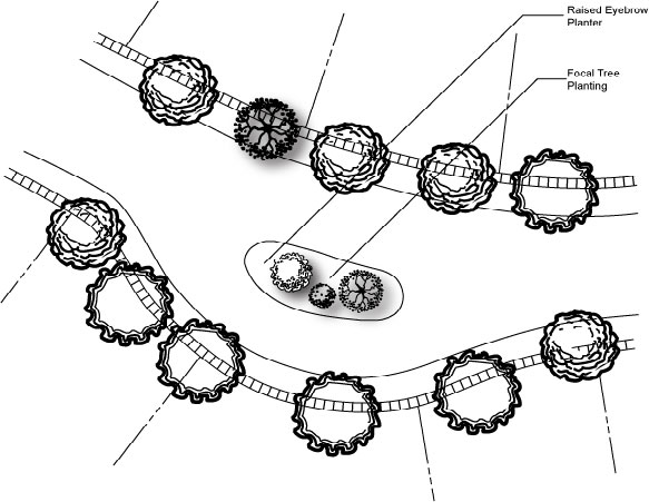
Figure 45 Eyebrow Planter
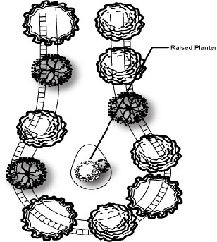
Figure 46 Raised Planter
TABLE 2 RIGHT-OF-WAY REQUIREMENTS
(Ord. No. 766, § 2(Exh. B), 6-15-2010; Ord. No. 834, § 5, 11-17-2020)
17.33.110 - Exterior lighting.
A.
Purpose. Outdoor lighting shall be required for safety and personal security in areas of public assembly and traverse for multifamily residential developments, as well as municipal, commercial, and institutional uses where there is outdoor public activity during hours of darkness. Glare and light trespass control shall be required to protect individuals from the consequences of stray light shining into eyes and onto neighboring properties. Light pollution controls shall be required to minimize the adverse effects of misdirected light. The glare, light trespass and light pollution requirements of this ordinance shall apply to all uses.
B.
Lighting Plan. An exterior lighting plan designed to eliminate light trespass and glare beyond the boundaries of each property shall be developed, submitted to the city for administrative approval, and implemented at the time of construction. The lighting plan shall meet the Illuminating Engineering Society of North America (IESNA) requirements for reduction of light trespass as set forth in Lighting for Exterior Environments: An IESNA Recommended Practice (RP-33-99). The lighting plan shall include, at a minimum, the following information:
□ Type of fixtures;
□ Level of wattage;
□ Initial lumen outputs;
□ Horizontal and vertical placement;
□ Type of shielding being included;
□ Area to be lighted.
During development of the lighting plan, all exterior lights shall be designed, located, directed, and shielded in such a manner as to prevent objectionable light and glare across property lines. Further, lighting shall not be adequately designed to provide sufficient light without excessive illuminance.
C.
Shielding.
1.
Shielded shall mean that the light is directed onto the site or object to be illuminated, and that the light source, whether bulb or tube, is not visible from an adjacent property or rights-of-way. Lighting within public rights-of-way, along public walkways and within parkways shall be shielded and include cutoff or semi-cutoff optics to reduce the amount of light directed to and reflected into the night sky.
2.
All building-mounted fixtures, other than architectural lighting, shall be fully shielded to eliminate the upward distribution of light. Floodlighting is discouraged and, if used, must be shielded to prevent: (1) light trespass beyond the property line and (2) light above a ninety-degree, horizontal plane.
D.
Residential Lighting/Glare.
1.
Permanent outdoor lighting shall be twelve feet or less in height unless it meets one or more of the following criteria:
a.
Fully shielded with a nonadjustable mounting; or
b.
Lighting for parking and vehicle circulation areas in which case heights up to a maximum of twenty feet may be allowed; or
c.
Building-mounted lighting directed back at house numbering or building façade.
2.
Lighting on above-grade decks or balconies shall be fully shielded.
3.
Outdoor lighting with HID light sources in excess of thirty-five watts (bulb or lamp) shall be prohibited. In addition, incandescent light sources including halogen shall not exceed fifty watts.
4.
All light sources that are not fully shielded shall use other than a clear lens material, as the primary lens material, to enclose the light bulb to minimize glare from a point source.
5.
Landscape lighting is limited to thirty-five watts per fixture per one hundred fifty square feet of landscaped area (as measured in a horizontal plane).
6.
Security lights shall be restricted as follows:
a.
The point light source shall not be visible from adjoining lots or streets.
b.
Floodlights must be controlled by a switch or preferably a motion sensor activated only by motion within the owner's property.
c.
Timer-controlled floodlights shall be prohibited.
7.
Photo-cell lights shall be allowed under the following circumstances:
a.
At primary points of entrance (e.g., front entries) or in critical common areas for multifamily properties;
b.
Where the light sources are fully shielded by opaque material (i.e., the fixture illuminates the area but is not itself visibly bright); and
c.
The light source shall be fluorescent (or compact fluorescent) to eliminate excess electricity consumption.
d.
Lights must be fully shielded, down directed and screened from adjacent properties in a manner that limits light trespass to 0.1 of a footcandle as measured at the property line.
e.
Light intensity shall not exceed ten footcandles measured three feet above finished grade.
8.
Building-mounted floodlights shall be fully shielded and downward directed using a light of fifty watts or less.
9.
Motion sensor lights may be permitted, but only where the sensor is triggered by motion within the owner's property lines.
10.
Light trespass at property lines should not exceed 0.1 of a footcandle as measured at the brightest point.
11.
Exterior lighting shall be directed downward and away from adjacent properties and the public right-of-way.
The use of highly-reflective materials, including unpainted metal roofing, shall be restricted in order to ensure that glare not be visible beyond property boundaries.
(Ord. No. 766, § 2(Exh. B), 6-15-2010)
17.33.120 - Glossary.
A.
Purpose for Glossary. This section provides definitions of terms and phrases used in this planned development ordinance that are technical or specialized, or that may not reflect common usage. If any of the definitions in this section conflict with definitions in other provisions of the Municipal Code, these definitions shall control for the purposes of this planned development ordinance. If a word is not defined in this section, or in other provisions of the city of Anderson Code or general plan, the most common dictionary definition is presumed to be correct.
B.
Glossary.
"Accessory retail uses" means the retail sales of various products (including food service) in a store or similar facility that is located within a health care, hotel, office or industrial complex. These uses include pharmacies, gift shops, and food service establishments within hospitals, convenience stores and food service establishments within hotel, office and industrial complexes.
"Affordable housing price" means a sales price at which low-income or very low-income households as defined by the State Department of Housing and Community Development can qualify for the purchase of for-sale inclusionary units, based on thirty percent of the very low- or low-income standard. For purposes of this calculation, housing expenses shall include mortgage principal and interest, taxes, insurance, and assessments.
"Affordable rent" means, for a unit whose occupancy is intended for a low-income household, that the monthly rent consists of a maximum of one-twelfth of thirty percent of eighty percent of the median income applicable to the city of Anderson as determined by the State Department of Housing and Community Development. For a unit whose occupancy is intended for a very low-income household that the monthly rent consists of a medium of one-twelfth of thirty percent of fifty percent of the median income for the city of Anderson as determined by the State Department of Housing and Community Development
"Arcade" means a roofed or built structure, extending over the sidewalk or square, open to the street except for supporting columns, piers, or arches. Residential or office units may occupy the space over the arcade.
"Art, antique, collectible and gift sales" means retail sales uses including antique shops, art galleries, curio, gift, and souvenir shops, and the sales of collectible items including sports cards and comic books. Stores selling handcrafted items that are produced on the site are instead defined as "Artisan shops."
"Artisans/craft product manufacturing" means establishments manufacturing and/or assembling small products primarily by hand, including jewelry, pottery and other ceramics, as well as small glass and metal art and craft products.
"Artisan shops" means retail stores selling art, glass, ceramics, jewelry, and other handcrafted items, where the facility includes an area for the crafting of the items being sold.
"Automated teller machines (ATMs)" means computerized, self-service machines used by banking customers for financial transactions, including deposits, withdrawals and fund transfers, without contact with financial institution personnel. The machines may be located at or within banks, or other locations.
"Banner" means any sign of lightweight fabric or similar material that is mounted to a pole, a wire or a building at one or more edges. Flags shall not be considered banners.
"Bed and breakfast inn (B&B)" means residential structures with one family or resident-manager in permanent residence with up to five bedrooms rented for overnight lodging, where meals may be provided subject to applicable health department regulations. A bed and breakfast inn with more than five guest rooms is considered a hotel or motel.
"Broadcasting studio" means commercial and public communication uses including radio and television broadcasting and receiving stations and studios, with facilities entirely within buildings. Transmission and receiving apparatus, including antennas and towers, are included under the definition of "Telecommunications facilities."
"Bulletin board" means a sign of permanent character, but with removable letters, words, numerals or symbols, indicating the names or persons associated with, or events conducted upon, or products or services offered upon, the premises upon which such a sign is maintained.
"Business establishment" means any individual person, nonprofit organization, partnership, corporation, other organization or legal entity holding a valid occupational license and occupying distinct and separate physical space.
"Business services" means establishments that provide services to other businesses. Examples of these services include the following; blueprinting, computer-related services (rental, repair), copying and quick-printing services, film processing and photo finishing (retail), protective services (other than office related), security systems services.
"Changeable message" means a portion of a sign [on] which message copy is changed manually or automatically in the field through the utilization of attachable letters, numbers, symbols, and other similar characteristics.
"Civic land use" means land use involving organizations considered to support the common good. Uses include government, educational, cultural, social, service, and religious not-for-profit organizations.
"Clubs, lodges, and private meeting halls" means permanent, headquarters-type and meeting facilities for organizations operating on a membership basis for the promotion of the interest of the members, including facilities for the following: business associations, civic, social and fraternal organizations, labor unions and similar organizations, political organizations, professional membership organizations, and other membership organizations
"Community support uses." Community support uses include public agency offices, religious institutions, civic clubs, lodges, community centers, youth or senior centers, educational and skills training facilities, museums, or other civic and nonprofit activities.
"Development standards." The development standards establish the basic parameters governing building construction, including the envelope for building placement in three dimensions.
"Discount store" means a retail establishment that sells new surplus or nonsurplus goods at a price lower than the original or manufacturers suggested retail price.
"Double-faced sign" means a sign which has two display surfaces backed against the same background, one face of which is designed to be seen from one direction and the other from the opposite direction, every point on each face being either in contact with the other face or in contact with the same background.
"Drive-up window" means a facility where food and other products may be purchased or services may be obtained by motorists without leaving their vehicles. Examples of these facilities include fast-food restaurants, drive-through coffee, dairy product, photo stores, pharmacies, drive-through bank teller windows, drive-through dry cleaners, etc.
"Duplex" means a residential structure under single ownership containing two dwellings.
"Entertainment services" means land uses in which crowds view and/or participate in live or projected performances, spectator sports, gaming, rides, or other active amusement involving an audience and/or participation in the use of amusement devices or games.
"Equipment rental" means service establishments with outdoor storage/rental yards, which may offer a wide variety of materials and equipment for rental, including construction equipment.
"Façade" means the side of a building below the eaves.

"Façade rhythm" means a relatively uniform building pattern (such as building width, spacing of openings, or story height) that creates a familiar pattern and helps to visually tie the streetscape together.
"Farmers market" means a temporary outdoor gathering of individual retailers primarily focused on the sale of fresh produce, but also including other foods, beverages, handicrafts, art objects and other items.

"Flag" means any fabric, banner or bunting containing distinct colors, patterns or symbols, used as a symbol of a government, political subdivision, corporation, business, or other entity.
"Gallery" means a frontage wherein the façade is aligned close to the frontage line with an attached shed or a series of lightweight columns overlapping the sidewalk.
"Grade" means the ground surface immediately adjacent to the exterior base of a structure, typically used as the basis for measurement of the height of the structure.
"Green" means an open space, available for unstructured recreation. A green shall be spatially defined by landscaping. Its landscape shall consist of lawn and trees, naturalistically disposed.
"Health/fitness facilities" means fitness centers, gymnasiums, health and athletic clubs including any of the following: indoor sauna, spa or hot tub facilities; indoor tennis, handball, racquetball, archery and shooting ranges and other indoor sports activities.
"Heliport" means a designated, marked area on the ground or the top of a structure where helicopters may land at any time.
"Household pets" means the keeping/raising of birds, cats, dogs or other common household pets, as determined by the planning director, accessory to a residential use.
"Iconographic monumentation" means a fixed object or objects or signage with words, symbols, and/or illustrations signifying the district and important tenets of the district's identity.
"Indoor amusement/entertainment facilities" means establishments providing indoor amusement and entertainment services for a fee or admission charge, including the following: bowling alleys, coin-operated amusement arcades, dance halls, clubs and ballrooms, electronic game arcades, ice skating and roller skating, and pool and billiard rooms as primary uses. Four or more electronic games or coin-operated amusements in any establishment, or in a premises where fifty percent or more of the floor area is occupied by amusement devices, are considered an electronic game arcade as described above, three or less machines are not considered a land use separate from the primary use of the site.
"Libraries and museums" means public or quasi-public facilities including aquariums, arboretums, art exhibitions, botanical gardens, historic sites and exhibits, libraries, museums, and planetariums which are generally noncommercial in nature.
"Live-work facilities" means an integrated housing unit and working space, occupied and used by a single household in a structure, either single-family or multifamily, that has been designed or structurally modified to accommodate joint residential occupancy and work activity, and which includes the following: a complete kitchen space and sanitary facilities in compliance with the city building code; and working space reserved for and regularly used by one or more occupants of the unit.
"Livestock raising" means the breeding and keeping of farm animals, whether for commercial or hobby purposes.
"Mixed-use development" refers to the practice of containing more than one type of use in a building or set of buildings. In zoning terms, this can mean some combination of residential, commercial, industrial, office, institutional, or other uses. Horizontal mixed use means that people can walk from one use to another. Vertical mixed use means that the different uses are combined in one building.
"Mixed-use building" means a building which includes at least two different primary uses, usually with one use on the ground floor and the other(s) on above floors. The most common types of mixed-use building have retail and/or commercial services on the ground floor with either office or residential uses on above floors.
"Multifamily dwelling" means a building or a portion of a building used and/or designed as residences for five or more families living independently of each other. Includes apartments (five or more units under one ownership in a single building), townhouse development (five or more attached single-family dwellings where no unit is located over anther unit), and senior citizen multifamily housing.
"Multitenant building" means a building where more than one business may be located above the first story or otherwise be without frontage on a public right-of-way.
"Nightclubs and bars" means any bar, cocktail lounge, discotheque, or similar establishment which provides live entertainment (music and/or dancing, comedy, etc.) in conjunction with alcoholic beverage sales, which are not part of a larger restaurant. Includes bars, taverns, pubs and similar establishments where any food service is subordinate to the sale of alcoholic beverages. May also include beer brewing as part of a microbrewery.
"Parapet" means a low protective wall or railing along the edge of a raised structure such as a roof or balcony.
"Park" means a natural preserve available for unstructured recreation. A park may be independent of surrounding building frontages. Its landscape shall consist of paths and trails, meadows, woodland and open shelters, all naturalistically disposed. Parks may be lineal, following the trajectories of natural corridors.
"Pedestrian orientation" means any physical structure or place with design qualities and elements that contribute to an active, inviting and pleasant place for pedestrians including, but not limited to, the following: street furniture; design amenities related to the street level such as awnings, paseos, arcades; visibility into buildings at the street level; highly articulated façades at the street level with interesting uses of material, color, and architectural detailing; continuity of the sidewalk with a minimum of intrusions into pedestrian right-of-way; continuity of building façades along the street with few interruptions in the progression of building and stores; signage oriented and scaled to the pedestrian rather than the motorist; and landscaping.
"Pedestrian-oriented use" means a use which is intended to encourage walk-in customers and which generally does not limit the number of customers by requiring appointments or otherwise excluding the general public. A pedestrian-oriented use provides spontaneous draw from sidewalk and street due to intense and surprising visual interest, high customer turnover and intense social interaction.
"Pedestrian scale" means a relationship of buildings, streets, and other improvements which results in a high level of comfort for pedestrians.
"Pinnacle" means a small tower or spire on a roof or buttress.
"Playground" means an open space designed and equipped for the recreation of children. A playground shall be fenced and may include an open shelter. Playgrounds shall be interspersed within residential areas and may be placed within a block. Playgrounds may be included within parks and greens.
"Plaza" means an urban open space, constructed entirely or largely of hard-surfaced paving blocks, stone, brick, or similar materials, framed on at least two sides by the vertical rise of building walls; occasionally framed by closely planted large, maturing trees in lieu of buildings. Available for civic purposes and commercial activities.
"Residential accessory uses and structures" means any use and/or structure that is customarily a part of, and clearly incidental and secondary to, a residence and does not change the character of the residential use. These uses include the following detached accessory structures, and other similar structures normally associated with a residential use of property: garages, gazebos, greenhouses, spas and hot tubs, storage sheds, studios, swimming pools, tennis and other on-site sport clusters, and workshops.
Also includes the indoor storage of automobiles (including their incidental restoration and repair), personal recreational vehicles and other personal property, accessory to a residential use. Includes home satellite dishes and other receiving antennas for earth-based TV and radio broadcasts.
"Site coverage" means the percentage of total site area occupied by structures and paving for vehicle use. Structure/building coverage includes the primary structure, all accessory structures (e.g., carports, garages, patio covers, storage sheds, trash dumpster enclosures, etc.) and architectural features (e.g., chimneys, balconies, decks above the first floor, porches, stairs, etc.). Structure/building coverage is measured from exterior wall to exterior wall. Pavement coverage includes areas necessary for the ingress, egress, outdoor parking, and circulation of motor vehicles.
"Stoop" means a small porch, platform, or staircase leading to the entrance of a house or building.
"Streetscape" means the urban element that establishes the major part of the public realm. The streetscape is composed of thoroughfares (travel lanes for vehicles and bicycles, parking lanes for cars, and sidewalks or paths for pedestrians) as well as the visible private frontages (building façades and elevations, porches, yards, fences, and awnings) and the amenities of the public frontages (street trees, plantings, benches, and streetlights).
"Terrace" means an open, often paved, area adjacent to a house serving as an outdoor living space; a patio.
"Turret" means a small tower or tower-shaped projection on a building.
"Universal design." Universal design, which is related to "inclusive design" and "design for all," is an approach to the design of products, services and environments to be useable by as many people as possible regardless of age, ability or circumstance. Universal design strives to be a broad-spectrum solution that helps everyone, not just people with disabilities. Moreover, it recognizes the importance of how things look. Examples of universal design are as follows: smooth ground surfaces of entranceways, without stairs; wide interior doors and hallways; lever handles for opening doors rather than twisting knobs; light switches with large flat panels rather than small toggle switches.
"Zero lot line" means the location of a building on a lot in such a manner that one or more building sides rests directly on a lot line.
(Ord. No. 766, § 2(Exh. B), 6-15-2010)
