
Bath Township City Zoning Code
ARTICLE XIII
MARSH ROAD/I-69 INTERCHANGE, M-78 ACCESS MANAGEMENT OVERLAY ZONING DISTRICT
Sec. 13.01.- Intent and purpose.
The Marsh Road/I-69 Interchange area access management zoning district—Site plan standards are intended to regulate the number and location of access points for a specified area along three identified roadways. The Marsh Road/I-69 Interchange area access management ordinance includes a non-expressway state trunk-line (Saginaw Street/BR 1-69) which serves as a primary east-west route across the southerly portion of the township; a state trunk-line roadway (Old M-78) which connects to the 1-69 entrance and exit ramps; and a major north-south county road (Marsh Road) which connects Clinton County (Bath Township) with Ingham County (Meridian Township). The Charter Township of Bath finds that special comprehensive zoning standards are needed in this area of the township based upon the following findings:
(1)
The combination of roadway design, traffic speeds, current and projected traffic volumes, potential traffic crashes and other characteristics necessitate special access standards.
(2)
Studies by transportation organizations in Michigan and nationally have found a direct correlation between the number of access points and the number of crashes.
(3)
The standards are based upon considerable research and recommendations contained within the Michigan Department of Transportation (MDOT) Access Management Guidebook.
(4)
Preservation of roadway capacity through access management protects the substantial public investment in the roadway system and helps avoid the need for costly reconstruction, which disrupts businesses.
(5)
Establish uniform access standards to ensure fair and equitable application.
(6)
Implement the goals and recommendations of the Bath Charter Township Comprehensive Plan (2008).
(7)
Implement the goals and recommendations of the Bath Charter Township Marsh Road/I-69 Interchange Area Access Management Plan (2010).
(Ord. No. 31.38, § II, 11-21-2011)
Sec. 13.02. - District boundaries.
This access management overlay district shall consist of the "hash-marked" areas set forth on the "Marsh Road/I-69, M-78 Overlay Access Management Zoning District Map" attached hereto and made a part of this ordinance by reference. Said map shall be attached to and become a part of the Zoning District Map described in section 4.01 of this ordinance, and shall be amended or replaced in accordance with the procedures for amendment or replacement of the zoning district map.
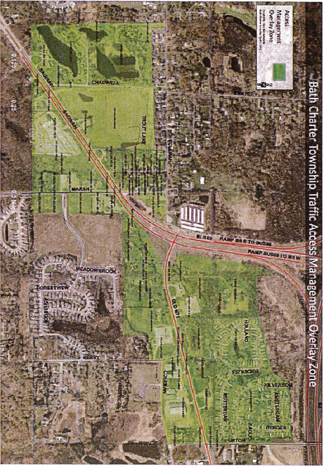
(Ord. No. 31.38, § II, 11-21-2011)
Sec. 13.03. - Intent of standards.
The Michigan Department of Transportation (MDOT) and the Clinton County Road Commission (CCRC) have jurisdiction over the roadways within their highway's right-of-way, while the Charter Township of Bath has authority for land use and site plan decisions within individual lots or parcels along the roadways. These access management standards were created to help ensure a collaborative process between the MDOT, CCRC and the Charter Township of Bath on access decisions within the Marsh Road/I-69 Interchange Area to implement the recommendations of the "Marsh Road/I-69 Interchange Area Access Management Plan" dated March, 2010 and other adopted Charter Township of Bath standards. The standards of this section are further intended to:
(1)
Promote a more coordinated development review process for the Charter Township of Bath with the Michigan Department of Transportation (MDOT) and the Clinton County Road Commission (CCRC).
(2)
Preserve the capacity of the roadways by limiting and controlling the number, location and design of access points and requiring alternate means of access through shared driveways, service drives, and access off cross streets in certain locations.
(3)
Encourage efficient flow of traffic by minimizing the disruption and conflicts between through traffic and turning movements.
(4)
Improve safety and reduce the potential for crashes.
(5)
Avoid the proliferation of unnecessary curb cuts and driveways, and eliminate or reconfigure existing access points that do not conform to the standards herein, when the opportunities arise.
(6)
Implement the recommendations of the "Marsh Road/I-69 Interchange Area Access Management Plan", dated March, 2010.
(7)
Require longer frontages or wider minimum lot widths than required in other zoning districts to help achieve access management spacing standards.
(8)
Require coordinated access among adjacent lands where possible.
(9)
Require demonstration that resultant lots or parcels are accessible through compliance with the access standards herein prior to approval of any land divisions to ensure safe accessibility as required by the Land Division Act.
(10)
Address situations where existing development within the corridor area does not conform to the standards of this overlay district.
(11)
Avoid the need for unnecessary and costly reconstruction, which disrupts business operations and traffic flow.
(12)
Ensure efficient access by emergency and public transportation vehicles.
(13)
Improve safety for pedestrians and other non-motorized travelers through reducing the number of conflict points at access crossings.
(14)
Establish uniform standards to ensure fair and equal application.
(15)
Provide landowners with reasonable access, though the access may be restricted to a shared driveway or service drive or via a side street, or the number and location of access points may not be the arrangement most desired by the landowner or applicant.
(Ord. No. 31.38, § II, 11-21-2011)
Sec. 13.04. - Applicability of standards.
The standards of this section shall apply to all lots and parcels with frontage along Saginaw Street/BR I-69, Old M-78 between Saginaw Street/BR 1-69 and Upton Road, and Marsh Road between Coleman Road and the Clinton County south county line within the map area designated by "hash marks." The standards herein apply in addition to, and simultaneously with, the other applicable regulations of the zoning ordinance. The standards of this section are not retro-active for existing property within the AMOD unless such property is part of a land use development change regulated by this section. Permitted and special land uses on these lands shall be as regulated in the applicable zoning district (as designated on the zoning map), and shall meet the following additional provisions.
(1)
The number of access points is the fewest needed to allow motorists reasonable access to the site.
(2)
No access point shall connect to a public street or road, without first receiving approval of the location and cross-section specifications from Bath Charter Township, the MDOT and/or CCRC. No access point shall connect to a private road unless approved by the planning commission and by the parties with an ownership interest in the private road.
(3)
Access spacing from intersections and other driveways shall meet the Marsh Road/I-69 Interchange area access management plan and the prevailing roadway jurisdictions guidelines. If there is a conflict in these requirements, the prevailing roadway jurisdiction requirements supersede the requirements of the Marsh Road/I-69 Interchange area access management plan.
(4)
Provisions have been made to share access with adjacent uses where possible, either now or in the future, including any necessary written shared access and maintenance agreements to be recorded with the county specifying that the Charter Township of Bath approval is required for any change to the easement.
(5)
No building or structure, nor the enlargement of any building or structure, shall be approved until the existing and/or proposed access points to the building or structure along the roadways within the Marsh Road/I-69 Interchange area access management plan regulations are reviewed by the township planning director and the prevailing roadway agency and the existing/proposed access points are deemed in compliance with the standards herein and all requirements are sufficiently met in connection with such building, structure, or enlargement.
(6)
All subdivisions and condominium projects shall comply with the access spacing standards as herein demonstrated. Compliance with this section shall be required to demonstrate that a lot is accessible as required under the Land Division Act (Act 288 of 1967, as amended).
(7)
Any change in use that requires a site plan review per article XX site plan review, the applicant shall identify the extent of compliance with the standards herein and shall submit information to the MDOT or the CCRC to determine if a new access permit is required.
(8)
For building or parking lot expansions, or changes in use or property, the township planning director shall determine the extent of upgrades to bring the site into greater compliance with the access standards. In making a decision, the township planning director shall consider the existing and projected traffic conditions, any sight distance limitations, site topography or natural features, impacts on internal site circulation, and any recommendations from the MDOT or CCRC. Required improvement may include removal or rearrangement of redesign of site access points.
(9)
The standards herein were developed collaboratively between the Charter Township of Bath, MDOT and Clinton County Road Commission. Where conflict occurs, the more restrictive standards apply.
(Ord. No. 31.38, § II, 11-21-2011)
Sec. 13.05. - Information required for approval.
In addition to the submittal information required for a special use permit in article XIX special use permits and site plan review in article XX site plan review, the following items (1) through (8) shall be provided with any application for site plan review or special use permit within said access management overlay district. The information listed in items (1) through (8) below shall also be required with any request for a land division, subdivision plat or site condominium.
(1)
Existing access points. Existing access points within 500 feet on both sides of the roadway frontage, and along both sides of any adjoining roads, shall be shown on the site plan, aerial photographs, plat or survey. Dimensions between proposed and existing access points shall be shown on the site plan.
(2)
Sight distance. The applicant shall submit evidence indicating that the applicable Charter Township of Bath's, CCRC or MDOT sight distance requirements are met.
(3)
Shared access. Where shared access is proposed or required, a shared access and maintenance agreement shall be submitted for approval by the Charter Township of Bath. Once approved, this agreement shall be recorded with the Clinton County Register of Deeds.
(4)
Dimensions. Dimensions shall be provided for driveways (width, radii, throat length, length of any deceleration lanes or tapers, pavement markings and signs) and all curb radii within the site.
(5)
Large vehicles. The site plan shall illustrate the route and layout of turning movements, with dimensions of any expected emergency vehicles, truck traffic, tankers, delivery vehicles, waste receptacle vehicles and similar vehicles. The plan should confirm that routing the vehicles will not disrupt operations on the mainline road at the access points nor impede maneuvering or parking within the site.
(6)
Traffic impact study. A traffic impact study is required as specified in section 13.07, modifications.
(7)
Review coordination. The applicant shall provide copies of any conceptual or preliminary plans to the Charter Township of Bath so copies can be sent to the MDOT or CCRC, as applicable, and other necessary review agencies for their information and comment. Any correspondence from the MDOT on the general access design and geometrics shall be considered during the special use permit and site plan review processes. The Charter Township of Bath may request attendance at coordination meetings with representatives of the MDOT or CCRC. Once a final site plan has been approved by the Charter Township of Bath, the applicant shall request an access permit from MDOT or the CCRC. The approval of a land division or site plan does not negate the responsibility of an applicant to subsequently secure permits from the MDOT or CCRC.
(Ord. No. 31.38, § II, 11-21-2011)
Sec. 13.06. - Access management standards.
Access points (not including driveways that serve an essential public service or utility substation) along the three roadway segments contained within the Marsh Road/I-69 Interchange area shall meet the following standards. The spacing standards specified below shall be required to be measured from all other roads and driveways with the exception of single-family residential driveways. If there is a change in use from residential to a nonresidential use, the Bath Township planning director shall require existing access to be brought into general conformance with the requirements of this section. These standards are based on considerable research in Michigan and nationally, and were prepared concurrent with guidelines promoted by the MDOT in their Access Management Guidebook.
(a)
Residential driveway spacing standards.
(1)
All subdivisions or condominium projects shall provide individual lot access from roads internal to the development and no lot shall have direct access to Saginaw Street/BR 1-69, Old M-78 or Marsh Road.
(2)
Each lot or parcel shall be permitted one access point.
(3)
In order to comply with the accessibility requirements of the Land Division Act (PA 228 of 1967, as amended), land divisions shall not be permitted that may prevent compliance with the access location standards of this section.
(b)
Commercial driveway spacing standards.
(1)
Each lot or parcel shall be provided reasonable access. This access point may consist of a shared access with an adjacent use or access via a service drive, frontage road or side street.
(2)
The access point location(s) shall be in accordance with the standards of this section and shall provide the opportunity for shared access with adjoining lots. Each lot or parcel developed under this section shall be required to grant shared access easements to adjoining lots or parcels to allow for future shared access. Where a proposed parking lot is located adjacent to the parking lot of similar use, there shall be a vehicular connection where feasible, as determined by the Bath Township planning director.
(3)
In order to comply with the accessibility requirements of the Land Division Act (PA 228 of 1967, as amended), land divisions shall not be permitted that may prevent compliance with the access location standards of this section.
(4)
Unsignalized driveway access spacing—Full movement driveways. Adjacent unsignalized accesses along Saginaw Street/BR 1-69, Old M-78 and Marsh Road within the overlay district should be spaced as far apart as allowable. Table 1 shows the desirable unsignalized access spacing as a function of posted speed. The site distance at the access pints must also be investigated to ensure that corner sight distance and stopping sight distance requirements are met.
*Based on MDOT Traffic and Safety Note 608A—Spacing for commercial driveways and streets. Note these values are considered minimums based on the distances required to avoid conflicts between vehicles turning right or left from adjacent driveways.
(5)
Unsignalized driveway access spacing—Restricted movement driveways (limited to right turn in/right turn out movements). Restricted accesses along Saginaw Street/BR 1-69, Old M-78 and Marsh Road within the overlay district should be spaced as far apart as allowable. However, restricted access points have a desirable spacing of at least 150 feet from the adjacent access points or as identified in the Marsh Road/I-69 Interchange area access management plan.
(6)
Driveway access spacing from signalized intersection. All driveway access points shall be located as far away from the signalized intersection as allowable. Full movement and restricted movement driveway accesses shall be located 230 feet away from the signalized intersection if the posted speed limit is 30 MPH to 35 MPH. For posted speed limits over 40 MPH, the driveway access should be located 460 feet from the signalized intersection or as identified in the Marsh Road/I-69 Interchange area access management plan.
(7)
Driveway access spacing from unsignalized intersections. All driveway access points shall be located as far away from the signalized intersection as allowable. At a minimum, all access points should be located a minimum of 115 feet from the intersection with a posted speed limit of 30 MPH to 35 MPH or 230 feet with a posted speed limit greater than 40 MPH or as identified in the Marsh Road/I-69 Interchange area access management plan.
(8)
Driveway access spacing—opposite sides of roadway. Consideration should be given to driveway alignment on both sides of the street. Access points shall be offset according to table 2 where allowable. If desired spacing cannot be achieved, the driveway shall be constructed perpendicular to the existing public street or an approved private road and shall line up with existing or planned driveways on the opposite side of the road wherever facing lots are not separated by a median. An engineering study should be performed to identify the proper location of opposite side of the road driveway spacing when the desirable offsets cannot be achieved or as directed by the township planning director.
*Based on MDOT Traffic and Safety Note 608A—Spacing for commercial driveways and streets. Note these values are considered minimums based on the distances required to avoid conflicts between vehicles turning left into adjacent driveways.
1 Table 2 does not apply to Saginaw Street/BR 1-69.
(c)
Number of access points. Access for an individual parcel, lot or building site or for contiguous parcels, lots or building sites, under the same ownership shall consist of a single two-way driveway to accommodate ingress and egress traffic. One driveway shall be permitted for each single and two-family residential lot or parcel. The number of commercial driveways serving a property shall be the minimum number necessary to provide reasonable vehicular access and proper access for emergency vehicles, while preserving traffic operations and safety along the public roadway, as supported by a traffic impact study. Access may be via an individual access point or shared access along a service drive. An additional access point may be allowed by the township planning director if the following applies.
(1)
One additional access point along Saginaw Street/BR 1-69 may be allowed for land with a continuous frontage of over 800 feet, and only if the planning commission determines there are no other reasonable access opportunities.
(2)
One additional access point along Old M-78 and March Road may be allowed for land with a continuous frontage of over 600 feet along the respective roadway and only if the planning commission determines there are no other reasonable access opportunities.
(3)
One additional access point may be allowed along streets that intersect Saginaw Street/BR 1-69, Old M-78 and Marsh Road for land with at least 600 feet of frontage along that street and only if the planning commission determines there are no other reasonable access opportunities.
(4)
One additional access point may be allowed if the land is a corner parcel with at least 300 feet of frontage along both public streets and only if the planning commission determines there are no other reasonable access opportunities.
(5)
Additional access points may be allowed if a traffic impact study prepared by a professional engineer deems the additional access necessary for safe and efficient movement of traffic on the public street system and within the proposed site.
(6)
One-way access points are discouraged (unless otherwise noted in the plan) due to their conflict with the township's goal to reduce the number of driveways.
(7)
The planning commission determines additional access is justified without compromising safety and traffic operations along the arterial, based upon a request for modification submitted pursuant to the requirements of the modifications section.
(d)
Shared access. The use of shared access, parking lot connections and service drives, in conjunction with driveway spacing is intended to preserve traffic flow along major thoroughfares and minimize traffic conflicts, while retaining reasonable access to the property. Shared access is strongly encouraged and in some cases may be required as part of the site plan review process. When required, one or more of the following options apply.
(1)
Shared driveways. Sharing, or joint use, of a driveway by two or more property owners shall be encouraged. In cases where access is restricted by the driveway spacing requirements of subsection E [D] of this section, where access could potentially interfere with traffic operations at an existing or planned traffic signal location, where the property frontage has limited sight distance or where the emergency services department recommends a second means of emergency access, a shared driveway may be the only access design allowed. The shared driveway shall be constructed along the midpoint between the two properties unless a written easement is provided which allows traffic to travel across one parcel to access another and/or access the public street.
(2)
Frontage/backage roads. In cases where a frontage road exists, is recommended either in the Bath Charter Township comprehensive plan or is proposed in an approved site plan for an adjoining lot or parcel, access shall be provided via such frontage road, rather than by direct connection to the abutting arterial street. If a frontage road is proposed but adjacent properties have not yet developed, the site shall be designed to accommodate a future road/facility designed according to the standards of this ordinance. The Planning commission may approve temporary access points where a continuous service drive is not yet available. Frontage/backage roads shall generally be parallel to the front property line and may be placed in required yards.
(3)
Parking lot connections. Where a proposed parking lot is adjacent to an existing parking lot of a similar use, there shall be a vehicular connection between the two parking lots where physically feasible, as determined by the planning commission. For developments adjacent to vacant properties, the site shall be designed to provide for a future connection. A written access easement signed by both landowners shall be presented as evidence of the parking lot connection prior to the issuance of any final approvals.
(Ord. No. 31.38, § II, 11-21-2011)
Sec. 13.07. - Site plan modifications and/or retrofit.
In the case of expansion, alteration or redesign of an existing development, or unique situations on a vacant parcel, where it can be demonstrated that existing conditions prohibit adherence to the access spacing and number standards of section 13.06, applicant may request from the planning commission a waiver of standards if the site cannot meet one or more of the standards according to the procedures provided below.
(1)
Such modifications shall be the minimum amount necessary.
(2)
Such modifications will meet the intent of, and be consistent, with the Marsh Road/I-69 Interchange area access management plan and the Bath Charter Township comprehensive plan to the extent possible.
(3)
When the owner of a property with an existing, nonconforming driveway(s) applies for a permit to upgrade or change the use of the property, the township, through its site plan review process, or, building permit review process, will determine whether it is necessary and appropriate to apply the standards presented in this ordinance or retrofit the existing driveway or driveways. The property owner may be required to establish a retrofit plan. The objectives of the retrofit plan will be to minimize the traffic and safety impacts of the development by bringing the number, spacing, location and design of the driveways into conformance with the standards and requirements of this ordinance to the extent possible without imposing unnecessary hardship on the property owner. The requirements of a retrofit plan shall be incorporated as conditions to the permit for the change or upgrade of use and the property owner shall be responsible for the retrofit.
(4)
A traffic impact study may be required as determined by the township planning director to be submitted by the petitioner for site plan modifications and/or retrofit in accordance with the requirements set forth in "Evaluating Traffic Impact Studies", 1 st Edition Published in 1994 by the Michigan Department of Transportation.
(Ord. No. 31.38, § II, 11-21-2011)

