
Bath Township City Zoning Code
ARTICLE XIV
PERFORMANCE CRITERIA
Sec. 14.01.- Purpose.
Within each zoning district is contained a section entitled "site development standards" which provides the framework for regulating the basic issues of zoning, i.e., adequate light, air, open spaces and so forth. Further criteria as contained within this article provide detailed regulations and restrictions in order to protect neighboring uses from possible adverse impacts associated with a given use. Also, to protect the general health, safety and welfare by limiting where uses may be established, insuring that traffic congestion is minimized, controlling the intensity of use and prescribing other such performance criteria as may be necessary to meet the goals and objectives of this ordinance. In that flexibility within application of the basic zoning regulations is a primary focus of this ordinance, it also depends upon a comprehensive performance evaluation process to review use proposals as well as insure compatibility between neighboring and perhaps dissimilar land uses.
Commentary. When utilizing a "traditional" zoning ordinance, a landowner when contemplating development of some type, would first refer to the zoning map to determine within what district his property was situated and secondly refer to the "uses permitted" section of the ordinance text to find whether or not what he was considering was permissible. Next, the landowner would refer to the "yard" and "lot" requirements for development in the specific district. Unfortunately, this system imposes such requirements without sensitivity to the characteristics of the particular site or parcel. Major variables such as environmental limitations and surrounding land uses and their interaction with the proposed use are, in large part, disregarded.
Utilizing a "performance oriented" approach does not change the initial activities of the above sequence, i.e., one still needs to reference the zoning map and list of uses. However, the range of options within those districts intended to accommodate the bulk of future growth, i.e., the D, H and M districts, is very broad. The performance zoning approach then applies the site specific orientation lacking in conventional zoning. The natural constraints of the site are considered; an assessment of land use "intensity" is determined (following that the more intense a use is, the greater its impact on neighboring uses); and provisions to reduce or compensate for this "intensity" are then applied. The landowners prerogative under the performance system is one of determining at what point the increased "intensity" of use is no longer worth the increased "performance" required, rather than attempting to revise the zoning map or text to meet his needs.
Sec. 14.02. - Definitions.
Several terms are used within the text or tables of this article that warrant clarification for the users of this document. In addition to the definitions set forth in article III, the following words shall have the meanings hereinafter set forth:
Base site area. A land area determination derived by simple calculation of gross site area excluding certain specified variables; see table in section 14.03.
Bufferyard. A strip of land, including any specified type and amount of planting or structures which may be required to protect one type of land use from another, or minimize or eliminate conflicts between them.
Floor area ratio. An intensity of use measured as a ratio, derived by dividing the total floor area of the building by the base site area.
Land use classes. A hierarchy of certain land use types that require compliance with specific performance standards as a criteria of their approval in a given zoning district; see table in section 14.04.
Open space ratio. The proportion of a site consisting of required open space as defined and specified in section 14.03 and which shall be calculated using the base site area. Roads and drives may be located within the required open space, however, open space land shall not be occupied by required parking areas.
Subdivision. The division of a lot, tract or parcel of land into five or more lots, tracts or parcels of land for the purpose, whether immediate or future, of sale or of building development. The meaning of the term "subdivision" shall not, however, apply to the partitioning or dividing of land into tracts or parcels of land of more than ten acres.
Subdivision, conventional. A conventional subdivision consists of single-family dwellings on individual lots with no provisions for clustering of dwelling units, reduction of lot sizes below the specified lot area, or required community or neighborhood open space. A conventional subdivision is characterized by division of the entire subject parcel into individual lots.
Subdivision, performance. Performance subdivisions permit the residential builder considerable freedom in design. It allows adjustments in lot sizes and clustering of dwelling units to better adjust to the constraints of a site or of adjoining uses. Further, it insures adequate open space for the residents of each such subdivision.
Cross reference— Definitions generally, § 1-2.
Sec. 14.03. - District performance standards.
This section contains those basic standards applicable to the districts' varied uses permitted within this ordinance. The standards as contained in table 14.03D are minimum standards and must be met by each use as specified. The minimum development/lot area specifies the minimum lot size for which development may be proposed. The high-density residential district provides for varying lot sizes depending upon the use type. The floor area ratio controls the amount of building floor area permitted per unit of lot area. Finally, the open space ratio regulates the undeveloped open space that must be provided per use type in a given district.
A.
Base site area. (How to determine).
(1)
Gross site area as determined by legal description, survey or assessor's records.
_______Acres
(2)
Subtract land within right-of-way of existing roads or utilities and easements.
(-) _______Acres
(3)
In those instances where mixed uses might be proposed;
(a)
Subtract land used or proposed for residential use in determining base site area for non-residential purposes; or
(-) _______Acres
(b)
Subtract land used or proposed for non-residential use in determining base site area for residential purposes.
(-) _______Acres
(4)
Subtract land required for bufferyard; (see section 14.05).
(-) _______Acres.
(5)
Equals base site area.
= _______Acres
Example - how to determine "base site area" of office in the development or D zoning district:
B.
Determination of site capacity. All non-residential uses. Individual site capacity for institutional, office, commercial and other non-residential uses, as denoted in various zoning districts, is determined as follows:
Example - office in development district:
Summary:
* 5,227 sq. ft. of permitted floor area divided by 150 sq. ft. = 35 spaces × 180 sq. ft. = 6,300 sq. ft. (see article XVII - Off-Street Parking…).
C.
Determination of site capacity. Other residential uses in the D, H and M districts. The individual site capacity and total density for two-family or multifamily residential uses, as permitted in the D, H and M districts, are determined as follows:
Example: two-bedroom townhouses in the H district:
* 14 is maximum density without bonuses
D.
Table of district performance standards.**
** Caution: This table applies to performance subdivisions only.
Sec. 14.04. - Land use classes.
Commentary. The dominant premise of this ordinance is that "performance" should be the relevant measure of any land use regulation. This section classifies all land uses permitted by this ordinance according to their type of degree of intensity, or impact they are likely to impose on adjacent land use situations. All uses within a specific class are considered to have equal impact relative to neighboring uses. The impacts of greater intensity may include, increased vehicular or pedestrian traffic and associated noise and congestion, larger signs, exterior lighting, more dominating buildings, increased stormwater runoff associated with larger roof surfaces and parking areas and other similar factors. The individual zoning district controls whether or not a specific use can develop on a lot in that district, while the land use classes are fundamental in determining the level of protection required in the all-important bufferyard.
LAND USE CLASS NUMBER AND GENERAL USE CATEGORY
Class I
Agriculture
Single-family detached residences
Class II
Performance subdivision
Open space/conservation uses
Non-commercial recreational facilities
Class III
Religious institutions
Educational institutions
Public buildings/public service installations
Two-family dwellings
Multifamily dwellings
Class IV
Offices
Service establishments
Convenience retail establishments
Class V
General retail establishments
Other commercial uses
Other office or service uses
Research and development uses
Wholesale and warehousing
Other industrial uses
Sec. 14.05. - Bufferyards.
Commentary. Traditional zoning theory has held that land uses in a community should be divided into districts which contain (in theory) compatible uses. Those uses permitted within a given district would be similar in intensity as well as negative characteristics. A second feature of traditional zoning theory is that by carefully selecting the location or juxtaposition of individual districts, the uses therein will be provided protection. In practice, however, this has not proven to be the case as diverse uses are often located adjacent to one another without sufficient protection. Under the "performance-oriented" system, the bufferyard will provide both distance and plantings in order to minimize negative impacts.
The bufferyard is a designated unit of yard or open area together with any plant materials, barriers or fences required thereon. Both the amount of land and the type and amount of landscaping specified are designated to lessen impacts between adjoining land uses. By using both distance and landscaping, potential nuisances such as noise, glare, activity, dirt, unsightly parking areas and so forth, will be minimized.
The bufferyard requirements must be flexible. A single standard applied to all circumstances may not function well or might impose unnecessary hardship (cost) on a developer to say nothing of promoting monotony. As expressed in the following diagram, differing requirements are obviously warranted depending upon the characteristics of the uses involved. It is a further intent of the following provisions to provide flexibility to the developer or property owner through the manipulation of four basic elements, i.e., distance, plant material type, plant material density and structural or land forms.
A.
Location of bufferyards. Bufferyards shall be located on the side and rear lot lines of a parcel extending to the lot or parcel boundary line. Bufferyards shall not extend into or be located within any portion of an existing street right-of-way (front lot line).
B.
Determination of bufferyard requirements. To determine the type of bufferyard required between two adjacent parcels, the following procedure shall be followed:
(1)
Identify the land use class of the proposed use by referring to the table in section 14.04.
(2)
Identify the land use class of each adjoining use by referring to the table in section 14.04.
(3)
Determine the bufferyard requirements for those side and rear lot lines or portion thereof, on the subject parcel, by referring to the table, "bufferyard requirements for adjacent land", in section 14.05(C). Existing plant material or fences may be counted as contributing to the total bufferyard requirement. The bufferyards specified are to be provided on each lot or parcel independent of adjoining uses or adjoining bufferyards.
(4)
When a developed use is proposed adjacent to vacant land, the owners of the affected properties may submit a contractual agreement whereby the bufferyard for the developed use is reduced or waived, provided that the owner of said use agrees to develop at no greater intensity than the specified land use class; and if additional buffer is needed at a future point, it will be provided on the vacant land.
(5)
Should a developed use increase in intensity from a given land use class to a higher one (e.g., class III to class IV), the planning commission shall, during the site plan review process, determine if additional bufferyard is needed and if so to what extent and type.
(6)
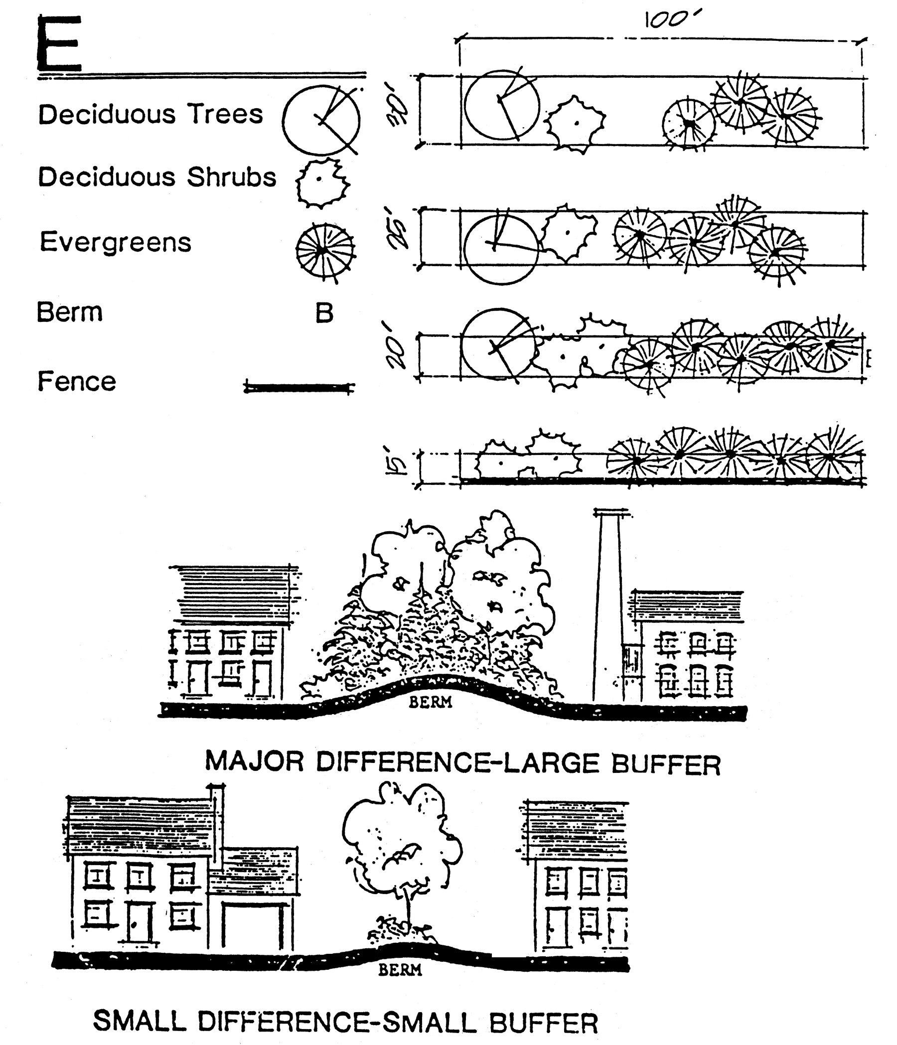
As indicated in sketches, an elevated bufferyard may be required by construction of a berm; the height, width and length of berm will be a determination of the planning commission on a site plan by site plan basis.
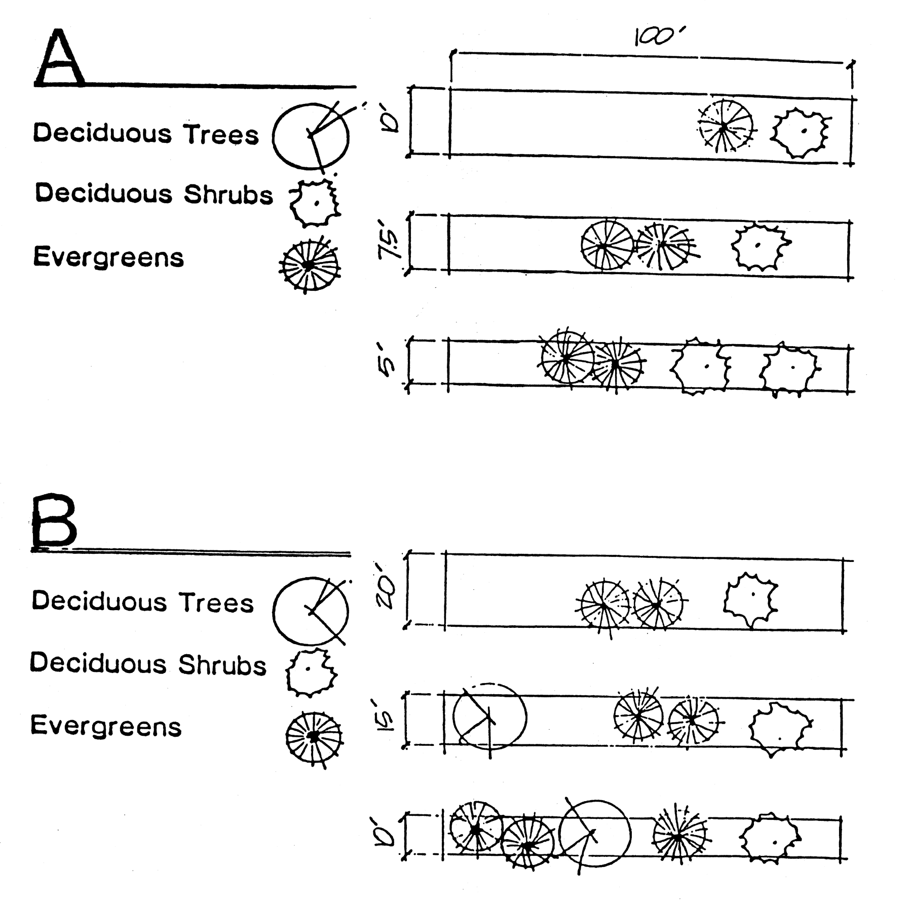
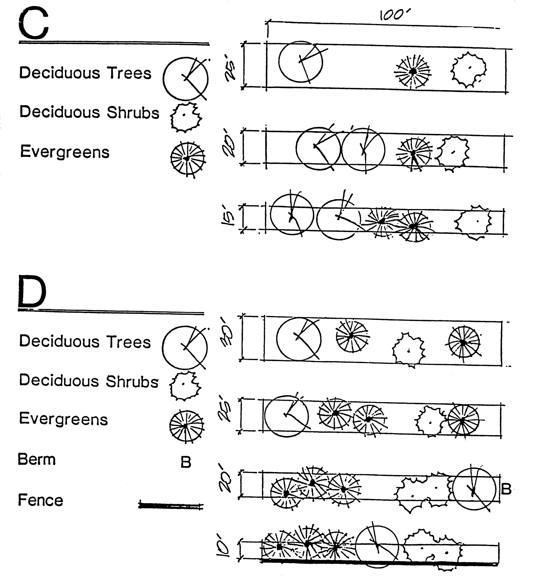
Note. Bufferyard requirements are stated in terms of the width of the bufferyard and the number of plant units required per 100 linear feet of bufferyard. The requirements may be satisfied by any of [the] options indicated (bufferyard type A—E).
C.
Plant materials. All plant materials required within specified bufferyard shall be planted to completion within six months from date of approval of the site plan and thereafter be properly maintained.
The following landscape/plant materials are suggested for inclusion in the required bufferyards:
Bufferyard requirements for adjacent land
*No bufferyard required
Bufferyard type. The following illustrations graphically indicate the specifications of each bufferyard. Bufferyard requirements are stated in terms of the width of the bufferyard and the number of plant units required per 100 linear feet of bufferyard. The requirements of a bufferyard may be satisfied by any of the options indicated.
See following bufferyard diagrams: A, B, C, D, and E
Sec. 14.06. - Detailed performance requirements.
Within this section are specified detailed regulations applicable to specific land uses. It is felt that standards, above and beyond those imposed by other sections of this ordinance, are necessary for certain uses.
A.
Performance subdivision. A performance subdivision may contain one or more of the housing development types as specified in this subsection. All dwelling types shall be single-family residences, having approved public sanitary sewer and/or water unless waived by the planning commission and board of trustees. By complying with stipulated performance criteria, flexibility in design is encouraged, thereby promoting lower land development costs, increased open space within subdivisions and protection of certain natural features. However, where a conflict arises between the requirements of yard setbacks and maximum lot coverage, yard setback requirements shall prevail.
1.
Requirements for performance subdivision include:
(a)
For each square foot of land gained under the provisions of this section in a performance subdivision, through the reduction of the lot size below the minimum requirements for the zoning district in which it is located, equal amounts of land shall be dedicated to the common use of lot owners of the subdivision in a manner approved by the planning commission. Such dedicated area shall be retained as undeveloped open space.
(b)
Wherein land proposed for usage as a performance subdivision is immediately contiguous on one or more sides to an existing single-family detached subdivision of 15 acres or larger in size, the net density per acre of the performance subdivision shall not exceed the net density per acre of said existing subdivision. Contiguity shall mean having immediate contact along a property line; properties separated by public road rights-of-way shall not be considered contiguous.
2.
Single-family house. This dwelling type consists of a single-family residence located on a privately owned lot having yard area on all four sides of the house. The following table specifies the minimum standards for this traditional method of single-family housing:
* In the event of condominium development, acreage net densities shall be maintained in respective zoning districts, as inferred in this table.
3.
Lot-line house. This dwelling type consists of a single-family residence, located on an individual lot. The dwelling: however, may be situated on a side lot line provided:
(a)
Exterior windows are prohibited for that portion of structure that abuts lot line;
(b)
A five-foot maintenance easement for painting, repair, etc., shall be provided for the property owner;
(c)
The minimum standards for the "single-family house" listed above shall apply except for the side yard.
4.
Duplex. This dwelling type consists of a semi-detached single-family residence located on an individual lot. The dwelling may be attached to another single-family dwelling at a side lot line through the use of one or more of the following characteristics:
(a)
A common party wall through the garage portion of adjacent structures;
(b)
An architectural wall detail which does not form interior room space between any two units; and
(c)
A common party wall that meets all fire resistance and sound transmission requirements of the township building code.
The duplex dwelling shall be typified insofar as possible by characteristics commonly associated with single-family dwellings in the township, including the expression of individuality of each dwelling unit; privacy; and a sense of spaciousness. In addition, the minimum standards for the "single-family house" listed above shall apply.
5.
Row or townhouse. In the event single-family dwellings with two common walls would be desired, row or townhouses could be constructed in the H district only; the minimum standards for the "single-family house" listed above shall apply; and the following requirements shall be followed:
(a)
The side yards shall be exempted from the minimum standards;
(b)
Front yard and rear yard dimensions shall be decreased by five feet each; and
(c)
The lot frontage and lot width shall be reduced by 20 feet.
B.
Institutional (public or quasi-public) uses or structures. Inasmuch as the institutional uses (schools, churches, public buildings) permitted in residential districts may have an adverse effect on residential properties if not properly located and designed, the following performance standards must be met prior to development of such uses:
1.
Hazardous areas must be adequately fenced to avoid accidents; such areas include public utility substations.
2.
Any permitted institutional structure should preferably be located at the edge of a low-density residential district, abutting a D, H or M district, or a public open space.
3.
If possible, all permitted institutional uses should front on a major street (minor arterial or collector).
4.
Motor vehicle entrance and exit should be made on a major street to avoid the impact of traffic generated by the institutional use upon the residential area.
5.
Site locations should be chosen which offer natural or man-made barriers that would lessen the effect of the intrusion of an institutional use into an established residential area.
6.
Institutional uses should not be located so as to cause costly public improvements.
7.
Institutional structures shall be located no closer than 50 feet to adjacent property lines.
C.
Two-family and multifamily dwellings. In addition to the site development standards and performance criteria required for two-family or multifamily uses in a specific zoning district, the following standards shall be met prior to development of such uses:
1.
No multiple family building designed, erected or used for ten or more families shall be located closer than 50 feet to any rural or low-density residential zone line. Where planning commission studies indicate adjoining property will eventually assume similar development as property in question, the commission may waive the 50-foot minimum.
2.
No single building or connected buildings may exceed 200 feet in any one dimension. All buildings shall be so arranged as to permit emergency vehicle access, by some practical means, to all sides.
3.
The distance of separation between grouped buildings shall be a minimum of 25 feet.
4.
No entrance to a multiple family structure shall be located closer to any street intersection access road, driveway, or parking area than 25 feet.
D.
Office, service or convenience commercial structures or uses. In addition to the site development standards and performance criteria required for office, service or convenience commercial uses in a specific zoning district, the following standards shall be met prior to development of such uses:
1.
Where one or more lot lines abuts an existing single-family residential use, an elevational drawing of the proposed structure shall be submitted for planning commission review and approval. The planning commission may stipulate that such office or commercial structures be constructed with a residential facade and/or be a residential scale (mass) and character.
E.
Industrial uses. In addition to the site development standards and performance criteria required for industrial (manufacturing, warehousing, etc.) uses in the village core district, the following standards of operation shall be met:
1.
Noise. The intensity level of sounds shall not exceed the following decibel level when adjacent to the following types of uses:
2.
Vibration. All machinery shall be so mounted and operated as to prevent transmission of ground vibration exceeding a displacement of .003 of one inch, as measured at the property line.
3.
Odor. The emission of noxious, odorous matter in such quantities as to be readily detectable at any point along lot lines when diluted in the ratio of one volume of odorous air to four or more volumes of clean air or as to produce a public nuisance or hazard beyond lot lines is prohibited.
4.
Gases. The escape of or emission of any gas which is injurious or destructive or explosive shall be unlawful and may be summarily caused to be abated.
5.
Glare and heat. Any operation producing intense glare or heat shall be performed within an enclosure so as to completely obscure and shield such operation from direct view from any point along the lot line, except during the period of construction of the facilities to be occupied.
6.
Light. Exterior lighting shall be so installed that the surface of the source of light shall be so arranged as far as practical to reflect light away from any residential use, and in no case shall more than one foot candle power of light cross a lot line five feet above the ground in a residential district.
7.
Electromagnetic radiation. Applicable rules and regulations of the Federal Communications Commission in regard to propagation of electromagnetic radiation are hereby made a part of this ordinance.
8.
Smoke. It shall be unlawful to discharge into the atmosphere from any single source of emission whatsoever any air contaminator for a period of [or] periods aggregating more than four minutes in any one-half hour which is:
(a)
As dark or darker in shade as that designated as No. 2 on the Ringelmann Chart. The Ringelmann Chart, as published by the United States Bureau of Mines, which is hereby made a part of this ordinance, shall be the standard. However, the Umbra scope readings of smoke densities may be used when correlated with the Ringelmann Chart. A Ringelmann Chart shall be on file in the office of the zoning administrator.
(b)
Of such opacity as to obscure an observer's view to a degree equal to or greater than the smoke described in (a) above, except when the emission consists only of water vapor.
9.
Drifted and blown materials. The drifting or airborne transmission to areas beyond the lot line of dust, particles, or debris from any open stockpile shall be unlawful and may be summarily caused to be abated.
10.
Radioactive materials. Radioactive materials shall not be emitted to exceed quantities established as safe by the U.S. Bureau of Standards, as amended from time to time.
11.
Sewage waste. All industrial sewage discharged into the public sewers shall be subject to the Bath Charter Township Sanitary Sewer Ordinance and all limitations or criteria set forth therein.
F.
Health and wellness centers. In addition to the site development standards and performance criteria required for health and wellness center uses in a specific zoning district, the planning commission may require building improvements to limit unwanted effects from a health and wellness center land use. All health and wellness center operations shall be consistent with applicable state agency regulations, such as public health codes and occupational codes.
(Ord. No. 31.75, § 8, 5-2-2022; Ord. No. 31.85, § 4, 2-5-2024)
State Law reference— MCL 333.20131 (health care facilities and agencies licensure)
State Law reference— R 338.13011-13017 (acupuncturist licensure)
State Law reference— MCL 339.1203a (hair and skin care services, manicures, electrologist licensure)
State Law reference— MCL 339.1204 & R 338.2121a-2126 (cosmetology licensure)
State Law reference— R 338.7132-7137 & R 338.7132-7137 (physical therapist & athletic trainer licensure)
State Law reference— MCL 333.17957 & R 338.732-739 (massage therapy licensure)

