
Bemidji City Zoning Code
ARTICLE II
ZONING DISTRICTS AND REGULATIONS
Sec. 28-41.- Zoning districts.
The city is hereby divided into the following zoning districts as shown below. These zoning districts are created in order to promote the orderly development of land within the city, including the shoreland of its public waters.
(Ord. No. 199, 3rd series, § 1, 11-6-2023)
Sec. 28-42. - Overlay districts.
(a)
Shoreland overlay (SH). Please see article IX. All information regarding the shoreland overlay district has been moved to article IX.
(b)
Sensitive area overlay (SA). Allows the appropriate development of land consistent with the intent of the underlying zoning district provided that adequate protection of sensitive environmental areas is ensured.
(1)
Permitted uses. All uses identified as permitted in the underlying zoning district are permitted in the sensitive area overlay district, provided that such use is in full compliance with the performance standards prescribed in section 28-414 of this development code.
(2)
Interim uses. All uses identified in the underlying zoning district as interim uses will be considered as interim uses in the sensitive area overlay district. The proposed use must meet the minimum requirements prescribed in section 28-414 of this development code.
(3)
Conditional uses. All conditional uses identified in the underlying zoning district as conditional uses will be considered as conditional uses in the sensitive area overlay district. The proposed use must meet the minimum requirements prescribed in section 28-414 of this development code.
(c)
Trunk Highway 197 overlay (TH). Protects the character of development along the Trunk Highway 197 corridor, and to protect the functionality of the highway.
(1)
Permitted uses. All uses identified as permitted in the underlying zoning district are permitted in the Trunk Highway 197 overlay district, provided that such use is in full compliance with the performance standards prescribed in section 28-415 of this development code.
(2)
Interim uses. All uses identified in the underlying zoning district as interim uses will be considered as interim uses in the Trunk Highway 197 overlay district, provided that such use is in full compliance with the performance standards prescribed in section 28-415 of this development code.
(3)
Conditional uses. All uses identified in the underlying zoning district as conditional uses will be considered as conditional uses in the Trunk Highway 197 overlay district, provided that such use is in full compliance with the performance standards prescribed in section 28-415 of this development code.
(d)
Airport protection overlay (AP). Protects the character of airport operations, airport safety, and the development within the airport safety zones at the ends of the runways. Any properties located within the Bemidji Regional Airport Land Use Safety Zones, as described in the Bemidji Regional Airport Zoning Ordinance which may be amended from time to time, must comply with the Airport Zoning Ordinance.
(e)
Closed landfill overlay (CL). Protects against potential health and safety impacts of methane gas and its migration around closed MPCA managed landfills.
(1)
Permitted uses. All uses identified as permitted in the underlying zoning district are permitted in the closed landfill overlay district, provided that such use is in full compliance with the performance standards prescribed in section 28-417 of this development code.
(2)
Interim uses. All uses identified in the underlying zoning district as interim uses will be considered as interim uses in the closed landfill overlay district, provided that such use is in full compliance with the performance standards prescribed in section 28-417 of this development code.
(3)
Conditional uses. All uses identified in the underlying zoning district as conditional uses will be considered as conditional uses in the closed landfill overlay district, provided that such use is in full compliance with the performance standards prescribed in section 28-417 of this development code.
(f)
University overlay (UO). The Bemidji State University area surrounding residential and commercial neighborhoods and the public streetscapes meant to encourage infill, mixed use, and redevelopment. The campus will serve as the primary focal point of the district. The main intent of the district is to preserve and promote the distinct character evident in existing structures.
(Ord. No. 199, 3rd series, § 1, 11-6-2023; Ord. No. 210, 3rd series, § 1, 10-21-2024)
Sec. 28-43. - Zoning map.
The zoning map of the city is located at the City's planning and zoning office. This map is hereby adopted by reference. A copy of this map is included in this development code. Copies are also available at the city hall.
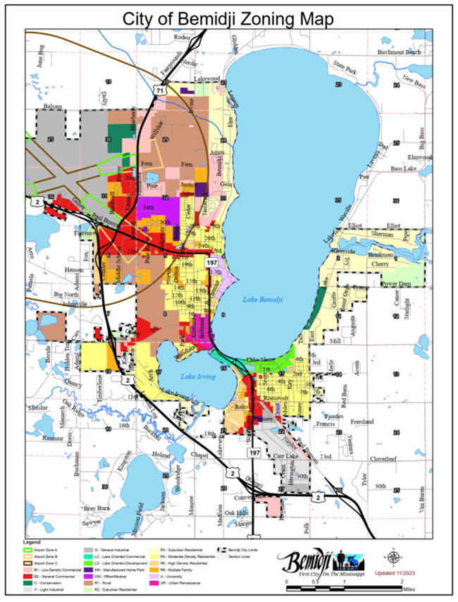
(Ord. No. 199, 3rd series, § 1, 11-6-2023; Ord. No. 210, 3rd series, § 1, 10-21-2024)
Sec. 28-44. - Interpretation of zoning map.
Regardless of the existence of purported copies of the zoning map which may from time to time be made or published, the zoning map, which shall be located in the office of the council, shall be the final authority as the current zoning status of land within the city.
District boundaries. The location and boundaries of the districts established by this development code are set forth on the zoning map. District boundary lines as indicated on the zoning map follow lot lines, property lines, rights-of-way or center lines of streets or alleys, rights-of-way or center lines of streets or alleys projected, the corporate city limit lines, and shorelines, all as they exist upon the effective date of this development code. If said boundary lines do not follow any of the above, the district boundary lines are established as drawn on the zoning map. If a lot or parcel held in single ownership on the date of adoption of this development code is divided by a district boundary line, the entire lot shall be construed to be within the more restrictive district.
Vacated ways. Whenever any street, alley or other public way is vacated in the manner authorized by law, the zoning district adjoining each side of such street, alley or public way shall be automatically extended to the center of such vacation and all included in the vacation shall then and henceforth be subject to all regulations of the extended districts.
Appeals. Appeals concerning the exact location of a zoning district boundary line shall be heard by the board of adjustment.
(Ord. No. 199, 3rd series, § 1, 11-6-2023)