
Bethlehem City Zoning Code
ARTICLE I
- IN GENERAL
Sec. 89-1.- Purpose of article.
This article sets out the legal basis for the Unified Development Code and its broad purposes, describes the lands to which and circumstances under which the Code applies, and describes how the Code is to be interpreted when certain words or phrases are used or uncertainty of meaning may exist.
(Ord. of 10-13-2020)
Sec. 89-2. - Title and authority.
(a)
Title. This Development Code regulates the use of land, the location and use of buildings and other site improvements, and the construction of public facilities and private improvements related to the development of land. This Development Code shall be known as and may be cited as "The Unified Development Code of Barrow County, Georgia" or, for brevity, "The Development Code".
(b)
Authority. This Development Code is adopted under authority of Article 9, Section 2, Paragraph 3 and 4 of the Constitution of the State of Georgia, and pursuant to the zoning procedures law (O.C.G.A. §§ 36-66-1 et seq.) and other applicable laws enacted by the general assembly.
(Ord. of 10-13-2020)
Sec. 89-3. - Adoption.
(a)
Adoption of the Unified Development Code. Under the authority and for the purposes stated herein, the Board of Commissioners of Barrow County does hereby enact as law, the articles, chapters, and sections contained in this Development Code.
(b)
Conflict with other regulations.
(1)
All regulations or parts of regulations of the Code of Laws of Barrow County, Georgia, in conflict with these regulations shall be and the same are hereby repealed in their portions so in conflict.
(2)
Where this Development Code overlaps with other requirements adopted by the board of commissioners, the more restrictive regulation shall govern.
(3)
It is not the intent of these regulations to repeal or affect any law of the State of Georgia, or any code, or ordinance of Barrow County, adopted as a requirement of a state law, in which case the most restrictive requirement shall control.
(4)
In no case shall Barrow County be required to enforce private easements, covenants, or other private agreements or legal relationships, whether they are more restrictive than the requirements of the Development Code or they apply a standard that is not addressed in this Code. See also section 89-4(c).
(5)
Nothing in these regulations shall be construed to affect the validity of any building permit lawfully issued prior to the effective date of these regulations.
(c)
Amendments.
(1)
These regulations may be amended from time to time by resolution of the board of commissioners. Such amendments shall be effective as of their date of adoption unless otherwise stated in the adopting resolution.
(2)
No amendment to these regulations shall be construed to affect the validity of any other.
(d)
Severability. If any action, section, subsection, sentence, clause, or phrase of these regulations is for any reason held unconstitutional, void, or invalid, the validity of the remaining portions of these regulations shall not be affected thereby, it being the intent of the board of commissioners in adopting these regulations that no portion thereof or provision of the regulations contained herein, shall become inoperative or failed by reason of the unconstitutionality or invalidity of any section, subsection, sentence, clause, phrase or provisions of this Development Code.
(Ord. of 10-13-2020)
Sec. 89-4. - Purpose and intent.
(a)
Purpose. This Development Code is made with reasonable consideration, among other things, of the character of the district and its peculiar suitability for particular uses, and with a view to promoting desirable living conditions and the sustained stability of neighborhoods, protecting property against blight and depreciation, securing economy in governmental expenditures, conserving the value of buildings and encouraging the most appropriate use of land and other buildings and structures throughout Barrow County.
This Development Code is made and designed to:
(1)
Lessen congestion in the streets;
(2)
Secure safety from fire, panic, and other dangers;
(3)
Prevent flooding of improved property;
(4)
Provide adequate light and air;
(5)
Prevent the overcrowding of land;
(6)
Avoid undue concentration of population;
(7)
Facilitate the adequate provision of transportation, water, sanitation, schools, parks, housing, communications, health care and other public requirements;
(8)
Promote the health, safety, morals, convenience, order, prosperity and welfare of the present and future inhabitants of the county; and
(9)
Improve the quality of life through protection of the county's total environment including, but not limited to, the prevention of air, water and noise pollution.
(b)
Intent in interpretation. In the interpretation and application of this Development Code all provisions shall be:
(1)
Considered as minimum requirements;
(2)
Liberally construed in favor of the property owner; and
(3)
Deemed neither to limit nor repeal any other powers granted under state statutes.
(c)
Intent relative to private property agreements. This Development Code is not intended to repeal, abrogate, or impair any valid easement, covenant or deed restriction duly recorded with the clerk of the superior court, to the extent that such easement, covenant or deed restriction is more restrictive than the requirements imposed by this Development Code. However, when this Development Code imposes a greater restriction upon the use or development of buildings or land than are imposed by such easements, covenants, agreements, or deed restrictions, the provisions of this Development Code shall govern.
(Ord. of 10-13-2020)
Sec. 89-5. - General applicability.
(a)
Lands to which this Development Code applies. This Development Code shall apply only in the unincorporated areas of Barrow County, Georgia.
(b)
Use of land or structures.
(1)
No structure or land shall hereafter be used or occupied, located, extended, moved, converted or structurally altered except in full compliance with the provisions of this Development Code.
(2)
No part of a yard, buffer or off-street parking spaces required in connection with any use or structure for the purpose of complying with this Development Code shall be included as part of a yard, buffer or off-street parking space required for any other use or structure, unless specifically allowed under the provisions of this Development Code.
(3)
Street rights-of-way shall not be considered a part of a lot or front yard setback for the purpose of meeting the minimum requirements of this Development Code.
(c)
Street frontage required. No building permit shall be issued on any lot unless the street giving access to the lot shall be accepted and opened as a public street prior to that time, or shall be a recorded private street approved by the board of commissioners, or shall otherwise have achieved the status of a public street.
(d)
One principal house on a lot. With respect to single-family detached dwellings, only one principal building and its customary accessory uses, buildings and structures may be erected on any one lot.
(e)
Lot reduction prohibited. No yard or lot existing prior to the effective date of this Development Code or any subsequent amendment to it shall be reduced in dimension or area below the minimum requirements set forth in this Development Code. Yards or lots created after the effective date of this Development Code shall meet at least the minimum requirements established by this Development Code.
(f)
Dedication of public lands and facilities. No land dedicated as a public street or other public purpose shall be opened or accepted as a public street or for any other public purpose, and no subdivision of land shall be made, nor subdivision plat thereof shall be recorded before obtaining final approval from the board of commissioners. Said approval shall be entered in writing on the final plat by the planning and community development director. Said planning and community development director is hereby authorized to accept such dedications of lands and public facilities on behalf of Barrow County and to cause such dedications to be recorded by the Clerk of Superior Court of Barrow County.
(g)
Requirements for moving a building. No dwelling unit or other permanent structure shall be moved within or into the county unless, when relocated, it meets all requirements of the Development Code and other County Code requirements and is first approved by the planning and community development director.
(Ord. of 10-13-2020)
Sec. 89-6. - Conformance with comprehensive plan.
The arrangement, character, extent, width, grade, and location of all streets shall conform to these regulations and the comprehensive plan and shall be considered in their relation to existing and planned streets, to topographical conditions, to public convenience and safety, and in their appropriate relation to the proposed uses of the land to be served by such streets.
(Ord. of 10-13-2020)
Sec. 89-7. - Grandfathered development.
(a)
Nonconformities in general.
(1)
This section sets out the provisions that protect uses, structures, lots and signs that lawfully existed prior to the adoption of this Development Code or a subsequent amendment, but no longer conform to the new regulations. The primary intent of the treatment of nonconformity is to allow continuation of these uses, structures, lots and signs until the end of their useful life, while encouraging conformance to the new regulations when it becomes reasonable.
(2)
Nothing in this Development Code shall prevent the strengthening, repair or restoration to a safe or lawful condition of any part of any building or structure declared unsafe or unlawful by the planning and community development director or any other duly authorized county official.
(3)
The lawful use of any nonconforming uses, structures, lots and signs may be continued, even though such use does not conform to the provisions of this Development Code under the circumstances presented in this section for each type of development.
(b)
Nonconforming uses.
(1)
Nonconforming uses; defined. A nonconforming use is a use or activity that was lawfully established prior to the adoption, revision or amendment of this Development Code, but which, by reason of such adoption, revision or amendment, is no longer a use or activity permitted by right or no longer meets or conforms to the requirements of this Development Code.
(2)
Grandfathered nonconforming uses. To avoid undue hardship, the lawful but nonconforming use of any structure or land at the time of the enactment of this Development Code or any subsequent amendment may be continued even though the use does not conform to the provisions of this Development Code, except that the nonconforming use:
a.
Shall not be changed to another nonconforming use.
b.
Shall not be re-established after its removal from the property for more than 15 days in the case of a nonconforming manufactured home, or its discontinuance for six months or more for all other uses, unless the premises are under a continuing lease but are unoccupied by the nonconforming use, regardless of the intent of the owner or occupier to resume the nonconforming use.
c.
Shall not be extended to occupy a greater area of land.
d.
Shall not be extended to occupy a greater area of a building or structure unless such additional area of the building or structure existed at the time of the passage or amendment of this Development Code and was clearly designed to house the same use as the nonconforming use occupying the other portion of the building or structure.
e.
If an existing use was lawfully established in a zoning district that is subsequently amended to require special use approval for such use, the existing use shall not be subject to the provisions of this subsection.
f.
Any intended but not yet existing nonconforming use for which a vested right was acquired prior to the adoption of this Development Code or the adoption of an amendment to it shall be prohibited unless such intended nonconforming use for which a vested right was acquired is actually commenced within one year of the adoption of this Development Code or the adoption of an amendment to it regardless of the intent or expectation to commence or abandon such nonconforming use.
(c)
Nonconforming structures.
(1)
Nonconforming structures; defined. A nonconforming structure is a structure or building whose size, dimensions or location on a property were lawful prior to the adoption, revision or amendment of this Development Code, but which, by reason of such adoption, revision or amendment, no longer meets or conforms to one or more such requirements of this Development Code.
(2)
Grandfathered nonconforming structures. A nonconforming structure may continue to be occupied and used, provided that the nonconforming structure:
a.
Shall not be enlarged or altered in any way that increases its nonconformity.
b.
Shall not be replaced after removal except in conformance with this Development Code.
c.
Shall not be occupied by a use for which off-street parking requirements cannot be met.
(3)
Grandfathered nonconforming structures may be routinely repaired and maintained, provided that:
a.
Repairs are as necessary to maintain a structure in a safe and sanitary condition and do not exceed 50 percent of the current replacement cost of the structure, during any period of 12 consecutive months.
b.
A structure damaged or destroyed by any means to an extent of more than 50 percent of its replacement cost at time of destruction shall be reconstructed only in conformance with this Development Code. Nonconforming structures that are damaged 50 percent or less must begin reconstruction or repair within six months after the damage is incurred in order to maintain the structure's grandfathered status.
(4)
A nonconforming structure that is declared by the administrator to be physically unsafe or unlawful due to lack of repairs and maintenance shall not thereafter be restored, repaired, or rebuilt except in conformity with this Development Code.
(d)
Nonconforming lots.
(1)
Nonconforming lots; defined. A nonconforming lot is a lot of record whose area, frontage, width or other dimensions, or location were lawful prior to the adoption, revision or amendment of this Development Code, and which, by reason of such adoption, revision or amendment, no longer meets or exceeds one or more such requirements of the applicable zoning district.
(2)
Grandfathered nonconforming lots.
a.
Where the owner of a legal lot of record at the time of the adoption of this Development Code does not own sufficient land to conform to the minimum lot size or lot width requirement of this Development Code, such lot may nonetheless be used as a building site provided that:
1.
No further subdivision of the lot is allowed;
2.
The building setback and other lot dimensions conform as closely as possible, given the size and shape of the lot, to the required dimensions of the zoning district; and
3.
Access to a public street is provided directly or through an easement recorded prior to adoption of this Development Code.
b.
On a legal nonconforming flag lot, landlocked lot or other lot where the minimum lot width cannot be achieved at the minimum front building setback line, the principal building shall be moved back to a location on the lot where the minimum lot width can be achieved.
(3)
Unbuildable lots. If a legal nonconforming lot has inadequate area or an unusual shape such that an adequate buildable area cannot be established under the setback requirements of the zoning district, a building permit may be issued under the following circumstances:
a.
Administrative approval as a special exception may be granted for reductions in setback or lot width of up to 20 percent of the requirement; or
b.
Approval for construction is granted as a hardship variance by the board of appeals.
(4)
Combination of nonconforming lots; where required. If the owner of two or more adjoining lots, at least one of which is a nonconforming lot, decides to build on or sell off these lots, he must first combine said lots to comply with the dimensional requirements of this Development Code.
(e)
Nonconforming signs.
(1)
Nonconforming signs; defined. A nonconforming sign is a sign that was lawfully erected and maintained prior to the adoption of this article, and which by reason of such adoption fails to conform to all applicable regulations and restrictions of this article.
(2)
Grandfathered nonconforming signs. A nonconforming sign that is permanently affixed to the ground or to a building may continue to be used, except that the nonconforming sign:
a.
Shall not be moved or replaced except in conformity with the provisions of this Development Code.
b.
Shall not be repaired, rebuilt, or altered after damage exceeding 60 percent of its replacement cost at the time of destruction except in conformance with this Development Code; provided that reconstruction begins within six months after damage of 60 percent or less is incurred.
c.
Shall not be enlarged or altered in a way that increases its nonconformity, but it may be repaired to the extent necessary to maintain it in a safe and well-maintained condition.
d.
These provisions shall not have the effect of excusing any violation of any other ordinance. Nor shall these provisions have the effect of permitting the continued existence of any unsafe sign or any sign that is not in a good state of repair.
(3)
Temporary signs to be removed.
a.
Any nonconforming sign that is temporary in nature and not permanently affixed to the ground or to a building, such as a streamer or pennant, shall be removed within 30 days of becoming a nonconforming sign.
b.
Failure to remove such illegal sign or bring it into conformance following 30 days notice to the owner or occupant of the property by the code enforcement officer shall authorize the county to institute enforcement procedures pursuant to this Development Code.
(4)
Treatment of illegal signs.
a.
Illegal signs located within a public right-of-way or on public lands:
1.
Signs located illegally within any public right-of-way or other public lands shall be removed immediately upon adoption of this Development Code.
2.
The planning and community development director other county employee(s), (and/or private individuals, corporations and entities, if so authorized by the board of commissioners), shall be authorized to remove and dispose of nonconforming signs from public rights-of-way and other public lands with or without notice to and at the expense of the owner, builder or other parties responsible for placement of said sign.
b.
Illegal signs not located within a public right-of-way or on public lands:
1.
A sign that was not lawfully existing under the county's regulations prior to adoption of this article shall, within 30 days of adoption of this article, either: a) be removed, or b) be brought into conformance with all provisions of this article.
2.
Failure to remove such illegal sign or bring it into conformance following 30 days notice to the owner or occupant of the property by the code enforcement officer shall authorize the county to institute enforcement procedures pursuant to this Development Code.
(5)
Removal due to road improvements. If a nonconforming sign must be removed due to a county or state road improvement project, the board of commissioners may authorize the relocation of said sign even though the new location may not meet the setbacks, location and/or spacing or other provisions of this Development Code.
(6)
Continuing maintenance of nonconforming signs.
a.
Nothing in this section shall be deemed to prevent keeping in good repair nonconforming signs.
b.
No repairs other than minor maintenance and upkeep of nonconforming signs shall be permitted except to make the sign comply with the requirements of this Development Code.
c.
A nonconforming sign that has been declared by the county to be unsafe because of its physical condition shall not be repaired, rebuilt, or restored unless such repair or restoration will result in a sign that conforms to all applicable provisions of this article.
(Ord. of 10-13-2020)
Sec. 89-8. - Exemptions.
(a)
Previously issued permits. The provisions of the Unified Development Code shall not affect the validity of any lawfully issued and previously effective preliminary plat approval, site development plan approval, building permit or development permit if:
(1)
The development activity or building construction authorized by the approval or permit has been commenced prior to the effective date of the Unified Development Code, or will be commenced after such effective date but within six months of issuance of the permit; and
(2)
The development activity or building construction continues without interruption (except because of war or natural disaster) until the development or construction is complete. If the permit expires, any further development or construction on that site shall occur only in conformance with the requirements of this Development Code in effect on the date of the permit expiration.
(b)
Governmental bodies. It is recognized that as a matter of law, all governmental bodies and authorities legally exempt from regulation under the police power of Barrow County are exempt from the regulations contained in this Development Code.
(c)
Validity. The provisions of any amendment of the development standards contained in the Unified Development Code shall not affect the validity of any lawfully issued and previously effective preliminary plat approval, site development plan approval, building permit or development permit if the development activity or building construction authorized by the approval or permit has been commenced prior to the effective date of such amendment, or will be commenced after such effective date but within 12 months from the date of such amendment. In the event that the development activity is not commenced within the 12-month period immediately following the effective date of the amendment, unless otherwise required by law, the development activity shall comply with those development standards in effect at the time of the commencement of such development activity.
(Ord. of 10-13-2020)
Sec. 89-9. - Interpretation.
(a)
Responsibility for interpretation.
(1)
The planning and community development director shall be responsible for the interpretation of the requirements, standards, definitions or any other provision of this Development Code.
(2)
Interpretations of the planning and community development director may be appealed under the provisions of this Development Code relating to appeals.
(b)
Use of figures and examples for illustration.
(1)
Figures associated with defined terms or regulatory paragraphs in this Development Code are provided for illustration only and do not limit or change the meaning of the term as defined or the requirements of the regulation as written.
(2)
When an example of the application of a specific provision is given, or other explanatory text is provided, such example or text is identified by placement in a shaded box separate from the regulatory paragraphs in this Development Code. Such examples or explanatory text are provided for illustration only and do not limit or change the meaning of the provision or the requirements of this Development Code as written.
(c)
Use of words and phrases. For the purpose of this Development Code, the following shall apply to the use of words and phrases:
(1)
Words used in the present tense include the future tense. Words used in the singular tense include the plural tense, and words used in the plural tense include the singular tense. The masculine person "he" or "his" also means "her" or "hers".
(2)
References to the "county" and to the board of commissioners and any public officials or appointed bodies of the county not otherwise named by political jurisdiction or defined in this Development Code shall always mean Barrow County, Georgia, and its governing body, appointed or employed officials, and appointed bodies as named. These include:
a.
The planning commission, created as such and appointed by the board of commissioners.
b.
The board of appeals, created as such and appointed by the board of commissioners.
c.
The county manager, appointed as such by the board of commissioners, or the county manager's designee.
d.
The county attorney, appointed as such by the board of commissioners, or the county attorney's designee.
e.
The planning and community development director, appointed as such by the board of commissioners, or his or her designee.
f.
The director of public works, appointed as such by the board of commissioners, or his or her designee.
(3)
References to an administrative department of Barrow County shall always mean the department created by the board of commissioners as such. These include:
a.
Planning and community development department: References to action by the "planning and community development department" shall mean action by that administrative official to whom responsibility for that action has been assigned by the planning and community development director.
b.
Public works department: A reference to action by the "public works department" shall mean action by that administrative official to whom responsibility for that action has been assigned by the director of public works.
(4)
References to public officials, departments or appointed bodies of jurisdictions other than Barrow County shall always mean such persons or bodies having jurisdiction over or relative to Barrow County, Georgia. These include:
a.
The Clerk of the Superior Court of Barrow County, Georgia;
b.
The Barrow County Health Department;
c.
The Oconee Natural Resources Conservation Service;
d.
The Northeast Georgia Regional Commission (the NEGRC );
e.
The Georgia Departments of Natural Resources (DNR) and Transportation (GDOT); and
f.
The United States Army Corps of Engineers, the Federal Aviation Administration (FAA), the Federal Emergency Management Agency (FEMA) and the Federal Environmental Protection Agency (EPA).
(5)
The word "person" is intended to include any individual, partnership, firm, association, joint venture, public or private corporation, trust, estate, commission, board, public or private institution, utility, cooperative, state agency, municipality or other political subdivision of this state, any interstate body or any other legal entity.
(6)
The words "shall", "will", "is to" and "must" are always mandatory and not discretionary, while the word "may" is permissive.
(7)
The word "and" indicates that all of the conditions, requirements or factors so connected must be met or fulfilled, while the word "or" indicates that at least one condition, requirement or factor so connected must be met.
(8)
The term "such as" is intended to introduce one or more examples in illustration of a requirement or point, and is intended to mean "including but not limited to the following".
(9)
The verbs "zone" and "rezone" have the same meaning and refer to the act of amending the official zoning map through the process established by this Development Code.
(10)
The nouns "zone", "zoning district" and "district" have the same meaning and refer to the zoning districts established under this Development Code.
(11)
The word "day" means a calendar day unless otherwise specified as a work day, which means Monday through Friday excluding official County holidays.
(12)
The word "used" or "occupied" as applied to any land or building shall be construed to include the words "intended", "arranged", or "designed to be used or occupied".
(13)
The term "zoning map" means the Official Zoning Map of Barrow County, Georgia, and may include a single map or a series of maps in sections.
(d)
Interpretation of words and phrases.
(1)
All words and phrases are to be interpreted within the context of the sentence, paragraph, subsection, section and article in which they occur.
(2)
Words and phrases specifically relating to a category of use of land or a structure that are defined in this Development Code shall be interpreted as defined without regard to other meanings in common or ordinary use, unless the context of the word or phrase indicates otherwise. Words and phrases not defined in this Development Code shall be construed to have the meaning given by common and ordinary use, the meaning of which may be further clarified by use of the word or phrase in the North American Industrial Classification System (NAICS) published by the U.S. Department of Commerce.
(3)
Other words and phrases defined in this Development Code shall be interpreted as defined without regard to other meanings in common or ordinary use, unless the context of the word or phrase indicates otherwise. Words and phrases not defined in this Development Code shall be construed to have the meaning given by common and ordinary use, the meaning of which may be further clarified by definition of the word or phrase in a dictionary of the English language in current circulation.
(Ord. of 10-13-2020)
Sec. 89-10. - Glossary of defined terms.
(a)
Purpose. This section is a glossary of all definitions specifically used in the text of this Development Code. Refer also to section 89-4 regarding the interpretation of figures, words and phrases as used in this Development Code. All definitions, regardless of location within an article of this Development Code, apply equally to the use of such terms throughout the Code.
(b)
Definitions.
Access: A way or means of approach to provide physical entrance to a property.
Accessory structure setback line: A line delineating the minimum allowable distance between a property line or the right-of-way line of an abutting street and an accessory structure.
Accessory use or structure: A use or structure that is permitted on a property in conjunction with a principal use. An accessory use is incidental to the principal use and would not exist independent of the principal use.
Addition (to an existing building): Any walled and roofed expansion to the perimeter of a building in which the addition is connected by a common load-bearing wall other than a firewall. Any walled and roofed addition which is connected by a firewall or is separated by independent perimeter, load-bearing walls is new construction.
Adult bookstore: An establishment having, as a substantial or significant portion of its stock in trade, books, magazines or other periodicals which are distinguished or characterized by their emphasis on matter depicting, describing or relating to specified sexual activities or specified anatomical areas, or an establishment with a segment or section, comprising five percent of its total floor space, devoted to the sale or display of such materials or five percent of its net sales consisting of printed materials which are distinguished or characterized by their emphasis on matter depicting, describing or relating to specified sexual activities or specified anatomical areas.
Adult cabaret: An adult entertainment facility, or that part of an adult entertainment facility, which regularly features or otherwise offers to the public, customers or members, in a viewing area which is designed for occupancy by more than five persons, any live exhibition, performance or dance by a person whose exhibition, performance or dance is characterized by the exposure of any specified anatomical area, or by specified sexual activities, or who otherwise appears unclothed or in such attire, costume or clothing so as to expose to view specified anatomical areas.
Adult dancing establishment: A business that features dancers displaying or exposing specified anatomical areas.
Adult hotel or motel: A hotel wherein material is presented which is distinguished or characterized by an emphasis on matter depicting, describing or relating to specified sexual activities or specified anatomical areas.
Adult massage parlor: A sexually oriented commercial enterprise whose major business is the offering, for any form of consideration, of a service of rubbing, kneading or striking the customer's body in a way which is intended to provide sexual stimulation or sexual gratification to the customer.
Adult mini-motion-picture theater: An enclosed building with a capacity of less than 50 persons used for commercially presenting material distinguished or characterized by an emphasis on matter depicting or relating to specified sexual activities or specified anatomical areas for observation by patrons therein.
Adult motion picture arcade: Any place to which the public is permitted or invited wherein coin- or slug-operated or electronically, electrically or mechanically controlled still or motion picture machines, projectors or other image-producing devices are maintained to show images to five or fewer persons per machine at any one time and where the images so displayed are distinguished or characterized by an emphasis on depicting or describing specified sexual activities or specified anatomical areas.
Adult motion picture theater: An enclosed building with a capacity of 50 or more persons used for presenting material distinguished or characterized by an emphasis on matter depicting, describing or relating to specified sexual activities or specified anatomical areas for observation by patron therein.
Adult video store: An establishment having, as a substantial or significant portion of its stock in trade, videotapes or movies or other reproductions, whether for sale or rent, which are distinguished or characterized by their emphasis on matter depicting, describing or relating to specified sexual activities or specified anatomical areas, or an establishment with a segment or section, comprising five percent of its total floor space, devoted to the sale or display of such material or which derives more than five percent of its net sales from videos which are characterized or distinguished by their emphasis on matter depicting, describing or relating to specified sexual activities or specified anatomical areas.
Agricultural: A property used primarily for the cultivation of crops, dairying or the raising of livestock, or a vacant property zoned or offered for sale or lease for such purpose. Agricultural uses are all uses listed on Table 2.3 under the category "Agricultural, forestry, fishing and hunting".
Agricultural activities:
(1)
Good-faith commercial production from the land or on the land of agricultural products, including horticultural, floricultural, dairy, livestock, poultry, and apiarian products, but not including forestry products (see "tree harvesting" below).
(2)
Clearing trees for the purpose of planting crops, providing pasture for livestock, or constructing buildings accessory to production of agricultural products.
Agritourism: Any activity carried out on a working farm that produces an agricultural commodity that allows members of the public, for recreational, entertainment, or educational purposes, to view, experience, or enjoy rural activities, including farming, ranching, historic, cultural, or harvest-your-own activities, and excluding any competitions utilizing motorized vehicles. An activity may constitute agritourism whether or not a fee is collected to participate.
Airport: The airport facility known as the Barrow County Airport (WDR).
Antenna: Any device or combination of devices, whether rods, panels or dishes, designed to receive and/or transmit radio frequency signals for amateur radio or personal wireless services, including but not limited to cellular telephone, personal communications services (PCS), specialized mobile radio (SMR), enhanced specialized mobile radio (ESMR), private mobile radio (PMR) and paging.
Appeal: A request for a review of the Barrow County Department of Community and County Development Director's interpretation of any provision of this ordinance.
Applicant: A property owner or their authorized representative who has petitioned the county for approval of a zoning change, development permit, building permit, hardship variance, special exception or appeal, or any other authorization for the use or development of their property under the requirements of this Development Code.
Application: A petition for approval of a zoning change, development permit, building permit, hardship variance, special exception or appeal, or any other authorization for the use or development of a property under the requirements of this Development Code.
Aquifer: Any stratum or zone of rock beneath the surface of the earth capable of containing or producing water from a well.
Area of shallow flooding: A designated AO or AH zone on the County's flood insurance rate map (FIRM) with base flood depths from one to three feet, and/or where a clearly defined channel does not exist, where the path of flooding is unpredictable and indeterminate, and where velocity flow may be evident.
Area of special flood hazard: The land in the floodplain within a community subject to a one percent or greater chance of flooding in any given year. In the absence of official designation by the Federal Emergency Management Agency, Areas of Special Flood Hazard shall be those designated by the county.
As-built survey drawings: Drawings specifying the dimensions, location, capacities, and operational capabilities of structures and facilities as they have been constructed.
Awning: A roof-like cover that projects from the wall of a building for the purpose of shielding a doorway, or window from the elements. Awnings are often made of fabric or flexible plastic supported by a rigid frame and may be retracted into the face of the building.
Awning sign: See "building sign".
Banner: A sign other than an official flag, made of paper, cloth, thin plastic, or similar lightweight material, and usually containing a message or logo.
Base flood: The flood having a one percent chance of being equaled or exceeded in any given year (100-year flood).
Base flood elevation (BFE): The elevation shown on the flood insurance rate map for Zones AE, AH, A1—A30, AR, AR/A, AR/AE, AR/A1—A30, AR/AH, AR/AO, V1—V30, and VE that indicates the water surface elevation resulting from a flood that has a one percent chance of equaling or exceeding that level in any given year.
Base zone: The primary zoning designation of a property that confers restrictions on buildings and land uses. All property in Barrow County has one base zone (such as R-1 low-density single-family residential or C-2 community commercial), but properties may be further regulated by one or more overlay zoning districts.
Basement: That portion of a building having its floor subgrade (below ground level) on all sides.
Bed and breakfast inn: A business establishment operated within a dwelling by the owner or occupant, offering temporary lodging not to exceed 14 consecutive days and offering one or more meals to guests while away from their normal places of residence. In contrast, see "short term rental" and "rooming or boarding house."
Berm: A mound of earth, or the act of pushing earth into a mound.
Best management practices (BMP's): A collection of structural measures and vegetative practices which, when properly designed, installed and maintained, will provide effective erosion and sedimentation control for all rainfall events up to and including a 25-year, 24-hour rainfall event. These include sound conservation and engineering practices to prevent and minimize erosion and resultant sedimentation, which are consistent with, and no less stringent than, those practices contained in the 'Manual for Erosion and Sediment Control in Georgia' published by the commission as of January 1 of the year in which the land-disturbing activity was permitted.
Breakaway wall: A wall that is not part of the structural support of the building and is intended through its design and construction to collapse under specific lateral loading forces without causing damage to the elevated portion of the building or the supporting foundation system.
Buildable area of lot: That portion of a lot bounded by and interior to the required rear, side and front building setback lines for a principal building.
Building: Any structure having a roof supported by columns or walls and intended for the shelter, housing, or enclosure of any individual, animal, process, equipment, goods, or materials of any kind. For flood management purposes, refer to "structure" hereinbelow.
Building code: The technical codes approved for enforcement or otherwise adopted or adopted as amended by the county under the Georgia Uniform Codes Act, which regulate the construction of buildings and structures.
Building floor area: The total floor area of all heated spaces within a building. Heated floor area does not include garages, unheated basements, attic storage areas and partially unenclosed decks, patios or lanais. Gross floor area comprises the area within the inside perimeter of the exterior walls with no deduction for corridors, stairs, closets, thickness of walls, columns or other features, exclusive of areas open and unobstructed to the sky. See also "gross floor area".
Building height: The vertical distance measured to the highest point of a building from the average finished grade across those sides of a building that face a street.
Building sign: A sign that in any manner is fastened to, projects from, or is placed or painted upon the exterior wall, window, door, or roof of a building. The term "building sign" includes but is not limited to the following:
Figure 1.1 - Sign Types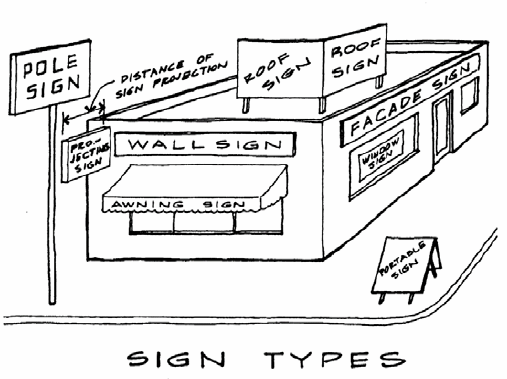
(1)
Awning sign: A sign imposed, mounted or painted upon an awning.
(2)
Canopy sign. A sign affixed to, imposed upon, or painted on any canopy, such that the sign is mounted in such a manner that a continuous face with the canopy is formed.
(3)
Mansard sign: A sign imposed, mounted or painted upon a mansard and not extending above the top of the mansard.
(4)
Marquee sign: Any sign attached flat against the marquee or permanent sidewalk canopy of a building and not extending above the top of the marquee.
(5)
Parapet sign: A sign imposed, mounted or painted on a parapet and not extending above the top of the parapet.
(6)
Projecting sign: A sign affixed to a wall and extending more than 18 inches from the surface of such wall, usually perpendicular to the wall surface.
(g)
Roof sign: A sign that is mounted on, applied to, or otherwise structurally supported by the roof of a building.
(h)
Under-canopy sign: A display attached to the underside of a marquee or canopy and protruding over private sidewalks.
(i)
Wall (or fascia) sign: A sign that is fastened directly to or is placed or painted directly upon the exterior wall of a building, with the sign face parallel to the wall, and extending from the surface of the wall no more than 18 inches.
(j)
Window sign: A sign that is placed on or behind a windowpane or glass door and intended to be viewed from outside the building.
Caliper: The diameter of a proposed tree (usually nursery stock) measured at a point six inches above the ground or top of root ball for up to and including four-inch caliper trees, and at a point 12 inches above the ground or top of root ball for larger sizes.
Canopy: A permanent roof-like structure projecting from a building and open on at least one side for the purpose of shielding a pedestrian walkway from the elements, or a freestanding roof-like structure supported by columns intended to shield a vehicular driveway or service area from the elements.
(1)
Changeable copy sign: A type of animated sign that is capable of changing the position or format of word messages or other displays on the sign face or change the visible display of words, numbers, symbols and graphics by the use of a matrix of electric lamps, movable discs, movable panels, light apertures or other methods, provided these changes are actuated by either a control mechanism or manually on the face of the sign. Changeable copy signs include the following types: Electronic changeable copy sign: A sign whose alphabetic, pictographic or symbolic informational content can be changed and is displayed electrically or electronically. See also, LED Sign.
(2)
Manual changeable copy sign: A sign whose alphabetic, pictographic or symbolic informational content can be changed or altered manually by placing such letters or other message elements directly on the sign face by hand, e.g., reader boards with changeable letters.
Channeled letters (internally illuminated letters):
(1)
Internally channeled letters: Letters or other symbols with recessed surface designed to accommodate incandescent bulbs or luminous tubing.
(2)
Reverse channeled letters: Letters or other symbols with raised surface designed to be lighted from behind by incandescent bulbs or luminous tubing.
Commercial: A property occupied by one or more business establishments that are primarily engaged in the sale of goods; the provision of personal, professional, business, entertainment or other commercial services; the management of a business enterprise; or the provision of temporary housing to the traveling public (such as a motel); or a vacant property zoned or offered for sale or lease for such purposes. Commercial uses are all uses listed on Table 2.3 under the categories "Administrative and professional offices," "Commercial services," "Arts, entertainment and recreation" and "Retail trade." In addition, conducting yard sales more than three times in any consecutive 12-month period shall constitute a commercial (retail) use.
Commercial vehicle: A commercial vehicle means any vehicle bearing a United States Department of Transportation registration number, whether issued pursuant to federal law (also known as a U.S. DOT Number) or state law (also known as a Georgia U.S. DOT Number). Without limiting the foregoing, a school bus shall be considered a commercial vehicle for purposes of this Code.
Commission: The state soil and water conservation commission.
Common open space: See "open space".
Comprehensive plan: The comprehensive plan for the county, prepared, adopted and as amended from time to time in accordance with the Georgia Comprehensive Planning Law.
Concealed support structure: Any freestanding structure constructed for the primary purpose of supporting one or more antennae but designed to resemble an architectural or natural feature of the specific environment, concealing or camouflaging the presence of the antennae. The term includes but is not limited to clock towers, campaniles, water towers, silos, light poles, flagpoles, and artificial trees.
Condition of zoning approval: A requirement adopted by the board of commissioners at the time of approval of a rezoning or special use, placing greater or additional requirements or restrictions on the property than provided in this Development Code in order to reduce an adverse impact of the rezoning or special use and to further the protection of the public health, safety, or general welfare.
Conservation easement: A portion of land set aside in its natural state and preserved as open space in perpetuity.
Containment: Any regulated substance, as defined by the Federal Resource Conservation and Recovery Act, as in effect on the date of passage of the ordinance codified in this article and as amended from time to time, and all petroleum products, including gasoline, oil, waste oils and other fuels, as well as their hazardous constituents.
Copy: See "sign copy".
Critical facility: Any public or private facility, which, if flooded, would create an added dimension to the disaster or would increase the hazard to life and health. Critical facilities include:
(1)
Structures or facilities that produce, use, or store highly volatile, flammable, explosive, toxic, or water-reactive materials;
(2)
Hospitals and nursing homes, and housing for the elderly, which are likely to contain occupants who may not be sufficiently mobile to avoid the loss of life or injury during flood and storm events;
(3)
Emergency operation centers or data storage centers which contain records or services that may become lost or inoperative during flood and storm events; and
(4)
Generating plants, and other principal points of utility lines.
Critical root zone: The minimum area beneath a tree that must be left undisturbed in order to preserve a sufficient root mass to give a tree a reasonable chance of survival. The critical root zone (CRZ) will typically be represented by a concentric circle centering on the tree's trunk with a radius equal in feet to one times the number of inches of the trunk diameter. Example: The CRZ radius of a 20-inch diameter tree is 20 feet.
Creek: See "stream".
Cul-de-sac length: For the purposes of this Development Code, a cul-de-sac street shall be interpreted to begin at the intersection of two or more streets nearest to the vehicular turnaround.
Cut: A portion of land surface or area from which earth has been removed or will be removed by excavation; the depth below original ground surface to excavated surface. Also known as "excavation."
Cutting: The removal of any soil or other solid material from a natural ground surface.
Day care facility: The use of a building or premises for the care and supervision of children or elderly adults who do not reside on the property, for periods of less than 24 hours.
(1)
Family day care home: An accessory use within a private residence operated by the occupant of the dwelling that enrolls for pay, supervision and non-medical care, five or fewer children or elderly adults with no overnight stays, or no more than six children or elderly adults if the structure meets the building code requirements for institutional uses.
(2)
Group day care home: A day care facility that enrolls for pay, supervision and non-medical care, up to 18 children or elderly adults with no overnight stays.
(3)
Day care center: A day care facility that enrolls for pay, supervision and non-medical care, 19 or more children or elderly adults.
Dead plant or tree: Any living plant material that has lost 33 percent or more of its branches or leaves, as determined by the county, shall be considered dead.
Decorative wall: A wall constructed of or faced with stone or brick, and which may incorporate decorative wrought iron or other architectural metal elements.
Developer: The person, corporation or other legal entity that undertakes the subdivision of property, the alteration of land or vegetation in preparation for construction activity, or the construction of streets, utilities, buildings or other improvements required for the habitation or use of property.
Development:
(1)
A land development project involving the construction of streets, utilities, buildings, or other improvements required for the habitation or use of property, such as a residential neighborhood, an apartment complex, a store, or a shopping center.
(2)
Any manmade change to improved or unimproved real estate, including, but not limited to, buildings or other structures, mining, dredging, filling, grading, paving, excavating or drilling operations or storage of equipment or materials.
(3)
The act of constructing or carrying out a land development project, including the alteration of land or vegetation in preparation for construction activity.
Development permit: The authorization necessary to initiate and conduct a land-disturbing activity and to carry out the planned development of land and structures.
Development site: That portion of a tract of land that will be dedicated to a proposed development, including the land containing trees that will be counted toward satisfying the requirements of these provisions.
DHR: The Georgia Department of Human Resources.
Diameter breast height (DBH): The diameter of an existing tree trunk measured at a height of four and one-half feet above the ground. If a tree splits into multiple trunks below four and one-half feet, the trunk is measured at its most narrow point beneath the split.
District: The Oconee Soil and Water Conservation District.
DNR: The Georgia Department of Natural Resources.
Double-faced sign: A sign structure with two sign faces that are parallel (back-to-back) or that form an angle to one another, where each sign face is designed to be seen from a different direction and the two sign faces are separated from each other at their nearest point by no more than three feet.
Drainage structure: A device composed of a virtually non-erodible material such as concrete, steel, plastic or other such material that conveys water from one place to another by intercepting the flow and carrying it to a release point for stormwater management, drainage control or flood control purposes.
Drip line: A perimeter formed by the points farthest away from the trunk of a tree where precipitation falling from the branches of that tree lands on the ground.
Figure 1.2 - Dwelling, Single-Family Detached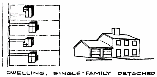
Dwelling: A building or portion of a building arranged or designed to provide living quarters for one or more families on a permanent or long-term basis.
(a)
Single-family detached residence: A residential building, whether site-built or a manufactured home or an industrialized building, designed for occupancy by one family.
Figure 1.3 - Dwelling, Townhouse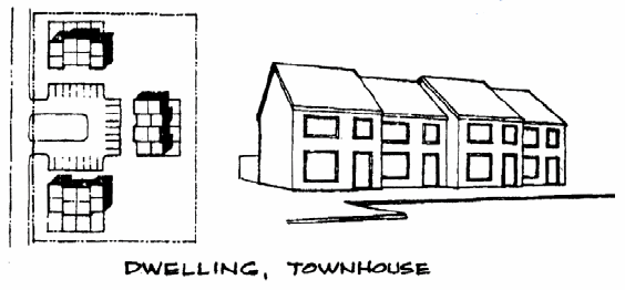
(b)
Single-family attached—Duplex: A residential building designed exclusively for occupancy by two families in separate dwelling units living independently of each other.
(c)
Single-family attached—Townhome: A residential building in which the dwelling units may adjoin one another only at the vertical walls and no dwelling unit may be located above another.
Figure 1.4 - Dwelling, Garden Apartment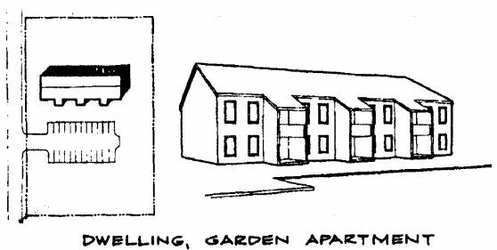
(d)
Multi-family: A residential building designed exclusively for occupancy by three or more families in separate dwelling units living independently of each other, such as in a garden apartment building.
Dwelling unit: One or more rooms connected together and constituting a separate, independent housekeeping establishment with complete provisions for cooking, eating, sleeping, bathing and personal hygiene, and physically set apart from any other dwelling unit in the same structure.
Elevated building: A non-basement building built to have the lowest floor of the lowest elevated area elevated above the ground level by means of solid foundation perimeter walls; pilings, columns (posts and piers), shear walls; or breakaway walls.
Encounter center: Any business, agency or person who, for any form of consideration or gratuity, provides a place where two or more persons may congregate, assemble or associate for the primary purpose of engaging in, describing or discussing specified sexual activities, or exposing specified anatomical areas. This definition does not include an establishment where a medical practitioner, psychologist, psychiatrist or similar professional person licensed by the state engages in sexual therapy.
EPD: The Georgia Environmental Protection Division of the Department of Natural Resources.
EPD director: The Director of the Environmental Protection Division of the Georgia Department of Natural Resources.
Erosion: The process by which land surface is worn away by the action of wind, water, ice, or gravity.
Erosion, sedimentation and pollution control plan: A plan required by the Erosion and Sedimentation Act, O.C.G.A. Chapter 12-7, that includes, as a minimum protection at least as stringent as the state general permit, best management practices, and requirements in section 89-1254.7(c) of this ordinance.
Erotic dance establishment: A nightclub, theater or other establishment which features live performances by topless and/or bottomless dancers, go-go dancers, strippers or similar entertainers, where such performances are distinguished or characterized by an emphasis on specified sexual activities or specified anatomical areas.
Escort bureau and/or introduction service: Any business, agency or person who, for a fee, commission, hire, reward or profit, furnishes or offer to furnish names of persons, or who introduces, furnishes or arranges for persons who may accompany other persons to or about social affairs, entertainments or places of amusement, or who may consort with others about any place of public resort or within any private quarters.
Event venue: See under "special event venue."
Existing construction: For the purposes of determining rates, structures for which the "start of construction" commenced before August 9, 1988, the date of adoption of the first flood damage prevention ordinance or regulation in the county.
Existing manufactured home park or subdivision A manufactured home park or subdivision for which the construction of facilities for servicing the lots on which the manufactured homes are to be affixed (including at a minimum the installation of utilities, the construction of streets, and final site grading or the pouring of concrete pads) is completed before April 7, 1988.
Expansion to an existing manufactured home park or subdivision: The preparation of additional sites by the construction of facilities for servicing the lots on which the manufactured homes are to be affixed, including the installation of utilities, the construction of streets, and either final site grading or the pouring of concrete pads.
Family: An individual or two or more persons living together as a household.
Family day care home: See under "day care facility".
Family personal care home: See under "personal care home".
Federal Aviation Regulations ("FAR") Part 77 Airspace Surfaces: The regulated airspace surfaces promulgated in 14 Code of Federal Regulations (CFR) Part 77, Objects Affecting Navigable Airspace.
Fence: An artificially constructed barrier of wood, wire, wire mesh, or decorative metal erected to enclose, screen or separate portions of a lot.
Festoon: Strings or ribbon, tinsel, small flags, pennants, streamers, pinwheels, or other devices or long narrow strips of fabrics, plastic, or other pliable material designed to move in the wind.
Fill: A portion of land surface to which soil or other solid material has been added; the depth above the original ground.
Filling: The placement of any soil or other solid material, either organic or inorganic, on a natural ground surface or excavation.
Finished grade: The final elevation and contour of the ground after cutting or filling and conforming to the proposed design.
Flood and flooding: A general and temporary condition of partial or complete inundation of normally dry land areas from the:
(1)
Overflow of inland or tidal waters; or
(2)
Unusual and rapid accumulation or runoff of surface waters from any source.
Flood hazard boundary map (FHBM): An official map of a community, issued by the Federal Emergency Management Agency, where the boundaries of the areas of special flood hazard have been defined.
Flood insurance rate map (FIRM): An official map of a community, on which the Federal Emergency Management Agency has delineated the areas of special flood hazard or the risk premium zones applicable to the county.
Flood insurance study: The official report provided by the Federal Emergency Management Agency evaluating flood hazards and containing flood profiles and water surface elevations of the base flood.
Flood proofing: Any combination of structural and non-structural additions, changes, or adjustments to structures, which reduce or eliminate flood damage to real estate or improved real property, water and sanitary facilities, structures and their contents.
Floodplain: Any land area susceptible to flooding.
Floodway: The channel of a river or other watercourse and the adjacent land areas that must be reserved in order to discharge the base flood without cumulatively increasing the water surface elevation more than one foot.
Floor: The top surface of an enclosed area in a building, including basement, i.e., top of slab in concrete slab construction or top of wood flooring in wood frame construction. The term does not include the floor of a garage used solely for parking vehicles or storage, or the floor area of an attic used exclusively for storage.
Floor area, building: See "building floor area".
Floor area, gross: See "gross floor area".
Flowering trees: See under "tree".
Freeboard: A factor of safety usually expressed in feet above a flood level for purposes of floodplain management. "Freeboard" tends to compensate for the many unknown factors that could contribute to flood heights greater than the height calculated for a selected size flood and floodway conditions, such as wave action, bridge openings, and the hydrological effect of urbanization of the watershed.
Free-flowing creek, stream, or river: See "regulated stream".
Freestanding sign: A sign permanently attached to the ground and that is wholly independent of any building or other structure. The term "freestanding sign" includes but is not limited to the following:
(1)
Pole sign: A sign that is mounted on a freestanding pole, columns, or similar support such that the bottom of the sign face or lowest sign module is not in contact with the ground.
(2)
Ground sign: A freestanding sign in which the entire bottom of the sign face or structure is in contact with the ground, providing a solid and continuous background for the sign face from the ground to the top of the sign. Also referred to as a "monument sign".
Frontage or street frontage: The width in linear feet of a lot where it abuts the right-of-way of any street from which access may be directly gained.
Functionally dependent facility: A facility which cannot be used for its intended purpose unless it is located or carried out in close proximity to water, such as a docking or port facility necessary for the loading and unloading of cargo or passengers, shipbuilding, ship repair or seafood processing facilities. The term does not include long-term storage, manufacture, sales or service facilities.
Functionally dependent use: A use which cannot perform its intended purpose unless it is located or carried out in close proximity to water. This term includes only docking facilities, port facilities that are necessary for the loading and unloading of cargo or passengers, and shipbuilding and ship repair facilities, but does not include long-term storage or related manufacturing facilities.
Good moral character: A person is of good moral character according to this article if that person has not been convicted of a felony, or any crime not a felony if it involves moral turpitude, in the past five years. The county may also take into account such other factors as are necessary to determine the good moral character of the applicant or employee. Conviction shall include pleas of nolo contendere or bond forfeiture when charged with such crime.
Grading: Altering the shape of ground surfaces to a predetermined condition; this includes stripping, cutting, filling, stockpiling and shaping, or any combination thereof, and shall include the land in its cut or filled condition.
Gross floor area: The total area of all floors of a building, measured from the outside planes of the exterior walls.
Ground cover: A low growing plant, other than turf grass, which forms a continuous cover over the ground surface.
Ground elevation: The original elevation of the ground surface prior to cutting or filling.
Group day care home: See under "day care facility".
Group home for the elderly: See "retirement community".
Group personal care home: See under "personal care home".
Guest house: An accessory use to a dwelling designed and intended for the temporary housing of visitors to a property at the behest of the property residents for no fee or other consideration, and meeting or exceeding the standards for single-family and two-family dwellings under this Development Code.
Heavily landscaped area: An area planted with a combination of shade and flowering trees, deciduous and evergreen shrubs, and flowering perennials such that the entire area is covered with landscape materials. The green space designated to be heavily landscaped shall have no more than 25 percent of its area covered in turf (seed or sod). The remaining 75 percent shall contain shade trees (two-inch caliper minimum), flowering trees (one-inch caliper minimum), evergreen shrubs (three-gallon minimum), deciduous shrubs (three-gallon minimum), and perennials or non-turf groundcovers (2½-inch pot minimum). All plant materials shall be mulched.
Hardwood tree: Any tree that is not coniferous (not cone bearing or a needle leaf evergreen).
Hazardous material: Any contaminant, as defined within the Environmental Protection Article, and any hazardous chemical for which a material safety data sheet must be filed under 42 USC 11021 and 11022.
Hazardous waste: Any solid waste which has been defined as a hazardous waste in regulations promulgated by the administrator of the United States Environmental Protection Agency according to federal act, which are in force and effect on February 1988, codified as 40 CFR 261.3.
Hazard to air navigation: An obstruction determined to have an adverse effect on the safe and efficient utilization of the navigable airspace.
Heated floor area: All floor area internal to a principle structure as those phrases are used herein, which actually is served by natural gas or an electric heating system.
Highest adjacent grade: The highest natural elevation of the ground surface, prior to construction, next to the proposed foundation of a building.
Historic structure: Any structure that is:
(1)
Listed individually in the National Register of Historic Places (a listing maintained by the U.S. Department of Interior) or preliminarily determined by the Secretary of the Interior as meeting the requirements for individual listing on the National Register;
(2)
Certified or preliminarily determined by the Secretary of the Interior as contributing to the historical significance of a registered historic district or a district preliminarily determined by the Secretary to qualify as a registered historic district;
(3)
Individually listed on a state inventory of historic places and determined as eligible by states with historic preservation programs which have been approved by the Secretary of the Interior; or
(4)
Individually listed on a local inventory of historic places and determined as eligible by communities with historic preservation programs that have been certified either:
a.
By an approved state program as determined by the Secretary of the Interior; or
b
Directly by the Secretary of the Interior in states without approved programs.
Holiday: An official day of festivity or recreation when the offices of the county government are closed for business (other than a Saturday or Sunday).
Home occupation: Types of commercial uses (for profit) that are customarily performed in a small area of a residence that are of a low intensity nature and clearly incidental to the use of a residence.
(1)
Home office: A home occupation that is limited to an office use and does not involve visits or access by the public, suppliers or customers, and does not involve the receipt, maintenance, repair, storage or transfer of merchandise at the home.
(2)
Home business: A home occupation that is limited to the office use of a practicing professional, an artist or a commercial representative, and may involve very limited visits or access by clients or customers, but does not involve the maintenance, repair, storage or transfer of merchandise received at the home.
Household: An individual living alone or a group of individuals living together in a single dwelling unit, sharing common use of and access to all living and eating areas, bathrooms, and food preparation areas, who mutually combine their efforts and share responsibilities for domestic chores such as child rearing, cleaning and cooking in a permanent and long-term relationship, as contrasted to one in a transient relationship who pays for lodging such as a boarder.
Human directional sign: A promotional sign held or worn by a human outside of a business to attract customers and promote the business. These signs are also referred to as human billboards, living signs, sign spinners, sign holders, human arrows.
Illuminated signs:
(1)
Internally illuminated sign: Any sign that is illuminated by an artificial light source from within the sign structure over any or all of its sign face.
(2)
Externally illuminated sign: Any sign that is partially or completely illuminated at any time by an artificial light source that directly or indirectly illuminates the face of the sign from outside the sign structure.
Impermeable: Something that water cannot pass through or be absorbed by, such as a layer of rock.
Impervious surface: A man-made structure or surface that prevents the infiltration of stormwater into the ground below the structure or surface, such as a building, paved road or driveway, parking lot, deck, swimming pool or patio.
Incidental sign: A small sign, emblem, or decal no larger than one square foot. Such signs are normally located on doors, windows, and gas pumps, and are generally not readily visible or legible from public rights-of-way.
Industrial: A property occupied by one or more business establishment that are primarily engaged in the fabrication, manufacture or production of durable or nondurable goods, or a vacant property zoned or offered for sale or lease for such purpose. Industrial uses are all uses listed on Table 2.3 under the categories "Manufacturing, wholesaling and warehousing" and "Transportation, communications and utilities".
Industrialized home: A dwelling manufactured in accordance with the Georgia Industrialized Building Act (O.C.G.A. Title 8, Chapter 2, Article 2, Part 1) and the rules of the Commissioner of the Georgia Department of Community Affairs issued pursuant thereto. State approved buildings meet the state building and construction codes and bear an insignia of approval issued by the commissioner.
Institutional use: A property occupied by a nonprofit religious, recreational or philanthropic organization, club or institution. Public or community uses are all uses listed on Table 2.3 under the category "Public and institutional uses".
Junked vehicle: Any vehicle, which is non-operable due to its having been wrecked or vandalized, having had parts removed, or age, which is not intended to be restored to operating condition.
Jurisdiction: That area over which the governing body has authority for planning, zoning and development permitting under the Constitution of the State of Georgia.
Lake: A body of water one acre or more in surface area, created either by a manmade or natural dam or other means of water impoundment.
Land-disturbing activity: Any activity which may result in soil erosion from water or wind and the movement of sediments into state waters or onto lands within the state, including, but not limited to, clearing, dredging, grading, excavating, transporting, and filling of land but not including agricultural practices as described in section 89-1254.5 (e) of this Development Code.
Landscape materials: Any combination of living plant materials and nonliving materials such as rock, pebbles, sand, mulch, pavers, berms, fencing, walls, fountains and other decorative materials.
Landscaping: Landscaping shall consist of shrubs, vines, turf, ground cover and other landscape materials which are utilized to enhance the aesthetic and functional qualities of a site.
Land use plan: An element of the comprehensive plan, which includes a future land use map.
Larger common plan of development or sale: A contiguous area where multiple, separate and distinct construction activities are or may be occurring at different times on different schedules under on plan of development or sale.
LED Sign: Any sign or portion thereof that uses light-emitting diode technology or other similar semiconductor technology to produce an illuminated image, picture, or message of any kind whether the image, picture, or message is moving or stationary. This type of sign includes any sign that uses LED technology of any kind, whether conventional (using discrete LEDs), surface-mounted (otherwise known as individually mounted LEDs), transmissive, organic light-emitting diodes (OLED), light-emitting polymer (LEP), organic electro polymer (OEL), or any other similar technology. An LED sign is considered to be a form of electronic changeable copy sign (see under "Sign, Changeable Copy").
Local issuing authority: The Barrow County Board of Commissioners or its assigned or designated representative, which shall be responsible for administering this article and has been certified by the director of the environmental protection division of the department of natural resources as the issuing authority, pursuant to the Erosion and Sedimentation Act of 1975, as amended. The planning and community development director is hereby designated the responsibility for administering this article.
Lot: A parcel or tract of land held in single ownership.
(1)
Corner lot: Any lot bounded by two streets at their intersection.
(2)
Double-frontage lot (through lot): A lot bounding on two or more streets, but not at their intersection, so that it is not a corner lot unless said corner lot has frontage on three or more sides.
(3)
Interior lot: A lot having frontage on only one street.
Lot area: The total horizontal area included within lot lines.
Figure 1.6 Types of Lot Lines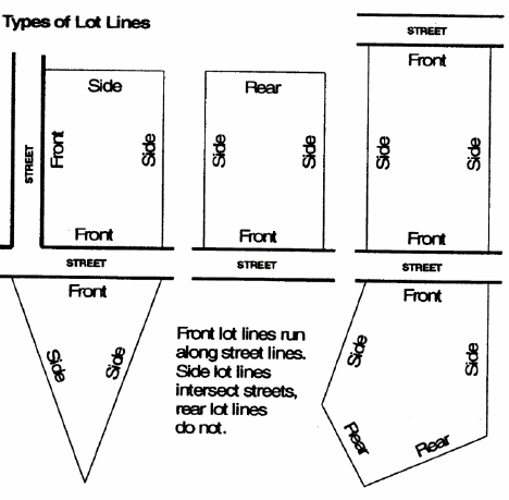
Lot line: The boundary dividing a given lot from the street or adjacent lots; the boundary defining the limit of ownership of a property.
(a)
Front lot line: Any boundary line of a lot that abuts a public street right-of-way line. A lot adjacent to more than one street will have more than one front lot line.
(b)
Rear lot line: Any boundary line of a lot that does not intersect with a public street right-of-way line and is not a front lot line.
(c)
Side lot line: Any boundary line of a lot that intersects with a public street right-of-way line and is not a front lot line.
Lot of record: A lot which is part of a subdivision recorded in the office of the clerk to the superior court, or a lot described by metes and bounds, the description of which has been so recorded.
Figure 1.7 - Lot Width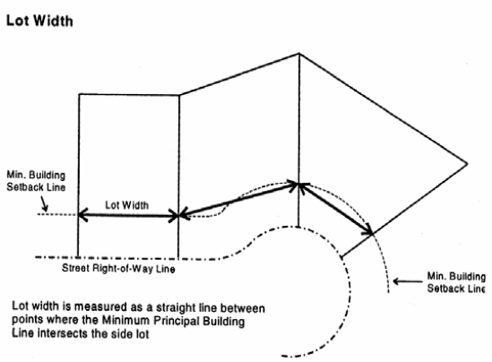
Lot width: The distance measured along the front principal building setback line between intersecting lot lines. The lot width shall be measured along a straight line between such points of intersection.
Lowest floor: The lowest floor of the lowest enclosed area, including basement. An unfinished or flood resistant enclosure, used solely for parking of vehicles, building access, or storage, in an area other than a basement, is not considered a building's lowest floor, provided that such enclosure is not built so as to render the structure in violation of other provisions of this Code.
Major subdivision: Any subdivision that does not qualify as a "minor subdivision" under section 89-462, or any subdivision of fewer than six lots that involves the construction of a new public or private street. A major subdivision commonly involves the construction of a new street or widening of an existing roadway, the provision of stormwater drainage facilities, or the construction or improvement of public utilities, or which otherwise has six or more lots (not in a large lot minor subdivision), building sites or other divisions.
Manual for Erosion and Sediment Control in Georgia: A publication of the same name published by the Georgia Soil and Water Conservation Commission, and as amended or supplemented from time to time. For the purposes of administration of this chapter, the applicable manual shall be that published as of January 1 of the year in which the land-disturbing activity is permitted.
Manufactured home: A dwelling fabricated in an off-site facility for installation or assembly at the building site, bearing a label certifying that it is constructed in compliance with the National Manufactured Housing Construction and Safety Standards Act of 1974 (42 U.S.C. 5401 et seq.), which first became effective on June 15, 1976. The term "manufactured home" includes a structure, transportable in one or more sections, which, in the traveling mode, is eight body feet or more in width or 40 body feet or more in length or, when erected on site, is 320 or more square feet in floor area, and which is built on a permanent chassis and designed to be used as a dwelling with or without a permanent foundation when connected to the required utilities and includes the plumbing, heating, air-conditioning, and electrical systems contained therein; except that such term includes any structure which meets all the requirements of this definition except the size requirement and with respect to which the manufacturer voluntarily files a certification required by the secretary of housing and urban development and complies with the standards established under the National Manufactured Housing Construction and Safety Standards Act of 1974 (42 U.S.C. 5401 et seq.).
Manufactured home park or subdivision: A parcel (or contiguous parcels) of land divided into two or more manufactured home lots for rent or sale.
Manufactured home park or subdivision for the purpose of flood damage: A manufactured home park or subdivision for which the construction of facilities for servicing the lots on which the manufactured homes are to be affixed (including at a minimum, the installation of utilities, the construction of streets, and either final site grading or the pouring of concrete pads) is completed on or after adoption of the first flood damage prevention ordinance or regulation in the county (April 7, 1988).
Manufactured home park: Any lot or parcel under single ownership on which two or more manufactured homes are to be located or intended to be located for purposes of residential occupancy.
Mansard: A steeply sloped, roof-like facade architecturally similar to a building wall.
Marquee: A permanent roof-like structure or canopy of rigid materials supported by and extending from the facade of a building.
Marquee sign: See under "building sign".
Mean sea level: The average height of the sea for all stages of the tide. It is used as a reference for establishing various elevations within the floodplain. For purposes of this Development Code, the term "mean sea level" is synonymous with North American Vertical Datum (NAVD) (formerly known as National Geodetic Vertical Datum (NGVD).
Metropolitan River Protection Act (MRPA): A state law referenced as O.C.G.A. §§ 12-5-440 et seq., which addresses environmental and developmental matters in certain metropolitan river corridors and their drainage basins.
Minimum front setback: The minimum distance required by the zoning on a property between an adjoining street and the facade of a principal building on the property.
Minor: Any person who has not attained the age of 18 years.
Minor subdivision: A subdivision of five or fewer lots in which each lot has frontage on an existing county street or road, and which does not involve the construction of a new street or the widening of an existing roadway, the provision of stormwater drainage facilities (other than driveway culverts), or the construction or improvement of any public utilities.
Mobile home: A dwelling manufactured prior to June 15, 1976, transportable in one or more sections, which, in the traveling mode, is eight body feet or more in width or 40 body feet or more in length or, when erected on site, is 320 or more square feet in floor area, and which is built on a permanent chassis and designed to be used as a dwelling with or without a permanent foundation when connected to the required utilities and includes the plumbing, heating, air-conditioning, and electrical systems contained therein.
Monument sign: See "ground sign" under "freestanding sign".
Multi-faced sign: A single sign structure consisting of two sign faces (see "double-faced sign") or three or more sign faces that are separated from each other at their nearest point by no more than three feet. Sign faces on a single sign structure that are separated by more than three feet are treated as separate signs.
Multi-family residential: A property occupied primarily by one or more residential buildings containing three or more dwelling units, or a mobile home park, or a vacant property zoned or offered for sale or lease for such purposes. Multi-family residential uses are all uses listed on Table 2.3 under the category "residential uses" other than "single-family detached" and "single-family attached: duplex".
National Geodetic Vertical Datum (NGVD): As corrected in 1929, is a vertical control used as a reference for establishing varying elevations within the floodplain. See "North American Vertical Datum (NAVD)."
Natural ground surface: The ground surface in its original state before any grading, excavation or filling.
Natural vegetated area: An undeveloped area largely free from human disturbance where naturally occurring vegetation is allowed to remain undisturbed or is enhanced and maintained by human intervention. The natural floras for specific areas are described in Georgia Geologic Survey Bulletin 114, "The Natural Environments of Georgia". Habitats for endangered and threatened species may require human management of the river corridor in order to maintain those species. Activities specifically allowed in such an area include:
(a)
Conservation or preservation of soil, water, vegetation, fish, shellfish and other wildlife;
(b)
Outdoor recreational activities, including hunting, fishing, trapping, bird watching, hiking, boating, horseback riding, swimming, canoeing and skeet and trap shooting;
(c)
Education, scientific research and nature trails;
(d)
Maintenance or repair of lawfully located roads, structures and utilities used in the service of the public, provided that the work is conducted using best management practices to ensure that negative effects on the pervious nature of the land shall be minimized; and
(e)
Limited excavating, filling and land disturbance necessary for the repair and maintenance of structures necessary to the permissible uses.
Nephelometric turbidity units (NTU): Numerical units of measure based upon photometric analytical techniques for measuring the light scattered by finely divided particles of a substance in suspension.
New construction: Any structure for which the start of construction commenced after adoption of the first flood damage prevention ordinance or regulation in the county (June 19, 1986), and includes any subsequent improvements to the structure.
New manufactured home park or subdivision: A manufactured home park or subdivision for which the construction of facilities for servicing the lots on which the manufactured homes are to be affixed (including at a minimum, the installation of utilities, the construction of streets, and either final site grading or the pouring of concrete pads) is completed after April 7, 1988.
North American Vertical Datum (NAVD): Replaced the National Geodetic Vertical Datum of 1929 in existing and future FEMA Flood Modernization Maps.
Obstruction: Any structure, tree, or other object, including a mobile object, which exceeds a limiting height based on FAA airport airspace analysis.
Office park: A development on a tract of land in single ownership that contains a number of separate office buildings, as well as accessory and supporting uses, that is designed, planned, constructed, and managed on an integrated and coordinated bases.
One hundred-year floodplain: A land area subject to a one percent or greater statistical occurrence probability of flooding in any given year.
Opaque: Impenetrable to view, or so obscuring to view that features, buildings, structures, and uses become visually indistinguishable.
Open space: An area of land or water that is permanently set aside through dedication, designation or reservation to remain in a natural and unimproved state or that may be improved only for active or passive recreation or enjoyment.
(1)
Common open space: Land or water areas within a development project that are available to or benefit all occupants of the development on a continuing and permanent basis, such as walking trails, community centers or clubhouses, golf courses and other recreation areas, protected floodplains or wetlands, and fishing or boating lakes. Common open space does not include any streets or public rights-of-way, or yard areas or landscape areas located on private property.
(2)
Public open space: Land reserved for preservation, leisure or recreational use but dedicated in fee simple to a governing body or agency to be responsible for operation and maintenance. Public open space may not be reserved for or dedicated to the exclusive use of the residents of a particular development.
Operator: The party or parties that have operational control of construction project plans and specifications, including the ability to make modifications to those plans and specifications; or day-to-day operational control of those activities that are necessary to ensure compliance with a stormwater pollution prevention plan for the site or other permit conditions, such as a person authorized to direct workers at a site to carry out activities required by the stormwater pollution prevention plan or to comply with other permit conditions.
Outparcel: A lot deeded separately from a larger tract for individual development, but generally sharing access with the larger tract. Outparcels are most generally associated with shopping centers.
Overlay district: A zoning district that may be placed on property in addition to its base zoning. Property may be regulated by a single or by multiple overlay zones. Also referred to as "overlay zone."
Overstory tree: See under "tree".
Owner: The legal or beneficial owner of a site, including, but not limited to, a mortgagee or vendee in possession, receiver, executor, trustee, lessee, or other person, firm, or corporation in control of the site; A person having or controlling a majority fee simple interest in a property, or their authorized representative.
Parking bay: Three or more parking spaces adjacent to one another and aligned side-by-side.
Pennant: Any lightweight plastic, fabric or similar material designed to move in the wind; pennants are often suspended from a rope, wire, or string in series. The term "pennant" shall not include a "banner" or an "official or personal flag" as regulated within the sign article.
Perennial river: A river or section of a river that flows continuously throughout the year.
Perennial stream: A stream that flows throughout the whole year. Perennial streams may be identified as shown as such on a United States Geologic Service Quad Map.
Person: Any individual, partnership, firm, association, joint venture, public or private corporation, trust, estate, commission, board, public or private institution, utility, cooperative, state agency, municipality or other political subdivision of the state, any interstate body or other legal entity.
Personal care home: A dwelling, whether operated for profit or not, which is required to be approved and licensed by the State of Georgia or any agency through which it acts, including but not limited to the department of human services ("DHS"), either as a personal care home or a community living arrangement, and which undertakes through its ownership or management to provide or arrange for the provision of housing, food service, and 24 hours per day assistance with one or more personal care services for persons who are not related to the owner or administrator of the dwelling by blood or marriage.
(1)
Small personal care home: A personal care home in a family-type residence, non-institutional in character, that offers personal care services for up to three ambulatory persons, without providing medical or nursing care.
(2)
Group personal care home: A personal care home in a residence or other type of building that is non-institutional in character and offers personal care services for up to 15 persons, without providing medical or nursing care.
(3)
Congregate personal care home: A personal care home that offers care to 16 or more persons or provides medical or nursing care for any number of residents.
Personal care services: Individual assistance with or supervision of self-administered medication and essential activities of daily living such as eating, bathing, grooming, dressing and toileting.
Place of public assembly: A structure which is designed to accommodate more than 50 persons at one time for such purposes as deliberation, education, worship, shopping, entertainment, or amusement.
Planned center: A single office, commercial, or industrial property or contiguous properties, planned, developed and managed as a unit for occupancy by two or more principal businesses that are separately owned and have no corporate relationship, such as a shopping center or office complex.
Plant materials: Living plants, such as trees, shrubs, ground cover, grasses and perennial flowering plants, turf, and vines that are suitable for ornamental and/or functional use.
Pollution susceptibility: The relative vulnerability of an aquifer to being polluted from spills, discharges, leaks, impoundments, applications of chemicals, injections and other human activities in a recharge area.
Pollution susceptibility map: Maps prepared by the state department of natural resources that show the relative susceptibility of groundwater recharge areas to pollution, the pollution susceptibility map categorizes the land areas of the state into areas of high, medium, and low groundwater pollution potential.
Pond: A body of standing water less than one acre in surface area, created either by a natural dam, or other means of water impoundment.
Portable sign: Any sign that is not permanently affixed to a building or other structure including but not limited to, signs mounted or painted on vehicles not used primarily for other purposes. (See also "vehicular sign", below.)
Principal building: A building in which is conducted a principal use.
Principal building setback line: A line delineating the minimum allowable distance between a property line or the right-of-way line of an abutting street and a principal building on a lot.
Figure 1.8 - Principal Building Setback Line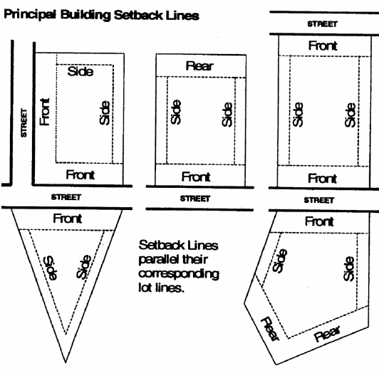
(1)
Front building setback: The minimum allowable distance between the right-of-way line of any abutting street and any part of a principal building on a lot. The front setback distance is applied along the full length of the right-of-way line and is parallel to it.
(2)
Rear building setback: The minimum allowable distance between a rear lot line and any part of a principal building on a lot. The rear building setback extends along and parallel to the full length of the rear lot line.
(3)
Side building setback: The minimum allowable distance between a side lot line and any part of a principal building on a lot. The side building setback extends along and parallel to the side lot line between the front building setback and a rear building setback (if any).
Principal freestanding sign: The main or largest freestanding sign or signs on a property.
Principal use: The specific, primary purpose for which land or a building is used.
Project: The entire proposed development project regardless of the size of the area of land to be disturbed.
Project entrance sign: A permanent freestanding sign located at a discernible entrance into a multi-family development; or at a discernible entrance into a development containing more than one principal building, such as a business center or office park; or into a development containing multiple lots, such as a particular residential, office, commercial or industrial subdivision.
Projecting sign: See under "building sign".
Property or parcel of land: See "lot".
Protected state river: Any perennial river or watercourse with an average annual flow of at least 400 cubic feet per second as determined by appropriate U.S. Geological Survey documents. In the county, the protected state rivers are the Middle Oconee River, the Mulberry River and the Apalachee River.
Protected zone: All lands that fall outside the buildable area of a parcel, all areas of the parcel required to remain in open space, and all designated buffers or tree save areas, and other areas as may be established by conditions of zoning approval.
Public improvement: The construction, enlargement, extension or other construction of a facility intended for dedication to the public, including but not limited to a street, curb and gutter, sidewalk, cross drain, catch basin, traffic control and street name sign, or other roadway appurtenance other than a driveway apron connection; domestic water supply system main, fire hydrant, valve or other appurtenance other than a supply line to a building; or sanitary sewerage main or outfall, lift station, force main, manhole or other appurtenance other than a drain line from a building.
Public open space: See under "open space".
Public utility: A service provided by a public utility company or private entity that provides such service, including all equipment and structures necessary to provide such services.
Qualified personnel: Any person who meets or exceeds the education and training requirements of O.C.G.A. § 12-7-19.
Recharge area: Any portion of the earth's surface where water infiltrates into the ground to replenish an aquifer.
Recreational vehicle: A motorized camper, converted bus, tent trailer, motor home, or other similar vehicular or portable structure used or designed for temporary portable housing or occupancy while on vacation or other recreational trip and provided with sleeping accommodations. A recreational vehicle is:
(1)
Built on a single chassis;
(2)
400 square feet or less when measured at the largest horizontal projection;
(3)
Designed to be self-propelled or permanently towable by a light duty truck; and
(4)
Designed primarily not for use as a permanent dwelling but as temporary living quarters for recreational, camping, travel, or seasonal use.
Regulated stream: A natural, free-flowing watercourse that meets certain criteria as established within the environmental protection article of this Development Code.
Replacement tree: See "tree, replacement".
Residential business: See "home business" under "home occupation".
Restaurant, custom service: An establishment where food and drink are prepared to individual order, ordered and served at the table, and consumed primarily within the principal building or in established outdoor dining areas, as contrasted to a fast food restaurant.
Restaurant, family: A custom service restaurant primarily oriented to sit-down service, occasionally with take-out service but no drive-in or drive-through facilities and having an average turnover rate generally of less than one hour. Family restaurants are usually moderately priced and frequently belong to chains such as Denny's, Pizza Hut and Shoney's.
Restaurant, fast food: Any establishment, building or structure where food or drink are served for consumption, either on or off the premises, by order from or service to persons either over an interior counter, outside the structure or from an outdoor service window or automobile service window, or by delivery. This definition shall not include otherwise permitted restaurants where outdoor table service is provided to customers in established outdoor dining areas or where drive-through or take-out service is provided incidental to a custom service restaurant.
Restaurant, quality: A custom service restaurant primarily oriented to fine dining and often associated with a particular cuisine. Quality restaurants are characterized by table settings of better silverware, china, glassware and cloth tablecloths, and have average turnover rates generally of one hour or more.
Retirement community: An age-restricted residential development that offers significant services and facilities for the elderly, including social and recreational activities, personal care services, or health facilities limited to use by the development's residents. At least 80 percent of the units must be occupied by residents 62 years old or older, and the remaining units must be occupied by at least one resident 55 years old or older.
River: A natural, free-flowing watercourse that is typically of greater volume than a stream or creek. See also "state protected river."
River bank: The rising ground, bordering a river, which serves to confine the water to the natural channel during the normal course of flow.
River corridor: All land, including islands, not regulated under the Metropolitan River Protection Act, O.C.G.A. §§ 12-5-440 et seq., or the Coastal Marshland Protection Act, O.C.G.A. §§ 12-5-280—12-5-293, in areas of a protected river and being within 100 feet horizontally on both sides of the river as measured from the river banks. The 100-foot buffer shall be measured horizontally from the uppermost part of the riverbank, usually marked by a break in slope. Although not within the measured 100-foot wide buffer, the area between the top of the bank and the edge of the river shall be treated by the county in the same manner as the river corridor. Because stream channels move due to natural processes such as meandering, riverbank erosion, and jumping of channels, the river corridor may shift with time. For the purpose of this article, the river corridor shall be considered to be fixed at its position at the beginning of each review period for the local comprehensive plan as established by the state department of community affairs. Any shift in the location of the protected river after the start of the review period will require a revision of the boundaries of the river corridor at the time of the next review by the department of community affairs.
River corridor protection plan: That part of the county comprehensive plan that deals with river corridor protection as required by the Georgia Planning Act of 1989, O.C.G.A. §§ 36-70-1 et seq.
Roadway drainage structure: A device such as a bridge, culvert or ditch, composed of a virtually non-erodible material such as concrete, steel, plastic or other such material that conveys water under a roadway by intercepting the flow on one side of a traveled way consisting of one or more defined lanes, with or without shoulder areas, and carrying water to a release point on the other side.
Rooming and boarding house: A dwelling within which a resident family or manager offers lodging (rooming) and meals (boarding) to up to 15 persons not under the resident's parental or protective care, in exchange for monetary compensation or other consideration, as a place of residence on a permanent or long term (more than 30 days) basis. In contrast, see "Bed and Breakfast Inn" and "Short Term Rental."
Roof sign: See under "building sign".
Screen: Natural vegetation or a decorative structure that creates an opaque visual block or obscures an unattractive view. Screening may consist of any combination of the following, as approved by the planning and community development director:
(1)
Fencing constructed of cedar, redwood, treated wood, or other suitable all-weather material.
(2)
Masonry walls.
(3)
Plant materials or natural vegetation.
(4)
Earthen berms.
For the purpose of this chapter, a screen is opaque to a height of six feet above the ground surface or, for a screen of plant materials, has the maximum opacity obtainable with the approved arrangement and species of plant materials, to a height of six feet.
Sediment: Solid material, both organic and inorganic, that is in suspension, is being transported or has been moved from its site of origin by air, water, ice or gravity as a product of erosion.
Sedimentation: The process by which eroded material is transported and deposited by the action of water, wind, ice, or gravity.
Sensitive natural area: Any area, as identified now or hereafter by DNR, which contains one or more of the following:
(1)
Habitat, including nesting sites, occupied by rare or endangered species;
(2)
Rare or exemplary natural communities;
(3)
Significant landforms, hydroforms, or geological features; or
(4)
Other areas so designated by DNR; and which is sensitive or vulnerable to physical or biological alteration.
Setback: The shortest straight-line distance between a street right-of-way or lot line and the nearest point of a structure or building or projection therefrom (excluding roof overhangs of 18 inches or less), measured at 90 degrees to the street or lot line. See also "principal building setback line."
Setback, minimum: The shortest distance allowed between a street right-of-way line or any other lot line and any principal or accessory building on a lot. Minimum setback requirements for buildings are associated with the type of lot line from which the setback is taken; for instance, a "side yard setback" is measured from a side lot line. See also "principal building setback line."
Sexually oriented establishment: Any establishment that, as a regular and substantial business purpose, offers services, live performances or materials in print or in any photographic or recorded media that depicts specified anatomical areas specified below or involves specified sexual activities described below, with the intent of providing sexual stimulation or gratification to the customer. Such uses include but are not limited to: an adult bookstore, adult cabaret, adult dancing establishment, adult hotel or motel, adult massage parlor, adult mini-motion-picture theater, adult motion picture arcade, adult motion picture theater, adult video store, encounter center, erotic dancing establishment, escort bureau or introduction service.
Shade tree: See under "tree".
Shrub: A self-supporting woody plant that normally reaches a height of less than 15 feet.
Shopping center: See "planned center".
Short term rental: An accommodation for transient guests, rented for the purpose of overnight lodging for a period of less than 30 consecutive nights. For the purposes of this definition, a short-term rental shall include only single-family housing types, and shall exclude bed and breakfast inns and rooming and boarding houses as they are defined by this Code.
Sign: Any structure, display, or device that is used to advertise, identify, direct, or attract attention to a business, institution, organization, person, idea, product, service, event, or location by any means, including words, letters, figures, design characteristics, symbols, logos, fixtures, colors, movement, or illumination.
Sign copy: The words, letters, numbers, figures, symbols, logos, fixtures, colors, or other design elements presented by a sign to convey its message or meaning.
Sign face: That portion of the surface of a sign structure where words, letters, figures, symbols, logos, fixtures, colors, or other design elements are or may be located in order to convey the message, idea, or intent for which the sign has been erected or placed. The sign face may be composed of two or more modules on the same surface that are separated or surrounded by open space or by portions of a sign structure not intended to contain any advertising message or idea and are purely structural or decorative in nature.
Sign module: Each portion or unit of a sign face that is clearly separable from other such units by virtue.
Sign structure: All elements of a freestanding sign, including the sign face, background, or decorative elements related to the presentation or support of the sign's message, and the structural supports.
Significant recharge area: Those areas mapped by the Georgia Department of Natural Resources in Hydrologic Atlas 18 (1989 Edition).
Soil and water conservation district approved plan: An erosion and sedimentation control plan approved in writing by the Oconee Soil and Water Conservation District.
Special event venue: A structure or space being leased for receptions, events, or similar functions as described in section 89-186.
Special flood hazard areas: Special flood hazard areas as designated on National Flood Insurance Program maps.
Specified anatomical areas: Any of the following:
(1)
Less than completely and opaquely covered human genitals or pubic region, buttocks, or female breast below a point immediately above the top of the areola; or
(2)
Human male genitalia in a discernibly turgid state, even if completely and opaquely covered.
Specified sexual activities: Any of the following:
(1)
Actual or simulated sexual intercourse, oral copulation, bestiality, direct physical stimulation of unclothed genitals, flagellation or torture in the context of a sexual relationship, or the use of excretory functions in the context of a sexual relationship, and any of the following sexually oriented acts or conduct: anilingus, buggery, coprophagy, coprophilia, cunnilingus, fellatio, necrophilia, pederasty, pedophilia, piquerism, sapphism or zooerasty;
(2)
Clearly depicted human genitals in a state of sexual stimulation, arousal or tumescence;
(3)
Use of human or animal ejaculation, sodomy or copulation, coitus or masturbation;
(4)
Fondling or touching of nude human genitals, pubic region, buttocks or female breast;
(5)
Masochism, erotic or sexually oriented torture, beating or the infliction of pain;
(6)
Erotic or lewd touching, fondling or other sexual contact with an animal by a human being; or
(7)
Human excretion, urination, menstruation or vaginal or anal irrigation.
Stabilization: The process of establishing an enduring soil cover of vegetation by the installation of temporary or permanent structures for the purpose of reducing to a minimum the erosion process and the resultant transport of sediment by wind, water, ice or gravity.
Standard informational sign: A sign with an area of not greater than 18 square feet, with a sign face made for short term use, containing no reflecting elements, flags, or projections and which, when erect, stands at a height not greater than six feet and is mounted on a stake or metal frame with a thickness or diameter not greater than 1½ inches.
Start of construction: The initiation of new construction or a substantial improvement, as follows:
(1)
For new construction: The date the development permit was issued, provided the actual start of construction, repair, reconstruction or improvement was within 180 days of the permit date. The actual start of construction means the first placement of permanent construction of a building, including a manufactured home, on a site, such as the pouring of slabs or footings, installation of piles, construction of columns, or any work beyond the stage of excavation or the placement of a manufactured home on a foundation. Permanent construction does not include land preparation, such as clearing, grading and filling, nor does it include the installation of streets or walkways; the excavation for a basement, footings, piers or foundations or the erection of temporary forms; nor does it include the installation on the property of accessory buildings, such as garages or sheds not occupied as dwelling units or not part of the main building. (Note: accessory structures are not exempt.)
(2)
For a substantial improvement: The date the building permit was issued provided the actual start of construction was within 180 days of the permit date. The actual start of construction means the first alteration of any wall, ceiling, floor or other structural parts of a building, whether or not that alteration affects the external dimensions of the building.
State general permit: The National Pollution Discharge Elimination System general permit or permits for stormwater runoff from construction activities as is now in effect or as may be amended or reissued in the future pursuant to the state's authority to implement the same through federal delegation under the Federal Water Pollution Control Act, as amended, 33 U.S.C. Section 1251, et seq., and O.C.G.A. § 12-5-30(f).
State waters: Any and all rivers, streams, creeks, branches, lakes, reservoirs, ponds, drainage systems, springs, wells and other bodies of surface or subsurface water, natural or artificial, lying within or forming a part of the boundaries of the state which are not entirely confined and retained completely upon the property of a single individual, partnership or corporation.
Stream: A natural, free-flowing watercourse with either constant or intermittent flow of moderate volume typically less than that of a river.
Stream bank: The point where vegetation has been wrested by normal stream flows or wave action. For non-trout waters, the normal stream flow is any stream flow that consists solely of base flow or consists of both base flow and direct runoff during any period of the year. Base flow results from groundwater that enters the stream channel through the soil. This includes spring flows into streams. Direct runoff is the water entering stream channels promptly after rainfalls or snow melts.
Stream buffer:
(a)
The area of land immediately adjacent to the banks of state waters in its natural state of vegetation, which facilitates the protection of water quality and aquatic habitat.
(b)
An area along the course of any river, stream, creek, branch, lake reservoir, pond, drainage system, spring, well or other body of surface or subsurface water, whether natural or artificial to be maintained in an undisturbed and natural condition. Stream buffers are established pursuant to the Georgia Erosion and Sedimentation Act of 1975, O.C.G.A. §§ 12-701 et seq., as amended.
Stream, regulated: See "regulated stream".
Street, half: A street having one-half of the minimum required right-of-way or pavement width.
Structure:
(1)
Anything constructed or erected with a fixed location on the ground or attached to something having a fixed location on the ground. Among other things, structures include but are not limited to buildings, driveways, parking lots, walls, fences, signs, and swimming pools.
(2)
A walled and roofed building that is principally above ground, a manufactured home, a gas or liquid storage tank, or other manmade facilities or infrastructures.
(3)
An object, including a mobile object, constructed or installed by man, including but without limitation, buildings, towers, cranes, smokestacks, earth formation, and overhead transmission lines.
Structural erosion and sedimentation control measures: Measures for the stabilization of erodible or sediment-producing areas by utilizing the mechanical properties of matter for the purpose of either changing the surface of the land or storing, regulating or disposing of runoff to prevent excessive sediment loss. Examples of structural erosion and sedimentation control practices are riprap, sediment basins, dikes, level spreaders, waterways or outlets, diversions, grade stabilization structures, sediment traps and land grading. Such measures can be found in the publication "Manual for Erosion and Sediment Control in Georgia."
Structure height: For all structures other than buildings, the vertical distance to the highest point of a structure, as measured from the average grade at the base of the structure or directly below a projecting structure. See also "building height."
Subdivision:
(1)
The division of a property or tract of land into two or more tracts or lots.
(2)
A land development project in which two or more lots are created, along with the streets and utilities needed to support construction of buildings on the lots.
Substantial damage: Damage of any origin sustained by a structure whereby the cost of restoring the structure to its before-damaged condition would equal or exceed 50 percent of the market value of the structure before damage occurred.
Substantial improvement: Any combination of repairs, reconstruction, alteration, or improvements to a building, taking place during the life of a building, in which the cumulative cost equals or exceeds 50 percent of the market value of the building prior to improvement.
The market value of the building should be:
(1)
The appraised value of the building prior to the start of the initial repair or improvement.
(2)
In the case of damage, the value of the building prior to the damage occurring. This term includes structures that have incurred "substantial damage" regardless of the actual amount of the actual repair work performed.
For the purposes of this definition, "substantial improvement" is considered to occur when the first alteration of any wall, ceiling, floor, or other structural part of the building commences, whether or not that alteration affects the external dimensions of the building. The term does not, however, include those improvements of a building required to comply with existing health, sanitary or safety code specifications which are solely necessary to assure safe living conditions, which have been pre-identified through enforcement of this Development Code and not solely triggered by an improvement or repair project.
Substantially improved existing manufactured home parks or subdivisions: Where the repair, reconstruction, rehabilitation or improvement of the streets, utilities and pads equals or exceeds 50 percent of the value of the streets, utilities and pads before the repair, reconstruction or improvement commenced.
Temporary event: An event or activity open to the public having a specific duration or the end of which is related to a specific action, usually lasting at most for only a few days at a time, which occurs upon private property in a manner of use that will significantly affect the ordinary use of the property in such a way as to constitute a public nuisance. The term "temporary event" may includes but is not limited to such activities as:
(1)
Special business promotions, such as, but not limited to, grand openings, close-out sales, carnivals and seasonal sales events;
(2)
A carnival or fair;
(3)
A horse show;
(4)
A rodeo;
(5)
Shooting or athletic events;
(6)
Flea markets;
(7)
Festivals.
The term "temporary event" does not include events or activities on government property. The term "temporary event" also does not include garage sales, yard sales, or similar casual sales of tangible personal property, but such sales may be regulated pursuant to other Barrow County regulations.
Temporary sign: A sign that is short-term in nature which is affixed to or placed on the ground or a building and is not intended for permanent installation.
Temporary wireless communication facility: Portable equipment without permanent foundation that is used for a limited period while a permanent facility is under construction, under repair or during a special public event or emergency. Also called a cell-on-wheels (COW).
Tenant: A natural person, business or other entity that occupies land or buildings by title, under a lease, or through payment of rent; an occupant, inhabitant, or dweller of a place.
Telecommunications tower: Any structure that is designed and constructed primarily for the purpose of supporting one or more antennas, including self-supporting lattice towers, guy towers, or monopole towers, radio and television transmission towers, microwave towers, common carrier towers, cellular telecommunications towers, alternative tower structures, and other similar structures.
Tree: Any living, self-supporting woody perennial plant which normally obtains a trunk diameter of at least two inches and a height of at least ten feet, and typically has one main stem or trunk and many branches.
(1)
Tree, deciduous: A tree that sheds its leaves annually.
(2)
Tree, evergreen: A tree that has live foliage throughout the year, the leaves of the past season not being shed until after the new foliage has been completely formed.
(3)
Tree, flowering: An ornamental tree that is known for its blooms and generally matures at a height of less than 40 feet. Flowering trees approved for use include dogwood, redbud, crape myrtle, and ornamental cherry. Flowering trees not approved for use include Bradford Pear.
(4)
Tree, shade: A broadleaf deciduous tree having an average height at maturity of a least 40 feet and having a broad spread relative to its height (excluding trees with columnar crowns) and a dense canopy, so as to provide shade to structures of parking areas in the summer months.
(5)
Tree, overstory: Any deciduous or evergreen tree that has the potential to grow to a mature height of 40 feet or more (Reference: Landscape Plant Materials for Georgia, cooperative Extension Service, The University of Georgia College of Agriculture, Bulletin No. 625 or any similar publications.) Reference may also be made to the Manual of Woody Landscape Plants (Michael Dirr, 1983, Castle Books).
(6)
Tree, understory: Any deciduous or evergreen tree that has the potential to grow to a mature height of less than 40 feet (Reference: Landscape Plant Materials for Georgia, cooperative Extension Service, The University of Georgia College of Agriculture, Bulletin No. 625 or any similar publications.) Reference may also be made to the Manual of Woody Landscape Plants (Michael Dirr, 1983, Castle Books).
Tree, replacement: A replacement tree is a new tree planted on a site to meet minimum site tree unit per acre requirements regardless of whether tree existed prior to any development).
Tree harvesting: The planting, cultivating and harvesting of trees in a continuous cycle as a regular agricultural practice on a tract of land; not including the removal of trees for purposes of development or the removal of trees without replanting.
Tree save area: All areas designated for the purpose of meeting tree density requirements or preserving natural zoning buffers.
Tree unit value: A unit of measure used to prescribe the calculated tree coverage on a site. Tree unit values relate to the size of the tree trunk (diameter or caliper). One tree unit is not equivalent to one tree.
Trout streams: All streams or portions of streams within the watershed as designated by the Wildlife Resources Division of the Georgia Department of Natural Resources under the provisions of the Georgia Water Quality Control Act, O.C.G.A. § 12-5-20, in the rules and regulations for Water Quality Control, Chapter 391-3-6 at www.epd.georgia.gov. Streams designated as primary trout waters are defined as water supporting a self-sustaining population of rainbow, brown or brook trout. Streams designated as secondary trout waters are those in which there is no evidence of natural trout reproduction, but are capable of supporting trout throughout the year. First order trout waters are streams into which no other streams flow except springs.
Turf: Ground cover composed of one or more species of perennial grass that is grown as a permanent lawn.
Under-canopy sign: See under "building sign".
Understory tree: See under "tree".
Use: The purpose for which land or a building or other structure is designed or arranged, or for which it is occupied. See also "principal use" and "accessory use or structure".
Vegetative erosion and sedimentation control measures: Measures for the stabilization of erodible or sediment-producing areas by covering the soil with:
(1)
Permanent seeding, sprigging or planting, producing long-term vegetative cover; or
(2)
Temporary seeding, producing short-term vegetative cover; or
(3)
Sodding, covering areas with a turf of perennial sod-forming grass.
Such practices can be found in the publication "Manual for Erosion and Sediment Control in Georgia".
Vehicular sign: Any sign placed, mounted, painted on or affixed to a motor vehicle, freight, flatbed or storage trailer or other conveyance when same are placed or parked in such a manner as to be viewed or intended to be viewed from the public right(s)-of-way except that this definition shall not apply when:
(1)
Such conveyances are actively being used to transport persons, goods or services in the normal course of business;
(2)
When such conveyances are parked in an inconspicuous area; or
(3)
When such conveyances are actively being used for storage of construction materials for, and on the same lot with a bona fide construction project for which building and other applicable permits have been issued and where construction is underway and provided said conveyances are located within designated storage areas.
Violation: The failure of a structure or other development to be fully compliant with the county's floodplain management regulations. A structure or other development without the elevation certificate, or other certifications, or other evidence of compliance required by this ordinance is presumed to be in violation until such time as that documentation is provided.
Wall sign: See under "building sign".
Water quality critical area: The water quality critical area for each water supply watershed shall comprise all lands within the respective water supply watershed districts within seven miles upstream from the public water supply intakes or the boundary of a public water supply reservoir.
Water supply reservoir: A governmentally owned impoundment of water for the primary purpose of providing water to one or more governmentally owned drinking water systems. This definition specifically excludes the multipurpose reservoirs owned by the U.S. Army Corps of Engineers.
Water supply watershed: The area upstream of a governmentally owned public drinking water supply intake or reservoir boundary.
Watercourse: Any natural or artificial watercourse, stream, river, creek, channel, ditch, canal, conduit, culvert, drain, waterway, gully, ravine, or wash in which water flows either continuously or intermittently and which has a definite channel, bed and banks, and including any area adjacent thereto subject to inundation by reason of overflow or floodwater.
Watershed: The total area of land that is drained by a river or stream and its tributaries.
Wetlands: Areas that are inundated or saturated by surface or groundwater at a frequency and duration sufficient to support, and that under normal circumstances do support, a prevalence of vegetation typically adapted for life in saturated soil conditions. Wetlands generally include swamps, marshes, bogs, and similar areas. The ecological parameters for designating wetlands include hydric soils, hydrophytic vegetation, and hydrological conditions that involve a temporary or permanent source of water to cause soil saturation.
Wetlands, jurisdictional: An area that meets the definitional requirements for wetlands as determined by the U.S. Army Corps of Engineers.
Window sign: See under "building sign".
Wireless telecommunications facility. The set of equipment and network components, exclusive of the underlying wireless support structure, including antennas, transmitters, receivers, base stations, power supplies, cabling, and accessory equipment, used to provide wireless data and wireless telecommunication services. This definition shall not include those facilities commonly known as "small cell communications equipment" or "small wireless facilities" which shall be governed by the County's Small Wireless Facilities and Antennas Ordinance.
Figure 1.9 - Types of Yard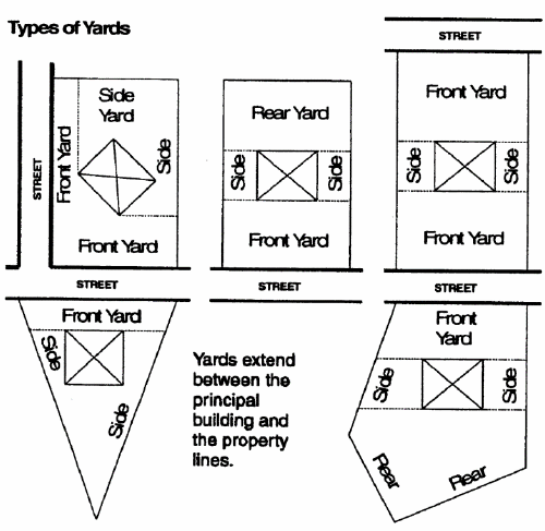
Yard: An area that lies between the principal building on a lot and the nearest lot line.
(1)
Front yard: A yard situated along any public street right-of-way or private street easement.
(2)
Rear yard: A yard situated along a rear lot line.
(3)
Side yard: A yard situated along a side lot line, but not extending into a front or rear yard.
Yard sale: An infrequent event lasting no more than three calendar days conducted on residentially zoned or used property where used or previously purchased household goods and personal items are offered for sale to the general public by the owner or tenant of the property or by a group of owners or tenants. Pursuant to the definition of commercial above, yard sales will amount to a commercial use of property if conducted more than three times in any consecutive 12 month period. A yard sale lasting over the course of a maximum of three consecutive calendar days shall constitute a single yard sale event for purposes of calculating the number of yard sales that occur in any consecutive 12-month period.
Zoning buffer: An area of natural vegetation or man-made construction, which is intended to provide a visual and dimensional separation between dissimilar land use.
Figure 1.10 - Buffers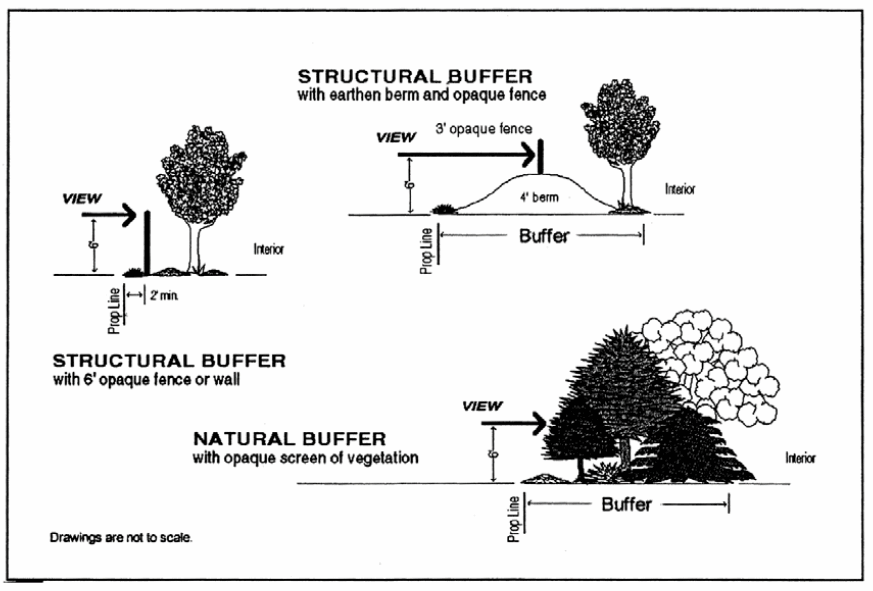
(1)
Natural zoning buffer: A visual screen created by vegetation of such density so as to present an opaque visual separation when viewed from one side to the other throughout the year.
(2)
Structural buffer: A visual screen created through construction of a solid wooden fence, decorative masonry wall, earthen berm, or combination of fence or wall with an earthen berm, which may be supplemented with vegetation, so as to present an opaque visual separation when viewed from one side to the other throughout the year.
Zoning change: An amendment to the zoning map (rezoning), approval of a special use, or approval of a change in the conditions of approval associated with a rezoning or special use.
(Ord. of 10-13-2020; Ord. of 3-8-2022; Ord. of 6-14-2022, § 1; Ord. of 6-14-2022, § 1; Ord. of 9-20-2022, § 1(Exh. A))