
Bethlehem City Zoning Code
ARTICLE XV
DESTINATION 211 DISTRICT
Sec. 89-1501. - Purpose statement.
(a)
This ordinance is intended to create opportunities for employment and large-scale commercial uses that are compatible with the county's growing tourism industry in a manner consistent with the growth strategy described for the Destination 211 Area described in the Barrow County Comprehensive Plan adopted in 2023 and as said plan may be amended in the future. Specifically, this district is intended to:
(1)
Create an opportunity rich and thriving planned, mixed-use community which is home to leading businesses and institutions, retail establishments, and a world-class entertainment district.
(2)
Allow residential developments on a limited basis, as necessary to support the non-residential uses desired in this district.
(3)
Attract employment opportunities that provide residents with high paying wages.
(4)
Encourage walking, bicycling, and other transportation alternatives to automobiles.
(5)
Conserve environmentally significant areas, ecologically sensitive areas, natural resources, watersheds, riparian corridors, and scenic vistas for the enjoyment of future generations.
(6)
Discourage the clear cutting of trees and enhance protection of existing tree sheds and sensitive habitats during the construction process.
(7)
Provide the opportunity for early communication and collaboration between Barrow County and developers and builders to support innovative site design and architecture.
(Ord. of 5-30-2025, § 1.1)
Sec. 89-1502. - Ordinance title.
This ordinance is titled the "Destination 211 Overlay" cited herein as "this ordinance."
(Ord. of 5-30-2025, § 1.2)
Sec. 89-1503. - Property affected by D211 ordinance.
(a)
This ordinance shall apply to all properties in unincorporated Barrow County located within the limits of the Destination 211 Overlay ("D211") as presented on the Official Zoning Map of Barrow County as ("D211").
(b)
The general boundaries of the Destination 211 District shall include:
(1)
Properties abutting that portion of Highway 124, bounded by Savannah Oaks Subdivision to the west, Interstate 85 to the north, and the jurisdictional limits of the City of Braselton to the east;
(2)
Properties abutting that portion of Old Victron Road running 817 feet south from the point of intersection of Old Victron Road and Highway 124;
(3)
Properties abutting Beaver Dam Road, Castle Gibson Road, Covered Bridge Road, Charlie Hall Road, Freeman Johnson Road, Highway 211 NW, Lee Stone Road, Old Hog Mountain Road, and Old Thomson Mill Road, as bounded by the established subdivisions of Claret Village, Happy Trails, Cruce Lake, Spring Lakes, and Lexington Ridge to the west, the jurisdictional limits of Barrow County to the east, Highway 124 to the north, and the Little Mulberry River to the south.
(c)
In the event of conflict between the description of the district boundaries as described subsection (b) of this section and the Official Zoning Map of Barrow County, the official zoning map shall govern.
(Ord. of 5-30-2025, § 1.3)
Sec. 89-1504. - Overlay relationship to base zoning districts.
In addition to the development requirements of this article XV, Destination 211 District, properties within the D211 Overlay District shall also comply with the development requirements of the base zoning district designated on the Official Zoning Map of Barrow County, except lot size.
(Ord. of 5-30-2025, § 1.4)
Sec. 89-1505. - Ordinance enforcement and appeals.
(a)
The planning and community development director and their designee shall have the duty and authority to implement the D211 Ordinance.
(b)
Appeal of final decisions or interpretations made by the planning and community development director or their designee for properties in the D211 District shall be heard directly by the board of commissioners.
(c)
An appeal shall be sustained only upon finding by the board of commissioners that the decision or interpretation being appealed was based on an erroneous finding of material fact or that action was taken in an arbitrary manner.
(d)
An appeal petition shall follow the process established by article XIII, Appeals, section 89-1393, Appeals of an administrative decision.
(Ord. of 5-30-2025, § 1.5)
Sec. 89-1506. - Ordinance organization.
(a)
Text amendments or other directives issued by the planning and community development director or designee are to be: (1) kept in written or digital form; and (2) available to each employee.
(b)
[The] ordinance [from which this article is derived] is subdivided in the following manner below:
(1)
"Article 15" Article by article numbers.
(2)
"1.1" Section by section numbers.
(3)
"A." Subsections by capital letters.
(4)
"1" Items by numbers.
(5)
"a." Sub-items by small letters.
(6)
"i." Points by small roman numerals (i., ii., iii., etc.).
(Ord. of 5-30-2025, § 1.6)
Sec. 89-1507. - Ordinance definitions.
(a)
In order to simplify the terminology used throughout this ordinance, some of the most often used words are defined below:
Administrative decision: Any decision made by the planning and community development director or their designee.
Administrative waiver: A modification made in the application of a specific regulation of this ordinance to a particular property or development, providing that the modification differs by 25 percent or less from a specific regulation.
Automobile: Any motorized vehicle designed and used for the transportation of people or goods. This term includes motorcycles, boats, buses, recreational vehicles, and tractor-trailers, but excludes e-bikes, scooters, motorized wheelchairs, canoes and kayaks.
Basal area: Basal area is the cross-sectional area of its trunk four and one-half feet above ground and reflects the tree's biomass, which includes its roots, trunk and canopy, and reflects its ecological value for soils, hydrology, microclimate, and diversity.
County: Barrow County, Georgia.
Department: The planning and community development department.
Directive: All laws, rules, regulations, general special orders, written or verbal orders given by a Barrow County Planning and Community Development Director ("PCD").
Fleet: A grouping of two or more automobiles or transportation vehicles under single ownership. For the purposes of this ordinance, fleets shall also include any trailers, hitches, or similar vehicular attachments which are commonly used for the purposes of hauling, storage, or transport of tools, equipment, or merchandise used for a profit-generating purpose.
Outdoor storage: The keeping or placement of any automobile, furnishings, seating, object, merchandise, potted plantings, portable signage, or structure outside of the principal building on the lot for three hours or longer.
Property: All attributes, parcels, lands, buildings, structures, infrastructure, trees, plantings, or rights of way under the ownership, possession or use of a person or entity.
(b)
Open space types.
(1)
Park. An open space available for structured or unstructured recreation. A park may be independent of surrounding buildings at its edges. Its landscape may consist of paths and trails, meadows and lawns, water bodies, runoff reduction measures such as bioretention areas, swales, cisterns, and woodlands. Recreation fields and courts may also be included. The minimum size for a park is one acre.
(2)
Square. An open space available for unstructured recreation and civic purposes. A square is spatially defined by building or streets at its edges. Its landscape must consist of paths and trees, and may also include runoff reduction measures such as bioretention areas and cisterns, lawns and non-asphalt paved surfaces. The minimum size for a square is one-half acre.
(3)
Plaza. An open space, available for civic purposes and commercial activities. A plaza must be spatially defined by building or streets at its edges. Its landscape must consist primarily of non-asphalt paved surfaces and trees, and may include runoff reduction measures such as bioretention areas and cisterns. The minimum size for a plaza is one-quarter acre.
(4)
Pocket park. An open space, available for unstructured recreation. A pocket park may be spatially defined by buildings or streets at its edges. Its landscape must consist of lawn and trees, and may include runoff reduction measures such as bioretention areas and cisterns. There is no minimum size for pockets parks.
(5)
Playground. An open space designed and equipped for the recreation of children. A playground must be fenced and may include an open shelter. Playgrounds must be interspersed within residential areas, may be placed within a block, and may be included in parks and greens. There is no minimum size for playgrounds. Playgrounds may include runoff reduction measures such as bioretention and underground detention.
(6)
Multi-use trails with potential connections to off-site trails. A linear open space consisting of a conforming multi-use trail that includes a connection to existing or proposed off-site trails. There is no minimum size for this type of open space.
(7)
Park overlooks. An open space primarily intended for the viewing of parks and other open spaces. Park overlooks must include seating. There is no minimum size for park overlooks.
(c)
Conventions.
(1)
Tense. The present tense will include the past and future.
(2)
Mandatory and permissive. "Shall" and "will" are mandatory; "may," "should," and "could" are permissive.
(3)
Right-of-way. Refers to all rights-of-way or access easements in the district, including those under public ownership and those under private ownership.
(Ord. of 5-30-2025, § 1.7)
Sec. 89-1508. - Ordinance severability.
(a)
Conflicts with state and federal ordinances. If the provisions of this ordinance are inconsistent with those of the state or federal government, the more restrictive provision shall govern to the extent allowed by law.
(b)
Conflicts with Barrow Ordinances. These regulations are not intended to annul, repeal, impair, or interfere with the existing provisions of other Barrow County Land Development Ordinances or Regulations, unless otherwise specified.
(1)
In the event of conflict between this ordinance and other Barrow County Land Development Ordinances and Regulations, the requirements of this ordinance shall apply.
(2)
In the event of conflict between this ordinance and conditions of approval set upon the property by the board of commissioners as part of their authorization of any special use permits, rezonings, or variance petitions, the requirements of the conditions of approval shall apply.
(3)
The interpretation and enforcement of this ordinance shall not be affected by deed restrictions, covenants, or easements.
(Ord. of 5-30-2025, § 1.8)
Sec. 89-1509. - Responsible for procuring external governmental permits.
It shall be the responsibility of property owners to determine and comply with all applicable land development, environmental, or land use requirements in effect upon the subject property that may be set by external state or governmental agencies (e.g., Georgia Department of Transportation, Georgia Department of Natural Resources, etc.). The issuance of any permit, certificate or authorization from Barrow County does not relieve the applicant from obtaining any applicable approvals said external state or governmental agencies.
(Ord. of 5-30-2025, § 1.9)
Sec. 89-1510. - District wide land use controls.
(a)
Property in the D211 District may be used for any use authorized by the base zoning district, subject to the following land area controls and as adjusted for compliance with section 89-1511, Land uses:
(1)
Base zoning districts classified low-density single-family residential (R1) or medium-density single-family residential (R2) shall be limited to maximum 25 percent of gross acreage available in the D211 District.
(2)
Base zoning districts classified light industrial (M1) or heavy industrial (M2) shall be prohibited in the D211 District. Further, all industrial uses shall be prohibited in this district, except for those classified as "Research and Development Facilities" uses as defined and authorized by section 89-1511, Land uses.
(3)
The gross acreage maximums established in this section shall not include any developments existing, under construction, or lawfully authorized as of the effective date of this ordinance.
(4)
Evidence that a development has been lawfully authorized may include an unexpired and lawfully issued land disturbance permit, building permit, special use permit, letter of rezoning approval, or final plat stamped by the Barrow County Planning and Community Development Director.
(b)
The uses listed in section 89-1511(b), Permitted uses and in section 89-1511(c), Special uses, may be lawfully authorized in the D211 District upon properties with a base zoning classification of AG, AR, O-I, C-1, C-2, C3, M1 or M2, whether or not said land use is an authorized use in the base zoning district.
(Ord. of 5-30-2025, § 2.1)
Sec. 89-1511. - Land uses.
(a)
Prohibited uses.
(1)
Automobile body shop. Automobile body shops are prohibited in the D211 District. An automobile body shop is a facility which provides collision repair services, including body frame straightening, replacement of damaged parts, and painting. Automobile body shops are also known as automobile repair establishments.
(2)
Automobile dealership. Automobile dealerships and their common secondary supporting uses are prohibited in the D211 District. An automobile dealership is a business establishment or use of any portion of land for the purpose of auctioning, selling, renting, leasing or financing new or used automobiles. Common secondary supporting uses of automobile dealerships include automobile sales offices, maintenance areas, repair and service areas, part storage areas, vehicle storage areas, and financial service areas.
(3)
Automobile detailing shop. Automobile detailing shops are prohibited in the D211 District. An automobile detailing shop provides automobile related services such as applying paint protectors, interior and exterior cleaning and polishing as well as installation of aftermarket accessories such as tinting, auto alarms, sound systems, spoilers, sunroofs, headlight covers, vinyl car wrapping and similar items.
(4)
Automobile gas stations. Automobile gas stations are prohibited in the D211 District. A gas station is any lot or parcel of land or portion thereof used partly or entirely for storing or dispensing flammable liquids, combustible liquids, liquified flammable gas, or flammable gas into the fuel tanks of motor vehicles.
(5)
Automobile impound facility. Automobile impound facilities are prohibited in the D211 District. An automobile impound facility provides outdoor storage for mechanically operable vehicles that are to be claimed by titleholders or their agents, or wrecked vehicles that are awaiting transport to a repair shop following a period of insurance adjustment. Vehicles do not remain on premises for longer than 45 days.
(6)
Automobile leasing or rental. Automobile leasing facilities are prohibited in the D211 District. An automobile leasing facility provides offices, parking areas, and servicing areas for automobiles marketed for lease or for rent.
(7)
Automobile parts or supply retail. Automobile parts or supply retail are prohibited in the D211 District. An automobile parts or supply retail uses are stand-alone stores that sell new or used automobile parts, tires, batteries, or similar accessories. They may also offer services such as minor parts installation.
(8)
Automobile repair establishments. Automobile repair establishments are prohibited in the D211 District. An automobile repair service establishment consists of any building, land, or structure used for the repair and maintenance of automobiles including but not limited to body, fender, muffler, or upholstery work and oil change and lubrication, painting, tire services, but not dismantling or salvage work.
(9)
Automobile wrecking yard. Automobile wrecking yards are prohibited in the D211 District. An automobile wrecking yard consists of any land, buildings, or structures used for the dismantling or wrecking of used motor vehicles or trailers, or the storage, sale, or dumping of dismantled or wrecked vehicles and their parts.
(10)
Car wash. Car wash uses are prohibited in the D211 District. Car wash is the use of a site for the washing, cleaning, drying, or waxing of passenger vehicles, recreational vehicles, commercial fleets or other vehicular equipment. This includes car wash services which are performed in exchange for money either by hand or by mechanical facilities. For the purposes of this ordinance use of car washes refer to either principal or accessory uses on a property.
(11)
Cemetery. New cemeteries are prohibited in the D211 District, but cemeteries existing prior to the adoption of this ordinance may continue to expand or intern human or animal remains. Nothing in this ordinance shall be interpreted to render cemeteries existing in this district prior to the adoption of this ordinance as non-conforming uses. Cemeteries are places, lands, or structures used for interment of human or animal remains or cremated remains, including a burial park for earth interments, a mausoleum for vault or crypt internments, a columbarium for cinerary internments, or a combination thereof.
(12)
Data centers. Data centers are prohibited in the D211 District. Data centers are indoor facilities that organizations use to house their critical software applications and data. It contains high-performance servers, storage systems, networking equipment, and other technological infrastructure. Data centers support large-scale operations, cloud computing, and content delivery.
(13)
Manufactured home park. New manufactured home parks are prohibited in the D211 District, however, manufactured home parks in existence as of the date of this ordinance are permitted as nonconforming uses. Manufactured home parks are contiguous parcels of land which have been developed for the placement of occupied manufactured homes.
a.
Manufactured homes in existing manufactured home parks may be replaced with newer or different models.
b.
Existing manufactured home parks shall not be permitted to expand beyond the land area occupied at the time of the adoption of this ordinance.
(14)
Motels. Motels are not permitted in the D211 District. A motel is a building which is used, rented, or hired for sleeping purposes by transient guests with access to units primarily from unit doors directly accessed from the exterior of the building.
(15)
Self-storage. Self-storage facilities and their common secondary uses are prohibited in the D211 District. Self-storage facilities are enclosed facilities containing independent, fully enclosed bays or units that are leased to individuals exclusively for the long-term storage of their goods or personal property. Self-storage facilities may be climatized or unacclimatized. Common secondary uses of property include leasing offices, automobile storage areas, and areas for dedicated mover vans or accessory trailers.
(16)
Warehousing. Warehouses are prohibited in the D211 District. Warehouses are facilities characterized by frequent heavy trucking activity, open storage of materials, or nuisances such as dust, noise, and odors. This use is engaged in the storage, wholesale, and distribution of manufactured products, supplies, and equipment. This use is not generally open to the public.
(b)
Permitted uses.
(1)
Beer gardens. Beer gardens are permitted in the D211 District. A beer garden is a permanent establishment which includes any area out-of-doors and not completely contained within a building in which alcoholic beverages and food are served. Beer gardens shall comply with the Barrow County Alcohol Ordinance.
(2)
Hotels. Hotel uses are permitted within the D211 District. A hotel is a building containing ten or more guest rooms, which are used, rented, or hired for sleeping purposes by transient guests and with access to units primarily from lobbies with gross floor areas of at least 500 square feet located within the building.
(3)
Mixed-use structures. Mixed-use structures are permitted in the D211 District. Mixed-use structures are buildings which residential dwellings on the upper stories and a contain a blend of two or more institutional, civic, office, commercial, or retail uses on the lower stories. For flat-roofed structures, parapets are required and said parapets must wrap around (i.e., enclose) the entirety of the roofline. The structures below are graphical representations. All buildings are subject to architectural standards found in section 15.4 and other applicable references.
Mixed-Use Commercial Structure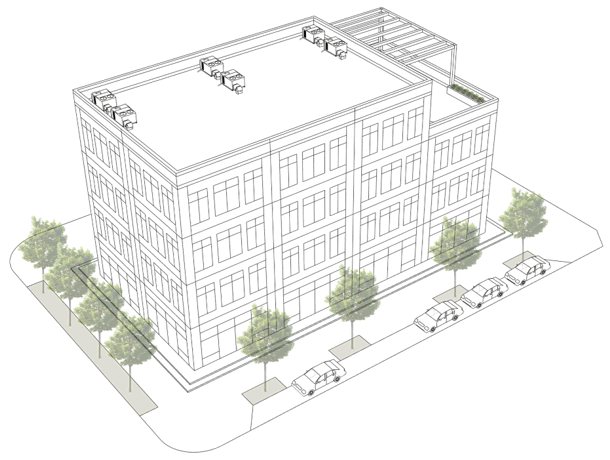
Mixed-Use Residential Structure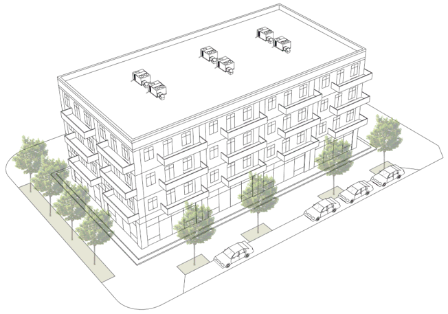
(4)
Parking decks. Parking decks are permitted in the D211 District. Parking decks are permanent multi-story structures consisting of parking spaces and adjacent access drives, aisles, and ramps used for the temporary storage of cars, motorcycles, and bicycles. Parking decks may have enclosed storage areas for dumpsters and recycling bins, mail or delivery package drop-off areas, or passenger pick up areas for on-call transportation services such as rideshares or taxis.
Parking Decks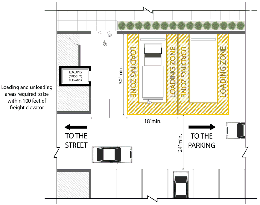
a.
Parking decks attached to condos, apartments, or mixed-use buildings with a residential component shall be designed to provide a dedicated loading and unloading area, properly marked through the use of paint and signage, that may be used by residents to load and unload furnishings for their unit.
1.
To accommodate mover vans sized up to 15 feet in length, the loading area shall provide minimum overhead clearance of 14 feet, accommodate a gross vehicle weight of at least 15,000 pounds, and provide parking area for the mover vans that measures at least 30 feet in depth and 18 feet in width.
2.
No portion of the dedicated loading/unloading area may encroach into drive aisles or abutting parking spaces intended for passenger vehicles.
(5)
Dedicated loading elevators shall be located within 100 feet of the designated loading area to provide access to the residential units.
(c)
Special uses. For all special uses listed below shall be subject to review and approval by board of commissioners. Applicants are advised that a detailed narrative describing the use, traffic study, conceptual master plan, and architectural renderings prepared by traffic engineers, civil engineers, and architects licensed to practice in the State of Georgia may be requested at the time that the special use permit application is submitted to the planning and community development department for review. Applicants are also advised that the vote cast by the board of commissioners is not the end of the permitting process for these uses, and that it is the applicant's responsibility to ensure all land disturbance permits, building permits, environmental permits, and business licenses are obtained and required inspections passed prior to the property or buildings being opened for public use.
(1)
Amphitheater. Amphitheater uses are permitted as special uses in the D211 District. An amphitheater is a large open, partially enclosed, or fully enclosed stage or facility used for major sporting events, shows, or concerts and where the stage is partly or completely surrounded by tiers of seats for spectators.
a.
Development sites that abut property zoned low-density single-family residential R-1 or medium-density residential R-2 may not be used for amphitheaters.
b.
Development sites for amphitheaters shall be at least 25 acres in size.
(2)
Event venues. Event venues are permitted as special uses within the D211 District on properties with a base zoning district of AG, C2, and C3. Event venues are indoor facilities for corporate events, conferences, seminars, fundraisers, weddings, holiday parties, and the presentation of performing arts such as live plays, live concerts, or movies. Event venues may include restaurants as an accessory use. Event venues do not include adult motion picture theaters or establishments featuring burlesque.
a.
Development sites that abut property zoned low-density single-family residential R-1 or medium-density residential R-2 may not be used for event venues.
b.
Development sites for event venues shall be at least three acres in size.
(3)
Mixed-use villages. Mixed-use villages are permitted as special uses in the D211 District. Mixed-use villages are primarily residential in character and include at least two different housing structure types and non-residential building(s) that may be accessed by the general public. Non-residential buildings shall be occupied by complementary non-residential uses listed herein.
Mixed-Use Villages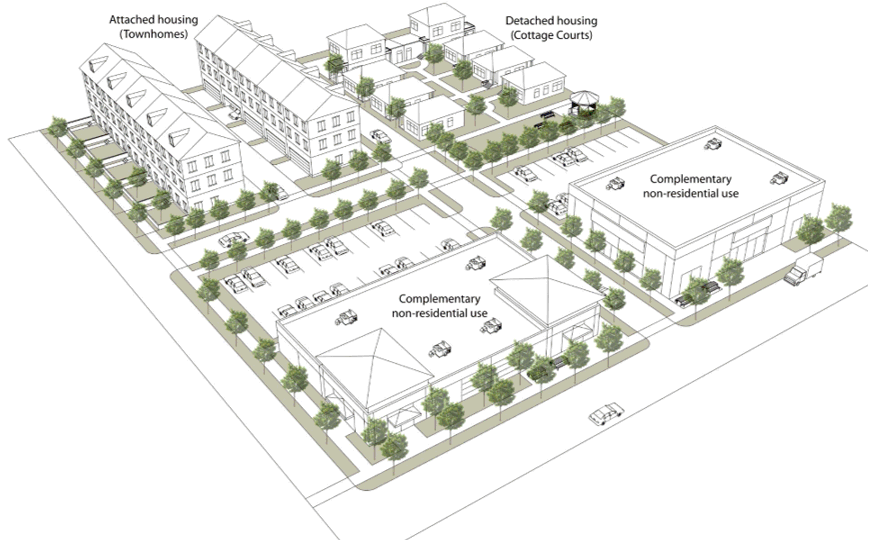
a.
This special use is limited to properties zoned AG, AR, or R3.
b.
Mixed-use villages shall be limited to no more than eight dwelling units per acre. In the event that the proposed development site abuts a parcel whose base zoning district has a density lower than eight units per acre, the board of commissioners may require a lower residential density on the development site.
c.
Mixed-use villages shall provide at least two different types of housing products. For clarification, use of the phrase "different types of housing products" does not refer to differences in exterior aesthetics or floor plans, but instead refers to distinct structural types (i.e., attached housing, detached housing, etc.).
d.
Non-residential uses that are complementary to and compatible with orderly operation of the residential component of the project are required as part of the mixed-use village development.
1.
Complementary non-residential uses shall make up at least 20 percent, but no more than 40 percent of the total land area set aside for the mixed-use village.
2.
Complementary non-residential uses include bakeries, coffee shops, cafes, shops, offices, spas, hair salons, fitness studios, grocery stores and similar uses which strengthen the formation of 3 rd places in the proposed neighborhood.
3.
Buildings designed to house complementary non-residential uses shall not be more than two stories taller than the tallest residential components proposed on the site.
4.
Buildings designed to house complementary non-residential uses shall meet the storefront treatment standards.
5.
Buildings designed to house complementary non-residential uses shall be used to screen any residential dwellings from the view of Highway 211, Covered Bridge Road, and Old Hog Mountain Road.
6.
No sureties may be released for any component of the mixed-use village project until the non-residential buildings have passed all inspections and are in receipt of their certificate of occupancy. Property owners shall renew any applicable sureties if said sureties are set to expire before the certificate of occupancy are issued.
(4)
Places of worship. A church, synagogue, mosque or other place of worship or religious assembly with related facilities such as the following in any combination: Rectory or convent, private school, meeting hall, offices for administration of the religious institution, licensed child or adult daycare, playground, cemetery.
a.
Development sites that abut property zoned low-density single-family residential R-1 or medium-density residential R-2 may not be used for places of worship.
b.
Development sites for places of worship shall be at least three acres in size.
(5)
Research and development facility. Research and development facilities are permitted as special use in the D211 District. Research and development facilities are establishments that are engaged in research and development, testing, assembly, repair, and manufacturing in the following industries: Biotechnology, pharmaceuticals, medical instrumentation or supplies, communications and information technology, electronics and instrumentation, and computer hardware and software. Office, warehousing, wholesaling, and distribution of the finished products produced at the site are allowed as part of this use.
(6)
Retail warehouse. Retail warehouses are permitted as a special use in the D211 District. A retail warehouse facility is an off-price or wholesale retail/warehouse establishment exceeding 70,000 square feet of gross floor area and offering a full range of general merchandise to the public.
(7)
Suburban residential developments. Suburban residential developments are special uses in the D211 District. Suburban residential developments are stand-alone homes or housing developments that provide one type of housing structure (e.g., attached, detached, garden apartment, etc.) and lack non-residential buildings that may be accessed by the general public who is not a guest or resident of the development. When provided as part of a traditional housing development, private amenities (e.g., clubhouses, pools, tot lots, dog parks, walking trails etc.) are typically reserved for homeowners, tenants and guests.
a.
This special use is eligible only to properties with a base zoning district of R1, R2, or R3.
b.
New suburban residential developments which require direct access to Highway 211, Covered Bridge Road, and Old Hog Mountain Road shall not be eligible for a special use permit.
c.
No portion of any unit or the development may be visible from Highway 211, Covered Bridge Road, and Old Hog Mountain Road. To screen these units from view of these roadways, there shall be a minimum 20-foot wide undisturbed or replanted vegetative buffer required along the full length of frontage abutting these roadways.
(Ord. of 5-30-2025, § 2.2)
Sec. 89-1512. - Outdoor storage.
(a)
Outdoor storage within this district shall be subject to administrative review. The planning and community development director shall have discretion to determine any controls, time constraints, screening or placement requirements for any outdoor storage needs, in accordance with the minimum criteria below:
(1)
Outdoor storage shall be limited to only those principal uses (i.e., businesses) with a valid and unexpired business license that are located on the same lot as the proposed outdoor storage area.
(2)
Outdoor storage areas must be well-maintained, orderly, and clean. Areas shall be kept free of trash, litter, broken furnishings, malfunctioning or inoperable equipment or appliances, oil or chemical runoff, or any hazardous materials. Failure to comply with this requirement may result in the revocation of the outdoor storage permit, business license, or any applicable liquor licenses.
(3)
Outdoor displays, including lighting, erected on a seasonal basis in recognition or celebration of religious, national, state, or Barrow County holidays, which are not intended to be permanent in nature and which contain no commercial advertising material, shall be allowed as a temporary use in the D211 District, subject to the following limitations:
a.
Outdoor holiday decorations shall be displayed for a period of not more than 60 consecutive days nor more than 60 days in a calendar year.
b.
Outdoor holiday decorations may be of any type; number; area; height; or location but decorations shall not be placed in any location that obstructs pedestrian passage around the storage area or that obstructs the vision of vehicular drivers.
c.
Outdoor holiday decorations may include decorative illumination so long as the lighting does not create lighting hotspots that blind motorists on adjacent public rights-of-way after dusk.
(4)
ADA parking spaces, fire truck turnarounds, and designated unloading areas are prohibited from being used as outdoor storage areas.
(5)
Retail, restaurant, and stand-alone offices shall be allowed to have outdoor storage areas directly adjacent to the principal building, subject to compliance with the standards of this subjection. Said outdoor storage areas may encroach up to one-half of the available sidewalk or supplemental zone area width directly abutting the building only if:
a.
The sidewalk or supplemental zone area offers sufficient clearance width for a standard wheelchair to comfortably navigate around the outdoor storage area or at least six feet, whichever is greater.
b.
If a standard wheelchair cannot navigate around the storage area without getting closer than three feet to the edge of curb or pavement, outdoor storage shall not be permitted.
c.
Standard wheelchair consists of 42 inches, a height of 36 inches, and a width of 25 inches.
(6)
Fleets of automobiles or other vehicles shall be limited to no more than four vehicles per business.
a.
Each vehicle shall be of a size that can be comfortably accommodated in a typical parking space on site (i.e., nine feet wide by 18 feet long) without any portion of said vehicle overhanging into adjacent parking spaces or drive aisles.
b.
Vehicles that need to occupy more than one parking space at a time shall be prohibited.
c.
Each parking space used for a fleet vehicle shall have signage installed which limits use of the assigned space to the associated principal business and vehicles shall be maintained only in their authorized spaces.
d.
Outdoor storage of vehicles commonly associated with heavy industrial uses or recreation, including buses exceeding 25 feet in length, boats, RVs, tractor trailers, or freight shall not be permitted in this district.
e.
Screening where required can be met by decorative masonry walls up to eight feet in height, vegetative buffers comprised of evergreen shrubs or existing tree sheds measuring at least 20 feet in width, or liner buildings.
f.
Except for those outdoor storage areas associated with office, retail, or restaurants, no outdoor storage shall be visible from Highway 211.
(Ord. of 5-30-2025, § 2.4)
Sec. 89-1513. - Minimum site area.
(a)
Development sites for projects shall consist of at least eight acres of land area, unless another minimum area is authorized for the use per this ordinance.
(b)
Internal lot sizes within development sites shall be in accordance with the conceptual masterplan reviewed and approved Barrow County.
(Ord. of 5-30-2025, § 3.1)
Sec. 89-1514. - Maximum block sizes.
(a)
Development sites shall incorporate existing or new streets that terminate at other existing or new streets to form an interconnected network with a maximum block size of 1,500 feet.
(b)
In addition to the maximum block size, blocks exclusively containing only detached or attached dwellings shall be wide enough to provide two tiers of lots.
(c)
Applicants may petition the planning and community development director for administrative relief to modify the block perimeter or lot tiering requirements when environmental conditions would make provision of a complete block not feasible. Such conditions could include presence of steep slopes exceeding 15 percent grade, tree protection areas, stream buffers, or easements.
(Ord. of 5-30-2025, § 3.2)
Sec. 89-1515. - Sewer is required.
New non-residential and mixed-use developments located within one mile of an established sewer line shall be required to use a sewer system not septic.
(Ord. of 5-30-2025, § 3.3)
Sec. 89-1516. - Underground utilities are required.
All new utility lines and extensions shall be buried underground.
(Ord. of 5-30-2025, § 3.4)
Sec. 89-1517. - Tree removal and replacement plan is required.
(a)
New developments shall provide at least 30 percent of tree canopy coverage.
(b)
To achieve the 30 percent tree canopy coverage, developers should prioritize the protection and preservation of existing tree sheds over replanting, as is feasible.
(c)
Trees removed from the property and trees to be replanted after construction is finalized shall be shown on the tree removal and replacement plan.
(d)
The tree removal and replacement plan shall include a planting schedule that lists the tree species, quantity, caliper size at planting, whether the tree is an understory or overstory selection, and whether the tree is deciduous or an evergreen.
(e)
Tree replacement shall be in accordance with the D211 Tree Replacement Chart below:
D211 Tree Replacement Chart
(f)
Ornamental shrubbery or flowering plants are encouraged but shall not be credited towards the 30 percent canopy.
(g)
The tree removal and replacement plan shall be prepared by a landscape architect or arborist licensed to practice in the State of Georgia.
(h)
The tree removal and replacement plan shall be submitted for review to Barrow County anytime a land disturbance permit is requested. Projects with an approved land disturbance permit issued prior to the effective date of this ordinance may proceed to building permits without the need to file a tree removal and replacement plan.
(i)
Tree removal and replacement plan approved and stamped by Barrow County shall be recorded as part of the final plat.
(j)
Tree species shall be limited to the species listed as native to the Barrow County area per the "Native Trees of Georgia" publication authored by G. Norman Bishop and printed in 2001 as published by the Georgia Forestry Commission.
(k)
Should space limitations or other environmental conditions prevent sufficient tree replanting to achieve the 30 percent lot minimum, a payment may be made to the Barrow County Tree Bank. Compensation for each removed tree shall be the tree market value for the same species and diameter removed. No tree shall cost less than $200.00.
(Ord. of 5-30-2025, § 3.5)
Sec. 89-1518. - Streetscape design and building orientation.
(a)
A substandard road is a road that does not meet the required standards or specifications for safety and traffic flow. Substandard roads may lack curbing, gutters, sidewalks, proper drainage, appropriate travel lane width, be in a general state of disrepair, and have asphalt cross sections which do not comply with current standards. The county engineer shall have the right to classify any road which is not safe for public use as a substandard roadway.
(b)
No new developments shall be permitted to use substandard roads. Roads serving new developments must be improved to current specifications before any land disturbance or building permits may be issued.
(c)
Highway 211 NE shall meet Type A Road Standards, and all other new roads shall meet Type B Road Standards as presented in the Streetscape Design Table and described in detail in the narrative of this section.
Type A Road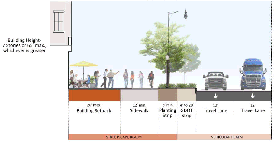
Type B Corridors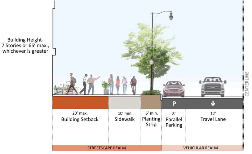
Planting Strip
Streetscape Design Table
(d)
Driveways. Driveways along Type A and Type B roadways must be at least 275 feet apart.
(e)
GDOT strip. The purpose of this streetscape element is to provide space for the future expansion of roadways managed by the Georgia Department of Transportation. The GDOT strip area shall continue along the full length of the new or improved street, continuous except for crossings for driveways and utilities. It shall be measured from the edge of the road pavement and its width shall consist of the entirety of existing GDOT right-of-way. Existing trees should be preserved in this area wherever possible. Where the GDOT strip passes through an open pasture area with no existing vegetation, the area may be seeded with a mixture of low growing (under 16 inches tall) wildflowers that area native or adapted to the area or grass.
(f)
Sidewalk. The sidewalk area shall continue along the full length of the new or improved street, continuous except for crossings for driveways and utilities. It shall be placed between the innermost edge of the GDOT strip and the planting strip. It shall conform to the following standards:
(1)
Sidewalk width shall comply with Streetscape Design Table.
(2)
Sidewalk cross slope shall not exceed three percent.
(3)
Sidewalks shall maintain an overhead clearance of at least eight feet. To preserve this clearance, the county shall have the right to require regular trimming or pruning of overhanging tree limbs.
(4)
Sidewalk width shall remain consistent along the full length of the block but may taper when crossing into new street classifications. Tapering shall occur at a new block crossing, street, or driveway.
(5)
Any sidewalk paving material including concrete, special or decorative paving shall continue across any intervening driveway.
(6)
Building features such as terraces, porches, stoops, and stairs may encroach into the sidewalk provided that there remains an unobstructed five-foot-wide portion of the sidewalk available for pedestrian access.
(g)
Planting strip. The planting strip shall continue along the full length of the new or improved street, continuous except for crossings for driveways or utilities. It shall be parallel and abut the full length of the innermost edge of sidewalk. It shall conform to the following standards:
(1)
The planting strip is reserved for the placement of street trees, streetlights, groundcover, utility poles, fire hydrants, traffic control boxes, waste receptacles or similar elements in a manner that does not obstruct pedestrian access or visibility.
(2)
Streetlight poles and luminaires are required in the planting strip and shall be the model per the standard detail on file with the community development department.
(3)
Street trees are required in the planting zone. Street trees shall be planted no farther than 40 feet on the center and be spaced at an equal distance from required streetlights.
(4)
Street trees abutting parallel on-street parking spaces shall be aligned with the stripes of abutting parallel on-street spaces. Alternatively, if the abutting on-street spaces are angled rather than parallel, a curb stop shall be installed that ensure the car does not damage the tree trunk.
(5)
Each street tree in the planting zone shall have a minimum area suitable for root growth of 200 square feet or more and a suitable soil depth of three feet or more. To protect underground utility lines from tree roots, trees shall be planted at least three and one-half feet away from the back of curb, or if the road is not curbed from the edge of pavement, and durable root guards shall be installed at time of planting.
(6)
Each street tree shall be at minimum three-inch caliper at time of planting and selected from the overstories species list below. Understory trees may be used in place of overstory trees with approval from the planning and community development director, when needed to accommodate overhead utilities or vehicular visibility.
(7)
The property owner shall be responsible for replacing any required plantings that die or become diseased, damaged, or otherwise fail to thrive, in order to maintain compliance with the approved plan.
(8)
In the event that the planting zone cannot be accommodated as a result of a condition outside of the control of the applicant, the planning and community development director is authorized to approved one of the alternative design options listed in this section, in order to provide alternative accommodation for the required street trees and streetlights:
(9)
Landscaped bulb-out option. Street tree requirements may be met by planting the required trees in landscaped bulb-outs installed between on-street parking spaces on roads where on-street parking is permitted.
Landscaped Bulb-Out Option (Parallel Parking)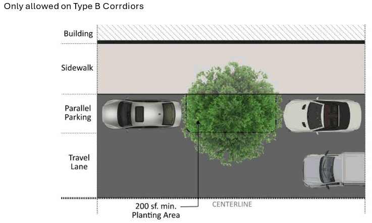
Landscaped Bulb-Out Option (Angled Parking)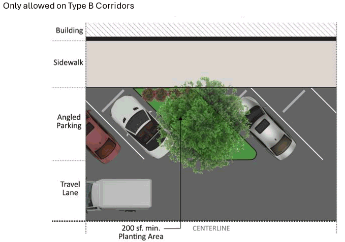
Landscaped Bulb-Out Option (Perpendicular Parking)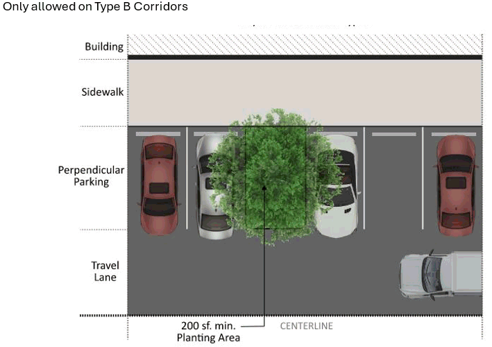
(10)
Sidewalk cut out option. Street tree requirements may be met by increasing sidewalk width to a minimum 15 feet along the full length of the streetscape and planting the required trees in sidewalk cut outs.
Sidewalk Cut Out Option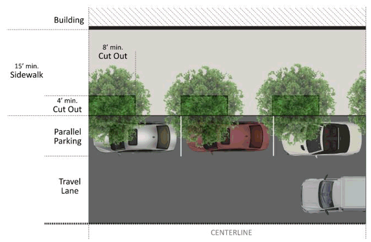
a.
Each sidewalk cut out shall offer a minimum area of 32 square feet.
b.
Each sidewalk cut out shall provide a minimum width of four feet and a minimum length of eight feet. The longer side shall run parallel to the street.
c.
Each sidewalk cut out shall be covered by mulch, gravel, ground cover or grass.
d.
Other cover types, including grates, shall require planning and community development director approval.
(Ord. of 5-30-2025, § 3.6)
Sec. 89-1519. - Alley standards.
(a)
New alleys and improvements to existing alleys shall be designed and constructed in accordance with the requirements of the Alley Standards Table.
(1)
It shall be unlawful to park any vehicle in any alley for a period of time longer than is necessary for the expeditious loading, unloading, pick-up, or delivery of materials from such vehicle.
(2)
It shall be unlawful to park a vehicle in such manner or under such conditions as to leave available less than ten feet of the width of the roadway for the free movement of vehicular traffic or to block entrance to any abutting property.
(3)
Alley right-of-way may not be dedicated to Barrow County. All alleys shall be privately maintained.
(4)
In no case shall any alley right-of-way portion included in the footprint of a residential lot.
(5)
Alleys shall not be used in place of any required road for a project.
(6)
Primary façades of principal buildings shall not face alley right-of-way.
(7)
Alley pavement width shall measure at least 16 feet but no more than 24 feet.
(8)
Gravel or packed dirt alleys are not permitted.
(9)
Residential buildings shall be a minimum of six feet from the edge of alley shoulder and non-residential buildings and vertical mixed-use buildings shall be a minimum of 20 feet from the edge of alley shoulder.
(10)
Alley shoulders shall have either mountable curb or a valley gutter.
(11)
Alley shoulders shall consist of either asphalt, minimum eight-inch-thick reinforced concrete, pervious pavers, or a blend of permeable asphalt and concrete. Reinforced turf may be permitted only where abutting residential dwellings.
(12)
If the alley is required to have fire department access, the fire marshall is authorized to require a minimum pavement width of up to 24 feet, specific corner radii, or mountable curbing or aprons capable of accommodating service vehicle weight.
Alley Standards Table
Alley #1: Residential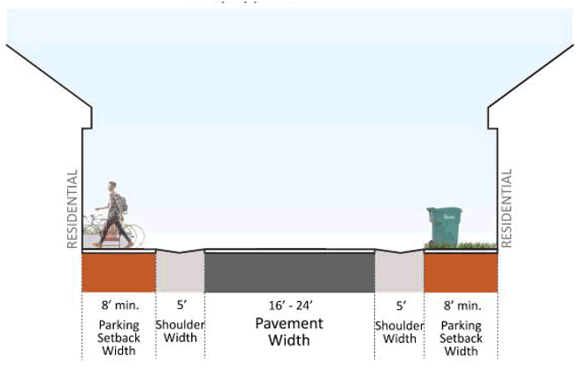
Alley #2: Mixed-Use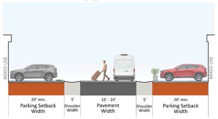
(Ord. of 5-30-2025, § 3.7)
Sec. 89-1520. - Inter-block and inter-parcel connectivity.
(a)
Midblock crossings/easements. In blocks of 500 feet or more, the planning and community development director may require the provision of a minimum ten-foot to maximum 20-foot-wide easement and construction of a minimum 65-foot-wide durable, all surface weather path through the block to accommodate utilities, drainage, or pedestrian-bicyclist mobility. Such paths shall be constructed with county standards and specifications.
(b)
Cross vehicle access. All lots shall comply with the following standards:
(1)
Internal vehicular circulation areas shall be designed and installed to allow for cross-access between abutting lots, depending upon the nature of the adjacent property.
(2)
Vehicle cross-access may not be gated.
(3)
When an abutting lot is vacant or already developed, a stub for a future cross-access connection shall be provided at the point where the connection to the abutting parcel is expected to occur in the future.
(4)
If a cross-access driveway stub exists on an abutting parcel, the internal vehicular circulation area shall connect to the stub to form a cross-access connection.
(5)
When cross-access for vehicles is deemed impractical by the county transportation engineer on the basis of topography, the presence of natural features, or vehicular safety factors, the requirement for cross-access may be waived. Bicycle and pedestrian connections shall be provided between abutting properties when cross-access is waived.
(6)
Property owners who establish cross-access easements shall:
a.
Allow pedestrian and vehicular access to all properties on the same block face as the property owner establishing the cross-access;
b.
Pedestrian and vehicular access is contingent upon the granting of reciprocal vehicular, bicycle, and pedestrian access rights to the granting property;
c.
Record an easement allowing cross-access to and from properties served by the cross-access easement;
d.
Record a joint maintenance agreement requiring each property owner to maintain the vehicular, bicycle, and pedestrian access areas on their lot;
e.
Contain a provision prohibiting the erection of fences, walls and other obstructions that prevent the use of vehicular, bicycle, and pedestrian access ways;
f.
Include a statement that the cross-access agreement is conveyed with the land, is binding on all successors, heirs and assigns and that the easement rights are perpetual; and
g.
The cross-access agreement shall be signed by all owners of the granting property.
(Ord. of 5-30-2025, § 3.8)
Sec. 89-1521. - Prohibited features.
(a)
No drive through facilities are permitted in the D211 District.
(b)
Unless contained in a mixed-use structure or unless shielded from the view of adjacent right of way through the use of commercial liner buildings, no new residential dwelling shall be permitted within 500 feet of Highway 211. Houses being constructed in communities substantially under development, in existence, or preauthorized prior to the effective date of this ordinance are exempt from this requirement.
(Ord. of 5-30-2025, § 4.1)
Sec. 89-1522. - Residential treatment.
(a)
New residential dwellings, except for mixed-use structures, shall be designed in one of the styles below. Architectural drawings shall include the specific elements of the required styles as outlined in the a "Field Guide to American Houses" by Virginia Savage McAlester.
(1)
FEDERAL (1800—1830) Many early structures were designed in the Federal style which was popular in the first part of the 19th century. The majority of Federal houses have two stories with gable roofs and is constructed of brick. Their façades always contain symmetrically placed openings. Windows have small panes and are often capped with a flat brick arch. The doorway may be contained in an arched opening and usually has a small classical portico with columns surrounding it. The cornice is also classically inspired and may contain modillion or dentil blocks.
(2)
GREEK REVIVAL (1830—1860) The Greek Revival style differs from Federal architecture in several ways: The roof is usually hipped instead of gable; the openings are wider and often have sidelights; and the lintels above the windows frequently have raised corner blocks. Porch supports are classic columns, round or fluted in design. Like the Federal style, the openings are always symmetrical and the entrance is usually centered within the façade.
(3)
ITALIANATE (1850—1880) The Italianate style also dates from the romantic Victorian era, and it can be identified by the large brackets under widely overhanging eaves and a shallow pitched roof. The windows are often arched or segmental in their design and may be capped with decorative hood molds. The structure usually consists of well-defined sections that are asymmetrically grouped, sometimes with a tower on the more elaborate examples.
(4)
QUEEN ANNE (1880—1910) The Queen Anne style was very popular during the Victorian era. It has many variations but is usually associated with a complex, irregularly shaped steep roof and a variety of surface materials such as shingles, wood siding, brick, and stone. Towers and turrets are often present as well as bay windows and large one-story front and side porches.
(5)
COLONIAL REVIVAL (1900—1930) The Colonial Revival style is based on the earlier Georgian, Federal, and Greek Revival periods. It has a rectangular plan and a symmetrical façade. The roof may be a gable or more often a hipped design. The details are always classical and porticoes over entrances are common. Like earlier periods, the windows have small panes, but their proportions are often more horizontal; and the first floor may contain paired or triple windows. Doorways can have various elements including sidelights, fanlights, pediments, and columns or pilasters.
(6)
FOLK VICTORIAN (1870—1920) This style of residential dwellings is also known as the Frame Vernacular style. Three variations of this style are: The "L" gable which reflects the shape of the floor plan and of the roof; the two-story gable roof form; and the pyramidal cottage with its hipped roof.
(b)
In addition to the specific architectural elements required by the "Field Guide to American Houses," residential dwellings shall meet the materials requirements below:
(1)
No more than three different exterior materials, exterior colors, or any combination thereof may be used on a single building, not including windows, doors, porches, balconies, foundations, and architectural details.
(2)
Materials may be combined on exterior walls only horizontally, with the heavier below the lighter.
Chamblee, GA, Building Exterior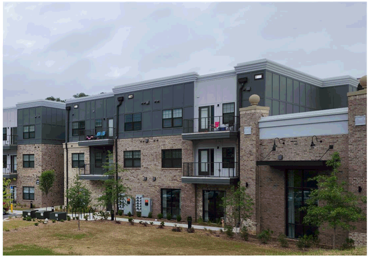
(3)
Exterior material shall be limited to brick, natural stone, clapboard, board and batten, hard-coat stucco, or wood shingles.
(4)
Vinyl or aluminum siding, and synthetic stone veneer are prohibited.
(5)
Stone, brick, and mortar color and style shall match building style.
(6)
Hard-coat stucco shall be a three-coat plaster finish, integral finish, applied on brick or concrete block; control joints shall be concealed where possible.
(7)
Clapboards and board and battens shall be wood or cementitious board. Hardi board shall have a four-inch maximum exposure, while Artisan series Hardi board or full three-quarter inch wood siding may have up to an eight-inch lap. False wood graining is prohibited.
(8)
Wood shingles shall be level at the bottom edge.
(9)
Homes with a built-in garage enclosed by the home or with a garage attached to the principal unit shall be required to be at least three stories tall.
(Ord. of 5-30-2025, § 4.2)
Sec. 89-1523. - Storefront treatment.
(a)
New non-residential principal buildings and vertical mixed-use structures shall be designed in accordance with the "storefront treatment" specifications below:
(1)
Storefront treatment is an architectural treatment that must be provided on the street façade of flat roofed buildings. Buildings with sloped roofs shall use residential treatment.
(2)
Primary frontages must be constructed at the required build to line.
(3)
Where there is required open space between the proposed building and streetscape, the build to line may extend around said open space perimeter.
(4)
The street-level façade (i.e., ground floor) of the building shall provide the following:
Street Level Facade Multi-Story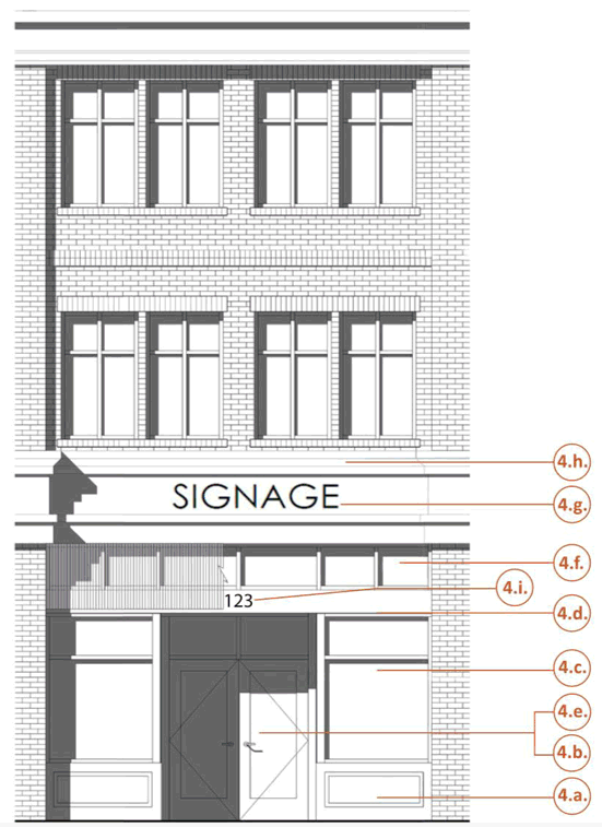
Street Level Facade One-Story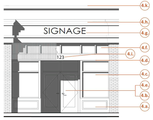
a.
A non-glass base or knee wall below all windows beginning at grade and extending to a point no less than eight inches but not more than 24 inches above the sidewalk area at the build-to line. Knee wall may be waived when directly abutting a private patio.
b.
A combination of glass display windows and doors covering a minimum of 75 percent of the area of the façade that is located along the build-to line at the ground floor of the building.
c.
Glass display windows shall be clear and provide visibility into the interior the building for minimum depth of two and one-half feet.
d.
Glass display windows shall be at least eight feet tall, as measured from the sidewalk.
e.
Primary pedestrian entrances on the street façade shall be recessed a maximum of seven feet from the exterior façade. All other doors located along street frontage shall be of a character that matches the surrounding downtown area.
f.
A glass transom measuring between 24 inches and 36 inches tall shall be installed above glass display windows and above the primary entrance door.
g.
A sign band area measuring at least 36 inches in height shall be installed above the glass transom and below the building's required cornice line.
h.
A cornice line measuring at least eight inches in height shall be installed above the sign band.
i.
Street address numbers measuring at least six inches in height shall be installed above or to the side of the primary pedestrian entrance.
j.
Finished ceiling height shall be a minimum of 18 feet on the ground floor.
k.
Exterior height of single-story buildings shall be a minimum of 18 feet as measured at top of parapet. Parapet must enclose all sides of the roof.
(Ord. of 5-30-2025, § 4.3)
Sec. 89-1524. - Civic spaces are required.
(a)
High-quality, pedestrian oriented, and publicly accessible gathering spaces are essential to advancing the vision for the D211 District outlined in the comprehensive plan. Refer to the definitions of this ordinance for descriptions of common civic spaces.
(b)
New developments shall provide a minimum of 20 percent civic space based on total lot area in accordance with standards below:
(1)
Civic space requirements shall be calculated multiplying the total lot area by the minimum civic space percentage.
(2)
Projects resulting in the construction of three or fewer residential dwelling units each upon a single lot (i.e., infill development) or whose calculated civic space minimum does not exceed 400 square feet are exempt from civic space requirements.
(3)
No portion of any detention facility or stream buffer may be credited towards satisfaction of the civic space minimum.
(4)
No portion of civic space may be placed within a required screening buffer or stream buffer, except for multi-use paths or trails.
(5)
The required civic space shall be provided on site.
(6)
No portion of the required streetscape may be credited towards civic space minimums, except for those portions of yards abutting residential treatment which are located wholly upon private lots.
(7)
Civic spaces must be constructed or dedicated as part of the first phase of construction, in an amount equivalent to the first phase proportion of the development.
(8)
Civic spaces shall maintain an overhead clearance of at least eight feet.
(9)
Civic spaces may be private or public.
a.
Private civic spaces are generally reserved for use by building tenants and owners and which may not necessarily be accessible to the public.
b.
Public civic spaces are open for use to the general public.
(c)
Permitted civic spaces include: Parks, squares, plazas, pocket parks, playgrounds, multi-use trails, park overlooks, roof top decks, patios, balconies, terraces, porches, pools, clubhouses, community gardens, pool areas, tennis courts, pickleball courts, pet care areas, dog parks, courtyards, walking paths, and bike facilities.
(1)
Decks, patios, balconies, terraces, and porches shall provide a minimum eight-foot depth and minimum five-foot width. The user must be able to exit their unit completely for the feature to eligible for credit.
(2)
Dog parks, courtyards, playgrounds, yards, plazas, and squares shall provide a minimum area of 400 square feet of horizontal contiguous space.
(3)
Courtyards and yards shall not be fenced or walled around more than 75 percent of the feature's perimeter. Walls or fences shorter than four feet are exempt from this standard.
a.
Public civic spaces shall abut and be directly accessible from the public sidewalk along the primary frontages.
b.
Features credited as civic spaces may not impede the pedestrian circulation around the building or in streetscape areas.
(d)
Each civic area must be approved for pedestrian use and aesthetic appeal, subject to the planning and community development director.
(Ord. of 5-30-2025, § 5.1)
Sec. 89-1525. - Outdoor lighting ordinance purposes.
The night sky has been a resource and part of the quality of life of Barrow County since the area was first settled. Over the years, however, the night sky has slowly diminished due to unnecessary light and glare for inappropriate lighting. This ordinance provides standards to prevent obtrusive and wasteful light pollution. Examples of light pollution include skyglow, light trespass and glare.
(Ord. of 5-30-2025, § 6.1)
Sec. 89-1526. - Definitions of top outdoor lighting pollution problems.
(a)
Glare: Overly bright and poorly aimed lights cause glare, which is the most safety-related aspect of light pollution. Many people assume that a bright light attached to an outside wall may deter criminal or unwanted activity. However, the brighter the lights the more difficult it is for the eye to adjust properly thus limiting the ability to detect possible intruders as quickly. Bright but unevenly distributed lighting often creates deep shadows which may hide unwanted activity. Shielded, evenly distributed lighting reduces glare, harsh brightness, and deep shadows. Reducing glare can provide a safer public environment.
(b)
Light trespass: Light trespass is light that is distributed onto areas where illumination is not wanted. Light intruding into neighboring homes and properties can keep people awake at night and destroy the sense of privacy. Effective, quality lighting includes amounts in the appropriate place and appropriate times of day.
(c)
Skyglow: Skyglow is the wasted light shining skyward and reflecting out into the atmosphere. It decreases the ability to see stars and other astronomical events. Full cut-off shields applied over light sources can direct light to where it is needed and reduces wasted up lights.
(d)
Wildlife disorientation: Lights attract and disorient animals. It can upset their biological patterns, affect their breeding cycles, and deter them from established foraging areas. Trees are also affected as artificial light may deter them from adjusting to seasonal variations. Light should only be directed where needed.
(Ord. of 5-30-2025, § 6.2)
Sec. 89-1527. - Outdoor lighting requirements.
(a)
To prevent the lighting problem pollutions described in section 89-1526 above, outdoor lighting in the D211 District shall be subject to this section. Any outdoor lighting used for the illumination of parking areas, landscaping, residences, buildings, recreational areas, or for any public or private purpose shall be arranged in a manner to meet the following conditions:
(1)
Lighting shall be fully shieled using full cut off fixtures and downlit. This shield must be opaque so that no light can pass through it.
(2)
Neither the direct nor reflected light from any light source may create a traffic hazard to operators of motor vehicles on public roads and no colored lights may be used in a way that could be confused or construed as traffic control devices.
(3)
No blinking, flashing, or fluttering lights or other illuminated device which has a change in light intensity, brightness, or color, and no lighting which exceeds 12 feet in height is permitted in any zoning district except for streetlights owned and maintained by Barrow County or temporary holiday displays, or as required by federal, state, or local regulations.
(4)
Please note that special use permits may condition properties to more restrictive requirements for outdoor lighting.
(5)
Outdoor lighting shall be limited to CFL or LED lighting sources.
(6)
Security lighting shall be directed towards the targeted area and shall not be placed at a distance greater than 20 feet above grade.
(Ord. of 5-30-2025, § 6.3)
Sec. 89-1528. - Outdoor lighting plans required.
(a)
Outdoor lighting plans shall be required upon application for a land disturbance permit, submittal of new development plans, or applies for a permit for construction or expansion of a building (collectively referred to as the "redevelopment activity"). The term "redevelopment activity" excludes permits for remodeling, for the construction of accessory buildings, and for expansion of a building, if such activity is for purposes consistent with the current use of the parcel.
(b)
Applicants for any permit for any non-single-family use proposing outdoor lighting shall submit evidence that the proposed work will comply with the outdoor lighting regulations of this section in accordance with the following:
(1)
Plans indicating the location on the premises of each outdoor illuminating device, both proposed and any already existing on the site.
(2)
Description of all proposed illuminating devices, fixtures, lamps, supports, reflectors. The description shall include, but is not limited to, catalog cuts, and illustrations by manufacturers.
(3)
Photometric data, such as that furnished by manufacturers or similar, showing the angle of cutoff of light emissions.
(4)
Photometric plans shall include the maximum and average light layout.
(5)
The submission shall show that the property does not exceed an illumination level of 0.5 footcandles where property lines abut a residential use or 1.5 footcandles where abutting any other use.
(6)
The submission shall also show that off-street parking lots comply with the following illumination requirements:
(Ord. of 5-30-2025, § 6.4)