
Biloxi City Zoning Code
ARTICLE 23
3: - ZONING DISTRICTS
(A) - Compliance With District Standards
No land within the city shall be developed except in accordance with the zoning district regulations of this article and all other regulations of this Ordinance, including but not limited to, Article 4: Use Regulations, Article 5: Intensity and Dimensional Standards, Article 6: Development Standards, and Article 7: Subdivision Standards.
(B) - Types of Zoning Districts
Land within the city is generally classified by this Ordinance to be within one of a number of base zoning districts. Land may be reclassified to one of several Planned Development overlay zoning districts or to one or more other types of overlay zoning districts.
(C) - Establishment of Zoning Districts
Table 23-3-1(C), Zoning Districts Established, sets out the zoning districts established by this Ordinance.
(D) - Classification of Zoning Districts
Land shall be classified or reclassified into a zoning district only in accordance with the procedures and requirements set forth in Section 23-2-3(B), Map Amendment (Rezoning). Reclassification of land into a Planned Development overlay zoning district also shall be in accordance with the procedures and requirements set forth in Section 23-2-3(C), Planned Development.
(E) - Relationships Among Base, Planned Development Overlay, and Other Overlay Zoning Districts
Regulations governing development in a Planned Development overlay zoning district shall apply instead of the regulations governing development in the underlying base zoning district. Regulations governing development in any other overlay zoning district shall apply in addition to or instead of the regulations governing development in the underlying base zoning district (and Planned Development overlay zoning district, where applied). If the standards governing an overlay zoning district expressly conflict with those governing an underlying base zoning district, the standards governing the overlay zoning district shall control. If land is classified into multiple overlay zoning districts and the standards governing one overlay zoning district expressly conflict with those governing another overlay zoning district, the more restrictive standard shall apply.
(F) - Organization of Zoning District Regulations
(1)
Base Zoning Districts
a.
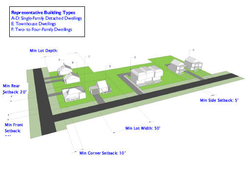
Sections 23-3-2 through 23-3-5 have a common structure for describing each base district, consisting of a statement of the purpose of the district, table(s) summarizing the basic intensity and dimensional standards established in Article 5: Intensity and Dimensional Standards, that define the district's character, photograph(s) of building forms typical in the district, and a graphic depiction of how the district's intensity and dimensional standards apply to typical lot patterns and building forms.
b.
The tables and graphics are intended to illustrate the general character of the district, and do not necessarily reflect all the standards that may apply to a particular development. All development is subject to Article 23-4: Use Standards, Article 23-5: Intensity and Dimensional Standards, and Article 23-6, Development Standards. If an intensity or dimensional standard summarized or graphically depicted in this article for a base zoning district is inconsistent with an intensity or dimensional standard established in Article 5: Intensity and Dimensional Standards, the standard established in Article 5 shall govern.
(2)
Planned Development Overlay Zoning Districts
Section 23-3-6 sets forth general provisions describing the general purpose of Planned Development overlay zoning districts and general standards applicable to all Planned Development overlay zoning districts established by this Ordinance, followed by sections that specify standards applicable in each type of Planned Development overlay district.
(3)
Other Overlay Zoning Districts
Section 23-3-7 sets forth the purpose and standards specific to each of the established overlay zoning districts other than Planned Development overlay zoning districts.
(Ord. No. 2189, § 1(Exh. A), 5-24-2011; Ord. No. 2410, 1-28-2020)
(A) - General Purposes of Residential Base Zoning Districts
The residential base zoning districts established in this section are intended to provide a comfortable, healthy, safe, and pleasant environment in which to live and recreate. More specifically, they are intended to:
(1)
Provide appropriately located lands for residential development that are consistent with the goals, objectives, and policies of the comprehensive plan and any functional plans and small area plans adopted by the city.
(2)
Ensure adequate light, air, privacy, and recreational and open space areas for each dwelling, and protect residents from the negative effects of noise, excessive population density, traffic congestion, flooding, and other significant adverse environmental impacts;
(3)
Protect residential areas from fires, explosions, toxic fumes and substances, and other public safety hazards;
(4)
Provide for residential housing choice, affordability, and diversity with varying housing densities, types, and designs, including accessory dwelling units;
(5)
Provide for safe and efficient vehicular access and circulation and promote bicycle-, pedestrian-, and transit-friendly neighborhoods;
(6)
Provide for public services and facilities needed to serve residential areas and accommodate public and semi-public land uses that complement residential development or require a residential environment while protecting residential areas from incompatible nonresidential development;
(7)
Create neighborhoods and preserve existing community character while accommodating new infill development and redevelopment consistent with the city's goals and objectives; and
(8)
Preserve the unique character and historic resources of the traditional neighborhoods and the community.
(B) - A: Agricultural District
(B-1) - AR: Agricultural Restricted District
|
Figs. 23-3-2(B)(1):
A & 23-3-2(B-1)(1): AR Example Lot Pattern 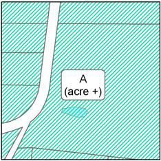 |
Figs. 23-3-2(B)(2):
A & 23-3-2(B-1)(2): AR Example Building Form 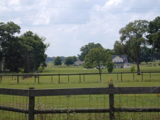 |
Figs. 23-3-2(B)(3):
A & 23-3-2(B-1)(3): AR Example Building Form 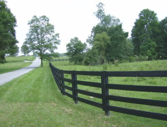 |
|---|
Figure 23-3-2(B)(4): An Example Lot Configuration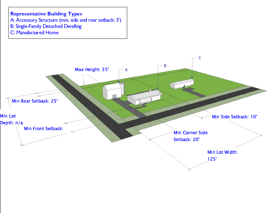
(C) - RE: Residential Estate District
|
Fig. 23-3-2(C)(1):
RE Example Lot Pattern 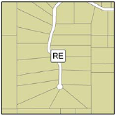 |
Fig. 23-3-2(C)(2):
RE Example Building Form 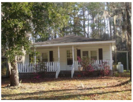 |
Fig. 23-3-2(C)(3):
RE Example Building Form 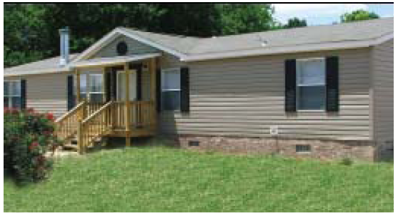 |
|---|
Figure 23-3-2(C)(4): RE Example Lot Configuration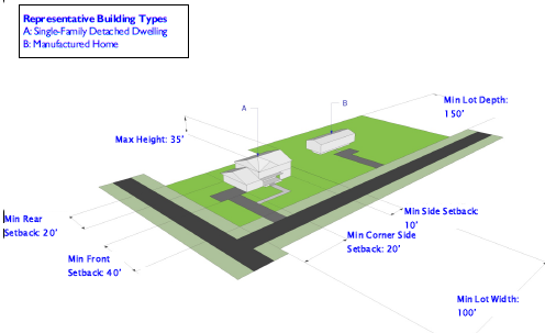
(D) - RER: Residential Estate, Restricted District
|
Fig. 23-3-2(D)(1):
RER Example Lot Pattern 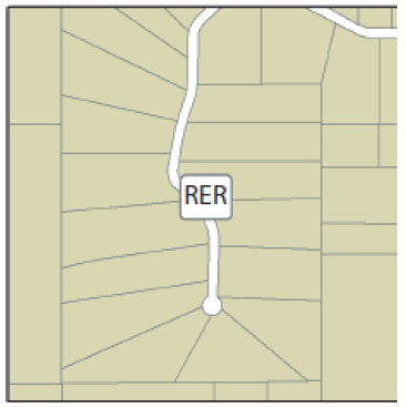 |
Fig. 23-3-2(D)(2):
RER Example Building Form 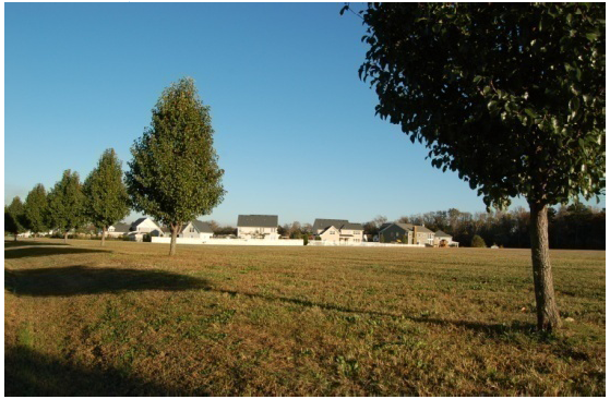 |
Fig. 23-3-2(D)(3):
RER Example Building Form 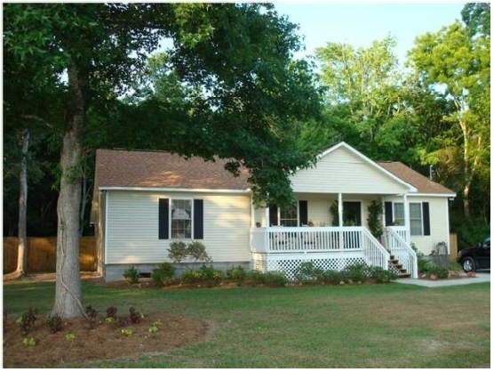 |
|---|
Figure 23-3-2(D)(4): RER Example Lot Configuration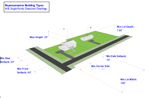
(E) - RS-10: Low-Density Single-Family Residential District
|
Fig. 23-3-2(E)(1):
RS-10 Example Lot Pattern 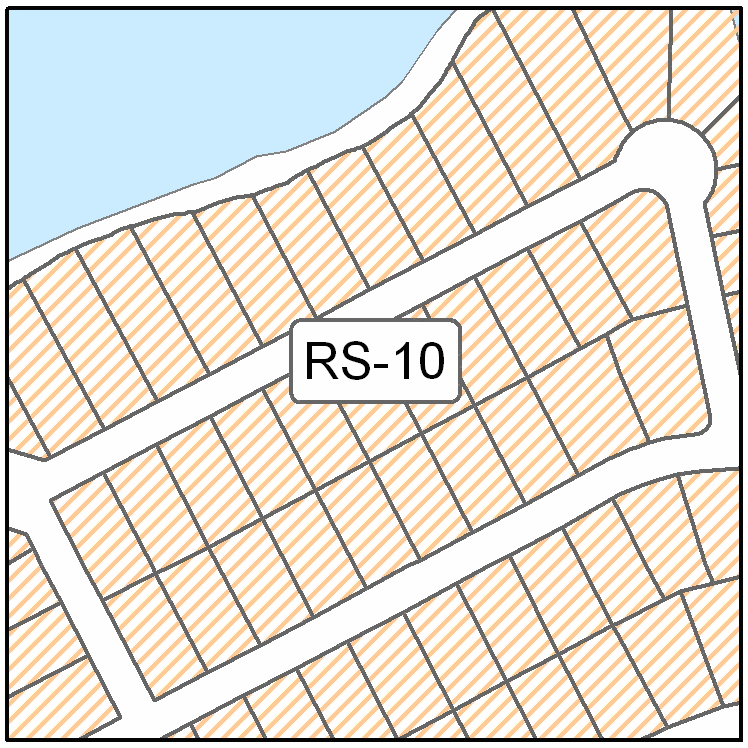 |
Fig. 23-3-2(E)(2):
RS-10 Example Building Form 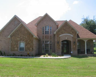 |
Fig. 23-3-2(E)(3):
RS-10 Example Building Form 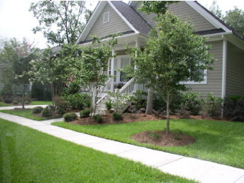 |
|---|
Figure 23-3-2(E)(4): RS-10 Example Lot Configuration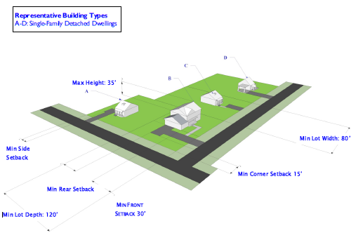
(F) - RS-7.5: Medium-Density Single-Family Residential District
|
Fig. 23-3-2(F)(1):
RS-7.5 Example Lot Pattern  |
Fig. 23-3-2(F)(2):
RS-7.5 Example Building Form  |
Fig. 23-3-2(F)(3):
RS-7.5 Example Building Form  |
|---|
Figure 23-3-2(F)(4): RS-7.5 Example Lot Configuration
(G) - RS-5: High-Density Single-Family Residential District
|
Fig. 23-3-2(G)(1):
RS-5 Example Lot Pattern 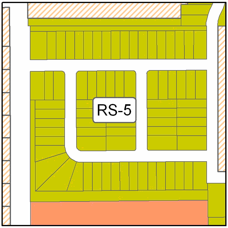 |
Fig. 23-3-2(G)(2):
RS-5 Example Building Form 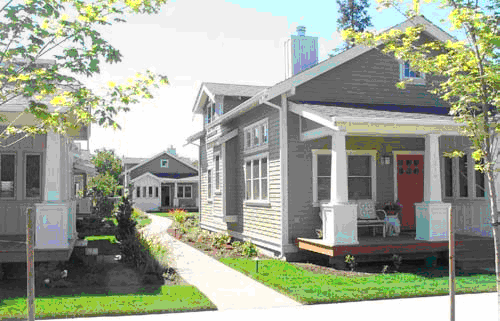 |
Fig. 23-3-2(G)(3):
RS-5 Example Building Form  |
|---|
(Ord. No. 2461, 9-28-2021)
(H) - RM-10: Low-Density Multifamily Residential District
|
Fig. 23-3-2(H)(1):
RM-10 Example Lot Pattern 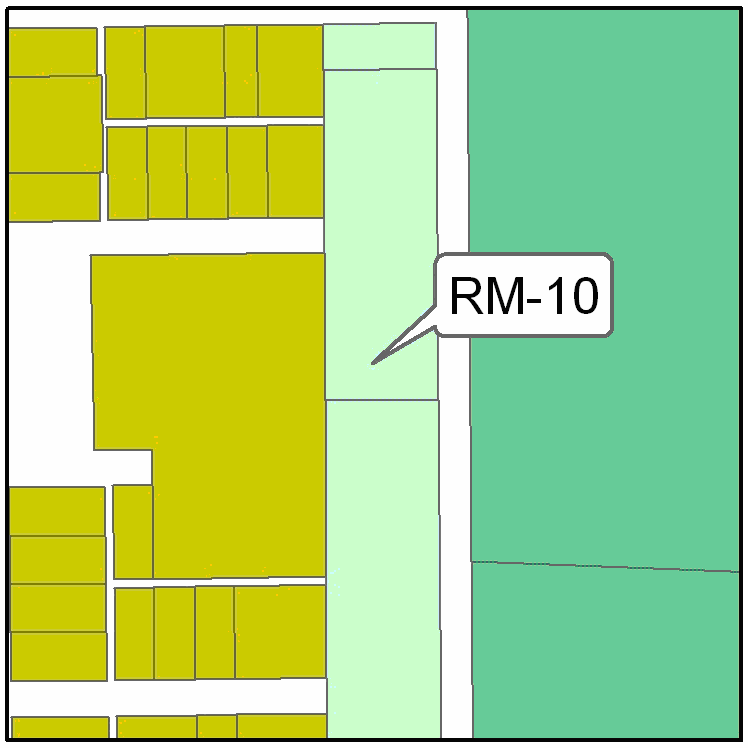 |
Fig. 23-3-2(H)(2):
RM-10 Example Building Form 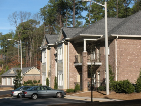 |
Fig. 23-3-2(H)(3):
RM-10 Example Building Form 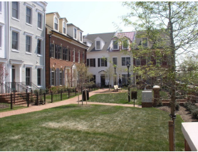 |
|---|
Figure 23-3-2(H)(4): RM-10 Example Lot Configuration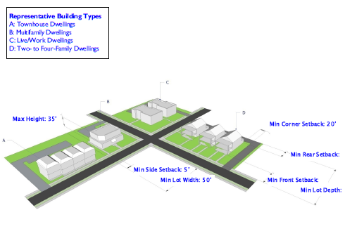
(Ord. No. 2423, 7-21-2020)
(I) - RM-20: Medium-Density Multifamily Residential District
|
Fig. 23-3-2(I)(1):
RM-20 Example Lot Pattern 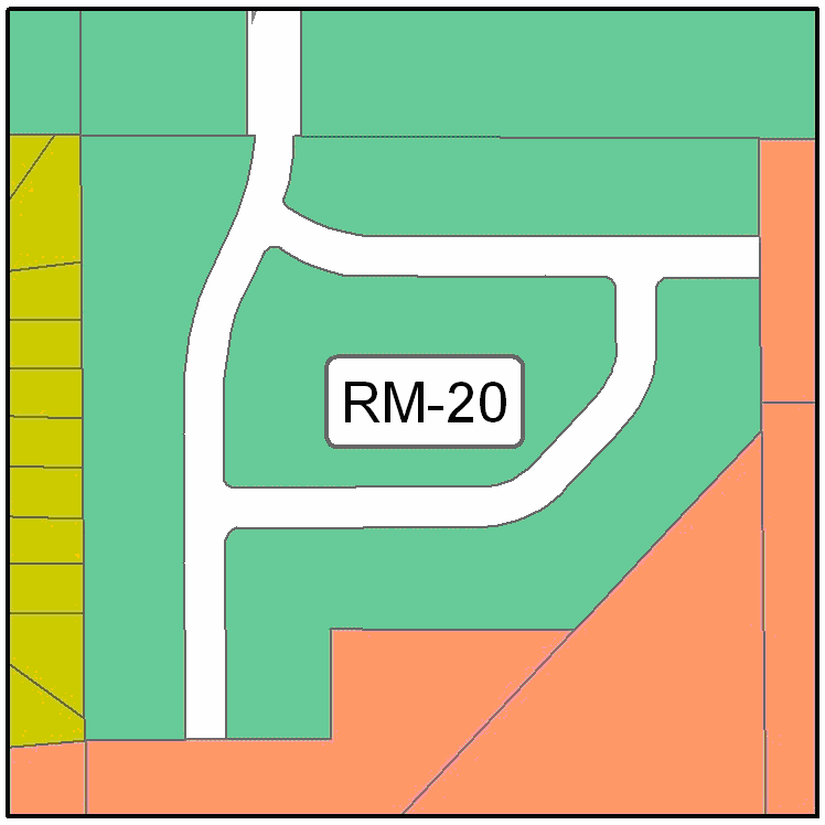 |
Fig. 23-3-2(I)(2):
RM-20 Example Building Form 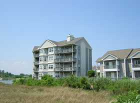 |
Fig. 23-3-2(I)(3):
RM-20 Example Building Form 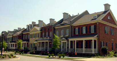 |
|---|
Figure 23-3-2(I)(4): RM-20 Example Lot Configuration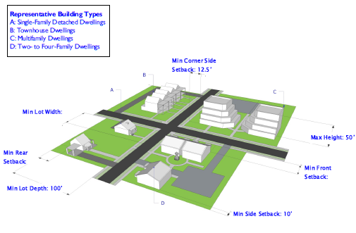
(J) - RM-30: High-Density Multifamily Residential District
|
Fig. 23-3-2(J)(1):
RM-30 Example Lot Pattern 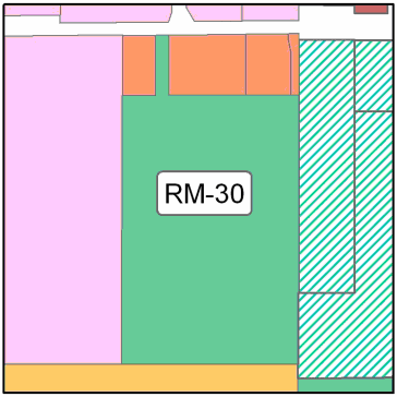 |
Fig. 23-3-2(J)(2):
RM-30 Example Building Form 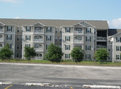 |
Fig. 23-3-2(J)(3):
RM-30 Example Building Form 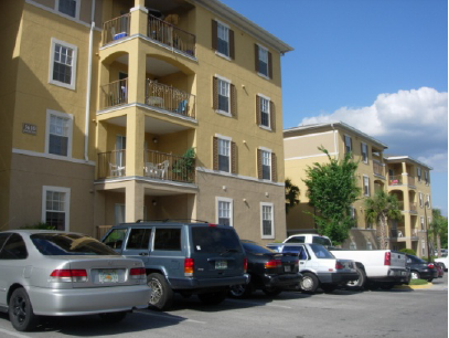 |
|---|
Figure 23-3-2(J)(4): RM-30 Example Lot Configuration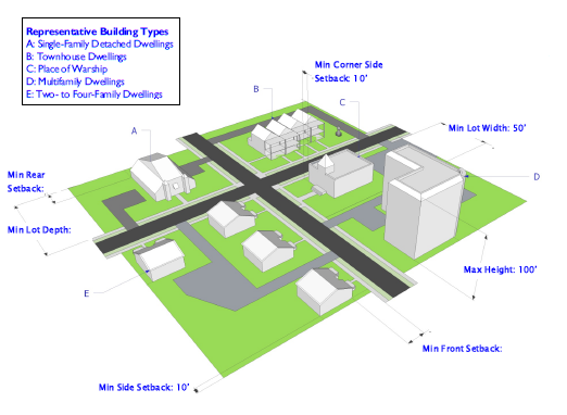
(K) - RMH: Residential Manufactured/Mobile Home District
|
Fig. 23-3-2(K)(1):
RMH Example Lot Pattern 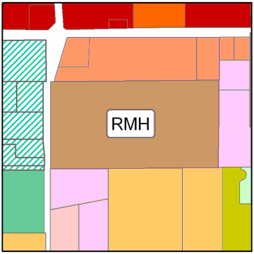 |
Fig. 23-3-2(K)(2):
RMH Example Building Form 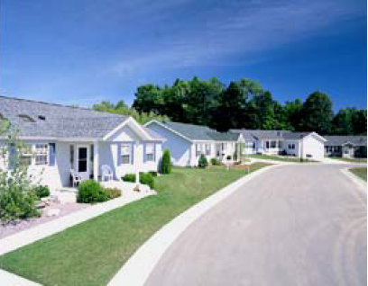 |
Fig. 23-3-2(K)(3):
RMH Example Building Form 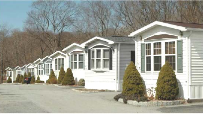 |
|---|
Figure 23-3-2(K)(4): RMH Example Lot Configuration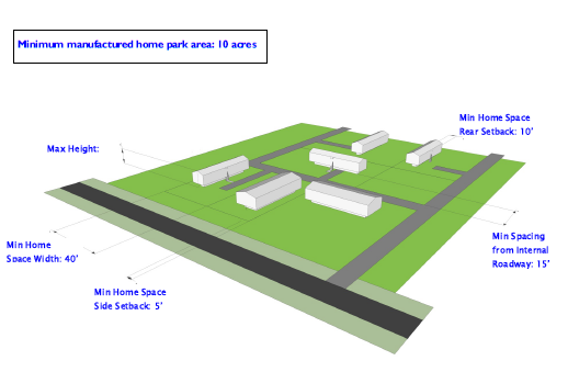
(Ord. No. 2189, § 1(Exh. B), 5-24-2011; Ord. No. 2273, § 1, 3-3-2015)
(A) - General Purposes of Nonresidential Base Zoning Districts
The nonresidential base zoning districts are established for the general purpose of ensuring there are lands in the city that provide a wide range of office, retail, service, institutional, industrial, and related uses to meet household and business needs, and more specifically to:
(1)
Provide appropriately located lands for the full range of business uses needed by the city's residents, businesses, and workers, consistent with the goals, objectives, and policies of the comprehensive plan and any functional plans and small area plans adopted by the city;
(2)
Strengthen the city's economic base, and provide employment opportunities close to home for residents of the city and surrounding communities;
(3)
Create suitable environments for various types of business uses, and protect them from the adverse effects of incompatible uses;
(4)
Create suitable environments for various types of mixed use development, where business, office, retail, and residential uses are designed and integrated in compatible ways;
(5)
Support the military and governmental activities taking place in the city;
(6)
Preserve the unique character of the downtown and historic districts, landmarks, and landmark sites;
(7)
Minimize the impact of business development on residential districts and uses, and historic districts, landmarks, and landmark sites.
(B) - LB: Limited Business District
|
Fig. 23-3-3(B)(1):
LB Example Lot Pattern 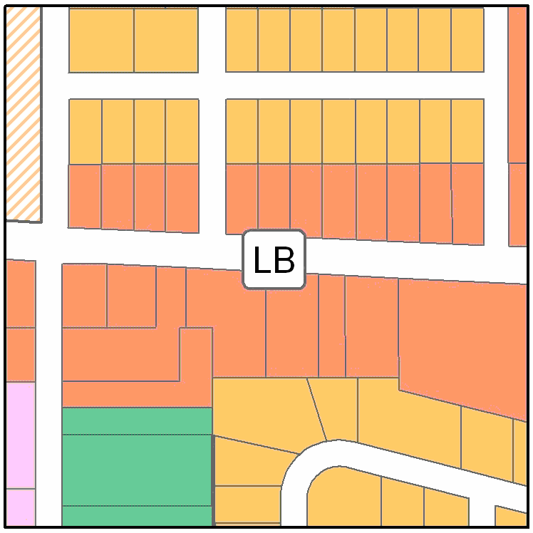 |
Fig. 23-3-3(B)(2):
LB Example Building Form 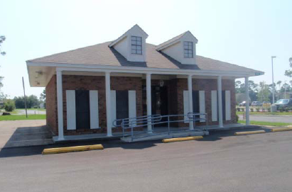 |
Fig. 23-3-3(B)(3):
LB Example Building Form 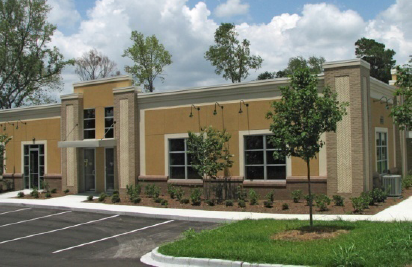 |
|---|
Figure 23-3-3(B)(4): LB Example Lot Configuration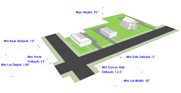
(C) - NB: Neighborhood Business District
|
Fig. 23-3-3(C)(1):
NB Example Lot Pattern 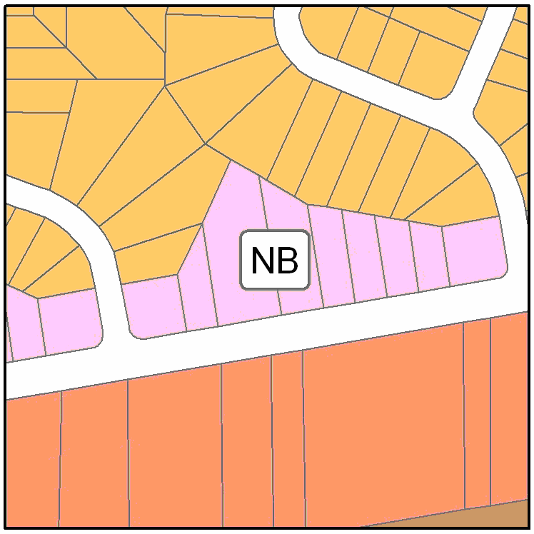 |
Fig. 23-3-3(C)(2):
NB Example Building Form 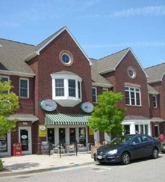 |
Fig. 23-3-3(C)(3):
NB Example Building Form  |
|---|
Figure 23-3-3(C)(4): NB Example Lot Configuration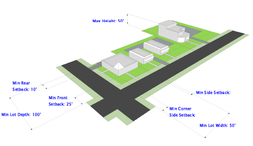
(D) - CB: Community Business District
|
Fig. 23-3-3(D)(1):
CB Example Lot Pattern 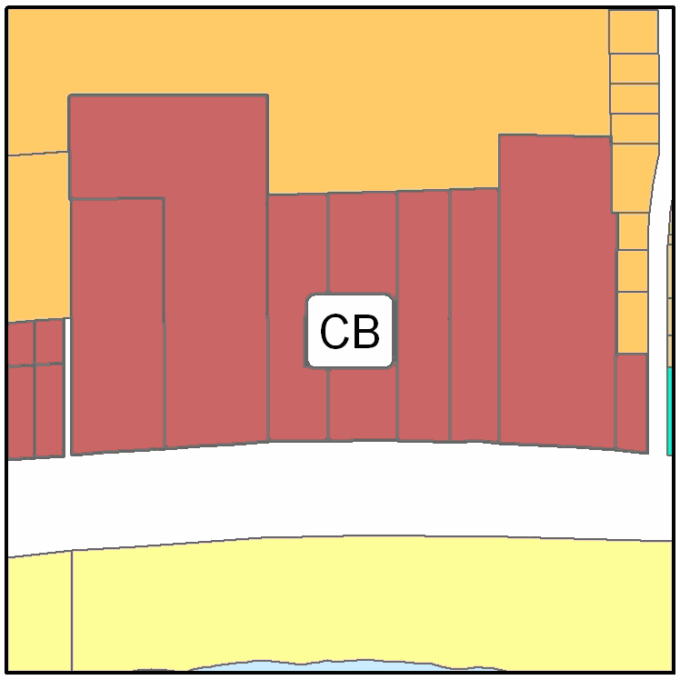 |
Fig. 23-3-3(D)(2):
CB Example Building Form 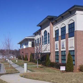 |
Fig. 23-3-3(D)(2):
CB Example Building Form  |
|---|
Figure 23-3-3(D)(4): CB Example Lot Configuration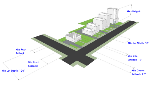
(E) - RB: Regional Business District
|
Fig. 23-3-3(E)(1):
RB Example Lot Pattern 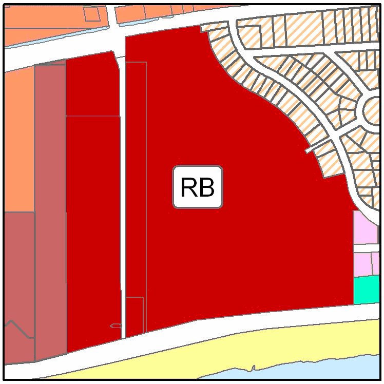 |
Fig. 23-3-3(E)(2):
RB Example Building Form 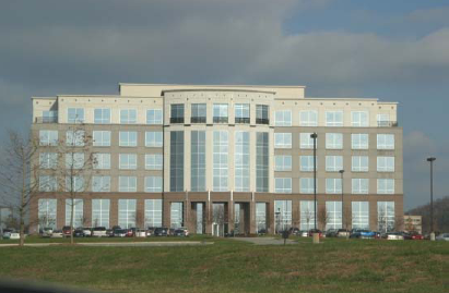 |
Fig. 23-3-3(E)(3):
RB Example Building Form 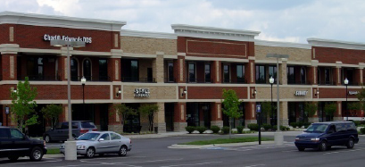 |
|---|
Figure 23-3-3(E)(4): RB Example Lot Configuration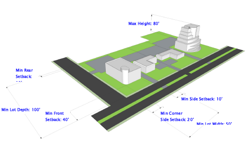
(F) - DT: Downtown District
|
Fig. 23-3-3(F)(1):
DT Example Lot Pattern 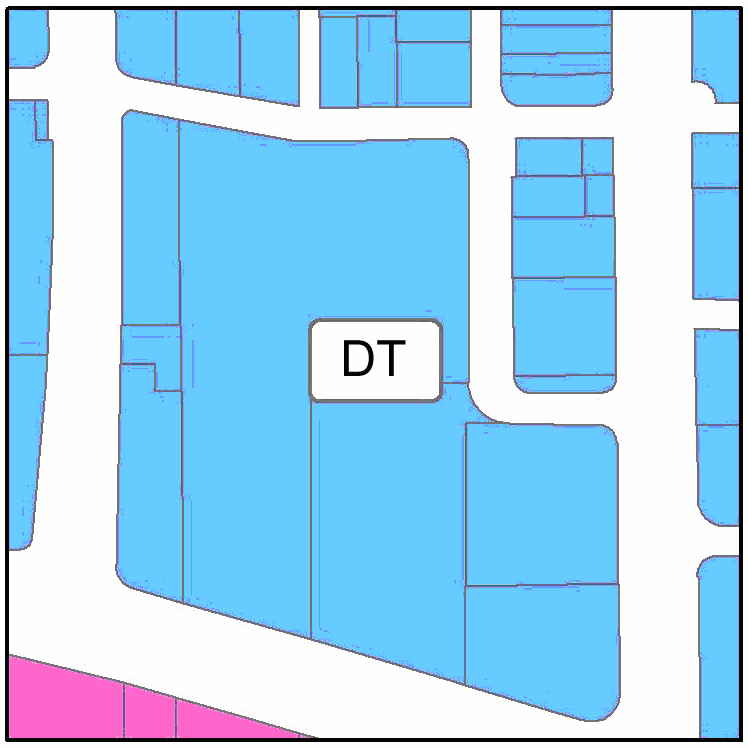 |
Fig. 23-3-3(F)(2):
DT Example Building Form 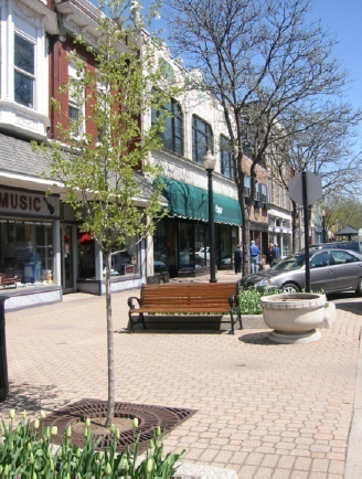 |
Fig. 23-3-3(F)(3):
DT Example Building Form  |
|---|
Figure 23-3-3(F)(4): DT Example Lot Configuration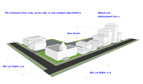
(G) - I: Industrial District
|
Fig. 23-3-3(G)(1):
I Example Lot Pattern 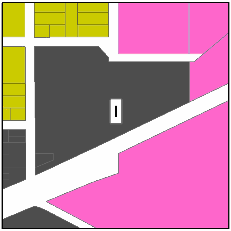 |
Fig. 23-3-3(G)(2):
I Example Building Form  |
Fig. 23-3-3(G)(3):
I Example Building Form  |
|---|
Figure 23-3-3(G)(4): I Example Lot Configuration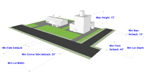
(H) - WF: Waterfront District
|
Fig. 23-3-3(H)(1):
WF Example Lot Pattern 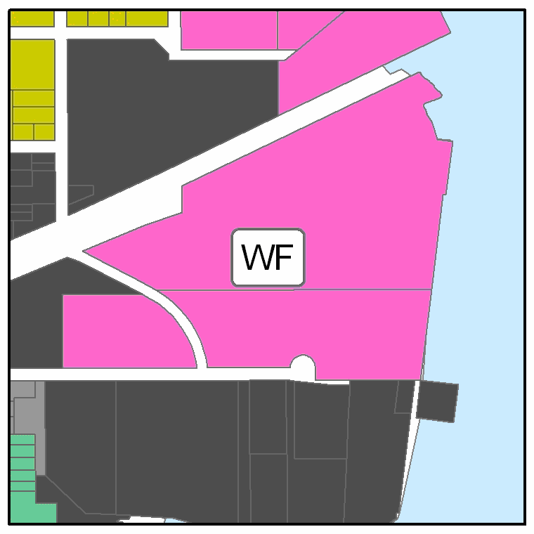 |
Fig. 23-3-3(H)(2):
WF Example Building Form  |
Fig. 23-3-3(H)(3):
WF Example Building Form  |
|---|
Figure 23-3-3(H)(4): WF Example Lot Configuration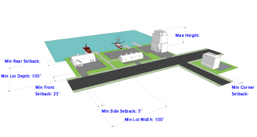
(I) - SB: Sand Beach District
|
Fig. 23-3-3(I)(1):
SB Example Development  |
Fig. 23-3-3(I)(2):
SB Example Development  |
|---|
Figure 23-3-3(I)(3): SB Example Development Configuration
(A) - General
(1)
General Planned Development District Purposes
The Planned Development (PD) districts are established and intended to encourage innovative land planning and site design concepts that support a high quality of life and achieve a high quality of development, environmental sensitivity, energy efficiency, and other city goals and objectives by:
a.
Reducing or diminishing the inflexibility or uniform design that sometimes results from strict application of zoning and development standards designed primarily for individual lots;
b.
Allowing greater freedom in selecting the means of providing access, open space, and design amenities;
c.
Allowing greater freedom in providing a well-integrated mix of residential and nonresidential land uses in the same development, including a mix of housing types, lot sizes, and densities;
d.
Providing for efficient use of land resulting in smaller networks of utilities and streets and thereby lowering development and housing costs; and
e.
Promoting quality design and environmentally sensitive development that respects surrounding established land use character and respects and takes advantage of a site's natural and man-made features, such as trees, streams, hillsides, floodplains, and historic features.
(2)
Classification of Planned Development Zoning Districts
Land shall be classified into a Planned Development zoning district only in accordance with the procedures and requirements set forth in Section 23-2-3(C), Planned Development, and this section.
(3)
Relationship to PUD District
Lands designated as Planned Unit District (PUD) on November 9, 2010 are subject to the standards and conditions included within the previously-adopted master plans and other requirements related to their approval. These developments may proceed subject to their original approvals in accordance with Section 23-1-8, Transitional Provisions. In the event the PUD expires, or a modification to the district is proposed, the provisions of this Ordinance shall apply.
(4)
Organization of Planned Development Zoning District Regulations
Section 23-3-4(B), General Standards for All Planned Development Districts, sets out general standards applicable to all types of Planned Development districts. Sections 23-3-4(C) to 23-3-4(H) set out the purpose statements and standards for each of the six specific types of Planned Development districts. These subsections have a common structure consisting of a purpose statement and applicable development standards. Some PD districts also include additional district-specific standards. Article 23-4, Use Regulations, includes a summary use table specifying the allowable uses for each of the PD districts (See Table 23-4-1(C), Use Table - Nonresidential, Special, and Planned Development Districts.), subject to an approved master plan. Uses that do not include an "A" under a particular PD district column in Table 23-4-1(C) are prohibited within that PD district.
(B) - General Standards For All Planned Development Districts
Before approving a PD zoning district classification, the City Council shall find that the application for the PD zoning district classification, as well as the PD Master Plan and the PD Terms and Conditions included as part of the application, comply with the following standards:
(1)
Planned Development Master Plan
The PD Master Plan shall:
a.
Include a statement of planning objectives for the district;
b.
Identify the general location of individual development areas, identified by land use(s) and/or development density or intensity;
c.
Identify for the entire PD district and each development area the acreage, types and mix of land uses, number of residential units (by use type), nonresidential floor area (by use type), residential density, and nonresidential intensity;
d.
Identify the general location, amount, and type (whether designated for active or passive recreation) of open space;
e.
Identify the location of environmentally sensitive lands, wildlife habitat, and stream corridors;
f.
Identify the on-site transportation circulation system, including the general location of all public and private streets, existing or projected transit corridors, and pedestrian and bicycle pathways, and how they will connect with existing and planned city systems;
g.
Identify the general location of on-site potable water and wastewater facilities, and how they will connect to city systems;
h.
Identify the general location of on-site stormwater management facilities, and how they will connect to city systems; and
i.
Identify the general location of all other on-site public facilities serving the development, including but not limited to parks, schools, and facilities for fire protection, police protection, EMS, stormwater management, and solid waste management.
(2)
Consistency with City Plans
The PD zoning district designation, the PD Master Plan, and the PD Terms and Conditions shall be consistent with the comprehensive plan and any functional plans and small area plans adopted by the city.
(3)
Compatibility with Surrounding Areas
Development along the perimeter of a PD district shall be compatible with adjacent existing or proposed development. Where there are issues of compatibility, the PD Master Plan shall provide for transition areas at the edges of the PD district that provide for appropriate buffering and/or ensure a complementary character of uses. Determination of complementary character shall be based on densities/intensities, lot size and dimensions, building height, building mass and scale, hours of operation, exterior lighting, and siting of service areas.
(4)
Development Phasing Plan
If development in the PD district is proposed to be phased, the PD Master Plan shall include a development phasing plan that identifies the general sequence or phases in which the district is proposed to be developed, including how residential and nonresidential development will be timed, how infrastructure (public and private) and open space will be provided and timed, and how development will be coordinated with the city's capital improvements program.
(5)
Conversion Schedule
The PD Master Plan may include a conversion schedule that identifies the extent to which one type of residential use may be converted to another type of residential use and one type of nonresidential use may be converted to another type of nonresidential use (i.e., residential to residential, or nonresidential to nonresidential). These conversions may occur within development areas and between development areas as long as they occur within the same development phase, as identified by the approved development phasing plan, and are consistent with established extents of conversion set down in the conversion schedule.
(6)
On-Site Public Facilities
a.
Design and Construction
The PD Master Plan shall establish the responsibility of the developer/landowner to design and construct or install required and proposed on-site public facilities in compliance with applicable city, state, and federal regulations.
b.
Dedication
The PD Master Plan shall establish the responsibility of the developer/landowner to dedicate to the public the rights-of-way and easements necessary for the construction or installation of required and proposed on-site public facilities in compliance with applicable city, state, and federal regulations.
c.
Modifications to Street Standards
In approving a PD Master Plan, the City Council may approve modifications or reductions of city street design standards—including those for right-of-way widths, pavement widths, required materials, and turning radii—on finding that:
1.
The PD Master Plan provides for separation of vehicular, pedestrian, and bicycle traffic;
2.
Access for emergency service vehicles is not substantially impaired;
3.
Adequate off-street parking is provided for the uses proposed; and
4.
Adequate space for public utilities is provided within the street right-of-way.
(7)
Planned Development Terms and Conditions
The PD Terms and Conditions shall incorporate by reference or include, but not be limited to:
a.
Conditions related to approval of the application for the PD zoning district classification;
b.
The PD Master Plan, including any density/intensity standards, dimensional standards, and development standards established in the PD Master Plan;
c.
Conditions related to the approval of the PD Master Plan, including any conditions related to the form and design of development shown in the PD Master Plan;
d.
Provisions addressing how transportation, potable water, wastewater, stormwater management, and other public facilities will be provided to accommodate the proposed development;
e.
Provisions related to environmental protection and monitoring; and
f.
Any other provisions the City Council determines are relevant and necessary to the development of the PD in accordance with applicable standards and regulations.
(8)
Uses
The uses allowed in each type of PD district are identified in Table 23-4-1(C), Use Table - Nonresidential, Special, and Planned Development Districts. Allowed uses in a particular PD district shall be established in the PD Master Plan, subject to conversion in accordance with a schedule incorporated in the PD Master Plan in accordance with Section 23-3-4(B)(5), Conversion Schedule. Allowed uses shall be consistent with city plans, the purpose of the particular type of PD district, and subject to applicable use-specific standards in Section 23-4-3 and any additional limitations or requirements set forth in Sections 23-3-4(C)—23-3-4(H) for the particular type of PD district.
(9)
Densities/Intensities
The densities for residential development and the intensities for nonresidential development applicable in each development area of a PD district shall be as established in the PD Master Plan, and shall be consistent with the comprehensive plan and other adopted special area and city plans, and with the purpose of the particular type of PD district.
(10)
Dimensional Standards
The dimensional standards applicable in each development area of a PD district shall be as established in the PD Master Plan, and shall be consistent with the purpose of the particular type of PD district. The PD Master Plan shall include at least the following types of dimensional standards, unless the PD Master Plan expressly states otherwise:
a.
Maximum dwelling units per acre and/or maximum floor area ratio;
b.
Minimum lot area;
c.
Minimum lot width;
d.
Maximum impervious surface area;
e.
Maximum building height;
f.
Maximum individual building size;
g.
Minimum and maximum setbacks; and
h.
Minimum setbacks from adjoining residential development or residential zoning districts.
(11)
Development Standards
All development in a PD district shall comply with the development standards of Article 23-6: Development Standards, or any modifications of those standards established in the PD Master Plan as consistent with city plans, the objective of the particular type of development standard, the purpose of the particular PD district, and any additional limitations or requirements set forth in Sections 23-3-4(C)—23-3-4(H) for the particular type of PD district.
(12)
Amendments to Approved Master Plan
Amendments or modifications to a master plan shall be considered in accordance with the standards in Sections 23-2-4(C)(7)—(8).
(C) - PD-R: Planned Development - Residential District
(D) - PD-C: Planned Development - Commercial District
(E) - PD-TND: Planned Development - Traditional Neighborhood Development District
(1)
General Standards
(2)
Additional PD-TND District-Specific Standards
a.
Center and Subcenters
A PD-TND District shall be designed with a neighborhood center, and may also be served by one or more sub-centers. A neighborhood center or sub-center shall consist of formal open space (such as a square, commons, green, or active recreation area) that is adjacent to nonresidential or civic uses (such as a school, religious institution, or other government building), and served by one or more prominent street intersections.
b.
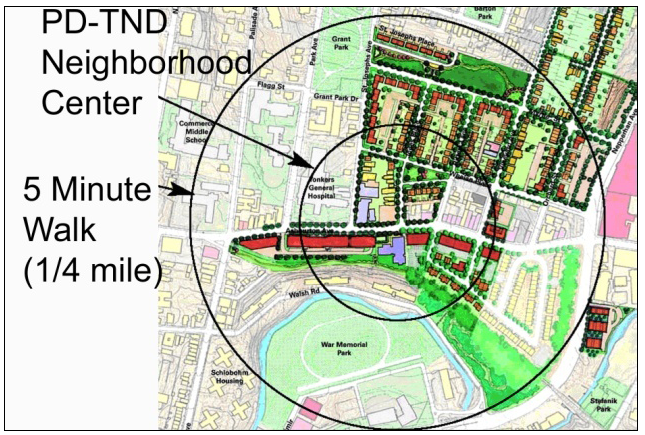
Walking Distance
At least 80 percent of all residential dwelling units in a PD-TND should be within a five-minute walk (approximately 1,250 feet) of the neighborhood center or a sub-center.
c.
Use Mixing
1.
A PD-TND District shall be structured to provide a mix of uses, like residential, retail, employment, civic, and recreational uses. The integration of residential and nonresidential uses allows residents to meet more of their daily needs within the development. In addition, provision of a variety of housing options is required to allow greater diversity of residents within the neighborhood.
2.
Civic uses are encouraged, but not required, as part of the district's nonresidential uses.
3.
Mixing of residential and nonresidential uses within a single project or structure is encouraged within integrated or vertical mixed-use projects, in which uses are located on different floors of a single structure.
d.
Open Space Design
1.
Open space in a PD-TND District should be designed in a hierarchy of formal and informal spaces and used to enhance community activity, identity, and civic pride. Formal open spaces consist of squares, greens, common areas, or other park-like settings where residents of the neighborhood may gather. Such areas are bounded by streets and/or buildings, and are typically located in or near the geographic center of the neighborhood. Informal open spaces are typically located throughout the development, and take the form of meandering walking paths, greenways, pocket parks, passive recreation areas, and areas set aside for vegetation retention.
2.
Some portion of the open space provided within a PD-TND shall be located to serve as a central open space or gathering area for the development.
e.
Building Configuration
1.
Public Buildings and Uses
Public buildings and uses—including Government Facilities, Community Services, and Educational Facilities—serve as focal points and landmarks for the community within a PD-TND district and should be located on prominent sites, such as terminal vistas at the end of streets and on prominent street corners. The PD Master Plan shall designate the general location of publicly or privately owned civic lots for civic buildings and uses, including public monuments or gateways into an ensuing space, as the terminus of street vistas for all major internal streets. In addition, public buildings and uses shall be located fronting on or adjacent to a square, plaza, or village green whenever possible.
2.
Location and Relationship between Buildings
In a PD-TND district, buildings should be used to define the street edge and the distinction between the public domain of the street and the private space of individual lots. To this end, buildings should have a fairly consistent, narrow setback alignment along the street frontage.
3.
Relationship between Building Types
Buildings in a PD-TND district should be built on a human scale and designed with a common, harmonious architectural vocabulary and landscaping to lend an intimate and personal feel to the streetscape. The intent should not be to create a uniform appearance, but rather a distinct sense of place.
(F) - PD-GE: Planned Development - Gaming Establishment District
(G) - PD-HB: Planned Development - Hospitality Business District
(H) - PD-I: Planned Development - Infill District
(A) - General
(1)
General Purpose of Overlay Zoning Districts
Overlay zoning districts are superimposed over portions of one or more underlying base zoning districts (and perhaps Planned Development overlay districts or other overlay districts) with the intent of supplementing generally applicable development regulations with additional development regulations that address special area-specific conditions, features, or plans while maintaining the character and purposes of the underlying zoning districts.
(2)
Classification of Overlay Zoning Districts
Land shall be classified or reclassified into an overlay zoning district only in accordance with the procedures and requirements set forth in Section 23-2-3(B), Map Amendment (Rezoning), and this section.
(B) - AHO: Architectural/Historic Overlay District
(1)
Purpose
In recognition that the historic heritage of Biloxi is one of the city's most valued and important assets, the Architectural/Historic Overlay (AHO) District is established and intended to safeguard that heritage by identifying, recognizing, preserving, maintaining, protecting, and enhancing old, historic, and architecturally valuable structures, properties, districts, or neighborhoods that serve as important elements and visible reminders of the social, cultural, economic, political, or architectural history of the city, county, state, or nation. The Architectural/Historic Overlay District is a flexible tool that may be applied to multiple areas and properties, and that may be tailored to apply different standards to different subdistricts, as appropriate to their various characters. In general, the Architectural/Historic Overlay District is intended to:
a.
Foster civic pride;
b.
Preserve the city's heritage;
c.
Preserve the character and desirable historic, architectural, and aesthetic features of the city;
d.
Stabilize and enhance the value of properties that are within historic districts or designated as historic landmarks or landmark sites, as well as the areas surrounding them;
e.
Protect and enhance the attractiveness of the city to residents, tourists, and visitors, thereby supporting and stimulating business and industry;
f.
Protect and enrich the quality of life for city residents;
g.
Foster wider public knowledge and appreciation of structures, properties, districts, or neighborhoods that provide a unique and valuable perspective on the social, cultural, economic traditions and ways of life of past generations;
h.
Foster architectural creativity by preserving physical examples of outstanding architectural designs and techniques of the past; and
i.
Encourage new structures and developments that will be harmonious with and complement the character of existing structures, properties, and districts designated in accordance with this section.
(2)
Procedures and Standards for AHO Zoning District Classification
Except as modified in accordance with this subsection, classification of land into the AHO zoning district shall occur in accordance with the procedures and requirements of Section 23-2-4(B), Map Amendment (Rezoning).
a.
Procedure
1.
Pre-Application Requirements
The following actions shall occur before the Map Amendment (Rezoning) application is submitted:
A.
Nomination
A potential historic district, landmark, or landmark site may be nominated for AHO zoning district classification by the Architectural and Historical Review Commission, or an owner of the property containing the potential historic district, landmark, or landmark site, or an organization that has as one of its central purposes the promotion of historic preservation objectives. The nomination shall contain information as required by the Architectural and Historical Review Commission.
B.
Investigation and Significance Report
The Architectural and Historical Review Commission shall make or cause to be made an investigation and report describing the historic, prehistorical, architectural, educational, or cultural significance of the buildings, structures, sites, areas, features, objects, or surroundings proposed to be included in the AHO zoning district. In the case of a proposal to apply the AHO zoning district classification to a potential historic district, the significance report shall include a description of the boundaries of the proposed historic district. In the case of a proposal to apply the AHO zoning district classification to a potential historic district or landmark, the report shall include justification for any deviation of such boundaries from the formal legal descriptions of tax parcels due to historical reasons or topographical conditions.
C.
Referral of Proposal for Map Amendment Application
Within six months after the nomination of property for AHO zoning district classification, the Architectural and Historical Review Commission shall review the significance report and decide whether to refer the report (and any boundary description, in the case of a proposed historic district) to the Director of Community Development for filing of a Map Amendment (Rezoning) application.
2.
Application Notice and Review Requirements
A.
Application Submittal
On receiving a significance report on a potential historic district, landmark, or landmark site referred from the Architectural and Historical Review Commission, the Director of Community Development shall prepare and submit an application for a Zoning Map Amendment (Rezoning), which shall include the significance report.
B.
Notice to State Department of Archives and History
When providing notice of the public hearings on the Map Amendment (Rezoning) application, the Director of Community Development shall also notify the Mississippi Department of Archives and History, by certified letter, of the proposed AHO zoning district classification, of the City Council's public hearing on the application, and of the City Council meeting to which the public hearing may be continued, as necessary to receive comments from the Department of Archives and History.
3.
City Council Review and Action
A.
Additional Public Hearing by City Council Required
In addition to the standard public hearing held by the Planning Commission in accordance with Section 23-2-4(B), Map Amendment (Rezoning), the City Council shall also hold a standard public hearing on a Map Amendment (Rezoning) application proposing to classify land into the AHO zoning district, in accordance with Section 23-2-3(F), Scheduling, Public Notice, and Conduct of Public Hearing.
B.
Consideration of Comments from State Department of Archives and History
If no comments on the Map Amendment (Rezoning) application are received from the Mississippi Department of Archives and History at or before the meeting on which the City Council opens a public hearing on the application, the City Council shall continue the hearing to its next regular meeting to provide the Mississippi Department of Archives and History additional time to submit comments. After receiving comments from the Mississippi Department of Archives and History, or after not receiving such comments by the end of any continued public hearing, the City Council may proceed and decide the application.
C.
Time Limit on Decision
The City Council shall decide a Map Amendment (Rezoning) application within 60 days after close of its public hearing on the application.
4.
Notice of Decision
Within ten days after amendment of this Ordinance to apply the AHO zoning district classification to a new historic district, landmark, or landmark site, the Director of Community Development shall provide notice of the classification to other municipal agencies and any appropriate county and state agencies. Within one week after entering the approved classification on the Official Zoning Map, the Director of Community Development shall provide such agencies a copy of a map showing the classification.
b.
Standards
In addition to the review standards in Section 23-2-4(B)(3), Map Amendment (Rezoning) Standards, the City Council shall adopt a Map Amendment (Rezoning) application to classify land into the AHO zoning district only after determining that the proposed historic district, landmark, or landmark site:
1.
Exemplifies or reflects the broad cultural, political, economic, or social history of the nation, state, or city; or
2.
Is identified with historic personages or with important events in national, state, or local history; or
3.
Embodies distinguishing characteristics of an architectural type or is a specimen inherently valuable for the study of a period, style, method of construction, or use of indigenous materials or craftsmanship; or
4.
Is representative of the notable work of a master builder, designer, or architect whose individual ability has been recognized or who has influenced his or her age (in the case of a historic district or landmark); or
5.
Has yielded or is likely to yield information important in prehistory or history (in the case of a landmark site); or
6.
Is an abandoned cemetery certified by the Mississippi Department of Archives and History as having historical significance and deserving of repair, rehabilitation, or maintenance as a historical monument (in the case of a landmark site).
(3)
Certificate of Appropriateness Required
After land is classified into the AHO zoning district, no erection, construction, exterior alteration, restoration, moving, relocation, or demolition of any building or other structure, street or sidewalk pavement, or landscaping, or the excavation, fill, or alteration of land may occur without approval and issuance of a Certificate of Appropriateness in accordance with Section 23-2-4(G), Certificate of Appropriateness.
(4)
Design Guidelines
The Architectural and Historical Review Commission is authorized to and shall prepare and adopt AHRC Design Guidelines to serve as guidance for its review of Certificate of Appropriateness applications. Guidelines may be adopted for use in all AHO zoning districts, or may be tailored to individual historic districts, landmarks, or landmark sites where appropriate to preserving and protecting their particular character. Any adopted guidelines shall be incorporated by reference as part of this Ordinance
(5)
Prevention of Demolition by Neglect
a.
Responsibility to Maintain Property
The owner or other person having legal possession, custody, or control of a property classified as in the AHO zoning district shall maintain the exterior and structural features of the property and not allow the occurrence of conditions of neglect that constitute or substantially contribute to deterioration threatening the structural integrity of structures or architectural details important to the property's historic, prehistoric, architectural, or cultural character. Failure to meet this responsibility shall be a violation of this Ordinance. Conditions that, if substantial or serious enough, could constitute demolition by neglect include, but are not limited to, the following:
1.
Defective or deteriorated exterior walls, foundations, or other vertical support that lean, sag, split, list, buckle, or otherwise indicate they are insufficient to safely carry imposed loads;
2.
Defective or deteriorated flooring or floor supports, ceilings, roofs, roof supports, or other horizontal members that lean, sag, split, list, buckle, or otherwise indicate they are insufficient to safely carry imposed loads;
3.
Defective or deteriorated foundations that lean, split, settle, list, bulge, buckle, or otherwise indicate they are insufficient to safely carry imposed loads;
4.
Defective or deteriorated fireplaces or chimneys that lean, settle, list, bulge, buckle, or otherwise indicate they are insufficient to safely support themselves;
5.
Ineffective waterproofing of exterior walls, roofs, and foundations, including broken windows or doors;
6.
Defective protection or lack of weather protection for exterior wall and roof coverings, including lack of paint, deteriorated or crumbling plasters or mortars, or weathering due to lack of paint or other protective covering;
7.
Rotting, holes, and other forms of decay;
8.
Deteriorated exterior stairs, porches, handrails, window and door frames, cornices, wall facings, and architectural details that causes delamination, instability, loss of shape and form, or crumbling;
9.
Heaving, subsidence, or cracking of sidewalks, steps, or pathways;
10.
Deteriorated fences, gates, and accessory structures;
11.
Deterioration that has a detrimental effect upon the special character of a AHO district as a whole or the unique attributes and character of a historic landmark or landmark site; and
12.
Deterioration of any exterior feature so as to create or permit the creation of any hazardous or unsafe conditions to life, health, or other property.
b.
Enforcement
1.
Enforcement of violations of the requirement to not allow conditions of neglect shall be in accordance with Article 23-9: Enforcement, except that the Architectural and Historical Review Commission is expressly authorized to determine if a property in an AHO district is in danger of being demolished by neglect and to file complaints about any properties so determined with the Director of Community Development, in accordance with Section 23-9-5(B), Complaints Regarding Violations.
2.
If the owner or other person responsible for allowing a property in an AHO district to be demolished by neglect fails to correct the identified conditions of neglect by the specified time limit, the Director of Community Development shall notify the Architectural and Historical Review Commission, who may consider and recommend to the City Council that, in accordance with authority granted by the Mississippi Code, the city make repairs necessary to correct the conditions of neglect and place the cost of such repairs as a lien against the property.
(6)
Specific AHO-Zoned Districts, Landmarks, and Landmark Sites
The following historic districts, landmarks, and landmark sites are designated and zoned as Architectural/Historic Overlay (AHO) districts.
a.
Historic Districts
Table 23-3-6(B)(6)a, Historic Districts, identifies by name, those areas designated historic districts and zoned as Architectural/Historic Overlay districts on the Official Zoning Map.
b.
Historic Landmarks
Table 23-3-6(B)(6)b., Historic Landmarks, identifies by address (and name in some cases), those properties designated historic landmarks and zoned as Architectural/Historic Overlay districts on the Official Zoning Map.
c.
Historic Landmark Sites
Table 23-3-6(B)(6)c., Historic Landmark Sites, identifies by name and address those properties designated historic landmark sites and zoned as Architectural/Historic Overlay districts on the Official Zoning Map.
(Ord. No. 2305, § 1, 4-26-2016; Ord. No. 2344, § 1, 9-19-2017; Ord. No. 2373, § 1, 10-23-2018; Ord. No. 2382, § 1, 2-26-2019; Ord. No. 2389, § 1, 5-28-2019; Ord. No. 2408, § 1, 1-7-2020; Ord. No. 2420, § 1, 4-21-2020; Ord. No. 2445, § 1, 6-15-2021; Ord. No. 2464, § 1, 10-19-2021; Ord. No. 2542, § 1, 2-20-2024; Ord. No. 2571, § 1, 11-5-2024; Ord. No. 2572, § 1, 11-19-2024)
(C) - CRO: Corridor Redevelopment Overlay District
(1)
Purpose
The Corridor Redevelopment Overlay (CRO) District is established and intended to encourage the redevelopment and revitalization of major commercial or mixed-use corridors and ensure such redevelopment is consistent with the comprehensive plan and the historic character of development along the corridor. The Corridor Redevelopment Overlay District is a flexible tool that may be applied to multiple commercial and mixed-use corridors, each of which has its own unique architectural, natural, cultural, and historic character. In general, the Corridor Redevelopment Overlay District is intended to:
a.
Encourage a mix of commercial and residential redevelopment and infill development;
b.
Enhance the commercial status of the corridor;
c.
Create a vibrant atmosphere that reflects a consolidated theme;
d.
Encourage pedestrian-oriented development;
e.
Increase property values by creating an active center that attracts residents and visitors; and
f.
Ensure corridor development is compatible with neighboring development.
(2)
Establishment of Individual Corridor Redevelopment Districts
The City Council may establish individual Corridor Redevelopment Overlay Districts in accordance with this section and Section 23-2-3(B), Map Amendment (Rezoning), after approving a plan for the corridor specifying the development context in the district. Each district shall comply with the standards in Section 23-3-6(C)(4), General Development Standards for All CRO Districts. In establishing a new CRO District, the City Council also may establish a unique set of development standards applicable to all development in the particular district. (See Section 23-3-6(C)(6), District-Specific Development Standards.)
(3)
Minimum Standards for Designation of an CRO District
The City Council may approve an application for designation of a CRO District only if:
a.
At least 65 percent of the land area within the proposed CRO District, not including street and other rights-of-way, is developed;
b.
Development patterns in the district demonstrate an on-going effort to maintain or rehabilitate the character and physical features of existing buildings in the district;
c.
There is significant potential for redevelopment, revitalization, and new infill development within the district;
d.
The area possesses distinctive features that create a cohesive identifiable setting, character or association
e.
Development standards proposed for the district will enhance or encourage creation of a consistent visual texture to the street building wall, maximize compatibility with existing buildings, give the street a comfortable sense of enclosure and human scale, and enhance walkability.
(4)
General Development Standards for All CRO Districts
a.
Compliance with Underlying Zoning District Standards
These standards supplement the applicable development and district-specific standards found in the underlying base zoning district and do not affect the use regulations applicable in the underlying zoning district.
b.
Compliance with Approved Design and Development Standards
No permit for any new construction or expansion of an existing structure resulting in an increase in building footprint area of 25 percent or more may be issued until the Director of Community Development determines that the proposal complies with all design standards established for the CRO District where the land is located. All new development in a CRO District shall comply with the development standards for the underlying zoning district.
c.
Conflict with Other Standards
In the case of conflict between the CRO District standards and any other standards of this Ordinance, the CRO District development standards shall control.
(5)
District-Specific Development Standards
Each area designated as a Corridor Redevelopment Overlay District shall identify, with specificity, the design standards to be applied to all new construction and expansion of existing structures. Aspects of development that these design standards may address include, but are not be limited to, the following:
(a)
Lot size;
(b)
Location of proposed buildings or additions;
(c)
Setbacks or required yards
(d)
Building height;
(e)
Building size (for principal and accessory structures);
(f)
Building orientation;
(g)
Exterior building materials and colors;
(h)
Building roof line and pitch;
(i)
Building foundation treatment;
(j)
Landscaping and screening;
(k)
Impervious surface coverage;
(l)
Paving requirements or limitations;
(m)
Exterior lighting;
(n)
Required features on a front façade;
(o)
Neighborhood character and compatibility;
(p)
Views of or from specific locations;
(q)
Riparian areas, wetland areas, or drainage patterns; and
(r)
Demolition of structures.
The City Council may approve additional design standards addressing aspects of development not listed above. The City Council may also prohibit Use Types within a CRO District.
(6)
Specific Corridor Redevelopment Overlay Districts
a.
Caillavet Street
1.
Purpose
The Caillavet Street CRO District is established and intended to encourage the redevelopment and revitalization of property adjacent to that segment of Caillavet Street north of the CSX railroad tracks into a vibrant mixed-use business and residential district that reflects a consistent visual texture to the street building wall, maximizes compatibility with existing buildings, gives the street a comfortable sense of enclosure and human scale, and enhances walkability.
2.
Applicability
The standards in this subsection shall apply to lands designated Caillavet Street CRO District on the Official Zoning Map.
3.
Standards
A.
To provide a continuous street wall that gives the streetscape a sense of enclosure and human scale, buildings shall:
1.
Be constructed abutting or close to the street and sidewalk;
2.
Extend the width of the front of the lot, excluding access walkways and driveways
3.
Be no more than five stories high, except at block corners or points of visual termination or unless greater heights are mitigated by architectural treatments such as step-backs.
B.
Buildings shall incorporate one or more of the following design elements:
1.
At least 25 percent—but not more than 75 percent—of the street façade shall be occupied by windows or doorways.
2.
At least 40 percent of the street façade shall be comprised of masonry materials such as stone, brick, cast stone, or colored fancy concrete masonry units.
3.
At least 75 percent of the street façade shall contain a canopy or arcade to provide pedestrians shade and rain protection.
C.
The street-level façade of buildings shall have well-defined main entrances from the sidewalk for pedestrians.
D.
Buildings with front façades at least 60 feet long shall incorporate one or more of the following details to break up the façade:
1.
Wall offsets at least one foot deep, at least ten feet wide, and spaced no more than 40 feet apart;
2.
Façade color changes, at least ten feet wide and spaced no more than 40 feet apart;
3.
Pilasters at least eight inches deep, at least eight inches wide, and extending up at least 80 percent of the façade's height; or
4.
Roofline changes aligned with corresponding façade material changes.
E.
Windows on the front façade of buildings shall be rectangular with a vertical orientation.
F.
Corrugated sheet metal and smooth concrete masonry units are prohibited materials for front building façades.
G.
Electrical, communications, and other utility lines to buildings from the fronting street shall be installed underground, and no associated mechanical equipment shall be installed in front of the building.
H.
Any overhead doors shall be installed at the rear of buildings and shall not be installed on street façades along Caillavet Street.
I.
All new buildings shall be constructed on a concrete slab.
J.
Off-street parking shall not be located between buildings and the front lot line, but shall be located at the rear of buildings or at the side of buildings. Shared parking facilities are encouraged.
K.
The intersection of an access driveway onto a street shall be spaced at least 50 feet away from the intersection of any other access drive or street onto the street. Vehicular access to parking and loading areas shall be provided from alleys or shared driveways wherever practicable, to minimize obstacles to sidewalk pedestrian traffic and turning movements onto streets.
b.
Beach Boulevard CRO District [placeholder]
c.
Division Street CRO District [placeholder]
d.
Oak Street CRO District [placeholder]
e.
Pass Road CRO District [placeholder]
f.
Downtown Howard Avenue CRO District
1.
Purpose
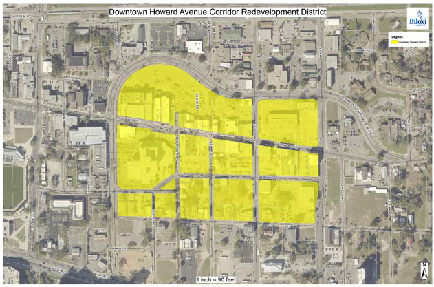
The Downtown Howard Avenue CRO District is hereby established to encourage the redevelopment and revitalization of those properties situated adjacent to or in close proximity to the section of Downtown Howard Avenue extending from Reynoir Street to Main Street. The Downtown Howard Avenue CRO District is bound on the West by Reynoir Street, North by Dr. Martin Luther King, Jr. Boulevard, East by Main Street, and South by Water Street.
2.
Applicability and Design Review Procedure
The standards, guidelines, and procedures herein provided shall serve as amendments to the City of Biloxi's Code of Ordinances, Land Development Ordinance, and Design Review Guidelines. In the case of conflict between Howard Avenue CRO District standards, guidelines and procedures and any other standards, guidelines and procedures of the City of Biloxi's Code of Ordinances, Land Development Ordinance, and Design Review Guidelines, the Howard Avenue CRO District standards, guidelines, and procedures shall control.
Applicants for building permits shall submit all applications and plans to the Director of Community Development, who shall perform the design review process provided in Chapter 3 of the City of Biloxi's Design Review Guidelines (Updated 2010), in consultation with the staff of Community Development, Mayor's Office, and an advisory representative of Biloxi Main Street (Howard Overlay Committee) instead of the AHRC.
3.
Standards
A.
Features
To encourage and enhance a walkable, pedestrian friendly street:
1.
Buildings should include some form of shelter from sun and rain for all or part of the sidewalk situated in front of each building to aid in protecting the entrances to all buildings.
2.
Examples of acceptable features include:
•
Flat or slightly sloping roofs at the top of the first level;
•
Balconies for second floor level that double as protection for sidewalk below;
•
Awnings affixed over doors and windows;
•
Indented front-door alcoves in concert with side display windows;
•
Architectural covers at corners and within alcoves along the main façade.
NOTE: All of the above features are functional, not merely decorative, and should be designed to actually provide adequate shelter.
B.
Building Height
1.
Height limits will be decided by the city to maintain the character of the existing streetscape. There shall be no maximum or minimum height limits imposed; however, plans submitted should demonstrate the use for any structural additions proposed, providing relevance of the modified structure to the preservation and enhancement of the existing Biloxi architecture in this district.
C.
Windows and Doors
1.
Windows and doors should be functional and reflective of the architectural style of pre-urban renewal Biloxi architecture. Ledges at the bottoms of display windows are highly encouraged, and, where practical, ledges should be wide enough for sitting.
D.
Garage Doors
1.
Any garage doors shall be installed at the rear of buildings and shall not be installed on street facades along Howard Avenue. However, overhead doors or security gates which are part of an approved architectural plan will be acceptable.
E.
Older Building Features
1.
Many pre-urban renewal Biloxi architecture buildings have a signature feature, such as a tiled entrance floor, unique trim, a special artistic window, or transom, or a design feature such as a turret. It is strongly encouraged that such aspects be preserved in these buildings. For new buildings, these features described above are strongly encouraged as well.
F.
Streetscape
1.
The total streetscape is most important to preserving the history and character of Downtown Biloxi; as such, no surface parking (other than on-street parking) shall be authorized within the front section of any property situated within this district. Any additional parking shall be placed in the rear of the property.
G.
Signage
1.
A variety of signage options will be permitted: neon, wall-painted, exterior-lighted, hand-painted, carved signs, hanging signs, and signature unique art. Flutter flags, noisy or inflatable signs, flat-screen digital signs, and reader boards are prohibited. Note: all signage is subject to the city's review and approval before permitting.
H.
Electrical
1.
Electrical, communications, and other utility lines to buildings from the fronting street shall be installed underground, and no associated mechanical equipment shall be installed in front of the building.
I.
Landscape
1.
No trees, bushes, or flowerbeds are permitted within the public right-of-way of Howard Avenue and adjacent sidewalks. Flower/plant containers placed on balconies and window boxes are encouraged. The rear entrances to buildings may include bushes, trees, and flowerbeds. Entrance alcoves to buildings may have plants in containers. Roof gardens are encouraged.
J.
Wi-Fi/Broadband
1.
Building owners/developers shall provide to each commercial and residential unit:
a)
Fiber optic connections capable of ISP connections for high speed broadband (at least one gigabit per second up and down); and
b)
5G coaxial cables.
Building owners/developers are encouraged to provide access to 5G Wi-Fi high-speed broadband (up and down) to all tenants.
K.
Commercial Vehicles
1.
No commercial vehicles other than service vehicles of any size are allowed within the brick paving area of Howard Avenue. If possible, service trucks shall serve all businesses and residential units from the rear entrances of buildings that front or have access to Howard Avenue, but fire, police, and medical units are specifically exempt.
L.
Lighting
1.
All security lights must be part of an approved building permit that specifically approves the design and specifications of the security lights, and fully complies with all city ordinances.
M.
Sidewalk Sales
1.
Sidewalk cafes and sales are authorized upon city sidewalks, and public pedestrian right-of-way, provided they afford appropriate accessibility to pedestrians. New sidewalks are required to match Downtown Howard Avenue CRO Design Standards with ADA accessibility; and
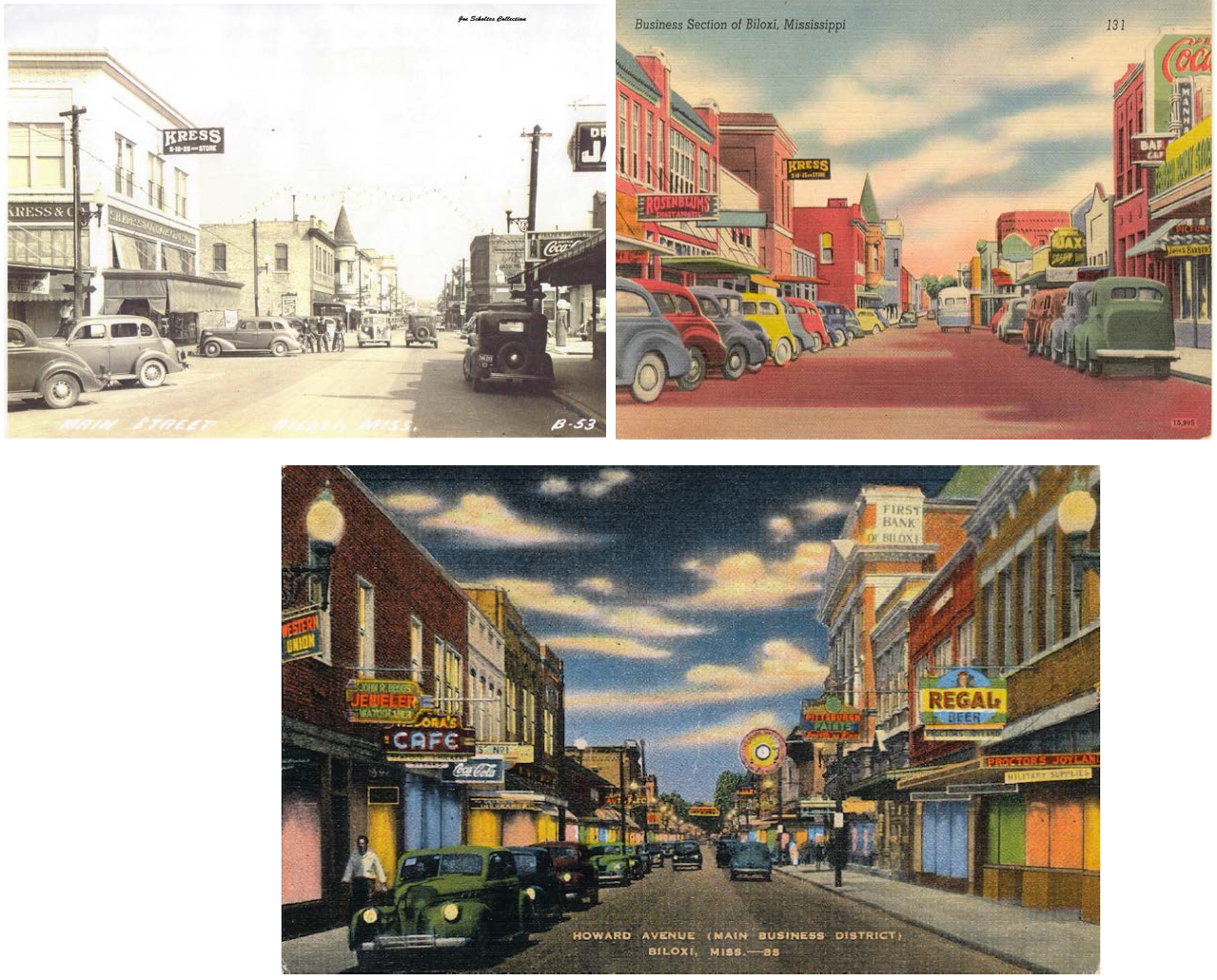
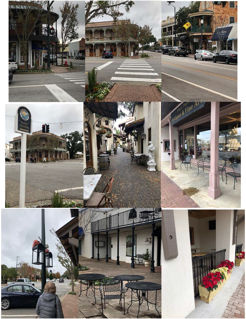
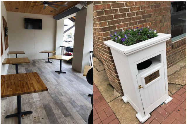
Figure 1 — Depiction of new Downtown Howard Avenue CRO District
See photo examples of some aspects of architectural styles, signage, lighting and streetscape described in the foregoing standards and guidelines for the Downtown Howard Avenue CRO District.
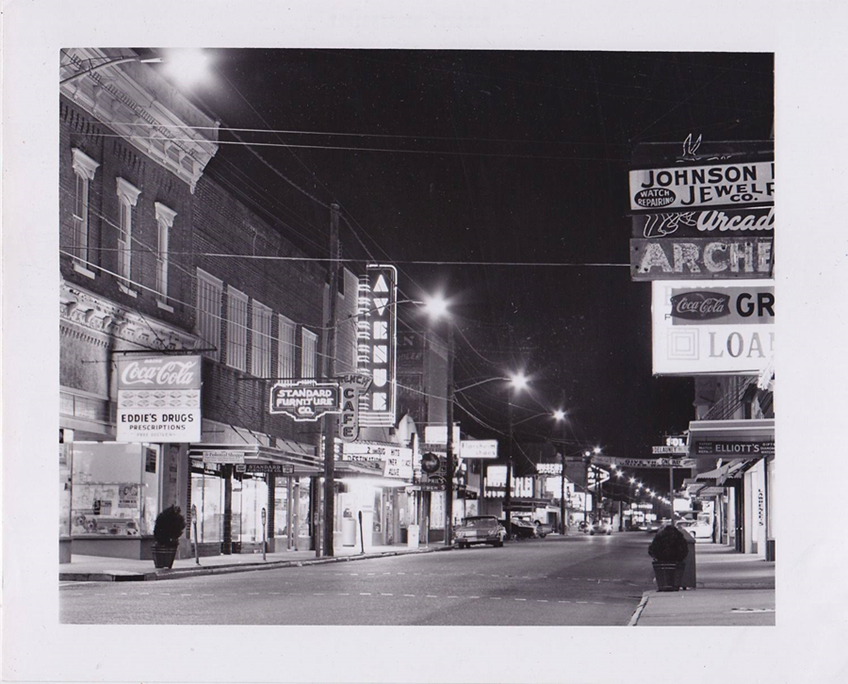
Note the attractive flat roof sidewalk shelter of Standard Furniture, the alcove of Eddie's Drugs, the hanging signs, the signature, special Avenue Theater neon and marque entrance, the variety of styles and fonts. Note: the security/street lights in this picture do not conform to the desired standards stated above.
g.
Biloxi Commerce Park CRO District
1.
Purpose
The Biloxi Commerce Park CRO District is hereby established to encourage the Redevelopment and revitalization of those properties situated upon Tommy Munro Drive, and the western 1,588 feet of Medical Park Drive. The Biloxi Commerce Park CRO District is bound on the North by Interstate 10, South by Popp's Ferry Road, East by Iron Horse Drive, and to the west by Ellzey Drive.
2.
Applicability and Design Review Procedure
The standards, guidelines and procedures herein provided, shall serve as amendments to the City of Biloxi's Code of Ordinances, Land Development Ordinance, and Design Review Guidelines. In the case of conflict between Biloxi Commerce Park CRO District standards, guidelines and procedures and any other standards, guidelines and procedures of the City of Biloxi's Code of Ordinances, Land Development Ordinance, and design.
Review Guidelines — The Biloxi Commerce Park CRO District standards, guidelines, and procedures shall control.
Applicants for building permits shall submit all applications and plans to the Director of Community Development, who shall initiate the review process with the Biloxi Commerce Park Design Review Committee, provided in Chapter 3 of the City of Biloxi's Design Review Guidelines (updated 2010).
3.
Standards
A.
Primary Intended Uses — All sites in the Biloxi Commerce Park, shall be used for the following purposes:
(a)
Medical office or clinic
(b)
Professional office
(c)
Educational
(d)
Research
(e)
Distribution
(f)
Light manufacturing/assembly
(g)
Warehouse
(h)
Commercial support facilities incidental to the specific permitted uses enumerated in this [subsection].
B.
Land
1.
All buildings must be set back a minimum of 45 feet from the right-of-way line of any street dedicated for public use.
2.
An area not less than 20 percent of the lot area (exclusive of street right-of-way and storage areas) shall be designated and suitably prepared for lawn and landscaping. A minimum of 50 percent of this lawn and landscaping area shall be provided between the front building line and the abutting street and shall be visible from the street.
3
All utility service lines shall be underground from the point of service at the lot line to the building.
4.
No lot shall be used in whole or in part for the storage of rubbish or other waste of any character whatsoever, nor for the storage of any property or purpose that will cause any lot to appear in unclean or untidy condition, or that will be obnoxious to the eye, or that would otherwise constitute either a public or private nuisance; nor shall any substance, structure or material be kept upon any lot that will emit foul or obnoxious odor.
5.
Outside storage must be screened from public view.
C.
Buildings
1.
The front or side of all buildings facing a street; including side streets, shall be of a masonry type construction, brick facing or of another similar surface approved by the Biloxi Commerce Park Design Review Committee, and shall extend from the ground level to the underside of the mansard or roof eave.
2.
The use of overhead doors on the street side of buildings shall be discouraged: however, a limited number may be approved by the Biloxi Commerce Park Design Review Committee provided that the wall containing such overhead door is recessed a minimum of 20 feet behind the front or side edge of the building and such overhead doors used on the front or side of the building shall be constructed not closer than 65 feet from the street property line surrounding the building.
D.
Signs
1.
Signs accessory to the principle use on the property are permitted in the Biloxi Commerce Park. No sign shall be permitted which is not accessory to the business use conducted on the property. All signs shall comply with the following standards:
(a)
Building mounted business signs may be erected provided the sum area of all signs does not exceed two square feet per linear foot of building frontage. The total area of business signs shall not exceed 100 square feet. Such signs shall be attached to the principal building and shall not extend more than five feet above the roofline.
(b)
In addition to building signs, each separate lot may have one freestanding monument name-plate sign that is accessory to the business conducted on the premises. Any freestanding monument name plate sign as permitted by this section must meet all of the following building requirements:
(1)
The height shall not exceed six feet.
(2)
No freestanding nameplate shall be closer than five feet from any abutting street right-of-way or property line.
(3)
The area of the sign shall not exceed nine square feet.
(4)
In the event there is more than one tenant in the building, each tenant is entitled to one name plate sign attached to the free-standing sign; provided, however, each name plate sign shall be of uniform dimensions and lettering, and no name plate sign shall exceed nine square feet in area.
(c)
No sign shall be lighted by means of flashing or intermittent illumination.
E.
Fences
1.
Fences shall be of chain link or better construction, (i.e., masonry or wooden), and shall not be erected closer to the street than the front building line.
F.
Parking
1.
All driveways and parking areas, on any lot, shall be paved with either concrete or asphalt of a quality suitable for the intended traffic. Entrances from public roads shall be provided with radii for the intended traffic.
2.
Off-street paved parking spaces, at least nine feet wide and 19 feet long exclusive of access or maneuvering area, ramps and other appurtenances, shall be located off the street right-of-way as follows:
One space for each 200 square feet of gross office area. There shall be, without exception, a minimum of one space for every two employees occupying the premises. On-street parking is prohibited.
3.
Specific development standards not addressed under these Overlay Design Standards, shall comply with the Development Standards of Article 23-6 of the current City of Biloxi Land.
The City Council may approve additional design standards addressing aspects of development not listed above. The City Council may also prohibit use types within a CRO District.
(Ord. No. 2384, 4-2-2019; Ord. No. 2492, 9-13-2022)
(D) - AAO: Airport Airspace Overlay District
(1)
Purpose
The Airport Airspace Overlay (AAO) District is established and intended to control the establishment of potential hazards to the safe operations of aircraft using navigable airspace near the airport at Keesler Air Force Base.
(2)
Applicability
Irrespective of standards applied by underlying zoning districts, land within the AAO district shall be subject to the standards of this subsection. If any requirement of this subsection conflicts with any other requirement of this subsection, the more restrictive requirements shall apply. Any existing structure or vegetation that exceeded the height limits of this subsection as of July 29, 2003 is considered a nonconforming structure or landscaping, respectively, and is subject to the requirements and limitations in Article 8: Nonconformities.
(3)
Official Maps
The boundaries of the Airport Airspace Overlay district shall be depicted on the Official Zoning Map. The three-dimensional sloped surfaces that define the height limits required by this subsection shall be as depicted on the map titled "City of Biloxi, Mississippi, Height/Hazard Overlay," copies of which shall be maintained in the Community Development Department.
(4)
Prohibited Airspace Obstructions
No structure shall be erected, constructed, expanded, enlarged, or otherwise altered, and no tree or other vegetation shall be allowed to grow, such that the height or the structure or vegetation exceeds either:
a.
The federal obstruction standards contained in Part 77, Title 14, of the Code of Federal Regulations, as those regulations are in effect on November 9, 2010, that relate to the primary surface, approach clearance surface, inner horizontal surface, outer horizontal surface, conical surface, or transitional surfaces; or
b.
The existing military operations surface, as defined in Section 23-10-2, Terms and Uses Defined.
(5)
Elevation Survey Required
Any application for a Certificate of Zoning Compliance, Public Works Permit, Temporary Use Permit, or Sign Permit that shows a structure proposed at a height within ten feet of the maximum allowed by this subsection shall include an elevation survey that demonstrates compliance with the height limits of this subsection, and certifies both the elevation of the highest point of the structure and the ground elevation used to compute the elevation of the highest point of the structure, or if the application is for improvements to an existing structure, the highest ground elevation surrounding the base of the foundation of the structure. Survey measurements shall use North American Vertical Datum as a standard of measurement.
(6)
Additional Airspace Navigation Protection Standards
No use shall be made of land or water in the City of Biloxi that:
a.
Creates electrical interference with navigational signals or radio communications between aircraft using the airport at Keesler Air Force Base and the base's control tower;
b.
Makes it difficult for pilots using the airport at Keesler Air Force Base to distinguish airport lights from other lights;
c.
Creates glare in the eyes of pilots using the airport at Keesler Air Force Base during take offs or landings; or
d.
Otherwise endangers or interferes with the safe landing, takeoff, or maneuvering of aircraft intending to use the airport at Keesler Air Force Base.
(7)
Variances
a.
Additional Application Material
Any application for a Variance from the height limits imposed by this subsection shall include:
1.
A written determination by the Federal Aviation Administration as to the proposed Variance's effect on the operation of air navigation facilities and the safe and efficient use of navigable airspace; and
2.
A written determination by Keesler Air Force Base as to the proposed Variance's effect on its flight operations and flight mission.
b.
Additional Standards of Review
An application for a Variance from the height limits of this subsection shall be approved only upon a finding that the standards in Section 23-2-4(P)(5), Variance Review Standards, and the following additional standards are met:
1.
The Variance would not create a flight hazard to air navigation;
2.
The Variance would not require a change in the flight operations or flight mission at Keesler Air Force Base.
(E) - ANO: Airport Noise Overlay Districts
(1)
Purpose
The Airport Noise Overlay zoning districts are established and intended to provide public notice of those areas of the city in which people may be exposed to the higher than average noise levels and risk of aircraft accidents associated with proximity to the airport at Keesler Air Force Base, and to ensure new buildings constructed within such areas include an appropriate level of exterior-to-interior reduction of noise levels associated with overhead aircraft.
(2)
Applicability
a.
General
Irrespective of standards applied by underlying zoning districts, land within an Airport Noise Overlay district shall be subject to the standards of this subsection. Any existing structure that does not meet the sound level reduction standards of this subsection as of November 9, 2010 is considered a nonconforming structure and is subject to the requirements and limitations in Article 8: Nonconformities.
b.
Airport Noise Overlay - 1 District
The Airport Noise Overlay - 1 (ANO-1) District applies to areas outside the Airport Noise Overlay - 3 District that, according to airport noise contours mapped in accordance with Federal Aviation Administration guidelines, are exposed to a yearly day-night average sound level (Ldn) between 65 and 70 decibels (dB). (In the prior Land Development Ordinance, this district was known and mapped as the Noise Contour District 65-70 (NCD 65-70).)
c.
Airport Noise Overlay - 2 District
The Airport Noise Overlay - 2 (ANO-2) District applies to areas outside the Airport Noise Overlay - 3 District that, according to airport noise contours mapped in accordance with Federal Aviation Administration guidelines, are exposed to a yearly day-night average sound level (Ldn) between 70 and 75 decibels (dB). (In the prior Land Development Ordinance, this district was known and mapped as the Noise Contour District 70-75 (NCD 70-75).)
d.
Airport Noise Overlay - 3 District
The Airport Noise Overlay - 3 (ANO-3) District applies to an approximately one-square-mile area to the southwest of Keesler Air Force Base. (In the prior Land Development Ordinance, this district was known and mapped as the Southwest Quadrant District.)
(3)
Official Maps
The boundaries of each Airport Noise Overlay district shall be depicted on the Official Zoning Map.
(4)
Public Notice
In addition to maintaining copies of the Official Zoning Map in the Community Development Department, the Director of Community Development shall endeavor to provide notice and information about the Airport Noise Overlay districts to the general public as well as to owners and occupants of land within the districts.
(5)
Airport Noise Level Reduction Standards
a.
Standards
Any building constructed within an Airport Noise Overlay district shall be constructed in a manner that achieves the exterior-to-interior noise level reduction prescribed in Table 23-3-6(E)(5), Airport Noise Level Reduction Standards, for the applicable Airport Noise Overlay district and proposed building use.
b.
Evidence of Compliance
Compliance with the airport noise level reduction standards in Table 23-3-6(E)(5), Airport Noise Level Reduction Standards, shall be demonstrated by either compliance with the recommended construction methods and materials for noise reduction levels of 25dB or 30dB, as appropriate, contained within the Administrative Manual, or certification of compliance by a licensed architect or engineer.
(F) - Health Care Industry Overlay District Zone
A Health Care Industry Overlay District Zone, as authorized by state statute, allows for qualified businesses to enjoy certain tax advantages upon locating within said Health Care Industry District Zone, as follows:
1.
An area within a five-mile radius of a health care facility with Certificate of Need for acute care hospital beds in a region where there are three contiguous counties which have Certificates of Need for more than 375 acute care hospital beds; and/or
2.
An area located within five miles of a hospital that will be constructed before July 1, 2017, and that involves a minimal capital investment of $250,000,000.00.
(1)
Purpose
The Health Care Industry Overlay District Zone is hereby established to provide notice of those areas of the city of Biloxi which qualify for consideration of certain incentives offered through the Mississippi Health Care Industry Zone Incentive Program. Under the terms of that Act, the Mississippi Development Authority (MDA) will certify those certain businesses deemed eligible to receive the following incentives through the Mississippi Health Care Industry Incentive Program:
(a)
An accelerated ten-year state income tax depreciation deduction.
(b)
A sales tax exemption for equipment and materials purchased from the date of the project's certification until three months after the facility is completed.
(c)
In addition, the city and county may grant a property tax "fee in lieu" for ten years for any certified project with an investment of more than $10,000,000.00 or a ten-year ad valorem tax exemption, at the city and/or county's discretion.
(d)
Certified companies can also qualify for other Mississippi incentive programs.
(2)
Applicability
The Mississippi Health Care Industry Zone Incentive Program is designed to benefit medical service providers and businesses engaged in: Medical Supply; Biologics; Laboratory Testing; Medical Product Distribution; Diagnostic Imaging; Biotechnology; Pharmaceutical Research and Development; and Medical Equipment or Medicine Production and related manufacturing or processing.
For a health care-related business to qualify for assistance through the Mississippi Health Care Industry Zone Incentive Program, MDA must certify that the business meets the minimum requirements of the program and that the project advances health care opportunities in the state. Certification must be obtained before the project is announced and prior to the start of construction and hiring. Certified businesses must create at least 25 new full-time jobs or involve an investment of $10,000,000.00 to qualify for this program.
The Mississippi Health Care Industry Zone Incentive Program will remain in effect from July 1, 2012 through June 30, 2022, unless extended by the Legislature.
(3)
Official Map
The specific area(s) to be included within the Health Care Industry Overlay District Zone in Biloxi will be addressed via a separate Zoning Map Amendment.
(G) - Waterfront Design Standards and Guidelines Overlay District Zone
A.
Purpose
The Waterfront Design Standards and Guidelines Overlay District Zone has been established and is intended to:
(a)
Require the protection and enhancement of the Biloxi waterfront, seascape and public trust tidelands as a public realm of special character, opportunity and value to the community; to facilitate the best use of the waterfront, to help protect the Biloxi waterfront from neglect, destruction, waste or misuse; to protect and enhance public health and safety on the waterfront, on structures and vessels near the edge of the water at the land's end and over the water; and in particular to enhance fire and life safety and law enforcement in these areas through the accessibility of fire department and police department personnel and equipment on and through the setbacks stated in subsection E.(a), below.
(b)
Encourage and enhance pedestrian-friendly and marine-vessel friendly public access to, and use of, the waterfront and the water for recreational and commercial purposes appropriate to water-related or water-dependent activities for:
(i)
Sports and recreation, including, but not limited to, sailing; swimming; soft-shelling; floundering; fishing by boat, pier, or wading; rowing; kayaking; relaxation; birding; viewing the seascape; and water-related festivals and ceremonies; and
(ii)
Businesses, including, but not limited to, marinas and harbors; commercial seafood businesses related to live-catch or aquaculture; charter boats for fishing, sailing, or touring; water-taxies; waterfront restaurants and recreational businesses; water-related tournaments and special events.
(c)
Encourage and facilitate access from the water to the land by use of boats, fire department pumper boats, and water vessels of all types appropriate to the culture of Biloxi;
(d)
Encourage the use of the waterfront for water-related public and private uses;
(e)
Encourage authentic Biloxi architectural and landscape designs that are appropriate to the culture and history of Biloxi; and
(f)
Encourage economic, social and environmental sustainability by encouraging living shorelines and sustainability of the natural and built environment along the landside and seaside of the waterfront.
B.
Applicability
(a)
Districts
These waterfront design standards and guidelines shall apply to all new development and redevelopment of land and buildings on land and on or over the water, including, but not limited to, site improvements, buildings, piers, boardwalks, marinas, landscaping and structures of any kind on the landside or the waterside of all parcels of land bordering the public waters in all of the following zoning districts:
(i)
Point Cadet Overlay Zoning District
(ii)
Back Bay of Biloxi Overlay Zoning District
(iii)
Biloxi Small Craft Harbor Overlay Zoning District
(iv)
West Biloxi Beach and Boardwalk Overlay Zoning District
(b)
Supplemental Authority
These waterfront design standards and guidelines are intended to be supplemental to and in addition to all other design standards, guidelines and requirements of the Land Development Ordinance. If any of these waterfront design guidelines are found to be in conflict with any other standard, guideline or requirement of the Land Development Ordinance, then these waterfront design guidelines shall prevail.
C.
Applications for review: timing of review
Review for compliance with the guidelines of this Section 23-3-5(G) shall occur during review of an application for approval of any Planned Development [Section 23-2-4(C)], Site Plan [Section 23-2-4(E)], Preliminary Plat [Section 23-2-4 (F)], or Certificate of Zoning Compliance [Section 23-2-4(L)], as appropriate, and shall be considered by the Director of Community Development, the DRC, and other decision-making authorities pursuant to, and as part of, the procedures and standards of Article 23-2 of the LDO.
D.
Certification of Compliance
As part of the process for issuance of a Certificate of Zoning Compliance pursuant to Section 23-2-4(L) of the LDO, the Director of Community Development shall determine and make findings of compliance and appropriateness of the applicant's design with these waterfront guidelines prior to issuing any building or other permits required under the LDO.
E.
General Waterfront Design Standards
(a)
All public and private developments and redevelopments shall have a minimum 25-foot, no-build setback from the edge of the water up to a vertical elevation of 14 feet above the horizontal surface and a minimum 12-foot side yard setback, to facilitate and enhance access for fire department and police department personnel and equipment to provide enhanced fire protection and life safety and law enforcement in and on structures and vessels on land, near the edge of the water and on and over the water; and to encourage and enhance pedestrian access to the shoreline and water and viewing of the seascape; these setbacks apply only to the surface of the land (which may be an improved surface) up to a vertical elevation of 14 feet from the surface; these setbacks do allow structures to be built above the 14-foot elevation above the land surface, and also allow structural columns, light fixtures, and other ancillary improvements on the land surface provided they do not impede access and use of the surface of the setback area for fire department pumper trucks and equipment and law enforcement vehicles that use less than 14 feet of vertical space.
(b)
No fencing is permitted within the 25-foot setback, but safety railings at the edge of the land and water are permitted, subject to applicable building and safety codes.
(c)
No parking, trash receptacles, utilities or other unsanctioned use within the setbacks shall be part of the design of any development or redevelopment.
(d)
No parking shall be permitted adjacent to the 25-foot setback.
(e)
No development or redevelopment shall block travel by pedestrians along the waterfront on public easements or tidelands adjacent to private uplands, and designs are encouraged to facilitate pedestrian access from and to adjacent properties.
(f)
Laser lights and other spotlights directed skyward are not allowed.
(g)
All public and private utilities shall be installed underground, except for lift stations, transformers and other elements of utility systems that may need to be installed aboveground for reasons of safety or technical necessity as certified by a registered professional engineer.
F.
General Waterfront Design Guidelines
These guidelines are not mandatory, but they are encouraged.
(a)
Access to the land from the water by boat is encouraged, where possible.
(b)
Outdoor cafes and other areas facing the water, or over the water's edge, are encouraged; incorporation of covered, open and/or arched, broad promenades are encouraged.
(c)
View of commercial workspaces is encouraged, to facilitate public education and view of seafood off-loading, aquaculture, oyster-shucking, crab-picking, net-making, seafood processing, seafood cooking, fish cleaning, boatbuilding, boat repair, and marine blacksmiths.
(d)
Native landscaping compatible with living shoreline is encouraged.
(e)
Light fixtures designed for minimal light pollution and dark-sky friendly are encouraged, to help preserve views of islands, vessels, moon and stars over water.
(f)
Dock space for working vessels is encouraged.
(g)
Design decisions should be mindful of the view of the land from the water as well as the view of the water from the land.
(h)
Design decisions that provide boardwalks, piers, steps, and other structures that allow pedestrians to be close to the water, wade in the water or touch the water are encouraged.
(i)
Applications should describe applicant's effort to achieve authentic Biloxi designs and activities appropriate for Biloxi's history and culture.
G.
Examples of Appropriate Designs and Activities
(a)
The following photos provide examples of authentic designs from Biloxi's history and from other waterfront communities with similar histories:
| This photo depicts the old Biloxi Yacht Club on regatta day. |
 |
| This photo depicts historic Biloxi waterfront in the downtown area. |
 |
| This photo depicts the Buena Vista pavilion over the water in downtown Biloxi. |
 |
| This photo depicts the Biloxi Small Craft Harbor before Hurricane Camille. |
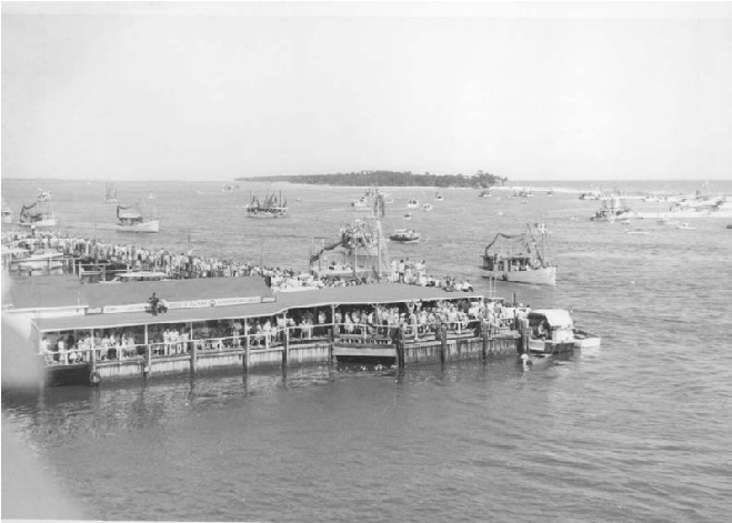 |
| This photo depicts the Biloxi Small Craft Harbor before Hurricane Camille. |
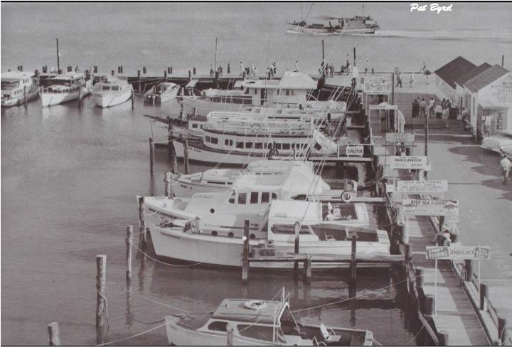 |
| This photo is an example of how NOT to plan or design docks and access to the water. These boats are next to the Factory Restaurant on Point Cadet in the early 1980s. |
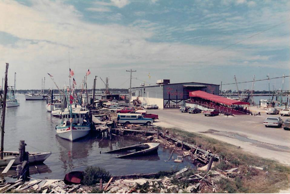 |
| This photo depicts the riverfront boardwalk in New Orleans. |
 |
| This photo is another depiction of the New Orleans riverfront. |
 |
| This photo depicts sidewalk café next to boardwalk at a marina. |
 |
| This photo depicts mixed-use retail, café, housing, and marina. |
 |
| This photo depicts a wharf and marketplace over the water with dock for historic vessels. |
 |
| This photo depicts Baltimore's Inner Harbor and Festival Marketplace. |
 |
| This photo depicts a wide boardwalk with floating pier for docking vessels. |
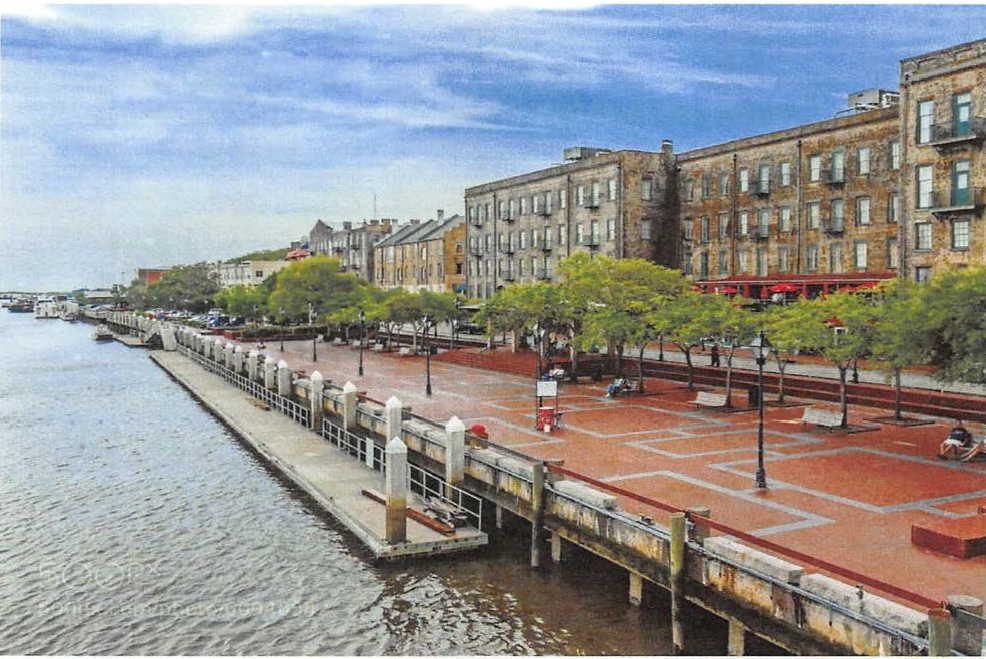 |
| This photo depicts a waterfront bandstand that could also float on a barge. |
 |
| This photo depicts a boardwalk with public access to the edge of the water. |
 |
| The article and photos on this page are about Gig Harbor, a city on Puget Sound in the State of Washington. Gig Harbor's waterfront today is similar to Biloxi before Hurricane Camille. |
 |
 |
a.
Activities
Biloxi's natural waterfront is "user-friendly" compared to waterfronts that have powerful waves, treacherous currents, rocks, or cliffs. The following is a partial list of activities associated with the Biloxi waterfront, old and new:
i.
Wading and swimming.
ii.
Soft-shelling and floundering.
iii.
Walking on sand bars at low tide.
iv.
Skimming with skim boards.
v.
Playing with or racing toy boats or model boats.
vi.
Walking on beach/beachcombing.
vii.
Watching sunset, sunrise.
viii.
Looking at moon, stars, and clouds.
ix.
Romance, enchantment.
x.
Bird watching.
xi.
Cooning oysters.
xii.
Treasure hunting.
xiii.
Skipping shells or rocks; various games.
xiv.
Dances in pavilions over water.
xv.
Talking on pier.
xvi.
Bonfires, cookouts.
xvii.
Recreational piers (ex: Wachenfeld Pier).
xviii.
Air shows, hot-air balloons, seaplanes, kite-flying.
xix.
Wade fishing, seining.
xx.
Fishing from pier, boat, or bridge.
xxi.
Throwing cast net in water; throwing cast net from pier or boat.
xxii.
Catching crabs with nets or trap.
xxiii.
Use of human-powered rowboats, skiffs, paddleboard, kayak, etc.
xxiv.
Use of various types of sailboats.
xxv.
Use of various types of motor vessels.
xxvi.
Landing and processing of commercial seafood.
xxvii.
Boatbuilding and repair.
xxviii.
Boat docks.
xxix.
Net making and mending.
xxx.
Marinas.
xxxi.
Charter boats and display of catch.
xxxii.
Fishing tournaments.
xxxiii.
Restaurants.
xxxiv.
Seafood markets.
xxxv.
Bars, lounges, music venues.
xxxvi.
Boat to Ship Island; boats to hire; tour boat.
xxxvii.
Schooner races, regattas, other boat races.
xxxviii.
Parasail service.
xxxix.
Jet ski and other vendors.
xl.
Casinos.
xli.
Hotels/motels.
xlii.
Water based festivals and parades (Blessing of the Fleet, Christmas on the Water).
H.
Specific Waterfront Design Standards and Guidelines
These specific guidelines apply in the areas defined in this subsection in addition to the general waterfront design standards that apply to all applicable zoning districts:
(a)
Point Cadet
Point Cadet Waterfront Design Guidelines (for the waterfront area from Oak Street East and around the peninsula to the CSX Railroad Bridge):
Boardwalk and/or walkway are recommended from the south end of Oak Street to the Howard Avenue Fishing Pier.
The following standards or guidelines shall be followed by the upland landowner for any new construction and renovation along the existing waterfront:
1.
Walkways or decks may be constructed to tie into the public walkway or boardwalk if they meet the following guidelines:
a.
Construction shall match or complement the existing construction and the design has been approved by the city.
b.
All construction shall be handicap accessible.
c.
Waste receptacles shall be supplied and maintained by landowner and receptacles shall match units used by the city.
d.
Landscaping shall meet the waterfront design standards.
e.
The public access and movement shall not be hindered by any items or construction by the upland landowner.
2.
The upland landowner may and is encouraged to construct piers, floating boat dock or marina south of the bulkhead or water's edge after approval of required government agencies.
3.
The construction of piers and decks to give the public access to the water edge is encouraged.
4.
Signage: The landowner may obtain permits to install signage as long as it meets city ordinances and waterfront design standards.
(b)
Back Bay of Biloxi
Back Bay of Biloxi Waterfront Design Guidelines (for the waterfront area from the CSX Railroad Bridge meandering north and west to the I-110 Bridge):
Back Bay of Biloxi—Phase I: Boardwalk and/or walkway are recommended from the Howard Avenue Fishing Pier to the north end of Oak Street.
The following standards or guidelines shall be followed by the upland landowner for any new construction and renovation along the existing waterfront:
1.
Walkways or decks may be constructed to tie into the public walkway or boardwalk if they meet the following guidelines:
a.
Construction shall match or complement the existing construction and the design has been approved by the city.
b.
All construction shall be handicap accessible.
c.
Waste receptacles shall be supplied and maintained by landowner and receptacles shall match units used by the city.
d.
Landscaping shall meet the waterfront design standards.
e.
Public access and movement shall not be hindered by any items or construction by the upland landowner.
2.
The upland landowner may and is encouraged to construct piers, floating boat dock or marina south of the bulkhead or water's edge after approval of required government agencies.
3.
The construction of piers and decks to give the public access to the water edge is encouraged.
4.
Signage: The landowner may obtain permits to install signage as long as it meets city ordinances and waterfront design standards.
Back Bay of Biloxi—Phase II: Boardwalk, walkway and piers are recommended from the north end of Oak Street to I-110 Bridge.
The following standards or guidelines shall be followed by the upland landowner with any new construction and renovation along the existing waterfront:
1.
Walkways or decks may be constructed to tie into the public walkway or boardwalk if they meet the following guidelines:
a.
Construction shall match or complement the existing construction and the design has been approved by the city.
b.
All construction shall be handicap accessible.
c.
Waste receptacles shall be supplied and maintained by landowner and receptacles shall match units used by the city.
d.
Landscaping shall meet the waterfront design standards.
e.
Public access and movement shall not be hindered by any items or construction by the upland landowner.
2.
The upland landowner may and is encouraged to construct piers, floating boat dock or marina south of the bulkhead or water's edge after approval of required government agencies.
3.
The construction of piers and decks to give the public access to the water edge is encouraged.
4.
Signage: The landowner may obtain permits to install signage as long as it meets city ordinances and waterfront design standards.
(c)
Biloxi Small Craft Harbor
Biloxi Small Craft and Commercial Harbors Waterfront and Downtown Design Standards and Guidelines (for the waterfront area from Bellman Street west to the Biloxi Lighthouse): The guidelines for this area shall be the same as stated above for the Point Cadet area.
(d)
West Biloxi Beach and Boardwalk
West Biloxi Beach and Boardwalk Waterfront Design Guidelines (for the waterfront area from the Biloxi Lighthouse to DeBuys Road):
West Biloxi Beach and Boardwalk Phase I: Boardwalk is recommended from Rodenberg Avenue Comfort Station to Camellia Street.
The following standards or guidelines shall be followed by the upland landowner with any new construction and renovation along the existing sand beach:
1.
Walkways or decks may be constructed to tie into the public boardwalk if they meet the following guidelines:
a.
Construction shall match or complement the existing construction and the design has been approved by the city.
b.
All construction shall be handicap accessible onto the boardwalk and back to the sand beach.
c.
Waste receptacles shall be supplied and maintained by landowner and receptacles shall match units used by the city.
d.
Landscaping shall meet the waterfront design standards.
e.
Public access and movement shall not be hindered by any items or construction by the upland landowner.
2.
Signage: The landowner may install signage as long as it meets city ordinances and waterfront design standards.
3.
Access to the boardwalk or the sand beach that crosses the existing or new dunes to be constructed to not damage the dunes or sea grasses.
West Biloxi Beach and Boardwalk Phase II: Concrete infill walkway is recommended over the existing seawall to match existing walkway from Biloxi Lighthouse to Rodenberg Avenue Comfort Station.
West Biloxi Beach and Boardwalk Phase III: Concrete infill walkway is recommended over the existing seawall to match existing walkway from Treasure Bay Casino to Broadwater Marina.
West Biloxi Beach and Boardwalk Phase IV: Concrete infill walkway is recommended over the existing seawall to match existing walkway from Broadwater Marina to DeBuys Road.
(Ord. No. 2207, § 1, 6-12-2012; Ord. No. 2219, § 1, 11-20-2012; Ord. No. 2221, § 1, 2-5-2013; Ord. No. 2230, § 1, 7-29-2013; Ord. No. 2247, § 1, 12-17-2013; Ord. No. 2264, § 1, 8-5-2014; Ord. No. 2265, § 1, 8-5-2014; Ord. No. 2280, § 1, 7-28-2015; Ord. No. 2282, § 1, 9-15-2015; Ord. No. 2283, § 1, 9-22-2015; Ord. No. 2314, § 1, 9-27-2016; Ord. No. 2325, § 1, 12-6-2016)