
Biloxi City Zoning Code
ARTICLE 23
6: - DEVELOPMENT STANDARDS
(A) - Purpose
The purpose of this section is to ensure that developments are served by a coordinated multimodal transportation system that permit the safe and efficient movement of motor vehicles, emergency vehicles, transit, bicyclists, and pedestrians within the development and between the development and external transportation systems, neighboring development, and local destination points such as places of employment, schools, parks, and shopping areas. Such a multimodal transportation system is intended to provide transportation options, increase the effectiveness of local service delivery, reduce emergency response times, promote healthy walking and bicycling, facilitate use of public transportation, contribute to the attractiveness of the development and community, connect neighborhoods and increase opportunities for interaction between neighbors, reduce vehicle miles of travel and travel times and greenhouse gas emissions, improve air quality, minimize congestion and traffic conflicts, and preserve the safety and capacity of community transportation systems.
(B) - Applicability
Except as otherwise provided in this section, the standards in this section shall apply to all development requiring approval of a Preliminary Plat (See Section 23-2-4(F)(6), Major Subdivision Preliminary Plat.) or a Site Plan (See Section 23-2-4(E), Site Plan Approval.).
(C) - Consistency With Plans
The design and construction of access and circulation systems associated with a development shall be consistent with the transportation goals, objectives, and actions in the Biloxi Comprehensive Plan and other city-adopted plans addressing transportation (including transportation plans, corridor plans, and small area plans).
(D) - Multimodal Transportation System
Access and circulation systems associated with a development shall provide for multiple travel modes (vehicular, transit, bicycle, and pedestrian), as appropriate to the development's size, character, and relationship to existing and planned community transportation systems. Vehicular, transit, bicycle, and pedestrian access and circulation systems shall be coordinated and integrated as necessary to offer the development's occupants and visitors improved transportation choices while enhancing safe and efficient mobility throughout the development and the community.
(E) - Circulation Plan Required
(1)
Applications for approval of a Preliminary Plat (See Section 23-2-4(F), Subdivision Approval.) or a Site Plan (See Section 23-2-4(E), Site Plan Approval.) proposing new development other than single-family detached, two-family dwellings, and three- to four-family dwellings shall include a circulation plan that addresses street connectivity, emergency and service vehicle access, parking movements, accommodation of loading operations, turning radii, traffic calming measures where future "cut-through" traffic is likely, and similar issues.
(2)
The Director of Community Development may waive the requirement for a circulation plan on determining that a proposed development is expected to have no impact on circulation or proposes no change in existing circulation patterns. This provision shall not be construed to exempt development that includes additional parking, driveways, or substantial modifications to the existing pedestrian network.
(F) - Vehicular Access and Circulation
(1)
Vehicular Accessway Classifications
As a basis for application of many of the vehicular access and circulation standards in this subsection, proposed and existing vehicular accessways shall be classified in accordance with the following classifications, which reflect the accessway's relative functions in providing access to and from principal origin and destination points and accommodating travel mobility. Driveways represent the lowest classification and interstate highways the highest classification.
a.
Driveways
Driveways include accessways that function solely to provide direct and immediate vehicular access to and from the principal origin and destination points within a development, or part of a development. They generally handle low travel speeds and low traffic volumes, but may handle moderate to high traffic volumes within large commercial and mixed-use developments (e.g., driveways within shopping center parking areas).
b.
Local Streets
Local streets primarily function to provide direct access to and from a development, or part of a large development, as well as to provide travel mobility by connecting driveways and other local streets with collector streets and arterial streets. Local streets generally handle low to medium travel speeds and traffic volumes, but may handle high traffic volumes within large commercial and mixed-use developments or in urbanized areas (e.g., shopping streets in the Downtown District).
c.
Collector Streets
Collector streets primarily function to provide travel mobility by connecting local streets and other collector streets with arterial streets, but may also provide limited direct access to and from a development through driveway connections. Collector streets are designated on the city's Major Thoroughfare Plan.
d.
Minor Arterial Streets
Minor arterial streets primarily function to provide travel mobility among the city's major activity centers by connecting local streets, collector streets, and other minor arterial streets with major arterial streets. They generally handle moderate travel speeds and traffic volumes over relatively long distances, and provide limited direct driveway access to a development. Minor arterial streets are designated on the city's Major Thoroughfare Plan.
e.
Major Arterial Streets
Major arterial streets primarily function to provide travel mobility among the city's major activity centers, as well as intercity traffic, by connecting collector streets and minor arterial streets with other arterial streets and interstate highways. They generally handle moderate to high travel speeds and traffic volumes over relatively long distances, and provide very limited direct driveway access to a development. Major arterial streets are designated on the city's Major Thoroughfare Plan.
f.
Interstate Highways
Interstate highways are special types of arterial streets that function solely to connect major arterial streets and different communities. Freeways generally consist of divided, limited-access highways that must accommodate uncongested traffic at very high travel speeds.
(2)
Required Vehicular Access and Circulation
a.
General
A development shall be served by a system of vehicular accessways (including driveways, local streets, collector streets, and minor and major arterial streets, as well as alleys and fire lanes) that permits safe, convenient, efficient, and orderly movement of emergency vehicles, public transit and school buses, garbage trucks, delivery vehicles, service vehicles, and passenger motor vehicles among the following origin and destination points within the development, and between these internal origin and destination points and the external roadway system, as appropriate for the type of vehicle:
1.
Emergency vehicles: Points within 150 feet of all buildings, major structures, and major recreational facilities.
2.
Public transit and school buses: Designated or planned bus stops and shelters.
3.
Garbage trucks: Bulk refuse containers and points within 150 feet of individual refuse receptacle storage/collection sites.
4.
Large delivery trucks: Off-street loading spaces.
5.
Small delivery trucks, service vehicles, and passenger motor vehicles: Off-street parking spaces.
b.
Emergency Vehicle Access
1.
To accommodate access for firefighting, accessways to all development except single-family detached, two-family dwellings, three- to four-family dwellings, manufactured homes, and manufactured home parks shall be capable of supporting loads imposed by expected fire apparatus, maintain a vertical clearance of at least 14 feet, and have a turning radius sufficient for the expected fire apparatus.
2.
Where accessways provide insufficient access for fire fighting, unobstructed fire lanes that are at least 20 feet wide shall be provided adjacent to a structure's primary entrance, in accordance with the Fire Code. If the structure is 30 feet or more in height, the fire lane shall be at least 26 feet wide and run along the longest side of the structure. This requirement does not affect the requirements for primary drive aisles (See Section 23-6-1(F)(5)e.).
(3)
Vehicular Access Management
a.
Limitation on Direct Access from Arterial Streets
Direct driveway access to a development's principal origin or destination points (including individual lots in a subdivision) may be provided directly from a major arterial, minor arterial, or collector street only if:
1.
No alternative direct access from a lower-classified accessway (e.g., driveway or local street) is available or feasible to provide; or
2.
The origin or destination point generates sufficiently low traffic volumes, and the adjacent arterial or collector street is expected to retain sufficiently low travel speeds and traffic volumes, to allow safe driveway access while preserving the safety and efficiency of travel on the arterial or collector street.
b.
Number of Access Points
1.
For single-family detached, single-family attached, townhouse, two-family dwellings, three- to four-family dwellings, and manufactured homes, a second driveway access is allowed along a lot frontage with a width between 80 and 1,500 feet, and a third driveway access is allowed along a lot frontage with a width of 1,500 feet or more. Two-family dwellings and three- to four-family dwellings on corner lots may be permitted to have one driveway access from each fronting street, and a pair of one-way driveways may be substituted for a single two-way driveway if the one-way driveways are located and aligned as necessary to protect the function, safety, and efficiency of travel on the intersected street and any associated bikeways and sidewalks.
2.
For multifamily residential, public and institutional, commercial, and industrial developments, the number of street access points shall be minimized as necessary to protect the function, safety, and efficiency of travel on the street and any associated bikeways and sidewalks.
3.
Where a through lot or corner lot fronts on roadways of different classifications, direct driveway access to the lot shall be from the lower-classified fronting street, to the maximum extent practicable.
c.
Driveway Intersection Spacing and Alignment
1.
Driveway Intersection Spacing
A.
The minimum spacing between adjacent driveway intersections along collector and arterial streets—or between a driveway intersection along a collector or arterial street and an adjacent street intersection—shall comply with the requirements in Table 23-6-1(F)(3)c., Minimum Driveway Spacing Standards Along Collector and Arterial Streets.
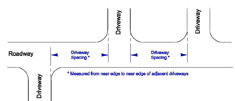
Figure 23-6-1(F)(3)c: Measurement of Driveway Intersection Spacing
B.
The spacing of adjacent driveway intersections between major street intersections along a collector or arterial street shall be uniform to the maximum extent practicable.
C.
Driveway intersections providing access to a single-family, two-family dwelling, three- to four-family dwelling, or manufactured home shall be spaced from an adjacent property line a distance sufficient to avoid encroachment of the driveway radius onto the adjacent property or interference with safe use of a driveway on the adjacent property.
2.
Driveway Alignment
A.
Driveway intersections along a street shall line up with existing or approved driveway or intersections on the opposite side of the street unless the intersections are separated by a median in the street.
B.
To the maximum extent practicable, the angle of driveway approaches to an intersection with a street shall be approximately 90 degrees for two-way driveways and between 60 degrees and 90 degrees for one-way driveways.
3.
Modification of Intersection Spacing and Alignment Standards
If an applicant can demonstrate that pre-existing conditions prevent compliance with the driveway intersection spacing and alignment requirements of this subparagraph, the Director of Community Development may modify the requirements to allow reasonable access, or grant temporary access approval until alternative access meeting the requirements is approved.
d.
Driveway Length
Private driveways shall be no longer than 150 feet unless a means for vehicular turn around is available or the driveway continues through to a public street, as approved by the Fire Marshall.
e.
Shared Driveways
1.
Driveway access shared between adjoining lots is encouraged and may be required to limit direct access from arterial roads (Section 23-6-1(F)(3)a.), minimize the number of access points (Section 23-6-1(F)(3)b.), or comply with driveway intersection spacing requirements (Section 23-6-1(F)(3)c.).
2.
Easements allowing cross-access to and from properties served by a shared driveway, along with agreements defining maintenance responsibilities of property owners, shall be recorded before issuance of a Certificate of Zoning Compliance for the development.
(4)
Connectivity
a.
Purpose
The purpose of the following vehicular connectivity standards is to enhance safe and convenient intra- and inter-neighborhood mobility that helps integrate and connect neighborhoods, allow residents to conveniently visit neighbors and nearby activity centers without compromising the capacity of the city's arterial roads to accommodate through traffic, improve opportunities for comprehensive and convenient transit service, enhance efficient provision of public services, and improve the speed and effectiveness with which emergency services and police and fire protection can be provided to city residents and properties.
b.
Connectivity Index
1.
Circulation plans for all new development shall demonstrate achievement of a connectivity index score of 1.5 or greater.
2.
The Director of Community Development may reduce the required connectivity index score through the Administrative Adjustment procedure (See Section 23-2-4(Q), Administrative Adjustment) if the applicant demonstrates that it is impossible or impracticable to achieve the score due to topographic conditions, natural features, or adjacent existing development patterns.
3.
The connectivity index for a development shall be calculated by dividing the number of nodes (roadway intersections and cul-de-sac heads) within the development into the number of links (stretches of roadway that connect nodes)—see Figure 23-6-1(F)(4)b, Connectivity Index.
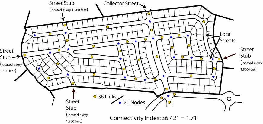
Figure 23-6-1-(F)(4)b: Connectivity Index.
This is an example of how to calculate a development's connectivity index. The diagram shows 36 links (circles) and 21 nodes (stars). Thus the connectivity index is 1.71 (36/21 = 1.71)
4.
For purposes of calculating the connectivity index for a development:
A.
One link beyond every node that exists in the development and provides access to the roadway network shall be included in the index calculation.
B.
Temporary dead-end roadways terminating at the perimeter of the development (roadway extensions or stub-outs) count as a link.
C.
Temporary dead-end roadways terminating internal to the development, gated roadways, private roads in gated sections, and alleys shall not be counted as links.
c.
Roadway Connections to/from Adjoining Development and Developable Land
1.
The vehicular access and circulation system for a development shall incorporate the continuation and connection of roadways and/or associated rights-of-way extended or connected to the boundary of the development site from existing or approved adjoining developments. It also shall provide for the extension or connection of proposed internal roadways and associated rights-of-way to those boundaries of the development site that adjoin potentially developable or redevelopable land. See Figure 23-6-1(F)(4)c., Roadway Connections to and from Adjoining Development.
Figure 23-6-1(F)(4)c.: Roadway Connections to and from Adjoining Development
2.
Roadway extensions and connections to adjoining lands shall be spaced at intervals not exceeding 1,500 feet along each principal boundary direction (north, south, east, west).
3.
The Director of Community Development may require the provision of a temporary turnaround at the end of a roadway extension on determining that the turnaround is needed to facilitate traffic flow or accommodate emergency vehicles pending the roadway's connection to other roadways.
4.
The Director of Community Development may waive or modify the requirements or standards for extension or connection of a roadway from or to adjoining property on determining that such extension is impractical or undesirable because it would:
A.
Require crossing a significant physical barrier or environmentally sensitive area (e.g., railroads, watercourses, floodplains, wetlands); or
B.
Provide a direct connection between arterial roads and encourage cut-through traffic at levels inappropriate for the classification of the roadway and character of the neighborhood.
5.
Where a roadway is extended to, but not yet onto, adjoining land, a sign shall be installed at the terminus of the roadway that informs neighboring property owners that the roadway is intended to be extended in the future (e.g., "STREET MAY BE EXTENDED BY AUTHORITY OF THE CITY OF BILOXI"). Notation of that intent shall also be included on the Site Plan or Preliminary Plat, as well as on the Final Plat.
d.
Cross Access between Adjoining Development
To encourage shared parking and minimize access points along roads, circulation plans prepared for all new nonresidential and mixed-use development, except within the Downtown (DT) District, shall comply with the following standards:
1.
The internal vehicular circulation system shall be designed to allow for vehicular cross-access between the development's vehicle use areas and those on adjoining lots containing a nonresidential or mixed-use development, or to the boundary of adjoining vacant land zoned to allow nonresidential or mixed-use development. (See Figure 23-6-1(F)(4)d., Cross-Access between Parking Areas of Adjoining Developments.)
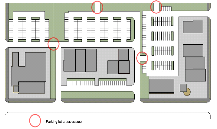
Figure 23-6-1(F)(4)d: Cross-Access between Parking Areas of Adjoining Developments
2.
Cross-accessways shall provide for two-way vehicular traffic between the vehicle use areas on the adjoining lots through the use of a single driveway or drive aisle that is at least 22 feet wide or through two one-way driveways or aisles that are each at least 11 feet wide.
3.
The Director of Community Development may waive or modify the requirement for vehicular cross-access on determining that such cross-access is impractical or undesirable due to the presence of topographic conditions, natural features, or vehicular safety factors.
4.
Easements allowing cross-access to and from properties served by a vehicular cross-access, along with agreements defining maintenance responsibilities of property owners, shall be recorded with the Office of the Chancery Clerk of Harrison County before issuance of a Certificate of Zoning Compliance for the development
(5)
Accessway Layout and Design
a.
Coordination with Transit, Bicycle, and Pedestrian Access and Circulation
1.
The vehicular access and circulation system of a development located along or adjacent to an existing or planned transit route shall accommodate a transit stop and other associated facilities unless the Director of Community Development determines that adequate transit facilities already exist to serve the needs of the development.
2.
The vehicular access and circulation system of a development shall be coordinated with the bicycle and pedestrian access and circulation systems of the development to minimize conflicts.
b.
Stacking Space for Drive-through and Related Uses
1.
Required Number of Stacking Spaces
In addition to meeting the off-street parking standards in Table 23-6-2(F)(4), Minimum Number of Off-Street Parking Spaces, uses with drive-through facilities and other auto-oriented uses where vehicles queue up to access a service facility shall provide at least the minimum number of stacking spaces established in Table 23-6-1(F)(5)b., Minimum Stacking Spaces for Drive-through and Related Uses.
2.
Design and Layout
Required stacking spaces are subject to the following design and layout standards.
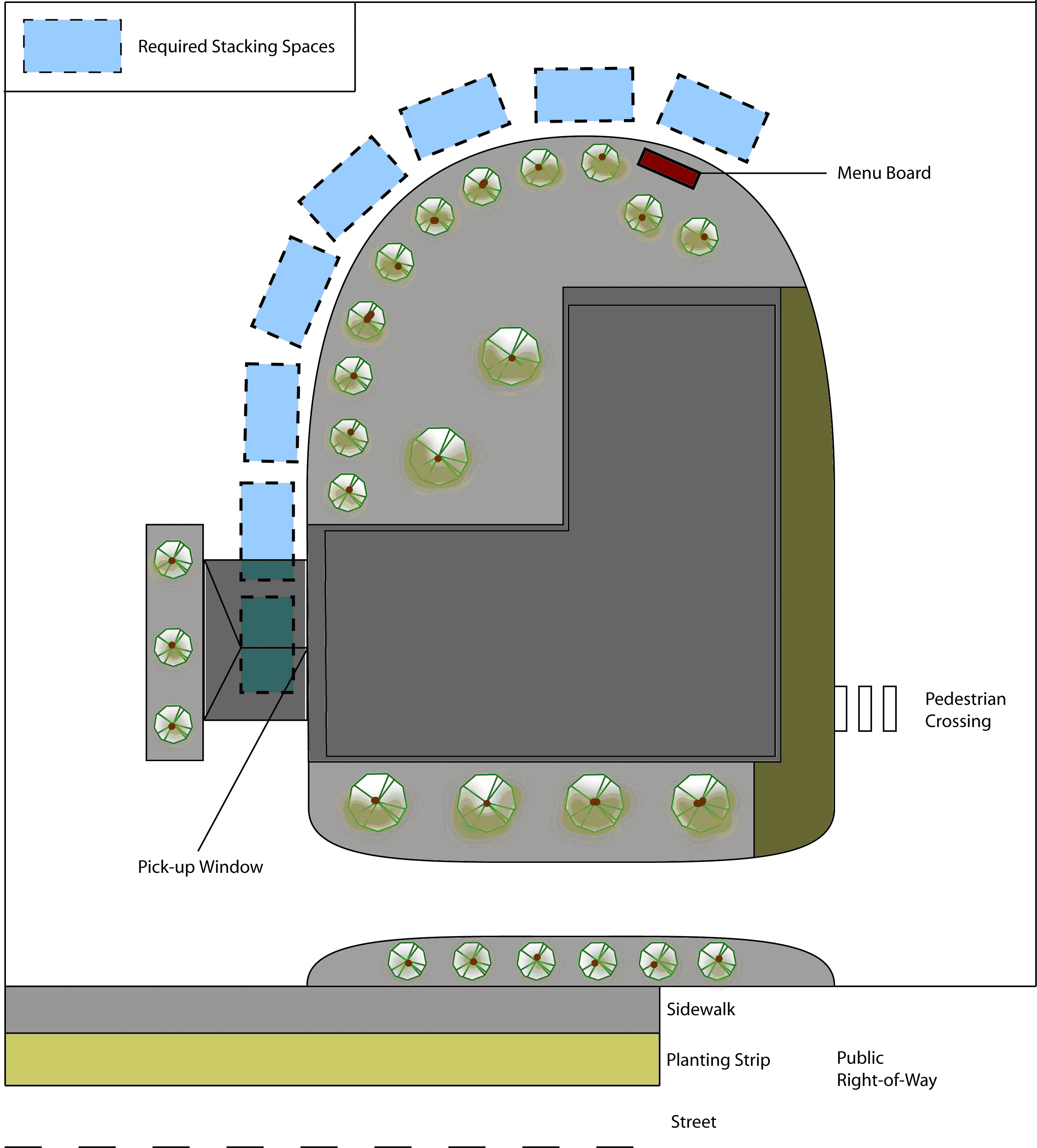
Figure 23-6-1(F)(5)b: Stacking Spaces for a Drive-Through Restaurant
A.
Size
Stacking spaces shall be a minimum of eight feet by 17 feet in size.
B.
Location
Stacking spaces shall not impede onsite or offsite traffic movements or movements into or out of off-street parking spaces.
C.
Design
Stacking spaces shall be separated from other internal driveways by raised medians if deemed necessary for traffic movement and safety by the Director of Community Development.
c.
Stacking Lanes for Parking Lot Entrance Drives
Except in the Downtown (DT) District, nonresidential uses shall provide stacking lanes between the edge of the street right-of-way and entrances into off-street parking areas in accordance with the minimum stacking lane distance established in Table 23-6-1-(F)(5)c., Minimum Stacking Lane Distance for Parking Lots. (See Figure 23-6-1(F)(5)c: Stacking Lane for a Parking Lot Entrance Drive.)
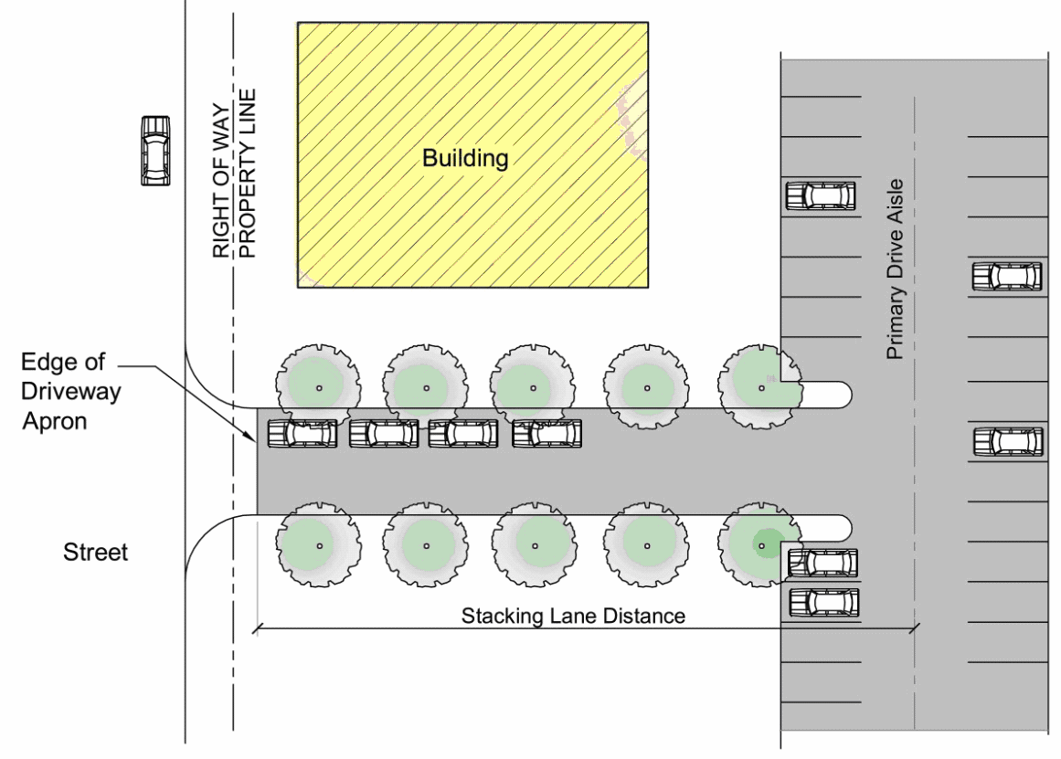
Figure 23-6-1(F)(5)c: Stacking Lane for a Parking Lot Entrance
d.
Driveway Design
1.
Minimum Driveway Width
Except for driveways serving single-family dwellings, two-family dwellings, three- to four-family dwellings, and manufactured homes, all driveways shall comply with the following minimum width requirements:
A.
One-way driveways shall be at least 20 feet wide, as measured between the backs of curbs or edge of paving.
B.
Two-way driveways shall be at least 22 feet wide, as measured between the backs of curbs or edge of paving, except that a two-way driveway may be less than 22 feet wide if it is less than 50 feet long or serves a surface off-street parking area with six or fewer parking spaces.
2.
Medians in Driveway Entrances
Medians may be provided within driveway entrance drives provided:
A.
The median is surrounded by valley or "roll" curbing;
B.
No signage is included within the median other than a monument sign not exceeding a height of five feet;
C.
Planted material within the median is limited to understory trees, shrubs, and ground cover; and
D.
The minimum aisle width is maintained for each travel and turning lane.
e.
Primary Drive Aisles
Primary drive aisles within or serving off-street surface parking lots with 400 or more spaces shall be designed to appear as an extension of the public street network extending from the public right-of-way along the full length of the primary façades of structures being served by the drive, and shall meet the following standards:
1.
Primary drive aisles shall have a maximum cross section width of 38 feet to accommodate two travel lanes and parallel parking spaces along both sides of the drive aisle in areas not needed for turning movements;
2.
Primary drive aisles shall be striped to designate parallel parking spaces, where appropriate, but in no case shall parallel parking spaces be designated within 60 feet of the primary building entrance(s);
3.
A sidewalk shall be provided adjacent to the building's front façade; and
4.
Street trees shall be provided along both sides of the primary drive aisle every 50 feet, although understory trees may be used adjacent to the building façade within 40 feet of building entrances.
(See Figure 23-6-1(F)(5)e., Primary Drive Aisle.)
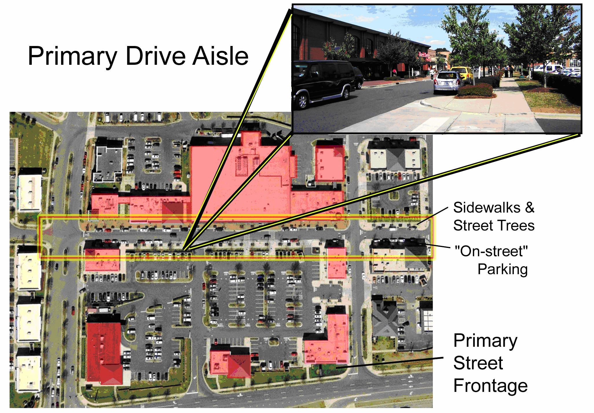
Figure 23-6-1(F)(5)e: Primary Drive Aisle
f.
Sight Triangles at Driveway Intersections
1.
Wherever a driveway intersects with a local, collector, or arterial street, unobstructed cross-visibility shall be provided between the heights of three and seven feet above the grade elevation of the roadway within sight triangles at each side of the intersecting driveway. Each sight triangle shall be measured from a point where the curb or edge-of-pavement line for the roadway and the extended edge of the driveway meet, to a point along the driveway edge located 15 feet behind the roadway's curb or edge-of-pavement line, to a point along the roadway curb or edge-of-pavement line located 30 feet from the original point—see Figure 23-6-1(F)(5)f, Sight Triangle at Driveway Intersection.
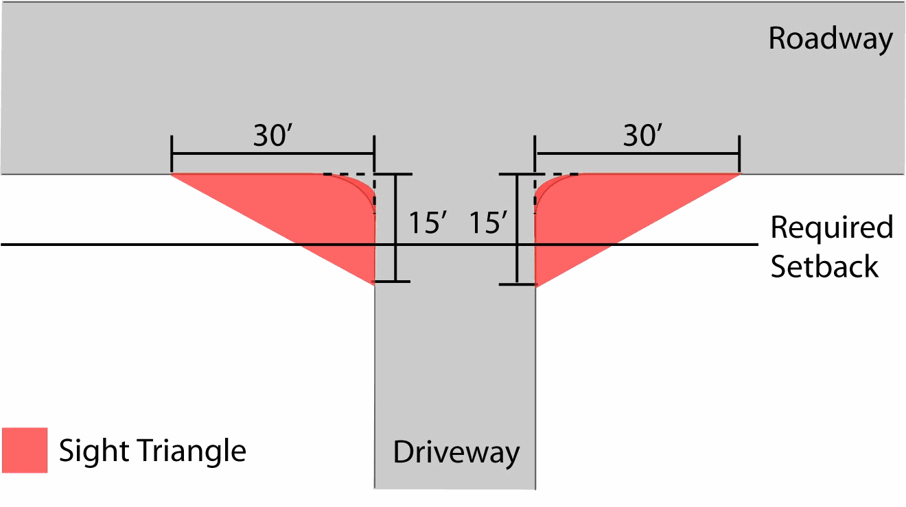
Figure 23-6-1(F)(5)f.1.: Sight Triangle at Driveway Intersection
2.
Within the sight triangles, no fence, wall, sign, earthworks, hedge, shrub, or other structure or planting shall be located, maintained, or permitted to grow between the heights of three and seven feet above the grade elevation of the adjacent road. Public safety and utility devices (such as street light, street sign, and telephone poles) and trees less than 12 inches in diameter are exempt from these standards, provided their number and location is limited, and the limbs and foliage of any such trees are trimmed, so as to ensure provision of the required unobstructed cross-visibility. (See Figure 23-6-1(F)(5)f.2., Sight Triangle Clear Visibility.)
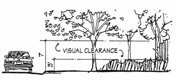
Figure 23-6-1(F)(5)f.2: Sight Triangle Clear Visibility
g.
Traffic Control and Calming Measures
Traffic-calming measures—such as, but not limited to, diverters, street gardens, and curvilinear alignments—shall be integrated into a development's vehicular circulation system where necessary to mitigate the impact of potential future cut-through traffic.
h.
Roadway Layout and Design
Roadways shall be arranged and designed in accordance with Section 23-7-4, Street Standards.
(Ord. No. 2535, § 1, 10-24-2023)
(G) - Pedestrian Access and Circulation
(1)
Required Pedestrian Access
a.
General
All new development except single-family detached dwellings, two-family dwellings, three- to four-family dwellings, and manufactured homes shall be served by a system of walkways (including sidewalks, pedestrian paths, and trails) that permits safe, convenient, efficient, and orderly movement of pedestrians among the following origin and destination points within the development, as well as between the internal walkway system and the existing or planned external pedestrian circulation system and any adjoining public parks, greenways, schools, community centers, and shopping areas:
1.
The primary entrance(s) of buildings;
2.
Off-street parking bays serving the buildings;
3.
Any designated or planned bus stops and shelters (on-site or on an adjacent road); and
4.
Recreation facilities and other common use area and amenities.
b.
Sidewalks Required
1.
All new development shall install sidewalks on both sides of all roadways (including loop streets, cul-de-sacs, private streets, and road bridges) within the development and along the entire frontage of the development site with an existing public street (unless an existing sidewalk meeting city standards is already in place).
2.
Where the development site fronts an existing public street with insufficient right-of-way width to accommodate installation of a required sidewalk along the frontage, the developer may install a sidewalk on the development site, within a public easement running parallel and adjacent to the public street.
(2)
Pedestrian Connectivity
a.
Pedestrian Cut-Throughs
Pedestrian access easements at least eight feet wide shall be provided between the ends of cul-de-sacs and the nearest existing or proposed sidewalk, pedestrian path, or trail. Such easements shall also be provided through the center of blocks that exceed the maximum block length standards in Section 23-7-3(B), Blocks, where necessary to provide convenient pedestrian access within the development, as well as to adjacent transit stops or stations, community facilities, and shopping areas. (See Figure 23-6-1(G)(2)a, Pedestrian Cut-Through at End of Cul-de-Sac.)
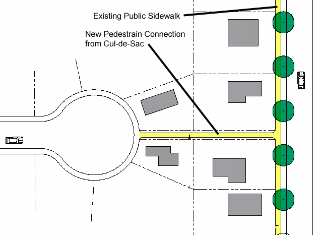
Figure 23-6-1(G)(2)a: Pedestrian Cut-Through at End of Cul-de-Sac
b.
Walkway Connections to/from Adjoining Development and Developable Land
1.
The pedestrian access and circulation system for a development shall incorporate the continuation and connection of walkways and/or associated rights-of-way or easements extended (or "stubbed out") to the boundary of the development site from existing or approved adjoining developments, and shall provide for the extension or connection of proposed internal walkways and associated rights-of-way or easements to those boundaries of the development site that adjoin potentially developable or redevelopable land.
2.
The Director of Community Development may waive or modify the requirements or standards for extension of a walkway from or to adjoining property on determining that such extension is impractical or undesirable because it would require crossing a significant physical barrier or environmentally sensitive area (e.g., railroads, watercourses, floodplains, wetlands).
c.
Cross Access between Adjoining Development
All new multifamily, nonresidential, and mixed-use development, except within the Downtown (DT) District, shall comply with the following standards:
1.
The internal pedestrian circulation system shall be designed to allow for pedestrian walkway cross-access between the development's buildings and parking areas and those on adjoining lots containing a multifamily, nonresidential, or mixed-use development, or to the boundary of adjoining vacant land zoned to allow multifamily, nonresidential, or mixed-use development.
2.
The Director of Community Development may waive or modify the requirement for pedestrian cross-access on determining that such cross-access is impractical or undesirable due to the presence of topographic conditions, natural features, or safety factors.
3.
Easements allowing cross-access to and from properties served by a pedestrian cross-access, along with agreements defining maintenance responsibilities of property owners, shall be recorded with the Office of the Chancery Clerk of Harrison County before issuance of a Certificate of Zoning Compliance for the development.
(3)
General Walkway Layout and Design
a.
General Walkway Standards
Required pedestrian walkways shall:
1.
Be at least five feet wide, and meet any additional width requirements set forth elsewhere in this Ordinance;
2.
Be distinguishable from traffic lanes they cross by painted markings, a change in pavement material or color, raised paving height, decorative bollards, and/or flashing caution signals;
3.
Be emphasized with special design features—such as shade structures (e.g., arcades and porticos), pedestrian light features, bollards, seat walls or benches, drinking water fountains, and landscape planters—that establish them as areas where pedestrians are physically separated from the flow of vehicular traffic and/or are protected from the elements;
4.
Have adequate lighting for security and safety;
5.
Be centrally located on the subject property;
6.
Be ADA accessible; and
7.
Not include barriers that limit pedestrian access between the subject property and adjacent properties.
b.
Pedestrian Walkways through Parking Areas and Parking Garages
1.
All parking lots containing more than 50 parking spaces shall include clearly identified pedestrian routes from the parking stalls to the primary building entrance or to a sidewalk providing direct access to the primary building entrance. At a minimum, walkways shall be provided for every three driving aisles or at intervals not more than 150 feet apart, whichever is less.
2.
Pedestrian walkways may not use vehicle entrance or exit driveways from the parking area to a public right-of-way.
3.
Pedestrian walkways shall connect from the parking spaces to the primary entrance of the building served by the parking or to a sidewalk with direct access to the primary building entrance.
(See Figure 23-6-1(G)(3)b., Vehicle Use Area Configuration.)
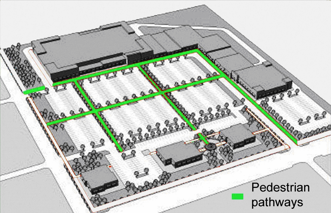
Figure 23-6-1(G)(3)b: Vehicle Use Area Configuration
(A) - Purpose and Intent
The purpose of this section is to ensure provision of off-street parking and loading facilities in proportion to the generalized parking and loading demand of the different uses allowed by this Ordinance. The standards in this section are intended to provide for adequate off-street parking and loading while allowing the flexibility needed to accommodate alternative solutions. The standards are also intended to achieve city policies of supporting development and redevelopment of the downtown and the commercial corridors, accommodating appropriate infill development, and encouraging pedestrian-oriented development while avoiding excessive paved surface areas, promoting low impact development, and safeguarding historic resources.
(B) - Applicability
(1)
New Development
All new development shall provide off-street parking and loading areas in accordance with the standards of this section.
(2)
Existing Development
a.
Change in Use
Any change in use of an existing development shall provide any additional off-street parking and loading facilities required for the change in use to comply with this section.
b.
Expansion and Enlargement
If an existing structure or use is expanded or enlarged (in terms of the number of dwelling units, floor area, number of employees, seating capacity, or other size unit used in this section to determine the minimum number of off-street parking spaces or loading berths required for the applicable use), additional off-street parking and loading spaces shall be provided in accordance with the requirements of this section to serve the expanded or enlarged part of the structure or use.
c.
Upgrading of Nonconforming Parking
Nonconforming parking facilities on the site of a remodeled structure or expanded structure or use area shall comply with the requirements of this section in accordance with the standards of Section 23-8-6, Nonconforming Site Features.
(C) - General Standards for Off-Street Parking and Loading Areas
(1)
Use of Parking and Loading Areas
a.
Business Districts
Off-street parking areas required by this section shall be used solely for the parking of licensed motorized vehicles in operating condition. Required parking spaces and loading berths may not be used for the display of goods for sale, or the sale, lease, storage, dismantling, or service of any vehicles, boats, motor homes, campers, mobile homes, building materials, equipment, or supplies.
b.
Residential Districts
1.
Required off-street parking areas are to be used solely for the parking of licensed motor vehicles in operating condition.
2.
In addition to the standard driveway parking spaces provided in conjunction with any single-family residence, an additional off-street parking or storage space for one recreational vehicle or one passenger vehicle may be provided within any front or side street setback area, provided no vehicle exceeds eight feet in height and 25 feet in length.
(2)
Identified as to Purpose and Location
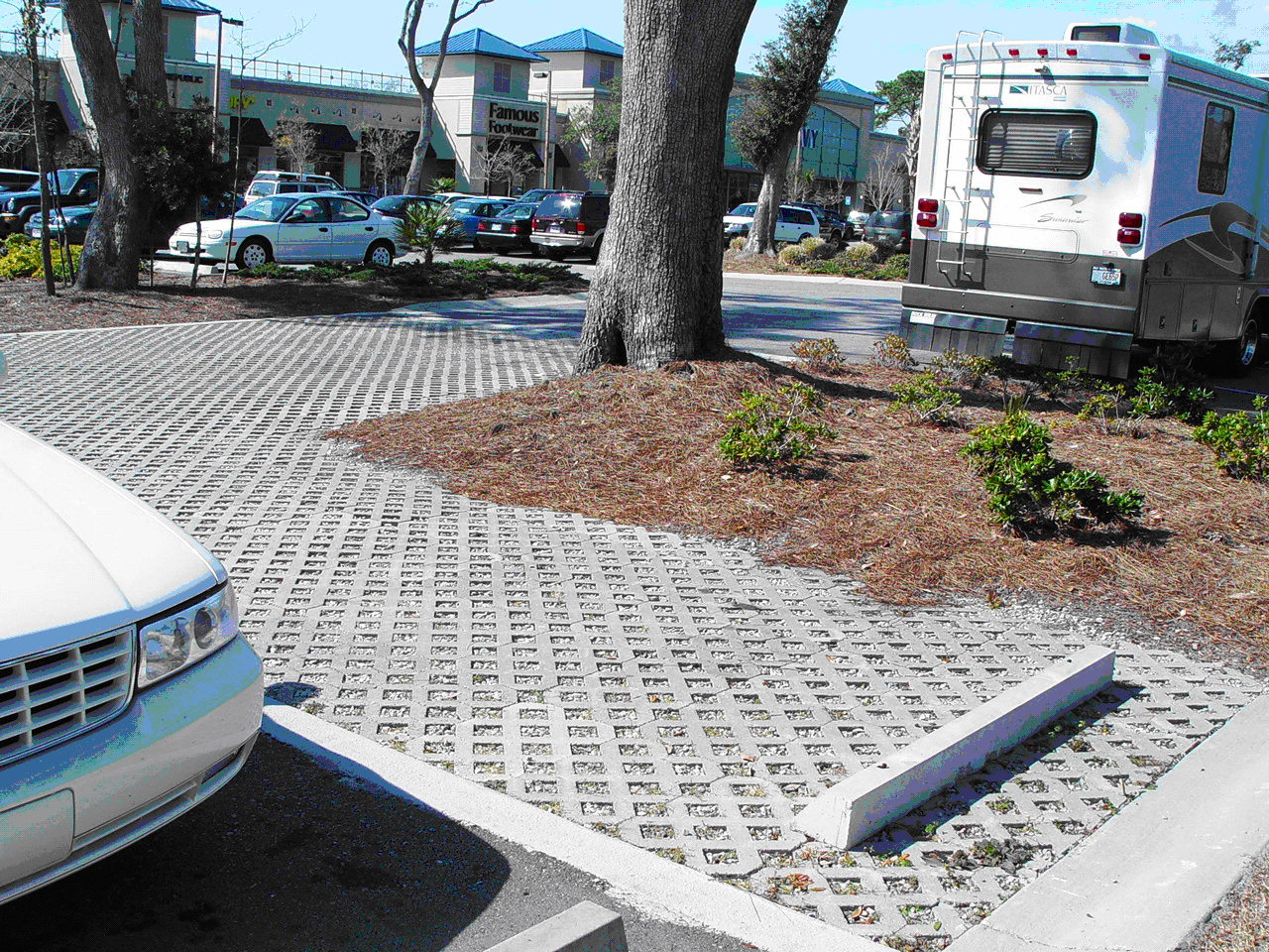
Figure 23-6-2(C)(4): Use of Alterative Materials in a Parking Lot
Off-street parking areas of three or more spaces and all off-street loading areas shall include painted lines, wheel stops, or other methods of identifying individual parking spaces and loading berths and distinguishing such spaces or berths from aisles.
(3)
Surfacing
Except as provided for in Section 23-6-2(C)(4), Alternative Materials, all off-street parking and loading areas shall be surfaced with asphalt, concrete, brick, stone, pavers, aligned concrete strips, or an equivalent material. These surfaces shall be maintained in a smooth, well-graded, clean, orderly, and dust-free condition.
(4)
Alternative Materials
The use of pervious or semi-pervious parking area surfacing materials—including, but not limited to, grass, mulch, "grass-crete," or recycled materials such as glass, rubber, used asphalt, brick, block, and concrete—may be approved for up to 25 percent of the required off-street parking and loading areas on a site, provided such areas are properly maintained. Where possible, such materials should be used in areas proximate to and in combination with on-site stormwater control devices. See Figure 23-6-2(C)(4), Use of Alternative Materials in a Parking Lot.
(5)
Arrangement
a.
Convenient Access
1.
Off-street parking and loading areas shall be arranged for convenient access to and from all parking spaces and to facilitate ease of mobility, ample clearance, and safety of vehicles and pedestrians.
2.
Off-street parking areas with three or more spaces shall be arranged so no parking or maneuvering incidental to parking shall occur on a public street or sidewalk, and so an automobile may be parked or unparked without moving another automobile (except as provided in Section 23-6-2(H)(4), Valet and Tandem Parking).
b.
Backing onto Streets Prohibited
Except for parking areas serving single-family detached dwellings, all off-street parking and loading areas shall be arranged so that no vehicle is required to back out from such areas directly onto a street.
(6)
Drainage
All off-street parking and loading areas shall be properly drained so as to eliminate standing water and prevent damage to abutting land and public streets and alleys.
(7)
Exterior Lighting
When lighted, off-street parking and loading areas shall be lighted so as to prevent glare or illumination exceeding maximum allowable levels on adjacent land (See Table 23-6-8(E)(3), Maximum Illumination Levels.), and unless exempted, shall comply with the standards of Section 23-6-8, Exterior Lighting.
(8)
Landscaping
Except for off-street parking areas serving single-family dwellings, two-family dwellings, or three- to four-family dwellings of 5,000 square feet in size or less, all off-street parking and loading areas shall comply with the standards of Section 23-6-3(D), Vehicular Use Area Landscaping.
(9)
Curbs and Motor Vehicle Stops
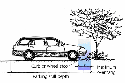
Figure 23-6-2(C)(9): Curb or Wheel Stop Preventing Vehicle Hanging over Landscaped
Area
All off-street parking and loading areas shall provide curbs, motor vehicle stops, or similar devices to prevent vehicles from overhanging a public right-of-way, sidewalk, walkway, landscape area, or adjacent property. (See Figure 23-6-2(C)(9), Curb or Wheel Stop Preventing Vehicle Hanging over Landscaped Area.)
(10)
Maintained in Good Repair
a.
Maintained at All Times
All off-street parking and loading areas shall be maintained in safe condition and good repair at all times so as not to constitute a hazard to public safety or a visual or aesthetic nuisance to surrounding land.
b.
Periodically Restored
All off-street parking and loading areas shall be periodically painted or otherwise restored to maintain a clear identification of separate parking spaces or loading berths.
(11)
Completion
All off-street parking and loading areas shall be completed prior to the issuance of a Certificate of Occupancy (See Section 23-2-4(O), Certificate of Occupancy) for the development they serve. In the case of phased development, off-street parking and loading areas should only be provided for the portions of the development to which Site Plan approval (See Section 23-2-4(E), Site Plan Approval) or subdivision approval (See Section 23-2-4(F), Subdivision Approval) applies, as appropriate.
(D) - Off-Street Parking Standards
(1)
Parking Plan Required
If a proposed development subject to Site Plan approval (See Section 23-2-4(E), Site Plan Approval) or subdivision approval (See Section 23-2-4(F), Subdivision Approval) is required to provide more than three off-street parking spaces, a parking plan shall be submitted with the application for Site Plan approval or subdivision approval, as appropriate. The parking plan shall accurately designate the required parking spaces, access aisles, and driveways, and the relation of the off-street parking facilities to the development they are designed to serve, including how the parking facilities coordinate with the vehicular and pedestrian access and circulation systems for the development.
(2)
Minimum Number of Off-Street Parking Spaces
Unless otherwise expressly stated in this section, the minimum number of off-street parking spaces shall be provided in accordance with Table 23-6-2(D)(2), Minimum Number of Off-Street Parking Spaces.
(3)
Downtown District Exempt from Parking Space Requirements
Development in the Downtown (DT) District shall be exempt from the minimum number of off-street parking spaces required in Table 23-6-2(D)(2), Minimum Number of Off-Street Parking Standards.
(4)
Uses with Variable Parking Demand Characteristics
Uses listed in Table 23-6-2(D)(2), Minimum Number of Off-Street Parking Spaces that refer to this subsection have widely varying parking and loading demand characteristics, making it difficult to establish a single appropriate off-street parking or loading standard for each. On receiving a development application for such a proposed use, the Director of Community Development is authorized to:
a.
Apply the minimum off-street parking space requirement specified in Table 23-6-2(D)(2) for the listed use that is deemed most similar to the proposed use; or
b.
Establish the minimum off-street parking space requirement by reference to standard parking resources published by the National Parking Association or the American Planning Association; or
c.
Establish the minimum off-street parking space requirement based on a parking demand study prepared by the applicant that estimates parking demand based on the recommendations of the Institute of Traffic Engineers (ITE) or other acceptable source of parking demand data, and includes relevant data collected from uses or combinations of uses that are the same or comparable to the proposed use in terms of density, scale, bulk, area, type of activity, and location.
(5)
Multiple Uses
Unless otherwise approved, development containing more than one use shall provide parking spaces in an amount equal to the total of the requirements applied to all individual uses. This provision shall not limit the opportunity to reduce the minimum number of required off-street parking spaces through approval of an alternative parking plan that justifies the feasibility of shared parking (See Section 23-6-2(H)(2), Shared Parking.) or a transportation demand management plan (See Section 23-6-2(I)(2), Transportation Demand Management.).
(6)
Maximum Number of Off-Street Parking Spaces
For any use listed under the commercial use classification in Table 23-6-2(D)(2), Minimum Number of Off-Street Parking Spaces, the number of off-street parking spaces shall not exceed 125 percent of the minimum number of parking spaces required, except that additional parking spaces may be allowed through approval of an alternative parking plan in accordance with Section 23-6-2(H)(1), Provision over Maximum Allowed.
(E) - Calculation of Off-Street Parking Space Requirements
(1)
Fractions
When computation of the number of required parking spaces results in a fraction, the result shall be rounded upward to the next highest whole number.
(2)
Seat-Based Standards
Where the minimum off-street parking space requirement is based on the number of seats, all computations shall be based on the design capacity of the areas used for seating.
(3)
Floor-Area-Based Standards
Except as otherwise provided in this section, where the minimum off-street parking space requirement is based on square feet of floor area, all computations shall be based on gross floor area.
(4)
Occupancy- or Capacity-Based Standards
Except as otherwise provided in this section, where the minimum off-street parking space requirement is based on the number of employees, students, or residents, all computations shall be based on the largest number of persons working on any single shift (for employees), maximum enrollment (for students), or the maximum fire-rated capacity (for residents), whichever is applicable.
(5)
On-Street Parking
Except as otherwise provided in this section, on-street parking on public or private streets, driveways, or drives shall not be used to satisfy the off-street parking standards of this section.
(6)
Driveways Used to Satisfy Requirements
For single-family detached dwellings and two- to four-family dwellings, driveways may be used to satisfy minimum off-street parking space requirements, provided sufficient space is available to satisfy the standards of this section and this Ordinance.
(F) - Accessible Parking Spaces for Physically Disabled Persons
In each off-street parking area, a portion of the total number of off-street parking spaces shall be spaces specifically designated, located, and reserved for use by persons with physical disabilities ("accessible parking spaces"), in accordance with the standards of this subsection.
(1)
Residential Uses
Residential uses shall provide at least one accessible off-street parking space for each dwelling unit designated for occupancy by the physically disabled.
(2)
Hospital Outpatient Facilities
For hospital outpatient facilities (facilities or units located in hospitals and providing regular and continuing medical treatment without an overnight stay), at least ten percent of the total number of off-street parking spaces serving the facility shall be accessible parking spaces.
(3)
Rehabilitation Facilities and Outpatient Physical Therapy Facilities
For rehabilitation facilities specializing in treating conditions that affect mobility and outpatient physical therapy facilities, at least 20 percent of the total number of off-street parking spaces serving the facility shall be accessible parking spaces.
(4)
Other Nonresidential Uses
Off-street parking areas for nonresidential uses other than hospital outpatient facilities, rehabilitation facilities, and outpatient physical therapy facilities shall include the minimum total number of accessible parking spaces and the minimum number of van accessible parking spaces established in Table 23-6-2(D)(2), Minimum Number of Accessible Off-Street Parking Spaces. Accessible off-street parking spaces count toward meeting the minimum off-street parking space requirements.
(5)
Location
a.
Required accessible off-street parking spaces serving a particular building shall be located to provide occupants of vehicles using the spaces the shortest accessible route of travel to an entrance of the building that is accessible to the physically disabled. Where the building has multiple accessible entrances, the location of required accessible off-street parking spaces shall be dispersed in close proximity to each of the accessible entrances.
b.
Required accessible off-street parking spaces within a parking structure that does not serve a particular building shall be located to provide occupants of vehicles using the spaces the shortest accessible route of travel to a pedestrian entrance of the parking structure that is accessible to the physically disabled.
(6)
Accessible Parking Space Dimensions
All accessible parking spaces shall be at least nine feet wide and shall have the same depth as the adjacent off-street parking spaces.
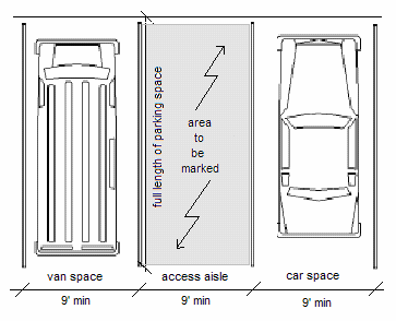
Figure 23-6-2(F)(7): Accessible Parking Space and Access Aisle Dimensions
(7)
Access Aisles
a.
All accessible parking spaces (whether for a van or car) shall abut an access aisle at least nine feet wide and extending the full length of the parking spaces they serve. (See Figure 23-6-2(F)(7), Accessible Parking Space and Aisle Dimensions.)
b.
Two accessible parking spaces may share a common access aisle.
c.
Access aisles may be placed on either side of the parking space except for angled van accessible parking spaces, which shall have the access aisle located on the passenger side of the parking space.
d.
Access aisles shall be at the same level as the accessible parking spaces they serve.
(8)
Signage and Markings
a.
Each accessible parking space shall be designated as reserved for persons with disabilities by pavement markings and a sign showing the symbol of accessibility. Access aisles shall be marked so as to discourage parking in them.
b.
Van accessible parking spaces shall be designated by an additional "Van Accessible" sign mounted below the signage showing the symbol of accessibility. Such additional signage is not required if all accessible parking spaces comply with the dimensional standards for van accessible parking spaces.
c.
Signs identifying accessible parking spaces must be posted directly in front of the accessible parking space at a height of at least five feet. Such signs shall be located so they cannot be obscured by a vehicle parked in the space.
(9)
Accessible Passenger Loading Zones
a.
Parking facilities providing valet parking services and mechanical access parking garages shall provide at least one passenger loading zone accessible to persons with physical disabilities ("accessible passenger loading zone"). Licensed medical care and long-term care facilities where the period of stay exceeds 24 hours shall provide a passenger loading zone close to least one accessible entrance to the facility.
b.
Accessible passenger loading zones shall include a vehicular pull-up space at least nine feet wide and 23 feet long and a parallel access aisle that is at least five feet wide, extending the length of the pull-up space, and adjoins an accessible route of travel to an accessible building entrance or an accessible parking facility entrance, as appropriate.
(10)
Vertical Clearance
A vertical clearance of at least eight feet shall be provided at all accessible parking or vehicular pull-up spaces and adjoining access aisles, and along at least one vehicle access route between such spaces and vehicular access points to and from the development.
(11)
Maximum Slope
The slope of accessible parking or vehicular pull-up spaces and adjoining access aisles shall not exceed two percent in any direction.
(G) - Dimensional Standards for Parking Spaces and Aisles
(1)
General
Standard car parking spaces and parking lot aisles shall comply with the dimensional standards established in Table 23-6-2(G)(1), Dimensional Standards for Parking Spaces and Aisles.
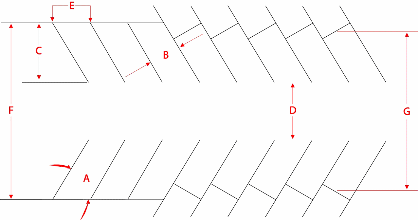
Figure 23-6-2(G)(1): Measurement of Parking Space and Aisle Dimensions
(2)
Compact Spaces
a.
When Allowed
The Director of Community Development is authorized to approve the use of compact parking spaces for up to 20 percent of required employee parking on determining that the need for compact parking spaces is supported by a parking study prepared by the applicant.
b.
Compact Space Standards
1.
Each compact car parking space shall be at least eight feet wide and 16 feet deep.
2.
Compact car spaces shall be designated by signage and/or pavement marking.
(3)
Vertical Clearance
All off-street parking spaces must have a minimum overhead clearance of seven feet.
(4)
Reduction for Planter and Sidewalk Overhangs
When a parking space abuts a landscape island or planter, the front two feet of the required parking space length may overhang the planter, provided that wheel stops or curbing are provided.
(5)
Spaces Near Obstructions
When the side of a parking space adjoins a wall, column, or other obstruction that is taller than six inches, the width of the parking space shall be increased by two feet on the obstructed side, provided that the increase may be reduced by three inches for each 12 inches of unobstructed distance from the edge of a required aisle, up to a maximum of four feet and measured parallel to the depth of the parking space.
(6)
Markings
a.
Each required off-street parking space and off-street parking facility shall be identified by surface markings that are arranged to provide for orderly and safe loading, unloading, parking, and storage of vehicles. Such markings—including striping, directional arrows, lettering on signs and in handicapped-designated areas, and field color—shall be maintained so as to be readily visible at all times.
b.
One-way and two-way accesses into required parking facilities shall be identified by directional arrows. Any two-way access located at any angle other than 90 degrees to a street shall be marked with a traffic separation stripe running the length of the access. This requirement does not apply to aisles.
(7)
Surfacing and Maintenance
All off-street parking areas must be paved and kept in a dust-free condition at all times.
(8)
Placement
The location or placement of off-street parking areas on a development site shall be limited in accordance with the standards of Section 23-6-1, Access and Circulation, Section 23-6-9, Multifamily Design Standards, Section 23-6-10, Commercial Design Standards, and Section 23-6-11, Transitional Standards, as appropriate.
(9)
Minimum Separation
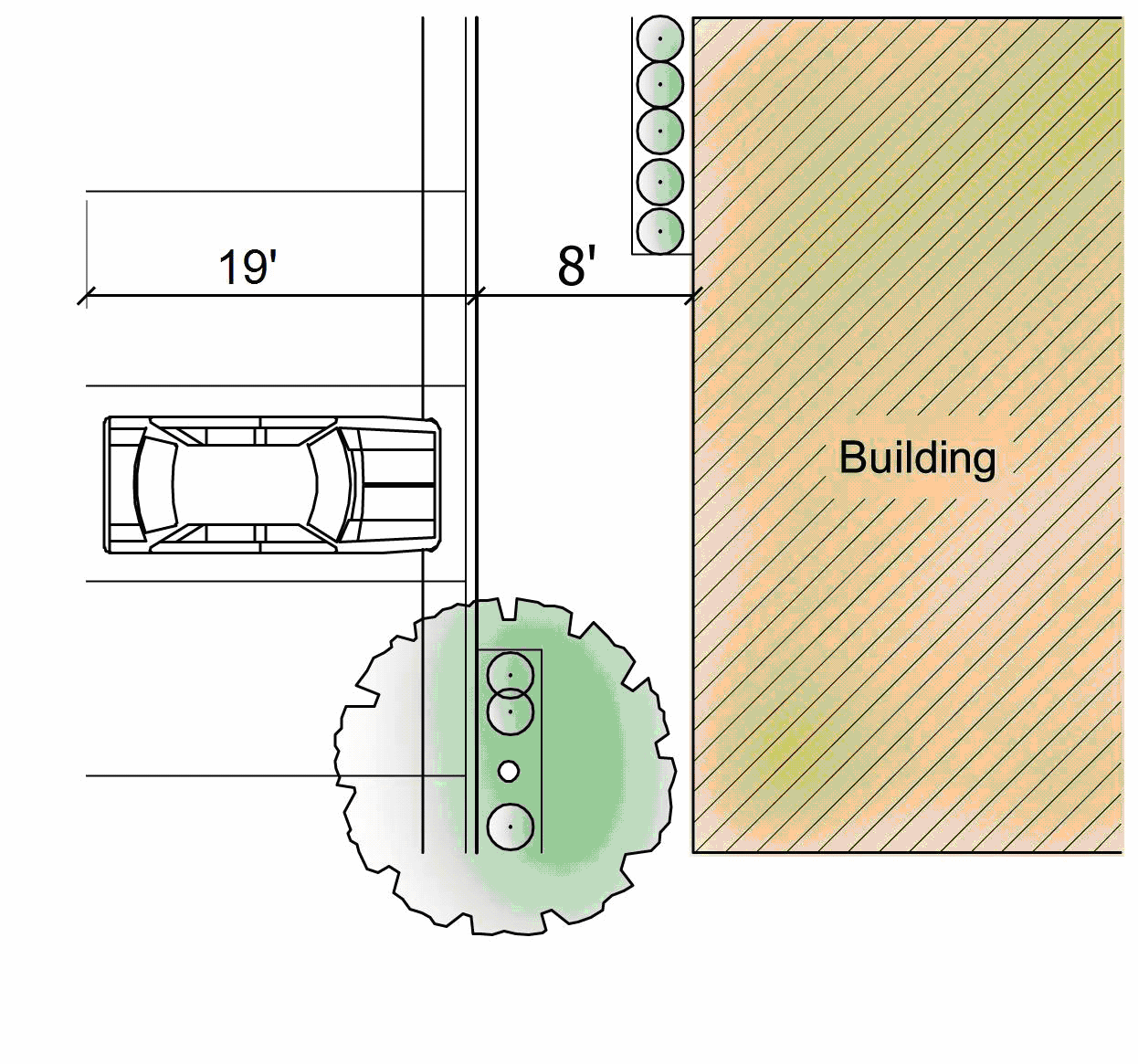
Figure 23-6-2(G)(9): Minimum Separation of Parking
All off-street parking areas shall be separated at least eight feet from buildings to allow room for sidewalks, landscaping, and other plantings between the building and the parking area. This separation may be eliminated to the rear of buildings in areas designed for unloading and loading of materials. (See Figure 23-6-2(G)(9), Minimum Separation of Parking.)
(H) - Off-Street Parking Alternatives
The Director of Community Development shall be authorized to approve an alternative parking plan that proposes alternatives to providing the minimum number of required off-street parking spaces required by Table 6.2.D.2, Minimum Number of Off-Street Parking Spaces, in accordance with the standards listed below. The alternative parking plan shall be submitted with an application for Site Plan approval (See Section 23-2-4(E), Site Plan Approval) or subdivision approval (See Section 23-2-4(E), Subdivision Approval), as appropriate. Nothing in this subsection shall limit the utilization of one or more of the following off-street parking alternatives by a single use.
(1)
Provision over Maximum Allowed
Proposals to exceed the maximum number of off-street parking spaces allowed by Section 23-6-2(D)(2) Maximum Number of Off-Street Parking Spaces, shall comply with the following standards:
a.
Parking Demand Study
An alternative parking plan proposing to exceed the maximum number of off-street parking spaces allowed shall include a parking demand study demonstrating how the maximum number of parking spaces specified by Section 23-6-2(D)(2), Maximum Number of Off-Street Parking Spaces, is insufficient for the proposed development.
b.
Limited to Minimum Needed
The total number of off-street parking spaces allowed shall not exceed the minimum number of spaces demonstrated to be needed by the required parking demand study.
(2)
Shared Parking
Proposals for shared parking—that is, use of parking spaces to meet the minimum number of off-street parking spaces required for more than one use—shall comply with the following standards:
a.
Location
1.
Shared parking spaces shall be located within 500 linear feet of the primary entrances of all uses served, unless remote shuttle bus service is provided.
2.
Shared parking spaces shall not be separated from the use they serve by an arterial or collector street unless pedestrian access across the arterial or collector street is provided by a grade-separated pedestrian walkway or appropriate traffic controls, or remote parking shuttle bus service is provided.
b.
Pedestrian Access
Adequate and safe pedestrian access must be provided from and to the shared parking areas.
c.
Maximum Shared Spaces
The maximum reduction in the number of parking spaces required for all uses sharing the parking area shall be 50 percent.
d.
Directional Signage
Directional signage that complies with the standards of this Ordinance shall be provided to direct the public to the shared parking spaces.
e.
Shared Parking Plan
1.
Justification
The alternative parking plan shall include a shared parking plan justifying the feasibility of shared parking. The shared parking plan shall address, at a minimum, the size and type of the proposed development, the composition of tenants, the anticipated rate of parking turnover, and the anticipated peak parking and traffic loads for all uses that will be sharing off-street parking spaces.
2.
Recorded Agreement
An approved shared parking plan shall be enforced through written agreement among all owners of record, which shall be submitted to the Director of Community Development for review and approval. An attested copy of an approved agreement shall be recorded with the Office of the Chancery Court of Harrison County before issuance of a Certificate of Zoning Compliance (Section 23-2-4(L)) for any use to be served by the shared parking area. A shared parking agreement may be terminated only if all required off-street parking spaces are provided in accordance with this section.
(3)
Off-Site Parking
Proposals for off-site parking—that is, location of off-street parking spaces required for a use on a lot separate from the lot containing the use—shall comply with the following standards.
a.
Ineligible Uses
Off-site parking may not be used to satisfy the minimum number of off-street parking spaces required for residential uses (except for extra guest parking), restaurants, convenience stores, or other convenience-oriented uses, and may be used to satisfy no more than 50 percent of the minimum number of off-street parking spaces required for any other use. In addition, required parking spaces reserved for persons with disabilities may not be located off-site.
b.
Location
1.
Off-site parking spaces shall be located within 500 linear feet from the primary entrance of the use served (measured along the shortest legal pedestrian route), unless a remote parking shuttle bus service is provided.
2.
Off-site parking spaces shall not be separated from the use they serve by a major street, secondary street, or collector street unless pedestrian access across the street is provided by a grade-separated pedestrian walkway or appropriate traffic controls, or a remote parking shuttle bus service is provided.
c.
Zoning Classification
The zoning district classification of the off-site parking area shall be the same or a more intensive zoning classification than that required for the use served.
d.
Agreement for Off-Site Parking
If land containing the off-site parking area is not under the same ownership as land containing the principal use served, the off-site parking arrangement shall be established in a written agreement between the record landowners that guarantees use of the off-site parking area for at least 20 years. An attested copy of the agreement shall be submitted to the Director of Community Development for review and approval and the approved agreement shall be recorded before issuance of a Certificate of Zoning Compliance for any use to be served by the off-site parking area. An off-site parking agreement may be terminated only if all required off-street parking spaces are provided in accordance with this section. No use served by the off-site parking may be continued if the off-site parking is removed unless substitute off-street parking spaces are provided in accordance with this section.
(4)
Valet and Tandem Parking
Proposals to use valet or tandem parking to meet the minimum off-street parking standards for uses listed under the commercial use classification in Table 23-6-2(D)(2), Minimum Number of Off-Street Parking Spaces, shall comply with the following standards:
a.
The development served by the valet or tandem parking shall provide 75 or more off-street parking spaces; and
b.
No more than 30 percent of the total number of parking spaces shall be designated for valet or tandem spaces; and
c.
The development shall provide a designated drop-off and pick-up area. The drop-off and pick-up area may be located adjacent to the building served, but may not be located in a fire lane or where its use would impede vehicular and/or pedestrian circulation or cause queuing in a public street or internal drive aisle serving the development; and
d.
Guarantees shall be provided that a valet parking attendant will be on duty during hours of operation of the uses served by the valet or tandem parking.
(5)
On-Street Parking
Proposals for use of on-street parking spaces to meet a portion of the minimum number of off-street parking spaces required for a use shall comply with the following:
a.
The use is located within a LB, NB, CB, RB, or WF Zoning District;
b.
The on-street parking spaces are located within 500 linear feet of walking distance from the primary entrance of the proposed use;
c.
No more than 25 percent of the off-street parking requirement is met through the use of on-street parking; and
d.
There is no negative impact to existing or planned traffic circulation patterns.
(I) - Parking Reduction Incentives
(1)
Transit Accessibility
The Director of Community Development may authorize up to a 15 percent reduction in the number of off-street parking spaces required for uses located within 1,000 feet of a bus or rapid transit stop that is served at intervals of 30 minutes or less between the hours of 7:00 a.m. and 9:00 a.m. And the hours of 4:00 p.m. and 6:00 p.m.
(2)
Transportation Demand Management
The Director of Community Development may, through approval of a transportation demand management plan (TDM plan), authorize up to a 15 percent reduction in the number of off-street parking spaces required for large employers (defined for purposes of this section as those with at least 500 employees) within a nonresidential or mixed-use development with a minimum overall area of ten acres.
a.
Required TDM Plan
The TDM plan shall include facts and/or projections (e.g., type of development, proximity to transit and/or other multi-modal systems, anticipated number of employees and/or patrons, minimum parking requirements) and indicate the types of transportation demand management activities that will be instituted to reduce single-occupant vehicle use and reduce traffic congestion.
b.
Transportation Demand Management Activities
To qualify for a reduction in the minimum number of required off-street parking spaces, the TDM plan shall provide at least three of the following transportation demand management activities:
1.
Establishment of a development-specific website that provides multi-modal transportation information such as real-time travel/traffic information, bus routes, bus schedules and maps and alternative commute log (bicycle, pedestrian, carpool, and vanpool).
2.
Written disclosure of transportation information and educational materials to all employees.
3.
Formation of transportation demand reduction programs such as carpooling, vanpooling, ridesharing, guaranteed ride home, teleworking, and shuttle service programs.
4.
Creation of a Preferential Parking Management Plan that specifically marks spaces for registered carpool and/or vanpool vehicles that are located near building entrances or in other preferential locations.
5.
Institution of off-peak work schedules that allow employees to arrive and depart at times other than the peak morning commute period (defined as 7:00 a.m. to 9:00 a.m.) and peak evening commute period (defined as 5:00 p.m. to 7:00 p.m.).
6.
Establishment of an office, staffed by a transportation coordinator, that makes transportation and ride-sharing information available to employees, residents, and nonresidents.
7.
Any other transportation demand management activity as may be approved by the Director of Community Development as a means of complying with the parking reduction incentive provisions of this subsection.
c.
Transportation Program Manager/Coordinator
1.
The applicant shall appoint a program coordinator to oversee transportation demand management activities.
2.
The program coordinator shall be a qualified or trained TDM professional.
3.
The transportation coordinator shall be appointed prior to issuance of a Building Permit or Certificate of Occupancy for the buildings to be served by the transportation demand management program.
d.
TDM Annual Report
The program coordinator shall provide the Director of Community Development an annual report that details the implementation strategies for the approved TDM plan. The report may include the following:
1.
A description of the transportation management activities efforts;
2.
A list of current tenants and number of employees for each tenant;
3.
A parking-reduction analysis based on employee and/or resident use of ridership programs or alternative transportation options;
4.
Changes to the TDM plan to increase ridership; and
5.
An employee transportation survey.
e.
Recordation
A copy of the approved TDM plan shall be recorded with the Office of the Chancery Clerk of Harrison County before issuance of a Building Permit for the development to be served by the plan. The TDM plan shall be recorded against the property, and the applicant and/or successors of interest shall be responsible for the plan in perpetuity on the property.
f.
Enforcement
The TDM plan shall be considered terminated, and the required off-street parking spaces shall be provided in accordance with requirements in this section, if:
1.
The program coordinator fails to submit an annual report to the Director of Community Development in a timely fashion, not to exceed 60 days after the report deadline, or
2.
The applicant no longer implements the program.
g.
Amendments
The Director of Community Development may approve amendments to an approved TDM plan following the same process required for the initial approval.
(3)
Special Facilities for Bicycle Commuters
The Director of Community Development may authorize up to a five percent reduction in the minimum number of off-street parking spaces required for development that provides both of the following:
a.
Enclosed (indoor or locker) and secure bicycle parking spaces equal to at least five percent of the number of vehicle parking spaces provided; and
b.
Shower and dressing areas for employees.
(4)
Other Eligible Alternatives
The Director of Community Development may approve any other parking-reduction incentive that reduces minimum off-street parking space requirements in exchange for strategies that will effectively reduce parking demand on the site of the subject development, provided the alternative does not result in more than a ten percent modification of the minimum number of off-street parking spaces required. Such alternatives may only be approved if the applicant demonstrates to the satisfaction of the Director of Community Development that the proposed plan will do at least as good a job protecting surrounding neighborhoods, maintaining traffic-circulation patterns, and promoting quality urban design as would strict compliance with the otherwise applicable off-street parking standards.
(J) - Loading Area Standards
(1)
Required Off-Street Loading Berths
The following uses shall provide on-street loading areas or berths in accordance with the requirements in Table 23-6-2(J)(1), Minimum Number of Off-Street Loading Berths.
(2)
Reduced Loading Berth Standards in Certain Districts
Development within the Downtown (DT) District is exempted from the minimum number of off-street loading berths required in Table 23-6-2(J)(1), Minimum Number of Off-Street Loading Berths.
(3)
Standards
a.
Minimum Dimensions
Each loading space required by this subsection shall be at least 12 feet wide and 25 feet deep, with at least 14 feet of overhead clearance. Each off-street loading space shall have adequate, unobstructed means for the ingress and egress of vehicles that typically use it. (See Figure 23-6-2(J)(3)a, Off-Street Loading Area.)
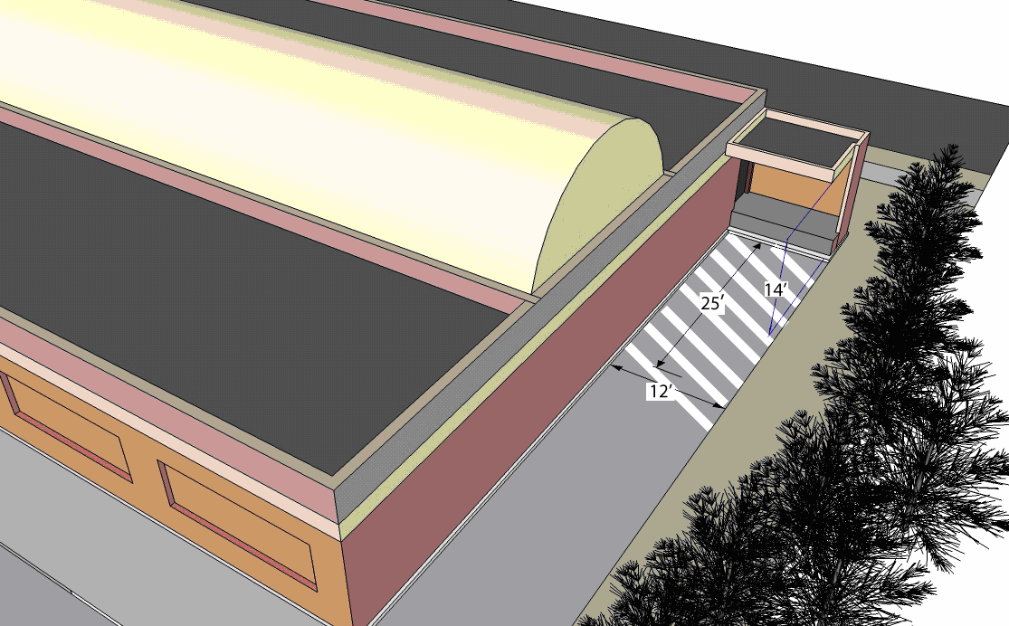
Figure 23-6-2(J)(3)a: Off-Street Loading Area
b.
Location
Where possible, loading areas shall be located to the rear of the use they serve. In addition, the loading area shall be located adjacent to the buildings loading doors, in an area that promotes their practical use.
c.
Delineation of Loading Spaces
All loading spaces shall be delineated by signage and striping and labeling of the pavement.
d.
Access to a Street
Every loading area shall be provided with safe and convenient access to a street, but in no case shall the loading space extend into the required aisle of the parking lot.
e.
Paving
The ground surface of loading areas shall be paved with a durable, dust free, and hard material, such as surface and seal treatment, bituminous hot mix, Portland cement, concrete, or some comparable material. Such paving shall be maintained for safe and convenient use at all times.
f.
Landscaping
Loading areas shall be landscaped in accordance with Section 23-6-3(D), Vehicular Use Area Landscaping.
g.
Exterior Lighting
Exterior lighting for loading areas shall comply with the standards in Section 23-6-8, Exterior Lighting.
(Ord. No. 2220, § 1(Exh. C), 12-11-2012; Ord. No. 2255, § 1, 5-20-2014)
(A) - Section Organization
These landscaping standards are organized into nine main subsections. They include:
(1)
Section 23-6-3(B), Purpose and Intent, which sets out the purpose and intent for the standards;
(2)
Section 23-6-3(C), General Standards for Landscaping, which includes the applicability provisions, requirements for landscaping plans, and standards for new plantings;
(3)
Section 23-6-3(D), Vehicular Use Area Landscaping, which contains the standards for landscaping around the perimeter and within vehicular use areas;
(4)
Section 23-6-3(E), Perimeter Buffers, which includes the landscaping buffer standards applied to the edges of some developments and base zoning districts;
(5)
Section 23-6-3(F), Street Trees, which includes requirements for provision of street trees;
(6)
Section 23-6-3(G), Screening, which sets out the screening requirements for site features like refuse, loading, and service areas;
(7)
Section 23-6-3(H), Stormwater Pond Landscaping, which contains the landscaping requirements for stormwater retention and detention pond facilities;
(8)
Section 23-6-3(I), Alternative Landscaping Plan, which sets out the standards and procedure for review of alternative landscaping plans; and
(9)
Section 23-6-3(J), Other Landscaping Standards, which includes the other landscaping standards, installation timing, maintenance, monitoring for compliance, and incentives.
(B) - Purpose and Intent
It is the purpose of this section to promote and protect the public health, safety and general welfare by providing for the planting, maintenance, and preservation of trees, shrubs, and other plants within the city. The intent of this section is to promote this purpose by:
(1)
Ensuring and encouraging the planting, maintenance, restoration, and survival of trees, shrubs, and groundcover;
(2)
Ensuring the protection of community residents and visitors from personal injury and property damage, and the protection of the city from property damage, caused or threatened by the improper planting, maintenance, or removal of trees, shrubs, or other plants;
(3)
Mitigating against erosion and sedimentation;
(4)
Reducing stormwater runoff and the costs associated therewith;
(5)
Preserving and protecting the water table and surface waters;
(6)
Reducing audible noise from automobiles and land uses;
(7)
Restoring soils and land denuded as a result of construction or grading;
(8)
Increasing the tree canopy to provide shade and moderate the effect of urban heat islands;
(9)
Limiting glare created by exterior lighting;
(10)
Reducing visual pollution from the urban environment and increasing privacy between incompatible uses;
(11)
Safeguarding and enhancing property values and protecting public and private investment;
(12)
Preserving and protecting the aesthetic qualities that contribute to the city's unique character and the economic benefits such qualities attract;
(13)
Helping differentiate streets and other areas of the public realm from private lands;
(14)
Providing additional improvements to air quality through the oxygen production and carbon dioxide uptake provided by trees and landscaping; and
(15)
Providing visual screening, where appropriate.
(C) - General Requirements for Landscaping
(1)
Applicability of Landscaping Standards
a.
General
Except where expressly exempted, these standards shall apply to all development in the city.
b.
Review for Compliance
Review for compliance with the standards of this section shall occur during review of an application for approval of a Site Plan (Section 23-2-4(E)), Major Subdivision Preliminary Plat (Section 23-2-4(F)(6)), or Certificate of Zoning Compliance (Section 23-2-4(L)), as appropriate.
c.
Existing Development
1.
Change in Use
Any change in use of an existing development shall provide any additional off-street landscaping required for the new use to comply with this section.
2.
Expansion and Enlargement
If an existing structure or use is expanded or enlarged (in terms of the number of dwelling units, floor area, number of employees, seating capacity, or other size unit), additional landscaping shall be provided in accordance with the requirements of this section to serve the expanded or enlarged part of the structure or use.
3.
Upgrading of Nonconforming Landscaping
Nonconforming landscaping on the site of a remodeled structure or expanded structure shall comply with the requirements of this section in accordance with the standards of Section 23-8-6, Nonconforming Site Features.
(2)
Landscape Plans Required
To ensure compliance with the standards of this section, a landscape plan demonstrating how landscaping will be planted on a development site shall be included as a part of any application for approval of a Major Site Plan (Section 23-2-4(E)), Major Subdivision Preliminary Plat (Section 23-2-4(F)(5)), or Certificate of Zoning Compliance (Section 23-2-4(L)), as appropriate. Landscape plans shall be prepared in accordance with the requirements in the Administrative Manual.
(3)
New Planting Standards
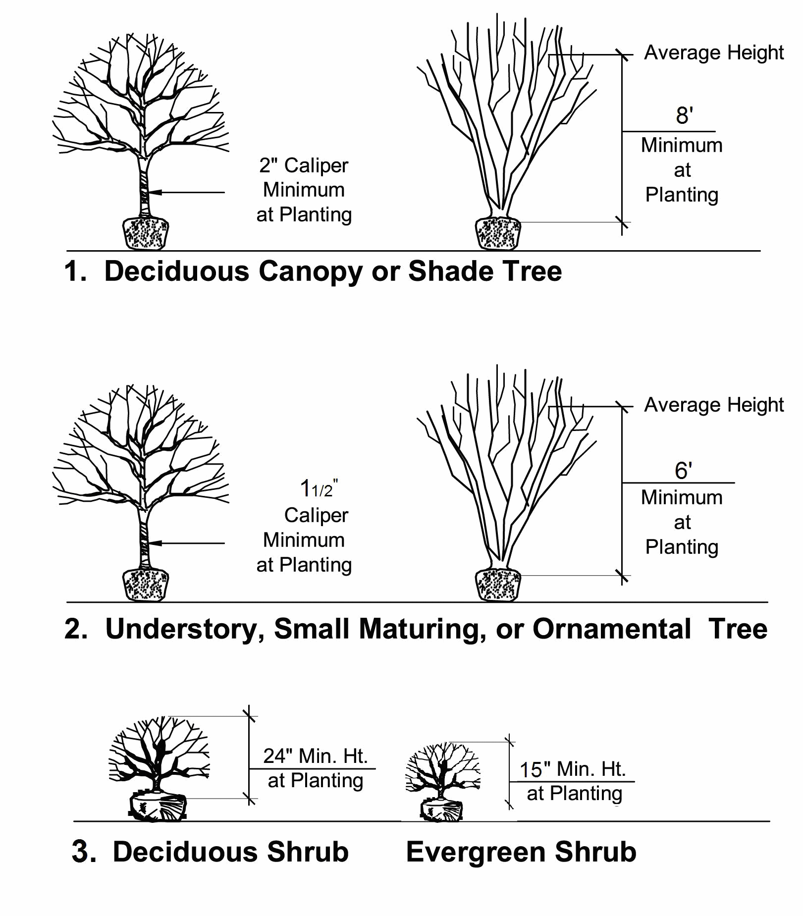
Figure 23-6-3(C)(3): Minimum New Planting Standards
New plantings provided in accordance with this section shall comply with the following standards:
a.
Minimum Size at Time of Planting
1.
At the time of planting, deciduous and evergreen canopy or shade trees shall have a caliper of at least two inches, as determined in the American Standard for Nursery Stock, ANSI Z60.1-2004, as amended, and shall be at least eight feet in height above ground level.
2.
At the time of planting, understory, small maturing, or ornamental trees shall have a caliper of at least one and one-half inches, as determined in the American Standard for Nursery Stock, ANSI Z60.1-2004, as amended, and shall be at least six feet in height above ground level.
3.
Large deciduous or evergreen shrubs shall be upright in nature and be a minimum of 24 inches in height at the time of planting.
4.
Small deciduous and evergreen shrubs shall be at least 15 inches in height at the time of planting.
5.
Where an aggregate caliper inch (ACI) requirement is utilized to derive a required amount of vegetation, and the ACI figure includes a fraction, an applicant may:
A.
Utilize a tree or trees with a caliper inch measurement exceeding the minimum size at planting standard to meet the required ACI; or
B.
Round the ACI figure upwards until the figure corresponds with a whole number of trees meeting the minimum size at time of planting standard.
6.
When trees exceeding the minimum size at time of planting standard are proposed, the minimum calipers of such trees shall be clearly noted on the PD Master Plan, Site Plan, or Preliminary Plat, as appropriate.
7.
Where application of the requirements in this subsection results in a fraction in the number of shrubs to be provided, the minimum number of shrubs or trees to be provided shall be rounded upwards to the next highest whole number. (See Figure 23-6-3(C)(3), Minimum New Planting Standards.)
b.
Plant Materials
1.
All planting materials shall correspond to the approved materials listed in the Administrative Manual, unless alternative materials are proposed as part of an alternative landscape plan (See Section 23-6-3(I), Alternative Landscaping Plan.).
2.
All landscape plant materials shall conform to the latest version of the American Standard of Nursery Stock (ANSI Z60.1, as amended). Plant material shall be of standard quality or better, true to name and type of species or variety.
3.
The use of native, drought tolerant vegetation is encouraged to reduce dependency upon irrigation.
c.
Plant Diversity
To curtail the spread of disease or insect infestation in a plant species, new tree plantings shall comply with the following standards:
1.
When fewer than 20 trees are required on a site, at least two different species shall be utilized, in roughly equal proportions.
2.
When more than 20 but fewer than 40 trees are required to be planted on a site, at least three different species shall be utilized, in roughly equal proportions.
3.
When 40 or more trees are required on a site, at least four different species shall be utilized, in roughly equal proportions.
4.
Nothing in this subsection shall be construed to prevent the utilization of a larger number of different species than specified above.
(4)
Existing Vegetation
Existing healthy, well-formed canopy and understory trees as well as healthy shrubs shall be credited toward the requirements of this section, provided the vegetation meets the minimum size standards of this Ordinance, and is protected before and during development of the site in accordance with Section 23-6-4(H), Tree Protection during Construction, and maintained thereafter in a healthy growing condition.
(5)
Stabilization
All required landscape planting areas shall be stabilized and maintained with lawn, ground covers, mulches, or other approved materials to prevent soil erosion and allow rainwater infiltration.
(6)
Berms
All berms shall comply with the following design standards:
a.
Berms shall have a slope not exceeding a horizontal to vertical ratio of two to one, a top width at least one-half the berm height, and a height at least eight feet above the toe of the berm.
b.
All berms, regardless of size, shall be stabilized with a ground cover or other suitable vegetation.
c.
Berms proposed to be placed along street rights-of-way shall be designed and constructed to provide adequate sight distances at intersections and shall not impair safe operation of vehicles.
d.
In no case shall berms damage the roots or trunks of existing healthy vegetation designated to be preserved.
(7)
Easements
Nothing except groundcover shall be planted or installed within any underground or overhead utility, drainage, or gas easement, or within three feet of a fire protection system, without the consent of the utility provider, easement holder, or the city, as appropriate.
(D) - Vehicular Use Area Landscaping
Except where exempted by Section 23-6-3(D)(1), Exemptions, all vehicular use areas shall include landscaping both within the interior of the vehicular use area and around its perimeter, as a means of mitigating the parking area's microclimate and visual impacts.
(1)
Exemptions
The following uses shall be exempt from the standards of this subsection:
a.
Single-family detached residential development;
b.
Two-family dwellings;
c.
Three- to four-family dwellings;
d.
Manufactured homes; and
e.
Off-street surface vehicular use areas with five or fewer spaces.
(2)
Interior Landscaping Standards
Vehicular use areas shall provide and maintain landscaped planting areas within the interior of the vehicular use area in accordance with the standards in this subsection. These standards shall not apply to parking structures or vehicle display areas.
a.
Configuration
Interior planting areas shall be designed in accordance with the following standards:
1.
Islands shall be located at the end of parking bays and have an area of at least 152 square feet for single-loaded parking bays, and at least 304 square feet for double-loaded bays.
2.
Off-street surface parking areas with 500 or more spaces shall be organized into a series of smaller modules of 25,000 square feet or less per module, and be visually separated by continuous landscaped islands at least 11 feet wide that contain pedestrian pathways located at least every six parking bays.
3.
Landscaped planting areas shall be distributed throughout the parking area for the purpose of heat abatement.
4.
Driveway medians with shrubs shall be at least four feet wide and six feet long and driveway medians with shrubs and understory trees shall be at least six feet wide.
5.
No parking space shall be separated from the trunk of a deciduous canopy tree by more than 60 feet. Perimeter vehicular use area landscaping or other required landscaping may be used to meet this requirement.
6.
Each interior planting island shall contain canopy or understory trees at the minimum rate of one and one-half aggregate caliper inches (ACI) per every 152 square feet, or portion thereof, of the total vehicular use area. (See Figure 23-6-1(G)(3)b., Vehicular Use Area Configuration.)
b.
Screened Backfill
Soil utilized in vehicular use area islands, driveway medians, and other areas internal to a vehicular use area shall be screened prior to deposition in planting areas.
c.
Protection of Planting Areas
All planting areas shall be protected from vehicle damage by the installation of curbing, wheel stops, or other comparable methods. This standard shall not prohibit the use of planting areas as on-site stormwater management devices.
(3)
Perimeter Landscaping Strips
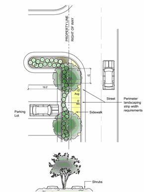
Figure 23-6-3(D)(3): Perimeter Landscaping Strip
Where a vehicular use area serving a use subject to these standards abuts a street right-of-way, vacant land, or any other development (except another vehicular use area), perimeter landscaping strips shall be provided and maintained between the vehicle use area and the abutting right-of-way or property line in accordance with the following standards. (See Figure 23-6-3(D)(3), Perimeter Landscaping Strip.)
a.
Location
1.
Perimeter landscaping strips shall be located on the same land as the vehicular use area, and shall be placed to assure visibility and safety of pedestrians on the public street and within the vehicular use area.
2.
Perimeter landscaping strips may not be placed within future street rights-of-way as identified in the Biloxi Thoroughfare Plan.
b.
Minimum Width
When a vehicular use area is located within 50 feet of a street right-of-way, the perimeter landscaping shall be located within a planting strip at least eight feet wide. In all other instances, the strip shall be the minimum width necessary to assure required landscaping is not damaged by vehicles or other on-site activity. In no instance shall the strip be less than three feet wide.
c.
Continuous, Opaque Visual Screen Required
Perimeter landscaping strips shall form a continuous, opaque visual screen, excluding required sight clearances at driveways.
d.
Protection of from Vehicular Damage
The perimeter landscaping strip shall be protected from vehicular damage by the installation of curbing, wheel stops, extra width in the landscaping strip, or other method approved by the Director of Community Development.
e.
Planting Height
1.
Shrubs associated with the perimeter landscaping strip shall be maintained at a minimum height of three feet above the surface elevation of the adjacent vehicular use area within four years of planting. To allow security surveillance of parking areas, the maximum height of shrubs in the perimeter landscaping strip shall be five feet.
2.
The perimeter landscaping strip shall allow compliance with all city, state, and federal highway sight distance standards.
f.
Required Materials
1.
Evergreen shrubs shall be used to form the continuous, opaque visual screen in the perimeter landscaping strip.
2.
In addition to the evergreen shrub requirements, each perimeter landscaping strip shall include at least eight aggregate caliper inches (ACI) of canopy trees per 100 linear feet of landscaping strip. Understory trees may be used beneath overhead utilities.
g.
Adjacent to Perimeter Buffers
Perimeter landscaping strips associated with a vehicle use area may be credited towards perimeter buffer standards (See Section 23-6-3(E), Perimeter Buffers.), provided the minimum buffer standards of this section are met.
(4)
Incentives
a.
The total aggregate caliper inch (ACI) requirements for canopy and understory trees in this subsection may be reduced by five percent when:
1.
At least 30 percent of the required parking is located to the side or rear of the building;
2.
At least 30 percent of the total required parking is subject to a shared parking agreement (See Section 23-6-2(H)(2), Shared Parking); or
3.
Pervious parking surfacing is used for 20 percent or more of the total vehicular use area.
b.
Nothing shall prohibit the combination of these incentives or the resulting cumulative reduction in the amount of required tree ACI.
(E) - Perimeter Buffers
(1)
Purpose and Intent
Perimeter landscape buffers are intended to mitigate potential negative effects of contiguous uses in different zoning districts.
(2)
Applicability
Except for single-family detached dwellings and uses in the Downtown (DT) district, all development shall provide a perimeter landscape buffer to separate it from a different existing use on abutting land, or from vacant abutting land in a different zoning district, in accordance with Table 23-6-3(E)(3), Buffer Types, and Table 23-6-3(E)(4), Buffer Type Application.
(3)
Types of Buffers
Table 23-6-3(E)(3), Buffer Types, describes four different types of perimeter buffer in terms of their function, opacity, width, and planting requirements. Where a particular buffer type is required in Table 26-6-3(E)(4), Buffer Type Application, the requirement may be met with the combination of minimum buffer width and minimum screening requirements specified under either Option 1 or Option 2. The option used shall be designated on the site plan for the development. Where an option utilizing a berm or fence is selected, the berm or fence shall comply with the standards of Section 23-6-3(C)(6), Berms, or Section 23-6-7, Fences and Walls, as appropriate.
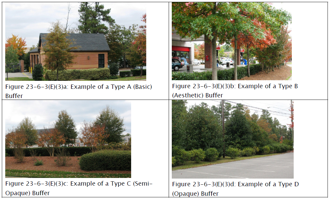
Table 23-6-3(E)(3): Buffer Types
(4)
Buffer Type Application
Table 23-6-3(E)(4), Buffer Type Application, specifies the type of perimeter landscape buffer that new development shall provide between it and adjacent property, based on the proposed use type on the development site and the existing use type on the abutting property or the zoning district in which abutting vacant property is located. The buffer type is indicated by a letter corresponding to one of the four buffer types depicted in Table 23-6-3(E)(3), Buffer Types.
(5)
Development Abutting Existing Buffer
Where a developing parcel abuts an existing use and application of a perimeter buffer is required by Table 23-6-3(E)(4), Buffer Type Application, the developing parcel shall provide the entire minimum perimeter buffer width and screening required by Table 23-6-3(E)(3), Buffer Types, unless a portion or all of a perimeter buffer that complies with the standards of this section already exists between the parcels. Where such an existing buffer does not fully comply with the width and screening standards for the required buffer type, the developing parcel shall be responsible for providing all the additional buffer width and planting material necessary to meet the standards of this section.
(6)
Location of Buffers
Perimeter buffers required by this section shall be located along the outer perimeter of the parcel and shall extend to the parcel boundary line or right-of-way line; however, the perimeter buffer may be located along shared access easements between parcels in nonresidential developments.
(7)
Development within Required Buffers
a.
The required buffer shall not contain any development, impervious surfaces, or site features (except fences or walls) that do not function to meet the standards of this section or that require removal of existing vegetation, unless otherwise permitted in this Ordinance.
b.
Sidewalks, trails, and other elements associated with passive recreation may be placed in perimeter buffers if all required landscaping is provided and damage to existing vegetation is minimized to the maximum extent practicable.
c.
Overhead and underground utilities required or allowed by the city are permitted in buffers, but shall minimize the impact to vegetation, to the maximum extent practicable. Where required landscaping material is damaged or removed due to utility activity within a required buffer, the landowner shall be responsible for replanting all damaged or removed vegetation as necessary to ensure the buffer meets the standards in this Ordinance.
(8)
Sight Triangles
No fencing, berms, walls, or other landscaping features may exceed a height of three feet above grade within required sight triangles for streets, alleys, or driveways.
(9)
Credit for Existing Vegetation
Existing vegetation located within the perimeter buffer area that meets the size standards of Section 23-6-3(C)(3), New Planting Standards, may be preserved and credited toward the perimeter buffer standards.
(10)
Credit for Required Landscaping
Required landscaping associated with perimeter landscaping around a vehicular use area or stormwater pond, or with required screening located within ten feet of the perimeter buffer, may be credited towards the perimeter buffer requirements of this subsection.
(F) - Street Trees
(1)
Where Required
Except in the following circumstances, street trees shall be required along both sides of all streets except alleys.
a.
Development of Agricultural uses in the A, RE, and RER Districts; or
b.
Development of a lot in a residential subdivision where there are no street trees on the block face.
(2)
Location
Street trees shall be planted between the back of the curb and the sidewalk, and shall be located at least three feet from the edge of the pavement.
(3)
Configuration
a.
Street trees shall be canopy trees except beneath overhead utilities or other projections into the public right-of-way, where understory trees shall be located.
b.
Within the Downtown (DT) District and other urbanized areas where planting strips behind the curb do not exist or are impractical, street trees shall be located within tree pits of at least 25 square feet in size. Tree pits may be located adjacent to the back of the curb.
c.
All trees planted along rights-of-way maintained by the Mississippi Department of Transportation (MDOT) shall conform to MDOT guidelines.
(4)
Maximum On-Center Spacing
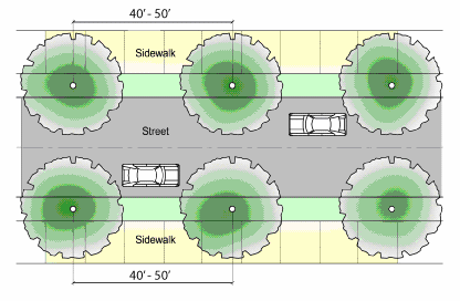
Figure 23-6-3(F)(4): Street Tree Spacing
a.
Canopy trees shall be spaced between 40 and 50 feet on center. (See Figure 23-6-3(F)(4), Street Tree Spacing.)
b.
Understory trees shall be spaced between 20 and 30 feet on center;
c.
Wherever possible, small and medium trees shall be placed between large trees to accommodate the canopy growth of large trees over time.
(G) - Screening
(1)
General Requirements
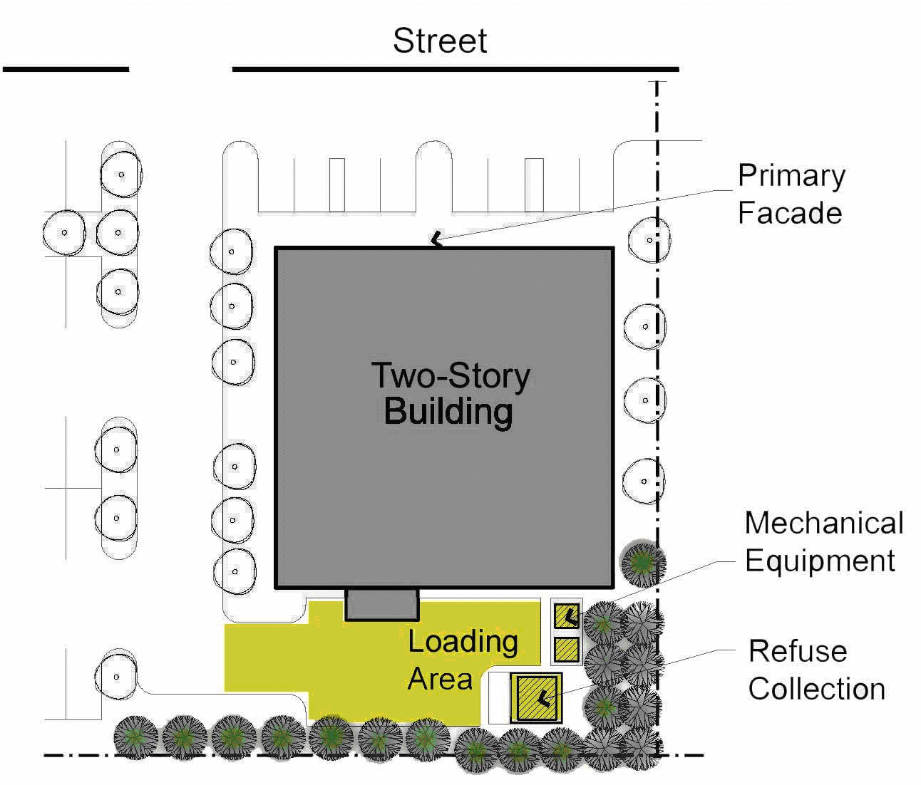
Figure 23-6-3(G)(3)a: Screening Methods (General)
In addition to the other forms of required landscaping, screening shall be required to conceal specific areas of high visual or auditory impact or hazardous areas from off-site views. Such areas shall be screened at all times, unless otherwise specified, regardless of adjacent uses, districts, or other proximate landscaping material.
(2)
Items to be Screened
The following areas shall be screened in accordance with this section:
a.
Large waste receptacles (e.g., dumpsters and cardboard recycling containers) and refuse collection areas;
b.
Loading and service areas;
c.
Outdoor storage areas (including, but not limited to, inoperable vehicles, appliances, tires, manufactured homes, building materials, equipment, raw materials, and above-ground storage tanks) located within 200 feet of a public right-of-way; and
d.
Ground-level mechanical equipment and utility meters.
(3)
Screening Methods
a.
The following items are permitted for use as screening materials, and more than one method may be used on a development site.
1.
Vegetative materials that provide a fully opaque screen to the minimum height necessary to fully screen the facility from off-site views; or
2.
An opaque fence or wall consistent with the standards in Section 23-6-7, Fences and Walls.
b.
Alternative screening materials that are not listed, or alternative configurations, may be proposed as part of an alternative landscaping plan (See Section 23-6-3(I).), if the alternative materials or configuration provide an equivalent or superior screening function.
(See Figures 23-6-3(G)(3)a, Screening Methods (General) and 23-6-3(G)(3)b, Screening Methods (Detail).)
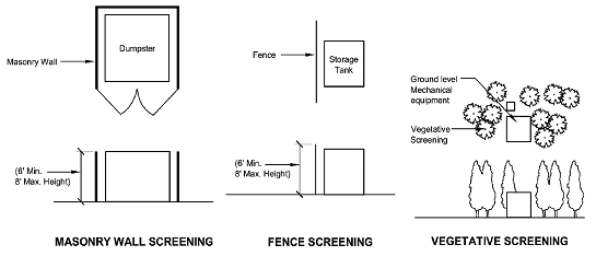
Figure 23-6-3(G)(3)b: Screening Methods (Detail)
(4)
Configuration of Vegetative Materials
Where vegetative materials are used for screening a site feature in accordance with this subsection, the vegetative materials shall:
a.
Be planted around the perimeter of the site feature in a manner that screens it from all off-site views;
b.
Be configured in two staggered rows or other arrangement that provides maximum screening;
c.
Consist of upright, large, evergreen shrubs capable of reaching at least six feet in height within three years of planting; and
d.
Be spaced no farther than three feet on-center.
(5)
Large Waste Receptacles and Refuse Collection Areas
Except for facilities serving individual single-family detached dwellings, two-family dwellings, three- to four-family dwellings, manufactured homes, and un-manned uses that do not generate any waste, all large waste receptacles and refuse collection areas shall be subject to the following standards.
a.
Depicted on Master Plans or Site Plans
The location and configuration of screening for large waste receptacles and refuse collection areas shall be depicted on all PD master plans and Site Plans.
b.
Screening Configuration
Where access to large waste receptacles and refuse collection areas faces a public right-of-way, the accessway shall be screened with an opaque gate. Chain link shall not be used for such gates.
c.
Setbacks
Large waste receptacles and refuse collection areas shall be set back at least five feet from a side or rear lot line, and shall not be located within the front or corner side setback area.
d.
Surfacing Requirements
Areas intended for large waste receptacles and refuse collection shall be surfaced with concrete that meets or exceeds minimum standards in the Administrative Manual.
e.
Drainage
Eating establishments and other uses that produce significant amounts of liquid waste shall configure areas intended for large waste receptacles and refuse collection to drain to the sanitary sewer system through grease traps or similar devices as required by the Director of Public Works.
(H) - Stormwater Pond Landscaping
(1)
Purpose
These provisions are intended to encourage stormwater retention or detention ponds to be located and configured as an open space amenity within a development site, as opposed to configuration as a utility facility. The standards do not prohibit configuration of the pond as a utility feature (instead of an amenity), but when configured as a utility, a stormwater retention or detention pond shall be fully screened from all off-site and on-site views.
(2)
Configured as a Site Amenity
a.
In General
Stormwater retention or detention ponds are considered as a site amenity when such features are integrated with the design and location of the other site features (instead of being located in a peripheral location), are designated as a site amenity on the site plan or utility plan for the development, and:
1.
Avoid the use of fencing that is higher than 30 inches;
2.
Include shrubs and other vegetative material comparable to that used in other areas of the site;
3.
Provide pedestrian access to and around the facility, where practicable;
4.
Maintain gentle slopes of 3:1 or less in the area around the facility;
5.
Avoid rip-rap or stone weirs within areas visible around the facility;
6.
Incorporate some form of fountain or other visible water circulation device;
7.
Are configured to avoid sharp drop-offs within three feet of the average water line; and
8.
Incorporate seating or other use areas.
b.
Credit towards Open Space Set-Asides
Land area occupied by stormwater management devices, including retention or detention ponds shall be counted towards the open space set-aside requirement (See Section 23-6-6, Open Space Set-Aside.), when such features are treated as a site amenity and support passive or active recreation uses.
(3)
Configured as a Utility
Stormwater retention or detention ponds configured as a utility feature (instead of a site amenity) shall comply with the following requirements:
a.
Fencing
1.
Stormwater retention or detention ponds shall be surrounded by a green or black vinyl-coated chain-link fence at least four feet high. All fences shall provide a securable entrance gate.
2.
Fences around stormwater ponds shall not be required when the site containing the pond is surrounded by a fence at least six feet high.
3.
Fences around stormwater ponds shall not be required when the depth of the pond is less than three feet, and the pond maintains a slope of 3:1 or less.
b.
Screening
1.
Shrubs
All fencing associated with a stormwater retention or detention pond, except gates, shall be fully screened by large evergreen shrubs capable of reaching at least four feet in height within three years of planting. Shrubs shall be planted with no more than five feet on-center.
2.
Understory Trees
In addition to large shrubs, understory trees shall be planted 50 feet on-center around stormwater retention or detention ponds.
(Ord. No. 2482, 5-3-2022)
(I) - Alternative Landscape Plan
(1)
General
An alternative landscape plan may be approved where a deviation from the landscaping standards in this section, or the tree protection standards in Section 23-6-4, Tree Protection, is justified because of site or development conditions that make compliance with such standards impossible or impractical. Such conditions may include:
a.
Natural conditions, such as streams or topography;
b.
The likelihood that landscaping material would be ineffective at maturity due to topography, placement, or other existing site conditions;
c.
Lot size or configuration;
d.
The presence of utility or other easements;
e.
The potential for interference with public safety; and
f.
Other situations where strict adherence to the landscaping or tree protection standards in this Ordinance are determined to be impractical by the Director of Community Development.
(2)
Submittal and Review
An applicant may submit an alternative landscape plan as part of an application for approval of a Site Plan (Section 23-2-4(E)), Major Subdivision Preliminary Plat (Section 23-2-4(F)(6)), or Certificate of Zoning Compliance (Section 23-2-4(L)), as appropriate. With input from other city staff, the Director of Community Development shall review and approve an alternative landscape plan if it meets the purpose and intent of the landscaping standards in Section 23-6-3, Landscaping Standards, or Section 23-6-4, Tree Protection, as appropriate.
(3)
Allowable Deviations
Allowable deviations from the standards of this section include, but are not limited to, the following:
a.
Reduced Planting Rates due to Public Facilities
An adjustment to planting locations or reduction of up to 20 percent in the type or total number of required caliper inches may be allowed when underground connections to public facilities or public utilities, or public easements or rights-of-way, are located on or in close proximity to the parcel.
b.
Reduction in Standards due to Nature of Parcel
A reduction in the count, spacing, or species diversity standards by up to 20 percent may be allowed when desirable in terms of enhanced protection of existing natural resources, greater consistency with the goals of the comprehensive plan, or a site design that exceeds the quality of what would otherwise result under a strict application of the standards in this Ordinance.
(J) - Other Landscaping Standards
(1)
Time for Installation of Required Landscaping
a.
Time Limit
All required landscaping (including mulching and seeding) shall be installed in accordance with the required planting standards set forth in this section before issuance of a Certificate of Occupancy unless the Director of Community Development grants an extension to this time limit in accordance with Section 23-6-3(J)(1)b, Extensions.
b.
Extensions
1.
The Director of Community Development may, for good cause shown, grant extensions to the above time limit, allowing a developer/owner to delay the installation of required landscaping. Circumstances that may warrant an extension include, but are not limited to, the following:
A.
Unusual environmental conditions, such as drought, cold weather, hurricanes, or over-saturated soil (deep mud);
B.
The inappropriateness of the current season for planting the approved plant species;
C.
Evidence that the approved plant species or required plant sizes are not commercially available and cannot be substituted within a reasonable time despite an applicant's diligent effort to secure the required materials; or
D.
Completion of utility work occurring in a proposed landscaped area that is incomplete or delayed.
2.
No extension to the time limit shall be granted unless a performance and maintenance guarantee in accordance with the requirements in Section 23-7-9, Performance and Maintenance Guarantees, is in place to ensure that all landscaping standards will be met at a predetermined later date.
3.
On receiving a performance and maintenance guarantee, the city may issue a temporary Certificate of Occupancy for a period of up to 180 days.
(2)
Maintenance of Landscaping Materials
The owner shall be responsible for the maintenance of all landscape areas not in the public right-of-way. Such areas shall be maintained in accordance with the approved landscape plan or alternative landscape plan and shall present a healthy and orderly appearance free from refuse and debris. All plant life shown on an approved landscape plan or alternative landscape plan shall be replaced if it dies, is seriously damaged, or is removed.
a.
Damage Due to Natural Occurrence
If any vegetation or physical element functioning to meet the standards of this section is severely damaged due to an unusual weather occurrence, natural catastrophe, or other natural occurrence such as damage by wild or domestic animals, the owner or developer may be required to replant or replace the vegetation or element if the landscaping standards are not being met. The owner shall have one growing season to replace or replant. In determining the extent of replanting or replacement required, the Director of Community Development shall consider the type and location of the landscape buffer or required vegetation area as well as the propensity for natural re-vegetation.
b.
Protection during Operations
The owner or developer shall take actions to protect trees and landscaping from unnecessary damage during all facility and site maintenance operations. Plants shall be maintained in a way that does not obstruct sight distances at roadway and driveway intersections, obstruct traffic signs or devices, or interfere with the use of bikeways, sidewalks, or pedestrian trails.
c.
Maintain Shape
All required trees (whether canopy, understory, or otherwise) shall be maintained in their characteristic natural shape, and shall not be severely pruned, sheared, topped, or shaped as shrubs. Trees (including, but not limited to, crape myrtles) that have been severely pruned, sheared, topped, or shaped as shrubs no longer serve the intended buffering or screening function and shall be considered as damaged vegetation in accordance with Section 23-6-3(J)(2)a, Damage Due to Natural Occurrence, and shall be replaced within one growing season.
d.
Natural Death
The natural death of existing vegetation within any required landscape area does not necessarily constitute a violation and does not require re-vegetation to replace the plant material unless the required landscape area no longer complies with the required standards of this section. In no instance shall this provision be construed to prevent re-planting if, in the opinion of the Director of Community Development, the required performance standard of the landscaping is not being met.
e.
Performance Guarantee
All initial replacement landscaping shall be subject to a two-year performance and maintenance guarantee that ensures proper replacement and maintenance, in accordance with Section 23-7-9, Performance and Maintenance Guarantees.
(3)
Monitoring of Compliance with Landscaping Standards
a.
Inspections before Certificate of Occupancy
The Director of Community Development shall inspect a development site before issuance of a Certificate of Occupancy for the development and such certificate shall not be issued if the landscaping required under this section is not living or healthy or is not installed in accordance with the approved landscape plan or alternative landscape plan, or the provisions in Section 23-6-3(J)(1)b., Extensions.
b.
Inspections after First Year
The Director of Community Development shall inspect a development site during the second growing season following the installation of required landscaping to ensure compliance with the approved landscape plan or alternative landscape plan, and to ensure that the landscaping is properly maintained. Failure to maintain required landscaping (trees and shrubs) in accordance with the standards of this subsection shall constitute a violation of this Ordinance.
(A) - Purpose and Intent
The purpose and intent of this section is to:
(1)
Preserve the cultural heritage and aesthetic qualities of the city;
(2)
Encourage site design techniques that preserve the natural environment and enhance the developed environment;
(3)
Provide for a separation of uses and establish a sense of privacy;
(4)
Minimize the impact of incompatible land uses;
(5)
Reduce glare, dust, heat, and noise;
(6)
Preserve and enhance air and water quality;
(7)
Increase slope stability, and control erosion and sediment run-off into streams and waterways;
(8)
Conserve energy by reducing heating and cooling costs;
(9)
Maintain and enhance the quality of life in the city; and
(10)
Provide incentives for Sustainable Development/Landscape Credits. (See Section 23-6-4(6).)
(B) - Applicability
(1)
General
Unless exempted in accordance with Section 23-6-4(B)(2), Exemptions, the standards in this section shall apply to all lands and development in the city.
(2)
Exemptions
The following tree removal activities are exempt from the standards of this section:
a.
The removal of dead or naturally fallen trees;
b.
The removal of diseased trees posing a threat to adjacent trees;
c.
The removal of Any Pecan (Carya illinoinensis), Chinese tallow or Popcorn (Sapium sebiferum), Water Oak (Quercus Nigra), or member of the Pine genus (Pinus spp.);
d.
The selective and limited removal of trees or vegetation necessary to obtain clear visibility at driveways or intersections;
e.
Removal of trees by the public utilities, local, state or federal government as necessary to maintain safe operations;
f.
Silvicultural activities undertaken in accordance with best management practices for forestry in Mississippi established by the Mississippi Forestry Commission; and
g.
Agricultural activities undertaken in accordance with agricultural best management practices for Mississippi established by the Mississippi Department of Environmental Quality.
(C) - Tree Permit Required
No removal of existing trees on a parcel of land or a development site shall occur before approval of a Tree Permit (Section 23-2-4(I)) unless in accordance with the unexpired approval of a Site Plan (Section 23-2-4(E)), Preliminary Plat (Section 23-2-4(F)), Certificate of Appropriateness (Section 23-2-4(G)), Public Works Permit (Section 23-2-4(H)), or Certificate of Zoning Compliance (Section 23-2-4(L)), as appropriate.
(D) - Responsibility for Compliance
Failure to comply with the standards of this section is a violation of this Ordinance subject to the remedies and penalties in this section and Article 23-9, Enforcement.
(E) - Protection of Trees
(1)
Applicability
a.
General All development in the city shall be required to support the preservation and replenishment of the native stock of trees, specifically those described as protected trees, as defined in Section 23-10-2, Terms and Uses Defined, in accordance with this subsection.
(2)
General Requirement
No protected tree may be removed, except in accordance with Section 23-6-4(E)(3), Removal of a Protected Tree. In addition, all protected trees shall have the following protections, whether located on public or private land:
a.
Cutting, Removal, or Harm Prohibited. Protected trees shall not be cut, removed, pushed over, killed, or otherwise harmed.
b.
Paving or Soil Compaction Prohibited. The area within the drip line of any protected tree shall not be subject to paving or soil compaction greater than ten percent of the total area within the drip line, if at all possible. (See Figure 23-6-4(E)(2)b., Paving or Soil Compaction Prohibited.)
(3)
Removal of a Protected Tree
Protected trees may be removed if the landowner demonstrates to the Director of Community Development one of the following conditions:
a.
Removal of a Healthy Protected Tree. A protected tree is in healthy condition, and all of the following standards are met:
1.
The landowner is otherwise in compliance with this section;
2.
The protected tree prevents development of a lot in a way that limits building area to less than otherwise allowed, or hinders compliance with the standards in Article 23-3: Zoning Districts, Article 23-5: Intensity and Dimensional Standards, Article 23-6: Development Standards, or Article 23-7: Subdivision Standards; and
3.
Mitigation is provided in accordance with Section 23-6-4-E(4), Replacement/Mitigation of Protected Trees.
b.
Removal of a Diseased, High Risk, or Dying Protected Tree. A protected tree is certified by an arborist or other qualified professional as diseased, high risk, or dying. Removal of a diseased, high risk, or dying protected tree shall not require mitigation in accordance with Section 23-6-4(E)(4), Replacement/Mitigation of Protected Trees.
(4)
Replacement/Mitigation of Protected Trees
Those causing the destruction or removal of a healthy protected tree, unless exempted, shall be responsible for the following mitigation:
a.
Replacement Trees Required
All healthy protected trees removed or destroyed shall be mitigated on a two for one basis with a tree minimum two-inch caliper tree with a minimum height of six feet tall at planting. The replacement trees shall be replanted within six months of the removal or destruction of the protected tree.
b.
Mitigation Species shall be a protected tree species (Live Oak, Bald Cypress and Southern Magnolia)
c.
Location of Replacement Trees
Replacement trees shall be either planted on the parcel of land from which the protected tree was removed, if sufficient space is available, or placed on nearby lands in accordance with Section 23-6-3(I), Alternative Landscape Plan. The Director of Community Development may allow replacement trees to be planted to provide street trees in accordance with the standards in Section 23-6-3(F), Street Trees.
d.
Mitigation Trust, in lieu of mitigation plantings
If the developer does not have the space to plant the mitigation trees onsite, they may elect to donate to the Mitigation Trust in lieu of planting mitigation trees. The donation amount will be based on the number of mitigation trees required by the cost of the purchase, planting and maintenance (Purchase Price × 2 = Cost of Mitigation Purchase, Planting, Irrigation and Maintenance).
1.
The City will establish a Mitigation Trust account to receive funds from developer in lieu of off-site mitigation.
2.
All mitigation trust planting projects shall be planted on city-owned property with protected species, or from approved City of Biloxi tree species list as defined herein, and recommended by Planning Commission and approved by City Council prior to disbursing any funds from the Mitigation Trust account and will be used exclusively for mitigation trees in accordance with the Biloxi Comprehensive Beautification Plan.
3.
All mitigation trust planting sites will be documented in the Biloxi Comprehensive Beautification Plan.
e.
Establishment Period
Replacement trees shall be maintained through an establishment period of at least three years. The applicant shall guarantee the survival and health of all replacement trees during the establishment period and guarantee any associated replacement costs (See Section 23-7-9, Performance and Maintenance Guarantees.). If the replacement trees do not survive the establishment period, the applicant shall purchase and install new replacement trees.
f.
Trees removed on residential home sites are exempt from the requirements of this section.
(F) - Tree Protection During Construction
(1)
Owner's Responsibility
During development, the owner or developer shall be responsible for the erection of any and all barriers necessary to protect any existing or installed vegetation from damage both during and after construction.
(2)
Tree Protection Fencing
a.
Where Required
Protected trees, existing tree canopy, and other existing trees being used for credit towards landscaping requirements shall be fenced with a sturdy and visible fence before grading or other development activity begins. Fencing shall be erected to protect the tree's drip line. The Director of Community Development shall consider the existing site conditions in determining the exact location of tree protection fencing. Areas located inside of tree protection fencing are considered as tree protection areas.
b.
Type of Fencing
All fencing required by this section shall be a minimum four feet high and of durable construction (i.e., plastic snow fencing or chain link). Chain link or wire fencing utilized as tree protection fencing shall not be required to be vinyl coated. Passive forms of tree protection may be utilized to delineate tree protection zones that are remote from areas of land disturbance. These must be surrounded by fencing, continuous rope, or other forms of clear delineation.
c.
Signage
Signs shall be installed on the tree protection fence visible on all sides of the fenced-in area delineating the tree protection zone.
d.
Inspection
All tree protection measures shall be inspected and approved by the Director of Community Development before start of any land disturbing activities. Failure to have tree protection measures prior to the commencement of construction is a violation of this Ordinance.
e.
When Required
No construction, grading, equipment or material storage, or any other activity shall be allowed within the fenced tree protection area. Fencing shall be maintained until after the final site inspection.
(3)
Encroachments into Tree Protection Areas
Encroachments into tree protection areas shall occur only when no other alternative exists. If such an encroachment is anticipated, the following preventive measures shall be employed:
a.
Soil Compaction
Where compaction might occur due to construction traffic or materials delivery through a tree protection area, the area must first be mulched with a minimum four-inch layer of wood chips. Equipment or materials storage shall not be allowed within a tree protection area.
b.
Fill
No fill shall be placed within a tree protection area without adequate venting to allow air and water to reach the roots.
c.
Chemical Contamination
Trees located within a tree protection area shall be protected from chemical contamination from liquids or other materials, including but not limited to paint, chemical solvents, gasoline, oil, diesel fuel, hydraulic fluid, concrete spoils, or rinse water from vehicle cleaning, including rinsing of concrete truck tanks and chutes.
d.
Paving Limitations
Except for driveway access points, sidewalks, curb, and gutter, no paving shall occur within of a tree protection area unless authorized through an alternative landscape plan. (See Section 23-6-3(I), Alternative Landscape Plan.)
(G) - Tree Preservation Incentives
(1)
Tree Preservation Credits
To encourage the preservation of as many trees as practical on a development site, credit towards the minimum landscaping requirements shall be applied to all existing trees retained on a site that are not protected trees. Credits are offered only for trees that are not required to be retained by other sections of this Ordinance. Credits shall be designated on the landscape plan for the development, and shall be granted in accordance with the following standards:
a.
A credit for trees that are not protected trees shall be credited and applied towards the vehicular use landscaping standards in Section 23-6-3(D) and the perimeter buffer standards in Section 23-6-3(E) when the trees that are saved are:
1.
Deciduous or evergreen canopy trees of four inches in caliper or greater, measured at DBH (54 inches) above ground level; or
2.
Deciduous or evergreen understory or ornamental trees of three inches in caliper or greater, measured at DBH (54 inches) above ground level.
b.
In no case shall credits substitute for more than 75 percent of the required site or vehicular use area landscaping material.
(2)
Reduction in the Minimum Number of Required Parking Spaces
Up to a ten percent reduction in the number of off-street parking spaces required on a development site shall be allowed if the reduction in the amount of required pavement will preserve the root zones of existing healthy trees with a DBH of eight inches or greater. The amount of reduction can be determined only after taking into consideration any unique site conditions and the impact of the reduction on parking needs for the use, and must be agreed upon by both the applicant and the Director of Community Development. Alternative paving materials (see Section 23-6-2(C)(4), Alternative Materials) may be allowed by the Director of Community Development in cases where required parking areas encroach upon root zones.
(Ord. No. 2475, 2-1-2022)
(A) - Wetlands
(1)
Shown on Site Plans and Plats
a.
Plans submitted as part of an application for approval of a Major Site Plan (Section 23-2-4(E)) or Preliminary Plat (Section 23-2-4(F)) shall show all existing wetlands that have been delineated or are shown on National Wetlands Inventory maps, and shall identify wetlands proposed to be filled or required to be mitigated.
b.
The Director of Community Development may require an applicant to have a wetlands delineation performed for the proposed development site if any lands suspected to be wetlands are not shown on the Site Plan or Preliminary Plat.
(2)
State and Federal Wetlands Permits
a.
An applicant for approval of a Major Site Plan or Preliminary Plat shall consult with the Mississippi Department of Marine Resources and the U.S. Army Corps of Engineers to determine whether state or federal wetlands permits are required for disturbance of wetlands or for discharge of waters into the public waters.
b.
If a state or federal wetlands permit is required, the application for approval of a Major Site Plan or Preliminary Plat shall include a copy of the application for the wetlands permit.
c.
Any approval of a Major Site Plan or Preliminary Plat shall be conditioned on all required state and federal wetland permits being obtained and submitted to the Director of Community Development before approval of a Certificate of Zoning Compliance, Public Works Permit, or Final Plat for the development, as appropriate.
(3)
Mitigation
If a state or federal wetlands permit requires mitigation for loss of wetlands, the developer shall comply with mitigation requirements by acquiring wetlands within in the City of Biloxi, if available. If wetlands are not available for acquisition in the city, then they shall be acquired elsewhere in Harrison County, if practical. If acquisition of mitigating wetlands in Harrison County is not practical, then the wetlands shall be acquired elsewhere in Mississippi.
(B) - Riparian Buffers
(1)
Intent
These riparian buffer standards are intended to protect the quality and quantity of the surface waters on which Biloxi citizens rely for drinking, storm mitigation, fishing, and the recreational and scenic functions that contribute so much to the city's economic health. Specifically, they are intended to limit development and land disturbance adjacent to surface water bodies and wetlands as necessary to protect public and private water supplies, trap sediment and other pollutants in surface runoff, promote bank stabilization, protect wetlands, protect wildlife habitat, protect fisheries, and preserve scenic beauty.
(2)
Riparian Buffer Required
a.
General
All new development shall maintain a 30-foot-wide vegetated riparian buffer adjacent to perennial surface water bodies shown on USGS quadrangle topographic maps and wetlands that have been delineated or are shown on National Wetland Inventory maps. The width of the buffer shall be measured perpendicular from the bank of a lake, pond, river, or stream, or the mean high water line of tidal waters, or the edge of wetlands. (See Figure 23-6-5(B)(2), Required Riparian Buffer.)
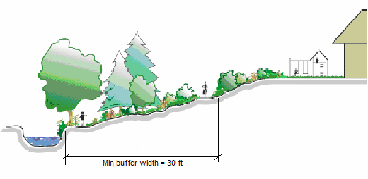
Figure 23-6-5(B)(2): Required Riparian Buffer
b.
Exceptions
The requirement for maintenance of a riparian buffer shall not apply to the following:
1.
Land within the Sand Beach (SB) Zoning District or otherwise abutting the Mississippi Sound;
2.
Land within a Waterfront (WF) Zoning District;
3.
Development of single-family detached dwellings, two-family dwellings, three- to four-family dwellings, or manufactured homes on lots within subdivisions for which, as of November 9, 2010, a plat has been recorded or a Preliminary Plat has been approved and is still valid; and
4.
Agricultural production that is consistent with state and federal laws, and agricultural best management practices for water quality established by Mississippi Soil and Water Conservation Commission.
(3)
Allowable Development within Riparian Buffers
Development allowed within a riparian buffer is limited to:
a.
Flood control structures;
b.
Perpendicular crossings by roadways and driveways (including associated sidewalks, stormwater management facilities, and utility lines);
c.
Perpendicular crossings by railroad tracks and associated maintenance corridors;
d.
Perpendicular crossings by utility lines and associated maintenance corridors;
e.
Bikeways and walkways, and other passive recreational facilities and uses that involve minimal removal of vegetation;
f.
Stormwater management facilities and sediment and erosion control devices, where determined to be necessary by the City Engineer;
g.
Temporary stream, stream bank, wetland, and vegetation restoration projects intended to restore the stream, wetland, or riparian buffer to an ecologically healthy state;
h.
Water dependent structures and other structures that, by their nature, cannot be located anywhere except within a riparian buffer, such as docks, boat launches, public water supply intake structures, and public wastewater treatment plant sewer lines and outfalls;
i.
Wildlife and fisheries management activities consistent with state law and programs established by the Mississippi Department of Wildlife, Fisheries and Parks; and
j.
Vegetation management, including:
1.
Planting of vegetation to enhance the purposes served by the riparian buffer;
2.
Pruning of forest vegetation that does not compromise the vegetation's continued health and function;
3.
Removal of individual trees that pose a danger to human life or nearby buildings, or as necessary to preserve other vegetation from extensive pest infestation;
4.
Removal of poison ivy or other understory nuisance vegetation; and
5.
Removal or disturbance of vegetation as part of emergency fire control measures.
(4)
Location of Riparian Buffers in Common Areas
For developments providing common areas (including open-space set-asides), riparian buffers shall be located within such common areas and outside individual building lots, provided that riparian buffers may be located within individual building lots if:
a.
The riparian buffer impacts only a limited portion of the development (e.g., less than ten lots within a subdivision);
b.
There is no other reason for the formation of a homeowners association (e.g., covenant, other common areas);
c.
The riparian buffer is subject to a permanent conservation or other legal instrument that provides for preservation of the buffer in compliance with the requirements of this subsection. A copy of the legal instrument shall be submitted to the Director of Community Development before the recording of a final plat creating the lot or issuance of a Certificate of Zoning Compliance for development of an existing lot.
(C) - Stormwater Management
Stormwater management requirements for all development shall be in accordance with this Ordinance and the City of Biloxi's Stormwater Phase II Program.
(D) - Flood Damage Prevention
Flood damage prevention requirements for all development shall be in accordance with Chapter 8, Flood Damage Prevention, of the Biloxi Code of Ordinances.
(A) - Purpose and Intent
Open space set-asides are intended for the use and enjoyment of a development's residents, employees, or users. Open space set-asides serve numerous purposes, including preservation of natural areas, ensuring resident access to open areas and recreation, reducing the heat island effect, enhancing stormwater quality, and providing public health benefits.
(B) - Applicability
The provisions of this section shall apply to all new development subject to approval of a Planned Development (Section 23-2-4(C)), Major Site Plan (Section 23-2-4(E)), or Major Subdivision Preliminary Plat (Section 23-2-4(F)).
(C) - Open Space Set-Aside Standards
(1)
Amounts of Open Space Set Aside Required
A development shall set aside the minimum amounts of open space set-aside identified in Table 23-6-6(C)(1), Required Open Space Set-Aside, based on the development's base zoning district and use classification:
(2)
Areas Counted as Open Space Set-Aside
The features and areas identified in Table 23-6-6(C)(2): Open Space Set-Aside Features, shall be credited towards the open space set-aside standards for the purposes of complying with this section.
| TABLE 23-6-6(C)(2): OPEN SPACE SET-ASIDE FEATURES
co;normal;normal | ||
|---|---|---|
| AREA COUNTED AS COMMON OPEN SPACE SET-ASIDES
co;normal;normal | DESCRIPTION
co;normal;normal | DESIGN AND MAINTENANCE REQUIREMENTS
co;normal;normal |
Natural Features
 | Natural water features (including lakes, ponds, rivers, streams, rivers, wetlands, drainageways, and other riparian areas), flood hazard areas, and wildlife habitat areas | Preservation of natural features shall have highest priority for locating open space set-asides, except in the DT District. Maintenance is limited to the minimum removal and avoidance of hazards, nusiances, or unhealthy conditions. |
Active Recreational Areas
 | Land occupied by active recreational uses such as pools, playgrounds, tennis courts, jogging trails, ball fields, and clubhouses used primarily for recreational purposes | Active recreational areas may occupy up to 100 percent of the open space set-aside (if no natural features exist on the site). Except in the DT District, active recreational area shall occupy no less than 40 percent of the total open space set-aside area within a residential or mixed-use development. Land shall be compact and contiguous unless used to link or continue an existing or planned open space resource. Areas shall abut at least one street, if reasonably practical. |
Formal Plantings and Gardens
 | Formally planned and regularly maintained open areas that provide passive recreation opportunities, including arranged plantings, gardens, gazebos, and similar structures | Formal plantings and gardens shall have at least one direct access street, and be oriented to surrounding development. Roof gardens are also acceptable. |
Squares, Forecourts, Plazas, and Parks
 | Squares, forecourts, plazas, and parks that provide active and passive recreational opportunities and help create special places | Where provided, such features shall be at least 200 square feet, but no more than one acre, in area. Such features shall have at least one direct access street. Surrounding buildings shall be oriented toward the square, forecourt, plaza, or park when possible and a connection shall be made to surrounding development. Such features are encouraged in the DT District. |
Required Landscape Areas
 | All areas occupied by required site landscaping, perimeter buffers, screening tree protection areas, and riparian buffers, except landscaped area within parking lots | See landscaping standards (Section 23-6-3), tree protection standards (Section 23-6-4), and riparian buffer standards (Section 23-6-5(B)). |
|
Stormwater Management;
Devices  | Up to 75 percent of the land area occupied by stormwater management devices (including retention and detention ponds and other bioretention devices), when such features are treated as an open space site amenity | To qualify as open space set-aside, stormwater management devices shall be configured as a site amenity (See Section 23-6-3(H)(2)b., Credit towards Open Space Set-Asides.). |
Public Access Easements
 | Public access easements (which often combine utility easements with paths or trails) that are available for passive recreational activities such as walking, running, and biking. | Public access easements used as open space set-aside shall include at least one improved access from a public sidewalk, street, trail, or easement that includes signage designating the access point. |
(3)
Not Counted as Open Space Set-Asides
The following areas shall not be counted as open space set-aside:
a.
Private yards not subject to an open space or conservation easement;
b.
Public street rights-of-way or private street easements, including sidewalks located within those rights-of-way or easements;
c.
Open parking areas and driveways for dwellings;
d.
Land covered by structures not designated for active recreational uses; and
e.
Designated outdoor storage areas.
(4)
Design Standards for Open Space Set-Asides
Land used as an open space set-aside shall meet the following design standards:
a.
Location
Where relevant and appropriate, the land shall be located so as to be readily accessible and useable by residents and users of the development. To the maximum extent practicable, a portion of the open space set-aside should provide focal points for the development.
b.
Configuration
1.
The land shall be compact and contiguous unless it is used for continuation of an existing trail, or if specific natural or topographic features require a different configuration.
2.
The land shall, to the maximum extent practicable, be located to adjoin, extend, and enlarge any open areas, trails, parks, or other open space resources that exist or are planned adjacent to the development. (See Figure 23-6-6(C)(4)b., Open Space Set-Aside Connections.)
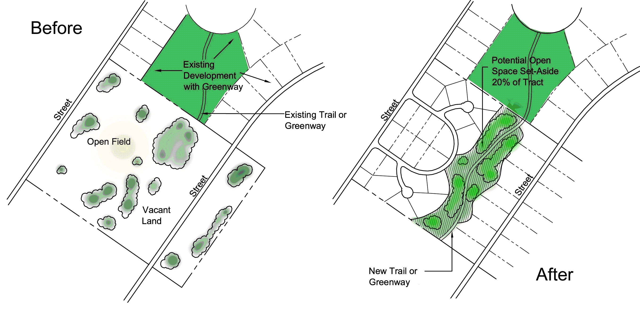
Figure 23-6-6(C)(4)b: Open Space Set-Aside Connections
c.
Orientation of Adjacent Buildings
Buildings adjacent to required open space set-asides shall have at least one entrance facing the open space set-aside.
d.
Provision in Multi-Phase Developments
In multi-phase developments, open space set-asides shall be apportioned among the phases such that the total amount of open space set aside in a phase and any previously approved phases meets the open space set-aside standard as applied to the total area of the phase and any previously approved phases.
e.
Prioritization of Open Space Set-Aside
Except in the Downtown (DT) District, and to the maximum extent possible, open space set-asides shall be located and organized to include, protect, or enhance as many of the following open areas and features as possible, and in the following priority:
1.
Natural features such as natural water features (including lakes, ponds, rivers, streams, rivers, wetlands, drainageways, and other riparian areas), flood hazard areas, wildlife habitat areas, geologic hazard areas, expansive soils, or areas particularly susceptible to sink holes or faulting;
2.
Riparian buffers;
3.
Lands intended for preservation as open space on adopted city plans, or lands that may extend or enhance existing park or open space features;
4.
Stormwater management facilities, including retention and detention ponds and other bioretention devices, where configured as an open space site amenity;
5.
Landscaped buffers or visual transitions between different types or intensities of uses;
6.
Areas that accommodate multiple compatible open space uses rather than a single use.
(5)
Use of Open Space Set-Asides
Open space set-aside areas shall not be disturbed, developed, or improved with any structures except for the following limited purposes:
a.
Active Recreation Uses
Facilities for active recreation purposes—including, but not limited to: benches or other seating areas; pedestrian-scaled lighting; gazebos or other decorative structures; fountains or other water features; play structures for children; gardens or seasonal planting areas; pools; athletic fields; courts; and clubhouses used primarily for recreational purposes (equipment or structures for such uses shall be indicated on the PD Master Plan (Section 23-2-4(C)), Subdivision Plat (Section 23-2-4(F)), or Site Plan (Section 23-2-4(E)).
b.
Passive Recreational Uses
Facilities for passive recreational, environmental education, wildlife habitat protection, and natural area preservation purposes—including, but not limited to: walking, jogging, and biking paths or trails; benches or other seating areas; tables, shelters, grills, and other picnicking facilities; docks and other facilities for fishing; and environmental guides and exhibits.
(6)
Ownership of Open Space Set-Asides
a.
Method of Ownership
1.
Open space set-aside areas shall be maintained as permanent open space through one or more of the following options:
A.
Conveyance of the land to a property owners or homeowners association that holds the land in common ownership and will be responsible for managing and maintaining it for its intended open space purposes; or
B.
Conveyance of the land to a third party beneficiary, such as a nonprofit environmental or civic organization, that is organized for, capable of, and willing to accept responsibility for managing and maintaining the land for its intended open space purposes; or
C.
Dedication of the land to the city or other appropriate public agency that is organized for, capable of, and willing to accept responsibility for managing and maintaining the land for its intended open space purposes.
2.
If an open space set-aside is to be conveyed to a property owners or homeowners association, the association shall be established in accordance with the following:
A.
The landowner shall submit documents for the creation of the property owners or homeowners association to the Director of Community Development for review and approval. The documents shall include the association's bylaws, a legal description of open space set-aside areas, and all documents governing ownership, maintenance, and use restrictions for the open space set-aside.
B.
Documents for the creation of the association shall provide that membership in the association is automatic (mandatory) for all purchasers of land, dwelling units, or structures in the development, and their successors in title, and that the association shall have clear legal authority to compel contributions from members to cover their proportionate share of the costs associated with the maintenance of common areas and facilities.
C.
The landowner shall agree that the association shall be established (with all required documents for its creation properly recorded with the Office of the Chancery Clerk of Harrison County), and operating (with financial subsidization by the landowner or applicant, if necessary) before approval of the first Building Permit for the development.
3.
If the open space set-aside is to be conveyed to a third party beneficiary such as a non-profit civic organization, then the conveyance shall include deed restrictions that:
A.
Govern the use, management, and maintenance of the open space set-asides, consistent with the standards in this section;
B.
Run with the land in perpetuity; and
C.
Include any other provisions the City Attorney deems necessary and appropriate to fulfill the requirements of this section.
4.
All methods utilizing private ownership shall include deed restrictions, covenants, or other legal instruments that ensure continued use of the land and facilities for their intended open space uses and provide for the continued and effective management, operation, and maintenance of the land and facilities.
(7)
Maintenance of Open Space Set-Asides
a.
Maintenance of open space set-aside areas shall be the responsibility of the owner(s) of the land making up the areas. Failure to maintain open space set-aside areas or other community facilities in accordance with the approved Planned Development (Section 23-2-4(C)), Major Site Plan (Section 23-2-4(E)), or Preliminary Plat (Section 23-2-4(F)) shall be a violation of this Ordinance subject to the remedies and penalties in Article 23-9: Enforcement.
b.
If the owner of an open space set-aside area fails to maintain it in reasonable condition, and in accordance with approved plans, and fails to correct deficiencies cited by the city in accordance with notice of violation and administrative hearing procedures in Section 23-9-5(D), Enforcement Procedure, the city shall have the authority to correct the deficiencies. The cost of the correction shall be assessed jointly and severally against the properties within the development that have a right of enjoyment of the common open space set-aside areas. The entire cost of correction shall be a lien on each of the properties from the date the lien is filed in the Office of the Chancery Clerk of Harrison County.
(A) - Purpose
The purpose of this section is to regulate the location, height, and appearance of fences and walls to maintain visual harmony within neighborhoods and the city, protect adjacent properties from the indiscriminate placement and unsightliness of fences and walls, and ensure the safety, security, and privacy of properties.
(B) - Applicability
The provisions of this section shall apply to all construction, substantial reconstruction, or replacement of fences or walls not required for support of a principal or accessory structure, or any other linear barrier intended to delineate different portions of a lot. If there is any inconsistency between the provisions of this section and any screening standard in Section 23-6-3(G), Screening, the standards in Section 23-6-3(G), Screening, shall control.
(C) - General Requirements for Fences and Walls
(1)
Location
Fences are permitted on the property line between two or more parcels of land held in private ownership.
(2)
Temporary Fences
Temporary fences for construction sites or a similar purpose shall comply with the requirements of the building code adopted by the city and all applicable standards of Section 23-4-5, Temporary Uses and Structures.
(3)
Fences and Walls Near Fire Hydrants
Fences and walls shall not be located where they would prevent immediate view of, or access to, fire hydrants or other fight-fighting water supply devices, in accordance with the Fire Code.
(4)
Fences in Easements
Fences shall be prohibited within utility easements except to the extent approved by the Director of Engineering after finding the fence would not impede the purpose or function of the easement. The city shall not be responsible for damage to, or the repair or replacement of, fences that must be removed to access such easements. In no instance shall this provision be construed to prevent fencing around stormwater retention or detention facilities that may be required by this Ordinance.
(5)
Blocking Natural Drainage Flow
No fence shall be installed so as to block or divert a natural drainage flow on to or off of any other land.
(6)
Fences on Retaining Walls or Berms
If a fence is constructed on top of a wall or berm, the combined height of the fence and wall or berm shall not exceed the maximum height that would apply to the fence or wall alone.
(7)
Fences and Walls within Buffers
Fences and walls shall be installed so as not to disturb or damage existing vegetation or installed plant material within perimeter or riparian buffers.
(8)
Integration with Other Required Landscaping
Required landscape screening for fences or walls may be integrated into the landscaping required for vehicular use area screening or perimeter buffers, provided the standards in Section 23-6-3, Landscaping, are maintained.
(9)
Customary Materials
Fences and walls shall be constructed of any combination of treated wood posts and planks, rot-resistant wood (such as cypress or redwood), wrought iron, decorative metal materials, chain link, brick, stone, masonry materials, or products designed to resemble these materials. Where certain materials are specified for particular types of screening or buffering fences or walls, all other fence materials are prohibited.
(Ord. No. 2421, 7-21-2020)co;normal;normal
(D) - Height Requirements for Fences and Walls
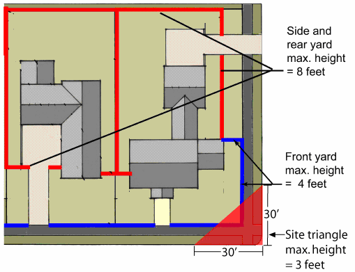
Figure 23-6-7(D)(1): Fence Height in Agricultural and Residential Districts
All fences and walls shall conform to the following standards unless exempted by Section 23-6-7(D)(3), Exemptions, and except as otherwise provided in Section 23-6-1(F)(5)f, Sight Triangles at Driveway Intersections, and Section 23-7-5(I), Sight Triangles at Street Intersections. In all cases, heights are measured from natural grade.
(1)
Agricultural and Residential Districts
Except for fences or walls providing required screening, fences and walls in the Agriculture and residential districts shall not exceed a height of four feet in front yards and that part of corner side yards located between the side street right-of-way and the side of a structure, or a height of eight feet in side and rear yards.
(2)
Business Districts
Except for fences or walls providing required screening, fences and walls in nonresidential districts shall not be permitted in front and corner side setback areas, shall not exceed a height of eight feet in the remainder of front and corner side yards, and shall not exceed a height of ten feet in side or rear yards unless located within 15 feet of a public right-of-way, in which case it shall not exceed a height of eight feet.
(3)
Exemptions
a.
Required Screening
A fence or wall provided to meet the standards of Section 23-6-3(G), Screening, is exempted from the height standards of this subsection, but in no case shall the fence or wall exceed a height of ten feet.
b.
Recreational Fencing
Customary fencing provided as a part of a permitted tennis court, athletic field, or other recreational facility shall be exempt from the height restrictions of this subsection.
c.
Public Safety Use Fences and Walls
Major utilities, wireless communication towers, government facilities, and other public safety uses shall be allowed to increase maximum fence or wall heights to ten feet in front, side, and rear yards, unless further increased through an approved security plan. (See Section 23-6-7(D)(3)d., Security Plan Fencing.)
d.
Security Plan Fences and Walls
An owner or tenant or a representative of a public agency responsible for a public facility may submit to the Director of Community Development a site security plan proposing fences or walls taller than those permitted by this subsection, or the use of barbed or concertina wire atop a fence or wall. The Director of Community Development shall approve, or approve with conditions, the site security plan and its proposed exemption of fences or walls from the standards of this subsection, on finding that:
1.
The condition, location, or use of the land, or the history of activity in the area, indicates the land or any materials stored or used on it are in significantly greater danger of theft or damage than surrounding land; and
2.
The proposed taller fences or walls, or use of barbed or concertina wire, will not have a significant adverse effect on the security, functioning, appearance, or value of adjacent lands or the surrounding area as a whole.
(E) - Perimeter Fences and Walls Abutting Public Rights-of-Way
Fences or walls located within 15 feet of a public right-of-way shall:
(1)
Be located outside the public right-of-way;
(2)
Be of a uniform style;
(3)
Be constructed of brick, stone, or concrete (when covered with stucco or similar finish), vinyl, or vertical wooden boards; and
(4)
Include breaks, offsets, access points, or other design details in the fence or wall plane at least every 200 feet, as illustrated in Figure 23-6-7(E)(4), Requiring Fencing and Wall Offsets.
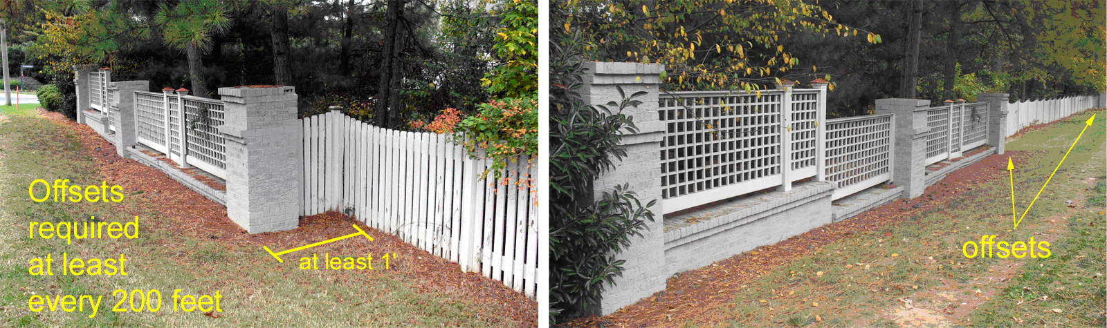
Figure 23-6-7(E)(4): Fencing and Wall Offsets
(F) - Appearance
Figure 23-6-7(F)(1): Fence with Finished Side Out
(1)
Finished Side to Outside
Wherever a fence or wall is installed, if one side of the fence or wall appears more "finished" than the other (e.g., one side has visible support framing and the other does not), then the more "finished" side of the fence shall face the section of the lot that "fronts to" or is otherwise exposed to a city street or right-of-way. Fences constructed between two private properties may display the "finished" side of the fence, at the discretion of the property owner submitting the building permit application. (See Figure 23-6-7(F)(1), Fence with Finished Side Out.)
(2)
Compatibility of Materials along a Single Lot Side
All fencing or wall segments located along a single lot side shall be composed of a uniform style and colors compatible with other parts of the fence and with the associated buildings.
(3)
Landscape Screening
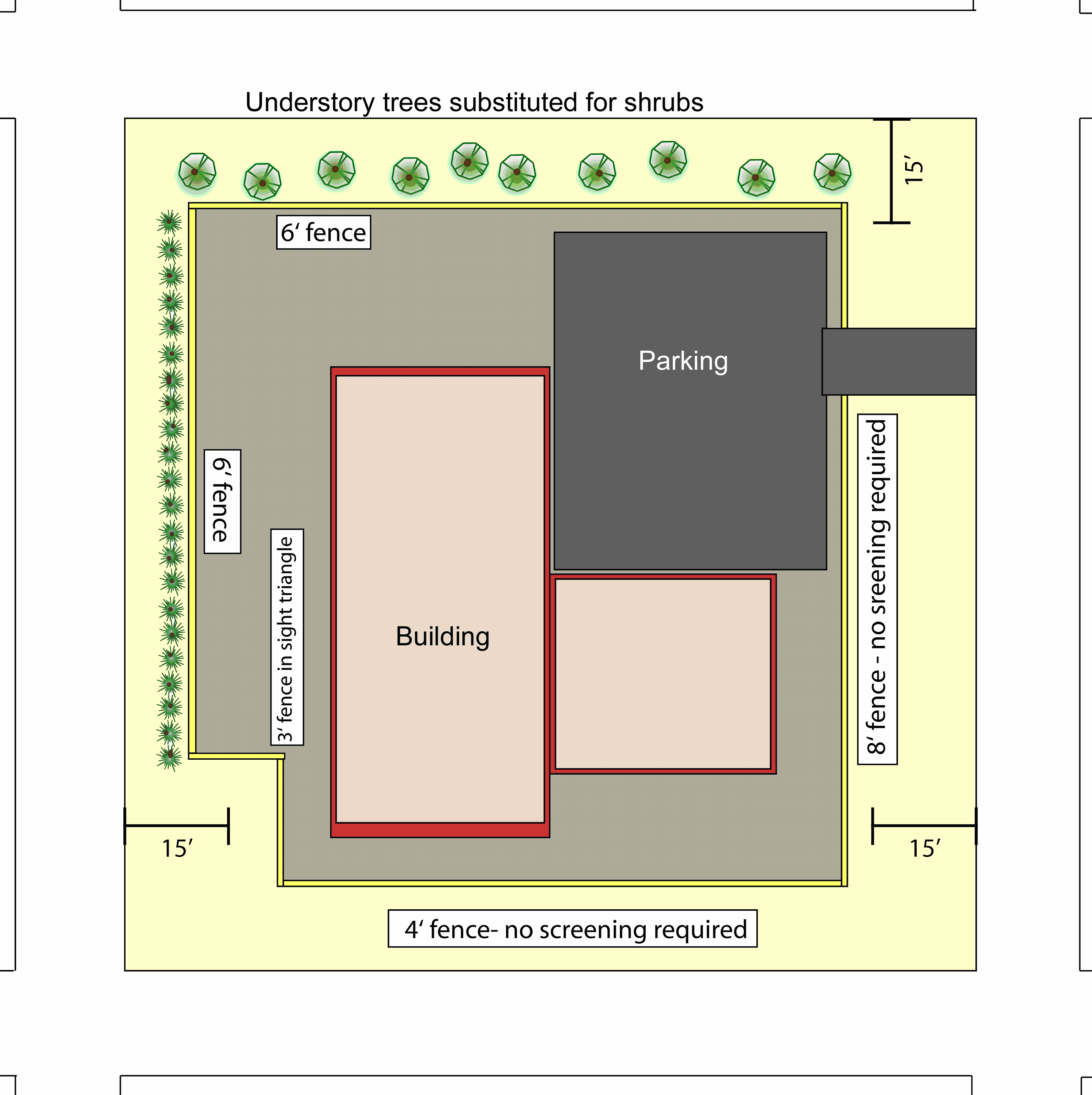
Figure 23-6-7(F)(3): Fence Landscape Screening
All chain link fences and fences and walls exceeding four feet in height, if located within 15 feet of a public street right-of-way, shall be supplemented with landscape screening in accordance with the following standards, to soften the visual impact of the fence. These standards shall apply to fences in single-family residential zoning districts only if they are located within 15 feet of the right-of-way of an arterial or collector street. (See Figure 23-6-7(F)(3), Fence Landscape Screening.)
a.
Shrubs Required
One evergreen shrub shall be installed for every five linear feet of fence or wall, and on the side of the fence or wall facing the public street right-of-way. Shrubs shall meet the size standards of Section 23-6-3(C)(3), New Planting Standards, and may be installed in a staggered, clustered, grouped, or linear fashion.
b.
Substitution of Understory Trees
One understory or ornamental tree may be substituted for every three evergreen shrubs, provided that the tree meets the size standards of Section 23-6-3(C)(3), New Planting Standards.
(G) - Visibility Clearance
Fences and walls shall be placed outside of required sight triangles or areas needed for visibility.
(H) - Prohibited Fences
(1)
Barbed Wire, Concertina Wire, and Aboveground Electrified Fences
In all zoning districts, fences using barbed or concertina wire and aboveground electrified fences shall be prohibited unless used in association with agricultural activities or allowed through an approved security plan (See Section 23-6-7(D)(3)d., Security Plan Fences and Walls.). Underground electric fences designed for control of domestic animals are allowed.
(2)
Debris, Junk, Rolled Plastic, Sheet Metal, Plywood, or Other Waste Materials
Fences or walls made of debris, junk, rolled plastic, sheet metal, plywood, or waste materials are prohibited in all zoning districts unless such materials have been recycled and reprocessed, for marketing to the general public, as building materials that resemble new building materials (e.g., picket fencing made from recycled plastic and fiber).
(I) - Maintenance Required
All fences and walls and associated landscaping shall be maintained in good repair and in a safe and attractive condition—including, but not limited to, the repair or replacement of missing, decayed, or broken structural and decorative elements.
(Ord. No. 2416, § 1, 3-17-2020; Ord. No. 2435, 3-2-2021)co;normal;normal
(A) - Purpose
The purpose of this section is to regulate exterior lighting to ensure the safety of motorists and pedestrians and minimize adverse impacts on adjacent properties. More specifically, this section is intended to:
(1)
Regulate lighting to assure that excessive light spillage and glare are not directed at adjacent properties, neighboring areas, and motorists;
(2)
Ensure that all site lighting is designed and installed to maintain adequate lighting levels on site while limiting negative lighting impacts on adjacent lands; and
(3)
Provide security for persons and land.
(B) - Applicability
(1)
General
The provisions of this section shall apply to all development in the city unless exempted in accordance with Section 23-6-8(C), Exemptions.
(2)
Time of Compliance
A lighting plan shall be submitted with an application for approval of a Site Plan (See Section 23-2-4(E).), Preliminary Plat (Section 23-2-4(F)), Certificate of Zoning Compliance (Section 23-2-4(L)), or Temporary Use Permit (Section 23-2-4(J)), as appropriate.
(C) - Exemptions
The following is exempted from the exterior lighting standards of this section.
(1)
Existing athletic field lighting;
(2)
City-owned, -operated, or -maintained street lights located within a street right-of-way or other easement granted to the city; and
(3)
Lighting and fixtures approved as part of a Certificate of Appropriateness (Section 23-2-4(G)).
(D) - General Standards for Exterior Lighting
(1)
Hours of Illumination
Public and institutional uses, commercial uses, and industrial uses (See use tables in Sections 23-4-1(B) and 23-4-1(C).) that are adjacent to existing residential development or vacant land in residential districts shall turn off all exterior lighting—except lighting necessary for security or emergency purposes—by 10:00 p.m. or within one hour of closing, whichever occurs first. For the purposes of this subsection, lighting "necessary for security or emergency purposes" shall be construed to mean the minimum amount of exterior lighting necessary to illuminate possible points of entry or exit into a structure, to illuminate exterior walkways, or to illuminate outdoor storage areas. Such lighting may be activated by motion sensor devices.
(2)
Illumination Direction
In all districts, lighting shall be directed downward. In addition, upwardly-directed lighting shall not be used to illuminate structures, except for low-wattage architectural lighting.
(E) - Design Standards for Exterior Lighting
All exterior lighting shall meet the following standards:
(1)
Maximum Lighting Height
a.
Except for outdoor sports fields or performance areas, the height of outdoor lighting, whether mounted on poles or walls or by other means, shall be no greater than 20 feet in Agricultural and Residential Districts and the LB, NB, WF, SB, and DT Districts, and no greater than 30 feet in the CB, RB, and I Districts.
b.
Wherever possible, illumination of outdoor seating areas, building entrances, and walkways shall be accomplished by use of ground mounted fixtures not more than four feet in height.
(2)
Shielding
a.
Exterior
Light fixtures in excess of 100 lumens shall use full cut-off lenses or hoods to prevent glare or spillover from the project site onto adjacent lands and streets.
b.
Interior
No interior light source shall be positioned, aimed, or configured so as to result in the light source being visible from occupied adjoining land zoned A, RE, RER, RS-, RM-, RMH, or AHO.
c.
Canopies
No light source in a canopy structure shall extend downward further than the lowest edge of the canopy ceiling.
d.
Awnings
Awnings or canopies used for building accents over doors, windows, etc., shall not be internally illuminated (i.e., from underneath or behind the awning).
(3)
Maximum Illumination Levels
All outdoor lighting and indoor lighting visible from outside shall be designed and located so that the maximum illumination measured in foot-candles at ground level at the development site's property lines shall not exceed the standard in Table 23-6-8(E)(3), Maximum Illumination Levels, for the type of use or development. Cut-off lighting shall be designed to direct light downward (e.g., shoe box style).
(F) - Wall Pack Lights
Wall packs on buildings may be used at entrances to a building to light unsafe areas. They are not intended to draw attention to the building or provide general building or site lighting. Wall packs on the exterior of the building shall be fully shielded (e.g., true cut-off type bulb or light source not visible from off-site) to direct the light vertically downward and have a light output of 1,000 lumens or less. Wall pack light sources visible from any location off the site are prohibited.
(G) - Exemptions for a Security Plan
Government maintenance facilities, public safety facilities, parks and public spaces, and other uses (See use tables in Sections 23-4-1(B) and 23-4-1(C).) where sensitive or dangerous materials are stored may submit to the Director of Community Development a site security plan proposing exterior lighting that deviates from the standards in this subsection. The Director of Community Development shall approve, or approve with conditions, the site security plan and its proposed deviation from the standards of this subsection, on finding that:
(1)
The proposed deviation from the standards is necessary for the adequate protection of the public;
(2)
The condition, location, or use of the land, or the history of activity in the area, indicates the land or any materials stored or used on it are in significantly greater danger of theft or damage, or members of the public are at greater risk for harm than on surrounding land; and
(3)
The proposed deviation from the standards is the minimum required, and will not have a significant adverse effect on neighboring lands.
(H) - Illumination of Outdoor Sports Fields and Performance Areas
Lighting of outdoor sports fields and performance areas shall comply with the following standards:
(1)
Glare Control Package
All lighting fixtures shall be equipped with a glare control package (e.g., louvers, shields, or similar devices) and aimed so that their beams are directed and fall within the primary playing or performance area.
(2)
Hours of Operation
The hours of operation for the lighting system for any game or event shall not continue more than one hour after the end of the game or event.
(I) - Sign Lighting
Lighting fixtures illuminating signs shall comply with the standards of this section, and such fixtures shall be aimed and shielded so that direct illumination is focused exclusively on the sign face and is not visible from off-site areas.
(A) - Purpose
These multifamily design standards are intended to:
(1)
Establish a minimum level of design quality for two-family dwellings, three- to four-family dwellings, single-family attached or townhouse development, and multifamily development to foster sustained value and stability within developments and neighborhoods; and
(2)
Promote greater compatibility between two-family dwellings, three- to four-family dwellings, single-family attached or townhouse development, and multifamily development and other allowable uses in the city.
(B) - Applicability
(1)
New Development
The standards in this section shall apply to all new two-family dwellings, three- to four-family dwellings, single-family attached or townhouse development, and multifamily development in the city.
(2)
Redevelopment
The standards in this section shall also apply to any expansion or alteration of an existing two-family dwelling, three- to four-family dwelling, single-family attached or townhouse development, or multifamily development where the cost of the expansion or alteration exceeds 50 percent of the building's or buildings' assessed value at the time of expansion or alteration.
(C) - Time of Review
Review for compliance with the standards of this section shall occur during review of an application for approval of a Planned Development (Section 23-2-4(C)), Site Plan (Section 23-2-4(E)), Preliminary Plat (Section 23-2-4(F)), or Certificate of Zoning Compliance (Section 23-2-4(L)), as appropriate.
(D) - Multifamily Design Standards
All two-family dwellings, three- to four-family dwellings, single-family attached or townhouse development, and multifamily development subject to this section shall comply with the following standards:
(1)
Building Orientation and Entryways
All buildings with shared building entrances shall be oriented so that the primary entrance(s) faces the street. In the case of corner lots, the primary entrance(s) shall face the street from which the building derives its street address. (See Figure 23-6-9(D), Multifamily Design Features.)
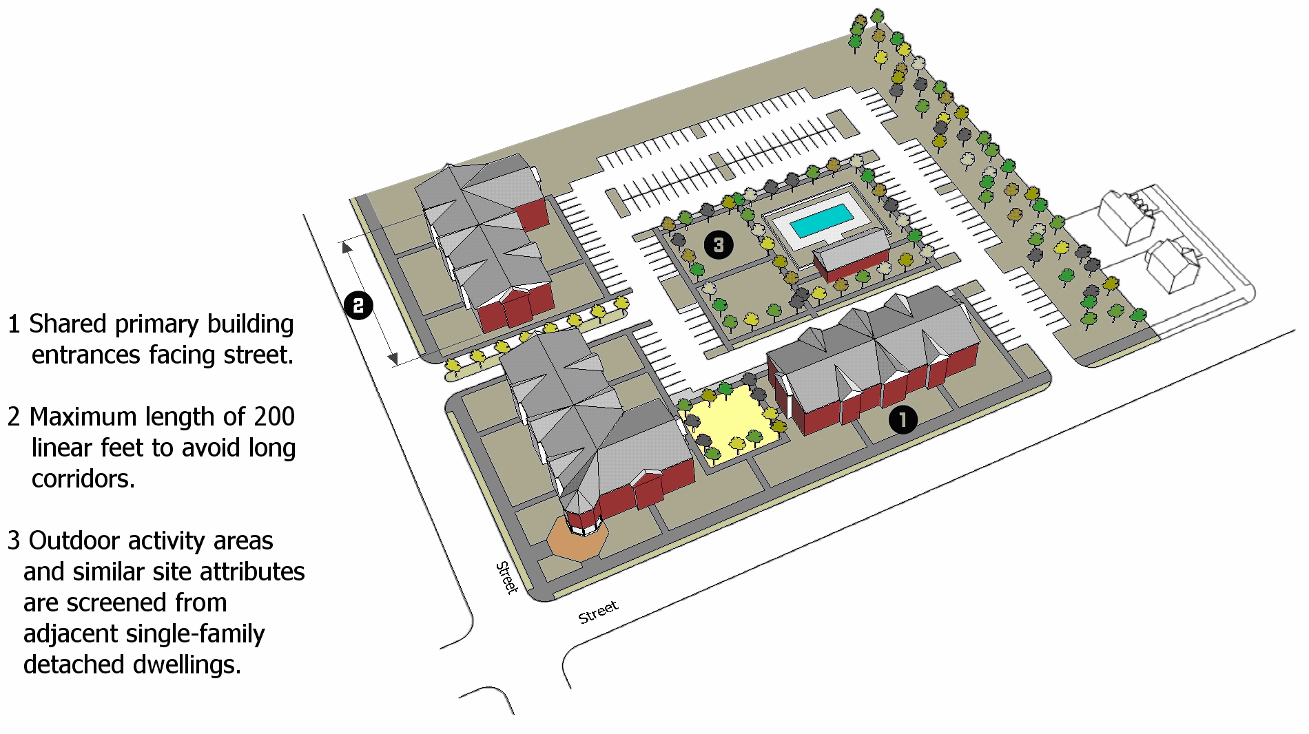
Figure 23-6-9(D): Multifamily Design Features
(2)
Pedestrian Circulation
A clearly defined, visible, and identifiable pedestrian network shall be provided between parking spaces, open spaces, recreational facilities, and individual buildings within the development site and connected to adjacent public street sidewalks and public parks, open spaces, and community facilities.
(3)
Building Size
a.
The maximum footprint area of any individual building shall be 20,000 square feet in the RM-30 and DT Districts and 15,000 square feet in all other districts.
b.
The maximum length of any individual building containing single-family attached or townhouse dwelling units or multifamily dwelling units shall be 200 linear feet, regardless of the number of units.
c.
No more than six side-by-side dwelling units shall be attached in any single structure.
(4)
Height
Except in the DT District, buildings shall have a maximum height of 35 feet within 100 feet of an existing single-family detached dwelling or vacant land classified as a single-family residential district (RS-) on the official zoning map.
(5)
Building Design
Building details—including roof forms, siding materials, windows, doors, and trim—shall reflect a similar level of quality and architectural detailing on all sides facing a street on which there is an existing single-family detached dwelling or vacant land classified as a single-family residential district (RS-) on the official zoning map.
(6)
Building Façades
a.
The street-facing front façades of buildings shall be articulated with wall offsets (e.g., projections or recesses in the façade plane) that are at least two feet deep and spaced no more than 30 feet apart.
b.
In addition to wall offsets, street-facing front façades shall provide at least three of the following articulation elements:
1.
A covered porch;
2.
A recessed entrance;
3.
One or more dormer windows or cupolas;
4.
Pillars, posts, or pilasters;
5.
One or more bay windows projecting at least 12 inches from the façade plane;
6.
Eaves projecting at least four inches from the façade plane;
7.
Raised corniced parapets over the entrance door;
8.
Multiple windows with a trim at least four inches wide; or
9.
Integral planters that incorporate landscaped areas or places for sitting.
c.
Side façades shall maintain at least 20 percent of the façade area as windows.
(7)
Roof Form
a.
Principal buildings shall incorporate roof pitches between 3:12 and 12:12, or incorporate a parapet at least three feet high with a three-dimensional cornice around a flat roof. Alternative roof forms or pitches may be allowed for small roof sections over porches, entryways, or similar features.
b.
All roof vents, pipes, antennas, satellite dishes, and other roof penetrations and equipment (except chimneys) shall be located on the rear elevations or otherwise be configured, to the degree practicable, to have a minimal visual impact as seen from the street.
(8)
Accessory Structures
a.
Garages serving two-family dwellings, three- to four-family dwellings, and single-family attached or townhouse dwellings shall be located to the side or rear of the building(s) containing the dwellings. Garages serving multifamily dwellings shall be located to the side or rear of the building(s) containing the dwellings, or be structured parking.
b.
The exterior materials, design features, and roof form of accessory structures shall be compatible with the principal building(s) to which they are accessory.
c.
Accessory structures shall not physically obstruct pedestrian entrances.
d.
Trash receptacles shall be located in an enclosed area.
e.
Fencing of multifamily development recreational amenities such as swimming pools and tennis courts shall provide visibility and safety.
(9)
Parking Location
No more than 40 percent of the off-street surface parking shall be located between the building and the street it fronts unless screened from the street by another building. The balance shall be located to the side or rear of the building. Off-street surface parking shall be located away or fully screened from adjacent existing single-family detached dwellings or vacant land classified as a single-family residential district (RS-) on the official zoning map. (See Figure 23-6-9(D)(9), Location of Parking for Multifamily Development and Figure 23-6-9(D)(10), Location and Screening of Multifamily Parking and Outdoor Activity Areas.)
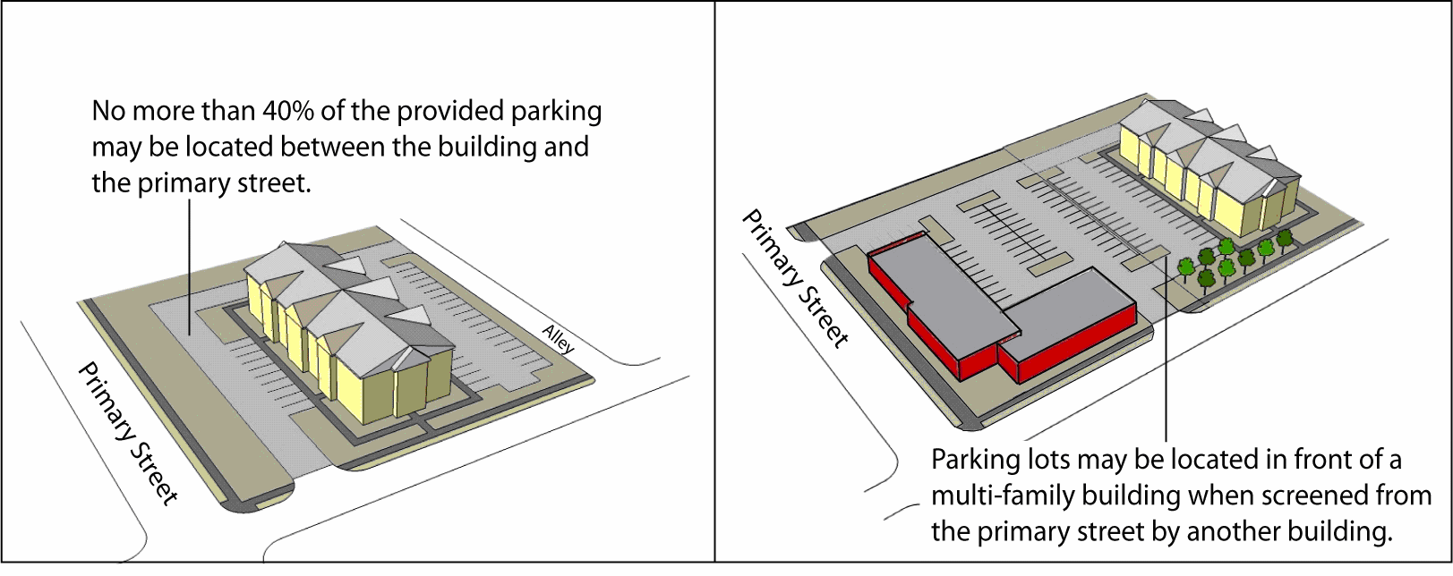
Figure 23-6-9(D)(9): Location of Parking for Multifamily Development
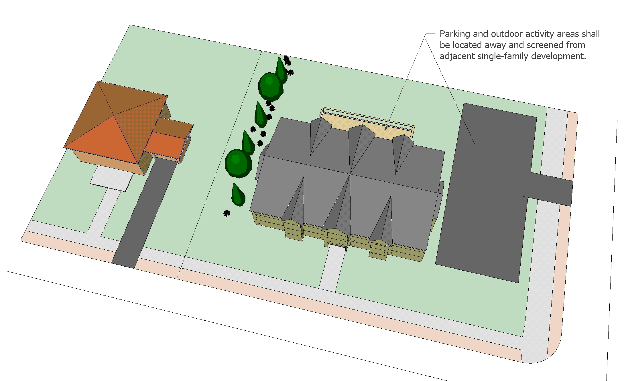
Figure 23-6-9(D)(10): Location and Screening of Multifamily Parking and Outdoor Activity
Areas
(10)
Outdoor Activity Areas
Outdoor activity areas, porches, balconies, decks, vending areas, and other similar site attributes shall be located away or fully screened from adjacent existing single-family detached dwellings or vacant land classified as a single-family residential district (RS-) on the official zoning map. (See Figure 23-6-9(D)(10), Location and Screening of Multifamily Parking and Outdoor Activity Areas.)
(A) - Purpose
These commercial design standards are intended to:
(1)
Encourage the establishment of a strong sense of place with vibrant commercial development in key areas of the city;
(2)
Encourage a more pedestrian-friendly environment through attention to human-scale design and site features;
(3)
Foster greater compatibility between commercial development and adjacent residential neighborhoods; and
(4)
Address the visual impact and compatibility of large-scale retail buildings.
(B) - Applicability
(1)
New Development
Except in the Downtown (DT) Zoning District, all new commercial development in the city shall comply with the general design standards in Section 23-6-10(D), General Commercial Design Standards.
(2)
Redevelopment
The general design standards in Section 23-6-10(D), General Commercial Design Standards, shall also apply to any expansion or alteration of an existing commercial development where the cost of the expansion or alteration exceeds 50 percent of the building's or buildings' assessed value at the time of expansion or alteration.
(3)
Additional Standards for Large Retail Development
Single-tenant buildings that have a gross floor area of 60,000 square feet or more and devote 60 percent or more of the total floor area to retail sales activities shall comply with both the general design standards in Section 23-6-10(D), General Commercial Design Standards, and the large retail design standards in Section 23-6-10(E), Large Retail Design Standards.
(C) - Timing of Review
Review for compliance with the standards of this section shall occur during review of an application for approval of a Planned Development (Section 23-2-4(C)), Site Plan (Section 23-2-4(E)), Preliminary Plat (Section 23-2-4(F)), or Certificate of Zoning Compliance (Section 23-2-4(L)), as appropriate.
(D) - General Commercial Design Standards
All commercial use development subject to this section shall comply with the following standards:
(1)
Building Orientation and Entryways
The front façade of buildings, as defined by the primary entrance, shall be oriented towards the street from which the building derives its street address.
(2)
Multi-Building Development
a.
Development composed of multiple buildings shall be configured to:
1.
Break up the site into a series of smaller "blocks" defined by on-site streets, vehicle accessways, pedestrian walkways, or other circulation routes;
2.
Frame the corner of an adjacent street intersection or entry point to the development;
3.
Frame and enclose a "main street" pedestrian or vehicle access corridor within the development site;
4.
Frame and enclose on at least three sides of parking areas, public spaces, or other site amenities; and
5.
Frame and enclose outdoor dining or gathering spaces for pedestrians between buildings.
(See Figures 23-6-10(D)(2)a., Multi-Building Framing and 23-6-10(D)(2)a.5., Outdoor Gathering Places.)
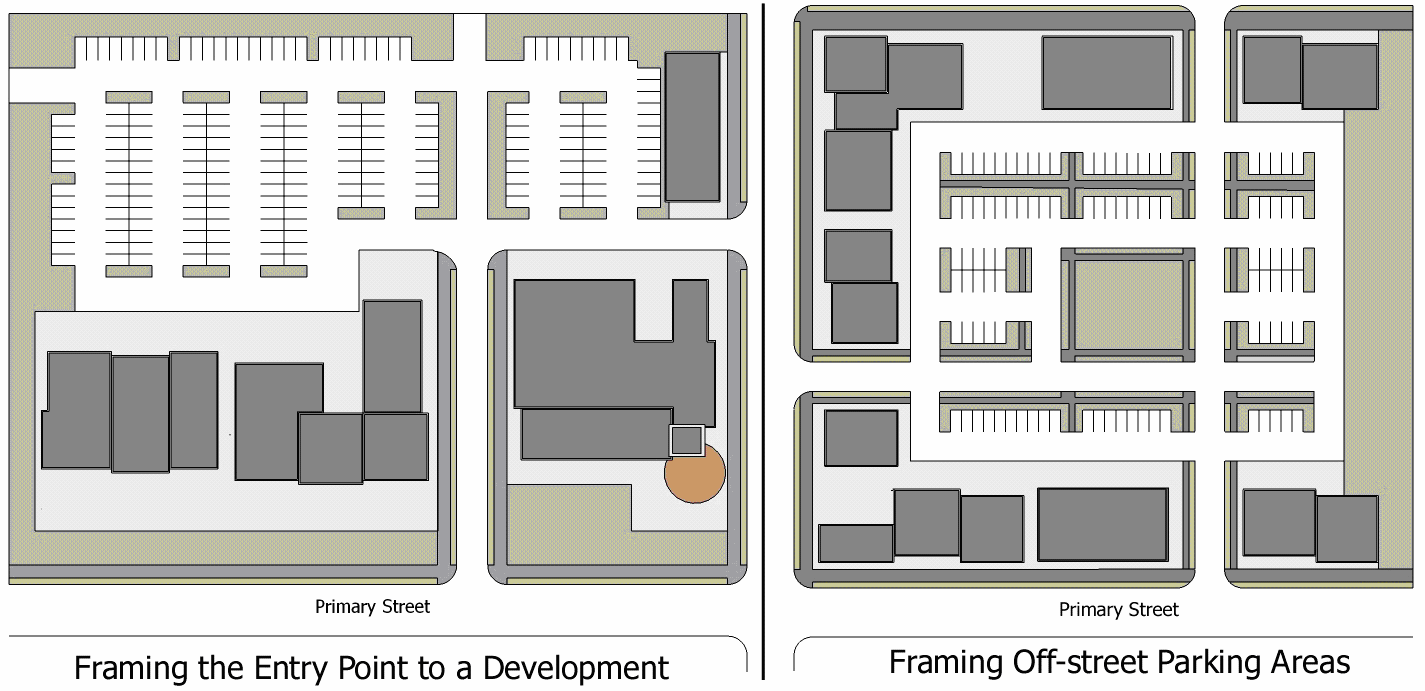
Figure 23-6-10(D)(2)a: Multi-Building Framing
b.
The primary entrances of the buildings shall be oriented towards a street along the perimeter of the development, towards streets interior to the development, or towards open space areas.
Figure 23-6-10(D)(2)a.5: Outdoor Gathering Places
(3)
Outparcel Development
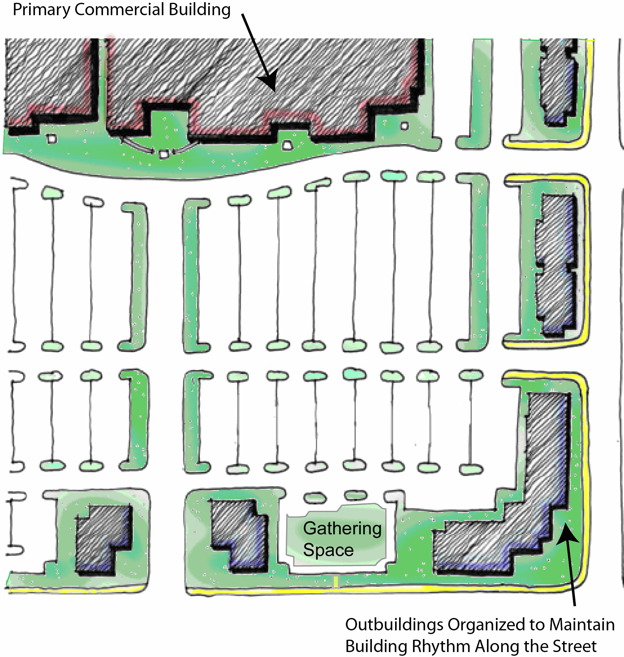
Figure 23-6-10(D)(3): Outparcel Location
a.
To the maximum extent practicable, outparcels and their buildings shall be configured and located to define street edges, development entry points, and spaces for gathering or seating between buildings.
b.
The even dispersal of outparcel sites in a widely-spaced, uniform pattern along streets is prohibited.
c.
To the maximum extent practicable, spaces between outparcel buildings shall be enlivened with pedestrian amenities such as small plazas, seating areas, and gathering spaces.
(See Figure 23-6-10(D)(3), Outparcel Location.)
(4)
Façades and Massing
a.
Façade Offsets
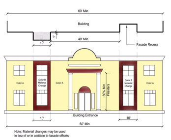
Figure 23-6-10(D)(4)a: Commercial Building Front Facade Offsets
1.
Street-facing front building façades that are more than 60 feet wide shall be articulated with wall offsets (e.g., projections or recesses in the façade plane) that are at least one foot deep, at least ten feet wide, and spaced no more than 40 feet apart.
2.
The following alternatives can be used alone or in combination as an alternative to the required front façade offsets:
A.
Changes in façade color or material that follow the same dimensional standards as the offset requirements;
B.
Pilasters that are at least eight inches deep and at least eight inches wide, and have a height equal to at least 80 percent of the façade's height; or
C.
Roofline changes that vertically align with a corresponding wall offset or change in façade color or material, including changes in roof planes and changes in the height of a parapet wall (such as extending the top of pilasters above the top of the parapet wall).
(See Figure 23-6-10(D)(4)a., Commercial Building Front Façade Offsets.)
b.
Base and Top Treatment
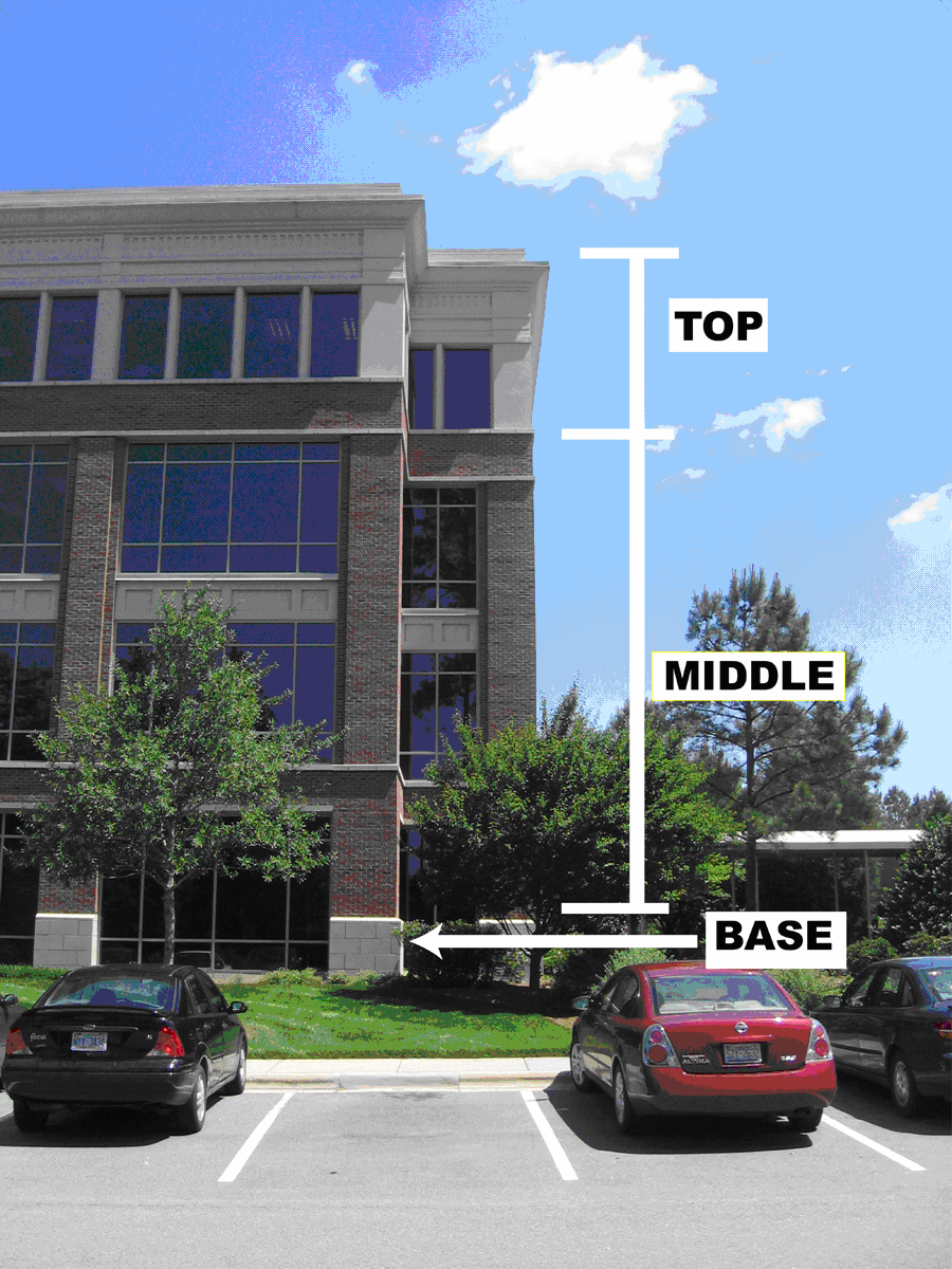
Figure 23-6-10(D)(4)b: Building Base, Middle, and Top
Buildings of three or more stories shall include a clearly recognizable base, middle, and top configured in accordance with the following standards:
1.
Building bases shall incorporate one or more of the following features:
A.
Thicker walls, ledges, or sills;
B.
Integrally-textured materials such as stone or other masonry;
C.
Integrally-colored and patterned materials such as smooth-finished stone or tile; or
D.
Lighter or darker colored materials, mullions, or panels.
2.
Building tops shall include two or more of the following features:
A.
Three-dimensional cornice treatments with integrally-textured materials such as stone or other masonry or differently colored materials;
B.
Sloping roof with overhangs and brackets;
C.
Stepped parapets; or
D.
Aligned openings and articulations.
(See Figure 23-6-10(D)(4)b., Building Base, Middle, and Top.)
c.
Side Façades
The street-facing side façades of buildings shall be fully screened from off-site views through fences, walls, or landscaping at least eight feet high, or be configured with the same façade details as provided on the building's front façade.
d.
Outbuildings
Outbuildings located in front of other buildings within the same development shall include a consistent level of architectural detail on all four sides of the building.
(5)
Window Treatment
a.
At least 25 percent of the street-facing façade area of the street-level floor of buildings shall be occupied by windows or doorways.
b.
All street-level windows shall be visually permeable between the heights of three and eight feet above the adjacent walkway grade.
(6)
Roofs
a.
Structures with a flat roof shall include parapet walls with a decorative three-dimensional cornice.
b.
All rooftop equipment shall be screened from view from all streets.
(7)
Off-Street Parking Location
a.
Limited Business and Neighborhood Business Districts
Commercial development consisting of single-story buildings in the LB or NB Districts shall be configured to locate all required off-street surface parking to the side or rear of the building. Buildings of two or more stories may locate up to two rows of off-street surface parking between the primary entrance of the building and the street they face.
b.
All Other Zoning Districts
1.
A portion of off-street parking for commercial development in all other zoning districts may be located between the building and the street it fronts, in accordance with Table 23-6-10(7), Off-Street Parking Location:
2.
All other off-street surface parking shall be located to the side or the rear of the building.
(8)
Loading, Storage, and Service Areas
a.
Loading, service, and equipment areas shall be located in a manner that minimizes their visibility from off-site areas, to the maximum extent practicable.
b.
Outdoor storage areas shall be fully screened from adjacent streets and single-family development.
c.
Loading, service, and equipment areas that are associated with an outparcel building shall be screened through the use of structural elements and similar materials attached to and integrated with the building.
(9)
Auto-Oriented Uses
Corner lots on all streets except arterials and collectors shall locate automobile-oriented uses or facilities—including but not limited to gas pumps, drive-through ordering points and pick-up windows, or other accessory uses intended for access while inside a vehicle—to the side or rear of the principal building.
(E) - Large Retail Design Standards
In addition to the general commercial design standards in Section 23-6-10(D), single-tenant buildings that have a gross floor area of 60,000 square feet or more and devote 60 percent or more of the total floor area to retail sales activities ("large retail buildings") shall also comply with the following standards. If there is a conflict between these standards and those in Section 23-6-10(D), General Commercial Design Standards, these standards control. (See Figure 23-6-10(E), Examples of Large Retail Buildings.)
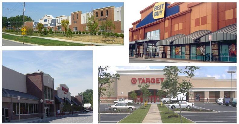
Figure 23-6-10(E): Examples of Large Retail Buildings
(1)
Building Entrances
Buildings shall have clearly defined, highly visible customer entrances featuring no less than three of the following:
a.
Canopies or porticos above the entrance;
b.
Roof overhangs above the entrance;
c.
Entry recesses or projections;
d.
Arcades that are physically integrated with the entrance;
e.
Raised corniced parapets above the entrance;
f.
Gabled roof forms or arches above the entrance;
g.
Outdoor patios or plazas adjacent to the entrance;
h.
Display windows that are directly adjacent to the entrance;
i.
Architectural details, such as tile work and moldings, that are integrated into the building structure and design and are above or directly adjacent to the entrance; or
j.
Integral planters or wing walls that incorporate landscaped areas or seating areas.
(2)
Façades and Massing
a.
To reduce their perceived mass and scale, buildings shall incorporate two or more of the following design elements on each façade facing a street:
1.
Variations in roof form and parapet heights;
2.
Pronounced wall offsets that are at least two feet deep;
3.
Distinct changes in texture and color of wall surfaces;
4.
Ground level arcades and second floor galleries or balconies;
5.
Protected and recessed entries; and
6.
Vertical accents or focal points.
b.
Side building walls that do not face a street and exceed 30 feet in length shall have façade-articulating elements such as columns and/or changes in plane, texture, or masonry pattern.
(See Figure 23-6-10(E)(2), Large Retail Building Entrances and Massing.)
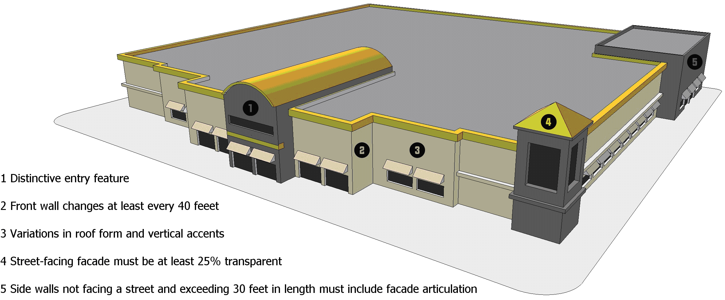
Figure 23-6-10(E)(2): Large Retail Building Entrances and Massing
(3)
Off-Street Parking Location Standards
a.
Up to 60 percent of the total off-street surface parking provided may be located between the front façade of the building and the street it faces.
b.
Off-street surface parking lots with 300 or more spaces shall be organized into a series of parking bays surrounded by buildings, landscaping, or accessways designed to appear as streets.
(See Figure 23-6-10(E)(3), Large Retail Parking Location.)
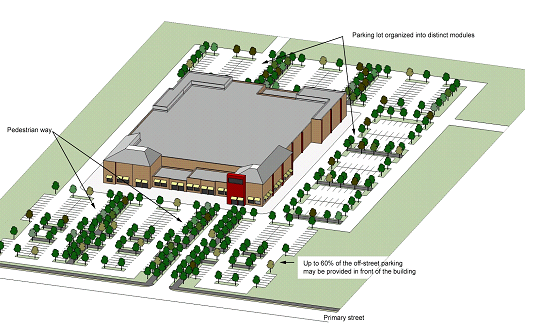
Figure 23-6-10(E)(3): Large Retail Parking Location
(A) - Purpose
(1)
These transitional standards are intended to:
a.
Provide proper transition and compatibility between single-family detached development and other more intense development.
b.
Protect the character of single-family development from negative impacts resulting from adjacent more intense forms of development.
c.
Establish or maintain vibrant pedestrian-oriented areas where differing uses can operate in close proximity to one another.
(B) - Applicability
(1)
New Development
Unless exempted in accordance with Section 23-6-11(B)(3), Exemptions, these transitional standards apply to all new two-family dwellings, three- to four-family dwellings, single-family attached or townhouse development, and multifamily, commercial, industrial, and mixed-use development where such dwelling or development is located on land abutting or across a local street, driveway, or alley from an existing single-family detached dwelling or vacant land within a Residential Estate (RE) or Residential Estate, Restricted (RER) District, any Single-Family Residential (RS-) District, or a Architectural/Historic Overlay (AHO) District. (See Figure 23-6-11(B)(1), Examples of Transitional Standards Applicability.)
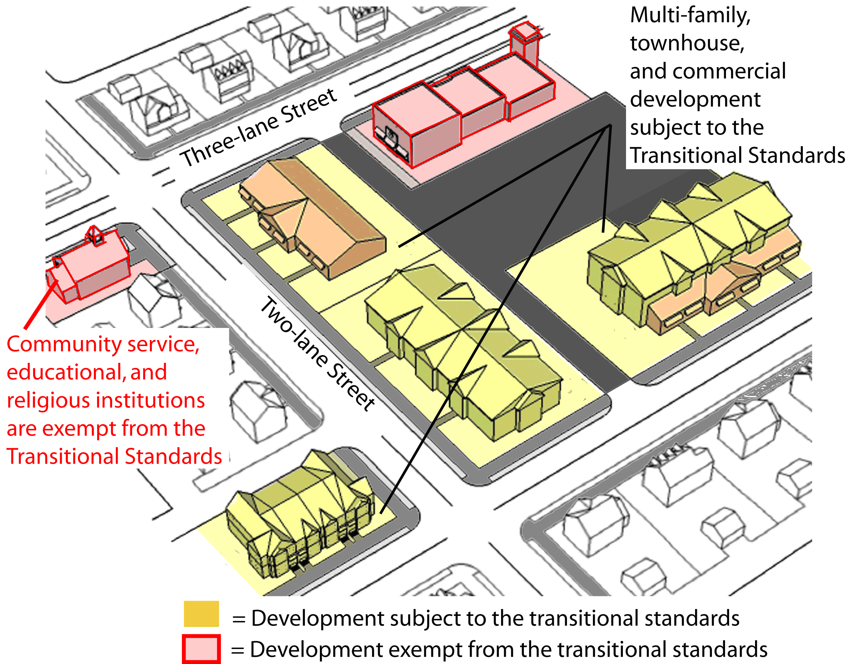
Figure 23-6-11(B)(1): Examples of Transitional Standards Applicability
(2)
Redevelopment
In addition, unless exempted in accordance with Section 23-6-11(B)(3), Exemptions, these standards also apply to any expansion or alteration of an existing two-family dwelling, three- to four-family dwelling, single-family attached or townhouse development, or multifamily, commercial, industrial, or mixed-use development where such dwelling or development is located on land abutting or across a local street, driveway, or alley from an existing single-family detached dwelling or vacant land zoned RE, RER, RS-, or AHO, and where the cost of the expansion or alteration exceeds 50 percent of the building's or buildings' assessed value at the time of expansion or alteration.
(3)
Exemptions
a.
The following development is exempt from these standards:
1.
Community Services, Educational Facilities, and Utilities Uses (See use tables in Sections 23-4-1(B) and 23-4-1(C).);
2.
Two-family dwellings, three- to four-family dwellings, single-family attached or townhouse development, and multifamily, commercial, industrial, and mixed-use development where such dwelling or development is located on land across a collector or arterial street from an existing single-family detached dwelling or vacant land zoned RE, RER, RS-, or AHO; and
3.
Development within the Downtown (DT) District.
(C) - Time of Review
Review for compliance with the standards of this section shall occur during review of an application for approval of a Planned Development (Section 23-2-4(C)), Site Plan (Section 23-2-4(E)), Preliminary Plat (Section 23-2-4(F)), or Certificate of Zoning Compliance (Section 23-2-4(L)), as appropriate.
(D) - Transitional Development Standards
Development subject to the standards of this section shall comply with the following standards.
(1)
Setbacks
a.
Building setbacks shall be consistent with those for other buildings on the block face and across the street to maintain a consistent plane along the public street frontage. Building setbacks shall vary no more than ten percent from those of adjacent buildings.
(2)
Height Limits
a.
Buildings shall maintain the same height as an abutting single-family detached dwelling, or be stepped back from the lot line such that the lowest portion of the building is the portion nearest the dwelling.
b.
No building within 150 feet of an existing single-family detached dwelling or vacant land zoned RE, RER, RS-, or AHO shall exceed 35 feet in height.
c.
When buildings or portions of buildings are allowed to exceed a height of 35 feet, they shall be broken up into modules or wings, with the smaller and shorter portions of the structure located nearest the abutting single-family detached dwelling or vacant land zoned RE, RER, RS-, or AHO.
(See Figure 23-6-11(D)(2), Transitional Building Height.)
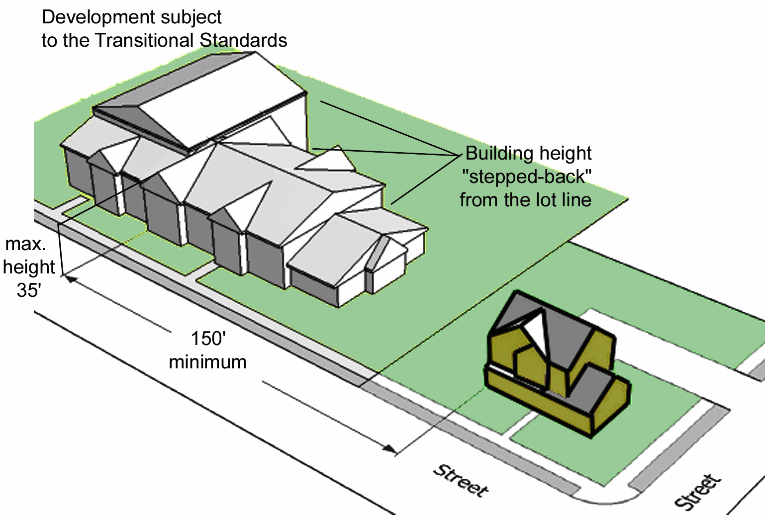
Figure 23-6-11(D)(2): Transitional Building Height
(3)
Building Design
a.
Buildings shall:
1.
Use exterior colors that are compatible with any adjacent single-family detached dwellings;
2.
Use similarly sized and patterned architectural features such as windows, doors, awnings, arcades, pilasters, cornices, wall offsets, building materials, and other building articulations found on any adjacent single-family detached dwellings; and
3.
Orient porches, balconies, outdoor space, and other exterior site features such as vending machines away from the adjoining land zoned RE, RER, RS-, or AHO.
b.
Retail commercial building façades that face single-family detached development or vacant land zoned RE, RER, RS-, or AHO shall be designed to appear as discrete storefronts, with no single storefront occupying more than 50 percent of the total façade width.
(4)
Similar Roof Forms
Consistency in roof forms with adjacent single-family development shall be addressed by using a similar roof form with varying height and proportion.
(5)
Use Intensity
For multi-building development that includes varying intensities in different buildings, the development shall establish a continuum of use intensity (e.g., residential to office to retail) with the least intense use located nearest to the abutting single-family detached development or vacant land zoned RE, RER, RS-, or AHO.
(6)
Service and Loading Area Location and Screening
a.
Separate service related activities associated with commercial uses shall be located behind or to the sides of buildings and away from the abutting single-family detached dwelling or vacant land zoned RE, RER, RS-, or AHO. They shall be screened with walls and/or landscaping in accordance with Section 23-6-3(G), Screening, and provided with access that is integrated with parking areas and the vehicular circulation network (See Section 23-6-2(J), Loading Area Standards.).
b.
Outdoor storage, trash collection, and loading areas shall not be visible from public or private rights-of-way.
(7)
Parking and Driveways
a.
Where required, off-street parking shall be established in one of the following locations (listed in priority order):
1.
Adjacent to off-street parking lots serving nonresidential uses on adjoining lots;
2.
Adjacent to lot lines adjoining nonresidential development;
3.
Adjacent to lot lines adjoining mixed-use development;
4.
Within a lot's corner side yard;
5.
Behind the building;
6.
In front of the building; or
7.
Adjacent to lot lines for the abutting single-family detached development or vacant land zoned RE, RER, RS-, or AHO.
b.
The façade of any parking structures facing abutting single-family detached development or vacant land zoned RE, RER, RS-, or AHO shall be designed to appear as solid building walls to soften its visual impact.
(8)
Drive-Throughs
Ordering speakers and menu boards associated with a use with drive-through service shall be located as far as possible from abutting single-family detached development or vacant land zoned RE, RER, RS-, or AHO.
(9)
Outdoor Activity Areas
Outdoor dining and other outdoor gathering areas that generate noise shall be located away from the abutting single-family detached development or vacant land zoned RE, RER, RS-, or AHO, so as to minimize acoustic impacts.
(10)
Open Space
a.
Location of Open Space
Development subject to these standards and the standards in Section 23-6-6, Open Space Set Asides, shall locate the open space set-aside adjacent to the abutting single-family detached development or vacant land zoned RE, RER, RS-, or AHO, if reasonably possible.
b.
Existing Natural Features
Natural features such as existing vegetation, natural differences in topography, streams, wetlands, and other such features shall be used as transitions where possible. Where such natural features are used as transitions, pedestrian connections to adjoining land uses shall be provided.
(11)
Operational Standards
On approval of a development application, the city may impose conditions to limit operational activities of the development to ensure it is compatible with adjoining residential uses. These operational activities include, but are not limited to, placement of trash receptacles, location of delivery and loading zones, placement and illumination of outdoor vending machines, hours of operation, and other such conditions.
(A) - Purpose
The purpose of this section is to promote sustainable development practices as a means of addressing global climate change, protecting natural resources, and ensuring a high quality of life for future city residents. More specifically, it is intended to require new development to use a basic level of site and building design options that conserve energy, promote a healthy landscape, support public health and safety, and otherwise increase the development's sustainability—to provide incentives to encourage even greater use of sustainable development practices.
(B) - Sustainable Development Point Requirement
(1)
All applications for approval of a Site Plan for nonresidential, mixed-use, and multifamily residential development shall incorporate a sufficient number of sustainable design options from Table 23-6-12(C), Sustainable Development Options and Points, to demonstrate achievement of the minimum number of points required below for the specific type of development.
a.
Nonresidential development and mixed-use development in the CB, RB, DT, and WF districts shall achieve at least 18 points.
b.
Nonresidential development and mixed-use development in all other districts shall achieve at least 12 points.
c.
Multifamily residential development shall achieve at least ten points.
(2)
Table 23-6-12(B), Sustainable Development Options and Points, sets forth a range of sustainable site and building design features and the number of points achieved by incorporating each design feature (or specified levels of the design feature).
(C) - Bonuses for Additional Sustainable Development Features
(1)
Applicability
a.
New development in the RM-, Business, and WF Districts that provide sustainable features in accordance with the provisions of this section shall be eligible for bonuses including:
1.
An increase in maximum allowable gross residential density or maximum allowable nonresidential floor area by up to 20 percent;
2.
An increase in the maximum allowable height to allow up to two additional stories;
3.
A reduction in the total amount of required landscaping material for site landscaping and perimeter buffers by up to 20 percent; or
4.
A modification to the off-street parking requirements resulting in a reduction in the minimum number of parking spaces requirement by 15 percent, or an increase to the maximum allowable number of spaces by 15 percent.
b.
Development may include a sufficient number of sustainable features to take advantage of more than one type of bonus, but in no instance shall the amount of an incentive be increased or decreased (as appropriate) beyond the maximum listed in this subsection.
c.
Features provided to satisfy a development's compliance with the requirement in Section 23-6-12(B), Sustainable Development Point Requirement, shall not be counted towards obtaining a bonus in accordance with this subsection.
(2)
Conflict with Transitional Standards
Where bonuses in this section conflict with the transitional standards in Section 23-6-11, the transitional standards control.
(3)
Procedure
a.
Applicants seeking to use the sustainability incentives in the section shall include a written request to do so with the development application.
b.
Review of any request for a bonus in accordance with this section, shall occur during review of an application for approval of a PD master plan (Section 23-2-4(C)), Site Plan (Section 23-2-4(E)) or Certificate of Zoning Compliance (Section 23-2-4(L)), as appropriate.
c.
The bonus granted shall be based on the number of sustainable features provided, in accordance with Table 23-6-12(C)(3), Sustainability Bonuses, and Section 23-6-12(C)(4), Menu of Sustainable Design Features.
(4)
Menu of Sustainable Design Features
One or more of the following sustainable design features may be offered by an applicant for proposed development in accordance with Table 23-6-12(C), Sustainability Bonuses.
(A) - Purpose
The purpose of this section is to regulate signage to:
(1)
Protect the public welfare, property values, economic benefits from the resort and tourism industry, and a high quality of life for citizens by preserving the aesthetic qualities that distinguish Biloxi from excessive and obtrusive signage;
(2)
Promote the efficient transfer of general public, commercial, and individual identification or information and reduce traffic confusion and congestion by improving the legibility and effectiveness of signs through the control of their number, location, size, appearance, illumination, and animation;
(3)
Promote the safety of pedestrians and traffic by ensuring that signs do not create traffic hazards or hazards due to collapse, fire, collision, decay, or abandonment; and
(4)
Maintain and enhance the pleasing look of Biloxi and preserve it as a community that is attractive to business, tourists, and residents.
(B) - Applicability
(1)
General
a.
A sign may be erected, placed, established, painted, created or maintained only in conformance with the standards, procedures, exemptions, and other requirements of this Ordinance and all other applicable laws, ordinances, and regulations. Except for signs listed in Section 23-6-13(B)(3), Signs Exempt from Regulation, or in Section 23-6-13(B)(4), Signs Allowed without a Sign Permit, all signs shall comply with the permitting procedure in Section 23-2-4(K), Sign Permit, and shall be erected or installed only after issuance of a Sign Permit and in accordance with such permit.
b.
Standards for signage for certain specific uses may be found in Section 23-4-3, Use-Specific Standards, and Section 23-4-4(C), Specific Standards for Certain Accessory Uses.
(2)
Existing Development
Existing permanent signs legally erected before November 9, 2010 may remain in place and in use, subject to restrictions on modification, replacement, and other actions. Certain temporary signs (including flags, banners, and portable signs), shall be subject to removal in accordance with this section.
(3)
Signs Exempt from Regulation
The following types of signs are exempt from the requirements of this section, and shall not be required to obtain a Sign Permit in accordance with Section 23-2-4(K), Sign Permit (but may require a Building Permit in accordance with the Building Code):
a.
Any public notice or warning required by a valid and applicable federal, state, or local law, regulation, or ordinance;
b.
Any sign inside a building, not attached to a window or door, and not legible from a distance of more than three feet beyond the lot line of the development site or parcel on which the sign is located; and
c.
A traffic control sign on private commercial property (such as "Stop," "Yield," and similar signs), where the sign face meets Mississippi Department of Transportation standards or contains no commercial message of any sort.
(4)
Signs Allowed without a Sign Permit
The following types of signs are exempt from the requirements to obtain a Sign Permit in accordance with Section 23-2-4(K), Sign Permit, but are subject to applicable standards in this section and may require a Building Permit in accordance with the Building Code:
a.
A sign not exceeding two square feet in area that contains only the name and address of the land or building on which it is located, or the owner or occupant of the land or building;
b.
An unlighted sign not exceeding 12 square feet in area that advertizes the sale, lease, or rent of the land or building on which it is located, provided the sign is removed from the land or building within ten days after the land or building is sold, leased, or rented;
c.
A sign that advertizes a political campaign or content based political speech, provided the sign is kept in good repair, and is removed within seven days after the election date; and
d.
A building marker sign that is carved or engraved into the building or made of bronze or other permanent material, and contains no commercial message;
e.
A notice sign that contains no commercial message;
f.
Any change in the advertising copy, announcement, or message on a marquee or changeable copy sign board;
g.
A wall sign not exceeding 12 square feet in area that identifies the name, address, and management of an apartment building or planned building group on the premises, provided such signs are limited to one sign per building; and
h.
A directional sign not exceeding four square feet in area that is located within a Multifamily Residential (RM), Limited Business (LB), or Neighborhood Business (NB) Zoning District, contains no commercial message, and is intended to provide useful noncommercial directions or information to persons likely to be on the premises, such as notice of parking/no parking zones, identification of entrance and exit lanes, and directions to telephones, restrooms, and automated teller machines.
(Ord. No. 2514, 7-11-2023)
(C) - Prohibited Signs
All signs not expressly permitted under this section or exempt from regulation or allowed without a permit in accordance with Section 23-6-13(B), Applicability, are prohibited. Signs prohibited in all zoning districts include, but are not limited to:
(1)
Pennants, banners, streamers and all other fluttering, spinning, or similar type signs and advertising devices, except as expressly authorized by the terms and conditions of a Temporary Use Permit for a special event that is approved in accordance with Section 23-2-4(J), Temporary Use Permit, and Section 23-4-5(G), Special Events.
(2)
Beacons;
(3)
Portable signs, except as expressly authorized by the terms and conditions of a Temporary Use Permit for a special event that is approved in accordance with Section 23-2-4(J), Temporary Use Permit, and Section 23-4-5(G), Special Events.;
(4)
A vehicle that:
a.
Is inoperable;
b.
Does not display a current vehicle inspection sticker or license plate;
c.
Is not principally used as a mode of transportation for business purposes;
d.
Is conspicuously parked or located on a lot or public right-of-way; and/or
e.
Is principally used as a business or advertising device, provided, however, that this provision shall not apply to licensed mobile vendors.
(5)
A sign advertising or identifying a business that has closed and ceased operations for 30 or more days;
(6)
Any sign fastened to public property (unless placed by a public agency), a utility pole, a tree, a fence, or a rock;
(7)
Any sign fastened to property or erected on property without the permission of the owner of the property;
(8)
Any sign utilizing flashing lights and located within 50 feet of the right-of-way lines of major arterial streets, as identified in Biloxi's Major Thoroughfare Plan.
(D) - Signs in A, RE, RER, RS-, RM-, and RMH Districts
The following Table 23-6-13(D), Sign Standards for A, RE, RER, RS-, RM-, and RMH Districts, lists signs permitted in these base zoning districts and the number, area, height, and other dimensional standards applicable to the signs in such districts.
(E) - Signs in LB District
The following Table 23-6-13(E), Sign Standards for LB District, lists signs permitted in the LB Zoning District and the number, area, height, and other dimensional standards applicable to such signs in the district.
(F) - Signs in NB District
The following Table 23-6-13(F), Sign Standards for NB District, lists signs permitted in the NB Zoning District and the number, area, height, and other dimensional standards applicable to such signs in the district.
(G) - Signs in CB District
The following Table 23-6-13(G), Sign Standards for CB District, lists signs permitted in the CB Zoning District and the number, area, height, and other dimensional standards applicable to such signs in the district.
(H) - Signs in RB District
The following Table 23-6-13(H), Sign Standards for RB District, lists signs permitted in the RB Zoning District and the number, area, height, and other dimensional standards applicable to such signs in the district.
(I) - Signs in DT District
The following Table 23-6-13(I), Sign Standards for DT District, lists signs permitted in the DT Zoning District and the number, area, height, and other dimensional standards applicable to such signs in the district.
(J) - Signs in I District
The following Table 23-6-13(J), Sign Standards for I District, lists signs permitted in the I Zoning District and the number, area, height, and other dimensional standards applicable to such signs in the district.
(K) - Signs in WF District
The following Table 23-6-13(K), Sign Standards for WF District, lists signs permitted in the WF Zoning District and the number, area, height, and other dimensional standards applicable to such signs in the district.
(L) - Maintenance of Signs
All signs shall be maintained in good condition and appearance. The Director of Community Development may cause to be removed any sign which shows gross neglect or which becomes dilapidated, or where the area immediately around such sign is not well maintained after due notice has been given.
(1)
Removal of Noncomplying or Hazardous Signs
The Director of Community Development shall remove or cause to be removed any sign erected or maintained in conflict with this Ordinance if the owner of either the site or the sign fails to correct the violation within ten days after receiving written notice of violation from the Director of Community Development. The Director of Community Development may immediately remove, or cause to be removed, any sign which in his opinion constitutes a public hazard. Removal of a sign by the Director of Community Development shall not affect any proceedings instituted prior to removal of such sign.
(2)
Repair or Removal of Dangerous Signs
Whenever a sign becomes structurally unsafe or endangers the safety of a building or premises, or endangers the public safety, the Director of Community Development shall give written notice to the owner of the sign, or the owner of the premises on which the sign is located, that such sign is to be made safe or removed within ten days, subject to penalties and remedies set out in Article 23-9: Enforcement.
(M) - Signs Not to Constitute Safety Hazard
(1)
Traffic Safety
No sign shall be erected at the intersection of any streets in such a manner as to obstruct free and clear vision, or at any location where it may interfere with or obstruct the view of traffic sight lines or traffic control devices. If located within direct line of vision of a traffic control device, no flashing or intermittent red, green or amber illumination shall be used.
(2)
Pedestrian Safety, Entrances, Exits
No sign shall be erected so as to prevent free ingress or egress from any door, window or fire escape, and no sign of any kind shall be attached to a standpipe or fire escape.
(N) - Temporary Signs
(1)
Unless otherwise prohibited, special sales promotional displays, including but not limited to displays incidental to the opening of a new business, shall be allowed in any zoning district in which such sales are allowed - provided,
a.
That such displays shall be limited to sandwich board/A-frame signs, pennants, banners, streamers, and flags.
b.
Any pennants, banners, streamers and flags:
1.
Shall be not be tattered, torn, or faded;
2.
At least ten feet from the curb, or the owners property line, whichever is greater; and
3.
Located between the business store front and the curb;
c.
Any sandwich board/A-frame signs may be less than ten feet from the curb provided they do not impede pedestrian traffic.
(2)
A Temporary Use Permit shall be required for all temporary signs, including temporary construction signs, in accordance with Section 23-2-4(K), Sign Permit.
(Ord. No. 2250, § 1, 1-30-2014; Ord. No. 2274, § 1, 3-3-2015; Ord. No. 2330, § 1, 1-24-2017; Ord. No. 2354, § 1, 3-27-2018; Ord. No. 2480, § 1, 4-26-2022)
Editor's note— It should be noted that § 2 of Ord. No. 2354, adopted March 27, 2018 provides as follows: "This ordinance shall expire three years after its effective date (April 26, 2018), and at that time subsection 23-6-13(N)(1) shall automatically revert to the version effective prior to the adoption of this ordinance, unless further action is taken by the City Council to remove this sunset provision. Any temporary sign permit granted while this amended version [is] in effect shall continue to be effective until it expires by the terms of its issuance even though it may extend past the sunset provision contained herein."