
Biloxi City Zoning Code
ARTICLE 23
5: - INTENSITY AND DIMENSIONAL STANDARDS
1 - Purpose
The purpose of this article is to present the intensity and dimensional standards for all principal and accessory uses and structures allowed in this Ordinance, set forth rules for measuring and applying the standards, and identify exceptions to and variations of the standards. These standards may be further modified by other applicable sections of this Ordinance.
2 - Intensity and Dimensional Standards Table
Unless otherwise specified in this Ordinance, all principal and accessory uses and structures are subject to the intensity and dimensional standards set forth in Table 23-5-2, Intensity and Dimensional Standards.
(Ord. No. 2273, § 1, 3-3-2015; Ord. No. 2423, 7-21-2020)
(A) - Lot Area Per Dwelling Unit
(1)
Lot area per dwelling unit shall be determined by dividing the total horizontal land area (in square feet) within the boundaries of the lot—excluding any area within existing or proposed public street rights-of-way and private street easements—by the total number of dwelling units located or proposed on the lot.
(2)
Minimum lot area per dwelling unit standards apply only to development comprised of dwelling uses (i.e., household living uses). For a mixed-use development containing dwelling uses and nonresidential or non-dwelling principal uses, lot area per dwelling unit shall be determined by dividing the portion of the total lot area allocated to the dwelling uses by the total number of dwelling units located or proposed on the lot.
(B) - Dwelling Units Per Acre
(1)
Dwelling units per acre shall be determined by dividing the total number of dwelling units located or proposed on a lot by the total horizontal land area (in acres) within the boundaries of the lot—excluding any area within existing public street rights-of-way or private street easements.
(2)
Maximum dwelling units per acre standards apply only to development comprised of dwelling uses (i.e., household living uses). For a mixed-use development containing dwelling uses and nonresidential or non-dwelling principal uses, dwelling units per acre shall be determined by dividing the total number of dwelling units located or proposed on the lot by the portion of the total lot area allocated to the dwelling uses.
(C) - Floor Area Ratio
(1)
Floor area ratio shall be determined by dividing the gross floor area (in square feet) devoted to nonresidential and non-dwelling uses on all floors of all buildings located or proposed on a lot by the total horizontal land area (in square feet) within the boundaries of the lot—excluding any area within existing public street rights-of-way or private street easements.
(2)
Maximum floor area ratio standards apply only to nonresidential or non-dwelling uses. For a mixed-use development containing nonresidential or non-dwelling principal uses and dwelling uses (i.e., household living uses), nonresidential floor area ratio shall be determined by dividing the gross floor area devoted to nonresidential and non-dwelling uses located or proposed on the lot by the portion of the total lot area allocated to the nonresidential and non-dwelling uses.
(D) - Lot Width
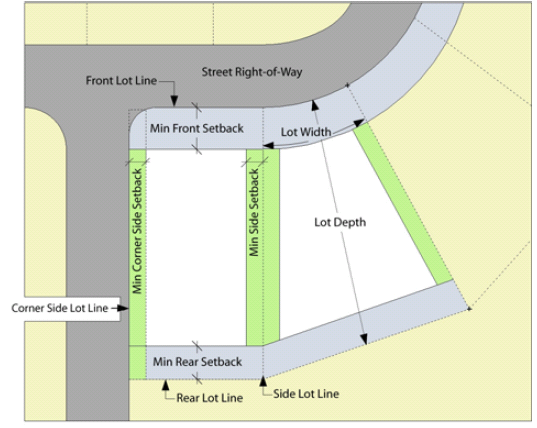
Figure 23-5-3(D): Lot Dimensions
Lot width shall be determined by measuring the horizontal distance along a straight line connecting the points where a line delineating the minimum front setback (front setback line) intersects the side lot lines—or in the case of corner lots, a side lot line and the opposite corner side lot line (See Figure 23-5-3(D), Lot Dimensions).
(E) - Lot Depth
Lot depth shall be determined by measuring the horizontal distance along a straight line connecting the midpoints of the front lot line and rear lot line (See Figure 23-5-3(D), Lot Dimensions.). If the lot has no rear lot line, lot depth shall be measured along a straight line connecting the midpoint of the front lot line and the most distant point on any other lot line. For a flag lot, lot depth shall be measured along a straight line connecting the midpoint of the lot line delineating the base of the "flag" portion of the lot, as extended across the "flagpole" portion of the lot, and the midpoint of the rear lot line (See Figure 23-5-3(H)(2)c., Flag Lot Dimensions.).
(F) - Impervious Surface Area
Impervious surface area (as a percentage of lot area) shall be determined by dividing the total horizontal area of impervious surfaces located or proposed on a lot by the total horizontal land area within the boundaries of the lot, then multiplying by 100.
(G) - Height
Height of a structure shall be determined by measuring the vertical distance between the elevation of the average finished grade around its foundation and the highest point of the structure (See Figure 23-5-3(G), Height Measurement)—provided, however, that if a structure is located within an area of special flood hazard subject to regulations in the city's Flood Damage Prevention Ordinance (Chapter 8 of the Biloxi Code of Ordinances), the height of the structure shall be measured from the base flood elevation (BFE) applicable at the structure's location.
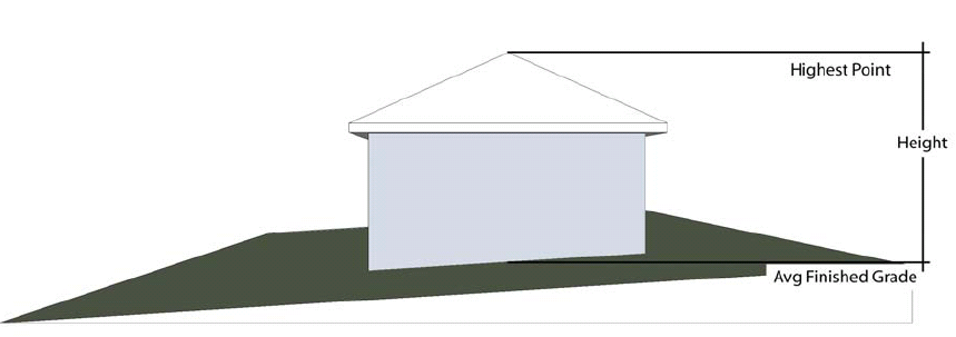
Figure 23-5-3(G): Height Measurement
(H) - Setbacks
(1)
Generally
a.
Front, corner side, side, and rear setbacks on a lot shall be determined by measuring the horizontal distance along a straight line extending at a right angle from the lot's front, corner side, side, or rear lot line (as appropriate) to the foundation of the nearest structure on the lot (See Figure 23-5-3(H)(1), Setback Measurement.). Allowable encroachments into setback areas (See Section 23-5-4(C)(1), Allowable Encroachments.) shall be ignored when measuring setbacks.
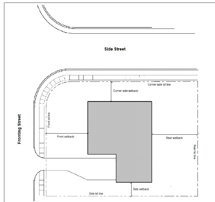
Figure 23-5-3(H)(1): Setback Measurement
b.
Attached buildings—whether two or more principal buildings, or two or more accessory buildings, or one or more accessory buildings attached to a principal building—shall be treated as a single structure for the purpose of applying or measuring minimum setbacks. This requirement shall not apply to residential patio covers, carports, open shade structures, or similar unenclosed structures.
(2)
Front Setback
a.
Corner Lot
1.
A corner lot shall have only one front lot line as determined by the Director of Community Development in accordance with the definition of front lot line in Section 23-10-2, Terms and Uses Defined, and Section 23-10-1, General Rules of Interpretation. Front setbacks shall be measured and applied only from that one front lot line, and corner side setbacks shall be measured and applied from the intersecting corner lot line.
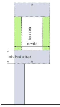
Figure 23-5-3(H)(2)c: Flag Lot Dimensions
2.
On a corner lot where the intersecting right-of-way boundaries are defined by a curve, the front setback shall be measured from the front lot line as extended to form an intersecting angle with an extension of the corner side lot line. (See Figure 23-5-3(D), Lot Dimensions.)
b.
Through Lot
For purposes of this subsection, a through lot shall be deemed to have a front lot line along each street it abuts. Front setbacks shall be measured and applied from each such front lot line.
c.
Flag Lot
On a flag lot, the front setback shall be measured within the "flag" portion of the lot, from the lot line delineating the base of that portion. (See Figure 23-5-3(H)(2)c, Flag Lot Dimensions.)
d.
Measured from Future Street Right-of-Way
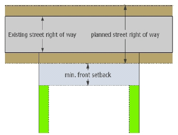
Figure 23-5-3(H)(2)d: Front Setback Measured from Future Street Right-of-Way
Where city-adopted plans call for the future widening of the abutting street right-of-way and identify the future right-of-way boundary (e.g., by delineating the boundary or establishing its distance from the street's centerline), the front setback shall be measured from the future right-of-way boundary (See Figure 23-5-3(H)(2)d., Front Setback Measured from Future Street Right-of-Way.).
(3)
Corner Side Setback
On a corner lot where the intersecting right-of-way boundaries are defined by a curve, the corner side setback shall be measured from the corner side lot line as extended to form an intersecting angle with an extension of the front lot line (See Figure 23-5-3(D), Lot Dimensions.).
(A) - Maximum Impervious Surface Area
(1)
Increase for Use of Porous Paving Material
The maximum impervious surface area standard in Table 23-5-2, Intensity and Dimensional Standards, may be increased by five percentage points (e.g., from 60 to 65 percent) for any lot on which at least 50 percent of the nonstructural impervious surface area (e.g., driveways, sidewalks, parking areas, and patios) is paved with porous paving material.
(B) - Maximum Height
The following exceptions and variations of the height limits set forth in Table 23-5-2, Intensity and Dimensional Standards, are allowed, provided the structure complies with the height limit established for the Airport Airspace Overlay District, where applicable.
(1)
Exceptions
The maximum height limits in Table 23-5-2, Intensity and Dimensional Standards, shall not apply to the following structures:
a.
Public monuments;
b.
Public water towers;
c.
Public utility towers, poles, and terminal facilities; or
d.
Spires, belfries, cupolas, domes, chimneys, elevator shaft enclosures, water tanks, ventilators, solar collectors, wind turbines, radio and television antennas, mechanical equipment and appurtenances, and similar rooftop structures or structural elements not intended for human occupancy, provided they cover not more than 25 percent of the roof area of a structure, comply with applicable screening requirements for mechanical equipment and appurtenances in Section 23-6-9(D)(7)b. and Section 23-6-10(D)(6)b., and extend no more than ten feet above the point where they are attached to the roof (unless otherwise allowed in this Ordinance).
(2)
Variations
a.
Public Buildings
The height of public or semipublic hospitals, institutions, schools, or public service buildings may exceed the maximum height set forth in Table 23-5-2, Intensity and Dimensional Standards, for the applicable zoning district, up to a maximum of 60 feet, provided minimum corner side, side, and rear setbacks are increased one foot for every two feet the building height exceeds the maximum height set forth in Table 23-5-2.
b.
Places of Worship
The height of places of worship may exceed the maximum height set forth in Table 23-5-2, Intensity and Dimensional Standards, for the applicable zoning district, up to a maximum of 75 feet, provided minimum corner side, side, and rear setbacks are increased one foot for every two feet the building height exceeds the maximum height set forth in Table 23-5-2.
c.
Accessory Structures
Except as otherwise provided in this Ordinance, the height of accessory structures located within any setback area shall not exceed 16 feet, provided that this height limit may be increased one foot for every two feet the structure's setback from lot lines exceeds the minimum setbacks applicable to the accessory structure. Accessory structures that comply with the minimum setback standards applicable to principal structures shall be subject the maximum height standards applicable to principal structures.
d.
Boat Houses and Piers
A boat house or pier shall not exceed a height of 25 feet above mean high tide level.
(C) - Setbacks
(1)
Allowable Encroachments
Every part of every required setback area shall remain open and unobstructed from the ground to the sky except as otherwise allowed in Table 23-5-4(C)(1), Allowable Setback Area Encroachments, or allowed or limited by provisions in Article 23-4, Use Standards, Article 23-6, Development Standards, or elsewhere in this Ordinance. (See Figure 23-5-4(C)(1), Allowable Setback Area Encroachments.)
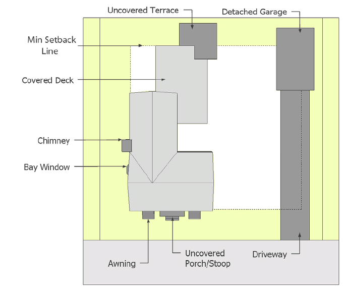
Figure 23-5-4(C)(1): Allowable Setback Area Encroachments
(2)
Front Setbacks
a.
Reduction of Minimum Front Setback to Block Face Average
If the average front setback on improved lots located on the same block face and in the same zoning district is less than the applicable minimum front setback set forth in Table 23-5-2, Intensity and Dimensional Standards, the minimum front setback required of a lot shall be reduced to that average front setback. This provision, however, does not apply to lots fronting a major arterial street.
b.
Reduction of Setbacks in Floodplains
Where a lot contains an area of special flood hazard identified in accordance with Chapter 8 (Flood Damage Prevention) of the Biloxi Code of Ordinances, the Director of Community Development may reduce required front, corner side, and/or side setbacks by up to 50 percent on determining the reduction is necessary to accommodate a reasonably-sized structure on the lot with no or minimal encroachment into the area of special flood hazard.
c.
Exception to Measurement from Future Street Right-of-Way
The Director of Community Development may exempt a lot from the requirement in Section 23-5-3(H)(2)d. that front setbacks be measured from identified future street rights-of-way on determining that the existing street right-of-way is adequate to encompass any anticipated need for widening of the street or other improvements, and that widening the right-of-way in accordance with adopted plans would create nonconforming front setbacks for a substantial number of other structures on lots fronting the street.