
Brighton City Zoning Code
ARTICLE 3
- Subdivision Standards
_____
3.01 - Streets
A.
Intent. The intent of the street design standards is to:
1.
Plan street networks to ensure the proper arrangement of blocks and lots, connect to adjacent development projects, and coordinate long-range growth and development.
2.
Emphasize street design as a key determinant of Brighton's community image and unique identity.
3.
Integrate street networks and street designs with open and civic spaces to establish a valuable public realm.
4.
Build complete and multi-modal networks of small, well-connected streets, trails and paths to improve the access, capacity, safety and efficiency of transportation systems.
5.
Provide multiple and direct connections between neighborhoods and local destinations such as parks, schools, and shopping, particularly where collector streets or neighborhood connector streets knit multiple projects or neighborhoods together, and avoid major streets becoming barriers.
6.
Use street networks, and a greater variety of streetscape designs and street types, to call attention to differing contexts within the City, and to better support development patterns and uses abutting the streets.
7.
Balance street designs to account for all potential users of the streets, including pedestrians, bicycles, automobiles, trucks and transit, and in a manner that the interests of a single mode of transportation do not compromise other modes.
8.
Implement the Brighton Transportation Master Plan as development occurs, and in particular, the Active Transportation policies and the street network and connectivity policies of that plan.
B.
Street Network. Arterial, collector, neighborhood connector, and local streets shall generally be laid out according to the policies of the Comprehensive Plan, Transportation Master Plan, and other major street, parks, trail and open space plans or maps. In the absence of more specific guidance in these plans, the following standards shall apply to street networks:
1.
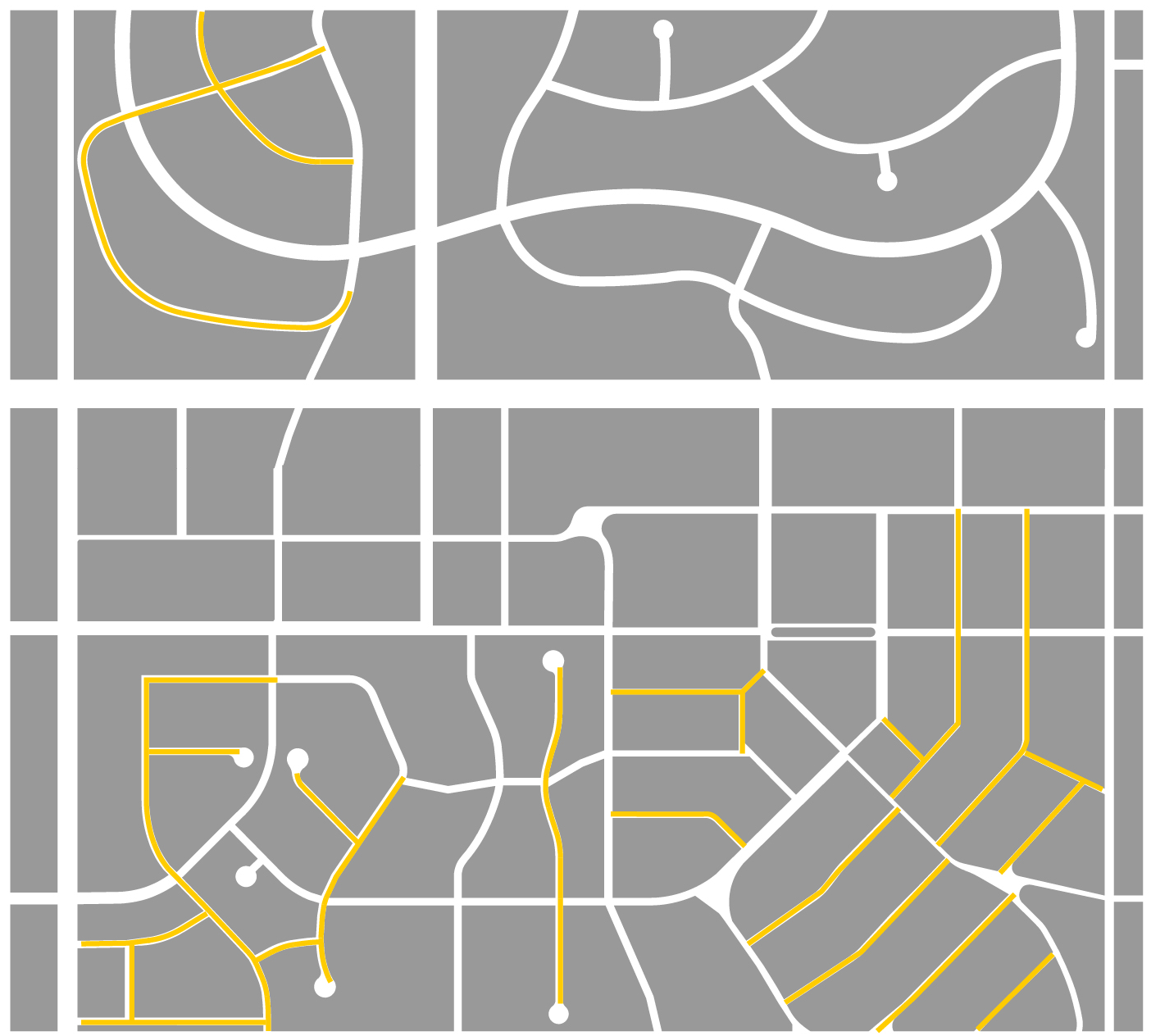
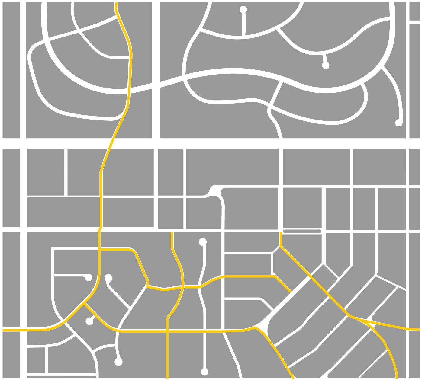
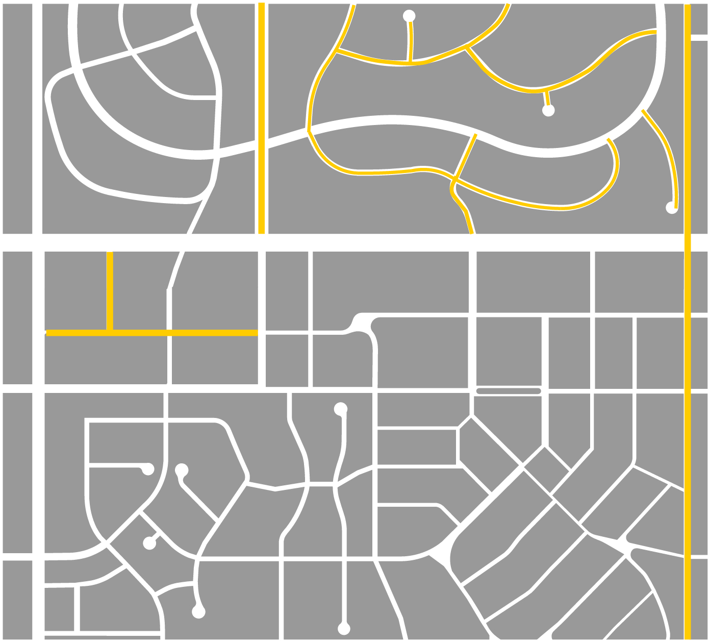
Blocks and Connectivity. Streets shall be laid out to provide a network of streets and blocks based on the planning context and development pattern as identified in Table 3-1:
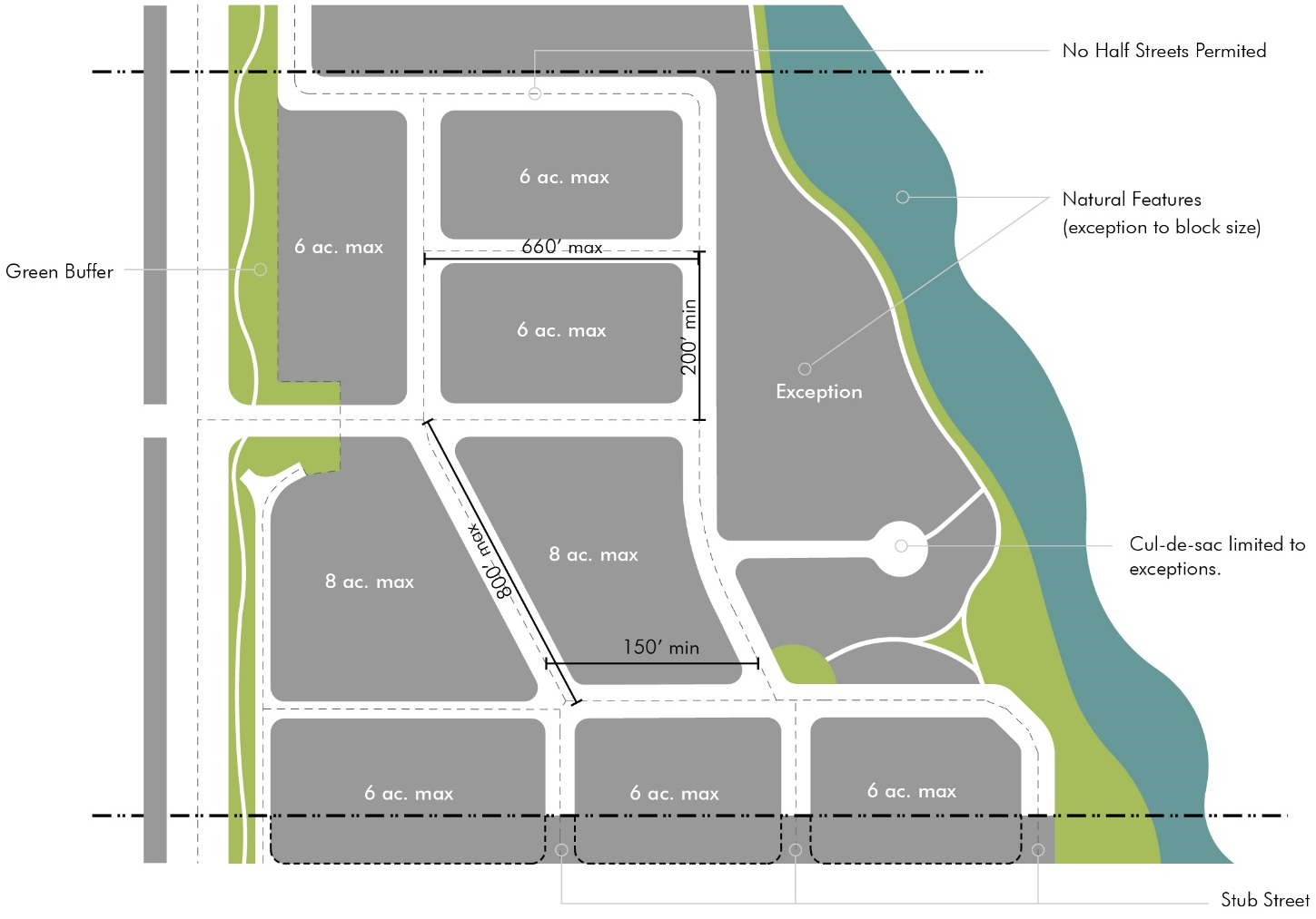
Figure 3-1 Street Networks and Block Sizes
Street networks shall establish typical block sizes in Table 3-1, and irregular block
and exceptions sizes are permitted to adjust to existing and surrounding conditions.
Figure 3-1 shows measurements and layout of common circumstances.
2.
Exceptions. The following are exceptions to the block and connectivity standards in Table 3-1:
a.
Natural Features, Open Spaces or other Civic Spaces. Blocks or parcels abutting or containing important natural features, topographical constraints or otherwise creating parts of the Open and Civic Space System, may be larger provided the proposed street layout preserves these features and integrates them into public realm design for the area.
b.
Regional Transportation Routes. Blocks or parcels abutting significant regional transportation routes that impede local network connectivity, such as highways or rail rights-of-way, may be larger provided the street layouts and development patterns achieve local connectivity in all other ways possible.
c.
Rural Parcels. Tracts divided into lots of at least five acres for rural or very low-intensity development may exceed block limits provided any development is arranged to allow future streets in compliance with these regulations and a logical pattern of re-subdivision can occur with minimal disruption of buildings, utilities, and other structures.
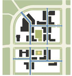
d.
Oversized Parcels. Where oversized parcels are platted for special land uses or projects that involve large-scale buildings and development patterns, such as campuses or large-scale employment or regional commercial areas, platted blocks may be larger provided through access drives mimic the block structure and urban design amenity of Table 3-1 and create logical extensions and connectivity to the public streetscape and open and civic spaces.
 NOT This
|  THIS
THIS
|
Figure 3-2 Through Access Drives
Large-scale projects, through initial plans or redevelopment, should arrange the projects
around through access drives that mimic the quality and priority of public streets,
create connectivity based on context and specified rates, and arrange the site and
buildings around a system of internal blocks and civic spaces, rather than islands
of buildings in parking lots.
e.
Specific Plans. A specific street network plan approved by the City through the planned development process in 2.04, or as an extension of the Transportation Master Plan, may provide different connectivity and external connection standards.
f.
In any case where streets are not required to connect by these standards or are justified by these exceptions, alternative designs such as loops, courtyard layouts, or closes are preferred over dead ends and cul-de-sacs.
3.
Walkways and Bicycle Routes. In any case where exceptions for larger blocks apply, where irregular or atypical blocks occur, or any other area where pedestrian and bicycle connections are important, such as adjacent to schools, parks, trail systems or community centers, the City may require pedestrian walkways or bicycle routes through blocks or at the end of any cul-de-sac. Connections shall meet the Trail Corridor or Pedestrian Passage design standards in Section 3.02.
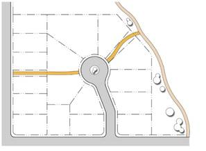 | Figure 3-3 Walkways and Bicycle Routes Where larger blocks or disconnected streets exist, alternate connections for pedestrians and bicycles may be required to provide the most direct route to destinations, connect transportation routes, and link to the open and civic space system. |
4.
External Connections. Streets shall be planned to provide continuation to adjacent undeveloped and future growth areas at intervals where all resulting blocks meet the standards in Table 3-1, unless justified by an exception in 3.01.B.2. The Planning Commission may require dedication of right-of-way and construction of streets extended to the boundary line of the property to be subdivided, or approve alternative arrangements for location and timing of construction that equally or better coordinate with anticipated future development of adjacent areas.
5.
Half Streets. Street systems shall be laid out to eliminate or avoid new perimeter half streets between adjacent property owners, except the City may approve phased street construction of arterial streets coordinated with a capital improvements plan. Where an existing half-street is adjacent to a new plat, the other half shall be improved and dedicated by the applicant. The Planning Commission may approve a new perimeter street where the applicant improves and dedicates the entire street and right-of-way within the boundaries, and may arrange for reimbursement of the applicant at the time the adjoining land is platted, as provided in Section 3.04.D.
6.
Intersections and Offsets. Streets shall be laid out to intersect subject to the following:
a.
Intersection angles should be as near as possible to right angles, and intersections less than 75 degrees are generally not acceptable.
b.
Oblique streets should be curved approaching an intersection and should be approximately at right angles for at least 100 feet prior to the intersection.
c.
Intersections should be generally aligned with existing intersections on the opposite side of the street, and offsets of the centerlines between 25 feet and 100 feet are generally not acceptable.
d.
Intersections of more than two streets at one point are generally not acceptable.
e.
Deviations from these standards may be approved through a subdivision plan and when considered as part of a network plan that uses different intersection configurations to emphasize unique natural features, better correspond to topography, implement traffic calming, or create gateways or focal points within the network.
C.
Street Types & Design. The street types in this section implement walkable street design, "complete" streets, and multi-modal networks for the various contexts in Brighton. They are based on the Active Transportation Policies of the Transportation Master Plan. An analysis of the specific context, the transportation network and development patterns, and balancing transportation, planning and urban design goals may warrant adjustments to the typical standards associated with each type. The City shall evaluate any proposed adjustments based on the Active Transportation Streets Design Guide in Table 3-5, the policies of the Transportation Master Plan, and an analysis of each particular application of the street types.
1.
Street Design Standards. Typical cross sections are shown for each street type with design standards for each element of the street cross-section. Application of these elements and the standards may be further refined by the Active Street Design Guide in Table 3-5.
2.
Planning & Urban Design Considerations. Planning and urban design considerations provide a guide to help apply each street type within the larger scale transportation network and address traffic function issues, while also considering smaller-scale site development and urban design issues.
a.
Traffic Volume. An estimated range of average daily traffic (ADT) within which the street will function well based on anticipated supported land uses and estimated trip generation.
b.
Vehicle Speeds. The desired and appropriate target for vehicle speeds considering the context, the streets role in the network, and the urban design priorities on a particular block or segment of that street.
c.
Street Tree Spacing. Spacing of street trees shapes the public realm and provides valuable landscape, urban design, and street function services, including infiltrating stormwater, shading and buffering pedestrians, and calming traffic.
d.
Driveway Spacing. Driveway spacing helps balance access vs. streetscape and frontage design and coordinate lot access and circulation on a block scale. Driveway limits and location are more specifically regulated by the frontage types in Article 5 and 6, and the access standards in Article 7.
e.
Frontage Types. The most common frontage types appropriate for each street are listed to help coordinate the design of the space between the building and the street. Frontage types are more specifically regulated by building standards in Articles 5 and 6, and the landscape standards in Article 8.
3.
Description & Context. Each street type includes summary of the design intent of the particular street type and its role in the larger development pattern and street network. This helps coordinate transportation planning and the design of street networks with the appropriate land uses, development patterns and zoning districts.
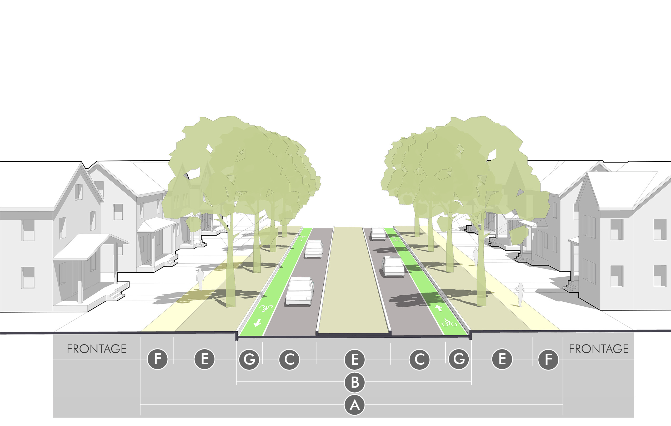
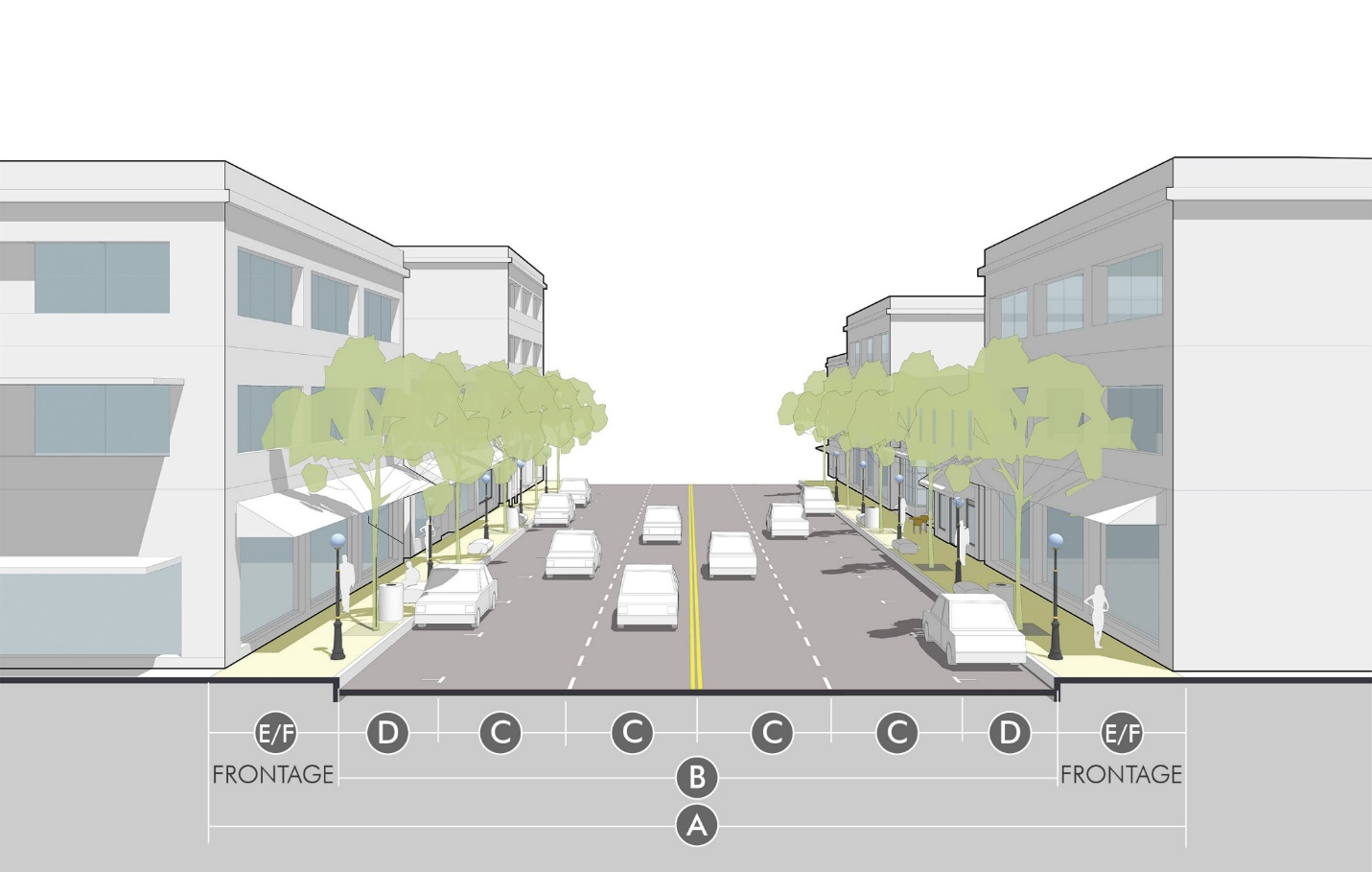
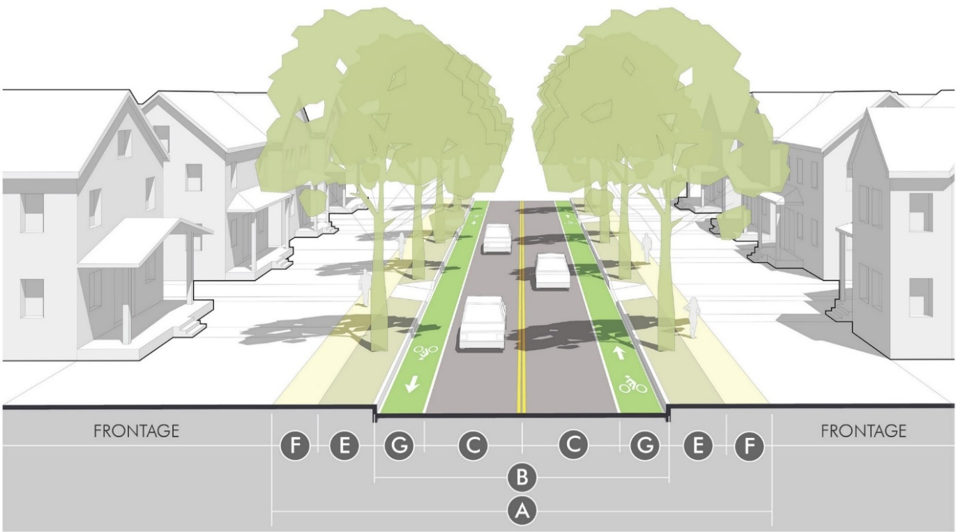
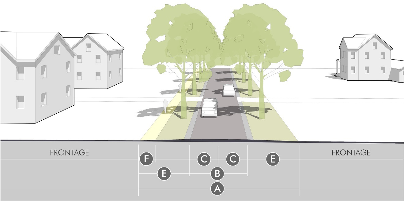
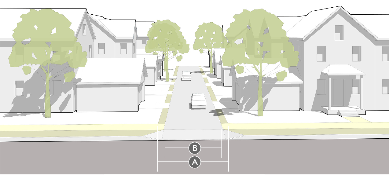
| Neighborhood Street (Local) |
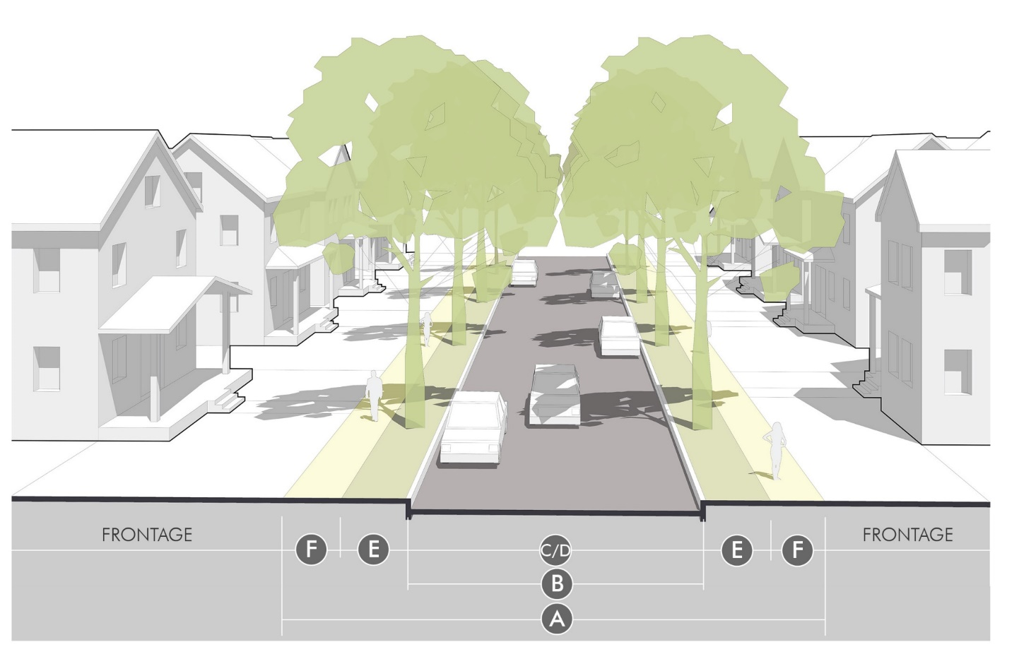 |
| Street Design | |||
| Ⓐ | ROW Width | 54' | |
| Ⓑ | Street Width (curb-to-curb) | 28' | |
| Ⓒ | Lanes (#/width) | n/a - two way slow speeds | |
| Ⓓ | On-street Parking | both sides; non-designated | |
| Ⓕ | Sidewalks | 5' | |
| Ⓔ | Planting/Amenity Area | 8' | |
| Bicycle Facilities | N/A | ||
| Turn Lanes | N/A | ||
| Planning & Urban Design Considerations | |||
| Traffic Volume (range) | under 1,500 adt | ||
| Vehicle Speeds (desired target) | under 20 mph | ||
| Street Tree Spacing | 25'—40' | ||
| Driveway Spacing |
40' + from other driveways
50' + from corner | ||
| Frontage Types |
Terrace
Neighborhood Yard Suburban Yard (limited) | ||
| Description & Context | |||
| The Neighborhood Street is a walkable street that supports a wide range of housing types, in compact and mixed-density neighborhoods. It requires a well-connected network to provide a variety of routes to neighborhood destinations, prioritizing walking and biking. The priority on slow speeds, streetscape design, and human-scale details makes the streetscape a safe and inviting space. | |||
 | |||
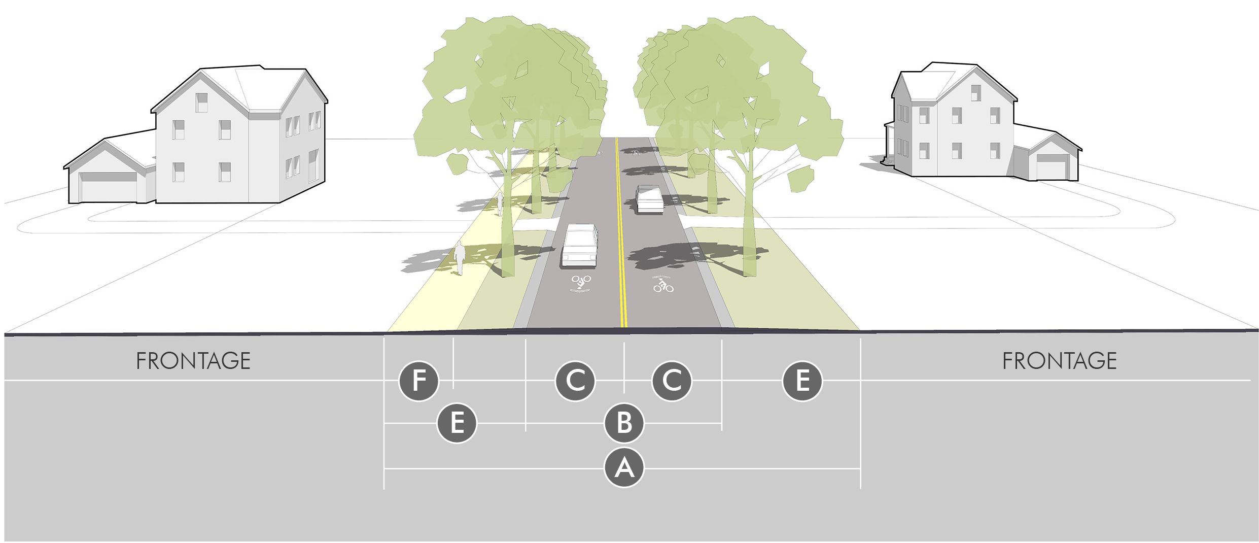
| Neighborhood Connector (Collector) |
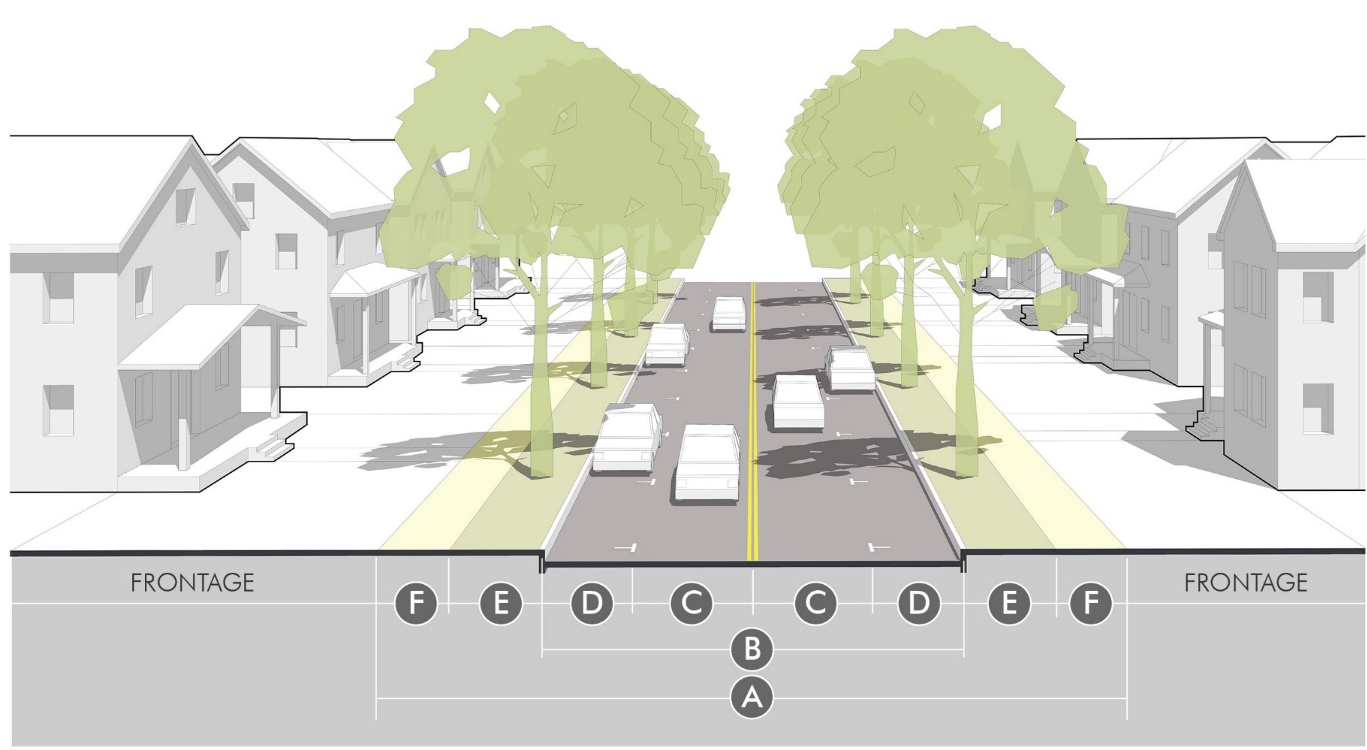 |
| Street Design | |||
| Ⓐ | ROW Width | 64' | |
| Ⓑ | Street Width (curb-to-curb) | 34' | |
| Ⓒ | Lanes (#/width) | 2 @ 10' | |
| Ⓓ | On-street Parking | 7' | |
| Ⓕ | Sidewalks | 6' | |
| Ⓔ | Planting/Amenity Area | 8' | |
| Bicycle Facilities |
Optional
5' bicycle lane added to street width | ||
| Turn Lanes |
N/A
unless dictated by traffic study | ||
| Planning & Urban Design Considerations | |||
| Traffic Volume (range) | 1,000—5,000 adt | ||
| Vehicle Speeds (desired target) | 20—25 mph | ||
| Street Tree Spacing | 25'—40' | ||
| Driveway Spacing |
65' + from other driveways
60' + from corner | ||
| Frontage Types |
Terrace
Neighborhood Yard Suburban Yard (limited) | ||
| Description & Context | |||
| The Neighborhood Connector is a walkable street that provides important connections between neighborhoods. It links local networks and reduces reliance on arterial streets, allowing all streets to better balance vehicles, walking and biking. The slow speed and high design amenities make these streets attractive for a wide range of housing types. | |||
 | |||
| Neighborhood Parkway (Collector or Minor Arterial) |
 |
| Street Design | ||
| Ⓐ | ROW Width |
86' (2 lane)
102' (4 lane) |
| Ⓑ | Street Width (curb-to-curb) |
44' (2 lane)
62' (4 lane) |
| Ⓒ | Lanes (#/width) |
2 @ 11' or
4 @ 10' |
| On-street Parking | N/A or limited by signs | |
| Ⓕ | Sidewalks | 8'; 10' if trail corridor |
| Ⓔ | Planting/Amenity Area |
12'
12' + median; or added to outside planting area |
| Bicycle Facilities | 5' lanes; off-street if trail corridor | |
| Turn Lanes | N/A, or within median | |
| Planning & Urban Design Considerations | ||
| Traffic Volume (range) | 1,000—10,000 adt | |
| Vehicle Speeds (desired target) | 30—35 mph | |
| Street Tree Spacing | 25'—40' on each side and within median; doubled on each side if no median | |
| Driveway Spacing |
120' + from other driveways
120' + from corner | |
| Frontage Types |
Terrace
Neighborhood Yard Suburban Yard (limited) | |
| Description & Context | ||
| The Neighborhood Parkway is a multi-model street that provides high landscape and design amenity, which makes it an attractive and livable street despite its higher order in the street network. Medians, civic spaces and other enhanced landscape and urban design amenities allow these streets to be focal points that define the character and identity of neighborhoods. | ||
 | ||
| Pedestrian/Mixed Use (Local) |
 |
| Street Design | ||
| Ⓐ | ROW Width | 60' |
| Ⓑ | Street Width (curb-to-curb) | 36' |
| Ⓒ | Lanes (#/width) | 2 @ 10' |
| Ⓓ | On-street Parking | 8' |
| Ⓕ | Sidewalks | 12' |
| Ⓔ | Planting/Amenity Area | 4' x 6' (min) tree wells within sidewalk |
| Bicycle Facilities | N/A | |
| Turn Lanes | Avoid due to connected network OR limit within reconfigured street space | |
| Planning & Urban Design Considerations | ||
| Traffic Volume (range) | under 5,000 adt | |
| Vehicle Speeds (desired target) | under 20 mph | |
| Street Tree Spacing | 25'—40' | |
| Driveway Spacing | Dependent on A, B, or C street designation; Mid-block alleys and shared access preferred | |
| Frontage Types |
Street Front
Terrace | |
| Description & Context | ||
| The Pedestrian/Mixed Use Street is a walkable street with generous sidewalks, on-street parking and slow speeds. It requires a well-connected network to disperse vehicle traffic and provide access to many uses and destinations. A, B, and C Street variations of these streets can support different quality of frontages and different levels of access and service to round out the network of walkable mixed-use places. | ||
 | ||
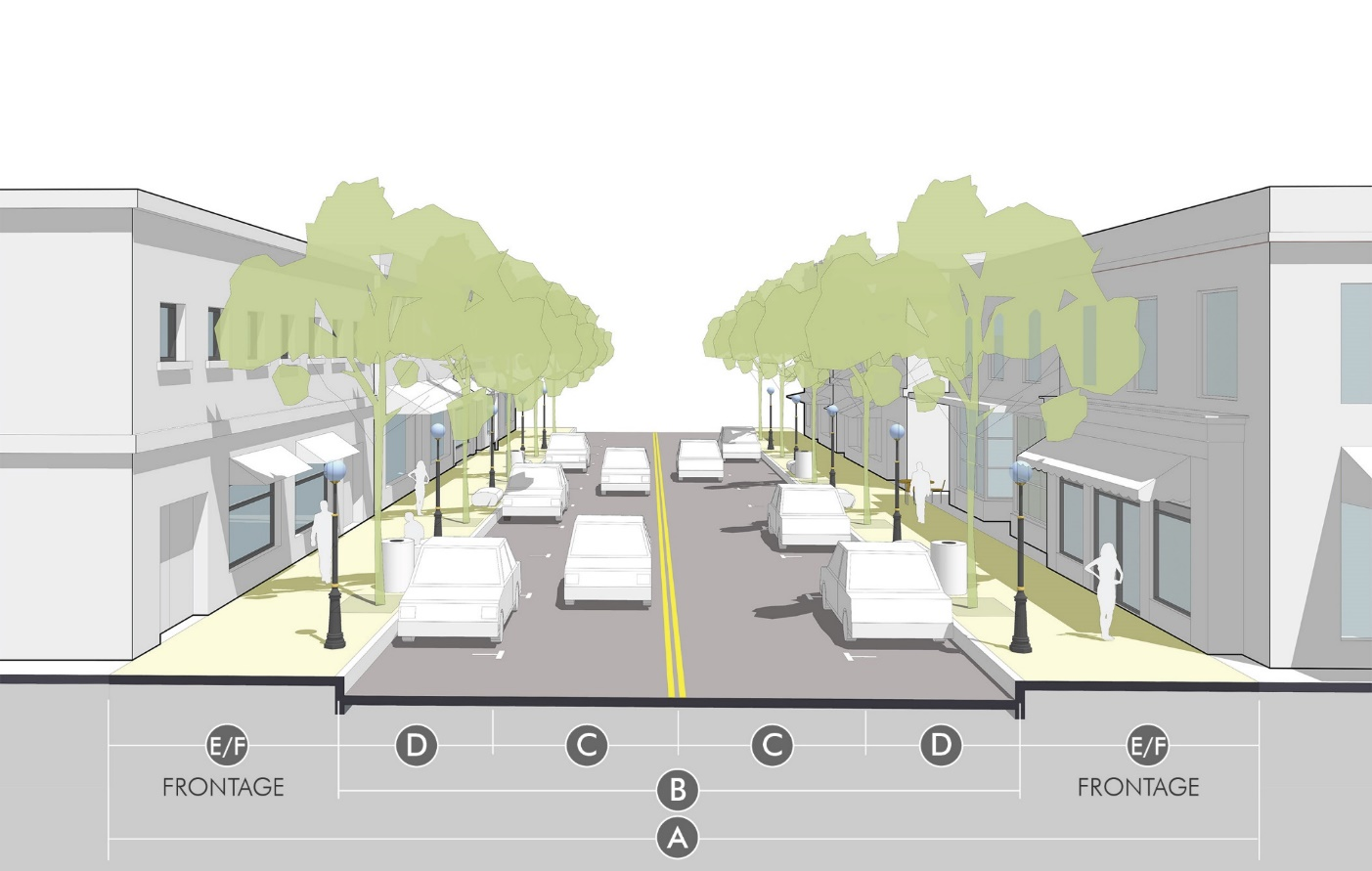
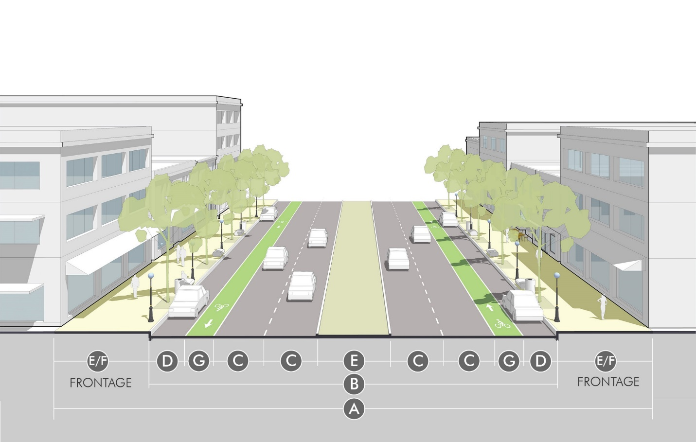
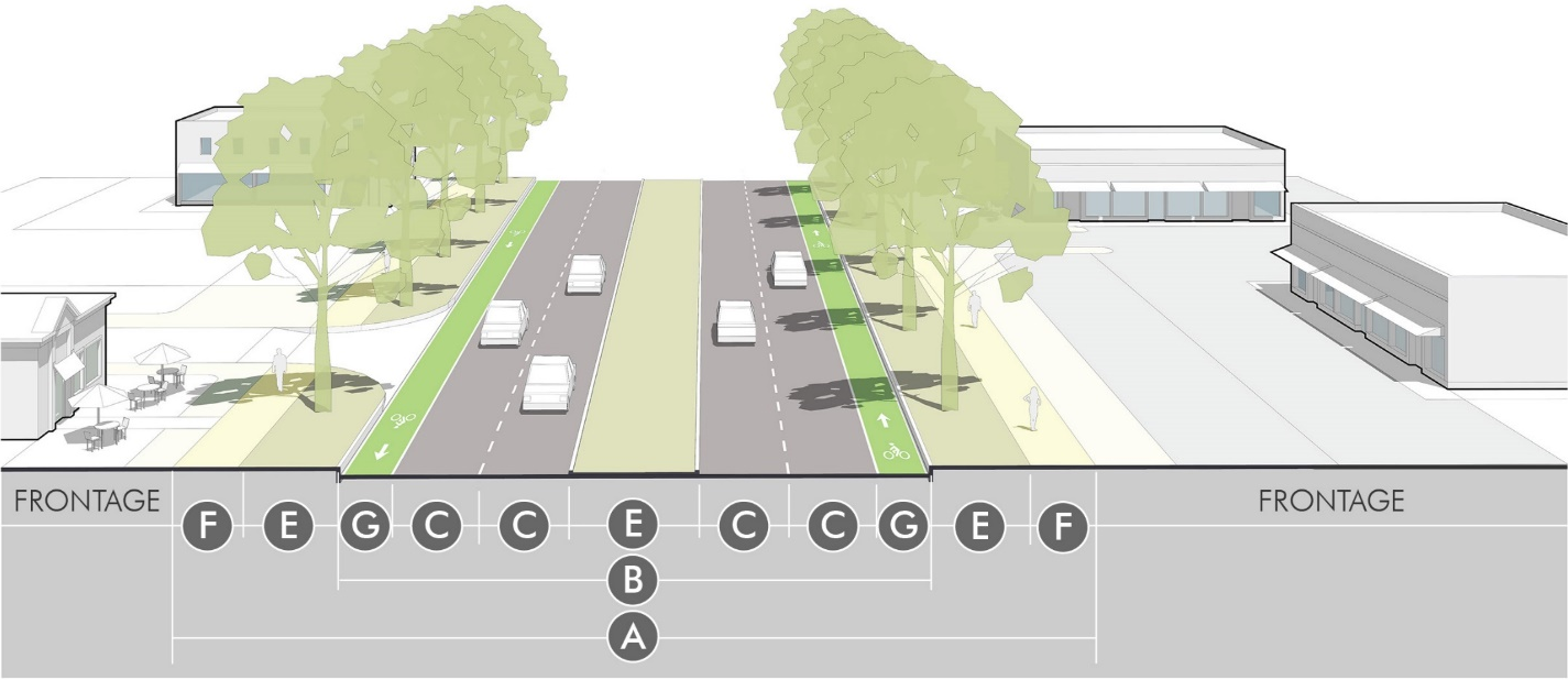
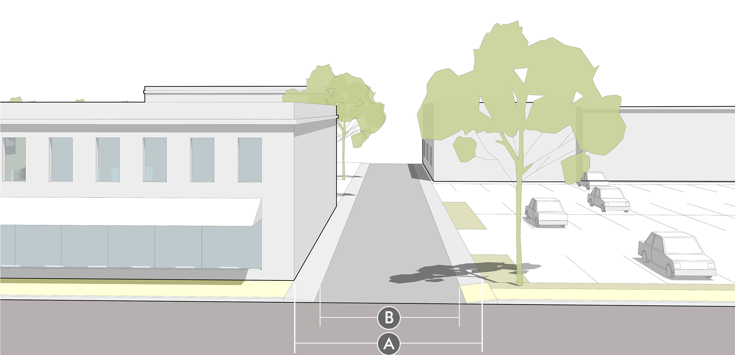
| Avenue (Collector) |
 |
| Street Design | ||
| Ⓐ | ROW Width | 90' |
| Ⓑ | Street Width (curb-to-curb) | 58' |
| Ⓒ | Lanes (#/width) | 4 @ 11' |
| Ⓓ | On-street Parking | 7' |
| Ⓕ | Sidewalks | 16' |
| Ⓔ | Planting/Amenity Area | 4' x 8' (min) tree wells within sidewalk |
| Bicycle Facilities | N/A | |
| Turn Lanes | Avoid due to connected network OR limit within reconfigured street space | |
| Planning & Urban Design Considerations | ||
| Traffic Volume (range) | 1,000—15,000 adt | |
| Vehicle Speeds (desired target) | 20—25 mph | |
| Street Tree Spacing | 25'—40' | |
| Driveway Spacing | Prohibited; Mid-block alleys only | |
| Frontage Types |
Street Front
Terrace | |
| Description & Context | ||
| The Avenue is a walkable street that supports a concentration of commercial uses and pedestrian activity. It often functions as the "main street" of moderate or larger-scale mixed-use areas, and transitions to Neighborhood Connector or Parkway designs outside of the center. The priority on parking, social spaces, and urban design amenities helps calm traffic despite the streets higher order in the network. | ||
 | ||
| Boulevard (Collector or Minor Arterial) |
 |
| Street Design | ||
| Ⓐ | ROW Width | 126' |
| Ⓑ | Street Width (curb-to-curb) | 86' |
| Ⓒ | Lanes (#/width) | 4 @ 11' |
| Ⓓ | On-street Parking | 7' |
| Ⓕ | Sidewalks | 20' |
| Ⓔ | Planting/Amenity Area | 4' x 8' (min) tree wells within sidewalk; 16' median |
| Bicycle Facilities | 6' bicycle lane | |
| Turn Lanes | Avoid due to connected network OR locate within median for limited distance at intersections | |
| Planning & Urban Design Considerations | ||
| Traffic Volume (range) | 5,000—25,000 adt | |
| Vehicle Speeds (desired target) | 30—35 mph | |
| Street Tree Spacing | 25'—40' | |
| Driveway Spacing |
150' + from other driveways
100' + from corner | |
| Frontage Types |
Street Front
Terrace | |
| Description & Context | ||
| The Boulevard is a multi-modal street that provides high landscape and design amenity, which makes it an attractive and vibrant street despite its higher order in the street network. Medians, civic spaces and other enhanced landscape and urban design amenities serve as gateways or focal points of mixed-use areas. These streets often serve as "edge" streets for mixed-use areas or the heart of mixed-use corridors, balancing the need for access and vehicle movement with walkability and providing the alternative to conventional arterial streets. | ||
 | ||
| Standard Street (Local or Collector) |
 |
| Street Design | ||
| Ⓐ | ROW Width | 60'—80' |
| Ⓑ | Street Width (curb-to-curb) | 32'—36' |
| Ⓒ | Lanes (#/width) | 2 @ 11' |
| On-street Parking | 7'; limited or converted to bike lane or sharrow on collectors/connectors | |
| Ⓕ | Sidewalks | 5'—6' |
| Ⓔ | Planting/Amenity Area | 6'—12' |
| Bicycle Facilities | N/A local; 6' lane or 14' sharrow lane on collectors or connectors | |
| Turn Lanes | Avoid due to connected network OR locate within reconfigured street width | |
| Planning & Urban Design Considerations | ||
| Traffic Volume (range) | up to 8,000 adt | |
| Vehicle Speeds (desired target) | 20—35 mph | |
| Street Tree Spacing | 25'—40' | |
| Driveway Spacing |
40' + from other driveways
50' + from corner | |
| Frontage Types |
varies by context
Suburban Yard; Buffer; Neighborhood Yard, Terrace | |
| Description & Context | ||
| The Standard Street is a basic street that provides access to districts, neighborhoods, blocks and lots in a wide variety of contexts, including residential, commercial, and industrial areas. This street typically serves as a local or collector street, particularly in less-connected networks, and can accommodate low-to-moderate speeds and volumes of traffic. Differences in the Standard Street cross-section design standards depend on the context to which the street is applied. | ||
 | ||
| Standard Arterial (Minor Arterial or Major Arterial) |
 |
| Street Design | ||
| Ⓐ | ROW Width | 112'/140' |
| Ⓑ | Street Width (curb-to-curb) | 72' including median |
| Ⓒ | Lanes (#/width) | 4 @ 11'/up to 6 major arterial |
| On-street Parking | N/A | |
| Ⓕ | Sidewalks | 8'; 10' if trail corridor |
| Ⓔ | Planting/Amenity Area |
12'/15'—20' + major
16' median |
| Ⓖ | Bicycle Facilities | 6' bicycle lane/12' multi-use trailfor major arterial |
| Turn Lanes | limited distances within median | |
| Planning & Urban Design Considerations | ||
| Traffic Volume (range) |
up to 8,000—25,000 adt minor
20,000 + adt major | |
| Vehicle Speeds (desired target) | 35—40 mph | |
| Street Tree Spacing | 25'—40' | |
| Driveway Spacing |
150' + spacing
100' + from corner | |
| Frontage Types | varies; Buffers typical | |
| Description & Context | ||
| The Arterial Street is a major street that provides a high degree of continuity between different parts of the City. It is applied generally where no other walkable or enhanced arterial street design can be allied. This street typically serves as a minor arterial but can also serve as a major arterial (though additional lanes, right-of-way, and multi-modal design considerations may be necessary). It accommodates moderate speeds and moderate-to-high volumes of traffic. | ||
 | ||
| Rural Lane (Local) |
 |
| Street Design | ||
| Ⓐ | ROW Width | 50' |
| Ⓑ | Street Width (curb-to-curb) | 18' |
| Ⓒ | Lanes (#/width) | 2 @ 9' |
| On-street Parking | N/A; except limited occasional bump outs | |
| Ⓕ | Sidewalks | 5' path 1 side within amenity area |
| Ⓔ | Planting/Amenity Area | 16' swale, including 2' shoulder and natural planting buffer |
| Bicycle Facilities | N/A | |
| Turn Lanes | N/A | |
| Planning & Urban Design Considerations | ||
| Traffic Volume (range) | under 400 adt | |
| Vehicle Speeds (desired target) | under 20 mph | |
| Street Tree Spacing | irregular/natural | |
| Driveway Spacing |
100' + from other driveways
50' + from corner | |
| Frontage Types |
Neighborhood Yard (limited)
Suburban Yard (limited) Natural Buffer | |
| Description & Context | ||
| A special and limited street type designed specifically to reinforce rural, agricultural or natural contexts. This street specifically applies to local streets in the local food district, agricultural or low density zoning, or other planned development applications designed to promote rural or natural character. | ||
 | ||
| Rural Connector (Collector) |
 |
| Street Design | ||
| Ⓐ | ROW Width | 70' |
| Ⓑ | Street Width (curb-to-curb) | 28' |
| Ⓒ | Lanes (#/width) | 2 @ 14' sharrow lanes (or 9'—10' lanes w/ paved shoulder) |
| On-street Parking | N/A | |
| Ⓕ | Sidewalks | 5' path or 10' multi-use path, 1 side; within amenity area |
| Ⓔ | Planting/Amenity Area | 20' swale, including 2' shoulder and natural planting buffer |
| Bicycle Facilities | 14' sharrow lanes (or 4'—5'; paved shoulder) | |
| Turn Lanes | 10'—12' based on engineering review where needed | |
| Planning & Urban Design Considerations | ||
| Traffic Volume (range) | under 2,000 adt | |
| Vehicle Speeds (desired target) | under 30 mph | |
| Street Tree Spacing | irregular/natural | |
| Driveway Spacing |
200' + spacing
100' + from corner | |
| Frontage Types |
Neighborhood Yard (limited)
Suburban Yard (limited) Natural Buffer | |
| Description & Context | ||
| A special and limited street type designed specifically to reinforce rural, agricultural or natural contexts. This street specifically applies to collector streets in local food district, agricultural or low density zoning, or other planned development applications designed to promote rural or natural character. | ||
 | ||
| Alley—Residential |
 |
| Street Design | ||
| Ⓐ | ROW Width | 20' |
| Ⓑ | Street Width (curb-to-curb) | 12'—16' |
| Lanes (#/width) | N/A, limited access only | |
| On-street Parking | N/A | |
| Sidewalks | N/A | |
| Planting/Amenity Area | 2'—4' shoulder area for ground cover or shrubs | |
| Bicycle Facilities | N/A | |
| Turn Lanes | N/A | |
| Planning & Urban Design Considerations | ||
| Traffic Volume (range) | under 500 adt | |
| Vehicle Speeds (desired target) | under 10 mph | |
| Street Tree Spacing | N/A | |
| Driveway Spacing | N/A | |
| Frontage Types | N/A | |
| Description & Context | ||
| A public, common or shared lane providing access to residential property internal to the block. This access is particularly crucial to more compact and walkable neighborhoods or other circumstances where small or narrow lots are used. The internal access preserves investments in a quality and attractive streetscape, where front-loaded access to the narrower or smaller lots would compromise designs when repeated on multiple frontages along the block. Configurations of alleys may be "I" (mid-block), "H," "T" or "L." | ||
 | ||
| Alley—Commercial |
 |
| Street Design | ||
| Ⓐ | ROW Width | 20'—24' |
| Ⓑ | Street Width (curb-to-curb) | 18'—24' |
| Lanes (#/width) | N/A, limited access only | |
| On-street Parking | N/A | |
| Sidewalks | N/A | |
| Planting/Amenity Area | N/A | |
| Bicycle Facilities | N/A | |
| Turn Lanes | N/A | |
| Planning & Urban Design Considerations | ||
| Traffic Volume (range) | under 1,000 adt | |
| Vehicle Speeds (desired target) | under 10 mph | |
| Street Tree Spacing | N/A | |
| Driveway Spacing | N/A | |
| Frontage Types | N/A | |
| Description & Context | ||
| A public, common or shared lane providing access to non-residential property internal to the block. This access typically provides access to services or loading areas behind buildings, or can provide internal block access to parking areas for vehicles in walkable or mixed-use commercial settings. | ||
 | ||
The Active Transportation Streets Design Guide includes criteria and rules of thumb to be used to modify any of the typical cross-sections for a particular context or block. It balances the priorities for the following street elements that encompass a complete street design.
| Elements | Illustration |
|---|---|
| Lanes/Lane Widths | 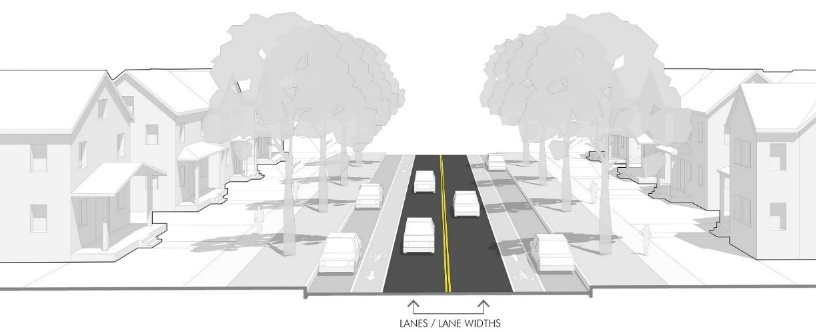 |
| Sidewalks | 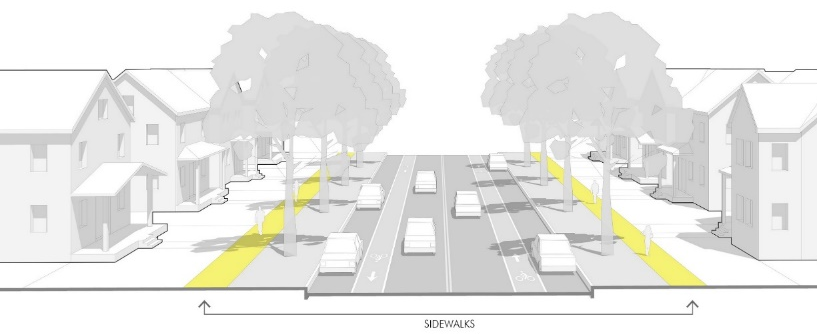 |
| Bicycle Facility | 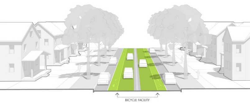 |
| Landscape/Amenity Area | 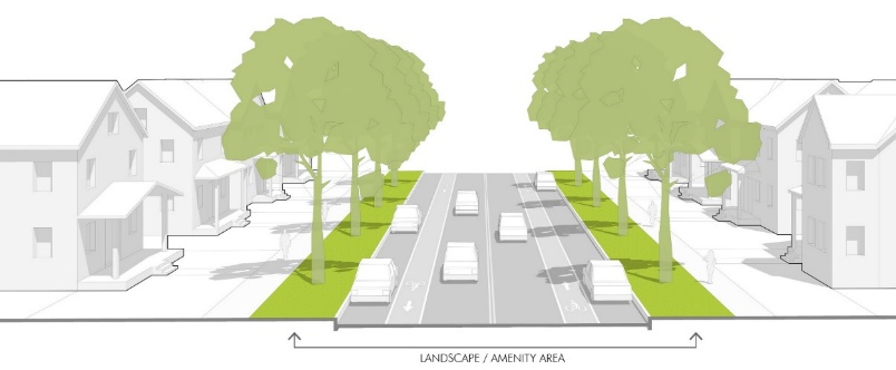 |
| Parking | 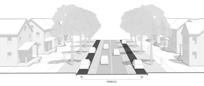 |
1 See generally, Brighton Transportation Master Plan, National Association of City Transportation Officials, Urban Street Design Guide, and National Association of City Transportation Officials (NACTO) Street Design Guide.
2 AASHTO, Geometric Design of Highways and Streets, pg. 473, AASHTO, Washington D.C., 2004. The AASHTO "green book" is a guide intended to be used flexibly for different types of streets in different contexts. The Forward to the "green book" makes it clear that the dimensions are guides and not standard, and the ranges should not be used to imply that the larger end of the range is preferred. (AASHTO Geometric Design of Highways and Streets, pg. xliii). Also see National Association of City Transportation Officials Street Design Guide (NACTO Guide) for a preferred practice for "complete streets" and city public realm design.
3 AASHTO, Geometric Design of Highways and Streets, pg. 473, AASHTO, Washington D.C., 2004. Also see NACTO Guide for preferred practice for "complete streets" and city public realm design.
D.
Intersection Design.
1.
Corner Radii. Curb radii shall be designed according to the Public Works Standards and Specifications. However, in order to balance the competing interest of vehicle turning movements and the distance and safety of pedestrians crossing the street, the Director may recommend, and the Planning Commission may approve, decreases in the specified corner radii based on the following considerations:
a.
The context of a particular development, and in particular, whether walkable development patterns are a priority.
b.
The impact that the specified radii has on increasing the distance that pedestrians must cross.
c.
The desired speeds of vehicles in the roadway and the desired speeds and volume of turning vehicles.
d.
The connectivity of the street network and whether vehicles have multiple alternative routes that minimize frequent turning movements.
e.
The effective turning radius of vehicles considering other features of the specific cross-section, including bicycle lanes, on-street parking or other configurations that impact the actual path of turning movements.
f.
The likelihood that large vehicles will make frequent turning movements at a particular location, compared with the ability of over-sized vehicles or unusual turning movements to safely encroach into other areas of the street.
2.
Sight Distances. Proper lines of sight shall be maintained at all intersections. The proper line of sight shall be an unobstructed view from the stopping point on the approaching street to all points three feet above the roadway along the centerline of the intersecting street. The distance of the unobstructed view shall be based upon the design speed of the intersecting street specified in Table 3-6, Clear Sight Distance.
Source: American Association of State Highway and Transportation Officials, A Policy on Geometric Design of Highways and Streets.
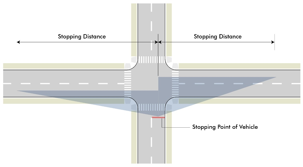
Figure 3-4 Sight Distance
The sight distance for intersecting streets or access points shall be clear of obstructions
from on-coming traffic. The distance shall be measured from the stopping point of
entering vehicles and be based on the type of control of the intersection and the
speeds of oncoming vehicles.
a.
No building or other type of visual obstruction shall be placed or maintained within the triangle created by the centerline of the street intersection, the stopping point on the approaching street, and the sight distance specified in Table 3-6 to the centerline of the intersecting street.
b.
Street trees, light poles or other limited narrow obstructions are allowed within the sight triangle provided they do not have any foliage, limbs, or other obstructions between 2.5 and 8 feet and are no closer than 30 feet to the intersecting right-of-way line.
c.
Fully controlled intersections where signalization establishes and prioritizes safe turning movements may deviate from the above sight triangle standards if site conditions warrant and based upon a recommendation of the Director.
3.
Crosswalks. All intersections and crosswalks shall be designed to address conditions at each specific location, based on the guidance in the Active Transportation section of the Transportation Master Plan. In general, or where this guidance does not provide more specificity, sidewalks intersecting with public streets or other vehicle access shall have crossings meeting the following standards:
a.
Curb ramps meeting ADA accessibility standards shall provide a direct, non-diverted approach from the sidewalk along the block into the designated or protected crossing area.
b.
Crosswalks on collector streets or higher classification shall be considered for enhanced crossings including pavement markings, bulb outs, refuge islands or other traffic-calming measures that are appropriate to the context of the intersection.
c.
Where blocks exceed more than 600 feet between intersections or at other locations of high pedestrian activity, mid-block crossings shall be considered. Mid-block crossing designs and locations are subject to a specific recommendation and approval of the Director.
d.
Any crosswalk over 80 feet, or any other significant pedestrian crossing, may require a pedestrian refuge in the median at the discretion of the Director.
4.
Turn Lanes. Turn lanes for left or right turn movements may be required for specific intersections at the discretion of the Director or based on an approved traffic study. Requirements for turn lanes should be based on careful consideration of the context balancing the impact of crossing distances for pedestrians, vehicle turning speeds, and prioritization of other planning, urban design, and traffic engineering issues. In general, this space should come from reconfiguration of the space within the roadway width near the intersection (i.e. within median space, narrowing lanes, or limiting on-street parking) rather than claiming space from the pedestrian area or streetscape, or rather than widening the road and right-of-way.
E.
Traffic Calming. In order to meet the desired speeds throughout the street network, to manage volumes in association with the street network, and to meet the City's Active Transportation policies and intent of this section, traffic-calming strategies may be required in street plans. Traffic calming may include bulb outs and curb extensions, medians and islands, neck downs, vertical diverters, enhanced or raised crossings, and other speed management techniques approved by the Public Works Director. [See National Association of City Transportation Officials Guidelines.]
F.
Engineering and Construction Specifications. All other engineering specifications, horizontal and vertical alignment, design details, and technical or construction specifications for constructing streets shall be covered by the Public Works Standards and Specifications and administered by the Public Works Director.
3.02 - Open and Civic Space
A.
Intent. The intent of this section is to:
1.
Emphasize open space design as a key determinant of Brighton's community image and unique identity.
2.
Plan and integrate open and civic space systems into the patterns and structure of streets, blocks and lots to create a coordinated public realm.
3.
Value the design, function and appropriate location of different types of open space, rather than solely the quantity of space.
4.
Consider the context and multiple functions that open spaces can serve to support development including ecological, recreation, aesthetic and urban design functions.
5.
Promote good civic design and create focal points for the community, district, neighborhood or development site to which development and site plans should relate.
6.
Integrate natural systems into the design of common or public open spaces to improve stormwater management, protect water resources, preserve prairie ecosystems, promote agriculture heritage, and improve sustainability efforts.
7.
Implement Brighton's parks, recreation, trails and open space plans and coordinate the design and location of other open and civic spaces with those plans and the comprehensive plan.
B.
Open & Civic Space System. Open and civic spaces platted as part of a development shall generally be laid out according to the policies of the Comprehensive Plan and the plans and policies of the Parks and Recreation Department. The proper arrangement of these spaces shall coordinate with street networks, block and lot layouts, and the landscape and site amenities of individual lots.
1.
Types and Requirements. Open and civic spaces designed according to the types and standards of this section may be used to meet the dedication requirements of Section 3.05.D., as specified in Table 3-7 Open and Civic Space Types & Requirements. Projects or lots in proximity to these spaces may be eligible for credits or exemptions to the site amenity requirements of Section 5.03, Lot Open Space Design (Residential) or Section 6.03 Site-Specific Open Space Design (Non-residential).
■ Open space types that can meet more than one requirement shall meet the larger-scale requirement first; then any space dedicated beyond what is required could count to the lower-scale requirement.
■ Areas marked with a multiplier (i.e. 1.5x) get a bonus and can count to the requirement based on the area times the multiplier.
2.
Location Criteria. To coordinate open and civic spaces into a system that integrates the public realm with surrounding development, subdivision design, and location of open and civic space types shall consider the following:
a.
Connections and integration with public streetscapes and other civic destinations, such as schools, to improve visibility and access;
b.
The accessibility of neighborhoods to recreation opportunities for active living;
c.
The opportunity for natural spaces (preserves, trail corridors or parks) to preserve of groves of trees, streams, unusual and attractive topography and other desirable natural landscape features and views;
d.
The opportunity for formal gathering places (greens, squares, plazas/courtyards or pedestrian passages) to be a focal point for compact, walkable places, located as an extension of the streetscapes at highly traveled and visible locations;
e.
The types of spaces that reinforce character of the area or create gateways and transitions to distinct places; and
f.
The distribution of spaces so that all development has similar proximity to open and civic spaces appropriate to its context.
C.
Open & Civic Space Types & Design. Open and civic spaces shall be designed according to the following types and standards:
| Preserve—Natural or Agriculture | ||
| The size, location and design of a Preserve shall be dependent on the planning context; the presence of natural amenities and ecological or agricultural resources worthy of protection; and the ability of the designated area to provide significant continuity with other similar nearby features and resources. In general, these areas should provide the opportunity for at least 5 acres of contiguous preserved area and ideally up to 40 or more acres. |  |  |
| Service Area: City-wide | ||
| Design Elements & Guidelines | ||
| • Natural Preserves include any area of existing or restored open lands such as riparian corridors and wetlands, unique geological formations, important habitats, or substantial groupings of important plant types. The goal is to protect the edges and to maximize intact and undisturbed spaces that provide valuable ecosystem services for the community, support preservation goals, or enhance the aesthetics and amenities of the area. Active recreation such as trails and paths can be a part of these areas provided they do not disrupt the essential natural character and ecological functions. | ||
| • Agriculture Preserves include valuable and productive farmlands or smaller community agriculture operations, protected to ensure their agriculture function, but also to promote the communities heritage and provide a source of unique destination commerce or tourism. These areas can include various scales of agriculture production that can integrate with and support the surrounding community in various ways depending on the scale: | ||
| º Rural/Large - 50+ acres | ||
| º Community/Medium - 15—50 acres | ||
| º Neighborhood/Small - 3—15 acres | ||
| º Local/Micro - under 3 acres (see "Community Garden") | ||
| Park | ||
| Size Regional - 50+ acres Community - 15—50 acres Neighborhood - 5—15 acres Local/Pocket - 0.5—5 acres; 3+ acres ideal Service Area Regional—City-wide Community - ½ to 1 mile Neighborhood - ¼ to ½ mile Local/Pocket - up to ¼ mile | 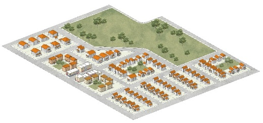 | 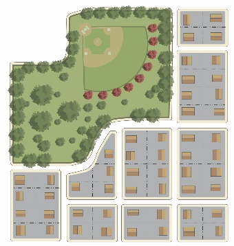 |
| Design Elements & Guidelines Any park planned for public dedication shall be designed according to official plans and policies of the Parks and Recreation Department. Parks shall be at least 150' wide in all directions (50' Pocket Park), except that linear natural features may be designed as a park with portions as narrow as 40' provided it has significant continuity between other open space features. Fronts on at least 1 public street for 150' or more (50' Pocket Park). One shade tree for every 40' of street frontage shall be required to relate the park to the public realm, plus other landscape to support the overall park design. Between 15% and 50% of the area should be designed for active, programmed or structured recreation such as ball fields, playgrounds or sport courts. The remainder of the area should be allocated to ground cover, tree areas, gardens, or other natural or formal landscape for passive recreation. When possible, neighborhood or local/pocket parks should be coordinated with school property or neighborhood community centers. | ||
| Trail Corridor | ||
| Size 20' min. width; 30' + ideal, but dependent on topography and natural features. No minimum length, except needs to provide significant continuity in the trail system or connection between streetscape and/or on-street trails and be coordinated with the Transportation Master Plan and Parks and Open Space trail plans. Service Area 1,000', or up to ¼ mile from access point. | 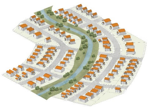 | 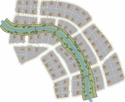 |
| Design Elements & Guidelines Any trail corridor planned for public dedication shall be designed according to official plans and policies of the Parks and Recreation Department. Trails Corridors should include a paved or otherwise dust-free stabilized surface at least 8' wide; 10'+ if a shared bike/pedestrian trail. All Regional Trails shall be a minimum of 10' wide and constructed out of concrete. The landscape area on each side of the trail should be at least 6', and wider in places that incorporate natural features or significant vegetation. One large tree for every 40' of trail length; and 1 ornamental tree or small evergreen tree for every 25' of trail length shall be required. Trails Corridors located along rights-of-way may be integrated into the streetscape design to create the optimal multi-modal design for the street and trail, particularly along major and minor arterial streets. | ||
| Green | ||
| Size 0.5 to 3 acres 150' minimum in all directions and no wider than 3:1 (length to width) Service Area ⅛ to ¼ mile | 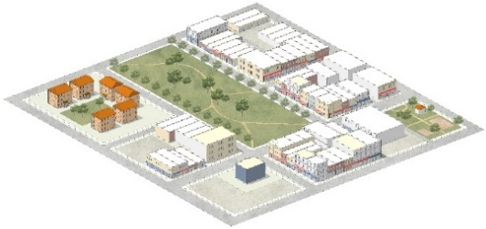 | 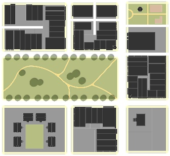 |
| Design Elements & Guidelines Greens should have a public street along at least 2 sides with direct pedestrian access to the street. Greens should have an enclosure ratio (width of space to height of buildings) for buildings on the Green between 6:1 and 2:1. Buildings fronting on the green should be designed with frequent entrances, transparency, and outdoor seating areas to create activity in the space and make physical and visual connections between the buildings and the space. One shade tree for every 25' of street frontage and one ornamental or evergreen tree for every 2,000 square feet shall be required. 15% to 50% of the area shall be designed for formal gathering such as seating areas and other areas of concentrated amenities that serve as a focal point of the Green; the remainder shall be allocated to ground cover, tree areas, gardens or other natural landscape amenities for aesthetic or passive recreation. | ||
| Community Garden | ||
| Size 1,000 s.f. to 3 acres Service Area 1,000—5,000 s.f. - On same or adjacent block 5,000 s.f. to 1 acre - up to 1,000' 1 to 3 acres - 1,000' to ¼ mile | 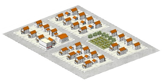 |  |
| Design Elements & Guidelines Community Gardens shall front on a public street for at least 25' or have a connection to public streets by a Pedestrian Passage. Community Gardens shall have a Level I buffer according to Section 8.03 on any area that abuts the public street or other public space. Up to 15% of the area may be used for sheds, green houses, storage or other support structures. Community gardens should include operating rules and pest management plans; and fences, screens structures and operations shall be subject to all other building, health and property maintenance codes and standards. | ||
| Square | ||
| Size 5,000 s.f. to 1 acre 70' minimum in all directions and no wider than 2:1 (length to width) Service Area Adjacent block, or up to 1,000' | 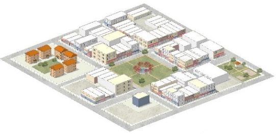 | 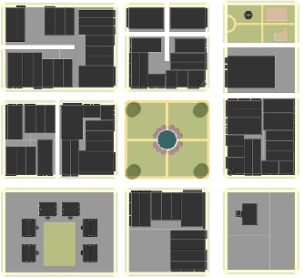 |
| Design Elements & Guidelines Squares should have a public street along all sides and be designed as a focal point for abutting blocks; streets should be designed for multi-modal transportation with direct pedestrian access to the Square. Squares should have an enclosure ratio (width of space to height of buildings) for buildings on the Square between 3:1 and 1:1. One shade tree for every 40' of street frontage and one ornamental tree for every 2,000 square feet shall be required. At least 50% of the area shall be designed for formal gathering such as seating areas and other concentrated amenities. At least 25% of the area shall be allocated to planter beds, seasonal plantings, garden, lawns or other landscape amenities. | ||
| Plaza/Courtyard | ||
| Size 1,000 to 5,000 s.f. 25' minimum in all directions and no wider than 3:1 (length to width) Service Area Abutting lots or on the same block | 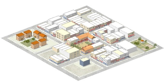 | 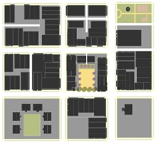 |
| Design Elements & Guidelines Plazas/Courtyards should have a public street along at least 1 side; streets should be designed for multi-modal transportation with direct pedestrian access between the Plaza/Courtyard and the street. Plazas/Courtyards should have an enclosure ratio (width of space to height of buildings) for buildings on the Plaza/Courtyard between 2:1 and 1:2. Plazas/Courtyards should include seating, art, formal landscape and other amenities and ornamentation as a focal point for gathering places. Buildings fronting on the Plaza/Courtyard should be designed as street front buildings with frequent entrances, transparency and outdoor seating areas to create activity in the space and make physical and visual connections between the buildings and the space. One shade tree for every 40' of street frontage and one ornamental tree for every 2,000 square feet shall be required. At least 20% of the area shall be allocated to planter beds, seasonal plantings or foundation plants or other landscape amenities. | ||
| Patio | ||
| Size 300 to 1,000 s.f. 15' minimum in all directions Service Area One lot | 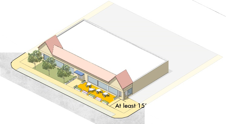 |  |
| Design Elements Patios shall front on a public street for at least 15' or have a connection to public streets by a Pedestrian Passage. Patios should include seating, art, formal landscape and other amenities and ornamentation as a focal point for gathering places. Patios should have at least one entrance from the building the patio supports and at least one entrance from the public street or other Pedestrian Passage connection to the public street. At least 20% of the area shall be allocated to planter beds, seasonal plantings or foundation plants, or other landscape amenities. | ||
| Pedestrian Passage | ||
| Size 12' to 20'+ wide No minimum length, except needs to provide connection between streets on opposite sides of a block, or between streets and other parts of the open and civic space system within the block. Service Area Abutting lots | 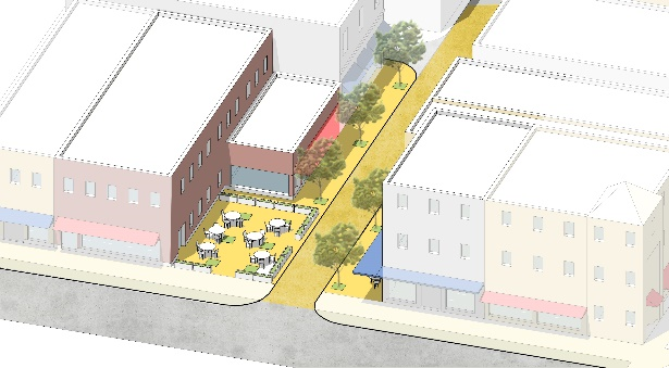 |  |
| Design Elements & Guidelines Pedestrian Passages should be designed with the same or greater amenity as the pedestrian areas of streetscapes on the block in terms of landscape, street furniture, lighting, etc. Buildings fronting on the Pedestrian Passage, particularly the first 50 feet from the beginning and end of the passage, should be designed as street front buildings with frequent entrances, transparency and outdoor seating areas to create activity in the space and make physical and visual connections between the buildings and the space. Larger passages or passages in more open areas shall be designed to the Trail Corridor standard. | ||
| Enhanced Streetscape | ||
| Size At least 1.5x the width of the Pedestrian or Landscape Amenity area of the typical Street Standards specified in Section 3.01. Must extend for at least one block and be integrated into the overall streetscape design for the block. Service Area Abutting lots | 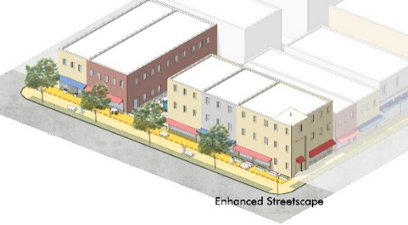 |  |
| Design Elements & Guidelines Enhanced Streetscapes should only be used in instances where the street design will clearly support the immediately abutting land use and is consistent with the character of the area, subject to approval by the Director. Enhanced Streetscape should be designed with the same or greater amenity as the pedestrian and landscape areas of streetscapes in terms of landscape, street furniture, lighting, etc., and added to the width of the areas required by the Streetscape Standards in Section 3.01. (For example, if a street requires a minimum 12' sidewalk and 8' landscape / amenity area, if the streetscape includes an 18' sidewalk and 12' landscape / amenity area this may count as Enhanced Streetscape.) | ||
D.
Stormwater Facilities. Stormwater facilities shall be designed and integrated into the open and civic space system. Any area used for stormwater may be counted towards the open space requirement provided:
1.
It is integrated into the design of the space in a manner that it is an aesthetic amenity and is consistent with the essential design character of the space.
2.
The design does not impact the utility of the space for either purpose (i.e stormwater functions do not compromise the use and value of the space as intended open space and landscape and open space designs do not compromise maintenance and management for stormwater purposes).
3.
The maintenance and management of the portion of the facility serving stormwater function is clearly identified, whether that is a public dedication or whether it is an obligation of the owner or property owners' association.
E.
Ownership and Management.Open and civic space platted as part of a development shall require specific designation on the final plat as a separate tract. Options for ownership and management of open and civic space include:
1.
Creation of or dedication to a non-profit entity capable of carrying out the ownership and management.
2.
Creation of a homeowners', leaseholders' and/or property owners' association that owns the space in common and is capable of carrying out the ownership and management.
3.
Dedication to a public entity as part of the rights-or-way, parks or other community facilities element of the plan.
All open and civic space shall require documentation recorded with the final plat that outlines the ongoing maintenance plans, as well as administrative and financial management of the space according to these standards. Documents such as covenants for a homeowners' association, bylaws or charter for a non-profit entity, or similar agreements and guarantees, shall be filed with the appropriate clerk and recorders office with the plat designating the open space, prior to any building permits. Dedication to the City or other public entity is subject to acceptance by and at the sole discretion of the City or other public entity.
3.03 - Blocks and Lots
A.
Intent. The intent of the blocks and lots standards is to:
1.
Ensure the proper arrangement of blocks and lots to complement the street network and open and civic space systems.
2.
Arrange blocks, lots and development in a manner that is least disruptive to existing topography and capitalizes on inherent natural characteristics of the land as defining features.
3.
Coordinate access and utilities for each lot in association with larger systems of streets and infrastructure.
4.
Promote appropriate site, building and frontage designs in relation to the public realm.
5.
Ensure that all lots are buildable according to this code and that all non-developed tracts or other parcels serve an urban design or planning function in relation to the overall development pattern.
B.
Block & Lot Arrangement.
1.
General Layout. All blocks shall be laid out to have two tiers of lots unless dictated by existing development patterns outside of the control of the project or by access management on major arterial streets. In these cases, streetscape standards and open or civic space systems should be used to create buffers and transitions at the rear of lots.
2.
Block Size & Patterns. The maximum block length shall be based on the street connectivity standards and specific context as identified in Section 3.01.B.
3.
Lot Patterns. All lots shall front on a public street, or on an alternative access or common open space where specifically allowed by these regulations. All side lot lines shall generally be perpendicular to front lot lines, or radial to any curves along the front lot lines. Alternatives to integrate patterns of buildable lots into the overall block structure may also be approved.
4.
Addressing. All lots, tracks, and other parcels shall require an address following city address policies and guidelines, including streets and street names.
5.
Easements. All blocks shall include easements for all utilities, required improvements, access and open spaces necessary to serve each lot. Easements shall be granted by the owner to the appropriate entity. All easements shall be accessible from the public right-of-way and graded to within six inches of final grade before utilities are installed. Unless otherwise specified through the development review process utility easements shall be as specified in Table 3-9, Easements.
6.
Drainage. Where a subdivision is traversed by a watercourse, drainageway or stream, blocks shall be laid out in coordination with these features.
a.
The Stream Management Corridor, as shown in a master drainage plan, shall be dedicated to the Urban Drainage and Flood Control District (UDFCD). If a Stream Management Corridor is not defined, the applicant shall work with the City and UDFCD to define this area.
b.
A pedestrian or bikeway easement may be required where the block structure is interrupted more than permitted in Section 3.01.B, or where the Planning Commission determines the area is appropriate for active recreation or transportation uses.
c.
If a master planned watercourse, drainageway or stream traverses or is shown to traverse a property, all necessary rights-of-way and easements shall be dedicated to the City. The design and construction of any watercourse, drainageway or stream is the responsibility of the property owner.
3.04 - Required Improvements
A.
Intent. The intent of this section is to:
1.
Ensure that all improvements necessary to serve lots within a subdivision are constructed, inspected or otherwise assured of completion prior to the issuance of building permits.
2.
Prevent the location or design of a subdivision from placing an undue burden on public utility systems and community facilities serving other areas.
3.
Provide appropriate apportionment of costs and offset higher net costs or premature costs to the public necessitated by the subdivision.
4.
Protect against subdivisions where soil, subsoil or flooding conditions would create potential dangers to public health or safety.
5.
Coordinate subdivisions and construction of required improvements with other anticipated improvements or with future growth.
B.
General Requirements.
1.
All required improvements shall be outlined in the subdivision plan, and be incorporated into the final design at the time of final plat as provided in Section 2.02.
2.
The applicant shall post a performance bond, letter of credit or similar security instrument drawn in favor of the City in an amount equal to 115% of the estimated cost of the construction of improvements, determined by the City Engineer.
3.
The schedule for construction of improvements may be divided into phases according to an approved preliminary or final plat as specified in Section 2.02.
4.
Required improvements shall be constructed in accordance with the Public Works Standards and Specifications and in accordance with approved plans and profiles and the construction requirements and specifications of the City.
5.
Finished plans of all public improvements as built shall be required before the City shall accept improvements. The approved design plans are acceptable if they remain true after construction and if attested to by a registered engineer.
6.
The performance guarantee shall be released upon written request by the applicant to the Director or his or her designee, only after all improvements for the subdivision, or any particular phases noted on a phasing plan, are completed, inspected and finally accepted by the City.
7.
The applicant shall be responsible for the repair, replacement and maintenance of any required improvement which fails to function or meet the standards of the City due to defects in material or workmanship, within 2 years from the date of final acceptance.
C.
Improvements. The following improvements are required to be constructed with the subdivision, except where facilities sufficient to serve the subdivision exist and have been approved by the City. The size, type and general location of each improvement, and estimated cost shall be included as part of the final plat submittal and review.
1.
Easements and utility services, including water lines, sanitary sewer, and other public utilities
2.
Easements and drainage systems including storm sewer lines, natural and constructed conveyances, retention/detention ponds, and similar facilities
3.
Retaining walls associated with an approved grading plan.
4.
Wells.
5.
Fire Hydrants.
6.
Rights-of-ways and streets.
7.
Access and alleys and other required vehicle circulation and parking components, and easements where shared or cross-access is proposed.
8.
Streetscape elements, including curb, gutter, sidewalks, landscape and amenity areas, street lights, and street signs.
9.
Traffic signal lights and signs, and any other safety measures in the rights-of-way.
10.
Open and civic spaces, whether public, common, or shared.
11.
Survey monuments, including range points and lot pins as required by the City Engineer. In general, this shall be at all beginning and end points, all angle points, or any change in radii of a curved line, and no more than 1,400 feet apart on any straight boundary line. In addition, minimum half-inch steel pins shall be set at all lot corners with a Colorado registration number of the surveyor responsible for the monument.
12.
Communication and electric distribution services and lines, which shall be underground with the exception of meters, terming boxes and other facilities. All facilities shall be in easements or the right-of-way subject to the design specifications and approval of the City through the plat review process. Every effort shall be made to place pedestals in accessible locations close to corner lot lines but to minimize their appearance through streetscape design, landscape materials, or other site planning and urban design strategies that minimize their impact on the public realm.
D.
Reimbursement Agreements. Applicants constructing required improvements for their property within their project or through undeveloped areas to serve their project shall be responsible for the entire cost of the improvements. Whenever any portions of the required public improvements are part of a planned future facility for the City, serving an area larger than the subdivision and its impact, the City may require and the applicant may enter into an upsizing agreement. The City and the applicant shall negotiate the following aspects of the agreement prior to approval of the plat:
1.
The applicant shall construct the facilities as planned by the City for future capacity as part of the subdivision and development process.
2.
The applicant shall be responsible for the portion of the costs required to serve the proposed subdivision based on actual total cost to build the facilities absent any upsizing agreement.
3.
The City shall be responsible for any incremental costs to expand the facility to the planned capacity, beyond the capacity to serve the subdivision. The City's participation may be based by the applicant bidding the project with bid alternates: one alternate to build the minimum required facility to serve the subdivision or development and the second bid alternate being for the upsized facility planned by the City.
4.
The City may coordinate its reimbursement schedule to the applicant with fees assessed to other property in coordination with any future development of land benefitting from the improvements, but in no case may this period be extended beyond 8 years from the date the improvement is made, unless specifically agreed to by the applicant.
5.
The agreement shall be subject to approval by the City Attorney.
(Ord. No. 2349, § 4, 12-15-2020)
3.05 - Community Facilities and Fees
A.
Intent. The intent of the community facility and fees standards is to:
1.
Anticipate and evaluate the incremental and long-term impact of development on broader public and community facility needs.
2.
Identify opportunities to integrate plans for public and community facilities into the planning and design of proposed land divisions.
3.
Consider the location of public and community facilities in coordination with the initial planning considerations for streets, open spaces, blocks, and lots, so that needed facilities are located conveniently in neighborhoods and districts and serve as gateways and focal points for the community.
4.
Provide the opportunity to negotiate a fair and equitable price for land needed to develop public or community facilities beyond the impact of the particular project, or alternatively to provide an incentive for land owners to dedicate land for needed facilities where the lack of facilities may otherwise constrain potential future development.
5.
Ensure that the most appropriate locations of public and community facilities are identified and considered prior to the premature commitment of these areas to conflicting development patterns.
6.
Promote fiscal responsibility for all public entities by coordinating the planning, design and financing of public facilities with impact generated from proposed development.
B.
Dedication of Land. The Planning Commission or City Council may request the dedication of land to the City or other government entity with jurisdiction over public and community facilities, for parks, open space, public safety facilities, school sites or other public or community facilities.
1.
The request for dedication shall be based on an official master plan of the entity having jurisdiction over the facility identifying the general location and extent of the facility, or some other documented need for the facility that is available for public review.
2.
The dedication may be included on the subdivision plan or a condition of approval of the subdivision plan, at the discretion of the applicant.
3.
Acceptance of the dedication shall be agreed to in writing by the entity having jurisdiction over the site or facility prior to approval of the final plat or through approval of the final plat if dedication is to the City. Upon dedication, the applicant may be eligible for credits towards open space requirements or reimbursement of other development fees.
4.
Nothing in this section shall prohibit any public entity from establishing fees that apportion the appropriate contribution for the impacts on planning, design and land acquisition for facilities needed due to the development.
C.
Dedication of Water. All subdivisions of land shall provide adequate water supply to balance the estimated and projected demand of any proposed development. Water needs shall be estimated by the City Engineer based on the proposed use and projected demands of the development proposal. Existing water use and previous water dedications shall be considered when determining the applicable water supply.
1.
The applicant shall be required to provide the City with water rights reviewed and determined acceptable by the City Engineer. Upon dedication and transfer of those rights, the developer may pay "with water rights" development fees at the time of building permit.
2.
If acceptable to and at the discretion of the city, an applicant that does not dedicate water for a subdivision of land shall be required to pay the "without water rights" fees at the time of building permit.
3.
Applicants required to bring water for a development proposal shall enter into a water dedication agreement prior to the approval of any plat, outlining the amount of water dedication, the timing of water rights transfers, and the fee category applicable at the time of permit.
D.
Reservation of Land. The Planning Commission or City Council may require the reservation of land for public or community facilities, public safety facilities, or other public or community facilities in addition to the required open space and school dedication or fees. The reservation shall be for a time period of no more than one year, unless otherwise agreed to by the applicant, to permit acquisition of the land by the appropriate public entity.
1.
The reservation by the Planning Commission or City Council shall:
a.
Be based on community facility needs that may serve a need or impact beyond that caused by the proposed development, and which are not otherwise met by standards of this code;
b.
Be based on an official master plan approved by the entity with jurisdiction over the public facility identifying the general location and extent of the facility, or some other documented need for the facility that is available for public review; and
c.
Be accompanied by a conceptual plan and program provided by the entity with jurisdiction over the improvement, demonstrating how the entity's facility needs relate to the site and surrounding development. The conceptual plan shall include information reasonably necessary for the applicant to plan for development around the reserved site and to prepare contingency plans in the event the site is not acquired by the public entity. Development plans for the unreserved property shall not adversely affect the potential use of the reserved property for the designated public or community facility.
2.
During the reservation period or in association with the subdivision plan, the applicant may submit a contingency subdivision plan for the portion of the property subject to the reservation. A contingency plat shall include all of the information of a preliminary plat for the reserved property and can serve as the preliminary plat if the negotiation is terminated or unsuccessful. Any final plat for a reserved portion may be conditionally approved and shall not be recorded until the one-year reservation period has expired or negotiations have terminated. Otherwise any reserved portion not acquired within one year will require a preliminary and final plat according to the standards and procedures in this code.
E.
Park and Open Space Dedication. At the time of final plat approval, the City Council shall determine whether to accept park dedication or have the applicant pay a fee in lieu of dedication, or a combination of dedication and paying the fee.
1.
Dedication Requirement. All subdivisions proposing dwelling units shall be required to dedicate land and pay development fees for parks as established in Table 3-10, Parks and Open Space Dedication & Fees.
Example: 670 dwelling units x. 2.96 = 1,983.2 people; 1.9832 (per 1,000 people) x 3 acres = 5.95 acres of neighborhood parks and open space required and 5.95 acres of community parks and open space required, and 29.75 acres of common or private open space.
2.
Design and Location.
a.
All property dedicated to the City for Neighborhood or Community Park requirements shall be suitable to meet the requirements of the Parks and Recreation Department. The space shall contain minimum improvements such as curb and gutter, storm drainage, sewer and water service to the property.
b.
The City may accept dedications of land to meet the Common Open Space requirement, provided it meets other open space and conservation goals of the City indicated in the Comprehensive Plan or other official Parks and Recreation Department Plans. These spaces may be off-site and non-continuous.
c.
The City may accept conservation easements or similar deed restrictions on behalf of the City or other public or community non-profit organization to meet the Common Open Space requirement. In considering whether to accept this, the City may consider the following:
(1)
Proximity to City boundaries or eligibility for annexation;
(2)
Connections to and integration with other parts of the open space systems and public realm; and
(3)
Consistency with other city policies regarding preservation of natural areas, open spaces, agricultural resources or other civic assets.
d.
All property dedicated for public or common open space shall:
(1)
Meet the standards for any of the open space types in Section 3.02, Open and Civic Spaces;
(2)
Be free of natural hazards (i.e., flood plains, steep slopes, water bodies, etc.) and man-made facilities (i.e., detention or retention basins, gas wells, etc.) which inhibit the development and utilization of the space as intended; and
(3)
Be preserved from future development and ensured to be maintained as an amenity for surrounding development by plat, deed restrictions, or similar instrument.
3.
Fee in lieu of dedication. When a subdivision is not within the vicinity of a planned or existing community park and common open spaces, or otherwise cannot dedicate land acceptable to the City for this requirement, the applicant shall pay a fee in lieu of dedication. The fee shall equal the fair market value of the land area required to be dedicated. The Fair market value shall be established by an appraisal commissioned by the City at the applicant's expense. The fee shall be due prior to acceptance of the final plat as provided in Section 2.02. All fees collected for the purposes of community park land acquisition shall be placed into a community park development fund to be utilized for the acquisition of land for community park purposes.
4.
Infill Exemption. Any property within the infill development boundary line served by existing parks shall be exempt from the neighborhood and community park land dedication requirement. However all infill development of new subdivisions platted after 1986 shall be required to pay the applicable park development fees.
F.
Schools
1.
Dedication or Fees. As fair contribution for public school sites, all development applications shall dedicate land for a public school site to the School District, or, in the event the dedication of land is not feasible or in the best interests of the School District as determined by the Superintendent, the School District may require a payment of cash in lieu of land dedication or conveyance to the School District. The manner and amount of either type of fair contribution for public school sites shall be as determined by the School District, consistent with the Intergovernmental Agreement Concerning Fair Contributions for Public School Sites Between the City of Brighton and Brighton School District 27J and the adopted methodology, except that, if the School District requires payment of cash in lieu of land dedication or conveyance, the payment shall not exceed the cash in lieu of land dedication or conveyance to the School District required by the School District in the City of Commerce City or the City of Thornton, whichever is lower, unless the City and the School District agree otherwise.
2.
Exceptions. The following uses within the City's boundaries shall be excepted from fair contribution for public school sites:
a.
Construction of any nonresidential building or structure;
b.
Alteration, replacement or expansion of any legally existing building or structure with a comparable new building or structure which does not increase the number of residential dwelling units;
c.
Construction of any building or structure for a limited term stay or for long-term assisted living, including but not limited to bed and breakfast establishments, boarding or rooming houses, family care homes, group care homes, halfway houses, hotels, motels, nursing homes or hospices; and
d.
Construction of any residential building or structure classified as housing for other persons, pursuant to the Federal Fair Housing Act then in effect.
3.
Proof of Fee Payment. If the fair contribution for public school sites includes the payment of cash in lieu of land dedication, it shall be made prior to the recording of the final plat, and the City shall require proof in the form of a letter from the School District Superintendent that the School District has received payment of cash in lieu of land dedication before the issuance of the first residential building permit for the applicable final plat.
4.
Proof of Dedication Acceptance. If the fair contribution for public school sites includes the dedication of land, it shall be made prior to the recording of the final plat, and the City shall require proof in the form of a letter from the School District Superintendent that the dedication has been made to the School District in accordance with the following requirements before the issuance of the first residential building permit for the applicable final plat:
a.
The person or entity has conveyed to the School District, by deed in form acceptable to counsel for the School District, title to the land slated for dedication.
b.
At the time not later than the issuance of the first building permit for the land development project, applicant shall also pay or provide for the payment of one-half of street development costs associated with the school site, and shall either provide, or pay or make provision for the payment of, the costs associated with making improvements for water, sewer and utilities stubbed to the dedicated land, and for overlot grading of the dedicated land.