
Broken Arrow City Zoning Code
CHAPTER 2
- ZONING DISTRICTS AND USE REGULATIONS
Sec. 2-1-1. - Purpose and applicability.
A.
General. This section divides the City into zoning districts as established in Table 2-1-2-1, Zoning Districts Established. The shape and boundaries of zoning districts are indicated on the Official Zoning Map, adopted by reference into this ordinance by Section 2-1-3, Official Zoning Map.
B.
Applicability. No building or land may be used, and no structure may be erected, altered, or moved that is used or designed to be used for any purpose other than a use that is permitted or specially permitted in a zoning district in which that building or land is located.
C.
Zoning districts. The established zoning districts are the minimum necessary to achieve compatibility of uses and maintain or create community character within each district, consistent with the City's Comprehensive Plan.
Sec. 2-1-2. - Zoning districts established and purpose statements.
A.
General. Established in Table 2-1-2.1, Zoning Districts Established, are the zoning districts for the City. The table identifies the district name and abbreviation, along with the previous district name.
B.
Agricultural and residential districts.
1.
General purposes of residential districts. The residential zoning districts are intended to:
a.
Provide appropriately located areas for residential development that are consistent with the Comprehensive Plan and with standards for public health, safety, and general welfare;
b.
Allow for a variety of housing types that meet the diverse economic and social needs of residents;
c.
Protect the scale and character of existing residential neighborhoods and community character;
d.
Discourage any use that would generate traffic or create congestion on neighborhood streets other than typical traffic associated with residential use; and
e.
Discourage any use that would create additional requirements and costs for public services that are in excess of such requirements and costs if the district were developed solely for the intended type of residential uses.
2.
Agricultural district (AG). The AG district is established to provide for the continued use of land for predominantly agricultural purposes; to preserve undeveloped areas until they can feasibly be developed pursuant to more urban standards and with adequate public safeguards for health, safety, and welfare; and to provide a base zoning classification as a holding mechanism for newly annexed property.
3.
Single-family residential district (RS). The RS district is intended to promote and encourage the construction of and continued use of land for single-family detached dwellings with larger lots at a lesser density than the RMD district.
4.
Single-family residential-compact district (RS-C). The RS-C district is intended to provide for smaller residential lots, compared to the RS district, in exchange for the permanent set aside of common open space, typically in the form of parks, plazas, and other programmed open spaces.
5.
Single-family residential district-preservation (RS-P). The RS-P district is intended to provide for the smallest of single-family residential lots, compared to the RS and RS-C districts, in exchange for the permanent set aside of common open space, typically in the form of natural areas, trails, or greenways.
6.
Residential medium density district (RMD). The RMD district is intended for the construction of and the continued use of land for single- and two-family dwellings.
7.
Residential multi-family district (RMF). The RM district is intended to accommodate the development of multi-family dwellings, including both ownership and rental units, at varied medium to high densities. Through adequate site planning and development standards, multi-family units are intended to be compatible with surrounding zoning and existing land uses.
8.
Residential manufactured home district (RMH). The RMH district is intended to accommodate manufactured home parks and subdivisions and to establish minimum standards for such uses to ensure compatibility with surrounding zoning and existing land uses.
C.
Mixed-use districts.
1.
Community mixed-use (CM). The CM district is intended to provide for small, compact community-serving mixed-use development that is compatible in scale and character with surrounding residential uses. The CM district is intended to include medium- to higher-density housing, commercial, institutional, recreational, and service facilities needed to support surrounding neighborhoods and the community at-large. Medium- to higher-density housing should be incorporated within or located around the district. Ground-floor, small scale retail is typical, and upper-story residential and office use is encouraged. Development should facilitate pedestrian connections between residential and nonresidential uses.
2.
Downtown mixed-use core (DM). The DM district is intended to provide for and encourage development and redevelopment that preserves and enhances the unique character and vitality of the Broken Arrow downtown. Small-scale offices, retail, and upper-story residential uses are allowed. Design standards focus on creating a human-scaled, pedestrian-oriented and walkable downtown that invites commercial development and complementary residential opportunities. Continuous retail frontages, largely uninterrupted by driveways and parking, are encouraged.
3.
Downtown fringe (DF). The DF district is intended to apply to those areas within the downtown core area but outside the DM district. DF district uses may have a similar form, density, and height as DM areas, but typically generate a lower intensity of activity, both vehicular and pedestrian. Commercial, office, and residential uses are allowed on all floors in the DF district. Uses within the DF district are subject to additional design considerations, since they abut residential neighborhoods in many cases.
D.
Commercial and industrial districts.
1.
Office neighborhood (ON). The ON district is intended to provide locations for compact office developments that serve, and are compatible with, residential uses.
2.
Commercial general (CG). The CG district is intended to provide a full range of community-oriented retail and service commercial uses. The CG district also accommodates compact neighborhood commercial uses provided they are compatible with surrounding residential uses in scale and character.
3.
Commercial heavy (CH). The CH district is intended primarily for uses that provide commercial goods and services to residents of the community in areas that are dependent on automobile access and exposed to heavy automobile traffic. These commercial uses are subject to frequent view by the public and visitors to Broken Arrow, and they should provide an attractive appearance and controlled internal and external traffic movement.
4.
Industrial light (IL). The IL district is intended to provide for light manufacturing, processing, service, storage, wholesale, and distribution operations with all operations contained within an enclosed building. The intent of the IL district is to preserve land for light industrial and service-oriented commercial uses.
5.
Industrial heavy (IH). The IH district is intended to provide for heavy industrial development of a potentially noxious nature, including heavy manufacturing, storage, major freight terminals, waste and salvage, resource extraction, processing, and other related uses. The intent of the IH district is to preserve land for industry in locations with access to major streets as designated on the Comprehensive Plan Map, as well as locations generally accessible to railroad transportation.
E.
Special purpose and overlay districts.
1.
Base zoning district relationship to overlay districts. All lands within the City shall be designated as one of the base zoning districts listed in Table 2-1-2.1, Zoning Districts Established. In addition, some lands may be designated as one or more of the overlay districts listed in Section 2-1-2.E, Special Purpose and Overlay Districts. Where the property is designated as an overlay district as well as a base zoning district, the regulations governing development in the overlay district shall apply in addition to the regulations governing development in the underlying base district. In the event of an express conflict between the two sets of standards, the standards for the overlay district shall control.
2.
Planned unit development overlay district (PUD).
a.
See Division 2-6.
3.
Floodplain district (FD). The floodplain district is designed to:
a.
Protect life;
b.
Reduce flood damage;
c.
Reduce public expenditures in the areas subject to flooding;
d.
Permit reasonable use of land in areas subject to flooding;
e.
Promote the general welfare of the community; and
f.
Prevent or reduce flood damage by keeping floodways free of manmade obstructions to permit the free flow and discharge of floodwater.
4.
Downtown residential overlay district (DROD). The DROD is intended to ensure that development in residential areas in the central part of the City complies with the Broken Arrow Downtown Master Plan by adhering to a high level of development quality.
5.
Highway design overlay district (HDOD). The HDOD is intended to ensure that development along designated highways within Broken Arrow present an attractive image of the community to City residents and highway drivers, thus contributing to the overall quality of life and economic development in the City.
6.
New Orleans Square overlay district (NOSOD).
a.
The NOSOD provides new zoning intended to guide the future growth of the area surrounding the intersection of West New Orleans Street (101st) and South Elm Place, often described as "New Orleans Square." This overlay was prepared to encourage redevelopment in and around the existing shopping centers in the area, along with other nearby underutilized land. The overlay also responds to the proposed landscape and intersection improvement project (including new landscaping and pedestrian improvements) at New Orleans Street and Elm Place.
b.
This overlay is intended to foster new residential and mixed-use development with more predictable results and a higher-quality public realm by prescribing the physical form of buildings and addressing the relationship between building facades and the public realm, the form and mass of buildings in relation to one another, and the scale and types of streets and blocks.
c.
This overlay has been written with specific application to the New Orleans Square district in mind; however, the overlay may be suitable elsewhere in the City.
Sec. 2-1-3. - Official zoning map.
A.
Zoning map.
1.
The zoning districts are shown on the "City of Broken Arrow Zoning Map" (zoning map). The boundaries of zoning districts established in this ordinance are delineated upon the zoning map and adopted as part of this ordinance. Procedures for amending the zoning map are in Section 6-3-4.2, Zoning Map Amendment (Rezoning).
2.
In the event of uncertainty in the exact boundaries of any of the districts as shown on the zoning map, the Board of Adjustment shall hold a public hearing and make the final determination.
B.
Annexed territory.
1.
Whenever any vacant lot, parcel, or tract of land is annexed into the City of Broken Arrow, said territory shall be classified as agricultural (AG); provided that any portion of such lot, parcel, or tract of land designated as 100-year floodplain shall be classified as floodplain district (FD).
2.
Whenever any individual lot or parcel, or any unplatted tract of land that is occupied by a lawful existing use and a viable structure is annexed into the City of Broken Arrow, said territory may be assigned a zoning classification by the City Council that permits the actual primary use of said tract of land.
3.
Adoption of this zoning ordinance shall include the removal of prefix "A" from all properties with such prefix on the Official Zoning Map.
4.
Whenever land is annexed into the City of Broken Arrow, and (a) any lot or block thereof is occupied by a lawful existing use and viable structure, and (b) said use is in conformity with the City's adopted Comprehensive Plan, then the City Council may assign said land a zoning district that most closely corresponds to the actual primary use of the occupied portion of the land.
5.
The Director shall investigate and recommend the most appropriate zoning classification for consideration by the City Council. The determination of the most appropriate recommendation shall be that classification having the least density, but allowing the primary use to be a lawful and conforming use by right. In the event more than one recommendation would meet this requirement, the determination of the appropriate recommendation will be made in accordance with the zoning classification that would have the fewest significant, nonconforming physical requirements. Provided that the City Council retains the right to annex occupied land and assign an agricultural district (AG) as the transitional zoning category.
6.
All such property, regardless of the transitional zoning classification, shall be subject to all provisions of this ordinance. Annexed territory shall remain within the transitional zoning classification assigned at the time of annexation until rezoned to another classification in the manner prescribed by law.
7.
The use of any land or structures annexed under paragraph 2, above, may not be physically expanded, or any new structure constructed, without site plan review and compliance with all applicable zoning requirements. Any unplatted land annexed under paragraph 2, on which the primary use is discontinued or proposed to be altered, must (a) be platted, (b) undergo site plan review and (c) comply with all applicable requirements in this UDC prior to the new or expanded use of the land or any structures.
8.
No new use may be commenced on unplatted property annexed under paragraph 2, above, which is not located within a 100-year floodplain, without obtaining appropriate conventional zoning and platting. New permitted uses can be commenced on platted land, which is not within a 100-year floodplain, provided the property contains all necessary public features, such as right-of-way and utility easements prior to receiving a building permit.
9.
Any land that was once annexed to the City of Broken Arrow and that was later de-annexed shall be assigned to AG, agricultural district, upon any subsequent annexation.
Sec. 2-2-1. - Legend—Land use matrix abbreviations.
A.
General. The purpose of this section is to identify the uses that are permitted, prohibited, limited or require a conditional use permit within each zoning district, and address accessory and other structures or activities permitted as accessory uses. It is also the purpose of this section to provide additional standards for certain uses that, left unregulated, tend to be or become incompatible with surrounding uses. These additional standards provide limitations on the intensity of use, land area, site design, and other factors that are appropriate to each class of use.
B.
Explanation of land use matrix abbreviations.
1.
Permitted uses. "P" in a cell indicates that the use is allowed by right, without special conditions other than those imposed upon other uses by right in the district. Permitted uses are subject to all other applicable regulations of this ordinance, including the special standards in this chapter and the standards in Chapter 3, Development and Design Standards.
2.
Limited uses.
a.
"L" in a cell indicates that, in the respective zoning district, the use is allowed only if approved in accordance with the procedures of Subsection 6-3-3.8, Limited Use Permit. Limited uses are subject to all other applicable regulations of this ordinance, including the limited use standards in this chapter and the requirements of Chapter 3, Dimensional and Design Standards, Chapter 4, Site Development, and Chapter 5, Signs.
b.
The "L" designation in Table 2-2-2-1 in a given district does not constitute an authorization or an assurance that such use will be permitted. Rather, each limited use permit application shall be evaluated as to its probable effect on adjacent properties and surrounding areas, and may be approved or denied as the findings indicate appropriate.
3.
Conditional uses.
a.
"C" in a cell indicates that, in the respective zoning district, the use is allowed only if reviewed and approved in accordance with the procedures of Section 6-3-4.4, Conditional Use Permit. Conditional uses are subject to all other applicable regulations of this ordinance, including the use standards in this chapter and the requirements of Chapter 3, Dimensional and Design Standards, Chapter 4, Site Development, and Chapter 5, Signs. Conditional use permit standards are noted through a cross-reference in the last column of the table.
b.
The "C" designation in Table 3.1-1 in a given district does not constitute an authorization or an assurance that such use will be permitted. Rather, each conditional use permit application shall be evaluated as to its probable effect on adjacent properties and surrounding areas, and may be approved or denied as the findings indicate appropriate.
4.
Prohibited uses. A blank cell indicates that the use is prohibited in the respective zoning district.
C.
Explanation of table organization. In Table 2-2-2-1, Land Use Matrix, land uses and activities are classified into general "use categories" and "use types" based on common functional, product, or physical characteristics, such as the type and amount of activity, the type of customers or residents, how goods or services are sold or delivered, and site conditions. This classification provides a systematic basis for assigning present and future land uses into appropriate zoning districts. This classification does not list every use or activity that may appropriately exist within the categories, and conditional uses may be listed in one category when they may reasonably have been listed in one or more other categories. The use categories are intended merely as an indexing tool and are not regulatory.
D.
Use for other purposes prohibited. Approval of a use listed in Table 2-2-2-1, Land Use Matrix, and compliance with the applicable standards for that use authorizes that use only. Development or use of a property for any other use not specifically allowed in Table 2-2-2-1, Land Use Matrix, and approved under the appropriate process is prohibited.
E.
Prohibited uses. The following are prohibited in the City and shall not be interpreted as being allowed in any zoning district.
1.
Portable building and manufactured home sales;
2.
Firework sales; and
3.
Slaughterhouses.
F.
Classification of new and unlisted uses. It is recognized that new types of land use will develop and forms of land use not anticipated may seek to locate in the City. In order to provide for such situations, a determination as to the appropriate classification of any new or unlisted form of land use shall be made. When application is made for a use category or use type that is not specifically listed in Table 2-2-2-1, Land Use Matrix, the procedure below shall be followed:
1.
The Director shall provide an interpretation as to the zoning classification into which such use should be placed. In making such interpretation, the Director shall consider its potential impacts, including, but not limited to: the nature of the use and whether it involves dwelling activity; sales; processing; type of product, storage and amount, and nature thereof; enclosed or open storage; anticipated employment; transportation requirements; the amount of noise, odor, fumes, dust, toxic material, and vibration likely to be generated; and the general requirements for public utilities such as water and sanitary sewer.
2.
Appeal of the Director's decision shall be made to the Board of Adjustment following procedures under Section 6-3-5.2, Appeals.
G.
Uses permitted in a planned unit development. A PUD, as established in Division 2-6, Planned Unit Developments (PUD), may include one or more of the uses permitted by right, as a limited use or as a conditional use within the general zoning district or districts within which the PUD is located; provided however:
1.
When located in whole or in part within any of the residential districts (except RMH), the PUD may include one or more of the dwelling types permitted within the RMF district;
2.
When located in whole or in part within an RMH district, the development may consist of one or more of the dwelling types permitted in the RMF district and/or an RMH district; and
3.
The permitted uses, whether principal or accessory uses, may be reallocated within the PUD irrespective of the general zoning district boundaries pursuant to an outline development plan or amendment thereof approved as provided in Division 2-6, Planned Unit Developments (PUDs). In any PUD prior to the effective date of this ordinance, medical marijuana commercial growing/cultivation and medical marijuana, retail sales are permissible by right so long as the PUD has the corresponding underlying zoning district per tables and has not been specifically forbidden by the PUD.
Sec. 2-2-2. - Land use matrix.
Sec. 2-3-1. - Purpose and applicability.
A.
General. Conditional use review is a legislative procedure whereby the Planning Commission recommends and the City Council makes a final decision on allowing a conditional use, as denoted in each zoning district in Section 2-2-2, Land Use Matrix. Refer to Section 6-3-4.4, Conditional Use Permits, for more information on the process to apply for, obtain, or appeal a final decision related to a conditional use permit.
B.
Purpose. The purpose of a conditional use approval is to ensure that a use that is generally deemed incompatible with permitted uses in a given zoning district can be considered for approval with certain conditions placed on the use as denoted in this section.
C.
Applicability. An application is required for the establishment of a new conditional use, a change to a conditional use, or the expansion of a conditional use.
D.
Duration. Approval of a conditional use permit is effective indefinitely unless the City Council sets an expiration date or requires renewal of the conditional use permit after a given period of time. If the applicant fails to renew the conditional use permit, or if the City Council denies the renewal, then the conditional use shall cease immediately.
E.
General standards. The standards in this division apply to a variety of specific uses and will be used by the Director for administrative review and by the Planning Commission to recommend approval or denial to City Council for conditional uses. The general standards that follow apply to all uses permitted subject to standards and to conditional uses:
1.
Air quality.
a.
Uses that emit any air contaminant as defined by the federal government, State of Oklahoma, or Tulsa or Wagoner County, shall comply with all applicable federal, state, and county standards concerning such emissions and with any other emission standards adopted by the City.
b.
No zoning or conditional use permit issued with respect to any use requiring a permit from a federal, state, county or City agency with jurisdiction shall be valid until it has been certified to the City that the appropriate permits have been issued to the user and that the use is in compliance with all applicable air pollution laws.
c.
Noncompliance with any of the applicable air pollution laws shall be justification for revocation of any permits issued by the City.
2.
Combustibles and explosives. The use, handling, storage, and transportation of combustibles and explosives shall comply with the provisions of Chapter 10, Article IV and all applicable state and federal laws.
3.
Gases. The escape or emission of any gas that is noxious, injurious, or destructive is unlawful and shall be immediately eliminated and, in addition, shall comply with Chapter 10 of this Code and all applicable state and federal regulations, including the federal Emergency Planning and Community Right to Know Act of 1986.
4.
Hazardous materials storage and use.
a.
The land use impacts for facilities that store or use hazardous materials in excess of the exempt amounts or maximum allowable quantities in control areas as specified in the Building and Fire Code are declared to be potentially harmful to the public health, safety, and welfare, or potentially damaging to the property values of adjacent properties.
b.
A conditional use permit shall be required for any commercial or industrial use involving the storage, handling, or use of hazardous materials when the quantity is in excess of the exempt amount or maximum allowable per control area, as specified in the Building or Fire Code.
c.
Notwithstanding the above regulations regarding hazardous materials storage, any substance designated as highly hazardous and requiring a state or federal permit shall only be permitted in the IL and IH zoning districts, and shall require conditional use permit approval.
d.
For any hazardous materials storage and fuel storage that requires a conditional use permit, the applicant may be required to submit additional reports to the Fire Department and/or appropriate City staff prior to being scheduled for a Planning Commission hearing. Additional required reports shall be prepared and reviewed at the applicant's expense. The cost of any consultant's services required to review reports that exceed the City's technical expertise shall be paid by the applicant.
5.
Heat and humidity. Uses, activities, and processes shall not produce any unreasonable, disturbing, or unnecessary emissions of heat or humidity at the property line of the site on which they are situated that cause material distress, discomfort, or injury to a reasonable person.
6.
Odors. Uses and activities that produce continuous, regular, or frequent odors and/or emissions, detectable beyond the boundary of the property from which the odor originates, may be prohibited, in whole or in part, if the odor or emission in question is a known health risk or danger, or if the Director judges such odor or emission to be harmful to the rights of others to enjoy their property(ies).
7.
Radioactive materials. The use, handling, storage, and transportation of radioactive materials shall comply with all applicable local, state, and federal regulations, including the Fire Code.
8.
Distance. Where a conditional use is required to be separated from a protected use by a minimum distance, and the conditional use complies with these standards, the later arrival of a protected use located within the minimum spacing distance does not make the conditional use subject to the spacing requirement nonconforming. The later arrival of the protected use also does not limit the ability of the conditional use to expand if such expansion would have been permitted prior to the arrival of the protected use.
9.
Light and glare. All uses shall comply with the standards in Division 4-4, Exterior Lighting.
10.
Noise. All uses shall comply with the standards in Section 16-12 of this Code.
11.
Vibration. No use, activity, or process shall produce vibrations that are perceptible without instruments at the property line for more than three minutes in any one hour of the day between the hours of 7:00 a.m. and 10:00 p.m. or for more than 30 seconds in any one hour between the hours of 10:00 p.m. and 7:00 a.m.
12.
Evidence of compliance. The Director shall require such evidence of ability to comply with appropriate performance standards and mitigation measures as deemed necessary by the Director prior to issuance of a building permit and certificate of occupancy.
F.
Other.
1.
When reviewing requests for conditional use permits, the Planning Commission may require that the applicant furnish plans and data concerning the operation, location, function, and characteristics of any use of land or building proposed.
2.
The Planning Commission may recommend to the City Council that certain safeguards and conditions concerning setbacks, ingress and egress, off-street parking and loading arrangements, and location or construction of buildings and uses and operation be required. The foregoing standards are considered to be minimal. The Planning Commission may recommend additional standards and conditions.
3.
The City Council may, in the interest of the public welfare and to assure compliance with the intent of this ordinance, require such development standards and operational conditions and safeguards as are indicated to be important to the welfare and protection of adjacent property and the community as a whole.
4.
While more stringent standards may be added, the standards outlined in the following sections represent the minimum that must be met for approval.
Sec. 2-3-2. - Residential uses.
A.
Dwelling, multi-family. See Section 3-1-6.
B.
Manufactured home park and manufactured home subdivision.
1.
Dimensional standards.Manufactured homes in a manufactured home park or subdivision shall comply with the dimensional standards established in Table 2-3-2, Manufactured Home Pad, Lot, and Building Standards.
2.
Density. A manufactured home park shall have a minimum area of 4,000 square feet per mobile home.
3.
Common recreation space. There shall be at least 300 square feet of common recreation space per manufactured home lot; the minimum area of any common recreation area shall be 8,000 square feet, and the minimum width of any such area shall be 60 feet. Each required common recreation area shall be within 300 feet of each of the manufactured homes it is intended to serve, measured along a route of pedestrian access. Such recreation area shall be no nearer than 25 feet to any property line. Each required common recreation area shall be graded and drained so as to dispose of all surface waters accumulated within the recreation area and shall be surfaced with turf or other dustless surface.
4.
Off-street parking areas. Off-street parking space may be provided on common areas improved in accordance with provision for common recreation areas and shall be located within 200 feet of each lot so served, measured along a route of pedestrian access. If parking space is provided with each lot, the minimum lot area shall be increased by 375 square feet.
5.
Interior driveways. Interior driveways shall be improved and maintained in accordance with the specifications in the Broken Arrow Land Subdivision Code.
6.
Accessory commercial uses. In a manufactured home park containing at least 75 improved manufactured home spaces, there may be provided accessory commercial uses for the convenience of the residents of the development, provided that:
a.
All such uses are operated within an enclosed structure;
b.
The gross floor area of such accessory uses shall not exceed 25 square feet for each manufactured home space in the park; and
c.
No such structure shall be closer than 50 feet to any abutting property in an agricultural or residential district.
C.
Convalescent home, nursing home, or assisted living facility. In residential districts, the use shall be located on a corner lot.
Sec. 2-3-3. - Public/institutional uses.
A.
Cemetery.
1.
A cemetery shall have a minimum net area of 40 acres.
2.
All principal vehicular entrances and exits shall be on arterial streets. Access lanes (i.e., acceleration and deceleration lanes) shall be provided on all principal entrances.
3.
A cemetery may be permitted to have funeral homes or crematories as accessory uses.
4.
Structure or building line setbacks shall be 100 feet from arterial streets and 50 feet from non-arterial streets.
5.
No gravesite shall be located within 25 feet of a future street right-of-way or perimeter property line and no less than 15 feet from a utility easement.
B.
Crematorium, without funeral parlor or public area.
1.
All vehicular access shall be from an arterial street.
2.
All buildings shall setback at least 50 feet from all property lines.
C.
Government administration and civic buildings. In agricultural and residential zone districts, and in DROD Areas 1, 2, 3, and 4, it is permitted if:
1.
Access shall be provided to the facility from a collector or arterial street.
2.
A Type C bufferyard is utilized when the building abuts a residential district or use.
D.
Place of assembly.
1.
Where an assembly use is originally approved by conditional use permit or PUD, any subsequent associated development that increases the intensity of the use on the site by more than what has been approved shall require an amendment to the conditional use or PUD. For the purposes of this section, an increase in intensity shall be measured as (1) an increase in vehicular trips generated, (2) an increase in impervious surface by five percent or more, and/or an increase in seating capacity by 20 percent or more.
2.
Developments shall provide parking according to requirements provided in Division 4-2, Parking, Loading, and Access.
3.
Landscaping and lighting shall meet the standards for commercial uses in Division 4-3, Landscaping, Screening and Tree Preservation, and Division 4-4, Exterior Lighting.
4.
When located within a residential district, the facility shall:
a.
Utilize access from a commercial corridor;
b.
Install a bufferyard when adjoining a residential use; and
c.
Locate buildings and parking areas a minimum of 50 feet from a residential use.
E.
Art gallery or museum. In the residential districts, the use shall abut an arterial street.
F.
Library, public. In the residential districts, the use shall abut an arterial street.
G.
Child care center, day care center/nursery school. The gross floor area shall not exceed 15,000 square feet.
H.
Schools.
1.
All colleges, universities, high schools, and trade schools shall have their principal vehicular entrance and exit on an arterial street and shall be located on land no less than two acres in size. Vehicle ingress and egress to local streets shall be prohibited. Pedestrian/bicycle access is encouraged. Elementary and middle schools may have ingress and egress to local streets if it will not cause adverse impacts on surrounding properties.
2.
Landscaping and lighting shall meet the standards for commercial uses contained in Division 4-3, Landscaping, Screening and Tree Preservation, and Division 4-4, Exterior Lighting.
I.
Hospital. The property shall be a minimum of five acres in area.
J.
Arboretum or botanical garden.
1.
In the residential districts, the use shall abut an arterial street.
2.
No sales are allowed with this use, except through gift shops that are approved accessory uses or through a permitted temporary sale in accordance with Section 2-5-2, Temporary Uses Allowed.
K.
Campground.
1.
The minimum area of the parcel proposed for development is two acres.
2.
All campgrounds shall have access from an arterial or collector street.
3.
One service building shall be provided and:
a.
Shall be a minimum of 25 feet and maximum of 600 feet away from any designated camping space; and
b.
Shall include one flush toilet and one shower or bathtub per nine camping spaces.
L.
Community garden.
1.
Stormwater. Water that has been used on-site shall not flow onto adjacent property, including water used for irrigation purposes.
2.
Nuisances. All community gardens shall be maintained to be free of odors, pests, rodents, trash, and/or anything else that might be considered a nuisance. Trash and recycling receptacles or any such other containers must be kept outside of all applicable building setbacks for the associated property. Composting containers shall be located in accordance with paragraph 7., Composting, below.
3.
Prohibited plants. The planting and/or growing of illegal or invasive plant species is prohibited.
4.
Buildings. A shed structure may be utilized on-site for storage of materials and tools used for garden cultivation, subject to the following:
a.
Maximum square footage of shed structure is 200 square feet.
b.
Maximum height of buildings is ten feet.
c.
This requirement may be split into one shed and one greenhouse, neither structure to exceed 100 square feet.
5.
Composting. Composting may be performed on-site, within a composting container, subject to the following:
a.
Composted materials shall be generated on-site or contributed by members of the community garden; and
b.
All composting containers shall be located a minimum of 20 feet from side and rear property lines and a minimum of 40 feet from the front property line.
M.
Social service establishments. All social service establishments shall have access from an arterial or collector street.
N.
Airport.
1.
FAA regulations. An airport shall be designed according to all applicable standards set out by, and comply with all rules and regulations of, the FAA.
2.
Site area. The minimum site area for an airport use is 300 acres.
3.
Restrictions. Except as otherwise provided in these regulations, no use may be made of land or water within any zoning district in such a manner as to:
a.
Create an electrical interference with navigational signals or radio communications between the airport and aircraft;
b.
Make it difficult for pilots to distinguish between airport and non-airport lights;
c.
Result in glare in the eyes of pilots using the airport;
d.
Impair visibility in the vicinity of the airport;
e.
Create the potential for bird strike hazards; or
f.
Otherwise endanger or interfere with the landing, taking off, or maneuvering of aircraft intending to use the airport.
4.
Noise impact assessment. All airport development applications shall be submitted with a noise impact assessment. The assessment shall identify the initial and 20-year projected Day Night Level (DNL) noise contour lines beginning with 50 DNL and proceeding to 75 DNL.
O.
Bus and passenger train terminal.
1.
Except for in a mixed-use district, the terminal shall not be located within 1,000 feet from the lot line of a residential district measured along a straight line between the closest residential district boundary line and the terminal property line;
2.
In a mixed-use district, the terminal shall not be located within 300 feet from the lot line of a residential district measured in the same manner as in paragraph 1, above.
3.
Terminal canopies shall be connected to or integrated into the architectural design of the building in terms of color, cladding, roofing, and roof pitch, if provided; and
4.
If a wash facility is included:
a.
The circulation for a wash facility shall be directed away from the circulation for the rest of the terminal site; and
b.
The stacking lane for the wash facility shall include an "escape lane" to bypass the wash.
P.
Helipad.
1.
Location.
a.
Helipads located on platforms or buildings, but are less than 48 feet to the ground shall be spaced:
i.
At least 500 feet (horizontal distance) from residential uses and schools.
ii.
At least 300 feet (horizontal distance) from multi-family uses.
b.
Helipads that are anticipated to conduct more than two flight operations per day shall add 100 feet to each of the spacing requirements provided above.
2.
Design.
a.
Helipads shall be designed according to the applicable design standards set out in U.S. Department of Transportation Advisory Circular No. 150/5390-2C, dated April 24, 2012, as may be amended or supplemented from time to time; and shall meet all Federal Aviation Administration requirements. Compliance with these standards shall be demonstrated to the City.
b.
In general, helipads shall be set back 250 feet from lot lines. Setbacks shall be increased if necessary to accommodate all required safety zones on the parcel proposed for development.
3.
Screening. When the heliport site is visible from a residential use or residential zoning district boundary, visual screening shall be provided along all property lines with such visibility. The screening shall consist of a landscaping strip at least four feet in width that provides a year-round visual barrier up to five feet off the ground. A solid masonry or concrete wall or a wood fence having a minimum height of five feet shall be installed immediately behind the landscaping strip.
4.
Other.
a.
In the interest of public safety, police stations, fire stations, hospitals, and trauma centers may be developed with an accessory heliport, subject to the considerations of this section.
b.
Nothing in this section shall be construed to prohibit or limit the ability of an emergency service helicopter from landing or taking off as part of an emergency response or for special events normally associated with the use of helicopters.
Q.
Utility facility, major.
1.
All above-ground utility structures and equipment shall be screened from public view by a masonry wall with a minimum height of 12 feet or the height of the structure or equipment, whichever is less; and
2.
The use is set back a minimum of 25 feet from the right-of-way of all streets bounding the property on which the use is located.
Sec. 2-3-4. - Commercial uses.
A.
Animal hospitals, animal training school, kennel, and veterinary clinic. All such uses shall have their principal entrance and exit on an arterial street and if serving large animals shall be located on land no less than five acres.
B.
Financial institution, with drive-thru.
1.
Location. The drive-thru shall not be located adjacent to or within 100 feet of a residential zone district.
2.
Standards. The drive-thru shall comply with standards provided in Section 4-2-5, Drive-Thru and Stacking.
C.
Micro food and beverage production. Applications for micro food and beverage production shall provide information regarding building square footage, site development, hours of operation, odor expectations, truck deliveries and pick ups, production quantities, distribution expectations, and number of employee projections.
D.
Brewery/winery.
1.
Location. The tasting/retail sales room shall be located in the same building as the manufacturing of the beverage.
2.
Orientation. The tasting/retail sales room shall be oriented toward the public facade, which shall be established by the building's address. Within a shopping center this area shall be oriented toward the common space where the public can access the building.
3.
Floor area. Within the DROD areas, commercial, and mixed use zone districts, the maximum gross floor area of the establishment shall be 10,000 square feet.
E.
General outdoor recreation. All uses of this type requiring a Conditional Use Permit shall abut an arterial or collector street.
F.
Major entertainment facility, outdoor.
1.
Bufferyard. A Type C bufferyard shall be required adjacent to any abutting residential zone district or residential use.
2.
Lighting. After-hours lighting shall be limited to that necessary only for security purposes and shall not spill over onto adjacent properties.
3.
Speakers. Any outdoor speakers shall be oriented toward the interior of the site and away from property lines. No outdoor speakers shall be allowed within 500 feet of a residential area.
G.
Race track (auto, dog, or horse). To establish and operate a race track, the operation shall not:
1.
Nuisance. Disseminate dust, fumes, gas, noxious odors, trash, smoke, glare, or other atmospheric influences beyond the boundaries of the property;
2.
Noise. Produce a level of noise at the boundary of the property that is of greater intensity of the level of noise of street traffic; and
3.
Hazard. Create a fire hazard on surrounding property.
H.
Recreational vehicle campground/park.
1.
Duration. No trailer, RV, or other similar vehicle shall be allowed for more than 14 days.
2.
Displays. No trailer, RV, or other similar vehicle will be parked for sale or display.
3.
Roads. Only hard-surfaced roads shall be used throughout the grounds.
4.
Facilities. Each campground shall provide facilities for the appropriate disposal of waste water, trash, and related items.
5.
Application. The following items shall be graphically shown on the application:
a.
All RV pad locations;
b.
Pathways;
c.
Provisions for utility hookups;
d.
Parking facilities;
e.
Restroom facilities;
f.
Water/wastewater treatment facilities;
g.
Dumpster locations and provisions for other trash receptacles;
h.
Playground facilities;
i.
Compliance with ADA guidelines;
j.
Landscaping;
k.
Lighting;
l.
Signage; and
m.
Storm water detention.
I.
Shooting range. To operate a shooting range:
1.
Area. The minimum area of the parcel proposed for development shall be 30 acres;
2.
Safety standards. The use shall be designed to prevent projectiles from leaving the site and shall be approved by the City of Broken Arrow Chief of Police and shall abide by Oklahoma State statutes.
J.
Fitness and recreational sports center. In the AG, ON, CN, and IL districts, it is permitted if:
1.
Use separation. The use is separated from all residential property by a Type C bufferyard or a local street or collector roadway; and
2.
Gross floor area. With no more than 10,000 square feet of gross floor area.
K.
Marijuana, retail sale.
1.
Location requirements. As defined by the State of Oklahoma, a marijuana dispensary license shall not be granted to any applicant where the proposed location would be located within 1,000 feet from:
a.
Any other licensed marijuana dispensary. The distance specified shall be measured from any entrance of a current facility to the nearest entrance to nearest leased or owned marijuana dispensary facility.
b.
Any public or private school entrance. The distance specified shall be measured from any entrance of the school to the nearest property line point of the dispensary.
c.
Any pre-school. The distance specified shall be measured from any entrance of any pre-school to the nearest leased or owned marijuana dispensary facility.
d.
Any State-licensed child care facility. The distance specified shall be measured from any entrance of a State-licensed child care facility to the nearest leased or owned marijuana dispensary facility.
2.
Prohibitions. Drive-through windows and drive-through lanes are prohibited for marijuana dispensaries.
L.
Open air market or flea market. In the DM, CG, CH zone districts and DROD Areas 6 and 7, it is permitted if:
1.
Hours of operation near residential uses. If outdoor and within 200 feet of a residential use or residential zone district boundary, the market shall not operate between the hours of 9:00 p.m. and 9:00 a.m.
2.
Minimum distance from same use. The minimum distance shall be one-half mile from an existing location of the same use.
3.
Minimum setback. All open air and flea markets shall be located at least 50 feet from all property lines.
4.
Noise limitation.
a.
Noise regulations. All open air and flea markets shall comply with the City's noise regulations.
b.
Speakers. Any outdoor speakers shall be oriented toward the interior of the site and away from property lines.
M.
Boat and RV storage. In the CH zone district, it is permitted if:
1.
Setbacks. Parking and any storage structures shall abide by the setback standards for this zone district.
2.
Barrier required.
a.
Entrance gate. The operation shall provide an entrance gate to prevent vehicular access during non-operational hours.
b.
Perimeter fencing. A barrier, such as a fence or landscaping, shall be provided around the storage facility.
N.
Vehicle sales and retail.
1.
Lots and frontage. The minimum lot size shall be 2.5 acres, and the site shall have a minimum of 200 feet street frontage.
2.
Landscaping. Landscaping shall meet or be upgraded to meet the landscape requirements of Division 4-3, Landscaping, Screening, and Tree Preservation. Particular attention shall be given to installing landscape material that does not attract birds. No parking of vehicles shall be allowed within landscape areas.
3.
Location. Such uses shall be located a minimum of 200 feet from any residential district, school, hospital, park, government office, or place of public assembly.
4.
Outdoor speakers. No outdoor speakers shall be allowed within 500 feet of a residential area.
5.
Fencing. Colored metal or wrought iron gates designed to enhance the appearance of the facility are encouraged. The use of chain link or barbed wire within 200 feet of a public street right-of-way is prohibited.
6.
Vehicle sales and retail. Vehicle sales and retail shall take place only as freestanding buildings.
7.
Building standards. The exterior of all buildings shall meet the requirements of the applicable zoning district building standards in Division 3-3, Non-Residential and Mixed-Use Standards.
O.
Short-term rental.
1.
RMF district. A Type 1 short-term rental is permitted in the RMF district only if the structure is a single-family detached residence or associated accessory dwelling unit.
2.
Owner on premise. The owner shall reside on premise within the primary structure.
3.
Maximum stay. Up to two individuals or one family are permitted to stay up to 30 days.
4.
Maximum guest bedrooms. No more than two guest bedrooms.
5.
Cooking facilities. No individual cooking facilities may be installed in any guest bedroom. Accessory dwelling units may be excepted from this if the guestroom is not separate from the cooking facilities.
6.
Meal service. Meal service is limited to residential guests only. Sale of food and beverage to other than overnight guests is strictly prohibited.
7.
Parking. Parking shall comply with Division 4-2, Parking, Loading, and Access.
8.
Additions. Any proposed additions must be compatible with the architectural style and building materials for the dwelling and compliant with City codes.
9.
Lighting and signage. No lighting or signage can be used for the short-term rental.
10.
License application requirements. Applicants for a short-term rental license shall submit, on an annual basis, an application for a short-term rental license or renewal to the Community Development Department in accordance with the short-term rental licensing requirements in this Code.
11.
Other requirements established. Outside of the downtown residential overlay district and within single-family residential zoning districts, a short-term rental license will not be granted to any applicant where the proposed location would be located within a radius of 300 feet from any other short-term rental. The distance specified shall be measured from property boundaries.
P.
Short-term rental 2.
1.
Maximum stay. Persons are permitted to stay up to 30 days.
2.
Maximum guest bedrooms. No more than four guest bedrooms.
3.
Cooking facilities. No individual cooking facilities may be installed in any guest bedroom. Accessory dwelling units may be excepted from this if the guestroom is not separate from the cooking facilities.
4.
Meal service. Meal service is limited to residential guests only. Sale of food and beverage to other than overnight guests is strictly prohibited.
5.
Parking. Parking shall comply with Division 4-2, Parking, Loading, and Access.
6.
Additions. Any proposed additions must be compatible with the architectural style and building materials for the dwelling and compliant with City codes.
7.
Lighting and signage. No lighting or signage can be used for the short-term rental in residential zoning districts.
8.
License application requirements. Applicants for a short-term rental license shall submit, on an annual basis, an application for a short-term rental license or renewal to the Community Development Department in accordance with the short-term rental licensing requirements in this Code.
9.
Other requirements established. Outside of the downtown residential overlay district and within single-family residential zoning districts, a short-term rental license will not be granted to any applicant where the proposed location would be located within a radius of 300 feet from any other short-term rental. The distance specified shall be measured from property boundaries.
Q.
Short-term rental 3.
1.
Maximum guest bedrooms.
a.
Within the one square mile boundary of Elm Place, Kenosha Street, Houston Street, and 9th Street, no more than four guest bedrooms.
b.
In all other permitted locations, between five and eight guest bedrooms.
2.
Maximum stay. Persons are permitted to stay up to 30 days.
3.
Cooking facilities. No individual cooking facilities may be installed in any guest bedroom. Accessory dwelling units may be excepted from this if the guestroom is not separate from the cooking facilities.
4.
Parking. See Division 4-2, Parking, Loading, and Access.
5.
Taxes. Owner must collect hotel/motel tax and remit to the City of Broken Arrow.
6.
License application requirements. Applicants for a short-term rental license shall submit, on an annual basis, an application for a short-term rental license or renewal to the Community Development Department in accordance with the short-term rental licensing requirements in this Code.
7.
Other requirements established. Outside of the downtown residential overlay district and within single-family residential zoning districts, a short-term rental license will not be granted to any applicant where the proposed location would be located within a radius of 300 feet from any other short-term rental. The distance specified shall be measured from property boundaries.
R.
Hotel or motel. Any parking structure shall be located behind the building or below the use.
S.
Zoo. The minimum area of the parcel proposed for development shall be 30 acres.
Sec. 2-3-5. - Industrial uses.
A.
Fossil fuel storage.
1.
Fossil fuel shall not be stored within 200 feet of a wetland, waterbody, or permitted portable water well.
2.
No more than 2,000 gallons shall be stored above ground.
B.
Assembly, light. No outdoor storage or assembly of products is allowed.
C.
Artisan manufacturing. In the DROD, mixed use, and commercial zone districts, this use shall not exceed 8,000 square feet.
D.
Mining and processing: minerals and raw materials; oil and gas.
1.
Compliance with State regulations. All resource extraction uses shall conform to O.S. Title 460, Department of Mines.
2.
Setbacks. To the extent of the land disturbing activity and the placement of mining machinery or structures, all resource extraction uses shall be separated a minimum of 600 feet from a residential land use. For all other land uses, minimum setbacks as stated in the zoning district, shall apply.
3.
Barrier required.
a.
Entrance gate. The operation shall provide an entrance gate to prevent vehicular access during non-operational hours.
b.
Perimeter barrier. A barrier shall be provided around the perimeter of a mine or quarry. The barrier shall consist of either an earthen berm, a solid fence and landscaping, existing topographical features, or any combination of the above. The barrier shall be constructed so as to completely block the view of the mining/quarrying operations from any point on an adjacent property line or public right-of-way, except at points of ingress and egress.
E.
Fulfillment center. An existing retail building redeveloped as a fulfillment center shall have a minimum of 50 percent of its gross floor area devoted to a permitted retail use.
F.
Mini-storage.
1.
Buffering/screening.
a.
Other than points of access, the mini-storage facility shall be completely enclosed with a brick or other masonry perimeter wall of no less than eight feet in height. Additional or alternative buffering such as increased wall height, berming, or intensive landscaping may be required by the City to achieve the following purposes: to buffer or enhance views; create or enhance entryways and public street appearance; and/or enhance the overall appearance of the mini-storage facility.
b.
Colored metal or wrought iron gates designed to enhance the appearance of the facility are encouraged.
c.
The use of chain link or barbed wire within the facility is prohibited.
2.
Building and equipment setbacks.
a.
A mini-storage facility shall be set back a minimum of 150 feet from any arterial street or limited access highway right-of-way.
b.
Mini-storage facilities shall meet the side and rear setbacks required by the underlying zone district or development plan, as applicable.
c.
In the CG district, the facility shall be located entirely within an enclosed building.
3.
Operational requirements.
a.
The mini-storage facility shall have a security system requiring the use of cards, keypads, keys or similar security devices limiting access to visitors while providing free access to fire, police, and emergency service officials when required.
b.
Self-storage units shall be used solely for the purpose of storage of goods and possessions and shall not be used for conducting or operating a business, hobby, or any type of activity not related to the storage of personal property.
c.
No mini-storage unit shall be used for the storage of explosives, ammunition or hazardous or flammable materials and the operator/owner of a mini-storage facility shall include such requirement in its written agreement with each tenant.
d.
No outdoor storage is permitted on the site of the mini-storage facility.
4.
Land area. The portion of the site that is devoted to mini-storage use shall not exceed 20 percent of the area of the conditional use permit, regardless of the number of lots contained within the conditional use permit.
G.
Auto salvage yard.
1.
Such uses shall be located a minimum of 300 feet from any residential district, school, hospital, park, government office, or place of public assembly.
2.
All such uses shall be so screened by ornamental walls or opaque fences that are at least eight feet in height.
3.
A 30-foot wide planting area composed of screening landscaping is required around the perimeter of the site when adjacent to residential districts, 15-foot wide planting area when adjacent to all other zone districts or streets.
4.
Provision shall be made to prevent any contamination of the domestic water supply or excessive surface runoff from the property into adjoining lands or streams. The drainage plan that carries water off the site shall be subject to the approval of the Director.
H.
Scrap operations. Scrap operations shall not be visible from and located less than one-half mile from a highway or from residential zone districts or residential uses.
I.
Recycling center (outdoor or indoor).
1.
Management. The recycling center shall have an on-site manager on duty at all times the facility is open. Suitable security measures and signage shall be provided to prevent access by unauthorized persons when the facility is closed. Scavenging shall not be permitted at any time.
2.
Hours of operation.
a.
Near residential. If the use is located within 200 feet of the property line of a residential use, a mixed-use development that includes residential use, or a residential zoning district boundary, measured as a radius from property lines of the limited use, the sorting, handling, loading, and transport aspects of the use shall not operate between the hours of 8:00 p.m. and 8:00 a.m. Any equipment essential to the operation of the recycling center shall not be operated between the hours of 7:00 p.m. and 7:00 a.m.
b.
Abutting residential. The use, when abutting a residential use, shall not be available for drop-off activity between the hours of 9:00 p.m. and 8:00 a.m.
3.
Minimum setback. Where the recycling center abuts a residential use:
a.
Drop-off, loading, and service areas: 25 feet from any residential property line.
b.
Outdoor storage: 25 feet from any residential property line.
4.
Vehicle stacking. If designed for drive-through, drop-off of recyclables, the site shall have sufficient off-street vehicle stacking areas to prevent queuing of patrons, employees, and service vehicles on an abutting public street.
5.
Screening.
a.
Residential. When the recycling center is located adjacent to a residential use, visual screening shall be provided along all shared side and rear property lines. Screening shall consist of a solid landscaping strip of at least four feet in width that provides year-round visual barrier, and positioned directly adjacent to the adjoining property. A solid masonry or concrete wall or a wood fence having a minimum height of five feet shall be installed immediately behind the landscaping strip.
b.
Outdoor storage. Any outdoor storage areas visible from a public right-of-way shall be enclosed by a solid masonry or concrete wall or a wood fence of sufficient height such that no stored materials are visible above the top of the screening wall or fence from a public right-of-way.
6.
No nuisance created. The use shall not create or cause any perceptible noise, odor, smoke, electrical interference, or vibrations that constitute a public or private nuisance to neighboring properties.
J.
Solid waste disposal. This use shall be approved in accordance to state and federal regulations and guidelines and shall be situated on land no less than 40 acres.
Sec. 2-4-1. - Purpose and applicability.
A.
Purpose. This section authorizes the establishment of accessory uses that are incidental and customarily subordinate to principal uses. An accessory use is "incidental and customarily subordinate" to a principal use if it complies with the standards set forth in this section.
B.
Approval. All principal uses allowed in a zoning district shall be deemed to include those accessory uses, structures, and activities typically associated with the use, unless specifically prohibited in this ordinance. All accessory uses shall be subject to the standards in this section, as well as any conditional use permit standards applicable to the associated principal use as set forth in Division 2-3, Use-Specific Standards, above.
C.
General standards.
1.
Compliance with this ordinance.
a.
All accessory uses and structures shall be subject to the dimensional requirements of Chapter 3, Development and Design Standards, unless otherwise specified in this ordinance.
b.
Accessory uses shall comply with all standards of this ordinance applicable to the principal use with which they are associated. Parking requirements shall be met for both the principal use and any accessory use.
2.
Dimensional standards for accessory buildings and structures.
a.
Same lot. The accessory use or structure shall be conducted and/or located on the same lot(s) as the principal use.
b.
Floor area.
i.
For lots in any residential district that are two acres in area or less, the maximum floor area of any accessory building, or the combined floor area of all accessory structures, shall be 1,200 square feet unless otherwise approved by conditional use permit. No accessory building shall be constructed until the construction of the main building has been actually commenced, and no accessory building shall be used unless the main building is also being used.
ii.
The floor area of an accessory dwelling unit shall not count toward the maximum floor area limitation established in paragraph C.2.b.i, above. Refer to 2-4-2.A.5, Accessory Dwelling Units.
iii.
For lots in any residential district that are greater than two acres in area, the maximum size of any accessory building, or the combined floor area of all accessory structures shall be 5,000 square feet unless otherwise approved by conditional use permit.
iv.
In nonresidential districts, an accessory use shall not occupy more than 50 percent of the building square footage associated with the principal use.
3.
Same ownership required. The principal use and the accessory use shall be under the same ownership.
4.
Same utility meter required. The principal use and the accessory use shall utilize the same utility meter with the exception of an approved accessory dwelling unit.
5.
Temporary accessory uses and standards. Temporary accessory uses and structures shall be governed by the temporary use permit procedures and standards set forth in Division 2-5, Temporary Uses and Structures, and 6-3-3.5, Temporary Use Permit, of this ordinance.
Sec. 2-4-2. - Standards.
A.
Residential accessory use and structure standards.
1.
Home occupations. A home occupation may be permitted as an accessory use to a principal dwelling unit in any of the residential districts, provided that:
a.
Size/area. The business or service is located within the dwelling or an associated accessory building, and does not exceed 20 percent of the combined floor area of the structures or 500 square feet, whichever is less.
b.
Employees and residency. The principal person or persons providing the business or service shall reside in the dwelling on the premises. The home occupation shall employ no more than one person who does not reside on the premises.
c.
Neighborhood compatibility.
i.
All vehicles used in connection with the home occupation shall be of a size, and located on the premises in such a manner, so as to not disrupt the quiet nature and visual quality of the neighborhood, and there shall be no more than two vehicles per home occupation.
ii.
There shall be sufficient off-street parking for patrons of the home occupation, with the number of off-street parking spaces required for the home occupation to be provided and maintained in addition to the space or spaces required for the dwelling itself pursuant to Division 4-2, Parking, Loading, and Access.
iii.
No additional parking areas other than driveways shall be located in the required front setback.
iv.
There shall be no advertising devices on the property, or other signs of the home occupation, which are visible from outside the dwelling or accessory building.
v.
The property shall contain no outdoor display or storage of goods or services that are associated with the home occupation.
vi.
Wholesale or retail sales of goods shall not occur on the premises.
vii.
The home occupation shall not create traffic or parking congestion, noise, vibration, odor, glare, fumes, or electrical or communications interference that can be detected by the normal senses off the premises, including visual or audible interference with radio or television reception.
d.
Prohibited home occupations. The following uses, because of their impacts on the surrounding residential area, shall not be permitted as home occupations:
i.
Auto repair or motorized implement repair;
ii.
Dance, music, or other types of instruction (if more than four students are being instructed at one time);
iii.
Dental offices;
iv.
Medical offices;
v.
The painting of vehicles, trailers, or boats;
vi.
Private schools with organized classes;
vii.
Motor vehicle towing operation;
viii.
Barber or beauty shops having more than one chair;
ix.
Welding shops; and
x.
Nursing homes.
2.
Swimming pools, hot tubs, and associated equipment. Swimming pools and hot tubs may be placed in rear yards and rear building line areas upon approval and issuance of a building permit in any agricultural or residential districts. No swimming pool or hot tub, nor any part of it, inclusive of decks and equipment, shall be placed in any utility easement, or drainage easement. No swimming pool, nor any part of it, shall be closer than five feet of any property line.
3.
Storage buildings. Storage buildings containing no more than 200 square feet may be placed in rear yards in any agricultural or residential districts, but shall be located at least five feet from the rear and side property lines. No part of the building, however, shall be located within a utility easement.
4.
Kennel. A kennel is permitted if the following standards are met:
a.
For a kennel that is more than 300 feet from property that is zoned or used for residential purposes:
i.
There shall be no outdoor dog runs or exercise areas on parcels that are less than one acre in area.
ii.
Dog runs or exercise areas shall be used only during daylight hours.
iii.
Fences a minimum of six feet in height shall enclose a dog run or exercise area.
b.
For a kennel that is within 300 feet of property that is zoned or used for residential purposes:
i.
There shall be no outdoor dog runs or exercise areas; and
ii.
The building shall be soundproofed such that no noise generated by the use is perceptible from the property line.
5.
Accessory dwelling units. In agricultural and residential zone districts, and DROD Areas 1, 2, 3, 4, and 5, an accessory dwelling unit (ADU) is permitted as an accessory to a primary residential structure if the following standards are met:
a.
Types of ADUs. Attached and detached ADUs shall be permitted.
i.
Attached ADU. An attached ADU shall:
(A)
Share utilities including water, sanitary sewer, and electrical with the principal building;
(B)
Have a separate entrance from the street or alley that does not add a new doorway or stairway to upper floors on the front of the principal building;
(C)
Locate the entry to not be visible from the public realm; and
(D)
Be constructed or designed to appear architecturally compatible with the principal building.
ii.
Detached ADU. A detached ADU shall:
(A)
Be sited so that the front wall of the ADU is located behind the rear wall of the principal building;
(B)
Be located a minimum of ten feet away from the principal building;
(C)
Be less than the height of the principal building, or a maximum of two stories, whichever is less;
(D)
Share the same address as the principal building; and
(E)
Have driveway access from the street, or from an alley where feasible.
b.
Location, height, and address. An ADU shall:
i.
Be sited so that the front wall of the ADU is located behind the rear wall of the principal building;
ii.
Meet the corner setback for the subject zoning district;
iii.
Be located a minimum of ten feet away from the principal building, where the ADU is detached;
iv.
Be less than the height of the principal building, or a maximum of two stories, whichever is less;
v.
Share the same address as the principal building; and
vi.
Have access from the street, or from an alley where feasible.
c.
Number. Only one ADU shall be permitted per lot.
d.
Size of unit.
i.
The ADU shall not exceed 50 percent of the square footage of the primary structure, or 1,200 square feet of gross floor area, whichever is less.
ii.
An ADU shall not count toward the overall maximum allowed accessory structure square footage established in [Subsection] 2-4-1.C.2.b, Floor Area.
e.
Manufactured homes. A manufactured home shall not be pulled up to a primary residence and considered an ADU. A manufactured home, as a principal or accessory dwelling unit, shall be permitted only in the RMH zone district.
f.
Parking. Parking shall be provided pursuant to Section 4-2-3, Off-Street Parking and Loading.
| Figure 2-4-2-1, Accessory Dwelling Unit Types | |
|---|---|
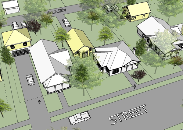 | |
| Figure Notes: Structures shaded yellow indicate the ADU. |
C.
Nonresidential and mixed use accessory use and structure standards.
1.
Home occupation. Home occupations shall be permitted in the mixed use zone districts, pursuant to the standards in [Subsection] A.1, above.
2.
Outdoor display and sales. Outdoor display and/or sale may be allowed as an accessory use for all commercial uses. It is the intent of this ordinance to allow the display of merchandise for sale, but not where the display of such items impedes the flow of pedestrian or vehicular traffic, or creates an unsafe condition. The display of goods shall meet all of the following requirements:
a.
Procedural requirements. Outdoor display and/or sale shall require approval of the Director. All new site plans must show the location of such areas in accordance with this section. Existing nonresidential uses must submit a plan showing the location of the outdoor display or sales areas and how the requirements of this section are to be met. Approval may be subject to appropriate conditions by the Director.
b.
Where permitted.
i.
Detached from or attached to principal building. The outdoor display area shall only contain items for sale by a business that is located within a permanent structure or a designated area on the same site, whether the display area is detached from, or attached to, a principal building.
ii.
Attached to principal building. As shown in Figure 2-4-2-2, Outdoor Display and Sales, an outdoor display area that is attached to a principal building is permitted if the outdoor display area is:
(A)
Adjacent to a wall of a principal structure;
(B)
Not located in areas that are required or used for parking, loading, or vehicular circulation.
(C)
Not larger than 15 percent of the gross floor area of the principal building;
(D)
Within the buildable area of the site formed by the required setbacks;
(E)
If permanently covered, the display area shall be covered with a roof structure that is architecturally integrated into the primary building, except that nursery areas may be covered by greenhouse roofing, screening, or another cover material that is appropriate for protecting plant stock; and
(F)
Configured as a walled and/or decoratively fenced area that is architecturally integrated into the principal building.
iii.
The area used for outdoor display or sales shall not occur on the sides and rear of buildings and shall be limited to no more than one-half of the length of the storefront, unless increased by the Director after taking into account aesthetic and safety concerns or other relevant factors. In the case of a shopping center, the "storefront" shall include the entire frontage of the shopping center, meaning that the total amount of display for all the in-line tenants combined shall not exceed 50 percent of the aggregate storefront of the overall shopping center.
iv.
The area of outdoor display or sales shall not encompass the width of the entrance doors to the facility as projected straight out from the facility. For example, if the width of the entrance doors is ten feet, then there shall be at least a ten-foot clearance from the doors as projected straight out and away from the facility.
v.
No goods shall be attached to a building's wall surface.
vi.
The height of the outdoor display shall not exceed six feet, unless an exception to this provision has been granted by the Director.
vii.
The outdoor display area shall take place on an improved surface such as the sidewalk or pavement, and be clearly marked by a contrasting paint color.
viii.
No outdoor displays shall be allowed in required landscape areas.
c.
No pedestrian obstruction. At least five feet along the parking lot side of the display shall be maintained free of obstruction to allow for pedestrian and handicap movement, such that handicapped pedestrians and others do not have to enter the parking lot or drive aisle to walk around the display.
| Figure 2-4-2-2, Outdoor Display and Sales | |
|---|---|
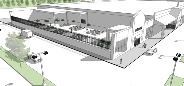 |
D.
Outdoor storage. Outdoor storage may be allowed as an accessory use through the site plan review process and subject to compliance with the following requirements:
1.
Each outdoor storage area shall be incorporated into the overall design of the primary structure on the site and shall be located at the rear of the primary structure.
2.
Goods stored in an approved outdoor storage area shall be limited to those sold on the premises as part of an associated primary use.
3.
Each outdoor storage area shall be screened from view from all property lines and adjacent rights-of-way by an opaque fence or wall between six feet and eight feet in height that incorporates at least one of the predominant materials and one of the predominant colors used in the primary structure. The fence may exceed eight feet in height where the difference in grade between the right-of-way and the outdoor storage area makes a taller fence necessary to effectively screen the area. Materials may not be stored higher than the height of the primary structure.
4.
A landscaped earthen berm a minimum of 48 inches in height may be used instead of or in combination with a required fence or wall.
5.
If the outdoor storage area is covered, then the covering shall include at least one of the predominant exposed roofing colors on the primary structure.
6.
No materials may be stored in areas intended for vehicular or pedestrian circulation.
7.
If installed, exterior lighting shall meet the functional needs of the facility without adversely affecting adjacent properties or the neighborhood.
8.
Storage in conexes, shipping containers, and semitrailers is not permitted.
Sec. 2-5-1. - Purpose and applicability.
A.
Purpose. This section provides standards for operating a temporary use for a limited duration provided the temporary use complies with the standards of this section and that the applicant pays the required fee. The purpose of these regulations is to manage temporary uses to protect the public health and safety and to preserve the value and enjoyment of surrounding properties.
B.
Applicability.
1.
Permit required. A temporary use permit shall be required, as established in Section 6-3-3.5, Temporary Use Permits, and is subject to administrative approval depending on the conformance of the application with the requirements of this section.
2.
Listed uses. This section applies to temporary uses in Section 2-5-2, Temporary Uses Allowed. Any temporary use that this section does not allow, or that the Director determines to be substantially similar to those not allowed, is prohibited.
3.
Unlisted uses. The Director may interpret unlisted uses as requiring a temporary use permit based on the provisions of Section 2-2-1.E, New and Unlisted Uses.
4.
Required principal use. Establishment of a temporary use requires a permanent principal use on the same property, except for a batch plant.
Sec. 2-5-2. - Temporary uses allowed.
A.
Temporary uses allowed. The following temporary uses are allowed provided they comply with the general standards of Section 2-5-3, Temporary Use Standards.
1.
Retail sales of products, including, but not limited to, Christmas trees, snow cone stands, food trucks (only one permitted without issuing a temporary use permit), nursery products, or agricultural produce (from June 15 through July 6 and from December 15 through January 2), in any nonresidential district for a period not to exceed the number of days specified in the temporary use permit. Display of products shall comply with the yard and setback requirements of this ordinance and no display shall be located within an area restricted by the corner sight distance requirements of Section 3-5-2, Measurements and Exceptions.
2.
Temporary office space and equipment storage when accessory to an approved construction project. Such uses shall be located on the site no more than 30 days prior to the start of construction and removed no more than 30 days after completion of such project.
3.
Sales offices on residential development sites in any zoning district until 100 percent of lots or houses are sold or leased. Use of the sales office for sites outside of the project is prohibited.
4.
Expansion or replacement facilities, consisting of transportable buildings that are pre-constructed and arrive at the site ready for occupancy and are readily removed and installed at other sites. Such facilities may include, but are not limited to, the following:
a.
Expansion of existing religious assembly facilities, health care facilities, and government offices following the approval of filed plans and applications for the permanent alteration/expansion of these facilities.
b.
Temporary classroom space for existing public schools.
c.
Temporary office space for construction and security personnel during the construction of an approved development for which a grading or building permit has been issued.
d.
Temporary space for recreational uses provided in connection with an approved residential development under construction.
e.
Temporary space for a nonresidential use following the destruction of a building by fire or other catastrophic event.
f.
Temporary office space (one per site) for hiring, membership solicitation, apartment office/leasing, and general office use following the issuance of a building permit for the construction of a permanent office building.
5.
Temporary space for residential accessory use following the destruction of a building by fire, catastrophic event and/or remodel/rehabilitation efforts. This includes, but is not limited to, storage containers (i.e. POD type containers) or trash containers (i.e. dumpsters) where such container:
a.
Is stored outside, along street rights-of-way and utility easements.
b.
Such container may be onsite no more than ten days prior to the start of reconstruction and no more than ten days after reconstruction is completed.
c.
The container may be permitted no longer than 180 days, or for the life of a valid building permit, whichever ends first.
d.
In no case will said container be placed in any sight-triangle or interfere with traffic visibility, or block any sidewalk area.
e.
Exception: Where conditions preclude placement out of the right-of-way, these types of containers may be placed at the curb-edge with written approval from Community Development Department.
f.
Storage containers or trash receptacles shall not exceed eight feet in width, nor 20 feet in length, nor eight feet in height.
6.
Temporary storage space for residential accessory use, when a residence is being vacated or being prepared for occupancy. The owner may apply for a temporary use permit for one storage container (i.e. POD type container or one trash enclosure, i.e. dumpster), as follows:
a.
Temporary storage use shall not exceed 30 days.
b.
Storage unit (POD) shall be located on private property or driveway only.
c.
Storage unit shall be located on paved surface only. In no case shall this unit be placed in a landscape or grass area.
d.
In no case shall the storage unit be placed within any sight-triangle or interfere with traffic or driveway visibility, or block any sidewalk.
e.
Storage containers or trash receptacles shall not exceed eight feet in width, nor 20 feet in length, nor eight feet in height.
7.
The Director, or his or her appointee may approve other temporary uses or structures using the process established in Section 2-2-1.E, New and Unlisted Uses, which shall require a permit as described in 6-3-3.5, Temporary Use Permit.
Sec. 2-5-3. - Temporary use standards.
General requirements for temporary uses and structures. All temporary uses or structures shall meet the following general requirements, unless otherwise specified in this ordinance:
1.
Permanent alterations to the site are prohibited.
2.
Unless otherwise stated in this ordinance or in the terms of the temporary use permit, the temporary use shall expire on the date specified on the temporary use permit.
3.
All temporary signs associated with the temporary use or structure shall be removed when the use ends.
4.
The temporary use or structure shall not violate any applicable conditions of approval that apply to a principal use on the site.
5.
The temporary use standards of this section do not exempt the applicant or operator from any other required permits, such as Health Department permits.
6.
If the property is undeveloped, it shall contain sufficient land area to allow the temporary use or structure to occur, as well as any parking and traffic movement that may be associated with the temporary use.
7.
If the property is developed, the temporary use shall be located in an area that is not actively used by an existing approved principal use, and that would support the proposed temporary use without encroaching or creating a negative impact on existing buffers, open space, landscaping, traffic movements, pedestrian circulation, or parking space availability.
8.
Tents, trailers, and other temporary structures shall be located not to interfere with the normal operations of any permanent use located on the property.
Sec. 2-6-1. - Purpose and applicability.
A.
Purpose. The planned unit development (PUD) district is established as an overlay zoning district that provides an alternative to conventional development, and requires approval under the procedure in Subsection 6-3-4.3, Rezoning to Planned Unit Development, of this ordinance. The PUD provisions are established for one or more of the following purposes:
1.
To permit and encourage innovative land development while maintaining appropriate limitation on the character and intensity of use and assuring compatibility with adjoining and proximate properties;
2.
To modify the zoning ordinance and allow greater flexibility within the development to best utilize the physical features of the particular site;
3.
To encourage the provision and preservation of meaningful open space;
4.
To encourage integrated and unified design and function of the various uses comprising the planned unit development; and
5.
To encourage a more productive use of land consistent with the public objectives and standards of accessibility, safety, infrastructure and land use compatibility.
6.
The minimum area of commercial or mixed use PUD shall be three acres. The minimum area of an industrial PUD shall be five acres. The minimum area of a residential PUD shall be two and one-half acres.
B.
Applicability. A PUD may be submitted for land located within any base zoning district or combination of base zoning districts. The regulations of the base zoning districts remain applicable except as specifically modified through this section or Subsection 6-3-4.3, Rezoning to Planned Unit Development.
Sec. 2-6-2. - PUD standards.
A.
Bulk and area requirements for planned unit developments.
1.
Intensity of use. Within a PUD, the permitted intensity, calculated as set forth in this subsection, may be reallocated irrespective of the general zoning district boundaries.
a.
Residential intensity.
i.
The maximum number of permitted dwelling units within a PUD shall be computed as follows:
(A)
The gross land area for the purposes of the above-described computation shall be the gross area of the PUD less the lot area or areas designated for any use other than dwellings, quasi dwellings, residential open space, and recreation areas. For the purpose of intensity computations, "gross land area" shall mean the lot area plus one-half of the right-of-way of any abutting street to which the lot has access.
(B)
The minimum gross land area per dwelling unit for the purposes of the above described computation shall be as follows:
(C)
Each 600 square feet of a quasi-dwelling, such as a care home, shall constitute a dwelling unit. If the PUD is within two or more districts, the permitted density shall be the sum of the permitted dwelling units computed separately for the residential area within each district.
ii.
Nonresidential intensity.
(A)
The nonresidential intensity shall not exceed a maximum permitted floor area computed as follows:
(B)
If a floor area ratio is not specified within the applicable use district, a floor area ratio of 0.75 shall apply. The nonresidential intensity of use of a PUD located within two or more general zoning districts shall be calculated separately for each district and allocated within the PUD with delineation of permitted floor area of specified permitted uses.
(C)
For the purpose of intensity computations, "gross land area" shall mean the lot area plus one-half of the right-of-way of any abutting street to which the lot has access.
b.
Livable open space.
i.
Within a residential development area of a PUD, livable open space (open space not used for parking or drives) shall be provided in an aggregate amount equal to the sum of the livable open space required for each dwelling unit calculated separately for each of the underlying use districts from which the permitted dwelling unit allocation is derived as follows:
ii.
Required livable open space may be provided on the lot containing the dwelling unit or units on which computed, or in common areas, common livable open space should be designed and located to be accessible to the dwelling units it is intended to serve. Livable open space shall be designed as meaningful open space that serves as an amenity. For instance, only storm water detention facilities that are wet year round, incorporate water fountains and other related features, have banks that can be easily maintained, and incorporate water quality features, can be counted towards the minimum livability open space requirement.
c.
Building height. Within a PUD the building height limitations shall be prescribed and set forth as development standards of the approved planned unit development and shall be incorporated within the required subdivision plat.
d.
Yards and building setbacks. Within a PUD the minimum yards and building setback requirements shall be prescribed and set forth as development standards of the approved planned unit development and shall be incorporated within the required subdivision plat.
2.
Perimeter requirements. Within a PUD, perimeter requirements for screening, landscaping, and setbacks necessary to assure compatibility with adjoining and proximate properties, shall be prescribed and set forth as development standards of the approved planned unit development and shall be incorporated within the required subdivision plat.
Sec. 2-7-1. - Purpose and applicability.
A.
Purpose. The City Council finds that telecommunication towers, antennas and other wireless facilities, including supporting structures, present land use concerns that should be dealt with by protecting residential uses, encouraging co-location, minimizing the number of wireless facilities in a manner that does not discourage market access or competition, and preventing or limiting adverse effects on off-site premises. The intent of these provisions is to provide for the continued establishment of new wireless communication providers and the expansion of existing wireless communication services within the City, while simultaneously protecting neighborhoods, all through minimizing adverse visual and operational effects of facilities through careful design, sighting, screening, camouflage, and co-location requirements encouraging creative design and camouflage measures.
B.
Applicability. The requirements set forth in this division shall apply to all telecommunications facilities in Broken Arrow.
C.
Duty to indemnify, defend, and hold harmless. Wireless providers shall defend, indemnify and hold harmless the City and its officers, agents and employees against any claims, demands, damages, lawsuits, judgements, costs, liens, losses, expenses and attorney fees resulting from the installation, construction, repair, replacement, operation, or maintenance of telecommunication facilities, including small wireless facilities, wireless support structure, or utility poles to the extent caused by the provider, its contractors, subcontractors and their officer, employees or agents. The provider shall have no obligation to defend, indemnify or hold harmless the City, its officers, agents or employees against any liabilities or losses due to or caused by the sole negligence of the City or its employees or agents.
D.
Proprietary powers reserved. Nothing in this section concerning the regulation of what is legally permissible or legally forbidden interferes with the proprietary right of the City Council to control the property held in the City's name or in the name of any of its trusts as either a corporate owner or as public trustee.
Sec. 2-7-2. - Telecommunication towers.
A.
Setbacks. Telecommunication towers shall be set back from any existing adjacent residential lot boundary equal to 200 percent of the total height of the telecommunication tower or other supporting structure, shall not exceed 200 feet in height as to industrial property or 120 feet in commercial property, and shall comply with the terms of this ordinance and any future amendment thereto. Such telecommunication towers on commercial property must also use camouflage technology such as flagpoles, obelisks or other approved "stealth" coverings. Such telecommunication towers on industrial property must meet the front and side yard setback requirements for the subdivisions.
B.
Standards for telecommunication towers which exceed the height limitations of 50 feet.
1.
Telecommunications towers which exceed the height limitations of 50 feet are prohibited without a permit. No person or entity shall hereafter construct, own, or operate any telecommunication tower which exceeds the height limitations of 50 feet above the mean elevation of the ground on which it is built, unless said person has obtained a building permit to construct from the City of Broken Arrow.
2.
Telecommunication towers on government land. Telecommunication towers located on property owned, leased, or otherwise controlled by the governing authority of any city, county, public school district, state, or by any agency of the United States of America, will be exempt from the remaining requirements of this Subsection 2 if in compliance with the remaining provisions of this Code and are no more than 120 feet in height; provided that such exemption will only be available if a commercial lease or license authorizing such telecommunication tower has been approved by the applicable governing body. The telecommunication tower owner shall file a permit application with the City of Broken Arrow for purposes of keeping a complete record of telecommunication towers within the City and the permit shall be issued administratively. The City Council expressly finds that governmental controls through proprietary devices such as a commercial lease are an adequate substitute for governmental control through regulatory devices.
3.
Telecommunication towers of limited height on residential land.
a.
No telecommunication tower shall be constructed in excess of 50 feet in height above mean ground elevation on any property actually used for a single-family residential purpose, or any vacant land that is intended for residential use in the Comprehensive Plan (Level 1 and Level 2), or that actually has any residential zone district classification and use.
b.
Any telecommunication tower constructed as an accessory use on residentially zoned land that is developed and utilized for institutional purposes shall not be constructed in the front yard or within the minimum side yard requirements for the applicable zoning district. However, a camouflaged telecommunication tower that does not exceed 100 feet may be placed in the front yard if concealment of both the telecommunication tower and the equipment structures are accomplished (e.g., a telecommunication tower disguised as steeple or comparable building element at a site for a place of worship, or a flagpole design at a public school, or an obelisk at other institutions).
4.
Application requirements.
a.
Each applicant for a permit to build a telecommunication tower shall provide to the Community Development Department an inventory of all the existing and approved telecommunication towers or permits for other locations that are within one-half mile of the site applied for. The inventory shall include specific information about the location, height, and design of each telecommunication tower.
b.
If the telecommunication towers within the applicant's inventory have been designed for co-location, a description of the facilities and heights for the possibility of co-location shall be included within the inventory. Copies of the standard colocation lease shall also be provided, with appropriate blanks for physical dimensions and price, but including all standard terms and conditions. Said inventories and form contracts may be shared with other applicants applying for any approvals under this ordinance; provided that the City does not warrant the accuracy of any such information shared with other applicants.
c.
The applicant for a permit shall also provide the description, identity, and contact for the backhaul network provider who will serve that site.
d.
Applicants for permits involving co-location shall specify in the application the features of the telecommunication tower that adapt it for co-location, such as the number and location of portholes for cables, the proposed ground footprint of multiple equipment sheds and cabinets and related items.
e.
The application shall also include elevations of all proposed shielding, screening, and the details of materials and color for the facility.
f.
A nonrefundable fee as set forth in the Manual of Fees shall accompany each application.
5.
Construction standards.
a.
The telecommunication tower shall either maintain a galvanized steel finish, or be painted a uniform neutral color (unless color is governed by applicable standards of the Federal Aviation Administration), so as to reduce visual intrusiveness. Cabling shall be contained interior to the structure of the telecommunication tower, or wrapped in a cover with a matching color scheme to the telecommunication tower. The use of camouflage technology so that the telecommunication tower appears to be a part of the primary building on site is also acceptable. The design and maintenance of the equipment, buildings, cabinets, or related structures shall use materials, colors, textures, screening, and landscaping that will blend the telecommunication tower facilities to the natural setting or the built environment of the primary use.
b.
Telecommunication towers shall not be artificially lighted, unless such lighting is required by the Federal Aviation Administration or other applicable authority.
c.
All telecommunication towers and related equipment shall meet or exceed current standards and regulations of the Federal Aviation Administration and the Federal Communications Commission, together with the regulations of any other agency of the federal government with the authority to regulate telecommunication towers and antennas.
d.
Antennas and associated supports, cables, brackets, and related equipment shall not be mounted on any telecommunication tower or other supporting structure by any method of punching, drilling, or other means that may weaken the telecommunication tower or supporting structure.
e.
All telecommunication tower sites shall be served by a driveway from a public street and said driveway shall be paved on an all-weather surface. However, sites in areas of restricted street access may be served by driveways from paved public or private parking lots. The Engineering and Construction Department must approve the size and type of "tin horns" or other drainage structures prior to the start of construction.
f.
All telecommunication towers and all antenna support structures with a height in excess of the height limitations of 50 feet but 100 feet or less shall be constructed to support a minimum of two antenna arrays with the cabling interior to or otherwise concealed within the structure. All telecommunication towers that are in excess of 100 feet in height shall be constructed to support a minimum of four antenna arrays with the cabling interior to or otherwise concealed within the structure.
g.
Construction must otherwise comply with all applicable codes.
h.
Any information of an engineering nature that the applicant submits to the City, whether civil, electrical, structural or mechanical, shall be certified in writing, by an Oklahoma licensed professional engineer. Such information shall include, but not be limited to, anticipated telecommunication tower height, telecommunication tower type, construction materials, declared wind speed in mph, ice load in inches, anticipated antennas loading for the design, and engineered appurtenance loading.
6.
Maintenance, operation, and removal. The owner of the telecommunication tower shall ensure that it is maintained in compliance with applicable Codes and the applicable standards for telecommunication towers established by the electronic industries association, as amended from time to time, in order to ensure the structural integrity of the telecommunication tower. The failure to maintain structural integrity through compliance with these standards is hereby declared a public nuisance and the telecommunication tower may be abated, including the removal of the telecommunication tower under authority of and in compliance with the City Council's powers to declare and abate public nuisances. No antenna may be used which, by design or by actual operation, causes interference on any frequency actually used by any police, fire, or public ambulance service having authority or jurisdiction over any portion of the City of Broken Arrow.
7.
Site plan. Each applicant requesting a permit under this section shall submit a scaled site plan, lighting plan, and scaled elevation view together with other supporting drawings, calculations, and documentation, all signed and sealed by appropriate licensed engineers or other appropriate professionals, showing the location and dimensions of all improvements proposed for the site. This information shall include existing and proposed topographical and planimetric drawings and all significant features that support co-location (e.g. provisions for interior cabling, portholes, the footprint for multiple equipment sheds and cabinets, etc.).
8.
CG, CH, and industrial districts. Telecommunication towers are lawful uses permitted administratively when located as accessory uses on any land in industrial zoning districts, or any developed land in CG zoning districts or CH zoning districts that are equal to or larger than two and one-half acres.
9.
Other industrial land. The Director may approve telecommunication tower construction if the new telecommunication tower to be constructed is within an industrially zoned area, the industrial district is at least ten acres in size, the telecommunication tower location is no closer than 350 feet to a residential structure, and the telecommunication tower is no greater than 100 feet in height.
10.
Council permits for telecommunication towers. If the telecommunication tower may not be permitted administratively as described above, then no telecommunication tower may be constructed without securing a permit from the Broken Arrow City Council in accordance with the following:
a.
Applications for a telecommunication tower permit from the City Council shall first obtain a conditional use permit from the Planning Commission in accordance with applicable codes.
b.
The City Council may impose conditions that it, in good faith, believes are reasonably necessary to minimize any adverse effect of the proposed telecommunication tower on adjoining properties, and that foster competition by encouraging multiple uses on co-location structures.
c.
The City Council may require particular evidence or special conditions in the event that it determines the proposal may potentially contaminate water supplies, contaminate surface waters or soil, interfere with drainage, or interfere with the primary use of the public property.
d.
All sized freestanding telecommunication towers are prohibited in the AG zoning district on properties that are 40 acres or less in area, including areas that are in fact used as agricultural or residential estate areas even though zoned at more intense levels. Telecommunication towers in excess of 100 feet are prohibited in RS zoning districts. Applicants in such areas shall be required to establish the necessity of the telecommunication tower and all elements of the application by clear and convincing evidence.
e.
When an applicant for a telecommunication tower permit works with a developer of residential land, and designs a subdivision that uses a flagpole and guard house (or comparable camouflage) as elements within the design of the subdivision entrance or private park reserve, the approval of the final plat shall include the permit for the telecommunication tower at a height not to exceed 80 feet and used as the flagpole, and an equipment cabinet within the guardhouse.
11.
Factors considered for City Council approval. The City Council shall consider the following factors in determining whether or not to issue a permit for a telecommunication tower, although Council may modify one or more of these criteria if, in the particular circumstances of the application, Council concludes that the goals and intent of this ordinance are better served by such modification. Factors to be considered are:
a.
Height of the proposed telecommunication tower;
b.
Proximity of the telecommunication tower to residential structures and adjacent residential lot boundaries;
c.
Nature of uses on adjacent and nearby properties;
d.
Surrounding topography;
e.
Surrounding tree coverage and foliage;
f.
Design of the tower with particular reference to those design characteristics, which have the effect of reducing or eliminating visual obtrusiveness, or providing camouflage;
g.
Proposed routes of ingress and egress;
h.
Whether or not the telecommunication tower is constructed so as to be available for co-location in the future; and
i.
Whether or not there are suitable, existing telecommunication towers or other supporting structures capable of meeting the technological needs of the applicant.
12.
Evidence of capacity. All evidence relating in any manner that in essence indicates that the application location is needed to improve the capacity of the system and is to address a specific and local geographic problem must be submitted in writing, and signed and sealed by a professional engineer licensed in the State of Oklahoma.
13.
Warning sirens. All applications for new telecommunication towers shall include an examination of the City's Emergency Warning Siren Location Map. If the new telecommunication tower site is in a location where the Emergency Warning Siren Location Map indicates that a siren is proposed, then the permit may be conditioned on the granting of permission for the City of Broken Arrow to place and operate a storm siren warning system on the completed telecommunication tower, at a height to be mutually agreed, but typically between 20 feet and 30 feet above the mean lot elevation, unless such location would create a technical problem for the applicant's system. Costs of the installation and operation of the warning siren shall be solely the responsibility of the City. Applicant shall advise at the time of the application what costs, rental, or other fees will be required for the placement of the warning siren.
14.
Radius report. If the application is for a telecommunication tower in excess of 200 feet in industrial areas or if in excess of 120 feet in any other zoning district, and Council action is required, then the applicant must provide a list of property owners within a 300-foot radius of the perimeter of the lot on which the telecommunication tower is proposed, and the City shall notify the persons on the list by mailing notice of the hearing, all at applicant's expense.
15.
Co-location contracts. Any applicant who claims that a proposed telecommunication tower will be used for co-location shall provide a form contract, which will be used for co-location for at least five years after construction. The contract shall only have blanks for the name of the lessee, date, location and size of the equipment shed, height of the antenna array and final price.
16.
Effect of existing telecommunication tower availability. No new telecommunication tower should be permitted by the Council unless the applicant demonstrates to the City Council's reasonable satisfaction that no existing telecommunication tower or other structure can accommodate the applicant's proposed antenna. Evidence of this unavailability may consist of any of the following:
a.
No existing telecommunication towers or structures are located within the geographic area required to meet applicant's engineering, capacity, or technical requirements;
b.
Existing telecommunication towers or structures are not of sufficient height or structural strength to meet the applicant's engineering, capacity, or technical requirements;
c.
Applicant's proposed telecommunication tower antennas would cause electromagnetic interference with existing antennas on existing telecommunication towers or structures, or the existing antennas on the existing telecommunication towers or structures would cause electromagnetic interference with applicant's proposed telecommunication tower antennas;
d.
The fees, costs, or contractual provisions required by the owner of the existing telecommunication tower in order to share said telecommunication tower structure are unreasonable. (In this regard, eight-year rental costs exceeding the costs of site acquisition and telecommunication tower construction including engineering and design fees, are presumptively unreasonable); and
e.
The applicant demonstrates that there are other limiting factors that render existing telecommunication towers and structures unsuitable.
17.
Setback and security. All telecommunication towers must be set back a minimum distance of 120 percent of the total height of the tower and structure from any adjacent residential lot boundaries unless a greater setback is required by other provisions of this ordinance. The location of telecommunication towers, guywires, and accessory facilities shall meet the minimum zoning district setback requirements and shall not be in the front yard of the principal use. Towers shall be closed by security fencing not less than eight feet in height together with such appropriate anti-climbing devices as may be best utilized by the type of telecommunication tower involved; provided the Council may waive security fencing requirement if other features of the site provide adequate substitute security. Camouflage technology may be used to justify a reduction or elimination of front yard setbacks as to the telecommunication tower.
18.
Screening and landscaping.
a.
Telecommunication tower facilities shall be visually buffered by a hedge of flow maintenance evergreen plant materials and approved opaque screening materials, which effectively screen the view of the telecommunication tower compound and accessory facilities.
b.
Existing trees and natural landscape and elevations around the site shall be preserved to the maximum extent possible. Shrub planting materials that are used for screening must be a minimum five-gallon evergreen the evergreens must be capable of reaching the full height of the fencing materials at full growth. Trees shall be at least two inches in caliper. Plant materials that die or do not effectively buffer the fencing materials shall be replaced. The landscaping plans shall include provisions for irrigation of all new materials proposed to be planted, or the landscape maintenance shall be bonded by insurance or other surety company licensed to do business in Oklahoma; provided that a single bond in an adequate amount may be used for multiple sites.
c.
The privacy fencing or similar approved opaque screening materials shall be a minimum of eight feet in height; a greater height of fencing shall be used as necessary to screen taller equipment sheds within the compound. Provided that equipment sheds which are adjacent to and camouflaged to resemble a structural element of the primary building on site do not have to be fenced.
d.
A landscaping plan shall be included with the application and shall include operational information on how the planting materials will be maintained, irrigated, and fertilized.
e.
Where a new application is made for an existing site at which the landscaping and screening has not been maintained, the issuance of the permit may be conditioned on the completion of the needed corrective action.
19.
Billboards and signs. No billboards or signs may be added to telecommunication towers.
20.
Five-year permits; notice of use; removal of abandoned telecommunication towers. Any telecommunication tower that is not actually used as an antenna support for a continuous period of 18 months shall be considered abandoned, and the permit owner(s) for such antenna(s) or telecommunication tower shall remove same at their expense within 90 days of receipt of notice from the City of Broken Arrow notifying the permit owner of said abandonment. In the event that such a telecommunication tower is not removed, notice of the intent by the City to remove shall be given to the applicant and to the owner of the real estate on which the telecommunication tower is located if different from the applicant. Abandoned telecommunication towers are hereby declared a public nuisance, removable by the City Council in accordance with nuisance abatement procedures or through the claim on a posted bond.
21.
Driveway for telecommunication towers. Any existing telecommunication tower site that lawfully uses an unpaved driveway to access a public street, and which driveway allows the deposit of dirt, gravel, or similar materials to be deposited on the public streets during rain conditions, shall be considered a public nuisance, and may be abated in accordance with the general ordinances dealing with nuisance abatement.
22.
Permits limited if not built. A permit for a telecommunication tower shall be valid for no more than one year, unless a valid building permit is issued and construction proceeds diligently.
23.
Written decision. Any decisions to deny an application for the placement, construction, or modification of telecommunication towers for cellular or personal communication service, or specialized radio mobile service shall be conveyed to the applicant in writing, together with the summary of the evidence which supports a denial of the application. A copy of the minutes of the meeting, which contains some of the evidence, may be used in place of or in addition to other summaries. The decision shall further contain the date at which the City Council denied the application. The applicant has 30 days after the denial of the application, within which to seek judicial review. Therefore, the City will attempt to give notice in writing within ten business days of the denial of the application, unless the applicant or applicant's representative was present in the meeting at which the denial was announced.
Sec. 2-7-3. - Antennas.
A.
Administrative approval of permits.
1.
Antennas may be installed on an existing structure other than a telecommunication tower (such as commercial or industrial buildings, billboard, sign, power transmission tower, water tower, or other free standing nonresidential structure) that exceed the height limitations of 35 feet, if and only if the additional antennas or supports create a new structure with a cumulative height not to exceed 120 feet from the mean ground elevation.
2.
Antennas may be installed on an existing structure other than a telecommunication tower (such as a building, sign, utility pole, water tower, or other free standing, nonresidential structure) that is less than 60 feet in height so long as such addition does not add more than 20 feet to the height of the existing structure.
3.
Antennas may be installed on any existing telecommunication tower or utility pole of any height, so long as the addition of said antennas add no more than 20 feet cumulative to the height of the existing telecommunication tower or utility pole. Any associated equipment building must be located in conformity with the generally applicable setback requirements of the zoning district and appropriately screened or landscaped. Said installation adding 20 feet of height may occur no more than one occurrence per telecommunication tower or utility pole. For equipment compounds that are served by a dirt road or drive, the new equipment owner shall pave at least the 20 feet of the dirt road or drive that is adjacent to the street.
4.
Antennas may be installed on existing structures on agricultural, residential, or office land through an administrative permit under the following conditions:
a.
On an existing structure other than a telecommunication tower (such as abuilding, sign, utility pole, water tower, or other free standing, nonresidential structure that is less than 60 feet in height, so long as such addition does not add more than 20 feet to the height of the existing structure;
b.
On an existing telecommunication tower of any height, and further including the placement of additional buildings or other supporting equipment used in connection with said antenna, so long as the addition of said antenna cumulatively adds no more than 20 feet to the height of the existing telecommunication tower and the telecommunication tower remains set back from any existing adjacent residential lot boundary equal to 120 percent of the total new height of the telecommunication tower;
c.
On certain developed public properties, including, but not limited to, water towers, water treatment plants, sewer treatment facilities, police stations, fire stations, ambulance stations, equipment maintenance facilities, and lighted and enclosed sports facilities such as football stadiums, baseball and softball parks, but not practice facilities at unlighted or unsecured locations that may be temporarily used for sporting events, nor in any open parks or greenbelts;
d.
On the roofs of public high schools, intermediate high schools, middle schools, elementary schools, and office buildings, so long as such addition does not add more than 30 feet to the height of the existing structure; or
e.
On an existing billboard located within the limited access highway corridors so long as the total height does not exceed 120 feet; provided that if the support for the billboard lacks sufficient strength for the new height, then the billboard may be removed and adequate support for both structures may be made, and a billboard of the same or smaller size be reinstalled at the former height. Existing billboards that are outside of the limited access highway corridor may be used, so long as the addition adds no more than 20 feet to the height of the billboard; for purposes of this section, the limited access highway corridors shall be defined as the Broken Arrow Expressway within Tulsa County, the Creek Turnpike, the Muskogee Turnpike and any land within 150 feet on either side, but said definition shall exclude State Highway 51 in Wagoner County and all spurs or older routings.
B.
Temporary antennas. Temporary antennas shall only be allowed in the following instances:
1.
In conjunction with a festival, carnival, or other activity requiring a special event permit from the City; and the antennas shall only be allowed commencing from one week prior to the event and be removed one-week after the event; or
2.
In conjunction with a natural calamity such as a storm or other emergency as declared by the City's Police or Fire Departments, which calamity has damaged or destroyed the regular facilities, and the temporary facilities are needed to restore service until the damage can be repaired or replaced. The facility owner or the service provider shall notify the City within 24 hours of the outage, and must receive an administrative permit if the temporary facility will be required for more than 15 days. Further, any temporary facilities that remain in place for in excess of six months must receive a permit from the City Council for the period in excess of six months.
C.
Screening and landscaping. Landscaping and fencing requirements on existing telecommunication towers and equipment facilities must be properly maintained prior to the administrative permit being issued by the Director, but new or additional requirements shall not be added for purposes of collocation.
Sec. 2-7-4. - Small wireless facilities.
A.
Permitted use. Co-location of a small wireless facility or a new or modified utility pole or wireless support structure for the co-location of a small cell facility shall be a permitted use subject to the provisions of this section.
B.
Permit required. No person or entity shall place a small wireless facility in the right-of-way without first filing a small wireless facility application and obtaining a permit.
C.
Application requirements. The small wireless facility permit application shall be made by the wireless provider or its duly authorized representative and shall contain the following:
1.
The applicant's name, address, telephone number, and e-mail address;
2.
The names, addresses, telephone numbers, and e-mail addresses of all consultants, if any, acting on behalf of the applicant with respect to the filing of the application;
3.
A general description of the proposed work and the purposes and intent of the small wireless facility. The scope and detail of such description shall be appropriate to the nature and character of the work to be performed, with special emphasis on those matters likely to be affected or impacted by the work proposed;
4.
Construction and engineering drawings stamped by a professional engineer registered in Oklahoma and information demonstrating the small wireless facility or new or modified utility pole or wireless support structure complies with all requirements of O.S. 11 § 36-504.D;
5.
An engineering analysis demonstrating compliance with the applicable standards and codes and a description of any recommended make-ready work;
6.
A small wireless facility shall comply with all applicable codes;
7.
Any amendment to information contained in a permit application shall be submitted in writing to the City within 30 days after the change necessitating the amendment.
D.
Processing of permit; time limits. As found in FCC Final Rule Part 1, Subpart U, Section 1.6003(d), City staff shall review for completeness any permit application to deploy small wireless facilities, and shall notify the applicant on or before the tenth day after submission of the application is materially incomplete, and shall clearly and specifically identify the missing document or information and the specific rule or regulation requiring such document or information. The ten-day limit (above) shall restart at zero on the date on which the applicant submits all the documents and information identified by City staff to render the application complete. An application shall be processed on a nondiscriminatory basis and deemed approved if the City fails to approve or deny the application within 75 days of receipt of the application. Upon issuance of a City permit, a small wireless provider shall install its facilities and commence operation within one year, as explained in 11 O.S. § 36-504.D, paragraphs 5 and 11.
E.
Rescission after approval. The City reserves the right to rescind a duly issued permit and/or order relocation of a small wireless facility or structure at the sole expense of the provider for any reason listed for denial of a permit in 11 O.S. § 36-504.D, or if other unforeseen condition occur which affect public safety or City operations. The City shall give reasonable notice to a provider of any such recession or order.
F.
Routine maintenance and replacement. An application shall not be required for:
1.
Routine maintenance; and
2.
The replacement of a small wireless facility with another small wireless facility that is substantially similar or smaller in size, weight, and height.
G.
Placement of small wireless facilities.
1.
Small wireless facilities, and new or modified utility poles and wireless support structures for the co-location of small wireless facilities may be placed in the right-of-way of an arterial or collector street as a permitted use subject to the following requirements:
a.
Each new modified utility pole installed in the right-of-way shall not exceed the greater of:
i.
Ten feet in height above the tallest existing utility pole located within 500 feet of the new pole in the same right-of-way; or
ii.
Fifty feet of overall height above the ground level.
b.
New small wireless facilities in the right-of-way may not extend more than ten feet above an existing utility pole or, for small wireless facilities on a new utility pole, above the height permitted for a new utility pole under this section.
c.
New small wireless facilities shall be separated from the property line of a residentially zoned property a minimum of 300 feet.
d.
Placement of small wireless facilities, wireless support structures, and utility poles in designated historic districts shall comply with 11 O.S. § 36-503.
2.
Small wireless facilities may be placed on property owned, leased, or otherwise controlled by the City of Broken Arrow pursuant to a commercial lease approved by the Broken Arrow City Council.
H.
Small wireless facilities standards.
1.
All small wireless facilities affixed to a utility pole which has exterior exposure shall be as close to the color of the utility pole as is commercially available to the wireless provider.
2.
The design and maintenance of all small wireless facilities, cables, wires, appurtenances, and utility poles, shall include the use of materials, colors, textures, screening and landscaping that will blend the small wireless facilities, appurtenances and utility poles to the natural setting or the built environment of the primary use.
I.
Zoning. Any wireless provider that seeks to construct or modify a utility pole, wireless support structure or wireless facility that exceeds the height or size limits contained in this section, or is proposed to be located on private property zoned exclusively for residential single-family or duplex use shall be subject to applicable zoning requirements and applicable codes.
J.
Relocation or modification of small cell facilities. Within 90 days following written notice from the City, wireless provider shall, at its own expense, protect, support temporarily or permanently disconnect, remove relocate, change or alter the position of any small wireless facilities within the right-of-way whenever the City has determined that such removal relocation, change or alteration, is reasonably necessary for the construction, repair, maintenance, or installation of any City improvement in or upon, or the operations of the City in or upon, the right-of-way.
K.
Emergency removal or relocation of facilities. The City retains the right and privilege to cut or move any small wireless facility located within the rights-of-way of the City, as the City may determine to be necessary, appropriate or useful in response to any public health or safety emergency. If circumstances permit, the City shall notify the wireless provider and provide the wireless provider an opportunity to move its own facilities prior to cutting or removing a facility and shall notify the wireless provider after cutting or removing a small wireless facility.
L.
Abandonment of facilities. Any wireless provider owning a utility pole or wireless support structure located in the City shall remove said utility pole or wireless support structure and any associated equipment upon abandonment or discontinuance or use and shall notify the City of said discontinuance and removal. The City may notify the wireless provider of suspected abandonment and may demand such removal. If the wireless provider neither removes the utility pole or wireless support structure, nor notifies the City that the utility pole or wireless support structure has not been abandoned, the City may remove the utility pole or wireless support structure, take ownership of the small wireless facility and assess the cost of the removal to the provider.
M.
Repair and restore. Wireless providers shall repair all damage caused by their activities in the right-of-way and shall restore the right-of-way to its previous state. If such a provider fails to make such repairs within a reasonable time, the City may perform said repairs and charge the provider the reasonable, documented cost of such repairs.
N.
Identification on pole or other structure. Every wireless provider within the City shall identify itself on any pole or other structure used in its small wireless communications business, including said provider's full legal name and emergency contact information. Such identification shall be placed in a conspicuous place on the pole or other structure in a permanent, all-weather medium and readily visible to the naked eye. Any wireless provider who purchases or leases, or otherwise succeeds to ownership or control of, such a pole or other structure, shall keep said identification accurate and current.