
Broken Arrow City Zoning Code
CHAPTER 4
- SITE DEVELOPMENT
Sec. 4-1-1. - Purpose and applicability.
A.
Purpose. The standards in this chapter apply to the physical layout and design of development. These provisions address the physical relationship between development and adjacent properties, public streets, neighborhoods, and the natural environment, in order to implement the Comprehensive Plan vision for a more attractive, efficient, and livable community. The specific purposes of this chapter include:
1.
To strengthen and protect the image, identity, and unique character of Broken Arrow and to enhance its economy;
2.
To protect and enhance residential neighborhoods, commercial districts, and other areas by encouraging physical development that is of high quality and is compatible with the character, scale, and function of its surrounding area;
3.
To preserve the quality of life by creating meaningful open space and providing buffers between incompatible uses and along roadways; and
4.
To provide appropriate standards to ensure a high-quality appearance for Broken Arrow and promote good design while also allowing flexibility, individuality, and creativity.
B.
Applicability. The standards in this chapter apply to all development unless specifically exempted in this chapter.
Sec. 4-2-1. - Purpose and applicability.
A.
Purpose. The purpose of this section is to support the creation of a highly connected transportation system within the City in order to:
1.
Mobility options. Provide choices for drivers, bicyclists, and pedestrians;
2.
Service efficiency. Increase effectiveness of municipal service delivery;
3.
Active transportation. Promote walking, bicycling, and the use of transit;
4.
Neighborhood connectivity. Connect neighborhoods to each other and to local destinations such as employment, schools, parks, and shopping centers;
5.
Travel reduction. Reduce vehicle miles of travel and travel times;
6.
Public safety. Promote public safety;
7.
Air quality. Improve air quality;
8.
Emergency response. Reduce emergency response times;
9.
Traffic mitigation. Mitigate the traffic impacts of new development; and
10.
Arterial capacity. Free up arterial capacity to better serve regional long-distance travel needs.
B.
Applicability.
1.
New development or change in use. This section shall apply to all new development and redevelopment, or a change in use, unless specifically exempted by Subsection 4-2-1.B.3, below.
2.
Enlargement of existing development. This section shall apply to all applications for building permits for projects that involve one or more of the following:
a.
An increase in the number of stories in an existing building on the lot;
b.
An increase in the nonpermeable lot coverage by more than 2,000 square feet; or
c.
An increase of 30 percent or more in the square footage of building area or parking lot;
d.
An increase in the number of parking spaces of more than 20, interior landscaping shall be provided on the new portion of the lot in accordance with Subsection 4-3-6 below.
3.
Exemptions. The following development types and areas are exempted from the requirements of this section:
a.
As described in the Broken Arrow Subdivision Code;
b.
Temporary uses approved pursuant to this ordinance.
Sec. 4-2-2. - Calculating required parking.
A.
Generally. The minimum off-street parking regulations shall be provided for the land uses specified in Table 4-2-3-1, Off-Street Parking Schedule.
B.
Calculation of spaces. The number of required spaces is calculated according to the formulas set out in this section. The variables used for parking calculations are as follows:
1.
Fractions. When measurements of the number of required spaces result in a fractional number, any fraction shall be rounded up to the next higher whole number.
2.
Multiple uses. Lots containing more than one use shall provide parking and loading in an amount equal to the total of the requirements for all uses, unless otherwise modified by Subsection 4-2-3.C.7, Parking Alternatives.
3.
Area measurements. Unless otherwise specified, all square footage-based parking and loading standards shall be computed on the basis of gross floor area of the use in question. Structured parking within a building shall not be counted in such measurement.
4.
Computation of off-street parking. Required off-street loading spaces shall not be included as off-street parking spaces in computation of required off-street parking spaces.
5.
Parking for unlisted uses. Parking requirements for uses not specifically listed in Table 4-2-3-1, Off-Street Parking Schedule, shall be determined by the Director based on the requirements for the closest comparable use, as well as on the particular parking demand and trip generation characteristics of the proposed use. The Director may alternately require the submittal of a parking demand study that justifies estimates of parking demand based on the recommendations of the Institute of Transportation Engineers, and includes relevant data collected from uses or combinations of uses that are the same or comparable to the proposed use in terms of density, scale, bulk, area, type of activity, and location.
6.
Maximum parking requirements. For the purpose of calculating parking requirements, the following types of parking spaces shall not count against the maximum parking requirement, but shall count toward the minimum requirement:
a.
Handicapped parking;
b.
Residential parking in a garage;
c.
Curbside pickup spaces, whether at the curb or designed as a typical parking space;
d.
Vanpool and carpool parking; and
e.
Structured parking, underground parking, and parking within, above, or beneath the building(s) it serves.
Sec. 4-2-3. - Off-street parking and loading.
A.
Purpose. This section is intended to provide for the location and design of off-street parking areas to accommodate motor vehicles, while balancing the needs of pedestrians, bicyclists, and transit users. Parking areas are secondary and supportive to the primary land uses on the site, and parking lot design should emphasize the primary facade and orient pedestrians toward the principal entranceways and walkways.
B.
Applicability.
1.
Generally.
a.
The off-street parking and loading standards of this section shall apply to all parking lots and parking structures accessory to any new building constructed and to any new use established in every district.
b.
The requirements of this section shall apply to all temporary parking lots and parking lots that are the principal use on a site.
2.
Expansions and enlargements. Where an existing parking area is altered or expanded to increase the number of spaces to a total of more than 20, the standards of this section shall apply.
3.
Downtown mixed-use district exempted. Off-street parking is not required for uses in the DM district.
C.
Off-street parking.
1.
Schedule A. Unless otherwise expressly stated in this ordinance, off-street parking spaces shall be provided in accordance with the following Table 4-2-3-1, Off-Street Parking Schedule A.
2.
Schedule B. Uses that reference "Schedule B" in Table 4-2-3-1, Off-Street Parking Schedule A, shall provide the following minimum number of off-street parking spaces listed in Table 4-2-3-2, Off-Street Parking Schedule B, below. Most uses subject to this schedule will engage in more than one type of activity. Unless otherwise approved, lots containing more than one activity shall provide parking and loading in an amount equal to the total of the requirements for all activities.
3.
Schedule C. Uses that reference "Schedule C" in Table 4-2-3-1, Off-Street Parking Schedule A, have widely varying parking and loading demand characteristics, making it impossible to specify a single off-street parking or loading standard. Upon receiving a development application for a use subject to Schedule C standards, the Director shall apply the off-street parking and loading standard specified for the listed use that is deemed most similar to the proposed use or establish minimum off-street parking requirements on the basis of a parking and loading study prepared by the applicant. Such a study shall include estimates of parking demand based on recommendations of the Institute of Transportation Engineers (ITE), or other acceptable estimates as approved by the Director, and shall include other reliable data collected from uses or combinations of uses that are the same as or comparable with the proposed use. Comparability will be determined by density, scale, bulk, area, type of activity, and location. The study shall document the source of data used to develop the recommendations.
4.
Maximum number of spaces permitted.
a.
General maximum requirement. Any use categorized as a "commercial" or "industrial" use in Chapter 2, Zoning Districts and Use Regulations, may provide no more than 125 percent of the minimum number of off-street vehicle parking spaces established in Table 4-2-3-1, Off-Street Parking Schedule A, unless an exception is approved under Subsection 2 below.
b.
Exceptions.
i.
If application of the maximum parking standard would result in fewer than six parking spaces, the development shall be allowed six parking spaces.
ii.
The Director may approve exceptions to the maximum parking requirement in situations that meet all of the following criteria:
(A)
The proposed development has a restaurant, unique or unusual characteristics such as high sales volume per floor area or low parking turnover, which create a parking demand that exceeds the maximum ratio and which typically does not apply to comparable uses; and
(B)
The parking demand cannot be accommodated by on-street parking, shared parking with nearby uses, or by increasing the supply of spaces that are exempt from the maximum ratio; and
(C)
The request is the minimum necessary variation from the standards; and
(D)
Written documentation of the reason for the exception and/or a traffic study (see Subsection 8.c, Parking Study) shall be submitted to the Director as part of the site plan application.
iii.
If located in a mixed-use district, the uses in the proposed development and the site design are highly supportive of the mixed-use concept and support high levels of existing or planned transit and pedestrian activity.
5.
Sites in mixed use districts. In the mixed-use districts, the total requirement for off-street parking facilities shall be the sum of the requirements for the various uses computed separately, subject to the modifications set forth below. The modifications are available cumulatively, but overall they may not reduce the minimum requirements by more than 20 percent.
a.
All uses within the mixed use districts shall be eligible or an automatic five percent parking reduction to reflect the reduced automobile use associated with mixed use and central City developments.
b.
A ten percent parking reduction for multi-family residential dwellings in the mixed use districts may be allowed if the proposed use is located within 300 feet of a transit stop with regularly scheduled daily service.
c.
For nonresidential uses in the mixed use districts, the minimum parking requirement may be reduced ten percent if the use incorporates a transit stop that meets minimum design standards established by the City to ensure ready access to users and is compatible with the design and materials of the nonresidential use with which it is associated.
6.
Multi-use facilities.
a.
Reduction. Where an on-site parking facility serving more than one use is proposed, the total number of required parking spaces may be reduced up to ten percent if:
i.
The peak hours of use do not overlap or coincide to the degree that peak demand for parking spaces from all uses will be greater than the total supply of spaces;
ii.
The proposed shared parking will adequately serve each use; or
iii.
The applicant can show that the total required parking can be accommodated on site.
b.
Analysis. In order to apply a parking reduction, the applicant shall provide a parking analysis prepared by a professional engineer.
7.
Handicapped parking requirements.
a.
Residential uses. Handicapped-accessible parking for residential uses shall be provided at the rate of one space per each dwelling unit that is designed for occupancy by the handicapped.
b.
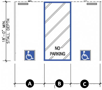
Nonresidential uses. Handicapped-accessible parking spaces, as depicted in Figure 4-2-3-1, ADA Parking, shall be provided for nonresidential uses at the rate shown in Table 4-2-3-3, Handicapped Parking for Nonresidential Uses, below.
Figure 4-2-3-1, Nonresidential ADA Parking
A = Van Space of 11' or Car Space of 8';
B = Access Aisle of 5' if adjacent to 11' Van Space or 8' Access if adjacent to Car
Space
8.
Parking alternatives. The Director may approve alternatives to providing the minimum number of off-street parking spaces in accordance with the following standards.
a.
Shared parking. Off-street parking shall be provided in accordance with the requirements in Table 4-2-3-1, Off-Street Parking Schedule A; provided, however, required parking spaces may be provided on the lot containing the uses the required parking is intended to serve or may be provided in common off-street parking facilities. The Director may approve such shared parking facilities for developments or uses if the shared parking spaces will be located within 600 feet of an entrance to the building the parking is intended to serve (measured along the shortest legal pedestrian route).
b.
Off-site parking. The Director may approve the location of required off-street parking spaces on a separate lot from the lot on which the principal use is located if the off-site parking complies with all of the following standards:
i.
Location. No off-site parking space may be located more than 600 feet from an entrance (measured along the shortest legal pedestrian route) of the use it is intended to serve. Off-site parking spaces may not be separated from the use served by a street right-of-way with a width of more than 80 feet, unless a grade-separated pedestrian walkway, a traffic signal, a shuttle bus, or other traffic control is provided or remote parking shuttle bus service is provided.
ii.
Control of site. Required parking spaces must be located on the site of the use or within a tract owned in common by all the owners of the properties that will use the tract.
iii.
Ineligible activities. Required parking spaces for persons with disabilities may not be located off-site.
c.
Parking study.
i.
An applicant may request to decrease the minimum amount of parking required or increase the maximum amount of parking allowed by submitting a parking study.
ii.
The parking study shall be conducted by a qualified transportation planner or traffic engineer at the applicant's expense (determined by the Zoning Administrator).
iii.
The special study shall include:
(A)
A peak parking analysis of comparable uses; and
(B)
Documentation regarding the comparability of the referenced uses, including name, function, location, gross floor area, parking availability, access to transportation network (including vehicular or other if applicable), use restrictions, and other factors that could affect the parking demand.
d.
Other eligible alternatives. At the discretion of the Director, other alternatives may be approved to providing off-street parking spaces on the site of the subject development if the applicant demonstrates to the satisfaction of the Director that the proposed plan will protect surrounding neighborhoods, maintain traffic circulation patterns, and promote quality urban design to at least the same extent as would strict compliance with otherwise applicable off-street parking standards.
7.
Prohibited occupation of parking spaces.
a.
Except for infrequent, special, temporary events approved under Division 2-5, Temporary Uses, of this ordinance, required parking spaces shall be available for the parking of operable passenger vehicles of residents, customers, patrons, and employees only, and shall not be used for the storage of vehicles or materials or for the parking of trucks used in conducting the business or use, or for the purpose of advertising.
b.
Parking for which a fee or other payment is paid or received shall be a principal use, not an accessory use unless approved as part of a conditional use permit or planned unit development application.
8.
Bicycle parking. Bicycle parking shall be required in the mixed-use, ON, and CN districts for any new building or facility, any addition to or enlargement of an existing use, or change to a use that requires bicycle parking as prescribed in Table 4-2-3-1, Off-Street Parking Schedule A.
a.
Location. The location for required bicycle parking shall comply with the following:
i.
Close proximity to building. At least 50 percent of all required bicycle parking shall be located within 50 feet of the principal building entrance; and
ii.
Remainder. The remaining required bicycle parking may be located:
(A)
In a secure location within 50 feet of building entryways other than the principal entrance;
(B)
At employee-only entrances;
(C)
Within the building; or
(D)
In structured parking that is connected to the building with an entrance.
b.
Dimensions. Bicycle racks shall be a minimum of 15 inches in width and a minimum of 72 inches in length.
c.
Installation. Bicycle parking racks shall be permanently mounted/installed within private property or in approved locations in the public right-of-way on solid surfaces. Racks placed adjacent to sidewalks shall not encroach upon required pedestrian accessways, accessible routes, or accessible passing space areas.
d.
Access. Racks shall be placed a minimum of 24 inches away from walls and other elements that may create an obstacle to accessing the bike parking spaces.
e.
Number. The number of bicycles that a rack is designed to accommodate shall count toward meeting the bicycle spaces required in Table 4-2-3-1, Off-Street Parking Schedule A.
9.
Off-street loading. Development of any nonresidential or public/institutional use shall require provision of off-street loading spaces in conformance with the following minimum requirements:
a.
Types of loading berths. Required off-street loading space shall be provided in berths that conform to the following minimum specifications:
i.
Type A berths shall be at least 60 feet long by ten feet wide by 14.5 feet high, inside dimensions.
ii.
Type B berths shall be at least 30 feet long by ten feet wide by 14.5 feet high, inside dimensions.
iii.
Type C berths shall be located in the rear of a lot and may utilize part of an adjacent alley. The building setback shall be a minimum of five feet from the property line along the alley for the entire width of the lot.
b.
Number of spaces. The following numbers and types of berths shall be provided for the specified uses in Table 4-2-3-4, Off-Street Loading Berths, below. The uses specified in this subsection shall include all structures designed, intended, or arranged, for such use.
10.
Uses not specifically mentioned. In the case of a use not specifically mentioned in this section, the requirements for off-street loading facilities shall be the same as the use mentioned in this section that, in the opinion of the Director, has most similar parking characteristics to the use mentioned in terms of loading classification.
11.
Concurrent different uses. When any proposed structure will be used concurrently for different purposes, final determination of loading requirements shall be made by the Director, but in no event shall the loading requirements be less than the total requirements for each use based upon its aggregate gross floor area.
12.
Location of off-street loading facilities. Off-street loading facilities required under this section shall be in all cases on the same lot or parcel of land as the structure they are intended to serve. The required off-street loading space shall not be part of the area used to satisfy the off-street parking requirements unless approved by the Director based on the adequacy of the site to accommodate both simultaneously. The placement of proposed off-street loading facilities adjacent to residential areas or in an area with a residential zoning classification shall be considered for noise and glare impacts. Mitigation techniques, including appropriate site design measures, maybe required by the Director.
13.
Manner of using loading areas. No space for loading or unloading of vehicles shall be so located that a vehicle using such loading space projects into any public street. Loading spaces shall be provided with access to an alley, or, if no alley adjoins the lot, with access to a street that does not interfere with pedestrian or vehicular circulation. Any required front, side, or rear yard may be used for loading unless otherwise prohibited by this ordinance. Design and location of entrances and exits for required off-street loading areas shall be subject to the approval of the Director based on consideration of the traffic flow and traffic safety. Service and off-street loading areas shall comply with the screening requirements for such areas in Division 4-3, Landscaping, Screening, and Tree Preservation.
14.
Loading area location. To the maximum extent feasible, loading areas shall be located to the rear of a site and/or away from adjacent residential areas.
15.
Signs. The owners of the property shall provide, locate, and maintain loading signs that do not exceed 24 square feet in area as specified by the Director. Such signs shall not be counted against allowed advertising sign area.
16.
Truck parking. One ten-foot by 80-foot truck parking space shall be required for every two loading docks. The spaces grouped together in a designated area with clear access to loading bays. Establishments with only one loading dock are exempt from this requirement.
Sec. 4-2-4. - Design and use of parking and loading areas.
A.
Parking lot design standards.
1.
Off-street parking lots.
a.
All districts. Unless otherwise approved under the parking alternatives described in Section 4-2-3, Off-Street Parking and Loading, the off-street parking lot shall be located within 200 feet, exclusive of street and alley widths, of an entrance of the principal use it is intended to serve, and shall have direct access to a street or alley.
b.
Residential or adjacent to residential districts. No parking area accessory to a nonresidential use shall be permitted within a front yard setback if the use is located in a residential district or immediately abutting the front yard of a residential use.
c.
Downtown fringe district. In the DM and DF districts, no parking shall be permitted within a front yard setback.
d.
Property lines. Vehicles shall not hang over property lines. This shall be accomplished by one of the following:
i.
Pavement shall be set back at least three feet from the property line.
ii.
A fence or other form of barrier shall be installed that prevents vehicles from overhanging the property line.
iii.
A mutual access easement is provided that allows cross access between properties.
2.
Parking structures. In downtown districts, the maximum frontage of parking structures along any one block shall be 200 feet.
B.
Parking space dimensions. Parking layout dimensions for required off-street parking spaces and aisles shall be in accordance with or in proportion to the standards set forth in the following illustrations.
| Figure 4-2-4-1, Parking Layout Dimensions | ||||
|---|---|---|---|---|
| For all illustrations that follow: A = Stall Angle; B = Stall Width; C = Stall Length; D = Aisle Width | ||||
| Parking Layout Dimensions for Nine-Foot Stall Widths at Various Angles with One-Way Aisles (Min. Standards) | ||||
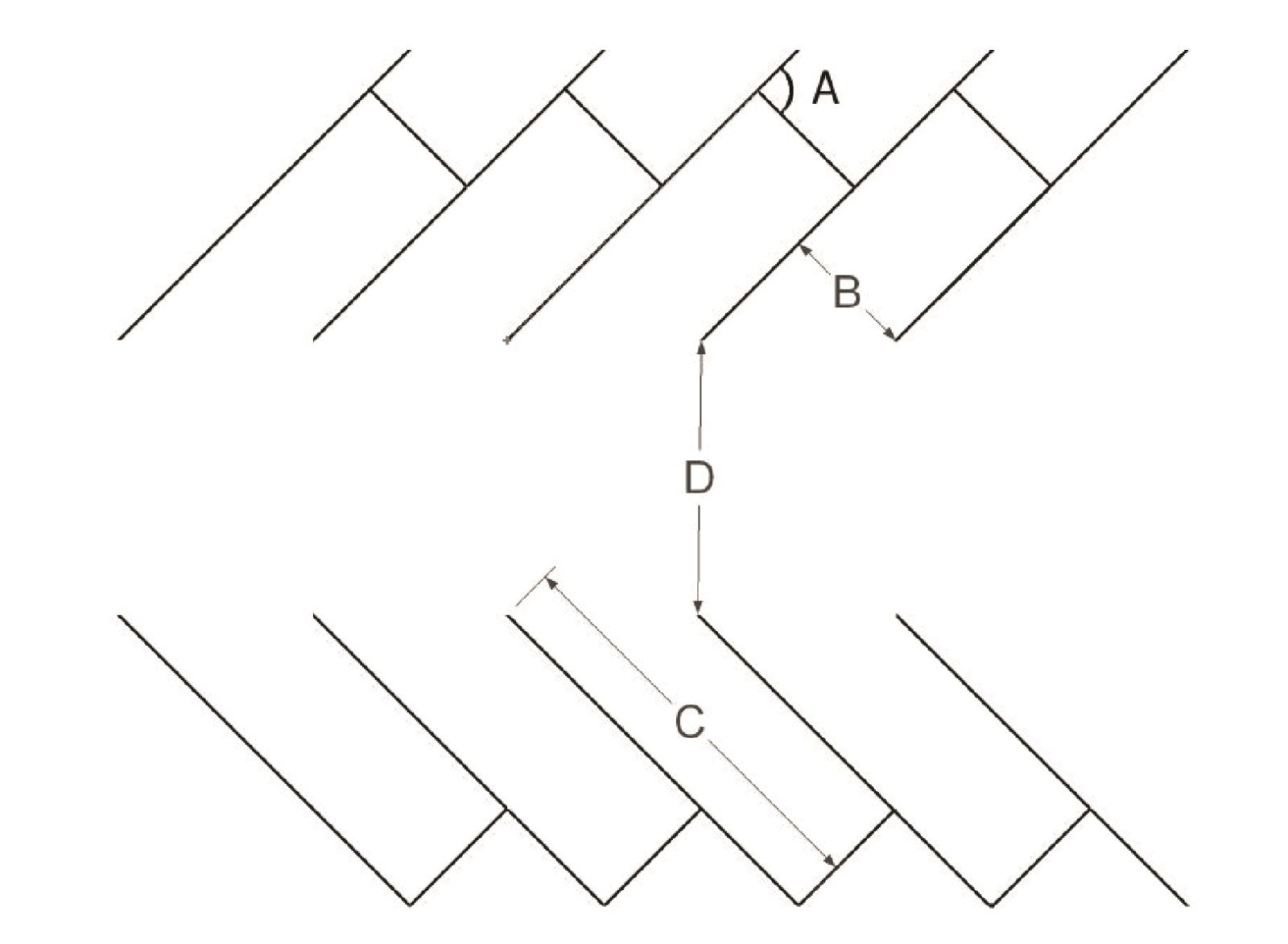 | A | B | C | D |
| 45° | 9 ft | 18 ft | 11 ft | |
| 60° | 9 ft | 18 ft | 15 ft | |
| 75° | 9 ft | 18 ft |
20 ft
| |
| Parking Layout Dimensions for Nine-Foot Stall Widths at Various Angles with Two-Way Aisles (Min. Standards) | ||||
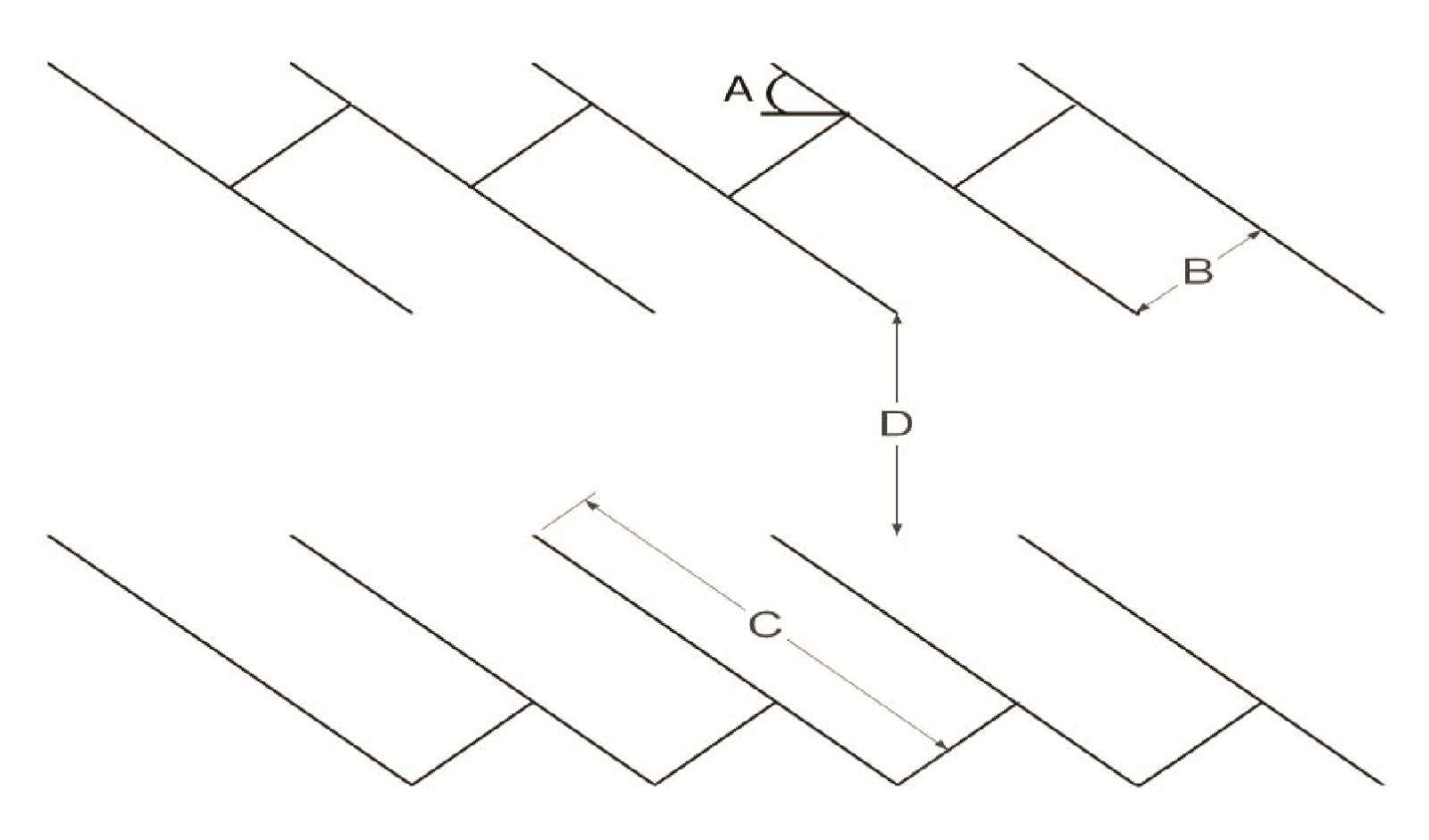 | A | B | C | D |
| 45° | 9 ft | 18 ft | 19 ft | |
| 60° | 9 ft | 18 ft | 20 ft | |
| 75° | 9 ft | 18 ft |
21 ft
| |
| Parking Layout Dimensions at Zero Degree Angles (Min. Standards) | ||||
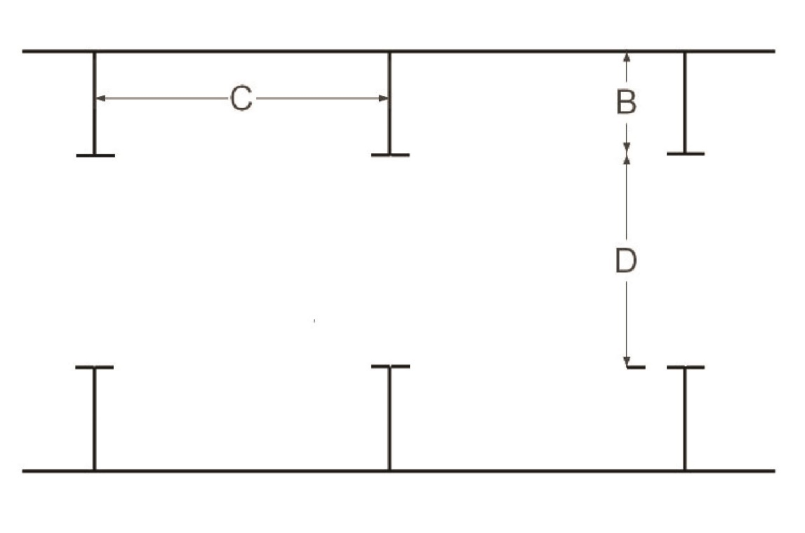 | A | B | C | D |
| One-Way Aisle | ||||
| 0° | 9 ft | 24 ft | 14 ft | |
| Two-Way Aisle | ||||
| 0° | 9 ft | 24 ft |
20 ft
| |
| Parking Layout Dimensions at 90 Degree Angles (Min. Standards) | ||||
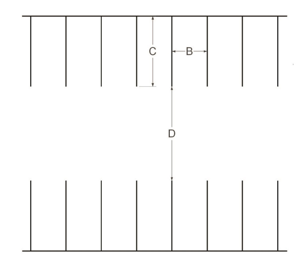 | A | B | C | D |
| 90° | 9 ft | 18 ft |
24 ft
| |
|
FIGURE NOTE:
Fire lanes shall meet the requirements of the current adopted Fire Code | ||||
C.
Recreational vehicle spaces. Parking spaces for recreational vehicles, if provided, shall be a maximum of ten feet by 40 feet.
D.
Construction and drainage. All parking areas shall be constructed and drained in accordance with City ordinances and regulations.
E.
Maintenance. Parking facilities shall be continually maintained in compliance with the approved site and/or subdivision plan and shall be free of litter and debris at all times.
F.
Surface requirement.
1.
All drives leading to parking spaces shall be paved with asphalt or concrete.
2.
An area used for secure storage of vehicles that is anticipated to last for more than four months without interruption is exempt from this paving requirement.
G.
Vehicular circulation. All parking areas shall be located and designed so as to avoid undue interference with the use of public streets and alleys. Parking areas shall provide suitable maneuvering room so that all vehicles may enter an abutting street in a forward direction. Parking spaces must be directly accessible to a parking aisle.
H.
Parking lot landscaping, buffering, and screening. All parking lot landscaping, buffering, and screening shall comply with the applicable requirements of Division 4-3, Landscaping, Screening, and Tree Preservation.
I.
Parking in residential and agricultural zone districts.
1.
Surface requirement. All parking spaces or areas where any vehicle is stored or parked shall be paved with a solid, all-weather surface.
2.
Driveways and parking spaces.
a.
Platted subdivisions.
i.
All parking spaces or areas where any vehicle is stored or parked shall be paved with a solid, all-weather surface.
ii.
Driveway from edge of the street to parking space shall be paved with a solid all-weather surface.
iii.
Driveway ingress (approach) width shall be no greater than 27 feet exclusive of curb returns at the street curb or pavement edge.
b.
Unplatted areas. Unplatted properties that contain one acre or more where a residential use exists.
i.
All parking spaces or areas where any vehicle is stored or parked shall be paved with solid, all-weather surface and shall be at least 25 feet in length.
ii.
Driveways from the edge of the street shall be paved with a solid, all-weather surface from the curb or pavement edge and extending 50 feet past the ultimate right-of-way.
iii.
Driveway ingress (approach) width shall be no greater than 25 feet exclusive of curb returns at the curb or pavement edge for two-car garages and no more than 27 feet for three-car garages except in cases where agricultural use and residential use occur together, the Director may grant an exception to the maximum width of the driveway ingress (approach) to accommodate typical agricultural-related equipment needs.
iv.
After 25 feet beyond the ultimate right-of-way pavement to the parking spaces may be paved with an all-weather surface, ecologically friendly materials such as concrete pavers, or washed gravel, if this distance is 50 feet or greater. If this distance is less than 50 feet, this area shall meet the requirements of Section 4-2-4-J.2.b.ii, above.
v.
Unplatted residentially zoned and/or used properties that are less than one acre will comply with the standards of platted subdivisions for all parking spaces and driveway/ingress surfaces.
3.
Commercial vehicle parking. No more than one commercial vehicle, which does not exceed one-and-one-half tons rated capacity, or have more than two axles, or does not exceed 24 feet in length, except for immediate loading or unloading; per family living on the premises, shall be permitted; and in no case shall a commercial vehicle used for hauling explosives, gasoline, hazardous materials, or liquefied petroleum products be permitted. In no case shall the commercial vehicle and/or attached trailer be parked over any portion of a sidewalk. Length of each vehicle, or a trailer attached to a vehicle shall be measured separately.
4.
Recreational vehicle (RV) and boat parking.
a.
No more than one camping, or travel trailer, or hauling trailer, or recreational vehicle per household shall be permitted on any residential lot, and no more than one boat and its associated trailer, per household shall be parked or stored on any residential lot exclusive of those vehicles entirely stored within a fully enclosed structure.
b.
No trailer, boat, or recreational vehicle shall be parked or stored on the premises for more than a single period not to exceed 24 hours in length unless such is located behind the front building line. On corner lots, no such vehicle shall be parked or stored unless such is located behind both front building lines. The Director may authorize the parking of Recreational Vehicles in front of building lines for periods of up to three days plus extensions not to exceed ten days cumulative, where temporary special circumstances would justify such a nonrecurring use for visitors to the household, and all streets, sidewalks, and sight triangles remain clear.
c.
No person shall occupy or use any recreational vehicle outside of a recreational vehicle park as living or sleeping quarters, except as outlined above in 4.b.
5.
Unlicensed, untagged, and inoperable vehicles. No person shall park, store, leave or permit the parking, storing or leaving of any abandoned, partially dismantled, non-operating, wrecked or junked vehicle in the open, upon public or private property, or on a public street, for a period exceeding 48 hours, unless such vehicle or the parts thereof are stored within a fully enclosed building or are stored on property lawfully designated under the zoning ordinances as a place where such vehicles may be stored.
6.
Vehicles in side or back yards. No vehicles, other than recreation vehicles, as described in Section 4, Recreational Vehicle and Boat Parking, above shall be parked, stored or kept in any side or rear yards.
Sec. 4-2-5. - Drive-thru and stacking.
A.
Applicability. Any development that involves a drive-thru facility shall provide stacking spaces within a stacking lane in accordance with this section.
B.
Dimensions. Each stacking space shall be a minimum of nine feet wide by 20 feet deep.
C.
Stacking spaces.
1.
Measurement. Stacking spaces shall be measured from the window, ATM, or service entrance, as shown in Figure 4-2-5-1, Stacking Illustration.
2.
Required spaces. The number of stacking spaces required for each stacking lane shall be provided as outlined in Table 4-2-5-1, Schedule of Stacking Spaces.
| Figure 4-2-5-1, Stacking Illustration | |
|---|---|
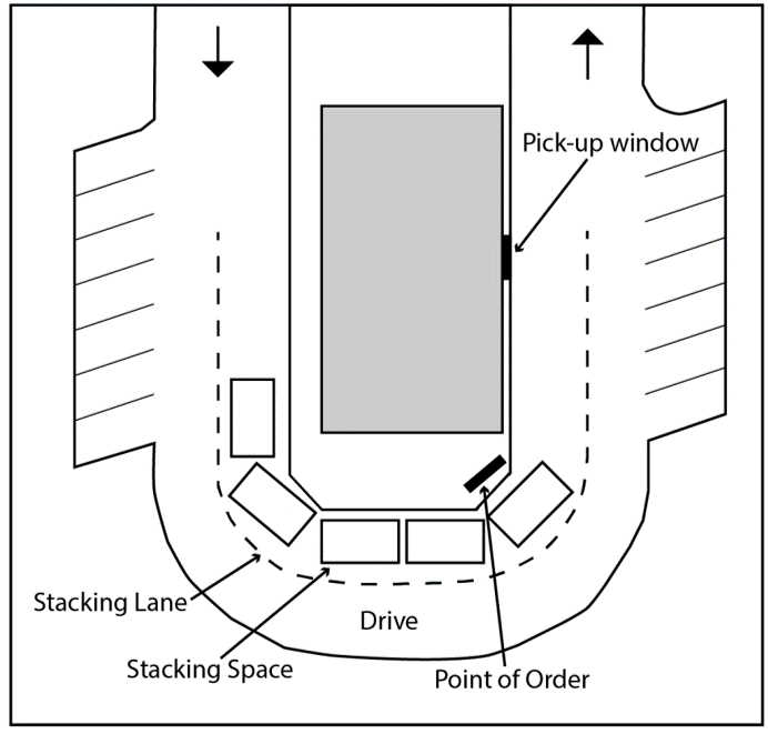 |
3.
Restaurants. As illustrated in Figure 4-2-5-2, Single Lane Restaurant Drive-Thru Stacking, a restaurant with a drive-thru shall include the following in each stacking lane:
a.
A minimum of eight stacking spaces shall be located between the entry of the drive-thru lane and the pick up window.
b.
If the restaurant utilizes double lanes for ordering, a minimum of two stacking spaces shall be provided between the point at which the lane splits into two and the order box for each lane, as illustrated in Figure 4-2-5-3, Double-Lane Restaurant Drive-Thru Stacking. A minimum of four stacking spaces shall be provided between the pick up window and where the lanes merge into one lane, if they merge into one lane.
c.
Additional stacking spaces may be required by the Director.
| Figure 4-2-5-2, Single-Lane Restaurant Drive-Thru Stacking | |
|---|---|
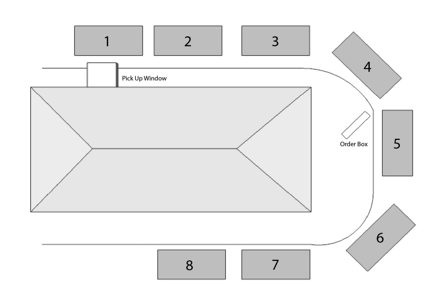 | |
| Figure 4-2-5-3, Double-Lane Restaurant Drive-Thru Stacking | |
 |
D.
Design.
1.
Traffic circulation. Stacking spaces shall be clearly marked and shall not interfere with on-site or off-site traffic circulation, including parking movements and parking spaces.
2.
Frontage restriction. Stacking spaces shall not be located between the facade of a building and the public street upon which the building fronts.
3.
Bypass lane. Stacking lanes shall be designed with an abutting nine-foot wide bypass lane.
Sec. 4-2-6. - General access and circulation.
A.
Street standards. All streets shall meet the standards and requirements of the Broken Arrow Land Subdivision Code and the Engineering Design Criteria and Standard Construction Specifications.
1.
Street connectivity.
a.
Purpose. Street and block patterns should include a clear hierarchy of well-connected streets that distribute traffic over multiple streets in order to avoid traffic congestion on principal routes. Within each residential development, the access and circulation system should accommodate the safe, efficient, and convenient movement of vehicles, bicycles, and pedestrians through the development and provide ample opportunities for linking adjacent neighborhoods, properties, and land uses. Local neighborhood street systems are intended to provide multiple direct connections to and between local destinations such as parks, schools, and shopping. These connections should knit separate developments together rather than form barriers between them.
b.
Connections to undeveloped or unplatted land. As depicted in Figure 4-2-6-1, Connections to Adjacent Properties, where new development is adjacent to undeveloped or unplatted land, all streets, bicycle paths, and access ways in the development's proposed street system shall continue through to the boundary lines of the area to provide for the orderly subdivision of such adjacent land or the transportation and access needs of the community. At least four points of access shall be provided per half mile.
c.
Connections to stub streets. Stub streets within previously platted subdivisions shall be connected with streets in the proposed subdivision unless the Director deems such connection impractical due to topography, the presence of natural features, or vehicular safety factors.
| Figure 4-2-6-1, Connections to Adjacent Properties | |
|---|---|
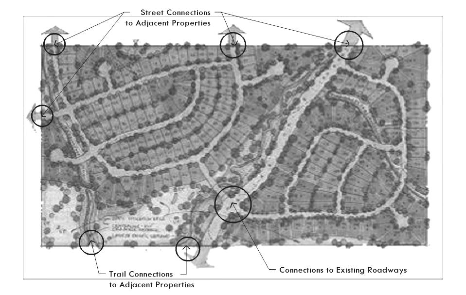 |
d.
Street access.
i.
No principal building or a residence shall be constructed on a lot that does not abut a public street, except in a PUD or other development in which a property owner's or homeowner's association is legally established with responsibility for maintenance and other concerns related to private access ways. The frontage of such a lot in which the principal building or residence is constructed shall not be less than that required for that district.
ii.
Driveway spacing, dimensions, and offsets shall comply with the City's Engineering Design Criteria Manual.
e.
Cross-access onto adjacent properties.All nonresidential development shall be designed to allow for cross access to adjacent properties, as depicted in Figure 4-2-6-2, Cross Access, to encourage shared parking and shared access points on public or private streets. When cross-access is deemed impractical by the Director on the basis of topography, the presence of natural features, or vehicular safety factors, this requirement may be waived provided that appropriate bicycle and pedestrian connections are provided between adjacent developments or land uses. A cross access, mutual access, or shared access easement must be recorded prior to issuance of a building permit.
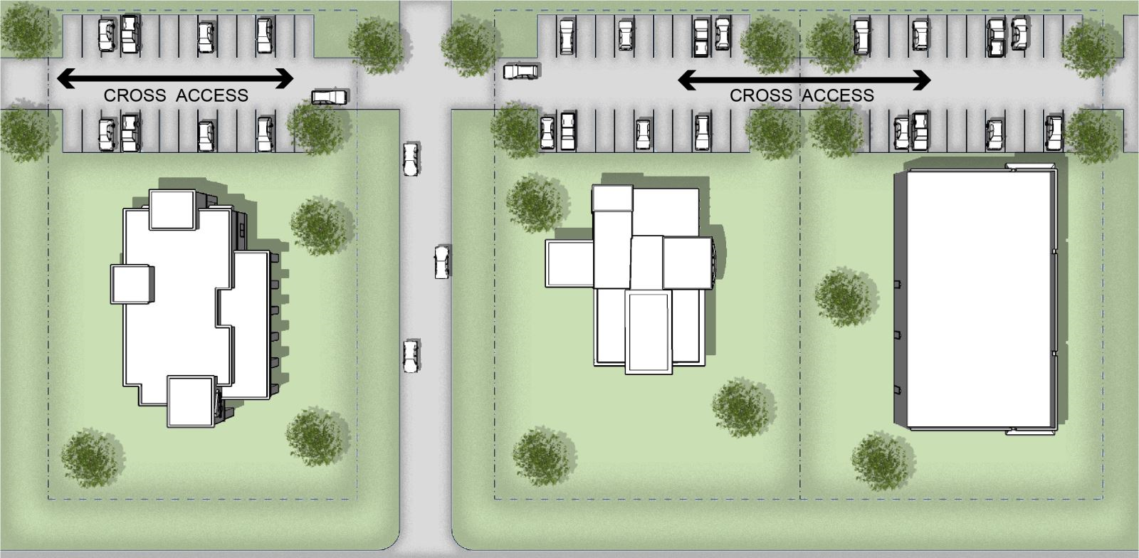
|
|---|
B.
Standards for pedestrian facilities.
1.
Applicability. Sidewalks shall be required under the following circumstances.
a.
New development. Sidewalks shall be required for all new development.
b.
Enlargement of existing development. Sidewalks shall be required for enlargement of existing development that involve one or more of the following:
i.
An increase in the number of stories in an existing building on the lot;
ii.
An increase in the nonpermeable lot coverage by more than 2,000 square feet; or
iii.
An increase of 30 percent or more in the square footage of building area or parking lot;
iv.
An increase in the number of parking spaces by more than 20.
2.
Sidewalks.
a.
All sidewalks shall comply with the requirements of the Broken Arrow Subdivision Code and the Engineering Design Criteria and Standard Construction Specifications.
b.
The developer shall install sidewalks with curb ramps on both sides of all streets other than highways and frontage roads, as established in the Comprehensive Plan within and along the frontage of all new development or redevelopment, and along all open spaces and common areas. The sidewalk shall be constructed before the final building, site, or subdivision inspection by the City.
c.
Sidewalks are not required on local streets in industrial districts.
3.
On-site pedestrian walkways. Site plans shall orient to pedestrian site access points and connections to surrounding street and trails networks, to destinations such as schools or shopping within one-quarter mile of the site, and to pedestrian linkage points on adjacent parcels, including building entrances, transit stops, walkway easements, and signalized street crossings. On-site pedestrian walkways shall connect (a) building entrances to one another and (b) from building entrances to public sidewalk connections and existing or planned transit stops. If buildings are not placed directly adjacent to the public sidewalk, then pedestrian walkways shall link the principal pedestrian site access to building entrances. All developments that contain more than one building shall provide walkways between the principal entrances of the buildings. All sidewalks shall be ADA accessible and meet ADA guidelines.
Sec. 4-3-1. - Purpose and applicability.
A.
Purpose. This section is intended to ensure that new landscaping and the retention of existing vegetation is an integral part of all development, and that it contributes added high quality to development, retains and increases property values, conserves water, and improves the environmental and aesthetic character of the community. It is also the intent of this section to provide flexible requirements that encourage and allow for creativity in landscape design.
B.
Applicability.
1.
New development. This section shall apply to all new development, unless specifically exempted by Subsection 4-3-1.B.2.
2.
Enlargement of existing development. This section shall apply to all applications for building permits for projects that involve one or more of the following:
a.
An increase in the number of stories in an existing building on the lot;
b.
An increase in the nonpermeable lot coverage by more than 2,000 square feet;
c.
An increase of 30 percent or more in the square footage of building area or parking lot; or
d.
An increase in the number of parking spaces of more than 20, interior landscaping shall be provided on the new portion of the lot in accordance with Subsection 4-3-6.
3.
Exemptions. The following development types and areas are exempted from the requirements of this section:
a.
Individual single-family and two-family dwellings on separate lots, where such residential use is the primary use on the lot;
b.
New single-family detached and two-family subdivisions with four or fewer lots and four or fewer dwellings; and
c.
Temporary uses approved pursuant to this ordinance.
C.
Landscaping plans approved under previous ordinances. All landscape plans approved under prior ordinances of the City shall remain in effect and subject to fulfillment of all terms of such plans previously filed and approved.
Sec. 4-3-2. - General landscaping standards.
A.
Generally. Standards for the removal and/or planting of all landscaping materials are set out in this section.
B.
Applicability. These standards shall apply to all areas where landscaping is required by this ordinance. Except where there are conflicts with utility lines, at least 50 percent of the trees shown on the landscape plan that are required by this ordinance shall be medium to large trees. Small trees shall only be used when there are conflicts with overhead utility lines and as places of accent.
1.
Approved plant list for landscape requirements. Trees shall be selected from Appendix A, Approved Plant List. Materials not on the list may be approved by the Director if it is determined that they are equally suitable for local soil conditions and climate and would provide the same level of visual benefits. Required landscaping shall not include artificial plants, trees, or other artificial vegetation. Under no circumstances may Bradford Pears be planted within required landscape areas.
2.
Irrigation. The irrigation system requires a permit and shall be installed to City of Broken Arrow Codes. Required new landscaping shall be irrigated by one of the following methods:
a.
An underground sprinkling system:
b.
A drip system; or
c.
In industrial areas with non-arterial street or highway frontage, a hose attachment, with such attachment within 100 feet of all landscaped areas.
3.
Visibility. Landscaping, including berms, shall not obstruct pedestrian and/or vehicular traffic visibility at street intersections or at access points to streets.
4.
Maintenance. Every property owner and any tenants shall keep their landscaped areas in a well-maintained, safe, clean, and attractive condition at all times. Such maintenance shall include, but is not limited to, the following:
a.
Landscaped areas shall be kept free of trash, litter, weeds, and other such materials or plants not a part of the landscape.
b.
All plant material shall be maintained in a healthy and growing condition. If any required landscape feature fails, it shall be replaced in accordance with Section 4-3-4.B.4, Replacement of Trees. Other required landscaping that is diseased, damaged, destroyed, or removed must be replaced with plant material of similar variety and size (size not to be smaller than the minimum required by this ordinance at the time of replacement).
c.
Lawn mowing on a regular basis.
d.
Proper pruning.
e.
Watering on a regular basis.
f.
Maintenance of landscape lighting in working order.
g.
Maintenance of underground irrigation systems in working order.
h.
Cleaning of abutting waterways and landscaped areas lying between public right-of-way lines (property lines) and the street, unless such streets, waterways, or landscaped areas are expressly designated to be maintained by a designated governmental authority.
5.
Landscaping on public property.
a.
The City shall have the power to plant, preserve, spray, trim, or remove any tree, shrub, or plant on any parkway, alley, or public ground belonging to the City.
b.
It shall be unlawful for any person, unless commissioned by the City, to cut or break any branch of any tree or shrub or injure in any way the bark of such tree or shrub growing on public property.
c.
Trees shall not be planted in arterial street rights-of-way without prior written permission from the City.
d.
It shall be unlawful to spray landscaping with any chemicals which result in the destruction or demise of trees, shrubs or landscape material.
6.
Tree location and sight distances.
a.
No tree or shrub shall be planted within an arterial street right-of-way without prior written permission from the City.
b.
At the intersection of any arterial street with any other street or driveway, no property owner shall allow any vegetation to exceed a height of 30 inches above street grade within the sight triangle.
c.
No tree shall be planted within ten feet of any fire hydrant so as to obstruct the fire hydrant when viewed from the street.
d.
No trees, other than those species listed as small trees in Section 4-3-2.B.1, shall be planted under or within 20 feet of any overhead utility wire, or over or within five feet of any underground public utility line.
e.
Prior to any landscaping being installed on freeways and expressways, a letter from the appropriate state transportation agency (i.e., Oklahoma Department of Transportation or Oklahoma Turnpike Authority) approving of such landscaping shall be provided to the City of Broken Arrow.
7.
Walkways and sidewalks. Where planting areas are required, upon approval of the Director, they may be crossed with walkways to allow access to the building or site. Sidewalks may encroach from the public right-of-way into a landscaped area on private property with approval of the Director and in accordance with Section 4-2-6.B.1.d.
C.
Landscaping and screening devices prior to construction. For nonresidential sites greater than ten acres, landscaping and screening devices along the perimeter of the site shall be installed prior to construction activity taking place on the site, except where the applicant can demonstrate to the Director that such landscaping and screening would be unavoidably destroyed during construction.
Sec. 4-3-3. - Landscaped edge.
A.
Generally. Landscape edge is a landscape area required to be provided on private property adjacent to a street or highway for multi-family development in all districts where it is permitted and for mixed use and nonresidential development in the RMF, CM, ON, CN, GC, and CH districts.
B.
Landscaped edge.
1.
Office and commercial, mixed-use and multi-family districts. Except in the DM, DF, and CM districts which are addressed in Subsection 4-3-3.B.2, all development in the office and commercial, multi-family, and mixed-use districts shall provide a landscaped edge adjacent to all highways, frontage roads, and any other street. The landscaped edge shall comply with the following standards:
a.
Width. The landscaped edge shall be a minimum width of 35 feet for multi-family development, and ten feet for all other development subject to this section. Street rights-of-way and sidewalks are not counted as part of the landscaped edge. However, the Director may reduce the width of the required landscaped edge during site plan review if the reduction is required for public improvements. Utility easements may be included in the landscaped edge, but the property owner is responsible for replacement of any required landscaping material that is damaged by any work done in the easement.
b.
Tree requirements. Within the landscaped edge, one tree shall be planted for every 35 linear feet of landscaped edge. The number of required trees shall be calculated based on the linear frontage of the required landscaped edge and shall be rounded to the nearest whole number. Trees may be grouped together or evenly spaced. Trees shall be a minimum two and one-half inch caliper and shall be on the City's approved plant list.
c.
Additional requirement for parking lots and drives abutting landscaped edge.
i.
Where parking lots and drives abut the landscaped edge, and the landscape edge is less than 35 feet in width, all developments shall provide ten shrubs (three-gallon minimum) for every 50 linear feet of abutment to the landscaped edge. These shrubs shall be placed within the landscaped edge and are in addition to the required number of trees. The number of required shrubs shall be calculated based on the linear frontage of parking lot/drive abutment to the required landscaped edge and shall be rounded to the nearest whole number.
ii.
As an alternative to Subsection 4-3-3.B.1.c.i, a berm or masonry wall may be placed within the landscaped edge in lieu of the required shrubs. The berm or masonry wall must be at least three feet but no more than five feet in height.
d.
Additional tree requirement per housing unit in RMF district. In the RMF district, in addition to the tree and shrub requirements above, at least one tree with a caliper of at least three inches, eight three-gallon shrubs, and five one-gallon groundcover or flowering shrubs shall be planted per multi-family housing unit. This landscape material shall not be included in the landscaped edge along the street frontage. However, it may be included in the other open space areas required by this ordinance.
2.
Requirements for mixed-use districts. All development in the DM, DF, and CM districts shall comply with this subsection. Where a surface parking lot abuts the street right-of-way, the development shall provide a sidewalk built to City specifications within the right-of-way and one of the following options:
a.
Option 1. A landscaped edge between three feet and five feet in width, built outside of but adjacent to the street right-of-way, with either ornamental fencing or masonry walls, of at least three feet in height, and wheel stops or curbing in the parking lot to prevent any vehicle overhang into the landscaped area (See Figure 4-3-3-1 below). At least ten shrubs (three-gallon minimum) for every 50 linear feet of abutment to the landscape edge shall be installed.
| Figure 4-3-3-1, Landscaped Edge in Mixed-Use Districts (Option 1) | |
|---|---|
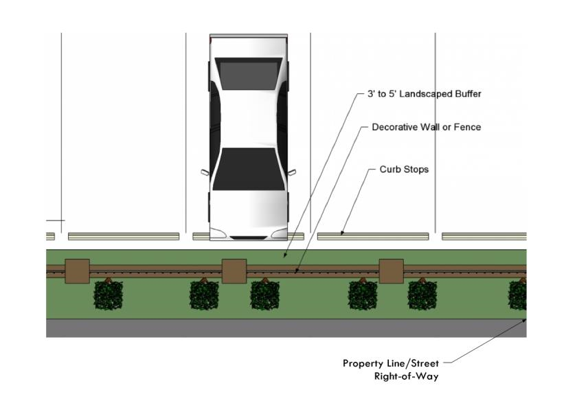 |
b.
Option 2. An ornamental fence or masonry wall of at least three feet in height without landscaping, built to the street right-of-way, provided that a landscaped edge with street trees is provided between the sidewalk and the adjacent public street. (See Figure 4-3-3-2 below). At least one two-inch caliper tree shall be planted for every 25 linear feet that the parking lot abuts the street right-of-way.
| Figure 4-3-3-2, Landscaped Edge in Mixed-Use Districts (Option 2) | |
|---|---|
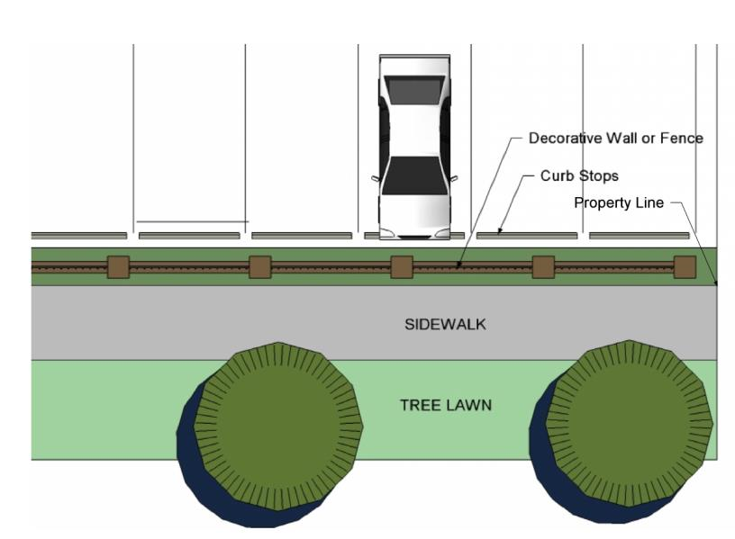 |
Sec. 4-3-4. - Existing tree protection and replacement.
A.
Purpose. This section is intended to establish incentives for the preservation of existing trees within Broken Arrow and to provide guidelines for the protection of trees during construction, development, or redevelopment.
B.
Applicability.
1.
Earth change permit. No clear-cutting of land is allowed without an earth change permit from the Community Development Department. (Refer to Chapter 13, Article II, Section 13-19 of this Code).
2.
Tree preservation credits.
a.
For every existing tree that is preserved in an area where landscaping is required by this ordinance, the developer shall be given credit in accordance with the following table. Only trees in good condition having been protected in accordance with Section 4-3-4.B.3 below shall be considered for credit.
b.
An applicant requesting credit for protecting existing trees pursuant to this section shall include on the landscaping plan the approximate location, size (caliper and height), condition, and common name of each tree to be preserved for which the applicant is requesting tree credits.
c.
Every tree credit that an applicant gains under Table 4-3-4-1, Tree Preservation Credit, shall allow for a reduction in the minimum parking requirements for the site by two parking spaces, but may not reduce the minimum parking requirements by more than 20 percent.
3.
Tree protection during construction. All developers are required to adhere to the following tree protection measures on all construction sites as applicable. Only trees protected in accordance with these standards shall be eligible for credit against required landscaping.
a.
Prior to grading, construction, or land development, the developer shall clearly mark all trees to be preserved.
b.
The developer shall erect a plastic mesh fence a minimum of four feet in height at the drip line around each tree or group of trees to prevent the placement of debris or fill within the drip line of any tree and the disturbance of soil below the canopy.
c.
During the construction stage of development, the developer shall prohibit cleaning, parking, or storage of equipment or materials under the canopy of any tree or group of trees. No disposal of any waste material such as, but not limited to, paint, oil, solvents, asphalt, concrete, mortar, etc., under the canopy of any tree or groups of trees shall be permitted to occur.
d.
No attachments or wires of any kind, other than those of a protective nature, should be attached to any tree. No twine shall be left on the tree such that it would girdle the trunk causing premature death.
e.
No fill or excavation may occur within the drip line of a tree to be preserved unless there is a specific approved plan. Major changes of grade (six inches or greater) will require additional measures to maintain proper oxygen and water exchange with the roots. With major grade changes, a retaining wall or tree well of rock or brick should be constructed around the tree no closer than the drip line. The retaining wall should be constructed so as to maintain the existing grades around a tree or group of trees.
f.
No utility, plumbing or irrigation trenches shall be dug within the drip line.
g.
At no time shall a wall, pavement, or porous pavement be placed closer than four and one-half feet or one foot for every two inches in caliper, whichever is greater, to the trunk of the tree.
4.
Replacement of trees.
a.
When required. Replacement trees are required when any required tree or any tree that was shown on a landscape plan and that was granted landscaping credit under this section is removed. Acceptable types of replacement trees are listed in the City's approved plant list.
b.
Tree replacement rates. Any required tree or credited tree that fails shall be replaced at the following rates:
c.
Off-site placement of replacement trees. If the physical limitations of the subject property are such that all of the replacement trees cannot be properly located on site, the applicant may locate the extra trees on public park land with the approval of the Parks Director, or in an adjoining or nearby reserve area with the approval of the property owner.
Sec. 4-3-5. - Development landscaping.
A.
Generally. Standards for planting and/or substitution of all landscaping materials in developments are set out in this section.
B.
Substitution of large trees. Small trees may be substituted for large trees in locations where building setbacks or build-to lines would create conflicts between buildings and large trees, or where overhead utilities require trees with a mature height that is less than the elevation of the power lines. However, if such substitutions are made, then:
1.
Tree requirements. Small trees shall be:
a.
Clustered in groups of three; or
b.
Spaced at intervals of 20 feet on center.
2.
Tree selection. If used, small trees shall be selected to not interfere with the street or sidewalk right-of-way at maturity.
C.
Residential landscaping.
1.
Generally. Landscaping is required on lots within new residential subdivisions and when new dwellings are constructed on infill lots with the RS, RS-C, RS-P, RMD, and RMH districts.
2.
Ground covers and sod. Areas of residential lots that are visible from the street and that are not covered by buildings, driveways, swimming pools, or other hard surfaces shall be sodded or planted with permitted ground covers as set out in Appendix A, Approved Plant List, unless they are covered by woodlands, crops, or feedstock.
3.
Required plantings and location. Required plants shall be installed as specified below. Any plants in excess of the minimum required plants may be installed in any location on the lot provided there is adequate room for healthy growth and stability.
a.
Front yards. Front yards shall be planted with two large trees, unless a street tree is planted within 15 feet of the front property line, then no tree is required.
b.
All other yards. No requirements or restrictions on planting.
D.
Street landscaping visibility.
1.
Purpose. The main objective of street landscaping visibility is to maximize safety while allowing for safer and more effective access for all drivers who cross through and make turning maneuvers at crossroads.
2.
Required planting setback. All development intersections and retail entries shall require a planting setback in accordance with the corner sight distance of Section 3-5-2.C.6, Corner Sight Distance.
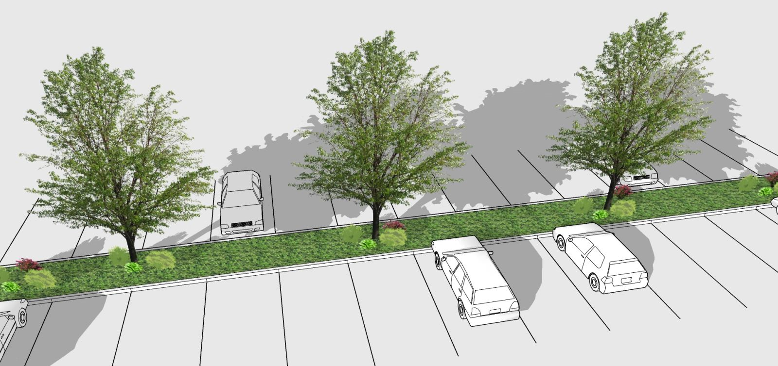
Sec. 4-3-6. - Parking lot landscaping.
A.
Generally. Parking lot landscaping is required within and around nonresidential, mixed-use, and multi-family parking lots that contain more than five parking spaces. This subsection does not apply to single-family detached or single-family attached uses.
B.
Interior parking lot landscaping.
1.
Office, commercial, and mixed-use districts. In all office, commercial, and mixed-use districts, landscaped areas shall be established and maintained in off-street parking areas as follows:
a.
At least one large or medium tree shall be planted for every 15 parking spaces. The number of required trees shall be rounded to the nearest whole number. These trees shall be planted inside or within 15 feet of the parking lot, but shall not be placed in the landscaped edge required in Subsection 4-3-3. Trees shall be two and a half-inch caliper minimum and shall be on the City's Approved Plant List in Appendix A, Approved Plant List.
b.
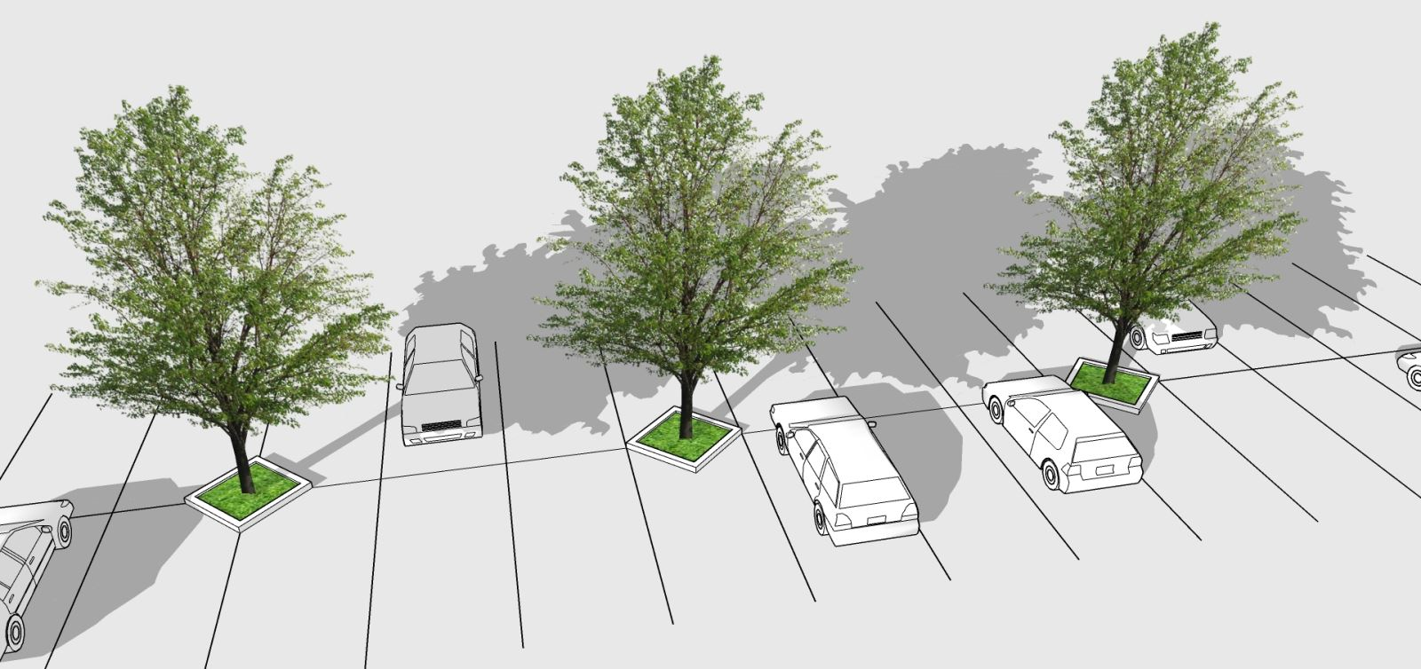
Landscape islands containing required trees in Subsection a., above, shall be either:
i.
A minimum of ten feet in width and 18 feet in length, measured face of curb to face of curb;
ii.
Sixteen square feet in plantable area, measured from face of curb to face of curb, configured in the shape of a diamond or eight square feet in the shape of a triangle, with the center point of the diamond located at the point where four parking spaces meet (for double parking rows) or the base of the triangle located at the point where two parking spaces meet (for a single parking row). See Figure 4-3-6-2, Diamond or Triangle Interior Islands.
c.
As an alternative to the requirement in Subsection a., above, the property owner may provide a landscaped median, as depicted in Figure 4-3-6-1, Landscaped Median, along the centerline of a double parking row at intervals of one median per three double parking rows. Each median shall contain a three-foot tall hedge or ornamental grasses and one small tree per 30 linear feet. Each median shall be a minimum of five feet wide.
d.
Landscape islands shall be provided on each side of all drives that provide access from the street to the property.
e.
All parking lot landscaped areas shall be protected by a raised six-inch concrete curb, unless an alternate green infrastructure solution is approved. Pavement shall not be placed closer than four and one-half feet from the trunk of a tree.
f.
For site plans of two and one-half acres or less in size:
i.
No parking space shall be located more than 50 feet from a landscaped area; and
ii.
Landscape islands shall contain at least 100 square feet, with a minimum width of ten feet.
g.
For site plans greater than two and one-half acres in size:
i.
No parking space shall be located more than 75 feet from a landscaped area; and
ii.
Landscape islands shall contain at least 180 square feet, with a minimum width of ten feet.
h.
Landscape areas from which parking spaces can be measured, as required in Subsection B.1.a, above, shall include the following:
i.
Landscape islands meeting the applicable size requirements of Subsections 4-3-6.B.1.d and 4-3-6.B.2.e. However, the landscaped edge, as identified in Section 4-3-3, cannot be an area from which to measure.
ii.
Landscape areas next to buildings that are at least five feet in width and contain at least one hundred square feet.
| Figure 4-3-6-1, Landscaped Median | |
|---|---|
 |
| Figure 4-3-6-2, Diamond Interior Islands | |
|---|---|
 |
C.
Residential multi-family districts. In the RMF district, landscaped areas shall be established and maintained in off-street parking areas as follows:
1.
In multi-family districts, at least one large or medium tree shall be planted for every two units. Parking spaces in an uncovered parking area shall extend no more than ten parking spaces without an intervening interior landscaped island no less than ten feet in width and 18 feet in length. Landscaped islands shall be planted with a combination of trees, and ground cover, or sod. Trees shall be two and one-half inch caliper minimum and shall be on the City's Approved Plant List. In lieu of the landscape islands, striped access aisles that are at least ten feet in width can be used that are handicapped accessible and connect to all ground floor breezeways. Landscape material otherwise required at the islands shall be located throughout the project.
2.
A landscaped area no less than ten feet in width and 18 feet in length shall separate detached garages or carport structures sited in a row (end-to-end). Such area shall be planted with a minimum one tree from the City's Approved Plant List and ground cover or sod.
3.
Lighting for parking lots may be contained within an interior parking lot landscaped area provided the landscaped area is a minimum of 200 square feet in area and provided the landscaping and trees, at maturity and as maintained, shall not obstruct the illumination path.
D.
Agriculture and residential districts. All nonresidential uses located within the established agriculture and residential zoning districts shall conform to the standards identified in Subsection 4-3-6.B.1.
E.
Green infrastructure. Green infrastructure is any combination of landscaping, facilities, or equipment that captures rainwater at or near the site where it falls by infiltration into the soil, evapotranspiration by plants, or storage for reuse. The following green infrastructure features may be used for interior parking landscaping.
1.
Permeable paving. Permeable paving is a surface paved with permeable pavers, porous concrete or porous asphalt that allows water infiltration into the soil.
2.
Rain garden. A rain garden is a landscaped area specifically designed to capture and infiltrate stormwater and filled with deep-rooted plants.
3.
Bioswale. A bioswale is a depressed area designed to capture and infiltrate stormwater runoff and remove pollutants. Constructed wetlands and other bioretention facilities may also be considered bioswales for the purposes of this section.
4.
Rainwater catchment area. A rainwater catchment area is an area from which rainfall flows into a rain garden, bioswale or other bioretention facility.
Sec. 4-3-7. - Buffers and screening standards.
A.
Purpose. This section is intended to ensure the inclusion of an adequate buffer between different land uses and provide screening standards for supplementary building features.
B.
Buffers generally. The bufferyards required by this subsection are based on the amount of screening (i.e., opacity) they provide and are classified from the least screening (Type A) to the most screening (Type C), depending on the types and intensities of adjacent uses.
C.
Opacity and width standards.
1.
Opacity standards. The opacity of the bufferyard is a measure of the view that is blocked by the bufferyard from grade to a height of 35 feet. Opacity relates to planting density, plant forms, bufferyard widths, and the presence of structures (e.g., fences and walls) or topography (e.g., natural slopes or constructed berms).
2.
Width standards. Comparable opacities can be achieved with bufferyards of different widths. However, in certain circumstances (e.g., where noise, dust, runoff, or other non-visual impacts are to be mitigated by the bufferyard), the width of the bufferyard may be as important or more important than its opacity.
D.
Bufferyard options. There are two bufferyards options, each identifying the width of the buffer and the number and types of plants required per 100 linear feet, or portion thereof. The minimum planting requirements for each type and composition of bufferyard are set out in Table 4-3-7-1, Bufferyard Classifications.
1.
Natural landscaped bufferyard. Landscape only bufferyards are the preferred option and use a higher density of plant material. An undulating berm may be utilized to screen abutting properties.
2.
Screened bufferyard. For properties more constrained by size, a second option provides a similar level of screening, but requires a fence or wall to be used in conjunction with a smaller width of landscape strip and lower density plant material.
E.
District boundary bufferyards. Set out in Table 4-3-7-2, District Bufferyard Standards, are the required bufferyards between zoning districts that are not separated by a public street. The rows show the zoning of the parcel proposed for development and columns show the zoning of the abutting land. The bufferyard required for the proposed use is determined by the letter type and where "—" is found there is no bufferyard required.
F.
Screening generally. All office and commercial, mixed-use and multi-family districts shall be required to provide screening as specified in this section to block the views of the specified features (e.g., refuse collection, service areas) from any adjacent street or public open space or any adjacent property or public areas of a site. For purposes of this section, public areas of a site include public parking areas, sales areas, outside eating areas, or other areas to which customers, clients, and guests are given regular access.
1.
Refuse collection. In order to reduce the visual impacts of Office and Commercial, Mixed-Use and Multi-Family Districts, and to avoid problems with blown trash and pests, all refuse collection receptacles shall adhere to the standards that follow. For purposes of this section, the term "refuse collection receptacles" includes dumpsters, garbage cans, debris piles, or grease containers, but does not include trash or recycling receptacles for pedestrians or for temporary construction sites. This section also does not apply to refuse collection receptacles such as garbage cans that are normally stored indoors and brought outdoors on garbage pickup days.
a.
Location. Outdoor refuse collection receptacles shall not be located in a required front setback, and should, depending on the size of the site and need for access by refuse collection vehicles, be set back from the front plane of the principal structure. Refuse collection receptacles for nonresidential uses shall not be located in any setback area or required landscaping area that abuts an adjacent residential use. Refuse collection receptacles shall not be located within any area used to meet the minimum landscaping or parking and loading area requirements of this section or be located in a manner that obstructs or interferes with any designated vehicular or pedestrian circulation routes onsite.
b.
Screening enclosure. Each refuse collection receptacle shall be screened from view on all sides by a durable sight-obscuring enclosure consisting of an opaque fence or wall of between six feet and eight feet in height, as seen in Figure 4-3-7-1, Screening Enclosure. Prohibited materials for refuge collection include, chain link, wire mesh, or other similar products. Where the access to the enclosure is visible from adjacent streets or residential properties, the access shall be screened with an opaque gate. The enclosure shall be maintained in working order and remain closed except during trash deposits and pick-ups.
| Figure 4-3-7-1, Screening Enclosure | |
|---|---|
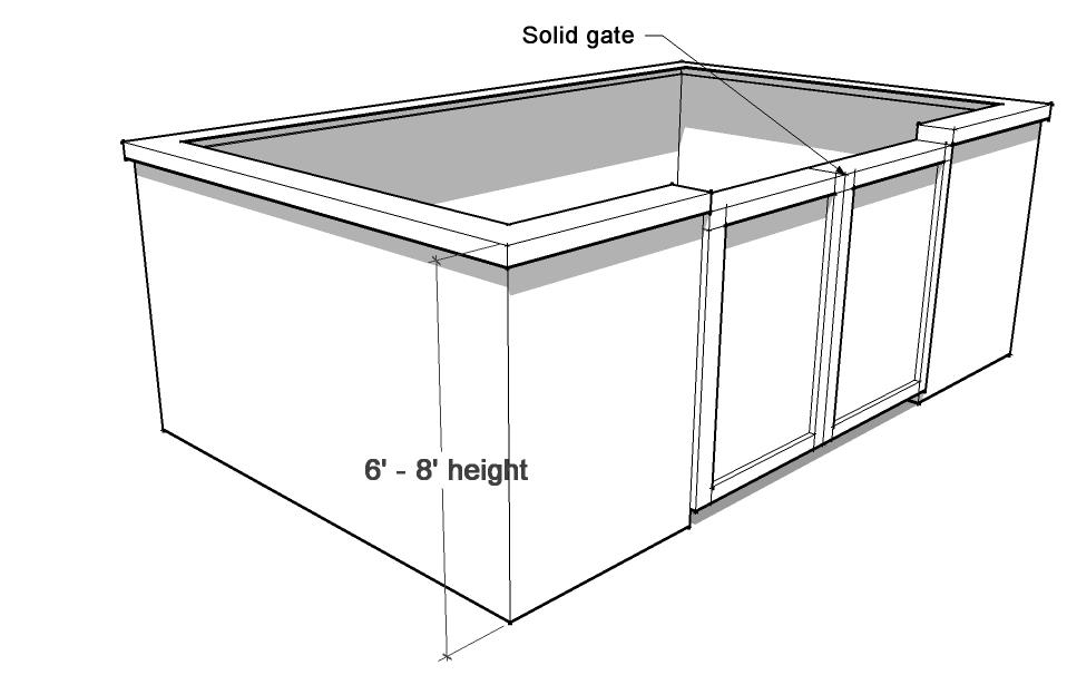 |
c.
Maintenance of Refuse Collection Receptacle. The lids of receptacles in screening enclosures without roof structures shall remain closed between pick-ups and shall be maintained in working order.
2.
Service, storage, and off-street loading areas. Service, storage, and off-street loading areas shall be designed and located to reduce the visual and acoustic impacts of these functions on adjacent properties and public streets. Non-enclosed service, storage, and off-street loading areas shall be screened with durable, sight-obscuring walls and/or fences of between six feet and eight feet in height. Screening materials shall be the same as, or of equal quality to, the materials used for the primary building and landscaping.
a.
Non-enclosed service, storage, and off-street loading areas fronting arterial or collector streets shall have a minimum five foot enhanced landscaped buffer adjacent to the public ROW in lieu of the sight-obscuring walls and/or fences.
H.
Rooftop mechanical equipment. Rooftop mechanical equipment, including HVAC equipment and utility equipment that serves the structure, shall be screened. Screening shall be accomplished through the use of parapet walls or a sight-obscuring enclosure around the equipment that is the same height as the equipment. The screening shall be constructed to match one of the building materials used on the exterior of the structure, and that is an integral part of the building's architectural design and is equal in height to equipment, as seen in Figure 4-3-7-2, Rooftop Equipment Screening.
| Figure 4-3-7-2, Rooftop Equipment Screening | |
|---|---|
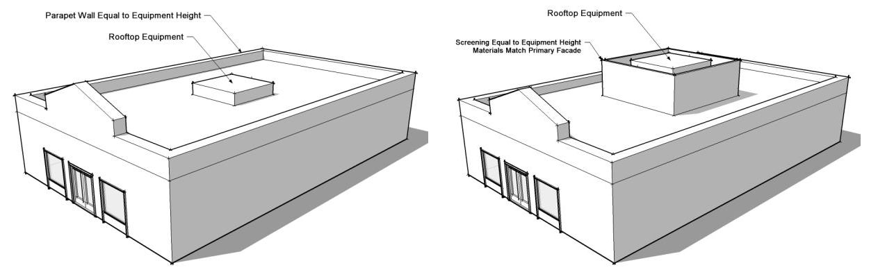 |
1.
Wall-mounted mechanical equipment and meters. Wall-mounted mechanical equipment, including air conditioning or HVAC equipment and groups of multiple utility meters, that extends six inches or more from the outer building wall shall be screened through the use of:
a.
Sight-obscuring enclosures constructed to match one of the building materials used on the exterior of the structure;
b.
Sight-obscuring fences; or
c.
Trees or shrubs that form an opaque visual screen.
Wall-mounted mechanical equipment that extends six inches or less from the outer building wall shall be designed to blend in with the color and architectural design of the subject building.
2.
Ground-mounted mechanical equipment and utility fixtures. Ground-mounted above-grade mechanical equipment shall be screened through the use of opaque fences or screening enclosures, or through the use of trees or shrubs that form an opaque visual screen. Above-grade ground-mounted utilities are prohibited on sidewalks in the DM and DF districts.
3.
Pitched roofs. All roof jacks and penetrations shall be painted to match the adjacent roof color.
Sec. 4-3-8. - Fence requirements.
A.
Purpose. These standards are intended to permit the construction and maintenance of high-quality fences and walls, while preventing the monotonous appearance of uninterrupted fences and walls from dominating the City's streetscapes.
B.
General fence requirements.
1.
Screening of residential uses that abut collector and arterial streets and highways. All residential uses that abut any arterial or collector street or highway shall install and maintain fences that comply with this section on the side(s) of the property that abut such street or highway. These fences shall be at least six feet in height, and a maximum of eight feet in height if adjoining a highway. A fence plan showing compliance with the requirements of this section shall be submitted with the landscape plan. For all platted single-family and two-family residential subdivisions, a mandatory home owners association shall be established for the perpetual ownership and maintenance of the required screening fence or wall.
2.
Screening of industrial uses that abut collector and arterial streets and highways. The need for screening fences where industrial districts abut arterial streets and limited access highways will be reviewed as part of the site plan. These fences shall screen all yards and shall be at least eight feet and no more than ten feet in height. Outside storage shall be fully screened with a solid material wall or a combination of earthen berms, fences, walls, and/or evergreen plant materials.
C.
Design standards for fences and walls. All fencing or walls provided pursuant to this section shall comply with the following standards:
1.
Location.
a.
Outside of the right-of-way. Fences shall not be constructed in the street right-of-way, whether such right-of-way is held as an easement or in fee. All required fences and walls shall be located within a minimum three-foot-wide fence easement adjoining the property boundary. This easement may be part of a wider or larger landscape easement or reserve.
b.
Fence location in residential districts. Fences in residential districts may be constructed on property lines, in side yards, and rear yards. However, no fences higher than 36 inches may be constructed in any front yard in single-family and two-family developments.
c.
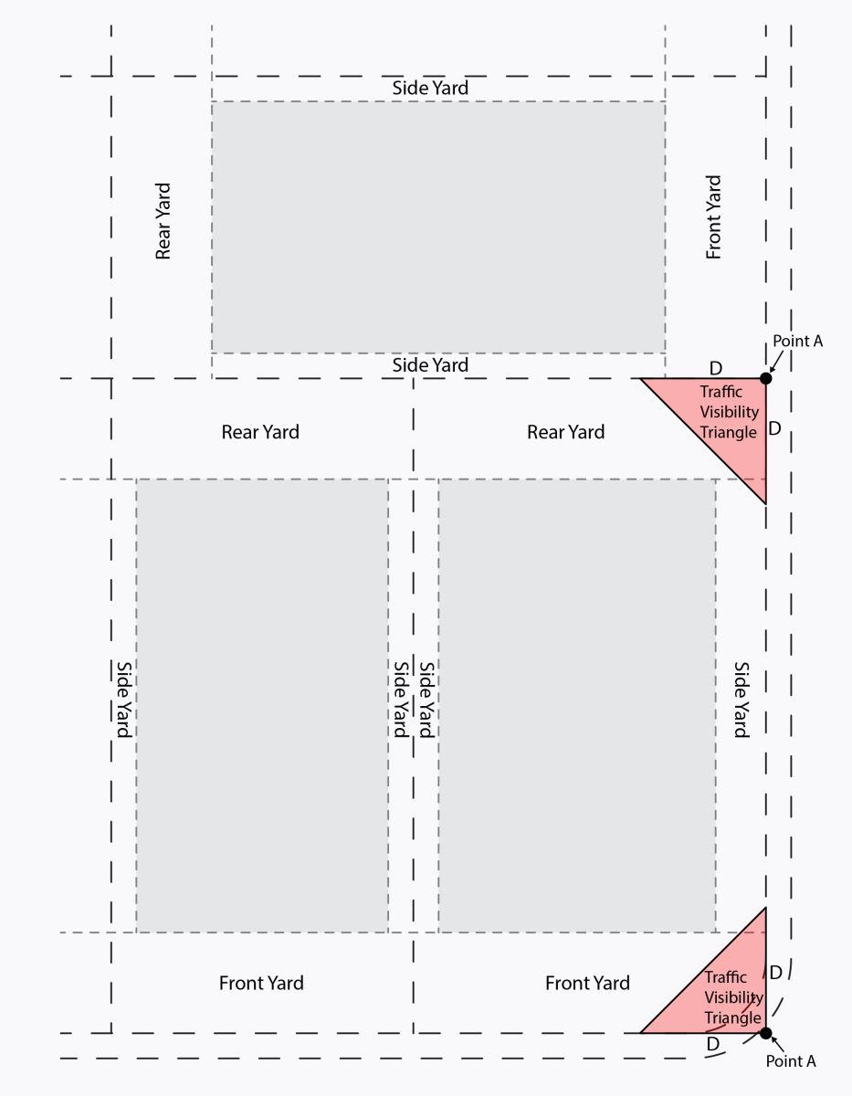
Fences on corner lots. If the owner of a corner lot constructs a fence within a side yard and rear yard in accordance with this section, and if the rear portion of these yards abut the side yard of a neighboring lot, then any such fence built between the building setback line and the property line must be so constructed as to create a clear traffic visibility triangle as shown in Figure 4-3-8-1, Corner Lot Fence. The traffic visibility triangle shall measure "D" 30 feet in each direction and be aligned to the property line, starting from "Point A."
| Figure 4-3-8-1, Corner Lot Fence | |
|---|---|
 |
d.
Fences in flood and drainage areas. No fences, other than an open split rail fence or barbed wire fence, shall be constructed in any 100-year floodplain area. No fences other than open split rail or barbed wire shall be constructed in drainage easements that are outside the 100-year floodplain area unless the owner obtains the written approval of the local Floodplain Administrator following their investigation of the proposed fence's impacts on drainage.
2.
Support posts.
a.
All new fences, including replacements for existing fences, that are required by this ordinance shall have vertical support posts constructed of permanent building materials that may include, but are not limited to, a minimum of schedule-40 galvanized steel posts with an outside diameter equal to or larger than two and three-eighths-inch, masonry columns at least one square foot, or PVC fencing using dual-extruded PVC posts. The Director may permit alternative support posts as part of any site/landscape plan review, as long as the materials used meet or exceed the wind load capabilities of the materials listed above. Footings shall be constructed of concrete or equivalent materials.
b.
Along arterial streets, masonry shall be used as the material for support posts.
3.
Replacement. Any existing fence otherwise lawful at the time of construction and thereafter maintained may continue throughout its useful life; however, the replacement of such fence or other repair of more than 50 percent of the fencing, shall require the replacement or repair of the entire fence to conform to the standards listed in Subsection 4-3-8.C.
4.
Uniform height. Unless otherwise approved by the Planning Commission, all fencing shall be uniform in height. Replacement fencing/screening, excluding support posts, shall retain its original height and material and the top elevation shall match the adjoining elevation.
5.
Materials. Where fencing is required by this ordinance, such fencing and walls shall be opaque and shall be constructed of durable, easily maintained materials such as, but not limited to, masonry, vinyl, or treated, stained or painted wood sections. Chain link, wire mesh, or other similar products shall be prohibited.
6.
Finished side. The "finished" side of the fence or wall shall face outward, away from the development installing the fence or wall, with all braces and supports on the interior side of the fence.
a.
The length of continuous, unbroken, and uninterrupted fence plane shall be no more than 60 feet. Breaks shall be provided through the use of masonry columns, landscaping pockets, transparent sections, and/or a change to different materials.
b.
A variety of landscaping shall be provided in combination with any of the above visual breaks to incorporate seasonal color and plant variety and break up the visual mass of walls and fences.
7.
Landscaped berms. Landscaped berms may be used in combination with any of the above visual breaks and shall meet the following standards:
a.
Berms shall be between 30 inches and 48 inches in height; and
b.
Berms shall provide additional separation and screening by incorporating a variety of plantings, consisting of dense stands of evergreen trees, canopy shade trees, ornamental trees, tall grasses, or shrubs.
8.
Appearance and maintenance. All fences shall be well maintained in a manner as to not become a nuisance or public safety hazard. Fences that are deemed not compliant by the Code Compliance Officer shall be repaired or replaced within 30 days from date of notification of the violation.
Sec. 4-3-9. - Landscape plan.
A.
Landscaping plan approval. Landscape plans shall be reviewed and approved by the Director.
1.
Mixed-use, office and commercial district developments. A landscaping plan may either be submitted with the required site plan or at later date following site plan approval. If the detailed landscape plan is to be submitted following site plan approval, the site plan shall at least show where landscape development is to occur.
2.
Agricultural and residential district developments. The location of proposed landscape development shall be shown on the preliminary plat followed by a landscape plan submitted with the final plat.
3.
Upon receipt of a landscape plan. The Director shall:
a.
Approve the landscape plan as complying with the requirements of this ordinance; or
b.
Approve the landscape plan with conditions that bring it into compliance with the requirements of this ordinance; or
c.
Reject the landscape plan as failing to comply with the requirements of this ordinance; or
d.
Waive the landscape requirement if it is determined that a suitable location for landscape development is not available.
B.
Landscape plan requirements. The required landscaping plan shall contain the following:
1.
Schedule. The schedule of installation of required landscaping and appurtenances, which shall specify installation of all required landscaping and appurtenances, except trees, prior to the issuance of a certificate of occupancy (for multi-family, commercial, and industrial developments) or first building permit (for single-family and two-family developments) and further specify installation of required trees within the landscape plan within 120 days after issuance of such occupancy permit or first building permit. No manufactured housing units shall be allowed to be installed until all required landscaping is completed.
2.
Description. A description of the type of irrigation system to be used and, if necessary, drawings of such system;
3.
Existing trees. The location, size (caliper and height), condition, and common name of any existing tree for which credit is requested shall be indicated. The method of protecting the existing trees which are to be retained from damage during construction shall be described;
4.
Planting details. Planting details and/or specifications;
5.
Proposed landscaping. The location, size, and type (tree, shrub, ground cover, berms, or grass) of proposed landscaping and the location and size of the proposed landscaped areas;
6.
Infrastructure. The approximate center line of existing water courses, the approximate location of significant drainage features, the location and size of existing and proposed streets and alleys, existing and proposed utility easements and overhead utility lines on or adjacent to the lot, existing and proposed fire hydrants on or adjacent to the lot, and existing and proposed sidewalks on or adjacent to the lot;
7.
Property lines. The location of property lines and dimensions of the tract; and
8.
Project details. The date, scale, north arrow, project name and the name of the owner and designer.
C.
Certification of installation.
1.
Installation of all landscaping except trees. Prior to the issuance of a certificate of occupancy (for multi-family, commercial, and industrial developments) or issuance of final inspection (for the first unit in single-family and two-family developments), written certification shall be submitted to the City's Community Development Department by an architect, landscape architect, or engineer authorized to do business in the State of Oklahoma, or the owner of the property, stating that the installation of the landscaping, except trees, is in accordance with the approved landscaping plan.
2.
Installation of trees. Prior to or within 120 days following the issuance of the occupancy permit (for multi-family, commercial, and industrial developments) or final building permit (for the first unit in single-family and two-family developments), written certification of an architect, landscape architect, or engineer authorized for business in the State of Oklahoma or the owner of the property that all trees have been installed in accordance with the approved landscaping plan shall be submitted to the City's Community Development Department.
3.
Temporary certificate of occupancy. A temporary certificate of occupancy may be issued for up to 120 days to allow landscape material to be installed in accordance with the approved landscape plan.
D.
Low impact development (LID).
1.
Purpose. Low impact development standards (LIDs) are included into landscape designs and plans to reduce the effects of increasing runoff and storm water pollution from new construction, redevelopment, or infill developments as near to the source as possible. LID practices are an essential component of the urban form and, when properly designed and built, will help ensure the preservation of permeable surfaces, promote the use of native plants, and encourage infiltration into subsoils to remove pollutants, regenerate ground water supplies, and lower subsidence rates.
2.
Applicability. All developers and homeowners are encouraged to incorporate low impact development practices and utilize incentives for new construction, redevelopment, or infill developments.
3.
LID practices.
a.
Listing. The following are encouraged LID practices:
i.
Tree preservation;
ii.
Minimized clearing/grading;
iii.
Minimized publicly owned impervious area;
iv.
Minimized privately owned impervious area;
v.
Good housekeeping during construction;
vi.
Vegetated swales;
vii.
Detention facility/landscape pond water quality improvements;
viii.
Private open space maintenance practices;
ix.
Property owners maintenance practices;
x.
Bio-retention filters/rain gardens;
xi.
Creek/floodplain setbacks;
xii.
Impervious surfaces disconnection; and
xiii.
Other practices that the City of Broken Arrow finds acceptable.
Sec. 4-4-1. - Purpose and applicability.
A.
Purpose. The purpose of this section is to establish standards for the use of outdoor lighting facilities that serve private developments; provide adequate lighting for customer, pedestrian, and driver use; provide for the efficient use of energy; and mitigate nuisance, and glare to adjacent properties.
B.
Applicability. All exterior lighting for any type of residential or nonresidential development shall comply with the standards of this section, unless exempted in the subsection below.
1.
Exemptions. The following types of lighting are exempt from the requirements of this section.
a.
Outdoor lighting associated with single-family residential dwellings or duplex development projects;
b.
Outdoor lighting used for public streets and right-of-way lighting;
c.
Public utility companies when working on public utility lighting for public utility purposes in utility easements;
d.
Outdoor lighting used for public or private recreational activities, sporting events at stadiums and ball fields, concerts, plays, or other outdoor events that are public or private; and
e.
Outdoor lighting used for temporary decorative seasonal lighting or other temporary events.
Sec. 4-4-2. - Compliance.
A.
Lighting plan requirement. In order to ensure safety and compliance with the standards in the lighting standards that follow the standards in Section 4-4-3, General Lighting Standards, outdoor lighting plans demonstrating compliance with the standards of this section shall be required with the submittal of a site plan. If no outdoor lighting is proposed, a note shall be placed upon the face of the site plan indicating that outdoor lighting is not required.
B.
Methods of compliance.
1.
Method 1: Fixture height standards. All outdoor lighting shall be shielded by fixtures. Light fixtures shall be parallel to the final grade and installed so that no direct light will shine beyond the subject property. The height of light poles and fixtures shall be approved through the site plan process.
a.
Fixture height standard lighting plan. The submitted lighting plan shall include the following:
i.
A scale drawing of the site with all outdoor lighting locations shown;
ii.
Fixture specifications, including catalog cut-sheets or generic standards;
iii.
Pole type and height of fixture from base of the pole;
iv.
Lamp type and size; and
v.
Fixture mounting, and orientation.
b.
Allowable heights. Allowable heights of light fixtures shall be measured from the light emitting fixture to the base of the pole location as follows:
i.
Maximum height of 16 feet, within 50 feet of agricultural/residential zoned districts, or public right-of-way;
ii.
Maximum height of 20 feet, within 51 feet to 250 feet of agricultural/residential zoned districts, or public right-of-way;
iii.
Maximum height of 35 feet, if located a minimum 251 feet from agricultural/residential zoned districts, or public right-of-way;
iv.
Maximum fixture height shall not exceed 35 feet; and
v.
Canopy lighting shall be by recessed fixtures with diffusers that do not extend below the canopy surface.
2.
Method 2: Photometric standards. A photometric plan is required to be submitted unless the "fixture height standard" is utilized. If the "photometric standard" is desired to increase pole heights, the applicant shall submit a photometric plan in sufficient detail to evaluate its conformance with the general lighting standards in Method 1, above. The photometric plan shall include the following:
a.
A scale drawing of the site with all outdoor lighting locations shown;
b.
Fixture specifications, including catalog cut-sheets or generic standards;
c.
Lamp type and size;
d.
Fixture mounting heights, mounting orientation, and tilt angles if applicable;
e.
A representative point-by-point illumination array for the site showing property lines and off-site lighting impacts;
f.
The maximum fixture height shall not exceed 35 feet as measured from the base of the fixture to the base of the pole;
g.
Canopy lighting shall use recessed fixtures with diffusers that do not extend below the canopy surface.
Sec. 4-4-3. - General lighting standards.
A.
Outdoor lighting must be in compliance with the following standards:
1.
Safety. Either method used shall provide sufficient and safe illumination for vehicle movement and pedestrian safety.
2.
Light poles. Light poles shall not be placed in street rights-of-way or utility easements adjacent to street rights-of-way, except by franchised utility companies or by the City of Broken Arrow, as a part of a street lighting project. Light poles may be placed in other utility easements with the approval of the Director; and if light poles are allowed to be placed in utility easements, a note shall be placed on the face of the site plan stating the following: "Property owner(s) assumes all liability and replacement responsibilities for any damage to light poles placed in utility easements."
3.
Site perimeter illumination. Illumination of the perimeter of the site shall be reduced in intensity when adjacent to lesser intensive uses or public rights-of-way measured in footcandles (fc) at three feet above grade as follows for either the fixture height or the photometric standard:
a.
Site adjoining another nonresidential zoning district—3.0 fc.
b.
Site adjoining agricultural/residential zoning districts—0.5 fc.
c.
Site adjoining public rights-of-way—3.0 fc.
4.
Shielding. Light sources shall be concealed or shielded with luminaries with cut-offs with an angle not exceeding 90 degrees to minimize the potential for glare and unnecessary diffusion on adjacent property. For purposes of this standard, "cutoff angle" is defined as the angle formed by a line drawn from the direction of light rays at the light source and a line perpendicular to the ground from the light source above from which no light is emitted.
| Figure 4-4-3-1, Examples of Cut-Off Fixtures and Shielded Luminaries | |
|---|---|
 | |
 |
Sec. 4-4-4. - Lighting level measurement.
Light level measurement. Light levels shall be measured with a direct-reading, portable light meter, calibrated within the last year by an independent laboratory regularly engaged in the calibration of such instruments. The meter's sensor shall be located at the top of the visual screening fence on the property line (or at a height of three feet above the surrounding local grade if there is no fence), aimed towards the subject property in horizontal position. Readings shall be recorded after the value has stabilized. Measurements are made after establishment of darkness with the light sources to be measured illuminated, and then with those light sources extinguished. The difference between these two readings will then be compared to the maximum allowed illumination at the property line. In this way, contributions to light levels by the moon and other ambient light sources are eliminated and the light intensity from the sources in question can be determined.