
Broken Arrow City Zoning Code
CHAPTER 5
- SIGNS
Sec. 5-1-2. - General provisions.
A.
Purpose. The purpose of this chapter is to ensure that the constitutionally guaranteed right to free speech is protected and to promote and protect the health, safety, and general welfare of the citizens and the City of Broken Arrow through administering fair and reasonable sign standards. The intent is to preserve the aesthetic character and maintain traffic and pedestrian safety by defining the types of signs that are permitted and prohibited in the various zoning districts, the manner in which sign size will be measured, and to exempt certain types of signs from regulation. The regulations set forth in this chapter are not intended to restrict content of signs and should not be construed that way. Rather, the regulations are intended to fulfill compelling government interests such as maintaining a visually attractive and safe environment through the following:
1.
Traffic and pedestrian safety. To maintain traffic and pedestrian safety by regulating placement of signs so that clear sight distance is maintained, free of obstructions, and to ensure that signs do not distract or are not blinding to motorists, bicyclists, or pedestrians.
2.
Aesthetics. To promote and maintain the beautification of the City of Broken Arrow by regulating the size, design and placement of signs in a manner that promotes and enhances the aesthetic quality and complements the natural areas.
3.
Economic development. To promote high-quality nonresidential development that presents an attractive image of the City of Broken Arrow and contributes to quality of life and economic development.
4.
Zoning district considerations. To consider the intensity of land use areas in determining the appropriate signage for each district.
5.
Historic character. To preserve the scale and character of core areas such as the downtown area.
6.
Property values. To protect property values by regulating the time, place and manner of signs by prohibiting signs that may create a nuisance due to their size, height, number, illumination, movement and scale with the surrounding area.
B.
Permit required. A sign permit issued in accordance with Subsection 6-3-3.7, Sign Permit, is required prior to the erection, installation, or substantial modification of any sign that is not listed in Section 5-1-3, Signs Exempt from Regulation, or that the tables in Section 5-1-5, Permanent Signs, declare do not require a sign permit.
C.
Corner sight distance. Except for public signs, no sign shall encroach into the corner sight distance triangle established in Section 3-5-2, Measurements and Exceptions.
D.
Measurement. As depicted in Figure 5-1-2-1, Sign Measurement, signs shall be measured as follows.
1.
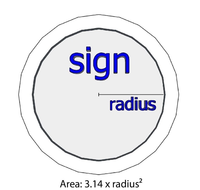
Sign area. In computing the permitted display surface area for signs, the linear footage of an abutting secondary residential street shall not be combined with the linear footage of any collector street, arterial street, limited access highway, or turnpike that is being used to calculate the permitted display surface area. Only one side of a double-sided sign shall be included in the computation of display service area. Double-sided signs may be separated, as long as the separation of the two display surfaces shall not exceed ten feet.
2.
Sign height. Sign height is measured as the distance from the topmost point of the sign to the lowest grade level adjacent to the sign or ground that the sign is located upon. The base and sign supports are included as part of the sign height.
3.
Sign setback. Sign setback is measured as the distance from a property line to the nearest part of the sign.
| Figure 5-1-2-1, Sign Measurement | |
|---|---|
| Frame or Cabinet Sign | |
| Where a sign is enclosed in a frame or cabinet, the area of the entire surface of the sign face within a single continuous perimeter enclosing the extreme limits of the sign and not passing through or between any adjacent elements of the sign. That perimeter does not include any structural or framing elements lying outside the limits of the sign face unless such elements consist of a corporate logo that is part of the face, frame, or cabinet of the sign. | 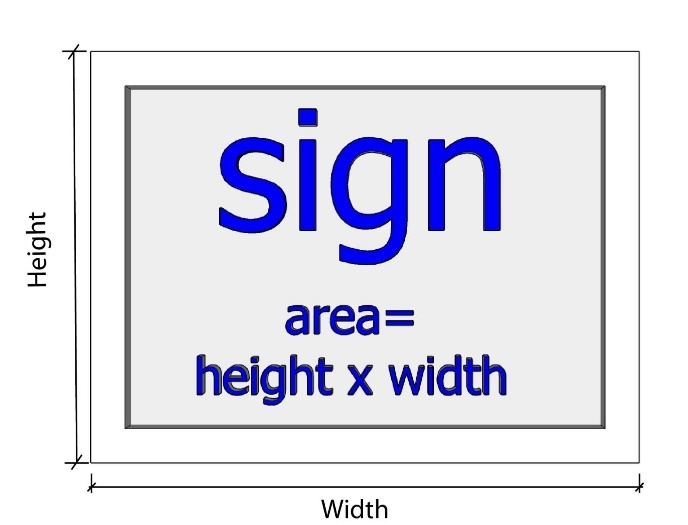 |
 | |
| Channel Sign | |
| Where a sign consists of individual letters, words or symbols attached to a surface, the area of the smallest rectangle that completely encompasses all such letters, words or symbols and any accompanying background of a color different than the color of the wall or sign face. |  |
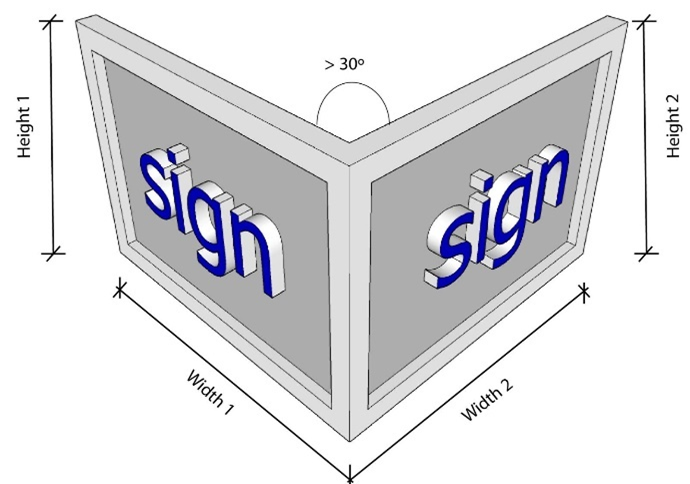
| Multi-Sided Signs | |
|
For projecting or double-faced signs, only one display face is measured in computing
sign area when the sign faces are parallel and ten feet or less apart from one another,
or where the interior angle formed by the faces is 30 degrees or less, provided that
the signs are mounted on the same structure.
If the sign faces are not parallel, and greater than 30 degrees of parallel of one another, each sign face is counted as a separate sign. If the sign faces are parallel, and greater than ten feet apart, each sign face is counted as a separate sign. If the sign faces are not parallel, and greater than 30 degrees of parallel of one another, each sign face is counted as a separate sign. If the two faces of a double-faced sign are of unequal area, the area of the sign shall be taken as the area of the larger face. | 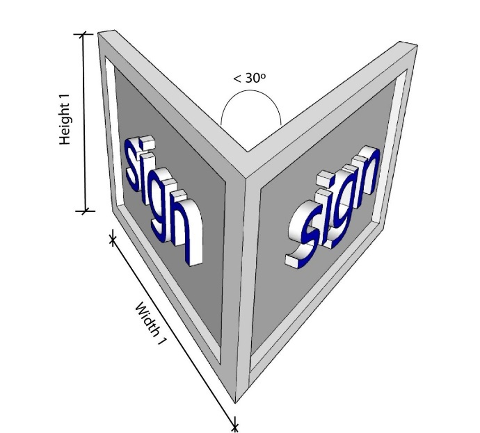 |
 | |
| Sign Height and Setback | |
|
Sign height is the distance from the topmost point of the sign to the lowest grade
level adjacent to the sign (A).
The base and sign supports are included as part of the sign height. Sign setback is measured as the distance from a property line (C) to the nearest part of the sign (B). | 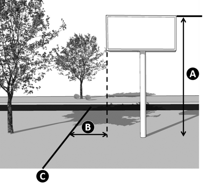 |
Sec. 5-1-3. - Signs exempt from regulation.
A.
Generally. This section establishes signs which are exempt from regulation or do not require a sign permit.
B.
Signs allowed without a permit. The following signs may be erected and maintained without a sign permit and without being deducted from the allowable face areas of other permitted signs.
1.
Existing signs. Signs that were permitted by the City under previous sign regulations prior to the adoption of this ordinance, or signs that were permitted by the County under previous regulations prior to annexation, may continue to exist and receive ordinary maintenance unless and until the use of the sign is discontinued for a period of six months, or the structure of the sign is damaged or destroyed in excess of 50 percent of its value, at which time such sign must be relocated in full conformity with the requirements of this ordinance.
2.
Temporary signs.
a.
Temporary signs having six square feet or less of display surface in residential zoned areas and not exceeding 32 square feet of surface area in agricultural, office, commercial, and industrial zoned areas.
b.
Temporary signs for properties with planned or active construction, which are displayed along arterial frontages that do not exceed one-half of a square foot per linear foot of arterial street frontage but not less than 32 square feet and shall not exceed 200 square feet of display area. A temporary construction sign shall be located upon the property where the construction work is taking place.
c.
Refer to Section 5-1-6.C, Duration, for the length of time that a temporary sign may be in place.
3.
Nameplate sign. One nameplate attached to the face of the wall of a building, not exceeding four square feet in surface area.
4.
Signs not visible. Signs which are not visible from a public street.
5.
Tablet signs. Tablets built into the wall of a building or other structure utilized for inscriptions, memorials, or similar historic or dedicatory purposes.
6.
Warning signs. Signs of a warning, directive, or instructional in nature erected by any unit of government or franchised utility.
7.
Public utility signs. Signs erected by public utility companies or construction companies to warn of danger or hazardous conditions, including signs indicating the presence of underground cables, gas lines, and similar devices.
8.
Legal notices. Legal notices required by law to be posted.
9.
Small window signs. Signs painted or posted on the surface of any window, when the display surface area of the sign does not cover more than 25 percent of the window.
10.
Interior signs. Signs located inside a building and either oriented to be primarily visible from inside the building only, or located more than 15 inches from the window. Signs erected inside a building by private parties of a warning, directive or instructional nature and not exceeding three square feet of display surface area, including entrance, exit, and restroom signs.
11.
Labels. Signs attached by the manufacturer and function as labels of commodities.
12.
Manufacturer label. Signs located on accessory equipment or structures, which identify the manufacturer, make or model, and which are limited to 15 square inches or less for each piece of equipment or structure. By way of example and not by limitation, equipment may include satellite dishes, air conditioners, fence components, and similar items.
13.
Street address. Street address numbers painted on the curb at the property owner's discretion.
14.
Directional sign. Directional signs that are less than four square feet.
15.
Loading sign. Loading signs that are less than four square feet.
16.
Freedom of speech. Individuals exercising their First Amendment rights, under the U.S. Constitution or their free speech rights under the Oklahoma Constitution, shall not be required to obtain permits for any sign so long as the sign is physically located on the lot of that individual's actual residence, or is being physically carried by that individual while exercising their First Amendment right of free speech. In addition, such individual may not, while exercising their First Amendment rights, block any public way, whether right-of-way, exclusive easement, general utility easement or the associated sight triangles required for traffic safety. The sign located on the residential property must either be attached physically to the wall of the house or placed in the yard and shall not exceed six square feet, nor shall it exceed two feet in height.
17.
Governmental signs. Governmental signs are exempt from the regulations of this ordinance when placed by any governmental entity.
18.
Fuel island signs. Signs, temporary or permanent, mounted to fuel island pumps, fuel island canopy columns (mounted with permanent type mounting bracket and not to exceed three square feet), placed on pallets of displayed product at the base of the fuel island canopy columns or on the entry sidewalk at the store front.
19.
Flags. A flag displayed on a flagpole is not considered a sign and is exempt from this chapter.
Sec. 5-1-4. - Prohibited sign types, materials, design elements, and locations.
A.
Purpose. This section identifies sign types, materials, design elements, and locations that are prohibited in the City.
B.
Prohibitions. The following sign types, materials, design elements, and sign locations are prohibited.
1.
Signs in right-of-way. Any signs and supports that are located in the public right-of-way, except signs and supports required by a governmental authority or for which a street use license is issued. The public right-of-way includes, but is not limited to, public streets, alleys, medians, and parkways. This section does not apply to signs on commercial vehicles or commercial trailers lawfully operated or parked in those areas, but it does apply to the use of vehicles and trailers prohibited in this section.
2.
Flashing, blinking, or traveling lights.
a.
Within 50 feet of street right-of-way. Signs with flashing, blinking, or traveling lights that are located within 50 feet of any street right-of-way, except permitted electronic message displays in accordance with Section 5-1-6, Temporary, Incidental, and Miscellaneous.
b.
Within 1,000 feet of street intersection. Signs with flashing, blinking, or traveling lights that are located within 1,000 feet of any street intersection, as measured where the street centerlines intersect, except electronic message displays.
3.
Certain temporary signs. Pennants, searchlights, twirling signs, balloons or other gas-filled objects, or tube signs, except as permitted in this chapter.
4.
Deceptive signs.
a.
Words. Any signs that resemble an official traffic sign or signal or that bears the words "Stop," "Yield," "Go Slow," "Caution," "Danger," "Warning," or similar words.
b.
Design. Signs which, by reason of their size, location, movement, coloring, or manner of illumination, may be confused with or construed as a traffic-control sign, signal or device, or the light of an emergency or road equipment vehicle, or which hide from view any traffic or street sign or signal or device.
5.
Obstructive signs. Any sign that obstructs any window, door, fire escape, stairway, ladder, or opening intended to provide light, air, ingress, or egress for any building, as required by law, or which hide from view any traffic or street sign or signal or device.
6.
Portable signs.
a.
Prohibition. Portable signs are prohibited except for A-frame signs where expressly permitted in this chapter.
b.
Parking of advertising vehicles. No person shall park an advertising vehicle or trailer on a public right-of-way or on public property. Any such vehicle parked on private property, visible from the public right-of-way, shall be used on a regular basis within each business week as a means of transportation for the business that is advertised.
7.
Nuisances.
a.
Glare. Any sign that causes any direct glare into or upon any residential building or premises, other than the building or premises to which the sign is attached.
b.
Other. Any sign which emits sound, odor, or visible matter which serves as a distraction to persons within the public right-of-way.
8.
Prohibited sign materials.
a.
The following materials shall be prohibited for all signs:
i.
Paper and cloth not suitable for exterior use (except high-quality, weather-resistant cloth for awnings);
ii.
Wood that is not sealed and maintained to keep moisture from deteriorating the sign;
iii.
Plywood or particle board; and
iv.
Letters, symbols, or numbers attached to a sign with adhesive backing.
b.
The following materials shall be prohibited for permanent signs:
i.
Nylon-reinforced vinyl such as banner material;
ii.
Corrugated plastic;
iii.
Polystyrene; and
iv.
Other materials that the Director determines are substantially the same as those listed above.
Sec. 5-1-5. - Permanent signs.
A.
Generally. The City allows the following permanent signs, as depicted in the tables below, and regulates them by zoning district.
B.
Applicability. The standards that follow shall apply to permanent signs. All permanent signs shall also follow the standards outlined in Section 5-1-2, General Provisions.
C.
Unlisted signs. Signs that are not listed in the tables below, or that are not expressly permitted as permanent signs per a separate provision in Chapter 5, Signs, are prohibited as permanent signs.
D.
Allowed sign types by zoning district. Table 5-1-5-1, Allowed Sign Type by District, identifies permanent attached and freestanding signs allowed by zoning district.
E.
Allowed attached permanent signs. All permanently attached signs shall follow the standards established in Table 5-1-5-2, Allowed Attached Permanent Sign Types. Standards in Section 5-1-5.H, Standards for Signs in Nonresidential Zone Districts, shall also apply. Attached signs shall not exceed the height of the parapet of the building to which they are attached. Where architectural features of the building will not permit a wall sign of at least three feet in height, a wall sign may be extended above the parapet of the building wall a distance sufficient to permit a sign of three feet in height.
| Table 5-1-5-2, Permanent Attached Sign Standards | ||||||||||||||
|---|---|---|---|---|---|---|---|---|---|---|---|---|---|---|
| Zoning District | Agricultural and Residential Districts | Mixed-Use Districts | Office and Commercial Districts | |||||||||||
| AG | RS, RS-C, RS-P | RMD | RMF | RMH | CM | DM | DF | ON | CN | CG | CH | IL | IH | |
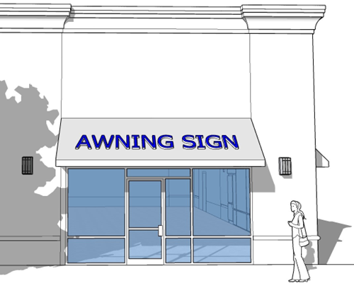
| Awning Sign | ||||||||||||||
| Number Allowed | — | 1 per each tenant or occupant with a ground-floor entry or storefront | ||||||||||||
| Maximum Area | — | 1 sq. ft. per every ft. of awning or 60 sq. ft., whichever is smaller | ||||||||||||
| Minimum Clearance | — | 8 ft. above grade | ||||||||||||
| Maximum Projection (distance from facade) | — | 4 ft. | ||||||||||||
| Changeable Copy Permitted | — | No | ||||||||||||
| Illumination | — | External Only | ||||||||||||
| Sign Permit Required | — | Yes | ||||||||||||
 | ||||||||||||||
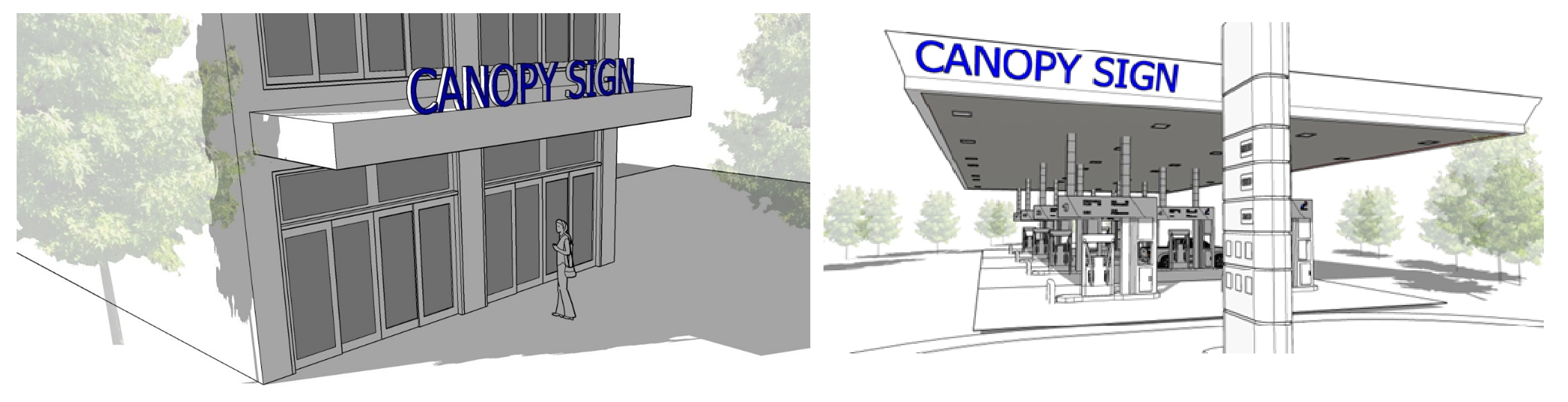
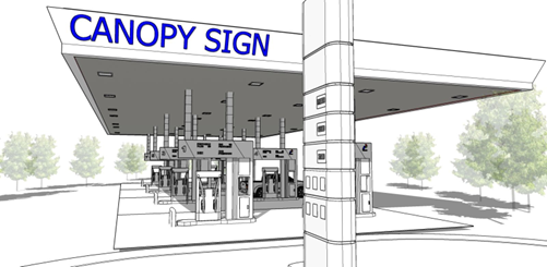
| Canopy (or Over-Canopy) Sign | ||||||||||||||
| Number Allowed | — | 1 per canopy side | 1 per building front or per storefront for a multi-tenant building | 1 per canopy side | ||||||||||
| Maximum Size | — | 50% of canopy width | 50% of canopy width | 75% of canopy width | ||||||||||
| Minimum Clearance | 8 ft. above grade | |||||||||||||
| Minimum Height (copy above sign) | — | 6 ft. | 2 ft. | 6 ft. | ||||||||||
| Changeable Copy Permitted | — | No | ||||||||||||
| Illumination | — | External or internal | ||||||||||||
| Other Standards | — | — | ||||||||||||
| Sign Permit Required | — | Yes | ||||||||||||
 | ||||||||||||||
| Directory Sign | ||||||||||||||
| Number Allowed | — | 1 per entrance | ||||||||||||
| Maximum Size | — | 8 sq. ft. | ||||||||||||
| Minimum Clearance | — | — | ||||||||||||
| Maximum Projection (distance from facade) | — | 6 in. | ||||||||||||
| Changeable Copy Permitted | — | — | ||||||||||||
| Illumination | — | External or Internal | ||||||||||||
| Other Standards | — |
1. The sign shall be located next to the entrance.
2. The sign shall not extend above the parapet, eave, or building facade. | ||||||||||||
| Permit Required | — | No | ||||||||||||
 | ||||||||||||||
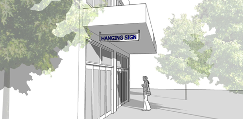
| Hanging Sign | ||||||||||||||
| Number Allowed | — |
1 per tenant or occu-
pant with a ground-floor entry or storefront |
1
occu- pancy per building face | 1 per tenant or occupant with a ground-floor entry or storefront | — | |||||||||
| Maximum Area | — | 10 sq. ft. | 6 sq. ft. per face; 3 feet in width | 10 sq. ft. | — | |||||||||
| Minimum Clearance | — | 8 ft. above grade | — | |||||||||||
| Changeable Copy Permitted | — | — | — | |||||||||||
| Illumination | — | Yes, indirect light only | — | |||||||||||
| Other Standards | — |
1. Not extend within 2 ft. of the curb line.
2. May be suspended under a marquee sign or under a canopy or awning. | — | |||||||||||
| Sign Permit Required | — | Yes | — | |||||||||||
 | ||||||||||||||
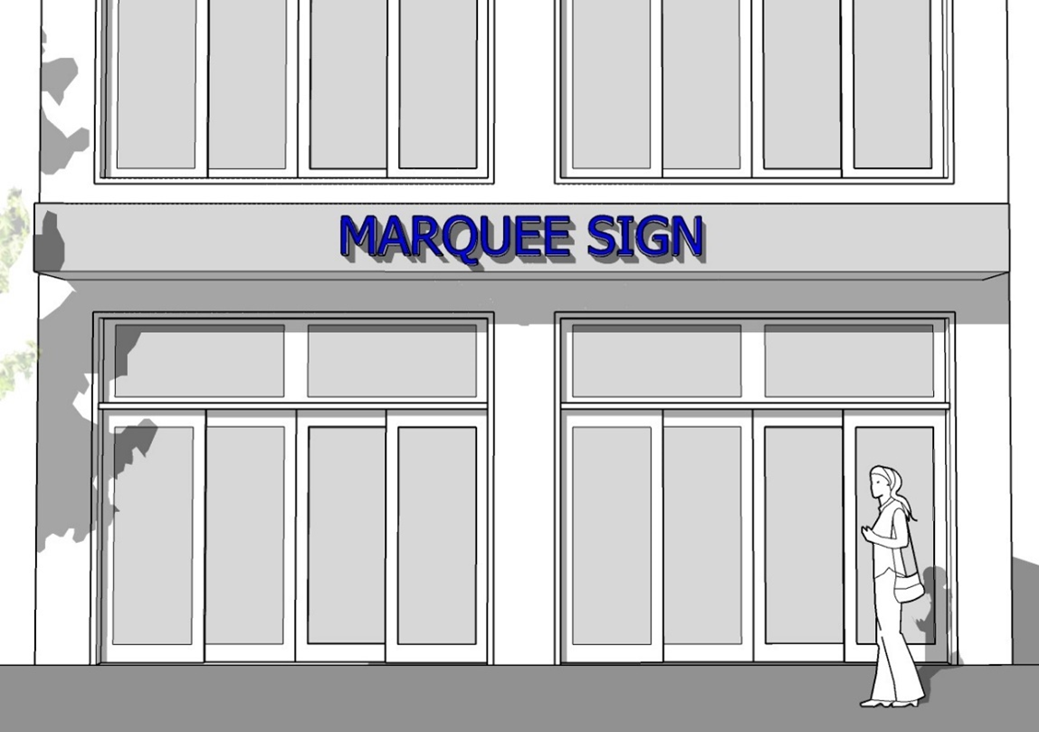
| Marquee Sign | ||||||||||||||
| Number Allowed | — | 1 per street-facing facade | — | |||||||||||
| Maximum Area | — | 150 sq. ft. total | 100 sq. ft. total | 150 sq. ft. total | — | |||||||||
| Maximum Height | — | 4 ft. from lowest point of marquee to highest point, excluding any ornamentation supported directly by the marquee | — | |||||||||||
| Minimum Clearance | — | 8 ft. above grade | — | |||||||||||
| Changeable Copy Permitted | — | Yes | — | |||||||||||
| Illumination | — | Downlighting only; only the changeable copy area may be internally illuminated | — | |||||||||||
| Other Signs | — | If used, then a wall sign is prohibited on same facade | — | |||||||||||
| Other Standards | — |
1. May not project more than 6 ft. from the building;
2. Sign may be on up to three sides of a marquee. | — | |||||||||||
| Sign Permit Required | — | Yes | — | |||||||||||
 | ||||||||||||||
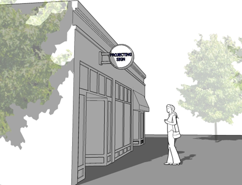
| Projecting Sign | ||||||||||||||
| Number Allowed | — | 1 per building or 1 per 20 ft. of building frontage if multiple occupants | ||||||||||||
| Maximum Area | — | 12 sq. ft. | ||||||||||||
| Maximum Distance from Building Wall to Farthest Part of Sign | — | 4 ft. | ||||||||||||
| Minimum Clearance | — | 8 ft. above sidewalk or walkway | ||||||||||||
| Minimum Clearance, Vehicular Way | — | 14 ft. above street | ||||||||||||
| Changeable Copy Permitted | — | No | ||||||||||||
| Illumination | — | Internal or External | ||||||||||||
| Other Standards | — | If used, then a wall sign is prohibited on same facade; Brackets shall be located under a second floor window sill or a maximum of 15 ft. from the street level. | ||||||||||||
| Sign Permit Required | — | Yes | ||||||||||||
 | ||||||||||||||
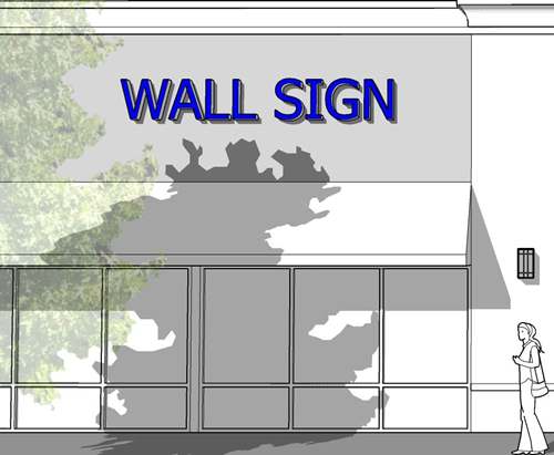
| Wall Sign | ||||||||||||||
| Number Allowed | 2 per entry to subdivision (subdivision entry); or 1 per building (private residence) | 1 per public street frontage | 1 per occupancy | 4 per site | ||||||||||
| Maximum Area | 6 sq. ft. | 1 sq. ft. for each linear foot at the front building wall of the building | 30 sq. ft. if located 12 ft or higher above grade; 10 sq. ft if less than 12 ft. above grade | 3 sq. ft. for each linear foot at the front building wall of the building; max. 10% coverage of total wall area | Single-tenant building: 30% of wall area on which sign is attached; multi-tenant building: 30% of each tenant space on which sign is mounted | |||||||||
| Maximum Height | 8 ft. | The eave line or the bottom of the second story windowsill, whichever is lower. | The eaveline or building parapet wall | |||||||||||
| Maximum Projection (Distance from Facade) | 2 ft. | |||||||||||||
| Changeable Copy Permitted | No | No | No | |||||||||||
| Illumination | No | External or internal | External or internal | |||||||||||
| Other Standards |
1. No wall sign or its supporting structure shall cover any window or part of a window.
2. In the DT district, wall signs shall have a texture or depth to distinguish them from the building wall. 3. These standards shall only apply to window signs on the first and second floor of a building. | |||||||||||||
| Sign Permit Required | Yes | Yes | ||||||||||||
 | ||||||||||||||
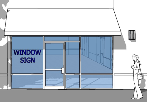
| Window Sign | ||||||||||||||
| Number Allowed | — | Residential: 1 per dwelling unit; Nonresidential: 1 per window | 1 per window | |||||||||||
| Maximum Size | — | 30% of window area, or 10% if window is part of a door | 25% of window area, or 10% if window is part of a door | 30% of window area, or 10% if window is part of a door | ||||||||||
| Minimum Clearance | — | — | ||||||||||||
| Maximum Projection | — | — | ||||||||||||
| Changeable Copy Permitted | — | — | ||||||||||||
| Illumination | Residential: No; Nonresidential: Yes, indirect or internal lighting, light shall be turned off when off-business hours | Nonresidential: Yes, indirect or internal lighting, light shall be turned off when off-business hours | ||||||||||||
| Permit Required | — | Yes | ||||||||||||
 | ||||||||||||||
|
TABLE NOTES:
ft. = Feet; sq. ft. = Square feet — = Characteristic, requirement, or sign type not applicable or required, or not permitted Yes = Characteristic or sign type is permitted; No = Characteristic or sign type not permitted. | ||||||||||||||
F.
Allowed freestanding permanent signs. All permanent freestanding signs shall follow the standards established in Table 5-1-5-3, Allowed Freestanding Permanent Signs. Standards in Section 5-1-5.H, Standards for Signs in Nonresidential Zone Districts, shall also apply.
| Table 5-1-5-3, Permanent Freestanding Sign Standards | ||||||||||||||
|---|---|---|---|---|---|---|---|---|---|---|---|---|---|---|
| Zoning District | Agricultural and Residential Districts | Mixed-Use Districts | Office and Commercial Districts | |||||||||||
| AG | RS, RS-C, RS-P | RMD | RMF | RMH | CM | DM | DF | ON | CN | CG | CH | IL | IH | |
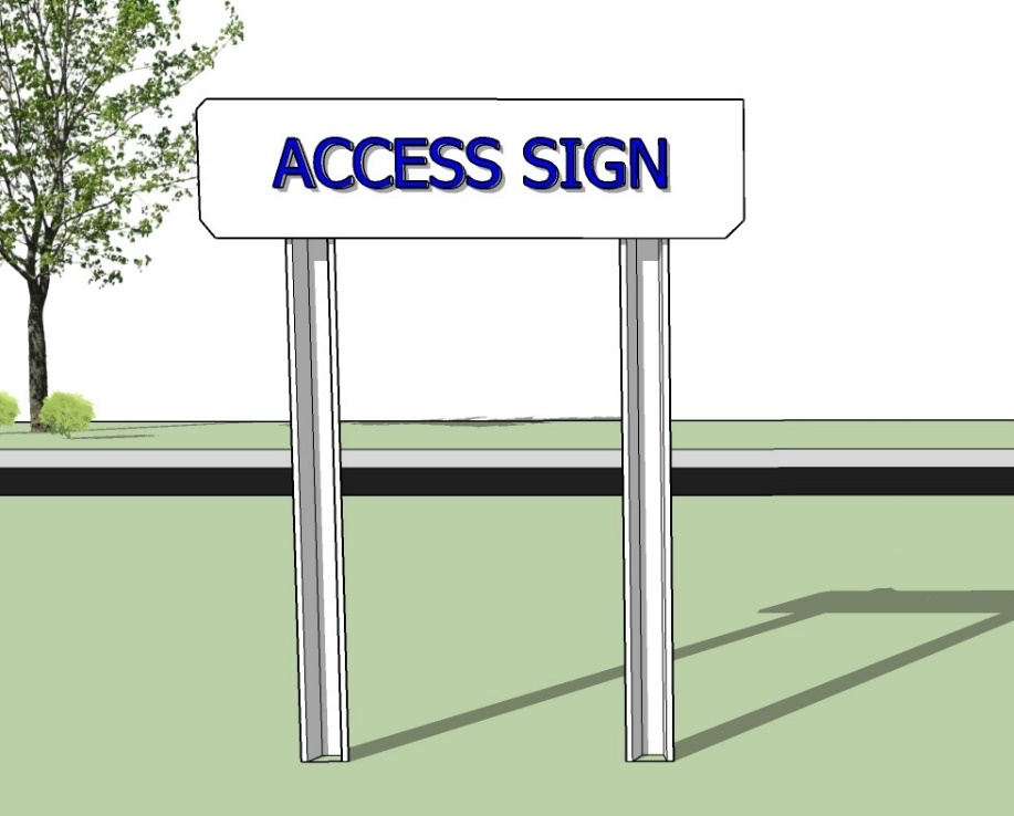
| Access Sign | ||||||||||||||
| Number Allowed | 1 per each lot or 1 per each frontage on a corner lot | 1 per each tenant or occupant with a ground-floor entry or storefront | ||||||||||||
| Maximum Area | 6 sq. ft. | 32 sq. ft. | ||||||||||||
| Minimum Clearance | — | — | ||||||||||||
| Maximum Projection (distance from facade) | — | — | ||||||||||||
| Changeable Copy Permitted | — | — | ||||||||||||
| Illumination | External only | |||||||||||||
| Sign Permit Required | Yes | Yes | ||||||||||||
 | ||||||||||||||
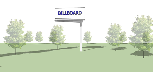
| Billboard Sign | ||||||||||||||
| Number Allowed | — | 1 per property | — | 1 per property | ||||||||||
| Maximum Area | — | 750 sq. ft. | — | 750 sq. ft. | ||||||||||
| Maximum Height | — | 35 ft. | — | 35 ft. | ||||||||||
| Changeable Copy Permitted | — | No | — | No | ||||||||||
| Illumination | — | External, must be shielded | — | External, must be shielded | ||||||||||
| Other Standards | — |
1. Minimum separation of 700 ft. between all billboards on the same side of the street;
for highways, this shall be increased to 1,500 ft.
2. Billboards are only permitted when placed or contracted by a governmental entity on government-regulated property. | ||||||||||||
| Sign Permit Required | — | Yes | — | Yes | ||||||||||
 | ||||||||||||||
| Canopy Sign (freestanding) | ||||||||||||||
| Number Allowed | — | 1 per canopy side | — | 1 per canopy side | ||||||||||
| Maximum Area | — | Cannot extend beyond sides of canopy | — | Cannot extend beyond sides of canopy | ||||||||||
| Maximum Height | — | — | — | — | ||||||||||
| Changeable Copy Permitted | — | — | — | — | ||||||||||
| Illumination | — | Internal or external | — | Internal or external | ||||||||||
| Other Standards | — | — | ||||||||||||
| Sign Permit Required | — | Yes | — | Yes | ||||||||||
 | ||||||||||||||
| Directory Sign (freestanding) | ||||||||||||||
| Number Allowed | — | — |
1 per property with a multi-tenant
building | |||||||||||
| Maximum Area | — | — | 2 sq. ft. per linear foot of street frontage; max. 100 sq. ft. | |||||||||||
| Maximum Height | — | — | 10 ft. | |||||||||||
| Minimum Setback (edge of pavement/property line) | — | — | 0 ft. | |||||||||||
| Changeable Copy Permitted | — | — | Yes | |||||||||||
| Illumination | — | — | Internal or external | |||||||||||
| Other Standards | — | — | The bottom portion of the sign shall rest flush against the ground, allowing no space between the ground and the bottom of the sign structure | |||||||||||
| Sign Permit Required | — | — | Yes | |||||||||||
 | ||||||||||||||
| Menu Board | ||||||||||||||
| Number Allowed | — | — | 2 per drive aisle of drive-through establishment | — | ||||||||||
| Maximum Area | — | — | 35 sq. ft. | — | ||||||||||
| Maximum Height | — | — | 8 ft. | — | ||||||||||
| Minimum Setback (Edge of pavement/property line) | — | — | n/a | — | ||||||||||
| Changeable Copy Permitted | — | — | n/a | — | ||||||||||
| Illumination | — | — | Internal or external | — | ||||||||||
| Other Standards | — | The audio component of a menu board is limited to communication between customers and employees, and may not exceed a volume of five decibels over ambient sound as measured from the nearest property line. | ||||||||||||
| Sign Permit Required | — | — | Yes | — | ||||||||||
 | ||||||||||||||
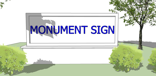
| Monument Sign | ||||||||||||||
| Number Allowed | 1 per property street frontage on nonresidential properties | — | 1 per establishment | |||||||||||
| Maximum Area | 32 sq. ft. | — | 32 sq. ft. |
< 200 ft. of street frontage: 60 sq. ft.
> 200 ft. of street frontage: 75 sq. ft. | ||||||||||
| Maximum Height | 6 ft. | — | 8 ft. | 25 ft. | ||||||||||
| Changeable Copy Permitted | Yes | — | Yes | |||||||||||
| Illumination | Internal or external | — | Internal or external | |||||||||||
| Other Standards | n/a | — | n/a | |||||||||||
| Sign Permit Required | Yes | — | Yes | |||||||||||
 | ||||||||||||||
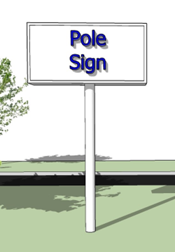
| Pylon or Pole Sign | ||||||||||||||
| Number Allowed | 1 per street frontage on nonresidential properties | — | 1 per public street frontage | |||||||||||
| Maximum Area |
< 75 ft of linear frontage: 20 sq. ft. per sign
> 75 ft of linear frontage: 40 sq. ft. per sign 20% of any wall facing a dedicated public right-of-way | — | 35 sq. ft./1 sq. ft. per linear ft. of street frontage; 250 sq. ft. maximum | |||||||||||
| Maximum Height | 15 ft. | — | 20 ft. | |||||||||||
| Minimum Clearance | 8 ft. above grade | 8 ft. above grade; 20 ft. above adjacent drive aisle, if edge of sign is within one foot of aisle | — | 8 ft. above grade; 20 ft. above adjacent drive aisle, if edge of sign is within one foot of aisle | ||||||||||
| Minimum Setback (Edge of pavement/property line) | 10 ft. | — | 10 ft. | |||||||||||
| Changeable Copy Permitted | No | Yes | — | Yes | ||||||||||
| Illumination | Internal or external | — | Internal or external | |||||||||||
| Other Standards | The width of the support(s) of the sign shall be a minimum of 60% of the width of the sign face. | |||||||||||||
| Sign Permit Required | Yes | — | Yes | |||||||||||
 | ||||||||||||||
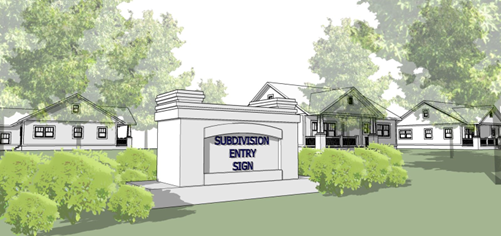
| Subdivision Entry | ||||||||||||||
| Number Allowed | 2 at primary entry to the subdivision; 1 per all other entries | — | ||||||||||||
| Maximum Size | 32 sq. ft. | — | ||||||||||||
| Maximum Height | 6 ft. | — | ||||||||||||
| Minimum Setback (Edge of pavement/property line) | 10 ft. from street right-of-way or property line for a private street | — | ||||||||||||
| Changeable Copy Permitted | — | — | ||||||||||||
| Illumination | Internal or external | — | ||||||||||||
| Other Standards |
1. Sign may be located on a base constructed of concrete not to exceed 18 inches in
height and shall be surrounded by landscaping and other decorative material.
2. Sign shall be located outside of existing or future utilities and any required sight triangle. | |||||||||||||
| Permit Required | No | — | ||||||||||||
 | ||||||||||||||
| TABLE NOTES: ft. = Feet; sq. ft. = Square feet. — = Characteristic, requirement, or sign type not applicable or required. Yes = Characteristic or sign type is permitted. No = Characteristic or sign type not permitted. | ||||||||||||||
G.
Standards for signs in nonresidential zone districts.
1.
Required setbacks.
a.
From public right-of-way.
i.
No sign shall be erected, constructed, placed, or projected into or over any public right-of-way, except that in the DM and DF zone districts and Area 6 of the downtown residential overlay district (DROD), projecting signs may extend into the right-of-way provided there is a vertical clearance of at least eight feet above the sidewalk and the sign does not extend past the sidewalk.
(A)
For locations adjacent to arterial streets, the right-of-way shall be defined as the ultimate right-of-way planned for the area as shown by the most recently adopted comprehensive plan. (Within 500 feet of all arterial street intersections, the ultimate right-of-way is 65 feet from the section line. Beyond 500 feet of the arterial street intersection, the ultimate right-of-way for primary arterial streets is 60 feet from the section line, and for secondary arterial streets the ultimate right-of-way is 50 feet from the section line.)
(B)
For locations adjacent only to non-arterial streets, the right-of-way shall be defined as the actual area that is publicly owned, designated, or dedicated as right-of-way or as easement for one or more streets.
b.
From residential districts.
i.
No permanent freestanding signs, projecting signs, on-premises signs, or wall signs shall be located within 50 feet of any residentially zoned district except for subdivision identification freestanding signs, or those permitted within a planned unit development (PUD) or by a conditional use permit (SUP). Residentially zoned districts that are used solely for streets, railroads, or highways are excluded from this subsection.
ii.
Any sign located within 50 feet to 100 feet of a residentially zoned district shall be limited to a maximum height of eight feet and shall not exceed 64 square feet of display area, regardless of setback.
iii.
Any sign located within 200 feet of a residential district shall not exceed 300 square feet in display surface area.
c.
From highway. Freestanding signs shall be set back a minimum distance of ten feet from any limited access highway or turnpike right-of-way, notwithstanding the setback requirements as set out in this section.
d.
Site triangle clearance. Except for public signs, no signs shall be located within 25 feet of the point of intersection of the ultimate right-of-way of two or more public streets, nor within 25 feet of the intersection of a public street right-of-way and a private street or driveway, nor within the median of a divided driveway for a distance of 25 feet from the entrance to the public street right-of-way.
e.
Pre-existing freestanding signs. In cases where there is a preexisting freestanding sign, any subsequent sign placement or land use shall also meet the above setback requirements.
i.
Modifications to pre-existing pole signs will be required to become compliant with sign design standards.
f.
Animated signs. No flashing, intermittent, animated graphic or moving sign shall be permitted within the City of Broken Arrow.
2.
Sign illumination.
a.
Incandescent illumination. No sign shall exceed an illumination of 70 foot candles as measured at a two-foot distance from the source of the illumination. Incandescent lamp message centers shall not be programmed to function as a strobe in an on-and-off display mode. Incandescent lamp message centers must utilize a dimming feature that will dim the lights during dark hours to no more than 80 percent of the normal watts used during daylight hours. Light source shall be shielded so that it does not impair the vision or endanger the safety and welfare of any pedestrian, cyclist, or person operating a motor vehicle.
b.
Light emitting diode (LED), digital signs.
i.
Digital signs are primarily allowed in commercial or industrial zoning districts. Institutional uses within agricultural or residential zoning districts may be permitted to have a digital sign upon approval of a conditional use permit (Subsection 6-3-4.4).
ii.
One digital sign is allowed per business or entity as either a wall sign or a ground sign.
iii.
No digital sign shall display an illuminative brightness of such intensity or brilliance that it impairs the vision or endangers the safety and welfare of any pedestrian, cyclist, or person operating a motor vehicle. No digital (LED) sign shall display an illuminative brightness exceeding 300 NITs at any time between one-half hour after sunset until one-half hour before sunrise or 5,000 NITs between one-half hour before sunrise until one-half hour after sunset.
iv.
Digital signs shall display only static messages with constant light and do not have movement or the appearance or optical illusion of movement. The dwell time for a message shall be a minimum of eight seconds.
v.
No digital sign shall resemble or simulate any warning or danger signal, or any official traffic control device, sign, signal or light.
vi.
No digital sign shall be permitted to operate unless it is equipped with a default mechanism that shall freeze the sign in one position or static message if a malfunction occurs.
vii.
Digital signs shall include a mechanism able to automatically adjust the display's illuminative brightness according to natural ambient light conditions by means of a light detector/photo cell by which the sign's brightness shall be dimmed after dark.
viii.
LED message centers shall be equipped with a security feature that prevents the sign message from being interfered with.
3.
Separation of signs. All freestanding signs or projecting signs shall maintain a minimum separation of 100 feet from any other freestanding sign or projecting sign. However, in cases where there is a preexisting off-premises advertising sign, except for those allowed in Section 5-1-5.I, Integrated Development Identification, any subsequent placement of a freestanding sign shall be separated by at least 500 feet along the street frontage from the preexisting off-premises advertising sign. Further, wall signs or projecting signs shall not exceed the height of the parapet of the building to which they are attached. Provided, where architectural features of the building will not permit a wall sign of at least three feet in height, a wall sign may be extended above the parapet of the building wall a distance sufficient to permit a sign of three feet in height.
4.
Off-premises signs. Off-premises signs shall not be permitted, except as provided in Section 5-1-5.I, Integrated Development Identification.
a.
Pre-existing billboards signs may be updated to ensure proper maintenance, and aesthetic quality. However, no new billboards shall be permitted.
5.
Height.
a.
The height of freestanding signs shall be measured from the grade where the sign is located and shall not exceed 20 feet in height except as modified by the following: additional height may be granted for additional setbacks, measured from the ultimate right-of-way line on a one-foot vertical to a two-foot horizontal basis, to a maximum of 30 feet.
b.
On lots that are adjacent to a designated turnpike right-of-way or limited access highway, the height of the sign may be increased to 35 feet using the formula herein stated measured from the right-of-way line provided the sign is located within 100 feet of the turnpike or limited access highway right-of-way line. However, a sign that is adjacent to a designated turnpike right-of-way or limited access highway, which sign's set back is located at the minimum distance allowed of ten feet, shall have a maximum height of 25 feet.
c.
Any sign that projects over a pedestrian walkway shall have a minimum of eight feet of vertical clearance.
d.
Any sign that projects over a vehicular access area shall have a minimum of 14 feet of vertical clearance.
6.
Size.
a.
Display surface area. No sign shall exceed 250 square feet of display surface area if being used by multiple users, nor 100 square feet if used by a single user. Multiple users shall mean two or more users on the sign. The identification plaque, decal, or other device that identifies the owner of the sign shall not be considered in the calculation of the multiple users.
b.
Adjacent to turnpike or highway.
i.
A single sign per lot with turnpike right-of-way or limited access highway frontage shall not exceed an aggregate display surface area of three square feet per each linear foot of limited access highway or turnpike frontage not to exceed a maximum of 300 square feet.
ii.
Multiple signs per lot with turnpike right-of-way or limited access highway frontage shall not exceed an aggregate display surface area of two square feet per each linear foot of limited access highway or turnpike frontage not to exceed a maximum of 250 square feet.
c.
All other signs. All other signs per lot shall comply with the following standards except as otherwise provided within this section.
i.
Lots with one freestanding sign shall not exceed an aggregate display area of two square feet per linear foot of lot frontage not to exceed 150 square feet.
ii.
Lots with multiple freestanding signs shall not exceed an aggregate display area of one square foot per linear foot of lot frontage, not to exceed 250 square feet.
iii.
Wall signs and projecting signs may utilize an aggregate display surface area of three square feet per linear foot of the wall on which it will be placed.
iv.
Sign area measurement. In computing the permitted display surface area for signs, the linear footage of an abutting secondary residential street shall not be combined with the linear footage of any collector street, arterial street, limited access highway, or turnpike that is being used to calculate the permitted display surface area. Only one side of a double-sided sign shall be included in the computation of display service area. Double-sided signs may be separated, as long as the separation of the two display surfaces shall not exceed ten feet.
7.
Forbidden lights and representations.
a.
No sign containing facsimiles of traffic control devices of any sort shall be located within 100 feet of the point of intersection of two or more public streets. No revolving red or blue lights shall be allowed. No sign containing light shall exceed an illumination of 70 foot candles as measured at a two-foot distance from the source of the illumination.
b.
Medical marijuana.
i.
Per 63 O.S. § 427.21, advertising for medical marijuana and medical marijuana products shall not contain any statements, illustrations, or other material that:
(A)
Is deceptive, false, or misleading;
(B)
Promotes over-consumption;
(C)
Represents that the use of marijuana has curative or therapeutic effects;
(D)
Depicts a child or other person under legal age consuming marijuana;
(E)
Depicts objects such as toys, cartoons, cartoon characters, or similar images, which suggest the presence of a child, or any other depiction designed in any manner to be especially appealing to children or other persons under legal age to consume marijuana; or
(F)
Has any manner or design that would be especially appealing to children or other persons under 18 years of age.
8.
Public easements. Signs may be erected within public utility easements and the unused portions of platted alleys under the following conditions:
a.
Sign structural poles/footings shall not be located immediately over City-owned utilities (i.e. waterlines, sanitary sewer lines, storm water lines, or facilities owned by the City) that are located in public utility easements or the facilities of franchised utility providers. Freestanding signs may be placed in public drainage easements upon prior written approval by the Engineering and Construction Director.
b.
The construction of the sign must be lawful.
c.
Site plans that show a sign placed in a utility easement shall have the following note placed on the face of the site plan: "Sign owner(s) assume all liability and replacement responsibilities for any damage to signs placed in utility easements."
d.
Sign placement within the public utility easement or alley should be done at the sign owner's own risk, and with the express knowledge that the needs for the construction, reconstruction, maintenance and repair of the existing or future publicly owned or franchised utilities are a priority and dominant over the servient estate of the sign placement.
e.
The sign placed in a public utility easement must meet the setback requirements of this section. The sign shall be constructed so that no portion thereof projects over the street right-of-way, or blocks the site triangle at intersections or blocks the sidewalks to normal pedestrian or bicycle traffic.
f.
No sign, nor any portion or support thereof shall be placed within a drainage easement or drainage area without the written approval of the Engineering and Construction Director, regardless of how the drainage easement or drainage area may have been created, obtained or conveyed and regardless of how the drainage easement or drainage area is designated, whether it is an easement, right-of-way, or any other type of designation.
g.
As a precondition to a permit being issued for a sign constructed within public easements, the sign owner shall submit a written statement, which is either made a part of the plat or is recorded in the County land records that states to the effect that:
i.
The sign owner acknowledges the prior rights and status of the public, its trustees, and franchised utility owners;
ii.
The sign owner assumes all liability and replacement responsibilities for any damage to its signs located within utility easements, as well as for any damage to subsurface or overhead facilities located within the easement, which may be damaged during the construction, installation, maintenance or repair of the signs; and
iii.
Acknowledgement that the sign is subject to removal at the sign owner's expense in the event that the City or a utility company has a need to construct, reconstruct, repair or maintain its facilities at that location.
9.
Sign owner. Each sign shall have a plaque, decal, be readable to a person of ordinary height and vision at a distance of two feet from the base of the sign, and the information must be printed in English block print. This device must be readily accessible to an inspector employed by the City, but does not have to be generally observable to the public.
10.
Installation of signs. All signs, which are permitted under this section or any future amendments thereto, shall be installed by licensed sign contractors in accordance with the locations and plans submitted at the time of the application and subsequently approved by the City.
11.
Pole sign construction material. All pole signs shall wrap the base of the pole with masonry material to match the architectural style of the building on the site and to landscape the area around the base of the sign. If the pole sign is pre-existing and is being updated, then landscaping is not required when the existing area around the pole is paved so long as a landscaping box is a part of the updated design.
12.
District-specific standards.
a.
DM and DF zone districts, and Area 5 and 6 of DROD.
i.
Wall signs shall have an aggregate display area not to exceed three square feet for each linear foot at the front building wall of the building not exceeding ten percent coverage of the total wall area. Wall signs in the mixed-use, office, and commercial districts shall have an aggregate display area not to exceed one square foot for each linear foot of the wall on which it will be placed.
ii.
Projecting signs shall be no larger than 12 square feet in area. Brackets for projecting signs should be located under a second floor window sill or a maximum of 15 feet from the street level.
iii.
Neighborhood identification signs are permitted as outlined in the Broken Arrow Downtown Master Plan and the downtown residential overlay district guidelines including gateway signs that identify the primary entrances into the district.
iv.
When two or more businesses occupy the same building, identifying signs should be grouped together in a single panel.
v.
All signs in the downtown area require approval of the Community Development Director.
b.
Mixed-use, commercial, and industrial districts. No more than one sign per 150 feet of limited access highway frontage, arterial street frontage, collector street frontage or a fraction thereof. On lots with multiple street frontages (i.e., corner lots, double frontage lots), the street frontage is not cumulative. In office districts, no more than one sign per 100 feet, or fraction thereof, of turnpike right-of-way, limited access highway frontage, arterial street frontage, collector street frontage.
c.
Area 7 of the DROD. Properties with commercial uses shall be subject to the requirements of this section with the following additional requirements:
i.
Shall be limited to ten feet in height and a maximum area of 50 square feet in area and include a masonry base.
ii.
No pole signs shall be permitted.
iii.
Shall be setback 50 feet from lots used for single-family residential.
d.
Sign regulations for planned unit developments (PUDs). Signs in a PUD shall be governed by this ordinance, but may be modified by the express terms of the PUD.
H.
Integrated development identification. A commercial and/or industrial development containing a minimum of not less than 15 acres within a defined area (hereinafter referred to as "development area") under common ownership or control may provide integrated development identification (hereinafter "IDI") in accordance with the following requirements:
1.
Application. An application for IDI shall be submitted as a conditional use permit in compliance with the hearing and notice requirements set forth within [Section] 6-3-4.4, Conditional Use Permit.
2.
Legal description. A legal description of the development area, an abstractor's certification of ownership of the development area, the owners' written authorization to proceed and a graphic depiction of the location, size, and height of the integrated development sign as hereinafter defined, shall accompany the filing of the application.
3.
Permitted signage. The permitted signage within the development area shall be limited as follows:
a.
One sign identifying the development and/or a tenant or tenants located within the development area shall be permitted (hereinafter the "integrated development sign") for each 15 acres (rounded to the nearest multiple of 15) not exceeding 35 in height nor 300 square feet of display surface area.
b.
In addition to the integrated development sign, a free standing sign for an individual tenant within a platted lot shall be permitted not exceeding ten feet in height nor 100 square feet of display surface area (hereinafter the "tenant sign") and each tenant sign shall have a monument base of substantially the same material as the exterior of the principal building on the lot.
c.
Except as above modified, signs within the development area shall meet the requirements of this section.
4.
Approval. Upon approval of a conditional use permit and prior to the issuance of a permit for any sign to be located within the development area, a declaration setting forth the following:
a.
The legal description and a graphic depiction of the land area comprising the development area.
b.
A recitation of the ownership of the development area.
c.
A statement of the applicability of the provisions of this chapter.
d.
A grant of any required easement sufficient to permit the location of a permitted sign not constituting an on premise sign.
e.
Provision for maintenance of each integrated development sign.
f.
Provision for the enforcement of the provisions of this chapter and the conditions of the conditional use permit by each owner of any parcel of land located within the development area.
g.
Provision for the enforcement of the provisions of this chapter and the conditions of the conditional use permit by the City of Broken Arrow Oklahoma shall be submitted to and approved by the Broken Arrow Planning Commission and thereafter duly filed of record in the office of the County Clerk of the applicable county within which the development area is located.
Sec. 5-1-6. - Temporary, incidental, and miscellaneous.
A.
Applicability. Temporary signs including banner, mobile, inflatable, promotional business, construction, or sandwich board/A-frame signs shall be permitted only as provided herein.
B.
Number.
1.
Permits for banner, temporary, mobile, inflatable, or promotional business signs shall be limited to no more than four per year for any single lot owner.
2.
Banner, temporary, mobile, inflatable, or promotional business signs shall not exceed more than one sign at any given time per lot of record.
C.
Duration.
1.
Banner, temporary, mobile, inflatable, or promotional business signs may be used for a period of no more than 45 days on any one occasion, provided that the applicant may at the time of application request that all or any of the four permitted time periods run consecutively.
2.
The permitted time periods may not exceed 120 days total during a one-year period from the date of the first application.
D.
Label. All banner, temporary, mobile business, inflatable, or promotional signs must have the sign owner's name, address and phone number affixed to the banner, temporary, mobile, inflatable, or promotional business sign at a location where it can be seen by inspectors, although it may be concealed from the public while on display in its ordinary manner.
E.
Setback. All banner, temporary, mobile, inflatable or promotional business sign shall beset back from the property line by a distance of one foot horizontal for every one foot vertical of the sign as measured from the base of the sign.
F.
Location.
1.
Banner, temporary, mobile, inflatable, or promotional business signs may be permitted in any commercial, office, or industrial zoning district.
2.
No banner, temporary, mobile, inflatable, or promotional business sign shall be placed in a manner which will interfere with the flow of vehicular and/or pedestrian traffic or create traffic visibility hazards such as being placed in the sight triangles of the intersection of two streets or the intersection of streets and driveways.
3.
No banner, temporary, mobile, inflatable, or promotional business sign shall be permitted to be located upon or within any required parking spaces or loading berths, nor shall it otherwise be located in such a manner to obstruct vehicular and/or pedestrian access or circulation.
4.
Except for standard public signs, no banner, temporary, mobile, inflatable, or promotional business signs shall be located within 25 feet of the point of intersection of the right-of-way of two or more public streets, nor within 25 feet of the intersection of a public street right-of-way and a private street or driveway, nor within the median of a divided driveway for a distance of 25 feet from the entrance to the public street right-of-way.
G.
Height.
1.
The height of banner, temporary, mobile, inflatable, or promotional business sign shall not exceed the height specified in Section 5-1-5, Permanent Signs.
2.
All banner, temporary, mobile, inflatable, or promotional business sign shall be set back from the property line by a distance of one foot horizontal for every one foot vertical of the sign as measured from the base of the sign.
H.
Size. Except for public signs, banner, temporary, mobile, inflatable, or promotional business signs shall not exceed 40 square feet of display surface area.
I.
Design. Banner, temporary, mobile, inflatable or promotional signs shall be designed and constructed to withstand a wind pressure of not less than 40 pounds per square foot of area, or of materials which are unlikely to become dangerous projectiles when propelled by windstorms.
J.
Attachment. Banner, temporary, mobile, inflatable, or promotional business signs must be anchored to the selected location sufficient to keep them from being moved by wind or storm.
K.
Sign-specific standards.
1.
Sandwich board/A-frame sign. Sandwich board signs, also known as A-frame signs, are allowed only in Area 5 and 6 of the downtown residential overlay district during business hours and do not require a permit. They must allow for a clear path of travel at all times and shall not interrupt pedestrian activity.
2.
Construction sign. A temporary construction sign shall be located upon the property where the construction work is taking place.
3.
Mobile sign anchors. No mobile sign shall be placed unless such sign is anchored at each support by a steel rod driven at least 18 inches into the ground, or unless said sign is attached by a steel chain having at least three-quarter-inch links or by a steel cable of at least one-half-inch diameter to a building or to a permanent freestanding sign, or similar upright supporting structure.
4.
On-site perimeter light pole mounted signs. One sign, not to exceed 15 square feet, mounted to one on-site light pole with permanent type bracket, between the range of three feet and ten feet from the ground, shall be permitted along each direction of store frontage at arterial intersections.
Sec. 5-1-7. - Installation and maintenance.
A.
Installation. All signs, which are permitted under this chapter or any future amendments thereto, shall be installed by licensed sign contractors in accordance with the locations and plans submitted at the time of the application and subsequently approved by the City, and shall meet the City's Building Code.
1.
Anchoring. Signs shall not be suspended by chains or other devices that will allow the sign to swing, due to wind action. Signs shall be anchored to prevent any lateral movement that could cause wear on supporting members or connections.
2.
Supports. Supports and braces shall be an integral part of the sign design. Angle iron or wires used for supports or braces shall be hidden from public view to the extent technically feasible.
3.
Freestanding signs. Freestanding signs shall be self-supporting structures and be permanently attached to sufficient foundations.
4.
Attached signs. Attached signs shall derive their principle and total support from the building to which they are attached.
5.
Use of fill under monument signs. Mounds or berms may be used to elevate permanent monument signs, provided that the mound or berm elevates the base of the sign not more than three feet above the natural grade at the location of the sign.
6.
Electrical switch. The sign shall be equipped with a disconnecting switch in accordance with the provisions of the National Electric Code.
7.
Inspection request. After any sign requiring a permit is constructed or erected, the sign contractor performing the work or service shall notify the Building Official for final inspection of the sign.
8.
Electrical signs. Where an electrical sign is erected or constructed, an inspection by the electrical inspector shall be made.
B.
Maintenance.
1.
Message. Signs shall display messages. Signs that do not display a message for a period of more than 90 days are "abandoned signs," which are prohibited subject to Section 5-1-4, Prohibited Sign Types, Materials, Design Elements, and Locations.
2.
Upkeep of ground around sign. The area within a ten-foot radius of the base of a sign shall be kept free of weeds, rubbish, or flammable waste or material.
3.
Supports and other hardware. Structural supports, braces, bolds, clips, supporting frames, and fastenings of a sign shall be kept in good repair and safe condition, including replacement of defective parts so that the sign is securely fastened or anchored to a building wall, structural framing, or other foundation.
4.
Paint and finishes. Paint and other finishes shall be maintained in good condition. Peeling finishes shall be repaired. Signs with running colors shall be repainted, repaired, removed, or replaced if the running colors were not part of the original design.
5.
Corrosion and rust. Permanent signs and sign structures shall be finished and maintained to prevent corrosion and rust. A patina on copper elements is not considered rust.
6.
Level position. Signs that are designed to be level shall be installed and maintained in a level position.
7.
Materials. All signs shall be constructed of durable materials and securely attached to framework with supports made of masonry, wood, metal, or other material of equivalent strength.
8.
Damage or destruction. Any damaged signs and sign structures sustaining damage to the extent of 40 percent of the sign shall be promptly repaired (to their original condition or better) or removed. Damaged or destroyed nonconforming permanent signs are subject to the applicable requirements of Chapter 7, Nonconformities. Damaged or destroyed temporary signs shall be removed.
9.
Failure to maintain. Failure of a property owner to maintain a sign is a violation of the City's Property Maintenance Code.