
Brunswick County Unincorporated
City Zoning Code
City Zoning Code
ARTICLE 3
- COMMON REVIEW AND APPROVAL PROCEDURES
3.1 - COMMON REVIEW AND APPROVAL PROCEDURES
Unless provided otherwise by law, all rights, privileges, benefits, burdens, and obligations created by development approvals made pursuant to Chapter 160D attach to and run with the land. This article outlines the most common types of review and approval of development activity. Less frequently used approvals, such as temporary use permits, vested rights, etc., are outlined in Article 9, Administration and Enforcement.
( Ord. No. UDO-21-01 , § 54, 5-17-21)
3.1.1. Development Permit Required
No land shall be used or occupied and no building hereafter constructed, structurally altered, erected, or moved shall be used or its use changed until a Development Permit is issued by the Planning Director. The purpose of the Development Permit is to guide the applicant in carrying out their improvement plans and avoid potential pitfalls by ensuring that the appropriate approvals are obtained in the most efficient and effective manner possible. Applications for development approvals may be made by the landowner, a lessee or person holding an option or contract to purchase or lease land, or an authorized agent of the landowner. Development permits shall be provided in writing in by the County in print or electronic form. Additional administrative provisions pertaining to Development Permits are outlined in Section 9.3 of Article 9, Administration and Enforcement, of this Ordinance.
(Ord. No. UDO-19-02 , § 11, 9-19-19; Ord. No. UDO-21-01 , § 52, 5-17-21)
3.1.2. Change of Use Approval Required
Change in the use of a structure shall require approval of the Zoning Administrator and other County Departments or outside agencies as required by applicable regulations or as deemed appropriate for the proposed use. There shall be no fee charged for review of changes within the same category (e.g., retail to retail, residential to residential, etc.). Fees for Changes of Use to a different category (e.g., retail to industrial, storage to assembly, residential to office, etc.) shall be charged in accordance with the current fee schedule adopted by the Board of Commissioners.
3.1.3. Building Permit/Certificate of Occupancy
No building permit or certificate of occupancy shall be issued until the required site plan of the proposed use or development has been approved and all County requirements have been met and approved by the appropriate County officials. All applicable state and federal approvals/permits must also be obtained. (Note: Applicants are responsible for ensuring compliance with outside agency requirements, except as specifically referenced in County ordinances such as Stormwater Management).
Building permits shall not be issued until substantial completion of required infrastructure improvements.
Option: Building permits may be issued prior to substantial completion of required infrastructure improvements, or obtaining all approvals from outside agencies, subject to:
A.
Recorded Development Plan Agreement or Development Agreement between the County and the Property Owner specifically limiting scope of building permit to the shell of the building only;
B.
Access acceptable to County Emergency Services for emergency vehicles must be provided;
C.
No further building permits beyond shell shall be issued until substantial completion of required infrastructure improvements have been completed; and
D.
Provision of a Certification acceptable to the County that required infrastructure improvements will be completed a minimum of thirty days prior to completion of the building.
No certificate of occupancy shall be issued until all required improvements are completed and approved by the appropriate County officials.
3.1.4. Setback Certification
A.
A foundation survey shall be required to certify setback requirements for all residential principal and accessory structures with the exceptions noted below in Section 3.1.4.C. The foundation survey shall be submitted at the time of the foundation inspection and must be signed and sealed by a registered Professional Land Surveyor (PLS). The foundation survey map must show the structure, property lines, distance from the structure to the property lines, the setback line, easements, and any existing structures and any other encumbrances associated with the property. A signed and sealed letter from a Professional Land Surveyor, identifying the property and structure and certifying that the structure meets or exceeds the setback for the zoning district in which it is located may be provided in lieu of a survey map.
B.
Prohibition on Inspections: No inspections shall be conducted by a Brunswick County Building Inspector on a structure after the "foundation inspection" unless the Setback Certification is completed and approved. The Inspector shall place a stop work order on any construction when the Setback Certification has not been completed and approved. The stop work order shall be lifted upon receipt of Setback Certification approved by the Zoning Administrator, or designee.
C.
Exceptions to Foundation Survey Requirements: Setback Certification shall not be required for the following:
a.
Any residential principal or accessory structure that is located more than fifty (50) feet from a property line;
b.
Accessory structures that are no more than twelve feet (12') in any dimension;
c.
Open Patios;
d.
Open Decks;
e.
Fences and walls;
f.
Signs;
g.
Structures that are part of a Bona Fide Farm; and
h.
Individual mobile homes located in a mobile home park.
(Ord. No. UDO-18-04 , § 1, 6-8-18)
3.1.5. Subdivision and Planned Development Recordation and Building Permit Issuance Requirements
No subdivision or planned development (PD) shall be recorded nor any structural building permit issued within a proposed subdivision until all County requirements have been met and approved by the appropriate County officials as follows:
A.
Approval of detailed preliminary subdivision plat or PD Final Master Plan, including required plans and specifications upon meeting all applicable County, State and Federal requirements. (Note: the final plat or PD plan must conform to the preliminary plat or PD plan in content and layout with only minor deviations).
B.
Approval of final plat or PD plan upon completion of all required improvements with the exception of minor improvements such as required landscaping or electric utilities. Surety acceptable to the county must be provided in the amount of 125% of the engineer certified cost of the final lift of asphalt.
C.
Building permits may be issued upon approval of final subdivision plat or PD plan.
Option: Building permits may be issued prior to final plat approval subject to:
1.
Approval or conditional approval of a detailed preliminary subdivision plat or PD plan;
2.
Recorded Development Plan Agreement or Development Agreement between the County and the owner of the property limiting building permits to no more than two model units;
3.
Water and sewer service approved by the County must be provided to unit(s) and a certificate of occupancy obtained for model unit(s);
4.
Access acceptable to County Emergency Services for emergency vehicles must be provided; and
5.
Required infrastructure improvements must be substantially complete for additional building permits.
D.
Final plat or PD plan approval and recordation required for transfer of lot ownership.
(Ord. No. UDO-16-01 , § 1, 1-19-16; Ord. No. UDO-16-02 , § 31, 3-7-16; Ord. No. UDO-18-04 , § 1, 6-8-18)
3.1.6. Site Plan Approval Required
Approval of the site plan is required for all proposed development activity including, but not limited to, single-family lots, individual businesses, non-residential developments, multifamily units, subdivisions, planned developments, special use permits, conditional zoning, change of use, or modification of a previously approved site plan.
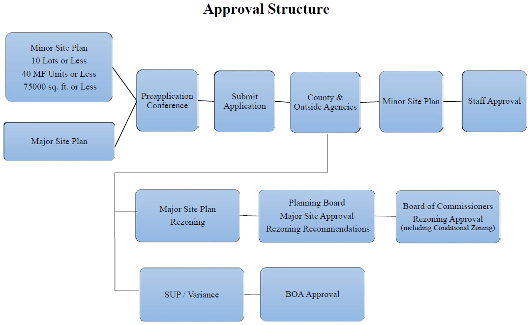
A.
Minor Site Plan
1.
Criteria:
i.
10 lots or less;
ii.
Total building floor area of 75,000 square feet or less including existing buildings on the site; or
iii.
Parking lot expansion with total building floor area (including existing buildings) less than 75,000 square feet.
2.
Approval Authority
The Planning Director shall be responsible for final action regarding a minor site plan. However, the Planning Director shall have the discretionary authority to refer a minor site plan to the Planning Board for final action.
3.
Multifamily Dwellings
Forty (40) multifamily dwellings or less; provided however, multifamily projects of any size permitted by right in the MR-3200, NC and C-LD zoning districts are approved administratively.
B.
Major Site Plan
1.
Criteria:
Any site plan not listed under Minor Site Plan above shall be considered a Major Site Plan.
2.
Approval Authority
The Planning Board shall be responsible for final action regarding all major site plans with the exception of applications reviewed by the Board of Adjustment and Conditional Zoning applications which shall be reviewed by the Planning Board for a recommendation to the Board of Commissioners for final action.
(Ord. No. UDO-18-04 , § 1, 6-8-18)
3.1.7. Project Planning Session
A.
Prior to undertaking the project design, applicants are strongly urged to schedule a Project Planning Session with the Planning Department. At the session, the project concept is discussed in order to determine how the considerable flexibility provided in Section 6.1 of this Ordinance can best be utilized to meet the needs of the project. There is no fee for the session and the discussions are consultative rather than prescriptive.
B.
A Project Planning Session with the Planning Director shall be required for the following approvals:
1.
Rezoning (Section 3.8);
2.
Subdivision review (Section 3.3);
3.
Major Site plan review (Section 3.2.1.C);
4.
Planned Development review (Section 3.3.3); and
5.
Special use permit (Section 3.5).
(Ord. No. UDO-16-02 , §§ 1, 2, 3-7-16; Ord. No. UDO-18-04 , § 1, 6-8-18)
3.1.8. Application Requirements (see Article 6
A.
Minimum Information Required
1.
All applications for land use permits shall be accompanied by accurate plot plans, drawn to scale, showing the actual shape and dimensions of the lot to be built upon; the legal description of the lot to be built upon or used; or the location of the plans as recorded by the Brunswick County Register of Deeds, the exact sizes and location on the lot of all existing buildings and accessory buildings; the lines within which the proposed building or structure shall be erected; the existing and intended use of each building or part of building and any other data deemed necessary by the approving agency to determine compliance of a proposed development with the terms of this Ordinance.
2.
Applications for rezoning, subdivision, or planned developments shall designate on preliminary development plans, the location and distance to any Agricultural Preservation Districts within ½ aerial mile of the proposed development.
3.
For nonresidential use: a properly completed checklist including the following information shall accompany all applications:
i.
Driveway entrance permit application for transmittal to the North Carolina Division of Highways, District Engineer.
ii.
Location of signs, if any, including ownership and type (identification, commercial, or those not requiring a permit).
iii.
Whether excavation, clearing of ground, or moving of earth other than that actually required for the building, is expected to occur.
4.
Additional information or materials may be required by the approving agency.
5.
Additional information may be required by the approving authority to determine compliance with all applicable requirements of this Ordinance.
B.
A landscaping plan shall be required in accordance with Section 6.1.2.A. For minor site plan applications, this landscaping plan may not necessarily need to be on a separate plan document.
C.
All site plans shall clearly indicate all required open space and/or recreation area that has been dedicated or reserved to conform with the requirements of Section 6.4.4, Open Space and Recreation Area.
D.
Major site plans may be required to include a heritage tree survey in accordance with Section 6.1.3.
E.
In most instances, major site plans will require a detailed infrastructure improvements plan prepared by a licensed engineer. The specifications, standard details, etc. for such plans are available from the County Engineering Department and on the County's website.
F.
Site plans should cite the presence of significant historic resources (consult with the Planning and Community Development Department for inventory available on County GIS).
G.
All site plan submittals include a lighting plan in conformance with Section 6.9, Lighting Plan.
H.
All outdoor display and storage areas shall be clearly indicated on the site plan for the project (see Section 6.22).
I.
A Traffic Impact Analysis may be required if the proposed site plan meets the thresholds established in Section 6.16, Traffic Impact Analysis.
J.
Forms
Applications required under this Ordinance shall be submitted on forms and in such numbers as required by the appropriate department.
K.
Electronic Files Required
1.
Applications for major site plan and major subdivision (preliminary and final) shall provide electronic drawings in ".dwg", ".dxf", or ".shp" format. Files must be drawn to scale in feet units, referenced to the NC State Plane coordinate system.
2.
Consult with the Planning and Community Development Department for more information on electronic data requirements.
L.
Fees
1.
Filing fees shall be established from time to time to defray the actual cost of processing the application.
2.
Before any permit shall be issued or application review initiated, a fee in an amount fixed by the Board of County Commissioners shall be paid.
3.
An applicant who has paid the appropriate fee pursuant to the submission of an application, but who chooses to withdraw such application, must do so within ten business days of submittal of the original application to be entitled to a refund of the total amount paid, less ten percent for administrative costs, upon written request to the appropriate department.
M.
Applications Sufficient For Processing
1.
All applications must be sufficient for processing before the appropriate department is required to review the application.
2.
The presumption shall be that all of the information required in the application forms is necessary to satisfy the requirements of this section. However, it is recognized that each application is unique, and therefore more or less information may be required according to the needs of the particular case. The applicant may rely on the recommendations of the appropriate department as to whether more or less information should be submitted.
3.
Once the application has been determined sufficient for processing, copies of the application shall be referred by the appropriate department to the appropriate reviewing entities.
4.
The appropriate department may require an applicant to present evidence of authority to submit the application.
N.
Application Deadline
Applications sufficient for processing shall be submitted to the appropriate department in accordance with the published calendar schedule. Schedules indicating submittal dates shall be developed each year and made available to the public.
O.
Staff Consultation after Application Submitted
1.
Upon receipt of an application sufficient for processing, the Planning Director shall review the application and confer with the applicant to ensure an understanding of the applicable requirements of this Ordinance; that the applicant has submitted all of the information they intend to submit; and that the application represents precisely and completely what the applicant proposes to do.
2.
Once the applicant indicates that the application is as complete as the applicant intends to make it, the application shall be placed on the agenda of the appropriate review board in accordance with standard procedures. However, if the Planning Director believes the application is incomplete, a recommendation to deny the application on that basis shall be provided to the appropriate reviewing entity.
(Ord. No. UDO-18-04 , § 1, 6-8-18)
3.1.9. Neighborhood Meeting
This section provides the requirements pertaining to Neighborhood Meetings. Additional details such as suggested format, etc. for neighborhood meetings is provided in Section 9.2 of Article 9, Administration.
A.
After the project planning session, the applicant is encouraged to hold a neighborhood meeting prior to submitting an application for any of the following approvals:
1.
Rezoning (Section 3.8);
2.
Planned Development review (Section 3.3.3); and
3.
Special Use Permit (Section 3.5).
B.
A neighborhood meeting is required (MANDATORY) prior to submitting an application for any of the following approvals:
1.
All Conditional Zoning requests;
2.
Modifications to an existing Planned Development (Section 3.3.3.B.15); or
3.
An existing Major Subdivision (Section 3.4.12), except in situations where the Planning Director is authorized to approve the modification administratively.
Commentary: Examples of situations where a neighborhood meeting is required include a change in land use from open space to single-family or single-family to multi-family.
C.
The purpose of the neighborhood meeting is to inform the neighborhood of the nature of the proposed land use and development features, explain the plan (if applicable), and receive comments. Comments from the neighborhood are not binding on the applicant. However, the applicant may elect to revise elements of the project to incorporate suggestions.
D.
When a neighborhood meeting is required, a neighborhood meeting verification form shall be obtained from the Planning and Community Development Department prior to holding said meeting.
(Ord. No. UDO-16-02 , § 1, 3-7-16; Ord. No. UDO-18-04 , § 1, 6-8-18)
3.2 - SITE PLAN APPROVAL PROCEDURES
3.2.1. Action by Planning Director
A.
All Site Plans
Upon receipt of a completed application, the Planning Director, in consultation with the Technical Review Committee shall review all site plans for conformance with the approval criteria found in Article 6. In addition, the Planning Director may consult with any County or state official if the need arises.
B.
Minor Site Plan
The Planning Director may approve, approve with conditions, or disapprove a minor site plan, refer the site plan to the Technical Review Committee for further consideration, or refer the site plan application to the Planning Board for a final decision under the procedure established for a major site plan application. Applications for minor site plan not receiving final action may be deemed denied and the applicant may appeal the decision in conformance with Section 9.8, Appeal of Administrative Decision. Notification of Planning Director decision shall be transmitted to the applicant in writing.
C.
Major Site Plan
1.
The Planning Director shall prepare a staff report based on the comments provided by the Technical Review Committee. The staff report and recommendations shall be forwarded to the Planning Board, Board of Adjustment, or Board of Commissioners, as appropriate, for review and final action.
2.
The Planning Director shall place the item on the next available agenda of the appropriate review body and give notice in accordance with Section 9.1, Notice and Public Hearings.
3.2.2. Actions by the Planning Board
A.
Before taking action on a major site plan, the Planning Board shall consider the recommendations of the Planning Director and the Technical Review Committee.
B.
For applications which the Planning Board serves as the approving authority, the Planning Board may approve or disapprove the application, approve the application with conditions, or send the application back to the Planning Director for additional consideration. Approval by the Planning Board shall be in the form of the conceptual plan for the project including street layout, lot/building layout, development type (commercial, residential, multifamily), number of dwelling units, floor area of buildings, building form and size (stories, etc.), open space areas, setbacks, buffers, etc. The detailed site plan shall be approved by the Planning Director, the components of which shall be in general conformance with the components of the conceptual plan as approved by the Planning Board. For Conditional Zoning site plans, the Planning Board shall take final action.
C.
Notification of Board decision shall be transmitted to the applicant in writing.
( Ord. No. UDO-21-01 , § 64, 5-17-21)
3.2.3. Action by the Board of Adjustment
A.
Before taking action on a major site plan, the Board of Adjustment shall consider the recommendations of the Planning Director and the Technical Review Committee.
B.
For applications which the Board of Adjustment serves as the approving authority, the Board of Adjustment may approve or disapprove the application, approve the application with conditions, or send the application back to the Planning Director for additional consideration.
C.
Notification of Board decision shall be transmitted to the applicant in writing.
3.2.4. Action by the Board of Commissioners
A.
The Board of Commissioners shall be responsible for hearing appeals of decisions by the Planning Board for Conditional Rezoning requests with site plans and shall hear the case de novo.
B.
The Board of Commissioners may approve or disapprove the application, approve the application with conditions, or send the application back to the Planning Board for additional consideration.
C.
Notification of Board decision shall be transmitted to the applicant in writing.
( Ord. No. UDO-21-01 , § 65, 5-17-21)
3.2.5. Approval Criteria
In approving an application, the reviewing entity shall consider the following:
A.
Compliance with all applicable requirements of this Ordinance;
B.
Agreement with the most recently adopted CAMA Land Use Plan and any other applicable adopted land use document(s);
C.
That the plan, site design and development intensity is appropriate for and tailored to the unique natural characteristics of the site, such as significant wooded areas, specimen trees, wetlands, significant historic resources, steep slopes, and floodplains;
D.
For nonresidential and multifamily projects, the site plan displays the location of trash handling, recycling, grease bins, and other waste-related facilities employed in the normal operation of the use;
E.
That the location of parking areas and pedestrian and vehicular access points is in compliance with all requirements of the Unified Development Ordinance;
F.
That the design of traffic patterns, traffic control measures and street pavement areas, with provisions for maintaining traffic flows for both public use as well as emergency management services are consistent with the requirements of the Unified Development Ordinance;
G.
Compliance with site construction specifications;
H.
That stormwater facilities, water supply, sanitary sewer service, fire protection and hydrants, street signs, and street lighting are in conformance with department standards, specifications and guidelines; and
I.
Easements or dedications are compliant with the Unified Development Ordinance.
3.2.6. Decisions
Unless specifically provided elsewhere, all decisions on land use changes, including rezoning, shall require an affirmative vote. Tie votes shall be considered denials of any requested change.
3.2.7. Notice of Decision
After a decision is made, a copy of the decision shall be sent to the applicant within reasonable time and filed in the Planning Department, where it shall be available for public review during regular office hours.
3.2.8. Applications Receiving Conditional Approval
Site plans granted conditional approval shall be corrected and returned to the Planning Director within 90 days of notification of decision or the application shall be considered withdrawn. One 90 day extension period may be granted by written petition to the Planning Director prior to the expiration of the revision period.
3.2.9. Site Plan Amendments
A.
Minor changes to the approved site plan, such as those resulting from field conditions or which result in an equivalent or better performance may be approved by the Planning Director in conjunction with the Building Official.
B.
Significant changes to the approved site plan, as determined by the Planning Director, shall be resubmitted for review and approval by the approving authority as if they were a new application.
3.2.10. Duration of Validity
An approved site plan shall remain valid for a period of three years from the date of approval and shall run with the land. After the initial three-year period, construction or development activity must be actively pursued to maintain validity. If construction or development activity is discontinued for a period of greater than 180 calendar days, the site plan shall expire and a new application must be submitted. Consistent with Chapter 160, Section 108.D.3., Brunswick County may provide that rights regarding a site-specific vesting plan shall be vested for a period exceeding three years, but not exceeding five years, where if warranted by the size and phasing of development, the level of investment, the need for the development, economic cycles, and market conditions or other considerations.
( Ord. No. UDO-21-01 , § 55, 5-17-21)
3.2.11. Building Permit/Certificate of Occupancy
No building permit or certificate of occupancy shall be issued until the required site plan of the proposed use or development has been approved by the appropriate County officials.
3.2.12. Appeal
A.
Final action on a minor site plan may be appealed to the Board of County Commissioners in accordance with Section 9.8, Appeal of Administrative Decision.
B.
Final Action on a site plan in conjunction with a Conditional Rezoning request may be appealed to the Board of Commissioners.
C.
Final action on a major site plan that does not involve a Special Use may be appealed to the Board of County Commissioners.
D.
Final action on a major site plan that involves a Special Use may be appealed by filing a petition for certiorari with the Brunswick County Superior Court.
( Ord. No. UDO-21-01 , § 66, 5-17-21)
3.3 - SUBDIVISION AND PLANNED DEVELOPMENT APPROVAL PROCESS
3.3.1. Applicability
A.
This Article shall apply to all new land development within the County's planning jurisdiction, including Planned Developments.
B.
Each subdivision of land or Planned Development shall meet the minimum standards of design and contain the improvements required by this article and in Article 6, Design and Performance Standards. Land may be dedicated and reserved in subdivisions or Planned Developments and the required improvements shall be paid for by the subdivider or developer.
3.3.2. Approval Required before Division of Land
Approval of a Subdivision or Planned Development shall be required before the division of land (for any purpose) into two or more parcels, except as expressly exempted in Section 3.4.1.
3.3.3. Planned Development
A.
Intent
The Planned Development (PD) option is intended to encourage the development of desirable and exceptional projects for both residential and nonresidential uses. This may include a mixture of uses not ordinarily permitted in a traditional development. Certain development privileges, through diversified land development standards in exchange for preplanning and exceptional design considerations, provide flexibility in utilizing new development concepts that are intended to:
i.
Encourage creative development that preserves natural and scenic features.
ii.
Promote the efficient use of land resulting in infrastructure networks that maximize the allocation of fiscal and natural resources.
iii.
To preserve in perpetuity unique or sensitive natural resources such as groundwater, floodplains, wetlands, streams, steep slopes, woodlands and wildlife habitat.
iv.
To protect prime agricultural land and preserve farming as an economic activity.
v.
To permit clustering of houses and structures in a manner that will reduce the amount of infrastructure, including paved surfaces and utility easements, necessary for development.
vi.
To reduce erosion and sedimentation by minimizing land disturbance and removal of vegetation in development.
vii.
To protect scenic views.
viii.
To promote interconnected greenways and corridors throughout Brunswick County in accordance with the County-wide Greenways Master Plan.
ix.
To create contiguous greenspace within and adjoining the development site.
x.
To preserve important historic and archaeological sites.
B.
Planned Development Approval
1.
Establishment Criteria
i.
There is no minimum acreage requirement. However, it is envisioned that PD projects are two acres or greater in size.
ii.
The PD may be developed in phases or sections in accordance with the phasing schedule submitted as part of the approved plan.
2.
Applicability
i.
All proposed developments utilizing a Planned Development or modifications to an approved Planned Development shall be subject to the review and approval procedures found in this Section.
ii.
Additional review or permits including a Traffic Impact Analysis may be required.
3.
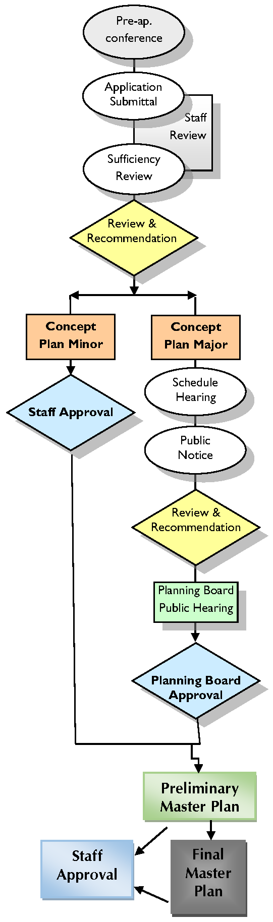
Project Planning Session
i.
All applicants seeking Planned Development approval shall schedule a project planning session with the Planning Director in accordance with Section 3.1.7. The Project Planning Session provides the project team (e.g., developer, contractor, land planner, engineer, realtor, etc.) the opportunity to discuss proposed uses, development intensity, general layout, unique site conditions, etc. on a conceptual level with County staff. In addition to Planning, other County departments attend the session to address utilities, stormwater, building code, etc. depending on the project scope. The intent is to provide an informal, non-binding exchange of information to determine the design approach that best matches the specific needs and characteristics of the project.
ii.
Following the Project Planning Session, the applicant will prepare a Concept Plan of the entire Planned Development as outlined in Section 3.3.3.B.5.ii. The applicant, at their option, may submit a Preliminary Master Plan consisting of a preliminary site plan and preliminary utilities plan as outlined in Section 3.3.3.B.5.iii.
4.
Neighborhood Meeting
i.
All applicants seeking approval of a Planned Development are encouraged to hold a neighborhood meeting in accordance with Section 9.2, Neighborhood Meeting.
ii.
Applicants seeking approval of modifications, including expansions to an existing Planned Development shall be required to hold a neighborhood meeting.
5.
Application Requirements
i.
General
(a)
An application for Planned Development plan review shall be submitted in accordance with Section 3.1.8, Application Requirements.
(b)
A Traffic Impact Analysis may be required if the proposed site plan meets the thresholds established in Section 6.16, Traffic Impact Analysis.
ii.
Concept Plan
At minimum, the concept plan should contain the following information in schematic form:
(a)
The location and size of the area involved.
(b)
General layout of proposed development including lots, open space/natural areas, recreation areas/amenities, transportation features including access, streets, circulation, pedestrian ways, off-street parking, etc.
(c)
Proposed type, location, density and/or intensity of uses.
(d)
A tabulation of land area to be devoted to various uses and activities, as well as overall densities.
(e)
Identify proposed exceptional design, best management practice elements.
(f)
The current zoning of the surrounding properties.
(g)
Location of existing waterways and other riparian areas, heritage trees and other significant environmental features.
(h)
Reservations for public uses including schools, parks, fire and medical emergency services, and other open spaces.
(i)
The general means of the disposition of sanitary waste and storm water.
(j)
List utility providers (power, water, sewer, internet, etc.).
(k)
If a project is to be developed in phases, a general breakdown showing the various phases and the estimated schedule of construction.
iii.
Preliminary Master Plan
(a)
Preliminary Master Plan must include, at minimum, major thoroughfares, acreage and development type (i.e., residential, commercial, open space) of each phase, vicinity map, density, Flood Zone(s) and proximity of nearest water and/or sewer main.
(b)
All site specific plans shall clearly indicate all required open space with the requirements of Section 6.4.4, Open Space and Recreation Area.
(c)
A heritage tree survey must be submitted in accordance with Section 6.1.3.
(d)
Recommendations and findings listed during the concept stage are preliminary only, subject to modifications as a result of information provided during the Preliminary Master Plan Application Approval process for all or each phase(s) of development.
(e)
The applicant will complete and submit to the Planning Department the Preliminary Master Plan compliance sheet.
(f)
The Preliminary Master Plan will consist of and be labeled, at a minimum: major thoroughfares, cross-section of proposed road type(s), recreational space, golf courses, natural or man-made lakes, setbacks, residential areas (single family, multi-family, townhouses, etc....), vicinity map, drainage and topography, approximate delineation of wetlands (404 jurisdictional wetlands) by Corps of Engineers or certified designee, land dedication for public facilities (i.e., public safety facilities, schools, EMS) and acreage (if applicable), environmentally sensitive areas, north arrow, adjoining land owners, and commercial area. Other relevant information such as the total number of acres within the planned development, and the total number of residential and commercial units or square footage (broken down into various phases and acreage) shall be provided. A proposed timetable of each development phase shall also be provided.
Commentary: Each development phase should also include a timetable of associated site amenities.
(g)
A detailed landscaping plan must be submitted that indicates the location of all required buffers and the minimum number of required plantings, (canopy trees, understory trees, shrubs) that are required in each buffer area.
(h)
The Preliminary Master Plan shall be accompanied with a preliminary utilities plan which consists of size and location of water and/or sewer lines, fire hydrant locations and spacing, estimated fire flows, utility easements / right-of-way, drainage and topography, location and/or type of solid waste disposal containers and shall be approved by the Director of Engineering Services and/or Public Utilities Director.
(i)
A mechanism and/or instrument guaranteeing adequate maintenance and continued operation of all assured open space and other private service facilities shall be submitted as part of the Preliminary Master Plan requirement and then properly recorded upon Planning Board approval of the Preliminary Master Plan. Assured open space and other facilities shall not be dedicated for public purpose or maintenance. However, NCDOT on-system roads within the PD are excluded from this provision.
iv.
Notice and Public Hearings
The County shall hold all required public hearings and give notice in accordance with Section 9.1, Notice and Public Hearings.
6.
Approval Authority
i.
Approval authority for the Concept Plan shall be as for Minor and Major Site Plan approval.
ii.
The Planning Director shall have approval authority for the Preliminary Master Plan and the Final Master Plan, including projects meeting the criteria of a Major Site Plan where there are no significant modifications to the approved Concept Plan are required.
iii.
Preliminary Master Plans or Final Master Plans meeting Major Site Plan criteria which differ significantly from the Conceptual Plan approval by the Planning Board shall require Planning Board review and approval.
7.
General Provisions
Planned Developments shall be in conformance with all provisions of this Ordinance except for the following development standards:
i.
Approval of uses within a PD shall be limited to the mix of uses permitted in the base zoning district and uses allowed in the C-LD and NC District.
ii.
Business Park uses (Section 5.1.6.H) may be permitted within a PD subject to approval by the Planning Board. Decisions by the Planning Board regarding the inclusion of Business Park uses in a PD shall be based on considerations including, but not limited to, the type of proposed uses, size of the proposed operations in relation to the overall development, the character and nature of surrounding area.
iii.
PDs shall provide stormwater drainage systems in accordance with the County Stormwater Ordinance and the Flood Damage Prevention standards found in Article 7.
iv.
Electrical, telephone and cable shall be underground. A written statement by the utility company authorized to provide electrical service to the PD stating their commitment to install electric utilities may be accepted in lieu of installation of the electrical service facilities.
8.
Action by Planning Director
i.
Concept Plan
The Planning Director shall approve or deny Concept Plans meeting the Minor Site Plan criteria. In rendering a decision, the Planning Director may consult with the Technical Review Committee and/or any County or state official if the need arises. Final action on a Concept Plan shall be taken within 45 days of receipt of a completed application. Incomplete applications shall not be considered. One extension of 45 days may be obtained by submitting a written notice to the applicant. If final action is not taken within the required time, the Concept Plan shall be considered to be approved.
ii.
Preliminary Master Plan
(a)
Upon receipt of a completed Preliminary Master Plan application, the Planning Director shall undertake a preliminary review of the application.
(b)
Once the Planning Director completes preliminary review of the Preliminary Master Plan, the owner/applicant will then be required to present 15 copies and an electronic version of the Master Plan to the Planning and Community Development Department for review by the Technical Review Committee (TRC), according to the published schedule of the TRC meetings.
9.
Action by the Technical Review Committee
Upon receipt of a Preliminary Master Plan application from the Planning Director, the TRC will hold a joint meeting between the respective County departments and applicant/agent to review both the Preliminary Master Plan, including preliminary utilities plan.
i.
The Planning Director shall prepare a staff report based on the comments provided by staff and the Technical Review Committee. The report and recommendations shall be forwarded to the Planning Board for final action. The Planning Director shall schedule the Preliminary Master Plan on the next available Planning Board agenda.
ii.
The Planning Director will then inform the applicant/agent when they will appear on the Planning Board agenda for action on the Preliminary Master Plan application. The applicant will then be required to submit 18 copies of the Preliminary Plan for Planning Board review.
10.
Final Master Plan Approval
i.
The Planned Development may be completed at once or in phases. It is the responsibility of the applicant or owner to present Final Master Plans (in accordance with the approved Preliminary Master Plan) of each phase prior to development of the phase.
ii.
The Final Master Plan shall be submitted to the Planning Director for approval. Streets, utilities, and drainage will be reviewed and approved by the Director of Engineering Services and shall conform with Master Plan (preliminary utility plans) according to Section 3.3.3.B.5.iii above. If utility changes are proposed in the Final Master Plan, said changes shall be reviewed and approved by the Director of Engineering Services and/or Public Utilities Director. The applicant/agent will be presented with a PD compliance sheet to assist with the completing of the Final Master Plan in a more accurate and efficient manner.
11.
Final Master Plan Requirements
If the proposed Planned Development is to be completed in one initial phase, the applicant/owner may submit a Final Master Plan that contains all of the following mentioned elements of the Final Master Plan. The Final Master Plans are in more detail and must contain or provide evidence of the following information:
i.
North point, full right-of-way of all abutting and intersecting streets, including curbs, and center line.
ii.
Scale, date, and legal description of the proposed site;
iii.
Location, dimensions and use of existing and proposed structures and parking areas;
iv.
Location and dimensions of proposed boundaries, setback lines and required buffers, and easements, open space and recreational areas;
v.
All site specific plans shall clearly indicate all required open space and/or recreation area that has been dedicated or reserved to conform with the requirements of Section 6.4.4, Open Space and Recreation Area;
vi.
Landscaping, irrigation and sedimentation control plans (including location, types, and quantities of all required plantings);
vii.
Site data breakdowns in square footage for building coverage, paved areas, green areas, lake areas, commercial structures and the gross site area;
viii.
Specific identification of the size, number, and type of proposed units and offices, commercial, total acreage, total dwelling units and total density per acre;
ix.
Type and/or location of trash containers;
x.
Elevations of building types, proposed walls, fences and bridges;
xi.
Evidence of all Federal and State approvals including approved wetlands delineation (404 jurisdictional wetlands);
xii.
Construction plans showing proposed location and size of streets, sidewalks, trafficways, location of spacing of fire hydrants or other emergency facilities, fire flow ratings, sanitary sewers, water mains, culverts, retention ponds, drainage structures and other utilities. These plans shall include the existing location and size of the nearest street(s), sidewalk(s), sanitary sewer main(s), water main(s), drainage culvert(s) in which this Final Master Plan will be tied to. These plans shall be approved by the Director of Engineering Services and/or Public Utilities Director, according to the County's Utility Policy;
xiii.
Each phase of a multi-phase PD shall be developed in acreage in accordance with Master Plan approval.
12.
Planning Director Review and Approval
i.
The Planning Director shall review the Final Master Plan application to ensure that all required elements are met.
ii.
Land dedicated to and accepted by the County for the construction of public facilities (i.e., schools, parks, public safety facilities, etc.) must be noted and shown on the Final Master Plan.
iii.
Once the Final Master Plans have been received and reviewed by the appropriate County departments and the applicant has met all of the required elements of this Ordinance and any other applicable regulations, and density requirements, the Planning Director shall issue a final approval of the Final Master Plan so that the applicant or owner may begin the process of having the proposed Final Master Plan recorded.
iv.
If any modifications are made to the Final Master Plan, the Planning Director will follow the specific conditions specified in Section 3.3.3. B.15, Amendments to Preliminary Master Plan and/or Final Master Plan.
v.
The applicant or owner shall complete these steps each time a new phase of a PD is to be developed.
13.
Action by the Planning Board
Conceptual Plans meeting the Major Site Plan criteria shall be submitted to the Planning Board along with the Planning Director's and the TRC's recommendation for review and approval. The Planning Board may approve, or approve with conditions, or deny a Conceptual Plan, as well as preliminary Master or Final Master Plans that differ significantly from Conceptual Plans approved by the Planning Board. The Planning may also send such plans back to the Planning Director for additional consideration.
14.
Recordation of Final Master Plan
i.
A survey on reproducible medium that is consistent with the Approved Final Master Plan with the appropriate information (including all applicable notes) will then be submitted so that the applicant or owner can record the plat with the Brunswick County Register of Deeds.
ii.
Except as provided in Section 3.1.5.C., all required improvements must be installed and approved by the applicable County or outside agencies prior to recordation of the final master plan.
15.
Amendments to Preliminary Master Plans and/or Final Master Plans
Any and all amendments to the Preliminary Master Plan and/or Final Master Plans for the PD shall be subject to the following review procedures:
i.
Planning Director shall have the authority to approve:
(a)
Changes which result in a decrease in assigned density for a specific parcel, either residential or non-residential.
(b)
Change in land use designation from multi-family to single-family or a change from any other use to open space/passive recreation.
(c)
Change in major infrastructure features (i.e., roads/access, sewer, water, storm drainage) of the Master Plan area which are clearly beneficial to the occupants of the Master Plan area. The applicant requesting such change shall notify the property owners association that would be affected by the change of the request and ask that all comments be directed to the Planning Director. Proof of such notification shall be provided to the Planning Director. If the proposed changes affect the construction of roadways, water, sewer and/or stormwater infrastructure, the Planning Director shall notify the Director of Engineering Services of such changes. The Director of Engineering Services and/or Public Utilities Director shall review and approve said changes. If the Planning Director determines that the change does not have the support of the affected property owners association, the request may be referred to the Planning Board for review.
(d)
Change in approved land use designations and to less intense use(s) [example: from a fast food restaurant to retail or office].
(e)
Change in land use designation from any use to allow the addition of governmental or quasi-governmental facilities such as schools (not including day care); fire stations, police stations, or other emergency management service facilities.
ii.
Planning Board approval is required for the following:
(a)
Change in major infrastructure features (i.e. roads/access, sewer, water, storm drainage) of the Master Plan area for a request which has been referred to the Planning Board by the Planning Director.
(b)
Change in Land Use Designation to increase density for an approved Concept Plan, Master Plan and/or Final Master Plan.
(c)
Any other change not specifically outline in Section 3.3.3.B.15.i.
16.
Dedication and Improvements
i.
In the development of any property for which PD approval is required, the applicant shall be required to dedicate any additional right-of-way necessary to the width required by the State for streets adjoining the property, to install curbs and gutters and pave all streets adjoining the property to NCDOT standards, and to install sidewalks in accordance with and requirements of Article 6.
ii.
The applicant shall bear the costs of the installation of all on-site and off-site improvements as required by this Ordinance, including provision for surface drainage, pavement, landscaping, and utilities.
iii.
Required improvements shall be installed and approved prior to the recordation of the approved final master plan.
iv.
Inspections of Required Improvements
(a)
Inspections during the installation of site improvements shall be made by the entity responsible for such improvements as required to certify compliance with approved PD plans. No improvements shall be accepted for maintenance by the County unless and until the requirements regarding public improvements have been met.
17.
Building Permit/Certificate of Occupancy
No building permit or certificate of occupancy shall be issued until the required PD of the proposed use or development has been approved by the appropriate County officials and all required improvements are installed and approved, except for up to two model units as provided in Section 3.4.1.C.
(Ord. No. UDO-16-02 , §§ 1, 3—6, 3-7-16; Ord. of UDO-17-01 , §§ 1, 3)
3.4 - SUBDIVISION APPROVAL
3.4.1. Activities Eligible for Waiver
The Planning Director may grant a waiver exempting any of the following activities from the requirement for Subdivision review and approval. However, Planning Director certification of exempt status must be indicated prominently on the approved plat so that it may be recorded with the Register of Deeds.
A.
The combination or recombination of portions of previously subdivided and recorded lots where the total number of lots is not increased and the resulting lots are equal to or exceed the standards of this Ordinance;
Commentary: An accompanying recordable instrument of combination is recommended.
B.
The division of land into parcels greater than ten acres where no street right-of-way dedication is involved;
Commentary: This means that each resulting parcel (including the original parcel) has to be at least 10 acres.
C.
The public acquisition by purchase of strips of land for water or sewer infrastructure;
D.
The public acquisition by purchase of strips of land for the widening or opening of streets;
E.
Utility easements and utility lease agreements;
F.
Cemeteries and individual cemetery plot(s) may be platted and recorded that do not meet the minimum lot size of the zoning district; however, the cemetery shall comply with all other zoning district restrictions. Where there is no reasonable access, an 18 foot easement for ingress and egress may be established.
G.
The division of a tract in single ownership whose entire area is no greater that two acres into not more than three lots, where no street right-of-way dedication is involved and where the resultant lots are equal to or exceed the standards of this Ordinance;
H.
Subdivision activity for transfer to a family member (family member transfer) provided that no more than ten lots are created. The following standards shall apply:
1.
Connections to public water and/or sewer may be required.
2.
For family member transfers, an access easement at least 45 feet in width shall provide access to lots created on the interior of the site from a public roadway.
3.
The following Statement shall appear on the plat and be signed by the Grantor(s) and Grantee(s) prior to approval:
The Grantor(s) and Grantee(s) certify that the Grantee(s) is within four (4) degrees of collateral kinship to the Grantor(s), and that the purpose of this waiver is not to circumvent the provisions of the Brunswick County Unified Development Ordinance (effective May 1, 2007), and that none of the lots shall be conveyed to non-family members for a period of not less than one (1) year.
THE PROPOSED STREET(S) WILL NOT BE MAINTAINED BY BRUNSWICK COUNTY AND THE MAINTENANCE SHALL BE THE RESPONSIBILITY OF ALL ADJACENT PROPERTY OWNERS TO SAID STREET(S).
4.
If the number of lots created (including original parcel) is at least six (6) and no more than ten (10) lots, a road maintenance agreement shall be presented with the plat and prepared for recordation.
5.
Failure of any person to comply with the provisions of Paragraph H.3 above shall be in violation of this Ordinance, and all of the remedies available in N.C.G.S. 160D-804 shall apply.
I.
Subdivision activity resulting for Court Activity.
1.
Connections to public water and/or sewer may be required.
2.
An access easement shall be provided with sufficient width to comply with the court order.
3.
The division of a tract into parcels in accordance with the terms of a probated will or in accordance with intestate succession under Chapter 29 of the General Statutes as specified in N.C.G.S. 160D-802.
(Ord. No. UDO-19-02 , § 10, 9-19-19; Ord. No. UDO-21-01 , §§ 6, 7, 5-17-21)
3.4.2. No Subdivision without Plat Approval
Pursuant to N.C.G.S. 160D-801, a final plat shall be prepared, approved, and recorded pursuant to the provisions of this Ordinance whenever any subdivision of land takes place in Brunswick County.
A.
No person may subdivide land except in accordance with all of the provisions of this Ordinance. In particular, no subdivision may occur unless and until a final plat of the subdivision has been approved in accordance with the provisions of this section and recorded by the Brunswick County Register of Deeds.
B.
The Brunswick County Register of Deeds shall not record a plat of any subdivision within the County's planning jurisdiction unless the plat has been approved in accordance with the provisions of this Ordinance.
C.
Not all divisions of land constitute subdivisions that are subject to regulation under this Ordinance. However, to ensure that such divisions are in fact exempt from the requirements of this Ordinance, all plats creating a division of land shall be presented to the Planning Department before recordation in the Brunswick County Registry and the Planning Director shall indicate on the face of the plat that the division is exempt from the provisions of this Ordinance if that is the case.
( Ord. No. UDO-21-01 , § 8, 5-17-21)
3.4.3. Unlawful to Record Plat without Plat Approval
Pursuant to N.C.G.S. 160D-803, no final plat of a subdivision within the jurisdiction of Brunswick County shall be recorded by the Register of Deeds of Brunswick County until it has been approved by the Planning Director or designee or by the County Planning Board pursuant to the procedures established in this Section.
( Ord. No. UDO-21-01 , § 9, 5-17-21)
3.4.4. Subdivision Required
As of March, 2015, any person who, being the owner or agent of the owner of land located within the territorial jurisdiction of this Ordinance, thereafter subdivides his land in violation of this Ordinance or transfers or sells land by reference to, exhibition of, or any other use of a plat showing a subdivision of the land before the plat has been properly approved under the terms of this Ordinance shall be guilty of a misdemeanor. The description of metes and bounds in the instrument of transfer or other document used in the process of selling or transferring land shall not exempt the transaction from this penalty. The County, through its attorney or other official designated by the Board of Commissioners, may enjoin illegal subdivision, transfer, or sale of land by action for injunction. Further, the violation of any provision of this Ordinance shall subject the offender to the penalties prescribed by N.C.G.S. 160D-807.
( Ord. No. UDO-21-01 , § 10, 5-17-21)
3.4.5. Delegation of Authority
The Board of County Commissioners shall delegate review and approval authority for all minor plats and final plats to the Planning Director, with review by the Technical Review Committee.
3.4.6. Definitions
A.
Minor Subdivision
A minor subdivision is any subdivision activity that creates no more than ten lots (including the original lot). Certain subdivision activities may be eligible for a waiver (see Section 3.4.1).
B.
Major Subdivision
All other divisions of land not exempted in Section 3.4.1, Activities Eligible for Waiver, or listed in paragraph 3.4.6.A, above shall be considered major subdivisions.
3.4.7. Project Planning Session and Sketch Plan
A.
All applicants seeking subdivision approval shall schedule a project planning session with the Planning Director, in accordance with Section 3.1.7.
B.
At the time of the project planning session, applicants shall submit a sketch plan for review by the Planning Director. This plan should, in simple sketch form, show the proposed layout of streets, lots and other features in relation to existing conditions.
(Ord. No. UDO-16-02 , § 1, 3-7-16)
3.4.8. Application Requirements
A.
All applications for subdivision review shall be submitted in accordance with Section 3.1.8, Application Requirements and any specific requirements listed in Appendix A. In addition, all applications for major subdivision shall submit electronic versions of surveyor's files for both preliminary plat and final plat. Files shall be in the North Carolina State Plane, NAD 1983, feet coordinate system and may be in ".shp", ".dwg", or ".dxf" format.
B.
A Traffic Impact Analysis may be required if the proposed subdivision meets the thresholds established in Section 6.16, Traffic Impact Analysis.
C.
All preliminary and final plats shall clearly indicate all required open space and/or recreation area that has been dedicated or reserved to conform with the requirements of Section 6.4.4, Open Space and Recreation Area.
D.
When berms are planned to be installed within required buffers, storm drainage plans submitted with the application shall be designed to anticipate a 100-year storm event.
Commentary: Berms can dramatically alter the drainage patterns in an area, and result in significant flooding both within a development and in areas abutting a development. Therefore, it is important to understand any potential impacts.
3.4.9. Notice and Public Hearings
The County shall hold all required public hearings and give notice in accordance with Section 9.1, Notice and Public Hearings.
3.4.10. Minor Plat Approval
A.
Applicability
1.
Minor plat approval shall apply only to minor subdivisions as defined in paragraph 3.4.6.A above.
2.
The procedures for approval of minor subdivisions are intended to simplify processing of routine small subdivisions with due regard to protection of the public interest. The primary difference between the minor and major subdivision processes is that minor subdivisions are approved administratively. For routine minor subdivisions, a preliminary plat is not necessary and only the final plat is required; however, a more detailed preliminary plat may be required for project where the layout, utilities, or other elements are more complex. Preliminary plats for minor subdivisions, when required, shall be approved administratively.
3.
There shall be only one minor subdivision approved on any original tax parcel in any three-year period.
4.
After completion of a project planning session and sketch plan review, the applicant may apply directly for approval of a final plat for routine developments.
5.
A minor subdivision plat shall only be approved when it meets all of the approval criteria in paragraph 3.4.11, below.
B.
Procedure
1.
Staff Consultation
i.
Applicants petitioning for minor subdivision plat approval shall meet with the Planning Director and submit a sketch plan in accordance with paragraph 3.4.7 above for a determination of whether the approval process authorized by this Section can be used.
ii.
The Planning Director may require the applicant to submit whatever information is necessary to make this determination, including, but not limited to, a copy of the tax map showing the land being subdivided and all lots created out of that tract of land within the previous five years.
2.
Action by Planning Director
i.
The Planning Director may refer the minor plat application to Engineering Services for consideration and recommendation. Engineering Services shall provide comments to the Planning Director on the application.
ii.
Following Engineering Services review, the Planning Director may approve or deny the application. Reasons for decision shall be transmitted in writing to the applicant.
C.
Final Plat
A final plat for a minor subdivision shall be approved in accordance with paragraph 3.4.12, below.
(Ord. No. UDO-16-02 , § 1, 3-7-16)
3.4.11. Preliminary Plat Approval
A.
Applicability
A preliminary plat shall be required for all subdivisions that do not meet the definition of a minor subdivision set forth in paragraph 3.4.6.A above; or minor subdivisions that are determined to be sufficiently complex to necessitate a preliminary plat.
B.
Staff Consultation
Prior to submitting a preliminary plat, the applicant shall meet with the Planning Director and submit a sketch plan in accordance with paragraph 3.4.7 above.
C.
Application Requirements
1.
Applications for preliminary plat approval shall be submitted in conformance with Section 3.1.8, Application Requirements, and specific requirements for Major Subdivision-Preliminary Plat Applications which may be found in the Appendix.
2.
When a subdivision is to be developed in stages, a master plan shall be submitted for the entire development and a preliminary plat shall be submitted for each individual stage. A final plat is submitted for individual stages as each stage is developed.
3.
An approximate delineation of wetlands at preliminary plat stage and surveyed delineation of Federally regulated wetlands at final plat stage are required in major subdivisions.
D.
Action by Planning Director
1.
Applications for preliminary plat approval shall be submitted to the Planning Director.
2.
Upon receipt of a completed application, the Planning Director shall distribute the application to the Technical Review Committee for review and comment (see Subsection E., below).
3.
The Planning Director shall prepare a staff report based on the comments provided by the Technical Review Committee. The report and Planning Director's recommendation shall be forwarded to the Planning Board for final action at the next available public hearing.
4.
The Planning Director shall provide notice of the hearing as required in Section 9.1, Notice and Public Hearings.
5.
The applicant may appeal an application to the Planning Board if final administrative review and recommendation has not been completed by the expiration of the revised application review period.
E.
Action by Technical Review Committee
1.
The Technical Review Committee shall review the preliminary plat and associated application documents for conformance with the requirements of this Ordinance in accordance with the published review schedule.
2.
Upon completion of the review period, the Technical Review Committee shall provide written comments to the applicant stating any corrections or modifications that may be required.
3.
The Technical Review Committee may meet with the applicant and discuss any modifications or corrections in development design that may be required, based on the recommendations made by members of the Technical Review Committee.
4.
The applicant shall have 30 days to make corrections and return the revised application to the Planning Director. The applicant may apply for an extension of this review period by written request to the Planning Director, provided that such request shall be received prior to the expiration of the 30-day period.
5.
Within ten business days of receipt of a revised application, the Technical Review Committee shall review the revised application for satisfactory completion of all required corrections and shall make a recommendation to approve, approve with conditions, or deny the application. The application and associated comments shall then be returned to the Planning Director.
F.
Action by Planning Board
1.
The Planning Board shall take final action on the preliminary plat application after review and recommendation by the Planning Director and Technical Review Committee. Applications that have not received final administrative review and recommendation shall be deemed recommended for denial.
2.
The preliminary plat shall be considered by the Planning Board at the next available hearing.
3.
The Planning Board may approve the preliminary plat, approve the preliminary plat with conditions, deny the preliminary plat, or return the preliminary plat to the Planning Director for additional consideration.
4.
A simple majority of all eligible voting members of the Planning Board shall be necessary for approval of any preliminary plat. The Planning Board's minutes shall include identification of each member present on their vote on the preliminary plat. No final action shall be deemed to have been given by the Planning Board on the preliminary plat until the Planning Board's written decision on the preliminary plat is delivered to the applicant by the County.
5.
If the Planning Board should deny the preliminary plat, the reasons for such action shall be given to the subdivider, or their agent along with recommendations for changes in the plat.
G.
Effect of Preliminary Plat Approval
1.
Approval of a preliminary subdivision plat shall not constitute approval of the final subdivision plat, nor shall it constitute approval of portions of a subdivision to be developed in future phases or stages that have not been reviewed in conformance with this Section. Application for approval of the final (recorded) plat (see Section 3.4.12.C, below) will be considered only after the requirements for final plat approval as specified below have been fulfilled and after all other specified conditions have been met.
2.
Upon approval of the preliminary subdivision plat, the subdivider may proceed to comply with the other requirements of these regulations, including construction plan approval, preparation of the final subdivision plat, and all other required approvals and permits.
H.
Duration of Preliminary Plat Validity
1.
A preliminary plat shall remain valid for a period of three years. Modifications or amendments to an approved plan do not extend the period of validity unless specifically provided by the Planning Board upon approval of the modification and or amendment.
2.
The Planning Board may approve an extension of a preliminary plat for a period of two years resulting in a total validity period of five years. Applications to extend preliminary plat validity shall be considered by the same authority that approved the original plat.
I.
Modifications to an Approved Preliminary Plat
1.
Limited changes to an approved preliminary plat may be approved by the Planning Director administratively. In granting such approval, the Planning Director may consult with the Technical Review Committee. Administrative approval of limited modifications shall not have the effect of extending the period of preliminary plat validity.
2.
Significant changes to an approved preliminary plat shall be resubmitted for review and approval as a new application.
3.4.12. Final Plat Approval
A.
Applicability
1.
A final plat shall be required for all subdivision of land in the planning jurisdiction of Brunswick County.
2.
The final plat shall constitute only that portion of the approved preliminary plat (if required) that the subdivider proposes to record and develop at the time of submission. After the improvements shown on the approved preliminary plat have been installed, or guaranteed, for the whole or portion of a subdivision, the applicant shall submit a final plat of the area covered by such improvements.
B.
Conformance with Preliminary Plat
The final plat shall conform to the approved preliminary plat, as revised, and may constitute only that portion of the preliminary plat which is proposed for recordation.
C.
Application Requirements
1.
All applications for final plat approval shall be submitted in accordance with Section 3.1.8, Application Requirements and any specific requirements provided by the Planning Director.
2.
The final plat shall be prepared by a land surveyor licensed to practice in North Carolina, and such registration shall be indicated on the final plat. All final plats to be recorded by the Brunswick County Register of Deeds shall be probated and shall conform to the provisions for plats, subdivisions, and mapping requirements set forth in G.S. 47-30 as amended, and the Standards of Practice for Land Surveying in North Carolina.
D.
Provision of Improvement Guarantees
Provisions of sureties in lieu of required improvements is limited to minor improvements such as landscaping. Sidewalks do not require an improvement guarantee but must be in place for the specific parcel prior to the issuance of a Certificate of Occupancy for any structure on that parcel. Where the required improvements have not been completed prior to the submission of the final plat, the Director of Engineering Services may accept from the subdivider a financial guarantee with surety or other guarantees satisfactory to the County in an amount equal to 125% of the cost of the installation of the required improvements, whereby improvements may be made and installed without cost to the County in the event of default by the subdivider. One of the methods described in Section 3.4.14, Improvement Guarantees, shall be used by the subdivider to guarantee the installation of said improvements.
E.
Action by the Planning Director
1.
Upon receipt of a completed application, the Planning Director shall review the application for conformance with the applicable approval criteria listed in paragraph I below. In performing such review, the Planning Director may consult with the Technical Review Committee or other applicable review entities. The Planning Director shall take final action within 30 days. However, this time period may be extended upon written request to the applicant if the Director finds that extensive corrections are necessary.
2.
If the final plat for a subdivision is in compliance with the applicable approval criteria listed in paragraph I below, the Planning Director shall approve the final plat. This approval, and all other required endorsements (see F, below) shall be noted on the original and one copy of the final plat. The original shall be returned to the subdivider. The approval shall grant the subdivider authority to record the subdivision plat and to begin the sale of lots.
3.
If the final plat is not in compliance, the reasons for disapproval and conditions to be met before approval of the final plat shall be noted on two copies of the proposed final plat. One copy shall be returned to the subdivider and one copy shall be retained for the Planning Board's records.
F.
Required Endorsements
The following endorsements shall be prominently located on all copies of an approved final plat:
1.
Certificate of Survey and Accuracy;
2.
Brunswick County Plat Review Officer's Certificate;
3.
When required by the federal government, all final plats shall contain a Certificate for a Federally Funded Project; and
4.
A listing with examples of additional certifications is provided in Appendix C.
G.
Appeal
1.
The applicant may appeal Planning Director action on a final plat to the Planning Board in accordance with Section 9.8, Appeal of Administrative Decision. The applicant shall notify the Planning Director in writing of his/her intent to appeal, within ten days of the denial. The Planning Director shall place the appeal on the next available Planning Board agenda.
2.
If the final plat is denied by the Planning Board, the applicant may appeal to the Board of Commissioners. Any appeal to the Board of Commissioners must be taken within 30 days after the decision of the Planning Board is filed in the Planning office, or after a written copy of the decision is mailed to the appellant by registered mail return receipt requested, whichever is later. Such appeal shall be for the Board of Commissioners to determine if the Planning Board correctly applied the subdivision ordinance to the subdivision request.
H.
Effect of Denial
The subdivider shall have six months from the time of final notification of denial by the Planning Board to submit a revised final plat. If the revised final plat is not received by the planning staff within six months, the approved preliminary plat shall be null and void.
I.
Final Plat Approval Criteria
1.
Minor Subdivision
Minor subdivision plats shall be approved only when the Planning Director, after Technical Review Committee review, finds that all of the following conditions exist:
i.
The plat complies with the standards of Article 8, Subdivision Standards, and any other applicable requirements of this Ordinance;
ii.
The plat indicates that all subject lots will have frontage on existing approved streets; or an access for ingress and egress is created in conformance with Section 6.11.5.B.i, Private Roads;
iii.
New or residual parcels conform to the requirements of this Ordinance and other applicable regulations;
iv.
The proposed subdivision will not adversely effect permissible development of the remainder of the parcel or of adjoining property;
v.
All necessary drainage easements have been provided; and
vi.
All required endorsements and certifications have been obtained.
2.
Major Subdivision
Major subdivision plats shall be approved only when the Planning Director, upon Technical Review Committee recommendation, finds that all of the following conditions exist:
i.
The plat substantially complies with the approved preliminary plat;
ii.
The plat complies with the standards of Article 6 and the other applicable requirements of this Ordinance;
iii.
New and residual parcels will conform to the requirements of this Ordinance and other applicable regulations;
iv.
The proposed subdivision will not adversely affect permissible development of the remainder of the parcel or of adjoining property;
v.
All necessary right-of-way has been offered for reservation or dedication;
vi.
All necessary drainage easements have been provided; and
vii.
All required endorsements and certifications have been obtained.
J.
Expiration of Final Plat Approval/Recordation Required
1.
Approved final plats shall be recorded with the Brunswick County Register of Deeds within six months from the date of approval.
2.
If the final plat is not recorded within this period, it shall expire. The plat may be resubmitted for review and it shall be reviewed against the ordinance in effect at that time.
K.
Limitations of Final Plat Approval
The approval of a final plat pursuant to regulations adopted under this article shall not constitute or affect the acceptance by the County or the public of the dedication of any street or other ground, public utility line, or other public facility shown on the plat. Public roads must be accepted by the North Carolina Department of Transportation.
L.
Resubdivision Procedures
For any replatting or resubdivision of land, the same procedures, rules, and regulations shall apply as prescribed herein for an original subdivision submittal.
(Ord. No. UDO-16-01 , § 2, 1-19-16; Ord. No. UDO-16-02 , § 32, 3-7-16; Ord. No. UDO-19-01 , 5-20-19)
3.4.13. Development Agreements
Development Agreements may be considered as specified in N.C.G.S. 160D-1001 in accordance with the following minimum criteria:
A.
The property must have at least 25 developable acres (excluding wetlands, unbuildable slopes, etc.).
B.
The Development Agreements shall be limited to a term not exceeding 20 years.
C.
Development Agreements are subject to public hearing procedures set forth in N.C.G.S. 160D-601 and must be adopted by the Brunswick County Board of Commissioners.
D.
Development Agreements are binding and must be recorded at the Brunswick County Register of Deeds. Once executed, the agreement shall run with the property, never the person or corporation.
E.
Development Plan Agreements proposed in conjunction with issuance of Building Permits as specified in Sections 3.1.3.A and 3.1.5.C.2 shall be subject to approval by the County Attorney.
( Ord. No. UDO-21-01 , § 11, 5-17-21)
3.4.14. Improvement Guarantees
A.
Agreement and Security Required
In lieu of requiring the completion, installation, and dedication of all improvements prior to final plat approval, the County may enter into an agreement with the subdivider whereby the subdivider shall agree to complete all required improvements. Such agreement shall be limited to minor improvements such as required landscaping. Sidewalks do not require an improvement guarantee but must be in place for the specific parcel prior to the issuance of a Certificate of Occupancy for any structure on that parcel. This agreement shall be accompanied by a survey plat indicating the property boundaries and lot lines (if applicable) of the area subject to the agreement. Once said agreement is signed by both parties and the security required herein is provided, the final plat may be approved by the Planning Director, if all other requirements of this Ordinance are met. To secure this agreement, the subdivider shall provide, subject to the approval of the Director of Engineering Services, either one or a combination of the following guarantees equal to 125% of the entire cost as provided herein:
1.
Surety Performance Bond
The subdivider shall obtain a performance bond from a surety financial guarantee company authorized to do business in North Carolina. The financial guarantees shall be payable to Brunswick County and shall be equal to, either alone or in combination with any other surety discussed in this section, to a total amount equal to 125% of the entire cost, as estimated by the subdivider and approved by the Director of Engineering Services, of installing all required improvements, with the exception of electric utilities. The duration of the financial guarantee(s) shall be until such time as the improvements are accepted by the County of Brunswick.
2.
Letter of Credit or Cash Security
The subdivider shall deposit an irrevocable letter of credit or other instrument readily convertible into cash at face value, either with the County or in escrow with a financial institution designated as an official depository of the County. The amount of the deposit shall be equal to, either alone or in combination with any other security discussed in this section, to a total amount equal to 125% of the cost, as estimated by the subdivider and approved by the Director of Engineering Services of installing all required improvements, with the exception of electric utilities. If cash or other instrument is deposited in escrow with a financial institution as provided above, then the subdivider shall file with the Director of Engineering Services an agreement between the financial institution and himself guaranteeing the following:
i.
That said escrow account shall be held in trust until released by the County and may not be used or pledged by the subdivider in any other matter during the term of the escrow; and
ii.
That in the case of failure on the part of the subdivider to complete said improvements the financial institution shall, upon notification by the County and submission by the County to the financial institution of an engineer's estimate of the amount needed to complete the improvements, immediately either pay to the County the funds estimated to complete the improvements, up to the full balance of the escrow account, or deliver to the County any other instruments fully endorsed or otherwise made payable in full to the County.
B.
Default
Upon default, meaning failure on the part of the subdivider to complete the required improvements in a timely manner as spelled out in the performance financial guarantee or escrow agreement, then the surety, or the financial institution holding the escrow account shall pay all or any portion of the financial guarantee or escrow fund to Brunswick County up to the amount needed to complete the improvements based on an engineering estimate. Upon payment, the County may expend such portion of said funds as it deems necessary to complete all or any portion of the required improvements.
C.
Release of Guarantee Security
1.
The Director of Engineering Services may release a portion of any security posted as the improvements are completed.
2.
In the event that the applicant wishes to occupy any building or any portion of any building prior to the completion of the required site improvements, the financial guarantee guaranteeing improvements shall be retained by the County until the remaining required improvements are completed.
(Ord. No. UDO-16-01 , § 3, 1-19-16; Ord. No. UDO-16-02 , § 33, 3-7-16; Ord. No. UDO-19-01 , 5-20-19; Ord. No. UDO-19-02 , § 11, 9-19-19)
NOTE: Example agreements are provided in Appendix D.
3.5 - SPECIAL USE PERMIT
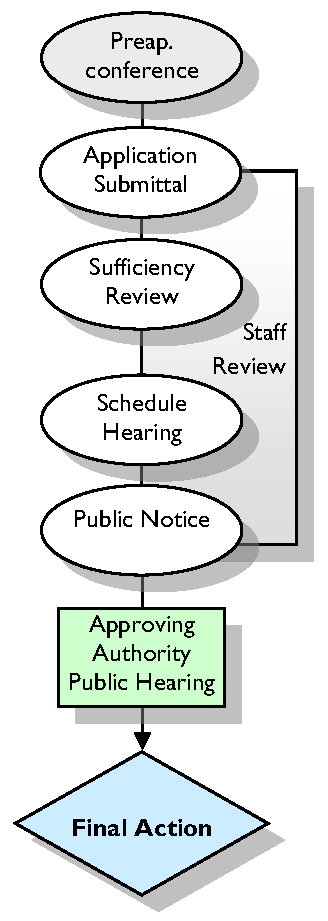
As specified in N.C.G.S. 160D-705, the Zoning Board of Adjustment may grant permits for special use permits for uses indicated as permissible with approval of a Special Use Permit.
( Ord. No. UDO-21-01 , § 12, 5-17-21)
3.5.1. Applicability
A.
Special uses within the zoning districts are considered to be uses which are appropriate in a particular zoning district but because of their potential for incompatibility with neighboring uses may require individual review.
B.
A Special Use Permit shall be required as set forth in the use table in Section 5.2, Use Table.
3.5.2. Approving Authority
Special Use Permits shall be considered by the Board of Adjustment only, no Planning Board items, as set forth in the use table in Section 5.2. For purposes of this section, the term "approving authority" shall refer to the Board of Adjustment.
3.5.3. Project Planning Session
All applicants applying for a Special Use Permit shall schedule a project planning session in accordance with Section 3.5.
(Ord. No. UDO-16-02 , § 1, 3-7-16)
3.5.4. Neighborhood Meeting
The applicant is encouraged to hold a neighborhood meeting in conformance with Section 9.2.
3.5.5. Application Requirements
All applications for Special Use permits shall be submitted in accordance with Section 3.1.8, Application Requirements.
3.5.6. Notice and Public Hearings
Once the application has been determined complete, the Zoning Administrator shall schedule a public hearing and give public notice as set forth in Section 9.1.
3.5.7. Action by the Zoning Administrator
The Zoning Administrator shall prepare a report that reviews the Special Use permit in light of any requirements of this Ordinance. A copy shall be provided to the approving authority and the applicant.
3.5.8. Approval of a Special Use Permit
A.
Prior to scheduling the public hearing on the Special Use permit, the corresponding site plan shall be ready for action by the approving authority.
B.
After conducting the public hearing, and hearing the recommendations of the Zoning Administrator, the approving authority shall:
1.
Approve the request;
2.
Approve the request with conditions;
3.
Deny the request; or
4.
Continue the hearing.
C.
The Board of Adjustment may place conditions on the use as part of the approval to assure that adequate mitigation measures are associated with the use. The conditions shall become a part of the Special Use Permit approval. Verbal consent to the conditions associated with the Special Use Permit must be agreed to by the applicant at the meeting once the Board discusses and decides on the case. Written consent is required from the applicant following the meeting as part of the draft Special Use Permit that is sent to the applicant once the Special Use Permit is approved. Written consent to conditions related to a Special Use Permit must be obtained to ensure enforceability. Violations of any of the conditions shall be treated in the same manner as other violations of this Ordinance.
( Ord. No. UDO-21-01 , § 50, 5-17-21)
3.5.9. Criteria for Special Use Permits
A.
General Findings
Applications for Special Use permits shall be approved only if the approving authority finds that the use as proposed, or the use as proposed with conditions, is:
1.
In harmony with the area and not substantially injurious to the value of properties in the general vicinity;
2.
In conformance with all special requirements applicable to the use;
3.
Will not adversely affect the health or safety of the public; and
4.
Will adequately address the review factors identified below.
B.
Review Factors
The applicant shall demonstrate that the review factors listed below have been adequately addressed. If an application is denied, the approving authority shall specify which of these review factors, if any, were not adequately addressed.
1.
Circulation
Adequacy of easements and rights-of-way. Number and location of access points to the property and the proposed structures and uses, with particular reference to automotive, bicycle, mass transit and pedestrian safety and convenience, traffic flow and control, connections with adjoining uses (connections may be desired or not desired), and access in case of fire or catastrophe.
2.
Parking and Loading
Support facilities such as off-street parking areas and driveways.
3.
Service Entrances and Areas
Locations of refuse and service areas with particular reference to ingress and egress of service vehicles.
4.
Lighting
Locations of exterior lighting with reference to glare, traffic safety, economic effect and compatibility with other property in the area.
5.
Signs
Appropriateness of signs considering location, height, size, and design within the context of other property in the area.
6.
Utilities
Location and availability of utilities.
7.
Open Spaces
Location of required yards and other open spaces and preservation of existing trees and other natural features.
8.
Environmental Protection
Preservation of tree cover, floodplain, stream buffers, wetlands, steep slopes, open space and other natural features, and protection of water quality.
9.
Screening, Buffering and Landscaping
Installation of screening, buffering, fencing and landscaping where necessary to protect adjoining property.
10.
Effect on Adjoining Property
Effects of the proposed use on nearby property, including, but not limited to, the effects of noise, and odor.
11.
Compatibility
The level of general compatibility with nearby properties and the appropriateness of the use in relationship to other properties.
12.
Impacts on Military Installations
In cases of a Special Use permit that would change or affect the list of permitted uses within five miles of a military base, comments and analysis of the base commander shall be included in the consideration before making a final determination (N.C.G.S. 160D-601).
( Ord. No. UDO-21-01 , § 13, 5-17-21)
3.5.10. Effect of Approval
A.
The applicant shall file the approved Special Use with the Brunswick County Register of Deeds prior to review of Final Plats. If a Final Plat is not recorded in the specified timeframe per Section 3.5.15, Expiration, then the Special Use will expire.
B.
All special uses that are granted shall run with the property or structure for which the exception is being sought and not with the owner of the property or structure.
3.5.11. Coordination with Variances
Applications for variances may be submitted concurrently with requests for Special Use permits. However, decisions shall be rendered separately for any variance and the Special Use permit.
3.5.12. Coordination with Rezoning Applications
An application for a special use permit may be reviewed concurrently with a Rezoning application.
( Ord. No. UDO-21-01 , § 14, 5-17-21)
3.5.13. Resubmittals
The Zoning Administrator may allow re-submission of a Special Use application within one year period if it is determined that, since the date of action on the prior application:
A.
There has been a significant change in the zoning district classification of an adjoining piece of property.
B.
The Board of Commissioners has adopted a plan that changes public policy regarding how the property affected by the amendment should be developed.
C.
There has been some other extraordinary change in conditions or circumstances, outside the control of the petitioner, which justifies waiver of the one year restriction on a new position; this, however, shall not include a change in the ownership of the subject property.
3.5.14. Amendments
Alterations or revisions to approved special use permits may be approved by the Zoning Administrator if the Special Use still meets the intent of the standards established with the original approval. Significant modifications to approved special uses, as determined by the Zoning Administrator, shall require submittal of a new application.
( Ord. No. UDO-21-01 , § 15, 5-17-21)
3.5.15. Expiration
A special use permit shall become null and void in any of the following cases:
A.
If a final site plan is not approved within 24 months of the date of permit approval.
B.
If an approved final site plan expires.
C.
If a substantial violation of the conditions of the permit, as determined by the Zoning Administrator occurs. The addition of language to the special use permit regarding such voiding shall not be required.
( Ord. No. UDO-21-01 , § 16, 5-17-21)
3.5.16. Appeal
Appeal from a final action by the approving authority on a Special Use permit may be taken by filing a petition for certiorari with the Brunswick County Superior Court.
3.6 - VARIANCE
3.6.1. Applicability
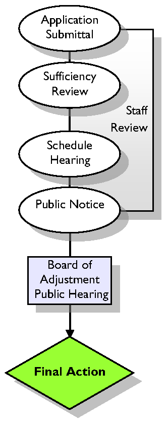
A.
The approving authority may vary certain requirements of this Ordinance, in harmony with the general purpose of these regulations, where special conditions applicable to the property in question would make the strict enforcement of the regulations impractical or result in a hardship in making reasonable use of the property.
B.
The approving authority may waive certain requirements when authorized to do so by provisions adopted as a part of this Ordinance.
C.
No variance shall be permitted that would have the effect of allowing a use not permitted in the use table of Section 5.2.
D.
No variance shall be permitted that would allow a project to exceed the maximum density as to number of dwelling units to the acre in a Zoning District (This maximum density shall be inclusive of any density bonus allowance (see Section 4.3.2) or additional units in a planned development (see Section 4.3.1.C).
E.
The need for the variance cannot be a result of the owner's own actions and cannot be for strictly economic reasons.
F.
The approving authority may grant variances in the following special circumstances, as indicated elsewhere in this Ordinance.
Commentary: Variances may be granted for, among other things, height, structure size, lot dimensions, and setbacks.
3.6.2. Approving Authority
A.
The Planning Board shall be the approving authority for applications for a variance of the regulations of Section 3.4, Subdivision Approval and Section 3.3.3, Planned Development.
Commentary: Stormwater Variance will be in accordance with the Stormwater Ordinance.
B.
The Zoning Board of Adjustment shall be the approving authority for all other requirements.
3.6.3. Project Planning Session
All applicants seeking a variance shall schedule a project planning session with the Zoning Administrator in accordance with Section 3.1.7, Project Planning Session, to discuss the procedures, standards, and regulations required for variance approval.
(Ord. No. UDO-16-02 , § 1, 3-7-16)
3.6.4. Application Requirements
An application for a variance shall be submitted in accordance with Section 3.1.8, Application Requirements.
3.6.5. Notice and Public Hearings
Once the application has been determined complete, the Zoning Administrator shall schedule a public hearing and give public notice as forth in Section 9.1.
3.6.6. Burden of Proof
The applicant seeking the variance shall have the burden of presenting evidence sufficient to allow the approving authority to reach the conclusions set forth below (Findings), as well as the burden of persuasion on those issues.
3.6.7. Findings
A.
In granting any variance, the approving authority shall make the following findings when unnecessary hardships would result from carrying out the strict letter of the ordinance, the Board of Adjustment shall vary any of the provisions of the ordinance upon a showing of all of the following:
1.
Unnecessary hardship would result from the strict application of the ordinance. It shall not be necessary to demonstrate that, in the absence of the variance, no reasonable use can be made of the property.
2.
The hardship results from conditions that are peculiar to the property, such as location, size, or topography. Hardships resulting from personal circumstances, as well as hardships resulting from conditions that are common to the neighborhood or the general public, may not be the basis for granting a variance.
3.
The hardship did not result from actions taken by the applicant or the property owner. The act of purchasing property with knowledge that circumstances exist that may justify the granting of a variance shall not be regarded as a self-created hardship.
4.
The requested variance is consistent with the spirit, purpose, and intent of the ordinance, such that public safety is secured, and substantial justice is achieved.
B.
The approving authority may grant a variance to expand an existing structure, including the expansion of a nonconforming structure if the findings listed above can be made. In the case of expansions to nonconforming structures, the variance granted shall be the smallest that is reasonably necessary.
3.6.8. Action by the Zoning Administrator
The Zoning Administrator shall provide the approving authority with a copy of the application and all relevant materials pertaining to the request prior to the public hearing.
3.6.9. Action by the Approving Authority
A.
Each decision shall be accompanied by a finding of fact by the approving authority which specifies the reasons for the decision.
B.
A decision of the approving authority to approve a variance or reverse an interpretation requires an affirmative vote by four-fifths of the members present and voting.
C.
The approving authority may approve the request, deny the request, or continue the request. In approving the variance, the approving authority may prescribe reasonable and appropriate conditions which will ensure that the use will be compatible with neighboring properties and will not alter the character of the neighborhood.
3.6.10. Effect of Approval
A.
The applicant shall file the approved variance with the Brunswick County Register of Deeds within six months from the date of approval or the variance shall be deemed void.
B.
All variances that are granted shall run with the property or structure for which the variance is being sought and not with the owner of the property or structure.
3.7 - ORDINANCE TEXT AMENDMENT
3.7.1. Applicability
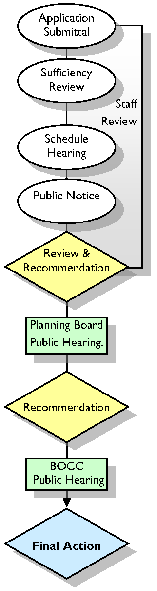
A.
The Board of County Commissioners shall consider amendments to the text of this Ordinance, as may be required from time to time.
B.
Amendments to the text of this Ordinance shall be made in accordance with the provisions of this section.
C.
A request to amend the text of this Ordinance may be initiated by the Board of County Commissioners, the Board of Adjustment, the Planning Board, the Agricultural Advisory Board, the Zoning Administrator, or a citizen of Brunswick County.
D.
Amendments to the Agricultural Preservation Program (Section 4.9) shall not use the procedures contained in this Section and shall instead be amended subject to Section 4.9.17 Amendments to the Agricultural Preservation Program.
3.7.2. Action by the Zoning Administrator
A.
The Zoning Administrator shall be responsible for review and recommendation regarding amendments to the text of this Ordinance.
B.
When a text amendment is initiated, the Zoning Administrator, in consultation with the appropriate body, shall draft an appropriate ordinance and present that ordinance to the Planning Board at a public hearing.
C.
The Zoning Administrator shall prepare a staff report that reviews the proposed text amendment request in light of any applicable plans and the general requirements of this Ordinance.
3.7.3. Action by the Planning Board
A.
Before making any recommendation on a text amendment, the Planning Board shall consider any recommendations from the Zoning Administrator and shall conduct a public hearing where interested parties may be heard.
B.
Notice and public hearing requirements shall be in accordance with Section 9.1.
C.
The Planning Board shall make a recommendation following the required public hearing based on the approval criteria in Section 3.7.5., as appropriate.
D.
When conducting a review of proposed zoning text amendment, the Planning Board shall advise and comment on whether the proposed action is consistent with any comprehensive plan that has been adopted and any other officially adopted plan that is applicable. The Planning Board shall provide a written recommendation to the Board of Commissioners that addresses plan consistency and other matters as deemed appropriate by the Planning Board, but a comment by the Planning Board that a proposed amendment is inconsistent with the comprehensive plan shall not preclude consideration or approval of the proposed amendment by the Board of Commissioners.
( Ord. No. UDO-21-01 , § 67, 5-17-21)
3.7.4. Action by Board of County Commissioners
A.
Before taking action on a text amendment, the Board of County Commissioners shall consider the recommendations of the Planning Board and Zoning Administrator and shall conduct a public hearing.
B.
If the Planning Board fails to make a recommendation within 75 days following the date of the first hearing on the text amendment, the Board of Commissioners may process the proposed amendment without a recommendation.
C.
Notice and public hearing requirements shall be in accordance with Section 9.1.
D.
The Board of County Commissioners shall make a decision based on the approval criteria in Section 3.7.5, as appropriate.
E.
Following the public hearing, the Board of County Commissioners may approve the text amendment, deny the amendment, or send the amendment back to the Planning Board or a committee of the Board of County Commissioners for additional consideration.
F.
When adopting or rejecting any zoning text amendment, the Board of Commissioners shall approve a brief statement describing whether its action is consistent or inconsistent with an adopted comprehensive plan. The requirement for a plan consistency statement may also be met by a clear indication in the minutes of the meeting that at the time of action on the amendment the Board of Commissioners was aware of and considered the Planning Board's recommendations and any relevant portions of an adopted comprehensive plan.
( Ord. No. UDO-21-01 , § 68, 5-17-21)
3.7.5. Approval Criteria
A.
In evaluating any proposed ordinance text amendment, the Planning Board and the Board of County Commissioners shall consider the following:
1.
The extent to which the proposed text amendment is consistent with the remainder of the Ordinance, including, specifically, any purpose and intent statements;
2.
The extent to which the proposed text amendment represents a new idea not considered in the existing Ordinance, or represents a revision necessitated by changing circumstances over time;
3.
Whether or not the proposed text amendment corrects an error in the Ordinance; and
4.
Whether or not the proposed text amendment revises the Ordinance to comply with state or federal statutes or case law.
B.
In deciding whether to adopt a proposed Ordinance text amendment, the central issue before the Board of County Commissioners is whether the proposed amendment advances the public health, safety or welfare and is consistent with any adopted County land use documents, the CAMA Land Use Plan, and the specific intent of this Ordinance.
C.
In cases of a text amendment that would change or affect the list of permitted uses within five miles of a military base, comments and analysis of the base commander shall be included in the consideration before making a final determination (N.C.G.S. 160D-601).
( Ord. No. UDO-21-01 , § 17, 5-17-21)
3.7.6. Changed Application
If the applicant makes significant changes to the application for a text amendment after the Planning Board has made its recommendation, the Zoning Administrator may refer the modified request back to the Planning Board for an additional public hearing.
3.8 - REZONING
3.8.1. Purpose & Applicability
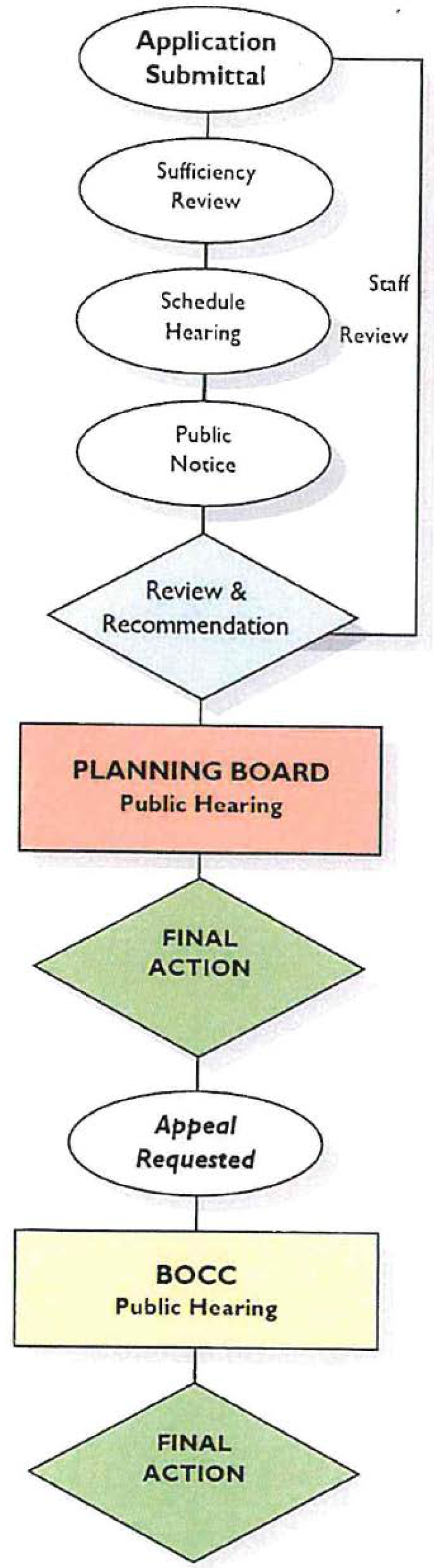
A.
Purpose
1.
Conventional Rezoning
A conventional rezoning or zoning map amendment is a legislative zoning map amendment to change the zoning district of a specified property or properties. Refer to Article 4, Zoning Districts, for a list of zoning districts. The permitted uses associated with these districts are found in Article 5, Permitted Uses.
2.
Conditional Rezoning
A conditional rezoning is a legislative zoning map amendment that incorporates site-specific conditions designed to mitigate impacts on adjacent properties and offers flexibility to meet project needs that are not accommodated by conventional zoning districts. Elements of conventional zoning classifications may be incorporated into the conditional rezoning.
B.
Applicability
1.
Amendments to the Zoning Map shall be made by Conventional Rezoning and Conditional Zoning. The two types of rezoning follow the same legislative process in accordance with the provisions of this section.
2.
The Planning Board and if appealed, the Board of County Commissioners, shall consider amendments to the Zoning Map of Brunswick County, as may be required from time to time.
3.
Rezoning should correspond with the boundary lines of existing platted lots or tracts. Where the boundaries of a rezoning request stop short of an exterior property line, it must be possible to subdivide and develop that portion of the property outside the proposed rezoning boundary in accordance with the existing zoning, required conditions, and other requirements of this Ordinance.
4.
All zoning requirements shall be met within the boundaries of the area being rezoned. If all of the requirements cannot be met on the site being rezoned, the rezoning shall be expanded to include all property necessary to meet zoning requirements.
5.
Any land use may be approved, subject to agreed-upon conditions in a Conditional Rezoning. Uses allowed as a Special Use Permit included with the Conditional Rezoning shall not require separate approval.
6.
For conditional rezoning, a site plan, a list of proposed uses, and a list of conditions shall be included with the approval.
7.
The conditions shall relate to the list of uses, development standards, site features, improvements, etc. and be agreed upon in writing by the current property owner to ensure enforceability.
(Ord. No. UDO-19-04 , §§ 4, 5, 11-18-19; Ord. No. UDO-21-01 , § 69, 5-17-21)
3.8.2. Initiation of Amendment
A.
A request for a conventional rezoning may be initiated by the Board of County Commissioners, the Board of Adjustment, the Planning Board, the Zoning Administrator, or the property owner or their agent or any other party. A request for a conditional rezoning may be initiated by the property owner or their agent. However, the property owner must agree to the conditions in writing to ensure enforceability.
B.
Amendments to zoning regulations or the zoning map that down-zone property shall not be initiated or enforced without the written consent of all property owners unless initiated by the County. For purposes of this section, "down-zoning" means a zoning change that affects a parcel or area of land in one of the following ways:
1.
By decreasing density to allow less development than previously allowed.
2.
By reducing permitted uses that are specified within this Ordinance to less than were allowed previously.
( Ord. No. UDO-21-01 , § 70, 5-17-21)
3.8.3. Project Planning Session
All applicants petitioning for a rezoning shall schedule a project planning session with the Planning Director or designee in accordance with Section 3.1.7.
(Ord. No. UDO-16-02 , § 1, 3-7-16; Ord. No. UDO-21-01 , § 71, 5-17-21)
3.8.4. Neighborhood Meeting
All applicants petitioning for a Conventional Rezoning are encouraged to hold a neighborhood meeting in accordance with Section 9.2. A neighborhood meeting is required for Conditional Zoning requests.
( Ord. No. UDO-21-01 , § 72, 5-17-21)
3.8.5. Application Requirements
All applications for a rezoning shall be submitted in accordance with Section 3.1.8, Application Requirements.
3.8.6. Notice and Public Hearings
The County shall hold all required public hearings and give notice in accordance with Section 9.1, Notice and Public Hearings.
3.8.7. Action by Planning Director
A.
The Planning Director or designee shall prepare a staff report that reviews the rezoning request in light of any applicable plans and the general requirements of this Ordinance. For conventional rezonings, the staff report shall consider the entire range of permitted uses allowed within the requested zoning district regardless of a proposed site plan or representations made that a specific use will be limited. For conditional rezonings, the staff report shall consider proposed uses, site plan, and conditions.
B.
Following completion of technical review by staff, the Planning Director or designee shall forward the completed request, staff report, and any related materials to the Planning Board for a hearing and decision.
(Ord. No. UDO-19-04 , § 6, 11-18-19; Ord. No. UDO-21-01 , § 73, 5-17-21)
3.8.8. Action by Planning Board
A.
Before making any decision on a rezoning request, the Planning Board shall consider any recommendations from the Planning Director or designee and shall conduct a public hearing where interested parties may be heard.
B.
Notice and public hearing requirements shall be in accordance with Section 9.1.
C.
The Planning Board shall make a decision based on the approval criteria in Section 3.8.10, as appropriate.
D.
When adopting or rejecting any zoning amendment, the Planning Board shall approve a brief statement describing whether its action is consistent or inconsistent with an adopted comprehensive plan. If a zoning amendment is adopted and the action was deemed inconsistent with the adopted plan, the zoning amendment shall have the effect of also amending any future land-use map in the approved plan, and no additional request or application for a plan amendment shall be required.
E.
When adopting or rejecting any petition for a zoning amendment, a statement analyzing the reasonableness of the proposed rezoning shall be approved by the Planning Board. This statement of reasonableness may consider factors including but not limited to the following:
1.
The size, physical conditions, and other attributes of the area proposed to be rezoned,
2.
The benefits and detriments to the landowners, the neighbors, and the surrounding community,
3.
The relationship between the current actual and permissible development on the tract and adjoining areas and the development that would be permissible under the proposed amendment,
4.
Why the action taken is in the public interest, and
5.
Any changed conditions warranting the amendment.
F.
Following Planning Board decision, the Planning Board Chair or Zoning Administrator shall announce that any person with standing may appeal the decision of the Planning Board by providing written notice to the County Manager within 15 days of the decision.
G.
If notice of the appeal is not provided in writing within 15 days, then the decision of the Planning Board shall be final.
(Ord. No. UDO-19-04 , § 7, 11-18-19; Ord. No. UDO-21-01 , § 74, 5-17-21)
3.8.9. Action by Board of County Commissioners
A.
Upon receipt of a timely appeal as described in Section 3.8.8., The Board of Commissioners shall schedule a public hearing for the rezoning case and shall hear it de novo.
B.
Notice and public hearing requirements shall be in accordance with these regulations.
C.
The Board of County Commissioners shall take action on the appeal of a rezoning decision based on the approval criteria in Section 3.8.10., as appropriate.
D.
The Board of County Commissioners may approve the rezoning, deny the rezoning, or send the rezoning back to the Planning Director or designee for additional consideration.
(Ord. No. UDO-19-04 , § 8, 11-18-19; Ord. No. UDO-21-01 , § 75, 5-17-21)
3.8.10. Review Criteria
The reviewing entity shall consider the following matters:
A.
Whether the range of uses permitted by the proposed change would be appropriate to the area concerned;
B.
Whether adequate public school facilities and other public facilities/services (i.e., water, wastewater, roads) exist, are planned, or can be reasonably provided to serve the needs of any permitted uses likely to be constructed as a result of such change;
C.
Whether the proposed change is consistent with the CAMA Land Use Plan or any other adopted land use document;
D.
Whether the proposed amendment is reasonable as it relates to the public interest.
3.8.11. Withdrawal of Rezoning Application
A.
An applicant may withdraw a rezoning application at any time, by filing a statement of withdrawal with the Zoning Administrator.
B.
The statement of withdrawal shall be signed by all persons who signed the application, or in the event of death or incompetence, by the estate's lawful personal representative.
3.8.12. Resubmission of Application
Upon final action to deny or approve an application for the rezoning of a piece of property, the Planning Board shall not review any applications for changes affecting the same property or any portion thereof until the expiration of one year from the date of such previous action except as provided as follows:
A.
The Planning Director may allow re-submission of such petition within one year period if it is determined that, since the date of action on the prior petition:
1.
There has been a significant change in the zoning district classification of an adjoining piece of property.
2.
The Board of Commissioners has adopted a plan that changes public policy regarding how the property affected by the amendment should be developed.
3.
Construction or expansion of a road, water line, sewer line, or other such facilities has occurred to serve the property and can comfortably accommodate the intensity of development allowed under the proposed classification.
4.
There has been some other extraordinary change in conditions or circumstances, outside the control of the petitioner, which justifies waiver of the one year restriction on a new position; this, however, shall not include a change in the ownership of the subject property.
(Ord. No. UDO-19-04 , § 9, 11-18-19; Ord. No. UDO-21-01 , § 76, 5-17-21)
3.8.13. Period of Validity
A.
An approved rezoning shall run with the property and shall be valid until the Official Zoning Map is subsequently amended.
3.9 - PERMITS AND CERTIFICATES
Other permits or certificates beyond those included in this Section may be required. Consult with the Planning Director and Article 9 of this Ordinance.
3.9.1. Stormwater Permit
A stormwater permit may be required for development in Brunswick County. For more information, contact the Stormwater Administrator or review the Stormwater Ordinance.