
Brunswick County Unincorporated
City Zoning Code
City Zoning Code
ARTICLE 6
- DESIGN AND PERFORMANCE STANDARDS
Brunswick County promotes quality development that conforms to infrastructure standards, enhances the visual appearance of the community and sustains the environment. This Article provides the requirements associated with site design, appearance, infrastructure and other project elements for major and minor developments outlined in Article 3, Review and Approved Procedures.
This Article is organized as follows:
Site Design
• Design Flexibility
• Trees and Landscaping
• Buffering
• Screening
• Open Space and Recreation Areas
• Historic Resources
• Suitability (wetlands, floodways, etc.)
Appearance
• Building Facade
• Large Scale Development
• Outdoor Lighting
• Fences and Walls
Vehicular
• Streets
• Off-Street Parking and Loading
• Access
• Emergency Management Standards
• Site Triangles
• Traffic Impact Analysis
Infrastructure
• Roadways
• Water and Sewer
• Private Utilities (electric, etc.)
• Stormwater
• Easements
Miscellaneous
• Utility, Dumpster, Recycling and Trash Handling
• Name duplication
• Addressing
• Outdoor Display and Storage
6.1 - SITE DESIGN
6.1.1. Design Flexibility
Flexibility is provided in this Ordinance to promote quality development through the use of exceptional design principles and best management practices. The intent is to promote the use of exceptional design methods to achieve quality development without imposing financial or regulatory burdens on projects.
Low Impact Development (LID) and other best management practices improve the environmental quality and sustainability of development. Many are very cost effective and can result in short and/or long-term cost savings. Use of these practices is strongly encouraged in the planning and design of projects.
Credit toward meeting the buffer, recreation, open space, stormwater and other requirements of this Ordinance for residential and non-residential projects may be obtained by utilizing best management practices, exceptional site and structure design, tree resource management, historic resource protection and other similar design practices. Examples of these techniques include the following:
A.
Site and/or structure design that reflects exceptional aesthetic elements and is consistent with the character and context of the community;
B.
Naturally shaped landscaped stormwater ponds with recreational features such as trails, bridges, gazebos, etc.;
C.
Tree resource management such as protecting large contiguous areas of heritage trees;
D.
Stormwater management utilizing LID methods such as bioretention;
E.
Connecting recreational elements with established greenways, trails, parks, etc.; and
F.
Green Growth techniques to conserve and connect highly sensitive areas.
Commentary: Information and references regarding selected best management practices is provided in Appendix E.
Alternative design using exceptional methods that result in equivalent or superior compliance with the purpose and intent of this Ordinance may be approved by the Planning Director, in consultation with other County departments and/or outside agencies as deemed necessary.
(Ord. No. UDO-16-02 , § 25, 3-7-16)
6.1.2. Trees and Landscaping
A.
Landscape Plan Required
1.
A landscape plan shall be submitted in conjunction with a required site plan. For minor site plan applications, the landscaping may be shown on the site plan, as opposed to a separate landscape plan.
2.
Landscaping requirements for Parking Lots is provided in Section 6.12.10 Vehicular Use Area Landscaping.
3.
A Landscape Architect or other person with landscape design knowledge (this could include the land owner) shall prepare all landscape plans, except where expressly exempted by the Planning Director. The landscape plan shall adequately detail the requirements of this Section.
4.
As much as possible, landscape designs should incorporate as much contiguous undeveloped areas into their plans. Whether left undisturbed during development or planted during site development, the purpose is to create suitable wildlife habitat and corridors that facilitate movement to adjoining forestland.
5.
Approved planting materials are provided in the standard plant list (see Appendix B for approved lists of Canopy Trees, Understory Trees and Shrubs). Alternative plant materials may be substituted if a letter of approval is provided from the N.C. Cooperative Extension. The plants approved for substitution shall be added to the standard plant list.
6.
Use of known invasive or problem plants is strongly discouraged (see Appendix B for plant listings and more detailed information).
6.1.3. Tree Survey Required
The primary objective of tree survey requirements is to provide better information about the presence and location of heritage trees (see Section 6.1.4.B) on sites proposed for development. This information is needed before plans for development are so far advanced that it is unreasonable and impractical to modify the plans to protect the trees identified on the tree survey. Tree survey requirements do not obligate a property owner or developer to save trees by modifying a plan for development. However, knowing the location and size of heritage trees helps the staff evaluate possible modifications to the proposed plans to preserve heritage trees and improve the appearance of proposed development. Canopy trees should be retained or installed to cover a minimum of 15% of the site. Coverage can be estimated by visual estimates, aerial photography or by land survey methods.
A.
Heritage Tree Survey
1.
A heritage tree survey shall be required for any multifamily development, nonresidential development, major subdivisions or planned development, with applications for site plan, preliminary plat, development plan, or special use permit. The heritage tree survey shall show the general location, species and size of trees listed below. However, a heritage tree survey shall not be required for land in the floodway (unless filled or developed in accordance), preserved wetlands and wetland buffers, steep slope areas, and stream buffers.
2.
For purposes of this Ordinance, a heritage tree shall be defined as follows:
i.
A flowering Dogwood, Live Oak, Long Leaf Pine, Redbay, Black Tupelo or Laurel Oak with a trunk diameter measurement of 4" or greater measured at 4.5 feet above ground;
ii.
Any tree species included in the planting table (See Section 6.1.5.C) with a trunk caliper measurement of 18" or greater measured at 4.5 feet above ground;
3.
For development plans where specific building locations are not shown, a more generalized survey of vegetation may be provided in lieu of a heritage tree survey. This survey shall describe existing forest stands, indicating the average species and size of trees on the tract. A more specific survey should be provided in conjunction with preparation of specific development plans.
4.
Having better information about the location of heritage trees is not especially useful where plans call for the preservation of large areas in undisturbed vegetation. An example is the pervious portions of developments in watershed protection districts. Producing such information adds to the project's cost without providing information that could result in project redesign. Where unique site conditions or a proposed development arrangement indicate that the required heritage tree survey would produce little useful information, the Planning Director shall have the authority to waive the requirements for a heritage tree survey for all or a portion of the tract.
6.1.4. Credit for Existing Vegetation
A.
General
The retention of "existing vegetation" shall be maximized within the proposed landscaping, parking and buffer areas. When retaining existing vegetation within the buffer area, only clearing methods that do not disturb the root structure shall be allowed within the dripline of tree canopies. Existing native habitat or plant material located within the proposed landscaping or buffer area that meets the percent opacity requirements (See Section 6.3.9.A.4, Buffer Alternatives Table [Required Opacity]) of these regulations may be counted toward the total buffer required between adjoining land uses, or toward total landscaping requirements. If the existing vegetation has been counted toward the total required buffer or landscaping and is subsequently removed or dies, it shall be replaced with the appropriate buffer or landscaping material.
B.
Heritage Trees
1.
With the exception of clearing required for required driveways or street connections, the retention of heritage trees within a proposed landscaping or buffer area shall be required. The Planning Director shall have the authority to permit the selective removal of heritage trees on a case by case basis.
2.
The preservation of heritage trees located on the interior of the lot is encouraged, but shall not be required.
C.
Credit for Existing Vegetation
In order to encourage the preservation of established vegetation, credit shall be given for preservation within the proposed buffer or other required landscaping areas on a one-for-one basis. In limited cases, the Planning Director may allow the applicant to count established vegetation located outside of the required planting area towards the landscaping requirement.
D.
Clear-Cutting
1.
With Forestry Activities
Properties should not be clear-cut during the conduct of forestry or silvicultural activities. To maintain the visual character of the site from adjoining properties and right-of-way, a vegetated perimeter buffer shall be maintained while tree harvesting for forestry occurs. All existing vegetation located in a required side or rear yard shall be maintained, exclusive of areas required for access to the site or connection to adjoining sites. Along public rights-of-way, all existing vegetation located in a required street yard shall be maintained, exclusive of areas required for access to the site.
2.
Prior to Development
Properties shall not be clear-cut prior to undertaking development activities. Along public rights-of-way, a buffer consisting of all existing vegetation located in a required street yard shall be maintained, exclusive of areas required for access to the site. Applications proposing development of properties that failed to maintain such a buffer prior to development may be denied for a period of up to five years from the date of clearing in conformance with N.C.G.S. § 160D-921(c).
3.
During Development
Properties shall not be clear cut while undertaking development activities. The preservation of the maximum amount of existing vegetation and selective removal of existing trees throughout the site is strongly encouraged during project design and construction. In order to encourage such preservation, the Planning Director may count established vegetation preserved during development towards the landscaping requirement (see paragraph C, above) where the percent opacity requirement is met (See Section 6.3.9.A.4, Buffer Alternatives Table [Required Opacity]).
Commentary: Clear-cutting trees should be avoided especially areas along roadways. Trees and plantings along roadways are desirable and provides a better visual appearance for the traveling public. Additional benefits include decreasing stormwater runoff, reduction of site erosion and potentially favorable tax implications. Contact with the NC Forestry Service for forestry management guidance is strongly encouraged prior to undertaking clearing activity.
(Ord. of UDO-17-01 , § 19; Ord. No. UDO-21-01 , § 31, 5-17-21)
6.1.5. Design of Landscaping and Buffers
A.
Design, Installation and Establishment Standards
Location of plants and design of landscaping, including maintenance, shall be according to sound landscape and horticultural principles. The use of native vegetation and other lower maintenance landscape materials is desired to promote environmental protection, energy efficiency, and water conservation.
1.
Landscape plans submitted for approval for the purposes of satisfying the requirements of this Section shall clearly indicate the name, location, and size of vegetation to be installed as well as trees to be preserved.
2.
Plant material should be chosen from the lists of recommended plant species contained in Appendix and shall adhere to the minimum specifications therein. Plant materials shall be reviewed for variety and suitability with regard to the eventual size and spread, susceptibility to diseases and pests, and appropriateness to existing soil, climate and site conditions.
3.
The height and canopy size at maturity of trees and other plantings should be considered with regard to potential conflicts with overhead lighting, utilities, etc.
B.
Issuance of Certificate of Occupancy
A permanent certificate of occupancy shall not be issued, until all seeding, trees, and plant material have been placed in accordance with the approved site plan and requirements of this section. A temporary certificate of occupancy may be issued for a period of 120 days under circumstances that would affect the seeding and planting of the site, or until the proper planting season (generally early spring or early fall) is reached to complete the landscaping requirements, and may be extended up to 90 days upon request to the Planning Director.
C.
Plant Material and Minimum Plant Size
The following list shall be used as a guide in identifying and categorizing the different acceptable types and minimum sizes for any required plant. Although the lists may be expanded, they are intended to provide guidance in selecting predominately hardy natural species. All materials shall be of high-quality nursery grade.
1.
Trees
i.
Canopy Trees (see Approved Canopy Tree List in Appendix B) At the time of planting, the tree shall have a minimum caliper of two inches measured at 4.5 feet above ground.
Commentary: At maturity, canopy trees shall be of a species having an average minimum height of 15 feet and a minimum mature crown spread of 20 feet.
ii.
Understory Trees (see Approved Understory Tree list in Appendix B) At the time of planting, the tree shall have a minimum caliper of two inches measured at 4.5 feet above ground.
Commentary: At maturity, understory trees shall be of a species having an average minimum height of eight feet and a minimum mature crown spread of 12 feet.
2.
Shrubs (see Approved Shrub list in Appendix B)
Shrubs shall have a minimum mature height of 24 inches.
D.
Minimum Planting Areas
1.
Canopy trees shall have a planting diameter no less than 8 feet wide.
2.
Understory trees shall have a planting diameter no less than eight feet wide.
3.
When planted as a hedge, the maximum spacing for 20-inch high shrubs shall be 40 inches on center.
4.
These minimum planting areas may be reduced administratively by the Planning Director.
E.
Mulch
Plants shall be mulched to provide ground cover and prevent water loss due to evaporation. Where selected plant material is not tolerant of deep mulch, a specific note regarding shallower mulch shall be set forth on the final landscape plan and approved by the County as part of the landscape plan. Mulch shall be kept away from tree trunks.
6.1.6. Requirements for Maintaining Planted Areas
A.
Responsibility
The responsibility for maintenance of a required buffer or other landscaping shall remain with the owner of the property, his or her successors, heirs, assignees or any consenting grantee. Maintenance is required in order to ensure the proper functioning of the plantings as a landscaped area which reduces or eliminates nuisance and/or conflict.
B.
Maintenance
1.
All plantings shall be maintained in an attractive and healthy condition. Maintenance shall include, but not be limited to, watering, mulching, fertilizing and pest management, mowing, weeding, removal of litter and dead plant material, and necessary pruning and trimming.
2.
Necessary pruning and trimming shall be in accordance with the American National Standards for Tree Care Operations: Tree Shrub and Other Woody Plant Maintenance - Standards Practices (Pruning), and shall not be interpreted to include topping of trees through removal of crown material or the central leader, or any other similarly severe procedures such as lollipopping or meatballing that cause irreparable harm to the natural form of the tree, except where such procedures are necessary to maintain public overhead utilities. Any such activity shall be a violation of these zoning regulations.
3.
Dead or diseased plantings shall be removed. Unless specifically exempted (such as Understory Trees shaded by Canopy Trees), replacement plantings shall be provided for any required plants which die or are removed for any reason and shall meet all minimum standards and conform to these regulations.
4.
Natural water courses within a buffer shall be maintained in a natural condition consistent with any applicable regulations.
5.
A water source shall be supplied within 100 feet of any planting requiring continuing watering. Where non-native or non-drought tolerant native vegetation is incorporated in the buffer, an irrigation system shall be required.
6.
Landscape structural features such as walls, fences, berms or water features shall be maintained in a structurally safe and attractive condition.
7.
Where other uses, including pedestrian, bike or other trails, are allowed within a buffer, these uses shall be maintained to provide for their safe use.
C.
Failure to Maintain
In the event that any owner of a buffer area or vehicular use landscaping area fails to maintain same according to the standards of these regulations, these regulations shall be enforceable by the County with the right to recover the cost of enforcement, including reasonable attorney fees. The County may also, following reasonable notice and a demand that deficiency of maintenance be corrected, enter the buffer area to maintain same. The cost of such maintenance shall be charged to those persons having the primary responsibility for maintenance of the buffer area.
6.2 - BUFFERING
6.2.1. Intent
Buffers are designed to protect adjoining land uses, particularly residential, from the noise, heat, dust, lights, and aesthetic impacts from more intense land uses. There are three basic types of landscaping that may be required for any project. They include (1) project boundary buffers, (2) street buffers (which may include project boundary buffers or vehicular use area landscaping) and (3) vehicular use area landscaping. The project boundary and street buffers are described further in this section. The vehicular use area landscaping is described in Section 6.12.10 of this Article.
The more intense land use shall be required to provide the buffer as part of its yard requirements. The following requirements shall be met for buffers and the yards in which buffers are required:
6.2.2. Applicability
The landscaping and buffering requirements found in this Section shall apply to all development within Brunswick County with the exception of bona fide farming activities and the construction of one or two single-family or two-family households.
Commentary: Credit for existing vegetation is possible. See Section 6.1.4 for more information.
1.
Plant material in buffer areas may be counted on a one-to-one basis toward the requirements for other required landscaping areas (e.g. vehicle use area landscaping and screening) when located appropriately to serve both functions. See illustrations below for details.
6.3 - REQUIRED BUFFERS
6.3.1. Buffer Defined
A buffer is a specified land area, located parallel to and within the outer perimeter of a lot or parcel and extending to the lot or parcel boundary line, together with the planting and landscaping required on the land. A buffer may also contain, or be required to contain, a barrier such as a berm, fence or wall, or combination thereof, where such additional screening is necessary to achieve the desired level of buffering between various land use activities. A buffer is not the same as the term "yard" or the term "stormwater management area."
6.3.2. Types of Required Buffers
There are two types of required buffers that may occur on any given development site, as follows.
A.
Street buffers; and
Commentary: Generally, a street buffer is located along the street(s) that border a development. The buffer requires a modest amount of landscaping, enhancing the "public" environment.
B.
Project boundary buffers.
Commentary: Generally, a project boundary buffer is located around the sides and rear
of a development. This buffer ensures an appropriate transition between uses.
A buffer located around the perimeter of a nonresidential use is intended to protect
adjoining land uses from noise, heat, dust, lights, and aesthetic impacts from more
intense land uses.
6.3.3. Location
A.
Buffers shall be located within the outer perimeter of a lot or parcel, parallel to and extending to the lot or parcel boundary line. Buffers shall not be located on any portion of an existing, dedicated or reserved public or private street or right-of-way.
B.
Buffers may be located and constructed within any required yard.
6.3.4. Permitted Use of Buffer Area
A.
A buffer may be used for passive recreation and picnic facilities; and it may contain pedestrian, bike, or equestrian trails, provided that:
1.
Minimal existing plant material is eliminated;
2.
The total depth of the buffer is maintained; and
3.
All other requirements of these regulations are met.
B.
Other appurtenances which require high visibility and easy access, such as fire hydrants, public and emergency telephones, mail boxes, and school bus or other bus shelters or benches, are also permitted in a buffer. No screening of such appurtenances is required.
C.
A required buffer is encouraged to retain areas of native habitat and may incorporate water resources including stormwater detention/retention facilities designed as a natural-appearing amenity. However a minimum 10-foot contiguous width of the buffer shall be preserved as a planting area without stormwater facilities.
D.
Ingress and egress to the proposed use, and utility lines and appurtenances, may cross the buffer provided they minimize the amount of buffer taken.
E.
The buffer area may be included as part of the calculation of any required open space.
F.
Identification signs may be located within a buffer as specifically permitted in the Sign Ordinance. The landscape buffer shall be designed to address visibility of permitted ground signs.
G.
Lighting may be located within a buffer as specifically permitted in Section 6.9, Outdoor Lighting.
H.
Other activities and development required by this Ordinance or expressly authorized by the Planning Director.
6.3.5. Prohibited use of Buffer Area
A buffer area shall not be used for any building or use, accessory building or use, parking or loading area, storage area, or other principal or accessory uses except as specifically permitted in this Ordinance.
6.3.6. Planting in Easements
A.
Where required plantings are located in easements, the property owner shall be responsible for replacement of such required vegetation if maintenance or other utility requirements require their removal.
B.
No trees shall be planted in wet retention ponds, drainage maintenance easement, or any utility maintenance easements.
C.
Shrubs may be planted within easements, provided they are only within the outer three feet of the easement. No new trees may be planted in an easement.
D.
Existing trees may remain in dry retention ponds provided that the natural grade is undisturbed to the tree line, they are a species adapted to seasonal flooding and the pond is adequately maintained.
6.3.7. Determination of Buffer Requirements
To determine the type of buffer required between two adjoining lots or parcels, or between a lot or parcel and a street, the following procedure shall be followed:
A.
Street Buffers
Determine the appropriate street buffer based on Section 6.3.8.
B.
Project Boundary Buffers
Identify the zoning districts of the subject parcel and all adjoining properties. Determine the buffer opacity class required on each boundary (or segment thereof) of the subject parcel. Refer to the minimum project boundary buffer table in Section 6.3.9.
Commentary: Landscape plans should depict the basis for meeting planting requirements in 100 foot intervals.
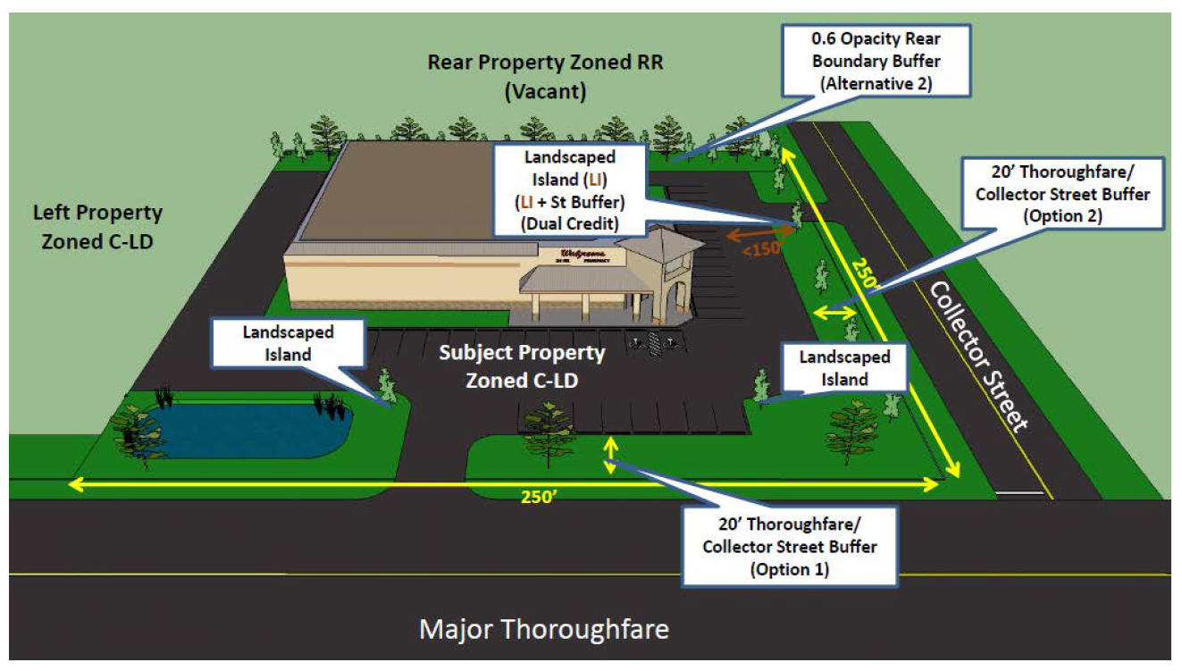
6.3.8. Street Buffers
Street buffers shall be required and existing vegetation should be used to satisfy these planting requirements where possible (see Section 6.1.4, Existing Vegetation). No vegetation or fence shall interfere with a required clear sight triangle at a driveway or intersection (See Section 6.15). Berms constructed in accordance with Section 6.3.10.C, Berms with Vegetation, are encouraged as a component of any street buffer and the Planning Director may allow up to 25% reduction in the required buffer depth with a berm.
A.
Measurements
1.
Street buffers shall be measured along a perpendicular line from the future right-of-way line determined during site and development plan review. Buffer depth averaging may be used in conformance with paragraph 5, below.
2.
Required driveways may penetrate required street buffers.
3.
Driveway widths (measured at the inside edge of the buffer) shall not be counted in the calculation of the plant material required.
4.
Vehicular access easements shall not be treated as a street, but shall be buffered as a project boundary buffer outside the easement area. The buffer may be provided on either side of the easement.
5.
While the buffer depth is normally calculated as parallel to the property line, design variations are allowed and are calculated on the average depth of the buffer per 100 feet of linear width measured along the property line. Minimum depth of buffer in any case shall not be less than 50% the required depth of the buffer chosen. Maximum depth shall not be more than 150% the required depth of the buffer chosen.
B.
Collector or Thoroughfare Street Buffers
All development located along either a collector or thoroughfare street shall be required to provide one of the following buffers along the entire street frontage.
1.
One canopy tree per 100 linear feet of property frontage, located within a twenty-foot landscape buffer; OR
2.
Two understory trees per 100 linear feet of property frontage, located within a twenty-foot landscape buffer; OR
3.
Under utility lines only, two understory trees per 100 linear feet of property frontage, located within a 20-foot landscape buffer. No trees under utility lines shall have a natural height over 25 feet.
C.
Local Street Buffers
With the exception of one- or two-family dwellings on a single lot or parcel, all development across a local street from a Residential district or use shall require a buffer with a minimum opacity of .2 (see Section 6.3.9.A.2, Measurements) and a depth of 15 feet.
6.3.9. Project Boundary Buffers
Commentary: Project Boundary Buffers ensure a landscaped transition between different
types of uses and/or zoning districts. At first glance, the following method may seem
complicated. In reality, this is a fairly easy approach to implement. A few simple
steps will provide the total amount of plants that are required to be in a buffer
as well as the buffer depth.
This approach also addresses the following criticisms that are raised when the County
requires buffers and landscaping.
1. What about unusual site circumstances? The table provides a number of alternative
approaches to achieving the requirements.
2. Why do I have to put all the plants in - the lot next to me is vacant? This approach
anticipates this type of situation. The initial developer will have a reduced buffer
requirement.
3. What if I want to put in a narrower buffer? The developer may select Alternative
3, Canopy and Wall or may install a berm. This will allow the developer to reduce
the buffer depth while still providing appropriate screening.
4. There are already plants there - why do I have to put in new plants? Credit is
given for existing plants (that meet a minimum size requirement) on a one-for-one
basis.
A.
Required Project Boundary Buffer Table
1.
Description
i.
The buffer standards in the table below address the opacity of the buffer that is required on the property boundary between zoning districts, and in some instances within a zoning district.
ii.
An opacity of 0.2 screens 20% of an object, and an opacity of 1.0 would fully screen the adjoining development during summer months after five years of growth.
2.
Measurements
Project boundary buffers shall be measured along a perpendicular line from the lot line.
3.
How to Read the Buffer Table
i.
The required opacity of project boundary buffers is represented in the Table below by two numbers (for example, .2/.6).
ii.
The second number represents the total required buffer opacity between any two properties.
iii.
Where the proposed project adjoins vacant property, the first number represents the applicant's required buffer opacity.
iv.
Where the adjoining property is already developed with no buffer, the proposed project is responsible for providing the total required opacity (the second number).
[See Buffer Alternatives Table]
v.
Where the adjoining property is already developed with a partial buffer, the proposed project is responsible for providing the remaining opacity required.
vi.
A zero means no project boundary buffer is required.
Commentary: A .2/.4 requires a 20% opaque buffer for property adjacent to vacant land
or a 40% opaque buffer when adjacent to existing development. A .4/.4 requires a 40
percent opaque buffer property adjacent to either vacant or developed land. A zero
means no project boundary buffer is required.
Example: A new development in the C-I District abutting a developed R-7500 District
would be required to provide a buffer with an opacity of .6 (60% opaque) If the adjacent
property were vacant, the requirement would be .4 since the adjacent property is vacant.
4.
Buffer Alternatives
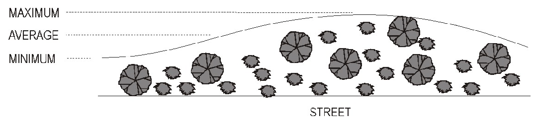
The table below shows the required buffer depth (average) and plantings required for a project boundary buffer to satisfy the required opacity. Existing vegetation should be used to satisfy these planting requirements where possible (see Section 6.1.4, Existing Vegetation). Credit may also be given for use of best management practices and exceptional design.
Commentary: Suppose you are required to install a buffer with an opacity of 0.6 and you elect to use Alternative 1. Your buffer would have to be 30 feet deep (on average) and you would have to plant 3 canopy tress, 6 understory trees, and 34 shrubs for every 100 feet of buffer length.
5.
In lieu of a project boundary buffer, the Street Buffer applies (See Section 6.3.8) when both a 1) recorded easement for ingress and egress or a right-of-way exists (whether developed or undeveloped) and 2) a zoning district designation of the adjacent parcel(s) is different than that of the subject parcel.
6.
When proposed residential units adjoin an existing bona fide farming activity in a Voluntary Agricultural District, the minimum buffer depth shall be 50 feet, with a minimum opacity of 0.2.
B.
Hardship Relief
The buffer requirement may be modified by the Planning Director upon a finding that a modification would be consistent with the purpose and intent of this Article, with any adopted land use plans, that such modification would not adversely affect the land use compatibility or public interest, and complies with one or more of the following criteria:
1.
The affected buffer is parallel to and adjoins an existing utility or drainage easement of at least 50 feet in width;
2.
The affected buffer is between uses that are to be developed under a common development plan or series of development plans; or
3.
The affected buffer adjoins a property that has a joint use agreement with the parcel under site plan;
4.
When buffering the adjoining property would serve no practical purpose due to the nature and/or use of the property, such as undevelopable land (wetlands, etc.), industrial use, public or private utility, etc.
6.3.10. Walls, Berms and Fences in Buffers
Where walls, berms or fences are built within any required buffer, they shall meet the following requirements.
A.
Walls
1.
A finished side of the wall shall face off site.
2.
All required plantings should be placed along the interior side of the wall (facing the developed area of the subject property).
B.
Fences
1.
A finished side of the fence shall face off site and see Note 2 in Buffer Alternatives Table (Section 6.3.9.A.4) for allowed fence types.
2.
Fencing shall be between six to ten feet in height.
3.
Fences shall be maintained in a structurally safe and attractive condition and with a finished face located towards the adjoining property.
4.
All required plantings should be placed along the interior side of the fence (facing the developed area of the subject property).
C.
Berm with Vegetation
1.
The Planning Director may allow a reduction of up to 25% of the required buffer depth when a berm meeting these requirements is provided.
2.
An earthen berm may be used in conjunction with planted vegetation provided that the combined height of the berm and planted vegetation shall be at least six feet and provide approximately 75% opacity within one year of planting.
3.
The slope of the berm shall be stabilized with vegetation and no steeper than 3:1. The height of the berm may not exceed six feet, with a level or rounded area on top of the berm. The berm shall be constructed of compacted earth.
4.
Prior to issuance of the first certificate of compliance, berms shall be planted to ensure coverage by live plant material within three to five years.
5.
When berms are planned to be installed within required buffers, storm drainage plans submitted with an application shall be designed to anticipate a 100-year storm event.
Commentary: Berms can dramatically alter the drainage patterns in an area, and result in significant flooding both within a development and in areas abutting a development. Therefore, it is important to understand any potential impacts.
6.4 - SCREENING
6.4.1. Applicability
A.
The following uses shall be screened as required by this section:
1.
Outdoor storage and loading areas.
2.
Self-storage warehouses not located in an industrial district.
3.
Air handlers and similar mechanical equipment in multifamily or nonresidential development not located on roof tops.
4.
Trash handling facilities, including dumpsters and recycling.
5.
Solar Collector (Accessory).
B.
The features and uses listed above need not be screened from similar features and uses on adjoining lots, except where project boundary buffers would be required pursuant to Section 6.3.9.
C.
Screening shall not be required for temporary construction activities undertaken during construction or modification of a building, structure, or site.
6.4.2. Standards
Features and uses specified above shall provide a visual obstruction from neighboring properties in conformance with the following standards:
A.
All Uses
1.
When visible from an adjoining residential use or residentially zoned property (including across a street), the screen shall be composed of view-obscuring vegetation (used individually, or in combination with), a wall, semi-opaque fence, or berm designed to obscure views to a height of six feet from the ground, except for mechanical equipment which shall be screened to the height of the equipment plus six inches.
2.
When adjoining any other use or zoning district, outdoor storage and mechanical equipment may be screened by chain link fencing with slats inserted to a height of six feet from the ground, except for mechanical equipment which shall be screened to the height of the equipment plus six inches.
3.
One upright shrub shall be installed per four linear feet of any screen wall or fence that faces off-site. These plantings shall be placed such that they obscure the screen wall or fence and shall be credited toward any plantings required elsewhere in this Ordinance.
4.
Plants must be at least two feet tall at the time of installation and reach the desired height within three to five years of planting. All berms, when provided, must be covered with plant materials within three to five years.
5.
All landscaping shall be maintained in accordance with Section 6.1.6, Requirements for Maintaining Planted Areas.
6.
Enclosures shall be required around all dumpsters except temporary construction dumpsters.
(Ord. No. UDO-19-02 , § 11, 9-19-19)
6.4.3. Credit for Other Landscaping
Plant material in project boundary buffers may be counted towards the requirements of this section when located to serve both functions.
6.4.4. Open Space and Recreation Area
Commentary: In order to prevent the possibility of ending up with random leftover slivers of land and the inefficient provision of open space, projects not meeting the threshold requirements below are not required to dedicate open space.
A.
Applicability
1.
Projects with 10 or more dwellings shall provide open space and recreation area in conformance with this Section. Only the portion of the project devoted to residential use shall be used in determining the minimum open space requirement. Non-residential elements of projects shall be exempt from the requirements of this Section.
Commentary: This is to capture phased or separate developments that may, when taken in part fall under the thresholds, but taken in whole will meet the threshold.
B.
Amounts of Open Space and Recreation Area to be Provided
When required, open space shall be provided in the amounts indicated in the tables below.
C.
Open Space and Recreation Area Standards
1.
Open Space Standards
i.
All open space shall be unoccupied or predominately unoccupied by buildings or other impervious surfaces. Unoccupied or predominately unoccupied by buildings or other impervious surfaces shall mean that not more than five percent of the area of any required open space shall be occupied by such surfaces. Open space shall be identified on plats as being permanently set aside. Except in the RR district, open space shall be exclusive of any individual lots.
ii.
In order to be included in the calculation for required open space, the following minimum dimensions shall be satisfied:
(a)
Open space shall have a minimum horizontal dimension of 15 feet.
(b)
No individual open space shall have a minimum area of less than 2,000 square feet.
iii.
Uses of open space may include the following:
(a)
Conservation areas for natural, archeological or historical resources;
(b)
Ecologically sensitive wetlands such as marsh, Carolina Bays, pocosins and swamps;
(c)
Bona fide agriculture, horticulture, silviculture or pasture uses, provided that all applicable best management practices are used to minimize environmental impacts;
(d)
Walking or bicycle trails, provided they are constructed of pervious paving materials;
(e)
Water trails;
(f)
Landscaped stormwater management facilities;
(g)
Easements for drainage, access, and underground utility lines; and
(h)
Other conservation-oriented uses compatible with the purposes of these regulations.
(i)
Up to 100% of a golf course may be included in the calculations for useable open space.
iv.
Open space does not include the following:
(a)
Roads, parking lots and impervious surfaces, except as specifically authorized; and
(b)
Agricultural and forestry activities not conducted according to accepted best management practices.
2.
Usable Recreation Area Standards
i.
At least 15% of the required open space must be in the form of usable recreation area.
ii.
Usable recreation area shall be useable land devoted to recreation and amenities for the residents of an subdivision. Usable recreation area shall be identified on plats as being permanently set aside.
iii.
Usable recreation space uses may include, but are not limited to:
(a)
Walking or bicycling trails (Note: Additional credit may be allowed for trails that connect with existing or planned greenways);
(b)
Water trails;
(c)
Passive recreation areas, including pocket parks;
(d)
Ball fields and playgrounds;
(e)
Tot lots; and
(f)
Clubhouses, swimming pools, tennis courts and other similar facilities used in common and made available to the residents of the entire subdivision.
(g)
Up to 75% of a golf course that is used in common and made available to the residents of the entire subdivision.
iv.
In cases where the determination is unclear (e.g. water trails) the Planning Director may make a determination on what area may be counted towards usable recreation area.
v.
Usable recreation space shall be situated so as to provide perpetual recreation benefit to the overall development.
Commentary: Un-usable recreation areas are spaces that are unsuitable for recreational uses such as wetlands, areas with very steep slopes, and sensitive natural habitat and other unsuitable areas.
D.
Legal Instrument for Permanent Protection
1.
The open and recreation space shall be protected in perpetuity by a binding legal instrument that is recorded with the deed filed with the Brunswick County Register of Deeds.
2.
The instrument for permanent protection shall include clear restrictions on the use of the open space and recreation area. These restrictions shall include all restrictions contained in this Section, as well as any further restrictions the applicant chooses to place on the use of the open and recreation space. Where appropriate, the instrument shall allow for stream or habitat restoration within the easement area.
(Ord. No. UDO-16-02 , § 26, 3-7-16)
6.4.5. Areas to be Reserved
The following shall be included within the common area of the subdivision, regardless of whether reservation of these areas would exceed the minimum open space dedication requirements.
A.
Floodways (AEFW) as designated on the most recently adopted FEMA FIRM maps for Brunswick County;
B.
30 foot undisturbed stream buffer areas as designated on the most recently adopted CAMA land use plan;
C.
Jurisdictional wetlands under federal law (Section 404) that meet the definition applied by the U.S. Army Corps of Engineers.
D.
Greenways, waterways, parkland, and other public use areas shown on the most recently adopted Brunswick County Trail Plan or other adopted plan related to parks, greenways, and trails. Copies of the most recent Plan may be obtained from the Planning Department. The following standards shall apply to lands so reserved:
Commentary: The Brunswick Tomorrow Plan and the Brunswick County Trail Plan or other adopted plan related to parks, greenways, and trails envision an interconnected network of land and waterway trails and parks across the County. These should provide safe access for both users of the system and emergency responders.
1.
Greenways, waterways, and trails reserved in conformance with the Brunswick County Trail Plan or other adopted plan related to parks, greenways, and trails shall be situated to best implement the plan's intent.
2.
Greenways, waterways, parkland, and other public use areas shown on the most recently adopted Brunswick County Trail Plan or other adopted plan related to parks, greenways, and trails shall be made accessible to the general public.
(Ord. No. UDO-19-02 , § 9, 9-19-19)
6.5 - HISTORIC RESOURCES
The rich history of Brunswick County contributes to the cultural diversity of the community. The County has complied an inventory of historic resources including significant architectural features. Protection and promotion, where appropriate, of these resources enhances the cultural experience of residents and visitors in the community.
Developers, project managers, design professionals and others should consult the inventory of Historic Resources available on the Brunswick County Geographic Information System in conjunction with project planning. Planning staff will include review of the Historic Resources inventory in the review of projects two acres or more in size. Best efforts should be utilized to protect and promote the presence of Historic Resources in the design of site development plans. The Planning Director is authorized to make reasonable adjustments to applicable requirements such as setbacks, buffers, open space, landscaping, etc. in the review and approval of project plans that successfully incorporate historic resources into project design.
6.6 - SUITABILITY OF LAND
6.6.1. Land which has been determined by the County staff on the basis of engineering or other expert surveys, to pose an ascertainable danger to life or property by reason of its unsuitability for the use proposed, shall not be platted for that purpose, unless and until the subdivider has taken the necessary measures to correct said conditions.
6.6.2. Areas that have been used for disposal of solid waste shall not be subdivided.
6.6.3. Development proposals shall be consistent with the need to minimize flood damage and provide adequate drainage to reduce exposure to flood hazards.
6.6.4. Wetlands
Commentary: If a Water Quality Protection Overlay is located in a proposed subdivision, specific requirements apply. See Section 4.8.8.
Ecologically sensitive lands, such as marsh, Carolina Bays, pocosins and swamps, when in the ownership of the owner/applicant, should be preserved whenever possible for the public interest.
6.7 - APPEARANCE
6.7.1. Large Scale Commercial
A.
General Purpose and Intent
B.
The purpose of this Section is to supplement development standards elsewhere in these zoning regulations with specific criteria that apply to the design of certain commercial buildings and projects.
C.
The County's goal is to create and maintain a positive ambiance and community image and identity by providing for architectural and site design treatments that will enhance the visual appearance of certain commercial development and the quality of life.
D.
The applicable commercial development depends on high visibility from public streets. In turn, design of certain commercial buildings and sites determines much of the image and attractiveness of the streetscapes and character of the community. Massive, duplicative or generic projects that do not contribute to, or integrate with, the community in a positive manner can be detrimental to a community's image and sense of place.
E.
This Section incorporates a basic level of architectural design which, in conjunction with site design, landscaping, lighting and sign treatments located elsewhere in this Ordinance, is intended to result in a comprehensive scheme for building design and site development. However, this Section is not intended to require any specific style of architecture.
F.
This Section is also intended to:
1.
Promote high standards in architectural design and the construction of creative, innovative, aesthetically pleasing structures;
2.
Encourage landowners, designers and developers to look closely at local conditions and the development site, and produce new development that enhances and complements both the built and natural environment;
3.
Ensure that development and building design is sensitive to the specific site, consistent with the existing and proposed character of the area, including residential and nonresidential uses in the surrounding area, and does not detract from the positive elements existing neighborhood characteristics.
6.7.2. Large Scale Commercial Defined
Large scale commercial developments are considered to be any structure or group of structures that share common walls that have an enclosed gross floor area of 75,000 square feet or more.
6.7.3. Applicability
The requirements of this section shall apply in the following circumstances:
A.
Where compliance with these standards is explicitly required in other portions of this Ordinance.
B.
Construction of any new use classified as Commercial or Office (see Section 5.1, Use Interpretation).
C.
Construction of any new use classified as Industrial when located within 100 feet of a public roadway.
D.
Expansion or modification of an existing commercial or office use that increases the total enclosed floor area by at least 50% or 5,000 square feet, whichever is greater.
6.7.4. Standards
Commentary: Compliance with the requirements for items such as parking, landscaping, screening, and other components of this Ordinance is still required.
A.
Building Materials
Predominant exterior building materials shall be high quality material. These include, without limitation: brick, natural decay resistant quality exterior wood siding, rock, stone or tinted and textured concrete masonry units, and transparent glass windows and doors. Facade colors shall be neutral or earth tone colors. Building trim and accent areas may feature brighter colors, including primary colors, but these colors may not comprise more than 15% of any building facade.
B.
Requirements for Building Massing and Articulation
1.
The design shall help integrate the development with its surroundings by breaking down the apparent mass and scale of the building on all sides.
2.
No more than 75,000 gross square feet of the structure shall be designed as a distinct mass. Preferably, two or more building masses shall be expressed.
3.
The primary (front) facade shall be designed to comply with the requirements of Section 6.8, Building Facade Design.
4.
All facades visible from a public roadway shall be given equal design significance. There shall be no blank, featureless walls, including rear walls. The design shall present a continuity of style on all facades visible from the public roadway, except where separated by a party wall located on a lot line.
5.
Outparcels shall be designed and integrated with the main project.
C.
Integration into the Street Network
Internal and new streets shall connect to existing streets or be designed to facilitate future connections to the maximum extent possible.
D.
Review Required
Compliance with the large-scale commercial requirements shall be demonstrated through submittal of architectural drawings at the time of site development plan review or where no site development plan is required, submittal of architectural drawings directly to the Planning Director. Drawings shall include, but not be limited to, a floor plan, roof plan and all exterior building elevations, and any other information deemed necessary to demonstrate compliance with this Section.
E.
Criteria for Approval
The Planning Director shall apply the following criteria in making a determination of compliance with these large-scale commercial requirements.
1.
The petition is complete and the information contained within the petition is sufficient and correct enough to allow adequate review and final action.
2.
The petition illustrates compliance with the large-scale commercial requirements of this Section.
3.
The design demonstrates unique, site-sensitive architecture.
4.
The design is compatible with surrounding properties.
6.7.5. Alternative Compliance
Alternative compliance may be obtained provided the design satisfies the intent of this section. In such cases, the Planning Director shall have the authority to approve the following:
A.
Materials of construction not listed, provided the materials used are implemented in a manner that enhances the surrounding area;
B.
Increase the maximum size of a single retail structure as a distinct mass by up to 10%, provided the structure is designed in a manner that enhances the surrounding area.
6.8 - BUILDING FACADE
6.8.1. Intent
In order to present an attractive 'face' for Brunswick County, buildings along Thoroughfares should enhance the image of the County. The emphasis should be on architectural detail and human-scale design.
6.8.2. Applicability
The requirements of this section shall apply in the following circumstances:
A.
Construction of any new use classified as Commercial or Office (see Section 5.1, Use Interpretation) and located adjacent to a Thoroughfare.
B.
Construction of any new use classified as Industrial when located within 100 feet of a Thoroughfare (See Section 6.8.3 for Exemptions).
C.
Expansion or modification of an existing Commercial or Office use that increases the total enclosed floor area by at least 50% or 5,000 square feet, whichever is greater.
D.
Where compliance with these standards is explicitly required in other portions of this Ordinance.
6.8.3. Exempt
The following shall be exempt from the requirements of this Section:
A.
Construction of any use classified as Industrial located within a designated Brunswick County Industrial Park shall be required to have a front facing building facade only.
B.
Communication towers shall be exempt from these requirements.
6.8.4. Standards
A.
All street-facing facades shall be constructed such that no more than 35 feet of the street facing facade extends unbroken in a horizontal plane (see diagram below) and shall be constructed such that 50% of the total area is comprised of the following:
1.
One or more of a combination of concrete aggregate, stucco, brick, stone, glass, wood or faced concrete block. Artificial materials which closely resemble these materials shall also be allowed; or
2.
Where construction is comprised of all metal, the use of pitched roofs and/or roof overhangs shall be incorporated in the overall design. Contrasting colors in combination with projections and/or recesses (articulation), windows, columns, canopies or other architectural detail to provide visual interest may be used in the 50% calculation and the 35 foot break requirement.
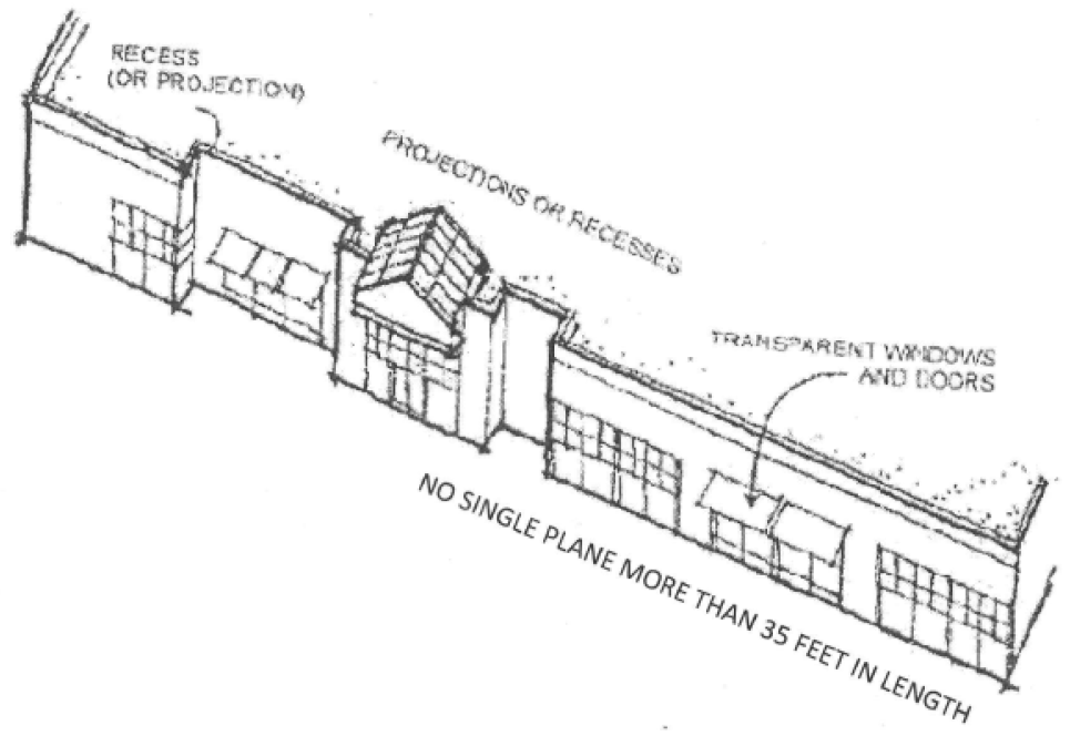
B.
A minimum of 25% of the first floor of the street facade of a business or mercantile use must be transparent.
C.
The use of pitched roofs and roof overhangs shall be required within 1500 feet of a Planned Development (as measured from either side of the subject property). Recommended roofing materials include slate shingles, asphalt and fiberglass shingles, metal standing seam or tiles. Partial (occupying less than three sides) mansard roofs are not allowed.
6.8.5. Alternative Compliance
Alternative compliance may be obtained provided the design satisfies the intent of this section. In such cases, the Planning Director in conjunction with the Building Inspector, shall have the authority to approve the following:
1.
Reduced transparency requirements; or
2.
Materials of construction not listed, provided the materials used are implemented in a manner that enhances the surrounding area.
6.9 - OUTDOOR LIGHTING
6.9.1. Purpose and Intent
Nonresidential and multifamily buildings and projects, including outparcels, shall be designed to provide safe, convenient, and efficient lighting for pedestrians and vehicles. Lighting shall be designed in a consistent and coordinated manner for the entire site. The lighting and lighting fixtures shall be integrated and designed so as to enhance the visual impact of the project on the community and/or should be designed to blend into the surrounding landscape. Lighting design and installation shall ensure that lighting accomplishes on-site lighting needs without intrusion on adjoining properties.
6.9.2. Applicability
The requirements of this Section shall apply to:
A.
All nonresidential or multifamily development;
B.
Lighting provided in conjunction with new subdivisions or planned developments;
C.
Modification of an existing lighted area where the lamp color will change or where the number of light fixtures or foot-candles (fc) are increased; and
D.
Expansion of areas that are increasing in size and in doing so will exceed the illumination levels in Section 6.9.6.
6.9.3. Exempt
A.
The following activities are exempt from the requirements of this Section.
1.
Outdoor lights used for a temporary event; permitted through a Temporary Use Permit.
2.
Outdoor lights used exclusively for recreational activities, concerts, plays or other outdoor events that are open to the public, provided that the event or function meets all other applicable Ordinance requirements. Such lighting shall be located at least 50 feet from any adjoining residential district or use.
3.
Fixtures may be replaced with like fixtures that meet requirements of Section 6.9.5.A.
4.
Maintenance and repairs (excluding replacement of fixtures, modifications or expansions as defined in Section 6.9.5.A) with like parts such as lamps, photo controls, lens and ballast may be performed.
5.
Nonconforming Outdoor Lighting damaged by fire or other causes consistent with the following requirements:
(a)
In the event of damage by fire or other causes to an extent exceeding 75% of its value, reconstruction of a nonconforming structure shall be permitted only in compliance with the dimensional provisions of this Ordinance.
(b)
In the event of damage by fire or other causes to an extent of between 25% and 75% of its value, reconstruction of a nonconforming structure shall be permitted with the issuance of a variance by the Board of Adjustment.
(c)
In the event of damage by fire or other causes to an extent of below 25% of its value, reconstruction of a nonconforming structure shall be permitted provided it is:
i.
In the same location and up to the same dimensions as originally existed; or
ii.
In compliance with the current dimensional requirements.
B.
Outdoor lighting exempt from the Section shall only be illuminated while the activity takes place and during high traffic periods immediately before and after the event.
6.9.4. Lighting Plan
A site lighting plan shall be required as part of the application review for all areas proposed for illumination that exceed 40,000 square feet in area. Projects with multiple areas proposed to be illuminated (such as separate parking lots) shall submit a site lighting plan if the sum of the multiple areas exceeds 40,000 square feet.
6.9.5. Site Lighting Design Requirements
Lighting shall be used to provide safety while accenting key architectural elements and to emphasize landscape features. Light fixtures shall be designed as an integral design element that complements the design of the project. This can be accomplished through style, material or color. All lighting fixtures designed or placed so as to illuminate any portion of a site shall meet the following requirements:
A.
Fixture (Luminaire)
1.
The light source shall be completely concealed behind an opaque surface and recessed within an opaque housing and shall not be visible from any street right-of-way or adjoining properties. Overhead lighting fixtures shall be designed to prevent light from emitting upwards towards the sky.
2.
Under canopy lighting fixtures should be completely recessed within the canopy.
B.
Fixture Height
1.
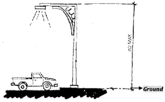
Lighting fixtures may not exceed 40 feet in height (as measured from the ground to the top of the pole) and illumination levels shall comply with Section 6.9.6.
2.
The Planning Director may allow fixtures above this height to provide internal lighting for stadiums, arenas, and similar facilities.
C.
Light Source (Lamp)
1.
The light emitted by Light Emitting Diodes (LEDs) and fiber optics is preferred. Light emitted by incandescent, metal halide, or color corrected high-pressure sodium is acceptable. Non color corrected high-pressure sodium lamps are prohibited.
2.
The same light source type must be used for the same or similar types of lighting on any one site throughout any development.
D.
Mounting
Fixtures shall be mounted in such a manner that the cone of light is contained on-site and maximum illumination levels off-site does not exceed those found in Section 6.9.6 and not conflict with excessive illumination requirements found in Section.
E.
Limit Lighting to Periods of Activity
The use of sensor technologies, timers or other means to activate lighting during times when it will be needed may be required by the Planning Director to conserve energy, provide safety, and promote compatibility between different land uses.
(Ord. No. UDO-16-02 , § 27, 3-7-16)
6.9.6. Illumination Levels
A.
To ensure uniform light distribution, all site lighting shall be designed so that the level of illumination as measured in foot-candles (fc) at any one point meets the standards in the table below with minimum and maximum levels measured on the pavement within the lighted area and average level (the overall generalized ambient light level), measured as a not-to-exceed value calculated using only the area of the site intended to receive illumination. The Planning Director may make reasonable adjustments to accommodate the specific lighting needs of the interior areas of projects; however, the measurements for the Maximum Illumination Levels pertaining to the project boundaries as outlined in the table below under item B, shall not be exceeded.
B.
All outdoor lighting shall be designed and located such that maximum illumination measured in foot-candles comply with those in the following table:
6.9.7. Excessive Illumination
A.
Lighting within any lot that unnecessarily illuminates and substantially interferes with the use or enjoyment of any other property is prohibited. Lighting unnecessarily illuminates another lot if it exceeds the requirements of this Section.
B.
Lighting shall not be oriented so as to direct glare or excessive illumination onto streets in a manner that may distract or interfere with the vision of drivers on such streets.
C.
Fixtures used to accent architectural features, landscaping or art shall be located, aimed or shielded to minimize light spill into the night sky.
D.
Blinking or flashing lights shall be prohibited unless the lights are required as a safety feature (e.g. beacons on towers) or shall be permitted as part of a sign in accordance with Article 8, Signs.
6.9.8. Nonconforming Lighting
Lighting fixtures existing as of May 1, 2007 may remain, and shall be considered nonconforming structures. Modifications, replacement or expansions, shall conform to the standards of this Ordinance.
6.10 - FENCES AND WALLS
6.10.1. Height
The maximum height of a fence or wall shall be as shown in the table below, unless a higher fence or wall is required by other provisions of this Ordinance.
A.
Fences or walls within required yards fronting on a public street shall comply with the front yard height standard. The Planning Director may approve an increase in height to the maximum indicated in the column "With Administrative Adjustment".
6.10.2. General
A.
No fence or wall shall impede the visual locating of 911 emergency street addresses.
B.
No fence or wall shall block access from doors or windows. Fences must have a clearance of at least two feet (from building walls, except where fences project from or to a building wall.
C.
Fences or walls shall not alter or impede the natural flow of water in any stream, creek, drainage swale, or ditch.
D.
A finished side shall face off site.
E.
No portion of a wall or fence constructed after May 1, 2007 may encroach on an adjoining property line.
F.
Pedestrian connections through fences and walls that connect to adjoining neighborhoods or other uses are encouraged.
G.
Fences and walls should be designed and constructed to prevent damage to the fence or wall and nearby structures during hurricane events.
H.
Additional wall or fence requirements applicable to a particular activity or use may be specified elsewhere in this Ordinance. Except where specifically modified (such as a specific height requirement), this Section shall take priority.
6.10.3. Placement
A.
Fences or walls may not be located within the required site triangle (see Section 6.15).
B.
When located in between the structure and a street, the fence or wall may be placed anywhere between the edge of the structure and the street right-of-way or easement line.
C.
Along all other boundaries, the fence may be placed anywhere between the edge of the structure and the property line, generally at a distance that allows pedestrian access within the property.
D.
Fences may be located within a required easement, subject to any additional restrictions imposed by the easement agreement. However, the property owner shall remain solely liable for any repair or replacement if any portion of the fence is damaged during maintenance or construction activities within the easement by the easement owner or their agent.
E.
Walls may not be placed within a required easement unless specifically allowed by the easement agreement.
F.
Vehicle stacking spaces are required for gates for fences and walls (See Section 6.12.8).
(Ord. No. UDO-19-02 , § 11, 9-19-19)
6.10.4. Fences
A.
The following types of fences are permitted in all zoning districts:
1.
Ornamental iron;
2.
Vinyl or similar material;
3.
Chain-link or woven wire (although the use of chain link fences in yards fronting on public streets is strongly discouraged); and
4.
Wood or similar material.
B.
In addition to the fences permitted by Subsection A., above, the following types of fences are permitted in the RR zoning district:
1.
Fences constructed primarily of barbed or razor wire, when specifically for the purpose of enclosing livestock. On fences topped with barbed wire, the bottom strand must be at least six feet above grade with vertical supports slanting inward away from the property line;
2.
Fences carrying electrical current, when specifically for the purpose of enclosing livestock;
C.
The following types of fences are prohibited in all zoning districts:
1.
Fences constructed primarily of barbed or razor wire, when not for the purpose of enclosing livestock.
2.
Fences carrying electrical current, when not for the purpose of enclosing livestock;
3.
Fences constructed in whole or in part of readily flammable material such as paper, cloth or canvas;
4.
Fences topped with barbed wire or metal spikes except those serving an institution requiring a security fence for public safety purposes;
6.10.5. Walls
A.
Walls shall be constructed of one or a combination of the following materials: stucco over concrete block, exposed aggregate concrete, brick, stone, or architectural block in a structurally safe and attractive condition.
B.
Alternative walls may be permitted with the approval of the Planning Director if such alternative walls provide a similar level of opacity to that of the listed materials and are in keeping with the architecture of the development. No walls of exposed, painted-only, plain concrete cinder block shall be permitted.
C.
No wall shall be located within any required drainage, utility or similar easement.
6.10.6. Retaining Walls
Retaining walls up to four feet in height may be located within required yards.
6.10.7. Maintenance
Any fence or wall which, through neglect, lack of repair, type or manner of construction, method of placement or otherwise, constitutes a hazard or endangers any person, animal or property is hereby deemed a nuisance. If such conditions exist, the Planning Director shall require the owner or occupant of the property upon which the fence or wall is located to repair, replace or demolish the fence causing the nuisance.
6.11 - VEHICULAR
6.11.1. Street Classification
A.
In all new subdivisions, streets that are dedicated to public use shall be classified as provided in this Section.
1.
The classification shall be based upon the projected volume of traffic to be carried by the street, stated in terms of the number of trips per day;
2.
The number of dwelling units to be served by the street may be used as a useful indicator of the number of trips but is not conclusive;
3.
Whenever a subdivision street continues an existing street that formerly terminated outside the subdivision or it is expected that a subdivision street will be continued beyond the subdivision at some future time, the classification of the street will be based upon the street in its entirety, both within and outside of the subdivision.
B.
The classification of streets shall be as follows:
1.
Alley. A vehicular way used for providing service access along rear or side property lines of lots which are also served by one of the other listed street types. Alleys are not intended to accommodate through traffic.
2.
Minor. A street whose sole function is to provide access to abutting properties. It serves or is designed to serve not more than nine dwelling units or expected to or does handle up to 75 trips per day.
3.
Local. A street whose sole function is to provide access to abutting properties. It serves or is designed to serve at least 10 but no more than 25 dwelling units or expected to or does handle between 75 and 200 trips per day.
4.
Cul-de-sac. A street that terminates in a vehicular turnaround.
5.
Subcollector. A street whose principal function is to provide access to abutting properties but is also designed to be used or is used to connect minor and local streets with collector or arterial streets. Including residences indirectly served through connecting streets, it serves or is designed to serve at least 26 but not more than 100 dwelling units and is expected to or does handle between 200 and 800 trips per day.
6.
Collector. A street whose principal function is to carry traffic between minor, local, and subcollector streets and arterial streets but that may also provide direct access to abutting properties. It serves or is designed to serve, directly or indirectly, more than 100 dwelling units and is designed to be used or is used to carry more than 800 trips per day.
7.
Arterial. A major street in the county's street system that serves as an avenue for the circulation of traffic into, out, or around the county and carries high volumes of traffic.
8.
Marginal Access Street. A street that is parallel to and adjacent to an arterial street and that is designed to provide access to abutting properties so that these properties are somewhat sheltered and so that the flow of traffic on the arterial street is not impeded by direct driveway access from a large number of abutting properties.
9.
Thoroughfare. A street serving the principal network for high volumes of traffic or high speed traffic as shown on the County Transportation Plan. This street type consists of at least two travel lanes in each direction. A thoroughfare shall be designated where the anticipated average daily volume exceeds 5,000 vehicles. Residences should not front on a major thoroughfare.
6.11.2. General Standards
A.
Road widening and right-of-way dedication shall be consistent with the recommendations of the adopted County or NCDOT Transportation Plan.
B.
The proposed street layout in new development shall be coordinated with the existing street system with connections made at all future connections. Where no full connection can be made as a result of the topography of the site being developed, the developer may install a cul-de-sac bulb or other turnaround facility.
C.
Creative design of circulation routes and trafficways is encouraged. A base characteristic in Planned Developments is that the internal circulation routes or streets do not follow fixed linear geometric lines as do most streets. Instead, circulation routes are curvilinear and of meandering character, to preserve tree and landscape features. Slower-paced traffic movements, private restrictions for extremely low speed limits.
D.
Where a tract of land to be subdivided adjoins a principal arterial street, the subdivider may be required to provide a marginal access street parallel to the arterial street or reverse frontage on a minor street for the lots to be developed adjacent to the arterial. Where reverse frontage is established, private driveways shall be prevented from having direct access to the principal arterial.
E.
Where, in the opinion of the Planning Director, or Planning Board, it is necessary to provide for street access to an adjoining property, proposed streets shall be extended by dedication to the boundary of such property and a temporary turn-around provided.
F.
All public streets shall be built to the standards of this Ordinance and all other applicable standards of the County and the NCDOT.
G.
Streets which are not eligible to be put on the State Highway System because there are too few lots or residences shall, nevertheless, be constructed in accordance with the standards in this Ordinance or the standards necessary to be put on the State Highway System, so as to be eligible to be put on the system at a later date. A written road maintenance agreement with provisions for maintenance of the street until it is put on the State system shall be included in the final plat (see paragraph H, below).
H.
All public streets shown on the final plat shall be designated in accordance with G.S. § 136-102.6 and designation as public shall be conclusively presumed an offer of dedication to the public. Where streets are dedicated to the public but not accepted into the State system, before lots are sold, a statement explaining the status of the street shall be included with the final plat.
I.
All roads that are not maintained by NCDOT (including those approved for dedication but not yet incorporated into the state road system) shall be dedicated to a property owners association, and comply with the following, prior to approval of the final plat:
1.
The association shall be responsible for the maintenance and upkeep of the street or road.
2.
The property owners association shall be established before the lots are sold.
3.
Membership in the association shall be mandatory for each lot buyer and all successive buyers.
4.
Any sums levied by the association that remain unpaid shall become a lien on the individual owner's property which shall be subordinate to tax and mortgagee liens.
5.
Owners of each lot shall have voting rights in the association.
6.
The following information shall also be provided:
i.
The name and address of the association.
ii.
The manner in which directors of the association are to be selected.
iii.
The post office address of the initial registered office.
iv.
The name of the city and county in which the registered office is located.
v.
The number of directors constituting the initial board of directors.
6.11.3. Street Connectivity Requirements
An interconnected street system is necessary in order to promote orderly and safe development by ensuring that streets function in an interdependent manner, provide alternative paths of evacuation in the event of a natural or man-made disaster, and provide adequate access for emergency and service vehicles.
A.
Connectivity Defined
Connectivity shall be defined by the ratio of links to nodes in any subdivision.
1.
The connectivity ratio shall be the number of street links divided by the number of nodes or end links, including cul-de-sac heads.
2.
A link shall be any portion of a street, other than an alley, defined by a node at either end. Future connections to adjoining property shall be considered links. For the purpose of determining the number of links in a development, boulevards, median-divided roadways, and divided entrances shall be treated the same as conventional two-way roadways.
3.
A node shall be the terminus of a street or the intersection of two or more streets.
i.
Any curve or bend of a street that exceeds 75 degrees shall receive credit as a node. Any curve or bend of a street that does not exceed 75 degrees shall not be considered a node.
ii.
The Planning Director may allow a divided entrance to count as two separate links provided the median dividing the entrance extends at minimum to the first internal intersection of the subdivision.
B.
Required Ratio
1.
Street Network
i.
The street network for any subdivision with internal roads or access to any public road shall achieve a connectivity ratio of not less than 1.3 in all tiers except the Rural Low Density Residential Zoning Districts, measured within the subdivision.
ii.
Within the Rural Low Density Residential Zoning Districts, the street network for any subdivision with internal roads or access to any public road shall achieve a connectivity ratio of not less than 1.15, measured within the subdivision.
2.
Street links and nodes along a marginal access street providing access to a proposed subdivision shall not be considered in computing the connectivity ratio.
3.
Future connections that cannot be constructed pursuant to Sec. 6.11.3.E, Future Connections, shall be considered as being present as a link at the ratio of one link per side as provided in Sec. 6.11.3.E, Future Connections, for purposes of determining if the required ratio has been met.
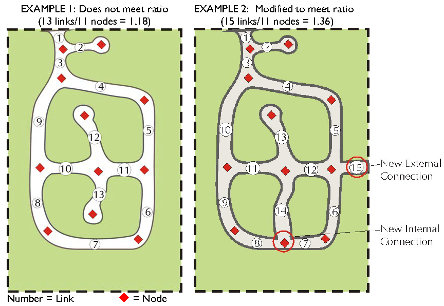
C.
Multiple Points of External Access May Be Required
1.
External access to residential development shall be provided as indicated below. In determining the number of access points that shall be required, the cumulative impacts of prior developments on the roads shall be considered.
i.
For residential developments with 90 or fewer lots (or equivalent dwelling units), at least one point of access to the roadway network shall be provided.
ii.
For residential developments with between 91 and 120 lots (or equivalent dwelling units), at least two points of access to the roadway network shall be provided.
iii.
For residential developments with more than 120 lots (or equivalent dwelling units), at least three points of access to the roadway shall be provided.
iv.
For residential developments with more than 300 lots (or equivalent dwelling units), the Planning Board may specify that more than three points of access shall be provided.
v.
Required points of access may provide access restrictions in the form of an electronically-controlled gate that may be opened by emergency responders via siren activation or other approved method. During times of emergency evacuation (such as a natural disaster), gates may be required to be opened to provide alternative evacuation routes.
2.
The Planning Director may allow a divided entrance to count as two separate links provided the median dividing the entrance extends at minimum to the first internal intersection of the subdivision.
3.
The Planning Board may approve variations in the requirements of this section when additional access points cannot be provided due to the following circumstances:
i.
If the only additional access points available would require crossing floodplains, steep slopes, or other similar natural features; or,
ii.
When the existing development pattern precludes additional access points and fewer units than would otherwise be allowed would be out of character with the surrounding development.
D.
Connections to Adjoining Properties
1.
Street connections or future connections to adjoining properties may be required. See Section 6.11.3.E, Future Connections, for standards.
2.
Connections may provide access restrictions in the form of an electronically-controlled gate that may be opened by emergency responders via siren activation or other approved method. During times of emergency evacuation (such as a natural disaster), gates may be required to be opened to provide alternative evacuation routes.
E.
Future Connections
1.
Unless exempted below, future connections are required on each side (as defined by each of the cardinal directions) of a development as follows:
i.
Rural Low Density Residential Zoning Districts
At least one future connection for every 2,800 linear feet on any single side of the proposed development.
ii.
All other Zoning Districts
At least one future connection for every 1,400 linear feet on any single side of the proposed development.
2.
Exemptions
i.
Future connections are not required adjoining existing development that has not made any accommodation for such connections or to adjoining sites that are permanently protected from development through conservation easements or ownership that precludes development.
ii.
Future connections are not required if the only point of access would require crossing floodplains, wetlands, or other similar natural features.
F.
Reserve Strips Controlling Access
The reservation of private property strips of too narrow a depth to permit development as a means of controlling access to public ways shall not be permitted.
6.11.4. Nonresidential Streets
The subdivider of a nonresidential subdivision shall provide streets in accordance with F-4 of the North Carolina Roads, Minimum Construction Standards, July 1, 1985, or current standards, and the standards in this Ordinance, whichever are stricter.
6.11.5. Design Standards
A.
General
The design of all public streets and roads within the jurisdiction of this Ordinance shall be in accordance with the accepted policies of the N.C. Department of Transportation, Division of Highways, as taken or modified from the American Association of State Highway Officials (AASHO) Manuals; the N.C. Department of Transportation Division of Highway's Subdivision Roads Minimum Construction Standards, July 1, 1985, or current standards; and County design standards.
In all new planned developments and subdivisions, the proposed street layout shall be coordinated with the existing street system with connections made at all future connectors. Where the development is bound by two or more NCDOT on-system roads, at minimum, one access to each road shall be provided. Siren activated gate systems shall be required for all unattended gates.
Adequately constructed and maintained bike and/or hiking trails shall be counted toward the open space requirement. Bicycle lanes and multi-use pathways that extend the minimum right-of-way width shall be designed in accordance with the North Carolina Bicycle Facilities Planning and Design Guidelines Manual.
Pedestrian-oriented communities are encouraged to enhance the quantity of pedestrian activity and to improve the quality of the pedestrian experience.
Commentary: Alternate street construction designs such as pervious pavement or other Low Impact Design (LID) methods may be approved if certification by a design engineer is provided showing the proposed street construction will meet or exceed NCDOT's construction standards for strength and durability for subdivision roads.
B.
Minimum Right-of-Way and Pavement
Right-of-Way widths may not be less than the table below except when approved through the Planned Development process or in those cases where right-of-way requirements have been specifically set out in the thoroughfare plan. Additionally, right-of-way may be required to accommodate wider roads or utilities.
A minimum paved street width of 20 feet shall be required for all internal two-way roadways. One-way roadways shall require a minimum paved street width of 14 feet.
i.
Private Streets
ii.
Public Streets
Public Streets shall be designed and constructed in accordance with the North Carolina Department of Transportation Subdivision Roads Minimum Construction Standards. See the 2010 or more recent version of NCDOT Division of Highway's Subdivision Roads Minimum Construction Standards For Subdivision Roads for design standards. In some instances, minimum Right-of-Way or Easement width of public and private streets may be required to exceed forty-five feet (45') based on street function, number of lots served and other factor(s) specific to the proposed development.
Commentary: All roads designed to meet NC Department of Transportation Subdivision
Roads Minimum Construction Standards will require a certification by a design engineer
to the Engineering and Planning Departments that all roadways and all on-site drainage
are designed in accordance with minimum NCDOT standards as required by the UDO. Upon
completion of the required improvements in the development, the design engineer also
will be required to certify that all road and on-site drainage have been constructed
in conformance with the minimum NCDOT standards.
Commentary: A certification on the preliminary and all final plats must be submitted
by a design engineer to the Engineering and Planning Departments that all roadways
and all on-site drainage are designed in accordance with minimum NCDOT standards as
required by the UDO. Upon completion of the required improvements in the development,
the design engineer also will be required to certify that all road and on-site drainage
have been constructed in conformance with the minimum NCDOT standards and the approved
plans.
C.
Intersections
1.
Streets shall be laid out so as to intersect as nearly as possible at right angles, and no street shall intersect any other street at an angle less than 60 degrees.
2.
Offset intersections are to be avoided unless an exception is granted by NCDOT. Intersections which cannot be aligned should be separated by a minimum length of 200 feet between survey centerlines.
3.
Intersections with arterials, collectors, and thoroughfares, shall be at least 1,000 feet from center line to center line. Greater separation distances may be required by the N.C. Department of Transportation.
D.
Turning Lanes
Any subdivisions on U.S. and NCDOT highways whose master plan shows over 100 lots shall be required to provide turning lanes into the subdivision.
E.
Alleys
1.
Alleys are required to serve lots used for commercial and industrial purposes or where lots are less than 50 feet wide. This requirement may be waived where other definite and assured provision is made for service access.
2.
The width of an alley shall be at least 18 feet but may be increased based on the proposed use.
3.
Dead-end alleys should be avoided, but if unavoidable shall be provided with adequate turn-around facilities at the dead-end.
F.
Culs-de-sac, Hammerheads, and Other Terminal Access Streets
1.
General
i.
Cul-de-sacs streets may not exceed 800 feet in length unless necessitated by topography or property accessibility. Measurement shall be along the centerline of the street from the center of the cul-de-sac to the centerline of the intersecting street.
ii.
The distance from the edge of pavement on the turnaround to the right-of-way line may not be less than the distance from the edge of pavement to right-of-way line on the street approaching the cul-de-sac.
iii.
Cul-de-sacs may not be used to avoid connection with an existing street or to avoid the extension of a street, unless exception is granted by the Planning Board.
2.
Multiple Types of Terminal Access Streets
In order to provide design flexibility, terminal access streets may provide turning and maneuvering area at the terminus of the street in compliance with the following graphic:
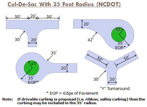
G.
Future Connections
1.
Unless exempted below, future connections are required on each side (as defined by each of the cardinal directions) of a development as follows:
i.
Rural Low Density Residential Zoning Districts
At least one future connection for every 2,800 linear feet on any single side of the proposed development.
ii.
All other Zoning Districts
At least one future connection for every 1,400 linear feet on any single side of the proposed development.
2.
Exemptions
i.
Future connections are not required adjoining existing development that has not made any accommodation for such connections or to adjoining sites that are permanently protected from development through conservation easements or ownership that precludes development.
ii.
Future connections are not required if the only point of access would require crossing floodplains, wetlands, or other similar natural features.
H.
Reserve Strips Controlling Access
The reservation of private property strips of too narrow a depth to permit development as a means of controlling access to public ways shall not be permitted.
6.11.6. Street Names
Street names shall not duplicate nor closely approximate existing street names within the County. Extensions of existing, named streets shall bear the existing street name. A complete list of previously used names shall be maintained by the GIS Division with the County Tax Department.
6.11.7. Street Signs and Markers
A.
Standard street name signs shall be installed at one corner of all street intersections, including private streets. The size, design, materials, location, and installation of the signs shall be in accordance with NCDOT standards, as applicable. Planned Developments may be allowed to use ornamental street signs in conformance with Section 8.7.17, Traffic Control Signs on Private Property.
B.
Signs denoting the beginning and ending of public maintenance shall also be erected and maintained on private streets.
C.
Signs denoting the right-of-way boundaries of dedicated or reserved, unopened streets and future connections shall be erected and maintained according to County standards.
6.11.8. Street Lighting
Installation of street lights within developments is encouraged but is optional. When street lights are installed, they must be in accordance with the provisions of Section 6.9.7, Excessive Illumination and the minimum spacing and other standards of the appropriate utility company.
6.12 - OFF-STREET PARKING AND LOADING
6.12.1. Statement of Intent
A.
Vehicles require adequate space in safe operating and parking conditions for all land uses, public and private. Yet Brunswick County has a unique and sensitive environment whereby space for vehicle parking and loading should have the least necessary impervious surface, should not drain directly into the waters of the county, and should be adequately designed for either on-site absorption of or disposal of such vehicular wastes such as oils.
B.
Brunswick County is dependent upon its tourists and seasonal visitors for sustenance of the economy. In keeping with a tourist economy is the need for presentation of a harmonious image. Landscape features to buffer large areas for parking and loading are required for such economic protection of the county, and for relief from heat build-up of large surface areas.
C.
Exception Design in parking lot landscaping, stormwater management, lighting, circulation, directional elements, etc. may be eligible for credit toward buffer, landscaping or other requirements.
6.12.2. Applicability
A.
No Building Permit, Certificate of Zoning Compliance, or Certificate of Occupancy shall be issued for uses of land, structures, and buildings, either initially or for a change in use or expansion of an existing use, unless the off-street parking and loading requirements of this Article are satisfied.
B.
Applicants proposing to construct large-scale parking facilities may be required to obtain a Transportation Facility Permit from the North Carolina Division of Air Quality prior to initiation of construction in conformance with 15A NCAC 02D .0800. Consult with the Planning Director for more information.
Commentary: Generally, a large scale parking facility is a surface parking lot with at least 1,500 spaces, a parking deck with at least 750 spaces, or a combination of surface and structured parking that has at least 1,000 spaces. See 15A NCAC 02D .0805: Parking Facilities for specific applicability standards.
6.12.3. Activities Exempt
Commentary: In order to accommodate renovation and investment in commercial properties or very small scale construction of single-family homes, ordinances often provide an exemption from parking requirements for certain activities.
A.
A change in use or expansion of an existing use meeting either of the following criteria shall be exempt from the requirements of this Article:
1.
Expansions of less than 1,500 square feet or 10% of the total enclosed floor area (whichever is greater); or
2.
The new use has the same parking requirement or a lesser requirement than the previous one.
B.
Restriping of a parking area or other vehicular use area which does not result in reconfiguration of the parking spaces shall be exempt from the requirements of this Article.
C.
Construction or modification of an individual single-family or two-family residence by the owner shall be exempt from the requirements of this Article.
Commentary: Construction of an entire subdivision, however, is not exempt.
6.12.4. Plans Required
Applications for permits and/or certificates shall include information as to location and dimension of off-street parking, and means of ingress and egress to such space, a copy of the Sedimentation and Erosion Control Plan prepared and filed under N.C. Statute for same, and a showing of shrubbery areas, trees to be saved or added, berms, proposed fences or walls, proposed surface materials, proposed lighting, and written assurance the N.C. Statute on handicapped parking will be satisfied.
6.12.5. Design Standards
A.
General Requirements
1.
Parking areas shall be designed to allow unobstructed movement into and out of each parking space without interfering with fixed objects such as lighting fixtures, dumpsters, signage, or vehicles.
2.
Each parking space within the parking area must be delineated by striping, curbs (each space signed or appropriately marked), wheel stops or other similar alternative devices. Railroad ties and landscape timbers are not considered acceptable alternative devices.
3.
All parking areas shall be designed to provide for internal circulation such that each parking space is accessible to all other parking spaces without necessitating the use of a public street or alley.
4.
Cross access drives between adjoining uses and properties shall be encouraged.
5.
Off street parking or loading areas may not be located within any required buffer (see Section 6.3).
6.
Modifications to off-street parking and loading to allow stormwater best management practices consistent with an approved stormwater plan may be considered.
B.
Paving
1.
Where an existing tree is adjacent to a parking area, paver bricks, tree grates, or other pervious surface shall be used within the dripline of the tree.
2.
Unless alternative surfaces are specified elsewhere in this document, or are approved by the Planning Director, in consultation with the Director of Engineering Services, all required parking and loading spaces, except for those associated with single-family dwellings, shall be surfaced with asphalt bituminous, concrete or dustless material and shall be maintained in a smooth, well-graded condition.
Commentary: Approved alternative surfaces are gravel, slate, and recycled asphalt.
3.
Within the Rural Low Density Residential districts, required off-street parking and loading spaces may be covered with an all-weather surface designed to support anticipated loads. Loose material surfaces shall be contained with a permanent edging. The surface shall be maintained so that traffic may move safely in and out of the parking area.
4.
Alternative Parking Surfaces
i.
Pervious pavers or concrete, stabilized grass lawn, or other pervious parking surfaces may be permitted for specific uses as set forth below, provided they are approved by the Planning Director, in consultation with the Director of Engineering Services. Where provided, such alternative parking surfaces shall be maintained in a smooth, well-graded condition. If parking demand is such that the grass or lawn is caused to be damaged or destroyed to the extent that it ceases to grow, then paving of the area in accordance with this section may be required.
ii.
All driveways, access aisles and parking spaces (excluding handicapped) may be surfaced with grass lawn or other pervious parking surface for the following:
(a)
Uses which require parking on an average of less than five days per week during a month;
(b)
Parks, playgrounds, ballfields, football and baseball stadiums, fairgrounds, and other similar outdoor recreation areas; and
(c)
Surplus parking areas above the required number of parking spaces (see Section 6.12.6, Required Parking).
C.
Lighting
Any lighting shall be internally oriented and shall be installed in conformance with Section 6.9, Outdoor Lighting.
D.
Signage
On-premises instructional signs may be provided in conformance with Section 8.7.5.
E.
Dimensional Requirements
1.
New or altered off-street parking areas shall conform to the following dimensions:
2.
For bumper overhang deduct 1.5 feet from stall depth to wall or 3 feet from module width wall to wall for 45° and 60° parking. Deduct 2 feet from stall depth to wall or 4 feet from module width to wall for 75° and 90° parking.
3.
Where natural and/or man-made obstacles, obstructions or other features such as but not limited to landscaping, support columns or grade difference exist, the Planning Director may approve a reduction in stall width, stall length and/or module width. In all instances where a reduction is requested, attention to emergency vehicle access must be considered and incorporated into the parking lot design.
4.
Parking spaces designed to be located parallel to a curb or roadway shall be 23 feet long and nine feet wide.
5.
Parking in driveways and aisles shall not be permitted unless it is determined by the Planning Director, in consultation with the Fire Marshal that emergency access shall not be impaired.
6.
Parking and loading areas shall provide sufficient maneuvering area to accommodate emergency services vehicles and solid waste vehicles. A minimum turning radius of 40 feet shall be required between internal aisles, driveways, and other vehicular use areas. This radius may be reduced if the Planning Director, in consultation with other county officials, determines that the resulting dimension does not impair the intent of this requirement.
7.
One-way drive aisles shall have angled parking to better guide the flow of traffic.
F.
Parking Decks and Parking Garages
Required parking and loading spaces need not be at ground level. Decks and garages shall be treated either as part of the principal structure and subject to all requirements over such structures, or as principal uses by themselves, meeting all requirements for principal structures and uses when permitted.
G.
Design Standards for Handicapped Accessible Parking
All off-street handicapped accessible parking spaces shall be designed in compliance with Chapter 11 of the North Carolina Building Codes. See Appendix B for additional information.
1.
The North Carolina Accessibility Code.
2.
All off-street handicapped accessible parking spaces shall be located in the closest parking area to a public entrance to the building but no more than 250 feet from such entrance.
3.
All off-street handicapped accessible parking spaces shall be designated by a sign or other means specified by State requirements.
4.
All off-street handicapped accessible parking spaces must be surfaced with concrete or asphalt.
(Ord. of UDO-17-01 , § 18; Ord. No. UDO-19-02 , § 11, 9-19-19)
Editor's note— Ord. No. UDO-19-02 , § 11, adopted September 19, 2019, set out provisions intended for use as 6.12.5.E.2. As that subsection already exists in the Code, and at the editor's discretion, these provisions have been included as 6.12.5.E.7.
6.12.6. Required Parking
A.
Minimum
1.
Off-street parking spaces shall be provided for all uses listed below in the amounts specified below. Uses not listed shall be reviewed by the Planning Director, for a determination of the required spaces. Buildings with multiple uses shall calculate parking based on the square footage of each use in the building.
2.
Where a building is constructed without a specific use identified, such as a "flexible-use" building that may be occupied by multiple uses, parking requirements shall be satisfied as follows:
i.
Adequate space shall be reserved either on-site or through an approved alternative parking plan (See Section 6.12.7) to accommodate the requirements for the use with the highest parking requirements permitted in the zoning district. This "reserve area" need not be paved, but shall be indicated on all required plans and shall be counted toward the impervious cover calculations for a development when located in an area where impervious parking and loading is required.
ii.
The actual number of spaces required to be paved shall be one space per 300 square feet of enclosed floor area. This requirement may be modified by the Planning Director.
3.
Calculation of spaces shall be in whole units only. If a calculation results with a fraction, that fraction shall be rounded up to the next whole number. Unless otherwise specified, enclosed floor area shall be deemed to be gross enclosed floor area.
B.
Maximum Parking Permitted
1.
No use shall provide more than 150% of the required parking shown in the table above unless any parking above the 150% threshold is pervious or is provided through use of structured parking.
2.
Where a project is intended to be developed in phases, the Planning Director may approve development of a parking area intended to serve current and future development.
C.
Modifications
The Planning Board may reduce the required number of spaces by up to 20% if for reasons of topography, mixes of uses, ride sharing programs, availability of transit, or other conditions specific to the site, provided the reduction in the required number of parking spaces satisfies the intent of this Section.
(Ord. No. UDO-16-02 , § 29, 3-7-16; Ord. No. UDO-18-02 , § 2, 3-19-18)
6.12.7. Alternative Parking Plans
A.
General
Innovative approaches which reduce the amount of impervious cover within Brunswick County are encouraged when the public interest is served and protected. The Planning Director or Planning Board, as specified, may reduce the minimum amount of off-street parking required (beyond that permitted by Sec. 6.12.6.C, Modifications) where developer-submitted parking data, prepared and sealed by a registered engineer with transportation expertise, illustrates that the standards of this section do not accurately apply to the specific development. The data submitted for an alternative parking plan shall include, at a minimum, the size and type of the proposed development, the mix of uses, the anticipated rate of parking turnover and the anticipated peak parking and traffic loads of all uses. The following factors may also be considered.
B.
Factors Considered in Alternative Parking Plans
1.
Public Parking
Up to 35% of the required off-street parking spaces may be waived by the Planning Director if publicly-controlled-parking is located within a 500 foot walking distance along public walkways from the main entrance of the proposed use and the Planning Director also determines that adequate parking spaces are available within the publicly-controlled parking area to accommodate the anticipated use. Reductions below 35% of the required off-street parking spaces may be approved by the Planning Board.
2.
Off-Site and Cooperative Parking
i.
Cooperative provision of required parking space and other innovative parking arrangements which protect and serve the public interest are encouraged.
ii.
The Planning Director may approve the location of up to 50% of required off-street parking spaces on a separate lot from that on which the principal use is located if the off-site parking complies with all of the following standards. This factor shall not be used to satisfy the off-street parking requirements for convenience stores or similar convenience-oriented uses or for handicapped accessible parking.
iii.
Location
No off-site parking space shall be located more than 500 feet from the primary entrance of the use served (measured along public walkways). Off-site parking spaces shall not be separated from the use served by a highway, unless a grade-separated pedestrian walkway is provided, or traffic control or remote parking shuttle bus service is provided. Off-site parking shall be located in a district where commercial parking is a permitted principal use.
iv.
Agreement for Off-Site and Cooperative Parking
If an off-site parking area is not under the same ownership as the principal use served, a written agreement between the record owners shall be required. The owner of the off-site parking area shall enter into a written agreement in a form acceptable to the County Attorney, (with enforcement running to the record owners of the area and the County) providing that the land comprising the parking area shall never be disposed of except in conjunction with the sale of the building which the parking area serves so long as the facilities are required; and that such agreement shall bind heirs, successors, and assigns.
3.
Valet Parking
The Planning Board may approve valet parking as a means of satisfying otherwise applicable off-street parking requirements where all of the following standards have been met.
i.
Adequate assurance of the continued operation of the valet parking, such as a contractual agreement for valet services or the tenant's affidavit agreeing to provide such services shall be provided;
ii.
An equivalent number of valet spaces shall be available to replace the required parking spaces. Such valet spaces do not require individual striping, and may take into account the tandem or mass parking of vehicles.
6.12.8. Vehicle Stacking Areas
A.
Vehicle Stacking Areas
The vehicle stacking standards of this subsection shall apply unless otherwise expressly approved by the Planning Director. Additional stacking spaces may be required where trip generation rates suggest that additional spaces will be needed.
B.
Minimum Number of Spaces
Off-street stacking spaces shall be provided as follows:
C.
Design and Layout of Stacking Spaces
Required stacking spaces shall be subject to the following design and layout standards:
1.
Size
Stacking spaces shall be a minimum of eight feet in width by 25 feet in length.
2.
Location
Stacking spaces shall not impede on- or off-site traffic movements or movements into or out of off-street parking spaces.
3.
Design
Stacking spaces shall be separated from other internal driveways by raised medians if deemed necessary by the Planning Director, for traffic movement and safety.
4.
Landscaping and Screening Requirements
In order to protect adjoining properties from noise and visual impacts, vehicle stacking areas shall be screened from adjoining residential property in accordance with the screening requirements of Section 6.4, Screening, and Section 6.12.10, Vehicular Use Area Landscaping.
6.12.9. Loading Areas
A.
Location
1.
No loading spaces shall be located within 30 feet of street intersections or in any required front, side, or rear yard.
2.
A minimum setback of 50 feet shall be required where loading docks face a residential district or a structure with first-floor residential uses, unless the loading area is completely screened from view with an eight foot high masonry wall in accordance with the requirements of Section 6.10, Fences and Walls.
3.
Loading areas shall be located to provide the most convenient access to the use being served. Generally, loading areas should be within 50 feet of the building.
B.
Surfacing
Generally, all open off-street loading areas shall be paved with an all-weather material such as concrete or asphalt, designed to carry the heaviest vehicle loads that can commonly be expected. Consideration should be given to the weight of fire and sanitation equipment as well as delivery vehicles.
C.
Design
1.
Loading berths for office uses shall be a minimum of 12 feet wide by 35 feet long with a height clearance of 14 feet.
2.
All other loading berths shall be a minimum of 12 feet wide and 55 feet long with a height clearance of 14 feet.
D.
Utilization
Space allocated to any off-street loading space, accessory drives, or aisles, shall not be used to satisfy the space requirements for any off-street parking or trash handling facilities.
E.
Ingress and Egress
Each required off-street loading space shall be provided with a means of unobstructed ingress and egress to an alley or onto a public street wide enough to accommodate expected vehicles. Where such ingress and egress is made into a public street, it shall be through driveways or openings which meet required standards. Permanent wheel stops or curbing shall be provided to prevent any vehicle using the loading area from encroachment on the required front yards, side yards, or adjoining property.
F.
Number of Spaces Required
1.
Loading spaces shall be required for uses which normally handle large quantities of goods, including but not limited to industrial plants, wholesale establishments, warehouses, freight terminals, hospitals and retail establishments.
2.
The numbers in the table below shall serve as a guideline for determining the number of loading spaces required.
3.
The Planning Director may require one or more additional loading areas if the magnitude of the use would anticipate the need for more loading or standing space.
4.
Similarly, the Planning Director may reduce the number of required spaces if it can be demonstrated that the nature of the use is such that the suggested number is not warranted.
G.
Off-Street Loading Requirements
1.
Off-street loading spaces may be either inside or outside the building and on the same or adjoining lots.
2.
The loading spaces shall be of sufficient size and number to allow normal loading and unloading operations appropriate to the property to be served.
3.
In no case shall the loading space hinder the movement of traffic or pedestrians. The loading spaces shall be indicated on site plans submitted for approval.
4.
Loading areas shall be signed to indicate "No Idling."
5.
Any loading area located adjoining to a residential district shall not receive deliveries between the hours of 11 p.m. and 7 a.m.
H.
No Repair and/or Service
No motor vehicle repair work or service of any kind shall be permitted in conjunction with loading facilities provided in any district.
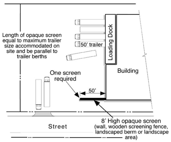
I.
Landscaping and Screening Requirements
Loading areas shall be screened from public streets and adjoining residential uses and Residential Districts in accordance with the screening requirements of Section 6.4, Screening, and Section 6.12.10, Vehicular Use Area Landscaping. The screen shall be at least as long as the longest trailer to be accommodated by the area (approximately 50 feet) and a minimum of eight feet in height. The Planning Director may reduce or waive this requirement if it can be determined that other elements would provide adequate screening. These elements may include, but are not limited to, existing site features or landscaping installed to satisfy other requirements.
J.
Signage
On-premises instructional signs may be provided in conformance with Section 8.7.5.
6.12.10. Vehicular Use Area Landscaping
A.
Intent
Landscaping of vehicle use areas is intended to buffer adjoining uses from parking areas and minimize large unbroken areas of parking.
B.
Applicability
With the exception of vehicular use areas located in an Industrial District and vehicle sales areas, the following standards shall apply to all development. These requirements shall be in addition to any required project boundary buffers or street buffers (See 6.3).
C.
General
1.
The use of existing trees and vegetation to meet the requirements of this Section is strongly encouraged.
2.
Wherever off-street facilities are provided for parking or any other vehicular uses as provided in this Section, such off-street facilities shall be landscaped in accordance with the landscaping requirements set forth in these zoning regulations; except that single- and two-family residential uses on individually platted lots, and multi-level parking structures shall be exempt from such requirements.
3.
All landscaped areas shall be protected from vehicular encroachment by curbs, wheel stops or other similar devices. Openings may be built into the curbs to allow surface drainage to enter the landscape islands.
Commentary: Other similar devices for landscaped island protection may be considered and approved by the Planning Director. However, railroad ties and landscape timbers are not considered acceptable alternative devices.
4.
With the approval of the Planning Director, grass, gravel, or other permeable surface parking areas may be used.
5.
The use of alternative forms of rigid curbing may be considered with approval of the Planning Director.
D.
Protection of Heritage Trees
Trees considered Heritage Trees shall be protected and preserved in conformance with Section 6.1.4.B, Heritage Trees.
E.
Landscaping Required
1.
Planting Material Standards
See Section 6.1.2.A, Design of Landscaping and Buffers for standards relating to plant types and sizes, and installation and maintenance requirements.
2.
Landscaping Required Prior to Occupancy Permit
Completion of landscape improvements in off-street vehicular facilities is required prior to issuing any final certificate of occupancy for construction subject to this Section. In cases where planting is delayed until the appropriate planting season the applicant may pursue the following actions:
i.
A temporary certificate of occupancy may be issued by the Zoning Administrator. However, no temporary certificate may be issued for a period in excess of six months, unless extended by the Zoning Administrator; and
ii.
The applicant must post a financial guarantee or letter of credit equal to 125% of the value of the required improvements.
3.
Required Interior Landscaping
Each off-street facility for parking or any other vehicular uses shall be constructed so that interior portions of off-street vehicular facilities not utilized specifically as a parking space or maneuvering or other vehicular use area shall not be paved, but shall be landscaped in accordance with this Section.
i.
Each off-street parking facility with 20 spaces or more shall provide one landscaped island for each twenty 20 spaces or fraction thereof.
ii.
For off-street parking facilities with 20 or more parking spaces at least one landscaped island must be located within 150 feet of every parking space.
iii.
Each island shall consist of not less than 144 square feet of unpaved area and have a minimum internal dimension of at least eight feet measured in all directions. Each island shall be planted with a tree at least five feet in height (see Appendix A for a listing of approved trees). The remaining area within a landscaped island shall be surfaced with shrubs, ground cover, grass, or other landscape material (excluding rock).
iv.
Landscaped islands shall be located to divide and break up the expanse of paving and at strategic points to guide traffic flow and direction.
v.
Islands shall be located in such a way to promote the harmonious integration of the parking area into the natural environment.
vi.
Avoid running utility lines and pipes under landscape islands and medians. Utility lines necessary for the operation and maintenance of the parking area (such as irrigation lines, power lines for parking area lighting, and water lines for fire hydrants) are exempt.
4.
Vehicle Encroachment into Required Landscaped Islands
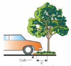
i.
The front of a vehicle may encroach upon any interior landscaped island or walkway when said area is at least four and one-half feet in depth per abutting parking space and protected by curbing. Two feet of such interior landscaped island or walkway may be part of the required depth of each abutting parking space. No tree or shrub more than two feet in height shall be planted within two feet of the edge of the landscape island.
ii.
Curbs shall be installed to prevent vehicles from overhanging on or into adjoining property, or landscaped areas. Where vehicles will overhang over medians or islands, shrubs and trees shall be planted a minimum of two feet from back of the curb. Where alternative parking surfaces are provided the Zoning Administrator may allow wheel stops in place of curbs.
iii.
The front of a vehicle may not encroach within any project boundary or street buffer area.
iv.
If no curb is provided, parking bumpers shall be provided to achieve the same effect.
5.
Relocation of Required Landscaping
In some vehicular use areas, the strict application of this subsection would seriously limit the function of the area, such as vehicle storage/display areas and grass parking areas. In such areas, the Zoning Administrator may approve the relocation of the square footage of required landscape islands and medians, along with the required trees to the perimeter of the parking area.
F.
Maintenance
Required landscaping shall be maintained pursuant to the requirements of Section 6.1.6, Requirements for Maintaining Buffers and Landscaping.
(Ord. No. UDO-19-02 , § 11, 9-19-19)
6.13 - ACCESS
6.13.1. General
A.
Every lot shall have (direct or indirect) access to a public or private street. Access must provide a reasonable means of ingress and egress for emergency vehicles as well as for all those likely to need or desire access to the property in its intended use.
B.
Improvements to provide required access must be installed and approved by the County or, where applicable, NCDOT, prior to final plat or final master plan approval. No certificate of occupancy will be issued prior to the installation of the required access improvements, except for construction of model units as provided in Section 9.4.
C.
In general, the minimum required width is equal to a 20-foot-wide public access easement, although this may be reduced by the Planning Director if access sufficient to satisfy paragraph A. above is provided. Additional width access easements may also be required to accommodate driveways or roadways serving large developments.
D.
Cross access connections between adjoining uses may be required (see Section 6.13.5).
6.13.2. Driveway Permit Required
An NCDOT driveway permit may be required for driveways serving any new use or change from an existing that accesses a state maintained road. Consult the Planning Department for more information.
6.13.3. Driveway Design
A.
In general, driveways shall meet minimum NCDOT driveway standards.
B.
All driveways shall conform to the site triangle requirements of Section 6.15.
C.
Parking in driveways shall not be permitted unless it is determined by the Planning Director, in consultation with the Fire Marshall that emergency access shall not be impaired.
Commentary: Chapter 7, Section J. "Control Dimensions" of the North Carolina Department of Transportation (NCDOT) Policy on Street and Driveway Access to North Carolina Highways dated July 2003 states "A driveway with two-way operations shall have a minimum 20 foot and a maximum 36 foot width. A driveway with one-way operation shall have a minimum 12 foot and a maximum 24 foot width."
6.13.4. Access to Major Thoroughfare Restricted
A.
With the exception of bona fide farming activities, all uses located adjacent to a Major Thoroughfare identified on the Brunswick County Comprehensive Transportation Plan shall require a driveway permit from NCDOT prior to the issuance of a building permit by Brunswick County.
B.
When a subdivision involving platting of a new street (or streets) borders on or contains an existing or proposed thoroughfare street, lots may not have direct driveway access to the thoroughfare.
Commentary: Possible solution for dealing with restricted access to major thoroughfares below when combined with the connectivity requirements.
C.
When a lot or development borders on or contains an existing or proposed thoroughfare as delineated by a County or NCDOT Transportation Plan access to the thoroughfare may be limited by one or more of the following means:
1.
A separation of 400 feet is required from the nearest centerline of any other proposed or existing driveway access along the same side of the thoroughfare. Reduced separation may be authorized only by review and recommendation of the Zoning Administrator and NCDOT.
2.
Lots shall be subdivided so as to provide access onto a frontage road or reverse frontage road. The centerline of the frontage or reverse frontage road where it intersects the thoroughfare shall be no closer than 800 feet to the centerline of the nearest proposed or existing driveway access or road.
3.
Driveway access closure may be required for any change in use of a lot based upon review and recommendation of the Zoning Administrator and NCDOT.
4.
Notwithstanding any other provisions of this Section, access provisions may be reduced when:
i.
The effect of such application would be to deprive the lot of reasonable access; or
ii.
The size of the tract being subdivided, or lack of frontage on the thoroughfare makes the alternatives above not feasible.
(Ord. No. UDO-19-02 , § 9, 9-19-19)
6.13.5. Cross-Access Corridors
A.
Description
In order to reduce the traffic burden created by vehicles traveling short distances on the public roadway, cross-access corridors are driveways constructed between adjoining properties to provide an alternative passageway to access adjoining developments without entering and exiting the roadway. These cross-access corridors are intended to link parking areas on neighboring developments.
B.
Applicability
1.
Cross-access corridors(s) shall be required for all nonresidential sites within a related project (as evidenced by a common development plan or site plan); even if the properties are subdivided.
2.
Cross-access corridor(s) are encouraged for all other developments.
3.
Cross-access corridors(s) are not required from or to adjoining sites which have more than 75% of the total land area in residential development.
Commentary: This means that single-family developments are not required to provide cross-access corridors.
4.
The Planning Director may modify or even waive the requirements of this section through the Administrative Adjustment process (see Section 9.6) if it can be proven that strict compliance would be impracticable due to unique site conditions such as environmental concerns, extreme slopes, or similar circumstances.
C.
Standards
1.
Cross-access corridor(s), where utilized, shall be designed to provide unified circulation and access between sites.
2.
The minimum paved width for a cross-access corridor(s) is 20 feet.
3.
Cross-access corridor(s) must be set back at least 20 feet from any public roadway.
4.
If a site is developed adjoining to an undeveloped piece of property, it shall be designed so that its parking, access and circulation are easily tied together to create a unified system at a later date. If the building site abuts an existing developed property, it shall tie into the abutting parking, access and circulation to create a unified system. To accomplish this, the Planning Director may allow the applicant to:
i.
Construct a cross-access corridor future connection to the property line to allow for future connection; or
ii.
Dedicate an easement of sufficient width to accommodate a future cross-access corridor and post fiscal surety in a form acceptable to the County of sufficient amount to construct the portion of the connection on the applicant's property.
D.
Maintenance and Operation
1.
Where a cross access corridor is developed, the owners/developers of the affected properties shall provide for mutually coordinated parking, access and circulation systems, and shall provide design features as necessary to make it visually obvious that abutting properties shall be tied together to create a unified system.
In order to maintain a clear passage for emergency and non-emergency travel, no parking shall be allowed in a cross-access corridor. Signs indicating "No Parking at Any Time" shall be erected along both sides of the corridor.
6.14 - EMERGENCY MANAGEMENT STANDARDS
6.14.1. The following provisions shall apply to all development where noted:
A.
Structures exceeding 30 feet or three stories in height shall provide at least three means of fire apparatus access.
B.
Structures or portions of structures exceeding 30 feet in height above the lowest level of fire department vehicle access shall be provided with approved fire apparatus access roads capable of accommodating fire department aerial apparatus. Overhead utility and power lines shall not be located within the aerial fire apparatus access roadway.
C.
Structures having a gross enclosed floor area of over 62,000 square feet shall be provided with two separate and approved fire apparatus access roads. However, when equipped throughout with an approved automatic sprinkler system, projects may be allowed to have a gross floor area of up to 124,000 square feet and provide access through one approved access road.
D.
Fire apparatus access roads shall have a minimum unobstructed width of 26 feet in the immediate vicinity of any building or portion of building more than 30 feet in height.
E.
At least one of the required access routes shall be located at least 15 feet, but no more than 30 feet from the structure and shall be parallel to one entire side of the building.
6.14.2. The following codes relating to emergency management services shall be adopted and made applicable to all development activities:
A.
The North Carolina State Fire Prevention Code and any amendments thereof.
B.
Brunswick County Fire Prevention Code and any amendments thereof.
(Ord. No. 18-03 , § 1, 5-21-18)
6.15 - SIGHT TRIANGLES
6.15.1. Corner Lots
On any corner lot, a sight triangle shall be established. The sight triangle shall be formed by extending lines from the intersections of two streets to points 25 feet from the corner of the intersecting streets and then connecting the two points.
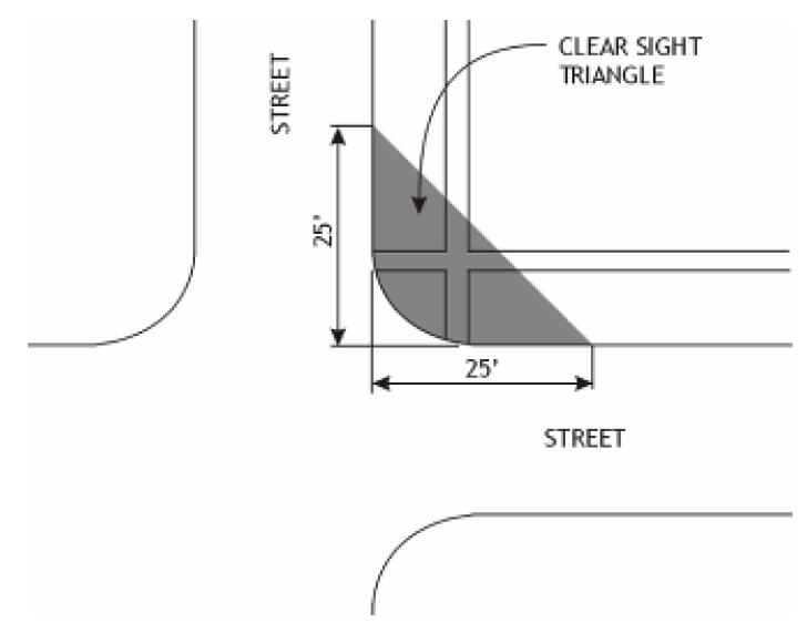
6.15.2. Driveways
For any driveway, a sight triangle measuring ten feet from the back of curb and extending 70 feet from the edge of each side of the driveway shall be required.
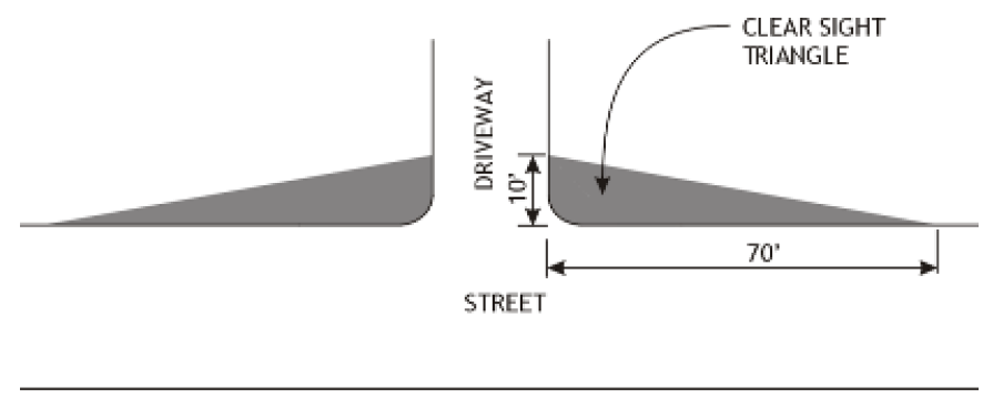
6.15.3. Design Standards
Within the sight triangle, no materials which would impede traffic visibility shall be allowed. Structures, fences and plant materials that extend into the sight triangle between two and one half feet and eight feet in height, as measured from the grade of the street or drive, shall not be allowed. In certain circumstances, increased site triangle distances may be required to conform to NCDOT requirements (see the NCDOT publication "Policy on Street and Driveway Access to North Carolina Highways").
6.16 - TRAFFIC IMPACT ANALYSIS (TIA)
6.16.1. Applicability
A.
A Traffic Impact Analysis may be required to be submitted in conjunction with an application for a
1.
Preliminary Plat of a Major Subdivision (Section 3.4);
2.
Major Site Plan (Section 3.2.1.C);
3.
Special Use Permit (Section 3.5); or
4.
Planned Development (Section 3.3.3)
B.
Unless exempted in paragraph Section 6.16.2 below, a Traffic Impact Analysis may be required for all residential projects, which can be anticipated to generate at least 100 vehicle trips at peak hour or 1,000 vehicle trips per day based on the latest edition of the Institute of Transportation Engineers (ITE) Trip Generation Manual.
C.
Commercial projects may be required to submit a Traffic Impact Analysis if the project can be anticipated to generate at least 100 vehicle trips at peak hour or 1,000 vehicle trips per day based on the latest edition of the Institute of Transportation Engineers (ITE) Trip Generation Manual.
6.16.2. Exemptions
The following projects shall not be required to submit a Traffic Impact Analysis:
A.
Developments approved prior to May 1, 2007 that have maintained valid preliminary plats, major site plans or special use permits.
B.
Development of any site on which the additional traffic at peak hour represents an increase of less than 100 additional peak hour trips from the traffic generated by the previous development, where the redevelopment is initiated within 12 months of the completion of demolition of the previous project.
6.16.3. Project Planning Session
A.
All applicants submitting a Traffic Impact Analysis shall schedule a project planning session with the Planning Director, in accordance with Section 3.3.3.B.3.
B.
The Planning Director shall determine the type and scope of the study during the project planning session, which may also involve representatives from other agencies or departments including NCDOT.
(Ord. No. UDO-16-02 , § 1, 3-7-16)
6.16.4. Application Requirements
A Traffic Impact Analysis shall be submitted in accordance with Section 6.16.4, Application Requirements and may include some or all of the requirements listed below.
A.
Type of Study
A letter report, full Traffic Impact Analysis report, or special report (such as a sight distance survey).
B.
Definition of Impact Area
Identification of the points of access and key streets and intersections to be affected by development of the subject tract. Traffic recorder and turning movement assessment locations may also have to be determined. A scoping meeting to be held jointly with the applicant, Planning staff, and NCDOT may be scheduled to determine project impact area.
C.
Period of Analysis
The period of analysis should be for both the morning and afternoon peak hour.
D.
Analysis Scenarios
Scenarios for analysis should include existing conditions, and opening year with and without development, and may include five or ten years after opening with or without development.
E.
Assumptions
Trip generation and distribution assumptions including trip generation categories, diversion assumptions and distribution assumptions. Assumed rate of growth in background traffic, and developments in the area that have been approved or are under review may also be required.
F.
Duration of Study
The duration of traffic studies (the time period for which they are considered a valid basis for approvals) for large projects, particularly Planned Unit Developments, will be evaluated on a case-by-case basis as part of the application review process.
G.
Existing Condition Survey
1.
Street System Description
The street system should be described, including geometric features, lane usage, traffic control, signage, sight distances, and adjoining uses and curb cuts.
2.
Traffic Volumes
Existing peak hour traffic volumes should be provided for the impact area. Data should be adjusted for daily and seasonal variations. Turning movement counts for peak hour may also be required for critical intersections.
3.
Capacity Analysis
Existing capacity of signalized and unsignalized intersections.
4.
Other Details
Other details may be required at the discretion of the Planning Director depending upon the type and scale of the project. These may include, but are not limited to, queue length analysis, pedestrian counts, accident data, traffic speeds (both 50th and 85th percentile), and stopping distances.
H.
Future without Development
Capacity analysis should be based on the Highway Capacity Manual or other methodology approved in advance by the Planning Director.
I.
Future with Development
1.
Projections of peak hour traffic generation should be made using the latest edition of the Institute of Transportation Engineers (ITE) Trip Generation Manual, unless the Planning Director determines that locally-derived data will provide more accurate forecasts. Data from similar facilities may be used where the information is not available from Institute of Transportation Engineers.
2.
Special analysis may be required to determine the need for signalization, minimum safe sight distances, gap analysis, turning radius requirements, queue length analysis, turning lane length analysis, curb cut locations or similar requirements.
6.16.5. Mitigation Plan
Where the analysis indicates that the project will create deficiencies in the impact area, improvements shall be recommended, along with projected cost estimates. The design of improvements shall be in accordance with the North Carolina Department of Transportation (NCDOT). Where a mitigation plan is not adequate to address the traffic impacts of the project, it may serve as a basis for denial of a Planned Development, preliminary plat, major site plan or special use permit.
6.16.6. Consultants
Commentary: The consultant retained by the County is not a substitute for the consultant the applicant is required to hire to perform the Traffic Impact Analysis.
The Planning Director may require that an independent consultant be hired by the County to perform the required studies, or to review all or part of a study prepared by the applicant's consultant. The Planning Director is authorized to administer the contract for any such consultant.
A.
The County shall determine the scope of services to be performed by the independent consultant and receive a cost estimate of such services.
B.
The applicant shall provide an amount equal to the estimate to the County, who shall deposit the amount in an escrow or other special account set up for this purpose. Any funds not used shall be returned to the applicant in a timely manner, without interest.
C.
The County may require additional funds for independent review where a decision-making body expands the scope of the required review; the applicant substantially amends the application; additional meetings involving the consultant are requested by the applicant; or the consultant's appearance is requested at public or affected agency meetings beyond those anticipated in the original scope of services.
6.16.7. Period of Validity
A Traffic Impact Analysis shall be valid for a specific site for no more than ten years, so long as no significant modifications to the development approved for the site are made.
6.17 - INFRASTRUCTURE
6.17.1. Dedication and Improvements
A.
In the development of any property for which site plan approval is required, the applicant shall be required to dedicate any additional right-of-way necessary to the width required by the State for streets adjoining the property, to install curbs and gutters and pave all streets adjoining the property to NCDOT standards, and to install sidewalks in accordance with and requirements of Article 8.
B.
The applicant shall bear the costs of the installation of all on-site improvements as required by this Ordinance, including provision for surface drainage, pavement, landscaping, and utilities.
C.
For all residential developments approved after May 1, 2007, recreation and open space dedication, shall be required.
6.17.2. Inspections of Required Improvements
Inspections during the installation of site improvements shall be made by the entity responsible for such improvements as required to certify compliance with approved site plans. No improvements shall be accepted for maintenance by the County unless and until the requirements regarding public improvements have been met.
6.17.3. Roads
The design of all public streets and roads within the jurisdiction of this Ordinance shall be in accordance with Section 6.11 of the Article, the accepted policies of the N.C. Department of Transportation, Division of Highways, as taken or modified from the American Association of State Highway Officials (AASHO) Manuals; the N.C. Department of Transportation Division of Highway's Subdivision Roads Minimum Construction Standards, July 1, 1985, or current standards; and County design standards.
Commentary: A certification on the subdivision preliminary and all final plats as well as PD Preliminary and Final Master Plans must be submitted by a design engineer to the Engineering and Planning Departments that all roadways and all on-site drainage are designed in accordance with minimum NCDOT standards as required by the UDO. Upon completion of the required improvements in the development, the design engineer also will be required to certify that all road and on-site drainage have been constructed in conformance with the approved construction plans.
6.17.4. Water and Sewer
Provision of water and sewer to each structure (residential or nonresidential) shall be in accordance with the latest version of the Brunswick County Utility Policy and the latest version of the Brunswick County Sewer Use Ordinance.
A.
Reclaimed Water
Brunswick County has invested considerable effort and financial resources toward the use of reclaimed water as an alternative for irrigation and other non-potable water uses. Reclaimed water is highly treated wastewater that can be used for irrigation and other uses permitted by NCDENR. Developers are strongly encouraged to make use of this environmentally responsible and cost effective resource. To this end, the following provisions apply to areas of the County served with reclaimed water distribution lines (served areas):
1.
Water fees will be waived for reclaimed water users that administer the associated permit requirements.
2.
New golf courses within served areas are required to utilize reclaimed water for non-potable water needs.
3.
The County will consider cost sharing to extend mains to existing golf courses within served areas or to existing or new courses outside of served areas.
4.
Developments utilizing reclaimed water to irrigate common areas of 10 acres or more are eligible for discounted potable water rates.
5.
Developments installing reclaimed water distribution systems are eligible for discounts on meter and box costs. The County will consider cost sharing on the installation of the distribution system, depending on the water volume.
B.
Utilities
1.
All affected utility companies shall be provided with copies of the plat by the subdivider and be expected to work with the developer in designing the utilities plan for the subdivision.
2.
All subdivision proposals which have public utilities and facilities such as sewer, gas, electrical and water systems shall have such systems located and constructed to minimize flood damage.
3.
Provisions of all utility services, including but not limited to: gas, water, sewer, electric, cable, and telephone, shall be underground.
6.17.5. Stormwater
A.
Development proposals are subject to the Brunswick County Floodplain Management Ordinance, the Brunswick County Stormwater Management Ordinance and the related permit requirements by the State of North Carolina Department of Environment and Natural Resources as well as related federal regulations.
B.
Development proposals shall be consistent with the need to minimize flood damage and provide adequate drainage to reduce exposure to flood hazards.
6.17.6. Easements
A.
Utility and drainage easements shall be approved by the Director of Engineering Services.
B.
Drainage easements shall be provided and shall be at least 20 feet wide. Drainage easements should be centered on rear or side lot lines where possible.
C.
A ten foot wide non-County utility easement shall be provided, and shall be located outside of the street right-of-way. A utility easement may be located within a required setback.
D.
Where a subdivision is traversed by a water course, drainageway, drainage tile, channel, or stream, there shall be provided a stormwater easement or drainage right-of-way conforming substantially to the lines of such water course, and such further width or construction, or both, as will be adequate for the purpose. Parallel streets or parkways may be required in connection therewith.
E.
Adequate easements and rights-of-way for ingress and egress for maintenance shall be provided.
6.18 - MISCELLANEOUS
6.18.1. Utility, Dumpster, Recycling and Trash Handling
A.
Applicability
This section shall apply to all nonresidential development, multifamily development, and all campgrounds and mobile home parks.
6.18.2. Location
A.
All utilities (including heating or air conditioning units and other mechanical equipment) dumpsters and trash handling facilities shall be located on the same lot as the use served unless shared facilities are approved by the Planning Board. No such facilities shall be located in any required front yard.
B.
Dumpsters and/or trash handling facilities shall not be located within any required buffer or within five feet of any property line, whichever is greater.
(Ord. No. UDO-19-02 , § 11, 9-19-19)
6.18.3. Screening
All utilities (including heating or air conditioning units and other mechanical equipment) dumpsters and trash handling facilities shall be screened in conformance with Section 6.4.
6.18.4. Access
All required dumpster, recycling and trash handling facilities shall be designed with appropriate means of access to a street or alley in a manner that will least interfere with traffic movement, and will most facilitate the service of the facilities.
6.18.5. Utilization
Space allocated to any off-street dumpster, and trash handling facilities shall not be used to satisfy the space requirements for off-street parking or loading facilities, nor shall any parking or loading spaces be used to satisfy the space requirements for any dumpster or trash handling facility.
6.18.6. Performance
All food-related businesses shall provide water quality treatment to mitigate runoff from trash handling facilities.
6.19 - NAME DUPLICATION
The name of the subdivider shall not duplicate nor closely approximate the name of an existing subdivision within Brunswick County.
6.20 - ADDRESSING
Reference GIS
6.21 - PERFORMANCE STANDARDS
All uses shall comply with all federal and state and county standards and requirements for performance, including noise, vibration, odor, toxic or noxious materials, heat and glare, and electromagnetic interference.
6.21.1. Performance Standards Regulating Noise
Noise emanating from a site may not exceed reasonable levels on adjoining lands or waters.
6.22 - OUTDOOR DISPLAY AND STORAGE
6.22.1. Applicability
A.
Outdoor display and storage shall be permitted in any nonresidential district only through the Administrative Adjustment process in Section 9.6. A binding site plan illustrating the extent of the permitted area for outdoor display shall be required.
B.
The requirements of this Section do not supersede or replace any previously issued special use permit for outdoor display or storage.
( Ord. No. UDO-21-01 , § 32, 5-17-21)
6.22.2. Site Plan
All outdoor display and storage areas shall be clearly indicated on the site plan for the property.
6.22.3. Exempt
The following activities and uses shall be exempt from the requirements of this Section:
A.
Vehicles for sale, lease or rent as part of a properly permitted use (including boats and manufactured housing);
B.
Plant material at a Plant Nursery or Plant Nursery with Landscape Supply;
C.
Waste generated on-site and deposited in ordinary refuse containers; and
D.
Properly permitted temporary uses (however, the Planning Director may impose certain restrictions as a condition of Temporary Use Permit approval).
6.22.4. Outdoor Display
A.
The outdoor location of soft drink or similar vending machines shall be considered outdoor display where the location is visible from neighboring residential development.
B.
Acceptance of remittance outdoors (including cash registers or similar devices) shall not be permitted, except for activities permitted through a temporary use permit.
C.
Menu boards associated with a drive-through that are visible from a public roadway or neighboring residential development shall be considered outdoor display.
6.22.5. Outdoor Storage
A.
Located Outside of Right-of-Way
1.
Where permitted by this Ordinance, all outdoor storage shall be located at least 15 feet from the public right-of-way and any abutting residential use or residentially-zoned district.
2.
Outdoor storage may not be located in the required site triangle (see Section 6.15).
B.
Storage Not Permitted in Required Street or Side Yards
1.
Unless expressly permitted by this Ordinance, no outdoor storage shall be allowed in required front yards or otherwise forward of the front building line.
2.
Outdoor storage may be located to the side or rear of a building, provided it is outside of the required side and rear yard area.
C.
Storage Not Permitted in Required Buffer
Unless specifically permitted by this Ordinance, no outdoor storage shall be allowed in a required buffer.
D.
Screening Required
All outdoor storage visible from a public roadway shall be screened in conformance with Section 6.4, Screening.