Brunswick County Unincorporated
City Zoning Code
City Zoning Code
ARTICLE 4
- ZONING DISTRICTS
4.1 - ZONING DISTRICTS ESTABLISHED
In order to implement all purposes and provisions of this Ordinance and the adopted CAMA Land Use Plan, and any other adopted County land use documents, the following districts are hereby established:
4.2 - GROUPING OF DISTRICTS
4.2.1. Where the phase "residential district" is used in this Ordinance, the phrase shall be construed to include the following districts:
A.
RR Rural Low Density Residential;
B.
R-7500 Medium Density Residential;
C.
R-6000 High Density Residential;
D.
SBR-6000 High Density Site Built Residential;
E.
MR-3200 Multifamily Residential.
4.2.2. Where the phrase "nonresidential district" is used in the UDO, the phrase shall be construed to include the following districts:
A.
C-LD Commercial Low Density;
B.
N-C Neighborhood-Commercial;
C.
C-I Commercial-Intensive;
D.
RU-I Industrial-Rural;
E.
I-G Industrial General.
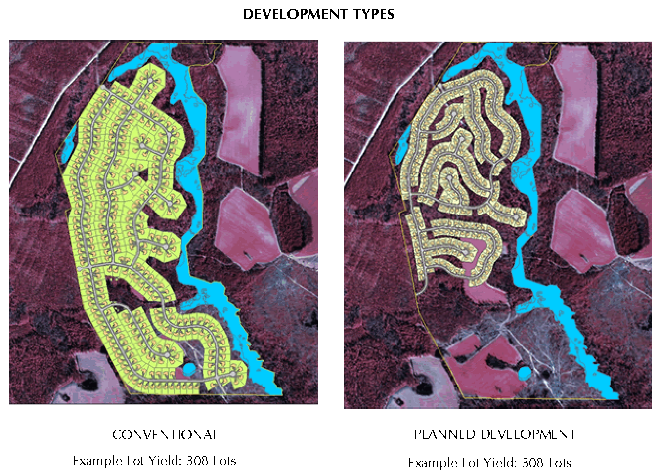
4.3 - DEVELOPMENT TYPES
Standards within the zoning districts allows two types of developments as follows:
A.
Planned Development
Planned Development is typified by clustering residential, mixed use or non-residential development on a single parcel or smaller lot sizes (with smaller yards) for additional common open space. Planned Development is generally larger scale projects to ensure sufficient open space can be incorporated into the development design. The Planned Development option provides increased design flexibility with varied development and housing types, provided certain enhancements are incorporated into the design of the project.
B.
Conventional Development
Conventional development is a pattern of development that conforms with standard dimensional requirements and typically provides a majority of property owners with substantial area on their own property.
4.3.1. Planned Development
A.
Intent
The intent of a Planned Development (PD) is to promote quality development by providing flexibility in the mixture of uses and in meeting dimensional and other requirements of this Ordinance. A PD utilizes exceptional design and best management practices that result in development that is aesthetically pleasing, promotes environmental sensitivity and makes more efficient use of the land, resulting in increased open space.
B.
Planned Development Approval
Planned Development projects shall be approved in accordance with the Planned Development approval process found in Section 3.3.3 and the site plan requirements as outlined in Article 3.
C.
Development Intensity
The building area coverage and number of dwelling units in a project utilizing the PD development standards shall be calculated as follows:
1.
The building area coverage shall be the dimensional standards of the applicable zoning District (i.e., R-7500, C-LD, etc.). However, the developed area may be increased as a result of utilizing exceptional design and/or best management practices as provided in Section 6.1, Design Flexibility. The extent of the allowable increase will be determined on a case-by-case basis by the Planning Director (minor site plans) or the Planning Board (major site plans) in relation to the extent of the successful use of exceptional design and best management practices in the project site plan.
2.
The allowable number of dwelling units in a project shall be determined by dividing the gross site area of the development project by the number of dwelling units (density) permitted in the underlying district.
Commentary: For example, the density for R-6000 with water and sewer is 7.3. The allowable number of units for a PD project with 20 acres with an underlying R-6000 district would be up to 143 units, provided all other requirements were satisfied.
3.
Increases in the number of dwelling units permitted in a project may be considered through the density bonus provisions in this article.
Commentary: There is no guarantee that the maximum density can be achieved on a particular site due to consideration such as required open space, site area devoted to easements or roadways, and other site specific issues.
D.
Uses Permitted within Planned Developments
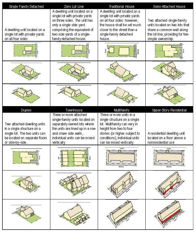
Uses permitted in the underlying district are permitted in Planned Developments. For residential development, the type of dwellings proposed (e.g., single family, multi-family, cottage style, cluster, etc.) shall be approved in conjunction with the PD approval. Mixed use projects are encouraged within residential and commercial Planned Developments to reduce travel and maximize the use of land. In residential districts, non-residential uses are allowed in approved Planned Developments as follows:
1.
Commercial and other non-residential uses within a residentially zoned PD shall be the same as those uses in the Commercial Low Density (C-LD) and Neighborhood Commercial (NC) Zoning Districts per Section 5.2.
2.
Business Park uses may be permitted within a PD per Section 5.2 subject to approval by the Planning Board of the specific uses. Decisions by the Planning Board regarding the inclusion of Business Park uses in a PD shall be based on considerations including, but not limited to, the type of proposed uses, size of the proposed operations in relation to the overall development, the character and nature of surrounding area.
3.
No more than twenty percent of the total acreage within a residentially zoned PD may be designated for non-residential, excluding golf courses and other similar facilities.
4.
Non-residential uses within residentially zoned PDs shall be designed and located to be easily accessible to residents of the development. It is expected that such uses will also serve patrons from outside the development.
5.
Such use shall, at minimum, have one internal access to the development.
6.
Within non-residentially zoned PDs, the uses shall be the same as those uses in the underlying district along with uses in the C-LD and NC districts, including residential uses. Business Park uses may be permitted within a non-residentially zoned PDs subject to approval by the Planning Board of the specific uses; provided however such specific approval of uses shall not be required for property zoned C-I or I-G.
E.
Planned Development Requirements
Planned Developments are subject to the site plan and improvement requirements of Article 6. Design and Performance Standards. Additionally, PDs are also subject to the following general requirements:
1.
Recreation Area
Open space and recreation area shall be provided as required in the subject district (per the PD dimensional table). See Section 6.4.4.B.
2.
Water and Wastewater
Generally, public or community water and wastewater service shall be required in all PD. However, the Planning Board may waive this requirement during the PD approval process.
3.
Ownership of Development Site
The development site to be subdivided may be held in single ownership or in multiple ownership. If held in multiple ownership, the site shall be developed according to a single plan with common authority and common responsibility.
4.
PD Perimeter Compatibility
Commentary: Generally, the perimeter buffer is required along all exterior boundaries, even if the adjacent property is vacant. This is intended to provide visual protection for residents of the PD and any development which may occur on adjacent properties.
F.
Buffers
1.
It is preferable that all buffers shall be a natural, undisturbed wooded area where possible, and shall count towards the provision of open space for the development. See Section 6.3, Required Buffers.
2.
A project boundary buffer with a minimum opacity of 0.6 shall be required along all boundaries of a PD except portions of the project located adjoining a street or roadway. Adjustments to the buffering requirements may be allowed by the Planning Director for minor Planned Developments and by the Planning board for major Planned Developments.
3.
A street buffer shall be required along all boundaries of a PD fronting on a street or roadway.
4.
Additional landscaping and buffering requirements may apply. See Section 6.2, Landscaping and Buffering.
G.
Private Utilities
1.
Provision of all utility services, including, but not limited to: gas, water, sewer, electric, cable, and telephone, shall be underground.
2.
Adequate easements and rights-of-way for ingress and egress for maintenance shall be provided.
H.
Street/Internal Trafficways
1.
Creative design of circulation routes and trafficways is encouraged. A base characteristic of a PUD is that the internal circulation routes or streets do not follow fixed linear geometric lines as do most streets. Instead, circulation routes are curvilinear and of meandering character, to preserve tree and landscape features. Generous use of design elements such as curved streets, private restrictions for extremely low speeds and other features to achieve slower-paced traffic movements are strongly encouraged.
2.
A minimum right-of-way of at least 35 feet in width shall be required for all internal roadways. Additionally right-of-way may be required to accommodate wider roads or utilities.
3.
A minimum paved street width of 20 feet shall be required for all internal two-way roadways. One-way roadways shall require a minimum paved street width of 14 feet.
4.
Pedestrian-oriented communities also are encouraged to enhance the quantity of pedestrian activity and to improve the quality of the pedestrian experience. Planned subdivisions must adhere to the design standards for drainage and paving found in Section 6.11.5, Streets.
5.
Where the development is bound by two or more NC DOT on-system roads, at minimum access to each road shall be provided. Siren activated gate systems shall be required for all unattended gates.
6.
Adequately constructed and maintained bike and/or hiking trails shall be counted toward the open space requirement. Bicycle lanes and multi-use pathways that extend the minimum right-of-way width shall be designed in accordance with the North Carolina Bicycle Facilities Planning and Design Guidelines Manual.
I.
Modifications of Standards Using Planned Development
Modification of the base dimensional standards shall require approval by the Planning Director (minor site plan) or the Planning Board (major site plan) in conjunction with the Planned Development approval process found in Section 3.3.3.
J.
Limits on Modification of Standards
1.
Modification of the maximum development density or minimum open space requirement shall not be permitted, except as allowed through a density bonus program (see Section 4.3.2 below) or as provided in Section 6.1, Design Flexibility.
2.
The minimum lot width and minimum yard requirements may be modified by the Planning Director or Planning Board through the PD process. However, the minimum distance between structures shall be as required by North Carolina Building Codes.
(Ord. No. UDO-16-02 , §§ 7, 8, 3-7-16; Ord. of UDO-17-01 , § 4; Ord. No. UDO-19-02 , § 11, 9-19-19)
4.3.2. Density Bonus
The Density Bonus provisions in this section are available to any project (i.e., Planned Development or Conventional) meeting the requirements as outlined herein. Density bonuses are intended to encourage work force housing, dedication of public facilities and exceptional design in development projects.
A.
Work Force Housing Density Bonus
1.
Applicability
This program may be utilized at the time of application for new developments with a minimum of 15 dwelling units or projects adding at least 15 units to an existing development.
i.
At least 15% of the units shall have payments affordable to persons and families with annual incomes at or below 60% of the area median family income by family size, according to target income limits set by HUD for Brunswick County.
ii.
Other incentives such as flexible parking or fee deferral agreements may be considered on a case-by-case basis.
2.
Bonus Program
i.
A density bonus of up to 20% may be granted for projects providing units affordable to persons with incomes between 60% and 80% of the median household income for the jurisdiction.
ii.
A density bonus of up to 25% may be granted by the Planning Board for projects providing units affordable to persons with incomes below 60% of the median household income for the jurisdiction.
iii.
Workforce units shall be incorporated throughout the project, and shall not be distinguishable from market-rate units through location, grouping, design or other physical characteristics.
iv.
In single-family and duplex developments, lot sizes and yard requirements in internal lots may be reduced up to 20% in order to incorporate the additional units; however, no decrease in lot size or yard requirements in perimeter lots shall be permitted.
v.
In multifamily housing developments, height allowance up to 60 feet with flexible setback requirements may be allowed, depending on the design of the project, number of units, etc.
vi.
Units added through this program shall not increase the amount of open space otherwise required for the project.
vii.
Affordability limits in rental units shall be adhered to for a minimum of 15 years. An annual report shall be provided by the project developer or manager to the County or designated personnel which identifies the incomes of persons residing in the workforce units, and the rents or initial sales price being charged, to verify these are within the established limits.
viii.
Affordability in for-sale units shall be required to be adhered to only in the initial sale.
ix.
Compliance measures may be required at the time of approval, including but not limited to contracts, restrictive covenants, deed restrictions, and stipulated penalties.
B.
Public Facility Density Bonus
1.
Applicability
This program may be utilized by projects meeting the requirements of this section. It is especially encouraged for Planned Development projects.
2.
Bonus Program
i.
A development may be granted a one-to-one density bonus by the Planning Board for land dedication for the construction of public facilities provided all of the following conditions are met:
(a)
The developer shall first prepare a deed of dedication of the land to the County;
(b)
The County has accepted the deed of dedication; and
(c)
The land dedicated is suitable and reasonably sufficient to allow for the construction of a public facility such as a school, park, fire department, police station, or other public use.
ii.
In such cases, certification of the need for the proposed public facility(ies) shall be required and must be approved by the Board of County Commissioners, and
iii.
Planning Board approval of a density increase shall be required.
C.
Exceptional Design Bonus
1.
Applicability
This density bonus option may be utilized by any project employing exceptional design, best management practices and other similar methods in the design of the project as outlined in Section 6.1.
2.
Bonus Program
i.
A development may be granted a density bonus up to 25% for incorporating exceptional design and other similar methods as outlined in Section 6.1 into the site design of the project.
ii.
The extent of the Exceptional Design density bonus shall be determined in accordance with Section 4.3.1.C.
(Ord. No. UDO-16-02 , §§ 9—11, 3-7-16)
4.3.3. Conventional Development Standards
A.
Applicability
Development utilizing the conventional standards shall be permitted in all residential districts utilizing the standards found in this Section. In addition to the standards contained in this Section, all other provisions in this Ordinance and all other applicable laws shall apply, except those that are incompatible with the provisions contained herein.
B.
Dimensional Standards
Projects utilizing the conventional development option shall meet the following standards:
C.
Multiple Principal Residential Structures
Multiple principal residential structures may be placed on a lot in all residential zoning districts in conformance with Section 5.4.3.
D.
Additional Standards
Additional residential district standards may apply to conventional development projects, including (but not limited to):
1.
Open Space and Recreation Area, Section 6.4.4;
2.
Density Bonus, Section 4.3.2;
3.
Areas to be Reserved, Section 6.4.5;
4.
Conventional Development Standards, Section 4.3.3;
5.
Accessory Structures and Uses, Section 4.4.3;
6.
Nonresidential Uses in Residential Districts, Section 4.4.4.
(Ord. No. UDO-16-02 , § 12, 3-7-16; Ord. No. UDO-19-02 , § 11, 9-19-19)
4.4 - RESIDENTIAL ZONING DISTRICTS
4.4.1. Residential District Intent Statements
A.
RR: Rural Low Density Residential
The Rural Low Density Residential District is intended to accommodate nonresidential agricultural uses and low density residential development, as well as limited nonresidential uses that are supportive of the County's traditional agricultural orientation including farming, silviculture operations and related activities. Development in this District should rely predominantly on individual wells and septic tank systems for domestic water supply and sewage disposal, respectively, although clustered residential development served by public water and wastewater systems may be allowed.
B.
R-7500, R-6000, and SBR-6000
The R-7500, R-6000, and SBR-6000 districts are established to provide for orderly suburban residential development. A limited number of commercial and civic uses are allowed, subject to the restrictions necessary to preserve and protect the residential character of the neighborhood. A special permit process for higher intensity development is also allowed, using discretion to balance issues of higher density with improved amenities. Due to the higher intensity developments contained in this district, it is intended to be applied to properties served by public sewer and water systems.
C.
MR-3200
This district is established as an area in which the principal use of the land is for high density residential purposes, not to exceed fourteen dwelling units per acre. The district also provides for the development of less intensive residential uses, as well as for compatible supporting non-residential uses. Due to the higher intensity developments contained in this district, it is intended to be applied only to properties served by public sewer and water systems.
4.4.2. Permitted Uses
Only uses specifically listed in the use table in Section 5.2 as a permitted ("P"), permitted subject to limited use standards ("L"), or permitted subject to special use permit ("SUP") shall be permitted in Residential districts.
4.4.3. Accessory Structures and Uses
The following accessory structures and uses shall be permitted in any residential district. All accessory structures and uses shall meet the applicable standards as set forth in Section 5.4, Accessory Uses.
1.
Accessory use customarily associated with a principal use.
2.
Accessory dwellings subject to the provisions of Section 5.4.2.
3.
Accessory structures subject to provisions of Section 5.4.1.
4.
Home occupations subject to the provisions of Section 5.4.4.
5.
Recycling drop-off collection stations subject to the requirements of Section 6.18.1.
6.
Fences and walls subject to the provisions of Section 6.10.
4.4.4. Nonresidential Uses in Residential Districts
A.
Dimensional Standards
Unless specifically modified in Section 5.3, Limited Use Standards, permitted nonresidential uses in a residential district shall meet the following standards:
Commentary: Refer to Table 4-1 in Section 4.3.3.B of the Ordinance for setback requirements for Wireless Transmission Facilities in residential districts.
(Ord. No. UDO-16-02 , § 13, 3-7-16; Ord. No. UDO-19-02 , § 11, 9-19-19)
4.5 - COMMERCIAL ZONING DISTRICTS
4.5.1. Districts
A.
C-LD: Commercial-Low Density
This District is intended primarily to be used in outlying areas, adjacent to major thoroughfares, with yards and other provisions for reducing conflicts with adjacent residential uses, and with substantial setbacks to reduce marginal friction on adjacent major thoroughfares. Commercial uses in this District will serve the needs of residential neighborhoods for auto-dependent commercial facilities; and serve the needs of highway oriented tourist business.
B.
N-C: Neighborhood-Commercial
The N-C, Neighborhood-Commercial District is primarily intended to accommodate very low intensity office, retail and personal service uses within and adjoining residential areas. The district is established to provide convenient locations for businesses which serve the needs of surrounding residents, including low intensity office, retail, and personal service uses, without disrupting the character of the neighborhood. Compatibility with nearby residences is reflected in design standards for both site layout and buildings. In addition, uses in the N-C District will have minimal infrastructure demands.
C.
C-I: Commercial-Intensive
The C-I District is intended for uses which require close access to major highways. Anticipated uses include those which are necessary to service more intensive commercial and industrial districts, such as warehousing, storage, moving, service and repair, distribution, wholesaling, marketing of specialty goods and light manufacturing plants.
4.5.2. Permitted Uses in Commercial Districts
Only uses specifically listed in the use table in Section 5.2 as a permitted ("P"), permitted subject to limited use standards ("L"), or permitted subject to special use permit ("SUP") shall be permitted in Commercial districts.
4.5.3. Development Standards
A.
Applicability
The following standards shall apply to all development within a Commercial zoning district. In addition to the standards contained in this Section, all other provisions in this Ordinance and all other applicable laws shall apply, except those that are incompatible with the provisions contained herein.
B.
Dimensional Standards
Projects shall meet the following standards.
(Ord. No. UDO-16-02 , § 14, 3-7-16; Ord. No. UDO-19-02 , §§ 5, 11, 9-19-19)
4.5.4. Special Standards in the C-LD Zoning District
A.
Yards
Required front, rear, and side yards abutting streets may be used for parking shelters and lighting devices, provided that visibility across a required front yard or side yard abutting a street shall not be impeded between the heights of 3 feet and 8 feet, and provided further, no signs shall be permitted in any required yard. Where this District borders a Residential District, including across streets, walls shall be provided so that no lights from automotive or other sources on commercial premises shall shine into windows in the Residential District, and no rear or side service areas on commercial premises shall be visible from the ground within Residential Districts. No structure (excluding fences or walls) shall be erected nearer than six feet to any Residential District boundary.
4.5.5. Residential Structures in Commercial Zoning Districts
Residential development in a commercial district may be permitted as a primary use in accordance with the Use Table in Section 5.2, subject to the standards and requirements applicable to the district in which it is located. Residential uses serving as an accessory structure or use to a nonresidential primary use shall comply with the standards set forth in Section 4.4.3, Accessory Structures and Uses.
A.
Dimensional Requirements
The dimensional requirements contained in the table below shall apply to all residential or mixed residential commercial development permitted in commercial districts.
B.
Building Separation
Where more than one residential or mixed commercial-residential building is located upon a single lot, the building spacing provisions of Section 4.13.5 shall apply.
C.
Multifamily and Mixed Commercial-Residential Buildings
The residential density shall be based only on that portion of the structure(s) dedicated to the residential use.
Commentary: For example, if 75% of a mixed building is to be utilized for residential purposes then 75% of the lot area will be used in calculating the residential density permitted.
D.
Open Space
Open space requirements for the residential portion of a multifamily or mixed commercial-residential project shall be the same and conform to the requirements for multifamily developments in the MR-3200 district.
4.5.6. Accessory Structures and Uses
The following accessory structures and uses shall be permitted in any commercial district. All accessory structures and uses shall meet the applicable standards as set forth in Section 5.4.
A.
In All Commercial Districts
1.
Accessory use customarily associated with a principal use.
2.
Accessory dwellings subject to the provisions of Section 5.4.2.
3.
Accessory structures subject to provisions of Section 5.4.1.
4.
Home occupations subject to the provisions of Section 5.4.4
5.
Fences and walls subject to the provisions of Section 6.10.
6.
Recycling drop-off collection stations subject to the provisions of Section 6.18.1.
B.
In the C-LD and C-I Districts
Nonresidential uses shall be permitted one on-premise accessory attached or detached dwelling unit for occupancy by the owner, lessors, managers, watchmen, or custodians in connection with the operation of any permitted or permissible use. The accessory dwelling shall adhere to the following requirements:
1.
The dwelling unit shall be occupied solely by the person engaged in the principal use (owner, lessor, manager, watchman, or custodian), or their family members residing with them;
2.
The building shall meet the minimum setback requirements of the zoning district;
3.
The amount of floor area for the attached dwelling unit shall be not more than 50% of the total floor area of the principal use;
4.
The attached dwelling unit shall be located totally above the ground floor or totally to the rear of the principal use so as not to interrupt the commercial low density frontage;
5.
In addition to the required off-street parking for the principal use, two off-street parking spaces shall be provided for the dwelling unit.
4.6 - INDUSTRIAL ZONING DISTRICTS
4.6.1. Districts
A.
RU-I: Industrial-Rural
1.
This District is intended to accommodate uses on lands which have not been in productive agricultural or farm use in the previous five year period. Also, this District is intended to be applied only on lands not anticipated to become urban or suburban by the Land Use Plan, and which are not wetlands or environmentally sensitive lands. This District is intended to provide areas for uses of open air or extensive rather than intensive character such as:
i.
Agricultural industry;
ii.
Repositories for waste products whose composition and features require they be removed from other Zoning Districts;
iii.
Chemical extraction or energy generation from crops or woods or the wastes of same, or conversion of crops, woods, and animals to various products of use to society; and
iv.
Animal slaughtering and processing operations and even incineration of animal remains.
2.
This District is intended to be used in an extremely limited manner sufficient only to meet proven needs for such generally adverse uses.
3.
Such land uses require restriction of other uses such as residential, institutional, commercial, and manufacturing where there are concentrations of persons likely at any given time.
Commentary: The Sunny Point Military Ocean Terminal's buffer zone is an illustration of how man would be expected to be limited in accessibility or closeness to uses in this District.
B.
I-G: Industrial-General
The I-G District is intended to provide locations for enterprises engaged in a broad range of manufacturing, processing, creating, repairing, renovating, painting, cleaning, or assembly of goods, merchandise or equipment. Lands in this District are to be located on or near Major Thoroughfares as identified in the Brunswick County Comprehensive Transportation Plan; to rail service; and to in-place infrastructure such as water, sewer, and/or natural gas.
(Ord. No. UDO-19-02 , § 9, 9-19-19)
4.6.2. Permitted Uses in Industrial Districts
Only uses specifically listed in the use table in Section 5.2 as permitted use ("P"), permitted subject to limited use standards ("L"), or permitted subject to special use permit ("SUP") shall be permitted in Industrial districts.
4.6.3. Development Standards
A.
Applicability
The following standards shall apply to all development within an Industrial zoning district. In addition to the standards contained in this Section, all other provisions in this Ordinance and all other applicable laws shall apply, except those that are incompatible with the provisions contained herein.
B.
Dimensional Standards
All proposed development shall meet the following standards:
(Ord. No. UDO-16-02 , § 15, 3-7-16; Ord. No. UDO-19-02 , § 11, 9-19-19)
4.6.4. Study Required
A.
In the I-G District
If the Zoning Administrator finds that the CAMA Land Use Plan identifies hazardous or fragile areas or features in close proximity to the land in question in the application, or where other natural and manmade environmental impacts are anticipated, the Zoning Administrator shall withhold action on the application and present it to the Planning Board at the next available meeting. The Planning Board shall make a determination of whether additional information will have to be filed. The nature and detail expected in the study may include a filing for approval of an Environmental Impact Statement to national standards and requirements, which may require an amended application upon the basis of studies.
B.
RU-I District
1.
In addition to the requirements for rezoning listed in Section 3.8, an application for a rezoning to the RU-I District shall be accompanied by a study which meets the most current requirements and guidelines for preparation of an Environmental Impact Statement (E.I.S.) under federal law. Prior to initiation of the required study, the Zoning Administrator shall establish the scope and required details of the required study. This scope shall be approved by the Planning Board and the Board of County Commissioners. All costs associated with the preparation of the required study shall be borne by the applicant. Action on the rezoning application shall not be considered until the required study has been received and approved by the Planning Board and Board of County Commissioners.
2.
Those soil types found in Brunswick County, dependent also on many other factors, which may possibly be found acceptable for inclusion in the zoning District include Baymeade, Baymeade-Marvyn group, Foreston, Goldsboro, Kureb, Newhan, Norfolk, Wando and Bragg.
4.7 - SPECIAL PURPOSE BASE DISTRICTS
4.7.1. CP - Conservation and Protection
A.
Intent
The Conservation and Protection District (CP) is intended to be used for the permanent protection and preservation of environmentally sensitive lands, and historical, cultural, and archeological areas of Brunswick County. Generally, activities within a CP district are limited to very low intensity uses, agricultural and silvicultural activities, parks, open space and natural habitat preservation, and very limited residential uses. Construction and land disturbing activities should be limited in nature and scope and should have a very low impact on the environment and the surrounding setting. Public or community water or wastewater facilities are generally discouraged in order to deter development pressure.
B.
Permitted Uses
Only uses specifically listed in the use table in Section 5.2 as a permitted use ("P"), permitted subject to limited use standards ("L"), or permitted subject to special use permit ("SUP") shall be allowed in a CP District.
C.
Standards
1.
Applicability
i.
The following standards shall apply to all development within a CP district with the exception of bona fide farms. However, bona fide farms are encouraged to comply with these requirements to the extent possible to ensure that impacts on the land and the surrounding environment are minimal.
ii.
In addition to the standards contained in this Section. All other provisions in this Ordinance and all other applicable laws shall apply, except those that are incompatible with the provisions contained herein.
2.
Dimensional Standards
Projects shall meet the following standards.
3.
Development Standards
In order to reduce the impact of development on the existing natural environment, the following standards apply to all land disturbing activities within a CP district:
i.
With the exception of a pedestrian trail or a fence, no land disturbing activities may occur within a required yard or within 100 feet of:
(a)
All lands located within a 100-year floodway;
(b)
All site area under the jurisdiction of the Army Corps of Engineers (the Corps) or the North Carolina Department of Natural Resources, Division of Water Quality (DWQ);
(c)
All lands located within a CAMA shoreline buffer;
(d)
All lands located below the high water line of an existing pond, lake, or stream; and
(e)
All lands with slopes steeper than 25%.
ii.
The requirement for mandatory connection to public water and sewer facilities (see Brunswick County Water and Sewer Use Policy) shall be waived.
4.
Development Guidelines
In order to reduce the impact of development on the existing natural environment, the following guidelines apply to all activities within a CP district. As guidelines, they provide an increased degree of flexibility.
i.
If development is anticipated to occur, the plan for such development should prioritize the preservation of natural habitat and sensitive environmental features such as large stands of trees, wetlands, Carolina Bays, pocosins, watercourses, marshes, and tidal areas.
ii.
The use of Low Impact Design, stormwater Best Management Practices (BMPs) and other alternative construction principles is strongly encouraged.
iii.
All site clearing and preparation, and construction activities should avoid removing existing trees and disturbing existing vegetation to the extent possible.
iv.
Although fencing is allowed, such fencing should be designed to allow for easy movement of wildlife. If more impervious fencing is desired, it is recommended that such fencing be limited to the areas around inhabited or occupied structures so that remaining portions of the property allow easy movement of wildlife.
(Ord. No. UDO-19-02 , § 11, 9-19-19)
4.7.2. MI - Military Installation
A.
Intent
1.
The purpose of the Military Installation District (MI) is to recognize the location of major single use and multiple use military facilities in Brunswick County.
2.
While federal government areas are not subject to local zoning and other codes, they occupy large land areas in the County. These areas therefore are identified on the zoning map as a Special Purpose District to differentiate them from other areas that are covered by the regulations in this Ordinance.
3.
The main objective of this District is to identify specific resources not otherwise identified where protection can be considered in the public's interest; identify interests relating to land use planning that impact County policy on industry, the environment and residential land uses in general; minimize substantial development impacts of these facilities; and develop a coordinated, planning/zoning process to include all federal entities.
B.
Permitted Principal Uses and Structures
The uses specified as permitted uses include any uses authorized by, and located in, official Military Installations of the U.S. Government.
C.
Development Coordination Required/Encouraged
1.
Notification Required
When an ordinance amendment or modification would result in a rezoning or change or affect the list of permitted uses within five miles of a military base, comments and analysis of the base commander shall be included in the consideration before making a final determination (N.C.G.S. 160D-601). Mailed notification shall be provided prior to any such action as specified in Section 9.1.B.3.iv.
2.
Coordination Encouraged
In areas of MI Districts not affected by military security in areas where commercial, residential, or mixed use developments are proposed, and in areas where joint public/private development may be explored, the federal government and Brunswick County is encouraged to establish a coordinated planning process to achieve both federal and local benefits, to minimize development impacts, and to help meet the objectives and policies of the Land Use Plan of Brunswick County.
( Ord. No. UDO-21-01 , § 18, 5-17-21)
4.8 - GENERAL OVERLAY DISTRICTS
4.8.1. General
A.
Overlays are zoning districts which are applied only in conjunction with a Base Zoning District, and may grant additional use and development requirements upon the underlying Base Zoning Districts. The effect is to have both the Overlay and the underlying Base Zoning District standards control the use and development of land placed into any Overlay.
Commentary: Some overlays provide additional restrictions on top of the underlying base district standards, while others may provide relief from certain underlying base district standards.
B.
Overlays support specific public policy objectives as are to be found in the CAMA Land Use Plan and any other adopted County land use documents.
4.8.2. Reserved
Editor's note— Ord. No. UDO-21-01 , § 77, adopted May 17, 2021, repealed § 4.8.2, which pertained to XCZ: Conditional Zoning and derived from the March 16, 2015 revision.
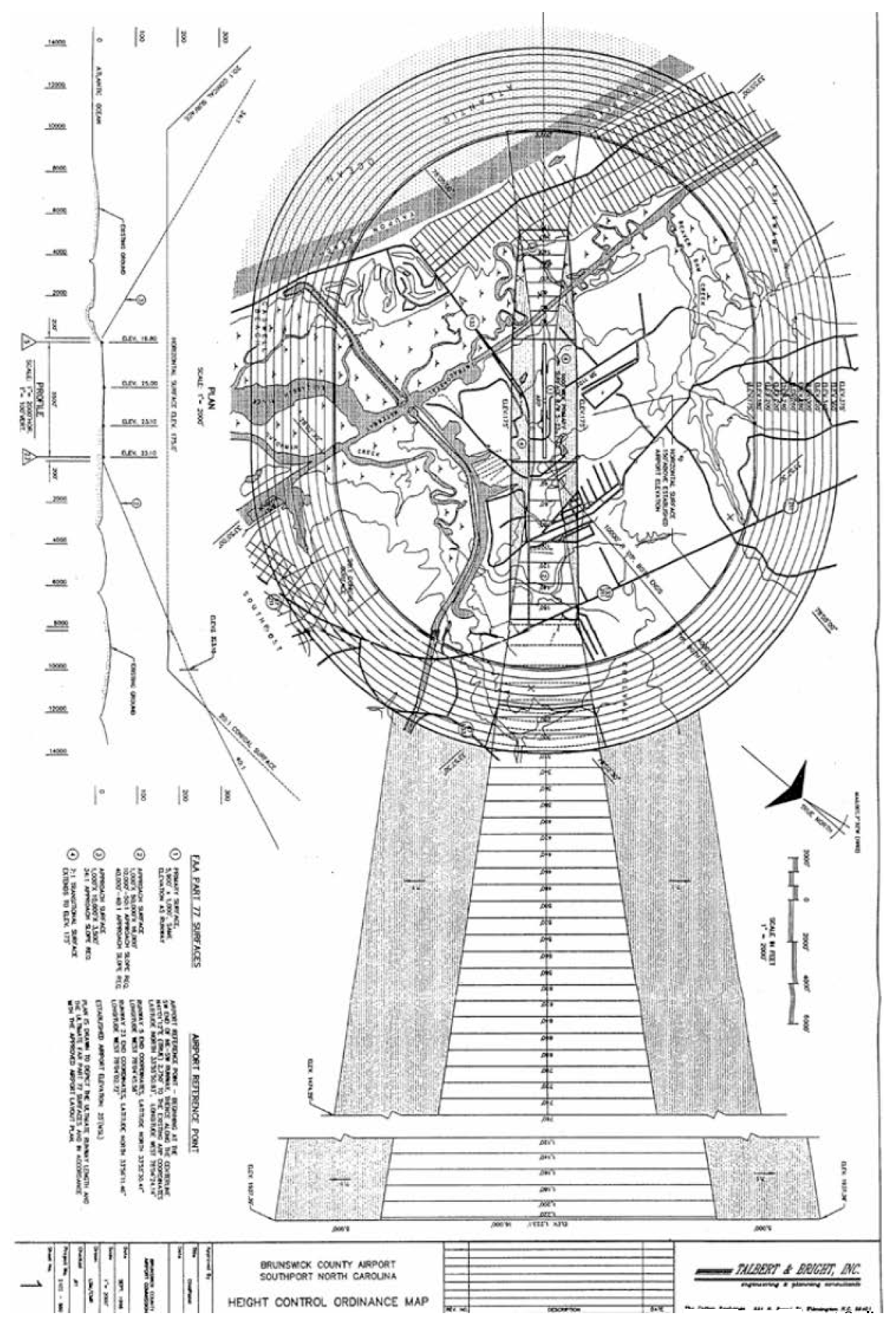
4.8.3. AHC: Airport Height Control Overlay
A.
The Airport Height Control Overlay is intended to regulate construction and restrict the location of certain uses within proximity to an airport due to the facts that:
1.
Airport hazards endanger the lives and property of users of airports and occupants and owners of property in their vicinity;
2.
The creation or establishment of an airport hazard injures the community served by the airport;
3.
In the interest of public health, safety, and general welfare, it is necessary to prevent the creation or establishment of airport hazards;
4.
The prevention of these obstructions should be accomplished, to the extent legally possible, by the exercise of police power without compensation.
B.
Standards applicable in the Airport Height Control Overlay can be obtained from the Brunswick County Planning Department or on the County's website: www.brunswickcountync.gov.
4.8.4. ED: Economic Development
A.
Intent
1.
The Economic Development Overlay District is intended to provide locations for a wide range of agricultural industry, light and heavy manufacturing, office, institutional and research uses with no adverse impacts beyond the space occupied by the use.
2.
The Economic Development Overlay District shall only be applied to lands in close association with Major Thoroughfares and over lands in the RR Rural Low Density Residential District. This District is designed to support specific public policy objectives stated in the Coastal Area Management Act Land Use Plan.
B.
Application Criteria
Ten acres shall be required to initiate an Economic Development Overlay District.
C.
Applicability
The following standards shall apply to all development within an ED overlay district. In addition to the standards contained in this Section, all other provisions in this Ordinance and all other applicable laws shall apply. In cases where there is a conflict between provisions found elsewhere in this Ordinance and the standards of this Section, this Section shall supersede unless otherwise noted.
D.
Standards
1.
No uses shall be located in an Area of Environmental Concern, as defined by the N.C. Coastal Area Management Act.
2.
No lot shall be less than one acre in size nor have less than 100 feet in width.
3.
All operations other than loading or unloading shall be conducted entirely within the building or buildings.
4.
The sign standards of the RR Districts shall apply.
5.
The Performance Standards of the C-I District shall apply.
E.
The more liberal requirements of the underlying Zoning District and of the Overlay Zoning District shall apply in any interpretive construction of this Section.
4.8.5. PD: Planned Development
The Planned Development option is outlined in Section 3.3.3 of this Article. PD projects are subject to the approval process in Section 3.1.6 and the site plan requirements outlined in Article 6.
4.8.6. TO: Transitional Office
A.
Purpose
The Transitional Office Overlay is established to allow an orderly transition of land use from residential use to relatively small-scale office use of lots and parcels fronting major roadways, while maintaining a predominantly residential property appearance and building scale.
B.
Designation of Transitional Office Overlay
1.
A Transitional Office Overlay may only be established as a zoning map change in accordance with the requirements of Section 3.8, Rezoning.
2.
A Transitional Office Overlay may only be established in any residential base district, and may be established over more than one residential base district.
C.
Permitted Uses
1.
Any use permitted by right, subject to limitations, or through special use permit in the underlying base districts shall be allowed in the overlay.
2.
The following uses or use categories shall be permitted in addition to the uses permitted in the underlying residential zoning district:
i.
Upper-story residential;
ii.
Medical facilities (other than hospitals);
iii.
Offices;
iv.
Animal hospitals and veterinary clinics (all without outdoor pens or runs). Kennels shall not be permitted in a TO unless they are permitted in the base district;
v.
Artist galleries and studios.
3.
No retail sales shall be permitted as a primary use in the TO overlay.
D.
Applicability
The following standards shall apply to all development within a TO overlay district. In addition to the standards contained in this Section, all other provisions in this Ordinance and all other applicable laws shall apply. In cases where there is a conflict between provisions found elsewhere in this Ordinance and the standards of this Section, this Section shall supersede unless otherwise noted.
E.
Development Standards
1.
New buildings in the Transitional Office Overlay shall maintain a single-family detached residential appearance and scale. Residential appearance and scale shall expressly include details from residential uses within 150 feet of the overlay area. Such details may include the following features:
i.
Roof type, including extent of eaves, if any;
ii.
Porches or other similar articulation of the front facade;
iii.
Size, pattern and location of windows and doors; and
iv.
Garage or parking location.
2.
The underlying district dimensional standards shall be met, except where expressly modified in this paragraph.
i.
The maximum length of a new building shall not exceed 80 feet.
ii.
The maximum floor area of any nonresidential use in the overlay or aggregation of multiple nonresidential uses in a single building shall be 10,000 square feet.
3.
All nonresidential activity (except that allowed within a residential district) shall occur within a completely enclosed building.
4.
The residential appearance of buildings shall be furthered by the retention of front lawns free of vehicle parking. All off-street parking spaces shall be located no closer to the principal street than the front building line, regardless of any required yard or building setback.
( Ord. No. UDO-21-01 , § 19, 5-17-21)
4.8.7. (VS) Viewshed Protection Overlay
A.
Intent
1.
Brunswick County has numerous waterways, marshes, Carolina Bays, pocosins, and other water courses that contribute to the County's scenic character and serve as a reminder of the important place these water courses hold in the County's history.
2.
The water courses are also an important natural resource and amenity to residents of and visitors to Brunswick County, and the scenic views associated with these watercourses are an important attraction to residents and visitors to Brunswick County, which in large part is economically dependent upon tourism.
3.
The intent of the Viewshed Protection Overlay is to protect and enhance the scenic character of Brunswick County's riparian areas and water courses, with the broader goal of ensuring the preservation of views from within these scenic areas as well as views of these areas from adjacent lands.
B.
Designation of Viewshed Protection Overlay
1.
A Viewshed Protection Overlay may only be established as a zoning map change in accordance with the requirements of Section 3.8, Rezoning.
2.
The ordinance adopting the overlay district shall clearly designate the name and geographic limits of the watercourse to be protected (i.e. can't just say Intercoastal Waterway, it must specify the extents of the district along the length of the watercourse).
3.
The following watercourses are designated (VS) Viewshed Protection Overlays:
C.
Applicability
1.
Generally, the requirements of this Viewshed Protection Overlay District apply to all structures within 300 feet of the normal high water line of a designated watercourse.
2.
However, the Planning Director may waive these requirements for structures related to an industrial use that is located in the RU-I or I-G zoning districts.
3.
These requirements shall not apply to water oriented commercial uses (see Section 5.1.4.J).
D.
Development Standards
1.
Portions of structures facing a protected watercourse that exceed 50 feet in height shall be set back a minimum of two feet for each additional one foot in height above 50 feet. The Planning Director shall have the authority to determine which portions of a structure are considered to be "facing" the protected watercourse for the purposes of these regulations.
2.
With the exception of Water Oriented Commercial Uses (see Section 5.1.4.J), and permitted height obstructions (see Section 5.4.13.C) the maximum height of any structure may not exceed 75 feet.
4.8.8. WQP: Water Quality Protection
A.
Purpose and Intent
1.
It is the intent of Brunswick County to bolster those regulations of state and federal government as to the unique quality of the water of the Lockwood Folly River associated with naturally occurring shellfish beds.
2.
The quality of these defined waters has been affected by such activities as forestry, farming, construction of roads, growth of towns, and rural and suburban residential development, as well as industrial processes associated with the fishing industry.
3.
Numerous types of water pollutants have been identified by state studies. No one or even several types or causes of such degradation have been determined as having more impact than any other.
4.
The intent of this Water Quality Protection District is to apply a set of regulations for water quality protection, to specifically described areas of land abutting a specifically described water area; which is encompassed by a line drawn to extend across the Lockwood Folly River from Genoe's Point to Mullet Creek, southly to and across the Atlantic Intracoastal Waterway.
B.
Applicability
1.
The requirements and standards of the WQP- Water Quality Protection Overlay shall apply to all lands shown on a special Zoning Overlay Map made a part of this District, whereby all land parcels of public record included are clearly shown. This District includes an area extending 575' landward of the mean high water line, with any lot or parcel falling within such distance being included entirely within this overlay zone.
2.
Parcels smaller than one acre in size shall be exempt from the requirements of this Section.
3.
Such waters have been defined by the State as being those waters south from a line extending from Genoes Point to Mullet Creek, to and across the Intracoastal Water to Sheep Island.
C.
Incorporation of Studies by Reference
1.
Among the specific studies establishing the WQP District have been the March, 1989 publication entitled "Report on Coastal Resource Waters - Intensive Study," by the Division of Environmental Management, N.C. Department of Natural Resources and Community Development, and the August, 1989, publication entitled "Lockwood Folly River Basin Water Quality Evaluation Report." Those studies are included by reference.
2.
The State of North Carolina has concluded the quality of the waters within the boundaries of the District had so declined there could be no assurance the proposed regulations would result in the goal of these waters being open full seasons for shell fishing. The Environmental Management Commission did, under N.C. Administrative Code, Subordinance 2B, Surface Water Standards, Monitoring, Section .0219, Water Quality Management Plans, sub-section (b) establish a defined area of the mouth of this river, as above described, to be protected by a Water Quality Management Plan with specific actions which became effective January 1, 1990, included herein by reference.
D.
Application Requirements
Applications for all development meeting the applicability requirements in the paragraph above shall require an approved Sedimentation Erosion Control Plan be filed.
E.
Development Standards
All development within a WQP- Water Quality Protection Overlay shall:
1.
Limit the built upon impervious area to no more than 25% of the lot;
2.
Provide a buffer zone of at least 30' from any wetland or water line;
3.
Limit any structures to being at least 75' from the mean high water line; and
4.
Comply with any additional standards imposed by State or Federal regulations.
4.9 - VOLUNTARY AGRICULTURAL DISTRICT PROGRAM
Commentary: The Voluntary Agricultural District is not an overlay zoning district, and is not implemented in the same was as a zoning district would be.
4.9.1. Authority
The standards and provisions of this Voluntary Agricultural District Program are established pursuant to the authority conferred by G.S. 106-735 through 106-743 and Chapter 160D.
( Ord. No. UDO-21-01 , § 20, 5-17-21)
4.9.2. Purpose
The purpose of this Program is to promote the health, safety, rural agricultural values, and general welfare of the County, and more specifically, increase identity and pride in the agricultural community, its way of life, and its importance in preserving the agrarian heritage of the county; encourage the economic and financial health of farming; increase protection from undesirable, non-farm development: and increase the protection of farms from nuisance suits anti other negative impacts on properly managed farms.
4.9.3. Initial Participation is Voluntary
Nothing contained within this Section shall require a landowner to initiate participation in the Program. Upon participation in the Program, compliance with the requirements of this Section shall be required to maintain status.
4.9.4. Implementation of Program
In order to implement the purposes stated in above, this Program provides for the creation of Voluntary Agricultural Districts (VADs) as follows:
A.
Application
1.
A landowner may apply to participate in the Program by making application to the chairperson of the Advisory Board or a designated staff person. The application shall be on forms provided by the Advisory Board. The application to participate in a VAD may be filed concurrent with the certification for qualifying farmland (see Section 4.9.8).
2.
The Advisory Board shall meet within 90 days of receipt of a complete application to render a decision on the application.
B.
Fees
Applicants wishing to implement (Section 4.9.4), expand (Section 4.9.5), or withdraw (Section 4.9.6) from a VAD shall pay any administrative fees required for the action. A schedule of the required fees shall be available from the Cooperative Extension.
C.
Criteria for Qualification
A VAD, when initially established, shall contain a minimum of 10 contiguous acres of qualified farmland; or two or more qualified farms which contain a minimum of 10 acres in total and are located within a mile of each other.
D.
Review and Recommendation
Upon receipt of an application, the chairperson shall forward copies immediately to the following offices for review and comment. Comments, if any, shall be returned to the Advisory Board at least one week prior to the date set for the Advisory Board action on the application.
1.
The Brunswick County Tax Assessor;
2.
Brunswick County Planning Department;
3.
The Brunswick Soil and Water Conservation District office; and
4.
The Natural Resources Conservation Service.
E.
Final Action
Within 90 days of receipt of the application, the Advisory Board shall vote on the application in conformance with Section 2.5.1.C.
F.
Notification of Decision
The chairperson shall notify the applicant of the Board's decision by first class mail.
G.
Preservation Agreement
The landowner(s) requesting inclusion in a VAD shall execute a Preservation Agreement with the County to sustain agriculture in the VAD in accordance with this Program. The Agreement shall be in a form which is reviewed and approved by the Agricultural Advisory Board (See Section 2.3).
H.
Appointment of New Advisory Board Members
The following agencies shall appoint a member from each newly created VAD to represent the District on the Agricultural Advisory Board.
1.
Farm Bureau;
2.
Cooperative Extension;
3.
Soil and Water Conservation District;
4.
Farm Service; and
5.
One at-large appointed by Agriculture Board.
I.
Appeal of Advisory Board Decision
If an application is denied by the Advisory Board, the applicant shall have 30 days to appeal the decision to the Board of County Commissioners. Such appeal shall be presented in writing. The decision of the Board of Commissioners shall be final.
4.9.5. Expansion of Program
The Agricultural Advisory Board may decrease or increase the number of Voluntary Agricultural Districts as set forth above in "Implementation," above.
4.9.6. Withdrawal from Program
A.
By the Owner
By written notice to the Advisory Board, a landowner of qualifying farmland may revoke a Preservation Agreement.
B.
By the Agricultural Advisory Board
The Advisory Board may revoke the Agreement based on noncompliance by the landowner.
C.
Effect on Lands No Longer Included in a VAD
1.
Revocation shall result in loss of qualifying farm status, and consequently, loss of eligibility to participate in the Program.
2.
Revocation by a landowner of an Agreement shall in no way affect the eligibility of the land to be taxed at its present use value as provided in G.S. 105-277.2 through G.S. 105-277.6.
D.
Effect on Lands Remaining in an VAD
In the event that one or more participants in a VAD withdraw and the remaining acreage becomes less than 10 acres or results in the remaining land being noncontiguous, the VAD will continue to exist so long as there is one qualifying farm located within the District.
4.9.7. Renewal
Conservation Agreements shall be deemed automatically renewed for an additional term of ten (10) years, unless either the Advisory Board or the landowner gives written notice prior to the termination date.
4.9.8. Certification and Qualification of Farmland
In order for farmland to qualify for participation under the terms of this program, it shall meet the following requirements:
A.
The farmland shall be real property consisting of at least three acres and not located in a planned development (Major Subdivisions, Planned Unit Developments [PUD], and Planned Groups of Structures) unless the development was originally designed and approved to accommodate agricultural uses and documented on the preliminary plan, site plan, and/or associated plats.
B.
The property must be engaged in agriculture and defined as a Bona Fide Farm per Article 12 (Definitions) of the Brunswick County Unified Development Ordinance (UDO).
C.
The property must be managed, if highly erodible land exists on the property, in accordance with the Natural Resources Conservation Service of the United States Department of Agriculture defined erosion-control practices that addresses highly erodible land.
D.
The property is the subject of a Preservation Agreement, as defined in G.S. 121-35, between the County and the owner of such land that prohibits non-farm use or development of such land for a period of at least ten years, except for the creation of not more than three lots that meet applicable county watershed and subdivision regulations, or the regulations of any municipality which apply to the farm property. The property owner may voluntarily revoke this Preservation Agreement by submitting a written request to the Advisory Board in accordance with Section 4.96.
E.
The property must be located in the unincorporated area of Brunswick County, unless there is an agreement in place with a municipality where the county is authorized to exercise the authority of the municipality on its behalf.
4.9.9. Record Notice of Proximity to a VAD
A.
Procedure
When Brunswick County computerizes its County Land Records System, the following requirements outlined in this subsection shall be implemented and enforced upon certification of qualifying farmland and designation of real property as an VAD District, the title to that qualifying farmland and real property within a VAD which is contained in the Brunswick County Land Records System shall be changed to include a notice reasonably calculated to alert a person researching the title of a particular tract that such tract is located within one-half aerial mile of a VAD District.
Commentary: With the automation of the Land Records System, research on any tract within one-half aerial mile of an VAD should alert a person of the proximity of the District to the tract being reviewed.
B.
Limit of Liability
In no event shall the County or any of its officers, employees, or agents be held liable in damages for any misfeasance, malfeasance, or nonfeasance occurring in good faith in connection with the duties or obligations imposed by this Ordinance.
C.
No Cause of Action
In no event shall any cause of action arise out of the failure of a person researching the title of a particular tract to report to any person the proximity of the tract to a qualifying farm or VAD as defined in this Ordinance.
4.9.10. Education
The County may take such action as it deems appropriate through the Advisory Board or other entities or individuals to promote the purposes and objectives of this Program and encourage the formation of VADs including the implementation of a public information program to reasonably inform landowners of the Program.
4.9.11. Abeyance of Water and Sewer Assessments
A.
Purpose
The purpose of this section is to help mitigate the financial impacts on farmers by some local and State capital investments unused by such farmers.
B.
Assessment and Abeyance
1.
Landowners belonging to voluntary agricultural districts shall not be assessed for, or required to connect to, water and/or sewer systems. Water and sewer assessments shall be held in abeyance, without interest, for farms inside a voluntary agricultural district, until improvements on such property are connected to the water or sewer system for which the assessment was made.
2.
Assessment procedures followed under 0.5. 153A-185 et seq. shall conform to the terms of this article with respect to qualifying farms that entered into preservation agreements while such article was in effect.
C.
Termination of Abeyance
When the period of abeyance ends, the assessment shall be payable in accordance with the term set out in the assessment resolution.
D.
Suspension of Statute of Limitations
Statutes of limitations dependent upon the operation of County ordinances are suspended during the time that any assessment is held in abeyance without interest.
E.
Other Statutory Abeyance Procedures
Nothing in this section is intended to diminish the authority of the County to hold assessments in abeyance under G.S. 153A-201.
F.
Conflict with Water and/or Sewer System Construction and Improvement Grants
To the extent that this section conflicts with the terms of Federal, State, or other grants under which county water and/or sewer systems are constructed, this section shall not apply.
4.9.12. Advertisement of an Voluntary Agricultural District
The Advisory Board, in cooperation with the County, shall take measures as set forth below to provide notification to property owners, residents, and other interested persons adjoining any designated VAD with a goal of informing all current and potential residents and property owners in and adjoining the District, that farming and agricultural activities may take place in this VAD any time during the day or night.
A.
Signage
Signs identifying an approved VAD shall be placed by the farmer upon the farm owner's property and outside of the NCDOT right-of-way.
B.
Maps
Maps identifying approved VADs shall be provided to the following:
1.
North Carolina Cooperative Extension Service;
2.
Brunswick County Planning Department;
3.
Natural Resources Conservation Service;
4.
Soil and Water Conservation District;
5.
Brunswick County Tax Department;
6.
Register of Deeds; and
7.
Any other such agency or office the Advisory Board deems appropriate.
C.
Public Notice
The following notice provided by the Advisory Board shall be displayed in a prominent position in the office of the Register of Deeds and the public access area in the Brunswick County Tax Department:
NOTICE TO REAL ESTATE PURCHASERS IN
BRUNSWICK COUNTY
BRUNSWICK COUNTY VOLUNTARY AGRICULTURAL DISTRICT PROGRAM
Brunswick County has established the Voluntary Agricultural District to protect and preserve agricultural lands and activities within the County.
Voluntary Agricultural Districts have been developed and mapped to inform all purchasers of real property that agricultural activities, including but not limited to: pesticide spraying, manure spreading, machinery and truck operations, livestock operations, sawing, controlled burning, and similar activities may take place in these Districts any time during the day or night.
For more information, contact the North Carolina Cooperative Extension Service.
(910) 253-2610
P.O. Box 429
Bolivia, NC 28422
D.
Unified Development Ordinance Review
Developers of Major Subdivisions or Planned Unit Developments shall designate on the preliminary development plan(s) and final plat(s), the existence of VAD Districts within a one-half (½) mile radius of the proposed development.
4.9.13. Consultation Authority
The Advisory Board may consult with the North Carolina Cooperative Extension Service, the Natural Resources Conservation Service, the North Carolina Department of Agriculture and Consumer Services, and with any other individual agency or organization the Advisory Board deems necessary to properly conduct its business.
4.9.14. North Carolina Agency Notification
An official copy of this Program ordinance shall be recorded with the North Carolina Commissioner of Agriculture's office after adoption. At least once a year, the County shall submit a written report to the North Carolina Commissioner of Agriculture and Consumer Services including the status, progress and activities of the County's Voluntary Agricultural District Program to include but not limited to:
A.
Number of landowners enrolled;
B.
Number of acres for which applications have been made;
C.
Number of acres certified;
D.
Number of acres denied;
E.
Date acres certified
4.9.15. Condemnation of Qualifying Farmland within a VAD
Pursuant to G.S. 106-740, no public agency or governmental unit may formally initiate any action to condemn any interest in qualifying farmland within a VAD until such agency or unit has requested the Advisory Board to hold a public hearing on the proposed action. The procedures for such hearings shall be as set forth below.
A.
Schedule Public Hearing
Upon receipt of a request for a public hearing, the Advisory Board shall have 30 days after receiving a request under this article to hold a public hearing and submit its findings and recommendations to the agency that proposed the condemnation. No formal initiation of condemnation may be initiated while the proposed condemnation is properly before the Advisory Board within the time limitations set forth in this Section.
B.
Advertise Public Hearing
The Advisory Board shall run a notice of the public hearing in a newspaper having general circulation in Brunswick County at least 10 days prior to the date established for the hearing. The notice shall contain the date, time, and place of the hearing and shall provide the name of the agency requesting the hearing and the purpose of the action. The notice shall also indicate the approximate address of the property(ies) under consideration.
C.
Conduct Public Hearing
1.
The Advisory Board shall conduct the public hearing and receive information and comments from the agency requesting the condemnation action and the citizens of Brunswick County. Additionally, the Advisory Board shall consider the following:
i.
Has the need for the project requiring the condemnation been satisfactorily shown by the agency requesting the action?
ii.
Has a financial impact analysis been conducted by the agency seeking the action?
iii.
Have alternatives been considered to the proposed action that are less disruptive to the agricultural activities and farmland base of the VAD within which the proposed action is to take place?
2.
The Advisory Board shall invite and allow input by the North Carolina Cooperative Extension Agent, U.S.D.A. Natural Resources Conservation Services, Farm Service Agency Personnel, and may consult with any other individuals, agencies or organizations, public or private, necessary to the Advisory Board's review of the proposed action.
D.
Findings and Notification
Within 10 days after the public hearing, the Advisory Board shall make a report containing its findings and be conveyed recommendations regarding the proposed action. The report shall be conveyed to the decision-making body of the agency proposing acquisition and made available to the public for comment.
4.9.16. Conflict with Other Ordinances and Statutes
Whenever the provisions of this Program (Section 4.9) conflict with other ordinances of Brunswick County, the provisions of this Program shall govern. Whenever the provisions of any Federal or State statute require more restrictive provisions than are required by this Program, the provisions of such statute shall govern.
4.9.17. Amendments to the Voluntary Agricultural District Program
The provisions of this Program (Section 4.9) may be amended from time to time after a public hearing and in consultation with the Advisory Board to the Board of Commissioners. Notice of the hearing shall be sent to program participants by first class mail at least 30 days prior to the hearing.
4.10 - GENERAL PROVISIONS
4.10.1. Division of the County into Zoning Districts: Official Zoning Maps
The County is hereby designated in Zoning Districts. The Zoning Districts are shown on the official Zoning Map of Brunswick County, which is a part of this Ordinance.
4.10.2. The official Zoning Map may consist of one or more map sheets.
4.10.3. The original reproducible map or map sheets comprising the official Zoning Map as well as any successor maps shall be signed by the County Manager and attested by the Clerk to the Board of County Commissioners.
4.10.4. In the event of amendment of any Zoning District boundaries set forth on the official Zoning Map, the change shall be certified by the County Manager and attested by the Clerk to the Board of County Commissioners with note as to the amending ordinance number, the date of amendment, and the nature of the change.
4.11 - RULES FOR INTERPRETING DISTRICT BOUNDARIES
Where uncertainty exists with respect to the boundaries of the Districts as shown on the official Zoning Map, the following rules shall apply:
4.11.1. Where District boundaries are indicated as following the center lines of streets, highways, or alleys, such center lines shall be construed to be such boundaries.
4.11.2. Where District boundaries are indicated as approximately parallel to the center lines of streets or highways, such District boundaries shall be construed as being parallel to the centerline, and at such distance from the centerline as indicated on the official Zoning Map. If no distance is indicated specifically on the Zoning Map, the scale of the map shall determine.
4.11.3. Where District boundaries run to, but do not extend into water areas, and no separate Zoning District is shown over such waters and their minor land areas, they shall be considered to run into such water areas in a straight line, continuing the prevailing direction of the boundary as it approaches water, until they intersect other District boundaries or the jurisdictional limits. Boundaries which run through water courses, lakes, and other water areas, shall be assumed to be located midway in such water areas, unless otherwise indicated.
4.11.4. Where District boundaries are indicated as following platted lot lines, the lot lines shall be construed to be the District boundaries.
4.11.5. Where District boundaries divide platted lots or cross unsubdivided property, and where no specific dimensions are indicated on the official Zoning Map, the scale of the official Zoning Map shall control.
4.11.6. Where the street or property layout, or other physical features existing on the ground are at variance with the official Zoning Map, or where other uncertainties exist as to interpretation of the official Zoning Map, upon receipt of a written report from the Planning Board, the Board of Adjustment shall interpret the map in such a manner as to carry out the intent and purposes of this Ordinance.
4.12 - CLASSIFICATION OF AREAS UNDER WATER AND OF AREAS NOT ELSEWHERE CLASSIFIED
4.12.1. All areas within the jurisdiction of the County which are under water and are not shown as included within any district shall be subject to all of the regulations of the District which immediately adjoins the water area. If the water area adjoins two or more Districts, the boundaries of each District shall be construed to extend into the water in a straight line until they meet the boundaries of another District or the jurisdictional limit.
4.12.2. All lands within the jurisdiction of Brunswick County which are not under water and are not shown as included within the limits of any district shall be considered to be in the R-7500-Residential District, until otherwise classified by amendment to this Ordinance.
4.13 - MEASUREMENT AND COMPUTATION
4.13.1. Number of Principal Structures Allowed
A.
Multiple principal residential structures may be placed on a lot in all residential zoning districts in conformance with Section 5.4.3. In non-residential districts, one principal non-residential structure is allowed on a lot; provided however, the placement of multiple principal residential, non-residential or mixed-use structures are allowed in all Planned Developments.
B.
Bona Fide Farms shall be exempt or as stipulated under Permitted or Accessory Uses and Structures in the various Zoning Districts.
(Ord. No. UDO-16-02 , § 16, 3-7-16)
4.13.2. Height
A.
Height shall be measured from the average of the finished ground level to the highest point of the roof or structure.
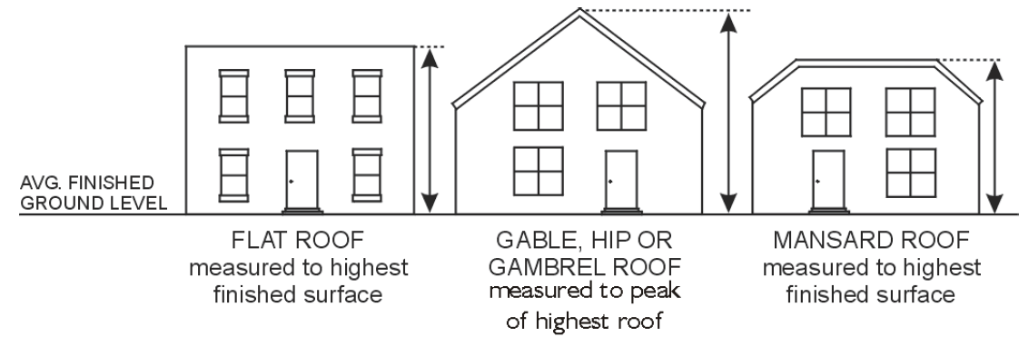
Commentary: Except when located in a Viewshed Overlay, structured parking located under a multifamily building is not included in the total height of the building (see Section 5.3.3.E.2).
B.
Any building or structure intended for human occupation exceeding 40 feet in height must obtain approval from the fire marshal prior to the issuance of a building permit. The fire marshal may stipulate special fire protection measures in accordance with National Fire Protection Association and North Carolina Building Codes criteria as a condition of approval of a structure.
C.
Permitted Height Obstructions
The following shall not be considered obstructions and may therefore exceed the maximum height provision otherwise applicable within a district as specified below.
1.
In all districts
i.
Bona fide farm buildings other than dwelling units or other residential uses;
ii.
Chimneys or flues extending not more than ten feet above the roofline;
iii.
Steeples, spires, or similar features on places of worship;
iv.
Strictly ornamental features such as belfries, parapets, roof screens and widows watches less than four feet in height;
v.
Air conditioning units and other mechanical features screened from view by a parapet wall;
vi.
Utility poles;
vii.
Lightning rods;
viii.
Aerials and antennas (not including WTF facilities Section 5.3.4.O); and
ix.
Water tanks.
2.
In all Nonresidential districts
In all nonresidential districts, the following shall be included in the list of obstructions permitted:
i.
Elevator or stair bulkheads, roof water tanks, or cooling towers.
ii.
With the exception of wireless communication facilities, other appurtenances usually required to be placed above roof level and not intended for human occupancy.
3.
Flags and Flagpoles
i.
Descriptions
(a)
The term flag in this section shall mean a piece of fabric or other flexible material solely containing distinctive colors, patterns, standards, words, or emblems used as a symbol of an organization or entity, including but not limited to political jurisdictions, such as the United States.
(b)
Flags displaying a logo, message, statement, or expression relating to commercial interests, and banners otherwise not meeting the definition of a flag shall also conform to all sign regulations in Article 8, Signs.
(c)
Reference to flagpole height refers to vertical flagpoles.
(d)
References to the number of flags and flagpoles and flag dimensions refer to both vertical flagpoles and mast arm flagpoles, such as staffs extending at an angle from a building.
(e)
Reference to flagpole height refers to the distance to the top of the flagpole from the ground.
ii.
Requirements
(a)
Except as otherwise provided herein flags shall be displayed on flagpoles.
(b)
In nonresidential zoning districts, flagpoles shall not exceed the maximum height allowed in the zoning district or 70 feet, whichever is less.
(c)
In residential districts, flagpoles shall not exceed 25 feet in height unless a special use permit (see Section 3.5) is granted by the Board of Adjustment. A fee shall not be charged for a use permit request for a flag in a residential district.
(d)
A vertical flag pole shall be set back from all property boundaries a distance which is at least equal to the height of the pole.
(e)
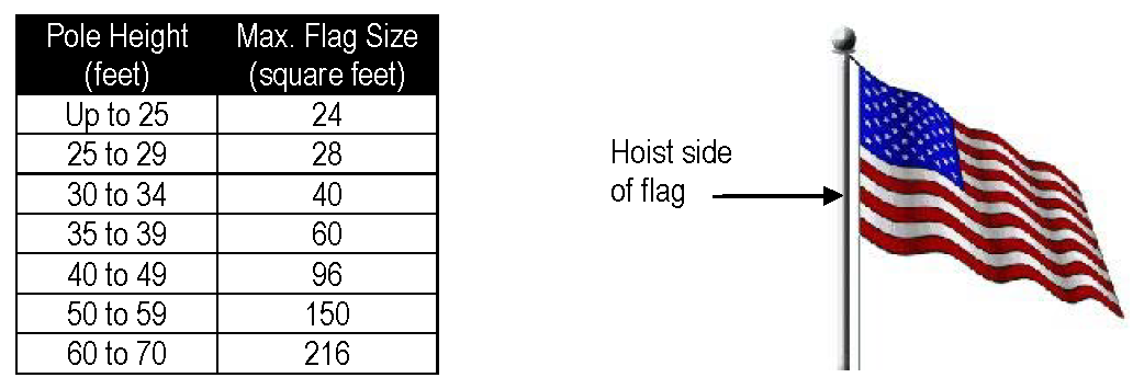
The maximum dimensions of any flag shall be proportional to the flagpole height. The hoist side of the flag shall not exceed 20% of the vertical height of the pole. In addition, flags are subject to the following dimensional limitations.
(f)
Each property shall be allowed a maximum of three flagpoles unless a special use permit (see Section 3.5) is granted by the Board of Adjustment.
(g)
A maximum of three flags shall be allowed per flagpole.
(h)
The flag and flagpole shall be maintained in good repair. A flagpole with broken halyards shall not be used and flags which are torn or frayed shall not be displayed.
(i)
On United States and North Carolina holidays, there shall be no maximum flag size or number or other limitations on manner of display.
(j)
This Section shall not be interpreted to restrict the right to display eligible flags as banners or noncommercial signage under Article 8, Signs. Flags mounted directly on a building wall shall expressly be considered signs and shall be subject to Article 8, Signs.
(Ord. No. UDO-19-02 , § 11, 9-19-19; Ord. No. UDO-21-01 , §§ 21, 22, 5-17-21)
4.13.3. Ground Floor Elevation
Ground floor elevation shall be measured from top of the fronting sidewalk or roadway to the top of the finished ground floor.
4.13.4. Building Width
Building width shall be measured by the distance along the front plane of any building (as determined by the location of an entrance fronting on a street).
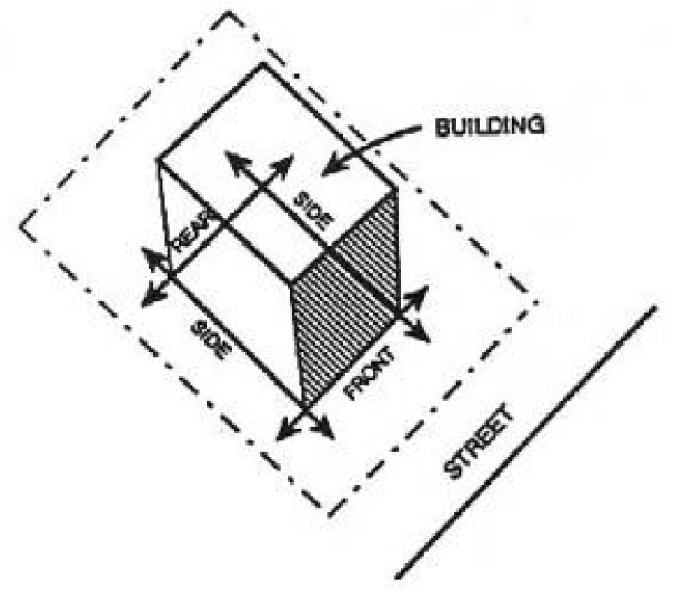
4.13.5. Standard Minimum Separation between Buildings
A.
The minimum required separation between buildings shall be in accordance with the latest edition of the North Carolina Building Codes.
B.
Attached buildings shall comply with all requirements for such structures including, but not limited, to, the provision of full firewalls between each independent structure.
(Ord. No. UDO-19-02 , § 11, 9-19-19)
4.13.6. Building Lines
Building lines are tangent to the exterior surface of a building or structure, parallel to front, side and rear lot lines. These are referred to as front, side and rear building lines, respectively.
4.14 - BLOCKS AND LOTS
4.14.1. General
A.
The lengths, width, and shapes of blocks shall be determined with due regard to; provision of adequate building sites suitable to the special needs of the type of use contemplated; zoning requirements; needs for vehicular and pedestrian circulation; control and safety of street traffic; limitations and opportunities of topography; and convenient access to water areas.
B.
Generally, blocks shall have sufficient width to allow two tiers of lots of minimum depth except where single tier lots are required to separate residential development from through-vehicular traffic or another type of use in non-residential subdivisions; or where abutting a water area.
C.
The Planning Board may require the construction of a pedestrian crosswalk at least 15 feet in width to provide convenient public access to a public area such as a park or school, to a water area, or to areas such as shopping centers, religious, or transportation facilities.
D.
Block numbers shall conform to the County street numbering system, if applicable.
E.
Lots in new subdivisions shall conform to dimensional regulations of the district in which the subdivision is located and any other dimensional requirements that may be imposed by additional regulations.
F.
Double frontage lots should be avoided.
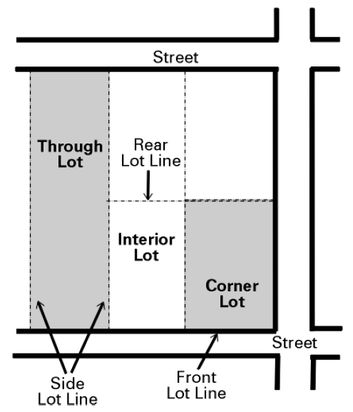
G.
Lot Type
Within the County, the various types of lots shall be classified as shown in the graphic at right:
H.
Lot Line Equivalent
The following provisions shall apply in the determination of a lot line equivalent.
1.
A front lot line equivalent is a straight line joining the foremost points of the side lot lines. In the case of rounded property corners at street intersections, the foremost point of a side lot line shall be assumed to be the point at which the side and the front lot line would have met without such rounding.
2.
In the case of "through lots" (also referred to as "double frontage lots"), the lot shall be considered to have two front lot lines on each street frontage.
3.
A rear lot line equivalent is a straight line joining the rearmost points of the side lot lines.
4.
A side lot line equivalent is a straight line joining the ends of the front yard line and the rear yard line on the same side of the zone lot.
5.
Flag lots shall be allowed in limited circumstances in conformance with Section 4.14.D.
I.
Lot Width
1.
Lot width shall be measured by the distance between the side lot lines (generally running perpendicular to a street), measured at the point of the front yard along a straight line parallel to the front of the property line or to the chord of the front property line.
2.
Except for cul-de-sacs, lot width (where they intersect with street line) may not be less than 80% of the minimum required width for the district. In the case of lots on the turning circle of cul-de-sacs, lot widths may be 50% of district requirements.
Commentary: In the graphic below, the measurement for lot width is indicated by the "W".
J.
Lot Depth
Depth of a lot shall be considered to be the distance between the midpoints of straight lines connecting the foremost points of the side lot lines in the front and the rear. On corner lots, the street side lot line is considered to extend to the point of tangency with the front lot line. On lots located on the interior of a cul-de-sac, the front most measurement point is assumed to be the midpoint of the curve between the side lot lines.
Commentary: In the graphic above, the measurement for lot depth is indicated by the "D".
4.14.2. Lot Area
A.
Lot area refers to the entire horizontal land area of a zone lot, measured in gross square feet. The minimum development area requirements may require a lot larger than the minimum lot area required.
B.
Minimum lot area shall be exclusive of public right-of-way or private streets.
C.
In a residential development project, a single remaining lot of record (not allocated to any other dwellings) may be built upon if all other dimensional requirements can be satisfied on the lot. Lots created after May 1, 2007 that do not satisfy the minimum lot area requirements may not be built upon.
D.
Flag Lots
When there are no other means of access to a parcel, the Planning Director may approve the creation of a flag lot, subject to the following provisions:
1.
Access shall be provided to the flag lot by means of an easement with a minimum width of 30 feet along the "pole."
2.
The maximum length of the "pole" may not exceed 500 feet.
3.
The area inside the "flag" portion of the lot must satisfy the minimum lot area requirements for a conventional development within the underlying zoning district.
4.
The flag portion of the flag lot must satisfy the minimum yard requirements of the zoning district.
5.
Where applicable, a driveway permit may be required from NCDOT. Failure to obtain a driveway permit shall result in denial of the flag lot.
6.
No more than four flag lots may be created from one parent parcel.
7.
Up to two flag lots may use the same access "pole" provided a shared access agreement has been recorded on the plat filed with Brunswick County.
4.14.3. Density
Commentary: This includes residential development in nonresidential districts and mixed-use projects.
A.
Definition
"Density" refers to the number of dwelling units per unit of land area. For residential development utilizing the Conventional Development standards (see Section 4.3.3), density is determined by dividing the total area (in acres) of the zone lot by the "development area per dwelling or rooming unit". The entirety of a lot is included in the calculation including, but not limited to, wetlands, ponds and marsh. The maximum density established for a district is not a guarantee that such densities may be obtained, nor, shall the inability of a development to achieve the stated maximum density be considered sufficient justification for varying or otherwise adjusting other density or dimensional requirements.
B.
Density Transfer
In any instance where a particular development is located in more than one district the density shall be separately computed for each district and no density may be transferred between districts.
4.14.4. Yards
A.
General
1.
Every part of a required yard shall be open and unobstructed from 30 inches above the general ground level of the graded lot upward to the sky except as permitted in Section 4.14.4.E, below.
2.
Except as may be expressly permitted as part of a Planned Unit Development (Section 4.3.1), no part of a required yard may be included as part of a yard for any other building.
3.
Yards or lots in existence prior to May 1, 2007 may not be reduced below the minimum dimensions required by this Ordinance unless specifically exempted by Article 10, Nonconformities.
B.
Types of Yards
1.
There are three types of yards—front, side, and rear.
2.
On a corner lot, the side yard adjoining a street shall meet the street side yard dimensional requirement. In general, the street side yard shall be the yard on the street with a lower classification. This is not necessarily the street that determines the address of the parcel.
3.
On a through lot (or double frontage lot), the lot shall have two front yards instead of one front and one rear yard. A front yard shall exist on each portion of the lot fronting on a street.
C.
Measurement of Yards
1.
The depth of a required yard shall be measured at right angles to a straight line joining the foremost points of the side lot lines. The foremost point of the side lot lines, in the case of rounded property corners at street intersections, shall be the point of tangency of the lot lines.
2.
The inner edge of the required side yard is parallel to the side lot line.
3.
The inner edge of the required rear yard is parallel to the rear lot line.
D.
Reduction in Required Front Yard
The minimum required front yard may be decreased if the width of the required buffer is increased by the same amount. See Section 6.3.8, Street Buffers, for standards relating to buffers.
E.
Permitted Obstruction in Required Yards
In all districts, the following shall not be considered obstructions when located within a required yard, except that these items shall not be permitted to violate the provisions of Section 6.15, Clear Site Triangle.
1.
In any Required Yard:
i.
Sidewalks, uncovered steps and handicapped access ramps.
ii.
Off street parking facilities may be located in the required front yard. Off-street parking and loading facilities may not be located in a required buffer.
iii.
Plantings and vegetation, arbors and trellises, open terraces, including natural plant landscaping.
iv.
Awnings or canopies projecting up to six feet from a building wall, provided that the awning has no supports other than provided by the wall or its integral part.
v.
Cornices, eaves, and awnings may extend up to five feet into any required yard, but shall remain at least two feet from the property line, except on zero lot line homes.
vi.
Bay windows, entrances, balconies, and similar features that are less than ten feet wide may extend up to one and one-half feet into any required yard, but shall remain at least six feet from the property line.
vii.
Chimneys projecting not more than three feet into and not exceeding two percent of the area, of the required yard.
viii.
Fire escapes or staircases may project no more than eight feet into the required yard.
ix.
Directional signs may be installed in conformance with Section 8.7.19.B.
x.
Driveways that meet the requirements of this Ordinance.
xi.
Flagpoles having only one structural ground member.
xii.
Mailboxes.
xiii.
Project boundary buffers (See Section 6.3.2.B) and street buffers (See Section 6.3.2.A).
xiv.
Fountains, sculpture or other similar objects of art.
xv.
Street furniture such as, but not limited to benches, drinking fountains, trash receptacles, ash trays, light standards.
xvi.
Retaining walls no more than six feet in height.
xvii.
Security gates and guard stations.
xviii.
When screened from adjacent residential dwellings, at-grade patios, decks or uncovered terraces may extend up to eight feet into any required front yard.
2.
In any Required Front Yard:
i.
An accessory solar collector may not exceed six feet (6') in height.
3.
In any Required Side or Rear Yard:
i.
When screened from adjacent residential dwellings, uncovered at-grade structures (patios, decks, or terraces) may be located anywhere between the edge of the structure and the property line.
ii.
Clothes poles or clothes lines associated with residential uses.
iii.
Recreational equipment.
iv.
Mechanical equipment for residential uses, such as HVAC units, may extend into any required side yard by no more than 50% of the required yard.
v.
Off street parking and loading facilities may be located in the required side or rear yard. Off-street parking and loading facilities may not be located in a required buffer.
Commentary: All permanent accessory structures must meet the setbacks requirements outlined in Section 5.4., Accessory Structures and Uses.
(Ord. No. UDO-19-02 , §§ 3, 13, 9-19-19)
4.14.5. Fractional Requirements
When any requirement of these regulations results in a fraction of a dwelling unit or other measurement, that fraction shall be disregarded and the next highest whole number shall apply.
4.14.6. Measurement of Days
Unless specifically stated otherwise, all provisions stating a required number of days shall mean calendar days, inclusive of weekend days.
4.15 - HOUSING TYPES
The following housing types are established to provide a common terminology for housing in the County. All drawings are for illustrative purposes only.