
Chattahoochee Hills
City Zoning Code
City Zoning Code
ARTICLE VI
ZONING DISTRICTS
Sec. 6-1.- Intent.
A.
The rural (RL) district is intended primarily for low density agricultural and single-family residential uses. This district is designed to stabilize and protect the rural, agricultural, and residential characteristics of the city and to encourage single-family uses on larger lots.
B.
Hamlet (HM) district. The hamlet district is intended primarily for the creation of communities developed at a low overall density. This district provides a location for agricultural and residential uses to exist in close proximity to smaller scaled mixed uses, including commercial, office, manufacturing or civic uses complete with standards and parameters to encourage a pedestrian-friendly traditional development form which enhances community aesthetics and limits conflicts between vehicles and pedestrians. This district is intended primarily for a medium-density, fine-grained mix of uses, and requires high levels of open space preservation within each individual district.
C.
Village district (VL). The village district is intended primarily for the creation of larger mixed-use communities developed at a medium to high density. This district allows agricultural and residential uses in close proximity to medium or larger scale commercial, office, manufacturing, or civic uses complete with standards and parameters to reduce dependence on automobiles, in order to encourage fine-scale mixed uses and a pedestrian-friendly traditional urban form which enhances community aesthetics and limits conflicts between vehicles and pedestrians.
D.
Historic crossroads (HC) districts. The intent of the historic crossroads (HC) districts are to:
1.
Protect the existing old Rico and Campbellton commercial areas from uses and building forms which are incompatible with the scale, character and needs of the surrounding area;
2.
Reconstitute historic crossroads communities as identified in the comprehensive plan as viable downtown districts with authentic historic character;
3.
Preserve and restore existing traditional and pedestrian scale buildings in historic crossroads communities;
4.
Promote historic small scale, local-serving commercial uses in historic crossroads communities;
5.
Provide opportunities for incremental development within a defined framework of streetscapes and building form;
6.
Prohibit or place reasonable controls on the development of inappropriate large-scale, highway-oriented retail, service, office, and dining uses which are intended to serve large areas of the city;
7.
Alleviate development pressure on the surrounding rural area by placing reasonable controls on development and expansion of strip commercial uses, especially at the fringes of this district; and
8.
Promote a nodal form of small scale historic commercial development that other zoning districts are unable to properly facilitate.
(Ord. No. 21-10-228, § 1, 10-5-2021; Ord. No. 25-08-287, § 5, 8-5-2025)
Sec. 6-2. - Development controls.
A.
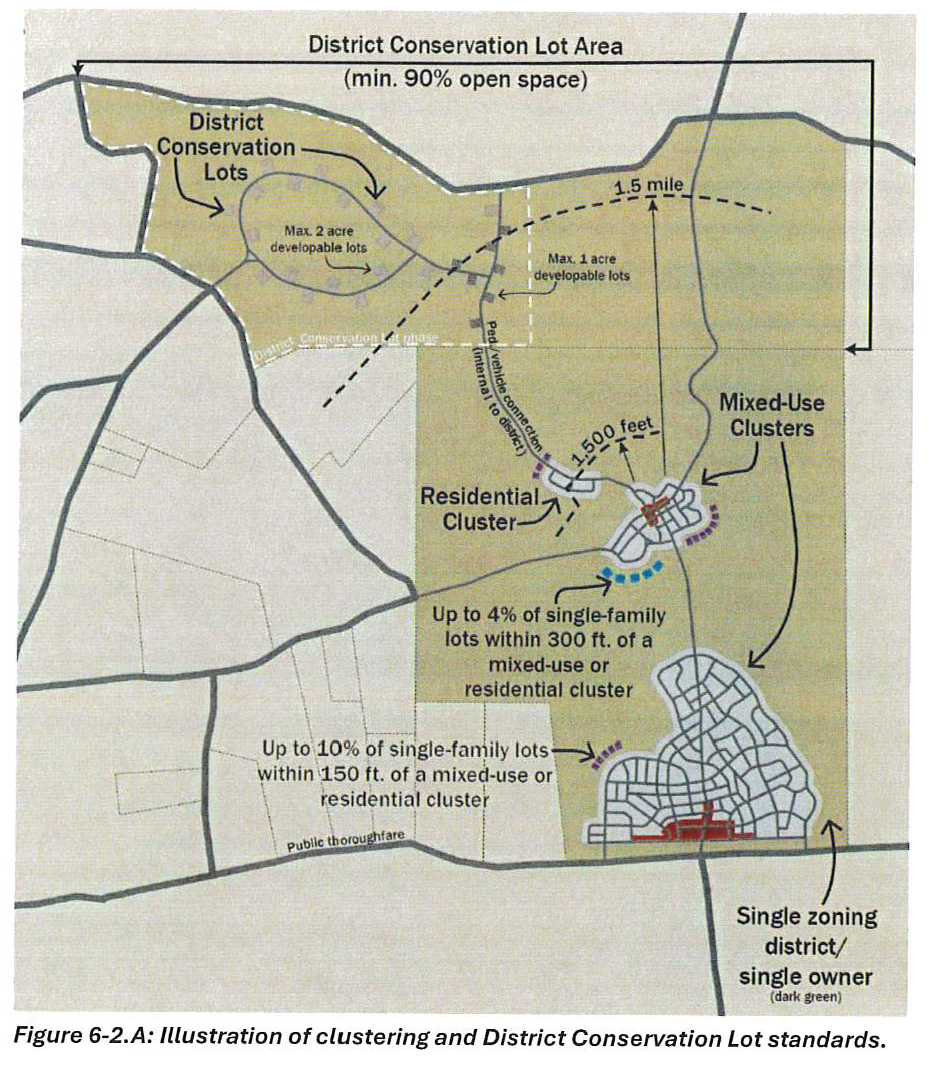
Clustering.
1.
Development within each hamlet (HM) or village (VL) district must be clustered as specified in this subsection to promote walking, minimize the fragmentation of open space, and to adhere to the design principles pertaining to the village and mixed-use hamlet development types specified in the city's comprehensive plan.
2.
General hamlet (HM) and village (VL) clustering requirements. The following standards apply within hamlet (HM) district and village (VL) districts:
a.
All lots must be contiguous or directly across a thoroughfare from other lots (i.e., clustered). Clusters maybe mixed-use clusters or residential clusters, as described below.
b.
Mixed-use clusters must meet the following requirements:
i.
The cluster must contain at least 5,000 square feet of existing or planned non-residential floor area.
ii.
The cluster must contain at least 100 existing or planned dwelling units.
iii.
Single-family detached lots in the cluster may not exceed 21,780 square feet in area.
iv.
No more than one percent of single family detached lots (rounded up to the nearest whole number of lots) may exceed 43,560 square feet in area.
c.
Residential clusters within a district must meet the following requirements:
i.
The residential cluster must contain at least 20 dwelling units.
ii.
Fifty percent of the lots in the residential cluster must be no more than 1,500 feet from an established mixed-use cluster that meets the standards of "2(b), above.
iii.
The residential cluster must be connected to the established mixed-use cluster via an internal thoroughfare, and/or a publicly accessible regional trail, and/or an unpaved road. Such connection must be located entirely within the district and may not utilize a public thoroughfare adjoining a district boundary.
iv.
Single-family detached lots in the residential cluster may not exceed 21,780 square feet in area.
v.
No more than one percent of single family detached lots (rounded up to the nearest whole number of lots) may exceed 43,560 square feet in area.
vi.
Though residential clusters are not required to include commercial uses, they may contain any uses allowed in the district.
d.
Exceptions:
i.
Up to ten percent of the total single-family lots may be fully or partially within 150 feet of the edge of a mixed-use or residential cluster. These lots may not exceed 43,560 square feet in area.
ii.
Up to four percent of the total single-family lots may be fully or partially within 300 feet of the edge of a mixed-use or residential cluster. These lots may not exceed 43,560 square feet in area.
iii.
District conservation lots, as regulated in subsection 3, below.
iv.
Up to five percent of commercial lots may be within any distance of the edge of a mixed-use or residential cluster subject to approval of city council, provided such commercial lots are only used for accommodation, restaurant, or personal or household service uses. In rendering its decision to allow such commercial lots and uses, the city council must find that all commercial lots and uses, though their programming, layout, and design, relate to the rural and/or agricultural character of the site.
e.
When a district is subdivided by a public thoroughfare, the city council will adopt conditions it finds appropriate to limit the number of residential units on the property across the thoroughfare from the portion of the district containing the mixed-use cluster, or other such conditions, in the interest of the public's health, safety, and welfare.
3.
District conservation lot requirements. The following standards are for what shall be known as "district conservation lots."
a.
Intent. The intent of these district conservation lot standards is to:
i.
Provide more development options where proximity to a mixed-use cluster has created demand;
ii.
Minimize the fragmentation of open space;
iii.
Provide design flexibility; and
iv.
Increase opportunities for viable agriculture and forestry uses.
b.
General standards. Developments utilizing these district conservation lot standards must meet the following requirements:
i.
Each district conservation lot area must be a single phase and must meet the requirements of this section based on such phase. The phase must include any developable lots and any required open space.
ii.
Developments may contain multiple phases of district conservation lot areas, but the total of all district conservation lot areas may not exceed 400 acres or 30 percent of the district, whichever is less.
iii.
District conservation lot areas must be located wholly or partially within 1.5 miles of the edge of an established mixed-use cluster.
iv.
No district conservation lot areas may be platted before a mixed-use cluster located within 1.5 miles in the same hamlet (HM) or village (VL) district meets all the following:
a.
The mixed-use cluster must contain at least 5,000 square feet of existing commercial floor area holding a valid certificate of occupancy when located off-site.
b.
The mixed-use cluster must have approved final plats for at least 80 percent of its lots.
c.
Connectivity standards. District conservation lots must directly connect to a mixed-use cluster via an internal thoroughfare, and/or a publicly accessible regional trail, and/or an unpaved private road. Such connection must be located entirely within the hamlet district and may not utilize a public thoroughfare adjoining a district boundary.
d.
Use, density, lot size, and open space standards.
i.
Only residential and agricultural uses are allowed in district conservation lot areas.
ii.
District conservation lot areas must meet the following standards based on the proposed minimum lot size:
a. Excludes septic reserves, which are allowed in Open Spaces.
iii.
Within a single HM (Hamlet) or VL (Village) district, open space within District Conservation Lot areas may be counted towards district requirements.
iv.
When a district conservation lot is sold to an end-user who also owns a portion of the open space adjacent to the developable district conservation lot area, that adjacent open space must be protected by a conservation easement meeting the requirements of sections 5-3 through 5-5 before the issuance of the first certificate of occupancy on that district conservation lot.
e.
Buffer requirements.
i.
In addition to the general buffer requirements of the zoning district, district conservation lots must also provide a buffer at least 150 feet deep along all internal thoroughfares.
ii.
Where existing topography is adequate to provide an effective visual buffer, the zoning administrator may reduce this buffer requirement.
iii.
The required buffer may be wooded or agricultural areas.
iv.
The required buffer may not include any buildings or pavements, except that a driveway is allowed through the buffer.
B.
Building setbacks.
1.
Setbacks shall not apply to lots exclusively used for common mailboxes or other community amenities.
2.
Any building used for human occupancy must be set back 40 feet from any easement containing a gathering or transmission line.
C.
Required setbacks and maximum building height. the required setbacks and maximum building height regulations shall be as shown in the following table, unless alternate standards are approved by city council.
a Or greater if required by building code
b Applies to front and side facades that face a thoroughfare or open space
D.
Building encroachments into required yards.
1.
Cornices, eaves, steps, gutters, fire chases, chimneys, bay windows, or other similar architectural features that are a part of an exterior wall of a structure, and fire escapes may extend into a required minimum setback, provided such extensions do not exceed three feet.
2.
Stairs, porches, canopies, fences, walls, outdoor dining areas, seating areas, and vending areas shall be permitted within the first layer, provided sufficient area is preserved within the sidewalk area for safe pedestrian circulation as approved by the zoning administrator.
3.
Cantilevered portions of buildings, including decks and awnings, shall be permitted to extend over portions of sidewalk on private property, including private thoroughfares.
E.
Building height.
1.
Building heights shall be as established in subsection (C), except that building heights in hamlet (HM) and village (VL) districts may be higher if the building is not visible from outside of the district, subject to the approval of the zoning administrator, the fire department, and the city engineer.
2.
Building height bonus. Buildings in hamlet (HM) and village (VL) districts shall be permitted an additional height bonus above the respective district maximum height limit in accordance with the following regulations:
a.
Individual buildings providing a minimum of 50 percent of the total building floor area as senior housing shall be permitted an additional 30 feet of building height;
b.
Individual buildings that visually terminate the viewshed of a public thoroughfare or open space through use of architectural detailing, massing and delineation shall be permitted an additional 20 feet of building height;
c.
Individual buildings within a village (VL) district containing a minimum of 100,000 square feet of any of the following uses shall be permitted an additional 20 feet of building height: educational; places of worship; and public or governmental use; and
d.
City council may approve an increase in the maximum building heights using the TDR program. Increases in building height shall require one TDR for each 20 feet of additional height across 2000 square feet of horizontal area.
3.
Height limitations shall not apply to spires, belfries, cupolas, domes, transmission towers, chimneys, smokestacks, derricks, conveyors, flagpoles, silos and grain elevators, fire towers, masts, clock towers, cooling towers, water tanks, or mechanical bulkheads. However, such elements shall be prohibited from heights in excess of 25 feet above the height limit without approval by the planning commission.
F.
Buildings in developable areas.
1.
Design standards.
a.
All principal buildings shall be oriented to face either an accessible open space or the thoroughfare of greatest intensity based on traffic volume, number of lanes, and/or pedestrian activity, as determined by the zoning administrator. For lots with frontage along both South Fulton Parkway and a thoroughfare that intersects with South Fulton Parkway, buildings may be oriented to face the other thoroughfare.
b.
The primary pedestrian access to all individual ground level or upper story dwellings, tenant spaces, and other uses shall either be directly accessible and visible from the sidewalk adjacent to the primary facade or shall provide a pedestrian connection with a minimum width of four feet to the sidewalk.
c.
Buildings also may be oriented to face a courtyard or mews and individual uses may have pedestrian entrances that open directly to a courtyard or mews.
d.
The first 30 feet of building depth facing any thoroughfare or open space must be occupied space on all above-grade floors of all buildings. Occupied space means interior building space regularly occupied by building users and does not include storage areas, utility space, or parking, but includes hallways, stairwells, and elevators.
e.
Where present, garages serving individual dwellings shall be located so as to be directly accessible from the thoroughfare of lesser intensity based on traffic volume, number of lanes, and/or pedestrian activity as determined by the zoning administrator. Where garage doors face any public or private thoroughfare except a lane or alley, they must be set back at least eight feet from the front facade.
f.
The interior finished floor elevation of all buildings shall be no more than five feet above the adjacent sidewalk for residential uses and no more than three feet above the adjacent sidewalk for all other uses.
g.
All buildings except single-family detached dwellings and townhouse dwellings shall have a minimum floor-to-floor height of 14 feet on the ground floor.
h.
Delineation of building floors at the third story above ground level and lower shall be executed through windows, belt courses, cornice lines or similar architectural detailing.
i.
Fueling station canopies shall have pitched roofs, no shallower than 5:12, and shall be covered in shingles, shakes, or traditional standing-seam metal.
j.
No drive-through service window or associated element or driveway shall be located between a building and any adjacent thoroughfare.
2.
Facades that face thoroughfares. All facades that face thoroughfares shall conform with the following requirements.
a.
Facades for residential or agricultural uses shall have residential windows with clear glass no less than ten percent of the area of the facade as measured per floor.
b.
Facades for education and arts, entertainment, and recreation uses shall be glazed with clear glass no less than 20 percent of the area of the facade as measured per floor.
c.
Facades for all other uses shall have storefronts and glazed with clear glass no less than 60 percent of the area of the ground floor façade and no less than 20 percent of the area of upper floor facades. Ground story fenestration shall be measured as a percentage of the area between two and eight feet above the average grade at the base of the facade.
d.
The length of facades without intervening fenestration, architectural detailing, or entryway shall not exceed 20 feet.
e.
Pedestrian entrances may be counted towards fenestration requirements.
f.
Exterior walls shall utilize brick, glass, wood, cementitious siding, stucco, or stone. Metal or metallic materials may be permitted but shall not constitute the majority of the material on any individual wall or facade unless approved by the zoning administrator.
3.
Maximum building footprint.
a.
Except as specified in subsection (c), no building footprint shall exceed 80,000 gross square feet in any village (VL) district.
b.
Except as allowed in subsection (c), no building footprint shall exceed 40,000 gross square feet in any hamlet (HM) or historic crossroads (HC) district.
c.
Maximum building footprints may be exceeded only with a variance and when the variance criteria of section 3-17 and the following apply.
i.
There is a compelling public interest.
ii.
The proposed building is occupied exclusively by industrial, office, institutional, or entertainment uses.
iii.
Such uses shall have their primary frontage only along boulevard or avenue thoroughfare types.
iv.
Such uses shall vary roof and facade details, patterns, and materials every 300 linear feet along the primary facade.
v.
The total number of large-scale non-residential uses shall not exceed four such uses within individual hamlet (HM) districts or six within individual village (VL) districts.
4.
Flat roofs shall be enclosed by parapets a minimum of four feet in height when mechanical equipment is located on the roof.
5.
Sidewalks or other pedestrian ways shall connect every building entrance with every parking area.
6.
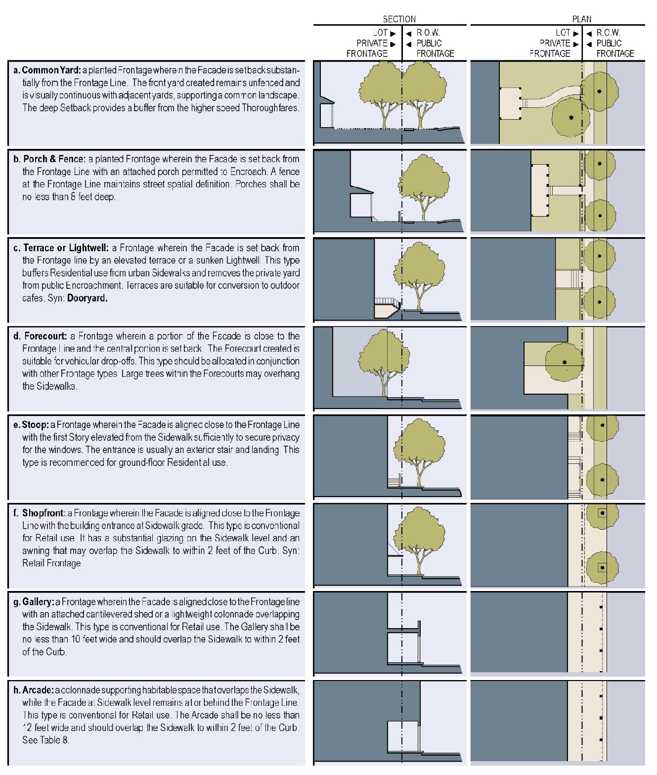
Private frontages shall conform to one of the types shown in the following figure.
G.
The provisions of this section shall apply except as provided in subsection 7-4.
(Ord. No. 21-10-228, § 1, 10-5-2021; Ord. No. 23-02-254, §§ 14—19, 2-7-2023; Ord. No. 25-08-287, § 6, 8-5-2025)
Sec. 6-3. - Density.
A.
Residential density calculation. The residential density of a site shall be calculated as follows:
1.
Accessory dwellings shall not count toward minimum or maximum residential units per acre.
2.
The non-residential area of live-work units shall not count toward density calculations.
3.
Principal dwellings shall count toward density as shown in the following tables. Whichever table results in more dwelling units shall apply:
a.
Unit size equivalency:
b.
Block net density equivalency:
a. Block net density is the total of dwelling units on the block divided by the block area (less any open spaces, nonresidential uses, and thoroughfares).
b. To qualify for a density equivalent less than one, at least 50 percent of the density units applied must come from DTCs or externally sourced TDRs.
B.
Bonuses.
1.
Civic use bonus. The floor area of any building that is operated or managed by the city for at least five years shall not count toward the maximum density. One additional density unit is allowed for every 1,000 square feet of such buildings provided.
2.
Historic building preservation bonus. Five additional density units are allowed for each building that is preserved as follows:
a.
The building was constructed before 1920;
b.
The building exceeds 320 square feet;
c.
The building is preserved and maintained utilizing the "restoration standards and guidelines" identified in The Secretary of the Interior's Standards for the Treatment of Historic Properties; and
d.
The building restoration shall be completed before the additional density bonus is allowed.
C.
Density controls.
1.
Density controls shall be as shown in the following table.
a. The total number of residential units per acre, before the application of any transferable development rights, density transfer charges, or civic use bonuses.
b. Non-residential includes all use categories except residential and agricultural uses. Numbers are expressed as total gross square feet of non-residential floor space at build out per gross acre of land. Example: A development with 250 gross acres of land in an HM district would have a minimum required non-residential floor area of 10,000 gross square feet.
c. Non-residential includes all use categories except residential and agricultural uses.
d. See section 11-5 and 11-6.
e. Transfer of development rights (TDR) is required to meet the minimum residential density. See article XIII.
f. Or as specified in section 6-3D, whichever is less.
g. Includes all parcels except those devoted exclusively to residential or agricultural uses, as well as any parking associated with those uses.
2.
Proof of DTC, a DTC agreement, or TDR acquisition in accordance with article XIII must be provided at the time of preliminary platting.
3.
For phased developments, proof of available development rights must be provided at the preliminary platting of each phase.
D.
Mixed-use concurrency requirement. The following shall apply within individual hamlet (HM) and village (VL) districts. For the purposes of this section, the non-residential area of live-work units shall be counted as non-residential space, and the residential area of live-work units shall count toward residential units based on the area shown in subsection (A) above.
1.
No more than 100 residential units on a site shall be issued a certificate of occupancy until such time as at least 8,000 gross square feet of non-residential floor area has been issued a certificate of occupancy on the same site. Any mixed-use concurrency requirements beyond the first 100 residential units may be required by conditional zoning.
2.
No certificate(s) of occupancy shall be issued for more than 40,000 gross square feet of non-residential floor area on a site until such time as a certificate of occupancy has been issued for at least 25 residential units. Any mixed-use concurrency requirements beyond the first 40,000 gross square feet may be required by conditional zoning.
3.
In developments of more than 500 acres, the conditions of zoning shall include additional concurrency requirements specific to and appropriate for the uses intended.
E.
Lot size regulations. There are no minimum lot sizes except in the RL district the minimum lot size is 20 acres, except as provided in section 11-6 for family lots. Lots used exclusively for common mailboxes, community amenities, private thoroughfares, or utilities are exempt from these regulations. Any lot on an individual septic system is subject to health department lot-size requirements.
*Any lot on an individual septic system must be at least one acre, or larger if required by the county health department.
F.
District size regulations.The following shall apply to individual district sizes.
(Ord. No. 21-10-228, § 1, 10-5-2021; Ord. No. 23-02-254, §§ 20—22, 2-7-2023; Ord. No. 25-08-287, §§ 4, 8, 8-5-2025)
Sec. 6-4. - District-specific controls: historic crossroads (HC).
A.
Design controls. The following regulations shall govern the form and design of development in a historic crossroads (HC) district:
1.
All structures and improvements shall have facade materials and details architecturally consistent with historic pre-World War II rural, crossroads, or small-town styles common in the Piedmont or southeastern region of the United States. Approval may be contingent on proof of such consistency, as determined by approval of the zoning administrator, planning commission, and city council.
2.
Any curb cut on any public thoroughfare must be approved by the zoning administrator. Direct thoroughfare connections shall be provided for both vehicular and pedestrian access to adjacent hamlet (HM) or village (VL) districts.
3.
Site design shall minimize cut-and-fill in siting of buildings, drives, and parking facilities.
4.
Buildings:
a.
Materials. Facades shall consist of brick, glass, wood, stucco, stone, or cementitious siding materials. Brick siding shall be painted or coated unless recycled brick or other antique finish is approved by the city. When used, lap siding shall be applied with a four and one-half inch reveal. Materials and style should be consistent on all sides of the building. Exterior building materials shall not include smooth-faced concrete block; tilt-up concrete panels; prefabricated steel panels; highly reflective, shiny, or mirror-like materials; mill-finish (non-colored) aluminum metal windows or door frames; exposed, unfinished foundation walls; exposed plywood or particle board; or unplastered, exposed concrete masonry blocks. Material or color changes generally should occur at a change of plane. Piecemeal embellishment and frequent changes in material should be avoided.
b.
Color. Paint colors shall be chosen from Sherwin Williams "Color Through the Decades" collections from 1850—1930 or the Benjamin Moore Historical Collection, or similar historical palette as approved by the zoning administrator. Unpainted surfaces shall be muted natural and earth tones. Buildings should be a single color with a complementary trim color. Bright colors or franchise colors are permitted as accents only.
c.
Windows and doors. Windows shall be vertical in proportion and topped with an appropriately proportioned lintel or arch. Windows that are openable shall be double hung.
d.
Roofs. Pitched roofs shall have pitches equal to or greater than 8:12, except that shed roofs on additions or porches may be shallower. Pitched roofs shall be traditional materials and treatments, appropriate to the historical style of the building. Where provided, parapet walls shall be of a design and materials consistent with the building facade. Facades should have a well-defined cornice with appropriate cornice returns on gabled roofs.
e.
Doorways. Front entrance doorways shall be recessed a minimum of three feet unless under an awning or a porch with a depth of eight feet or greater.
f.
Buildings shall include historically accurate architectural elements such as columns, arcades, covered entry-walkways, arches, facade offsets, windows, balconies, and recesses. Exceptions may be approved for design, color, or roof pitch when the application is accompanied with appropriate documented historical antecedents and approved by the city council.
B.
Building permit review and approval. Architectural plans for all new buildings and all exterior alterations in an HC district must be approved by the city council prior to the issuance of a building permit.
1.
Building permit applications shall be accompanied with color elevations accurately depicting materials, finishes, colors, etc. of all elements, including the primary structure, accessory structures, fences, awnings, and other appurtenances. Materials samples are encouraged to provide a better understanding of the proposal.
2.
City council approval of the final site plan is required before the issuance of a building permit.
(Ord. No. 21-10-228, § 1, 10-5-2021)