
Clearwater City Zoning Code
ARTICLE 2
- ZONING DISTRICTS
Sec. 2-100.- Permitted uses.
Chart 2-100 Permitted Uses. The following chart is a summary of the uses permitted in each zoning district. The "X" only indicates whether the use is permitted; it does not indicate the nature of the approval required. No use is permitted unless it complies with the provisions of the zoning district in which it is located and the applicable development standards in Article 3 of this Development Code.
(Ord. No. 6526-00, § 1, 6-15-00; Ord. No. 6928-02, § 2, 5-2-02; Ord. No. 7835-07, § 1, 1-17-08; Ord. No. 8043-09, § 2, 9-3-09; Ord. No. 8044-09, § 1, 10-1-09; Ord. No. 8211-10, § 1, 10-5-10; Ord. No. 8311-12, § 1, 3-1-12; Ord. No. 8349-12, § 1, 9-6-12; Ord. No. 8540-14, § 1, 4-3-14; Ord. No. 8654-15, § 2, 2-5-15; Ord. No. 8715-15, § 3, 6-18-15; Ord. No. 8810-16, § 1, 1-21-16; Ord. No. 8931-16, § 4, 9-1-16; Ord. No. 8988-17, § 1, 2-2-17; Ord. No. 9149-18, § 1, 8-2-18; Ord. No. 9643-23, § 1, 4-4-23; Ord. No. 9758-24, § 1, 6-6-24)
Section 2-101. - Intent and purpose.
The intent and purpose of the Low Density Residential District ("LDR") is to protect and preserve the integrity and value of existing, stable residential neighborhoods of low density while at the same time, allowing a careful and deliberate redevelopment and revitalization of such neighborhoods in need of reinvigoration or neighborhoods with unique amenities which create unique opportunities to increase property values and the overall attractiveness of the city.
Section 2-101.1. - Maximum development potential.
The Low Density Residential District ("LDR") may be located in more than one land use category. It is the intent of the LDR District that development be consistent with the Countywide Future Land Use Plan as required by state law. The uses and development potential of a parcel of land within the LDR District shall be determined by the standards found in this Development Code as well as the Countywide Future Land Use Designation of the property, including any acreage or floor area restrictions set forth in the Rules Concerning the Administration of the Countywide Future Land Use Plan, as amended from time to time. Development potential for the Countywide Future Land Use Designations that apply to the LDR District are as follows:
(Ord. No. 8043-09, § 3, 9-3-09)
_____
Section 2-102. - Minimum standard development.
The following uses are Level One permitted uses in the LDR District subject to the minimum standards set out in this Section and other applicable provisions of Article 3.
(1)
Community residential homes shall not be located within 1,000 feet of one another.
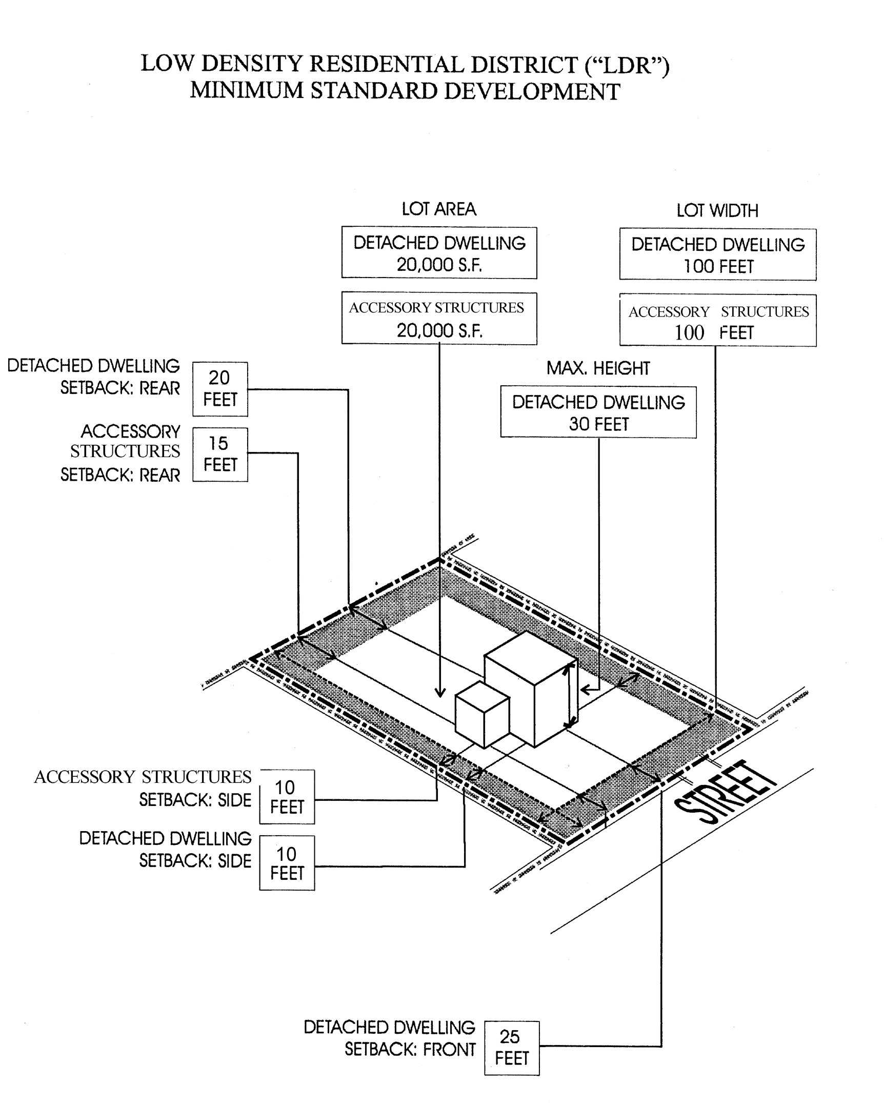
Low Density Residential District
(Ord. No. 6526-00, § 1, 6-15-00; Ord. No. 6928-02, § 3, 5-2-02; Ord. No. 7449-05, §§ 1, 2, 12-15-05; Ord. No. 7631-06, § 19, 11-2-06; Ord. No. 8540-14, § 2, 4-3-14; Ord. No. 8654-15, § 3, 2-5-15)
Section 2-103. - Flexible standard development.
The following Level One uses are permitted in the LDR District subject to the standards and criteria set out in this Section and other applicable regulations in Article 3.
(1)
The Building Code may require the rear setback on a waterfront lot to be at least 18 feet from a seawall.
(2)
Utility/infrastructure uses shall not exceed three acres. Any such use, alone or when added to contiguous like uses which exceed three acres shall require a land use plan map amendment to transportation/utility which shall include such uses and all contiguous like uses.
_____
Flexibility criteria:
A.
Accessory dwelling unit.
1.
Accessory dwelling units shall not exceed 750 square feet or 50 percent of the gross floor area of the principal detached dwelling, whichever is less.
2.
A parcel of land with conforming density shall be permitted one accessory dwelling unit.
3.
Design standards.
a.
The accessory dwelling unit shall be constructed with a consistent architectural style as the principal detached dwelling.
b.
Detached accessory dwelling units shall be constructed with similar architectural features as the principal detached dwelling, including window style, paint scheme, and roof design.
c.
A shipping container may be utilized as a detached accessory dwelling unit, provided it fully complies with the Florida Building Code and is architecturally treated using windows, doors, cladding, porches, and/or decks to provide a residential appearance, as determined by the Community Development Coordinator.
d.
Entrances to attached accessory dwelling units shall not be visible from the street.
4.
The location of an accessory dwelling unit shall be subject to Section 3-203.A.
5.
The height of a detached accessory dwelling unit shall be subject to Section 3-203.D.
6.
Setbacks.
a.
Attached accessory dwelling units shall meet the principal detached dwelling setbacks.
b.
Detached accessory dwelling units shall meet the setbacks established in Table 2-103.
c.
Flexibility for the side and rear setbacks may be approved if the unit is buffered with landscape material and/or fences to minimize impacts to adjacent properties.
7.
Either the principal detached dwelling or accessory dwelling unit shall be occupied by the property owner.
8.
One legal on-street parking space may be substituted in lieu of the required off-street parking space as determined by the City Engineer.
B.
Detached dwellings.
1.
The parcel proposed for development is a corner lot or is an existing lot;
2.
Structures located within the side and rear setbacks otherwise required in the LDR District are used only for accessory uses such as a swimming pool;
3.
Structures within the side and rear setback otherwise required in the LDR District are buffered with landscape material and fences to protect the privacy and value of adjacent properties.
C.
Residential infill projects.
1.
Single-family detached dwellings are the only permitted use eligible for residential infill project application;
2.
The development or redevelopment of the parcel proposed for development is otherwise impractical without deviations from one or more of the following: intensity; other development standards;
3.
The development of the parcel proposed for development as a residential infill project will not materially reduce the fair market value of abutting properties;
4.
The uses within the residential infill project are otherwise permitted in the district;
5.
The uses within the residential infill project are compatible with adjacent land uses;
6.
The development of the parcel proposed for development as a residential infill project will upgrade the immediate vicinity of the parcel proposed for development;
7.
The design of the proposed residential infill project creates a form and function which enhances the community character of the immediate vicinity of the parcel proposed for development and the City of Clearwater as a whole;
8.
Flexibility in regard to lot width, required setbacks, height, off-street parking access or other development standards are justified by the benefits to community character and the immediate vicinity of the parcel proposed for development and the City of Clearwater as a whole.
D.
Utility/infrastructure facilities.
1.
No above ground structures are located adjacent to a street right-of-way;
2.
Any above ground structure, other than permitted telecommunication towers and utility distribution lines, located on or along a rear lot line shall be screened from view by a landscaped opaque wall or fence which is at least two-thirds the height of the above ground structure and shall be landscaped with trees and hedges which five years after installation will substantially obscure the fence or wall and the above ground structure.
(Ord. No. 6526-00, § 1, 6-15-00; Ord. No. 6680-01, § 1, 4-5-01; Ord. No. 7413-05, § 1, 5-5-05; Ord. No. 7605-06, § 19, 4-20-06; Ord. No. 9758-24, § 2, 6-6-24)
Section 2-104. - Flexible development.
The following Level Two uses are permitted in the LDR District subject to the standards and criteria set out in this Section and other applicable regulations in Article 3.
(1)
The Building Code may require the rear setback on a waterfront lot to be at least 18 feet from a seawall.
(2)
The development standards for residential infill projects are guidelines and may be varied based on the criteria set forth in Section 2-104(D).
_____
Flexibility Criteria:
A.
Attached dwellings.
1.
The parcel proposed for development is a corner lot and is vacant on the date of adoption of this Development Code;
2.
The buildings are designed with front setbacks on both streets;
3.
Off-street parking is screened from adjacent parcels of land by a landscaped wall or fence of at least four feet in height;
4.
No more than two dwelling units front on a single street;
5.
The development of attached dwellings does not require the removal of a protected tree;
6.
The dwelling units are contained in no more than two buildings;
7.
The buildings are consistent with the architectural style of existing dwellings in the immediate vicinity of the parcel proposed for development;
8.
The parcel proposed for development is not located in a designated Neighborhood Conservation District; or if the parcel is within the boundaries of a designated Neighborhood Conservation District, the lot area, lot width and setbacks are not less than 90 percent of the average lot area, lot width and setbacks of all improved parcels of land which are located within the Neighborhood Conservation Immediate Vicinity Area and the height does not exceed 120 percent of the average height of buildings and structures located within the Neighborhood Conservation Immediate Vicinity Area.
B.
Overnight accommodations.
1.
The use is accessory to the use of the principal building as a private residence;
2.
The number of units in the proposed overnight accommodations use does not exceed four;
3.
Food service in conjunction with overnight accommodations shall be limited to guests of the use;
4.
The parcel proposed for development fronts on an arterial street;
5.
Off-street parking is screened to a height of four feet by a landscaped wall or fence so that headlamps from automobiles in the off-street parking area can not project into adjacent properties;
6.
All waste disposal containers which serve the proposed overnight accommodations use are located within a landscaped enclosed structure;
7.
The parcel proposed for development is not located in a designated Neighborhood Conservation District; or if the parcel is within the boundaries of a designated Neighborhood Conservation District, the lot area, lot width and setbacks are not less than 90 percent of the average lot area, lot width and setbacks of all improved parcels of land which are located within the Neighborhood Conservation Immediate Vicinity Area and the height does not exceed 120 percent of the average height of buildings and structures located within the Neighborhood Conservation Immediate Vicinity Area.
C.
Parks and recreational facilities.
1.
The proposed use is compatible with the surrounding properties.
2.
Off-street parking is screened from adjacent parcels of land and any street by a landscaped wall or fence of at least four feet in height.
3.
All outdoor lighting is designed so that no light fixtures cast light directly on adjacent land used for residential purposes.
4.
The characteristics of the parcel proposed for development are such that the uses of the property will require fewer parking spaces than otherwise required or that the use of significant portions of the property will be used for passive recreational purposes.
D.
Residential infill projects.
1.
The development or redevelopment of the parcel proposed for development is otherwise impractical without deviations from one or more of the following: intensity; other development standards;
2.
The development of the parcel proposed for development as a residential infill project will not materially reduce the fair market value of abutting properties;
3.
The uses within the residential infill project are otherwise permitted in the district;
4.
The uses within the residential infill project are compatible with adjacent land uses;
5.
The development of the parcel proposed for development as a residential infill project will upgrade the immediate vicinity of the parcel proposed for development;
6.
The design of the proposed residential infill project creates a form and function which enhances the community character of the immediate vicinity of the parcel proposed for development and the City of Clearwater as a whole;
7.
Flexibility in regard to lot width, required setbacks, height, off-street parking access or other development standards are justified by the benefits to community character and the immediate vicinity of the parcel proposed for development and the City of Clearwater as a whole.
E.
Schools.
1.
The parcel proposed for development fronts on a major arterial;
2.
All off-street parking is located at least 200 feet from any property used for residential purposes or is designated as residential in the Zoning Atlas;
3.
All outdoor lighting is designed and located so that no light fixture is within 200 feet from the nearest existing building used for residential purposes and so that no light falls on residential property.
(Ord. No. 6526-00, § 1, 6-15-00; Ord. No. 6595-00, § 1, 9-7-00; Ord. No. 7413-05, § 2, 5-5-05; Ord. No. 7449-05, § 38, 12-15-05; Ord. No. 7605-06, § 20, 4-20-06; Ord. No. 9758-24, § 2, 6-6-24)
Section 2-201. - Intent and purpose.
The intent and purpose of the Low Medium Density Residential District ("LMDR") is to protect and preserve the integrity and value of existing, stable residential neighborhoods of low to medium density while at the same time, allowing a careful and deliberate redevelopment and revitalization of such neighborhoods in need of revitalization or neighborhoods with unique amenities which create unique opportunities to increase property values and the overall attractiveness of the City.
Section 2-201.1. - Maximum development potential.
The Low Medium Density Residential District ("LMDR") may be located in more than one land use category. It is the intent of the LMDR District that development be consistent with the Countywide Future Land Use Plan as required by State law. The uses and development potential of a parcel of land within the LMDR District shall be determined by the standards found in this Development Code as well as the Countywide Future Land Use Designation of the property, including any acreage or floor area restrictions set forth in the Rules Concerning the Administration of the Countywide Future Land Use Plan, as amended from time to time. Development potential for the Countywide Future Land Use Designations that apply to the LMDR District are as follows:
(Ord. No. 6526-00, § 1, 6-15-00; Ord. No. 7449-05, § 3, 12-15-05; Ord. No. 8043-09, § 4, 9-3-09)
_____
Section 2-202. - Minimum standard development.
The following uses are Level One permitted uses in the LMDR District subject to the minimum standards set out in this section and other applicable provisions of Article 3.
(1)
Waterfront detached dwellings in LMDR District should be 25 feet except as provided in Article 3 Division 8, Section 3-805 and Division 9, Section 3-904 and except where adjacent structures on either side of the parcel proposed for development are setback 20 feet and then the rear setback shall be 20 feet. The Building Code may require the rear setback to be at least 18 feet from a seawall.
(2)
Community residential homes shall not be located within 1,000 feet of one another.
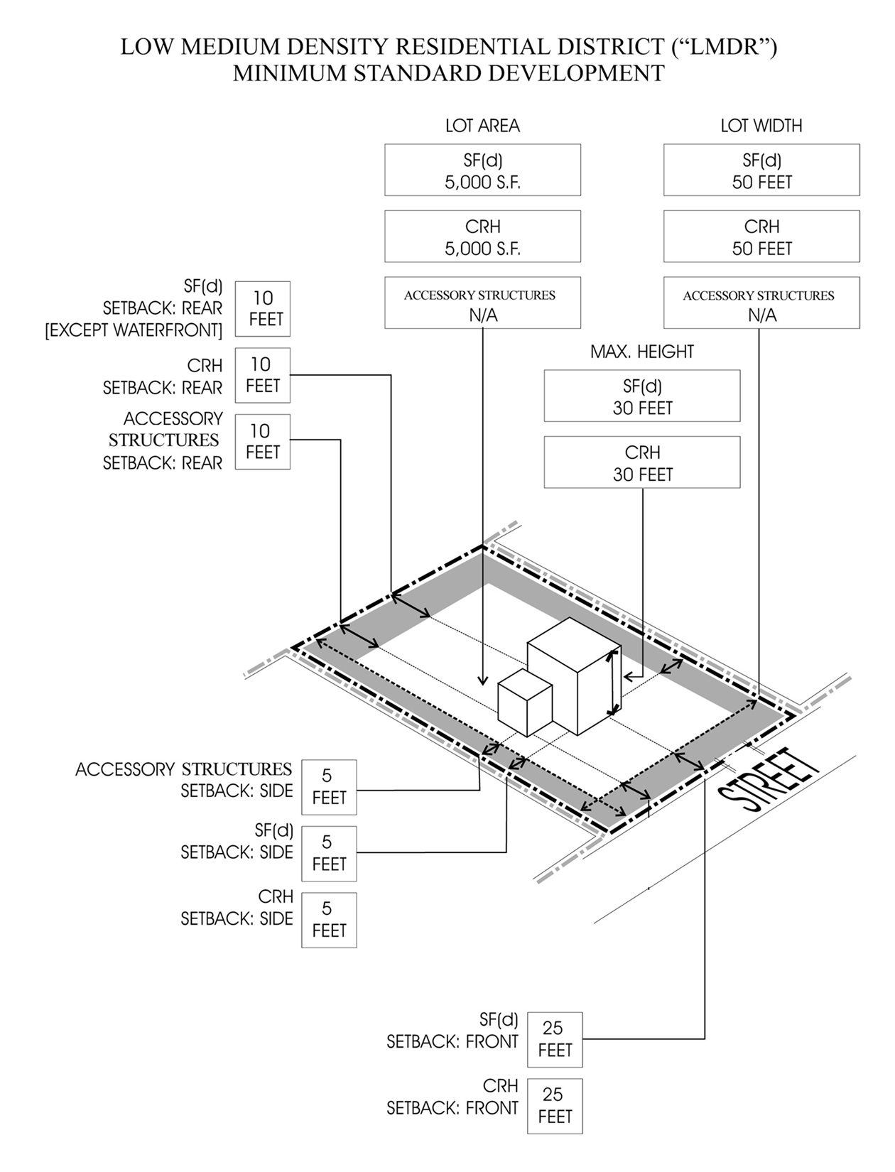
LMDR Minimum Standard Development Diagram
(Ord. No. 6417-99, § 2, 8-19-99; Ord. No. 6526-00, § 1, 6-15-00; Ord. No. 6928-02, §§ 4, 5, 5-2-02; Ord. No. 7449-05, §§ 4, 5, 12-15-05; Ord. No. 7631-06, § 20, 11-2-06; Ord. No. 8540-14, § 3, 4-3-14; Ord. No. 8654-15, § 4, 2-5-15)
Section 2-203. - Flexible standard development.
The following Level One uses are permitted in the LMDR District subject to the standards and criteria set out in this Section and other applicable regulations in Article 3.
(1)
Waterfront detached dwellings in LMDR District should be 25 feet except as provided in Article 3 Division 8, section 3-805 and Division 9, section 3-904 and except where adjacent structures on either side of the parcel proposed for development are setback 20 feet and then the rear setback shall be 20 feet. The Building Code may require the rear setback to be at least 18 feet from any seawall.
(2)
Utility/infrastructure uses shall not exceed three acres. Any such use, alone or when added to contiguous like uses which exceed three acres shall require a land use plan map amendment to Transportation which shall include such uses and all contiguous like uses.
_____
Flexibility Criteria:
A.
Accessory dwelling unit.
1.
Accessory dwelling units shall not exceed 750 square feet or 50 percent of the gross floor area of the principal detached dwelling, whichever is less.
2.
A parcel of land with conforming density shall be permitted one accessory dwelling unit.
3.
Design standards.
a.
The accessory dwelling unit shall be constructed with a consistent architectural style as the principal detached dwelling.
b.
Detached accessory dwelling units shall be constructed with similar architectural features as the principal detached dwelling, including window style, paint scheme, and roof design.
c.
A shipping container may be utilized as a detached accessory dwelling unit, provided it fully complies with the Florida Building Code and is architecturally treated using windows, doors, cladding, porches, and/or decks to provide a residential appearance, as determined by the Community Development Coordinator.
d.
Entrances to attached accessory dwelling units shall not be visible from the street.
4.
The location of an accessory dwelling unit shall be subject to Section 3-203.A.
5.
The height of a detached accessory dwelling unit shall be subject to Section 3-203.D.
6.
Setbacks.
a.
Attached accessory dwelling units shall meet the principal detached dwelling setbacks.
b.
Detached accessory dwelling units shall meet the setbacks established in Table 2-203.
c.
Flexibility for the side and rear setbacks may be approved if the unit is buffered with landscape material and/or fences to minimize impacts to adjacent properties.
7.
Either the principal detached dwelling or accessory dwelling unit shall be occupied by the property owner.
8.
One legal on-street parking space may be substituted in lieu of the required off-street parking space as determined by the City Engineer.
B.
Attached dwellings.
1.
The parcel proposed for development is a corner lot and is vacant on the date of adoption of this Development Code;
2.
The buildings are designed with front setbacks on both streets;
3.
Off-street parking is screened from adjacent parcels of land by a landscaped wall or fence of at least four feet in height;
4.
No more than two of the front doors of the dwelling units front on a single street;
5.
The development of the attached dwellings does not require the removal of a protected tree;
6.
The dwelling units are contained in no more than two buildings;
7.
The buildings are consistent with the architectural style of existing dwellings in the immediate vicinity of the parcel proposed for development;
8.
The parcel proposed for development is not located in a designated Neighborhood Conservation District, or if the parcel is within the boundaries of a designated Neighborhood Conservation District, the lot area, lot width and setbacks are not less than 90 percent of the average lot area, lot width and setbacks of all improved parcels of land which are located within the Neighborhood Conservation Immediate Vicinity Area and the height does not exceed 120 percent of the average height of buildings and structures located within the Neighborhood Conservation Immediate Vicinity Area.
C.
Detached dwellings.
1.
Front setback:
a.
A determination of the front setback shall consider the extent to which existing structures in the neighborhood have been constructed to a regular or uniform set back from the right-of-way;
b.
The reduction in front setback will not adversely affect adjacent property values.
c.
The reduction in front setback is consistent with neighborhood character; and
d.
The reduction in front setback results in an efficient house layout.
2.
Rear setback:
a.
The reduction in rear setback will allow for the preservation of existing vegetation which could not otherwise be preserved; or
b.
The reduction in rear setback will allow the development or redevelopment of a substandard lot which would otherwise not be feasible; or
c.
The reduction results in an efficient house layout; and
d.
The structures located within the rear setback otherwise required in the LMDR District are buffered with landscape material or fences to protect the privacy and value of adjacent properties.
3.
Side setback: The reduction in side setback will allow for the preservation of existing vegetation which could not otherwise be preserved.
D.
Residential infill projects:
1.
Single-family detached dwellings are the only permitted use eligible for residential infill project application;
2.
The development or redevelopment of the parcel proposed for development is otherwise impractical without deviations from one or more of the following: intensity; other development standards;
3.
The development of the parcel proposed for development as a residential infill project will not materially reduce the fair market value of abutting properties;
4.
The uses within the residential infill project are otherwise permitted in the district;
5.
The uses within the residential infill project are compatible with adjacent land uses;
6.
The development of the parcel proposed for development as a residential infill project will upgrade the immediate vicinity of the parcel proposed for development;
7.
The design of the proposed residential infill project creates a form and function which enhances the community character of the immediate vicinity of the parcel proposed for development and the City of Clearwater as a whole;
8.
Flexibility in regard to lot width, required setbacks, height, off-street parking access or other development standards are justified by the benefits to community character and the immediate vicinity of the parcel proposed for development and the City of Clearwater as a whole.
E.
Utility/infrastructure facilities.
1.
No above ground structures are located adjacent to a street right-of-way;
2.
Any above ground structure other than permitted telecommunication towers and utility distribution lines located on or along a rear lot line shall be screened from view by a landscaped opaque wall or fence which is at least two-thirds the height of the above ground structure and shall be landscaped with trees and hedges which five years after installation will substantially obscure the fence or wall and the above ground structure.
(Ord. No. 6526-00, § 1, 6-15-00; Ord. No. 6680-01, § 2, 4-5-01; Ord. No. 7413-05, § 3, 5-5-05; Ord. No. 7449-05, § 38, 12-15-05; Ord. No. 7605-06, § 21, 4-20-06; Ord. No. 9758-24, § 3, 6-6-24)
Section 2-204. - Flexible development.
The following Level Two uses are permitted in the LMDR District subject to the standards and criteria set out in this section and other applicable regulations in Article 3.
(1)
Waterfront detached dwellings in LMDR District should be 25 feet except as provided in Article 3, Division 8, Section 3-805 and Division 9, Section 3-904 and except where adjacent structures on either side of the parcel proposed for development are setback 20 feet and then the rear setback shall be 20 feet. The Building Code may require the rear setback to be at least 18 feet from a seawall.
(2)
Non-residential parking lots shall not exceed three acres. Any such use, alone or when added to contiguous like uses which exceed three acres shall require a land use plan map amendment to the appropriate land use category.
_____
Flexibility Criteria:
A.
Attached dwellings.
1.
The parcel proposed for development is a corner lot and is vacant on the date of adoption of this Development Code;
2.
The buildings are designed with front setbacks on both streets;
3.
Off-street parking is screened from adjacent parcels of land by a landscaped wall or fence of at least four feet in height;
4.
No more than two dwelling units front on a single street;
5.
The development of attached dwellings does not require the removal of a protected tree;
6.
The dwelling units are contained in no more than two buildings;
7.
The buildings are consistent with the architectural style of existing dwellings in the immediate vicinity of the parcel proposed for development;
8.
The parcel proposed for development is not located in a designated Neighborhood Conservation District; or if the parcel is within the boundaries of a designated Neighborhood Conservation District, the lot area, lot width and setbacks are not less than 90 percent of the average lot area, lot width and setbacks of all improved parcels of land which are located within the Neighborhood Conservation Immediate Vicinity Area and the height does not exceed 120 percent of the average height of buildings and structures located within the Neighborhood Conservation Immediate Vicinity Area.
B.
Detached dwellings.
1.
Minimum lot size per dwelling of less than 5,000 square feet is an existing lot or a lot size of less than 5,000 square feet is necessary to the development or redevelopment of a vacant lot which would otherwise not be economically feasible;
2.
Access is provided to each lot by frontage on a public street or by an easement of access at least 15 feet in width;
3.
The volume to lot size ratio of the structures to be developed on the lot is no more than ten percent greater than the average volume to lot size ratio of all existing structures within 500 feet of the lot;
4.
Front setback:
a.
The existing structures along the same side of the road have been constructed with irregular setbacks and the proposed reduction in front setback will not be out of character with the neighborhood;
b.
The extent to which existing structures in the neighborhood have been constructed to a regular or uniform set back from the right-of-way;
c.
The reduction in front setback will not adversely affect adjacent property values;
5.
Rear setback:
a.
The reduction in rear setback will allow for the preservation of existing vegetation which could not otherwise be preserved; or
b.
The reduction in rear setback will allow the development or redevelopment of a substandard structure which would otherwise not be feasible; or
c.
The reduction results in an efficient house layout.
6.
Side setback: The reduction in side setback will allow for the preservation of existing vegetation which could not otherwise be preserved.
C.
Non-residential off-street parking.
1.
The parcel proposed for development is contiguous to the parcel on which the non-residential use which will be served by the off-street parking spaces, is located and has a common boundary of at least 25 feet, or the parcel proposed for development is located immediately across a public road from the non-residential use which will be served by the off-street parking spaces, provided that access to the off-street parking does not involve the use of local streets which have residential units on both sides of the street.
2.
No off-street parking spaces are located in the required front setback for detached dwellings in the LMDR District or within ten feet, whichever is greater, or within ten feet of a side or rear lot line, except along the common boundary of the parcel proposed for development and the parcel on which the non-residential use which will be served by the off-street parking spaces.
3.
Off-street parking spaces are screened by a wall or fence of at least three feet in height which is landscaped on the external side with a continuous hedge or non-deciduous vine.
4.
All outdoor lighting is automatically switched to turn off at 9:00 p.m.
5.
All parking spaces shall be surface parking.
D.
Parks and recreation facilities.
1.
The proposed use is compatible with the surrounding properties.
2.
Off-street parking is screened from adjacent parcels of land and any street by a landscaped wall or fence of at least four feet in height.
3.
All outdoor lighting is designed so that no light fixtures cast light directly on adjacent land used for residential purposes.
4.
The characteristics of the parcel proposed for development are such that the uses of the property will require fewer parking spaces than otherwise required or that the use of significant portions of the property will be use for passive recreational purposes.
E.
Residential infill projects.
1.
The development or redevelopment of the parcel proposed for development is otherwise impractical without deviations from one or more of the following: intensity; other development standards;
2.
The development of the parcel proposed for development as a residential infill project will not materially reduce the fair market value of abutting properties;
3.
The uses within the residential infill project are otherwise permitted in the district;
4.
The uses within the residential infill project are compatible with adjacent land uses;
5.
The development of the parcel proposed for development as a residential infill project will upgrade the immediate vicinity of the parcel proposed for development;
6.
The design of the proposed residential infill project creates a form and function which enhances the community character of the immediate vicinity of the parcel proposed for development and the City of Clearwater as a whole;
7.
Flexibility in regard to lot width, required setbacks, height, off-street parking, access or other development standards are justified by the benefits to community character and the immediate vicinity of the parcel proposed for development and the City of Clearwater as a whole.
F.
Schools.
1.
The parcel proposed for development fronts on a major arterial street;
2.
All off-street parking is located at least 200 feet from any property used for residential purposes or is designated as residential in the Zoning Atlas;
3.
All outdoor lighting is designed and located so that no light fixture is within 200 feet from the nearest existing building used for residential purposes and so that no light falls on residential property.
(Ord. No. 6526-00, § 1, 6-15-00; Ord. No. 6595-00, § 2, 9-7-00; Ord. No. 7413-05, § 4, 5-5-05; Ord. No. 7449-05, § 38, 12-15-05; Ord. No. 7605-06, § 22, 4-20-06; Ord. No. 8715-15, § 4, 6-18-15; Ord. No. 9758-24, § 3, 6-6-24)
Section 2-301. - Intent and purpose.
The intent and purpose of the Medium Density Residential District ("MDR") is to protect and preserve the integrity and value of existing, stable residential neighborhoods of medium density while at the same time, allowing a careful and deliberate redevelopment and revitalization of existing neighborhoods in need of revitalization or neighborhoods with unique amenities which create unique opportunities to increase property values and the overall attractiveness of the City.
_____
Section 2-301.1. - Maximum development potential.
The Medium Density Residential District ("MDR") may be located in more than one land use category. It is the intent of the MDR District that development be consistent with the Countywide Future Land Use Plan as required by State law. The uses and development potential of a parcel of land with the MDR District shall be determined by the standards found in this Development Code as well as the Countywide Future Land Use Designation of the property, including any acreage or floor area restrictions set forth in the Rules Concerning the Administration of the Countywide Future Land Use Plan, as amended from time to time. Development potential for the County wide Future Land Use Designations that apply to the MDR District are as follows:
(Ord. No. 7449-05, § 6, 12-15-05; Ord. No. 7835-07, § 2, 1-17-08; Ord. No. 8043-09, § 5, 9-3-09)
Section 2-302. - Minimum standard development.
The following uses are Level One permitted uses in the MDR District subject to the minimum standards set out in this Section and other applicable provisions of Article 3.
(1)
The Building Code may require the rear setback on a waterfront lot to be at least 18 feet from a seawall.
(2)
Community residential homes shall not be located within 1,000 feet of one another.
_____
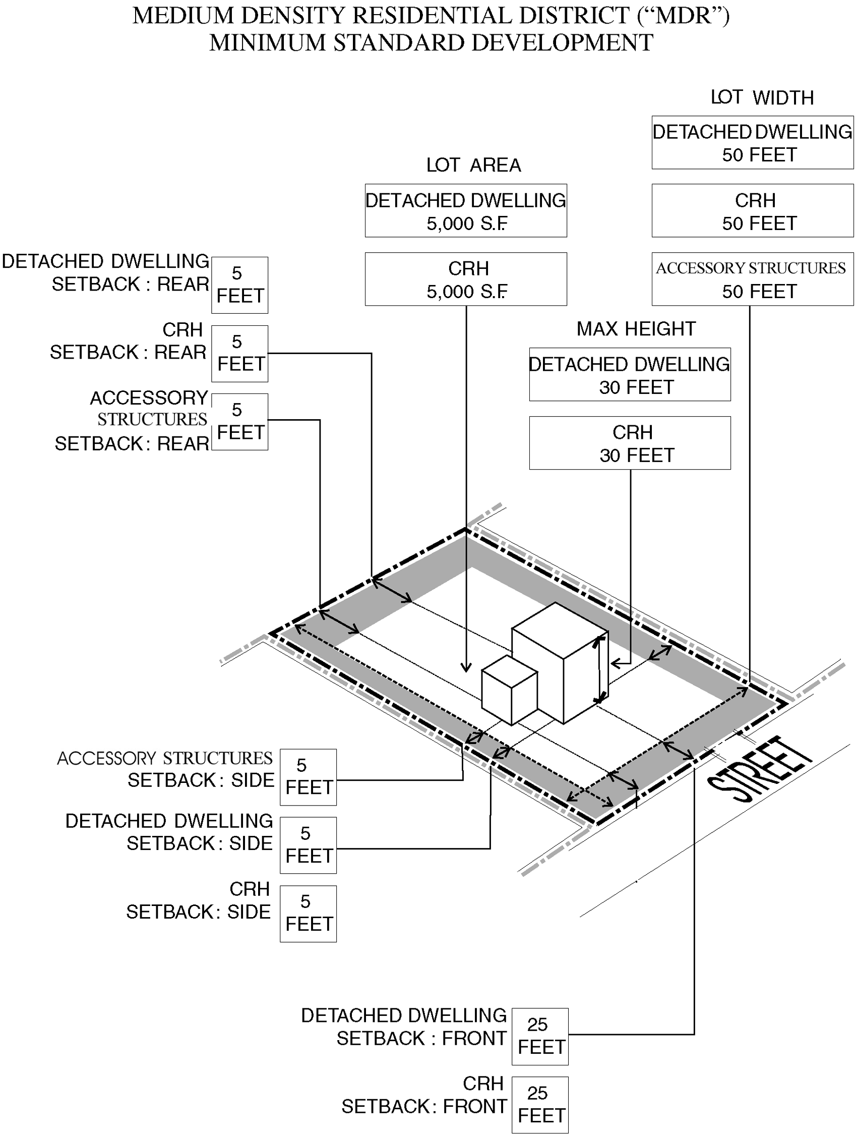
Medium Density Residential
(Ord. No. 6526-00, § 1, 6-15-00; Ord. No. 6928-02, § 6, 5-2-02; Ord. No. 8540-14, § 4, 4-3-14; Ord. No. 8654-15, § 5, 2-5-15)
Section 2-303. - Flexible standard development.
The following Level One uses are permitted in the MDR District subject to the standards and criteria set out in this section and other applicable regulations in Article 3.
(1)
The Building Code may require the rear setback on a waterfront lot to be at least 18 feet from a seawall.
(2)
Utility/Infrastructure uses shall not exceed three acres. Any such use, alone or when added to contiguous like uses which exceed three acres shall require a land use plan map amendment to transportation/utility which shall include such uses and all contiguous like uses.
_____
Flexibility Criteria:
A.
Accessory dwelling unit.
1.
Accessory dwelling units shall not exceed 750 square feet or 50 percent of the gross floor area of the principal detached dwelling, whichever is less.
2.
A parcel of land with conforming density shall be permitted one accessory dwelling unit.
3.
Design standards.
a.
The accessory dwelling unit shall be constructed with a consistent architectural style as the principal detached dwelling.
b.
Detached accessory dwelling units shall be constructed with similar architectural features as the principal detached dwelling, including window style, paint scheme, and roof design.
c.
A shipping container may be utilized as a detached accessory dwelling unit, provided it fully complies with the Florida Building Code and is architecturally treated using windows, doors, cladding, porches, and/or decks to provide a residential appearance, as determined by the Community Development Coordinator.
d.
Entrances to attached accessory dwelling units shall not be visible from the street.
4.
The location of an accessory dwelling unit shall be subject to Section 3-203.A.
5.
The height of a detached accessory dwelling unit shall be subject to Section 3-203.D.
6.
Setbacks.
a.
Attached accessory dwelling units shall meet the principal detached dwelling setbacks.
b.
Detached accessory dwelling units shall meet the setbacks established in Table 2-303.
c.
Flexibility for the side and rear setbacks may be approved if the unit is buffered with landscape material and/or fences to minimize impacts to adjacent properties.
7.
Either the principal detached dwelling or accessory dwelling unit shall be occupied by the property owner.
8.
One legal on-street parking space may be substituted in lieu of the required off-street parking space as determined by the City Engineer.
B.
Attached dwellings.
1.
Height:
a.
The increased height results in an improved site plan, landscaping areas in excess of the minimum required and/or improved design and appearance;
b.
The increased height will not reduce the vertical component of the view from a parcel of land which is designated as low density residential in the Zoning Atlas.
2.
The parcel proposed for development is not contiguous to a parcel which is designated as low density residential in the Zoning Atlas.
3.
Off-street parking is screened from adjacent parcels of land and any adjacent street by a landscaped wall for fence of at least four feet in height.
C.
Community residential homes.
1.
The number of residents does not exceed 14;
2.
The neighborhood in which the parcel proposed for development is a stable neighborhood where the average assessed value of improvements exceeds the assessed value of land.
3.
The parcel proposed for development is not located within 1,000 feet of another parcel of land used for community residential home purposes.
4.
Height:
a.
The increased height results in an improved site plan, landscaping areas in excess of the minimum required and/or improved design and appearance;
b.
The increased height will not reduce the vertical component of the view from a parcel of land which is designated as low density residential in the Zoning Atlas.
D.
Detached dwellings.
1.
The parcel of land proposed for development was an existing lot of less than 5,000 square feet and was not in common ownership with any contiguous property on May 1, 1998;
2.
The parcel of land proposed for development was an existing lot less than 50 feet in width and was not in common ownership with any contiguous property on May 1, 1998;
3.
Front setback:
a.
A determination of the front setback shall consider the extent to which existing structures in the neighborhood have been constructed to a regular or uniform setback from the right-of-way;
b.
The reduction in front setback will not adversely affect adjacent property values;
c.
The reduction in front setback is consistent with neighborhood character; and
d.
The reduction in front setback results in an efficient house layout.
4.
Side setback:
a.
The reduction in side setback is limited to a single side setback;
b.
The reduction in side setback is necessary to permit the development or redevelopment of a vacant lot or lot improved with a substandard structure, the redevelopment of which would not otherwise be economically feasible.
5.
Rear setback:
a.
The reduction in rear setback will allow for the preservation of existing vegetation which could not otherwise be preserved;
b.
The reduction in rear setback will allow the development or redevelopment of a substandard structure which would otherwise not be economically feasible; or
c.
The structures located within the rear setback otherwise required in the MDR District are only used for accessory uses such as a swimming pool; and
d.
The structures located within the rear setback otherwise required in the MDR District are buffered with landscape material and fences to protect the privacy and value of adjacent properties.
6.
Height:
a.
The increased height results in an improved site plan, landscaping areas in excess of the minimum required and/or improved design and appearance;
b.
The increased height will not reduce the vertical component of the view from a parcel of land which is designated as low density residential in the Zoning Atlas.
E.
Residential infill projects:
1.
Single-family detached dwellings are the only permitted use eligible for residential infill project application;
2.
The development or redevelopment of the parcel proposed for development is otherwise impractical without deviations from one or more of the following: intensity; other development standards;
3.
The development of the parcel proposed for development as a residential infill project will not materially reduce the fair market value of abutting properties;
4.
The uses within the residential infill project are otherwise permitted in the district;
5.
The uses within the residential infill project are compatible with adjacent land uses;
6.
The development of the parcel proposed for development as a residential infill project will upgrade the immediate vicinity of the parcel proposed for development;
7.
The design of the proposed residential infill project creates a form and function which enhances the community character of the immediate vicinity of the parcel proposed for development and the City of Clearwater as a whole;
8.
Flexibility in regard to lot width, required setbacks, height, off-street parking access or other development standards are justified by the benefits to community character and the immediate vicinity of the parcel proposed for development and the City of Clearwater as a whole.
F.
Schools.
1.
The parcel proposed for development fronts on a major arterial street;
2.
All off-street parking is located at least 200 feet from any property used for residential purposes or is designated as residential in the Zoning Atlas;
3.
All outdoor lighting is designed and located so that no light fixture is within 200 feet from the nearest existing building used for residential purposes and so that no light falls on residential property.
4.
Height:
a.
The increased height results in an improved site plan, landscaping areas in excess of the minimum required and/or improved design and appearance;
b.
The increased height will not reduce the vertical component of the view from a parcel of land which is designated as low density residential in the Zoning Atlas.
G.
Utility/infrastructure facilities.
1.
No above ground structures are located adjacent to a street right-of-way;
2.
Any above ground structure other than permitted telecommunication towers and utility distribution lines located on or along a rear lot line shall be screened from view by a landscaped opaque wall or fence which is at least two-thirds the height of the above ground structure and shall be landscaped with trees and hedges which will five years after installation substantially obscure the fence or wall and the above ground structure.
(Ord. No. 6526-00, § 1, 6-15-00; Ord. No. 7449-05, § 38, 12-15-05; Ord. No. 9643-23, § 2, 4-4-23; Ord. No. 9758-24, § 4, 6-6-24)
_____
Section 2-304. - Flexible development.
The following Level Two uses are permitted in the MDR District subject to the standards and criteria set out in this Section and other applicable regulations in Article 3.
(1)
The Building Code may require the rear setback to be as least 18 feet from any seawall.
(2)
Non-residential parking lots shall not exceed three acres. Any such use, alone or when added to contiguous like uses which exceed three acres shall require a land use plan map amendment to the appropriate land use category.
_____
Flexibility criteria:
A.
Assisted living facilities.
1.
The building in which the facilities are to be located does not have a flat roof;
2.
Off-street parking is screened from adjacent parcels of land and any adjacent street by a landscaped wall or fence of at least four feet in height;
3.
No sign of any kind is designed or located so that any portion of the sign is more than six feet above the finished grade of the front lot line of the parcel proposed for development unless such signage is a part of an approved comprehensive sign program;
4.
All outdoor lighting is designed and located so that no light fixtures cast light directly on to adjacent land used for residential purposes;
5.
All waste disposal containers which serve the proposed use are located within a landscaped enclosed structure;
6.
The parcel proposed for development is not located in a designated Neighborhood Conservation District, or if the parcel is within the boundaries of a designated Neighborhood Conservation District, the lot area, lot width and setbacks are not less than 90 percent of the average lot area, lot width and setbacks of all improved parcels of land which are located within the Neighborhood Conservation Immediate Vicinity Area and the height does not exceed 120 percent of the average height of buildings and structures located within the Neighborhood Conservation Immediate Vicinity Area.
7.
Height:
a.
The increased height results in an improved site plan, landscaping areas in excess of the minimum required and/or improved design and appearance;
b.
The increased height will not reduce the vertical component of the view from a parcel of land which is designated as low density residential in the Zoning Atlas.
B.
Attached dwellings.
1.
Height:
a.
The increased height results in an improved site plan, landscaping areas in excess of the minimum required and/or improved design and appearance;
b.
The increased height will not reduce the vertical component of the view from a parcel of land which is designated as low density residential in the Zoning Atlas.
2.
The parcel proposed for development is not contiguous to a parcel of land which is designated as low density residential in the Zoning Atlas.
3.
Off-street parking is screened from adjacent parcels of land and any adjacent street by a landscaped wall or fence of at least four feet in height.
C.
Congregate care.
1.
The buildings in which the dwellings are to be located do not have flat roofs;
2.
Off-street parking is screened from adjacent parcels of land and any adjacent street by a landscaped wall or fence of at least four feet in height;
3.
All outdoor lighting is designed and located so that light fixtures do not cast light directly onto adjacent land used for residential purposes;
4.
All waste disposal containers which serve the proposed use are located within a landscaped enclosed structure;
5.
The parcel proposed for development is not located in a designated Neighborhood Conservation District, or if the parcel is within the boundaries of a designated Neighborhood Conservation District, the lot area, lot width and setbacks are not less than 90 percent of the average lot area, lot width and setbacks of all improved parcels of land which are located within the Neighborhood Conservation Immediate Vicinity Area and the height does not exceed 120 percent of the average height of buildings and structures located within the Neighborhood Conservation Immediate Vicinity Area.
6.
Height:
a.
The increased height results in an improved site plan, landscaping areas in excess of the minimum required and/or improved design and appearance;
b.
The increased height will not reduce the vertical component of the view from a parcel of land which is designated as low density residential in the Zoning Atlas.
D.
Non-residential off-street parking.
1.
The parcel proposed for development is contiguous to the parcel on which the non-residential use which will be served by the off-street parking spaces, is located and has a common boundary of at least 25 feet, or the parcel proposed for development is located immediately across a public road from the non-residential use which will be served by the off-street parking spaces, provided that access to the off-street parking does not involve the use of local streets which have residential units on both sides of the street.
2.
No off-street parking spaces are located in the required front setback for detached dwellings in the MDR District or within ten feet, whichever is greater, or within ten feet of a side or rear lot line, except along the common boundary of the parcel proposed for development and the parcel on which the non-residential use which will be served by the off-street parking spaces.
3.
Off-street parking spaces are screened by a wall or fence of at least four feet in height which is landscaped on the external side with a continuous hedge or non-deciduous vine.
4.
All outdoor lighting is automatically switched to turn off at 9:00 p.m.
5.
All parking spaces shall be surface parking.
E.
Overnight accommodations.
1.
The use is accessory to the use of the principal building as a private residence.
2.
The number of units in the proposed overnight accommodations use does not exceed six;
3.
Food service in conjunction with the overnight accommodations shall be limited to guests of the use;
4.
The parcel proposed for development fronts on a major arterial street or is a corner lot;
5.
Off-street parking is screened to a height of four feet by a landscaped wall or fence so that headlamps from automobiles in the off-street parking area can not project into adjacent properties and streets;
6.
All outdoor lighting is designed and located so that no light fixtures cast light directly on to adjacent land used for residential purposes;
7.
All waste disposal containers which serve the proposed overnight accommodations use are located within a landscaped enclosed structure;
8.
The parcel proposed for development is not located in a designated Neighborhood Conservation District, or if the parcel is within the boundaries of a designated Neighborhood Conservation District, the lot area, lot width and setbacks are not less than 90 percent of the average lot area, lot width and setbacks of all improved parcels of land which are located within the Neighborhood Conservation Immediate Vicinity Area and the height does not exceed 120 percent of the average height of buildings and structures located within the Neighborhood Conservation Immediate Vicinity Area.
9.
Height:
a.
The increased height results in an improved site plan, landscaping areas in excess of the minimum required and/or improved design and appearance;
b.
The increased height will not reduce the vertical component of the view from a parcel of land which is designated as low density residential in the Zoning Atlas.
F.
Parks and recreational facilities.
1.
The proposed use is compatible with the surrounding properties.
2.
Off-street parking is screened from adjacent parcels of land and any street by a landscaped wall or fence of at least four feet in height.
3.
All outdoor lighting is designed so that no light fixtures cast light directly on adjacent land used for residential proposes.
4.
The characteristics of the parcel proposed for development are such that the uses of the property will require fewer parking spaces than otherwise required or that the use of significant portions of the property will be used for passive recreational purposes.
G.
Residential infill projects.
1.
The development or redevelopment of the parcel proposed for development is otherwise impractical without deviations from one or more of the following: intensity; other development standards;
2.
The development of the parcel proposed for development as a residential infill project will not materially reduce the fair market value of abutting properties;
3.
The uses within the residential infill project are otherwise permitted in the district;
4.
The uses within the residential infill project are compatible with adjacent land uses;
5.
The development of the parcel proposed for development as a residential infill project will upgrade the immediate vicinity of the parcel proposed for development;
6.
The design of the proposed residential infill project creates a form and function which enhances the community character of the immediate vicinity of the parcel proposed for development and the City of Clearwater as a whole;
7.
Flexibility in regard to lot width, required setbacks, height, off-street parking access or other development standards are justified by the benefits to community character and the immediate vicinity of the parcel proposed for development and the City of Clearwater as a whole.
(Ord. No. 6526-00, § 1, 6-15-00; Ord. No. 6595-00, § 3, 9-7-00; Ord. No. 7413-05, § 5, 5-5-05; Ord. No. 7449-05, § 38, 12-15-05; Ord. No. 7605-06, § 23, 4-20-06; Ord. No. 8715-15, § 5, 6-18-15; Ord. No. 9758-24, § 4, 6-6-24)
Section 2-401. - Intent and purpose.
The intent and purpose of the Medium High Density Residential District ("MHDR") is to protect and preserve the integrity and value of existing, stable residential neighborhoods of medium high density while at the same time, allowing a careful and deliberate redevelopment and revitalization of such neighborhoods in need of revitalization or neighborhoods with unique amenities which create unique opportunities to increase property values and the overall attractiveness of the City.
Section 2-401.1. - Maximum development potential.
The Medium High Density Residential District ("MHDR") may be located in more than one land use category. It is the intent of the MHDR District that development be consistent with the Countywide Future Land Use Plan as required by state law. The uses and development potential of a parcel of land within the MHDR District shall be determined by the standards found in this Development Code as well as the Countywide Future Land Use Designation of the property, including any acreage or floor area restrictions set forth in the Rules Concerning the Administration of the Countywide Future Land Use Plan, as amended from time to time. Development potential for the Countywide Future Land Use Designations that apply to the MHDR District are as follows:
(Ord. No. 6526-00, § 1, 6-15-00; Ord. No. 8043-09, § 6, 9-3-09)
____________
Section 2-402. - Minimum standard development.
The following uses are Level One permitted uses in the MHDR District subject to the minimum standards set out in this Section and other applicable provisions of Article 3.
(1)
The Building Code may require the rear setback on a waterfront lot to be at least 18 feet from any seawall.
(2)
Community residential homes shall not be located within 1,000 feet of one another.
____________
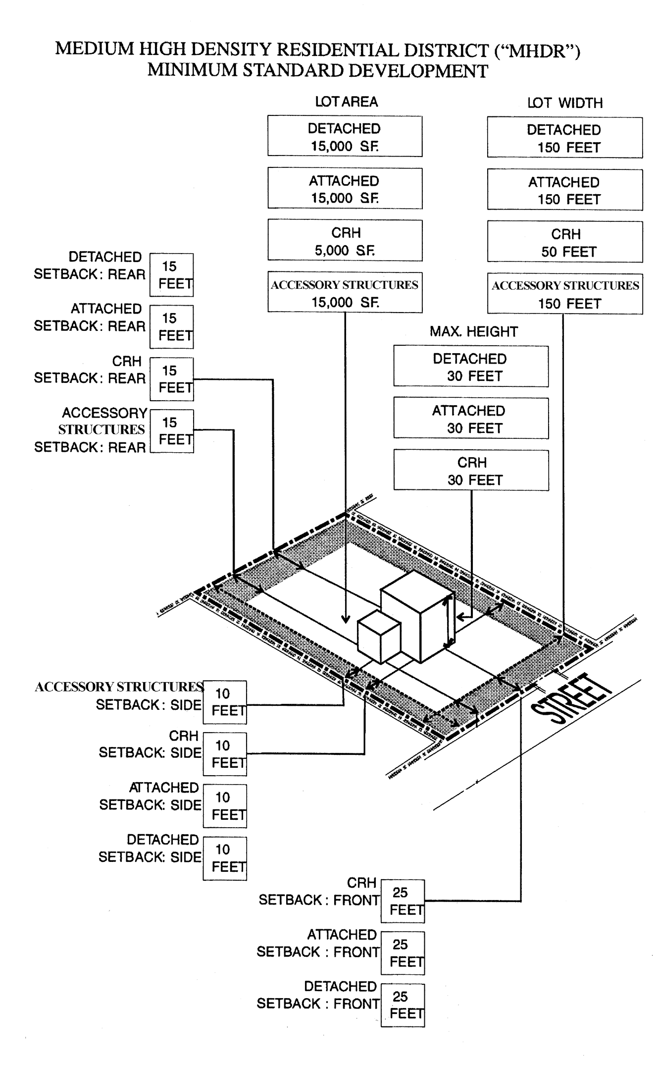
Medium High Density
(Ord. No. 6526-00, § 1, 6-15-00; Ord. No. 6928-02, § 7, 5-2-02; Ord. No. 7449-05, § 38, 12-15-05; Ord. No. 8349-12, § 2, 9-6-12; Ord. No. 8540-14, § 5, 4-3-14; Ord. No. 8654-15, § 6, 2-5-15)
____________
Section 2-403. - Flexible standard development.
The following Level One uses are permitted in the MHDR District subject to the standards and criteria set out in this section and other applicable regulations in Article 3.
(1)
The Building Code may require the rear setback on a waterfront lot to be at least 18 feet from any seawall.
(2)
Utility/Infrastructure uses shall not exceed three acres. Any such use, alone or when added to contiguous like uses which exceed three acres shall require a land use plan map amendment to Transportation/Utility which shall include such uses and all contiguous like uses.
____________
Flexibility Criteria:
A.
Assisted living facilities.
1.
The buildings in which the facilities are to be located do not have a flat roof;
2.
Off-street parking is screened from adjacent parcels of land and any adjacent street by a landscaped wall or fence of at least four feet in height;
3.
No sign of any kind is designed or located so that any portion of the sign is more than six feet above the finished grade of the front lot line of the parcel proposed for development unless such signage is a part of an approved comprehensive sign program;
4.
All outdoor lighting is designed and located so that no light fixtures cast light directly on to adjacent land used for residential purposes;
5.
All waste disposal containers which serve the proposed use are located within a landscaped enclosed structure;
6.
The parcel proposed for development is not located in a designated Neighborhood Conservation District, or if the parcel is within the boundaries of a designated Neighborhood Conservation District, the lot area, lot width and setbacks are not less than 90 percent of the average lot area, lot width and setbacks of all improved parcels of land which are located within the Neighborhood Conservation Immediate Vicinity Area and the height does not exceed 120 percent of the average height of buildings and structures located within the Neighborhood Conservation Immediate Vicinity Area.
7.
Height:
a.
The increased height results in an improved site plan, landscaping areas in excess of the minimum required and/or improved design and appearance;
b.
The increased height will not reduce the vertical component of the view from a parcel of land which is designated as low density residential in the Zoning Atlas.
B.
Attached dwellings.
1.
Rear setback:
a.
The reduction in rear setback does not prevent access to the rear of any building by emergency vehicles;
b.
The reduction in rear setback results in an improved site plan, more efficient parking or improved design and appearance;
2.
Height:
a.
The increased height results in an improved site plan, landscaping areas in excess of the minimum required and/or improved design and appearance;
b.
The increased height will not reduce the vertical component of the view from a parcel of land which is designated as low density residential in the Zoning Atlas.
3.
The parcel proposed for development is not contiguous to a parcel of land which is designated as low density residential in the Zoning Atlas;
4.
Off-street parking is screened from adjacent parcels of land and any adjacent street by a landscaped wall or fence of at least four feet in height;
5.
All waste disposal containers which serve the proposed overnight accommodations use are located within a landscaped enclosed structure.
C.
Community residential homes.
1.
The number of residents does not exceed 14;
2.
The neighborhood in which the parcel proposed for development is a stable neighborhood where the average assessed value of improvements exceeds the assessed value of land.
3.
The parcel proposed for development is not located within 1,000 feet of another parcel of land used for community residential home purposes.
4.
Height:
a.
The increased height results in an improved site plan, landscaping areas in excess of the required minimum and/or improved design and appearance.
b.
The increased height will not reduce the vertical component of view from a parcel of land which is designated as low density residential in the Zoning Atlas.
5.
Front setback:
a.
A determination of front setback shall consider the extent to which existing structures in the neighborhood have been constructed to a regular or uniform setback from the right-of-way;
b.
The reduction in front setback will not adversely affect adjacent property values.
6.
Side and rear setbacks:
a.
The reduction in side and rear setback does not prevent access to the rear of any building by emergency vehicles;
b.
The reduction in side and rear setback results in an improved site plan, more efficient parking or improved design and appearance;
D.
Detached dwellings.
1.
Lot area and width:
a.
Lot size of less than 15,000 square feet is an existing lot;
b.
A lot size of less than 15,000 square feet is necessary to the development or redevelopment of a vacant lot which would otherwise not be feasible;
c.
The volume to lot size ratio of the structures to be developed on the lot is no more than ten percent greater than the average volume to lot size ratio of all existing structures within 500 feet of the lot;
2.
Side and rear setback: The reduction in side and rear setback is necessary to the development or redevelopment of a vacant lot which would otherwise not be economically feasible.
3.
Height:
a.
The increased height results in an improved site plan, landscaping areas in excess of the minimum required and/or improved design and appearance;
b.
The increased height will not reduce the vertical component of the view from a parcel of land which is designated as low density residential in the Zoning Atlas.
E.
Nursing homes.
1.
Off-street parking is screened from adjacent parcels of land and any adjacent street by a landscaped wall or fence of at least four feet in height;
2.
All waste disposal containers which serve the proposed use are located within a landscaped enclosed structure.
3.
The buildings in which the dwellings are to be located do not have flat roofs.
4.
Height:
a.
The increased height results in an improved site plan, landscaping areas in excess of the required minimum and/or improved design and appearance.
b.
The increased height will not reduce the vertical component of view from a parcel of land which is designated as low density residential in the Zoning Atlas.
F.
Overnight accommodations.
1.
The use is accessory to the use of the principal building as a private residence.
2.
The number of units in the proposed overnight accommodations use does not exceed ten;
3.
Food service in conjunction with the overnight accommodations shall be limited to guests of the use;
4.
The parcel proposed for development fronts on a major arterial street or is a corner lot;
5.
Off-street parking is screened to a height of four feet by a landscaped wall or fence so that headlamps from automobiles in the off-street parking area can not project into adjacent properties and streets;
6.
All outdoor lighting is designed and located so that light fixtures do not cast light directly on to adjacent land used for residential purposes;
7.
All waste disposal containers which serve the proposed overnight accommodations use are located within a landscaped enclosed structure.
8.
Height:
a.
The increased height results in an improved site plan, landscaping areas in excess of the required minimum and/or improved design and appearance.
b.
The increased height will not reduce the vertical component of view from a parcel of land which is designated as low density residential in the Zoning Atlas.
G.
Schools.
1.
The parcel proposed for development fronts on a major arterial street;
2.
All off-street parking is located at least 200 feet from the nearest property used for residential purposes or is designated as residential in the Zoning Atlas;
3.
All outdoor lighting is designed and located so that no light fixture is within 200 feet from the nearest existing building used for residential purposes and so that no light falls on residential property.
4.
Height:
a.
The increased height results in an improved site plan, landscaping areas in excess of the required minimum and/or improved design and appearance.
b.
The increased height will not reduce the vertical component of view from a parcel of land which is designated as low density residential in the Zoning Atlas.
H.
Utility/infrastructure facilities.
1.
No above ground structures are located adjacent to a street right-of-way;
2.
Any above ground structure other than permitted telecommunication towers and utility distribution lines located on or along a rear lot line shall be screened from view by a landscaped opaque wall or fence which is at least two-thirds the height of the above ground structure and shall be landscaped with trees and hedges which five years after installation will substantially obscure the fence or wall and the above ground structure.
(Ord. No. 6526-00, § 1, 6-15-00; Ord. No. 7449-05, § 38, 12-15-05; Ord. No. 8349-12, § 3, 9-6-12; Ord. No. 9758-24, § 5, 6-6-24)
_____
Section 2-404. - Flexible development.
The following Level Two uses are permitted subject to the standards and criteria set out in this section and other applicable regulations in Article 3.
(1)
The Building Code may require the rear setback on a waterfront lot to be at least 18 feet from a seawall.
(2)
Non-residential parking lots shall not exceed three acres. Any such use, alone or when added to contiguous like uses which exceed three acres shall require a land use plan map amendment to the appropriate land use category.
_____
Flexibility criteria:
A.
Attached dwellings.
1.
Side and rear setback:
a.
The reduction in side and rear setback does not prevent access to the rear of any building by emergency vehicles;
b.
The reduction in side and rear setback results in an improved site plan, more efficient parking or improved design and appearance;
2.
Height:
a.
The increased height results in an improved site plan, landscaping areas in excess of the minimum required and/or improved design and appearance;
b.
The increased height will not reduce the vertical component of the view from a parcel of land which is designated as low density residential in the Zoning Atlas.
3.
The parcel proposed for development is not contiguous to a parcel of land which is designated as low density residential in the Zoning Atlas;
4.
Off-street parking is screened from adjacent parcels of land and any adjacent street by a landscaped wall or fence of at least four (4) feet in height;
5.
All waste disposal containers which serve the proposed overnight accommodations use are located within a landscaped enclosed structure.
6.
Front setback:
a.
The existing structures along the same side of the road have been constructed with irregular setbacks and the proposed reduction in front setback will not be out of character with the neighborhood.
b.
The extent to which existing structures in the neighborhood have been constructed to a regular or uniform set back from the right of way.
c.
The reduction in front setback will not adversely affect adjacent property values.
B.
Congregate care.
1.
The building in which the use is to be located does not have a flat roof;
2.
Off-street parking is screened from adjacent parcels of land and any adjacent street by a landscaped wall or fence of at least four feet in height;
3.
All outdoor lighting is designed and located so that light fixtures do not cast light directly on to adjacent land used for residential purposes;
4.
All waste disposal containers which serve the proposed use are located within a landscaped enclosed structure.
C.
Non-residential off-street parking.
1.
The parcel proposed for development is contiguous to the parcel on which the non-residential use which will be served by the off-street parking spaces, is located and has a common boundary of at least 25 feet, or the parcel proposed for development is located immediately across a public road from the non-residential use which will be served by the off-street parking spaces, provided that access to the off-street parking does not involve the use of local streets which have residential units on both sides of the street.
2.
No off-street parking spaces are located in the required front setback for detached dwellings in the MHDR District or within ten feet, whichever is greater, or within ten feet of a side or rear lot line, except along the common boundary of the parcel proposed for development and the parcel on which the non-residential use which will be served by the off-street parking spaces.
3.
Off-street parking spaces are screened by a wall or fence of at least four feet in height which is landscaped on the external side with a continuous hedge or non-deciduous vine.
4.
All outdoor lighting is automatically switched to turn off at 9:00 p.m.
5.
All parking spaces shall be surface parking.
D.
Overnight accommodations.
1.
The use is accessory to the use of the principal building as a private residence.
2.
The number of units in the proposed overnight accommodations use does not exceed ten;
3.
Food service facilities shall be limited to 25 percent of the gross floor area of the building in which the overnight accommodations are located;
4.
The parcel proposed for development fronts on a major arterial street or is a corner lot;
5.
Off-street parking is screened to a height of four feet by a landscaped wall or fence so that headlamps from automobiles in the off-street parking area can not project into adjacent properties and streets;
6.
All outdoor lighting is designed and located so that no light fixtures cast light directly on to adjacent land used for residential purposes;
7.
All waste disposal containers which serve the proposed overnight accommodations use are located within a landscaped enclosed structure.
8.
Front setback:
a.
The existing structures along the same side of the road have been constructed with irregular setbacks and the proposed reduction in front setback will not be out of character with the neighborhood.
b.
The extent to which existing structures in the neighborhood have been constructed to a regular or uniform set back from the right-of-way.
c.
The reduction in front setback will not adversely affect adjacent property values.
9.
Side and rear setback:
a.
The reduction in side and rear setback does not prevent access to the rear of any building by emergency vehicles;
b.
The reduction in side and rear setback results in an improved site plan, more efficient parking or improved design and appearance;
10.
Height:
a.
The increased height results in an improved site plan, landscaping areas in excess of the minimum required and/or improved design and appearance;
b.
The increased height will not reduce the vertical component of the view from a parcel of land which is designated as low density residential in the Zoning Atlas.
E.
Parks and recreation facilities.
1.
The proposed use is compatible with the surrounding properties.
2.
Off-street parking is screened from adjacent parcels of land and any street by a landscaped wall or fence of at least four feet in height.
3.
All outdoor lighting is designed so that no light fixtures cast light directly on adjacent land used for residential purposes.
4.
The characteristics of the parcel proposed for development are such that the uses of the property will require fewer parking spaces than otherwise required or that the use of significant portions of the property will be used for passive recreational purposes.
F.
Residential infill projects.
1.
The development or redevelopment of the parcel proposed for development is otherwise impractical without deviations from one or more of the following: intensity; other development standards;
2.
The development of the parcel proposed for development as a residential infill project will not materially reduce the fair market value of abutting properties;
3.
The uses within the residential infill project are otherwise permitted in the district;
4.
The uses within the residential infill project are compatible with adjacent lands uses;
5.
The development of the parcel proposed for development as a residential infill project will upgrade the immediate vicinity of the parcel proposed for development;
6.
The design of the proposed residential infill project creates a form and function which enhances the community character of the immediate vicinity of the parcel proposed for development and the City of Clearwater as a whole;
7.
Flexibility in regard to lot width, required setbacks, height and off-street parking are justified by the benefits to community character and the immediate vicinity of the parcel proposed for development and the City of Clearwater as a whole.
G.
Reserved.
(Ord. No. 6526-00, § 1, 6-15-00; Ord. No. 6595-00, § 4, 9-7-00; Ord. No. 7413-05, § 6, 5-5-05; Ord. No. 7449-05, § 38, 12-15-05; Ord. No. 7605-06, § 24, 4-20-06; Ord. No. 8349-12, §§ 4, 5, 9-6-12; Ord. No. 9758-24, § 5, 6-6-24)
Section 2-501. - Intent and purpose.
The intent and purpose of the High Density Residential District ("HDR") is to protect and preserve the integrity and value of existing, stable residential neighborhoods of higher density while at the same time, allowing a careful and deliberate redevelopment and revitalization of existing neighborhoods in need of revitalization or neighborhoods with unique amenities which create unique opportunities to increase property values and the overall attractiveness of the city.
_____
Section 2-501.1. - Maximum development potential.
The High Density Residential District ("HDR") may be located in more than one land use category. It is the intent of the HDR District that development be consistent with the Countywide Future Land Use Plan as required by state law. The uses and development potential of a parcel of land within the HDR District shall be determined by the standards found in this Development Code as well as the Countywide Future Land Use Designation of the property, including any acreage or floor area restrictions set forth in the Rules Concerning the Administration of the Countywide Future Land Use Plan, as amended from time to time. Development potential for the Countywide Future Land Use Designations that apply to the HDR District as follows:
(Ord. No. 7949-08, § 1, 5-1-08; Ord. No. 8043-09, § 7, 9-3-09)
Section 2-502. - Minimum standard development.
The following uses are Level One permitted uses in the HDR District subject to the minimum standards set out in this Section and other applicable provisions of Article 3.
(1)
The Building Code may require the rear setback on a waterfront lot to be at least 18 from a seawall.
(2)
Community residential homes shall not be located within 1,000 feet of one another.
_____
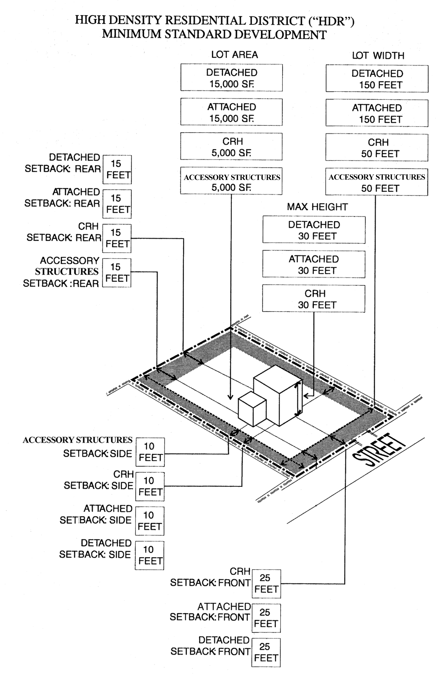
High Density
(Ord. No. 6526-00, § 1, 6-15-00; Ord. No. 6928-02, § 8, 5-2-02; Ord. No. 7449-05, § 38, 12-15-05; Ord. No. 8540-14, § 6, 4-3-14; Ord. No. 8654-15, § 7, 2-5-15)
Section 2-503. - Flexible standard development.
The following Level One uses are permitted in the HDR District subject to the standards and criteria set out in this section and other applicable regulations in Article 3.
(1)
The Building Code may require the rear setback on a waterfront lot to be at least 18 feet from a seawall.
(2)
Utility/Infrastructure uses shall not exceed three acres. Any such use, alone or when added to contiguous like uses which exceed three acres shall require a land use plan map amendment to Transportation/Utility which shall include such uses and all contiguous like uses.
_____
Flexibility Criteria:
A.
Assisted living facilities.
1.
The buildings in which the facilities are to be located do not have a flat roof;
2.
Off-street parking is screened from adjacent parcels of land and any adjacent street by a landscaped wall or fence of at least four feet in height;
3.
No sign of any kind is designed or located so that any portion of the sign is more than six feet above the finished grade of the front lot line of the parcel proposed for development unless such signage is a part of an approved comprehensive sign program;
4.
All outdoor lighting is designed and located so that no light fixtures cast light directly on to adjacent land used for residential purposes;
5.
All waste disposal containers which serve the proposed use are located within a landscaped enclosed structure;
6.
The parcel proposed for development is not located in a designated Neighborhood Conservation District, or if the parcel is within the boundaries of a designated Neighborhood Conservation District, the lot area, lot width and setbacks are not less than 90 percent of the average lot area, lot width and setbacks of all improved parcels of land which are located within the Neighborhood Conservation Immediate Vicinity Area and the height does not exceed 120 percent of the average height of buildings and structures located within the Neighborhood Conservation Immediate Vicinity Area.
B.
Attached dwellings.
1.
Rear setback:
a.
The reduction in rear setback does not prevent access to the rear of any building by emergency vehicles;
b.
The reduction in rear setback results in an improved site plan, more efficient parking or improved design and appearance;
2.
Height:
a.
The increased height results in an improved site plan, landscaping areas in excess of the minimum required and/or improved design and appearance;
b.
The increased height will not reduce the vertical component of the view from a parcel of land which is designated as low density residential in the Zoning Atlas.
3.
The parcel proposed for development is not contiguous to a parcel of land which is designated as low density residential in the Zoning Atlas;
4.
Off-street parking is screened from adjacent parcels of land and any adjacent street by a landscaped wall or fence of at least four feet in height;
5.
All waste disposal containers which serve the proposed use are located within a landscaped enclosed structure;
C.
Community residential homes.
1.
The number of residents does not exceed 14;
2.
The neighborhood in which the parcel proposed for development is a stable neighborhood where the average assessed value of improvements exceeds the assessed value of land.
3.
The parcel proposed for development is not located within 1,000 feet of another parcel of land used for community residential home purposes.
4.
Front setback:
a.
The existing structures along the same side of the road have been constructed with irregular setbacks and the proposed reduction in front setback will not be out of character with the neighborhood.
b.
The extent to which existing structures in the neighborhood have been constructed to a regular or uniform set back from the right-of-way.
c.
The reduction in front setback will not adversely affect adjacent property values.
5.
Side and rear setback:
a.
The reduction in side and rear setback does not prevent access to the rear of any building by emergency vehicles;
b.
The reduction in side and rear setback results in an improved site plan, more efficient parking or improved design and appearance.
D.
Detached dwellings.
1.
Lot area and width:
a.
A lot of less than 15,000 square feet is an existing lot;
b.
A lot size of less than 15,000 square feet is necessary to the development or redevelopment of a vacant lot which would otherwise not be economically feasible;
c.
The volume to lot size ratio of the structures to be developed on the lot is no more than ten percent greater than the average volume to lot size ratio of all existing structures within 500 feet of the lot;
2.
Side and rear setback: The reduction in side and rear setback is necessary to the development or redevelopment of a vacant lot which would otherwise not be economically feasible.
E.
Nursing homes.
1.
Off-street parking is screened from adjacent parcels of land and any adjacent street by a landscaped wall or fence of at least four feet in height;
2.
All waste disposal containers which serve the proposed use are located within a landscaped enclosed structure.
F.
Overnight accommodations.
1.
The use is accessory to the use of the principal building as a private residence.
2.
The number of units in the proposed overnight accommodations use does not exceed ten;
3.
Food service in conjunction with the overnight accommodations shall be limited to guests of the use;
4.
The parcel proposed for development fronts on a major arterial street or is a corner lot;
5.
Off-street parking is screened to a height of four feet by a landscaped wall or fence so that headlamps from automobiles in the off-street parking area can not project into adjacent properties and streets;
6.
All outdoor lighting is designed and located so that light fixtures do not cast light directly on to adjacent land used for residential purposes;
7.
All waste disposal containers which serve the proposed overnight accommodations use are located within a landscaped enclosed structure.
G.
Schools.
1.
The parcel proposed for development fronts on a major arterial street;
2.
All off-street parking is located at least 200 feet from any property used for residential purposes or designated as residential in the Zoning Atlas;
3.
All outdoor lighting is designed and located so that no light fixture is within 200 feet from the nearest existing building used for residential purposes and so that no light falls on residential property.
H.
Utility/infrastructure facilities.
1.
No above ground structures are located adjacent to a street right-of-way;
2.
Any above ground structure other than permitted telecommunication towers and utility distribution lines located on or along a rear lot line shall be screened from view by a landscaped opaque wall or fence which is at least two-thirds the height of the above ground structure and shall be landscaped with trees and hedges which five years after installation will substantially obscure the fence or wall and the above ground structure.
(Ord. No. 6526-00, § 1, 6-15-00; Ord. No. 7449-05, § 38, 12-15-05; Ord. No. 9758-24, § 6, 6-6-24)
Section 2-504. - Flexible development.
The following Level Two uses are permitted in the HDR District subject to the standards and criteria set out in this section and other applicable regulations in Article 3.
(1)
The Building Code may require the rear setback on a waterfront lot to be at least 18 feet from a seawall.
(2)
Parking garages shall not exceed three acres. Any such use, alone or when added to contiguous like uses which exceed three acres shall require a land use plan amendment to the appropriate land use.
_____
Flexibility criteria:
A.
Attached dwellings.
1.
Side and rear setback:
a.
The reduction in side and rear setback does not prevent access to the rear of any building by emergency vehicles;
b.
The reduction in side and rear setback results in an improved site plan, more efficient parking or improved design and appearance;
2.
Height:
a.
The increased height results in an improved site plan, landscaping areas in excess of the minimum required and/or improved design and appearance;
b.
The increased height will not reduce the vertical component of the view from a parcel of land which is designated as low density residential in the Zoning Atlas.
c.
The height may exceed 80 feet if the parcel proposed for development fronts on Clearwater Bay, Old Tampa Bay, or is only separated from Clearwater Bay or Old Tampa Bay by a public open space.
3.
The parcel proposed for development is not contiguous to a parcel of land which is designated as low density residential in the Zoning Atlas;
4.
Off-street parking is screened from adjacent parcels of land and any adjacent street by a landscaped wall or fence of at least four feet in height;
5.
All waste disposal containers which serve the proposed use are located within a landscaped enclosed structure.
6.
Front setback:
a.
The existing structures along the same side of the road have been constructed with irregular setbacks and the proposed reduction in front setback will not be out of character with the neighborhood.
b.
The extent to which existing structures in the neighborhood have been constructed to a regular or uniform set back from the right-of-way.
c.
The reduction in front setback will not adversely affect adjacent property values.
B.
Congregate care.
1.
The buildings in which the use is to be located do not have a flat roof;
2.
Off-street parking is screened from adjacent parcels of land and any adjacent street by a landscaped wall or fence of at least four feet in height;
3.
All outdoor lighting is designed and located so that light fixtures do not cast light directly on to adjacent land used for residential purposes;
4.
All waste disposal containers which serve the proposed use are located within a landscaped enclosed structure.
C.
Overnight accommodations.
1.
The use is accessory to the use of the principal building as a private residence.
2.
The number of units in the proposed overnight accommodations use does not exceed ten;
3.
Food service facilities shall be limited to 25 percent of the gross floor area of the building in which the overnight accommodations are located;
4.
The parcel proposed for development fronts on a major arterial street or is a corner lot;
5.
Off-street parking is screened to a height of four feet by a landscaped wall or fence so that headlamps from automobiles in the off-street parking area can not project into adjacent properties and streets;
6.
All outdoor lighting is designed and located so that no light fixtures cast light directly on to adjacent land used for residential purposes;
7.
All waste disposal containers which serve the proposed overnight accommodations use are located within a landscaped enclosed structure.
8.
Front setback:
a.
The existing structures along the same side of the road have been constructed with irregular setbacks and the proposed reduction in front setback will not be out of character with the neighborhood.
b.
The extent to which existing structures in the neighborhood have been constructed to a regular or uniform set back from the right-of-way.
c.
The reduction in front setback will not affect adjacent property values.
9.
Side and rear setback:
a.
The reduction in side and rear setback does not prevent access to the rear of any building by emergency vehicles;
b.
The reduction in side and rear setbacks results in an improved site plan, more efficient parking or improved design and appearance.
D.
Parking garages and lots.
1.
Access to and from the parking garage or lot shall be based on the findings of a transportation analysis approved by the city;
2.
The stacking spaces available for cars waiting to pass through a parking ticket dispenser or booth to enter the garage or lot shall be based on the design and size of the garage or lot;
3.
Any frontage along a public street is landscaped or designed to be similar in character and use to other uses fronting on each street for a distance of 250 feet in either direction along the street or the nearest intersections, whichever is less;
4.
Parking structures are designed, constructed and finished so that the structure of the garage is architecturally compatible the design and character of adjacent principal uses;
5.
There is an unmet existing demand for additional parking in the immediate vicinity of the parcel proposed for development;
6.
Construction of a parking structure would not otherwise be physically or economically feasible;
7.
The front and rear setbacks which are provided are improved as an arcade or with other active pedestrian/commercial areas for sidewalk cafes, sidewalk vendors, street furniture or urban amenities;
8.
Side setback:
a.
The reduction in side setback will allow for the preservation of existing vegetation which could not otherwise be preserved; or
b.
The reduction in side setback results in an improved site plan or improved design and appearance.
9.
Height:
a.
The increased height results in an improved site plan, landscaping areas in excess of the required minimum and/or improved design and appearance.
b.
The increased height will not reduce the vertical component of view from a parcel of land which is designated as low density residential in the Zoning Atlas.
E.
Parks and recreational facilities.
1.
The proposed use is compatible with the surrounding properties.
2.
Off-street parking is screened from adjacent parcels of land and any street by a landscaped wall or fence of at least four feet in height.
3.
All outdoor lighting is designed so that no light fixtures cast light directly on adjacent land used for residential purposes.
4.
The characteristics of the parcel proposed for development are such that the uses of the property will require fewer parking spaces than otherwise required or that the use of significant portions of the property will be used for passive recreational purposes.
F.
Residential infill projects.
1.
The development or redevelopment of the parcel proposed for development is otherwise impractical without deviations from one or more of the following: intensity; other development standards;
2.
The development of the parcel proposed for development as a residential infill project will not materially reduce the fair market value of abutting properties;
3.
The uses within the residential infill project are otherwise permitted in the district;
4.
The uses within the residential infill project are compatible with adjacent lands uses;
5.
The development of the parcel proposed for development as a residential infill project will upgrade the immediate vicinity of the parcel proposed for development;
6.
The design of the proposed residential infill project creates a form and function which enhances the community character of the immediate vicinity of the parcel proposed for development and the City of Clearwater as a whole;
7.
Flexibility in regard to lot width, required setbacks, height and off-street parking are justified by the benefits to community character and the immediate vicinity of the parcel proposed for development and the City of Clearwater as a whole. Building height, may only exceed 80 feet, however, if the parcel proposed for development fronts on Clearwater Bay, Old Tampa Bay, or is only separated from Clearwater Bay or Old Tampa Bay by a public open space.
(Ord. No. 6526-00, § 1, 6-15-00; Ord. No. 6595-00, § 5, 9-7-00; Ord. No. 7413-05, § 7, 5-5-05; Ord. No. 7449-05, §§ 7, 8, 38, 12-15-05; Ord. No. 7630-06, § 1, 5-4-06; Ord. No. 9758-24, § 6, 6-6-24)
Section 2-601. - Intent and purpose.
The intent and purpose of the Mobile Home Park District is to recognize the existence of mobile home communities within the City of Clearwater and to provide for their continued existence and enhancement.
Section 2-601.1. - Maximum development potential.
The Mobile Home Park District ("MHP") may be located in more than one land use category. It is the intent of the MHP District that development be consistent with the Countywide Future Land Use Plan as required by State law. The uses and development potential of a parcel of land within the MHP District shall be determined by the standards found in this Development Code as well as the Countywide Future Land Use Designation of the property, including any acreage or floor area restrictions set forth in the Rules Concerning the Administration of the Countywide Future Land Use Plan, as amended from time to time. Development potential for the Countywide Future Land Use Designations that apply to the MHP District are as follows:
(Ord. No. 8043-09, § 8, 9-3-09)
_____
Section 2-602. - Minimum standard development.
The following uses are Level One permitted uses in the MHP District subject to the minimum standards set out in this section and other applicable provisions of Article 3.
(1)
Any mobile home replacement shall maintain a separation of ten feet between mobile homes or provide a setback of six feet, whichever is less.
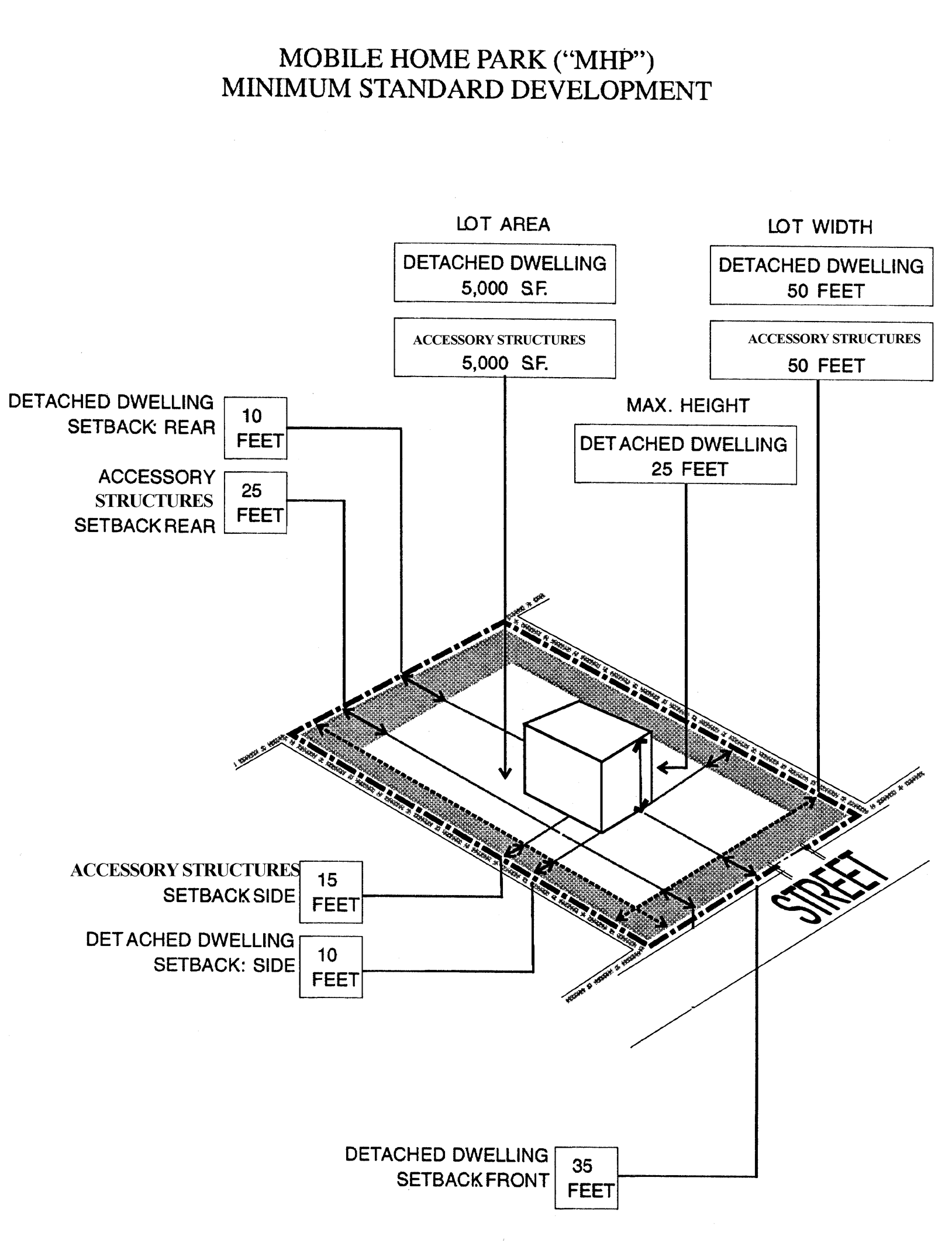
MHP Illustration
(Ord. No. 6526-00, § 1, 6-15-00; Ord. No. 6928-02, § 9, 5-2-02)
Section 2-603. - Flexible standard development.
The following uses are Level One permitted uses in the MHP District subject to the standards and criteria set out in this section and other applicable provisions of Article 3.
(1)
Utility/infrastructure uses shall not exceed three acres. Any such use, alone or when added to contiguous like uses which exceed three acres shall require a land use plan map amendment to Transportation/Utility which shall include such uses and all contiguous like uses.
_____
Flexibility Criteria:
A.
Mobile home parks.
1.
At least ten percent of the gross land area of the mobile home park is devoted to active recreational amenities;
2.
Two way internal driveways have a minimum width of 24 feet with a minimum of four foot shoulders on each side;
3.
One way internal driveways have a minimum width of 12 feet with a minimum of four foot shoulders on each side;
4.
In addition to any other landscaping requirements, at least one canopy tree per 5,000 square feet of land area is located on the parcel proposed for development.
B.
Offices.
1.
The office use is located within a mobile home park;
2.
The office use is devoted to administration and/or management of the mobile home park;
3.
The gross floor area of the office use does not exceed 2,000 square feet.
C.
Public transportation facilities.
1.
The public transportation facilities are not located within 1,000 feet of another public transportation facility unless necessary to serve established transit stops with demonstrated ridership demand;
2.
The public transportation facilities are designed, located and landscaped so that the structures are screened from view from any residential use or land designated as residential in the Zoning Atlas;
3.
All lighting associated with the public transportation facilities is designed and located so that no light is cast directly on any residential use or land designated as residential in the Zoning Atlas.
D.
Retail sales and service.
1.
The retail sales and service use is located within a mobile home park;
2.
The sale of goods and services is limited to the residents of the mobile home park;
3.
The gross floor area of the retail and service use does not exceed 2,000 square feet.
E.
Utility/infrastructure facilities.
1.
No above ground structures are located adjacent to a street right-of-way, and
2.
Any above ground structure, other than permitted telecommunication towers and utility distribution lines located on or along a rear lot line, shall be screened from view by a landscaped opaque wall or fence which is at least two-thirds the height of the above ground structure, landscaped with trees which five years after installation will substantially obscure the fence or wall and the above ground structure.
(Ord. No. 6526-00, § 1, 6-15-00)
_____
Section 2-701. - Intent and purpose.
The intent and purpose of the Commercial District is to provide the citizens of the City of Clearwater with convenient access to goods and services throughout the city without adversely impacting the integrity of residential neighborhoods, diminishing the scenic quality of the city or negatively impacting the safe and efficient movement of people and things within the City of Clearwater.
Section 2-701.1. - Maximum development potential.
The Commercial District ("C") may be located in more than one land use category. It is the intent of the C District that development be consistent with the Countywide Future Land Use Plan as required by State law. The uses and development potential of a parcel of land within the C District shall be determined by the standards found in this Development Code as well as the Countywide Future Land Use Designation of the property, including any acreage or floor area restrictions set forth in the Rules Concerning the Administration of the Countywide Future Land Use Plan, as amended from time to time. Development potential for the Countywide Future Land Use Designations that apply to the C District are as follows:
(Ord. No. 7949-08, § 2, 5-1-08; Ord. No. 7926-08, § 1, 7-17-08; Ord. No. 8043-09, § 9, 9-3-09)
Section 2-702. - Minimum standard development.
The following uses are Level One permitted uses in the "C" District subject to the minimum standards set out in this section and other applicable provisions of Article 3.
(1)
Governmental uses and medical clinics shall not exceed five acres. Any such use, alone or when added to contiguous like uses which exceed five acres shall require a land use plan map amendment to Institutional which shall include such uses and all contiguous like uses.
(2)
Restaurants within the retail plaza may occupy up to 25 percent of the total gross floor area of the retail plaza. Any restaurant, or fraction thereof, that exceeds 25 percent must provide off-street parking at a rate consistent with the parking requirement for the restaurant use in the district.
(3)
Medical marijuana treatment center dispensing facilities shall comply with the requirements set forth in F.S. § 381.986, as amended.
(4)
Limited on-site retail sales may be permitted as an accessory use consistent with the criteria specified in Section 3-2602.B.
(Ord. No. 6526-00, § 1, 6-15-00; Ord. No. 6928-02, § 10, 5-2-02; Ord. No. 8349-12, § 6, 9-6-12; Ord. No. 8423-13, § 1, 8-14-13; Ord. No. 8654-15, § 8, 2-5-15; Ord. No. 8810-16, § 2, 1-21-16; Ord. No. 8988-17, § 2, 2-2-17; Ord. No. 9042-17, § 1, 12-7-17; Ord. No. 9643-23, § 3, 4-4-23; Ord. No. 9758-24, § 7, 6-6-24)
Section 2-703. - Flexible standard development.
The following uses are Level One permitted uses in the "C" District subject to the standards and criteria set out in this Section and other applicable provisions of Article 3.
(1)
Educational facilities, Governmental uses, Medical clinics and Social and community centers uses shall not exceed five acres. Any such use, alone or when added to contiguous like uses which exceed five acres shall require a land use plan map amendment to Institutional which shall include such uses and all contiguous like uses.
(2)
Places of worship shall not exceed five acres. Any such use, alone or when added to contiguous like uses which exceed five acres shall require a land use plan map amendment to Institutional which shall include such uses and all contiguous like uses.
(3)
Public transportation facilities shall not exceed three acres. Any such use, alone or when added to contiguous like uses which exceed three acres shall require a land use plan map amendment to Transportation/Utility which shall include such uses and all contiguous like uses.
(4)
Utility/infrastructure uses shall not exceed three acres. Any such use, alone or when added to contiguous like uses which exceed three acres shall require a land use plan map amendment to Transportation/Utility which shall include such uses and all contiguous like uses.
(5)
In the Commercial Neighborhood (CN), Commercial Limited (CL) and Commercial General (CG) land use categories, Schools shall not exceed five acres. Any such use, alone or when added to contiguous like uses which exceed five acres shall require a land use plan map amendment to Institutional which shall include such uses and all contiguous like uses.
_____
Flexibility criteria:
A.
Accessory dwelling unit. One accessory dwelling unit, which is subordinate and accessory to a principal permitted use is allowed provided that:
1.
Title to the unit is vested in the ownership of the principal use.
2.
The floor area of the unit does not exceed 25 percent of the floor area of the principal use.
3.
The unit complies with the development standards established for the principal use.
4.
The unit shall be constructed with a similar architectural style as the principal use.
B.
Alcoholic beverage sales.
1.
The parcel proposed for development is not contiguous to a parcel of land which is designated as residential in the Zoning Atlas;
2.
The parcel proposed for development is not located within 500 feet of a parcel of land used for a place of worship or a public or private school, unless the floor area of the use which is devoted to the display and storage of alcoholic beverages is less than ten percent of the total floor area of the use and there is no signage located on the parcel proposed for development which identifies the use as a location where alcoholic beverages are sold;
3.
The parcel proposed for development is not located within 500 feet of a parcel of land used for a place of worship or a public or private school unless the intervening land uses, structures or context are such that the location of the alcoholic beverage sales is unlikely to have an adverse impact on such school or use as a place of worship.
C.
Automobile service stations.
1.
The parcel proposed for development is not contiguous to a parcel of land which is designated as residential in the Zoning Atlas;
2.
The use does not involve the overnight, outdoor storage of automobiles;
3.
No more than two service bays front on a public street.
D.
Bars.
1.
The parcel proposed for development is not contiguous to a parcel of land which is designated as residential in the Zoning Atlas;
2.
The parcel proposed for development is not located within 500 feet of a parcel of land used for purposes of a place of worship or a public or private school unless the intervening land uses, structures or context are such that the location of the stand alone bar is unlikely to have an adverse impact on such school or use as a place of worship.
E.
Brewpubs.
1.
No more than 50 percent of the total gross floor area of the establishment shall be used for the brewery function including, but not limited to, the brewhouse, boiling and water treatment areas, bottling and kegging lines, malt milling and storage, fermentation tanks, conditioning tanks and serving tanks;
2.
Any overhead loading doors shall be located perpendicular to the abutting streets and screened from adjacent properties by landscaped walls or fences.
3.
Lot area and width: The reduction in lot area and/or width will not result in a building which is out of scale with existing buildings in the immediate vicinity of the parcel proposed for development.
4.
Height: The increased height results in an improved site plan, landscaping areas in excess of the minimum required and/or improved design and appearance;
5.
Front setback: The reduction in front setback results in an improved site plan or improved design and appearance.
6.
Side and rear setback:
a.
The reduction in side and rear setback does not prevent access to the rear of any building by emergency vehicles;
b.
The reduction in side and rear setback results in an improved site plan, more efficient parking or improved design and appearance and landscaped areas are in excess of the minimum required.
7.
Off-street parking:
a.
The reduction in off-street parking is justified by the reasonably anticipated automobile usage by visitors to the subject property; and
b.
The availability of transportation modes other than the automobile, specifically that there is access to mass transit within 1,000 feet of the subject property.
F.
Educational facilities.
1.
The parcel proposed for development fronts on a road with at least four lanes;
2.
The proposed development does not have an access which connects to a local street at a point more than 100 feet from the four lane road on which the parcel proposed for development fronts.
G.
Funeral homes.
1.
Lot area and/or width: The reduction shall not result in a building which is out of scale with existing buildings in the immediate vicinity;
2.
Height: The increased height results in an improved site plan, landscaping areas in excess of the minimum required or improved design and appearance;
3.
Side and/or rear setback:
a.
The reduction in side and/or rear setback does not prevent access to the rear of any building by emergency vehicles;
b.
The reduction in side and/or rear setback results in an improved site plan, more efficient parking or improved design and appearance;
c.
The reduction in side and/or rear setback does not reduce the amount of landscaped area otherwise required.
H.
Governmental uses.
1.
Height:
a.
The increased height results in an improved site plan, landscaping areas in excess of the minimum required or improved design and appearance.
b.
The increased height will not reduce the vertical component of the view from any contiguous residential property.
I.
Indoor recreation/entertainment.
1.
Off-street parking: The physical characteristics of a proposed building are such that the likely uses of the property will require fewer parking spaces per floor area than otherwise required or that the use of significant portions of the building will be used for storage or other non-parking demand-generating purposes; and
2.
Lot area and/or lot width: The reduction shall not result in a building which is out of scale with existing buildings in the immediate vicinity.
J.
Medical clinics.
1.
Side and/or rear setback:
a.
The reduction in side and/or rear setback does not prevent access to the rear of any building by emergency vehicles;
b.
The reduction in side and/or rear setback results in an improved site plan, more efficient parking or improved design and appearance;
c.
The reduction in side and/or rear setback does not reduce the amount of landscaped area otherwise required.
2.
Off-street parking: The physical characteristics of a proposed building are such that the likely uses of the property will require fewer parking spaces per floor area than otherwise required or that the use of significant portions of the building will be used for storage or other non-parking demand-generating purposes.
3.
Height: The increased height results in an improved site plan or improved design or appearance.
K.
Microbreweries.
1.
The parcel proposed for development is not contiguous to a parcel of land which is designated as residential in the Zoning Atlas;
2.
The parcel proposed for development is not located within 500 feet of a parcel of land used for purposes of a place of worship or a public or private school unless the intervening land uses, structures or context are such that the location of the microbrewery is unlikely to have an adverse impact on such school or use as a place of worship.
3.
No more than 75 percent of the total gross floor area shall be used for the brewery function including, but not limited to, the brewhouse, boiling and water treatment areas, bottling and kegging lines, malt milling and storage, fermentation tanks, conditioning tanks and serving tanks;
4.
Any overhead loading doors shall be located perpendicular to the abutting streets and screened from adjacent properties by landscaped walls or fences.
5.
Lot area and width: The reduction in lot area and/or width will not result in a building which is out of scale with existing buildings in the immediate vicinity of the parcel proposed for development.
6.
Height: The increased height results in an improved site plan, landscaping areas in excess of the minimum required and/or improved design and appearance;
7.
Front setback: The reduction in front setback results in an improved site plan or improved design and appearance.
8.
Side and rear setback:
a.
The reduction in side and rear setback does not prevent access to the rear of any building by emergency vehicles;
b.
The reduction in side and rear setback results in an improved site plan, more efficient parking or improved design and appearance and landscaped areas are in excess of the minimum required.
9.
Off-street parking:
a.
The reduction in off-street parking is justified by the reasonably anticipated automobile usage by visitors to the subject property; and
b.
The availability of transportation modes other than the automobile, specifically that there is access to mass transit within 1,000 feet of the subject property.
L.
Mixed use.
1.
Lot area and width: The reduction in lot area and/or width will not result in a building which is out of scale with existing buildings in the immediate vicinity of the parcel proposed for development.
2.
Side and rear setback:
a.
The reduction in side and/or rear setback does not prevent access to the rear of any building by emergency vehicles.
b.
The reduction in side and/or rear setback results in an improved site plan, more efficient parking, or improved design appearance and landscaped areas are in excess of the minimum required.
3.
The increased height results in an improved site plan, landscaping areas in excess of the minimum required or improved design and appearance.
M.
Offices.
1.
Height:
a.
The increased height results in an improved site plan, landscaping area in excess of the minimum required or improved design and appearance.
b.
The increased height will not reduce the vertical component of the view from any adjacent residential property.
2.
Side and rear setback:
a.
The reduction in side and rear setback does not prevent access to the rear of any building by emergency vehicles;
b.
The reduction in side and rear setback results in an improved site plan, more efficient parking or improved design and appearance;
c.
The reduction in side and rear setback does not reduce the amount of landscaped area otherwise required.
3.
Lot area and width: The reduction in lot area and/or width will not result in a building which is out of scale with existing buildings in the immediate vicinity of the parcel proposed for development.
N.
Nightclubs.
1.
The parcel proposed for development is not contiguous to a parcel of land which is designated as residential in the Zoning Atlas;
2.
The parcel proposed for development is not located within 500 feet of a parcel of land used for purposes of a place of worship or a public or private school unless the intervening land uses, structures or context are such that the location of the nightclub is unlikely to have an adverse impact on such school or use as a place of worship.
O.
Off-street parking.
1.
Access to and from the parking lot shall be based on the size and design of the lot and approved by the community development coordinator;
2.
All outdoor lighting is so designed and located so that no light fixtures cast light directly on to adjacent land;
3.
If the parking lot is adjacent to residentially used or zoning property, such off-street parking spaces shall be screened by a wall or fence of at least four feet in height which is landscaped on the external side with a continuous hedge or non-deciduous vine.
P.
Overnight accommodations.
1.
Lot area and/or width: The reduction shall not result in a building which is out of scale with existing buildings in the immediate vicinity;
2.
The parcel proposed for development fronts on but will not involve direct access to a major arterial street unless no other means of access would be possible;
3.
Height:
a.
The increased height shall result in an improved site plan through landscape areas in excess of the minimum required dimensions, and landscape materials in excess of the minimum required quantities; and
b.
The increased height will not reduce the vertical component of the view from any adjacent residential property.
4.
Signs: No sign of any kind is designed or located so that any portion of the sign is more than six feet above the finished grade of the front lot line of the parcel proposed for development unless such signage is a part of an approved comprehensive sign program.
5.
Side and rear setback:
a.
The reduced setback does not prevent access to the rear of any building by emergency vehicles and/or personnel;
b.
The reduced setback results in an improved site plan through the provision of a more efficient off-street parking area, and/or improved building design and appearance; and
c.
The reduced setback will not result in a loss of landscaped area, as those areas being diminished by the setback reduction will be compensated for in other areas through a Comprehensive Landscape Plan; and
6.
The parcel proposed for development shall, if located within the coastal storm area, have a hurricane evacuation plan requiring the use close when a hurricane watch is posted.
7.
Accessory uses:
a.
Accessory uses must be incidental, subordinate, and customarily accessory to overnight accommodations;
b.
The maximum floor area for accessory uses located within the building interior shall be limited to ten percent of the gross floor area of the development;
c.
Signage for any accessory use shall be subordinate to and incorporated into the primary freestanding signage for the overnight accommodation use. In no case shall more than 25 percent of the sign area be dedicated to the accessory uses;
d.
Overnight accommodations with fewer than 50 rooms that have a full service restaurant shall comply with the parking standards for the restaurant use as contained in Table 2-703. The lowest number of spaces allowed shall be used to calculate the additional amount of off-street parking required for the restaurant.
Q.
Places of worship.
1.
Lot area:
a.
The reduction in lot area will not result in a building which is out of scale with existing buildings in the immediate vicinity of the parcel proposed for development;
b.
The reduction in lot area does not prevent access to the rear of any building by emergency vehicles;
c.
The reduction in lot area results in an improved site plan, more efficient parking or improved design and appearance;
d.
The reduction in lot area does not reduce the day/night activity level along building façades on public streets.
2.
Location: The use of the parcel proposed for development fronts on but will not involve direct access to a major arterial street;
3.
Height:
a.
The increased height results in an improved site plan, landscaping areas in excess of the minimum required and/or improved design and appearance;
b.
The increased height will not reduce the vertical component of the view from any adjacent residential property.
4.
Off-street parking: The total number of off-street parking spaces including off-site parking spaces within 600 feet of the parcel proposed for development will be available on a shared basis to meet the peak period demands of the facility.
5.
Lot width: The parcel proposed for development was an existing lot of less than 200 feet and was not in common ownership with any contiguous property on May 1, 1998 or the reduction in lot width will not result in building which is out of scale with existing buildings in the immediate vicinity of the parcel proposed for development.
R.
Public transportation facilities.
1.
The public transportation facilities are not located within 1,000 feet of another public transportation facility unless necessary to serve established transit stops with demonstrated ridership demand;
2.
The public transportation facilities are designed, located and landscaped so that the structures are screened from view from any residential use or land designated as residential in the Zoning Atlas;
3.
Any lighting associated with the public transportation facilities is designed and located so that no light is cast directly on any residential use or land designated as residential in the Zoning Atlas.
S.
Restaurants.
1.
Lot area and width: The parcel proposed for development was an existing lot of less than 10,000 square feet and was not in common ownership with any contiguous property on May 1, 1998 or the reduction in lot area will not result in a building which is out of scale with existing buildings in the immediate vicinity of the parcel proposed for development;
2.
Location: The use of the parcel proposed for development fronts on but will not involve direct access to a major arterial street;
3.
Height:
a.
The increased height results in an improved site plan, landscaping areas in excess of the minimum required and/or improved design and appearance;
b.
The increased height will not reduce the vertical component of the view from any adjacent residential property.
4.
Signs: No sign of any kind is designed or located so that any portion of the sign is more than six feet above the finished grade of the front lot line of the parcel proposed for development unless such signage is a part of an approved comprehensive sign program;
5.
Side and rear setback:
a.
The reduction in side and rear setback does not prevent access to the rear of any building by emergency vehicles;
b.
The reduction in side and rear setback results in an improved site plan, more efficient parking or improved design and appearance;
c.
The reduction in side and rear setback does not reduce the amount of landscaped area otherwise required.
6.
Off-street parking:
a.
The physical characteristics of a proposed building are such that the likely uses of the property will require fewer parking spaces per floor area than otherwise required or that the use of significant portions of the building will be used for storage or other non-parking demand-generating purposes;
b.
Fast food restaurants shall not be eligible for a reduction in the number of off-street parking spaces.
T.
Retail plazas.
1.
Height:
a.
The increased height results in an improved site plan, landscaping areas in excess of the minimum required and/or improved design and appearance;
b.
The increased height will not reduce the vertical component of the view from any adjacent residential property.
2.
Side and rear setback:
a.
The reduction in side and rear setback does not prevent access to the rear of any building by emergency vehicles;
b.
The reduction in side and rear setback results in an improved site plan, more efficient parking or improved design and appearance;
c.
The reduction in side and rear setback does not reduce the amount of landscaped area otherwise required.
3.
Restaurants within the retail plaza may occupy up to 25 percent of the total gross floor area of the retail plaza. Any restaurant, or fraction thereof, that exceeds 25 percent must provide off-street parking at a rate consistent with the parking requirement for the restaurant use in the district.
4.
All retail plaza buildings, including outparcels, must be unified in terms of color, materials, and architectural style.
5.
Medical marijuana treatment center dispensing facilities: Shall comply with the requirements set forth in F.S. § 381.986, as amended.
U.
Schools.
1.
The parcel proposed for development fronts on a major arterial street;
2.
All off-street parking is located at least 200 feet from any property designated as residential in the Zoning Atlas;
3.
Side and rear setback:
a.
The reduction in side and rear setback does not prevent access to the rear of any building by emergency vehicles;
b.
The reduction in side and rear setback results in an improved site plan, more efficient parking or improved design and appearance;
c.
The reduction in side and rear setback does not reduce the amount of landscaped area otherwise required;
4.
Compatibility: The parcel proposed for development, if located within a parcel with multiple tenants, does not contain adult uses, alcohol beverage sales (package), nightclubs or problematic uses, and is not located within 500 feet of a parcel of land used for purposes of adult uses, alcohol beverage sales (package), nightclubs or problematic uses;
5.
All outdoor lighting is designed and located so that no light falls directly on a parcel of land which is designated as residential in the Zoning Atlas, to avoid a nuisance or glare to the residential parcels;
6.
A drop-off area shall be provided that can accommodate a vehicle stacking area adequate to meet the demand, based on the number of students, the grade levels, and the estimated number of students who can walk or ride the bus to the school. The drop-off area shall be adjacent to a sidewalk or landing area which connects to the main entrance of the school;
7.
A circulation plan shall be submitted by the applicant that demonstrates how students will access the site from adjacent roadways and once on site, ensures a safe flow of traffic that does not create conflicts between student drop-off area, potential van and bus drop-off area, parking, access driveway, pedestrian and bicycle paths on the site.
V.
Social and community centers.
1.
The parcel proposed for development does not abut any property designated as residential in the Zoning Atlas.
2.
Front setback: The reduction in front setback results in an improved site plan or improved design and appearance.
3.
Side and rear setback: The reduction in side and/or rear setback is necessary to preserve protected trees and/or results in an improved site plan or more efficient design and appearance and results in landscaping in excess of the minimum required.
4.
Lot size and width: The parcel proposed for development was an existing lot of less than 10,000 square feet and was not in common ownership with any contiguous property on May 1, 1998.
5.
Height:
a.
The increased height results in an improved site plan, landscaping areas in excess of the minimum required or improved design and appearance;
b.
The increased height will not reduce the vertical component of the view from any contiguous residential property.
6.
Off-street parking: The physical characteristics are such that the likely uses of the property will require fewer parking spaces per floor area than otherwise required or that the use of significant portions of the building will be used for storage or other non-parking demand-generated purposes.
W.
Retail sales and service.
1.
Lot size and width: The parcel proposed for development was an existing lot of less than 10,000 square feet and was not in common ownership with any contiguous property on May 1, 1998.
2.
Height:
a.
The increased height results in an improved site plan, landscaping areas in excess of the minimum required or improved design and appearance;
b.
The increased height will not reduce the vertical component of the view from any contiguous residential property.
3.
Side and rear setback:
a.
The reduction in side and rear setback does not prevent access to the rear of any building by emergency vehicles;
b.
The reduction in side and rear setback results in an improved site plan, more efficient parking or improved design and appearance;
c.
The reduction in side and rear setback does not reduce the amount of landscaped area otherwise required.
4.
Off-street parking: The physical characteristics of a proposed building are such that the likely uses of the property will require fewer parking spaces per floor area than otherwise required or that the use of significant portions of the building will be used for storage or other non-parking demand-generating purposes.
5.
Medical marijuana treatment center dispensing facilities: Shall comply with the requirements set forth in F.S. § 381.986, as amended.
X.
Utility/infrastructure facilities.
1.
Any above ground structure other than permitted telecommunication towers and utility distribution lines located on or along a rear lot line shall be screened from view by a landscaped opaque wall or fence which is at least two-thirds the height of the above ground structure and shall be landscaped with trees and hedges which five years after installation will substantially obscure the fence or wall and the above ground structure.
Y.
Vehicle sales/displays.
1.
The gross floor area of enclosed buildings is at least 7,000 square feet;
2.
The parcel proposed for development is not contiguous to a parcel of land which is designated as residential in the Zoning Atlas;
3.
No area suitable for the display of vehicles for sale is located within the front setback of the parcel proposed for development;
4.
Provision is made to dim outdoor lighting at all times when the automobile sales and service uses is not open to the public to that level necessary to maintain the security of the premises;
5.
The use of the parcel proposed for development fronts on but will not involve direct access to a major arterial street.
Z.
Veterinary offices.
1.
The parcel proposed for development is not contiguous to a parcel of land which is designated as residential in the Zoning Atlas;
2.
The use of the parcel proposed for development does not involve animal confinement facilities that are open to the outside.
3.
Lot area and width: The reduction in lot area and width will not result in a building which is out of scale with existing buildings in the immediate vicinity of the parcel proposed for development.
4.
Side and rear setback:
a.
The reduction in side and/or rear setback does not prevent access to the rear of any building by emergency vehicles;
b.
The reduction in side and/or rear setback results in an improved site plan, more efficient parking, or improved design and appearance and landscaped areas are in excess of the minimum required.
5.
Front setback: The reduction in front setback results in an improved site plan or improved design and appearance.
(Ord. No. 6417-99, § 3, 8-19-99; Ord. No. 6526-00, § 1, 6-15-00; Ord. No. 6928-02, §§ 11—14, 5-2-02; Ord. No. 7449-05, § 9, 12-15-05; Ord. No. 7631-06, § 3, 11-2-06; Ord. No. 7926-08, §§ 2, 3, 7-17-08; Ord. No. 8044-09, § 2, 10-1-09; Ord. No. 8211-10, § 2, 10-5-10; Ord. No. 8311-12, § 2, 3-1-12; Ord. No. 8349-12, §§ 7, 8, 9-6-12; Ord. No. 8423-13, § 2, 8-14-13; Ord. No. 8654-15, § 9, 2-5-15; Ord. No. 8715-15, § 6, 6-18-15; Ord. No. 8810-16, § 3, 1-21-16; Ord. No. 8931-16, § 5, 9-1-16; Ord. No. 8988-17, § 3, 2-2-17; Ord. No. 9042-17, § 2, 12-7-17; Ord. No. 9758-24, § 7, 6-6-24)
_____
Section 2-704. - Flexible development.
The following uses are Level Two permitted uses in the "C" District subject to the standards and criteria set out in this section and other applicable provisions of Article 3.
(1)
Social/public service agencies shall not exceed five acres.
(2)
In the Commercial Neighborhood (CN), Commercial Limited (CL) and Commercial General (CG) land use categories, Schools shall not exceed five acres. Any such use, alone or when added to contiguous like uses which exceed five acres shall require a land use plan map amendment to Institutional which shall include such uses and all contiguous like uses.
_____
Flexibility criteria:
A.
Alcoholic beverage sales.
1.
Location:
a.
The parcel proposed for development is not contiguous to a parcel of land which is designated as residential in the Zoning Atlas;
b.
The parcel proposed for development is not located within 500 feet of a parcel of land used for a place of worship or public or private school unless the floor area of the use which is devoted to the display and storage of alcoholic beverages is less than ten percent of the total floor area of the use and there is no signage located on the parcel proposed for development which identifies the use as a location where alcoholic beverages are sold;
c.
The parcel proposed for development is not located within 500 feet of a parcel of land used for a place of worship or a public or private school unless the intervening land uses, structures or context are such that the location of the alcoholic beverage sales is unlikely to have an adverse impact on such school or use as a place of worship;
d.
The use of the parcel proposed for development will not involve direct access to a major arterial street;
2.
Lot area and width: The reduction in lot area and/or will not result in a building which is out of scale with existing buildings in the immediate vicinity of the parcel proposed for development.
3.
Front setback: The reduction in front setback results in an improved site plan or improved design and appearance.
4.
Side and rear setback:
a.
The reduction in side and rear setback does not prevent access to the rear of any building by emergency vehicles;
b.
The reduction in side and rear setback results in an improved site plan, more efficient parking layout or improved design and appearance and landscaped areas are in excess of the minimum required.
B.
Animal boarding.
1.
The parcel is not contiguous to a parcel of land which is designated as residential in the Zoning Atlas.
2.
The use of the parcel does not involve animal confinement facilities that are open to the outside.
3.
Animals may have supervised outdoor exercise but only between 7:00 a.m.—9:00 p.m. In no case shall animals be left unsupervised while outdoors.
4.
Accessory boarding facilities shall contain waste control facilities and an air- handling system for disinfection and odor control.
5.
Lot area and width: The reduction in lot area and width will not result in a building which is out of scale with existing buildings in the immediate vicinity.
6.
Side and rear setback:
a.
The reduction in side and/or rear setback does not prevent access to the rear of any building by emergency vehicles;
b.
The reduction in side and/or rear setback results in an improved site plan, more efficient parking, or improved design and appearance and landscaped areas are in excess of the minimum required.
7.
Front setback: The reduction in front setback results in an improved site plan or improved design and appearance.
C.
Bars.
1.
Location:
a.
The parcel is not contiguous to a parcel of land which is designated as residential in the Zoning Atlas;
b.
The parcel is not located within 500 feet of a parcel of land used for a place of worship or a public or private school unless the intervening land uses, structures or context are such that the location of the stand alone bar is unlikely to have an adverse impact on such school or use as a place of worship;
c.
The parcel has frontage on an arterial street but will not involve direct access to a major arterial street;
2.
Lot area and width: The reduction in lot area and width will not result in a building which is out of scale with existing buildings in the immediate vicinity of the parcel proposed for development.
3.
Front setback: The reduction in front setback results in an improved site plan or improved design and appearance.
4.
Side and rear setback:
a.
The reduction in side and/or rear setback does not prevent access to the rear of any building by emergency vehicles;
b.
The reduction in side and/or rear setback results in an improved site plan, more efficient parking, or improved design and appearance and landscaped areas are in excess of the minimum required.
D.
Brewpubs.
1.
No more than 50 percent of the total gross floor area of the establishment shall be used for the brewery function including, but not limited to, the brewhouse, boiling and water treatment areas, bottling and kegging lines, malt milling and storage, fermentation tanks, conditioning tanks and serving tanks;
2.
Any overhead loading doors shall be located perpendicular to the abutting streets and screened from adjacent properties by landscaped walls or fences.
3.
Lot area and width: The reduction in lot area and/or width will not result in a building which is out of scale with existing buildings in the immediate vicinity of the parcel proposed for development.
4.
Height: The increased height results in an improved site plan, landscaping areas in excess of the minimum required and/or improved design and appearance;
5.
Front setback: The reduction in front setback results in an improved site plan or improved design and appearance;
6.
Side and rear setback:
a.
The reduction in side and rear setback does not prevent access to the rear of any building by emergency vehicles;
b.
The reduction in side and rear setback results in an improved site plan, more efficient parking or improved design and appearance and landscaped areas are in excess of the minimum required;
7.
Off-street parking:
a.
The reduction in off-street parking is justified by the reasonably anticipated automobile usage by visitors to the subject property; and
b.
The availability of transportation modes other than the automobile, specifically that there is access to mass transit within 1,000 feet of the subject property.
E.
Marinas and marina facilities.
1.
The parcel proposed for development is not located in areas identified in the Comprehensive Plan as areas of environmental significance including:
a.
The north end of Clearwater Beach;
b.
Clearwater Harbor grass beds;
c.
Cooper's Point;
d.
Clearwater Harbor spoil islands;
e.
Sand Key Park;
f.
The southern edge of Alligator Lake.
2.
No commercial activities other than the mooring of boats on a rental basis shall be permitted on any parcel of land which is contiguous to a parcel of land which is designated as residential in the Zoning Atlas, unless the marina facility is totally screened from view from the contiguous land which is designated as residential and the hours of operation of the commercial activities are limited to the time period between sunrise and sunset.
3.
Lot area: The parcel proposed for development was an existing lot of less than 20,000 square feet and was not in common ownership with any contiguous property on May 1, 1998 or the reduction in lot width will not result in a facility which is out of scale with existing buildings in the immediate vicinity of the parcel proposed for development.
4.
All marina facilities shall comply with the commercial dock requirements set forth in Section 3-601.C.3 and the marina and marina facilities requirements set forth in Section 3-603.
F.
Comprehensive infill redevelopment projects.
1.
The development or redevelopment is otherwise impractical without deviations from the use and/or development standards set forth in this zoning district;
2.
The development or redevelopment will be consistent with the goals and policies of the Comprehensive Plan, as well as with the general purpose, intent and basic planning objectives of this Code, and with the intent and purpose of this zoning district;
3.
The development or redevelopment will not impede the normal and orderly development and improvement of surrounding properties;
4.
Adjoining properties will not suffer substantial detriment as a result of the proposed development;
5.
The proposed use shall otherwise be permitted by the underlying future land use category, be compatible with adjacent land uses, will not substantially alter the essential use characteristics of the neighborhood; and shall demonstrate compliance with one or more of the following objectives:
a.
The proposed use is permitted in this zoning district as a minimum standard, flexible standard or flexible development use;
b.
The proposed use would be a significant economic contributor to the city's economic base by diversifying the local economy or by creating jobs;
c.
The development proposal accommodates the expansion or redevelopment of an existing economic contributor;
d.
The proposed use provides for the provision of affordable housing;
e.
The proposed use provides for development or redevelopment in an area that is characterized by other similar development and where a land use plan amendment and rezoning would result in a spot land use or zoning designation; or
f.
The proposed use provides for the development of a new and/or preservation of a working waterfront use.
6.
Flexibility with regard to use, lot width, required setbacks, height and off-street parking are justified based on demonstrated compliance with all of the following design objectives:
a.
The proposed development will not impede the normal and orderly development and improvement of the surrounding properties for uses permitted in this zoning district;
b.
The proposed development complies with applicable design guidelines adopted by the city;
c.
The design, scale and intensity of the proposed development supports the established or emerging character of an area;
d.
In order to form a cohesive, visually interesting and attractive appearance, the proposed development incorporates a substantial number of the following design elements:
• Changes in horizontal building planes;
• Use of architectural details such as columns, cornices, stringcourses, pilasters, porticos, balconies, railings, awnings, etc.;
• Variety in materials, colors and textures;
• Distinctive fenestration patterns;
• Building stepbacks; and
• Distinctive roofs forms.
e.
The proposed development provides for appropriate buffers, enhanced landscape design and appropriate distances between buildings.
G.
Indoor recreation/entertainment.
1.
Lot area and/or lot width: The reduction shall not result in a building that is out of scale with existing buildings in the immediate vicinity;
2.
Height: The increased height shall result in an improved site plan through landscape areas in excess of the minimum required dimensions, and landscape materials in excess of the minimum required quantities;
3.
Front setback: The reduced setback shall result in an improved site plan through the provision of a more efficient off-street parking area, and/or improved building design and appearance;
4.
Side and rear setbacks:
a.
The reduced setback does not prevent access to the rear of any building by emergency vehicles and/or personnel;
b.
The reduced setback results in an improved site plan through the provision of a more efficient off-street parking area, and/or improved building design and appearance; and
5.
Off-street parking: The physical characteristics of a proposed building are such that the likely uses of the property will require fewer parking spaces per floor area than otherwise required or that the use of significant portions of the building will be used for storage or other non-parking demand-generating purposes.
H.
Light assembly.
1.
Lot area and width: The reduction in lot area and/or width will not result in a building which is out of scale with existing buildings in the immediate vicinity of the parcel proposed for development.
2.
Front setback: The reduction in front setback results in an improved site plan or improved design and appearance.
3.
Side and rear setback:
a.
The reduction in side and/or rear setback does not prevent access to the rear of any building by emergency vehicles;
b.
The reduction in side and/or rear setback results in an improved site plan, more efficient parking or improved design and appearance and landscaping areas are in excess of the minimum required.
4.
Off-street parking: The physical characteristics of a proposed building are such that the likely uses of the property will require fewer parking spaces per floor area than otherwise required or that the use of significant portions of the building will be used for storage or other non-parking demand-generating purposes.
5.
The parcel proposed for development shall have no outdoor storage of goods, materials and products.
6.
The parcel proposed for development shall have no process carried on within the building which causes any external negative impact with regard to noise, fumes, or odors.
7.
The building design of the parcel proposed for development shall be architecturally compatible with the surrounding area.
I.
Limited vehicle service.
1.
Lot area and width: The reduction in lot area and/or width will not result in a building which is out of scale with existing buildings in the immediate vicinity of the parcel proposed for development.
2.
Front setback: The reduction in front setback results in an improved site plan or improved design and appearance and landscaped areas are in excess of the minimum required.
3.
Side and rear setback:
a.
The reduction in side and/or rear setback does not prevent access to the rear of any building by emergency vehicles;
b.
The reduction in side and/or rear setback results in an improved site plan, more efficient parking, or improved design and appearance and landscaped areas are in excess of the minimum required.
4.
Off-street parking: The physical characteristics of a proposed building are such that the likely uses of the property will require fewer parking spaces per floor area than otherwise required or that the use of significant portions of the building will be used for storage or other non-parking demand-generating purposes.
5.
Garage doors and bays shall be located perpendicular to the abutting streets. Bays shall be screened from adjacent property by landscaped walls or fences.
6.
Tunnels associated with car washes shall be located parallel to the abutting street.
7.
Vacuums and similar equipment accessory to car washes shall meet applicable side and rear setbacks, consist of muted colors, and shall not be placed between the principal structure and the right-of-way.
8.
The façade of the building which fronts on public roads are designed with windows, cornices or other architectural features or treatments.
9.
The use does not involve the overnight, outdoor storage of automobiles.
10.
The parcel proposed for development is not contiguous to a parcel of land which is designated as residential in the Zoning Atlas.
11.
The design of the parcel proposed for development is compatible with the surrounding area.
J.
Microbreweries.
1.
The parcel proposed for development is not contiguous to a parcel of land which is designated as residential in the Zoning Atlas;
2.
The parcel proposed for development is not located within 500 feet of a parcel of land used for purposes of a place of worship or a public or private school unless the intervening land uses, structures or context are such that the location of the microbrewery is unlikely to have an adverse impact on such school or use as a place of worship.
3.
No more than 75 percent of the total gross floor area shall be used for the brewery function including, but not limited to, the brewhouse, boiling and water treatment areas, bottling and kegging lines, malt milling and storage, fermentation tanks, conditioning tanks and serving tanks;
4.
Any overhead loading doors shall be located perpendicular to the abutting streets and screened from adjacent properties by landscaped walls or fences.
5.
Lot area and width: The reduction in lot area and/or width will not result in a building which is out of scale with existing buildings in the immediate vicinity of the parcel proposed for development.
6.
Height: The increased height results in an improved site plan, landscaping areas in excess of the minimum required and/or improved design and appearance;
7.
Front setback: The reduction in front setback results in an improved site plan or improved design and appearance.
8.
Side and rear setback:
a.
The reduction in side and rear setback does not prevent access to the rear of any building by emergency vehicles;
b.
The reduction in side and rear setback results in an improved site plan, more efficient parking or improved design and appearance and landscaped areas are in excess of the minimum required.
9.
Off-street parking:
a.
The reduction in off-street parking is justified by the reasonably anticipated automobile usage by visitors to the subject property; and
b.
The availability of transportation modes other than the automobile, specifically that there is access to mass transit within 1,000 feet of the subject property.
K.
Mixed use.
1.
Lot area and width: The reduction in lot area and/or width will not result in a building which is out of scale with existing buildings in the immediate vicinity of the parcel proposed for development.
2.
Front setback: The reduction in front setback results in an improved site plan or improved design and appearance.
3.
Side and rear setback:
a.
The reduction in side and/or rear setback does not prevent access to the rear of any building by emergency vehicles.
b.
The reduction in side and/or rear setback results in an improved site plan, more efficient parking, or improved design appearance and landscaped areas are in excess of the minimum required.
4.
Off-street parking: The physical characteristics of a proposed building are such that the likely uses of the property will require fewer parking spaces per floor area than otherwise required or that the use of significant portions of the building are used for storage or other non-parking demand-generating purposes.
5.
The increased height results in an improved site plan, landscaping areas in excess of the minimum required or improved design and appearance.
L.
Nightclubs.
1.
Location:
a.
The parcel proposed for development is not contiguous to a parcel of land which is designated as residential in the Zoning Atlas;
b.
The parcel proposed for development is not located within 500 feet of a parcel of land used for a place of worship or a public or private school unless the intervening land uses, structures or context are such that the location of the nightclub is unlikely to have an adverse impact on such school or use as a place of worship;
c.
The use of the parcel proposed for development has frontage on an arterial street but will not involve direct access to a major arterial street;
2.
Lot area and width: The reduction in lot area and width will not result in a building which is out of scale with existing buildings in the immediate vicinity of the parcel proposed for development.
3.
Front setback: The reduction in front setback results in an improved site plan or improved design and appearance.
4.
Side and rear setback:
a.
The reduction in side and/or rear setback does not prevent access to the rear of any building by emergency vehicles;
b.
The reduction in side and/or rear setback results in an improved site plan, more efficient parking, or improved design and appearance and landscaped areas are in excess of the minimum required.
M.
Offices.
1.
Height:
a.
The increased height results in an improved site plan, landscaping areas in excess of the minimum required or improved design and appearance;
b.
The increased height will not reduce the vertical component of the view from any adjacent residential property.
2.
Signs: No sign of any kind is designed or located so that any portion of the sign is more than six feet above the finished grade of the front lot line of the parcel proposed for development unless such signage is a part of an approved comprehensive sign program;
3.
Side and rear setback:
a.
The reduction in side and rear setback does not prevent access to the rear of any building by emergency vehicles;
b.
The reduction in side and rear setback results in an improved site plan, more efficient parking or improved design and appearance;
c.
The reduction in side and rear setback does not reduce the amount of landscaped area otherwise required.
4.
Off-street parking: The physical characteristics of a proposed building are such that the likely uses of the property will require fewer parking spaces per floor area than otherwise required or that the use of significant portions of the building for storage or other non-parking demand-generating purposes.
5.
Lot area and width: The reduction in lot area and width will not result in a building which is out of scale with existing buildings in the immediate vicinity of the parcel proposed for development.
6.
Front setback: The reduction in front setback results in an improved site plan or improved appearance and landscaped areas are in excess of the minimum required.
N.
Off-street parking.
1.
Access to and from the parking lot shall be based on the size and design of the lot and approved by the community development coordinator.
2.
All outdoor lighting is so designed and located so that no light fixtures cast light directly onto adjacent land.
3.
If the parking lot is adjacent to residentially used or zoning property, such off-street parking spaces shall be screened by a wall or fence of at least four feet in height which is landscaped on the external side with a continuous hedge or non-deciduous vine.
O.
Outdoor recreation/entertainment.
1.
The parcel proposed for development is not contiguous to a parcel of land which is designated as residential in the Zoning Atlas;
2.
All signage is a part of a comprehensive sign program;
3.
Sound amplification is designed and constructed to ensure that no amplified sound can be heard to the extent that the sound is recognizable in meaning of words or the melody of music or when wind conditions are less than ten miles per hour at a instance of more than 100 feet in all directions or when wind conditions are ten miles per hour or greater, at a distance of more than 150 feet in all directions;
4.
All outdoor lighting is designed and constructed so that no light falls directly on land other than the parcel proposed for development;
5.
Off-street parking: The operational character of the outdoor recreation/ entertainment use and the location of the parcel proposed for development is such that the likely use of the property will require fewer parking spaces per land area than otherwise required or that significant portions of the land will be used for passive or other non-parking demand-generating purposes.
6.
Front setback: The reduction in front setback results in an improved site plan or improved design and appearance.
7.
Rear setback:
a.
The reduction in rear setback does not prevent access to the rear of any building by emergency vehicles;
b.
The reduction in rear setback results in an improved site plan, more efficient parking, or improved design and appearance and landscaped areas are in excess of the minimum required.
P.
Overnight accommodations.
1.
Lot area and/or width: The reduction shall not result in a building which is out of scale with existing buildings in the immediate vicinity;
2.
The parcel proposed for development fronts on but will not involve direct access to a major arterial street unless no other means of access would be possible;
3.
Height:
a.
The increased height shall result in an improved site plan through landscape areas in excess of the minimum required dimensions, and landscape materials in excess of the minimum required quantities; and
b.
The increased height will not reduce the vertical component of the view from any adjacent residential property.
4.
Signs: No sign of any kind is designed or located so that any portion of the sign is more than six feet above the finished grade of the front lot line of the parcel proposed for development unless such signage is a part of an approved comprehensive sign program;
5.
Side and rear setback:
a.
The reduced setback does not prevent access to the rear of any building by emergency vehicles and/or personnel;
b.
The reduced setback results in an improved site plan through the provision of a more efficient off-street parking area, and/or improved building design and appearance; and
c.
The reduced setback will not result in a loss of landscaped area, as those areas being diminished by the setback reduction will be compensated for in other areas through a Comprehensive Landscape Plan.
6.
Front setback:
a.
The reduced setback shall result in an improved site plan through the provision of a more efficient off-street parking area, and/or improved building design and appearance; and
b.
The reduced setback will not result in a loss of landscaped area, as those areas being diminished by the setback reduction will be compensated for in other areas through a Comprehensive Landscape Plan; and
7.
The parcel proposed for development shall, if located within the coastal storm area, have a hurricane evacuation plan requiring the use close when a hurricane watch is posted.
8.
Accessory uses:
a.
Accessory uses must be incidental, subordinate, and customarily accessory to overnight accommodations;
b.
The following shall apply to required parking for accessory uses:
i.
Accessory uses located within the building interior may occupy between ten percent and 15 percent of the gross floor area of the development, but only when additional parking is provided for that portion of the accessory uses which exceeds ten percent. The required amount of parking shall be calculated by using the minimum off-street parking development standard for the most intensive accessory use(s). Where there is a range of parking standards, the lowest number of spaces allowed shall be used to calculate the additional amount of off-street parking required for the project. In projects where the interior accessory uses exceed 15 percent of the building gross floor area, all interior accessory uses shall be considered additional primary uses for purposes of calculating development potential and parking requirements.
ii.
Regardless of the gross floor area percentage, overnight accommodations with fewer than 50 rooms that have a full service restaurant shall comply with the parking standards for the restaurant use as contained in Table 2-704. The lowest number of spaces allowed shall be used to calculate the additional amount of off-street parking required for the restaurant;
c.
Signage for any accessory use shall be subordinate to and incorporated into the primary freestanding signage for the overnight accommodation use. In no case shall more than 25 percent of the sign area be dedicated to the accessory uses.
Q.
Problematic uses.
1.
Location:
a.
The parcel proposed for development is not contiguous to a parcel of land which is designated as residential in the Zoning Atlas;
b.
The use is not located within 500 feet of another problematic use;
2.
Design:
a.
The building in which the use is located is painted or otherwise finished in materials and colors which are muted;
b.
There are no security bars on the outside of doors or windows which are visible from a public right-of-way;
3.
Signs: Any signage which has a height of greater than six feet is a part of a comprehensive sign program;
4.
The building in which the use is located is a building which is conforming to all current land development and building regulations;
5.
Front setback: The reduction in front setback results in an improved site plan or improved design and appearance;
6.
Rear setback:
a.
The reduction in rear setback does not prevent access to the rear of any building by emergency vehicles.
b.
The reduction in rear setback results in an improved site plan, more efficient parking, or improved design and appearance and landscaped areas are in excess of the minimum required.
R.
Restaurants.
1.
Lot area and width: The reduction in lot area will not result in a building which is out of scale with existing buildings in the immediate vicinity of the parcel proposed for development;
2.
Location: The use of the parcel proposed for development fronts on but will not involve direct access to a major arterial street;
3.
Height:
a.
The increased height results in an improved site plan, landscaping areas in excess of the minimum required and/or improved design and appearance;
b.
The increased height will not reduce the vertical component of the view from any adjacent residential property.
4.
Signs: No sign of any kind is designed or located so that any portion of the sign is more than six feet above the finished grade of the front lot line of the parcel proposed for development unless such signage is a part of an approved comprehensive sign program;
5.
Side and rear setback:
a.
The reduction in side and rear setback does not prevent access to the rear of any building by emergency vehicles;
b.
The reduction in side and rear setback results in an improved site plan, more efficient parking or improved design and appearance and landscaped areas are in excess of the minimum required.
6.
Off-street parking:
a.
The physical characteristics of a proposed building are such that the likely uses of the property will require fewer parking spaces per floor area than otherwise required or that the use of significant portions of the building will be used for storage or other non-parking demand-generating purposes;
b.
Fast food restaurants shall not be eligible for a reduction in the number of off-street parking spaces.
7.
Front setback: The reduction in front setback results in an improved site plan or improved design and appearance.
S.
Retail plazas.
1.
Height:
a.
The increased height results in an improved site plan, landscaping areas in excess of the minimum required and/or improved design and appearance;
b.
The increased height will not reduce the vertical component of the view from any adjacent residential property.
2.
Front setback: The reduction in front setback results in an improved site plan or improved design and appearance.
3.
Side and rear setback:
a.
The reduction in side and rear setback does not prevent access to the rear of any building by emergency vehicles;
b.
The reduction in side and rear setback results in an improved site plan, more efficient parking or improved design and appearance;
c.
The reduction in side and rear setback does not reduce the amount of landscaped area otherwise required.
4.
Restaurants within the retail plaza may occupy up to 25 percent of the total gross floor area of the retail plaza. Any restaurant, or fraction thereof, that exceeds 25 percent must provide off-street parking at a rate consistent with the parking requirement for the restaurant use in the district.
5.
All retail plaza buildings, including outparcels, must be unified in terms of color, materials, and architectural style.
6.
Medical marijuana treatment center dispensing facilities:
a.
Shall comply with the requirements set forth in F.S. § 381.986, as amended;
b.
May be permitted to be located within 500 feet of a public or private school, if the location of such dispensing facility is determined to promote the public health, safety, and general welfare of Clearwater.
T.
Retail sales and service.
1.
Lot area and width: The reduction in lot area will not result in a building which is out of scale with existing buildings in the immediate vicinity of the parcel proposed for development;
2.
Location: The use of the parcel proposed for development fronts on but will not involve direct access to a major arterial street;
3.
Height:
a.
The increased height results in an improved site plan, landscaping areas in excess of the minimum required or improved design and appearance;
b.
The increased height will not reduce the vertical component of the view from any adjacent residential property.
4.
Side and rear setback:
a.
The reduction in side and rear setback does not prevent access to the rear of any building by emergency vehicles;
b.
The reduction in side and rear setback results in an improved site plan, more efficient parking or improved design and appearance and landscaped areas are in excess of the minimum required.
5.
Off-street parking:
a.
The physical characteristics of the proposed building are such that the likely uses of the property will require fewer parking spaces per floor area than otherwise required or that the use of significant portions of the building will be used for storage or other non-parking demand-generating purposes;
b.
Convenience retail shall not be eligible for a reduction in the number of off-street parking spaces.
6.
Front setback: The reduction in front setback results in an improved site plan or improved design and appearance.
7.
Medical marijuana treatment center dispensing facilities:
a.
Shall comply with the requirements set forth in F.S. § 381.986, as amended;
b.
May be permitted to be located within 500 feet of a public or private school, if the location of such dispensing facility is determined to promote the public health, safety, and general welfare of Clearwater.
U.
RV parks.
1.
The parcel proposed for development is not contiguous to a parcel of land which is designated as residential in the Zoning Atlas;
2.
The perimeter of the RV Park is screened to a height of four feet by a landscaped wall or fence so that headlamps from automobiles in the off-street parking area can not project into adjacent properties and streets;
3.
All outdoor lighting is designed and located so that light fixtures do not cast light directly on to adjacent land used for residential purposes;
4.
All waste disposal containers which serve the use are located within a landscaped enclosed structure;
5.
Front setback: The reduction in front setback results in an improved site plan or improved design and appearance;
6.
Rear setback:
a.
The reduction in rear setback does not prevent access to the rear of any building by emergency vehicles;
b.
The reduction in rear setback results in an improved site plan, more efficient parking, or improved design and appearance and landscaped areas are in excess of the minimum required.
V.
Schools.
1.
The parcel proposed for development fronts on a major arterial street;
2.
All off-street parking is located at least 200 feet from any property designated as residential in the Zoning Atlas;
3.
Lot area and/or lot width: The reduction shall not result in a building which is out of scale with existing buildings in the immediate vicinity;
4.
Height.
a.
The increased height results in an improved site plan, landscaping area in excess of the required minimum and/or improved design and appearance;
b.
The increased height will not materially reduce the vertical component of view from a parcel of land which is designated as low density residential in the Zoning Atlas;
5.
Front setback: The reduction in front setback results in an improved site plan or improved design and appearance;
6.
Side and rear setback.
a.
The reduction in side and rear setback does not prevent access to the rear of any building by emergency vehicles;
b.
The reduction in side and rear setback results in an improved site plan, more efficient parking or improved design and appearance;
c.
The reduction in side and rear setback does not reduce the amount of landscaped area otherwise required;
7.
Compatibility: The parcel proposed for development, if located within a parcel with multiple tenants, does not contain adult uses, alcohol beverage sales (package), nightclubs or problematic uses, and is not located within 500 feet of a parcel of land used for purposes of adult uses, alcohol beverage sales (package), nightclubs or problematic uses;
8.
All outdoor lighting is designed and located so that no light falls directly on a parcel of land which is designated as residential in the Zoning Atlas, to avoid a nuisance or glare to the residential parcels;
9.
A drop-off area shall be provided that can accommodate a vehicle stacking area adequate to meet the demand, based on the number of students, the grade levels, and the estimated number of students who can walk or ride the bus to the school. The drop-off area shall be adjacent to a sidewalk or landing area which connects to the main entrance of the school;
10.
A circulation plan shall be submitted by the applicant that demonstrates how students will access the site from adjacent roadways and once on site, ensures a safe flow of traffic that does not create conflicts between student drop-off area, potential van and bus drop-off area, parking, access driveway, pedestrian and bicycle paths on the site.
W.
Self storage.
1.
Access doors to individual storage units are located within a building or are screened from view from adjacent property or public rights-of-way by landscaped walls or fences located no closer to the property lines of the parcel proposed for development than five feet.
2.
The parcel proposed for development does not abut land which is designated or used for residential purposes.
3.
The façades of the building in which the individual storage units are located which front on public roads are designed with windows, cornices, retail sales and service uses or other architectural features or treatments.
4.
Vehicular access to the parcel proposed for development shall be by way of a local or collector street. The local/collector street shall not be located more than 100 feet from an arterial street.
5.
Off-street parking: The physical characteristics of the proposed building are such that the likely uses of the property will require fewer parking spaces per floor area than otherwise required or that the use of significant portions of the building will be used for non-parking demand generating purposes.
6.
Front setback: The reduction in front setback results in an improved site plan or improved design and appearance.
7.
Rear setback:
a.
The reduction in rear setback does not prevent access to the rear of any building by emergency vehicles;
b.
The reduction in rear setback results in an improved site plan, more efficient parking, or improved design and appearance and landscaped areas are in excess of the minimum required.
X.
Social/public service agencies.
1.
The parcel proposed for development does not abut any property designated as residential in the Zoning Atlas.
2.
The social/public service agency shall not be located within 1,500 feet of another social/public service agency.
3.
Lot area and width: The reduction in lot area and/or will not result in a building which is out of scale with existing buildings in the immediate vicinity of the parcel proposed for development.
4.
Front setback: The reduction in front setback results in an improved site plan or improved design and appearance.
5.
Side and rear setback:
a.
The reduction in side and rear setback does not prevent access to the rear of any building by emergency vehicles;
b.
The reduction in side and rear setback results in an improved site plan, more efficient parking layout or improved design and appearance and landscaped areas are in excess of the minimum required.
Y.
Vehicle sales/displays.
1.
The gross floor area of enclosed buildings is at least 4,000 square feet;
2.
The parcel proposed for development is not contiguous to a parcel of land which is designated as residential in the Zoning Atlas;
3.
The display of vehicles for sale shall be located within an enclosed building;
4.
The use of the parcel proposed for development fronts on but will not involve direct access to a major arterial street.
5.
Lot area and width: The reduction in lot area and/or width will not result in a building which is out of scale with existing buildings in the immediate vicinity of the parcel proposed for development.
6.
Front setback: The reduction in front setback results in an improved site plan or improved design and appearance.
7.
Rear setback:
a.
The reduction in rear setback does not prevent access to the rear of any building by emergency vehicles;
b.
The reduction in rear setback results in an improved site plan, more efficient parking, or improved design and appearance and landscaped areas are in excess of the minimum required.
(Ord. No. 6526-00, § 1, 6-15-00; Ord. No. 6680-01, § 3, 4-5-01; Ord. No. 6928-02, §§ 15, 16, 5-2-02; Ord. No. 7106-03, § 1, 9-18-03; Ord. No. 7413-05, § 8, 5-5-05; Ord. No. 7449-05, § 10, 12-15-05; Ord. No. 7605-06, §§ 1, 2, 4-20-06; Ord. No. 7631-06, § 9, 11-2-06; Ord. No. 7835-07, § 3, 1-17-08; Ord. No. 7926-08, §§ 4, 5, 7-17-08; Ord. No. 8044-09, § 3, 10-1-09; Ord. No. 8211-10, § 3, 10-5-10; Ord. No. 8311-12, § 3, 3-1-12; Ord. No. 8349-12, §§ 9, 10, 9-6-12; Ord. No. 8423-13, § 2, 8-14-13; Ord. No. 8654-15, § 10, 2-5-15; Ord. No. 8715-15, § 7, 6-18-15; Ord. No. 8988-17, § 4, 2-2-17; Ord. No. 9042-17, § 3, 12-7-17; Ord. No. 9758-24, § 7, 6-6-24)
_____
Section 2-801.1. - Maximum development potential.
The Tourist District ("T") may be located in more than one land use category. It is the intent of the T District that development be consistent with the Countywide Future Land Use Plan as required by state law. The uses and development potential of a parcel of land within the T District shall be determined by the standards found in this Development Code as well as the Countywide Future Land Use Designation of the property, including any acreage or floor area restrictions set forth in the Rules Concerning the Administration of the Countywide Future Land Use Plan, as amended from time to time. For those parcels within the T District that have an area within the boundaries of and governed by a special area plan approved by the city council and the countywide planning authority, maximum development potential shall be as set forth for each classification of use and location in the approved plan. Development potential for the Countywide Future Land Use Designations that apply to the T District are as follows:
* Or as set forth in Beach by Design: A Preliminary Design for Clearwater Beach and Design Guidelines, the special area plan governing Clearwater Beach adopted by Ord. No. 6689-01 and as amended.
(Ord. No. 6526-00, § 1, 6-15-00; Ord. No. 6680-01, § 7, 4-5-01; Ord. No. 7605-06, § 3, 4-20-06; Ord. No. 7926-08, § 6, 7-17-08; Ord. No. 8043-09, § 10, 9-3-09; Ord. No. 8044-09, § 4, 10-1-09)
Section 2-802. - Flexible standard development.
The following uses are Level One permitted uses in the T District subject to the standards and criteria set out in this section and other applicable provisions of Article 3.
(1)
Specific use, height, setback and parking standards set forth in Section II, Future Land Use (Character Districts) and height standards and Coronado and Hamden Drives setback/stepback standards set forth in Section IV., Design Guidelines, of Beach by Design: A Preliminary Design for Clearwater Beach and Design Guidelines, shall supersede these standards.
(2)
Governmental uses shall not exceed five acres. Any such use, alone or when added to contiguous like uses which exceed five acres shall require a land use plan map amendment to Institutional which shall include such uses and all contiguous like uses.
(3)
Public transportation facilities shall not exceed three acres. Any such use, alone or when added to contiguous like uses which exceed three acres shall require a land use plan map amendment to Transportation/Utility which shall include such uses and all contiguous like uses.
(4)
Utility/infrastructure uses shall not exceed three acres. Any such use, alone or when added to contiguous like uses which exceed three acres shall require a land use plan map amendment to Transportation/Utility which shall include such uses and all contiguous like uses.
(5)
For those properties within the boundaries of the Retail/Restaurant District, as established by Beach by Design, off-street parking shall not be required.
(6)
Swimming pools and/or decks in conjunction with a swimming pool that are accessory to either an attached dwellings, overnight accommodations, or resort attached dwellings principal use on Clearwater Beach are permitted a rear setback of zero feet.
_____
Flexibility criteria:
A.
Accessory dwelling unit. One accessory dwelling unit, which is subordinate and accessory to a principal permitted use is allowed provided that:
1.
Title to the unit is vested in the ownership of the principal use.
2.
The floor area of the unit does not exceed 25 percent of the floor area of the principal use.
3.
The unit complies with the development standards established for the principal use.
4.
The unit shall be constructed with a similar architectural style as the principal use.
B.
Alcoholic beverage sales.
1.
Location:
a.
The parcel proposed for development is not contiguous to a parcel of land which is designated as residential in the Zoning Atlas;
b.
The use of the parcel proposed for development will not involve direct access to a major arterial street;
c.
The design of all buildings complies with the Tourist District design guidelines in Division 5 of Article 3.
2.
Front setback:
a.
The reduction in front setback contributes to a more active and dynamic street life;
b.
The reduction in front setback results in an improved site plan or improved design or appearance.
C.
Attached dwellings.
1.
Height:
a.
The increased height results in an improved site plan or improved design and appearance;
b.
The increased height is necessary to allow the improvement of off-street parking on the ground floor of the residential building.
2.
Parking: Off-street parking within the footprint of the residential building is designed and constructed to create a street level façade comparable to the architectural character and finishes of a residential building without parking on the ground level;
3.
Location: The use of the parcel proposed for development will not involve direct access to a major arterial street;
4.
Setbacks:
a.
The reduction in front setback contributes to a more active and dynamic street life;
b.
The reduction in front setback results in an improved site plan or improved design and appearance;
c.
The reduction in rear setback does not prevent access to the rear of any building by emergency vehicles;
d.
The reduction in rear setback results in an improved site plan, more efficient parking or improved design and appearance;
e.
The reduction in rear setback does not reduce the amount of landscaped area otherwise required.
5.
The design of all buildings complies with the Tourist District design guidelines in Division 5 of Article 3.
D.
Bars.
1.
Location: The parcel proposed for development is not contiguous to a parcel of land which is designated as residential in the Zoning Atlas;
2.
The design of all buildings complies with the Tourist District design guidelines in Division 5 of Article 3.
E.
Brewpubs.
1.
No more than 50 percent of the total gross floor area of the establishment shall be used for the brewery function including, but not limited to, the brewhouse, boiling and water treatment areas, bottling and kegging lines, malt milling and storage, fermentation tanks, conditioning tanks and serving tanks;
2.
Any overhead loading doors shall be located perpendicular to the abutting streets and screened from adjacent properties by landscaped walls or fences.
3.
Lot area and width: The reduction in lot area and/or width will not result in a building which is out of scale with existing buildings in the immediate vicinity of the parcel proposed for development.
4.
Height: The increased height results in an improved site plan, landscaping areas in excess of the minimum required and/or improved design and appearance;
5.
Front setback: The reduction in front setback results in an improved site plan or improved design and appearance.
6.
Side and rear setback:
a.
The reduction in side and rear setback does not prevent access to the rear of any building by emergency vehicles;
b.
The reduction in side and rear setback results in an improved site plan, more efficient parking or improved design and appearance and landscaped areas are in excess of the minimum required.
7.
Off-street parking:
a.
When located on Clearwater Beach, adequate off-street parking is available on a shared basis as determined by all existing land uses within 1,000 feet of the parcel proposed for development, or parking is available through any existing or planned and committed parking facilities or the shared parking formula in Article 2, Division 14; or
b.
The reduction in off-street parking is justified by the reasonably anticipated automobile usage of visitors to the subject property; and
c.
The availability of transportation modes other than the automobile, specifically that there is access to mass transit within 1,000 feet of the subject property.
8.
The design of all buildings complies with the Tourist District design guidelines in Division 5 of Article 3.
F.
Governmental uses.
1.
Height: The increased height results in an improved site plan or improved design and appearance;
2.
Signs: No sign of any kind is designed or located so that any portion of the sign is more than six feet above the finished grade of the front lot line of the parcel proposed for development unless such signage is a part of an approved comprehensive sign program;
3.
Location: The use of the parcel proposed for development will not involve direct access to a major arterial street;
4.
Setbacks:
a.
The reduction in front setback contributes to a more active and dynamic street life;
b.
The reduction in front setback results in an improved site plan or improved design and appearance;
c.
The reduction in side and rear setback does not prevent access to the rear of any building by emergency vehicles;
d.
The reduction in side and rear setback results in an improved site plan, more efficient parking or improved design and appearance;
e.
The reduction in side and rear setback does not reduce the amount of landscaped area otherwise required.
5.
Off-street parking:
a.
Adequate parking is available on a shared basis as determined by all existing land uses within 1,000 feet of parcel proposed for development, or parking is available through any existing or planned and committed parking facilities or the shared parking formula in Article 2, Division 14;
b.
The physical characteristics of a proposed building are such that the likely uses of the property will required fewer parking spaces per floor area than otherwise required or that the use of significant portions of the building will be used for storage or other non-parking demand-generating purposes.
6.
The design of all buildings complies with the Tourist District design guidelines in Division 5 of Article 3.
G.
Indoor recreation/entertainment.
1.
The design of all buildings complies with the Tourist District design guidelines in Division 5 of Article 3.
2.
Setbacks:
a.
The reduction in front setback contributes to a more active and dynamic street life;
b.
The reduction in front setback results in an improved design and appearance;
c.
The reduction in side setback does not prevent access to the rear of any building by emergency vehicles;
d.
The reduction in side setback results in an improved site plan, more efficient parking or improved design and appearance;
e.
The reduction in side setback results in landscaped areas in excess of the minimum required.
3.
Height: The increased height results in an improved site plan or improved design and appearance.
H.
Medical clinic.
1.
Front setback:
a.
The reduction in front setback contributes to a more active and dynamic street life;
b.
The reduction in front setback results in an improved site plan or improved design and appearance.
2.
Height: The increased height results in an improved site plan or improved design or appearance.
I.
Mixed use.
1.
Lot area and width: The reduction in lot area and/or width will not result in a building which is out of scale with existing buildings in the immediate vicinity of the parcel proposed for development.
2.
Front setback: The reduction in front setback results in an improved site plan or improved design and appearance.
3.
Side and rear setback:
a.
The reduction in side and/or rear setback does not negatively impede emergency access;
b.
The reduction in side and/or rear setback results in an improved site plan, more efficient parking, or improved design appearance and landscaped areas are in excess of the minimum required.
4.
Off-street parking:
a.
Adequate parking is available on a shared basis as determined by all existing land uses within 1,000 feet of parcel proposed for development, or parking is available through any existing or planned and committed parking facilities or the shared parking formula in Article 2, Division 14;
b.
The physical characteristics of a proposed building are such that the likely uses of the property will require fewer parking spaces per floor area than otherwise required or that the use of significant portions of the building will be used for storage or other non-parking demand-generating purposes.
5.
The increased height results in an improved site plan, landscaping areas in excess of the minimum required or improved design and appearance.
J.
Museums.
1.
Height: The increased height results in an improved site plan, landscaping areas in excess of the minimum required or improved design and appearance.
2.
Front setback: The reduction in front setback results in an improved site plan or improved design and appearance.
3.
Side and rear setback:
a.
The reduction in side and rear setback does not prevent access to the rear of any building by emergency vehicles;
b.
The reduction in side and rear setback results in an improved site plan, more efficient parking or improved design and appearance;
c.
The reduction in side and rear setback does not reduce the amount of landscaped area otherwise required.
4.
Off-street parking: The physical characteristics of a proposed building are such that the likely uses of the property will require fewer parking spaces per floor area than otherwise required or that the use of significant portions of the building for storage or other non-parking demand-generating purposes or the physical context, including adjacent buildings and uses are such that there is a high probability that patrons will use modes of transportation other than the automobile to access the use.
K.
Nightclubs.
1.
Location:
a.
The parcel proposed for development is not contiguous to a parcel of land which is designated as residential in the Zoning Atlas;
b.
The use of the parcel proposed for development will not involve direct access to a major arterial street;
2.
The design of all buildings complies with the Tourist District design guidelines in Division 5 of Article 3.
L.
Offices.
1.
Lot area and width: The reduction in lot area will not result in a building which is out of scale with existing buildings in the immediate vicinity of the parcel proposed for development;
2.
The design of all buildings complies with the Tourist District design guidelines in Article 3, Division 5.
3.
Setbacks:
a.
The reduction in front setback contributes to a more active and dynamic streetlife;
b.
The reduction in front setback results in an improved site plan or improved design and appearance;
c.
The reduction in side and rear setbacks does not prevent access to the rear of any building by emergency vehicles;
d.
The reduction in side and rear setbacks results in an improved site plan, more efficient parking or improved design and appearance;
4.
Height: The increased height results in an improved site plan or improved design and appearance.
M.
Outdoor recreation/entertainment.
1.
The parcel proposed for development is not contiguous to a parcel of land which is designated as residential in the Zoning Atlas;
2.
All signage is a part of a comprehensive sign program;
3.
Sound amplification is designed and constructed to ensure that no amplified sound can be heard to the extent that the sound is recognizable in terms of the meaning of words or melody when wind conditions are less than ten miles per hour at a distance of more than 100 feet in all directions or when wind conditions are ten miles per hour or greater at a distance of more than 150 feet in all directions;
4.
All outdoor lighting is designed and constructed so that no light falls directly on land other than the parcel proposed for development;
5.
The design of all buildings complies with the Tourist District design guidelines in Division 5 of Article 3.
6.
Front setback:
a.
The reduction in front setback contributes to a more active dynamic street life;
b.
The reduction in front setback results in an improved site plan or improved design and appearance.
7.
Off-street parking:
a.
Adequate parking is available on a shared basis as determined by all existing land uses within 1,000 feet of the parcel proposed for development, or parking is available through any existing or planned and committed parking facilities or the shared parking formula in Article 2, Division 14; or
b.
The physical characteristics of a proposed building are such that the likely uses of the property will require fewer parking spaces per floor area than otherwise required or that the use of significant portions of the building are used for storage or other non-parking demand-generating purposes.
N.
Overnight accommodations.
1.
With the exception of those properties located on Clearwater Beach, the parcel proposed for development shall front on but shall not involve direct access to a major arterial street unless no other means of access would be possible;
2.
Height: The increased height results in an improved site plan and/or improved design and appearance;
3.
Signs: No sign of any kind is designed or located so that any portion of the sign is more than six feet above the finished grade of the front lot line of the parcel proposed for development unless such signage is a part of an approved Comprehensive Sign Program;
4.
Front setback:
a.
The reduced setback shall contribute to a more active and dynamic street life;
b.
The reduced setback shall result in an improved site plan through the provision of a more efficient off-street parking area, and/or improved building design and appearance; and
c.
The reduced setback will not result in a loss of landscaped area, as those areas being diminished by the setback reduction will be accommodated for in other areas through a Comprehensive Landscape Plan.
5.
Side and rear setbacks:
a.
The reduced setback does not prevent access to the rear of any building by emergency vehicles and/or personnel;
b.
The reduced setback results in an improved site plan through the provision of a more efficient off-street parking area, and/or improved building design and appearance; and
c.
The reduced setback will not result in a loss of landscaped area, as those areas being diminished by the setback reduction will be compensated for in other areas through a Comprehensive Landscape Plan.
6.
The design of all buildings shall comply with the Tourist District site and architectural design guidelines in Section 3-501, as applicable;
7.
Lot width: The reduced lot width shall not result in a building which is out of scale with existing buildings in the immediate vicinity; and
8.
The parcel proposed for development shall, if located within the Coastal Storm Area, have a hurricane evacuation plan requiring the use close when a hurricane watch is posted; and
9.
A development agreement must be approved by the city council pursuant to F.S. §§ 163.3221—163.3243 and Community Development Code Section 4-606 if the development proposal exceeds the base density and/or base F.A.R. established for the underlying Future Land Use designation. The development agreement shall:
a.
Comply with all applicable requirements of the "Rules Concerning the Administration of the Countywide Future Land Use Plan" as they pertain to alternative density/intensity, and as amended from time to time;
b.
Be recorded with the clerk of the circuit court pursuant to F.S. § 163.3239, with a copy filed with the property appraiser's office, and a copy submitted to the PPC and CPA for receipt and filing within 14 days after recording; and
c.
Have its development limitations memorialized in a deed restriction, which shall be recorded in the Official Records of Pinellas County prior to the issuance of any building permit for the overnight accommodations use.
10.
Accessory uses:
a.
Accessory uses must be incidental, subordinate, and customarily accessory to overnight accommodations;
b.
The maximum floor area for accessory uses located within the building interior shall be limited to 15 percent of the gross floor area of the development;
c.
Signage for any accessory use shall be subordinate to and incorporated into the primary freestanding signage for the overnight accommodation use. In no case shall more than 25 percent of the sign area be dedicated to the accessory uses;
d.
Those developments that have obtained additional density from the Destination Resort Density Pool established in Beach by Design are not subject to the requirements set forth in Sections 2-802.K.10.a—c;
e.
Overnight accommodations with fewer than 50 rooms that have a full service restaurant shall comply with the parking standards for the restaurant use as contained in Table 2-802. The lowest number of spaces allowed shall be used to calculate the additional amount of off-street parking required for the project.
O.
Parking garages and lots.
1.
The parcel proposed for development is not contiguous to land designated as residential in the Zoning Atlas;
2.
Access to and from the parking garage or lot shall be based on the findings of a transportation analysis approved by the city;
3.
The stacking spaces available for cars waiting to pass through a parking ticket dispensable or booth to enter the garage or lot shall be based on the design and size of the garage or lot;
4.
Any frontage along a public street is landscaped or designed to be similar in character and use to other uses fronting on each street for a distance of 250 feet in either direction along the street or the nearest intersections, whichever is less;
5.
Parking structures are designed, constructed and finished so that the structure of the garage is architecturally compatible the design and character of adjacent principal uses;
6.
There is an unmet existing demand for additional parking in the immediate vicinity of the parcel proposed for development;
7.
Construction of a parking structure would not otherwise be physically feasible;
8.
The front and rear setbacks which are provided are improved as an arcade or with other active pedestrian/commercial areas for sidewalk cafés, sidewalk vendors, street furniture or urban amenities;
9.
The design of all buildings complies with the Tourist District design guidelines in Division 5 of Article 3.
10.
Front setback:
a.
The reduction in front setback contributes to a more active dynamic street life;
b.
The reduction in front setback results in an improved site plan or improved design and appearance.
11.
Rear setback:
a.
The reduction in rear setback does not prevent access to the rear of any building by emergency vehicles;
b.
The reduction in rear setback results in an improved site plan, more efficient parking or improved design and appearance;
c.
The reduction in rear setback results in landscaping in excess of the minimum required.
P.
Parks and recreation facilities.
1.
The proposed use is compatible with the surrounding properties;
2.
Off-street parking is screened from adjacent parcels of land and any street by a landscaped wall or fence of at least four feet in height;
3.
All outdoor lighting is designed so that no light fixtures cast light directly on adjacent land used for residential proposes;
4.
Off-street parking: Adequate parking is available on a shared basis as determined by all existing land uses within 1,000 square feet of the parcel proposed for development, or parking is available through any existing or planned and committed parking facilities or the shared parking formula in Article 3, Division 14.
Q.
Public transportation facilities.
1.
The public transportation facilities are not located within 1,000 feet of another public transportation facility unless necessary to serve established transit stops with demonstrated ridership demand;
2.
The public transportation facilities are designed, located and landscaped so that the structure of the facilities are screened from view from any residential use or land designated as residential in the Zoning Atlas;
3.
All lighting associated with the public transportation facilities is designed and located so that no light is cast directly on any residential use or land designated as residential in the Zoning Atlas;
4.
The design of all buildings complies with the Tourist District design guidelines in Division 5 of Article 3.
R.
Resort attached dwellings.
1.
Height:
a.
The increased height results in an improved site plan or improved design and appearance;
b.
The increased height is necessary to allow the improvement of off-street parking on the ground floor of the residential building.
c.
The increased height does not exceed the height specified for residential uses for the Beach by Design character district in which the subject property is located.
2.
Off-street parking: Off-street parking within the footprint of the residential building is designed and constructed to create a street level façade comparable to the architectural character and finishes of a residential building without parking on the ground level;
3.
Front setback:
a.
The reduction in front setback contributes to a more active and dynamic street life;
b.
The reduction in front setback results in an improved site plan or improved design and appearance.
4.
Rear setback:
a.
The reduction in rear setback does not prevent access to the rear of any building by emergency vehicles;
b.
The reduction in rear setback results in an improved site plan, more efficient parking or improved design and appearance;
c.
The reduction in rear setback does not reduce the amount of landscaped area otherwise required.
5.
The design of all buildings complies with the Tourist District design guidelines in Division 5 of Article 3.
6.
Accessory uses:
a.
Accessory uses, including but not limited to restaurants, snack bars, and sundries shops, must be incidental and subordinate to the primary use, and the maximum floor area for interior accessory uses shall not exceed, in the aggregate, ten percent of the building footprint.
b.
No signage shall be visible from outside of the development.
S.
Restaurants.
1.
Lot area and width: The reduction in lot area will not result in a building which is out of scale with existing buildings in the immediate vicinity of the parcel proposed for development;
2.
Height: The increased height results in an improved site plan and/or improved design and appearance;
3.
Signs: No sign of any kind is designed or located so that any portion of the sign is more than six feet above the finished grade of the front lot line of the parcel proposed for development unless such signage is a part of an approved comprehensive sign program;
4.
Setbacks:
a.
The reduction in front setback contributes to a more active and dynamic street life;
b.
The reduction in front setback results in an improved site plan or improved design and appearance;
c.
The reduction in side and rear setbacks does not prevent access to the rear of any building by emergency vehicles;
d.
The reduction in side and rear setbacks results in an improved site plan, more efficient parking or improved design and appearance;
5.
Off-street parking:
a.
The physical characteristics of a proposed building are such that the likely uses of the property will require fewer parking spaces per floor area than otherwise required or that the use of significant portions of the building will be used for storage or other non-parking demand-generating purposes;
b.
Adequate off-street parking is available on a shared basis as determined by all existing land uses within 1,000 feet of the parcel proposed for development, or parking is available through any existing or planned and committed parking facilities or the shared parking formula in Article 2, Division 14;
c.
Fast food restaurants shall not be eligible for a reduction in the number of off-street parking spaces.
6.
The design of all buildings complies with the Tourist District design guidelines in Division 5 of Article 3.
T.
Retail plazas.
1.
Height: The increased height results in an improved site plan or improved design and appearance;
2.
Setbacks:
a.
The reduction in front setback contributes to a more active and dynamic street life;
b.
The reduction in front setback results in an improved site plan or improved design and appearance;
c.
The reduction in side and rear setbacks does not prevent access to the rear of any building by emergency vehicles;
d.
The reduction in side and rear setbacks results in an improved site plan, more efficient parking or improved design and appearance;
e.
The reduction in side and rear setbacks does not reduce the amount of landscaped area otherwise required.
3.
The design of all buildings complies with the Tourist District design guidelines in Division 5 of Article 3.
4.
Restaurants within the shopping center may occupy up to 25 percent of the total gross floor area of the shopping center. Any restaurant, or fraction thereof, that exceeds 25 percent must provide off-street parking at a rate consistent with the parking requirement for the restaurant use in the district.
5.
All shopping center buildings, including outbuildings, must be unified in terms of color, materials, and architectural style.
6.
Medical marijuana treatment center dispensing facilities: Shall comply with the requirements set forth in F.S. § 381.986, as amended.
U.
Retail sales and services.
1.
Lot area and width: The reduction in lot area will not result in a building which is out of scale with existing buildings in the immediate vicinity of the parcel proposed for development;
2.
Height: The increased height results in an improved site plan or improved design and appearance;
3.
Setbacks:
a.
The reduction in front setback contributes to a more active and dynamic street life
b.
The reduction in front setback results in an improved site plan or improved design and appearance;
c.
The reduction in side and rear setbacks does not prevent access to the rear of any building by emergency vehicles;
d.
The reduction in side and rear setbacks results in an improved site plan, more efficient parking or improved design and appearance;
4.
Off-street parking:
a.
The physical characteristics of a proposed building are such that the likely uses of the property will require fewer parking spaces per floor area than otherwise required or that the use of significant portions of the building will be used for storage or other non-parking demand-generating purposes;
b.
Adjacent land uses are of a nature that there is a high probability that patrons will use modes of transportation other than the automobile to access the use;
c.
Adequate parking is available on a shared basis as determined by all existing land uses within 1,000 feet of the parcel proposed for development, or parking is available through any existing or planned and committed parking facilities or the shared parking formula in Article 2, Division 14.
5.
The design of all buildings complies with the Tourist District design guidelines in Division 5 of Article 3.
6.
Medical marijuana treatment center dispensing facilities: Shall comply with the requirements set forth in F.S. § 381.986, as amended.
V.
Social and community center.
1.
The parcel proposed for development does not abut any property designated as residential in the Zoning Atlas.
2.
Front setback: The reduction in front setback results in an improved site plan or improved design and appearance.
3.
Side and rear setback: The reduction in side and/or rear setback is necessary to preserve protected trees and/or results in an improved site plan or more efficient design and appearance and results in landscaping in excess of the minimum required.
W.
Utility/infrastructure facilities.
1.
Any above ground structure other than permitted telecommunication towers and utility distribution lines located on or along a rear lot line shall be screened from view by a landscaped opaque wall or fence which is at least two-thirds the height of the above ground structure and shall be landscaped with trees which five years after installation substantially will obscure the fence or wall and the above ground structure;
2.
The design of all buildings complies with the Tourist District design guidelines in Division 5 of Article 3.
(Ord. No. 6526-00, § 1, 6-15-00; Ord. No. 6928-02, §§ 17—20, 5-2-02; Ord. No. 7449-05, § 38, 12-15-05; Ord. No. 7576-06, § 1, 2-2-06; Ord. No. 7723, § 1, 2-15-07; Ord. No. 7835-07, § 4, 1-17-08; Ord. No. 7926-08, § 7, 7-17-08; Ord. No. 8043-09, § 11, 9-3-09; Ord. No. 8044-09, §§ 5—7, 10-1-09; Ord. No. 8211-10, §§ 4, 6, 10-5-10; Ord. No. 8349-12, §§ 11, 12, 9-6-12; Ord. No. 8523-14, § 1, 1-16-2014; Ord. No. 8654-15, § 11, 2-5-15; Ord. No. 8715-15, § 8, 6-18-15; Ord. No. 8810-16, § 4, 1-21-16; Ord. No. 8931-16, § 6, 9-1-16; Ord. No. 9042-17, § 4, 12-7-17; Ord. No. 9758-24, § 8, 6-6-24)
_____
Section 2-803. - Flexible development.
The following uses are Level Two permitted uses permitted in the Tourist "T" District subject to the standards and criteria set out in this section and other applicable provisions of Article 3.
(1)
Specific use, height, and setback standards set forth in Section II., Future Land Use (Character Districts), and height standards and Coronado and Hamden Drives setback/stepback standards set forth in Section IV., Design Guidelines, of Beach by Design: A Preliminary Design for Clearwater Beach and Design Guidelines, shall supersede these standards.
(2)
For those properties within the boundaries of the Retail/Restaurant District, as established by Beach by Design, off-street parking shall not be required.
(3)
Swimming pools and/or decks in conjunction with a swimming pool that are accessory to either an attached dwellings, overnight accommodations, or resort attached dwellings principal use on Clearwater Beach are permitted a rear setback of zero feet.
_____
Flexibility criteria:
A.
Alcoholic beverage sales.
1.
Location:
a.
The parcel proposed for development is not contiguous to a parcel of land which is designated as residential in the Zoning Atlas;
b.
The use of the parcel proposed for development will not involve direct access to a major arterial street;
2.
Height: The increased height results in an improved site plan and/or improved design and appearance;
3.
Signs: No sign of any kind is designed or located so that any portion of the sign is more than six feet above the finished grade of the front lot line of the parcel proposed for development unless the sign is a part of a comprehensive sign program;
4.
Setbacks:
a.
The reduction in front setback contributes to a more active and dynamic street life;
b.
The reduction in front setback results in an improved site plan or improved design and appearance;
c.
The reduction in side and rear setback does not prevent access to the rear of any building by emergency vehicles;
d.
The reduction in side and rear setback results in an improved site plan, more efficient parking or improved design and appearance;
5.
The design of all buildings complies with the Tourist District design guidelines in Division 5 of Article 3.
B.
Attached dwellings.
1.
Lot area and width: The reduction in lot area will not result in a building which is out of scale with existing buildings in the immediate vicinity of the parcel proposed for development;
2.
Location: The use of the parcel proposed for development will not involve direct access to an arterial street;
3.
Height:
a.
The increased height results in an improved site plan or improved design and appearance;
b.
The increased height is necessary to allow the improvement of off-street parking on the ground floor of the residential building;
4.
Setbacks:
a.
The reduction in front setback contributes to a more active and dynamic street life;
b.
The reduction in front setback results in an improved site plan or improved design and appearance;
c.
The reduction in side and rear setback does not prevent access to the rear of any building by emergency vehicles;
d.
The reduction in side and rear setback results in an improved site plan, more efficient parking or improved design and appearance;
5.
Off-street parking:
a.
The physical characteristics of a proposed building are such that the likely uses of the property will require fewer parking spaces per floor area than otherwise required or that the use of significant portions of the building for storage or other non-parking demand-generating purposes or that the nature of the individual dwelling units and their location is likely to lead to dependency on non-automobile modes of transportation;
b.
Off-street parking within the footprint of the residential building is designed and constructed to create a street level façade comparable to the architectural character and finishes of a residential building without parking on the ground level.
6.
The design of all buildings complies with the Tourist District design guidelines in Division 5 of Article 3.
C.
Bars.
1.
Location: The parcel proposed for development is not contiguous to a parcel of land which is designated as residential in the Zoning Atlas;
2.
Height: The increased height results in an improved site plan and/or improved design and appearance;
3.
Setbacks:
a.
The reduction in front setback contributes to a more active and dynamic street life;
b.
The reduction in front setback results in an improved site plan or improved design and appearance;
c.
The reduction in side and rear setback does not prevent access to the rear of any building by emergency vehicles;
d.
The reduction in side and rear setback results in an improved site plan, more efficient parking or improved design and appearance;
4.
The design of all buildings complies with the Tourist District design guidelines in Division 5 of Article 3.
D.
Comprehensive infill redevelopment projects.
1.
The development or redevelopment is otherwise impractical without deviations from the use and/or development standards set forth in this zoning district;
2.
The development or redevelopment will be consistent with the goals and policies of the Comprehensive Plan, as well as with the general purpose, intent and basic planning objectives of this Code, and with the intent and purpose of this zoning district;
3.
The development or redevelopment will not impede the normal and orderly development and improvement of surrounding properties;
4.
Adjoining properties will not suffer substantial detriment as a result of the proposed development;
5.
The proposed use shall otherwise be permitted by the underlying future land use category, be compatible with adjacent land uses, will not substantially alter the essential use characteristics of the neighborhood; and shall demonstrate compliance with one or more of the following objectives:
a.
The proposed use is permitted in this zoning district as a minimum standard, flexible standard or flexible development use;
b.
The proposed use would be a significant economic contributor to the city's economic base by diversifying the local economy or by creating jobs;
c.
The development proposal accommodates the expansion or redevelopment of an existing economic contributor;
d.
The proposed use provides for the provision of affordable housing;
e.
The proposed use provides for development or redevelopment in an area that is characterized by other similar development and where a land use plan amendment and rezoning would result in a spot land use or zoning designation; or
f.
The proposed use provides for the development of a new, and/or preservation of a working waterfront use.
6.
Flexibility with regard to use, lot width, required setbacks, height and off-street parking are justified based on demonstrated compliance with all of the following design objectives:
a.
The proposed development will not impede the normal and orderly development and improvement of the surrounding properties for uses permitted in this zoning district;
b.
The proposed development complies with applicable design guidelines adopted by the city;
c.
The design, scale and intensity of the proposed development supports the established or emerging character of an area;
d.
In order to form a cohesive, visually interesting and attractive appearance, the proposed development incorporates a substantial number of the following design elements:
• Changes in horizontal building planes;
• Use of architectural details such as columns, cornices, stringcourses, pilasters, porticos, balconies, railings, awnings, etc.;
• Variety in materials, colors and textures;
• Distinctive fenestration patterns;
• Building stepbacks; and
• Distinctive roofs forms.
e.
The proposed development provides for appropriate buffers, enhanced landscape design and appropriate distances between buildings.
E.
Brewpubs.
1.
No more than 50 percent of the total gross floor area of the establishment shall be used for the brewery function including, but not limited to, the brewhouse, boiling and water treatment areas, bottling and kegging lines, malt milling and storage, fermentation tanks, conditioning tanks and serving tanks;
2.
Any overhead loading doors shall be located perpendicular to the abutting streets and screened from adjacent properties by landscaped walls or fences.
3.
Lot area and width: The reduction in lot area and/or width will not result in a building which is out of scale with existing buildings in the immediate vicinity of the parcel proposed for development.
4.
Height: The increased height results in an improved site plan, landscaping areas in excess of the minimum required and/or improved design and appearance;
5.
Front setback: The reduction in front setback results in an improved site plan or improved design and appearance.
6.
Side and rear setback:
a.
The reduction in side and rear setback does not prevent access to the rear of any building by emergency vehicles;
b.
The reduction in side and rear setback results in an improved site plan, more efficient parking or improved design and appearance and landscaped areas are in excess of the minimum required.
7.
Off-street parking:
a.
When located on Clearwater Beach, adequate off-street parking is available on a shared basis as determined by all existing land uses within 1,000 feet of the parcel proposed for development, or parking is available through any existing or planned and committed parking facilities or the shared parking formula in Article 2, Division 14; or
b.
The reduction in off-street parking is justified by the reasonably anticipated automobile usage of visitors to the subject property; and
c.
The availability of transportation modes other than the automobile, specifically that there is access to mass transit within 1,000 feet of the subject property.
8.
The design of all buildings complies with the Tourist District design guidelines in Division 5 of Article 3.
F.
Limited vehicle sales and display.
1.
The use of the parcel proposed for development shall be located in an enclosed structure.
2.
The use of the parcel proposed for development shall have no outdoor displays.
3.
No vehicle service shall be provided on the parcel proposed for development.
G.
Marinas and marina facilities.
1.
The parcel proposed for development is not located in areas identified in the Comprehensive Plan as areas of environmental significance including:
a.
The north end of Clearwater Beach;
b.
Clearwater Harbor grass beds;
c.
Cooper's Point;
d.
Clearwater Harbor spoil islands;
e.
Sand Key Park;
f.
The southern edge of Alligator Lake.
2.
No commercial activities other than the mooring of boats on a rental basis shall be permitted on any parcel of land which is contiguous to a parcel of land which is designated as residential in the Zoning Atlas, unless the marina facility is totally screened from view from the contiguous land which is designated as residential and the hours of operation of the commercial activities are limited to the time period between sunrise and sunset;
3.
Setbacks:
a.
The reduction in front setback contributes to a more active and dynamic street life;
b.
The reduction in front setback results in an improved site plan or improved design and appearance;
c.
The reduction in side and rear setback does not prevent access to the rear of any building by emergency vehicles;
d.
The reduction in side and rear setback results in an improved site plan, more efficient parking or improved design and appearance.
4.
The design of all buildings complies with the Tourist District design guidelines in Division 5 of Article 3.
5.
All marina facilities shall comply with the commercial dock requirements set forth in Section 3-601.C.3 and the marina and marina facilities requirements set forth in Section 3-603.
H.
Nightclubs.
1.
Location:
a.
The parcel proposed for development is not contiguous to a parcel of land which is designated as residential in the Zoning Atlas;
b.
The use of the parcel proposed for development will not involve direct access to a major arterial street;
2.
Height: The increased height results in an improved site plan and/or improved design and appearance;
3.
Signs: No sign of any kind is designed or located so that any portion of the sign is more than six feet above the finished grade of the front lot line of the parcel proposed for development unless the sign is a part of a comprehensive sign program;
4.
Setbacks:
a.
The reduction in front setback contributes to a more active and dynamic street life;
b.
The reduction in front setback results in an improved site plan or improved design and appearance;
c.
The reduction in side and rear setback does not prevent access to the rear of any building by emergency vehicles;
d.
The reduction in side and rear setback results in an improved site plan, more efficient parking or improved design and appearance;
5.
The design of all buildings complies with the Tourist District design guidelines in Division 5 of Article 3.
I.
Offices.
1.
Height: The increased height results in an improved site plan or improved design and appearance;
2.
Lot area and width: The reduction in lot area will not result in a building which is out of scale with existing buildings in the immediate vicinity of the parcel proposed for development;
3.
Setbacks:
a.
The reduction in front setback contributes to a more active and dynamic street life;
b.
The reduction in front setback results in an improved site plan or improved design and appearance;
c.
The reduction in side and rear setback does not prevent access to the rear of any building by emergency vehicles;
d.
The reduction in side and rear setback results in an improved site plan, more efficient parking or improved design and appearance;
4.
Off-street parking:
a.
The physical characteristics of a proposed building are such that the likely uses of the property will require fewer parking spaces per floor area than otherwise required or that the use of significant portions of the building will be used for storage or other non-parking demand-generating purposes;
b.
Adequate parking is available on a shared basis as determined by all existing land uses within 1,000 feet of the parcel proposed for development, or parking is available through existing or planned and committed parking facilities or the shared parking formula in Article 3, Division 14.
5.
The design of all buildings complies with the Tourist District design guidelines in Division 5 of Article 3.
J.
Outdoor recreation/entertainment.
1.
The parcel proposed for development is not contiguous to a parcel of land which is designated as residential in the Zoning Atlas;
2.
All signage is a part of a comprehensive sign program;
3.
Sound amplification is designed and constructed to ensure that no amplified sound can be heard to the extent that the sound is recognizable in meaning of or identity of a melody when wind conditions are less than ten miles per hour at a distance of more than 100 feet in all directions or when wind conditions are ten miles per hour or grater at a distance of more than 150 feet in all directions;
4.
All outdoor lighting is designed and constructed so that no light falls directly on land other than the parcel proposed for development;
5.
Setbacks:
a.
The reduction in front setback contributes to a more active and dynamic street life;
b.
The reduction in front setback results in an improved site plan or improved design and appearance;
c.
The reduction in side and rear setback does not prevent access to the rear of any building by emergency vehicles;
d.
The reduction in side and rear setback results in an improved site plan, more efficient parking or improved design and appearance.
6.
The design of all buildings complies with the Tourist District design guidelines in Division 5 of Article 3.
7.
Off-street parking: Adequate parking is available on a shared basis as determined by all existing land uses within 1,000 feet of the parcel proposed for development, or parking is available through any existing or planned and committed parking facilities or the shared parking formula in Article 3, Division 14.
K.
Overnight accommodations.
1.
With the exception of those properties located on Clearwater Beach, the parcel proposed for development shall front on but shall not involve direct access to a major arterial street unless no other means of access would be possible;
2.
Height: The increased height results in an improved site plan and/or improved design and appearance;
3.
Signs: No sign of any kind is designed or located so that any portion of the sign is more than six feet above the finished grade of the front lot line of the parcel proposed for development unless such signage is a part of an approved comprehensive sign program;
4.
Front setback:
a.
The reduced setback shall contribute to a more active and dynamic street life;
b.
The reduced setback shall result in an improved site plan through the provision of a more efficient off-street parking area, and/or improved building design and appearance; and
c.
The reduced setback will not result in a loss of landscaped area, as those areas being diminished by the setback reduction will be compensated for in other areas through a Comprehensive Landscape Plan.
5.
Side and rear setbacks:
a.
The reduced setback does not prevent access to the rear of any building by emergency vehicles and/or personnel;
b.
The reduced setback results in an improved site plan through the provision of a more efficient off-street parking area, and/or improved building design and appearance; and
c.
The reduced setback will not result in a loss of landscaped area, as those areas being diminished by the setback reduction will be compensated for in other areas through a Comprehensive Landscape Plan.
6.
Off-street parking:
a.
The proposed development contains no more than 130 rooms; and
b.
The proposed development is within 1,000 feet of an existing public parking garage with documented available capacity.
7.
The design of all buildings shall comply with the Tourist District site and architectural design guidelines in Section 3-501, as applicable;
8.
Lot area and/or width: The reduction shall not result in a building which is out of scale with existing buildings in the immediate vicinity;
9.
The parcel proposed for development shall, if located within the Coastal Storm Area, have a hurricane evacuation plan requiring the use close when a hurricane watch is posted; and
10.
A development agreement must be approved by the city council pursuant to F.S. §§ 163.3221—163.3243 and Community Development Code Section 4-606 if the development proposal exceeds the base density and/or base F.A.R. established for the underlying Future Land Use designation. The development agreement shall:
a.
Comply with all applicable requirements of the "Rules Concerning the Administration of the Countywide Future Land Use Plan" as they pertain to alternative density/intensity, and as amended from time to time;
b.
Be recorded with the clerk of the circuit court pursuant to F.S. § 163.3239, with a copy filed with the property appraiser's office, and a copy submitted to the PPC and CPA for receipt and filing within 14 days after recording; and
c.
Have its development limitations memorialized in a deed restriction, which shall be recorded in the Official Records of Pinellas County prior to the issuance of any building permit for the overnight accommodations use.
11.
Accessory Uses:
a.
Accessory uses must be incidental, subordinate, and customarily accessory to overnight accommodations;
b.
The following shall apply to required parking for accessory uses:
i.
Accessory uses located within the building interior may occupy between 15 percent and 20 percent of the gross floor area of the development, but only when additional parking is provided for that portion of the accessory uses which exceeds 15 percent. The required amount of parking shall be calculated by using the minimum off-street parking development standard for the most intensive accessory use(s). Where there is a range of parking standards, the lowest number of spaces allowed shall be used to calculate the additional amount of off-street parking required for the project. In projects where the interior accessory uses exceed 20 percent of the building gross floor area, all interior accessory uses shall be considered additional primary uses for purposes of calculating development potential and parking requirements.
ii.
Regardless of the gross floor area percentage, overnight accommodations with fewer than 50 rooms that have a full service restaurant shall comply with the parking standards for the restaurant use as contained in Table 2-803. The lowest number of spaces allowed shall be used to calculate the additional amount of off-street parking required for the restaurant;
c.
In addition to the requirements above, for those projects that request additional rooms from the Hotel Density Reserve established in Beach by Design and whose interior accessory uses are between ten percent and 15 percent of the gross floor area of the proposed building, density shall be calculated as follows:
i.
Calculate the maximum number of units allowed by the base density;
ii.
Calculate the maximum number of units that may be allocated from the Hotel Density Reserve established in Beach by Design;
iii.
Add the figures determined in i. and ii. to determine the total number of units allowed for the site;
iv.
Divide the total number of units allowed, as calculated in iii., by the total land area to determine the resulting units per acre for the project site;
v.
Determine the total floor area of all interior accessory uses exceeding ten percent of the gross floor area of the proposed building;
vi.
Subtract the figure determined in v. from the total land area, and divide this difference by 43,560 to determine the net acreage;
vii.
Multiply the net acreage derived in vi. by the applicable resulting units per acre figure determined in iv. The resulting product is the maximum number of rooms allowable for the project.
viii.
The final allocation of rooms from the Hotel Density Reserve shall be determined by multiplying the net acreage determined in vi. by the base density and subtracting this product from the maximum number of rooms allowable for the project as determined in vii.
d.
Signage for any accessory use shall be subordinate to and incorporated into the primary freestanding signage for the overnight accommodation use. In no case shall more than 25 percent of the sign area be dedicated to the accessory uses;
e.
Those developments that have obtained additional density from the Destination Resort Density Pool established in Beach by Design are not subject to the requirements set forth in Sections 2-803.I.11.a—d.
L.
Resort attached dwellings.
1.
Lot area and width: The reduction in lot area will not result in a building which is out of scale with existing buildings in the immediate vicinity of the parcel proposed for development;
2.
Height:
a.
The increased height results in an improved site plan or improved design and appearance;
b.
The increased height is necessary to allow the improvement of off-street parking on the ground floor of the residential building.
c.
The increased height does not exceed the height specified for residential uses for the Beach by Design Character District in which the subject property is located.
3.
Front setback:
a.
The reduction in front setback contributes to a more active and dynamic street life;
b.
The reduction in front setback results in an improved site plan or improved design and appearance.
4.
Side and rear setbacks:
a.
The reduction in side and rear setback does not prevent access to the rear of any building by emergency vehicles;
b.
The reduction in side and rear setback results in an improved site plan, more efficient parking or improved design and appearance.
5.
Off-street parking: Off-street parking within the footprint of the residential building is designed and constructed to create a street level façade comparable to the architectural character and finishes of a residential building without parking on the ground level.
6.
The design of all buildings complies with the Tourist District design guidelines in Division 5 of Article 3.
7.
Accessory uses:
a.
Accessory uses, including but not limited to restaurants, snack bars, and sundries shops, must be incidental and subordinate to the primary use, and the maximum floor area for interior accessory uses shall not exceed, in the aggregate, 15 percent of the building footprint;
b.
No signage shall be visible from outside of the development.
M.
Restaurants.
1.
Lot area and width: The reduction in lot area will not result in a building which is out of scale with existing buildings in the immediate vicinity of the parcel proposed for development;
2.
Height: The increased height results in an improved site plan and/or improved design and appearance;
3.
Setbacks:
a.
The reduction in front setback contributes to a more active and dynamic street life;
b.
The reduction in front setback results in an improved site plan or improved design and appearance;
c.
The reduction in side and rear setback does not prevent access to the rear of any building by emergency vehicles;
d.
The reduction in side and rear setback results in an improved site plan, more efficient parking or improved design and appearance;
4.
Off-street parking:
a.
The physical characteristics of a proposed building are such that the likely uses of the property will require fewer parking spaces per floor area than otherwise required or that the use of significant portions of the building for storage or other non-parking demand-generating purposes;
b.
Fast food restaurants shall not be eligible for a reduction in the number of off-street parking spaces;
c.
Adequate parking is available on a shared basis as determined by all existing land uses within 1,000 feet of the parcel proposed for development, or parking is available through any existing or planned and committed parking facilities or the shared parking formulas in Article 3, Division 14.
5.
The design of all buildings complies with the Tourist District design guidelines in Division 5 of Article 3.
N.
Retail plazas.
1.
Height: The increased height results in an improved site plan or improved design and appearance;
2.
Setbacks:
a.
The reduction in front setback contributes to a more active and dynamic street life;
b.
The reduction in front setback results in an improved site plan or improved design and appearance;
c.
The reduction in side and rear setbacks does not prevent access to the rear of any building by emergency vehicles;
d.
The reduction in side and rear setbacks results in an improved site plan, more efficient parking or improved design and appearance;
e.
The reduction in side and rear setbacks does not reduce the amount of landscaped area otherwise required.
3.
The design of all buildings complies with the Tourist District design guidelines in Division 5 of Article 3.
4.
Restaurants within the shopping center may occupy up to 25 percent of the total gross floor area of the shopping center. Any restaurant, or fraction thereof, that exceeds 25 percent must provide off-street parking at a rate consistent with the parking requirement for the restaurant use in the district.
5.
All shopping center buildings, including outbuildings, must be unified in terms of color, materials, and architectural style.
6.
Medical marijuana treatment center dispensing facilities:
a.
Shall comply with the requirements set forth in F.S. § 381.986, as amended;
b.
May be permitted to be located within 500 feet of a public or private school, if the location of such dispensing facility is determined to promote the public health, safety, and general welfare of Clearwater.
O.
Retail sales and services.
1.
Lot area and width: The reduction in lot area will not result in a building which is out of scale with existing buildings in the immediate vicinity of the parcel proposed for development;
2.
Location: The use of the parcel proposed for development will not involve direct access to a major arterial street;
3.
Height: The increased height results in an improved site plan or improved design and appearance;
4.
Setbacks:
a.
The reduction in front setback contributes to a more active and dynamic street life;
b.
The reduction in front setback results in an improved site plan or improved design and appearance;
c.
The reduction in side and rear and setbacks does not prevent access to the rear of any building by emergency vehicles;
d.
The reduction in side and rear setbacks results in an improved site plan, more efficient parking or improved design and appearance.
5.
Off-street parking:
a.
The physical characteristics of a proposed building are such that the likely uses of the property will require fewer parking spaces per floor area than otherwise required or that the use of significant portions of the building will be used for storage or other non-parking demand-generating purposes;
b.
Adjacent land uses are of a nature that there is a high probability that patrons will use modes of transportation other than the automobile to access the use;
c.
Adequate parking is available on a shared basis as determined by all existing land uses within 1,000 feet of the parcel proposed for development, or parking is available through any existing or planned and committed parking facilities or the shared parking formula in Article 3, Division 14.
6.
The design of all buildings complies with the Tourist District design guidelines in Division 5 of Article 3.
7.
Medical marijuana treatment center dispensing facilities:
a.
Shall comply with the requirements set forth in F.S. § 381.986, as amended;
b.
May be permitted to be located within 500 feet of a public or private school, if the location of such dispensing facility is determined to promote the public health, safety, and general welfare of Clearwater.
P.
Mixed use.
1.
Lot area and width: The reduction in lot area and/or width will not result in a building which is out of scale with existing buildings in the immediate vicinity of the parcel proposed for development.
2.
Front setback: The reduction in front setback results in an improved site plan or improved design and appearance.
3.
Side and rear setback:
a.
The reduction in side and/or rear setback does not prevent access to the rear of any building by emergency vehicles;
b.
The reduction in side and/or rear setback results in an improved site plan, more efficient parking, or improved design appearance and landscaped areas are in excess of the minimum required.
4.
The increased height results in an improved site plan, with landscaping areas in excess of the minimum required or improved design and appearance.
5.
Off-street parking:
a.
The physical characteristics of a proposed building are such that the likely uses of the property will require fewer parking spaces per floor area than otherwise required or that the use of significant portions of the building are used for storage or other non-parking demand-generating purposes.
b.
Adequate parking is available on a shared basis as determined by all existing land uses within 1,000 feet of the parcel proposed for development or parking is available through any existing or planned and committed parking facilities or the shared parking formula in Article 2, Division 14.
(Ord. No. 6526-00, § 1, 6-15-00; Ord. No. 6928-02, § 21, 5-2-02; Ord. No. 7106-03, § 2, 9-18-03; Ord. No. 7413-05, § 9, 5-5-05; Ord. No. 7449-05, § 38, 12-15-05; Ord. No. 7576-06, § 2, 2-2-06; Ord. No. 7605-06, §§ 4, 5, 4-20-06; Ord. No. 7631-06, § 22, 11-2-06; Ord. No. 7723, § 2, 2-15-07; Ord. No. 7835-07, § 5, 1-17-08; Ord. No. 7926-08, § 8, 7-17-08; Ord. No. 8043-09, § 12, 9-3-09; Ord. No. 8044-09, §§ 8—10, 10-1-09; Ord. No. 8211-10, § 5, 10-5-10; Ord. No. 8349-12, §§ 13, 14, 9-6-12; Ord. No. 8523-14, § 2, 1-16-14; Ord. No. 8654-15, § 12, 2-5-15; Ord. No. 8715-15, § 9, 6-18-15; Ord. No. 8810-16, § 5, 1-21-16; Ord. No. 9042-17, § 5, 12-7-17; Ord. No. 9758-24, § 8, 6-6-24)
_____
Section 2-901. - Intent and purpose.
The intent and purpose of the Downtown District and Development Standards is to encourage mixed use, pedestrian-oriented development, promote context-sensitive forms, patterns, and intensities of development, support a variety of new housing types to provide for a range of affordability and mix of incomes, preserve and celebrate the unique features of Downtown's community and neighborhoods, encourage the renovation, restoration and/or reuse of existing historic structures, and provide for the design of safe, attractive, and accessible places for working, living, and shopping consistent with the vision, guiding principles, goals, objectives and policies in the Clearwater Downtown Redevelopment Plan.
(Ord. No. 9149-18, § 2, 8-2-18)
Section 2-901.1. - Maximum development potential.
A.
The Downtown District ("D") shall be located in the Central Business District (CBD) land use category and the Activity Center (AC) Countywide Plan Map Category, Special Center Subcategory. The uses and development potential of a parcel of land shall be determined by the standards found in Appendix C of this Development Code, consistent with the approved Clearwater Downtown Redevelopment Plan.
B.
Residential density on those portions of property located within the Coastal Storm Area (CSA) shall be limited to the density in place prior to the adoption of the Clearwater Downtown Redevelopment Plan, as depicted on Figure 7 in Appendix C of this Development Code. However, if development is located entirely outside of those portions of property located within the CSA, this provision shall not apply.
(Ord. No. 8043-09, § 13, 9-3-09; Ord. No. 9149-18, § 2, 8-2-18)
Section 2-901.2. - Downtown district permitted uses and development standards.
Permitted uses and applicable approval requirements are established in the Downtown District and Development Standards set forth in Appendix C of this Development Code. All development pursuant to this Division 9 shall be governed by the zoning and development standards contained therein.
(Ord. No. 9149-18, § 2, 8-2-18)
Section 2-902. - Reserved.
Editor's note— Ord. No. 9149-18, § 2, adopted Aug. 2, 2018, repealed § 2-902, which pertained to flexible standard development and derived from Ord. No. 6526-00, § 1, adopted June 15, 2000; Ord. No. 6928-02, §§ 22—25, adopted May 2, 2002; Ord. No. 7631-06, § 14, adopted Nov. 2, 2006; Ord. No. 7835-07, § 6, adopted Jan. 17, 2008; Ord. No. 7999-08, § 1, adopted July 16, 2009; Ord. No. 8211-10, § 7, adopted Oct. 5, 2010; Ord. No. 8349-12, §§ 15, 16, adopted Sept. 6, 2012; Ord. No. 8654-15, § 13, adopted Feb. 5, 2015; Ord. No. 8715-15, § 10, adopted June 18, 2015; Ord. No. 8810-16, § 6, adopted Jan. 21, 2016; Ord. No. 8931-16, § 7, adopted Sept. 1, 2016; Ord. No. 9042-17, § 6, adopted Dec. 7, 2017.
Section 2-903. - Reserved.
Editor's note— Ord. No. 9149-18, § 2, adopted Aug. 2, 2018, repealed § 2-903, which pertained to flexible development and derived from Ord. No. 6526-00, § 1, adopted June 15, 2000; Ord. No. 6928-02, § 26, adopted May 2, 2002; Ord. No. 7106-03, § 3, adopted Sept. 18, 2003; Ord. No. 7413-05, § 10, adopted May 5, 2005; Ord. No. 7605-06, §§ 6, 7, adopted April 20, 2006; Ord. No. 7835-07, § 7, adopted Jan. 17, 2008; Ord. No. 7999-08, § 2, adopted July 16, 2009; Ord. No. 8349-12, §§ 17, 18, adopted Sept. 6, 2012; Ord. No. 9042-17, § 6, adopted Dec. 7, 2017.
Section 2-1001. - Intent and purpose.
The intent and purpose of the Office "O" District is to provide the citizens of the City of Clearwater with convenient access to professional services and high quality jobs throughout the city without adversely impacting the integrity of residential neighborhoods, diminishing the scenic quality of the City of Clearwater or negatively impacting the safe and efficient movement of people and things within the City of Clearwater.
Section 2-1001.1. - Maximum development potential.
The Office District ("O") may be located in more than one land use category. It is the intent of the O District that development be consistent with the Countywide Future Land Use Plan as required by state law. The uses and development potential of a parcel of land within the O District shall be determined by the standards found in this Development Code as well as the Countywide Future Land Use Designation of the property, including any acreage or floor area restrictions set forth in the Rules Concerning the Administration of the Countywide Future Land Use Plan, as amended from time to time. Development potential for the Countywide Future Land Use Designation that apply to the O District are as follows:
(Ord. No. 8043-09, § 14, 9-3-09)
Section 2-1002. - Minimum standard development.
The following uses are Level One permitted uses in the Office "O" District subject to the minimum standards set out in this section and other applicable provisions of Article 3.
(1)
Places of Worship shall not exceed five acres. Any such use, alone or when added to contiguous like uses which exceed five acres shall require a land use plan map amendment to Institutional which shall include such uses and all contiguous like uses.
(Ord. No. 6526-00, § 1, 6-15-00; Ord. No. 8349-12, § 19, 9-6-12; Ord. No. 8810-16, § 7, 1-21-16; Ord. No. 8988-17, § 5, 2-2-17; Ord. No. 9758-24, § 9, 6-6-24)
Section 2-1003. - Flexible standard development.
The following uses are Level One permitted uses in the Office "O" District subject to the standards and criteria set out in this section and other applicable provisions of Article 3.
(1)
Places of worship shall not exceed five acres. Any such use, alone or when added to contiguous like uses which exceed five acres shall require a land use plan map amendment to Institutional which shall include such uses and all contiguous like uses.
(2)
Public transportation facilities shall not exceed three acres. Any such use, alone or when added to contiguous like uses which exceed three acres shall require a land use plan map amendment to transportation/utility which shall include such uses and all contiguous like uses.
(3)
Utility/infrastructure facilities shall not exceed three acres. Any such use, alone or when added to contiguous like uses which exceed three acres shall require a land use plan map amendment to transportation/utility which shall include such uses and all contiguous like uses.
_____
Flexibility criteria:
A.
Accessory dwelling unit. One accessory dwelling unit, which is subordinate and accessory to a principal permitted use is allowed provided that:
1.
Title to the unit is vested in the ownership of the principal use.
2.
The floor area of the unit does not exceed 25 percent of the floor area of the principal use;
3.
The unit complies with the development standards established for the principal use.
4.
The unit shall be constructed with a similar architectural style as the principal use.
B.
Community residential homes.
1.
The number of residents does not exceed 14;
2.
The neighborhood in which the parcel proposed for development is a stable neighborhood where the average assessed value of improvements exceeds the assessed value of land.
3.
The parcel proposed for development is not located within 1,000 feet of another parcel of land used for community residential home purposes.
C.
Educational facilities.
1.
The proposed parcel for development fronts on a road with at least four lanes; and
2.
The proposed development does not have an access which connects to a local street at a point more than 100 feet from the four lane road on which the parcel proposed for development fronts.
3.
Height:
a.
The increased height results in an improved site plan, landscaping in excess of the minimum required and/or improved design and appearance.
b.
The increased height will not reduce the vertical component of the view from any adjacent residential property.
D.
Funeral homes.
1.
Lot area and/or width: The reduction shall not result in a building which is out of scale with existing buildings in the immediate vicinity;
2.
Height: The increased height results in an improved site plan, landscaping areas in excess of the minimum required or improved design and appearance;
3.
Side and/or rear setback:
a.
The reduction in side and/or rear setback does not prevent access to the rear of any building by emergency vehicles;
b.
The reduction in side and/or rear setback results in an improved site plan, more efficient parking or improved design and appearance;
c.
The reduction in side and/or rear setback does not reduce the amount of landscaped area otherwise required.
E.
Medical clinic.
1.
Height: The increased height results in an improved site plan, landscaping areas in excess of the minimum required or improved design and appearance;
2.
Front and/or rear setback: The reduction in front and/or rear setback is necessary to preserve protected trees and/or results in an improved site plan or more efficient design and appearance and/or results in landscaping in excess of the minimum required.
F.
Nursing homes.
1.
Off-street parking is screened from adjacent parcels of land and any adjacent street by a landscaped wall or fence of at least four feet in height;
2.
All waste disposal containers which serve the proposed use are located within a landscape enclosed structure.
G.
Offices.
1.
Height:
a.
The increased height results in an improved site plan, landscaping areas in excess of the minimum required or improved design and appearance;
b.
The increased height will not reduce the vertical component of the view from any adjacent residential property;
2.
No sign of any kind is designed or located so that any portion of the sign is more than six feet above the finished grade of the front lot line of the parcel proposed for development unless such signage is a part of an approved comprehensive sign program.
3.
Off-street parking: The physical characteristics of a proposed building are such that the likely use of the property will require fewer parking spaces per floor area than otherwise required or that the use of significant portions of the building will be used for storage or other non-parking demand-generating purposes.
4.
Lot area and width: The reduction in lot area and/or width will not result in a building which is out of scale with existing buildings in the immediate vicinity of the parcel proposed for development;
5.
Front and rear setbacks: The reduction in front and/or rear setbacks result in an improved site plan, more efficient parking or improved design and appearance.
H.
Off-street parking.
1.
Off-street parking spaces shall be screened from residentially zoned or used properties by a wall or fence at least four feet in height which is landscaped on the external side with a continuous hedge or non-deciduous vine.
2.
All outdoor lighting shall be automatically switched to turn off at 9:00 p.m.
3.
All parking spaces shall be surface parking.
4.
Access and any necessary stacking space shall be based on the size and design of the parking lot as determined by the community development coordinator.
I.
Places of worship.
1.
Lot area and width: The reduction in lot area and width will not result in a building which is out of scale with existing buildings in the immediate vicinity of the parcel proposed for development;
2.
The use of the parcel proposed for development will not involve direct access to a major arterial street;
3.
Side and rear setbacks:
a.
The reduction in side and setback does not prevent access to the rear of any building by emergency vehicles;
b.
The reduction in side and rear setback results in an improved site plan, more efficient parking or improved design and appearance;
c.
The reduction in side setback does not reduce the amount of landscaped area otherwise required;
4.
Height:
a.
The increased height results in an improved site plan, landscaping areas in excess of the minimum required and/or improved design and appearance;
b.
The increased height will not reduce the vertical component of the view from any adjacent residential property;
5.
Front setback: The reduction in front setback results in an improved site plan or improved design and appearance.
J.
Public transportation facilities.
1.
The public transportation facilities are not located within 1,000 feet of another public transportation facility unless necessary to serve established transit stops with demonstrated ridership demand;
2.
The public transportation facilities are designed, located and landscaped so that the structure of the facilities are screened from view from any residential use or land designated as residential in the Zoning Atlas;
3.
Any lighting associated with the public transportation facilities is designed and located so that no light is cast directly on any residential use or land designated as residential in the Zoning Atlas.
K.
Restaurants.
1.
The use is located in a building which is primarily used for office purposes;
2.
The total floor area devoted to retail sales and service use and restaurant does not occupy more than ten percent of the floor area of the building in which it is located.
L.
Retail sales and services.
1.
The use is located in a building which is primarily used for office purposes;
2.
The total floor area devoted to retail sales and service use and restaurant does not occupy more than ten percent of the floor area of the building in which it is located.
M.
TV radio studios.
1.
All buildings are designed and located so that no building is closer than 100 feet from a parcel of land which is designated as residential in the Zoning Atlas or is used for residential purposes;
2.
All satellite dishes and other telecommunication equipment other than permitted antennae are screened from view from any land which is designated as residential in the Zoning Atlas or is used for residential purposes;
3.
All satellite dishes and other equipment other than permitted antennae are screened from view from the right-of-way of arterial roads.
N.
Utility/infrastructure facilities.
1.
Any above ground structure other than permitted telecommunication towers and utility distribution lines located on or along a rear lot line shall be screened from view by a landscaped opaque wall or fence which is at least two-thirds the height of the above ground structure and shall be landscaped with trees and hedges which will five years after installation substantially obscure the fence or wall and the above ground structure.
O.
Veterinary offices.
1.
All buildings are designed and located so that no building is closer than 100 feet from a parcel of land which is designated as residential in the Zoning Atlas or is used for residential purposes;
2.
No sign of any kind is designed or located so that any portion of the sign is more than six feet above the finished grade of the front lot line of the parcel proposed for development unless such signage is a part of an approved comprehensive sign program.
3.
The use of the parcel proposed for development will not involve direct, exclusive access to a major arterial street.
(Ord. No. 6526-00, § 1, 6-15-00; Ord. No. 6928-02, § 27, 5-2-02; Ord. No. 8349-12, §§ 20, 21, 9-6-12; Ord. No. 8810-16, § 8, 1-21-16; Ord. No. 9758-24, § 9, 6-6-24)
_____
Section 2-1004. - Flexible development.
The following uses are Level Two permitted uses in the Office "O" District subject to the standards and criteria set out in this section and other applicable provisions of Article 3.
_____
Flexibility criteria:
A.
Comprehensive infill redevelopment projects.
1.
The development or redevelopment is otherwise impractical without deviations from the use and/or development standards set forth in this zoning district;
2.
The development or redevelopment will be consistent with the goals and policies of the Comprehensive Plan, as well as with the general purpose, intent and basic planning objectives of this Code, and with the intent and purpose of this zoning district;
3.
The development or redevelopment will not impede the normal and orderly development and improvement of surrounding properties;
4.
Adjoining properties will not suffer substantial detriment as a result of the proposed development;
5.
The proposed use shall otherwise be permitted by the underlying future land use category, be compatible with adjacent land uses, will not substantially alter the essential use characteristics of the neighborhood; and shall demonstrate compliance with one or more of the following objectives:
a.
The proposed use is permitted in this zoning district as a minimum standard, flexible standard or flexible development use;
b.
The proposed use would be a significant economic contributor to the City's economic base by diversifying the local economy or by creating jobs;
c.
The development proposal accommodates the expansion or redevelopment of an existing economic contributor;
d.
The proposed use provides for the provision of affordable housing;
e.
The proposed use provides for development or redevelopment in an area that is characterized by other similar development and where a land use plan amendment and rezoning would result in a spot land use or zoning designation; or
e.
The proposed use provides for the development of a new, and/or preservation of a working waterfront use.
6.
Flexibility with regard to use, lot width, required setbacks, height and off-street parking are justified based on demonstrated compliance with all of the following design objectives:
a.
The proposed development will not impede the normal and orderly development and improvement of the surrounding properties for uses permitted in this zoning district;
b.
The proposed development complies with applicable design guidelines adopted by the city;
c.
The design, scale and intensity of the proposed development supports the established or emerging character of an area;
d.
In order to form a cohesive, visually interesting and attractive appearance, the proposed development incorporates a substantial number of the following design elements:
• Changes in horizontal building planes;
• Use of architectural details such as columns, cornices, stringcourses, pilasters, porticos, balconies, railings, awnings, etc.;
• Variety in materials, colors and textures;
• Distinctive fenestration patterns;
• Building stepbacks; and
• Distinctive roofs forms.
e.
The proposed development provides for appropriate buffers, enhanced landscape design and appropriate distances between buildings.
B.
Mixed use.
1.
The uses of the parcel proposed to be developed shall be permitted in the Office District.
2.
Residential uses are located in a building which is part of a mixed use development, designed and constructed to be occupied by at least two uses.
3.
Height:
a.
The increased height results in an improved site plan, landscaping in excess of the minimum required and/or improved design and appearance;
b.
The increased height will not reduce the vertical component of the view from any adjacent residential property.
4.
Front setback: The reduction in front setback results in an improved site plan or improved design and appearance.
5.
Side and rear setbacks:
a.
The reduction in the side and/or rear setback does not prevent access to the rear of any building by emergency vehicles;
b.
The reduction in the side and/or rear setback results in an improved site plan, more efficient parking or improved design and appearance and landscaping in excess of the minimum required.
6.
Off-street parking: The physical characteristics of a proposed building are such that the likely uses of the property will require fewer parking spaces per floor area than otherwise required or the use of significant portions of the building will be used for storage or other non-parking demand-generating purposes.
C.
Nursing homes.
1.
Access: The use of the parcel proposed for development will not involve direct, exclusive access to a major arterial street;
2.
Height: The increased height results in an improved site plan or improved design and appearance;
3.
Sign: No sign of any kind is designed or located so that any portion of the sign is more than six feet above the finished grade of the front lot line of the parcel proposed for development unless such signage is a part of an approved comprehensive sign program;
4.
Front setback: The reduction in front setback results in an improved site plan or improved design and appearance.
5.
Side and rear setback:
a.
The reduction in side and rear setback does not prevent access to the rear of any building by emergency vehicles;
b.
The reduction in side and rear setback does not prevent access to the rear of any building by emergency vehicles.
D.
TV radio studios.
1.
All buildings are designed and located so that no building is closer than 100 feet from a parcel of land which is designated as residential in the Zoning Atlas or is used for residential purposes;
2.
All satellite dishes and other telecommunication equipment other than permitted antennae are screened from view from any land which is designated as residential in the Zoning Atlas or is used for residential purposes;
3.
All satellite dishes and other equipment other than permitted antennae are screened from view from the right-of-way of arterial streets;
4.
Lot area and width: The reduction in lot area will not result in a building which is out of scale with existing buildings in the immediate vicinity of the parcel proposed for development;
5.
The use of the parcel proposed for development will not involve direct access to a major arterial street;
6.
Height: The increased height results in an improved site plan or improved design and appearance;
7.
No sign of any kind is designed or located so that any portion of the sign is more than six feet above the finished grade of the front lot line of the parcel proposed for development unless such signage is a part of an approved comprehensive sign program;
8.
Setbacks:
a.
The reduction in front setback results in an improved site plan or improved design and appearance;
b.
The reduction in side and rear setback does not prevent access to the rear of any building by emergency vehicles;
c.
The reduction in side and rear setback results in an improved site plan, more efficient parking or improved design and appearance;
d.
The reduction in side and rear setback does not reduce the amount of landscaped area otherwise required;
9.
Off-street parking: The physical characteristics of a proposed building are such that the likely uses of the property will require fewer parking spaces per floor area than otherwise required or that the use of significant portions of the building for storage or other non-parking demand-generating purposes.
(Ord. No. 6417-99, § 4, 8-19-99; Ord. No. 6526-00, § 1, 6-15-00; Ord. No. 7106-03, § 4, 9-18-03; Ord. No. 7413-05, § 11, 5-5-05; Ord. No. 7449-05, § 11, 12-15-05; Ord. No. 7605-06, §§ 8, 9, 4-20-06; Ord. No. 7631-06, § 10, 11-2-06; Ord. No. 8349-12, §§ 22, 23, 9-6-12; Ord. No. 8810-16, § 9, 1-21-16; Ord. No. 8988-17, § 6, 2-2-17; Ord. No. 9758-24, § 9, 6-6-24)
Section 2-1101. - Intent and purpose.
The intent and purpose of the US 19 Zoning District and Development Standards is to promote employment-intensive and transit-supportive forms, patterns, and intensities of development; encourage the development of mixed use destinations at major cross streets; and provide for the design of safe, attractive, and accessible settings for working, living, and shopping consistent with the strategies defined in the US 19 Corridor Redevelopment Plan.
(Ord. No. 8988-17, § 7, 2-2-17)
Section 2-1101.1. - Maximum development potential.
A.
The US 19 District ("US 19") may be located in more than one land use category. It is the intent of the US 19 District that development be consistent with the Countywide Plan for Pinellas County as required by state law. The uses and development potential of a parcel shall be determined by the standards found in Appendix B of this Development Code, consistent with the approved US 19 Corridor Redevelopment Plan. Development potential for the City of Clearwater future land use categories and the consistent Countywide Plan Map categories that apply to the US 19 District are as follows:
(1)
Residential and overnight accommodation development potential governed by FAR.
B.
Residential density on those portions of property located within the coastal storm area shall be limited to the density in place prior to the adoption of this Code, consistent with the Comprehensive Plan.
(Ord. No. 8988-17, § 7, 2-2-17; Ord. No. 9758-24, § 10, 6-6-24)
Section 2-1101.2. - US 19 zoning district permitted uses and development standards.
Permitted uses and applicable approval requirements are established in the US 19 Zoning District and Development Standards set forth in Appendix B of this Development Code. All development pursuant to this Division 11 shall be governed by the zoning and design standards contained therein.
(Ord. No. 8988-17, § 7, 2-2-17)
_____
Section 2-1201. - Intent and purpose.
The intent and purpose of the Institutional "I" District is to establish areas where public and private organizations can establish and operate institutions with a public interest in support of the quality of life of the citizens of the City of Clearwater without adversely impacting the integrity of adjacent residential neighborhoods, diminishing the scenic quality of the City of Clearwater or negatively impacting the safe and efficient movement of people and things within the City of Clearwater.
Section 2-1201.1. - Maximum development potential.
The Institutional District ("I") may be located in more than one land use category. It is the intent of the I District that development be consistent with the Countywide Future Land Use Plan as required by state law. The uses and development potential of a parcel of land within the I District shall be determined by the standards found in this Development Code as well as the Countywide Future Land Use Designation of the property, including any acreage or floor area restrictions set forth in the Rules Concerning the Administration of the Countywide Future Land Use Plan, as amended from time to time. Development potential for the Countywide Future Land Use Designations that apply to the I District are as follows:
(Ord. No. 6526-00, § 1, 6-15-00; Ord. No. 8043-09, § 15, 9-3-09)
Section 2-1202. - Minimum standard development.
The following uses are Level One permitted uses in the Institutional "I" District subject to the minimum standards set out in this Section and other applicable provisions of Article 3.
(1)
Limited on-site retail sales may be permitted as an accessory use consistent with the criteria specified in Section 3-2602.B.
(Ord. No. 6526-00, § 1, 6-15-00; Ord. No. 6928-02, § 28, 5-2-02; Ord. No. 7631-06, § 11, 11-2-06; Ord. No. 8654-15, § 14, 2-5-15; Ord. No. 8810-16, § 10, 1-21-16; Ord. No. 8988-17, § 8, 2-2-17; Ord. No. 9643-23, § 4, 4-4-23)
Section 2-1203. - Flexible standard development.
The following uses are Level One permitted uses in the Institutional District subject to the standards and criteria set out in this section and other applicable provisions of Article 3.
(1)
Utility/infrastructure uses shall not exceed 3 acres. Any such use, alone or when added to contiguous like uses which exceed 3 acres shall require a land use plan map amendment to Transportation/Utility which shall include such uses and all contiguous like uses.
_____
Flexibility criteria:
A.
Accessory dwelling unit. One accessory dwelling unit, which is subordinate and accessory to a principal permitted use is allowed provided that:
1.
Title to the unit is vested in the ownership of the principal use.
2.
The floor area of the unit does not exceed 25 percent of the floor area of the principal use.
3.
The unit complies with the development standards established for the principal use.
4.
The unit shall be constructed with a similar architectural style as the principal use.
B.
Airport. All development activity identified in the Airport Master Plan (as amended) shall be processed as Flexible Standard Development Projects. All development projects at the city's Airpark must be consistent with the approved Airport Master Plan.
C.
Educational facilities.
1.
Off-street parking: The physical characteristics of a proposed building are such that the likely uses of the property will require fewer parking spaces per floor area than otherwise required or that the use of significant portions of the building will be used for storage or other non-parking demand-generating purposes.
2.
Front setback: The reduction in front setback results in an improved site plan or improved design and appearance.
3.
Rear setback: The rear setback is necessary to preserve protected trees and/or results in an improved site plan or more efficient design and landscaping is in excess of the minimum required.
D.
Funeral homes.
1.
Lot area: The reduction in lot area will not result in a building which is out of scale with existing buildings in the immediate vicinity of the parcel proposed for development.
2.
Front and/or rear setback: The reduction in front and/or rear setback is necessary to preserve protected trees and/or results in an improved site plan or more efficient design and appearance and/or results in landscaping in excess of the minimum required.
E.
Halfway houses.
1.
The halfway house is not located within 1,000 feet of another halfway house.
2.
Front setback: The reduction in front setback results in an improved site plan or improved design and appearance.
3.
Rear setback: The reduction in rear setback is necessary to preserve protected trees and/or results in an improved site plan or more efficient design and appearance and results in landscaping in excess of the minimum required.
F.
Hospitals.
1.
Lot area and width: Reduction results in improved site design and does not result in a building incompatible with surrounding area;
2.
The parcel proposed for development is not contiguous to a parcel of land which is designated as residential in the Zoning Atlas;
3.
The use of the parcel proposed for development will not involve direct access to a major arterial street;
4.
Front setback: The reduction in front setback results in an improved site plan or improved design and appearance.
5.
Side and rear setback: The reduction in side and/or rear setback is necessary to preserve protected trees and/or results in an improved site plan or more efficient design and appearance and results in landscaping in excess of the minimum required.
6.
Off-street parking: The physical characteristics of a proposed building are such that the likely uses of the property will require fewer parking spaces per floor area than otherwise required or that the use of significant portions of the building will be used for storage or other non-parking demand-generating purposes.
G.
Medical clinic.
1.
Front setback: The reduction in front setback results in an improved site plan or improved design and appearance.
2.
Rear setback: The reduction in rear setback is necessary to preserve protected trees and/or results in an improved site plan or more efficient design and appearance and results in landscaping in excess of the minimum required.
H.
Museums.
1.
Front setback: The reduction in front setback results in an improved site plan or improved design and appearance.
2.
Side and rear setback:
a.
The reduction in side and rear setback does not prevent access to the rear of any building by emergency vehicles;
b.
The reduction in side and rear setback results in an improved site plan, more efficient parking or improved design and appearance;
c.
The reduction in side and rear setback does not reduce the amount of landscaped area otherwise required.
3.
Off-street parking: The physical characteristics of a proposed building are such that the likely uses of the property will require fewer parking spaces per floor area than otherwise required or that the use of significant portions of the building for storage or other non-parking demand-generating purposes or the physical context, including adjacent buildings and uses are such that there is a high probability that patrons will use modes of transportation other than the automobile to access the use.
I.
Parking garages and lots.
1.
The parcel proposed for development is not contiguous to land designated as residential on the Zoning Atlas;
2.
Access to and from the parking garage or lot shall be based on the findings of a transportation analysis approved by the city;
3.
The stacking spaces available for cars waiting to pass through a parking ticket dispenser or booth to enter the garage or lot shall be based on the design and size of the garage or lot;
4.
Any frontage along a public street is designed and improved to be similar in character and use to other uses and structures fronting on each street for a distance of 250 feet in either direction along the street or the nearest intersections, whichever is less;
5.
Parking structures are designed, constructed and finished so that the structure of the garage is architecturally compatible with the design and character of adjacent principal uses.
6.
Front setback: The reduction in front setback results in an improved site plan or improved design and appearance and landscaping in excess of the required minimum.
7.
Rear setback: The reduction in rear setback is necessary to preserve protected trees and/or results in an improved site plan or more efficient design and appearance and landscaping in excess of the minimum required.
J.
Places of worship.
1.
Off-street parking: The physical characteristics of a proposed building are such that the likely uses of the property will require fewer parking spaces than otherwise required or that the use of significant portions of the building will be used for storage or other non-parking demand-generating purposes.
2.
Front setback: The reduction in front setback results in an improved site plan or improved design and appearance and landscaping is in excess of the minimum required.
3.
Rear setback: The reduction in rear setback is necessary to preserve protected trees and/or results in an improved site plan or more efficient design and appearance and landscaping is in excess of the minimum required.
K.
Planned medical campus project.
1.
All development activity identified in the applicable approved planned medical campus shall be processed as a Flexible Standard Development. No development order, building permit or certificate of occupancy shall be issued for any project within a planned medical campus until the community development coordinator determines that the proposed project is consistent with the approved planned medical campus. Such a determination may be made if the proposed project is consistent with a project that was a part of the approved planned medical campus, or if the project differs from an approved project but can be found to create a minimal impact according to the following criteria:
a.
The project does not result in the need for additional parking beyond that which is provided for within the campus; and
b.
The project does not result in the establishment of a different use than what was approved for the specific property area within the campus; and
c.
The project does not result in an increase of more than 5,000 square feet of floor area from what was approved for the specific property area within the campus; and
d.
The project does not result in an increase in coverage of more than 5,000 square feet of site area from what was approved for the specific property area within the campus.
2.
A transportation plan shall be provided which is based upon the results of any required traffic study and/or parking demand study that identifies any traffic mitigation measures to be employed as well as internal traffic circulation plans, including traffic ingress and egress locations.
L.
Public transportation facilities.
1.
The public transportation facilities are not located within 1,000 feet of another public transportation facility unless necessary to serve established transit stops with demonstrated ridership demand;
2.
The public transportation facilities are designed, located and landscaped so that the structure of the facilities are screened from view from any residential use or land designated as residential in the Zoning Atlas;
3.
Any lighting associated with the public transportation facilities is designed and located so that no light is cast directly on any residential use or land designated as residential in the Zoning Atlas.
M.
Residential shelters.
1.
The parcel proposed for development does not abut a manufacturing, wholesale/distribution/warehouse facility, office or retail sales and service use;
2.
The parcel proposed for development is located within 600 feet of a transit line;
3.
The parcel proposed for development is not located within 1,500 feet of another residential shelter;
4.
All outdoor lighting is designed and located so that light fixtures do not cast light directly on to adjacent land use for residential purposes;
5.
The residential shelter does not involve outdoor eating or sleeping facilities.
6.
Front setback: The reduction in front setback results in an improved site plan or improved design and appearance and landscaping exceeds the minimum required.
7.
Rear setback: The reduction in rear setback is necessary to preserve protected trees and/or results in an improved site plan or more efficient design and appearance and landscaping exceeds the minimum required.
8.
The parcel is not located within the Clearwater Downtown Redevelopment Plan area.
N.
Retail sales and services.
1.
The goods and services which are available are limited to goods and services directly related to the physical health and well-being of persons or animals;
2.
The retail sales and service use is located in a building which is used for a principal use which is otherwise permitted and the retail sales and service use occupies no more than ten percent of the gross floor area of the building;
3.
Outdoor signage related to the retail sales and service use is limited to 12 square feet of total sign face or 25 percent of the face of a sign for the principal use;
4.
Front setback: The reduction in front setback results in an improved site plan or improved design and appearance and landscaping exceeds the minimum required; and
5.
Rear setback: The reduction in rear setback is necessary to preserve protected trees and/or results in an improved site plan or more efficient design and appearance and landscaping exceeds the minimum required.
6.
Medical marijuana treatment center dispensing facilities: Shall comply with the requirements set forth in F.S. § 381.986, as amended.
O.
Utility/infrastructure facilities.
1.
Any above ground structure other than permitted telecommunication towers and utility distribution lines located on or along a rear lot line shall be screened from view by a landscaped opaque wall or fence which is at least two-thirds the height of the above ground structure and shall be landscaped with trees which will five years after installation substantially obscure the fence or wall and the above ground structure.
2.
Front setback: The reduction in front setback results in an improved site plan or improved design and appearance.
3.
Rear setback: The reduction in rear setback is necessary to preserve protected trees and/or results in an improved site plan or more efficient design and appearance and landscaping exceeds the minimum required.
P.
Assisted living facilities.
1.
The buildings in which the facilities are to be located do not have a flat roof;
2.
Off-street parking is screened from adjacent parcels of land and any adjacent street by a landscaped wall or fence of at least four feet in height;
3.
All outdoor lighting is designed and located so that no light fixtures cast light directly on to adjacent land used for residential purposes;
4.
All waste disposal containers which serve the proposed use are located within a landscaped enclosed structure;
5.
The parcel proposed for development is not located in a designated Neighborhood Conservation District, or if the parcel is within the boundaries of a designated Neighborhood Conservation District, the lot area, lot width and setbacks are not less than 90 percent of the average lot area, lot width and setbacks of all improved parcels of land which are located within the Neighborhood Conservation Immediate Vicinity Area and the height does not exceed 120 percent of the average height of buildings and structures located within the Neighborhood Conservation Immediate Vicinity Area.
6.
Lot area: The reduction in lot area will not result in a building which is out of scale with existing buildings in the immediate vicinity of the parcel proposed for development.
7.
Side and/or rear setback: The reduction in side and/or rear setback is necessary to preserve protected trees and/or results in an improved site plan or more efficient design and appearance and results in landscaping in excess of the minimum required.
Q.
Nursing homes.
1.
Off-street parking is screened from adjacent parcels of land and any adjacent street by a landscaped wall or fence of at least four feet in height;
2.
All waste disposal containers which serve the proposed use are located within a landscaped enclosed structure.
3.
Lot area and/or lot width: The reduction in lot area and/or lot width will not result in a building which is out of scale with existing buildings in the immediate vicinity of the parcel proposed for development.
4.
Side and/or rear setback: The reduction in side and/or rear setback is necessary to preserve protected trees and/or results in an improved site plan or more efficient design and appearance and results in landscaping in excess of the minimum required.
R.
Social and community centers.
1.
The parcel proposed for development does not abut any property designated as residential in the Zoning Atlas;
2.
Front and/or rear setback: The reduction in front and/or rear setback is necessary to preserve protected trees and/or results in an improved site plan or more efficient design and appearance and/or results in landscaping in excess of the minimum required.
3.
Off-street parking: The physical characteristics of a proposed building are such that the likely uses of the property will require fewer parking spaces per floor area than otherwise required or that the use of significant portions of the building will be used for storage or other non-parking demand-generating purposes.
S.
Congregate care.
1.
The buildings in which the use is to be located do not have a flat roof;
2.
Off-street parking is screened from adjacent parcels of land and any adjacent street by a landscaped wall or fence of at least four feet in height;
3.
All outdoor lighting is designed and located so that light fixtures do not cast light directly on to adjacent land used for residential purposes;
4.
All waste disposal containers which serve the proposed use are located within a landscaped enclosed structure.
5.
Side and/or rear setback: The reduction in side and/or rear setback is necessary to preserve protected trees and/or results in an improved site plan or more efficient design and appearance and results in landscaping in excess of the minimum required.
(Ord. No. 6928-02, § 29—33, 5-2-02; Ord. No. 7631-06, § 12, 11-2-06; Ord. No. 8043-09, § 16, 9-3-09; Ord. No. 8349-12, § 24, 9-6-12; Ord. No. 8540-14, § 7, 4-3-14; Ord. No. 8810-16, § 11, 1-21-16; Ord. No. 8931-16, § 9, 9-1-16; Ord. No. 9042-17, § 8, 12-7-17; Ord. No. 9758-24, § 11, 6-6-24)
_____
Section 2-1204. - Flexible development.
The following are Level Two permitted uses in the Institutional I District, subject to the standards and criteria set out in this section and other applicable provisions of Article 3.
Flexibility criteria:
A.
Comprehensive infill redevelopment projects.
1.
The development or redevelopment is otherwise impractical without deviations from the use and/or development standards set forth in this zoning district;
2.
The development or redevelopment will be consistent with the goals and policies of the Comprehensive Plan, as well as with the general purpose, intent and basic planning objectives of this Code, and with the intent and purpose of this zoning district;
3.
The development or redevelopment will not impede the normal and orderly development and improvement of surrounding properties;
4.
Adjoining properties will not suffer substantial detriment as a result of the proposed development;
5.
The proposed use shall otherwise be permitted by the underlying future land use category, be compatible with adjacent land uses, will not substantially alter the essential use characteristics of the neighborhood; and shall demonstrate compliance with one or more of the following objectives:
a.
The proposed use is permitted in this zoning district as a minimum standard, flexible standard or flexible development use;
b.
The proposed use would be a significant economic contributor to the city's economic base by diversifying the local economy or by creating jobs;
c.
The development proposal accommodates the expansion or redevelopment of an existing economic contributor;
d.
The proposed use provides for the provision of affordable housing;
e.
The proposed use provides for development or redevelopment in an area that is characterized by other similar development and where a land use plan amendment and rezoning would result in a spot land use or zoning designation; or
f.
The proposed use provides for the development of a new, and/or preservation of a working waterfront use.
6.
Flexibility with regard to use, lot width, required setbacks, height and off-street parking are justified based on demonstrated compliance with all of the following design objectives:
a.
The proposed development will not impede the normal and orderly development and improvement of the surrounding properties for uses permitted in this zoning district;
b.
The proposed development complies with applicable design guidelines adopted by the city;
c.
The design, scale and intensity of the proposed development supports the established or emerging character of an area;
d.
In order to form a cohesive, visually interesting and attractive appearance, the proposed development incorporates a substantial number of the following design elements:
• Changes in horizontal building planes;
• Use of architectural details such as columns, cornices, stringcourses, pilasters, porticos, balconies, railings, awnings, etc.;
• Variety in materials, colors and textures;
• Distinctive fenestration patterns;
• Building stepbacks; and
• Distinctive roofs forms.
e.
The proposed development provides for appropriate buffers, enhanced landscape design and appropriate distances between buildings.
B.
Marinas and marina facilities.
1.
The parcel proposed for development is not located in areas identified in the Comprehensive Plan as areas of environmental significance including:
a.
The north end of Clearwater Beach;
b.
Clearwater Harbor grass beds;
c.
Cooper's Point;
d.
Clearwater Harbor spoil islands;
e.
Sand Key Park;
f.
The southern edge of Alligator Lake.
2.
No commercial activities other than the mooring of boats on a rental basis shall be permitted on any parcel of land which is contiguous to a parcel of land which is designated as residential in the Zoning Atlas, unless the marina facility is totally screened from view from the contiguous land which is designated as residential and the hours of operation of the commercial activities are limited to the time period between sunrise and sunset;
3.
Setbacks:
a.
The reduction in front setback contributes to a more active and dynamic street life;
b.
The reduction in front setback results in an improved site plan or improved design and appearance;
c.
Side and rear setback: The reduction in side and/or rear setback does not prevent access to the rear of any building by emergency vehicles; the reduction in side and/or rear setback results in an improved site plan, more efficient parking or improved design and appearance.
4.
The use of the parcel proposed for development will not involve direct access to an arterial street.
5.
All marina facilities shall comply with the commercial dock requirements set forth in Section 3-601.C.3 and the marina and marina facilities requirements set forth in Section 3-603.
C.
Planned medical campus.
1.
Floor area ratio/impervious surface ratio. This shall be applied to the campus as a whole and not to individual lots within the campus.
2.
Minimum lot area. This shall be applied to the campus as a whole and not to individual lots within the campus, if any. Individual lots within the campus are exempt from the minimum lot area requirement.
3.
Minimum lot width. This shall be applied to the campus as a whole and not to individual lots within the campus, if any. Individual lots within the campus are exempt from minimum lot width requirement.
4.
Setbacks.
a.
Setbacks shall only be administered from the outermost perimeter of the planned medical campus, irrespective of internal rights-of-way.
b.
Setbacks shall be applied to all improvements within the campus (i.e., buildings and off-street parking).
c.
Where adjacent to property designated as residential in the Zoning Atlas, the minimum setback shall be increased to 50 feet.
5.
Maximum height. Height is limited to 60 feet except for those portions of the subject building(s) that are used as a hospital where the height may be 110 feet.
6.
Minimum off-street parking.
a.
A parking demand study shall be provided for all requests for a planned medical campus. The findings of the study will be used in determining whether or not the proposed off-street parking is approved.
b.
The required off-street parking must be available for each phase at the time of completion of the phase.
7.
A planned medical campus must include a hospital as the primary use.
8.
The following accessory uses are permissible as part of an approved planned medical campus:
a.
Offices and clinics providing surgical and medical services to persons including, but not necessarily limited to, general practice, dentistry, psychiatry, counseling, radiology, and medical specialties.
b.
Hospital-related facilities such as morgues, inpatient and outpatient surgery centers, inpatient and outpatient therapy/treatment centers, and inpatient rehabilitation services.
c.
Clinical laboratories providing medical testing and research services.
d.
Hospital support facilities and staff facilities such as educational and meeting facilities, administrative facilities and exercise rooms/gyms.
e.
Retail sales and services related to a planned medical campus, including, but not limited to: pharmacies, gift and florist shops, medical and health care equipments sales and rentals, and food service facilities.
f.
Child and adult day care facilities.
g.
Parking facilities, lots and garages.
h.
Heliport facilities, subject to the following criteria:
1.
The helipad shall be limited to emergency medical uses only.
2.
The helipad shall be sited so as to maintain a minimum separation of 150 feet from any external border of the planned medical campus.
9.
In addition to those materials specifically required in the application for development approval, all applications for a planned medical campus shall include the following information unless the community development coordinator determines that such information is not necessary to evaluate the proposed planned medical campus:
a.
A parking management plan regarding: taxi passenger loading and unloading; accessible paratransit pick-up, drop-off, handicapped access, and passenger waiting area; loading zones for short-term deliveries; bus stops; bicycle parking; and on-and off-street parking for employees and visitors.
b.
A mobility plan that includes pedestrian and bicycle circulation systems to be provided through the campus and plans for ensuring the accessibility of pedestrian areas and open spaces. The plan shall also include all mass transit facilities within and adjacent to the campus.
10.
If the planned medical campus is to be developed in phases, then a schedule shall be submitted as part of the planned medical campus application. The schedule shall indicate the timing, land use, building height and floor area ratio of each phase.
11.
If the concept of any phase identified within the planned medical campus should change beyond that which can be accommodated in the Flexibility Criteria for a planned medical campus project, then the revised planned medical campus shall be resubmitted for review and approval by the community development board.
D.
Retail sales and service.
1.
The goods and services which are available are limited to goods and services directly related to the physical health and well-being of persons;
2.
The retail sales and service use is located in a building which is used for a principal use which is otherwise permitted and the retail sales and service use occupies no more than ten percent of the gross floor area of the building;
3.
Outdoor signage related to the retail sales and service use is limited to 12 square feet of total sign face or 25 percent of the face of a sign for the principal use;
4.
Front setback: The reduction in front setback results in an improved site plan or improved design and appearance and landscaping exceeds the minimum required; and
5.
Rear setback: The reduction in rear setback is necessary to preserve protected trees and/or results in an improved site plan or more efficient design and appearance and landscaping exceeds the minimum required.
6.
Medical marijuana treatment center dispensing facilities:
a.
Shall comply with the requirements set forth in F.S. § 381.986, as amended;
b.
May be permitted to be located within 500 feet of a public or private school, if the location of such dispensing facility is determined to promote the public health, safety, and general welfare of Clearwater.
E.
Social/public service agencies.
1.
The parcel proposed for development does not abut any property designated as residential in the Zoning Atlas.
2.
The social/public agency shall not be located within 1,500 feet of another social/public service agency.
3.
Lot area: The reduction in lot area will not result in a building which is out of scale with existing buildings in the immediate vicinity of the parcel proposed for development.
4.
Front and/or rear setback: The reduction in front and/or rear setback is necessary to preserve protected trees and/or results in an improved site plan or more efficient design and appearance and/or results in landscaping in excess of the minimum required.
5.
Off-street parking: The physical characteristics of a proposed building are such that the likely uses of the property will require fewer parking spaces per floor area than otherwise required or that the use of significant portions of the building will be used for storage or other non-parking demand-generating purposes.
(Ord. No. 6417-99, § 6, 8-19-99; Ord. No. 6526-00, § 1, 6-15-00; Ord. No. 6928-02, §§ 34, 35, 5-2-02; Ord. No. 7106-03, § 5, 9-18-03; Ord. No. 7413-05, § 12, 5-5-05; Ord. No. 7605-06, §§ 10, 11, 4-20-06; Ord. No. 7631-06, § 13, 11-2-06; Ord. No. 7835-07, § 8, 1-17-08; Ord. No. 8540-14, § 8, 4-3-14; Ord. No. 8810-16, § 12, 1-21-16; Ord. No. 8988-17, § 9, 2-2-17; Ord. No. 9042-17, § 9, 12-7-17)
_____
Section 2-1301. - Intent and purpose.
The intent and purpose of the Industrial, Research and Technology "IRT" District is to establish areas for economic development and to provide the citizens of the City of Clearwater with high quality jobs without adversely impacting the integrity of adjacent residential neighborhoods, diminishing the scenic quality of the City of Clearwater or negatively impacting the safe and efficient movement of people and things within the City of Clearwater.
Section 2-1301.1. - Maximum development potential.
The Industrial, Research and Technology District ("IRT") may be located in more than one land use category. It is the intent of the IRT District that development be consistent with the Countywide Future Land Use Plan as required by State law. The uses and development potential of a parcel of land within the IRT District shall be determined by the standards found in this Development Code as well as the Countywide Future Land Use Designation of the property, including any acreage or floor area restrictions set forth in the Rules Concerning the Administration of the Countywide Future Land Use Plan, as amended from time to time. Development potential for the Countywide Future Land Use Designations that apply to the IRT District are as follows:
(Ord. No. 7926-08, § 9, 7-17-08; Ord. No. 8043-09, § 17, 9-3-09)
Section 2-1302. - Minimum standard development.
The following uses are Level One permitted uses in the Industrial Research and Technology "IRT" District subject to the minimum standards set out in this section and other applicable provisions of Article 3.
(1)
Government uses shall not exceed five acres. Any such use, alone or when added to contiguous like uses which exceed five acres shall require a land use plan map amendment to Institutional which shall include such uses and all contiguous like uses.
(2)
Indoor recreation/entertainment uses, when alone or added to existing contiguous like uses, and when not part of a master development plan, shall not exceed five acres. This restriction applies when used in the Industrial Limited (IL) Countywide future land use plan category.
(3)
In the Industrial Limited (IL) land use category, manufacturing shall be limited to a use engaged in the manufacture, predominately from previously prepared materials, of finished products or parts, including processing, fabrication, assembly, treatment, packaging, storage, sales and distribution of goods, and shall not include or allow for any exterior storage or processing of equipment or materials of any kind.
(4)
Offices located in the Industrial General (IG) future land use category shall be allowed only as an accessory use, located within the structure to which it is accessory, and shall not exceed 25 percent of the floor area of the principal use to which it is accessory. Offices located in the Industrial Limited (IL) future land use category are not permissible as a Minimum Standard Development.
(5)
Restaurants that are accessory or incidental to any permitted use will not require Flexible Standard Development application for review. Restaurants located in the IL future land use category shall not exceed five acres. Any such use, alone or when added to contiguous like uses which exceed five acres shall require a land use plan amendment to the appropriate category which shall include such use and all contiguous like uses. Restaurants located in the IG future land use category shall be allowed only as an accessory use, located within the structure to which it is accessory, and shall not exceed 25 percent of the floor area of the principal use to which it is accessory.
(6)
Medical marijuana treatment center processing and cultivating facilities shall comply with the requirements set forth in F.S. § 381.986, as amended.
(7)
Vehicle service located in the Industrial General (IG) future land use category shall be allowed only as an accessory use, located within the structure to which it is accessory, and shall not exceed 25 percent of the floor area of the principal use to which it is accessory. Vehicle service located in the Industrial Limited (IL) future land use category shall not exceed five acres. Any such use, alone or when added to contiguous like uses which exceed five acres shall require a land use plan map amendment to Commercial General which shall include such uses and all contiguous like uses.
(Ord. No. 6526-00, § 1, 6-15-00; Ord. No. 6680-01, § 4, 4-5-01; Ord. No. 7449-05, § 12, 12-15-05; Ord. No. 7605-06, § 12, 4-20-06; Ord. No. 7835-07, § 9, 1-17-08; Ord. No. 8043-09, § 18, 9-3-09; Ord. No. 8349-12, § 25, 9-6-12; Ord. No. 8654-15, § 15, 2-5-15; Ord. No. 8931-16, § 10, 9-1-16; Ord. No. 8988-17, § 10, 2-2-17; Ord. No. 9042-17, § 10, 12-7-17; Ord. No. 9758-24, § 12, 6-6-24)
Section 2-1303. - Flexible standard development.
The following uses are Level One permitted uses in the IRT District subject to the standards and criteria set out in this Section and other applicable provisions of Article 3.
(1)
Automobile service station, major vehicle service, and retail sales and service uses in the Industrial Limited (IL) future land use category that are not part of a master development plan shall not exceed five acres. Any such use, alone or when added to contiguous like uses which exceed five acres shall require a land use plan map amendment to the appropriate category which shall include such uses and all contiguous like uses.
(2)
In the Industrial Limited (IL) land use category, manufacturing shall be limited to a use engaged in the manufacture, predominately from previously prepared materials, of finished products or parts, including processing, fabrication, assembly, treatment, packaging, storage, sales and distribution of goods, and shall not include or allow for any exterior storage or processing of equipment or materials of any kind.
(3)
Outdoor recreation/entertainment uses in the Industrial Limited (IL) future land use category that are not part of a master development plan shall not exceed five acres. Any such use, alone or when added to contiguous like uses which exceed five acres shall require a land use plan map amendment to the appropriate category which shall include such uses and all contiguous like uses.
(4)
Public transportation facilities shall not exceed five acres. Any such use, alone or when added to contiguous like uses which exceed five acres shall require a land use plan map amendment to Transportation/Utility which shall include such uses and all contiguous like uses.
(5)
Residential shelters shall not exceed five acres. Any such use, alone or when added to contiguous like uses which exceed five acres shall require a land use plan map amendment to Transportation/Utility which shall include such uses and all contiguous like uses.
(6)
Restaurants that are accessory or incidental to any permitted use will not require Flexible Standard Development application for review. Restaurants located in the IL future land use category shall not exceed five acres. Any such use, alone or when added to contiguous like uses which exceed five acres shall require a land use plan amendment to the appropriate category which shall include such use and all contiguous like uses. Restaurants located in the IG future land use category shall be allowed only as an accessory use, located within the structure to which it is accessory, and shall not exceed 25 percent of the floor area of the principal use to which it is accessory.
(7)
Utility/infrastructure uses shall not exceed five acres. Any such use, alone or when added to contiguous like uses which exceed five acres shall require a land use plan map amendment to Transportation/Utility which shall include such uses and all contiguous like uses.
(8)
Vehicle sales/displays, major vehicle sales/displays, and/or vehicle service in the Industrial Limited land use category shall not exceed five acres. Any such use, alone or when added to contiguous like uses which exceed five acres or 25 percent of the floor area shall require a land use plan map amendment to Commercial General which shall include such uses and all contiguous like uses. In the Industrial General category such uses shall not exceed 25 percent of the floor area and shall be accessory.
_____
Flexibility criteria:
A.
Animal boarding.
1.
The parcel is not contiguous to a parcel of land which is designated as residential in the Zoning Atlas.
2.
The use does not involve animal confinement facilities that are open to the outside.
3.
Animals may have supervised outdoor exercise but only between 7:00 a.m.—9:00 p.m. In no case shall animals be left unsupervised while outdoors.
4.
Accessory boarding facilities shall contain waste control facilities and an air-handling system for disinfection and odor control.
B.
Automobile service stations.
1.
The parcel proposed for development is not contiguous to a parcel of land which is designated as residential in the Zoning Atlas;
2.
The use does not involve the overnight, outdoor storage of automobiles;
3.
No more than two service bays front on a public street.
C.
Major vehicle service.
1.
The parcel proposed for development is not contiguous to a parcel of land which is designated as residential in the Zoning Atlas;
2.
The use does not involve the overnight, outdoor storage of automobiles;
3.
No more than two service bays front on a public street.
D.
Manufacturing.
1.
The parcel proposed for development is not contiguous to a parcel of land which is designated as residential in the Zoning Atlas;
2.
All activities associated with the use of the parcel proposed for development shall be conducted within completely enclosed buildings;
3.
All outdoor storage of goods, materials and products shall be in compliance with the provisions of Section 2-1303(F) below.
E.
Microbreweries.
1.
The parcel proposed for development is not located within 500 feet of a parcel of land used for purposes of a place of worship or a public or private school unless the intervening land uses, structures or context are such that the location of the microbrewery is unlikely to have an adverse impact on such school or use as a place of worship.
2.
No more than 75 percent of the total gross floor area shall be used for the brewery function including, but not limited to, the brewhouse, boiling and water treatment areas, bottling and kegging lines, malt milling and storage, fermentation tanks, conditioning tanks and serving tanks;
3.
Any overhead loading doors shall be located perpendicular to the abutting streets and screened from adjacent properties by landscaped walls or fences.
4.
Lot area and width: The reduction in lot area and/or width will not result in a building which is out of scale with existing buildings in the immediate vicinity of the parcel proposed for development.
5.
Off-street parking:
a.
The reduction in off-street parking is justified by the reasonably anticipated automobile usage by visitors to the subject property; and
b.
The availability of transportation modes other than the automobile, specifically that there is access to mass transit within 1,000 feet of the subject property.
F.
Offices.
1.
The proposed use of the parcel shall be related to the uses permitted in the district and shall include, but not be limited to, office uses related to scientific or industrial research, product development and testing, engineering development and marketing development, corporate offices provided, however, that they do not provide services or uses to the general public on the premises, and such other office uses, including support services, as well as uses which are accessory to and compatible with the permitted uses. Support services for the purposes of this zoning district shall be defined as companies that supply services utilized wholly by other companies located in this zoning district.
2.
Offices located in the IG future land use category shall be allowed only as an accessory use, located within the structure to which it is accessory, and shall not exceed 25 percent of the floor area of the principal use to which it is accessory.
G.
Outdoor recreation/entertainment.
1.
The parcel proposed for development is not contiguous to a parcel of land which is designated as residential in the Zoning Atlas;
2.
All signage is a part of a comprehensive sign program;
3.
Sound amplification is designed and constructed to ensure that no amplified sound can be heard to the extent that the sound is recognizable in terms of the meaning of words or melody when wind conditions are less than ten miles per hour at a distance of more than 100 feet in all directions or when wind conditions are ten miles per hour or greater, at a distance of more than 150 feet in all directions;
4.
All outdoor lighting is designed and constructed so that no light falls directly on land other than the parcel proposed for development;
5.
Off-street parking: The operational character of the outdoor recreation/entertainment use and the location of the parcel proposed for development is such that the likely use of the property will require fewer parking spaces per land area than otherwise required or that significant portions of the land will be used for passive or other non-parking demand-generating purposes.
H.
Outdoor storage.
1.
Outdoor storage within the required front yard setback shall be prohibited.
2.
All outdoor storage areas shall be completely screened from view from all adjacent residential zoned properties and/or public rights-of-way by a solid wall/fence six feet in height.
3.
Items stored within outdoor storage areas shall not exceed six feet in height and/or shall not be otherwise visible from adjacent residentially zoned property and/or public rights-of-way.
I.
Parking lots.
1.
The parking lot shall be screened from the public right-of-way and any adjacent residentially zoned property by a wall or fence at least four feet in height which is landscaped on the external side with a continuous hedge or non-deciduous vine.
J.
Public facilities.
1.
The parcel proposed for development is not contiguous to a parcel of land which is designated as residential in the Zoning Atlas;
K.
Public transportation facilities.
1.
The public transportation facilities are not located within 1,000 feet of another public transportation facility unless necessary to serve established transit stops with demonstrated ridership demand;
2.
The public transportation facilities are designed, located and landscaped so that the structure of the facilities are screened from view from any residential use or land designated as residential in the Zoning Atlas;
3.
Any lighting associated with the public transportation facilities is designed and located so that no light is cast directly on any residential use or land designated as residential in the Zoning Atlas.
L.
Publishing and printing.
1.
Lot area and width: The reduction in lot area and/or width will not result in a building which is out of scale with existing buildings in the immediate vicinity of the parcel proposed for development;
2.
The parcel proposed for development is not contiguous to a parcel of land, which is designated as residential in the Zoning Atlas; and
3.
All activities associated with the use of the parcel proposed for development shall be conducted within completely enclosed buildings.
M.
Research and technology.
1.
All activities associated with the use of the proposed parcel for development shall be conducted within completely enclosed buildings.
2.
All outdoor storage of goods, materials and products shall be in compliance with the provisions of Section 2-1303(F) below
N.
Residential shelters.
1.
The parcel proposed for development does not abut a manufacturing, wholesale sales and service use;
2.
The parcel proposed for development is located within 600 feet of a transit line;
3.
The parcel proposed for development is not located within 1,500 feet of another residential shelter;
4.
The parcel proposed for development is not contiguous to a parcel of land which is designated as residential in the Zoning Atlas.
O.
Retail sales and services.
1.
The parcel proposed for development is not contiguous to a parcel of land which is designated as residential in the Zoning Atlas;
2.
The use of the parcel proposed for development will not involve direct access to a major arterial street;
3.
The retail sales and service use is located in a building used for a minimum standard use in the district and the retail sales and service use occupies no more than ten percent of the floor area of the building;
4.
The retail sales and service use is of a design and character that will primarily serve the employees or patrons of minimum standard uses in the district.
P.
Restaurants.
1.
The parcel proposed for development is not contiguous to a parcel of land which is designated as residential in the Zoning Atlas;
2.
The use of the parcel proposed for development will not involve direct access to a major arterial street;
3.
Off-street parking:
a.
The physical characteristics of a proposed multiple tenant building are such that the likely uses of the property will require fewer parking spaces per floor area than otherwise required or that the use of significant portions of the building will be used for storage or other non-parking demand-generating purposes;
b.
Adequate parking is available on a shared basis as determined by all existing land uses within 1,000 feet of the parcel proposed for development, or any parking is available through any existing or planned and committed parking facilities or the shared parking formula in Article 2, Division 14.
4.
Fast food restaurants shall not be eligible for a reduction in the number of off-street parking spaces.
5.
Lot area and width: The parcel proposed for development was an existing lot of less than 10,000 square feet and was not in common ownership with any contiguous property on May 1, 1998 or the reduction in lot area will not result in a building which is out of scale with existing buildings in the immediate vicinity of the parcel proposed for development.
Q.
Self storage.
1.
The parcel proposed for development is not contiguous to a parcel of land which is designated as residential in the Zoning Atlas;
2.
Access doors to individual storage units are located within a building or are screened from view from adjacent property or public rights-of-way by landscaped walls or fences located no closer to the property lines of the parcel proposed for development than five feet.
R.
TV/radio studio.
1.
All buildings are designed and located so that no building is closer than 100 feet from a parcel of land which is designated as residential in the Zoning Atlas or is used for residential purposes.
2.
All satellite dishes and other telecommunication equipment other than permitted antennae are screened from view from any land which is designated as residential in the Zoning Atlas or is used for residential purposes.
3.
All satellite dishes and other equipment other than permitted antennae are screened from view from the right-of-way of arterial roads.
S.
Utility/infrastructure facilities.
1.
Any above ground structure other than permitted telecommunication towers and utility distribution lines located on or along a rear lot line shall be screened from view by a landscaped opaque wall or fence which is at least two-thirds the height of the above ground structure and shall be landscaped with trees which will five years after installation substantially obscure the fence or wall and the above ground structure.
T.
Vehicle sales and service.
1.
The parcel proposed for development is not contiguous to a parcel of land which is designated as residential in the Zoning Atlas.
U.
Vehicle service.
1.
The parcel proposed for development is not contiguous to a parcel of land which is designated as residential in the Zoning Atlas.
2.
The use does not involve the overnight, outdoor storage of automobiles.
3.
No more than two service bays front on a public street.
V.
Veterinary offices.
1.
The parcel proposed for development is not contiguous to a parcel of land which is designated as residential in the Zoning Atlas;
W.
Wholesale/distribution/warehouse facility.
1.
The parcel proposed for development is not contiguous to a parcel of land which is designated as residential in the Zoning Atlas;
2.
All activities associated with the use of the proposed parcel for development shall be conducted within completely enclosed buildings.
3.
All outdoor storage of goods, materials and products shall be in compliance with the provisions of Section 2-1303(F).
(Ord. No. 6526-00, § 1, 6-15-00; Ord. No. 6680-01, § 5, 4-5-01; Ord. No. 6928-02, §§ 36, 37, 5-2-02; Ord. No. 7449-05, §§ 13, 14, 12-15-05; Ord. No. 7605-06, §§ 13, 14, 4-20-06; Ord. No. 7835-07, § 10, 1-17-08; Ord. No. 8043-09, § 19, 9-3-09; Ord. No. 8070-09, § 3, 12-3-09; Ord. No. 8349-12, §§ 26, 27, 9-6-12; Ord. No. 8654-15, § 16, 2-5-15; Ord. No. 8715-15, § 11, 6-18-15; Ord. No. 9758-24, § 12, 6-6-24)
_____
Section 2-1304. - Flexible development.
The following uses are Level Two permitted uses in the Industrial, Research and Technology "IRT" District subject to the standards and criteria set out in this section and other applicable provisions of Article 3.
(1)
Adult uses shall not exceed five acres in area in the Industrial Limited land use plan map category or exceed 25 percent of a project in the Industrial General land use plan map category.
(2)
Nightclubs shall not exceed five acres in area in the Industrial Limited land use plan map category or exceed 25 percent of a project in the Industrial General land use plan map category.
(3)
Overnight accommodations shall not exceed five acres in the Industrial Limited land use plan map category.
(4)
Social/public service agencies shall not exceed five acres.
(5)
Bars shall not exceed five acres in area in the Industrial Limited land use plan map category or exceed 25 percent of a project in the Industrial General land use plan map category.
_____
Flexibility criteria:
A.
Adult uses.
1.
The use complies with each and every requirement of Division 3 of Article 3.
B.
Bars.
1.
The parcel proposed for development is not contiguous to a parcel of land which is designated as residential in the Zoning Atlas;
2.
The use of the parcel proposed for development will not involve direct access to a major arterial street;
3.
Adjacent land uses are of a nature that there is a high probability that patrons will use modes of transportation other than the automobile to access the use.
C.
Nightclubs.
1.
The parcel proposed for development is not contiguous to a parcel of land which is designated as residential in the Zoning Atlas;
2.
The use of the parcel proposed for development will not involve direct access to a major arterial street;
3.
Off-street parking: The physical characteristics of a proposed building are such that the likely uses of the property will require fewer parking spaces per floor area than otherwise required or that the use of significant portions of the building will be used for storage or other non-parking demand-generating purposes;
4.
Adjacent land uses are of a nature that there is a high probability that patrons will use modes of transportation other than the automobile to access the use.
D.
Comprehensive infill redevelopment project.
1.
The development or redevelopment is otherwise impractical without deviations from the use and/or development standards set forth in this zoning district;
2.
The development or redevelopment will be consistent with the goals and policies of the Comprehensive Plan, as well as with the general purpose, intent and basic planning objectives of this Code, and with the intent and purpose of this zoning district;
3.
The development or redevelopment will not impede the normal and orderly development and improvement of surrounding properties;
4.
Adjoining properties will not suffer substantial detriment as a result of the proposed development;
5.
The proposed use shall otherwise be permitted by the underlying future land use category, be compatible with adjacent land uses, will not substantially alter the essential use characteristics of the neighborhood; and shall demonstrate compliance with one or more of the following objectives:
a.
The proposed use is permitted in this zoning district as a minimum standard, flexible standard or flexible development use;
b.
The proposed use would be a significant economic contributor to the city's economic base by diversifying the local economy or by creating jobs;
c.
The development proposal accommodates the expansion or redevelopment of an existing economic contributor;
d.
The proposed use provides for the provision of affordable housing;
e.
The proposed use provides for development or redevelopment in an area that is characterized by other similar development and where a land use plan amendment and rezoning would result in a spot land use or zoning designation; or
f.
The proposed use provides for the development of a new, and/or preservation of a working waterfront use.
6.
Flexibility with regard to use, lot width, required setbacks, height and off-street parking are justified based on demonstrated compliance with all of the following design objectives:
a.
The proposed development will not impede the normal and orderly development and improvement of the surrounding properties for uses permitted in this zoning district;
b.
The proposed development complies with applicable design guidelines adopted by the city;
c.
The design, scale and intensity of the proposed development supports the established or emerging character of an area;
d.
In order to form a cohesive, visually interesting and attractive appearance, the proposed development incorporates a substantial number of the following design elements:
• Changes in horizontal building planes;
• Use of architectural details such as columns, cornices, stringcourses, pilasters, porticos, balconies, railings, awnings, etc.;
• Variety in materials, colors and textures;
• Distinctive fenestration patterns;
• Building stepbacks; and
• Distinctive roofs forms.
e.
The proposed development provides for appropriate buffers, enhanced landscape design and appropriate distances between buildings.
E.
Offices.
1.
The proposed use of the parcel shall be related to the uses permitted in the district and shall include, but not be limited to, office uses related to scientific or industrial research, product development and testing, engineering development and marketing development, corporate offices provided, however, that they do not provide services or uses to the general public on the premises, and such other office uses, including support services, as well as uses which are accessory to and compatible with the permitted uses. Support services for the purposes of this zoning district shall be defined as companies that supply services utilized wholly by other companies located in this zoning district.
2.
Offices located in the IG future land use category shall be allowed only as an accessory use, located within the structure to which it is accessory, and shall not exceed 25 percent of the floor area of the principal use to which it is accessory.
F.
Overnight accommodations.
1.
The parcel proposed for development is not contiguous to a parcel of land with a residential designation in the Zoning Atlas;
2.
The parcel proposed for development shall front on but shall not involve direct access to a major arterial street;
3.
Signs: No sign of any kind is designed or located so that any portion of the sign is more than six feet above the finished grade of the front lot line of the parcel proposed for development unless such signage is a part of an approved comprehensive sign program;
4.
The parcel proposed for development shall, if located within the Coastal Storm Area, have a hurricane evacuation plan requiring the use close when a hurricane watch is posted; and
5.
A development agreement must be approved by the City Council pursuant to F.S. §§ 163.3221—163.3243 and Community Development Code Section 4-606 if the development proposal exceeds the base density and/or base F.A.R. established for the underlying Future Land Use designation. The development agreement shall:
a.
Comply with all applicable requirements of the "Rules Concerning the Administration of the Countywide Future Land Use Plan" as they pertain to alternative density/intensity, and as amended from time to time;
b.
Be recorded with the Clerk of the Circuit Court pursuant to F.S. § 163.3239, with a copy filed with the Property Appraiser's office, and a copy submitted to the PPC and CPA for receipt and filing within 14 days after recording; and
c.
Have its development limitations memorialized in a deed restriction, which shall be recorded in the Official Records of Pinellas County prior to the issuance of any building permit for the overnight accommodations use.
G.
Salvage yards.
1.
The parcel proposed for development does not abut a parcel of land used or designated for residential use;
2.
All materials stored on the parcel proposed for development are screened from view from any point outside of the boundaries of the parcel proposed for development.
H.
Social/public service agencies.
1.
The parcel proposed for development is not contiguous to a parcel of land which is designated as residential in the Zoning Atlas.
2.
The social/public service agency shall not be located within 1,500 feet of another social/public service agency.
(Ord. No. 6417-99, § 7, 8-19-99; Ord. No. 6526-00, § 1, 6-15-00; Ord. No. 6680-01, § 6, 4-5-01; Ord. No. 7106-03, § 6, 9-18-03; Ord. No. 7413-05, § 13 5-5-05; Ord. No. 7605-06, §§ 15, 16, 4-20-06; Ord. No. 7926-08, §§ 10, 11, 7-17-08; Ord. No. 8349-12, §§ 28, 29, 9-6-12; Ord. No. 8988-17, § 11, 2-2-17)
Section 2-1401. - Intent and purpose.
The intent and purpose of the Open Space/Recreation District is to establish areas where public and private organizations can establish and operate passive and active open space and recreation facilities which are important to the quality of life and economic vitality of the City of Clearwater without adversely impacting the integrity of adjacent residential neighborhoods, diminishing the scenic quality of the City of Clearwater or negatively impacting the safe and efficient movement of people and things within the City of Clearwater.
Section 2-1401.1. - Maximum development potential.
The Open Space/Recreation District ("OSR") may be located in more than one land use category. It is the intent of the OSR District that development be consistent with the Countywide Future Land Use Plan as required by state law. The uses and development potential of a parcel of land within the OSR District shall be determined by the standards found in this Development Code as well as the Countywide Future Land Use Designation of the property, including any acreage or floor area restrictions set forth in the Rules Concerning the Administration of the Countywide Future Land Use Plan, as amended from time to time. Development potential for the Countywide Future Land Use Designations that apply to the OSR District are as follows:
(Ord. No. 8043-09, § 20, 9-3-09)
_____
Section 2-1402. - Minimum standard development.
The following uses are Level One permitted uses in the OSR District subject to the minimum standards set out in this section and other applicable provisions of Article 3.
(Ord. No. 6526-00, § 1, 6-15-00; Ord. No. 9643-23, § 5, 4-4-23)
Section 2-1403. - Flexible standard development.
The following uses are Level One permitted uses in the OSR District subject to the standards and criteria set out in this section and other applicable provisions of Article 3.
Flexibility criteria:
A.
Governmental use:
1.
The use is accessory to the principal use of the property.
B.
Outdoor recreation/entertainment.
1.
The use is limited to golf courses and clubhouses.
2.
The parcel proposed for development is not contiguous to a parcel of land which is designated as residential in the Zoning Atlas;
3.
All signage is a part of a comprehensive sign program;
4.
Sound amplification is designed and constructed to ensure that no amplified sound can be heard to the extent that the sound is recognizable in terms of the meaning of words or melody when wind conditions are less than ten miles per hour at a distance of more than 100 feet in all directions or when wind conditions are ten miles per hour or greater at a distance of more than 150 feet in all directions;
5.
All outdoor lighting is designed and constructed so that no light falls directly on land other than the parcel proposed for development.
6.
Off-street parking: The physical characteristics of a proposed building are such that the likely uses of the property will require fewer parking spaces per floor area than otherwise required or that the use of significant portions of the building will be used for storage or other non-parking demand-generating purposes.
C.
Parking garages and lots.
1.
The parcel proposed for development is not contiguous to land designated as residential an the Zoning Atlas;
2.
Any frontage along a public street is designed and improved to be similar in character and use to other uses and structures fronting on each street for a distance of 250 feet in either direction along the street or the nearest intersections, whichever is less;
3.
Parking structures are designed, constructed and finished so that the structure of the garage is architecturally compatible with the design and character of adjacent principal uses.
D.
[Reserved.]
E.
Restaurants.
1.
The restaurant use is operated in conjunction with a permitted active recreation use and the gross floor area of the restaurant use does not occupy more than 25 percent of the gross floor area of the building in which the principal permitted use is located;
2.
Outdoor signage related to the restaurant is limited to 12 square feet of total sign face or 25 percent of the face of a sign for the principal recreation use.
F.
Retail sales and services.
1.
The goods and services which are available are limited to goods and services directly related to recreational activities;
2.
The gross floor area of the retail sales and service use does not exceed 2,500 square feet;
3.
Outdoor signage related to the retail sales and service use is limited to six square feet of total sign face or 25 percent of the face of a sign for the principal recreation use of the property on which the use is located.
G.
Utility/infrastructure facilities.
1.
No above ground structures are located adjacent to a street right-of-way;
2.
Any above ground structure, other than permitted telecommunication towers and utility distribution lines located on or along a rear lot line, shall be screened from view by a landscaped opaque wall or fence which is at least two-thirds the height of the above ground structure, landscaped with trees which will five years after installation substantially obscure the fence or wall and the above ground structure;
3.
The utility/infrastructure facility shall be accessory to the principal use of the property.
(Ord. No. 6526-00, § 1, 6-15-00; Ord. No. 7926-08, § 12, 13, 7-17-08; Ord. No. 8043-09, § 21, 9-3-09)
_____
Section 2-1404. - Flexible development.
The following uses are Level Two permitted uses in the OSR District subject to the standards and criteria set out in this section and other applicable provisions of Article 3.
_____
Flexibility criteria:
A.
Comprehensive infill redevelopment projects.
1.
The development or redevelopment is otherwise impractical without deviations from the use and/or development standards set forth in this zoning district;
2.
The development or redevelopment will be consistent with the goals and policies of the Comprehensive Plan, as well as with the general purpose, intent and basic planning objectives of this Code, and with the intent and purpose of this zoning district;
3.
The development or redevelopment will not impede the normal and orderly development and improvement of surrounding properties;
4.
Adjoining properties will not suffer substantial detriment as a result of the proposed development;
5.
The proposed use shall otherwise be permitted by the underlying future land use category, be compatible with adjacent land uses, will not substantially alter the essential use characteristics of the neighborhood; and shall demonstrate compliance with one or more of the following objectives:
a.
The proposed use is permitted in this zoning district as a minimum standard, flexible standard or flexible development use;
b.
The proposed use would be a significant economic contributor to the city's economic base by diversifying the local economy or by creating jobs;
c.
The development proposal accommodates the expansion or redevelopment of an existing economic contributor;
d.
The proposed use provides for the provision of affordable housing;
e.
The proposed use provides for development or redevelopment in an area that is characterized by other similar development and where a land use plan amendment and rezoning would result in a spot land use or zoning designation; or
f.
The proposed use provides for the development of a new, and/or preservation of a working waterfront use.
6.
Flexibility with regard to use, lot width, required setbacks, height and off-street parking are justified based on demonstrated compliance with all of the following design objectives:
a.
The proposed development will not impede the normal and orderly development and improvement of the surrounding properties for uses permitted in this zoning district;
b.
The proposed development complies with applicable design guidelines adopted by the city;
c.
The design, scale and intensity of the proposed development supports the established or emerging character of an area;
d.
In order to form a cohesive, visually interesting and attractive appearance, the proposed development incorporates a substantial number of the following design elements:
• Changes in horizontal building planes;
• Use of architectural details such as columns, cornices, stringcourses, pilasters, porticos, balconies, railings, awnings, etc.;
• Variety in materials, colors and textures;
• Distinctive fenestration patterns;
• Building stepbacks; and
• Distinctive roofs forms.
e.
The proposed development provides for appropriate buffers, enhanced landscape design and appropriate distances between buildings.
(Ord. No. 6526-00, § 1, 6-15-00; Ord. No. 7106-03, § 7, 9-18-03; Ord. No. 7413-05, § 14, 5-5-05; Ord. No. 7605-06, §§ 17, 18, 4-20-06; Ord. No. 7926-08, § 14, 7-17-08)
Section 2-1501. - Intent and purpose.
It is the intent and purpose of the Preservation District to protect the waters, waterways and coastal wetlands of the Gulf of Mexico and Tampa Bay and noncoastal wetlands, environmentally sensitive palustrine, lacustrine and riverine areas, natural and artificially made interior bodies of water and other submerged lands through the control of development of these areas so that their ecological and aesthetic values may be preserved for the health and enjoyment of present and future generations.
Section 2-1501.1. - Maximum development potential.
The Preservation District ("P") may be located in more than one land use category. It is the intent of the P District that development be consistent with the Countywide Future Land Use Plan as required by state law. The uses and development potential of a parcel of land within the P District shall be determined by the standards found in this Development Code as well as the Countywide Future Land Use Designation of the property, including any acreage or floor area restrictions set forth in the Rules Concerning the Administration of the Countywide Future Land Use Plan, as amended from time to time. Development potential for the Countywide Future Land Use Designations that apply to the P District are as follows:
(Ord. No. 8043-09, § 22, 9-3-09)
_____
Section 2-1502. - Minimum standard development.
The following uses are Level One permitted uses in the P District subject to the minimum standards set out in this section and other applicable provisions of Article 3.
(Ord. No. 6526-00, § 1, 6-15-00; Ord. No. 7835-07, § 11, 1-17-08; Ord. No. 8043-09, § 23, 9-3-09; Ord. No. 8715-15, § 12, 6-18-15)
Section 2-1503. - Flexible standard development.
The following uses are Level One permitted uses in the Preservation District subject to the minimum standards set out in this section and other applicable provisions of Article 3.
Flexibility criteria:
A.
Marinas.
1.
The parcel proposed for development is not located in areas identified in the Comprehensive Plan as areas of environmental significance including:
a.
The north end of Clearwater Beach;
b.
Clearwater Harbor grass beds;
c.
Cooper's Point;
d.
Clearwater Harbor spoil islands;
e.
Sand Key Park;
f.
The southern edge of Alligator Lake.
2.
No commercial activities other than the mooring of boats on a rental basis shall be permitted on any parcel of land.
3.
Setbacks:
a.
The reduction in front setback contributes to a more active and dynamic street life;
b.
The reduction in front setback results in an improved site plan or improved design and appearance;
c.
The reduction in side and rear setback does not prevent access to the rear of any building by emergency vehicles;
d.
The reduction in side and rear setback results in an improved site plan, more efficient perking or improved design and appearance.
4.
The use of the parcel proposed for development will not involve direct access to an arterial street.
B.
Reserved.
(Ord. No. 6526-00, § 1, 6-15-00; Ord. No. 7835-07, § 11, 1-17-08; Ord. No. 8043-09, § 23, 9-3-09; Ord. No. 8715-15, § 12, 6-18-15)
Section 2-1601. - Coachman Ridge Neighborhood Conservation Overlay District.
A.
Intent and purpose. The Coachman Ridge Neighborhood Plan was developed in response to neighborhood needs and approved by the city commission on September 6, 2001 to provide guidance and policy direction for all public and private actions within and in the vicinity of the Coachman Ridge Neighborhood. The purpose of the Coachman Ridge Neighborhood Conservation Overlay District (CRNCOD) is to provide overlay requirements to ensure that infill and redevelopment activities are consistent with the protection of the existing established character within the district and to protect the health, safety and welfare of the district.
B.
Jurisdictional boundaries. The Coachman Ridge Neighborhood Conservation Overlay District (CRNCOD) shall be consistent with the boundaries of Tract A-I, Coachman Ridge Subdivision, as recorded in Plat Book 83, pages 62 through 64 of the Public Records of Pinellas County, Florida, Tract A-II, Coachman Ridge Subdivision as recorded in Plat Book 85, pages 57 and 58 of the Public Records of Pinellas County, Florida, and Tract A-III, Coachman Ridge Subdivision, as recorded in Plat Book 88, page 73 of the Public Records of Pinellas County, Florida.
C.
Relationship to underlying districts and other provisions of the Community Development Code. The designation of the Coachman Ridge Neighborhood Conservation Overlay District on the Zoning Atlas provides requirements in addition to those contained in the low density residential and low medium density residential districts. The provisions contained herein shall govern in this overlay district only. Issues not specifically addressed in this overlay district shall be governed by the remaining provisions of this Community Development Code.
_____
D.
Minimum standard development. The following uses are Level One permitted uses in the CRNCOD District subject to the minimum standards set out in this section and other applicable provisions of Article 3.
(1) A corner side yard is the side yard of a corner lot that abuts a public right-of-way.
(2) Community residential homes (six of fewer residents) shall be considered a detached dwelling.
E.
Flexible standard development. The following Level One uses are permitted in the CRNCOD District subject to the standards and criteria set out in this section and other applicable regulations in Article 3.
(1) A corner side yard is the side yard of a corner lot that abuts a public right-of-way.
(2) The development standards for residential infill projects are guidelines and may be varied based on the criteria specified in section 2-1601(E)(1)(a).
(3) Utility/infrastructure uses shall not exceed three acres. Any such use, alone or when added to contiguous like uses which exceed three acres shall require a land use plan map amendment to transportation/utility which shall include such uses and all contiguous like uses.
_____
Flexibility criteria:
1.
Residential infill.
a.
Single-family detached dwellings and community residential homes with six or fewer residents are the only permitted uses eligible for residential infill project application;
b.
The development or redevelopment of the parcel proposed for development is consistent with the Coachman Ridge Neighborhood Plan;
c.
The development or redevelopment of the parcel proposed for development is otherwise impractical without deviations from one or more of the following: intensity; other development standards;
d.
The development of a parcel proposed for development as a residential infill project will not materially reduce the fair market value of abutting properties;
e.
The development of the parcel proposed for development as a residential infill project will upgrade the immediate vicinity of the parcel proposed for development;
f.
The design of the proposed residential infill project creates a form and function which enhances the community character of the immediate vicinity of the parcel proposed for development and the City of Clearwater as a whole;
g.
Flexibility in regard to lot width and required setbacks or other development standards is justified by the benefits to community character and the immediate vicinity of the parcel proposed for development and the City of Clearwater as a whole.
2.
Utility/infrastructure facilities.
a.
The proposed utility/infrastructure facility is needed to maintain current levels of service or enhance levels of service.
b.
The siting and screening of the proposed utility/infrastructure facility protects the established character of the Coachman Ridge Neighborhood.
c.
No above ground structures shall be located in a required front yard or corner side yard setback.
F.
Flexible development. The following Level Two use is permitted in the CRNCOD District subject to the standards and criteria set out in this section and other applicable regulations in Article 3.
(1) A corner side yard is the side yard of a corner lot that abuts a public right-of-way.
(2) Utility/infrastructure facilities shall not exceed three acres. Any such use, alone or when added to contiguous like uses which exceed three acres shall require a land use plan map amendment to transportation/utility which shall include such uses and all contiguous uses.
_____
Flexibility criteria.
1.
Infrastructure/utility facilities.
a.
The proposed infrastructure/utility facility is needed to maintain current levels of service or enhance levels of service;
b.
The siting and screening of the proposed infrastructure/utility facility protects the established character of the Coachman Ridge Neighborhood;
c.
No above ground structures shall be located in a required front yard setback;
d.
The development or redevelopment of the parcel proposed for development is otherwise impractical without deviations from the setback requirements;
e.
Flexibility with regard to setbacks are justified by the benefits to the neighborhood character and the immediate vicinity of the parcel proposed for development;
f.
The proposed use is compatible and consistent with the character of the adjacent properties and the Coachman Ridge Neighborhood as a whole.
G.
Driveway materials. Driveways constructed of asphalt, gravel, shell and other similar materials shall be prohibited.
H.
Parking on landscaped areas. The parking of any type of vehicle, trailer, boat, recreational vehicle, or any other similar vehicle shall be prohibited on grass or any other landscaped area.
I.
Parking of certain types of vehicles. The following vehicles shall only be kept on property if parked inside a garage and concealed from public view: boats, personal watercrafts, recreational vehicles, trailers, commercial vehicles, race cars, dune buggies, farm equipment, go karts, ATVs or other similar vehicles. This provision shall not prevent commercial vehicles from parking on the streets and on driveways if present on business. This provision shall not prevent the loading, unloading and cleaning of such vehicles as permitted in Section 3-1407(B).
J.
Fences.
1.
Chain line fences. Chain link and vinyl coated chain link fences shall be prohibited throughout the CRNCOD.
2.
Fences located in the front yard.
a.
Property with an underlying zoning designation of low density residential. Non-opaque fences not exceeding three feet in height may be permitted between the front building line and the front property line and between the side building line and any property line adjacent to a street right-of-way line provided that fence materials and design are compatible with the architectural design of the dwelling.
b.
Property with an underlying zoning designation of low medium density residential. Fences shall be prohibited between the front building line and the front property line and between the side building line and any property line adjacent to a street right-of-way line.
3.
Fences located in the side and rear yards. Fences located in the side and rear yards shall be in compliance with the fence requirements as set forth in Article 3, Division 8.
K.
Screening requirements. Trash containers, oil tanks, gas tanks, soft water tanks and other similar equipment shall be located behind the front building line and screened from public view. Screening may be accomplished through landscaping and/or fencing.
(Ord. No. 6825-01, § 2, 9-6-01; Ord. No. 6928-02, § 38, 5-2-02; Ord. No. 7413-05, § 15, 5-5-05)
Section 2-1602. - Island Estates Neighborhood Conservation Overlay District.
A.
Intent and purpose. The Island Estates Neighborhood Plan was developed in response to neighborhood needs and approved by the city commission on August 8, 2002 to provide guidance and policy direction for all public and private actions within and in the vicinity of the Island Estates neighborhood. The intent and purpose of the Island Estates Neighborhood Conservation Overlay District (IENCOD) is to provide overlay requirements to ensure that infill and redevelopment activities are consistent with the protection of the existing established character within the district and to protect the health, safety and general welfare of the district. Development and redevelopment shall be reviewed for consistency with the Island Estates Neighborhood Plan. Any development requesting flexibility from the minimum development standards of the IENCOD shall be consistent with the Island Estates Neighborhood Plan.
B.
Jurisdictional boundaries. The Island Estates Neighborhood Conservation Overlay District (IENCOD) shall be consistent with the boundaries of all the land in Clearwater Harbor, known as Island Estates lying northerly of the northerly right of way line of Memorial Causeway, less and except the following described tracts:
(1)
All of Block C, and Lots 1-3, 7, 9-13, Block D, and the westerly 61 feet of the vacated right-of-way of Dory Passage, Unit 5 Island Estates of Clearwater as recorded in Plat Book 51, Page 34, of the Public Records of Pinellas County, Florida;
(2)
Begin at the most easterly corner of Lot 13, Block D of Unit 5 Island Estates of Clearwater; as recorded in Plat Book 51, Page 34, of the Public Records of Pinellas County, Florida; thence N49°23′41″W, 100.00 feet; thence N04°23′41″W, 71.42 feet, to a point on a curve to the left; thence along the arc of said curve, having a radius of 70.00 feet, a chord bearing of N75°47′40″E, a chord length of 23.86 feet, 23.98 feet; thence S49°23′41″E, 136.75 feet; thence S08°12′32″E, 81.05 feet; thence S40°36′19″W, 16.63 feet; thence N49°23′41″W, 61.00 feet to the Point of Beginning;
(3)
Island Yacht Club Condominium, as recorded in Condominium Plat Book 39, Page 74, of the Public Records of Pinellas County, Florida;
(4)
The land bounded on the north by Dory Passage, on the south by Windward Passage, on the west by Larboard Way and on the east by Island Way.
C.
Relationship to underlying districts and other provisions of the Community Development Code. The designation of the Island Estates Neighborhood Conservation Overlay District on the zoning atlas provides requirements in addition to those contained in the Low Medium Density Residential, Medium Density Residential, Medium High Density Residential, High Density Residential, Institutional and Commercial Districts. The provisions contained herein shall govern in this overlay district only. Issues not specifically addressed in this overlay district shall be governed by the remaining provisions of this Community Development Code.
D.
Minimum standard development for areas zoned LMDR/IENCOD. The following uses are Level One permitted uses in the LMDR/IENCOD District subject to the minimum standards set out in this section and other applicable provisions of Article 3.
_____
(1) In special flood hazard areas designated by the National Flood Insurance Program, maximum height is measured above base flood elevation.
(2) Any pool exceeding one foot in height above grade shall comply with the required rear setback for the principal structure. Waterfront detached dwellings in the LMDR/IENCOD District should be 25 feet except as provided in Article 3, Division 8, Section 3-805 and Division 9, Section 3-904 and except where adjacent structures on either side of the parcel proposed for development are setback 20 feet and then the rear setback shall be 20 feet. The Building Code may require the rear setback to be at least 18 feet from a seawall.
E.
Flexible standard development for areas zoned LMDR/IENCOD. The following Level One uses are permitted in the LMDR/IENCOD District subject to the standards and criteria set out in this section and other applicable regulations in Article 3.
(1) In special flood hazard areas designated by the National Flood Insurance Program, maximum height is measured above base flood elevation.
(2) Any pool exceeding one foot in height above grade shall comply with the required rear setback for the principal structure. Waterfront detached dwellings in LMDR/IENCOD District should be 25 feet except as provided in Article 3, Division 8, Section 3-805 and Division 9, Section 3-904 and except where adjacent structures on either side of the parcel proposed for development are setback 20 feet and then the rear setback shall be 20 feet. The Building Code may require the rear setback to be at least 18 feet from a seawall.
(3) The development standards for residential infill projects are guidelines and may be varied based on the criteria specified in Section 2-1602.E.2.
(4) Utility/infrastructure uses shall not exceed three acres. Any such use, alone or when added to contiguous like uses which exceed three acres shall require a land use plan map amendment to transportation/utility which shall include such uses and all contiguous like uses.
_____
Flexibility criteria:
1.
Detached dwellings.
a.
The development or redevelopment of the parcel proposed for development is consistent with the Island Estates Neighborhood Plan.
b.
Front setback:
i)
A determination of the front setback shall consider the extent to which existing structures in the neighborhood have been constructed to a regular or uniform setback from the right-of-way;
ii)
The reduction in front setback will not adversely affect adjacent property values;
iii)
The reduction in front setback is consistent with neighborhood character;
iv)
The reduction in front setback results in an efficient house layout.
c.
Rear setback:
i)
The reduction in rear setback will allow for the preservation of existing vegetation which could not otherwise be preserved; or
ii)
The reduction in rear setback will allow the development or redevelopment of a substandard lot which would otherwise not be feasible; or
iii)
The reduction in rear setback results in an efficient house layout; and
iv)
The structures located within the rear setback otherwise required in the LMDR/IENCOD District are buffered with landscape material or fences to protect the privacy and value of adjacent properties.
2.
Residential infill.
a.
The development or redevelopment of the parcel proposed for development is consistent with the Island Estates Neighborhood Plan;
b.
Single-family detached dwellings and community residential homes with six or fewer residents are the only permitted uses eligible for residential infill project application;
c.
The development or redevelopment of the parcel proposed for development is otherwise impractical without deviations from one or more of the following: intensity; other development standards;
d.
The development of a parcel proposed for development as a residential infill project will not materially reduce the fair market value of abutting properties;
e.
The uses within the residential infill project are compatible with adjacent land uses;
f.
The development of the parcel proposed for development as a residential infill project will upgrade the immediate vicinity of the parcel proposed for development;
g.
The design of the proposed residential infill project creates a form and function which enhances the community character of the immediate vicinity of the parcel proposed for development and the City of Clearwater as a whole; and
h.
Flexibility in regard to lot width, required setbacks, height, off-street parking, access or other development standards is justified by the benefits to community character and the immediate vicinity of the parcel proposed for development and the City of Clearwater as a whole.
3.
Utility/infrastructure facilities.
a.
The development or redevelopment of the parcel proposed for development is consistent with the Island Estates Neighborhood Plan;
b.
The siting and screening of the proposed utility/infrastructure facility protects the established character of the Island Estates neighborhood;
c.
No above ground structures are located adjacent to a street right-of-way; and
d.
Any above ground structure other than permitted telecommunications towers and utility distribution lines located on or along a rear lot line shall be screened from view by a landscaped opaque wall or fence which is at least two-thirds the height of the above ground structure and shall be landscaped with trees and hedges which five years after installation will substantially obscure the fence or wall and the above ground structure.
F.
Flexible development for areas zoned LMDR/IENCOD. The following Level Two uses are permitted in the LMDR/IENCOD District subject to the standards and criteria set out in this section and other applicable regulations in Article 3.
(1) In special flood hazard areas designated by the National Flood Insurance Program, maximum height is measured above base flood elevation.
(2) Any pool exceeding one foot in height above grade shall comply with the required rear setback for the principal structure. Waterfront detached dwellings in LMDR/IENCOD District should be 25 feet except as provided in Article 3, Division 8, Section 3-805 and Division 9, Section 3-904 and except where adjacent structures on either side of the parcel proposed for development are setback 20 feet and then the rear setback shall be 20 feet. The Building Code may require the rear setback to be at least 18 feet from a seawall.
(3) The development standards for residential infill projects are guidelines and may be varied based on the criteria specified in Section 2-1602.F.2.
_____
Flexibility criteria:
1.
Detached dwellings.
a.
The development or redevelopment of the parcel proposed for development is consistent with the Island Estates Neighborhood Plan;
b.
Minimum lot size per dwelling of less than 7,500 square feet is an existing lot or a lot size of less than 7,500 square feet is necessary to the development or redevelopment of a vacant lot which would otherwise not be economically feasible;
c.
The volume to lot size ratio of the structures to be developed on the lot is not more than ten percent greater than the average volume to lot size ratio of all existing structures located on the same local street and within a 700 feet radius of the lot;
d.
Front setback:
i)
The existing structures along the same side of the road have been constructed with irregular setbacks and the proposed reduction in front setback will not be out of character with the neighborhood;
ii)
The extent to which existing structures in the neighborhood have been constructed to a regular or uniform setback from the right-of-way;
iii)
The reduction in front setback will not adversely affect adjacent property values;
e.
Rear setback:
i)
The reduction in rear setback will allow for the preservation of existing vegetation which could not otherwise be preserved;
ii)
The reduction in rear setback will allow the development or redevelopment of a substandard structure which would otherwise not be feasible; or
iii)
The reduction in rear setback will result in an efficient house layout.
f.
Side setback: The reduction in side setback will allow for the preservation of existing vegetation that could not otherwise be preserved.
2.
Residential infill.
a.
The development or redevelopment of the parcel proposed for development is consistent with the Island Estates Neighborhood Plan;
b.
Single-family detached dwellings and community residential homes with six or fewer residents are the only permitted uses eligible for residential infill project application;
c.
The development or redevelopment of the parcel proposed for development is otherwise impractical without deviations from one or more of the following: intensity; other development standards;
d.
The development of a parcel proposed for development as a residential infill project will not materially reduce the fair market value of abutting properties;
e.
The uses within the residential infill project are compatible with adjacent land uses;
f.
The development of the parcel proposed for development as a residential infill project will upgrade the immediate vicinity of the parcel proposed for development;
g.
The design of the proposed residential infill project creates a form and function which enhances the community character of the immediate vicinity of the parcel proposed for development and the City of Clearwater as a whole; and
h.
Flexibility in regard to lot width, required setbacks, height, off-street parking, access or other development standards is justified by the benefits to community character and the immediate vicinity of the parcel proposed for development and the City of Clearwater as a whole.
G.
Additional development standards for single-family areas zoned LMDR/IENCOD.
1.
Parking on landscaped areas. The parking of any type of vehicle, trailer, boat, personal watercraft, recreational vehicle, or any other similar vehicle shall be prohibited on grass or any other landscaped area;
2.
Fences.
a.
Fences shall not exceed six feet in height between any portion of the principal structure and any side lot line;
b.
All fences between the rear building setback line and the seawall shall be non-opaque (see-through);
3.
Landscaping requirements. Use of gravel, stones, cinders and other similar material in any yard shall be prohibited unless included as an integral, but minor, element of a landscaping plan; and
4.
Outdoor storage. The storage of commercial fishing and crabbing equipment shall be prohibited outdoors on any residential property.
H.
Additional development standards for multi-family areas zoned MDR/IENCOD, MHDR/IENCOD, HDR/IENCOD and C/IENCOD.
1.
Parking. The parking of any type of vehicle, trailer, boat, personal watercraft, recreational vehicle, or any other similar vehicle shall be prohibited on grass or any other landscaped area.
2.
Fences.
a.
Fences shall not exceed six feet in height between any portion of the principal structure and any side lot line.
b.
All fences between the rear building setback line and the seawall shall be non-opaque (see-through.)
3.
Landscaping requirements. Use of gravel, stones, cinders and other similar material in any yard shall be prohibited unless included as an integral, but minor, element of a landscaping plan.
4.
Outdoor storage. The storage of commercial fishing and crabbing equipment shall be prohibited outdoors on any residential property.
I.
Additional development standards for areas zoned I/IENCOD.
1.
Landscaping requirements. Use of gravel, stones, cinders and other similar material in any yard shall be prohibited unless included as an integral, but minor, element of a landscaping plan.
(Ord. No. 6981-02, § 1, 8-8-02; Ord. No. 7413-05, §§ 16, 17, 5-5-05)