
College Station City Zoning Code
ARTICLE 3
- Development Review Procedures
Sec. 3.1.- Applicability.
The provisions of this Article shall not apply to land that is zoned BioCorridor Planned Development District.
(Ord. No. 2023-4453, Pt. 1(Exh. A), 8-10-2023)
Sec. 3.2. - General Approval Procedures.
A.
Conformity with Unified Development Ordinance and the Comprehensive Plan.
The provisions of this UDO and the Comprehensive Plan shall apply to and be binding on all persons seeking to develop, redevelop, or otherwise change existing land uses within the city limits and, where applicable, its extraterritorial jurisdiction. Compliance with the UDO and the Comprehensive Plan includes the dedication and construction of identified infrastructure, right-of-way, and improvement of specified facilities including but not limited to pedestrian facilities, bicycle facilities, thoroughfares, etc.
B.
Pre-Application Conference.
Prior to the submission of any application required by this UDO, applicants are encouraged to schedule and attend an optional pre-application conference with the City staff. Pre-application conferences with City staff may be used to discuss, in general, procedures, standards, or regulations relating to a proposed development. If a pre-application conference is requested, the Administrator may require the applicant to submit information prior to the pre-application conference to allow City staff time to review the proposal. Any proposed development submitted or discussed as a part of a pre-application conference shall not be considered a plan, plat, or permit application but will be considered an informal request for information prior to the actual plat, plan, or permit application.
C.
Application Forms and Fees.
The following regulations shall apply to all applications:
1.
Forms.
Applications required under this UDO shall be submitted using correct, completed forms, where applicable, along with any requested information and attachments, and in such numbers as required by the City, including any checklists for submittals. The Administrator shall have the authority to request any other pertinent information required to ensure compliance with this UDO.
2.
Electronic Submission Required.
All plats and site plans shall be prepared and submitted upon request in an electronic form acceptable to the Administrator and compatible with the City's geographic information system (GIS).
3.
Fees.
Filing fees shall be established from time to time by resolution of the City Council for the purpose of defraying the actual cost of processing the application.
a.
All required fees shall be made payable to "The City of College Station."
b.
An applicant who has paid the appropriate fee pursuant to submission of an application, but who chooses to withdraw the application prior to any notification, review, or action taken, shall be entitled to a refund of fifty (50) percent of the total amount paid upon written request to the City except that the filing fee required for text or map amendments shall not be refundable.
c.
The Administrator may waive or reduce development-related fees on a case-by-case basis pursuant to applicable law or when the City is the applicant.
D.
Application Deadline.
An application shall not be considered officially submitted until application completeness has been determined in accordance with this UDO.
E.
Application Completeness.
An application shall be considered submitted only after the Administrator has determined it is complete as set forth herein. This includes determining whether it is accompanied by any required forms, mandatory information (including all exhibits), and the applicable fee. A determination of completeness does not constitute a determination of compliance with the substantive requirements of this UDO nor precludes that additional information and/or documents may still be required as identified during the formal review of the application. If an application is determined to be incomplete, no further processing of the application shall occur until the deficiencies are corrected. An application of any kind under this Article expires and forfeits the application fee on or after the forty-fifth (45th) day after the application is deemed incomplete if:
1.
The applicant fails to provide documents or other information necessary to comply with the technical requirements of this UDO as to form and content of the submittal;
2.
The City notifies the applicant, in writing, of the failure to provide specific documents or other information within ten (10) business days from the filing date, noting the date the application will expire if same is not provided; and
3.
The applicant fails to provide the specified documents or other information within the time provided in the notice.
No vested rights accrue solely from the filing of an application that has expired pursuant to this Section, or from the filing of a complete application that is subsequently denied.
F.
Standards of Review.
Applications shall be reviewed based on the ordinances which are in effect at the time the permit application is submitted to the City. It is the responsibility of the applicant to inform the Administrator if vesting is claimed on a specific project application and to which ordinance the claim is vested in accordance with Chapter 245 of the Texas Local Government Code, as amended. This information shall be conveyed to the Administrator as part of the permit application. The Administrator may attempt to inform the applicant if a project can vest to a previously adopted ordinance. Notwithstanding anything in this UDO to the contrary, vesting is limited to that which is provided in Chapter 245 of the Texas Local Government Code, as amended, or other applicable law.
G.
Required Public Notice.
1.
Summary of Notice Required.
Notice shall be required for development review as shown in the following table.
Notes:
(a)
Applies only to amendments to the Comprehensive Plan Future Land Use & Character Map. This shall not apply to major evaluations and updates to the Comprehensive Plan, which have their own public notification and input processes.
(b)
Only when required per the Texas Local Government Code, as amended.
2.
Specific Notice Requirements.
a.
Published Notice.
Notice of the public hearing shall be placed by the Administrator at least once in the official newspaper of the City before the fifteenth (15th) day before the date of the hearing for the purpose of notifying the public of the time and place of such public hearing and the substance of the public hearing agenda items that may be considered or reviewed.
b.
Mailed Notice.
Notice of the public hearing shall be sent to owners of record of real property, as indicated by the most recently approved municipal tax roll, within two hundred (200) feet of the parcel under consideration. The notice may be served by its deposit, properly addressed with postage paid, in U.S. mail before the fifteenth (15th) day before the date of the hearing.
c.
Content of Notice.
A published or mailed notice shall provide at least the following specific information:
1)
The general location of land that is the subject of the application;
2)
The substance of the application, including the magnitude of the proposed development and the current zoning district;
3)
The time, date, and location of the public hearing; and
4)
A phone number to contact the City.
d.
Mailed Notice of Approval Requirements.
As required by the Texas Local Government Code, certain replats that do not have a public hearing shall provide notice of approval to owners of record (as indicated by the most recently approved municipal or county tax roll) of lots in the original subdivision that are within two hundred (200) feet of the lots to be replatted. The notification shall be mailed no later than the fifteenth (15th) day after the replat is approved. The notice must include the zoning of the property after the replat and a telephone number and e-mail address an owner of a lot may use to contact the municipality about the replat.
3.
Public Hearing Signs.
In addition to meeting the minimum statutory notice requirements, for the purpose of notifying the public the Administrator may require the installation of a sign on the property advertising the public hearing. The specifications including size, location, and content of public hearing signs shall be established by the Administrator.
4.
Required Hearings and Reviewing Body.
The following table illustrates the types of review requiring a public hearing and the review body responsible for conducting the hearing.
Notes:
(a)
* Only when required per the Texas Local Government Code, as amended.
(b)
** Request is considered by Council only if Planning and Zoning Commission's decision is appealed.
H.
Simultaneous Processing of Applications.
Two (2) or more forms of review and approval are typically required in the development process. Development proposals that require applications for Official Zoning Map amendments are required to be acted upon by the City Council before plat and other development applications will be accepted for review by the City. In addition, preliminary plans are to be acted upon by the Planning and Zoning Commission or the Administrator before a subsequent final plat will be accepted for review by the City. At the discretion of the Administrator, plat and other applications for development approvals may be processed simultaneously, so long as the approval procedures for each application can be completed pursuant to the requirements of this UDO. Such processing shall occur at the applicant's own risk.
I.
Expiration of Applications, Permits, and Projects.
1.
Expiration of Inactive Applications.
An application that has been determined to be administratively complete and written staff review comments provided to the applicant shall be deemed expired and closed in ninety (90) calendar days from the date the most recent written review comments were provided by the City to the applicant if the applicant has not acted by providing written response comments and revised documents to the Administrator that seek to address the review comments.
2.
Expiration of Approved Permits.
a.
Unless otherwise specified by this UDO, any individual permit, authorization, or approval required in this UDO expires twenty-four (24) months from the date of approval, or as may be further extended pursuant to the terms of this UDO, if no progress has been made towards completion of the project. For purposes of this Section, progress toward completion of the project is as defined by Chapter 245 of the Texas Local Government Code, as amended.
b.
If no expiration date was in effect at the time the approval of the permit occurred, an expiration date of twenty-four (24) months from the approval shall apply.
3.
Expiration of Projects.
a.
For projects requiring more than one (1) permit, authorization, or approval, there shall be a project expiration date of five (5) years from the date the first complete application is filed for the project or from the date vesting occurs pursuant to Chapter 245 of the Texas Local Government Code, as amended if no progress is made towards completion of the project or if the expiration date is not otherwise further extended pursuant to the terms of this UDO. For purposes of this Section, progress toward completion of the project is as defined by Chapter 245 of the Texas Local Government Code, as amended.
b.
Any application for a new permit, authorization for approval, or application to replace an existing approved permit shall be deemed to commence a new development project, as of the date it is filed, if the new application is not compatible with the permits preceding it concerning the type of proposed use(s), nature of the development, or significant changes to density or infrastructure demands.
J.
Appeals from Development Exaction Requirements.
1.
Purpose.
The purpose of a petition for relief from a dedication or public infrastructure requirement is to ensure that the application of uniform dedication and construction standards to a proposed development does not result in a disproportionate burden on the property when considering the nature and extent of the demands created by the proposed development on the City's roadways and other public infrastructure.
2.
Applicability.
A petition for relief under this Section may be filed by the applicant to contest any requirement to dedicate land or to construct public improvements as required by this UDO, the Bryan/College Station Unified Design Guidelines, or any other public infrastructure standards in any ordinance or regulation to a plat application or any related development application authorized by the City or attached as a condition to approval of the application. A petition for relief shall not be used to waive a standard on grounds subject to other appeal and waiver criteria set forth in this UDO.
3.
Petition Requirements.
a.
Form of Petition.
The petition for relief from a dedication or construction requirement shall allege that the application of the standards relating to the dedication or construction requirement is not roughly proportional to the nature and extent of the impacts created by the proposed development on the City's water, wastewater, storm drainage, parks, roadway system or other public infrastructure.
b.
Required Supporting Documentation.
The applicant shall provide information in support of the petition for relief that includes the following:
1)
Total capacity of the City's water, wastewater, storm drainage, parks, roadway system or other public infrastructure to be utilized by the proposed development, employing standard measures of capacity and equivalency tables relating the type of development proposed to the quantity of system capacity to be consumed by the development. If the proposed development is to be developed in phases, such information also shall be provided for the entire development proposed, including any phases already developed;
2)
Total capacity to be supplied to the City's water, wastewater, storm drainage, parks, roadway system, or other public infrastructure by the proposed dedication of an interest in land or construction of public infrastructure. If the application is part of a phased development, the information shall include any capacity supplied by prior dedications or construction of public infrastructure;
3)
Comparison of the capacity of the City's public facilities system(s) to be consumed by the proposed development with the capacity to be supplied to such system(s) by the proposed dedication of an interest in land or construction of public infrastructure. In making this comparison, the impacts on the City's public infrastructure system(s) from the entire development shall be considered;
4)
The effect of any City participation in the costs of oversizing the public improvement to be constructed in accordance with the City's requirements;
5)
All other information that alleges the dedication or construction requirement imposed by the City is not roughly proportional to the impacts created by the proposed development;
6)
The proportionality analysis should not only be based on any immediate plans for the property but should be based on the size of the property, existing and proposed use of the property, and the development potential permitted by the existing zoning; and
7)
Only costs directly related to the dedication or construction requirements should be included in the analysis. Indirect costs, such as applications, permits, and fees, shall not be included.
c.
Time for Filing Petition and Supporting Documentation.
A petition for relief from a dedication or construction requirement shall be submitted to the Development Engineer within fourteen (14) calendar days following the Administrator's or Planning and Zoning Commission's decision to approve, conditionally approve or deny an application. The information in support of the petition as set forth above shall be submitted to the Development Engineer within sixty (60) calendar days following the initial decision unless the applicant (petitioner for relief) seeks an extension in writing. The Development Engineer may extend the time for submitting the information for a period not to exceed an additional thirty (30) calendar days for good cause shown.
d.
Land in the Extraterritorial Jurisdiction.
Where land or facilities to be dedicated are located in the extraterritorial jurisdiction and are to be dedicated to the applicable county, a petition for relief or documentation in support of the petition shall be accepted as complete for review by the Development Engineer only when such petition or study is accompanied by verification that a copy has been delivered to and accepted by the applicable county.
4.
Processing of Petitions and Decision.
a.
Responsible Official.
The Development Engineer shall be the responsible official for reviewing a petition for relief from a dedication or construction requirement. Where the petition is for relief from the dedication of land or construction of a facility in the extraterritorial jurisdiction that is to be dedicated to the applicable county, the Development Engineer shall coordinate a recommendation with the appropriate county official responsible for reviewing plats.
b.
Evaluation and Recommendation.
1)
The Development Engineer shall evaluate the petition and supporting documentation and shall make a recommendation to the Planning and Zoning Commission for their consideration and recommendation to the City Council, if applicable.
2)
In evaluating the petition and documentation, the Development Engineer shall consider the maximum amount of any impact fees to be charged against the development for the type of public infrastructure that is the subject of the petition, or similar developments on the City's water, wastewater, storm drainage, parks, roadway system or other public infrastructure. The Development Engineer may utilize any reasonable methodology to evaluate, affirm, or refute the applicant's petition and supporting documentation.
3)
To achieve proportionality between the demands created by a proposed development on public facilities and the City's obligation to provide adequate public facilities, the City may participate in the costs of public infrastructure, credit or offset the developer's proposed obligations, or otherwise relieve the property owner of any of the obligations in response to a petition for relief from a dedication or construction requirement.
c.
Decision-Maker.
The Planning and Zoning Commission shall decide the petition for relief from a dedication or construction requirement.
d.
Public Hearing.
The Planning and Zoning Commission shall conduct a public hearing within thirty (30) calendar days after the final documentation supporting the petition is filed by the applicant with the Development Engineer.
e.
Burden of Proof.
The applicant bears the burden of proof to demonstrate that the application of a dedication or construction requirement imposes a disproportionate burden on the applicant.
f.
Decision.
The Planning and Zoning Commission shall consider the petition for relief from a dedication or construction requirement based on the following criteria:
1)
The Planning and Zoning Commission shall determine whether the application of the standard or condition is roughly proportional to the nature and extent of the impacts created by the proposed development on the City's water, wastewater, storm drainage, parks, roadway system, or other public infrastructure and whether the application of the standard or condition reasonably benefits the development.
2)
In making such determination, the Planning and Zoning Commission shall consider the documentation submitted by the applicant, the report and recommendation of the Development Engineer, and, where the property is located within the extraterritorial jurisdiction, any recommendations from the county official, as applicable.
g.
Action.
Based on the decision criteria stated in the Appeals from Development Exaction Requirements Subsection above, the Planning and Zoning Commission may take one (1) or more of the following actions:
1)
Deny the petition for relief, and impose the dedication or construction requirement as required by this UDO;
2)
Deny the petition for relief in whole or in part, upon finding that the proposed dedication or construction requirements are inadequate to offset the impacts of the development on the City's water, wastewater, storm drainage, parks, roadway system, or other public infrastructure; or
3)
Grant the petition for relief in whole or in part and waive any dedication or construction requirement to the extent necessary to achieve proportionality, including consideration of alternative designs for the public infrastructure systems or improvements.
h.
Notification of Decision on Petition.
The applicant shall be notified of the decision on the petition for relief by the Development Engineer within fourteen (14) calendar days following the Planning and Zoning Commission's decision.
5.
Appeal of the Decision on a Petition for Relief.
a.
Initiation of an Appeal.
The applicant, the Administrator, or no less than four (4) voting members of the City Council may appeal the decision of the Planning and Zoning Commission within fourteen (14) calendar days following the date of the Commission's decision:
1)
For an applicant-initiated appeal, a letter stating the reasons for the appeal, citing the specific section(s) of the applicable ordinance requirement, shall be submitted by the applicant.
2)
The Administrator may, on their initiative, appeal the decision of the Planning and Zoning Commission by scheduling an appeal on the City Council's next available regularly scheduled meeting that occurs after the Commission meeting at which the decision was made.
3)
For a City Council-initiated appeal, the Council shall consider and act on whether it will appeal the Planning and Zoning Commission's decision at its next available regularly scheduled meeting that occurs after the Commission meeting at which the decision was made.
b.
Notification of Appeal.
Both the applicant and the City shall be notified of the appeal request within fourteen (14) calendar days. Appeals by the applicant shall include all documentation submitted for the appeal.
c.
Council Decision.
The City Council shall consider a properly submitted appeal at its next available regularly scheduled meeting. The City Council may affirm, modify, or reverse the decision of the Planning and Zoning Commission by a simple majority vote. The decision of the City Council is final.
6.
Expiration or Failure to File Application.
Where an application was denied based upon the imposition of the standard requiring the dedication of land or construction of a required public infrastructure and the Administrator's or Planning and Zoning Commission's decision, if not further appealed (or the City Council's decision if further appealed as applicable), is to grant some level of relief, the applicant must resubmit the application within sixty (60) calendar days following the date the relief is granted. If such re-submittal of the application is not made within the sixty (60) day period, the relief granted by the Commission (or City Council as applicable) on the petition shall expire.
7.
Effect of Relief.
a.
The Development Engineer may require the applicant to submit a modified application or supporting materials consistent with the relief granted by the Planning and Zoning Commission on the petition.
b.
The relief granted on the petition shall remain in effect for the period the application is in effect and shall expire upon expiration of the plat or related application.
K.
Figures and Flow Charts.
The figures and flow charts provided in this UDO are intended to be graphical representations of procedures or standards set forth in this UDO to assist in understanding the requirements of this UDO and are not intended to be requirements themselves.
(Ord. No. 2023-4453, Pt. 1(Exh. A), 8-10-2023; Ord. No. 2024-4496, Pt. 1 (Exhs. B—D), 1-25-2024)
Sec. 3.3. - Comprehensive Plan Amendments.
Comprehensive Plan Amendment Process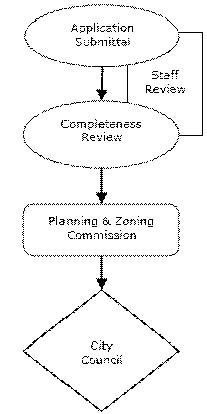
A.
Purpose.
For the purpose of establishing and maintaining sound, stable, and desirable development within the territorial limits of the city, the Comprehensive Plan, including specifically the Future Land Use & Character Map and the Functional Classification & Context Class Map, shall be amended only based upon changed or changing conditions in a particular area or in the city.
B.
Initiation of Amendment.
An amendment may be initiated by:
1.
The City Council;
2.
The Planning and Zoning Commission;
3.
The Administrator; or
4.
The property owner(s).
C.
Amendment Application.
A complete application for a Comprehensive Plan amendment shall be submitted to the Administrator as set forth in the General Approval Procedures Section above.
D.
Time Limitations on Applications.
Comprehensive Plan amendment applications may be submitted on a rolling basis, except during the six (6) month period prior to a major evaluation or update to the Comprehensive Plan. The beginning of the six (6) month time limitation period shall be determined by counting backward from the expected date of the evaluation or update public hearing before the Planning and Zoning Commission.
E.
Approval Process.
1.
Project Proposal Meeting.
After applying for a Comprehensive Plan amendment to the Future Land Use & Character Map or attending a pre-application conference relating to the same, the applicant shall request to set up a project proposal meeting with City staff. The purpose of this meeting is to begin communicating with the local neighborhood early in the process and is not a forum for final decisions or the acceptance of formal comments concerning public support or opposition.
Project proposal meetings shall abide by the following minimum requirements:
a.
The applicant or an authorized representative must schedule and facilitate a minimum of one project proposal meeting to discuss the application or proposal. At a minimum, property owners within 200 feet of the subject property must be notified by the applicant or authorized representative.
b.
When possible, City staff shall be present at the meeting to address questions relating to City processes and requirements.
c.
The project proposal meeting shall be held on or near the subject property, or virtually.
d.
The project proposal meeting shall be held thirty (30) to sixty (60) days prior to the corresponding Planning and Zoning Commission meeting.
2.
Review and Report by Administrator.
Once the application is complete, the Administrator shall review the proposed amendment in light of the remainder of the Comprehensive Plan and existing conditions in the city and report to the Planning and Zoning Commission and City Council.
3.
Recommendation by Planning and Zoning Commission.
a.
Notice.
The Planning and Zoning Commission shall publish, post, and mail public notice in accordance with the General Approval Procedures Section above and shall recommend to the City Council such action as the Commission deems proper.
b.
Public Hearing.
A public hearing shall be held by the Planning and Zoning Commission before making a report to the City Council.
c.
Review and Action by Planning and Zoning Commission.
The Planning and Zoning Commission shall review the amendment and approve, approve with conditions, deny, or determine that the proposed development complies with the Comprehensive Plan, and no amendment is required. If the Commission determines that no amendment is required, the applicant may proceed with the next step in the development process. No further action by the City Council is required.
4.
City Council Action.
a.
Notice.
The City Council shall publish, post, and mail public notice in accordance with the General Approval Procedures Section above, before taking final action on a petition to amend the Comprehensive Plan.
b.
Public Hearing.
The City Council shall hold a public hearing and approve, approve with modifications, or disapprove the application to amend the Comprehensive Plan.
c.
Review and Final Action by City Council.
In determining whether to approve, approve with modifications, or disapprove the application to amend the Comprehensive Plan, the City Council shall consider the following matters regarding the proposed amendment:
1)
Changed or changing conditions in the subject area of the city;
2)
Compatibility with the existing uses, development patterns, and character of the immediate area concerned, the general area, and the city as a whole;
3)
Impact on environmentally sensitive and natural areas;
4)
Impacts on infrastructure, including water, wastewater, drainage, and the transportation network; and
5)
Consistency with the goals and strategies set forth in the Comprehensive Plan.
F.
Limitation on Reapplication.
If a petition for a plan amendment is denied by the City Council, another petition for reclassification of the same property or any portion thereof shall not be considered within a period of one hundred eighty (180) days from the date of denial, unless the Planning and Zoning Commission finds that one (1) of the following factors are applicable:
1.
There is a substantial change in circumstances relevant to the issues and/or facts considered during the review of the application that might reasonably affect the decision-making body's application of the relevant review standards to the development proposed in the application; or
2.
New or additional information is available that was not available at the time of the review that might reasonably affect the decision-making body's application of the relevant review standards to the development proposed; or
3.
A new application is proposed to be submitted that is materially different from the prior application (e.g., proposes new uses or a substantial decrease in proposed densities or intensities); or
4.
The final decision on the application was based on a material mistake of fact.
(Ord. No. 2023-4453, Pt. 1(Exh. A), 8-10-2023)
Sec. 3.4. - Official Zoning Map Amendments (Rezonings).
Official Zoning Map Amendment Review Process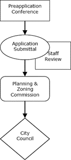
A.
Purpose.
To establish and maintain sound, stable, and desirable development within the territorial limits of the city, the Official Zoning Map may be amended based upon changed or changing conditions in a particular area or the city generally or to rezone an area or extend the boundary of an existing zoning district. All amendments shall be consistent with the Comprehensive Plan, including the Future Land Use & Character Map.
B.
Initiation of Amendments.
An amendment to the Official Zoning Map may be initiated by:
1.
The City Council;
2.
The Planning and Zoning Commission;
3.
The Administrator; or
4.
The property owner(s).
C.
Application.
A complete application for an Official Zoning Map amendment shall be submitted to the Administrator as set forth in the General Approval Procedures Section above and herein. As applicable, applicants shall submit the information, documents, and materials set forth in the Traffic Impact Analyses Section of Article 7, General Development Standards of this UDO.
1.
Application requests for a P-MUD Planned Mixed-Use District or PDD Planned Development District shall provide the following additional information:
a.
A written statement of the purpose and intent of the proposed development;
b.
A list and explanation of the potential land uses permitted; and
c.
A concept plan as described in the Concept Plans (P-MUD and PDD Districts) Section below.
2.
Application requests for an NCO Neighborhood Conservation Overlay shall provide the following additional information in accordance with the Neighborhood Conservation Overlay Process Handbook.
a.
A copy of the original plat of the subdivision, or multiple contiguous phases of original subdivisions that apply jointly;
b.
A petition including dated signatures by property owners of at least fifty (50) percent plus one (1) of the total number of single-family zoned or developed building plots contained within the original subdivision, or multiple contiguous phases of original subdivisions that apply jointly in one application, in support of the overlay district. The fifty (50) percent plus one (1) petition signatures must be met for each of the original subdivisions that apply jointly;
c.
Contact information for property owners of platted single-family development in the original subdivision to serve on the Neighborhood Conservation Overlay petition committee;
d.
Certificate of mailing neighborhood meeting notice for all property owners of single-family zoned or developed building plots contained within the original subdivision;
e.
Completed neighborhood meeting sign-in sheets; and
f.
Neighborhood meeting minutes signed by a petition committee member.
3.
Application request for an HP Historic Preservation Overlay shall provide the following additional information:
a.
An inventory and survey of structures to be included in the rezoning, submitted on a form provided by the Historic Preservation Officer;
b.
A current photograph of each property included in the rezoning, and its improvements;
c.
Historical photographs, where available; and
d.
A completed designation report. Upon initiation of the historic designation procedure, the Historic Preservation Officer shall coordinate research to compile a written report regarding the historical, cultural, and architectural significance of the place or area proposed for historic designation at the request of the applicant, but the rezoning application will not be considered complete until the report has been completed. A designation report shall include a statement on each of the following to the extent that they apply:
1)
A listing of the architectural, archaeological, paleontological, cultural, economic, social, ethnic, political, or historical characteristics upon which the nomination is based;
2)
A description of the historical, cultural, and architectural significance of the structures and sites;
3)
Identification of historic contributing and non-contributing resources to the proposed district; and
4)
A description of the boundaries of the proposed HP Historic Preservation Overlay, including subareas and areas where new construction will be prohibited.
D.
Approval Process.
1.
Pre-Application Conference.
Prior to the submission of an application for an Official Zoning Map amendment, applicants are encouraged to schedule and attend an optional pre-application conference in accordance with the Pre-Application Conference Subsection of the General Approval Procedures Section above.
2.
Required Meetings.
a.
Neighborhood Meeting.
Prior to the submission of an application for an Official Zoning Map amendment for an NCO Neighborhood Conservation Overlay, all potential applicants shall request to set up a neighborhood meeting with City staff.
b.
Historic Preservation Officer.
Prior to the submission of an application for an Official Zoning Map amendment for an HP Historic Preservation Overlay, all potential applicants shall request a neighborhood meeting with the Historic Preservation Officer. The purpose of the meeting is to present information about the proposed overlay district and explain the rezoning process to the neighborhood.
3.
Review and Report by Administrator.
With the exception of applications for HP Historic Preservation Overlays, once the application is complete, the Administrator shall review the proposed amendment to the Official Zoning Map in light of the Comprehensive Plan and the criteria enumerated in this Section. The Administrator shall give a report to the Planning and Zoning Commission on the date of the scheduled public hearing. If the Administrator determines that the request is not in conformity with the Comprehensive Plan, the application shall not be accepted, and no further processing shall occur until the Official Zoning Map amendment conforms.
4.
Review and Report by Historic Preservation Officer.
An application for an HP Historic Preservation Overlay shall be reviewed by the Historic Preservation Officer, who shall review the proposed amendment in light of the Comprehensive Plan, the criteria of this Section, and the Historic Preservation Overlay Subsection of the Overlay Districts Section of Article 5, District Purpose Statements and Supplemental Standards of this UDO. The Historic Preservation Officer shall give a report to the Landmark Commission on the date of the scheduled public hearing.
5.
Referral to Landmark Commission.
The Historic Preservation Officer, upon receipt of an application to amend the Official Zoning Map to an HP Historic Preservation Overlay, shall refer the same to the Landmark Commission for study, hearing, and report. The Planning and Zoning Commission may not hold a public hearing or make a report to the City Council until it has received a report from the Landmark Commission.
6.
Recommendation by Landmark Commission.
The Landmark Commission shall publish, post, and mail public notice in accordance with the General Approval Procedures Section above. The Landmark Commission shall hold a public hearing and make a recommendation to the Planning and Zoning Commission.
7.
Referral to Planning and Zoning Commission.
With the exception of applications for HP Historic Preservation Overlays, the Administrator, upon receipt of a petition to amend the Official Zoning Map, shall refer the same to the Planning and Zoning Commission for study, hearing, and report. For an application to amend the Official Zoning Map to an HP Historic Preservation Overlay, the Historic Preservation Officer shall refer the same to the Planning and Zoning Commission for study, hearing, and report with the report of the Landmark Commission. The City Council may not enact the proposed amendment until the Planning and Zoning Commission makes its report to the City Council.
8.
Recommendation by Planning and Zoning Commission.
The Planning and Zoning Commission shall publish, post, and mail public notice in accordance with the General Approval Procedures Section above. The Planning and Zoning Commission shall hold a public hearing and recommend to the City Council such action as the Commission deems proper.
9.
City Council Action.
a.
Notice.
The City Council shall publish, post, and mail public notice in accordance with the General Approval Procedures Section above and hold a public hearing before taking final action on an application to amend the Official Zoning Map.
b.
Public Hearing.
The City Council shall hold a public hearing and approve, approve with modifications, or disapprove the application to amend the Official Zoning Map.
c.
Effect of Protest to Proposed Amendment.
If a proposed change to this UDO or rezoning is protested in accordance with Chapter 211 of the Texas Local Government Code, as amended, the proposed change must receive the affirmative vote of at least three-fourths (¾) of all members of the City Council to take effect. The protest must be written and signed by the owners of at least twenty (20) percent of either the area of lots covered by the proposed change or of the area of the lots or land immediately adjoining the area covered by the proposed change and extending two hundred (200) feet from that area.
d.
Review Criteria.
In determining whether to approve, approve with modifications, or disapprove the proposed Official Zoning Map amendment, the City Council shall consider the following matters regarding the proposed amendment:
1)
Whether the proposal is consistent with the Comprehensive Plan;
2)
Whether the uses permitted by the proposed zoning district will be appropriate in the context of the surrounding area;
3)
Whether the property to be rezoned is physically suitable for the proposed zoning district;
4)
Whether there are available water, wastewater, stormwater, and transportation facilities generally suitable and adequate for uses permitted by the proposed zoning district;
5)
The marketability of the property; and
6)
In addition, for proposed amendments to HP Historic Preservation Overlays, the City Council shall consider if the proposed amendment contains one or more properties in an environmental setting that meets two (2) or more of the criteria for designation of an HP Historic Preservation Overlay as described in the Historic Preservation Overlay Subsection of the Overlay Districts Section of Article 5, District Purpose Statements and Supplemental Standards of this UDO.
e.
Effect of Historic Preservation Overlay Zoning Upon Official Public Records.
Upon designation of a property with an HP Historic Preservation Overlay, the City Council shall cause the designation to be recorded in the Official Public Records of Real Property of Brazos County, Texas, the tax records of the City of College Station, and the Brazos Central Appraisal District, as well as the Official Zoning Map.
E.
Limitation on Reapplication.
If a rezoning application is denied by the City Council, another application for reclassification of the same property or any portion thereof shall not be considered within a period of one hundred eighty (180) days from the date of denial, unless the Planning and Zoning Commission finds that one (1) of the following factors are applicable:
1.
There is a substantial change in circumstances relevant to the issues and/or facts considered during the review of the application that might reasonably affect the decision-making body's application of the relevant review standards to the development proposed in the application;
2.
New or additional information is available that was not available at the time of the review that might reasonably affect the decision-making body's application of the relevant review standards to the development proposed;
3.
A new application is proposed to be submitted that is materially different from the prior application (e.g., proposes new uses or a substantial decrease in proposed densities and intensities); or
4.
The final decision on the application was based on a material mistake of fact.
F.
Repeal of a Single-Family Overlay District.
A repeal of a single-family overlay district is considered a rezoning and is subject to the Official Zoning Map amendment requirements herein and may be initiated by:
1.
The City Council;
2.
The Planning and Zoning Commission;
3.
The Administrator; or
4.
By a petition including dated signatures by property owners of at least fifty (50) percent plus one (1) of the total number of single-family zoned or developed building plots contained within the original subdivision, or contiguous phases of original subdivisions that applied jointly, in support of repealing the overlay district.
(Ord. No. 2023-4453, Pt. 1(Exh. A), 8-10-2023; Ord. No. 2025-4620, Pt. 1(Exh. B), 9-11-2025)
Sec. 3.5. - Concept Plans (P-MUD and PDD Districts).
Concept Plan Review Process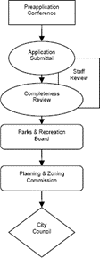
A.
Applicability.
A concept plan shall accompany a P-MUD Planned Mixed-Use District or PDD Planned Development District rezoning application to ensure the intent of the UDO is met by the proposed planned district standards.
B.
Application Requirements.
A complete application for a concept plan shall be submitted to the Administrator with a P-MUD Planned Mixed-Use District or PDD Planned Development District rezoning application as set forth in the General Approval Procedures Section above unless otherwise specified in this Section.
C.
Concept Plan Approval Process.
1.
Pre-Application Conference.
Prior to submitting a concept plan, applicants are encouraged to schedule and attend an optional pre-application conference in accordance with the Pre-Application Conference Subsection of the General Approval Procedures Section above.
2.
Review and Report by the Parks and Recreation Advisory Board.
If the proposed area involves any required or voluntary parkland dedication, the concept plan must be reviewed by the Parks and Recreation Advisory Board. Parks and Recreation Advisory Board recommendations shall be forwarded to the City Council.
3.
Review and Report by the Greenways Program Manager.
If the proposed area includes a greenway dedication as shown on the Bicycle, Pedestrian, and Greenways Master Plan, or if the applicant is proposing greenway dedication or voluntary sale, the concept plan must be reviewed by the Greenways Program Manager. The Greenways Program Manager's recommendation shall be forwarded to the City Council.
4.
Review and Recommendation by the Administrator.
The Administrator shall review the concept plan and recommend approval, approval with conditions, or disapproval of the same.
5.
Review and Recommendation by the Planning and Zoning Commission.
The Planning and Zoning Commission shall review the concept plan and recommend to the City Council approval, approval with conditions, or disapproval of the same.
6.
City Council Final Action.
The City Council shall review the concept plan and approve, approve with conditions, or disapprove.
D.
Concept Plan Requirements.
A concept plan shall not be considered or reviewed as a complete site plan application. The concept plan for the proposed development shall include the following:
1.
A general plan showing the location and relationship of the various land uses permitted in the development;
2.
A range of proposed building heights;
3.
A written statement addressing the drainage development of the site;
4.
The general location of detention/retention ponds and other major drainage structures;
5.
A list of general bulk or dimensional variations sought;
6.
If general bulk or dimensional variations are sought, provide a list of community benefits and/or innovative design concepts to justify the request;
7.
The general location of the building and parking areas;
8.
Open spaces, parkland, conservation areas, greenways, parks, trails, and other special features of the development; and
9.
Buffer areas or a statement indicating buffering proposed.
E.
Review Criteria.
The Administrator and Planning and Zoning Commission shall recommend approval and the City Council may approve a concept plan if it finds that the concept plan meets the following criteria:
1.
The proposal will constitute an environment of sustained stability and will be in harmony with the character of the surrounding area;
2.
The proposal conforms with the policies, goals, and objectives of the Comprehensive Plan, including any associated plans or studies adopted by the City Council, and will be consistent with the intent and purpose of this Section;
3.
The proposal is compatible with existing or permitted uses on abutting sites and will not adversely affect adjacent development;
4.
Every dwelling unit need not front on a public street but shall have access to a public street directly or via a court, walkway, public area, or area owned by an owners association;
5.
The development includes the provision of adequate public improvements, including but not limited to parks, schools, and other public facilities;
6.
The development will not be detrimental to the public health, safety, welfare, or materially injurious to properties or improvements in the vicinity; and
7.
The development will not adversely affect the safety and convenience of vehicular, bicycle, or pedestrian circulation in the vicinity, including traffic reasonably expected to be generated by the proposed use and other uses reasonably anticipated in the area considering existing zoning and land uses in the area.
F.
Minimum Requirements.
Unless otherwise indicated in the approved concept plan, the minimum requirements for each development shall be those stated in this UDO for subdivisions and the requirements of the most restrictive standard zoning district in which designated uses are permitted. Modification of these standards may be considered during the approval process of the concept plan. If modification of these standards is granted with the concept plan, the Administrator will determine the specific minimum requirements.
G.
Compliance with Other Regulations.
The approval of a concept plan shall not relieve the developer from responsibility for complying with all other applicable sections of this UDO and other codes and ordinances of the City of College Station unless such relief is granted in the approved concept plan.
H.
Owners Association Required.
An owners association will be required if other satisfactory arrangements have not been made for providing, operating, and maintaining common facilities including streets, drives, service, and parking areas, common open spaces, buffer areas, and common recreational areas at the time the development plan is submitted. If an owners association is required, documentation must be submitted to the City at the time of platting to assure compliance with the provisions of this UDO.
I.
Modifications.
Any deviations from the approved concept plan shall require City Council approval except as provided in the Minor Amendment to Concept Plan Subsection below.
J.
Minor Amendment to Concept Plan.
Minor additions and modifications to the approved concept plan meeting the following criteria may be approved by the Administrator:
1.
Minor additions to structures as determined by the Administrator;
2.
Minor new accessory structures if the location does not interfere with the existing site layout (e.g., circulation, parking, loading, stormwater management facilities, open space, landscaping, buffering);
3.
Minor additions to parking lots;
4.
Clearing or grading of areas not depicted on the concept plan as a conservation area, greenway, or park; and
5.
Final determination of the specific meritorious modifications such as setbacks, lot size, dimensional standards, etc., granted generally as part of the concept plan.
(Ord. No. 2023-4453, Pt. 1(Exh. A), 8-10-2023)
Sec. 3.6. - Conditional Use Permits.
Conditional Use Permit Review Process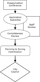
A.
Purpose.
Conditional use permits allow City Council discretionary approval of uses with unique or widely varying operating characteristics or unusual site development features, subject to the terms and conditions set forth in this UDO.
B.
Applicability.
Conditional uses are generally compatible with those uses permitted by right in a zoning district, but require individual review of their location, design, configuration, density, and intensity and may require the imposition of additional conditions to ensure the appropriateness and compatibility of the use at a particular location.
C.
Applications.
A complete application for a conditional use permit shall be submitted to the Administrator as set forth in the General Approval Procedures Section above. A complete site plan must accompany all applications for a conditional use permit.
D.
Approval Process.
1.
Pre-Application Conference.
Prior to the submission of an application for a conditional use permit, applicants are encouraged to schedule and attend an optional pre-application conference in accordance with the Pre-Application Conference Subsection of the General Approval Procedures Section above.
2.
Review and Report by Administrator.
Once the application is complete, the Administrator shall review the proposed development subject to the criteria enumerated in the Conditional Use Review Criteria Subsection below and give a report to the Planning and Zoning Commission on the date of the scheduled public hearing.
3.
Planning and Zoning Commission Recommendation.
a.
Notice.
The Planning and Zoning Commission shall publish, post, and mail notices in accordance with the General Approval Procedures Section above.
b.
Public Hearing.
After review of the conditional use permit application, subject to the criteria enumerated in the Conditional Use Review Criteria Subsection below, the Planning and Zoning Commission shall hold a public hearing and recommend to the City Council such action as the Planning and Zoning Commission deems proper.
4.
City Council Action.
a.
Notice.
The City Council shall publish, post, and mail notices in accordance with the General Approval Procedures Section above.
b.
Public Hearing.
The City Council shall hold a public hearing after review of the conditional use permit application, subject to the criteria enumerated in the Conditional Use Review Criteria Subsection below. With consideration of the recommendation provided by the Planning and Zoning Commission, the City Council shall approve, approve with modifications or conditions, or disapprove the conditional use permit application.
E.
Conditional Use Review Criteria.
The City Council may approve an application for a conditional use permit where it reasonably determines that there will be no significant negative impact upon residents of surrounding properties or the general public. The City Council shall consider the following criteria in its review:
1.
Purpose and Intent of the Unified Development Ordinance.
The proposed use shall meet the purpose and intent of this UDO and the use shall meet all the minimum standards established in this UDO for this type of use.
2.
Consistency with the Comprehensive Plan.
The proposed use shall be consistent with the development policies and goals and objectives as embodied in the Comprehensive Plan.
3.
Compatibility with the Surrounding Area.
The proposed use shall not be detrimental to the health, welfare, or safety of the surrounding neighborhood or its occupants, nor be substantially or permanently injurious to neighboring property.
4.
Harmonious with the Character of the Surrounding Area.
The proposed site plan and circulation plan shall be harmonious with the character of the surrounding area.
5.
Infrastructure Impacts Minimized.
The proposed use shall not negatively impact existing uses in the area or the city through impacts on public infrastructure such as roads, parking facilities, electrical, or water and sewer systems, or on public services such as police and fire protection, solid waste collection, or the ability of existing infrastructure and services to adequately provide services.
6.
Effect on the Environment.
The proposed use shall not negatively impact existing land uses in the area or the city.
F.
Additional Conditions.
The City Council may impose additional reasonable restrictions or conditions to carry out the spirit and intent of this UDO and to mitigate adverse effects of the proposed use. These requirements may include but are not limited to increased open space, loading and parking requirements, additional landscaping, and additional improvements such as curbing, utilities, drainage facilities, sidewalks, and screening.
G.
Enlargement, Modification, or Structural Alteration.
1.
A building, premise, or use under a conditional use permit may be enlarged, modified, structurally altered, or otherwise changed without applying for a new conditional use permit provided the Administrator determines that the changes do not:
a.
Increase the height of structures;
b.
Increase building square footage from its size at the time the original conditional use permit was granted by greater than ten (10) percent;
c.
Increase the approved occupancy load from the date the original conditional use permit was granted by greater than ten (10) percent for combined indoor occupancies;
d.
Increase the approved occupancy load from the date the original conditional use permit was granted by greater than ten (10) percent for combined outdoor occupancies;
e.
Reduce the distance between a building or noise-generating activity on the property and an adjacent, off-site residential use. This provision shall not apply should the property and the residential use be separated by a major thoroughfare depicted on the Comprehensive Plan Functional Classification & Context Class Map; or
f.
Reduce the buffer yard or buffer plantings as indicated on the previously approved site plan.
2.
The Administrator may require a new application for a conditional use permit for any reason when an enlargement, modification, or structural alteration is proposed.
3.
All other enlargements, modifications, structural alterations, or changes shall require the approval of a new conditional use permit.
H.
Duration; Expiration; Suspension; Violation; Revocation.
1.
Duration.
A conditional use permit shall remain in effect until it expires, is suspended, or is revoked in accordance with this Section.
2.
Expiration.
A conditional use permit shall expire if:
a.
A construction permit, if any, for the conditional use has not been issued within one (1) year of the date of approval of the conditional use permit;
If the conditional use will be for a tenant within a new multi-tenant building that is not yet constructed or is under construction, the conditional use permit shall expire if a building permit to finish out the tenant space has not been issued before the building receives its first certificate of occupancy;
b.
The construction permit subsequently expires for the building or the tenant finish out;
c.
The conditional use has been discontinued for a period exceeding six (6) months; or
d.
A termination date attached to the conditional use permit has passed.
3.
Suspension.
In accordance with the authority granted to municipalities by the state, the City shall have the right to immediately suspend the conditional use permit for any property where the premises are determined to be an immediate hazard to the health and safety of any person or an immediate danger to any adjacent property. The suspension shall be for a period not to exceed twenty-four (24) hours or until the danger or hazard is removed.
4.
Violation.
It is unlawful for any person to violate or to cause or permit to be violated any terms or conditions of a conditional use permit or upon which a conditional use permit was issued.
5.
Revocation.
The revocation of a conditional use permit shall follow the following revocation procedure:
a.
If the Administrator determines, based on inspection or investigation by the City, that there are reasonable grounds for revocation of a conditional use permit, a public hearing shall be set before the Planning and Zoning Commission for a recommendation and a public hearing before the City Council for the consideration of an ordinance amendment. Circumstances that warrant revocation of an approved conditional use permit application shall include but not be limited to the following:
1)
There is a conviction of a violation of any of the provisions of state law, this UDO, the ordinance approving the conditional use, or any ordinance of the City of College Station that occurs on the property for which the conditional use permit is granted;
2)
The property is found to be in violation of state laws or City ordinance resulting in a history of arrests or criminal activity on the property;
3)
The building, premise, or uses under the conditional use permit is enlarged, modified, structurally altered, or otherwise significantly changed without the approval of a separate conditional use permit for such enlargement, modification, structural alteration, or change, unless the Administrator had determined that such enlargement, modification, or structural alteration did not require a new conditional use permit, as described in the Applicability Subsection above;
4)
Violation of any provision of the site plan encompassing the property for which the conditional use permit was issued, terms, or conditions of a conditional use permit;
5)
The conditional use permit was obtained by fraud or deception; or
6)
The use of the property is detrimental to the public health, safety, or general welfare of the City.
b.
The revocation process shall be conducted as for the conditional use permit, including giving notice to the holder of the conditional use permit and property owners within 200 feet of the public hearings in the manner provided in the Required Public Notice Subsection of the General Approval Procedures Section above.
c.
The City Council may revoke the conditional use permit, deny the revocation and allow the conditional use to continue, or deny the revocation and amend the conditional use permit to attach conditions to assure that the terms, conditions, and requirements of the conditional use permit be met.
Upon the effective date of the revocation set by the City Council, it shall be unlawful to undertake or perform any activity that was previously authorized by the conditional use permit. The property subject to the conditional use permit may be used for any permitted use within the base zoning district.
(Ord. No. 2023-4453, Pt. 1(Exh. A), 8-10-2023; Ord. No. 2024-4557, Pt. 1(Exh. A—C), 10-24-2024)
Sec. 3.7. - Plats.
Plat Review Process
A.
Applicability.
This Section applies to the subdivision and development of property as set forth herein.
1.
Subdivision Plat Required.
a.
Subdivision of property within the city limits or extraterritorial jurisdiction is required to be approved in accordance with applicable state law and as set forth herein when one (1) or more of the following occurs:
1)
The division of land (for any purpose) into two (2) or more parcels to lay out a subdivision of the tract, including an addition to the city, to lay out suburban, building, or other lots, or to lay out streets, alleys, squares, parks or other parts of the tract intended to be dedicated to public use or for the use of purchasers or owners of lots fronting on to or adjacent to the streets, alleys, squares, parks or other parts;
2)
Development on a parcel not previously legally subdivided;
3)
Resubdivision of land that has previously been platted; or
4)
Amendment of any approved plat.
b.
Types of Subdivision Filings.
1)
Preliminary Plans.
A preliminary plan is required for the subdivision of all tracts of land within the city limits or extraterritorial jurisdiction, except as otherwise set forth in this UDO. A preliminary plan shall include the entire parent survey or tract of land under common ownership.
2)
Final Plats and Replats.
A final plat is required for the subdivision of all property within the city limits or extraterritorial jurisdiction. A final plat shall include the entire preliminary plan area or less when the final plat adheres to the phasing identified on the approved preliminary plan. The final plat shall conform to the preliminary plan as approved by the Administrator, provided it incorporates all changes, modifications, corrections, and conditions imposed by the Administrator; and provided further, that it conforms to all requirements of these regulations and the Comprehensive Plan.
3)
Minor Plats and Amending Plats.
A preliminary plan shall not be required prior to the application of a minor plat or amending plat. Amending plats are as described in Chapter 212 of the Texas Local Government Code, as amended. Minor plats or replats involve four (4) or fewer lots fronting on an existing street and do not require the creation of any new street or the extension of municipal facilities.
4)
Vacating Plats.
A vacating plat shall adhere to the requirements of Chapter 212 of the Texas Local Government Code, as amended. Vacating plats shall be processed and reviewed in the same manner as a final plat.
c.
Exemptions from Subdivision Plat Requirement.
The following subdivisions are exempt from subdivision plat requirements:
1)
A division of land into parts greater than five (5) acres within the city limits and greater than ten (10) acres in the extraterritorial jurisdiction, where each part has access, and no public improvement is being dedicated;
2)
Division of property that results from a governmental entity's land acquisition for public facilities such as the expansion of street right-of-way;
3)
Any lot(s) forming a part of a subdivision created and recorded prior to July 15, 1970, the effective date of the City of College Station Subdivision Regulations, or prior to the date on which the Subdivision Regulations applied to the property through the extension of the extraterritorial jurisdiction;
4)
A division of land performed by a political subdivision of the state, as defined in Chapter 245 of the Texas Local Government Code, as amended. Such entities that choose to plat voluntarily shall comply with all of the applicable requirements; or
5)
A division of land created by order of a court of competent jurisdiction.
2.
Development Plat Required.
a.
The City chooses to be covered by Subchapter B, Regulation of Property Development of Chapter 212 of the Texas Local Government Code, as amended. Any person who proposes the development of a tract of land or lot of record not located within a recorded subdivision within the city limits or the extraterritorial jurisdiction must have a development plat of the tract prepared in accordance with this Section. New development may not begin on the property until the development plat is filed with and approved by the City.
b.
Exemptions from Development Plat Requirement.
The following developments are exempt from development plat requirements:
1)
When an applicant is required to file a preliminary plan or final plat pursuant to other requirements of this Section, a development plat is not required in addition thereto.
2)
The development of a tract of land within the city limits or the extraterritorial jurisdiction that meets all of the following criteria is not required to file a development plat:
(a)
The tract is at least five (5) acres;
(b)
The tract has access; and
(c)
The development is a single-family home for the use of the property owner or a member of the property owner's family, an accessory structure(s) of the home, and/or an accessory structure(s) for the benefit of agricultural uses.
3)
Development by a political subdivision of the state, as defined in Chapter 245 of the Texas Local Government Code, as amended. Such entities that choose to plat voluntarily shall comply with all of the applicable requirements.
4)
The Administrator may waive the requirement for a development plat within the city limits when no parkland, public infrastructure, or public dedication is required on the subject tract.
B.
Determination of Plat Applicability.
Upon written application and in compliance with Chapter 212 of the Texas Local Government Code, as amended, the Administrator shall make the following determinations regarding the tract of land identified in the request:
1.
Whether a plat is required under this UDO for the tract of land; and
2.
If a plat is required, whether it has been prepared and whether it has been reviewed and approved by the Planning and Zoning Commission or Administrator, as applicable.
The Administrator may require additional information and documents to be provided by the applicant to make the requested determination.
C.
Application Requirements.
1.
Pre-Application Conference.
Prior to the submission of a preliminary plan or a plat application required by this UDO, applicants are encouraged to schedule and attend an optional pre-application conference in accordance with the Pre-Application Conference Subsection of the General Approval Procedures Section above.
2.
A complete application for review shall be submitted to the Administrator including payment of a fee as set forth in this UDO. Upon request, all preliminary plans and all plats shall be submitted in an electronic form acceptable to the Administrator and compatible with the City's geographic information system (GIS). The signatures of all owners of land within the boundary of the preliminary plan or the plat shall be required on the application. A representative of an owner may sign the application provided a written letter of agency is provided to the City with the application. If the property owner is not an individual but an entity (e.g., business or trust), the application must be accompanied by proof of authority for the individual to sign on behalf of the entity.
3.
When required to submit the following, the applications shall comply with and/or show the following information:
a.
Preliminary Plans.
When submitting preliminary plans, the following information is required:
1)
The preliminary plan shall conform to the general requirements of this UDO and minimum standards of design and improvements as set forth in Article 8, Subdivision Design and Improvements of this UDO;
2)
The words "PRELIMINARY PLAN - NOT FOR RECORD" shall appear on the plan;
3)
The proposed name of the subdivision or development, which shall not have the same spelling as or be pronounced similar to the name of any other subdivision located within the county it is located;
4)
The name and address of all property owners, developers and subdividers, engineers, and surveyors;
5)
Description by metes and bounds of the subdivision which shall close within accepted land survey standards (labeled on boundary lines, not separate metes and bounds description). An accurate location of the subdivision or development shall be provided by reference to an established survey or league corner, City of College Station horizontal control monument, subdivision corner, or other known points. Primary control points or descriptions and ties to a control point, to which, later, all dimensions, angles, bearings, block numbers, and similar data shall be referred. The preliminary plan shall be oriented to a corner of the survey or tract, or an original corner of the original survey of which it is a part;
6)
Subdivision boundary lines shall be indicated by heavy lines and the computed acreage of the subdivision or development shown;
7)
Indicate whether the contiguous property is platted and provide the name of all contiguous subdivisions or names of owners of contiguous, unplatted parcels;
8)
The following existing features shall be shown:
(a)
The location, dimension, name, and description of all recorded streets, alleys, reservations, easements, or other public or private rights-of-way within the subdivision or development, intersecting or contiguous with its boundaries or forming such boundaries. In the case of pipelines carrying flammable gas or fuel, the approximate location, size of the line, design pressure and product transported through the line shall be shown;
(b)
The location, dimension, description, and name of all existing or recorded lots, parks, public areas, permanent structures, and other sites within or contiguous with the subdivision or development;
(c)
The location, dimensions, description, and flow line of existing watercourses and drainage structures within the subdivision, development, or contiguous thereto;
(d)
The location of the one hundred (100) year floodplain according to the most recent best available data;
9)
Date of preparation, scale in feet, and north arrow;
10)
Topographic information, including contours at two-foot intervals, flow line elevation of streams, and wooded areas;
11)
The location, approximate dimensions, description, and name of all proposed streets, alleys, drainage structures, parks, or other public areas, easements, or other rights-of-way, blocks, lots, and other sites within the subdivision or development. Proposed channel cross sections, if any. Existing and/or proposed well site locations;
12)
A number or letter to identify each lot and each block. Lots and blocks shown on a preliminary plan should be numbered sequentially;
13)
Location of current city limits line and current zoning district boundaries;
14)
Vicinity map which shows the general location of the subject property to existing streets in College Station to its city limits. No scale is required but a north arrow is to be included;
15)
The number of residential lots and average lot size when applicable;
16)
Provide a note to identify a cluster development when applicable;
17)
Provide any oversize participation requests that will be sought;
18)
Provide a title report for the property that is current within ninety (90) days and includes applicable information such as ownership, liens, encumbrances, etc.;
19)
Written requests for waivers of subdivision standards, if any, shall be submitted in accordance with the applicable Sections of this UDO;
20)
Provide a note on the preliminary plan to identify the residential parking option chosen from the Single-Family Residential Parking Requirements for Platting Section of Article 8, Subdivision Design and Improvements of this UDO, when applicable; and
21)
As applicable, applicants shall submit the information, documents, and materials set forth in the Traffic Impact Analyses Section of Article 7, General Development Standards of this UDO.
b.
Plats to be Recorded.
When submitting plats, the following shall be required:
1)
The plat shall conform to the general requirements of this UDO and minimum standards of design and improvements as set forth in Article 8, Subdivision Design and Improvements of this UDO unless expressly provided for otherwise;
2)
Prior to filing a plat for record, provide a twenty-four (24) inch by thirty-six (36) inch mylar of the plat and current certified tax certificates from all taxing agencies showing payment of all ad valorem taxes on the land within the subdivision;
3)
Provide a title report for the property that is current within ninety (90) days and includes applicable information such as ownership, liens, encumbrances, etc.;
4)
Provide the plat in a digital format as accepted by the City's online application review and permitting system. The plat must be sized at a ratio of two-to-three (2:3) and be at a scale of one hundred (100) feet per inch or larger. Smaller scales may be allowed at the discretion of the Administrator. If more than one (1) sheet, provide an index sheet at a scale of five hundred (500) feet per inch or larger;
5)
Vicinity map which shows the general location of the subject property to existing streets in College Station to its city limits. No scale is required but a north arrow is to be included;
6)
The proposed name of the subdivision or development, which shall not have the same spelling as or be pronounced similar to the name of any other subdivision located within the county it is located;
7)
Date of preparation, scale in feet, and north arrow;
8)
The name and address of all property owners, developers, subdividers, engineers, and surveyors responsible for the plat;
9)
Subdivision boundary lines shall be indicated by heavy lines and the computed acreage of the subdivision or development;
10)
For a replat where there are existing improvements, provide a survey of the subject property showing the improvements to ensure that no setback encroachments are created;
11)
The name of contiguous subdivisions and names of owners of contiguous parcels and an indication of whether or not contiguous properties are platted;
12)
The location of the one hundred (100) year floodplain and floodway according to the most recent best available data;
13)
A number or letter to identify each lot and each block. Lots and blocks shown on a plat should be numbered sequentially;
14)
Provide the number of lots and average lot size when applicable;
15)
Provide a note to identify a cluster development when applicable;
16)
Written requests for waivers of subdivision standards, if any, shall be submitted in accordance with the applicable Sections of this UDO;
17)
The plat shall also include the following, based on a field survey, and marked by monuments and markers:
(a)
The exact location, dimensions, name, and legal description of all existing or recorded streets, alleys, easements, or other rights-of-way within the subdivision or development, intersecting or contiguous with the boundary or forming such a boundary with accurate dimensions, bearings or deflection angles and radii, area, center angle, degree of curvature, tangent distance, and length of all curves, where applicable;
(b)
The exact location, dimensions, description, and name of all proposed streets, alleys, drainage structures, parks, and other public areas, easements, or other rights-of-way, blocks, lots, and other sites within the subdivision or development, with accurate dimensions, bearings, or deflection angles and radii, areas, center angle, degree of curvature, tangent distance, and length of curves, where applicable;
(c)
Lot corner markers and survey monuments shall be shown clearly by symbol, and tied to City of College Station horizontal control monuments;
(d)
The following, when applicable, shall appear on the face of the plat: (See examples in the Certifications Section of Article 8 Subdivision Design and Improvements of this UDO.)
i.
Certificate of Ownership and Dedication;
ii.
Certificate of Surveyor and/or Engineer;
iii.
Certificate of City Engineer;
iv.
Certificate of Planning and Zoning Commission;
v.
Certificate of the County Clerk;
vi.
Certificate of Administrator; and
vii.
Certificate of Approval.
18)
The plat shall be accompanied by the construction documents and reports bearing the seal and signature of a registered professional engineer. All shall be in accordance with the Bryan/College Station Unified Design Guidelines and the Bryan/College Station Unified Technical Specifications and shall include the following:
(a)
Construction plans shall be provided in a digital format as accepted by the City's online application review and permitting system. The plat must be sized at a ratio of two-to-three (2:3);
(b)
Street, alley, and sidewalk plans, profiles, and sections, with specifications and detailed cost estimates;
(c)
Sanitary sewer plan with contours, plan, and profile lines, showing depth and grades, with sewer report and detailed cost estimates;
(d)
Water line plan showing fire hydrants, valves, etc., with specifications, a water report, and a detailed cost estimate. This may be combined with related information supplied for preliminary plan submissions;
(e)
Storm drainage system plan with contours, street lines, inlets, storm sewer, and drainage channels with profiles and sections. Detail drainage structure design and channel lining design if used, with specifications, drainage report, and detailed cost estimate;
(f)
Street lighting plan showing the location of lights, design, and with specifications and detailed cost estimates; and
(g)
Any associated necessary items, including but not limited to off-site public utility easements, permits, or approval of governmental agencies.
19)
Provide a note on the final plat to identify the residential parking option chosen from the Single-Family Residential Parking Requirements for Platting Section of Article 8, Subdivision Design and Improvements of this UDO, when applicable; and
20)
If the subject property is zoned MH Middle Housing, provide a note on the final plat to identify the list of proposed residential product type(s) to ensure the correct application of the Middle Housing Project Types and Dimensional Standards Table Section of Article 5, District Purpose Statements and Supplemental Standards of this UDO.
D.
Filing of Plat.
For the purposes of this Section, the date of filing shall be determined as the date on which a complete application, as determined by the Administrator, and a plat meeting all of the technical terms and conditions of this UDO or has filed a waiver request to those Sections for which the plat does not comply, is submitted. Once a complete application has been filed with the City, it will be scheduled for action by the Administrator or the Planning and Zoning Commission, as applicable.
E.
Plat Approval Authority.
Pursuant to Chapter 212 of the Texas Local Government Code, as amended, the City Council delegates authority to the Administrator and the Planning and Zoning Commission the ability to approve, approve with conditions, or disapprove plats in accordance with the procedure set forth herein. The delegation of authority to the Administrator applies to all plats except for plats including one or more waiver requests or discretionary items, or which require a public hearing. The Planning and Zoning Commission has approval authority over plats which include one or more waiver requests or discretionary items, or which require a public hearing. The Administrator may, for any reason, elect to present the plat for approval to the Planning and Zoning Commission.
F.
Review Procedure.
1.
Preliminary Plan Review.
a.
Review and Approval by Administrator.
If a waiver or discretionary item is not included or required with the preliminary plan application and a public hearing is not required, the Administrator may review and approve or deny the application based on compliance with the following elements:
1)
The Comprehensive Plan, including any associated plans or studies adopted by the City Council;
2)
Existing zoning of the property, if applicable;
3)
Article 8, Subdivision Design and Improvements of this UDO;
4)
Form and content as required in the General Approval Procedures Section above;
5)
If phased, the preliminary plan must demonstrate the sufficiency and viability of public infrastructure for each phase such that an undue burden is not placed on any particular phase. In addition, the proposed phasing is not to create phases or potential remainders of size, shape, or location so as not to be developable in compliance with this UDO; and
6)
Other provisions of this UDO as applicable.
b.
Review and Recommendation by Parks and Recreation Advisory Board.
The Parks and Recreation Advisory Board shall review the preliminary plan application for compliance with the Requirements for Parkland Dedication Section of Article 8, Subdivision Design and improvements of this UDO and recommend approval, approval with conditions, or disapproval of the same. This recommendation must be considered by the Administrator or the Planning and Zoning Commission in its review. Once the Board has determined compliance, the preliminary plan and subsequent plats may proceed directly to the Administrator or the Planning and Zoning Commission.
c.
Consideration by Planning and Zoning Commission.
If a preliminary plan application will be scheduled for a public hearing or includes one or more waiver requests or discretionary items, the Administrator shall forward the preliminary plan to the Planning and Zoning Commission for consideration when it meets all of the technical terms and conditions of this UDO. Proposed parkland dedication equal to or exceeding five (5) acres and dedications of floodplain or greenway not previously considered by the Planning and Zoning Commission shall be considered discretionary items. The Administrator shall provide a recommendation on the waiver request(s) or discretionary item(s) as appropriate. The Planning and Zoning Commission shall receive the recommendations of the Administrator and the Parks and Recreation Advisory Board and shall approve, disapprove, or conditionally approve the preliminary plan with modifications based on compliance with the same elements listed in the Review and Approval by Administrator Subsection above. Conditions of approval must entail corrections, changes, or completion of items that are ministerial and explicitly spelled out.
d.
Effect of Approval.
Approval of a preliminary plan shall mean the following:
1)
Approval of a preliminary plan application by the Administrator or the Planning and Zoning Commission shall allow the applicant to continue the subdivision process by submitting a development permit application with construction plans and a final plat application.
2)
Approval of a preliminary plan shall not constitute approval of a final plat. Application for approval of a final plat will be considered only after the requirements for preliminary plan approval as specified herein have been fulfilled and after all other specified conditions have been met.
3)
If a final plat is not filed with the City within twenty-four (24) months of the date of approval or conditional approval of a preliminary plan, the Planning and Zoning Commission may, upon written application of the applicant, extend the approval for a one-time additional twelve (12) month period. The request for consideration of an extension shall be submitted to the Administrator at least thirty (30) days before the preliminary plan approval expires.
4)
Each final plat which is a phase of an approved preliminary plan shall extend the expiration date of the preliminary plan an additional two (2) years from the date the final plat was approved.
5)
If a preliminary plan is phased, final plats shall only be permitted to proceed in the numerical order set forth by the preliminary plan.
2.
Amendments to an Approved Preliminary Plan.
a.
Minor Amendments.
Minor amendments of an approved preliminary plan may be in an application for approval of a final plat without the necessity of filing a new application for approval of a preliminary plan. Minor amendments may include adjustments in street or alley alignments and lengths, phasing, the adjustment in lot lines that do not result in the creation of additional developable lots, or adjustments to utility or access easements.
Minor amendments shall comply with the standards of this UDO, shall not alter a subdivision standard that is discretionary to the Planning and Zoning Commission, and shall not increase the extent of an approved waiver to a subdivision standard.
b.
Major Amendments.
All other proposed amendments of an approved preliminary plan not constituting a minor amendment shall be considered a major amendment and require the approval of a new preliminary plan application by the Administrator or the Planning and Zoning Commission, as appropriate. Major amendments include but are not limited to an increase in the number of developable lots, rerouting of streets, addition or deletion of alleys, change to thoroughfare street layout, or modification to parkland.
c.
Amendment Determination.
The applicant shall provide a written description of proposed amendments to an approved preliminary plan. The Administrator shall determine whether the proposed amendments are deemed minor or major amendments. At the discretion of the Administrator, a new preliminary plan application that proposes major amendments may be processed simultaneously with a final plat application.
d.
Retaining Previous Approval.
If the proposed major amendments are not approved or if the applicant is unwilling to accept the terms and conditions required by the Administrator or the Planning and Zoning Commission, the applicant may withdraw the proposed amendments by written request and retain the previously approved preliminary plan.
3.
Final Plat, Replat, Vacating Plat, Development Plat, Minor Plat, and Amending Plat Review.
a.
Review and Approval by Administrator.
1)
If a waiver or discretionary item is not included or required with the plat application and a public hearing is not required, the Administrator may review and approve, approve with conditions, or disapprove the application based on compliance with the following elements:
(a)
The approved preliminary plan, if applicable;
(b)
The Comprehensive Plan, including any associated plans or studies adopted by the City Council;
(c)
Existing zoning of the property, if applicable;
(d)
Article 8, Subdivision Design and Improvements of this UDO;
(e)
Form and content as required in the General Approval Procedures Section above; and
(f)
Other provisions of this UDO as applicable.
2)
If public infrastructure is required for the plat, the following is required for the plat application to be complete:
(a)
The construction documents must be approved by the City Engineer;
(b)
Any necessary off-site easements are reviewed and acceptable by the City in recordable form; and
(c)
Either the public infrastructure is constructed by the applicant and accepted by the City, or a guarantee provided to the City Engineer in accordance with the Construction, Guarantee of Performance, and Acceptance of Public Infrastructure Section of Article 8, Subdivision Design and Improvements of this UDO.
3)
If a waiver or discretionary item is included or required with the plat application, a public hearing is required, or the Administrator elects to forward a plat to the Planning and Zoning Commission, the applicant will be advised of the date set for Planning and Zoning Commission consideration. The Administrator shall recommend approval or disapproval of the same.
b.
Review and Recommendation by Parks and Recreation Advisory Board.
If not already determined through an approved preliminary plan, the Parks and Recreation Advisory Board shall review the plat application for compliance with the Requirements for Parkland Dedication Section of Article 8, Subdivision Design and Improvements of this UDO, and recommend approval, approval with conditions, or disapproval of the same. This recommendation must be considered by the Planning and Zoning Commission in its plat review.
c.
Criteria for Approval by Planning and Zoning Commission.
If a plat application will be considered by the Planning and Zoning Commission, the Commission shall receive the recommendation of the Administrator and the Parks and Recreation Advisory Board (if applicable) and shall approve or disapprove such plat within thirty (30) days after the plat is filed. Proposed parkland dedication equal to or exceeding five (5) acres and dedications of floodplain or greenway not previously considered by the Planning and Zoning Commission shall be considered discretionary items. The Planning and Zoning Commission's action shall be based on compliance with the review elements listed in the Review and Approval by Administrator Subsection above and the City Engineer's approval of all required infrastructure as proposed in the construction documents and which has been constructed and accepted or guaranteed in accordance with the Construction, Guarantee of Performance, and Acceptance of Public Infrastructure Section of Article 8, Subdivision Design and Improvements of this UDO. Conditions of approval must entail corrections, changes, or completion of items that are ministerial and explicitly spelled out.
d.
Recordation.
Approved plats shall be recorded in the County Clerk's Office of the county in which the plat is located when all requirements and conditions have been met.
G.
Waivers.
The Planning and Zoning Commission, where authorized by this UDO, may approve, approve with conditions, or disapprove waivers of the standards in Article 8, Subdivision Design and Improvements of this UDO.
H.
Plat Disapproval.
1.
When a plat is disapproved, the applicant is provided a written statement articulating the reasons for disapproval.
2.
An applicant may submit a written response that remedies each reason for disapproval.
3.
An applicant has the right to appeal if the designated authority disapproves a plat.
I.
Platting in Planned Districts (P-MUD Planned Mixed-Use District and PDD Planned Development District).
If the subject property is zoned as a P-MUD Planned Mixed-Use District or PDD Planned Development District, the City Council may approve a concept plan that provides for general modifications to the site development and subdivision standards. The general modifications shall be indicated on the approved concept plan or within the rezoning ordinance.
J.
Platting in the Extraterritorial Jurisdiction.
The City has entered into one (1) or more written agreements with counties in which it has extraterritorial jurisdiction. Such agreements identify the authority authorized to regulate plats within the extraterritorial jurisdiction, and the provisions of this Section are subject to the terms and conditions of such valid agreements. In the event such an agreement creates a direct conflict between the regulations herein and those of the particular county, the stricter standard shall apply.
K.
Failure to Obtain Plat Approval.
1.
If plat approval is required for the subdivision of property or development of property and the same is not properly secured:
a.
Prohibition of Recordation.
It shall be unlawful to offer and cause to be recorded any plat or replat of land within the city limits or extraterritorial jurisdiction at the County Clerk's Office unless the same bears the endorsement and approval of the Planning and Zoning Commission, the Administrator, or bears a valid certificate of No Action Taken as provided for in the Certifications Section of Article 8, Subdivision Design and Improvements of this UDO.
b.
Prohibition of Making Improvements.
It shall be unlawful to make any improvements, alterations, or changes of any kind to such property;
c.
No Issuance of Permits.
The City shall not issue any building, repair, plumbing, electrical, or other permit relating to such property until such approval occurs;
d.
No Provision or Maintenance of Infrastructure.
The City shall not repair, maintain, install, or provide any streets, public utilities, or public infrastructure of any kind to such property;
e.
No Provision of Public Utilities.
The City shall not sell or supply water, gas, electricity, or sewerage to such property.
2.
Council Action.
a.
If any subdivision or development exists for which a plat has not been approved or in which the standards contained herein or referred to herein have not been complied with in full, the City Council may pass a resolution reciting the fact of such noncompliance or failure to secure plat approval and reciting the fact that the provisions of this Section apply.
b.
The City Secretary shall, when directed by the City Council, cause a certified copy of the said resolution under the corporate seal of the City to be recorded in the Deed Records of the county in which the plat is located.
c.
If such compliance and plat approval are secured after the recording of such resolution, the City Secretary shall forthwith record an instrument in the Deed Records of the county in which the plat is located stating that the property is no longer in violation.
(Ord. No. 2023-4453, Pt. 1(Exh. A), 8-10-2023; Ord. No. 2024-4496, Pt. 1(Exh. E), 1-25-2024)
Sec. 3.8. - Development Permits.
Development Permit Review Process
A.
Applicability.
A development permit shall be required prior to any development activity to ensure conformance to the provisions and requirements of this UDO. The following uses are exempt from the permitting requirements of this Section, but shall otherwise meet all of the requirements of this UDO and the Bryan/College Station Unified Design Guidelines, Technical Specifications and Standard Details, and the Drainage and Stormwater Management Section of Article 7, General Development Standards of this UDO:
1.
Customary and incidental grounds maintenance, landscaping, and gardening;
2.
Drainage-related improvements or modifications by a homeowner on property used as their principal residence where that property lies outside of the designated area of special flood hazard; and
3.
Uses by a landowner of their property for bona fide agricultural purposes.
B.
Approval Process.
Prior to the issuance of a development permit, the following requirements shall be met:
1.
Pre-Application Conference.
Prior to the submission of an application for a development permit, applicants are encouraged to schedule and attend an optional pre-application conference following the procedure laid out in the Pre-Application Conference Subsection of the General Approval Procedures Section above.
2.
Application.
A complete application for a development permit shall be submitted to the Development Engineer as set forth in the General Approval Procedures Section above.
3.
Review and Action by the Development Engineer.
The Development Engineer shall review the required information and application form and shall take one (1) of the following actions:
a.
Approve the development permit;
b.
Disapprove the development permit;
c.
Approve the development permit with conditions; or
d.
Require additional information or an engineering conference with the applicant or their engineer.
4.
Review Criteria.
Approval or denial of a development permit by the Development Engineer shall be based on the following relevant factors:
a.
The danger to life or property due to flooding or erosion damage;
b.
The susceptibility of the proposed facility and its contents to flood damage and the effect of such damage on the individual owner;
c.
The danger that materials may be swept onto other lands to the injury of others;
d.
The compatibility of the proposed use with existing and anticipated development;
e.
The maintenance and operational costs of providing governmental services during and after flood conditions, including maintenance and repair of streets and bridges, and public utilities and facilities such as sewer, gas, electrical, and water systems;
f.
The expected heights, velocity, duration, rate of rise, and sediment transport of the flood waters, and the effects of wave action, if applicable, expected at the site;
g.
The necessity for the facility of a waterfront location, where applicable;
h.
The availability of alternative locations, not subject to flooding or erosion damage, for the proposed use;
i.
The barricading of existing trees to remain on the property and count as protected trees under the Landscaping and Tree Protection Section of Article 7, General Development Standards of this UDO; and
j.
Compliance with this UDO.
5.
Notification of Decision.
a.
The applicant shall be notified in writing of the action of the Development Engineer. If the development permit has been disapproved, the specific reasons for disapproval shall be indicated in the notification. If additional information is required of the applicant, the specific requirements shall be indicated in the notification. A final determination of the approval or disapproval of the development permit, considering the additional information, shall be made, and written notification to the applicant is given within ten (10) working days after acceptance of the complete application.
b.
Any proposal which includes areas of special flood hazard within the following special drainage areas shall receive written notice of approval or disapproval of the development permit from the Development Engineer within sixty (60) working days after receipt of the proposal:
1)
The entirety of Carter's Creek;
2)
The main channel of Lick Creek;
3)
Wolf Pen Creek from the Earl Rudder Freeway to the confluence with Carter's Creek; and
4)
The Brazos River.
(Ord. No. 2023-4453, Pt. 1(Exh. A), 8-10-2023)
Sec. 3.9. - Site Plans.
Site Plan Review Process
A.
Applicability.
1.
Prior to the development of any use or structure other than single-family (excluding manufactured home parks), duplex, or townhouse, a site plan shall be approved by the City in accordance with this Section. No development shall be lawful or permitted to proceed without final site plan approval. A site plan approved as part of a conditional use permit shall be considered a site plan approval.
2.
If the subject property is zoned P-MUD Planned Mixed-Use District or PDD Planned Development District, the City Council may approve a concept plan that provides for general modifications to the site development standards. The general modifications shall be indicated on the approved concept plan. The Administrator shall determine the specific standards that comply with the general modifications of the site development requirements at the time a site plan is approved. The applicant or the Administrator may have the City Council determine the specific standards that comply with the approved concept plan.
3.
If the subject property is zoned WPC Wolf Pen Creek, no private development shall be lawful or permitted to proceed without site plan approval. Site plan approval shall be required for all site plans as part of a conditional use permit. The Administrator may require traffic and parking impact studies, a review of existing occupancy, and other reasonable data to determine the impact of the project.
B.
General Requirements.
1.
All improvements reflected on approved site plans must be constructed at the time of development. All terms and conditions of site plan approval must be met at the time of development.
2.
If the subject property is zoned WPC Wolf Pen Creek, all associated rehabilitation, façade work, and other construction must be conducted after and in compliance with approved elevations, colors, and materials, and comply with all requirements in the WPC Wolf Pen Creek Subsection of the Design Districts Section of Article 5, District Purpose Statements and Supplemental Standards of this UDO. Such review may take place concurrent with the site plan review or may take place separately as provided in the Development Permits Section above.
C.
Application Requirements.
A complete application for site plan approval shall be submitted to the Administrator as set forth in the General Approval Procedures Section above. The application shall include a landscape plan illustrating compliance with the requirements of the Landscaping and Tree Protection Section of Article 7, General Development Standards of this UDO. Where applicable, applicants shall submit information, documents, and materials required in the Non-Residential Architectural Standards Section and Traffic Impact Analyses Section of Article 7, General Development Standards of this UDO.
D.
Site Plan Approval Process.
Site plan applications shall be processed in accordance with the following requirements:
1.
Pre-Application Conference.
Prior to the submission of an application for site plan approval, applicants are encouraged to schedule and attend an optional pre-application conference in accordance with the Pre-Application Conference Subsection of the General Approval Procedures Section above.
2.
Final Action by the Administrator.
If the proposed site plan is determined to be consistent with all applicable provisions of this UDO, the Administrator shall approve or conditionally approve the site plan. A determination that all such requirements and provisions have not been satisfied shall result in disapproval of the site plan and notice of such disapproval shall be given to the applicant in writing. Conditional approval must entail corrections or changes that are ministerial and explicitly spelled out.
E.
Site Plan Review Criteria.
The Administrator may request changes to the site plan to accomplish the following requirements. To be approved, a site plan must provide for:
1.
Safe and convenient traffic control, handling, and vehicle queuing;
2.
Assured pedestrian safety which may include the provision of sidewalks along the perimeter of the property;
3.
Efficient and economic public utilities;
4.
Public road or street access;
5.
Safe and efficient internal access including public, private, or emergency;
6.
Adequate parking and maneuvering areas;
7.
Noise and emission control or dispersion that complies with Chapter 7, Health and Sanitation of the City of College Station Code of Ordinances;
8.
Runoff, drainage, and flood control;
9.
Visual screening of areas offensive to the public or adjacent developments such as detention areas, retaining walls, utilities, and solid waste facilities;
10.
Compliance with standards, guidelines, and policies of the Landscape & Streetscape Standards Section of the City of College Station Site Design Standards;
11.
Clear indication of what constitutes the building plot for purposes of signage; and
12.
Location and density of buildings or dwelling units where topography or characteristics of the site compel a lower density than would otherwise be allowed or require location consistent with accepted engineering practices and principles.
F.
Additional Site Plan Review Criteria for the WPC Wolf Pen Creek Design District.
All development within the WPC Wolf Pen Creek design district shall comply with the Site Plan Review Criteria Subsection above. In addition, the following standards, which affect the appearance of a development, shall govern the evaluation of a design submission in the WPC Wolf Pen Creek design district:
1.
Conformance with the Comprehensive Plan, including any associated plans or studies adopted by the City Council;
2.
Exterior space utilization;
3.
Material selection;
4.
Compatibility with existing development in the design district;
5.
Vehicular, pedestrian, and bicycle circulation;
6.
Building location and orientation; and
7.
Specific standards listed in the Design Districts Section of Article 5, District Purpose Statements and Supplemental Standards of this UDO.
G.
Appeal.
Appeals of site plans denied by the Administrator where the denial was based upon or a condition was imposed to assure compliance with the Site Plan Review Criteria Subsection or Additional Site Plan Review Criteria for the WPC Wolf Pen Creek Design District Subsection above shall be submitted to the Design Review Board within thirty (30) days of the decision. If no appeal is filed within thirty (30) days, the decision shall be final.
The Design Review Board shall have the same authority and use the same review criteria as the Administrator in reviewing the site plan and taking final action. The Board may impose reasonable site-related conditions to mitigate the impacts of the development; however, they shall not impose architectural changes unless otherwise provided for in this UDO.
(Ord. No. 2023-4453, Pt. 1(Exh. A), 8-10-2023)
Sec. 3.10. - Sign Permits.
Sign Permit Review Process
A.
Applicability.
No sign shall hereafter be installed, erected, moved, added to, or structurally altered without a permit issued by the Administrator, except in conformity with the provisions of this Section, unless the Administrator is so directed by the Zoning Board of Adjustment as provided by this UDO. In the WPC Wolf Pen Creek design district, all substantial maintenance (including the replacement or alteration of signs) shall be subject to the sign permit review process detailed in this Section.
1.
A sign permit shall be required for the following:
a.
Apartment/condominium/manufactured home park identification signs;
b.
Attached signs;
c.
Development signs;
d.
Freestanding signs;
e.
Low profile signs;
f.
Roof signs; and
g.
Subdivision and area identification signs.
2.
No sign permit shall be required for the following:
a.
Real estate, finance, and construction signs;
b.
Directional traffic control signs;
c.
Home occupation signs; and
d.
Non-commercial signs.
3.
It shall be the responsibility of the owner or the leasing agent to assign the available attached or freestanding sign square footage to individual building tenants. In no case shall this be the responsibility of the Administrator. In no case may the cumulative total of individual signs for a multi-tenant building exceed the allowable area available or attached or freestanding signs.
B.
Application.
A complete application for a sign permit shall be submitted to the Administrator as set forth in the General Approval Procedures Section above.
C.
Review and Action by the Administrator.
The Administrator must review each sign permit application in light of this UDO and act to approve, approve with conditions, or deny the permit. The Administrator may approve with conditions only to the extent that such conditions specify the actions necessary to bring the application into compliance with this UDO. As applicable, the Administrator shall apply the standards in the WPC Wolf Pen Creek Subsection of the Design Districts Section of Article 5, District Purpose Statements and Supplemental Standards of this UDO. In considering such matters, the Administrator may rely on special area plans or studies adopted by the City Council.
D.
Maintenance and Repair.
1.
Cleaning, painting, repainting, and other normal maintenance and repair of a sign shall not require a permit unless a structural or size change is made. Maintenance includes the replacement of a sign face. Repainting or replacement of materials in the WPC Wolf Pen Creek design district must receive approval of either the Administrator or the Design Review Board.
2.
Repair of conforming signs, damaged as a result of accidents or acts of God, shall be exempt from permit fees when they are being restored to their original condition.
E.
Waivers (WPC Wolf Pen Creek only).
The Design Review Board shall hear and decide requests for waivers from the standards in the WPC Wolf Pen Creek Subsection of the Design Districts Section of Article 5, District Purpose Statements and Supplemental Standards of this UDO as limited to the possible waivers authorized by that Subsection.
(Ord. No. 2023-4453, Pt. 1(Exh. A), 8-10-2023)
Sec. 3.11. - Building Permits.
Building Permit Review Process
A.
Applicability.
1.
No building or other structure shall hereafter be erected, moved, added to, structurally altered, repaired, demolished, or occupancy changed without a permit issued by the Building Official except in conformity with the provisions of this Section and the International Building Code, as adopted by the City unless otherwise provided for in the City of College Station Code of Ordinances. No building permit issued under the provisions of this Section for land use or construction in the City shall be considered valid unless signed by the Building Official.
2.
In the WPC Wolf Pen Creek design district, all substantial maintenance (including but not limited to rehabilitation, façade work, and change of exterior materials or other construction) shall be subject to the building permit review process detailed in this Section. All building permits required in the WPC Wolf Pen Creek design district, including minor additions to a site (accessory buildings and structures, change of solid waste disposal location, painting, and landscaping) shall be reviewed by the Administrator.
B.
Application for Building Permit.
1.
Applications for building permits for single-family, duplex, townhouse, or courtyard house structures shall be accompanied by one (1) set of complete plans, drawn to scale, showing the actual dimensions and shape of the lot to be built upon; the exact sizes and locations of buildings already existing on the lot, if any; and the location and dimensions of the proposed building or alteration, easements, and required setbacks.
Applications for multi-family (including multiplex) and non-residential structures shall be accompanied by three (3) sets of complete plans, drawn to scale, including the approved site plan as required in the Site Plans Section above.
Additional sets of plans shall be supplied to the Building Official upon request.
2.
The application shall include such other information as lawfully may be required by the Building Official or the Administrator, including existing or proposed building or alteration; existing or proposed uses of the building and land; the number of families, housekeeping units, or rental units the building is designed to accommodate; conditions existing on the lot; and such other matters as may be necessary to determine conformance with and provide for the enforcement of this UDO.
3.
One (1) copy of the plans shall be returned to the applicant after it is marked as either approved, approved with conditions, or disapproved and attested to same by the signature of the Building Official on such copy. The original copy of the plans, similarly marked, and the associated site plan shall be retained by the Building Official.
4.
Where applicable, applicants shall submit information and materials required in the Landscaping and Tree Protection Section of Article 7, General Development Standards of this UDO.
5.
Where applicable, applicants shall submit information and materials required in the Non-Residential Architectural Standards Section of Article 7, General Development Standards of this UDO.
6.
If the subject property is zoned MH Middle Housing, applicants shall specify the proposed residential product type. See the Middle Housing Product Types and Dimensional Standards Table in the Residential Dimensional Standards Section of Article 5, District Purpose Statements and Supplemental Standards of this UDO for a list of allowed product types.
C.
Review and Recommendation.
The Building Official shall review all building permit applications to determine if intended uses, buildings, or structures comply with all applicable regulations and standards, including this UDO, and approve or disapprove the same.
D.
Review and Action by Building Official.
1.
The Building Official shall make a final determination of whether the intended uses, buildings, or structures comply with all applicable regulations, standards, and the International Building Code, as adopted. The Building Official shall not issue a building permit unless the plans, specifications, and intended use of such building or structures or parts thereof conform in all respects to the provisions of this UDO and the International Building Code, as adopted.
2.
If the subject property is zoned P-MUD Planned Mixed-Use District or PDD Planned Development District, the City Council may approve a concept plan that provides for general modifications to the site development standards. The general modifications shall be indicated on the approved concept plan. The Administrator shall determine the specific standards that comply with the general modifications of the site development requirements during the building permit review. The applicant or the Administrator may have the City Council determine the specific standards that comply with the approved concept plan.
E.
Decision by Administrator (WPC Wolf Pen Creek only).
1.
Design Review.
The Administrator shall apply the standards in the WPC Wolf Pen Creek Subsection of the Design Districts Section of Article 5, District Purpose Statements and Supplemental Standards of this UDO. In considering such matters, the Administrator may rely on special area plans or studies adopted by the City Council.
2.
Written Decision.
The decision of approval or denial shall be communicated in writing to the applicant.
F.
Waivers (WPC Wolf Pen Creek only).
The Design Review Board shall hear and decide requests for waivers from the standards in the WPC Wolf Pen Creek Subsection of the Design Districts Section of Article 5, District Purpose Statements and Supplemental Standards of this UDO as limited to the possible waivers authorized by that Subsection.
(Ord. No. 2023-4453, Pt. 1(Exh. A), 8-10-2023)
Sec. 3.12. - Certificates of Occupancy.
A.
Applicability.
A certificate of occupancy shall be required for any of the following:
1.
Occupancy of a building hereafter erected or enlarged;
2.
Change in use of an existing building to a different use category;
3.
Any change in a nonconforming use or structure; or
4.
As required by Section 110 of the International Building Code, as adopted.
B.
Application.
Once all required building inspections have been reviewed by the Building Official and no violation of the provisions of the Code is found, the Building Official shall issue a certificate of occupancy for the structure.
C.
Review and Action by Building Official.
Upon the request for a certificate of occupancy, the Building Official shall inspect the use or structure. If the Building Official determines that the use or structure complies with all applicable provisions of the International Building Code, as adopted, and this UDO, a certificate of occupancy shall be issued.
D.
Temporary Certificate of Occupancy.
Pending the issuance of a certificate of occupancy, a temporary certificate of occupancy may be issued by the Building Official. The temporary certificate of occupancy shall be valid for a period established by the Building Official, pending completion of additional requirements or during partial occupancy of a structure and as provided in Section 110 of the International Building Code, as adopted.
E.
Unlawful to Occupy Without Valid Certificate of Occupancy.
It is unlawful to occupy any building that does not have a validly issued certificate of occupancy or temporary certificate of occupancy.
(Ord. No. 2023-4453, Pt. 1(Exh. A), 8-10-2023)
Sec. 3.13. - Certificates of Completion.
A.
Applicability.
A certificate of completion shall be required for any of the following:
1.
Use of a parking lot hereafter constructed or enlarged not in conjunction with a building or structure;
2.
Site changes including but not limited to landscaping, parking lots, façade changes in a design district, or a change to an existing site that is not done in conjunction with a building or structure that requires a building permit; or
3.
Site improvements associated with a telecommunications tower.
B.
Application.
Once all required building inspections have been reviewed by the Building Official and no violation of the provisions of the International Building Code, as adopted are found, the Building Official shall issue a certificate of completion for the structure.
C.
Review and Action by Building Official.
Upon the request for a certificate of completion, the Building Official shall inspect the structure. If the Building Official determines that the structure complies with all applicable provisions of the International Building Code, as adopted, and this UDO, a certificate of completion shall be issued.
D.
Temporary Certificate of Completion.
Pending the issuance of a certificate of completion, a temporary certificate of completion may be issued by the Building Official. The temporary certificate of completion shall be valid for a period established by the Building Official, pending compliance with approved development plans.
E.
Unlawful to Utilize Without Valid Certificate of Completion.
It is unlawful to utilize any structure that does not have a validly issued certificate of completion or temporary certificate of completion.
(Ord. No. 2023-4453, Pt. 1(Exh. A), 8-10-2023)
Sec. 3.14. - Certificates of Appropriateness.
Certificate of Appropriateness Review Process
A.
Applicability.
1.
Prior to any construction, reconstruction, alteration, restoration, or rehabilitation of any structure or any property within an HP Historic Preservation Overlay, or any material change in the light fixtures, signs, sidewalks, fences, steps, paving, or other exterior elements visible from a public right-of-way that affects the appearance and cohesiveness of any structure or any property within an HP Historic Preservation Overlay, an applicant must obtain a certificate of appropriateness in accordance with this Section.
2.
No building permit shall be issued for proposed work within an HP Historic Preservation Overlay until a certificate of appropriateness has first been issued as required by the UDO. The certificate of appropriateness shall be in addition to and not in place of any building permit that may be required by any other ordinance of the City of College Station.
B.
Application Requirements.
A complete application for a certificate of appropriateness shall be submitted to the Administrator as set forth in the General Approval Procedures Section above. The application shall include, where applicable:
1.
Detailed description of proposed work;
2.
Proposed building plans (this will not constitute a building plan submittal for review for a building permit);
3.
Landscaping plans showing landscaping features and vegetation species, sizes, and locations;
4.
Landscape protection plans;
5.
Location and photographs of the property and adjacent properties;
6.
Elevation drawings of the proposed changes, if available;
7.
Samples of materials to be used;
8.
Specifications for architectural features and materials; and
9.
Any other information that the Landmark Commission or Historic Preservation Officer may deem necessary to visualize the proposed work.
C.
Certificate of Appropriateness Approval Process.
Certificate of appropriateness applications shall be processed in accordance with the following requirements:
1.
Pre-Application Conference.
Prior to the submission of an application for a certificate of appropriateness, applicants are encouraged to schedule and attend an optional pre-application conference in accordance with the Pre-Application Conference Subsection of the General Approval Procedures Section above.
2.
Review and Report by the Historic Preservation Officer.
Upon receipt of an application for a certificate of appropriateness, the Historic Preservation Officer shall determine whether the application is to be reviewed under the Standard Certificate of Appropriateness Review Criteria or the Routine Maintenance Work Review Procedure. If the application is to be reviewed under the Standard Certificate of Appropriateness Review Criteria, the following applies. If the application is to be reviewed under the Routine Maintenance Work Review Procedure, the procedure in the Routine Maintenance Work Review Procedure Subsection below will apply.
Under the Standard Certificate of Appropriateness Review Criteria, the Historic Preservation Officer will review the application to determine if the proposed plan is consistent with all applicable provisions of this UDO and the Comprehensive Plan. The Historic Preservation Officer will forward the report on the application to the Landmark Commission with a recommendation for approval, denial or conditional approval.
3.
Review by the Landmark Commission.
The Landmark Commission shall review the application in a public meeting and may approve, approve with conditions, or deny the application. If the Landmark Commission requires additional information than that presented at a meeting, a decision may be postponed until a specified date when the specified information may be provided. Notice shall be provided by the publication of the agenda of the meeting.
4.
Final Action by the Landmark Commission.
If the application is determined to be consistent with all applicable provisions of this UDO, including the applicable district provisions of the Historic Preservation Overlay Subsection of the Overlay Districts Section of Article 5, District Purpose Statements and Supplemental Standards of this UDO, and the review criteria in the Standard Certificate of Appropriateness Review Criteria Subsection below, the Landmark Commission shall approve the plan. A determination that all requirements and provisions have not been satisfied shall result in disapproval of the plan.
D.
Standard Certificate of Appropriateness Review Criteria.
The Landmark Commission shall approve a certificate of appropriateness if it finds:
1.
For Historic Contributing Resources.
a.
The proposed work is consistent with The Secretary of the Interior's Standards for Rehabilitation, The Secretary of the Interior's Guidelines for Rehabilitating Historic Buildings, Preservation Briefs, and all related interpretative documents published by the U.S. Department of Interior;
b.
The proposed work will not have an adverse effect on the architectural features of the structure;
c.
The proposed work will not have an adverse effect on the HP Historic Preservation Overlay; and
d.
The proposed work will not have an adverse effect on the future preservation, maintenance, and use of the structure or the HP Historic Preservation Overlay.
2.
For Historic Non-Contributing Resources.
The proposed work is compatible with the HP Historic Preservation Overlay.
E.
Routine Maintenance Work Review Procedure.
1.
If upon review of an application for a certificate of appropriateness, the Historic Preservation Officer determines that an applicant is seeking a certificate of appropriateness to authorize only routine maintenance work, the Historic Preservation Officer shall review the certificate of appropriateness application to determine whether the proposed work complies with the regulations contained in this Section and approve, approve with conditions, or deny the application. The Historic Preservation Officer may also forward the application to the Landmark Commission for any reason.
2.
Routine maintenance work on a property is considered to be:
a.
The installation of a chimney located on an accessory building, or on the rear fifty (50) percent of a main building and not part of a corner side façade;
b.
The installation of an awning located on an accessory building, or the rear façade of a primary structure;
c.
The installation of a wood or chain link fence that is not painted or stained;
d.
The installation of gutters and downspouts of a color that matches or compliments the dominant trim or roof color;
e.
The installation of skylights and solar panels;
f.
The installation of storm windows and doors; and/or
g.
The restoration of original architectural elements.
3.
The applicant may appeal the Historic Preservation Officer's decision by submitting to the Historic Preservation Officer a written request for appeal within ten (10) calendar days of the decision. Upon the written request for appeal, the Landmark Commission will review the application under the Standard Certificate of Appropriateness Review Criteria Subsection above.
F.
Expiration of Approval.
For plans that do not require the issuance of a building permit, work to complete the plans shall commence and be completed within twenty-four (24) months from the date of approval of the application. The Historic Preservation Officer may authorize a single extension of a certificate of appropriateness for up to six (6) months upon demonstration of substantial progress and the lack of changed or changing conditions in the area.
For plans that require the issuance of a building permit, if a building permit has not been issued for the proposed work within twenty-four (24) months from the date of approval of the application, the Historic Preservation Officer may authorize a single extension of a certificate of appropriateness up to six (6) months upon demonstration of the lack of changed or changing conditions in the area. A certificate of appropriateness shall be valid as long as there is a valid building permit.
G.
Appeals.
An applicant for a certificate of appropriateness dissatisfied with the action of the Landmark Commission related to the issuance or denial of a certificate of appropriateness shall have the right to appeal to the City Council within ten (10) calendar days after the date of such action. In considering an appeal, the City Council shall consider the same standards and evidence that the Landmark Commission was required to consider in making the decision.
H.
Limitation on Reapplication.
If a final decision is reached denying a certificate of appropriateness, no further applications may be considered for the subject matter of the denied certificate of appropriateness for one (1) year from the date of the final decision unless the Landmark Commission waives the time limitation because the Landmark Commission finds that there are changed circumstances sufficient warrant a new hearing.
I.
Revocation.
The Historic Preservation Officer may, in writing, revoke a certificate of appropriateness if:
1.
The certificate of appropriateness was issued based on incorrect information supplied by the applicant, or
2.
The work is not performed in accordance with the certificate of appropriateness.
J.
Amendment to a Certificate of Appropriateness.
A certificate of appropriateness may be amended by submitting a new certificate of appropriateness application to the Historic Preservation Officer. The application shall then be subject to either the Standard Certificate of Appropriateness Review Criteria or the Routine Maintenance Work Review Procedure.
K.
Ordinary Maintenance.
Other than the routine maintenance work listed in the Routine Maintenance Work Review Procedure Subsection above, a certificate of appropriateness shall not be required for the ordinary maintenance and repair of any exterior architectural feature of a property within an HP Historic Preservation Overlay which does not involve a change in design, material, or outward appearance such as:
1.
The replacement of a roof of the same or an original material that does not include a change in color;
2.
The application of paint that is the same as the existing;
3.
Minor repair using the same material and design as the original;
4.
The repair of sidewalks and driveways using the same type and color of materials;
5.
The process of cleaning (including but not limited to low-pressure water blasting and stripping, but excluding sandblasting and high-pressure water blasting); and
6.
The painting, replacing, duplicating, or stabilizing deteriorated or damaged non-original architectural features (including but not limited to roofing, windows, columns, and siding) to maintain the structure and slow deterioration.
L.
Temporary Emergency Repairs.
If the Building Official determines that a building or structure in an HP Historic Preservation Overlay poses an immediate threat to persons or property, the Building Official may take any action authorized under the City of College Station Code of Ordinances to make the building or structure safe without the requirement of a certificate of appropriateness. The Building Official shall send a written report of such actions to the Landmark Commission.
(Ord. No. 2023-4453, Pt. 1(Exh. A), 8-10-2023)
Sec. 3.15. - Certificates of Demolition.
Certificate of Demolition Review Process
A.
Applicability.
1.
Prior to any demolition or removal of any structure or portion thereof on any property within an HP Historic Preservation Overlay, an applicant must obtain a certificate of demolition in accordance with this Section.
2.
No building permit shall be issued for proposed work within an HP Historic Preservation Overlay until a certificate of demolition required by the UDO has first been issued by the Landmark Commission. The certificate of demolition shall be in addition to, and not in place of, any building permit that may be required by any other ordinance of the City of College Station.
3.
No permit for the demolition of a structure or property within an HP Historic Preservation Overlay, including secondary buildings and landscape features, shall be granted by the Building Official without the review of a completed application for and approval of a certificate of demolition by the Landmark Commission.
B.
Application Requirements.
A property owner seeking demolition or removal of a structure, including secondary buildings and landscape features, on a property in an HP Historic Preservation Overlay shall submit a complete application for a certificate of demolition to the Administrator as set forth in the General Approval Procedures Section above. The application shall include:
1.
An affidavit in which the owner swears or affirms that all information submitted in the application is true and correct.
2.
An indication that the demolition or removal is sought for one (1) or more of the following reasons:
a.
To replace the structure with a new structure that is more appropriate and compatible with the HP Historic Preservation Overlay;
b.
No economically viable use of the property exists;
c.
The structure poses an imminent threat to public health or safety; or
d.
The structure is noncontributing to the HP Historic Preservation Overlay because it is newer than the period of historic significance.
3.
An application "to replace the structure with a new structure that is more appropriate and compatible with the HP Historic Preservation Overlay" shall also include:
a.
Records depicting the original construction of the structure, including drawings, pictures, or written descriptions where available;
b.
Records depicting the current condition of the structure, including drawings, pictures, or written descriptions;
c.
Any conditions proposed to be placed voluntarily on the new structure that would mitigate the loss of the structure;
d.
Complete architectural drawings of the new structure; and
e.
A guarantee agreement between the owner and the City that demonstrates the owner's intent and financial ability to construct the new structure. The guarantee must:
1)
Contain a statement of intent to construct the proposed structure by a specific date in accordance with architectural drawings approved by the City through the certificate of appropriateness process;
2)
Require the owner or construction contractor to post a performance and payment bond, letter of credit, escrow agreement, cash deposit, or another arrangement acceptable to the Administrator to ensure the construction of the new structure; and
3)
Be approved as to form by the City Attorney.
4.
An application that "no economically viable use of the property exists" shall also include:
a.
The past and current uses of the structure and property;
b.
The name of the owner. If the owner is a legal entity, the type of entity and state in which it is registered;
c.
The date and price of purchase or other acquisition of the structure and property, the party from whom it was acquired, and the owner's current basis in the property;
d.
The relationship, if any, between the owner and the party from whom the structure and property were acquired. If one (1) or both parties to the transaction were legal entities, any relationships between the officers and the board of directors of the entities must be specified;
e.
The assessed value of the structure and property according to the two (2) most recent tax assessments;
f.
The amount of real estate taxes on the structure and property for the previous two (2) years;
g.
The current fair market value of the structure and property as determined by an independent licensed appraiser;
h.
All appraisals obtained by the owner and prospective purchasers within the previous two (2) years in connection with the potential or actual purchase, financing, or ownership of the structure and property;
i.
All listings of the structure and property for sale or rent within the previous two (2) years, prices asked, and offers received;
j.
A profit and loss statement for the property and structure containing the annual gross income for the previous two (2) years; itemized expenses (including operating and maintenance costs) for the previous two (2) years, including proof that adequate and competent management procedures were followed; the annual cash flow for the previous two (2) years; and proof that the owner has made reasonable efforts to obtain a reasonable rate of return on the owner's investment and labor;
k.
A mortgage history of the property during the previous five (5) years, including the principal balances and interest rates on the mortgages and the annual debt services on the structure and property;
l.
All capital expenditures during the current ownership;
m.
Records depicting the current conditions of the structure and property, including drawings, pictures, or written descriptions;
n.
A study of the restoration of the structure or property, performed by a licensed architect, engineer, or financial analyst, analyzing the physical feasibility (including architectural and engineering analyses) and financial feasibility (including pro forma profit and loss statements for ten years, taking into consideration redevelopment options and all incentives available) of adaptive use of restoration of the structure and property;
o.
Any consideration is given by the owner to profitable adaptive uses for the structure and property;
p.
Construction plans for any proposed development or adaptive reuse, including site plans, floor plans, and elevations;
q.
Any conditions proposed to be placed voluntarily on new development that would mitigate the loss of the structure; and
r.
Any other evidence that shows that the affirmative obligation to maintain the structure or property makes it impossible to realize a reasonable rate of return.
5.
An application to demolish or remove a structure that "poses an imminent threat to public health or safety" shall also include:
a.
Records depicting the current condition of the structure, including drawings, pictures, or written descriptions;
b.
A study regarding the nature, imminence, and severity of the threat, as performed by a licensed architect or engineer; and
c.
A study regarding both the cost of restoration of the structure and the feasibility (including architectural and engineering analyses) of restoration of the structure, as performed by a licensed architect or engineer.
6.
An application to demolish or remove a structure that is "noncontributing to the HP Historic Preservation Overlay because the structure is newer than the period of historic significance" shall also provide:
a.
Documentation that the structure is noncontributing to the HP Historic Preservation Overlay;
b.
Documentation of the age of the structure; and
c.
A statement of the purpose of the demolition.
7.
Any other evidence the property owner wishes to submit in support of the application.
8.
Any other evidence requested by the Landmark Commission or the Historic Preservation Officer.
C.
Approval Process.
Certificate of demolition applications shall be processed in accordance with the following requirements:
1.
Pre-Application Conference.
Prior to the submission of an application for a certificate of demolition, applicants are encouraged to schedule and attend an optional pre-application conference in accordance with the Pre-Application Conference Subsection of the General Approval Procedures Section above.
2.
Application.
When a complete application for a certificate of demolition has been submitted to the City, the application will begin a mandatory sixty (60) day stay of demolition. The certificate of demolition approval process will continue concurrently with the stay of demolition, but the Landmark Commission shall not take final action before the stay demolition has expired.
3.
Review and Report by the Historic Preservation Officer.
If the application is determined to be consistent with all applicable provisions of this UDO and the Comprehensive Plan, or if the application is recommended for denial or conditional approval, the Historic Preservation Officer shall report such consistency, inconsistency, or proposed conditions to the Landmark Commission.
4.
Review by an Economic Review Panel.
For an application that "no economically viable use of the property exists", within thirty-five (35) days after the appointment of the Economic Review Panel as provided in the Landmark Commission Section of Article 2, Development Review Bodies of this UDO, the Panel shall review the submitted documentation, hold a public hearing, consider all options for renovation, adaptive reuse, and redevelopment, and forward a written recommendation to the Landmark Commission. The Historic Preservation Officer shall provide administrative support to the Economic Review Panel. The Economic Review Panel's recommendation shall be based on the same standard for approval to be used by the Landmark Commission. An application that "no economically viable use of the property exists" will not be considered complete until the Economic Review Panel has made its recommendation to the Landmark Commission. If the Economic Review Panel is unable to reach a consensus, the report will indicate the majority and minority recommendations. If the Economic Review Panel does not meet within thirty-five (35) days after the appointment, a recommendation of "no economically viable use of the property" will be forwarded to the Landmark Commission.
5.
Review by the Landmark Commission.
The Landmark Commission shall review the application for a certificate of demolition in a public meeting and may approve, approve with conditions, or deny the application. If the Landmark Commission requires additional information than that presented at a meeting, a decision may be postponed until a specified date when the specified information may be provided. Notice shall be provided by the publication of the agenda of the meeting.
6.
Final Action by the Landmark Commission.
If the application is determined to be consistent with all applicable provisions of this UDO, including the applicable district provisions of the Historic Preservation Overlay Subsection of the Overlay Districts Section of Article 5, District Purpose Statements and Supplemental Standards of this UDO, and the review criteria in the Criteria for Approval of a Certificate of Demolition Subsection below, the Landmark Commission shall approve the plan. A determination that all such requirements and provisions have not been satisfied shall result in disapproval of the plan. The property owner has the burden of proof to establish by clear and convincing evidence the necessary facts to warrant favorable action by the Landmark Commission.
D.
Approval Criteria.
In considering an application for a certificate of demolition, the Landmark Commission shall deny the application unless it makes the following findings:
1.
The Landmark Commission shall deny an application for a certificate of demolition to replace a structure with a new structure unless it finds that:
a.
The new structure is more appropriate and compatible with the HP Historic Preservation Overlay than the structure to be demolished or removed; and
b.
The owner has the financial ability and intent to build the new structure. The Landmark Commission must first approve the certificate of appropriateness for the proposed new structure and the guarantee agreement to construct the new structure before it may consider the application for a certificate of demolition.
2.
The Landmark Commission shall deny an application for a certificate of demolition to remove a structure because of "no economically viable use of the property" unless it finds that:
a.
The structure is incapable of earning a reasonable economic return unless the demolition or removal is allowed (a reasonable economic return does not have to be the most profitable return possible);
b.
The structure cannot be adapted for any other use, whether by the owner or by a purchaser, which would result in a reasonable economic return; and
c.
The owner has failed during the last two (2) years to find a developer, financier, purchaser, or tenant that would enable the owner to realize a reasonable economic return, despite having made substantial ongoing efforts to do so.
3.
The Landmark Commission shall deny an application for a certificate of demolition to remove a structure that poses an imminent threat to public health or safety unless it finds that:
a.
The structure constitutes a documented major and imminent threat to public health and safety;
b.
The demolition or removal is required to alleviate the threat to public health and safety; and
c.
There is no reasonable way, other than demolition or removal, to eliminate the threat in a timely manner.
4.
The Landmark Commission shall deny an application for a certificate of demolition to remove a structure that is noncontributing to the HP Historic Preservation Overlay because it is newer than the period of historic significance unless it finds that:
a.
The structure is noncontributing to the HP Historic Preservation Overlay;
b.
The structure is newer than the period of historic significance for the HP Historic Preservation Overlay; and
c.
Demolition of the structure will not adversely affect the historic character of the property or the integrity of the HP Historic Preservation Overlay.
E.
Appeals.
1.
Any interested person may appeal the decision of the Landmark Commission to the City Council by filing a written notice with the Administrator within ten (10) calendar days after the decision of the Landmark Commission. If no appeal is made of a decision to approve a certificate of demolition within ten (10) days, the Building Official shall issue the permit to allow demolition or removal. If an appeal is filed, the City Council shall hear and decide the appeal within sixty-five (65) days of its filing.
2.
In considering an appeal, the City Council shall consider the same standards and evidence that the Landmark Commission was required to consider in making the decision.
F.
Limitation on Reapplication.
If a final decision is reached denying a certificate of demolition, no further applications may be considered for the subject matter of the denied certificate of demolition for one (1) year from the date of the final decision unless the Landmark Commission waives the time limitation because the Landmark Commission finds that there are changed circumstances sufficient to warrant a new hearing.
G.
Expiration of Approval.
A certificate of demolition expires if the work authorized by the certificate of demolition is not commenced within one hundred eighty (180) days from the date of final approval. A final, one-time extension for the commencement of work of ninety (90) days may be granted by the Administrator upon written request by the applicant showing circumstances beyond the control of the applicant. If the certificate of demolition expires, a new certificate of demolition must first be obtained before the work can commence.
H.
Demolition by Neglect.
1.
Prohibition.
No owner or person with an interest in real property included within an HP Historic Preservation Overlay shall permit the property to fall into a serious state of disrepair so as to result in the deterioration of any exterior architectural feature or structural compromise which would, in the judgment of the Landmark Commission, produce a detrimental effect upon the character of the HP Historic Preservation Overlay as a whole or the life and character of the property itself. Examples of such deterioration include but are not limited to:
a.
Deterioration of the foundation;
b.
Deterioration of floor supports, or the addition of floor supports that are insufficient to carry the loads imposed;
c.
Deterioration of walls, windows, doors, or other vertical supports, or the addition of such supports that are of insufficient size or strength to carry the loads imposed;
d.
Deterioration of roof or other horizontal members;
e.
Deterioration of exterior chimneys;
f.
Deterioration or crumbling of exterior stucco or mortar;
g.
Ineffective waterproofing of exterior walls, roof, or foundations, including broken windows or doors;
h.
Defective weather protection or lack of weather protection for exterior wall coverings, including lack of paint or another protective coating;
i.
Any fault, defect, or condition in the structure that renders it structurally unsafe or not properly watertight; and
j.
Deterioration of any feature so as to create a hazardous condition which could lead to the claim that demolition is necessary for public safety.
2.
Procedure.
a.
Purpose.
The purpose of the demolition by neglect procedure is to allow the Landmark Commission to work with the property owner to encourage maintenance and stabilization of the structure and identify resources available before any enforcement action is taken.
b.
Request for Investigation.
Any interested party may request that the Historic Preservation Officer investigate whether a property is being demolished by neglect.
c.
First Meeting With the Property Owner.
Upon receipt of a request, the Historic Preservation Officer and Building Official shall meet with the property owner or the property owner's agent with control of the structure to inspect the structure and discuss the resources available for financing any necessary repairs. After the meeting, the Historic Preservation Officer shall prepare a report for the Landmark Commission on the condition of the structure, the repairs needed to maintain and stabilize the structure, any resources available for financing the repairs, and the amount of time needed to complete the repairs.
d.
Certification and Notice.
After review of the report in a public meeting, the Landmark Commission may vote to certify the property as a demolition by neglect case. If the Landmark Commission certifies the structure as a demolition by neglect case, the Landmark Commission shall notify the property owner or the property owner's agent with control over the structure of the repairs that must be made. The notice must require that repairs be started within thirty (30) days and set a deadline for completion of the repairs. The notice shall be sent by certified mail.
e.
Second Meeting With the Property Owner.
The Historic Preservation Officer and the Building Official shall meet with the property owner or the property owner's agent with control over the structure within sixty (60) days after the notice was sent to inspect any repairs.
f.
Referral for Enforcement.
If the property owner or the property owner's agent with control over the structure fails to start repairs by the deadline set in the notice, fails to make continuous progress toward completion, or fails to complete repairs by the deadline set in the notice, the Landmark Commission may refer the demolition by neglect case to the Code Enforcement Division for appropriate enforcement action to prevent demolition by neglect.
I.
Demolition by Condemnation.
Reasonable attempts to engage a property owner in a demolition by neglect procedure shall be made when there is a concern for the deterioration of a structure, but when a structure or equipment is found by the Building Official to be a dangerous structure, the provisions of the City of College Station Code of Ordinances regulating dangerous structures will apply.
J.
Historic Preservation Fund.
1.
The City, in cooperation with community organizations, shall develop appropriate funding structures and shall administer the historic preservation fund.
2.
The historic preservation fund is composed of the following funds:
a.
Outside funding (other than City general funds or capital funds), such as grants and donations, made to the City for the purpose of historic preservation and funding partnerships with community organizations.
b.
Damages recovered pursuant to Chapter 315 of the Texas Local Government Code, as amended, from persons who illegally demolish or adversely affect historic structures.
3.
The outside funding may be used for financing the following activities:
a.
Necessary repairs in demolition by neglect cases;
b.
Full or partial restoration of low-income residential and nonresidential structures;
c.
Full or partial restoration of publicly owned historic structures;
d.
Acquisition of historic structures, places, or areas through gift or purchase;
e.
Public education of the benefits of historic preservation or the regulations governing HP Historic Preservation Overlays; and
f.
Identification and cataloging of structures, places, areas, and districts of historical, cultural, or architectural value along with factual verification of their significance.
4.
Damages recovered pursuant to Chapter 315 of the Texas Local Government Code, as amended, must be used only for the following purposes:
a.
Construction, using as many of the original materials as possible, of a structure that is a reasonable facsimile of a demolished historic structure;
b.
Restoration, using as many of the original materials as possible, of the historic structure; and
c.
Restoration of another historic structure.
(Ord. No. 2023-4453, Pt. 1(Exh. A), 8-10-2023)
Sec. 3.16. - Variances.
Variance Review Process
A.
Purpose.
The Zoning Board of Adjustment shall have jurisdiction to hear requests for a variance from the terms of this UDO. The Zoning Board of Adjustment shall be authorized to grant a variance from the terms hereof if, and only if, they find that the strict enforcement of this UDO would create a substantial hardship to the applicant by virtue of unique special conditions not generally found within the city and that the granting of the variance would preserve the spirit and intent of the UDO and would serve the general interests of the public and the applicant. Variances may be granted only when in harmony with the general purpose and intent of this UDO so that public health, safety, and welfare may be secured, and substantial justice done.
B.
Applicability.
The Zoning Board of Adjustment shall have the authority to grant variances from the standards in this UDO except for waivers of the standards in Article 8, Subdivision Design and Improvements of this UDO, which may be made by the Planning and Zoning Commission during the subdivision process, and requests for relief from a site plan requirement imposed by the Administrator when the requirement was necessary to gain compliance with the criteria for approval of a site plan in the Site Plans Section above, which may be made by the Design Review Board. Any variance request for up to ten (10) percent may be treated as an administrative adjustment subject to the requirements of the Administrative Adjustments Section below.
C.
Application.
A complete application for a variance shall be submitted to the Administrator as set forth in the General Approval Procedures Section above.
D.
Action by the Zoning Board of Adjustment.
1.
Public Hearing.
Following notice in accordance with the General Approval Procedures Section above, the Zoning Board of Adjustment shall hold a public hearing.
2.
Variance Review.
Upon completion of the public hearing and after review of the variance application subject to the criteria listed in the Criteria for Approval of Variance Subsection below, the Zoning Board of Adjustment shall make a written finding and give its approval, approval with limitations, or disapproval of the variance.
E.
Criteria for Approval of Variance.
1.
Required Findings.
The Zoning Board of Adjustment may authorize a variance from the requirements of this UDO when an unnecessary hardship would result from the strict enforcement of this UDO. In granting a variance, the Zoning Board of Adjustment shall prescribe only limitations that it deems not prejudicial to the public interest. In making the required findings, the Zoning Board of Adjustment shall consider the nature of the proposed use of the land involved, the existing use of land in the vicinity, the possibility that a nuisance will be created, and the probable effect of such variance upon traffic conditions and public health, convenience, and welfare of the vicinity. No variance shall be granted unless the Board makes affirmative findings in regard to all of the following criteria:
a.
Special Conditions.
That there are special conditions affecting the land involved such that strict application of the provisions of this UDO will deprive the applicant of the reasonable use of their land. For example, the variance is justified because of topographic or other special conditions unique to the property and development involved, in contradistinction to the mere inconvenience or financial disadvantage.
b.
Other Property.
That these conditions do not generally apply to other property in the vicinity.
c.
Enjoyment of a Substantial Property Right.
That the variance is necessary for the preservation and enjoyment of a substantial property right of the applicant.
d.
Hardships.
That the hardship is not the result of the applicant's actions.
The Zoning Board of Adjustment may consider the following as grounds to determine whether compliance with this ordinance as applied to a structure that is the subject of the variance would result in unnecessary hardship:
1)
The financial cost of compliance is greater than fifty (50) percent of the appraised value of the structure as shown on the most recent appraisal roll certified to the assessor for the city under Chapter 26 of the Texas Tax Code;
2)
Compliance would result in a loss to the lot on which the structure is located of at least twenty-five (25) percent of the area on which development may physically occur;
3)
Compliance would result in the structure not being in compliance with a requirement of a City of College Station ordinance, building code, or other requirement;
4)
Compliance would result in the unreasonable encroachment on an adjacent property or easement; or
5)
The City considers the structure to be a nonconforming structure.
e.
Subdivision.
That the granting of the variance will not have the effect of preventing the orderly subdivision of land in the area in accordance with the provisions of this UDO.
f.
Flood Hazard Protection.
That the granting of the variance will not have the effect of preventing flood hazard protection in accordance with Article 8, Subdivision Design and Improvements of this UDO.
g.
Comprehensive Plan.
That the granting of the variance would not substantially conflict with the Comprehensive Plan and the purposes of this UDO.
h.
Utilization.
That because of these conditions, the application of the UDO to the particular piece of property would effectively prohibit or unreasonably restrict the utilization of the property.
i.
Substantial Detriment.
That the granting of the variance will not be detrimental to the public health, safety, or welfare, or injurious to other property in the area or the City administering this UDO.
2.
Limitations.
The Zoning Board of Adjustment may not grant a variance where the effect would be any of the following:
a.
To allow the establishment of a use not otherwise permitted in the applicable zoning district;
b.
To increase the density of a use above that permitted by the applicable district;
c.
To extend physically a nonconforming use; or
d.
To change the zoning district boundaries shown on the Official Zoning Map.
3.
Profitability Not to Be Considered.
The fact that property may be utilized more profitably should a variance be granted may not be considered grounds for a variance.
(Ord. No. 2023-4453, Pt. 1(Exh. A), 8-10-2023)
Sec. 3.17. - Administrative Adjustments.
Administrative Adjustment Review Process
A.
Purpose.
Administrative adjustments are specified deviations from otherwise applicable development standards where development is proposed that would be:
1.
Compatible with surrounding land uses;
2.
Harmonious with the public interest; and
3.
Consistent with the purposes of this UDO.
B.
Applicability.
The Administrator shall have the authority to authorize adjustments of up to ten (10) percent from any dimensional standard or numerical requirement set forth in this UDO. Any adjustment requests greater than ten (10) percent shall be treated as a variance handled by the Zoning Board of Adjustment subject to the requirements of the Variances Section above.
C.
Application.
A complete application for an administrative adjustment shall be submitted to the Administrator as set forth in the General Approval Procedures Section above.
D.
Review and Action by Administrator.
The Administrator shall review the application and approve, approve with conditions, or deny the application based upon the criteria in the Administrative Adjustment Criteria Subsection below. A written decision including affirmative findings on the criteria set forth below shall be sent to the applicant.
E.
Administrative Adjustment Criteria.
1.
To approve an application for an administrative adjustment, the Administrator shall make an affirmative finding that the following criteria are met:
a.
That granting the adjustment will ensure the same general level of land use compatibility as the otherwise applicable standards;
b.
That granting the adjustment will not materially or adversely affect adjacent land uses or the physical character of uses in the vicinity of the proposed development; and
c.
That granting the adjustment will be generally consistent with the purposes and intent of this UDO.
2.
In the event the Administrator finds that the applicant has not met the criteria, the applicant may request that the application be forwarded to the Zoning Board of Adjustment as a variance request subject to the requirements of the Variances Section above.
(Ord. No. 2023-4453, Pt. 1(Exh. A), 8-10-2023)
Sec. 3.18. - Written Interpretations.
Written Interpretation Process
A.
Applicability.
The Administrator shall have the authority to make all written interpretations concerning the provisions of this UDO.
B.
Request for Interpretation.
A request for interpretation shall be submitted to the Administrator in a form established by the Administrator and made available to the public.
C.
Interpretation by Administrator.
1.
The Administrator shall:
a.
Review and evaluate the request in light of the text of this UDO, the Official Zoning Map, the Comprehensive Plan, and any other relevant information;
b.
Consult with other staff, as necessary; and
c.
Render an opinion.
2.
The interpretation shall be provided to the applicant in writing.
D.
Official Record.
The Administrator shall maintain an official record of interpretations. The record of interpretations shall be available for public inspection during normal business hours.
E.
Appeal.
Appeals of written interpretations made by the Administrator shall be filed only by a party affected by the written interpretation with the Zoning Board of Adjustment, or for appeals of written interpretations of Article 8, Subdivision Design and Improvements of this UDO, the Planning and Zoning Commission, within twenty (20) days of the decision in accordance with the procedures found in the Administrative Appeals Section below. If no appeal is filed within twenty (20) days, the written interpretation shall be final.
(Ord. No. 2023-4453, Pt. 1(Exh. A), 8-10-2023)
Sec. 3.19. - Administrative Appeals.
Administrative Appeal Review Process
A.
Applicability.
1.
Appeals to the Zoning Board of Adjustment may be taken by any person aggrieved by, or any officer or department affected by, specific points found in any of the following final decisions of the Administrator:
a.
Written interpretations of the text of this UDO; or
b.
Denial of a building permit or site plan based on interpretation of Article 7, General Development Standards of this UDO.
2.
Appeals to the Planning and Zoning Commission may be taken by any person aggrieved by or any officer or department affected by specific points found in the Administrator's written interpretations of the text of Article 8, Subdivision Design and Improvements.
B.
Effect of Appeal.
An appeal to the Zoning Board of Adjustment stays all legal proceedings in furtherance of the appealed action unless the Administrator from whom the appeal is taken certifies to the Zoning Board of Adjustment after the notice of appeal shall have been filed, that because of the facts stated in the certificate a stay would, in the Administrator's opinion, cause imminent peril to life or property. In such case, proceedings shall not be stayed otherwise than by a restraining order which may be granted by the Board or by a court of record on application, on notices to the officer from whom the appeal is taken, and on due cause shown.
C.
Deadline for Submission of Application.
An appeal from any final decision of the Administrator shall be filed with the Administrator within twenty (20) days after the date the decision is made. If no appeal is filed within twenty (20) days, the decision shall be final.
D.
Application.
A complete application for an administrative appeal shall be submitted to the Administrator as set forth in the General Approval Procedures Section above.
E.
Record of Administrative Decision.
The Administrator shall forthwith transmit to the Zoning Board of Adjustment or the Planning and Zoning Commission, as appropriate, all the papers constituting the record of the action appealed.
F.
Hearing.
The Zoning Board of Adjustment or Planning and Zoning Commission, as appropriate, shall set a reasonable time for the appeal hearing and give public notice as set forth in the General Approval Procedures Section above, as well as due notice to the parties in interest. The Board or Commission shall decide the appeal at their next meeting for which notice can be provided following the hearing and not later than the sixtieth (60th) day after the date the appeal is filed.
G.
Final Action by Zoning Board of Adjustment or Planning and Zoning Commission.
The Zoning Board of Adjustment or Planning and Zoning Commission, as appropriate, may only consider the specific interpretive language of the Administrator and may reverse or affirm wholly or partly, or may modify the interpretation appealed from. In any case, the Board or Commission shall only present findings regarding specific errors made in the Administrator's interpretation.
(Ord. No. 2023-4453, Pt. 1(Exh. A), 8-10-2023)
Sec. 3.20. - Unified Development Ordinance Text Amendments.
Unified Development Ordinance Text Amendment Process
A.
Purpose.
For the purpose of establishing and maintaining sound, stable, and desirable development within the territorial limits of the city, the text of this UDO may be altered from time to time.
B.
Initiation of Amendments.
An amendment to the text of this UDO may be initiated by:
1.
The City Council;
2.
The Planning and Zoning Commission; or
3.
The Administrator.
C.
Approval Process.
1.
Review and Report by Administrator.
The Administrator shall review the proposed text amendment in light of the Comprehensive Plan and give a report to the Planning and Zoning Commission.
2.
Referral to Planning and Zoning Commission.
The Administrator shall refer the same to the Planning and Zoning Commission for study, hearing, and report. The Planning and Zoning Commission may direct staff to proceed with drafting the amendment and scheduling the necessary public hearings, forward the proposed text amendment to City Council for direction, or determine not to pursue the proposed amendment. The City Council may not enact the proposed text amendment until the Planning and Zoning Commission makes its report to the City Council.
3.
Recommendation by Planning and Zoning Commission.
a.
Notice.
The Administrator shall publish and post public notice in accordance with the General Approval Procedures Section above, and shall recommend to the City Council such action as the Planning and Zoning Commission deems proper.
b.
Public Hearing.
A public hearing shall be held by the Planning and Zoning Commission before making a recommendation to the City Council.
4.
City Council Action.
a.
Notice.
The Administrator shall publish and post notices in accordance with the General Approval Procedures Section above, before taking final action on the amendment.
b.
Public Hearing.
The City Council shall hold a public hearing and approve, approve with modifications or conditions, or disapprove the text amendment.
(Ord. No. 2023-4453, Pt. 1(Exh. A), 8-10-2023)