
College Station City Zoning Code
ARTICLE 7
- General Development Standards
The following general development standards shall apply to all zoning districts, except where expressly stated to apply to, or exclude, specific districts.
(Ord. No. 2023-4453, Pt. 1(Exh. A), 8-10-2023)
Sec. 7.1.- Applicability.
The following general development standards shall apply to all zoning districts, except where expressly stated to apply to, or exclude, specific districts. The provisions of this Article shall not apply to property zoned BioCorridor Planned Development District.
(Ord. No. 2023-4453, Pt. 1(Exh. A), 8-10-2023)
Sec. 7.2. - General Provisions.
A.
Health and Environmental Safeguards.
No machine, process, or procedure shall be employed on any property in the city, in which:
1.
Emission of smoke, dust, or noxious, toxic, or lethal gases are detectable beyond the perimeter of the property;
2.
Materials are stored or accumulated in such a way that they may be carried by rainwater in natural drainage channels beyond the limits of the property, which are noxious, toxic, radioactive, contain oil or grease, wood, cellulose fibers, hair, feathers, or plastic, or have a pH factor greater than ten (10) or less than five (5);
3.
Vibration is discernible beyond the property line; or
4.
Noise above the ambient noise level is discernible beyond the property line.
B.
Minimum Requirements.
1.
No building plot shall have lower or less stringent standards or dimensions than those prescribed for respective zones in this UDO.
2.
No building permit or development approval may be issued for a lot that does not meet the minimum lot area requirements of this UDO except as provided for in Article 9, Nonconformities of this UDO.
3.
In the absence of public water or public sewer, no building permit shall be issued until the lot meets all applicable requirements of this UDO and the Texas Department of Health and Environmental Control. A septic system that has been approved by the Brazos County Health Department may be permitted if an exception to sewer service has been granted under the Water and Sewer Service Article of Chapter 40, Utilities of the City of College Station Code of Ordinances.
4.
Utilities using land or an unoccupied building covering less than one thousand (1,000) square feet of site area shall be exempt from minimum lot area standards.
C.
Visibility at Intersections in all Districts.
Within a departure sight triangle as defined by the current edition of the American Association of State Highway and Transportation Officials' (AASHTO) A Policy on Geometric Design of Highways and Streets, nothing shall be erected, placed, planted, or allowed to grow in such a manner that would obstruct the drivers' view at intersections. Sight triangles shall apply to street intersections, commercial driveways, and multifamily driveways. Obstacles prohibited include but are not limited to fences, walls, entry signage, structures, buildings, hedges, etc. However, fences, walls, and/or hedges that do not impair vision from three (3) feet to nine (9) feet above the curb may be permitted with the approval of the City Engineer. Required public use facilities such as fire hydrants, traffic signage, utility structures, etc. are exempted.
D.
Required Yards (Setbacks).
1.
General Requirements.
a.
Setbacks are measured from the property line.
b.
On lots with approved rear access, the rear setback shall be measured from the nearest boundary of the access easement or alley.
c.
No structure that is taller than eight (8) feet in height and that has a roof structure that completely or partially blocks the view to the sky shall be located within the required setback area unless specifically allowed herein.
d.
No part of a yard or other open space required in connection with any building, building plot, or use for the purpose of complying with this UDO shall be included for any other building, building plot, or use as part of a yard or open space.
e.
Where an existing lot was created by an approved plat prior to July 15, 1970, and the property is designated as Neighborhood Conservation in the Comprehensive Plan Future Land Use & Character Map, a new (infill) single-family dwelling unit shall use the adjacent lots to determine the appropriate front yard setback. The new dwelling unit shall be set no closer to the street or farther back from the street than the nearest neighboring units. Areas zoned NPO Neighborhood Prevailing Overlay are exempt from this requirement. Setbacks for areas zoned NCO Neighborhood Conservation Overlay are stated in the specific rezoning ordinance for the area.
2.
Reduction for Public Purpose.
a.
When an existing setback is reduced because of a recent or pending conveyance to a federal, state, or local government for a public purpose and the remaining setback is at least fifty (50) percent of the required minimum setback for the district in which it is located, then that remaining setback will be deemed to satisfy the minimum setback standards of this UDO.
b.
For the purposes of this Subsection, such conveyance shall have occurred within one (1) year immediately following submittal for site plan approval or be anticipated to occur within one (1) year of site plan approval.
3.
Features Allowed Within Required Yards.
The following features may be located within a required yard but may be subject to additional regulations applied herein:
a.
Trees, shrubbery, or other landscape features, excluding gazebos or other similar structures that require a building permit;
b.
Fences and walls;
c.
Driveways;
d.
Sidewalks;
e.
Utility lines, wires, and associated structures, such as power poles;
f.
Mechanical equipment, such as air conditioning units, pool pumps, and similar equipment;
g.
Uncovered porches, uncovered steps to building entrances, and uncovered patio decks;
h.
Covered porches that are open on three (3) sides, may extend up to six (6) feet, including eaves, into any required front or side street setback;
i.
Openwork fire balconies and fire escapes may extend up to six (6) feet into any required rear setback;
j.
Sills, belt courses, cornices, buttresses, chimneys, flues, eaves, and other architectural features may extend up to eighteen (18) inches into any required yard;
k.
Balconies or decks located more than eight (8) feet from the ground may project up to six (6) feet into the required front yard;
l.
Accessory structures that do not require building permits;
m.
Bus stops that offer shelter from the elements. Such shelters may be located within a front or side street yard. Shelters may be located within a public right-of-way if a private improvement in public right-of-way permit has been duly issued; and
n.
Swimming pools and hot tubs without shelter.
E.
More Than One (1) Principal Structure on a Lot or Parcel.
1.
In any single-family, duplex, or townhouse zoning district, including MH Middle Housing, no more than one (1) structure housing a permitted principal use may be erected on a single lot or building plot.
2.
In all other districts, more than one (1) structure housing a permitted principal use may be erected on a building plot. Yard and other requirements herein shall apply to the building plot.
F.
Fences/Walls.
Fences of wood, chain-link, or similar material, and less than eight (8) feet in height, and walls of brick, stone, concrete, or similar material, and less than six (6) feet in height, shall not be construed to be structures, nor shall they require a building permit.
G.
Low-Density Residential Height Protection.
1.
Purpose.
The purpose of low-density residential height protection is to help mitigate the negative visual impacts of higher-density residential and non-residential uses on adjacent, low-density residential uses and districts. This is accomplished by regulating the height of such higher-density residential or non-residential uses when adjacent to low-density residential uses and districts.
2.
Applicability.
a.
This Subsection shall apply to all multi-family structures, structures with shared housing uses, and non-residential structures to be constructed or reconstructed in any way that would increase the building height as defined in the Defined Terms Section of Article 11, Definitions of this UDO on property adjacent to a detached single-family, manufactured home park, or townhouse use or district.
b.
Unless otherwise stated in this UDO, the regulations herein shall not apply to any of the following:
1)
Structures located in any of the NG Northgate design districts, RDD Redevelopment Districts, or P-MUD Planned Mixed-Use Development zoning districts;
2)
Utility structures such as elevated water storage tanks and electrical transmission lines;
3)
Individual architectural structures such as flagpoles, belfries, cupolas, spires, domes, monuments, chimneys, bulkheads, elevators, or chimney flues; or any other similar structure extending above the roof of any building where such structure does not occupy more than thirty-three (33) percent of the surface area of the roof;
4)
Residential radio/television receiving antennas;
5)
When the detached single-family, manufactured home park, or townhome use on the adjacent tract is nonconforming;
6)
When the use on the adjacent tract is agricultural;
7)
Developments designed to be mixed-use or that are within areas where it has been identified that redevelopment is appropriate, as shown on the Comprehensive Plan Future Land Use & Character Map. Such developments at the periphery of the mixed-use area or area identified as appropriate for redevelopment shall meet the terms of this Subsection, when applicable; or
8)
When the developing property and all abutting properties are designated Mixed Residential on the Comprehensive Plan Future Land Use & Character Map, regardless of existing use or zoning. Unless otherwise excepted, the regulations herein shall apply to properties at the periphery of the Mixed Residential land use designation.
3.
Slope Requirement.
a.
Multi-family and multiplex structures, structures with shared housing uses, and non-residential structures shall not be taller than fifty (50) percent of the linear distance from the property line that is shared with a single-family, manufactured home park, or townhouse use or district as illustrated by the inclined plane in the graphic below.
When the adjacent lot is one dedicated by plat for detention or open area and is not buildable for a detached single-family house, manufactured home, residential amenity, or townhouse, the measurement shall be taken from the closest property line shared with a buildable detached single-family, manufactured home, or townhouse lot.
Example of Low-Density Residential Height Protection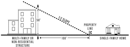
b.
In addition to the height limitations set forth above in this subsection, the following additional height limitations apply in WC Wellborn Commercial zoning:
1)
No building may exceed two (2) stories;
2)
Maximum eave height shall be twenty-four (24) feet;
3)
Maximum overall height to the peak of the roof shall be thirty-five (35) feet;
4)
Any structure with an eave height over fifteen (15) feet will be constructed to resemble a two (2) story facade;
5)
Buildings located closest to detached single-family, manufactured home park, or townhouse use or district and that are within fifty (50) feet of the property line are limited to one (1) story in height with an eave maximum of twelve (12) feet; and
6)
An eave maximum of fourteen (14) feet in height is permitted when mechanical equipment is housed within a mezzanine.
H.
Public Address Systems.
Public address systems shall not be audible to adjacent residential uses.
I.
Pedestrian Facilities.
1.
In SC Suburban Commercial and WC Wellborn Commercial districts, pedestrian connections adjacent to residential areas shall be provided as determined by the Administrator to enhance pedestrian and bicycle mobility and connectivity.
2.
In MU Mixed-Use districts, sidewalks that are a minimum of eight (8) feet wide shall be provided along all public rights-of-way, streets, and public ways adjacent to and within the development.
3.
For sites subject to the Non-Residential Architectural Standards Section below except for MU Mixed-Use districts:
a.
Public entry façades of retail buildings that exceed two hundred (200) feet in horizontal length shall place a minimum ten (10) foot sidewalk along the full frontage of its public entry façade. Tree wells and planter boxes may be placed along this walkway in a manner that does not obstruct pedestrian movement. Bike parking facilities are allowed in this area. Vehicular parking or cart storage is prohibited. Outside display is allowed but only if it does not occupy more than thirty (30) percent of this area and meets the requirements of the Outside Storage and Display Section below.
b.
A site or sites that are part of a building plot over ten (10) acres shall provide designated connections among primary buildings and pad sites for pedestrian and bicycle traffic. Locations for sidewalks and bicycle parking facilities shall be provided and shown on the site plan. Pedestrian walkways may be incorporated into the landscape strips separating parking areas only if the strip is ten (10) feet in width. Pedestrian walkways shall be a minimum of five (5) feet wide and shall connect public street sidewalks, transit stops, parking areas, and other buildings in a design that ensures safe pedestrian use.
c.
A site or sites that are part of a building plot over ten (10) acres shall provide one (1) plaza developed as an integral part of the development and not less than five hundred (500) square feet in area. This area shall not count toward the required parking islands. This area shall incorporate a minimum of three (3) of the following:
1)
Seating components;
2)
Structural or vegetative shading; *
3)
Water features; *
4)
Decorative landscape planters; *
5)
Public art; *
6)
Outdoor eating accommodations; or
7)
Hardscape elements at entrances and within the parking area such as decorative pavers, low masonry walls, clock towers, etc.
* These public areas may be located within the parking landscape areas.
(Ord. No. 2023-4453, Pt. 1(Exh. A), 8-10-2023; Ord. No. 2023-4454, Pt. 1(Exh. C), 8-10-2023)
Sec. 7.3. - Off-Street Parking Standards.
A.
Purpose.
The purpose of this Section is to balance the demand for off-street parking while avoiding the construction of excessive parking areas and to ensure that parking areas are appropriately designed for motor vehicles, bicycles, and pedestrians. The design shall be consistent with the character and development patterns identified within the Comprehensive Plan.
B.
Applicability.
1.
New Development & Redevelopment.
Any new building must comply with this Section.
2.
Renovations or Repairs.
An existing building or site may be repaired, maintained, or modernized without providing additional parking, provided there is no increase in gross floor area or improved site area.
3.
Additions and Increases in Floor Area.
a.
When an existing building, use, or site is increased in gross floor area or improved site area by up to twenty-five (25) percent cumulatively, additional parking is required for the additional floor or site area only.
b.
When an existing building, use, or site is increased in gross floor area or improved site area by more than twenty-five (25) percent cumulatively, both the existing building, use, or site and the additional floor or site area must conform to the parking requirements.
4.
Change in Use.
a.
A change in use, based on the parking tables in the Required Parking Subsection below, must comply with the parking requirements.
b.
Where the required number of parking spaces for a new use, according to the Required Parking Subsection below, is one hundred twenty-five (125) percent or less of the parking spaces required for the existing use, no additional parking spaces are required.
c.
Where required parking spaces for the new use exceed one hundred twenty-five (125) percent of the required parking spaces for the existing use, additional Ordinance Form 8-14-17 parking is only required for the difference between the current parking spaces required and the parking spaces required for the new use above the one hundred twenty-five (125) percent.
5.
Where off-street parking facilities are provided more than the minimum amounts specified by this Section, or when off-street parking facilities are provided but not required, said off-street parking facilities shall comply with the minimum requirements for parking and maneuvering space as specified in this Section.
C.
Required Parking.
In computing the number of parking spaces required, the following rules shall govern:
1.
Parking shall be provided in accordance with the table below. Where a use is not specifically listed or only a broad use category is shown, the Administrator shall categorize the use.
2.
When a property is used for a combination of uses, the parking requirements are the sum of the requirements for each use and no parking space for one use can be included in the calculation of parking requirements for any other use, except as allowed as in the Alternative Parking Plans Subsection below.
3.
Parking requirements based on square footage shall be based on the gross floor area unless otherwise stated. Service areas such as mechanical rooms, restrooms, and closets shall be included in the calculation of gross floor area for determining required parking spaces.
4.
Where fractional spaces result in computing required parking spaces, the required number of spaces must be increased to the nearest whole number.
5.
At the time of construction, redevelopment, or when an addition to the number of existing bedrooms or similar spaces is completed, all residential uses shall come into compliance with the minimum off-street parking requirements in the table below. Garages that meet minimum dimensional standards may be counted towards parking requirements.
6.
Where requirements are established based on the number of seats, such requirements shall be based on the seating capacity as determined by the Building Official.
7.
Refer to the Modifications to Required Parking Subsection below for the potential to substitute additional bicycle facilities for vehicular parking.
Notes:
(a)
For areas designated Neighborhood Conservation on the Comprehensive Plan Future Land Use & Character Map, there shall be no maximum number of parking spaces.
(b)
Unless no bicycle spaces are required, the minimum number of bicycle spaces provided shall not be less than two (2), nor will any development be required to provide more than twenty-four (24) spaces.
(c)
Overflow parking above required parking spaces may be grassed rather than paved. All unpaved spaces shall be shown on the site plan and organized for efficient traffic circulation using wheel stops and other appropriate measures as required by the Administrator.
D.
Modifications to Required Parking.
1.
For all non-residential uses in Redevelopment Areas as shown on the Comprehensive Plan Future Land Use & Character Map, no minimum number of off-street vehicular parking spaces will be required.
2.
For non-Shared Housing multi-family residential uses in Redevelopment Areas as shown on the Comprehensive Plan Future Land Use & Character Map, seventy-five (75) percent of the minimum number of off-street vehicular parking spaces will be required.
3.
For all non-residential uses, the minimum number of off-street vehicular parking spaces may be reduced by up to twenty (20) percent, according to the following:
a.
Bicycle Facilities - The Administrator may authorize reducing the number of required off-street parking spaces by up to ten (10) percent for developments or uses that make special provisions to accommodate bicyclists. Examples of accommodations include bicycle lockers, employee shower facilities, and/or dressing areas for employees.
b.
Bicycle Parking - For developments or uses that provide bicycle parking spaces above the minimum requirements, one required automobile parking space may be exchanged for each additional bicycle parking space, not to exceed ten (10) percent of the required vehicular parking spaces, provided that adequate accessibility by motor vehicle and bicycle to the subject site is maintained.
c.
Bus Transit Availability - Locations within a one thousand three hundred twenty (1,320) foot walking distance of an approved bus stop may reduce the total number of required vehicular parking spaces by ten (10) percent. Walking distance is measured from the primary entrance of the building to the bus boarding location.
d.
Tree Preservation - The Administrator may approve a reduction in the total number of required vehicular parking spaces by one space for every tree at least eight (8) inches in diameter at breast height preserved within the parking area.
e.
Structured Parking - Where parking is provided entirely in a structure on a lot, the required total number of spaces may be reduced by ten (10) percent.
4.
The Design Review Board may waive parking space requirements in the WPC Wolf Pen Creek and NG Northgate districts if the development meets the goals of the master plan for the respective district.
5.
The maximum number of off-street vehicular parking spaces may be exceeded according to the following:
a.
Additional Landscape Points - For every five (5) additional parking spaces above the maximum, one additional canopy tree of at least two hundred twenty-five (225) points as identified in the Landscaping and Tree Preservation Section below shall be planted on the development site within the parking area within landscape islands, or within ten (10) feet of the edge of the parking area.
E.
Dimensions, Access, and Location.
1.
Each off-street parking space for automobiles shall have an area of not less than nine (9) feet by twenty (20) feet and each stall shall be striped. This standard shall apply for off-street parking for all uses including single-family residential, duplexes, and townhouses. Single-family residential and townhouses are not required to stripe parking spaces.
2.
For properties designated as a Redevelopment Area on the Comprehensive Plan Future Land Use & Character Map, a new single-family structure may locate its parking, including both required and additional parking in the areas described below:
a.
Anywhere on the lot behind the structure with no limit on the size of the area;
b.
Anywhere in the side yards of the lot with no limit on the size of the area; and
c.
An area located in front of the structure not to exceed a size equivalent to fifty (50) percent of the front portion of the property. The front portion of the property is the area of the lot within the side lot lines, the front setback, and the public right-of-way line (see graphic below). The square footage of parking allowed by this calculation may be located within or outside the boundary of the area used for calculations (see graphic below). The portion of the driveway located between the front property line and the structure shall be included in the maximum parking area square footage.
Allowable Location for Parking in a Redevelopment Area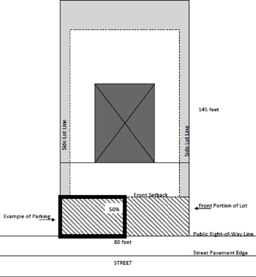
3.
For all detached single-family uses other than as set forth above, at the time of construction, reconstruction, or addition to the number of existing bedrooms, parking shall be located in the areas described below:
a.
Anywhere on the lot behind the structure with no limit on the size of the area. Parking located behind the structure shall be screened by a solid hedge wall, fence, or wall, at least six (6) feet in height. All solid hedge walls shall be one hundred (100) percent opaque. All shrubs planted for a hedge wall shall be a minimum of fifteen (15) gallons each and evergreen;
b.
Anywhere in the side yards of the lot with no limit on the size of the area; and
c.
Any area located in front of the primary structure not to exceed a size equivalent to fifty (50) percent of the front area. The front area is defined as the area of the lot within the side lot lines, the front plane of the primary structure and the public right-of-way (see graphic below). The driveway area shall be included in this calculation.
Allowable Location for Parking for Detached Single-Family Uses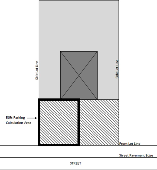
4.
When existing detached single-family parking is expanded in front of the structure, it shall not exceed a size equivalent to fifty (50) percent of the front area as described above.
5.
In the MH Middle Housing zoning district, single-family, duplexes, townhouses, and live-work units may locate parking in front of the structure as long as four (4) or fewer parking spaces are required, and the parking area does not exceed a size equivalent of fifty (50) percent of the front area as described above.
6.
In the MH Middle Housing zoning district, courtyard houses and multiplexes shall locate parking between the rear plane of the primary structure and the rear property line.
7.
An eighteen (18) foot paved space (ninety (90) degree only) may be utilized where the space abuts a landscaped island with a minimum depth of four (4) feet. An eighteen (18) foot space may also be used when adjacent to a sidewalk provided that the minimum width of the sidewalk is six (6) feet. This standard shall also apply to off- street parking for single-family residential, duplexes, and townhouses.
8.
The width of an alley may be assumed to be a portion of the maneuvering space requirement for off-street parking facilities located adjacent to a public alley. This standard shall apply for off-street parking for all uses including single-family residential, duplexes, townhouses, and small and medium multiplexes.
9.
Each parking space intended for use by the handicapped shall be designed in accordance with the standards of the Texas Architectural Barriers Act (TABA) administered by the Texas Department of License and Regulation.
10.
Each parking space and the maneuvering area thereto shall be located entirely within the boundaries of the building plot except where shared parking is approved by the City.
11.
All parking spaces, aisles, and modules shall meet the minimum requirements, as shown in the following table. All dimensions are measured from face of curb to face of curb or wall to wall.
Parking Space and Aisle Dimensions Graphic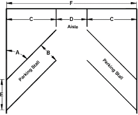
12.
Parking lots located within fifteen (15) feet of a public right-of-way shall have a maximum of seven (7) contiguous spaces separated by an eighteen (18) by twenty (20) foot landscaped island.
13.
All parking lots and drive aisles shall be setback a minimum of six (6) feet from any public right-of-way or public way. In sites subject to the Non-Residential Architectural Standards Section below, where parking or drive aisles are located between the building and the public right-of-way or public way, there shall be a minimum setback of ten (10) feet from the public right-of-way or public way to the parking area or drive aisle.
14.
In SC Suburban Commercial and WC Wellborn Commercial districts, parking shall not be located between the structure and an adjacent single-family use or zoning district. Drive aisles and service aisles shall be permitted between the structures and an adjacent single-family use or zoning district.
15.
Parking is discouraged along entrance drives and should be limited on major circulation aisles of large developments and major retail centers.
16.
The Design Review Board may waive parking lot dimension requirements in the WPC Wolf Pen Creek and NG Northgate districts if the development meets the goals of the master plan for the respective district.
F.
Bicycle Parking Placement and Design.
1.
Facilities shall be separated from motor vehicle parking to protect both bicycles and vehicles from accidental damage and shall be sufficiently separated from building or other walls, landscaping, or other features to allow for ease and encouragement of use. This separation shall be a minimum of three (3) feet.
2.
Bicycle Corrals: In areas with limited sidewalk space and frequent bicycle activity, bicycle parking may be provided in bicycle corrals located in the vehicular parking area adjacent to a curb. The design will be considered as the context dictates as approved by the Administrator. Bicycle corrals shall be designed to distinguish and define the parking stall they inhabit for visibility and safety purposes. The corral should be well defined, such as generally surrounded by a painted white box on the pavement with flexible vertical delineators and a wheel stop where vehicles in adjacent parking spots might back into the corral. See the example image below:
Example of a Bicycle Corral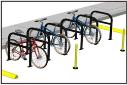
3.
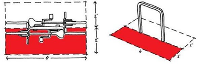
Where bicycle facilities are provided for two (2) bicycles, a standard footprint that is at least four (4) feet wide by six (6) feet long shall be used.
Examples of Bicycle Parking Footprint and Dimensions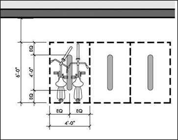
4.
Facilities shall be placed in clearly designated, safe, and convenient locations and such that no primary building entrance is further than one hundred fifty (150) feet from a bicycle facility.
a.
At least twenty-five (25) percent of the required spaces need to be outside of any enclosed buildings or structures and available to visitors anytime of the day.
b.
If providing bike parking internal to a building or structure, appropriate signage is needed to provide clear direction on how to find the bicycle parking area.
5.
Bicycles may be permitted on sidewalks or other paved surfaces provided that the bicycles do not block or interfere with pedestrian or vehicular traffic.
6.
Bicycle racks shall be constructed to enable the user to secure a bicycle by locking the frame and one (1) wheel of each bicycle parked therein. Bicycle racks must be easily usable with both U-locks and cable locks and support the bicycle frame at two (2) points. Racks shall be anchored securely to the ground and allow for a bicycle to be parked on both sides.
G.
Landscape Islands.
1.
End Islands.
a.
A raised island, encompassing not less than one hundred eighty (180) square feet in area, shall be located at both ends of every interior and peripheral parking row, regardless of the length of the row. End islands may have sidewalks through them. Examples of interior and peripheral parking are shown in the figure below.
Landscaped End Islands Graphic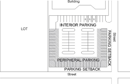
b.
All end islands must be raised at least six (6) inches and curbed, with the majority of the area of each island planted or treated with enhanced paving. The soil within the planted area shall not be compacted or stabilized and shall be contiguous with the soil at the natural grade.
2.
Interior Islands.
a.
All interior islands shall be evenly distributed throughout the interior of the parking area.
b.
For every fifteen (15) interior parking spaces, one hundred eighty (180) square feet of landscaping must be provided somewhere in the interior rows of the parking lot. Interior island areas may be grouped and configured as desired provided that circulation aisles remain clear, and the minimum island area is not less than one hundred eighty (180) square feet. Interior islands may have sidewalks through them.
c.
In the MH Middle Housing zoning district, for every five (5) parking spaces located off alleys or in shared parking areas, ninety (90) square feet of landscaping must be provided somewhere along the parking row in a raised interior island. Islands should be spaced evenly along the property, or properties, that have a shared parking agreement. Interior islands may have sidewalks through them. These sidewalks shall count as part of the landscaping.
d.
End island areas that exceed the minimum required may be counted toward the interior parking island requirement.
e.
All interior islands must be raised at least six (6) inches and curbed, with the majority of the area of each island planted or treated with enhanced paving. The soil within the planted area shall not be compacted or stabilized and shall be contiguous with the soil at the natural grade.
H.
Requirements Apply to All Parking Areas.
Every parcel of land hereafter used as a public parking area, including commercial parking lots, visitor parking areas for single-family and townhouse uses, and parcels used for open-air sales lots, shall be developed and maintained in accordance with the requirements in this Section and as described in the City of College Station Site Design Standards. The requirements in this Section do not apply to overflow parking for churches, nor to temporary overflow parking for City events and temporary parking for special events.
I.
Surfacing.
1.
General.
All surfacing of off-street parking areas shall be constructed of either asphalt or concrete as described in the City of College Station Site Design Standards. Alternatives to the standards may be approved by the Administrator if it is demonstrated that the materials and design are equal or superior to the requirements in the Standards. All off-street parking areas shall be graded to drain and be maintained to dispose of surface water accumulated within the area. Parking spaces shall be arranged and marked to provide for orderly and safe parking of vehicles.
2.
Non-Public, All-Weather Drive Surfaces.
Temporary or permanent drive surfaces required for emergency access or turnaround for emergency vehicles must be constructed to function under all weather conditions. To accommodate a project during construction, phasing, or permanent installation, drive surfaces that do not meet the requirements for permanent pavement surfaces may be allowed at the discretion of the Administrator for the specific conditions stated below:
a.
Temporary All-Weather Surface (During Construction).
A structure under construction must be accessible by an all-weather drive surface as specified in the City of College Station Site Design Standards. This temporary all-weather surface must be reworked or replaced to meet the permanent pavement standard as described in the City of College Station Site Design Standards prior to the issuance of a certificate of occupancy.
b.
Semi-Permanent All-Weather Surface (During Phasing).
During the phasing of a large project, emergency access points and turnarounds often must be added as a temporary measure until additional phases are constructed. These emergency access areas may consist of permanent pavement surfaces as specified in the City of College Station Site Design Standards. When the additional phase is constructed, these areas must be removed or reworked to meet the permanent pavement standards as described in the City of College Station Site Design Standards.
c.
Permanent Surfaces.
1)
All-Weather Surface (Permanent).
In some development scenarios, an emergency access point or turnaround must be constructed to meet emergency access purposes and is not required for public traffic, service vehicles or sanitation vehicles. In these cases, the area required for emergency access only may meet the permanent pavement standards as specified in the City of College Station Site Design Standards.
2)
Permeable Surface.
a)
The use of porous materials (such as permeable concrete and pavers) to mitigate stormwater sheeting and pooling of water may be used in off-street parking areas if the material meets vehicular loading standards and is approved by the Administrator.
b)
Fire lanes may be constructed of porous materials such as permeable concrete and pavers to mitigate stormwater sheeting and pooling of water, so long as it is demonstrated that the permeable surface can obtain sufficient land and compaction ratings for its application as approved by the City of College Station Fire and Solid Waste Departments.
c)
Single-family and townhouse visitor parking areas, as required in Single-Family Residential Parking Requirements for Platting Subsection below, may also be constructed of porous materials such as permeable concrete and pavers to mitigate stormwater sheeting and pooling of water.
d)
Permeable surfaces approved as provided above shall be maintained in accordance with industry standards and to achieve mitigation of stormwater sheeting and pooling of water. Failure to maintain permeable surfaces as required herein shall constitute a violation of this Section of the UDO for which penalty provisions may be involved.
J.
Curbing Required.
1.
General.
The perimeter of all paved surfaces shall be curbed as described in the City of College Station Site Design Standards. Unless otherwise required by this Section, curbs may be omitted where drive aisles or parking spaces are located adjacent to a building if bollards or other protective devices are installed to protect pedestrian areas.
Alternatives to the standards may be approved by the Administrator if it is demonstrated that the materials and design are equal or superior to the requirements in the Standards.
2.
Temporary Curbing.
A temporary curb may be permitted in lieu of the minimum standard stated in the City of College Station Site Design Standards, at the discretion of the Administrator, when a project is phased in such a way that a permanent, monolithic curb may preclude the development of future phases or limit access to a recorded private or public access easement adjoining properties. Wheel stops shall not be permitted as temporary curbing. Temporary curbing must have the appearance of permanent curbing and shall be temporarily attached to the pavement surfacing below and meet the minimum standards for dowelled-in curbs as described in the City of College Station Site Design Standards.
K.
Drive-Thru Facility Queuing Requirements.
1.
Minimum Number of Spaces.
Drive-thru queuing spaces shall be provided as indicated in the following table:
2.
Design and Layout.
Queuing spaces or queuing areas shall be designed in accordance with the following criteria:
a.
Queue spaces or queuing areas may not interfere with parking spaces, parking aisles, loading areas, internal circulation, or driveway access;
b.
Each queue space shall consist of a rectangular area not less than ten (10) feet wide and eighteen and one-half (18.5) feet long with a vertical clearance as specified in the International Building Code, as adopted;
c.
Queue spaces are not interchangeable with parking spaces except for the following uses where the space providing services may count toward the parking requirement: bank teller, car wash, and oil-change station;
d.
A twelve (12) foot bypass lane shall be required adjacent to queue lines to allow vehicles an opportunity to circumvent the drive-thru activity and exit the site;
e.
Queue areas and drive-thru facilities shall be clearly identified with the appropriate signing and marking; and
f.
Spaces within a car wash facility or drive-thru oil change station may be counted toward the queuing requirement.
L.
Alternative Parking Plans.
1.
Scope.
An alternative parking plan represents a proposal to meet vehicle parking and transportation access needs by means other than providing parking spaces on-site in accordance with the ratios established in the Required Parking Subsection above.
2.
Applicability.
Applicants who wish to provide fewer or more off-street parking spaces than allowed above shall be required to secure approval of an alternative parking plan, in accordance with the standards of this Section. The Administrator may require that an alternative parking plan be submitted in cases where the Administrator deems the listed standard to be inappropriate based on the unique nature of the use or in cases where the applicable standard is unclear.
3.
Contents.
Alternative parking plans shall be submitted in a form established by the Administrator and made available to the public. At a minimum, such plans shall detail the type of alternative proposed and the rationale for such a proposal.
4.
Review and Approval Procedure.
The Administrator shall be authorized to approve alternative parking plans. Appeals of the Administrator's decision may be made to the Planning and Zoning Commission.
5.
Recording.
An attested copy of an approved alternative parking plan shall be submitted to the Office of the County Clerk for recordation on forms made available in the Planning and Development Services Department. Proof of recordation of the agreement shall be presented to the Administrator prior to the issuance of a building permit. An approved alternative parking plan may be amended by the Administrator.
6.
Eligible Alternatives.
Several specific parking and access alternatives are described below. The Administrator shall, however, be authorized to consider and approve any alternative to providing off-street parking spaces on the site of the subject development if the applicant demonstrates that the proposed plan shall result in a better situation with respect to surrounding neighborhoods, City-wide traffic circulation, and urban design than would strict compliance with otherwise applicable off-street parking standards.
a.
Demand-Based Parking.
When the developer of a non-residential or multi-family development can demonstrate that such development will require fewer parking spaces than required by the standards of this Section, the Administrator may permit a reduction in the number of required parking spaces for the development. Such a reduction in parking spaces shall be justified by the applicant through the development of a parking study prepared by a professional engineer or transportation planner and submitted to the Administrator. Single-family, duplex, and townhouse developments are not eligible for the demand-based parking option.
b.
Shared Parking.
The Administrator may authorize a reduction in the number of required off-street parking spaces for multiple-use developments or for uses that are located near one another and that have different peak parking demands or different operating hours. Shared parking shall be subject to the following standards:
1)
Location.
Shared off-street parking spaces shall be located no farther than five hundred (500) feet from the building site. The Administrator may waive this distance limitation if adequate assurances are offered regarding the usability of the shared lot and the principal use (such as the operation of a van or shuttle service, etc.);
2)
Zoning Classification.
Shared-parking areas shall be considered accessory uses of principal uses that the parking spaces are intended to serve. Shared parking areas shall require the same or a more intensive zoning classification than that required for the most intensive of the uses served by the shared parking area;
3)
Required Study and Analysis.
The applicant shall submit a shared parking analysis to the Administrator that clearly demonstrates the feasibility of shared parking. The study shall be provided in a form established by the Administrator and made available to the public. It shall address, at a minimum, the size and type of the proposed development, the composition of tenants, the anticipated rate of parking turnover, and the anticipated peak parking and traffic loads for all uses that shall be sharing off-street parking spaces. The Administrator shall have the authority to require a revised study and analysis should conditions change that may result in a change in site parking conditions;
4)
Shared Parking Agreement.
A shared parking plan shall be enforced through a written agreement among the owners of record. An attested copy of the agreement shall be submitted to the Office of the County Clerk for recordation on forms made available in the Planning and Development Services Department. Proof of recordation of the agreement shall be presented to the Administrator prior to issuance of a building permit. If a shared parking agreement is revoked by the parties to the agreement, either off-street parking must be provided pursuant to this Section or an alternative parking plan must be approved by the Administrator; and
5)
Revocation.
Failure to comply with the shared parking provisions of this Section shall constitute a violation of this UDO and shall specifically be cause for the revocation of a certificate of occupancy or building permit.
c.
Off-Site Parking.
The Administrator may permit all or a portion of the required off-street parking spaces to be located on a remote and separate lot from the lot on which the principal use is located, subject to the standards of this Section.
1)
Location.
No off-site parking space shall be located more than five hundred (500) feet from the building site. The Administrator may waive this distance limitation if adequate assurances are offered regarding the usability of the off-site lot and the principal use (such as the operation of a van or shuttle service, etc.).
2)
Zoning Classification.
Off-site parking areas shall be considered accessory uses of principal uses that the parking spaces are intended to serve. Off-site parking areas shall require the same or a more intensive zoning classification than that required for the use served;
3)
Off-Site Parking Agreement.
If an off-site parking area is not under the same ownership as the principal use served, a written agreement among the owners of record shall be required. An attested copy of the agreement between the owners of record shall be submitted to the Office of the County Clerk for recordation on forms made available in the Planning and Development Services Department. Proof of recordation of the agreement shall be presented to the Administrator prior to the issuance of a building permit. If an off-site parking agreement is revoked by the parties to the agreement, either off-street parking must be provided on-site pursuant to this Section, or an alternative parking plan must be approved by the Administrator.
(Ord. No. 2023-4453, Pt. 1(Exh. A), 8-10-2023; Ord. No. 2023-4454, Pt. 1(Exh. D), 8-10-2023; Ord. No. 2023-4467, Pt. 1(Exh. B), 9-14-2023)
Sec. 7.4. - Access Management and Circulation.
A.
Location of Existing and Planned Multi-Modal Routes.
Any proposed development shall take into account the location of existing and planned multi-modal routes (i.e., bikeways, pedestrian ways, and transit routes) and provide pedestrian and/or vehicular connections to the route(s) within or adjacent to the development.
B.
Easements.
1.
Street Access.
No use shall be permitted to take direct access to a street except as allowed in this Section.
a.
Local Streets.
All residential uses and associated visitor parking areas may take direct access to local streets. Residential visitor parking areas may take direct access to local streets via a driveway; however, no backing maneuvers onto local streets shall be allowed. Non-residential uses shall not take direct access to local streets, provided that any lot located within a non-residential subdivision or any parcel adjacent to a street within a non-residential subdivision may take direct access to the local street internal to the subdivision, and provided that any corner lot abutting a local street and an arterial or collector street or freeway/expressway may take access to the local street if such access is required by the highway governmental authority having jurisdiction.
b.
Minor Collector Streets.
No single-family dwelling, duplex, or townhouse shall take direct access to minor collector streets except when permitted by Article 8, Subdivision Design and Improvements of this UDO. Residential visitor parking areas may take direct access to minor collector streets via a driveway; however, no backing maneuvers onto local streets shall be allowed.
c.
Major Collector Streets.
No single-family dwelling, duplex, townhouse, or multiplex shall take direct access to major collector streets. Residential visitor parking areas may take direct access to major collector streets via a driveway; however, no backing maneuvers onto local streets shall be allowed.
d.
Arterial Streets.
No single-family dwelling, duplex, townhouse, or multiplex shall take direct access to arterial streets.
e.
Shared Driveways.
The Development Engineer may require a shared driveway at the time of platting, development, or redevelopment of the affected lots.
When MH Middle Housing lots take access from a public street to provide rear parking, one (1) driveway shall be allowed for every two (2) lots, unless a rear alley is provided. The Administrator may approve up to three (3) lots to take access from a single driveway for rear parking if a shared access easement is provided. See the example diagram below:
MH Middle Housing Shared Driveways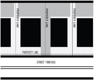
2.
Cross-Access Easements.
a.
If a parcel is to be developed for any non-residential land use, a cross-access easement shall be provided by the property owner to adjoining properties that front on the same street and that are, or may be, developed as non-residential land uses.
b.
Cross-access easements shall be situated parallel to the street right-of-way line abutting both parcels. The property owner shall maintain access easements.
c.
The property owner shall provide appropriate documentation of a good faith effort to extend the access easement through all immediately abutting properties. If such an effort fails, the portion of the easement on the subject site shall be developed and designed to ensure future connection to the neighboring properties.
d.
Where a cross-access easement is granted, no permanent structures or parking that would interfere with the proposed access shall be permitted in the easement. Some improvements such as medians and parking islands may be constructed within an access easement if it has been demonstrated that adequate circulation and cross access have been accomplished and that all applicable standards of this UDO have been met.
e.
The Development Engineer may waive the requirement for an easement of access required above in those cases where unusual topography or site conditions would render such an easement of no useable benefit to adjoining properties.
f.
The Development Engineer may approve the vacation of an easement of access in those cases where adjoining parcels are subsequently developed with a residential use.
C.
Driveway Access Location and Design.
1.
General.
a.
It shall be unlawful for any person to cut, break, or remove any curb or install a driveway along a street except as herein authorized. Openings in the curb may be approved by the Development Engineer for the purposes of drainage.
b.
It shall be unlawful for any person to construct, alter, extend, permit, or cause to be constructed, altered, or extended any driveway approach which can be used only as a parking space or area between the curb and private property.
c.
This Section shall be deemed to be supplemental to other Sections regulating the use of public property, and in case of conflict, this Section shall govern.
d.
Adequate sight distance shall be provided for a passenger motor vehicle making a left or right turn exiting from a driveway. This determination shall be made by the Development Engineer.
e.
The specifications and guidelines set forth in this UDO are to be applied to driveways providing access to commercial and multi-family developments and visitor parking areas for single-family and townhouse uses. Single-family and duplex residential driveways are excluded from this policy unless otherwise indicated.
f.
As determined by the Development Engineer, engineering judgment shall override the required dimensions set forth in this Section if warranted by specific traffic conditions.
2.
Location of Driveway Access.
a.
In determining the location of driveway access, the Development Engineer shall consider:
1)
The characteristics of the proposed use;
2)
The existing traffic flow conditions and the future traffic demand anticipated on the development and the adjacent street system;
3)
The location of the property;
4)
The size of the property;
5)
The orientation of structures on the site;
6)
The number of driveways needed to accommodate anticipated traffic;
7)
The number and location of driveways on existing adjacent and opposite properties;
8)
The location and carrying capacity of intersections;
9)
The proper geometric design of driveways;
10)
The spacing between opposite and adjacent driveways;
11)
The internal circulation between driveways; and
12)
The speed of the adjacent roadway.
b.
Driveway access to arterials shall not be permitted for parking or loading areas that require backing maneuvers in a public street right-of-way. Driveway access to collector streets for commercial or multi-family developments shall not be permitted for parking or loading areas that require backing maneuvers in a public street right-of-way.
c.
One (1) curb cut shall be allowed for access to single-family and duplex residential tracts. Alternative access configurations, including circle driveways, may be allowed upon approval by the Development Engineer.
d.
For corner residential lots, if a backing maneuver would be required, the side access driveway connection to the street shall be subject to rear building setback requirements with a maximum of twenty (20) feet.
e.
No cuts through a left-turn reservoir of a median shall be permitted, to provide for left-turn movements to driveway approaches.
f.
Driveways in right-turn lane transition areas shall not be permitted. The right-turn lane transition area is defined as the taper and deceleration/acceleration length.
g.
When a commercial or multi-family development abuts more than one (1) public street, access to each abutting street may be allowed only if the following criteria are met:
1)
It is demonstrated that such access is required to adequately serve driveway volumes and will not be detrimental or unsafe to traffic operations on public streets. The Development Engineer may require the submittal of a traffic study that demonstrates that such access is required.
2)
The minimum requirements for corner clearance for commercial or multi-family driveways are met.
3.
Spacing of Driveway Access.
a.
Application of the driveway access location and design standards requires identification of the functional classification of the street on which access is requested and then applying the appropriate spacing requirements. The City of College Station streets are classified as follows and defined in Article 11, Definitions of this UDO:
1)
Major arterial;
2)
Minor arterial;
3)
Collector; and
4)
Local street.
b.
Major arterial, minor arterial, and collector streets in the City of College Station are indicated on the Comprehensive Plan Functional Classification & Context Class Map. The functional classification of any street in the city not indicated as an arterial or collector street on this plan shall be determined using the functional street classification defined by the current edition of the American Association of State Highway and Transportation Officials' (AASHTO) A Policy on Geometric Design of Highways and Streets.
c.
Driveway access spacing shall be measured from the centerline of the proposed driveway pavement to the nearest edge of the roadway of the adjacent or opposite driveway or street as indicated in the illustration below.
Driveway Spacing Diagram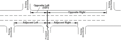
d.
A minimum of one hundred twenty-five (125) feet shall be required for opposite left driveways for all street classifications.
e.
If the centerline of an opposite drive is less than fifteen (15) feet from the centerline of the proposed drive, the drives form an intersection, and the minimum spacing requirements shall apply for the closest drive.
f.
Spacing of Adjacent Driveways.
1)
Adjacent drives shall be located no closer than the spacing requirement in the table below. The Development Engineer or their designee may allow adjacent driveway spacing less than the spacing requirement below if it is determined that favorable conditions exist under peak traffic conditions.
2)
On divided streets with raised or depressed medians, it is the City's policy to align other streets, alleys, private roads, and driveways on either side of the median openings. Therefore, when locating such an intersection, it shall be assumed that this type of intersection will exist at median openings, and other intersections between median openings should be spaced accordingly. The Development Engineer may waive this requirement if an existing condition precludes access at a median opening.
3)
Residential alleys may be allowed on major collectors, minor collectors, and local streets at spacings less than those shown in the table below with the approval of the Development Engineer.
* This standard does not apply to single-family residential, duplexes, or townhomes.
g.
Spacing of Opposite Right Driveways.
1)
Opposite right driveways shall be located no closer than the standard requirements of the table below. The Development Engineer may allow opposite right spacing below the standard spacing requirement if it is determined that favorable conditions exist under peak traffic conditions.
2)
Additional opposite right spacing over and above that set forth in the table below may be required if it is determined by the Development Engineer that there is insufficient left turn queue storage or weave maneuver area between the opposite right and proposed driveway. This determination shall be made under peak traffic conditions.
3)
On roadways that include raised or depressed medians prohibiting left-turning movements, this standard shall not apply.
4)
Residential alleys may be allowed on major collectors, minor collectors, and local streets at spacings less than those shown in the table below with the approval of the Development Engineer.
* This standard does not apply to single-family residential, duplexes, or townhomes.
4.
Freeway/Expressway Frontage Road Access and Location Requirements.
a.
Driveways shall be located in accordance with the most recent version of the Access Management Manual as administered by the Texas Department of Transportation (TxDOT).
b.
These guidelines apply to existing and planned interchanges.
c.
In addition to ramp spacing, driveways on frontage roads under the jurisdiction of the Texas Department of Transportation shall also meet the other requirements of this Section as major arterial streets.
5.
Corner Clearance.
a.
No residential driveway approach shall be constructed within the site distance triangle detailed in the Visibility at Intersections in all Districts Subsection of the General Provisions Section above.
b.
At intersections of arterials with channelized right turn lanes with yield control, a corner clearance distance in accordance with those set forth in the illustration below shall be required for the first downstream driveway when adjacent spacing requirements cannot be met due to lack of frontage, and all means to acquire shared access drives or cross-access easements have been exhausted. This distance shall be measured from the channelized median to the nearest edge of the proposed driveway as indicated in the illustration.
Channelized Right-Turn Lane Guideline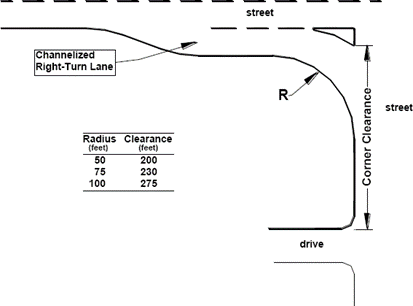
c.
When the requirements of the previous two (2) tables cannot be met due to lack of frontage and all means to acquire shared access driveways or cross-access easements have been exhausted, no commercial driveway approach may be located closer to the corner than seventy-five (75) feet on collector streets, one hundred (100) feet on minor arterials, and one hundred twenty (120) feet for major arterials. This measurement shall be taken from the intersection of property lines at the corner. When these requirements cannot be met due to a lack of frontage, the driveway may be located such that the radius will begin at the farthest property line.
6.
Shared Access.
a.
A joint private access easement may be required between adjacent lots fronting arterials and collectors to minimize the total number of access points along those streets and to facilitate traffic flow between lots. The location and dimensions of said easement shall be determined by the Development Engineer.
b.
A private cross-access easement may be required across any lot fronting on an arterial or collector street to minimize the number of access points and facilitate access between and across individual lots. The location and dimension of said easement shall be determined by the Development Engineer.
c.
A joint private access easement is required between adjacent lots that share driveways in the MH Middle Housing zoning district.
7.
Geometric Design of Driveway Access.
a.
All driveways shall meet the Bryan/College Station Unified Design Guidelines.
b.
Curb cuts for driveways shall not be permitted in the curb return of an intersection.
c.
The curb return radii for driveways intersecting at right angles with the roadway and without a deceleration lane shall be as follows:
1)
Curb return radii for residential (single-family, townhouse, duplex, and multiplex) driveways shall be between three (3) feet and ten (10) feet. Flare-type residential driveways must also adhere to these dimensional criteria.
2)
Curb return radii for commercial and multi-family driveways shall vary between twenty-five (25) feet and thirty (30) feet. When special traffic conditions exist, the Administrator may require larger curb return radii of up to fifty (50) feet.
3)
Curb return radii for driveway types not included above shall be determined by the Administrator.
d.
The maximum width of the residential driveway approach, measured at the property line, shall not exceed twenty-five (25) feet in width, while the minimum width shall not be less than twelve (12) feet.
e.
The maximum width of commercial, multiplex, and multi-family driveway approaches for two-way operation shall not exceed thirty-six (36) feet, except that the Administrator may issue permits for driveway approaches greater than thirty-six (36) feet in width on major streets to handle special traffic conditions. The minimum width of commercial and multi-family driveway approaches for two-way operation shall be not less than twenty-four (24) feet.
f.
The combination of two (2) driveways for residential circular drives shall not exceed twenty-five (25) feet.
g.
The angle of the driveway approach shall be approximately ninety (90) degrees for two-way drives and between forty-five (45) degrees and ninety (90) degrees for one-way drives.
h.
A minimum driveway throat length shall be required to allow traffic entering the site to be stored on-site, avoiding a queue of traffic onto the adjacent roadway causing delays to the through traffic stream. The driveway throat length shall be defined as the distance from the street to the first point of conflict in the driveway. Minimum driveway throat depths are provided in the figure below. For more intense uses (i.e., retail shopping centers) a minimum throat depth of one hundred thirty (130) feet will be required.
Throat Depth Requirements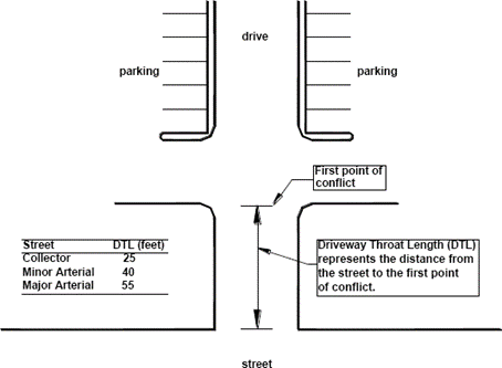
i.
Gated residential communities shall use the Private Streets and Gating of Roadways Subsection of the General Requirements and Minimum Standards of Design for Subdivisions within the City Limits Section of Article 8, Subdivision Design and Improvements of this UDO as a guideline for throat depth and entry designs.
j.
For the benefit of traffic safety and flow on collector and arterial streets, access points may be required to be designed to prohibit certain types of turning movements. Driveways not meeting the standard opposite and adjacent spacing guidelines may be designed for limited access by the addition of a median to the driveway.
k.
For the benefit of traffic safety and flow on collector and arterial streets, auxiliary lanes may be required at driveways where high turning volumes are expected.
l.
A right-turn deceleration lane with storage length plus taper may be required for any access with a projected peak hour right-turn ingress turning volume greater than fifty (50) vehicles per hour. If the posted speed is greater than forty (40) miles per hour, a right-turn deceleration lane and taper may be required for any access with a projected peak hour ingress turning volume greater than twenty-five (25) vehicles per hour.
m.
Driveways shall be constructed to avoid altering the drainage patterns of the street and adjoining property.
n.
Driveways shall be constructed to provide a crossing path within the right-of-way that meets the minimum Texas Accessibility Standards.
o.
A right-turn acceleration lane with taper may be required for any access with a projected peak hour right-turning volume greater than fifty (50) vehicles per hour when the posted speed on the roadway is greater than forty (40) miles per hour. The design of right-turn deceleration lanes shall be in accordance with the current edition of the AASHTO A Policy on Geometric Design of Highways and Streets on auxiliary lanes.
p.
The spacing requirements for driveways not meeting the specifications in the Driveway Access Location and Design Subsection above may be lessened or waived if auxiliary lanes are used.
q.
Access points on arterial and collector streets may be required to be signalized, to provide safe and efficient traffic flow. A development may be responsible for all or part of any right-of-way dedication, design, hardware, or construction costs of a traffic signal if it is determined that the signal is necessitated by the traffic generated from the development. The procedures for signal installation and the percent of financial participation required of the development in the installation of the signal shall be in accordance with criteria set forth in the City's Traffic Signal Policy.
(Ord. No. 2023-4453, Pt. 1(Exh. A), 8-10-2023; Ord. No. 2023-4467, Pt. 1(Exh. C), 9-14-2023)
Sec. 7.5. - Signs.
A.
Purpose.
The purpose of this Section is to establish clear and unambiguous regulations pertaining to signs in the City of College Station and to promote an attractive community, foster traffic safety, and enhance the effective communication and exchange of ideas and commercial information.
B.
Applicability.
The City Council recognizes that signs are necessary for visual communication for public convenience and that businesses and other activities have the right to identify themselves by using signs that are incidental to the use on the premises where the signs are located. The Council herein seeks to provide a reasonable balance between the right of a person to identify their business or activity, and the rights of the public to be protected against visual discord and safety hazards that result from the unrestricted proliferation, location, and construction of signs. This Section will ensure that signs are compatible with adjacent land uses and with the total visual environment of the community, in accordance with the Comprehensive Plan.
1.
The City Council finds that the rights of residents of this City to fully exercise their rights of free speech by the use of signs containing non-commercial messages are subject to minimum regulation regarding structural safety and setbacks for purposes of traffic protection. The City Council seeks herein to provide for the reasonably prompt removal and disposal of such signs after they have served their purpose, and yet to avoid any interference with First Amendment freedoms, especially as to persons who are of limited financial means.
2.
The City Council finds that instances may occur in the application of this Section where strict enforcement would deprive a person of the reasonable use of a sign, or the reasonable utilization of a sign in connection with other related property rights, and herein provides for such persons to have the right to seek variances from the requirements of this UDO for good cause. The City Council finds that it is imperative that enforcement officials apply this Section as it is written, in the interest of equality and fair and impartial application to all persons, and that the procedures to appeal a denial of a sign permit to the ZBA shall remain the sole administrative means to obtain any exception to the terms hereof.
3.
The regulations of this Section shall apply to developments within the zoning districts listed in the Summary of Permitted Signs Subsection below. These regulations only apply to special districts within the City of College Station in accordance with the following Sections:
a.
The WPC Wolf Pen Creek Subsection of the Design Districts Section of Article 5, District Purpose Statements and Supplemental Standards of this UDO;
b.
The NG Northgate Districts Subsection of the Design Districts Section of Article 5, District Purpose Statements and Supplemental Standards of this UDO; and
c.
The OV Corridor Overlay Subsection of the Overlay Districts Section of Article 5, District Purpose Statements and Supplemental Standards of this UDO.
C.
Summary of Permitted Signs.
The following signs are permitted in the relevant zoning districts of the City:
Notes:
(a)
Apartment signage is permitted in the MU Mixed-Use district as attached signs only.
(b)
Except as provided for in the Signs for Permitted Non-Residential Uses in Residential or Rural Districts Subsection below.
(c)
One (1) freestanding sign shall be allowed in the O Office zoning district only when the building plot has a minimum of two (2) acres.
(d)
Freestanding signs are permitted for building plots with freeway/expressway frontage only. See the Freestanding Commercial Signs Subsection below for additional standards.
D.
Prohibited Signs.
The following signs shall be prohibited in the City of College Station:
1.
Portable and trailer signs, and temporary freestanding signs;
2.
Signs painted on rooftops;
3.
Inflated signs, pennants, wind-driven devices (excluding flags), tethered balloons, and/or any gas-filled objects for advertisement, decoration, or otherwise, except as permitted in the Grand Opening Signs and Special Event Signs Subsections below;
4.
Vehicle signs except as permitted in the Vehicle Signs Subsection below;
5.
Flags containing copy or logo, excluding the flags of any country, state, city, or school, are prohibited in residential zones and on any residentially developed property (except when flags are used as subdivision signs);
6.
Signs and displays with flashing, blinking, or traveling lights, or erratic or other moving parts, including electronic message boards that change more than once per fifteen (15) minutes, either internal or external to the premise, and oriented and visible to vehicular traffic. Time and temperature signs are permissible if the maximum area and setback requirements of this Section are met and if the commercial information or content of such signs are restricted to no more than eight (8) square feet;
7.
Signs containing manual change copy which are greater than thirty (30) percent of the allowable sign area;
8.
Any signs that are intended to or designed to resemble traffic signs or signals and bear such words as "stop", "slow", "caution", "danger", "warning", or other words that are erected for purposes other than actual traffic control or warning to the public;
9.
Any sign located within the site triangle in any district as stated in the Visibility at Intersections in all Districts Subsection of the General Provisions Section above. This does not include traffic control or directional signs;
10.
Any sign that emits sound, odor, or visible matter; and
11.
Off-premises signs, including commercial and non-commercial billboards.
E.
Exempt Signs.
The following signs are exempt from the requirements of this UDO:
1.
Signs that are not easily identified from beyond the boundaries of the lot or parcel on which they are located or from any public thoroughfare or traveled right-of-way, as determined by the Administrator. Such signs are not exempt from the safety regulations contained herein and in the International Building and Electrical Codes, as adopted;
2.
Official notices posted by government officials in the performance of their duties, including but not limited to signs controlling traffic, regulating public conduct, identifying streets, or warning of danger. Bulletin boards or identification signs accessory to government buildings or other buildings are subject to the provisions of this UDO;
3.
Signs related to a primary or secondary educational facility, except that such signs shall adhere to the limitations of the Prohibited Signs Subsection above;
4.
Temporary signs erected by private property owners for the purpose of warning of a dangerous defect, condition, or another hazard to the public;
5.
Non-commercial signs on private property or works of art that in no way identify or advertise a product or business, or by their location and placement impede traffic safety, except as stated in the Non-Commercial and Political Signs Subsection below;
6.
Temporary decorations or displays if they are clearly incidental to and are customarily and commonly associated with any national, local, or religious celebration;
7.
Temporary or permanent signs erected by public utilities or construction companies to warn of the location of pipelines, electrical conduits, or other dangers or conditions in public rights-of-way;
8.
Non-commercial signs carried by a person and not set or affixed to the ground that in no way identify or advertise a product or business, or by their location and placement impede traffic safety;
9.
Commercial signs carried by a person and not set on or affixed to the ground, provided that the sign is temporary, on-premises, and not used by the person on the premises for more than three (3) consecutive days, more than four (4) times per calendar year;
10.
Outdoor advertising display signs for sponsors of charitable events held on public properties. These signs may be displayed for the duration of the event or not more than three (3) days with the approval of the Administrator;
11.
Flags used as political symbols;
12.
Special district identification signs as defined by the Defined Terms Section of Article 11, Definitions that in no way advertise a product or a business, or by their location and placement impede traffic safety. Special district identification signs must be approved by the appropriate development review body in accordance with Article 2, Development Review Bodies of this UDO;
13.
On-premises and/or off-premises signs where there has been a resolution adopted by the City of College Station or an executed contract with the City of College Station and the display of the signs is for designated locations, a specified period of time, and:
a.
Promotes a positive image of the City of College Station for the attraction of business or tourism;
b.
Depict an accomplishment of an individual or group; or
c.
Creates a positive community spirit.
14.
Temporary signs erected for a neighborhood event sponsored by a neighborhood group that is registered with the City of College Station provided that the signage is:
a.
Located within the perimeter of the neighborhood;
b.
Provides the name of the association sponsoring the event on the sign;
c.
In good repair;
d.
Allowed up to fourteen (14) days prior to the event; and
e.
Removed within twenty-four (24) hours of the event.
15.
Home tour event signs as defined by the Defined Terms Section of Article 11, Definitions with a limit of two (2) events per calendar year. Such signage shall:
a.
Be in good repair;
b.
Display the name of the group sponsoring the event (if applicable);
c.
Be allowed up to ten (10) consecutive days per event;
d.
Be removed within twenty-four (24) hours of the end of the event;
e.
Comply with the following if located within a right-of-way:
1.
Located outside the visibility triangle of intersections as set forth in the Visibility at Intersections in all Districts Subsection of the General Provisions Section above.
2.
Permitted by the State Department of Highways and Public Transportation if located on any state highway or roadway.
3.
Be constructed of durable material and no sign shall be greater in size than three (3) feet by three (3) feet.
F.
Sign Standards.
The following table summarizes the sign standards for the City of College Station:
Notes:
(a)
The area of a sign is the area enclosed by the minimum imaginary rectangle or vertical and horizontal lines that fully contains all extremities (as shown in the illustration below), exclusive of supports.
(b)
Except as provided for in the Freestanding Commercial Signs Subsection below.
(c)
In SC Suburban Commercial, WC Wellborn Commercial, BP Business Park, and BPI Business Park Industrial, one (1) low profile sign per structure is permitted.
(d)
As designated on the Comprehensive Plan Functional Classification & Context Class Map.
How To Calculate the Area of Different Types of Signs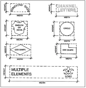
G.
Apartment/Condominium/Manufactured Home Park Identification Signs.
1.
One (1) apartment/condominium/manufactured home park identification sign may be located at a primary entrance on each frontage to a public road.
2.
The maximum area allowed for each frontage may be divided among two (2) signs if those signs are single-sided and mounted at a single entrance.
3.
An apartment/condominium/manufactured home park identification sign may be either an attached sign or a freestanding monument sign. It shall be placed upon the private property of a particular multi-family project in the appropriate zone as set forth in the Summary of Permitted Signs Subsection above and subject to the requirements set forth in the Sign Standards Subsection above.
4.
The apartment/condominium/manufactured home park identification sign shall list the name and may list the facilities available and have leasing or sales information incorporated as a part of the sign.
5.
An apartment or condominium project must have a minimum of twenty-four (24) dwelling units to qualify for an identification sign.
6.
Indirect lighting is permissible, but no optical effects, moving parts, or alternating, erratic, or flashing lights or devices shall be permitted.
7.
Any manufactured home parks existing at the time of this UDO that are nonconforming may still utilize an identification sign meeting the provisions of this Section and the Sign Standards Subsection above.
H.
Area Identification and Subdivision Signs.
1.
Area identification signs shall be permitted upon private property in any zone to identify subdivisions of ten (10) to fifty (50) acres in size subject to the requirements set forth in the Sign Standards Subsection above. Area identification signs may also be used within a large subdivision to identify distinct areas within that subdivision subject to the requirements in the Sign Standards Subsection above.
2.
Subdivision signs shall be permitted upon private property in any zone to identify subdivisions of greater than fifty (50) acres subject to the requirements set forth in the Sign Standards Subsection above.
3.
Both area identification and subdivision signs must be located on the building plot as identified by a preliminary plan of the subdivision. Subdivision signs will be permitted only at the intersection of two (2) collector or larger streets on the perimeter of the subdivision. At each intersection, either one (1) or two (2) subdivision signs may be permitted so long as the total area of the signs does not exceed one hundred fifty (150) square feet. Flags may be utilized in place of a subdivision sign, but the overall height shall not exceed twenty (20) feet and twenty-five (25) square feet in area in a residential zone and thirty-five (35) feet in height and one hundred (100) square feet in area in industrial or commercial districts.
4.
Subdivision markers of no more than one (1) square foot in area, used in conjunction with a subdivision or area identification sign, are permitted attached to architectural elements within the subdivision.
5.
Indirect lighting is permissible but no optical effects, moving parts, or alternating, erratic, or flashing lights shall be permitted. Landscaping valued at two hundred fifty (250) points shall be installed around each subdivision sign. Adequate arrangements for permanent maintenance of all signs and any landscaping in conjunction with such signs shall be made, which may be through an owners association if one (1) exists or is created for this purpose.
6.
All signs shall be set back as shown in the Sign Standards Subsection above except in areas where a private improvement in public right-of-way permit has been issued.
I.
Attached Signs.
1.
Attached signs are commercial signs under this Section.
2.
Attached signs on any commercial building or tenant lease space shall not exceed a total of two and one-half (2.5) square feet per linear foot of all public entry façades, with a maximum of five hundred (500) square feet of attached signage allowed for any one (1) tenant. Multi-story businesses will be allowed one hundred (100) square feet of additional attached signage.
3.
The division of allowable building signage amongst building tenants shall be the sole responsibility of the owner or property manager and not the City of College Station.
4.
Signs attached to features such as gasoline pumps, automatic teller machines, mail/package drop boxes, or similar on-site features shall count as part of the allowable sign area of the attached signs for the site if identifiable from the right-of-way as determined by the Administrator. See the Sign Standards Section of the City of College Station Site Design Standards for more information. Information contained on such features pertaining to federal and state requirements and operation/safety instructions are not counted. All other signage on such features shall count towards the allowable attached sign area.
5.
Architectural elements which are not part of the sign or logo and in no way identify the specific business tenant shall not be considered attached signage.
6.
An attached sign:
a.
Shall advertise only the name of, uses of, or goods or services available within the building or tenant lease space to which the sign is attached;
b.
Shall be parallel to the face of the building;
c.
Shall not be cantilevered away from the structure;
d.
Shall not extend more than one (1) foot from any exterior building face, mansard, awning, or canopy;
e.
Shall not obstruct any window, door, stairway, or other opening intended for ingress or for needed ventilation or light; and
f.
Shall not be attached to any tree or public utility pole.
7.
Attached signs may be mounted to site lighting poles located on private property and may be constructed of cloth, canvas, or other flexible material provided such signage is maintained in good condition and complies with the following restrictions:
a.
No part of any sign attached to a light pole will be allowed to overhang or encroach into any portion of the public right-of-way;
b.
Light pole signs shall not exceed twelve (12) square feet in area and shall have a minimum of eight (8) feet of clearance from the grade below;
c.
Light pole signs shall only be attached to one (1) side of a light pole;
d.
Light pole signs shall not project more than three (3) feet from the edge of the light pole; and
e.
Light pole signs constructed of cloth, canvas, or other flexible material shall be secured on a minimum of two (2) opposing sides to prevent wind-driven movement.
J.
Campus Wayfinding Signs.
1.
A campus wayfinding sign:
a.
May be utilized as a part of a PDD Planned Development District or unified development that is at least twenty (20) acres in size, contains multiple buildings, and may include multiple building plots;
b.
A maximum of one (1) campus wayfinding sign shall be allowed per intersection of two (2) primary circulation drive aisles when parking is not provided along the drive aisle, or intersection of a primary circulation drive aisle and public way when parking is not provided along the drive aisle and public way;
c.
All signs shall be internal to the development and shall not be located along a public right-of-way or at the intersection of a primary circulation aisle or public way and right-of-way.
d.
Shall be limited in height to no greater than six (6) feet, measured from the elevation of the curb or pavement edge, with a maximum total sign area of thirty (30) square feet;
e.
Shall not be located within a site visibility triangle;
f.
All campus wayfinding signs shall be submitted as part of a sign package for the development; and
g.
Shall utilize a common design or theme throughout the development and contain no commercial logo or graphics.
K.
Commercial Banners.
1.
A commercial banner:
a.
Shall be in good repair;
b.
Shall have the permit number conspicuously posted in the lower right-hand corner of the banner;
c.
Shall be allowed in addition to the signage provided for in the Attached Signage Subsection above;
d.
Shall advertise only the name of, uses of, or goods or services available within the building or tenant lease space to which the sign is attached;
e.
Shall be mounted parallel to the face of a building or permanent structure;
f.
Shall not be located within the public road right-of-way;
g.
Shall not obstruct any window, door, stairway, or other opening intended for ingress or for needed ventilation or light; and
h.
Except as identified below, shall be allowed for a maximum fourteen (14) day period per permit.
2.
An annual banner permit may be allowed for places of worship meeting in public spaces on a temporary basis. Banners allowed by this Section shall only be displayed on the day of the worship service.
3.
The applicant shall pay an application fee as established by resolution of the City Council upon submission of a banner permit application to the City. The application fee is waived for a non-profit association or organization. This fee shall not apply to banners associated with special events as provided for in the Special Event Signs Subsection below.
L.
Development Sign.
1.
A development sign may be placed only on private property subject to the requirements in the Sign Standards Subsection above.
2.
A development sign for a building project shall be removed if the project has not received a building permit at the end of twelve (12) months. The Administrator may renew the sign permit for one (1) additional twelve (12) month period upon request. Once a building permit for the project is received, the sign may stay in place until seventy-five (75) percent of the project is leased or a permanent sign is installed, whichever comes first.
3.
A development sign for a proposed subdivision shall be removed if a preliminary plan or final plat has not been approved by the end of twelve (12) months. The Administrator may renew the sign permit for one (1) additional twelve (12) month period upon request. Once a plat has been approved, the sign permit is valid as long as a preliminary plan is in effect, or in the absence of a valid preliminary plan, for twenty-four (24) months from the date of approval of a final plat.
M.
Directional Traffic Control Sign.
1.
Directional traffic control signs may be utilized as traffic control devices in off-street parking areas subject to the requirements set forth in the Sign Standards Subsection above.
2.
For multiple lots sharing an access easement to the public right-of-way, there shall be only one (1) directional sign located at the curb cut.
3.
Logo or copy shall be less than fifty (50) percent of the sign area.
4.
No directional traffic control sign shall be permitted within or upon the right-of-way of any public street unless its construction, design, and location have been approved by the City Traffic Engineer.
N.
Electronic Reader Boards.
In addition to meeting the other requirements of this Section, electronic reader boards are subject to the following requirements:
1.
The sign display (message) change shall be instantaneous; scrolling, fading, or animation between messages is prohibited;
2.
No electronic reader board shall exceed a brightness level of three-tenths (0.3) foot candles above ambient light as measured using a light meter capable of measuring in foot candles at a distance based upon sign area, measured as follows:
Measurement distance = √ (sign display area x 100)
3.
The sign shall be equipped with automatic brightness control keyed to ambient light levels;
4.
In the event of a malfunction, the sign display must go dark; and
5.
Electronic reader board size is limited to thirty (30) percent of the allowable sign area.
O.
Flags.
1.
One (1) freestanding corporate flag per premise, not to exceed thirty-five (35) feet in height or one hundred (100) square feet in area, is allowed in multi-family, commercial, and industrial districts.
2.
Flags used solely for decoration, not containing any copy or logo, and located only in multi-family, commercial, and industrial districts or developments are allowed without a permit. In multi-family developments, such flags will be restricted to sixteen (16) square feet in area. In all permitted zoning districts, such flags will be restricted to thirty (30) feet in height, and the number shall be restricted to no more than six (6) flags per building plot.
3.
Flags containing commercial copy or logo, excluding the flags of any country, state, city, school, or church are prohibited in residential zones and on any residentially developed property (except when flags are used as subdivision signs).
P.
Freestanding Signs.
1.
Any development with over seventy-five (75) linear feet of frontage will be allowed one (1) freestanding commercial sign. All freestanding commercial signs shall meet the following standards:
a.
Allowable Area.
b.
Area.
For the purposes of this Section, the area shall be considered the area in square feet of a single-face sign, one (1) side of a double-face sign, or half the sides of a multi-face sign.
c.
Frontage.
1.
For the purposes of this Section, frontage shall be considered the number of feet fronting on a public street to which a sign is oriented; and
2.
On corner lots, the frontage street shall be the higher classification street on the Comprehensive Plan Functional Classification & Context Class Map. Where the two (2) streets are classified the same, the applicant may choose the frontage street.
d.
Allowable Height.
1.
The allowable height of a freestanding commercial sign is determined by measuring the distance from the closest point of the sign to the curb or pavement edge and dividing this distance by two (2). No freestanding commercial sign shall exceed thirty-five (35) feet in height;
2.
For the purposes of this Section, the height of a sign shall be measured from the elevation of the curb or pavement edge;
3.
For the purposes of this Section, the distance from the curb shall be measured in feet from the back of the curb or pavement edge to the nearest part of the sign; and
4.
For properties with freeway/expressway frontage in SC Suburban Commercial districts, the maximum height of the sign may not exceed the eave height of the structure to which it most closely relates. Freestanding commercial signs must be adjacent to and oriented to the freeway/expressway frontage.
2.
Freestanding commercial signs are allowed only on developed commercial property established in the appropriate zones as set forth in the Summary of Permitted Signs Subsection above. One (1) freestanding sign shall be allowed in the O Office zone only when the building plot has a minimum of two (2) acres, subject to the requirements set forth in the Sign Standards Subsection above. One (1) low profile sign shall be allowed in the O Office zone when the building plot has less than two (2) acres subject to the requirements set forth in the Sign Standards Subsection above.
3.
A building plot with more than one hundred fifty (150) feet of frontage shall be allowed to use one (1) freestanding commercial sign or any number of low profile signs as long as there is a minimum separation between signs of one hundred fifty (150) feet.
In lieu of one (1) low profile sign every one hundred fifty (150) feet, hospital uses may have one (1) low profile sign located at each driveway.
4.
Building plots with less than seventy-five (75) feet of frontage may be combined to utilize signage corresponding to the resulting frontage as described in the preceding two (2) paragraphs.
5.
No more than one (1) freestanding commercial sign shall be allowed on any premises except when the site meets one (1) of the following sets of criteria:
a.
The building plot, as recognized on an approved plat or site plan, must be twenty-five (25) acres or more in area with at least one thousand (1,000) feet of continuous unsubdivided frontage on a street classified as a major arterial or higher on the Comprehensive Plan Functional Classification & Context Class Map toward which one (1) additional freestanding commercial sign may be displayed (see diagram below); or
b.
The building plot, as recognized on an approved plat or site plan, must be fifteen (15) acres or more in area with at least six hundred (600) feet of continuous unsubdivided frontage on a street classified as a major arterial or higher on the Comprehensive Plan Functional Classification & Context Class Map and the site must have additional frontage on a street classified as a minor arterial or higher on the Comprehensive Plan Functional Classification & Context Class Map, toward which the additional freestanding commercial sign may be displayed.
6.
Any sign where two (2) or more panels have separate supports extending to them shall be considered to be more than one (1) freestanding commercial sign, even where only one (1) main support extends to the ground.
7.
Sites with limited or no street frontage due to a proliferation of pad sites that are not contained within the building plot, as defined by the Administrator, and are fronting along a street classified as a collector or higher on the Comprehensive Plan Functional Classification & Context Class Map, will be allowed the area of the sign to be less than or equal to the square of one-sixth (.17) of the distance from the closest portion of the sign to the curb or pavement edge, with the maximum area not to exceed two hundred (200) square feet.
8.
Any site defined as a single building plot and containing one (1) or more pad sites, shall be permitted to erect a freestanding commercial sign in accordance with this Subsection, and to the standards of the Allowable Area Subsection above, with the maximum area not to exceed two hundred (200) square feet. In addition, each pad site will be permitted one (1) low profile sign per pad site according to the restrictions of the Sign Standards Subsection above.
Q.
Fuel Price Signs.
Facilities with fuel sales will be allowed one (1) additional sign per building plot, either freestanding or attached, for the purposes of fuel pricing.
1.
The area of the fuel price sign shall not exceed twenty-four (24) square feet.
2.
Fuel pricing may be incorporated into the allowable square footage of a freestanding commercial sign or attached sign.
3.
This sign shall follow the setback requirements for a freestanding commercial sign and shall not be located within the right-of-way.
R.
Grand Opening Signs.
1.
Flags, commercial banners, and balloons that advertise a business's grand opening may be displayed for one (1) consecutive fourteen (14) day period, selected by the business owner, within sixty (60) days of the granting of the initial certificate of occupancy, a change in the use, or of a change in the name of the business. A permit is required.
2.
A commercial banner:
a.
Shall advertise only the name of, uses of, or goods or services available within the building or tenant lease space to which the sign is attached;
b.
Shall be parallel to the face of the building;
c.
Shall not be cantilevered away from the structure;
d.
Shall not extend more than one (1) foot from any exterior building face, mansard, awning, or canopy;
e.
Shall not obstruct any window, door, stairway, or other opening intended for ingress or for needed ventilation or light; and
f.
Shall not be attached to any tree, fence, or public utility pole.
S.
Hanging Signs.
1.
Hanging signs shall be suspended from canopies or awnings and located in front of building entrances and perpendicular to the façade.
2.
A maximum of one (1) hanging sign per building entrance is allowed.
3.
The hanging sign shall not exceed four (4) square feet in size and shall have a minimum of eight (8) feet of clearance from the walkway grade, four (4) inches of clearance from the building face, and eight (8) inches of clearance from the edge of the canopy/awning.
4.
Hanging signs located in or over the public right-of-way shall require a private improvement in public right-of-way permit in addition to the necessary building permit.
T.
Home Occupation Sign.
1.
A person having a legal home occupation may have one (1) sign on the building or porch of a residence.
2.
The sign may contain only the name and occupation of the resident.
3.
It shall be attached directly to the face of the building or porch.
4.
It shall not exceed two (2) square feet in area, shall not be illuminated in any way, and shall not project more than twelve (12) inches beyond the building.
5.
No display of merchandise or other forms of commercial communication shall be allowed within a residential area unless the same were in existence prior to the adoption of the UDO in connection with a use that is presently a lawful nonconforming use within the district.
6.
Such a nonconforming sign may be maintained until the nonconforming use of the building ceases, subject to the requirements for maintenance herein. Discontinuance of the use of such a sign for more than three (3) months shall prevent future use, even if the nonconforming use is continuous.
U.
Low Profile Signs.
In addition to meeting the other requirements of this Section, low profile signs are subject to the following:
1.
A building plot with less than seventy-five (75) feet of street frontage shall be allowed to use one (1) low profile sign in lieu of a freestanding commercial sign;
2.
Each building plot containing one (1) or more pad sites, shall be permitted one (1) low profile sign per pad site according to the restrictions of the Sign Standards Subsection above; and
3.
In SC Suburban Commercial, WC Wellborn Commercial, BP Business Park, and BPI Business Park Industrial, one (1) low profile sign per structure is permitted.
V.
Non-Commercial and Political Signs.
This Section does not regulate the size, content, or location of non-commercial signs except as follows:
1.
No commercial message shall be shown on any non-commercial sign.
2.
No non-commercial sign:
a.
May be greater than fifty (50) square feet in size;
b.
May be located within the public road right-of-way;
c.
May be located off the premises of the property owner who is displaying the sign; and
d.
May not be located within any sight distance triangle as defined in the Visibility at Intersections in All Districts Subsection of the General Provisions Section above, or a location that would hinder intersection visibility as determined by the Administrator. This provision is necessary to avoid clutter, proliferation, and dangerous distraction to drivers caused by the close proximity of such signs to automobile traffic, to avoid damage to automobiles which may leave the paved surface intentionally or by accident, and to avoid the necessity for pedestrians to step into the roadway to bypass such signs. No regulatory alternative exists to accomplish this police power obligation.
3.
In the event any non-commercial sign is located in a public right-of-way, the City shall remove it.
4.
All non-commercial signs addressing a particular event are allowed up to ninety (90) days prior to the event and shall be removed within ten (10) days after.
W.
Projection Signs.
Example Projection Sign
Projection signs will be allowed in the MU Mixed-Use district with the following restrictions:
1.
One (1) projection sign per frontage along a public right-of-way will be allowed except where otherwise stated in this Section.
2.
The total square footage of all projection signs used will be applied toward the total allowable area for the attached signage.
3.
The division and placement of allowable building signage amongst building tenants shall be the sole responsibility of the owner or property manager and not the City of College Station.
4.
Projection signs shall be mounted perpendicular to buildings.
5.
Internally lit plastic signs will not be permitted.
6.
Projection signs may utilize fabric or other flexible material provided that they remain in good condition at all times.
7.
Projection signs shall have a minimum of eight (8) feet of clearance from the walkway grade and four (4) inches of clearance from the building face. Excluding the four (4) inch minimum clearance requirement, no part of a projection sign shall project more than three (3) feet from the building face.
8.
Projection signs shall not extend above the façade of the building to which it is attached.
9.
Buildings with one (1) story may have a sign that shall not exceed eighteen (18) square feet in size. For each additional building story, an additional eight (8) square feet of signage is allowed, up to a maximum of fifty (50) square feet per sign.
10.
Projection signs located in or over the public right-of-way shall require a private improvement in public right-of-way permit in addition to the necessary building permit.
X.
Real Estate/Finance/Construction Signs.
1.
One (1) real estate sign not exceeding sixteen (16) square feet in total area (exclusive of stakes and posts) may be erected at any time while a property is offered for sale or lease to the public. Properties with a minimum of one hundred fifty (150) feet of frontage shall be allowed one (1) real estate sign not exceeding thirty-two (32) square feet in total area. Properties with a minimum of two (2) acres and frontage on two (2) streets shall be allowed one (1) real estate sign on each frontage street with the area of the sign to be determined by the amount of frontage as stated above.
2.
One (1) finance sign and three (3) construction signs (for a total of four (4) signs), not exceeding sixteen (16) square feet in total area each (exclusive of stakes and posts) may be erected once a building permit has been issued on a property. Properties with a minimum of ten (10) acres and one thousand (1,000) feet of frontage shall be allowed one (1) finance sign and three (3) construction signs not exceeding thirty-two (32) square feet in total area each.
3.
Real estate, finance, and construction signs may be either attached or freestanding and only those visible from the street are limited in number.
4.
All such signs shall be maintained by the persons in control of the premises to remain erect and in good repair. Such signs shall be removed by the property owner or other person in control of the premises if they are damaged, broken, or incapable of remaining erect.
5.
Such signs must be removed by the owner or person in control of the premises when either the property has sold or been leased and/or when performance under the construction contract or subcontract (in the case of construction signs) has been completed. In all cases, finance and construction signs shall be removed prior to the issuance of a certificate of occupancy.
Y.
Roof Signs.
1.
Signs mounted to the structural roof shall be regulated as freestanding commercial signs.
2.
Painted or applied roof signs are prohibited.
Z.
Signs for Conditional Uses.
1.
Signs for conditional uses shall comply with the regulations for the zoning district in which the conditional use is permitted.
2.
Signs for conditional uses in residential or rural zoning districts shall comply with the Low Profile Signs Subsection above.
AA.
Signs for Permitted Non-Residential Uses in Residential or Rural Districts.
1.
Signs for permitted non-residential uses in residential or rural zoning districts shall comply with the Low Profile Signs Subsection above.
2.
Signs for places of worship with frontage on a street classified as freeway/expressway on the Comprehensive Plan Functional Classification & Context Class Map are allowed one (1) freestanding sign in accordance with the Freestanding Commercial Signs Subsection above or one (1) low profile sign in accordance with the Low Profile Signs Subsection above. The freestanding sign must be adjacent to and oriented to the freeway/expressway.
3.
Signs for places of worship and government facilities in residential or rural zoning districts may utilize signage in accordance with the Attached Signs and Commercial Banners Subsections above.
BB.
Signs in the Extraterritorial Jurisdiction.
All off-premise and portable signs shall be prohibited within the extraterritorial jurisdiction.
CC.
Special Event Signs.
1.
Signs, including commercial banners and balloons, advertising or announcing a special event, as defined in Chapter 8, Businesses of the City of College Station Code of Ordinances, are permitted as a part of the special event permit and shall be limited to the property holding the event.
2.
The special event signage is allowed up to fourteen (14) days prior to the event and must be removed within twenty-four (24) hours of the end of the event.
DD.
Vehicle Signs.
1.
Signs that are displayed on motor vehicles that are being operated or stored in the normal course of a business, such as signs indicating the name or the type of business, excluding all banners, that are located on moving vans, delivery trucks, trailers or other commercial vehicles are permitted; but only if the primary purpose of such vehicles is not for the display of the signs thereon, and only if such vehicles are parked or stored in areas appropriate to their use as commercial or delivery vehicles, such as service areas or locations close to the business building away from public traffic areas.
2.
Signs or advertisements permanently attached to non-commercial vehicles, excluding all banners, are permitted.
EE.
Abandoned, Damaged, or Unsafe Signs.
1.
The provisions of this Section shall apply when in conflict with the provisions of the International Building Code, as adopted, but where the provisions of both ordinances are consistent, the enforcement of either shall be permissible and remedies or penalties cumulative.
2.
Nonconforming signs that have become deteriorated or damaged to an extent that the cost of the reconstruction or restoration of such signs is over fifty (50) percent of its replacement value exclusive of foundations will be required to be removed or brought into full compliance with the current sign regulations.
3.
All abandoned signs and their supports shall be removed within sixty (60) days from the date of abandonment. All damaged signs shall be repaired or removed within sixty (60) days. The Administrator shall have the authority to grant a thirty (30) day extension where they determine there is a reasonable necessity for same.
4.
Discontinuance of use or removal of any nonconforming sign or any sign in connection with a nonconforming use shall create a presumption of intent to abandon said sign. A nonconforming sign that is damaged and not repaired within sixty (60) days shall be presumed to be abandoned.
5.
When a building is demolished, the associated signs and sign structures shall also be removed.
(Ord. No. 2023-4453, Pt. 1(Exh. A), 8-10-2023)
Sec. 7.6. - Landscaping and Tree Protection.
A.
Purpose and Intent.
The purpose and intent of this Section is to regulate the manner in which land in the city is used and developed to minimize adverse effects on surrounding property owners or the general public and ensure that high-quality development is maintained throughout the community.
For the purpose of landscaping, College Station falls within Zone 8 of the United States Department of Agriculture (USDA) Hardiness Zone Map. Also, dwarf plants will not be allowed in required screening or buffer areas.
B.
Application of Section.
The landscaping requirements of this Section apply to all land located in College Station proposed for site development with the exception of those zoned NG-1 Core Northgate and NG-3 Residential Northgate. The requirements also do not apply to single-family, duplex, townhouse, or mixed-use developments in the MU Mixed-Use district, except as follows:
1.
The requirements of this Section have limited application to properties developed for duplexes, as follows:
a.
A minimum of two hundred (200) points of landscaping as calculated in this Section shall be provided for each new duplex;
b.
Where parking is provided in the front yard, an eight (8) foot landscaped setback shall be required between the property line and the nearest side of the parking pad. This eight (8) foot setback area must be landscaped and contain a three (3) foot high screen consisting of a continuous berm, hedge, or wall. In addition, an eight (8) foot landscaped setback shall be required between the dwelling unit and the nearest side of the parking pad; and
c.
The maintenance and completion requirements of this Section also apply to duplex uses. Every development must employ an irrigation system. All new plantings must be irrigated. An irrigation system shall be designed so that it does not negatively impact existing trees and natural areas. Soaker hose and drip irrigation system designs may be permitted as the Administrator deems appropriate.
2.
The requirements of this Section have limited application to properties developed for single-family, townhouse, and courtyard house developments, as follows:
a.
A minimum of two (2) trees of at least two (2) inch caliper or one (1) tree of four (4) inch caliper shall be planted on each lot with every new single-family home.
b.
A minimum of one (1) tree of four (4) inch caliper shall be planted on each lot with every new courtyard house.
c.
For townhouse and courtyard house developments, the Administrator may allow the required trees to be dispersed throughout, including common areas.
d.
The landscaping requirements of this Section shall apply to manufactured home parks, but not to individual manufactured homes on separate lots.
3.
The requirements of this Section apply to properties developed for multiplexes, as follows:
a.
A minimum of two hundred (200) points of landscaping as calculated in this Section shall be provided for each new multiplex unit with a maximum of one thousand (1,000) points;
b.
Within fifty (50) feet of the property line along the street, and located between the structure and the public right-of-way, street, or public way, one (1) canopy tree for every twenty-five (25) linear feet of frontage shall be installed. One (1) existing tree (minimum four (4) inch caliper) may be substituted for a new tree;
c.
Canopy trees must be selected from the Landscape & Streetscape Standards Section of the City of College Station Site Design Standards and may be grouped as desired so long as the canopy trees are reasonably dispersed across each public right-of-way, street, or public way frontage;
d.
Two (2) non-canopy trees may be substituted for one (1) canopy tree;
e.
Parking areas adjacent to a right-of-way shall be screened from the right-of-way. Screening, such as ten (10) shrubs for every thirty (30) linear feet of frontage, is required along one hundred (100) percent of the street frontage with the exception of areas within the visibility triangle. Screening may be accomplished using plantings, berms, structural elements, or combinations thereof, and must be a minimum of three (3) feet above the parking lot pavement elevation. Walls and planting strips shall be located at least two (2) feet from any parking area. Where the street and the adjacent site are at different elevations, the Administrator may alter the height of the screening to ensure adequate screening. Fifty (50) percent of all shrubs used for screening shall be evergreen;
f.
One hundred (100) percent coverage of groundcover, decorative paving, decorative rock, or perennial grass is required in parking lot islands, swales, and drainage areas, and the parking lot setback unless otherwise landscaped or existing plants are preserved. One hundred (100) percent coverage of groundcover or perennial grass is also required in all unpaved portions of street or highway right-of-way or on adjacent property that has been disturbed during construction. If grass is to be used for groundcover, one hundred (100) percent live grass groundcover is required whether by solid sod overlay or pre-planting and successful takeover of grasses. No point value shall be awarded for ground cover; and
g.
All new plantings must be irrigated. An irrigation system shall be designed so that it does not negatively impact existing trees and natural areas. Soaker hose and drip irrigation system designs may be permitted as the Administrator deems appropriate.
4.
The requirements of this Section have limited application to properties developed in the MU Mixed-Use district, as follows:
a.
Within fifty (50) feet of the property line along the street, and located between the structure and the public right-of-way, street, or public way, one (1) canopy tree for every twenty-five (25) linear feet of frontage shall be installed. One (1) existing tree (minimum four (4) inch caliper) may be substituted for a new tree.
b.
Canopy trees must be selected from the Landscape & Streetscape Standards Section of the City of College Station Site Design Standards and may be grouped as desired so long as the canopy trees are reasonably dispersed across each public right-of-way, street, or public way frontage.
c.
Parking areas adjacent to a right-of-way shall be screened from the right-of-way. Screening is required along one hundred (100) percent of the street frontage (such as ten (10) shrubs for every thirty (30) linear feet of frontage), with the exception of areas within the visibility triangle. Screening may be accomplished using plantings, berms, structural elements, or combinations thereof, and must be a minimum of three (3) feet above the parking lot pavement elevation. Walls and planting strips shall be located at least two (2) feet from any parking area. Where the street and the adjacent site are at different elevations, the Administrator may alter the height of the screening to ensure adequate screening. Fifty (50) percent of all shrubs used for screening shall be evergreen.
d.
One hundred (100) percent coverage of groundcover, decorative paving, decorative rock, or perennial grass is required in parking lot islands, swales, and drainage areas, and the parking lot setback unless otherwise landscaped or existing plants are preserved. One hundred (100) percent coverage of groundcover or perennial grass is also required in all unpaved portions of street or highway right-of-way or on adjacent property that has been disturbed during construction. If grass is to be used for groundcover, one hundred (100) percent live grass groundcover is required whether by solid sod overlay or pre-planting and successful takeover of grasses. No point value shall be awarded for ground cover.
e.
All new plantings must be irrigated. An irrigation system shall be designed so that it does not negatively impact existing trees and natural areas. Soaker hose and drip irrigation system designs may be permitted as the Administrator deems appropriate.
5.
All landscaping/streetscaping requirements under this Section shall run with the land once the development has begun and shall apply against any owner or subsequent owner.
6.
The landscaping requirements of this Section apply to all unsubdivided property, improved subdivided lots, and other improved lands where buildings or structures are being added or replaced within the city.
7.
Each phase of a multi-phase project shall comply with this Section.
8.
All plantings must be in accordance with the Landscape & Streetscape Standards Section of the City of College Station Site Design Standards, or as deemed appropriate by the United States Department of Agriculture (USDA) for Zone 8 in their Hardiness Zone Map.
C.
Landscaping Point Requirements.
1.
The landscaping point requirement for a site is determined by the combined point total of site area and streetscape subtotals.
2.
Site Area Points.
a.
Minimum thirty (30) landscape points per one thousand (1,000) square feet of site area.
b.
The minimum total number of points for any development is eight hundred (800) points.
c.
Undeveloped floodplains may be removed from site size calculations; in such case, existing trees within that floodplain shall not be claimed for points.
d.
Projects may be phased with the phase lines being drawn twenty (20) feet beyond any new site amenity. The portion left for subsequent phases shall be of developable size and quality.
3.
Streetscape Points.
a.
Six (6) additional landscape points shall be required for each linear foot of frontage on a right-of-way or public way; and
b.
Driveway openings, visibility triangles, and other traffic control areas may be subtracted from the total streetscape frontage.
4.
Point Credits.
The following point credits will apply to the total landscaping point requirement so long as the total reduction does not cause the development to have a point total lower than the minimum eight hundred (800) point requirement:
a.
A twenty (20) percent point credit will be awarded where the irrigation system employed is a recognized water-conserving system as defined in the City of College Station Site Design Standards or utilizes a commercial soil moisture meter.
b.
A ten (10) percent point credit will be awarded if twenty-five (25) percent or more of the parking area consists of enhanced paving.
c.
A ten (10) percent point credit will be awarded for every one (1) percent of the site area devoted to special facilities including water features, public art, or other public features determined by the Administrator.
d.
A ten (10) percent point credit will be awarded for landscape plans that are prepared by a landscape architect registered in Texas, an International Society of Arboriculture (ISA) certified arborist, or another professional as deemed appropriate by the Administrator.
e.
A ten (10) percent point credit will be awarded where berms are utilized for parking screening.
5.
Point Values.
a.
Point values will be awarded for any type of canopy tree, non-canopy tree, or shrub, except for those listed on the Non-Point Tree List as prepared by the Administrator. No point value shall be awarded for ground cover. For the purpose of this Section, Texas native, as referenced in the City of College Station Site Design Standards, shall be considered those notated as both native to Texas and recommended by the Texas Forest Service for Brazos County.
b.
All caliper measurements shall be twelve (12) inches above grade. The minimum caliper for non-canopy trees shall be measured on a single cane of a multi-trunk tree.
c.
Landscaping points are accrued as follows:
d.
To receive landscape points for existing trees, all existing trees must be in good form and condition and reasonably free of damage by insects and/or disease.
e.
To receive additional points for barricaded trees, such trees must be barricaded to the dripline of the tree. A barricade detail must be provided on the landscape plan. Barricades must be in place prior to any activity on the property including but not limited to grading. If the required barricades are not in place prior to any activity and maintained during construction, barricaded points will be forfeited.
f.
No points shall be awarded for existing Post Oak trees.
D.
Planting and Screening Requirements.
1.
General Requirements.
a.
Every project must expend a minimum of fifty (50) percent of its point total on canopy trees.
b.
Landscaping must be reasonably dispersed throughout all visible areas of the site.
c.
One hundred (100) percent coverage of groundcover, decorative paving, decorative rock, or perennial grass is required in parking lot islands, swales, and drainage areas, and the parking lot setback unless otherwise landscaped or existing plants are preserved. When decorative rock is used, it shall be designed such that it will not migrate into sidewalks or other paved areas. One hundred (100) percent coverage of groundcover or perennial grass is also required in all unpaved portions of street or highway right-of-way or on adjacent property that has been disturbed during construction. If grass is to be used for groundcover, one hundred (100) percent live grass groundcover is required whether by solid sod overlay or pre-planting and successful takeover of grasses.
d.
All landscape materials shall be installed in accordance with the current planting procedures established by the most recent addition of The American Standard for Nursery Stock, as published by the American Association of Nurserymen.
e.
For existing plantings, the Administrator may require a health appraisal if the applicant wishes to receive point credits.
f.
All new plantings must be irrigated. An irrigation system shall be designed so that it does not negatively impact existing trees and natural areas. Soaker hose and drip irrigation system designs may be permitted as the Administrator deems appropriate.
2.
Streetscape.
a.
Within fifty (50) feet of the property line along all major arterials and freeways/expressways as designated on the Comprehensive Plan Functional Classification & Context Class Map, one (1) canopy tree for every twenty-five (25) linear feet of frontage shall be installed;
b.
Within fifty (50) feet of the property line along all other roadways including public ways, one (1) canopy tree for every thirty-two (32) feet of frontage shall be installed;
c.
Fractional amounts shall be increased to the nearest whole number;
d.
Two (2) non-canopy trees may be substituted for one (1) canopy tree;
e.
Trees used to meet the requirement along one (1) streetscape frontage shall not be counted toward another frontage;
f.
Canopy and non-canopy trees must be selected from the Landscape & Streetscape Standards Section of the City of College Station Site Design Standards and may be grouped as desired so long as the trees are reasonably dispersed across each frontage; and
g.
One (1) existing tree (minimum four (4) inch caliper) may be substituted for a new tree. Existing trees must be of acceptable health, as determined by the Administrator.
3.
Additional Landscaping along Large Building Façades.
This Subsection applies to sites subject to the Non-Residential Architectural Standards Section below:
a.
Sites with building façades that face a public right-of-way or public way and that exceed two hundred (200) feet in length shall place landscaping between the façade and roadway;
b.
One (1) canopy tree is required for every forty (40) feet of façade length. Fractional amounts shall be increased to the nearest whole number;
c.
The trees shall be placed within fifty (50) feet of the building I;
d.
Two (2) non-canopy trees may be substituted for one (1) canopy tree; and
e.
Trees counting toward streetscape planting requirements may also count toward the requirement.
4.
Parking Screening.
a.
Parking areas adjacent to a right-of-way or public way shall be screened from the right-of-way or public way.
b.
Screening may be accomplished using plantings, berms, structural elements, or combinations thereof as described below, and must be a minimum of three (3) feet above the parking lot pavement elevation.
c.
Walls and planting strips shall be located at least two (2) feet from any parking area.
d.
Where the street and the adjacent site are at different elevations, the Administrator may alter the height of the screening to ensure adequate screening.
e.
A minimum of fifty (50) percent of all shrubs used for screening shall be evergreen.
f.
The following options are allowed as parking lot screening methods:
1)
A solid hedgerow (such as ten (10) shrubs for every thirty (30) linear feet of frontage) to screen the parking to a height of three (3) feet. The screening must be a minimum of twenty-four (24) inches at planting and reach thirty-six (36) inches within one (1) calendar year of planting, and such method is certified to meet these requirements by a registered landscape architect, landscape designer, or landscape contractor;
2)
Berms with a minimum height of three (3) feet as measured from the parking lot pavement, and a maximum slope of three (3) feet of height for every one (1) foot of width. Berms may be designed around trees that are barricaded for tree preservation. Where there will be gaps in berm screening for the preservation of existing trees, other screening methods shall be used to meet the minimum three (3) foot screening requirement; or
3)
Half-berms with a minimum height of three (3) feet as measured from the parking lot pavement, and a maximum allowable slope of one (1) foot of height for every three (3) inches of width. Retaining walls shall be designed to face the parking lot and sidewalks located between the retaining wall and right-of-way or public way may not be closer than three (3) feet to the top of a retaining wall.
g.
For redeveloping sites maintaining existing parking lot perimeters, the Administrator may authorize the use of masonry walls, or lower the minimum berm height to a height that may be safely maintained in the existing parking setback when additional parking lot screening is provided. The cumulative height of plant material and berm shall be a minimum of three (3) feet.
h.
Variations to the requirements of this Section may be approved if the landscape/streetscape plan is sealed by a registered landscape architect and approved by the Administrator. Such plans must show reasonable evidence that the requirements, as set forth in this Section were used as a guide.
5.
Detention Ponds.
Detention ponds shall be integrated into the overall landscaping theme and design of the site as described in the Detention Pond Aesthetic Design Subsection of the Flood Hazard Protection Section below.
E.
Landscape/Streetscape Plan Requirements.
When a landscape/streetscape plan is required, the landscape/streetscape plan shall contain the following:
1.
The location of existing property lines and dimensions of the tract;
2.
A north arrow and scale;
3.
Topographic information and final grading adequate to identify and properly specify planting for areas needing slope protection;
4.
Location and dimensions of existing and proposed structures, parking lots and drives, sidewalks, refuse disposal areas, fences, and other features as determined necessary by the Administrator;
5.
Location, size, spread, type, and quantity of all proposed landscaping and screening materials, along with common and botanical names;
6.
The location of existing and proposed utilities and all easements on or adjacent to the lot;
7.
An indication of adjacent land uses, existing development, and roadways;
8.
An irrigation system plan or a general note indicating that an irrigation system to service all new plantings will be installed by a certified installer prior to the issuance of a certificate of occupancy;
9.
Provide landscape information as set forth below:
a.
Landscape points required for the site and calculations shown in the landscape legend.
b.
A legend showing the size, type (canopy, non-canopy, shrub), and points claimed for proposed landscaping.
c.
Location of landscape plants on the plan identified by a symbol defined in a landscape legend (see sample legend below).
Sample Landscape Plan Legend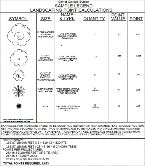
10.
Provide streetscape information as set forth below:
a.
Streetscape points required for site and calculations shown.
b.
A table showing the scientific and common plant names, size, type (canopy, non-canopy, and shrub), and points claimed for proposed streetscaping.
c.
Location of streetscape plants on plan identified by a symbol defined in a landscape legend (see sample legend above).
11.
The location and diameter of protected existing trees claimed for either landscape or streetscape requirements and an indication of how the applicant plans to barricade the existing trees from damage during construction. Barricading shall be subject to the following requirements:
a.
Prior to land development or redevelopment, or any construction thereof, the developer shall clearly mark all qualifying and significant trees to be preserved;
b.
The developer shall erect a fence around each tree or group of trees to prohibit the placement of debris or fill, or the parking of vehicles within the drip line of any qualifying or significant tree;
c.
During construction, the developer shall prohibit the cleaning of equipment or materials within the drip line of any tree or group of trees that are protected and required to remain. The developer shall not allow the disposal of any waste material including but not limited to paint, oil, solvents, asphalt, concrete, mortar, or other harmful liquids or materials within the drip line of any tree or groups of trees that are required to remain;
d.
No attachments or wires of any kind shall be attached to any tree except those used to stabilize or protect such tree;
e.
With grade changes in excess of six (6) inches, a retaining wall or tree well of rock or brick shall be constructed around the tree not closer than fifty (50) percent of the distance between the trunk and the drip line. The mid-point of the retaining wall shall be constructed at the new grade. Grade changes greater than one (1) inch may not be made without the prior approval of the Administrator; and
f.
All vegetation must be planted in accordance with the visibility triangle referenced in the Visibility at Intersections in all Districts Subsection of the General Provisions Section above.
F.
Maintenance and Changes.
1.
Landscaping/streetscaping shall be maintained and preserved in accordance with the approved landscape/streetscape plan. Replacement of landscaping/streetscaping must occur within forty-five (45) days of notification by the Administrator. Replacement material must be of similar character and the same or higher point total as the dead or removed landscaping. Failure to replace dead or removed landscaping, as required by the Administrator, shall constitute a violation of this Section for which the penalty provision may be invoked.
2.
Landscaping/Streetscaping Changes to Existing Sites.
a.
If changes constituting twenty-five (25) percent or more of the number of canopy and non-canopy trees are proposed, a revised landscape/streetscape plan must be submitted for approval and is required to comply with this Section. Planting must occur pursuant to this approved landscape/streetscape plan within forty-five (45) days.
b.
Revised landscape/streetscape plans shall meet the requirements of the ordinance in effect at the time of the revised landscape/streetscape plan submittal.
c.
The replacement of existing canopy and non-canopy trees must be replaced caliper for caliper, or as determined by the Administrator.
G.
Completion and Extension.
The Administrator shall review all landscaping for completion in accordance with this Section and the approved landscape/streetscape plan. Landscaping/streetscaping shall be completed in accordance with the approved plan prior to the issuance of a certificate of occupancy. However, the applicant may receive an extension of four (4) months from the date of the certificate of occupancy upon the approval of an application for extension with a bond or letter of credit in the amount of one hundred fifty (150) percent of the landscape/streetscape bid, as well as the irrigation required for the project. Failure to complete the landscaping/streetscaping according to the approved landscape/streetscape plan at the expiration of the bond or letter of credit shall constitute forfeiting the bond or cashing of the letter of credit. Also, failure to complete the approved landscaping/streetscaping shall constitute a violation of this UDO.
H.
Review and Approval.
Landscape/streetscape plans shall be reviewed and approved by the Administrator.
I.
Parking, Storage, or Display.
No parking, storage, or display of vehicles or merchandise shall be allowed in the required landscape/streetscape areas or on required parking islands.
J.
Alternative Compliance Permitted.
Variations to the requirements of this Section may be approved if the landscape/streetscape plan is sealed by a registered landscape architect and approved by the Administrator. Such plans must show reasonable evidence that the requirements as set forth in this Section were used as a guide.
(Ord. No. 2023-4453, Pt. 1(Exh. A), 8-10-2023)
Sec. 7.7. - Buffer Requirements.
A.
Purpose.
The purpose of buffer requirements, which generally include a buffer yard, plantings, and a fence or wall, is to provide a visual barrier between different zoning districts and to help mitigate any negative impacts of adjacent land uses on developed or developing properties. A buffer should visibly separate one (1) use from another and shield or block noise, glares, or other nuisances.
B.
Applicability.
1.
Perimeter buffers shall be provided on building plots abutting developed or developing sites in accordance with the standards of this Section as set forth in the Minimum Buffer Standards Subsection below. The following shall provide buffers:
a.
Vacant sites that develop;
b.
Existing sites when additions, expansions, and/or redevelopments equal or are greater than twenty-five (25) percent of the existing improvements;
c.
Existing sites when cumulative additions, expansions, and/or redevelopments total twenty-five (25) percent or more of the existing improvements;
d.
Existing sites when a change of use intensifies the development in terms of elements such as traffic, processes, noise, water or air pollution, etc.;
e.
Existing sites with lawfully established nonconforming uses when the use is expanded; and
f.
Sexually oriented businesses.
2.
Exceptions to the terms of this Section will be made when:
a.
The adjacent developed use is nonconforming;
b.
The adjacent developed use is agricultural;
c.
The Comprehensive Plan Future Land Use & Character Map designates the area as a Redevelopment Area;
d.
The property is zoned P-MUD Planned Mixed-Use District or PDD Planned Development District and the buffer requirement was determined through the rezoning process;
e.
The developing use is a primary or secondary educational facility containing a building with a Group "E" occupancy as defined in the International Building Code, as adopted;
f.
The developing property is in any of the NG Northgate design districts or RDD Redevelopment District;
g.
The required buffer yard is adjacent to FEMA designated one hundred (100) year floodplain or residential common area, with approval by the Administrator; or
h.
The developing property and all abutting properties are designated Mixed Residential or a more intense land use on the Comprehensive Plan Future Land Use & Character Map, regardless of existing use or zoning. Unless otherwise excepted, the regulations herein shall apply to properties at the periphery of the Mixed Residential land use designation.
C.
Relationship to Other Landscaping Standards.
All buffer requirements shall be included on a development's landscaping plan. Landscaping provided to meet the buffer landscaping standards of this Section may not be counted towards meeting a project's landscape point requirements. The area of a site dedicated to a perimeter buffer shall not be included in calculating a site's minimum landscaping point requirements.
D.
Location.
The buffer shall abut property boundaries shared with less intense uses or zoning districts as set forth in the Minimum Buffer Standards Subsection below. In the event a property abuts a less intense use and a less intense zoning district, the less stringent buffer shall be required along the shared boundary.
E.
Permitted Uses.
1.
A buffer yard may be used for passive recreation or stormwater management. It may contain pedestrian, bike, or equestrian trails provided that:
a.
No plant material is eliminated;
b.
The total width of the buffer yard is maintained; and
c.
All other regulations of this Section are met.
2.
No active recreation area, storage of materials, parking, driveways, or structures, except for approved pedestrian, bike, or equestrian trails and necessary utility boxes and equipment, shall be located within the buffer yard.
3.
Pedestrian access through a perimeter fence or wall and buffer yard may be provided at the abutting resident's, owners association's, or the Administrator's option to provide convenient pedestrian access to non-residential uses such as commercial areas or schools.
F.
Minimum Buffer Standards.
The buffer requirements are designed to permit and encourage flexibility in the widths of buffer yards, the number of plants required in the buffer yard, and opaque screens. Standard buffer requirements are depicted in the table below. The numbers shown are the required buffer widths.
Notes:
(a)
When an abutting parcel is vacant and zoned R Rural, the Administrator shall use the land use classification of the property as designated on the Comprehensive Plan Future Land Use & Character Map in lieu of the zoning category in determining the buffer requirement.
(b)
Includes manufactured homes, mobile homes, manufactured home parks, duplexes in the D Duplex zoning district, and townhouses in the T Townhouse zoning district.
(c)
Includes commercial and other non-residential uses developed in the MF Multi-Family district.
(d)
When an abutting parcel is zoned BP Business Park or BPI Business Park Industrial, the buffer width shall be reduced to five (5) feet.
(e)
When a developing parcel is zoned WC Wellborn Commercial and adjacent to a single-family use, the buffer width shall be twenty (20) feet with a fence.
(f)
Shall include a fence.
(g)
Shall include a wall.
1.
Buffer Yards.
a.
Buffer yards shall be measured from the common property line and may be located within established building setbacks.
b.
Where utility or drainage easements or other similar situations exists in the required buffer yard, the buffer yard may be reduced by the width of the easement; however, an additional five (5) feet may be required beyond the width of the easement in these situations to allow for the required plantings and fence or wall. All new plantings and irrigation shall be located outside of the easement. The Administrator has the discretion to allow a required fence or wall within the easement.
c.
In WC Wellborn Commercial:
1)
Required buffer plantings shall be doubled along property lines adjacent to single-family residential zoning or land use. In lieu of a fence, plantings may be tripled.
2)
When adjacent to single-family use, zoning, or designation on the Comprehensive Plan Future Land Use & Character Map, a buffer wall is required for the length of any adjacent parking, loading areas, or dumpster uses (including required maneuvering space).
d.
In BP Business Park, required buffer plantings shall be doubled along property lines adjacent to single-family residential zoning or development.
e.
In BPI Business Park Industrial, required buffer plantings shall be doubled along property lines adjacent to any zoning district or use other than BP Business Park or BPI Business Park Industrial.
f.
In MF Multi-Family and MU Mixed-Use, buffer yards shall only be required along the perimeter of the development, unless otherwise exempted in this Section. No buffer yards are required between uses contained within the development.
2.
Plantings.
a.
If a fence or wall is not required per the table above, the following plantings shall be installed in the buffer yard:
1)
A minimum of one (1) five (5) gallon shrub at a minimum of three (3) feet in height per three (3) linear feet of landscaping buffer; and
2)
A minimum of one (1) two (2) inch caliper canopy tree per twenty-five (25) linear feet of landscape buffer.
b.
If a fence or wall is required per the table above, the following plantings shall be installed in the buffer yard, unless expressly provided for otherwise in this UDO:
1)
A minimum of one (1) one and one-fourths (1.25) inch caliper non-canopy tree per fifteen (15) linear feet of landscaping buffer. The Administrator may allow the substitution of a minimum of one (1) five (5) gallon shrub at a minimum of three (3) feet in height per three (3) linear feet of landscaping buffer for the non-canopy tree requirement, or may require the substitution to mitigate potential negative impacts of a development; and
2)
A minimum of one (1) two (2) inch caliper canopy tree per twenty-five (25) linear feet of landscape buffer.
c.
All buffer yard landscaping areas not dedicated to trees or shrubs shall be landscaped with grass, ground cover, or other appropriate landscape treatment in accordance with the Landscaping and Tree Protection Section above.
d.
Fifty (50) percent of all required shrubs within the buffer yard shall be evergreen.
e.
Plant materials shall show a variety of textures, colors, shapes, and other characteristics. Recommended buffer materials can be found in the Landscape & Streetscape Standards Section of the City of College Station Site Design Standards or those listed as appropriate for Zone 8 on the United States Department of Agriculture (USDA) Hardiness Zone Map.
f.
The arrangement of trees and shrubs in the buffer area shall be done in a manner that provides a visual separation between abutting land uses. Shrubs shall be massed in rows or groups to achieve the maximum screening effect.
g.
Irrigation is required for all new plantings.
h.
Existing vegetation may count toward the planting requirement if:
1)
The vegetation is in good health and the landscape/streetscape plan verifies that it will meet the plantings criteria listed above (non-point trees may count towards a natural buffer); and
2)
The vegetation is protected in accordance with the Landscaping and Tree Protection Section above.
i.
Plantings will not be allowed to encroach into a required visibility triangle for a public or private right-of-way except as set forth in the Visibility at Intersections in all Districts Subsection of the General Provisions Section above.
3.
Fences and Walls.
a.
Fences may be solid wood or solid wood accented by masonry, stone, Exterior Insulation and Finish System (EIFS), or concrete columns. Walls may be masonry, stone, EIFS, concrete, or a combination of these materials, and shall be finished on both sides (framing not visible). Walls and masonry columns for fences must meet the footing standards prescribed by the International Building Code, as adopted, for such structures.
b.
Fences and walls shall be a minimum of six (6) feet in height and a maximum of eight (8) feet. Walls over six (6) feet must obtain a building permit. When the adjacent property and the buffer yard are at different elevations, the Administrator may require a greater fence or wall height to ensure adequate buffering.
c.
Fences and walls shall be placed within one (1) foot of the common boundary line when physically possible. In the event there is a physical constraint that will not allow the construction of a fence on the common boundary line (including but not limited to the existence of a creek, access easement, or existing vegetation), the Administrator may authorize an alternative fence location.
d.
Fences or walls will not be allowed to encroach into a required visibility triangle for a public or private right-of-way.
4.
Substitutions.
a.
Existing natural vegetation may be used in lieu of plantings and a fence or wall under the following circumstances:
1)
The existing vegetation consists of canopy and non-canopy trees which are shown through a tree survey to meet the minimum buffer planting requirements (non-point trees may be considered) and is of sufficient density to provide one hundred (100) percent opacity to a height of six (6) feet; and
2)
The vegetation is protected in accordance with the Landscaping and Tree Protection Section above.
b.
Fences and walls may be substituted with a solid plant or hedge wall that is greater than six (6) feet in height with approximately one hundred (100) percent opacity. All shrubs planted for a hedge wall must be a minimum of fifteen (15) gallons each. The solid plant or hedge wall must be evergreen and may not be counted towards meeting the buffer planting requirement.
c.
Fences and walls may be substituted with a landscaped earthen berm if the combination of berm and landscaping is not less than six (6) feet in height from the elevation at the property line with approximately one hundred (100) percent opacity. The berm plantings must be evergreen and may not be counted towards meeting the buffer planting requirement. Berms must be a minimum of four (4) feet in height with a maximum slope of one (1) foot of height for every three (3) inches of width. Berms over six (6) feet in height shall have a maximum slope of four (4) feet of height for every one (1) foot of width as measured from the exterior property line.
d.
The required height of fences or walls may be reduced if used in combination with an earthen berm or a landscaped earthen berm if the height of the screening is six (6) feet from the elevation at the property line with approximately one hundred (100) percent opacity. The berm plantings must be evergreen and may not be counted towards meeting the buffer planting requirement.
e.
Walls may be substituted with fences if the required buffer yard area and plantings are doubled.
f.
Walls and fences may be omitted if the required buffer yard area and plantings are tripled.
g.
Walls and fences may be omitted if two (2) rows of evergreen plantings (minimum six (6) feet in height at the time of planting) are provided to create a solid screen along the common property line.
h.
Buffer plantings may be reduced by fifty (50) percent if providing a wall where a fence is required.
G.
Maintenance and Replacement.
1.
Upon installation or protection of required landscape materials, appropriate measures shall be taken to ensure their continued health and maintenance. Required landscape areas and buffers shall be free of garbage and trash, weeds, pests, and disease. Required plant materials that do not remain healthy shall be replaced consistently with these provisions.
2.
All landscaping materials and/or fences, walls, or berms shall be maintained by the owner(s) of the property that was required to install such landscaping materials and/or fences, walls, or berms under this Section.
3.
Any canopy tree removed or otherwise destroyed by the willful act or negligence of the property owner, tenant, or contractor shall be replaced by a tree of the same or larger caliper.
H.
Appeals.
1.
Appeals of the terms of this Section, with the exception of the Maintenance and Replacement Subsection above, shall be to the Design Review Board.
2.
An appeal shall be made within thirty (30) days of the date of the notification of the decision by filing with the Administrator a notice of appeal specifying the grounds thereof.
3.
The Design Review Board may authorize on appeal alternative buffer standards for a specific property or a waiver to this Section when such standards or variance will not be contrary to the public interest where, owing to unique and special conditions not normally found in like areas, strict enforcement of the provisions of the ordinance by the Administrator would result in unnecessary hardship, and so that the spirit of this Section shall be observed and substantial justice done.
(Ord. No. 2023-4453, Pt. 1(Exh. A), 8-10-2023)
Sec. 7.8. - Solid Waste.
A.
Purpose.
It is the purpose of this Section to establish the guidelines for the provision of solid waste collection in all developments within the City of College Station where curb service will not take place to:
1.
Provide for the safe and efficient collection and removal of waste from commercial and residential developments; and
2.
Reduce nuisances associated with waste collection containers.
B.
Responsibility.
The City shall make the final determination as to the appropriate collection system; however, it is the responsibility of the developer to ascertain the appropriateness of the proposed collection system. Staff will endeavor to accommodate applicants to the extent equipment, efficiency, and policy allow.
C.
Guidelines.
The following minimum standards shall be met:
1.
Dumpster screens should be located outside of utility and drainage easements. Property owners with dumpster screens located within utility easements are hereby warned that they will be responsible for the replacement of the screens if it becomes necessary to remove them for utility construction and/or maintenance.
2.
Multi-family developments and multiplexes in the MH Middle Housing district shall provide the required pad and screening for one (1) eight (8) -yard dumpster per thirty-two (32) bedrooms.
3.
Townhomes with five (5) or more attached units not served by approved, accessible alleys shall provide the required pad and screening for one (1) eight (8) yard dumpster per thirty-two (32) bedrooms.
4.
The interior clearance (inside the screen) dimensions for a single three hundred (300) gallon container enclosure shall be ten (10) feet deep by ten (10) feet wide.
5.
The interior clearance (inside the screen) dimensions for a single (one (1) eight (8) yard) dumpster enclosure shall be twelve (12) feet deep by twelve (12) feet wide.
6.
The interior clearance (inside the screen) dimensions for a double (two (2) eight (8) yard) dumpster enclosure shall be twelve (12) feet deep by twenty-four (24) feet wide.
7.
Bollards and other such devices are highly recommended but shall not be set within the minimum width dimensions noted above.
8.
All required containers and dumpster pads shall be constructed of six (6) inches of steel-reinforced concrete.
9.
All required containers and dumpsters shall be screened by means of an approved six (6) foot-high opaque device on a minimum of three (3) sides. Depending on visibility to pedestrian and vehicular traffic, a gate may be required for all enclosures except three hundred (300) gallon side-loading automated containers. Gates shall have a minimum width of twelve (12) feet when open, shall swing one hundred eighty (180) degrees from the closed position, and shall utilize a positive-locking mechanism while in the open position. Three hundred (300) gallon side-loading automated container enclosures shall be open on the side, facing the collection point. The open side cannot be facing the public right-of-way. Plant materials may be used to supplement the required screening. Materials may be dictated by the terms of a conditional use permit or the Design Review Board.
10.
The ingress, egress, and approach to all dumpster pads shall conform to the fire lane requirements.
11.
In SC Suburban Commercial and WC Wellborn Commercial, consolidated solid waste service is required and shall be located furthest from single-family use or zoning. Notwithstanding the foregoing, it may be located adjacent to single-family if a buffer wall is used.
12.
In BP Business Park, consolidated solid waste service is required and shall be located furthest from single-family use or zoning.
(Ord. No. 2023-4453, Pt. 1(Exh. A), 8-10-2023)
Sec. 7.9. - Flood Hazard Protection.
A.
Any reference to this Section shall also apply to the Flood Hazard Protection Article of Chapter 105, Floods of the City of College Station Code of Ordinances.
B.
Detention Pond Aesthetic Design.
Detention ponds should be treated as aesthetic site amenities, adding quality and depth to the visual environment of the site. Therefore, the detention pond area shall be integrated into the overall landscaping design of the site by reasonably dispersing the required landscaping points.
1.
Unless the landscape plan is sealed by a landscape architect and approved by the Administrator, only plantings designated as High Water Usage/Detention Pond Appropriate in the Landscape & Streetscape Standards Section of the City of College Station Site Design Standards may be used in a detention area.
2.
Variations to the requirements of this Section may be approved if the development project is employing Leadership in Energy and Environmental Design (LEED) development standards, using stormwater management to acquire LEED points. The project must be LEED certifiable (it does not have to be registered as a LEED project but must be eligible for certification), be sealed by a landscape architect, and show reasonable evidence that the requirements as set forth in this Section were used as a guide.
(Ord. No. 2023-4453, Pt. 1(Exh. A), 8-10-2023)
Sec. 7.10. - Non-Residential Architectural Standards.
A.
Purpose.
The intent of the design standards provided in and related to this Section are to:
1.
Protect and enhance the character and quality of non-residential buildings and associated site elements in the interest of the general welfare of College Station;
2.
Establish minimum design parameters for the appearance of non-residential buildings including heightened standards for more visible and prominent areas of the community;
3.
Not limit architectural creativity or prescribe a specific architectural style; and
4.
Provide a balance between the community's economic and aesthetic concerns.
B.
Applicability.
Except as expressly set forth otherwise herein, the design standards of this Section shall apply to development, redevelopment, and façade changes to all non-residential buildings including single-tenant buildings, multiple-tenant buildings, and any grouping of attached or stand-alone buildings and associated pad sites.
The portions of structures containing non-residential uses located in the MF Multi-Family zoning district shall comply with this Section.
The following are exempt from this Section:
1.
Buildings internal to the BP Business Park zoning district. Any building located within BP Business Park districts is required to comply with this Section if it is along the periphery of the zoning district. All other interior buildings located within BP Business Park districts are exempt from this Section.
2.
Districts. Uses located within the following districts are exempt from this Section: BPI Business Park Industrial, M-1 Light Industrial, M-2 Heavy Industrial, R&D Research & Development, NG-1 Core Northgate, NG-2 Transitional Northgate, and NG-3 Residential Northgate.
3.
Uses. The following uses are exempt from this Section: places of worship, primary and secondary educational facilities, municipal industrial facilities, and private utility buildings that are screened from public or private rights-of-way and adjacent properties.
4.
Freestanding structures such as pavilions, canopies, gazebos, automated teller machines, etc. that are unenclosed buildings and do not have walls. Unenclosed structures that are attached or functionally appear as part of an enclosed building are to be integrated with and meet the requirements associated with the building.
C.
Standards for Non-Residential Structures.
1.
General Standards.
a.
A side or rear façade of a building shall not be considered visible from a public right-of-way or public way if it is located more than four hundred (400) feet away.
b.
A façade is considered facing a public right-of-way, private access easement, or public way when an imaginary plane could be extended unobstructed by a wall or structure in the building plot from at least twenty-five (25) percent of the façade into the public right-of-way, private right-of-way, or public way adjacent to the building plot, as illustrated below.
How to Determine Facing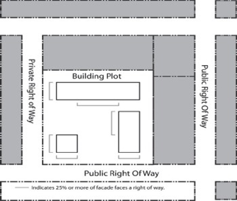
2.
Required Screening.
For all properties zoned SC Suburban Commercial and WC Wellborn Commercial, the following screening requirements apply:
a.
All mechanical equipment shall be screened from view or located so as not to be visible from any public right-of-way, public way, or residential district when viewed within one hundred fifty (150) feet of the perimeter boundary of the subject lot or tract, measured from a height five (5) feet above grade. Such screening shall be coordinated with the building architecture, materials, colors, and scale to maintain a unified appearance. Acceptable methods of screening include encasement, parapet walls, partition screens, and brick/stone/masonry walls or fences. Electrical panel boxes attached to the side of a building that are painted to match the building color do not require additional screening.
b.
Roof-mounted mechanical equipment shall be screened from any right-of-way, public way, or adjacent property by either the roof itself (including within a cut-out) or by a false roof element (i.e., chimney, cupola). Components of a mechanical equipment system, such as vents or exhaust pipes, protruding from the roof that are no larger than twelve (12) inches in diameter nor exceeding the height of the roof line are not required to be screened but must be painted to match the roof color.
3.
Building Mass and Design.
a.
Horizontal Façade Articulation.
1)
Façade articulation (wall plane projections or recessions) is required on the first two (2) stories of any primary façade that exceeds two hundred (200) feet in horizontal length. No more than thirty-three (33) percent of any primary façade shall be on the same continuous geometric plane. Wall plane projections or recessions shall have a minimum depth of four (4) feet.
2)
For all properties zoned SC Suburban Commercial, primary façades on buildings over eight thousand (8,000) square feet shall have an articulation of a minimum four (4) foot depth within each fifty (50) foot section of façade.
3)
For all properties zoned MU Mixed-Use, the vertical wall plane of any façade visible from the public right-of-way, street, or public way shall project and/or recess by a minimum of two (2) feet so that no more than sixty-six (66) percent of the façade is on the same plane.
b.
Building Entry Design.
1)
To provide a sense of arrival and shelter, public building entrances are to feature a protected entry through the use of an awning, canopy, porte-cochere, recessed entry, or another similar architectural element.
2)
Buildings that have multiple ground floor tenants or multiple primary building entrances shall have all entrances treated architecturally.
3)
For all properties zoned WC Wellborn Commercial, the following additional standards shall apply:
a)
All buildings shall be required to provide a covered front porch along the full length of the public entry façade, projecting a minimum of four (4) feet from the face of the building.
b)
All buildings that have frontage on Wellborn Road and/or Live Oak Street, shall have a public entry facing both rights-of-way.
c)
In cases where more than two (2) facades require a public entrance, the administrator may determine which two (2) facades require entrances.
c.
Architectural Relief.
1)
To provide visual interest, the first two (2) stories of any primary façade or façade visible from a public right-of-way or public way shall use at least one (1) architectural relief element for every twenty-five (25) horizontal feet, or part thereof, of façade length.
2)
Façades requiring architectural relief shall provide a minimum of two (2) different types of relief elements per façade.
3)
To avoid monotony, no more than fifty (50) percent of the required minimum number of elements on a façade may consist of the same type of relief element.
4)
The design elements may be grouped or spaced as needed along the façade, though in no case shall more than seventy-five (75) feet of continuous horizontal length be void of a relief element.
5)
Design elements used to meet architectural relief must have a functional architectural purpose. For example, awnings may not be located over faux windows or a wall area that does not have an opening.
6)
A relief element counted to meet the requirement of one (1) façade may not also be counted toward another façade.
7)
Architectural relief is not required for façades, or parts of a façade, that are within fifteen (15) feet of another building that screens the façade.
8)
Accessory buildings to a primary use, where each façade is equal to or less than twenty-five (25) horizontal feet in length or the perimeter of all façades is less than one hundred (100) horizontal feet in length, and where each façade incorporates the same building materials and colors as the primary structure, are not required to provide architectural relief elements.
9)
Architectural relief elements may be added to a non-conforming façade of an existing building subject to the following limitation: if more than fifty (50) percent of the required number of elements on a façade are added, removed, or altered, including on a cumulative basis, the façade must be brought into compliance for architectural relief.
10)
For all applicable properties other than those located in SC Suburban Commercial, WC Wellborn Commercial, and MU Mixed-Use districts, the following types of architectural relief may be utilized to meet the requirements of this Section:
a)
Canopies, permanent decorative awnings, or windows accompanied by overhangs that exceed eighteen (18) inches;
b)
Wall plane projections or recessions with a minimum of four (4) foot depth;
c)
Pilasters that project from a wall at least four (4) inches or columns;
d)
Roofline articulation as described below may count as one (1) element for a façade if it is used on a façade where the articulation is not already required;
e)
A well-defined cornice or other architectural termination to visually cap the building along a parapet may count as one (1) element for a façade if it is used on a façade where this feature is not already required;
f)
Recessed entries, stoops, porches, or arcades;
g)
Balconies that extend from the building;
h)
Boxed or bay windows;
i)
Decorative stormwater management initiatives physically integrated with the building, as approved by the Administrator; or
j)
Other architectural relief elements that provide visual interest to the affected façade and are of a physical scale to possess architectural significance may be approved by the Administrator.
11)
For all properties zoned SC Suburban Commercial and WC Wellborn Commercial, the following types of architectural relief may be utilized to meet the requirements of this Section:
a)
Decorative or functional window shutters;
b)
Covered front porch extending along at least fifty (50) percent of the building façade and projecting a minimum of four (4) feet from the face of the building if used on a façade where this feature is not already required;
c)
Eaves over eighteen (18) inches, if used on a façade that does not have a covered front porch;
d)
Window planter boxes;
e)
Window canopy;
f)
Dormers;
g)
Transom windows;
h)
Decorative façade lighting;
i)
Chimneys or cupolas;
j)
Cross gables;
k)
Entry portico;
l)
Horizontal articulation with a minimum depth of four (4) feet for WC Wellborn Commercial only;
m)
Canopies, permanent decorative awnings, or windows accompanied by overhangs that exceed eighteen (18) inches for SC Suburban Commercial zoning only;
n)
Pitched roof or peaked parapet roof if it gives the appearance of a pitched roof from all sides and has a minimum roof slope of four inches over twelve inches (4/12) for SC Suburban Commercial zoning only; or
o)
Other architectural relief elements that provide visual interest to the affected façade and are of a physical scale to possess architectural significance as may be approved by the Administrator.
12)
For all properties zoned MU Mixed-Use, the following types of architectural relief may be utilized to meet the requirements of this Section:
a)
Canopies or permanent decorative awnings;
b)
Wall plane projections or recessions with a minimum of four (4) foot depth;
c)
Pilasters that project from a wall at least four (4) inches or columns;
d)
Recessed entries, stoops, porches, or arcades;
e)
Balconies that extend from the building;
f)
Boxed or bay/oriel windows;
g)
Hood/drip molding over windows;
h)
Cornices, corbelling, quoining, or stringcourses;
i)
Decorative or functional window shutters;
j)
Window planter boxes;
k)
Transom windows;
l)
Decorative façade lighting;
m)
Chimneys or cupolas; or
n)
Other architectural relief elements that provide visual interest to the affected façade and are of a physical scale to possess architectural significance may be approved by the Administrator.
d.
Other Mass and Design Requirements.
1)
For all properties zoned SC Suburban Commercial, the gross floor area of a single structure shall not exceed fifteen thousand (15,000) square feet in area.
2)
For all properties zoned WC Wellborn Commercial, the gross floor area of a single structure shall not exceed ten thousand (10,000) square feet in area.
3)
For all properties zoned MU Mixed-Use:
a)
The ground floor shall have a minimum floor-to-ceiling height of twelve (12) feet.
b)
The commercial portions of any façade facing a public right-of-way, street, or public way shall be at least thirty (30) percent transparent between zero (0) feet and eight (8) feet above ground level.
c)
Public entry is required on all façades facing a public right-of-way, street, or public way. In the event more than two (2) façades require a public entrance, the Administrator may determine which two (2) façades require entrances. The Administrator may also forward the question to the Design Review Board for any reason.
d)
Loading docks, overhead doors, and service entries shall not be located on a façade facing a public right-of-way, street, or public way. In the case that more than two (2) façades face a public right-of-way, street, or public way, the Administrator shall determine the most appropriate façade for such activities.
e.
Roof and Roofline Design.
1)
On buildings three (3) stories or less, the horizontal line of a flat roof or parapet along a primary entrance façade, along any façade facing a public right-of-way of a street classified as a minor arterial or higher on the Comprehensive Plan Functional Classification & Context Class Map, and on all façades visible from a public right-of-way for properties that are zoned MU Mixed Use, shall vary by a minimum of two (2) feet up or down so that no more than sixty-six (66) percent of the roofline is on the same elevation, as represented below.
Roofline Design Standards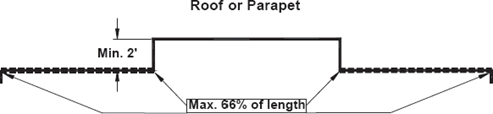
2)
For all rooflines that are required to articulate as described above, the parapet roof line shall feature a well-defined cornice or other architectural termination to visually cap the building along the roofline.
3)
For all properties zoned WC Wellborn Commercial, roofs shall be similar to residential roof types. Flat roofs are not permitted. Shed roofs are only permitted as part of a peaked roof network. A peaked parapet is permitted if it gives the appearance of a pitched roof from all sides. The roof slope must be a maximum of eight inches over twelve inches (8/12) and a minimum of four inches over twelve inches (4/12).
f.
Building Materials.
1)
The following minimum amount of fired brick, natural stone, marble, granite, or any concrete product so long as it has an integrated color and is textured or patterned (not aggregate material) to simulate brick, stone, marble, or granite shall be provided:
a)
A minimum of ten (10) percent on any façade visible from a public right-of-way or public way;
b)
A minimum of twenty (20) percent on primary entrance façades (single or multiple tenant building) that exceed two hundred (200) feet in horizontal length;
c)
A minimum of twenty (20) percent on any façade facing a public right-of-way of a street classified as a major collector on the Comprehensive Plan Functional Classification & Context Class Map; and
d)
A minimum of thirty (30) percent on any façade facing a public right-of-way of a street classified as a minor arterial or higher on the Comprehensive Plan Functional Classification & Context Class Map.
2)
Building materials used to meet the minimum material requirements as provided above may not be painted.
3)
The following building materials are allowed on all façades subject to the following limitations:
a)
Stucco, Exterior Insulation and Finish System (EIFS), high build textured paint on concrete to simulate the appearance of stucco, split-face concrete masonry that does not simulate brick or stone, fiber cement siding, reflective glass, or any material equivalent in appearance and quality as determined by the Design Review Board, shall not cover more than seventy-five (75) percent of any façade.
b)
Wood or cedar siding, stainless steel, chrome, standing seam metal, premium grade architectural metal, or architecturally finished metal panels (not corrugated metal) shall not cover more than thirty (30) percent of any façade.
c)
Tile or smooth face tinted concrete blocks shall only be used as an accent and shall not cover more than ten (10) percent of any façade.
d)
Painted metal panel siding is allowed without limitation on a rear façade of a building when the façade is not visible from a right-of-way, parkland, greenway, or any residential area.
e)
Galvanized steel and painted steel are allowed on doors, including roll-up doors.
f)
Metal, standing seam metal, architectural metal or steel may be used as a roof and or canopy/awnings with no limitation on percentage.
g)
In WC Wellborn Commercial wood or cedar siding shall be allowed but not cover more than seventy-five (75) percent of any façade and reflective glass shall not cover more than thirty (30) percent of any façade.
4)
When determining the area of a façade, doors, windows, and other openings are included and roof area is not included.
5)
Existing buildings may continue to utilize materials other than those listed provided that any material replacement is for maintenance purposes only and the existing material is continued. Any material change or replacement of more than fifty (50) percent of the total area of a façade, including on a cumulative basis, shall require that all building materials be brought into compliance on that façade.
6)
All architectural submittals shall provide elevation drawings for each façade and a material legend (see sample below) for each façade.
D.
Alternative Compliance Permitted.
The Design Review Board may authorize variation to the overall requirements of this Section through an application from a licensed architect for an alternative compliance approval that would allow the innovative or visually interesting design or to address unique circumstances not otherwise permitted through strict adherence to this Section. Such requests must show reasonable evidence that the purposes of the requirements as set forth in this Section were maintained and that the additional design flexibility afforded does not provide a means to permit the design of lesser quality.
E.
Waivers and Appeals.
The Design Review Board shall review requests for deviations from this Section. The Design Review Board shall approve waivers or appeals found meeting the intent and general purposes of the standards as it is recognized that unique and unforeseen design circumstances exist in the application of the standards.
Financial hardship may not be considered in the review or determination of a waiver proposal. The Design Review Board may review and approve the following:
1.
Substitutions of building materials if the applicant shows that:
a.
The building material is a new or innovative material manufactured that has not been previously available to the market or the material is not listed as an allowed or prohibited material herein;
b.
The material is similar and comparable in quality and appearance to the materials allowed in this Section; or
c.
The material is an integral part of a themed building (example 50's diner in chrome).
2.
Alternate materials on each façade if the applicant shows that:
a.
The applicant is a franchised and/or chain commercial use to be developed as a single detached building (not integrated into a multi-tenant building);
b.
The proposed materials are part of its corporate branding; and
c.
The applicant provides all of the alternative materials schemes the chain or franchise has used.
3.
Alternative materials on façade work that does not involve an expansion of an existing building as defined in Article 9, Nonconformities of this UDO or constitute redevelopment if the applicant shows that:
a.
The materials allowed in this Section cannot be utilized without a structural alteration(s) to the existing building; and
b.
A licensed professional engineer or architect verifies in writing that a structural alteration is required to apply the permitted façade materials to the building.
4.
Alternatives to the options for required screening of mechanical equipment.
5.
Alternatives to the design elements available to provide architectural relief.
6.
Relief from the building orientation and access for buildings in MU Mixed-Use districts when physical characteristics limit the site or provide unique orientation and access opportunities.
7.
Reduction in the percentage of required building transparency for the rehabilitation or expansion of existing buildings in MU Mixed-Use districts if it can be proven by the applicant that inherent site characteristics constrain the proposed project from meeting the transparency requirement.
8.
A variance of up to one hundred (100) percent from the façade articulation or roofline standards herein if the applicant shows that it is not financially or structurally feasible.
F.
Submittal Requirements.
When the non-residential architectural standards are applicable, submitted building elevations shall include the following:
1.
Scaled building elevations for each façade, depicting the required architectural relief and other design elements.
2.
Accurate building footprint(s) and general orientation of the building façades in relation to adjacent rights-of-way, public ways, and properties.
(Ord. No. 2023-4453, Pt. 1(Exh. A), 8-10-2023)
Sec. 7.11. - Outdoor Lighting Standards.
It is recognized that no design can eliminate all ambient light from being reflected or otherwise visible from any given development; however, the following requirements shall be followed to the fullest extent possible to limit nuisances associated with lighting and resulting glare.
A.
Applicability.
All lighting within developments shall meet the requirements of this Section, except that single-family, duplexes, townhouses, primary and secondary educational facilities containing a building with a Group "E" occupancy as defined in the International Building Code, athletic fields, and lighting not visible from the perimeter of development are exempted.
B.
Site Lighting Design Requirements.
1.
Fixture (luminaire).
The light source shall not project below an opaque housing. No fixture shall directly project light horizontally.
2.
Light Source (lamp).
Only incandescent, florescent, metal halide, mercury vapor, or color-corrected high-pressure sodium may be used. The same type must be used for the same or similar types of lighting on each site throughout any master-planned development.
3.
Mounting.
Fixtures shall be mounted in such a manner that the projected cone of light does not cross any property line.
C.
Specific Lighting Requirements.
The following specific lighting requirements apply:
1.
Façade and flagpole lighting must be directed only toward the façade or flag and shall not interfere with the night visibility on nearby thoroughfares or shine directly at any adjacent residential use.
2.
All lighting fixtures incorporated into non-enclosed structures (i.e., gas pump canopies, car washes, etc.) shall be fully recessed into the underside of such structures.
3.
For properties zoned SC Suburban Commercial, site and building lighting may not be located within required buffer areas or within required building setbacks adjacent to single-family use or zoning district, except when pedestrian walkways or trails are provided.
4.
For properties zoned SC Suburban Commercial and WC Wellborn Commercial, site and parking lot lighting fixtures may not exceed the eave height of the building to which they principally relate, with a maximum height limit of twenty (20) feet.
5.
For properties zoned BP Business Park, site and parking lot lighting fixtures may not exceed the height of the building to which they principally relate, with a maximum height limit of twenty (20) feet.
Permitted and Prohibited Outdoor Lighting Fixtures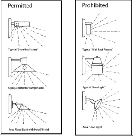
(Ord. No. 2023-4453, Pt. 1(Exh. A), 8-10-2023)
Sec. 7.12. - Outdoor Storage and Display.
A.
General.
Outdoor storage and display is allowed in non-residential districts in accordance with this Section. Any merchandise, material, or equipment situated outdoors and visible from the public right-of-way or adjacent properties shall be subject to the requirements of this Section. No outdoor storage or display shall be allowed to occur in required parking areas. For the purpose of this Section, outdoor storage, display, and sales shall be broken down into the four (4) categories listed below.
B.
Categories of Outdoor Storage and Display.
1.
Outdoor Display.
Outdoor display is the display of items actively for sale or rent. Outdoor display shall be allowed adjacent to a principal building wall and extending to a distance no greater than five (5) feet from the wall. In lieu of this requirement, a business may obtain site plan approval for outdoor display areas adjacent to the principal building's public entry façade. Such areas shall not exceed ten (10) percent of the total gross floor area of the principal structure or two thousand five hundred (2,500) square feet, whichever is less. Such storage shall not be permitted to block windows, entrances, or exits, and shall not restrict pedestrian or vehicular circulation, access, or parking.
2.
Permanent Outdoor Sales Areas.
Merchandise may be stored or displayed on-site for sale to customers. Permanent outdoor sales areas shall be enclosed by a minimum six (6) foot screen or wall. Such areas shall not exceed two thousand five hundred (2,500) square feet or ten (10) percent of the total site area, whichever is less. Permanent outdoor sales areas must comply with district setback requirements. Such areas may not interfere with parking or parking lot requirements. Permanent areas open to the public for the display and/or sale of merchandise shall be shown on a site plan and will be included in parking requirement calculations.
3.
Temporary Outdoor Sales and Storage.
Temporary outdoor sales areas, including sales tents, may be displayed for a two (2) week period in a calendar year. Such areas shall be clearly defined and shall not interfere with parking lot requirements. Christmas trees may be displayed for sale from November 15 to December 31.
4.
General Outdoor Storage.
Outdoor storage consists of all remaining forms of outdoor storage not classified above. Outdoor storage that is visible to the public right-of-way or adjacent properties is allowed so long as it is completely screened from view outside the site by a solid wall or fence at least six (6) feet in height. Except for developments in the M-2 Heavy Industrial district, outdoor storage shall not exceed the height of the required screening. Outdoor storage shall not be allowed within a required front setback.
C.
Exceptions.
1.
Vehicles for sale as part of a properly permitted vehicle sales use (including boats and manufactured housing) shall not be considered merchandise, material, or equipment subject to the restrictions of this Section. Such vehicles shall be located and displayed on a paved area that meets parking lot pavement standards and shall be screened under the same requirements for a parking lot.
2.
Waste generated on-site and deposited in ordinary refuse containers shall not be considered outdoor display or storage.
D.
Location of Outdoor Storage and Display.
Unless specifically authorized elsewhere in the City of College Station Code of Ordinances, all outdoor storage, display, and sales shall be located outside the public right-of-way and must adhere to the required district setbacks.
(Ord. No. 2023-4453, Pt. 1(Exh. A), 8-10-2023)
Sec. 7.13. - Traffic Impact Analyses.
This Section establishes requirements and procedures pertaining to traffic impact analyses. This Section is intended to inform the applicant of the City's expectations to ensure safe and adequate access to development properties, adequate traffic flow on existing and proposed/planned roadways, and sufficient connectivity of the existing and proposed/planned roadway system attributable to their proposal. In addition, this Section is intended to expedite the City's review of traffic impact analysis reports, provide standard criteria for evaluating proposals, and identify some potential mitigation measures.
The traffic impact analysis is intended to form the basis for the design of any proposed access/roadway system to ensure coordination of the proposed land use with the transportation needs resulting therefrom. The City and the developer share the responsibility to identify and solve transportation issues arising from land development.
The City requires that traffic impact analyses accompany certain zoning applications, certain preliminary plan applications, and certain site plan applications. It is intended that any traffic impact analysis required for any type of land development proposal will complement the overall goal of ensuring that adequate transportation facilities are in place to serve land uses by the time those uses are occupied and generating traffic. These purposes are further amplified below.
A.
Purpose.
1.
Zoning Traffic Impact Analysis.
The goal of a traffic impact analysis submitted in conjunction with a zoning request is to determine the effect that uses allowed within various proposed zones will have on existing and/or any proposed/planned roadway systems, and to ensure there is a balance between future land uses and future transportation systems. Zoning applications that are required to have a traffic impact analysis are evaluated using both current and long-term traffic and roadway scenarios.
The traffic impact analysis will determine whether acceptable levels of service will be maintained for traffic flow within the proposed project and in its study area. Where service levels fall below acceptable standards, mitigation solutions will be analyzed for their effectiveness. A traffic impact analysis for a zoning request should not recommend mitigation measures that are inconsistent with any traffic or roadway provisions of the UDO or the Comprehensive Plan, including the Thoroughfare Plan. The Planning and Zoning Commission and the City Council shall consider the findings of the traffic impact analysis in approving or disapproving zoning changes to the extent allowed by law.
2.
Preliminary Plan Traffic Impact Analysis.
The goal of a traffic impact analysis submitted in conjunction with a preliminary plan is twofold: to assess the adequacy and safety of proposed access to adjacent existing or planned roadways (or designs proposed for such access or roadways) and to determine the effects the proposed project may have on current and future land development and roadway systems in its study area. Generally, the traffic impact analysis uses current and anticipated near-term traffic volumes and roadway configurations for the analysis. The process should ensure that the roadway system is, or will be, adequate to accommodate the proposed use and that safe and adequate access will be provided for travel between the site and the public roadway system.
Where the traffic impact analysis shows levels of service falling below acceptable minimums on roadway systems in its study area the traffic impact analysis will recommend appropriate mitigation measures and demonstrate their effectiveness. Example mitigation techniques may include adding/lengthening deceleration/turn lanes, improving driveway access, providing connectivity, and modifying traffic control devices. Combinations of these techniques and other techniques can be considered. A traffic impact analysis for a preliminary plan should not recommend mitigation measures that are inconsistent with any traffic or roadway provisions of the UDO or the Comprehensive Plan, including the Thoroughfare Plan. The Planning and Zoning Commission shall consider the findings of the traffic impact analysis in approving or disapproving preliminary plans to the extent allowed by law.
3.
Site Plan Traffic Impact Analysis.
The goal of a traffic impact analysis submitted in conjunction with a site plan is twofold: to assess the adequacy and safety of proposed access to adjacent existing or planned roadways (or designs proposed for such access or roadways) and to determine the effects the site project may have on current and future land development and roadway systems in its study area. Generally, the traffic impact analysis uses current and anticipated near-term traffic volumes and roadway configurations for the analysis.
The process should ensure that the roadway system is, or will be, adequate to accommodate the proposed use and that safe and adequate access will be provided for travel between the site and the public roadway system.
Where the traffic impact analysis shows levels of service falling below acceptable minimums on roadway systems in its study area the traffic impact analysis will recommend appropriate mitigation measures and demonstrate their effectiveness. Example mitigation techniques may include adding/lengthening deceleration/turn lanes, improving driveway access, providing connectivity, and modifying traffic control devices. Combinations of these techniques and other techniques can be considered. A traffic impact analysis for a site plan should not recommend mitigation measures that are inconsistent with any traffic or roadway provisions of the UDO or the Comprehensive Plan, including the Thoroughfare Plan. The Planning and Zoning Commission shall consider the findings of the traffic impact analysis in approving or disapproving site plans to the extent allowed by law.
B.
Definitions.
1.
Trip Generation Rates.
Trip generation rates are used to estimate the amount of vehicular traffic generated by proposed rezoning or a proposed site plan. For zoning and preliminary plan traffic impact analyses, these rates are shown by zoning district in the table below. Preliminary plan trip generation rates should be based on the underlying zoning district. Site plan traffic impact analyses shall use rates set forth in the latest edition of the Trip Generation Report published by the Institute of Transportation Engineers (ITE) unless said report does not adequately address the type or intensity of the proposed land use. In this event, the applicant or their agent shall submit projected vehicle trips to the Administrator. For land uses adequately represented in said report, alternate trip generation rates shall not be accepted.
* Density maximum calculated based on existing (2007) developments in the City of College Station.
* Density maximum calculated based on existing (2007) developments in the City of College Station.
2.
Design Year.
The design year is the point in time upon which assumptions pertaining to land use, population, employment, and transportation facilities are based. All traffic impact analyses shall use a design year based on the expected date of project occupancy and shall include consideration of nearby development that has been approved and will contribute traffic volume to the proposed project's study area.
3.
Peak Periods.
Peak periods relate to times of day experiencing the greatest hourly traffic flow rates. Two (2) "peaks" are to be addressed by a traffic impact analysis: The morning and afternoon peak hours (or projected peak hours) of existing (or planned) roadways serving the proposed land development. Typically, roadway peak periods are between 7:00 and 9:00 a.m. and between 4:00 and 6:00 p.m.
4.
Base Volumes.
Base volumes shall be based on current traffic counts adjusted to the expected date of project occupancy plus volumes generated by nearby future development (all phases) that has been approved by the City. When available, base data will be supplied by the City Traffic Engineer. In all cases where traffic counts are needed and are not available, the developer or their agent shall be required to collect such data according to guidelines approved by the Administrator.
5.
Level of Service.
Level of service is a measure of the extent of congestion experienced on roadways. It is measured through analysis of traffic operating conditions on roadway links and at intersections, using techniques presented in the latest edition of the Transportation Research Board's Highway Capacity Manual.
C.
Applicability.
1.
Zoning Traffic Impact Analysis.
Any zoning request, except for certain redevelopment areas as designated on the Comprehensive Plan Future Land Use & Character Map, which is expected to generate at least one hundred fifty (150) vehicle trips during any peak hour period requires a traffic impact analysis. Where the Comprehensive Plan designates a property as a redevelopment area, a traffic impact analysis is required if the zoning request is expected to generate at least one hundred fifty (150) vehicle trips during any peak hour period more than those generated by the currently approved use(s) on the property. A zoning request involving multiple zoning districts is required to have a traffic impact analysis based on the total traffic generated for all the proposed districts. A traffic impact analysis may be required for a zoning request that generates less than one hundred fifty (150) trips in the peak hour, where the peaking characteristics could have a detrimental impact on the transportation system as determined by the Administrator.
A traffic impact analysis shall be required unless the applicant demonstrates to the satisfaction of the Administrator that a traffic impact analysis is not necessary for the proposed rezoning request. In cases where a traffic impact analysis is required, the rezoning application will be considered incomplete until the traffic impact analysis is submitted.
2.
Preliminary Plan Traffic Impact Analysis.
Any proposed development requiring preliminary plan approval, which is expected to generate at least one hundred fifty (150) trips in any peak hour period requires a traffic impact analysis. A traffic impact analysis may be required for preliminary plans that generate less than one hundred fifty (150) trips in any peak hour period where the peaking characteristics could have a detrimental impact on the area's vehicular transportation system as determined by the Administrator.
A traffic impact analysis shall be required unless the applicant demonstrates to the satisfaction of the Administrator that a traffic impact analysis is not necessary for the proposed project. In cases where a traffic impact analysis is required, the preliminary plan application must be accompanied by the traffic impact analysis.
3.
Site Plan Traffic Impact Analysis.
Any proposed development requiring site plan approval, excluding developments located in the zoning classifications of NG-1 Core Northgate, NG-2 Transitional Northgate, or NG-3 Residential Northgate, which is expected to generate at least one hundred fifty (150) trips in any peak hour period requires a traffic impact analysis. A traffic impact analysis may be required for site plans that generate less than one hundred fifty (150) trips in any peak hour period where the peaking characteristics could have a detrimental impact on the area's vehicular transportation system as determined by the Administrator.
A traffic impact analysis shall be required unless the applicant demonstrates to the satisfaction of the Administrator that a traffic impact analysis is not necessary for the proposed site project. In cases where a traffic impact analysis is required, the site plan application must be accompanied by the traffic impact analysis.
D.
Methodology.
1.
Professional Engineer to Perform Traffic Impact Analysis.
All required traffic impact analyses shall be performed by a professional engineer licensed in the State of Texas and qualified to perform such analysis. Qualifications may include but are not limited to certification as a Professional Traffic Operations Engineer or Professional Transportation Planner by the Institute of Transportation Engineers or certification by the Texas Department of Transportation (TxDOT) to conduct traffic engineering studies.
2.
Pre-Submittal Meeting.
A pre-submission consultation with the Administrator is required at the time of the pre-application conference to discuss whether a traffic impact analysis is required and, if so, the relevant aspects thereof. The study area will be defined to include nearby land developments (existing or approved), the street network to be examined (the study network), and the minimum extent of analysis. In addition, details of the procedures, assumptions, data collection, and analysis methodologies will be determined at this meeting. Traffic from other nearby developments that have been approved but not yet constructed will be accounted for in the traffic impact analysis as determined by the Administrator. The Administrator may require other specific assumptions such as the percentage of trucks to match local conditions. The City may require analysis of peak fifteen (15) minute intervals for certain types of land uses that generate major traffic surges including but not limited to stadiums, movie theaters, arenas, and schools.
3.
Zoning Traffic Impact Analysis Content.
a.
Study Area.
A map(s) will delineate the traffic impact analysis study area, including land areas to be considered and all existing/planned streets therein, and the study network (those streets and intersections requiring specific analysis). The study area shall be determined based on the geographical area most affected by the proposed zoning request as determined by the Administrator after conferring with the applicant's traffic engineer.
b.
Existing Zoning.
A description by zoning classification of the existing zoning in the area proposed for rezoning.
c.
Proposed Zoning.
A description of the proposed zoning including the land area by zoning classification.
d.
Roadway Network.
A description of the existing and proposed/planned roadways of all classifications and traffic volumes on the study network within the study area.
e.
Impact Determination.
An assessment of projected traffic volumes is to be made for all study network roadways, comparing those with allowable volume limits on roadways classed as collector and local, and providing a description of the volume/capacity ratio for all roadways in the study network. In addition, delay projections for signalized and unsignalized intersections in the study network will be determined. Where volume/capacity ratios and intersection delay are the measures of effectiveness level of service D or better must be maintained. The analysis shall contain the following minimum information:
1)
Proposed Trip Generation.
Show in tabular form trip generation rates (see the tables above in this section) and the total trips generated based on proposed zoning.
2)
Existing Trip Generation.
Show in tabular form trip generation rates (see the tables above in this section) and the total trips generated based on existing zoning.
3)
Net Increased Trip Distribution and Assignment.
Show proposed trip generation minus existing trips and the calculation of new trips generated. The net increase in trips generated by the zoning request is to be added to the base volumes projected by design year. Twenty-four (24) hour and peak hour volumes must be calculated. Distribution and assignment calculations must be provided.
4)
Level of Service Analysis.
Show in tabular form the peak hour level of service for existing and proposed zoning. Calculations shall include all thoroughfare links and intersections. Calculate the level of service and percentage change (when compared to base volumes) for each link and intersection.
5)
Neighborhood Traffic Analysis.
If a proposed rezoning is projected to increase the traffic on an existing or proposed/planned minor collector or local residential street by at least ten (10) percent, a neighborhood traffic analysis shall be performed. This analysis will include an evaluation of existing and projected traffic on the affected roadways. Where the projected traffic exceeds the limits indicated in the Bryan/College Station Unified Design Guidelines, the street network layout must be adjusted to lower this traffic volume.
6)
Conclusions.
Summarize points of conflict and congestion, identify all thoroughfare links and intersections not achieving a level of service D or better, and the percentage change resulting from the proposed zoning change. The results of examining collector and local residential roadways, including the findings of any neighborhood traffic analysis must also be summarized.
f.
Mitigation.
A description of the mitigation measures proposed for achieving acceptable service thresholds shall be shown. Analysis of the study network as adjusted by the proposed measures must be documented. Traffic produced by the proposed zoning request plus traffic levels projected by the time of project occupancy should result in a level of service D or better. Locations not meeting a level of service D where the proposed zoning contributes five (5) percent or more of the peak hour traffic must be mitigated by the applicant. Acceptable methods of mitigating negative traffic impacts include one (1), or a combination of, the measures listed below but are not limited to those listed.
1)
Modifying the zoning request so that resulting traffic volumes yield a level of service D or better throughout the study network.
2)
Modify any street network proposed as part of the development project in terms of size, layout, connectivity, intersection layouts, or location of termini with thoroughfares, or any combination of such changes.
3)
Limit development densities/intensities within one (1) or more zoning classifications or land parcels to result in acceptable traffic volumes.
4)
Making minor thoroughfare or intersection improvements, such as adding/extending or relocating turn lanes, adding/extending acceleration and/or deceleration lanes, adding non-traversable medians, relocating median openings, using special directional median openings, or using special features to facilitate safe U-turn maneuvers.
Amendments to the Comprehensive Plan Functional Classification & Context Class Map shall not be accepted as a means of mitigating negative impacts unless the proposed amendment(s) can be shown to enhance capacity and safety and will be constructed as part of the proposed land development project.
g.
Planning and Zoning Commission Report.
The Planning and Zoning Commission shall make a report to the City Council on all traffic impact analyses it considers in conjunction with rezoning requests. The Planning and Zoning Commission may make a recommendation for approval, modification, or denial of the zoning case based on other planning factors in addition to its review of the traffic impact analysis.
Where the identified impacts of the proposed zoning cannot be adequately mitigated, the Planning and Zoning Commission may recommend to the City Council one (1) or more of the following actions:
1)
Denial of the zoning case in total or in part.
2)
Other action(s) deemed appropriate by a study made, or endorsed by, a qualified traffic engineer to mitigate negative traffic impacts.
4.
Preliminary Plan Traffic Impact Analysis Content.
Submittals of traffic impact analyses for preliminary plan projects shall include the following:
a.
Study Area.
A map(s) delineating the traffic impact analysis study area, including land areas to be considered and all existing/planned roadways therein, and the study network (those roadways and intersections requiring specific analysis). The study area will be determined by identifying the geographical area most affected by the proposed development as determined by the Administrator after conferring with the applicant. In general, the study area will cover all intersections through which at least ten (10) percent of the proposed development's site traffic passes and shall extend to and include at least the first traffic signal in all directions if within one (1) mile of any portion of the site. Existing roadway and intersection capacities shall be shown.
b.
Existing Zoning.
A description of existing zoning in the area included in the preliminary plan.
c.
Thoroughfare Network.
A description of existing thoroughfares, signals, signal phasing, and traffic volumes within the study area.
d.
Proposed Development.
A description of the proposed development including land area (gross and net), square footage, density, dwelling units, etc. Also, a description of anticipated roadway conditions expected by the date of completion of the proposed development shall be included.
e.
Proposed Roadway Network.
Identification of the proposed roadway network for the preliminary plan. This shall include the location of access points, the location and number of lanes of proposed roadways or public ways, and proposed traffic controls. It must also include any proposed modifications to adjacent roadways.
f.
Impact Determination.
A determination of the level of service for all roadways and intersections in the study area shall be included, as shall an evaluation of pedestrian, bicycle, and motor vehicle safety conditions within the preliminary plan. The analysis shall contain the following minimum information:
1)
Proposed Trip Generation.
A calculation of the total trip generation by use within the study area assuming full development and occupancy, including both peak hour and twenty-four (24) hour information showing any reductions attributed to passers-by, mixed-use, etc. Show trip generation by use in tabular form with land use trip generation rates and trips generated.
2)
Trip Distribution and Assignment.
A calculation of trips generated by the proposed development as added to the base volumes projected for the design year. Peak hour volumes must be calculated. Distribution assumptions (and the bases, therefore) and assignment calculations must be provided.
3)
Level of Service Analysis.
A depiction shown in tabular form, twenty-four (24) hour and peak hour volume/capacity ratios for links and intersections within the study area. This analysis should be done for the following traffic conditions: existing traffic, existing traffic plus projected traffic.
4)
Neighborhood Traffic Analysis.
If the traffic impact analysis calculations show that a proposed preliminary plan increases traffic on a minor collector or local residential street by at least ten (10) percent, a neighborhood traffic analysis shall be performed. This analysis will include an evaluation of existing and projected traffic on the affected roadways. Where the projected traffic exceeds the limits indicated in the Bryan/College Station Unified Design Guidelines mitigation to lower this traffic may be required.
5)
Conclusions.
A summary of findings must be reported. It must show all adjacent roadways and intersections noting those that fail to provide a level of service D or better, and the percent increase in total traffic produced by the proposed project. In addition, the report must demonstrate that the proposed roadway network will provide safe and adequate access to the development. It also must identify any safety and operational problems (e.g., driveways, sight distances, median openings, and signalization) within the study area.
g.
Mitigation.
A description of the mitigation measures proposed for meeting acceptable traffic service thresholds shall be shown. Where the development is contributing five (5) percent or more of the traffic at locations failing to meet a level of service D or better the total trips should be mitigated by the applicant to low enough levels to achieve the required standard (or to pre-development levels if the pre-development level is less than a level of service D). Acceptable measures for mitigating negative traffic impacts include one (1), or a combination of, those listed below.
1)
Modifying the density or intensity of land use, such as a reduction in square footage or the percentage of commercial use to result in traffic levels meeting a level of service D or better;
2)
Phasing approval and construction of a project until additional roadway capacity becomes available;
3)
Modifying the proposed street network in terms of size, layout, connectivity, intersection layouts, or location of termini with thoroughfares or any combination of such changes;
4)
Making off-site improvements including the construction of additional lanes, increases in storage lane capacities, or modification/installation of signalization, to list some examples.
h.
Costs of Mitigation.
Mitigation improvements that are attributable to the proposed development shall be funded at the developer's expense. Any other improvements shown which are consistent with the Thoroughfare Plan may be repaid by the City in accordance with its cost-sharing policies.
5.
Site Plan Traffic Impact Analysis Content.
Submittals of traffic impact analyses for site plan projects shall include the following:
a.
Study Area.
A map(s) delineating the traffic impact analysis study area, including land areas to be considered and all existing/planned roadways therein, and the study network (those roadways and intersections requiring specific analysis). The study area will be determined by identifying the geographical area most affected by the proposed development as determined by the Administrator after conferring with the applicant. In general, the study area will cover all intersections through which at least ten (10) percent of the proposed development's site traffic passes and shall extend to and include at least the first traffic signal in all directions if within one (1) mile of any portion of the site. Existing roadway and intersection capacities shall be shown.
b.
Existing Zoning and Development.
A description of existing zoning including land area (gross and net) by zoning classification, square footage, the density of hotel rooms, dwelling units, etc. Also, a description of the development currently within the proposed site plan, including showing how it will be affected by the new development proposal.
c.
Thoroughfare Network.
A description of existing thoroughfares, signals, signal phasing, and traffic volumes within the study area.
d.
Proposed Development.
A description of the proposed development including land area (gross and net), square footage, the density of hotel rooms, dwelling units, etc. Also, a description of anticipated roadway conditions expected by the date of occupancy of the proposed development shall be included.
e.
Proposed Access.
Identification of the proposed access driveways for the site. This shall include the location and number of lanes, proposed traffic controls, and relationship to on-site circulation features for each proposed point of access. It must also include any proposed modifications to adjacent roadways. Once the traffic impact analysis and an access plan have been approved, the final location and design of all access points shall meet or exceed the current access management and roadway design policies of the entity responsible for the condition of that portion of the adjacent roadway.
f.
Impact Determination.
A determination of the level of service for all roadways and intersections in the study area shall be included, as shall an evaluation of pedestrian, bicycle, and motor vehicle safety conditions along all the roadway frontage of the site. The analysis shall contain the following minimum information:
1)
Proposed Trip Generation.
A calculation of the total trip generation by use within the study area assuming full development and occupancy, including both peak hour and twenty-four (24) hour information showing any reductions attributed to passers-by, mixed-use, etc. Show trip generation by use in tabular form with land use trip generation rates and trips generated.
2)
Trip Distribution and Assignment.
A calculation of trips generated by the proposed development as added to the base volumes projected for the design year. Peak hour volumes must be calculated. Distribution assumptions (and the bases, therefore) and assignment calculations must be provided.
3)
Level of Service Analysis.
A depiction shown in tabular form, twenty-four (24) hour and peak hour volume/capacity ratios for links and intersections within the study area. This analysis should be done for the following traffic conditions: existing traffic, existing traffic plus projected traffic. Capacity analyses must be shown for all points of ingress and egress, median breaks, and turn lanes associated with the proposed site.
4)
Neighborhood Traffic Analysis.
If the traffic impact analysis calculations show that a proposed site project increases traffic on a minor collector or local residential street by at least ten (10) percent, a neighborhood traffic analysis shall be performed. This analysis will include an evaluation of existing and projected traffic on the affected roadways. Where the projected traffic exceeds the limits indicated in the Bryan/College Station Unified Design Guidelines mitigation to lower this traffic may be required.
5)
Conclusions.
A summary of findings must be reported. It must show all adjacent roadways and intersections noting those that fail to provide a level of service D or better, and the percent increase in total traffic produced by the proposed site project. In addition, the report must demonstrate that the proposed access design will provide safe and adequate access to the project site. It also must identify any safety and operational problems (e.g., driveways, sight distances, median openings, and signalization) within the study.
g.
Mitigation.
A description of the mitigation measures proposed for meeting acceptable traffic service thresholds shall be shown. Where the development is contributing five (5) percent or more of the traffic at locations failing to meet a level of service D or better the total trips should be mitigated by the applicant to low enough levels to achieve the required standard (or to pre-development levels if the pre-development level is less than a level of service D). Acceptable measures for mitigating negative traffic impacts include one (1), or a combination of, those listed below:
1)
Modifying the density or intensity of land use, such as a reduction in square footage or the percentage of commercial use to result in traffic levels meeting a level of service D or better;
2)
Phasing approval and construction of a project until additional roadway capacity becomes available;
3)
Improving the access plan by dealing with features such as overall site arrangement, the placement and design features of access points, provision of additional access points to roadways not immediately adjacent to the property, provision of alternate controls, or adjustments in the site circulation system;
4)
Making off-site improvements including the construction of additional lanes, increases in storage lane capacities, or modification of signalization, to list some examples.
h.
Costs of Mitigation.
Mitigation improvements that are attributable to the proposed development shall be funded at the developer's expense. Any other improvements shown that are consistent with the Thoroughfare Plan may be repaid by the City in accordance with its cost-sharing policies.
E.
Criteria for Approval.
The City shall consider the following standards in determining whether a proposed rezoning or submitted site plan project meets an acceptable level of service:
1.
Design Requirement.
The proposed rezoning or site plan project is consistent with the City's adopted access management and design requirements and is consistent with the design requirements of the Texas Department of Transportation (TxDOT) on roadways maintained by such agency.
2.
Level of Service D.
The desirable minimum level of service for the City of College Station is a level of service D as that term is described in the Transportation Research Board's Highway Capacity Manual.
3.
Determination of Adequate Mitigation.
Notwithstanding anything to the contrary herein, the appropriate Administrator and the appropriate reviewing body, where required, shall, based on recommendations by a qualified traffic engineer, determine whether adequate mitigation has occurred to meet an acceptable level of service utilizing the requirements set forth herein.
(Ord. No. 2023-4453, Pt. 1(Exh. A), 8-10-2023)
Sec. 7.14. - Drainage and Stormwater Management.
A.
General.
1.
Purpose and Intent.
This Section establishes methods for controlling the introduction of pollutants into the municipal stormwater drainage system and establishes legal authority for the City to carry out all inspections, surveillance, monitoring, and enforcement procedures necessary to ensure compliance with the Municipal Separate Storm Sewer System (MS4) permit for industrial and construction activity.
2.
Compatibility with Other Regulations.
a.
This Section is not intended to modify or repeal any other ordinance, rule, regulation, or other provision of law. The requirements of this Section are in addition to the requirements of any other ordinance, rule, regulation, or other provision of law, and where any provision of this Section imposes the restriction of law, whichever provision is more restrictive or imposes higher protective standards for human health or the environment shall control.
b.
Any reference to this Section shall also apply to the Stormwater Discharges Article of Chapter 14, Environment and Natural Resources of the City of College Station Code of Ordinances, and both Sections shall be interpreted and enforced in conjunction with each other, where applicable.
3.
General Standards.
a.
Final stabilization occurs when one of the following conditions has been met for a site:
1)
All soil disturbing activities at a site have been completed and either of the two (2) following criteria are met:
a)
A uniform (e.g., evenly distributed, without large bare areas) perennial vegetative cover with a density of seventy (70) percent of the native background vegetative cover for the area has been established on all unpaved areas and areas not covered by permanent structures; or
b)
Equivalent permanent stabilization measures (such as the use of riprap, gabions, or geotextiles) have been employed.
2)
When background native vegetation or other appropriate vegetation will cover less than one hundred (100) percent of the ground (e.g., arid areas, beaches), the seventy (70) percent coverage criteria is adjusted as follows: if the native vegetation or other appropriate vegetation covers fifty (50) percent of the ground, seventy (70) percent of fifty (50) percent (0.70 × 0.50 = 0.35) would require thirty-five (35) percent total cover for final stabilization. On a beach with no natural vegetation, no stabilization is required.
3)
For individual lots in residential construction:
a)
The homebuilder has completed final stabilization as specified above; or
b)
The homebuilder has established temporary stabilization including perimeter controls for an individual lot prior to occupation of the home by the homeowner and informing the homeowner of the need for, and benefits of, final stabilization.
4)
For construction projects on land used for agricultural purposes (e.g., pipelines across crop or range land, staging areas for highway construction, etc.), final stabilization may be accomplished by returning the disturbed land to its preconstruction agricultural use. Areas disturbed that were not previously used for agricultural activities, such as buffer strips immediately adjacent to surface waters of the State and areas which are not being returned to their preconstruction agricultural use must meet the final stabilization criteria above.
b.
The following categories of facilities are considered to be engaging in industrial activity:
1)
Facilities subject to stormwater effluent limitations guidelines, new source performance standards, or toxic pollutant effluent standards under 40 CFR. subchapter N (except facilities with toxic pollutant effluent standards which are exempted under Subsection 11 below);
2)
Facilities classified as Standard Industrial Classifications 24 (except 2434), 26 (except 265 and 267), 28 (except 283), 29, 311, 32 (except 323), 33, 3441, 373;
3)
Facilities classified as Standard Industrial Classifications 10 through 14 (mineral industry) including active or inactive mining operations (except for areas of coal mining operations no longer meeting the definition of a reclamation area under 40 CFR § 434.11(1) because the performance bond issued to the facility by the appropriate federal Surface Mining Control and Reclamation Act authority has been released, or except for areas of non-coal mining operations which have been released from applicable state or federal reclamation requirements after December 17, 1990, and oil and gas exploration, production, processing, or treatment operations, or transmission facilities that discharge stormwater contaminated by contact with or that has come into contact with, any overburden, raw material, intermediate products, finished products, byproducts or waste products located on the site of such operations;
4)
Hazardous waste treatment, storage, or disposal facilities, including those that are operating under interim status or a permit under subtitle C of the Federal Resource Conservation and Recovery Act (RCRA);
5)
Landfills, land application sites, and open dumps that receive or have received any industrial wastes (waste that is received from any of the facilities described under this subsection) including those that are subject to regulation under subtitle D of the RCRA;
6)
Facilities involved in the recycling of materials, including metal scrap yards, battery reclaimers, salvage yards, and automobile junkyards, including but limited to those classified as Standard Industrial Classification 5015 and 5093;
7)
Steam electric power generating facilities, including coal handling sites;
8)
Transportation facilities classified as Standard Industrial Classifications 40, 41, 42 (except 422125), 43, 44, 45, and 5171 which have vehicle maintenance shops, equipment cleaning operations, or airport deicing operations. Only those portions of the facility that are either involved in vehicle maintenance, equipment cleaning operations, airport deicing operations, or which are otherwise identified under Subsections 1-7 above or Subsections 9-11 below are associated with the industrial activity;
9)
Treatment works treating domestic sewage or any other sewage sludge or wastewater treatment device or system, used in the storage treatment, recycling, and reclamation of municipal or domestic sewage, including land dedicated to the disposal of sewage sludge that is located within the confines of the facility, with a design flow of one (1) million gallons per day or more, or required to have an approved pretreatment program under 40 CFR part 403. Not included are farmlands, domestic gardens, or lands used for sludge management where sludge is beneficially reused and which are not physically located in the confines of the facility, or areas that comply with Section 405 of the Clean Water Act;
10)
Construction activity including clearing, grading, and excavation activities except for operations that result in the disturbance of less than one (1) acre of total land area which are not part of a larger common plan of development or sale;
11)
Facilities under Standard Industrial Classifications 20, 21, 22, 23, 2434, 25, 265, 267, 27, 283, 285, 30, 31 (except 311), 323, 34 (except 3441), 35, 36, 37 (except 373), 38, 39, 422125, (and which are not otherwise included within Subsections 2-10 above);
c.
For the purposes of this section:
1)
Construction activity or construction activities include clearing, grading, and excavating that are subject to Texas Pollutant Discharge Elimination System (TPDES) Construction General Permits. It does not include routine maintenance that is performed to maintain the original line and grade, hydraulic capacity, and original purpose of a ditch, channel, or other similar stormwater conveyance. Additionally, it does not include the routine grading of existing dirt roads, asphalt overlays of existing roads, the routine clearing of existing rights-of-way, and similar maintenance activities.
2)
Construction site includes any construction site required by the Clean Water Act to operate within the limits of a TPDES permit to discharge stormwater associated with construction activity.
3)
Facility includes any facility, industrial facility, or construction site required by the Clean Water Act to have a permit to discharge stormwater associated with industrial or construction activity.
4)
Industrial facility includes any facility required by the Clean Water Act to have a permit to discharge stormwater associated with industrial activity subject to TPDES Industrial Permits as defined in 40 CFR, Section 122.26 (b)(14).
B.
Prohibitions.
1.
Unpermitted Discharges Prohibited.
It is an offense for an operator or responsible party of a facility to:
a.
Discharge, or cause to be discharged, stormwater associated with industrial or construction site activity without first having obtained a TPDES permit from the Texas Commission on Environmental Quality (TCEQ).
b.
Operate a facility that is discharging stormwater associated with a construction site activity without having submitted a copy of the notice of intent or construction site notice to the City.
c.
Introduce sediment, concrete, asphalt, or any other construction debris into the MS4 from construction activity. The Administrator will provide the operator with a reasonable amount of time to remove any pollutants or debris from the MS4 conveyances.
C.
Facility Inspection for Stormwater Discharges.
1.
Applicability for Industrial and Construction Activity.
a.
This Section applies to all facilities located within the city limits that have stormwater discharges associated with industrial activity or construction site activity. State regulations require that subject facilities apply for and obtain general permits for industrial facilities (TPDES TXR050000) and construction sites (TXR150000) that have been determined to contribute or have the potential to contribute substantial pollutant loads to the MS4 or waters of the State. The general permits require that the permittee develop, implement, and maintain a stormwater pollution prevention plan (SWP3) and submit a notice of intent notifying the TCEQ and the MS4 operator (City of College Station).
b.
The MS4 permit issued to the City by the TCEQ mandates the City to "carry out all inspections, surveillance, and monitoring procedures necessary to determine compliance with permit conditions" (Part III (E)(6)) and to implement a program that shall include "inspection of construction sites and enforcement of control measure requirements" (Part III (A)(9)(b)). To meet these requirements, the City must enter the premises of industrial and construction sites to inspect, monitor, and conduct surveillance of requirements mandated by the TCEQ. These requirements include, but are not limited to:
1)
Review of the facilities' SWP3 with onsite conditions;
2)
Evaluation of best management practices (BMPs) to effectively prohibit the discharge of non-stormwater to the MS4;
3)
Inspection for illicit connections and illicit discharges;
4)
Self-inspection compliance; and
5)
Compliance with the City's MS4 permit and the facilities subject to general permit (TXR150000 or TXR050000).
2.
Access to Industrial Facilities and Construction Sites.
a.
The intent of facility inspections shall be to determine compliance with the conditions of the City's TPDES permit, any TPDES general permit the facility is currently obligated to for industrial and construction activities, and this Section. Facility owners and operators will allow the Administrator ready access to applicable sections of public and private premises for the sole purpose of inspection, surveillance, and monitoring for the presence of illegal discharges to the MS4, illicit connections to the MS4, and assessment of any portions of a regulated facility influenced by stormwater runoff that may adversely affect the MS4 or waters of the United States.
b.
Admittance to the facility shall be requested at a reasonable time during the facility's normal working hours unless it is determined by the Administrator that imminent and substantial danger exists.
c.
The owner or operator shall make all necessary arrangements to allow access to the Administrator.
d.
If the owner or operator refuses entry after a request to enter and inspect has been made, the City is hereby empowered to seek assistance from any court of competent jurisdiction in obtaining such entry.
e.
The Administrator retains the authority to collect samples and photographs from stormwater outfalls or other components of the MS4 as may be deemed appropriate in the administration and enforcement of this Section.
f.
The Administrator has the authority to establish devices to conduct monitoring of the facility's stormwater discharge on subject facilities as necessary in the opinion of the Administrator.
g.
The Administrator or the designated inspector must present appropriate credentials to the facility officials at the time of entry to a facility.
3.
Review and Modification of Stormwater Pollution Prevention Plans.
a.
The Administrator has the authority to request to review any documents or plans (stormwater pollution prevention plan, spill prevention control plans, hazardous material plans, waste management documentation, etc.) from a regulated facility that the Administrator deems may affect stormwater discharges to the MS4.
b.
The Administrator may require an operator of a regulated facility to modify its stormwater pollution prevention plan if the stormwater pollution prevention plan does not comply with the requirements of the facility's TPDES permit to discharge stormwater associated with industrial or construction activity.
c.
The deficiencies in a facility's stormwater pollution prevention plan will be communicated in writing, and the Administrator will provide the operator a reasonable amount of time to make the necessary changes in the stormwater pollution prevention plan.
4.
Review and Modification of Best Management Practices.
a.
Any person engaged in activities or operation, or owning facilities or property, which will or may result in pollutants entering the MS4 or waters of the United States, shall implement BMPs to the extent they are technologically achievable to prevent and reduce such pollutants. The owner or operator of a regulated facility shall prove reasonable protection from accidental discharge of prohibited materials or other wastes into the MS4 or waters of the United States. Practices implemented to prevent the accidental discharge of prohibited materials or other wastes shall be provided and maintained at the owner or operator's expense.
b.
The City does not maintain a list of required or approved BMPs for regulated facilities. The Administrator may request facilities to demonstrate the effectiveness of implemented BMPs. Suggested BMPs and a list of prohibited BMPs will be maintained in the Drainage Section of the Bryan/College Station Unified Design Guidelines.
c.
The Administrator may require an operator of a regulated facility to modify its BMPs if the BMPs do not provide effective protection from accidental discharge of prohibited materials or other wastes from entering into the MS4 or waters of the United States.
d.
The deficiencies in a facility's BMPs will be communicated in writing, and the Administrator will provide the operator a reasonable amount of time to make the necessary changes in the BMPs.
5.
Compliance with Permit.
a.
A facility shall be operated in strict compliance with the requirements of the TPDES permit to discharge stormwater associated with industrial or construction site activity.
b.
A person commits an offense if the person operates a facility in violation of a requirement of the facility's TPDES permit to discharge stormwater associated with industrial or construction site activity.
D.
Stormwater Discharges Associated with Industrial Activity.
1.
Applicability.
This Subsection applies to all facilities located within the city limits that have stormwater discharges associated with industrial activity.
2.
Industrial and High-Risk Runoff Monitoring.
a.
All hazardous waste treatment and storage facilities, active municipal landfills, facilities subject to Section 313 of Title III of the Superfund Amendment and Reauthorization Act of 1986, and any other industrial discharger the City determines is contributing a substantial pollutant load to the MS4 shall submit self-monitoring data to the City on an annual basis. The submittal date of self-monitoring data is to be determined by the Administrator.
b.
The City's MS4 permit requires that all industrial facilities listed above be subject to site inspections of no less than once per permit term (five (5) years). However, the Administrator has the authority to inspect these industrial facilities as often as deemed necessary to assure permit compliance and safety of the MS4 and waters of the United States.
c.
An unreasonable delay or refusal to submit self-monitoring data to the Administrator is a violation of this Section. A person who is the operator of an industrial facility with a TPDES permit to discharge stormwater associated with industrial activity commits an offense if the person denies the Administrator reasonable access to a facility's self-monitoring data for the purpose of review required by this Section.
d.
An industrial facility may submit a no-exposure certification to the City in lieu of self-monitoring; however, any facility operating under a no-exposure certification is subject to periodic facility inspections (not less than once per permit term (five (5) years) to verify the facility's no exposure exemption.
e.
The City may waive monitoring requirements for industrial facilities determined to comply with the TPDES Multi-Sector General Permit Number TXR050000.
f.
The Administrator has the authority to conduct inspections on any industrial facility subject to the TCEQ's TPDES Multi-Sector General Permit or has been deemed to be, or has the potential to be, contributing a substantial pollutant load to the MS4 to determine compliance and safety of the MS4 and waters of the United States.
E.
Stormwater Discharges Associated with Construction Activity.
1.
Applicability.
This Subsection applies to all facilities located within the city limits that have stormwater discharges associated with construction activity.
2.
Submission of a notice of intent, a notice of change, a notice of termination, or a construction site notice to the municipal stormwater drainage system operator.
a.
The operator of a construction site required to have a TPDES permit to discharge stormwater associated with construction activity shall submit a copy of the above notices to the Administrator at the same time the operator submits the original notice to the TCEQ.
b.
The operator of a construction site that does not require a notice of intent is required to submit a construction site notice to the Administrator per TCEQ's TPDES general permit for construction sites.
c.
Copies of all notices may be delivered to the Administrator either in person or by mail.
F.
Stormwater Management for Residential Subdivision Construction Activity.
1.
A note shall be placed on all plats stating that residential lots shall be developed in accordance with a master grading plan for the proposed subdivision. A master grading plan shall be prepared and submitted to the City, which indicates lot grading for all lots in the subdivision using typical Federal Housing Administration (FHA) lot grading types (A, B, and C), as depicted below. An alternative grading plan, prepared by a licensed professional engineer or other drainage professional may also be acceptable if approved by the Development Engineer.
Federal Housing Administration (FHA)
Lot Grading Types
A, B, and C
2.
Construction activities shall match existing adjacent property grades around the perimeter of the property. Retaining walls may be utilized on a case-by-case basis, with the approval of the Development Engineer, if the proposed lot grading is prepared by a licensed professional engineer. In no circumstances shall a fence be utilized as a retaining wall.
3.
All drainage, including but not limited to direct roof discharge, gutters, storm drains, and swales shall avoid point discharges that may cause damage to adjacent properties.
4.
The maximum slope of grading on a property shall not exceed ten (10) percent unless designed by a professional engineer and approved by the Development Engineer.
G.
Enforcement.
Any person found guilty of violating a provision of this Section may be punished as provided for in Article 10, Enforcement of this UDO.
(Ord. No. 2023-4446, Pt.1 (Exh. A), 6-12-2023; Ord. No. 2023-4453, Pt. 1(Exh. A), 8-10-2023)
Sec. 7.15. - Lot Grading and Drainage for Individual Lots.
A.
General.
1.
Purpose and Intent.
The purpose of this Section is to establish regulations pertaining to individual or lot-by-lot grading within new or existing developments. The proper grading of a lot(s) is necessary to promote the health, safety, and welfare of citizens and minimize the impact of drainage or flooding on adjoining properties.
2.
Applicability.
a.
All residential developments shall meet the requirements of this Section. Multi-family residential products shall follow drainage requirements as set forth in other sections of this UDO and the Bryan/College Station Unified Design Guidelines.
b.
This Section shall apply to all platted lots or unplatted tracts seeking to develop residential uses within the city.
c.
The requirements of this Section shall be applicable with every building permit or other permitted activity on a subject property.
3.
Standards for Individual Lot-by-Lot Grading.
a.
A grading plan shall be prepared and submitted to the City, which indicates one of the Federal Housing Administration lot grading types (A, B, and C), as depicted below. An alternative grading plan prepared by a licensed professional engineer or other drainage professional is also acceptable if approved by the Development Engineer.
Federal Housing Administration (FHA)
Lot Grading Types
A, B, and C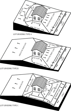
b.
Construction activities shall match existing adjacent property grades around the perimeter of the property. Retaining walls may be utilized on a case-by-case basis, with the approval of the Development Engineer, if the proposed lot grading is prepared by a licensed professional engineer. In no circumstances shall a fence be utilized as a retaining wall.
c.
All drainage, including but not limited to direct roof discharge, gutters, storm drains, and swales shall avoid point discharges that may cause damage to adjacent properties.
d.
The maximum slope of grading on a property shall not exceed twenty-five (25) percent unless designed by a professional engineer and approved by the Development Engineer. Impervious surfaces shall be sloped a minimum of two (2) percent away from the building foundation.
e.
Finished floor elevations or fill height shall be provided with the building permit for review. Finished floors that are proposed to be more than twenty-four (24) inches above the gutter line of the curb may be subject to additional grading requirements as directed by the Development Engineer.
(Ord. No. 2023-4446, Pt.1 (Exh. B), 6-12-2023; Ord. No. 2023-4453, Pt. 1(Exh. A), 8-10-2023)