
College Station City Zoning Code
ARTICLE 8
- Subdivision Design and Improvements
Sec. 8.1.- Purpose.
The subdivision of land is a major factor in the process of sound community growth and ultimately becomes a public responsibility in that the streets and other infrastructure must be maintained and various public services customary to urban areas must be provided. These regulations seek to protect the interests of public and private parties by granting certain rights and privileges and requiring certain obligations in association with the subdivision and development of land. The welfare of the entire community is affected in many important respects. Therefore, it is in the interest of the public, the developer, and the future landowners that the subdivisions and developments be conceived, designed, and developed in accordance with sound rules and proper minimum standards. These regulations encourage the growth of the City of College Station in an orderly manner.
(Ord. No. 2023-4453, Pt. 1(Exh. A), 8-10-2023)
Sec. 8.2. - Applicability.
With the exception of the Requirements for Parkland Dedication Section below, the provisions of this Article shall not apply to property in the BioCorridor Planned Development District. The Requirements for Parkland Dedication Section below shall apply to property in the BioCorridor Planned Development District.
(Ord. No. 2023-4453, Pt. 1(Exh. A), 8-10-2023)
Sec. 8.3. - General Requirements and Minimum Standards of Design for Subdivisions within the City Limits.
A.
Suitability of Lands.
The Administrator or the Planning and Zoning Commission, or as otherwise delegated herein, shall approve the subdivision of land if, from adequate investigations conducted by all public agencies concerned, it has been determined that in the best interest of the public, the site is suitable for platting and development purposes of the kind proposed.
B.
Zoning and Other Regulations.
No plat of land within the force and effect of an existing zoning ordinance shall be approved unless it conforms to such zoning and other pertinent regulations.
C.
Reserved Strips and Tracts Prohibited.
A plat shall not provide reserved strips or tracts of land. In addition, the effect of the phasing of a plat, provision of common area, or other land or easement shall not unnecessarily restrict access to land, right-of-way, or easements dedicated or intended to be dedicated to the public by the subject plat or adjacent developments.
D.
Technical Standards.
All public infrastructure shall be designed and constructed in accordance with the Bryan/College Station Unified Design Guidelines, Bryan/College Station Unified Technical Specifications, Bryan/College Station Unified Construction Details, and all other applicable local, state, and federal requirements. Hereafter, these documents shall be referred to collectively as the B/CS Unified Design Guidelines. Where there is a conflict of standards, the more stringent standard shall apply, as determined by the City Engineer. The City shall accept for public use only streets, alleys, water, wastewater, drainage, and other public infrastructure that comply with these standards for construction.
E.
Streets.
1.
Streets on the Comprehensive Plan Functional Classification & Context Class Map.
Where a subdivision encompasses or is adjacent to a thoroughfare, as shown on the Comprehensive Plan Functional Classification & Context Class Map, the thoroughfare shall be constructed and included in the subdivision plat to maintain continuity in the approximate location as shown and of the type indicated.
2.
Relation to Adjoining Street System.
a.
Where there is an existing street adjacent to or through the area to be subdivided, the necessary street intersections to the existing street shall be constructed.
b.
Existing and planned streets and public ways in adjacent or adjoining areas shall be continued in alignment therewith.
c.
When land is subdivided into larger parcels rather than ordinary building lots, such parcels shall be arranged to allow for the opening of future streets and logical further subdivisions.
3.
Street Projections.
a.
When a public street is provided internal to the platting property and adjoining areas are not platted, the platting subdivision shall provide street projections to such areas by projecting a public street at intervals no fewer than the maximum block length along the perimeter boundary of the subdivision.
b.
Where abutting properties are landlocked, a street connection or street frontage shall be provided through the platting property.
c.
In lieu of a public street, a public way may satisfy a required street projection when the public way is projected to future non-residential or multi-family development and can be continued through that development to a public street.
4.
Adequate Street Access.
a.
One (1) external street connection is required for a street serving as roadway access for thirty (30) or fewer lots.
b.
When there are more than thirty (30) lots to be served by external street connections, a minimum of two (2) street connections to external paved public streets shall be required. The Planning and Zoning Commission may allow remote emergency access where development phasing or constraints of the land prevent the provision of a second street connection. Notwithstanding the foregoing, two (2) street connections to externally paved public streets shall be required when one hundred (100) or more lots are served.
c.
Three (3) street connections to external paved public streets may be required by the Planning and Zoning Commission when two hundred (200) or more lots are served.
d.
Where more than one (1) external street connection is required, at least one (1) external street connection shall not be located over a potential hazard such as a high-pressure gas line or a creek where the one hundred (100) year floodplain overtops the street, regardless of its classification.
5.
Intersections.
In addition to the B/CS Unified Design Guidelines, proposed street and alley intersections shall meet the minimum spacing and requirements of the Access Management and Circulation Section of Article 7, General Development Standards of this UDO.
6.
Dead-End Streets.
Dead-end streets shall be prohibited except for short stubs to permit future extensions. Temporary turnarounds shall be required for stubs of more than one hundred (100) feet in length or the depth of one (1) lot, whichever is less.
7.
Culs-de-Sac.
a.
The maximum length of a cul-de-sac is based on the designation of the area in which the cul-de-sac is located on the Comprehensive Plan Functional Classification and Context Class Map. The length of a cul-de-sac is measured along the centerline of the cul-de-sac street from the center of the bulb to the edge of the nearest intersecting through the street right-of-way. Culs-de-sac shall not exceed the following lengths:
1)
Four hundred fifty (450) feet in General Urban context zones;
2)
One thousand two hundred (1,200) feet in Suburban context zones; and
3)
One thousand five hundred (1,500) feet in Rural context zones.
b.
Culs-de-sac are not permitted in Urban Core context zones unless the proposed subdivision is surrounded by platted property and where a through street is not possible.
c.
Regardless of length, culs-de-sac shall have no more than thirty (30) lots.
8.
Geometric Standards; Street Design Criteria.
a.
Streets and alleys shall be designed and constructed in accordance with the B/CS Unified Design Guidelines.
b.
Streets in rural residential subdivisions may be constructed to either rural or urban street standards except that thoroughfares that continue beyond the boundary of a rural residential subdivision to an urban one shall be constructed to urban street standards.
9.
Existing Substandard Street Right-of-Way.
a.
Whenever an existing right-of-way is within or adjacent to a proposed subdivision and such right-of-way width is substandard, the additional width for the street shall be dedicated. For development occurring on only one (1) side of such a roadway, the amount dedicated shall generally equal fifty (50) percent of the deficiency in width based on the classification and type of street, as measured from the existing centerline of the right-of-way. If the parcel(s) on the opposite side of the right-of-way previously dedicated a portion, the proposed plat shall dedicate the remaining width. If the opposite side of the right-of-way has a permanent constraint such as a railroad right-of-way or conservation easement, the full width of the deficiency may be required.
b.
The Administrator may reduce, increase, or eliminate the amount of right-of-way dedication based on design considerations, existing land uses, existing development on adjacent properties, and dimensions of the proposed subdivision or plat.
c.
Notwithstanding the foregoing, additional right-of-way dedication is not required for amending plats.
10.
Street Names and Addresses.
a.
Proposed streets that are extensions of existing streets shall bear the name of the existing street unless otherwise recommended by the Administrator.
b.
New streets shall be named to prevent conflict or confusion with identical or similar names in the city, Brazos County 911 district, or the extraterritorial jurisdiction.
c.
Streets shall not be named after any living person.
d.
A proposed street name may be disapproved if it too closely approximates phonetically the name of an existing street, is too difficult to pronounce, or carries undesirable meanings or connotations.
e.
Street addresses shall be assigned by the Administrator.
F.
Alleys.
1.
Alleys may be required at the rear of all lots intended to be used for business purposes and residential lots fronting a thoroughfare.
2.
Alleys shall generally be parallel to the street that the lot it serves fronts.
3.
Where two (2) alleys intersect, or where an alley turns, additional width may be required to allow the turning of vehicles or guying of utility poles.
4.
Dead-end alleys shall not be permitted, except where the alley is one hundred (100) feet or less in length or the width of one (1) lot, whichever is less.
5.
Residential lots served by an alley shall only have driveway access via the alley.
6.
Public alleys are prohibited in rural residential subdivisions.
7.
Private alleys shall be constructed to public alley standards except that they shall be located within a common area or private access easement. The City reserves the right to not provide sanitation and fire service along private alleys.
G.
Blocks.
1.
Blocks designed for single-family, duplex, townhouse, and multiplex lots shall be platted to provide two (2) tiers of lots with a utility easement or alley between them. A single tier of lots may be used if the lots back up to a thoroughfare, railroad, or floodplain. Courtyard house developments may provide more tiers of lots if an alley connection is provided through both sides of the block.
2.
To provide a public street network that is complimentary to the Thoroughfare Plan and that ensures uniform access and circulation to areas intended for similar land use contexts, block length shall not exceed the following dimensions based on the designation of the area along which the block is located on the Comprehensive Plan Functional Classification and Context Class Map:
a.
Six hundred sixty (660) feet in Urban Core context zones;
b.
Nine hundred (900) feet in General Urban context zones;
c.
One thousand two hundred (1,200) feet in Suburban context zones; and
d.
One thousand five hundred (1,500) feet in Rural context zones.
3.
If a plat is not bounded by a public through street or another qualifying break to block length, then the block length measurement shall continue to extend each way beyond the plat along the public through street until the nearest intersecting through street or qualifying break to the block is reached.
4.
In lieu of a public street, non-residential and multi-family developments may opt to construct a public way to satisfy block length requirements when the public way connects two (2) public streets. The plat shall dedicate a public access easement that covers the entire width of the private drive and sidewalks for the public way. The private drive and sidewalks may be constructed with the development of the property. A public way shall not substitute for a thoroughfare identified on the Comprehensive Plan Functional Classification & Context Class Map.
5.
Block length shall not require a new street, public way, or access way to enter the face of a block when:
a.
The surrounding area of the block is subdivided so that a through movement is not possible, or a new block cannot be created.
b.
The development is zoned for single-family uses and is being platted through a development plat or minor plat.
H.
Lots.
1.
General Requirements.
a.
Lots shall be identified in numerical order within a block.
b.
Lot size and setback lines shall be in accordance with the applicable zoning requirements.
c.
Lots established for special purposes such as common areas, open space, parkland, floodplain, drainage, utilities, or other similar facilities shall be uniquely named and are not required to meet the minimum dimensional standards for the applicable zoning district.
d.
Side lot lines shall be substantially right angle to straight right-of-way or radial to the curved right-of-way.
e.
Land located within the Federal Emergency Management Agency (FEMA) designated floodway shall not be included within a lot intended for residential occupancy.
f.
Lots shall be laid out so as not to cross municipal, county, school district, or utility service area boundaries.
g.
A subdivision shall not cause an existing structure to encroach into the setback of a proposed lot line.
h.
Single-family, duplex, townhouse, and multiplex lots shall have frontage on a public street, or a private street constructed to public standard. Lots intended for other uses that do not have frontage on a public street shall provide access via a public way or a private access easement containing a drive that meets City fire lane standards. The construction of the private drive may be delayed until the time of site development. Courtyard house lots may be exempted from this requirement as long as fire protection is maintained.
i.
No single-family, duplex, or townhouse lot shall have direct access to an arterial or collector thoroughfare; however, these lots may face a thoroughfare if driveway access is provided via a public alley. Notwithstanding the foregoing, single-family detached lots that are at least one hundred (100) feet in width may have direct access with the recommendation of the Administrator and approval of the Planning and Zoning Commission. Access restrictions and determinations shall be noted on the plat.
2.
Platting and Replatting within Older Residential Subdivisions.
a.
This Subsection applies to a subdivision in which any portion of the proposed subdivision meets all of the following criteria:
1)
Such portion of the subdivision is currently zoned or developed for single-family detached residential uses as of January 1, 2002, with the exception of NG-1 Core Northgate, NG-2 Transitional Northgate, NG-3 Residential Northgate, NPO Neighborhood Prevailing Overlay, and NCO Neighborhood Conservation Overlay zoning districts;
2)
Such portion of the subdivision is part of a lot or building plot that was located within the city limits when it was created on or prior to July 15, 1970. This also includes lots that may have been vacated or replatted after July 15, 1970, but where the original plat predates July 15, 1970; and,
3)
Such portion of the subdivision is designated as Neighborhood Conservation on the Comprehensive Plan Future Land Use & Character Map.
b.
In addition to the other provisions of this UDO, no plat or replat intended to provide for the resubdivision of an existing lot or lots in a residential subdivision that meets the above criteria may be approved unless:
1)
The plat does not create an additional lot or building plot; or
2)
For a proposed plat that does create an additional lot or lots, the lot(s) must meet or exceed the average width of the lots along the street frontage for all of the lots in the block, including the subject lot(s) and contain at least eight thousand five hundred (8,500) square feet of space for each dwelling unit.
For the purpose of determining the average lot width, a lot shall be defined to include the lot, lots, and/or portions of lots that have been combined and used as a residential plot or building plot, as of July 15, 1970. The Administrator may include the lots on the opposing blockface when calculating the average lot width if the lots are similar in character and the Administrator may exclude lots to the rear when said lots are part of another subdivision or dissimilar in character.
c.
It is the applicant's responsibility to provide documentation during the application process regarding the original plat in which the lot was created and/or the configuration and ownership documentation of the properties since July 15, 1970.
3.
Zero Lot Line Development.
The following requirements apply to all proposed subdivisions with single-family residential lot line construction.
a.
Description.
Zero lot line developments require planning for all house locations to be done at the same time. Restrictions that assure the minimum distance between houses and any required easements must be recorded on the plats of the applicable lots.
b.
Setbacks.
The side building setback shall be zero on one (1) side of the house. This reduction does not apply to the street side setback or to the interior side setback adjacent to lots that are not part of the zero lot line portion of the plat. The minimum distance between all buildings within the lot line development must be fifteen (15) feet.
c.
Eaves.
Eaves may project a maximum of eighteen (18) inches, excluding non-combustible gutters, over the adjacent property line.
d.
Maintenance Easement.
A maintenance easement shall be dedicated between the two (2) property owners to allow for maintenance or repair of the house built on the lot line. The easement shall be unobstructed, located on the adjacent property abutting the side wall, and must be a minimum of seven and one-half (7.5) feet in width. Required maintenance easements shall be shown on the recorded plat.
e.
Privacy.
Windows or other openings that allow for visibility into the side yard of the adjacent lot are not allowed. Windows that do not allow visibility into the side yard of the adjacent lot, such as a clerestory window or a translucent window, are allowed. All materials within three (3) feet of the property line shall be fire-rated to meet building code requirements.
4.
Cluster Development.
a.
General Purpose.
Cluster development is intended to provide open space, preserve unique environmental features, or protect the character of rural areas. It is a residential subdivision in which the lots are allowed to be smaller (in area and width) than otherwise required for the underlying, base zoning district, but in which the overall density of all the lots collectively does not exceed the maximum density limit for the underlying zoning district. Through the cluster development option, a subdivision can contain no more lots than would otherwise be allowed for a conventional subdivision in the zoning district, though the individual lots within the development can be smaller than required in a conventional subdivision. The average lot size in a cluster development must be less than the minimum lot size of the base zoning district. Smaller lot sizes within a cluster development are required to be offset by the provision of open space as set forth below.
b.
Conflict with Other Regulations.
If there is a conflict between the cluster development standards of this Subsection and any other requirement of this UDO, the standards of this Subsection control. Where no conflict exists, cluster development is subject to all other applicable requirements of this UDO.
c.
Where Allowed.
Cluster developments are allowed in WE Wellborn Estate, E Estate, RS Restricted Suburban, WRS Wellborn Restricted Suburban, and GS General Suburban zoning districts.
d.
Approval Procedure.
Cluster developments are subject to the subdivision procedures set forth in this UDO. A note shall be provided on the plat that states the subdivision is a cluster development with additional descriptions as necessary.
e.
Specific District Standards.
1)
WE Wellborn Estate.
a)
Lot Size. The minimum lot size is one (1) acre as long as individual lot sizes are adequate to meet all other required density, district, and development standards. There is no set minimum lot width or depth requirement within a cluster development, except as noted below. Subdivisions with all lots over one acre and lot widths of one hundred (100) feet may use rural character roads.
b)
Setbacks and Building Separations. The minimum setback standards of the base zoning district apply along the perimeter of cluster development. All detached structures within a cluster development must be separated by a minimum distance of ten (10) feet.
2)
E Estate.
a)
Lot Size. The minimum average lot size is twenty thousand (20,000) square feet with an absolute minimum lot size of ten thousand (10,000) square feet as long as individual lot sizes are adequate to meet all other required density, district, and development standards. There is no set minimum lot width or depth requirement within a cluster development, except as noted below. Subdivisions with all lots over twenty thousand (20,000) square feet and lot widths of one hundred (100) feet may use rural character roads. Subdivisions containing any lots below twenty thousand (20,000) square feet must use urban street standards.
b)
Setbacks and Building Separations. The minimum setback standards of the base zoning district apply along the perimeter of cluster development. All detached structures within a cluster development must be separated by a minimum distance of ten (10) feet.
c)
In the Wellborn Community Plan area, the cluster development option may be used only in the area designated Wellborn Preserve-Open on the Comprehensive Plan Future Land Use & Character Map.
3)
WRS Wellborn Restricted Suburban.
a)
Lot Size. The minimum average lot size is eight thousand (8,000) square feet as long as individual lot sizes are adequate to meet all other required density, district, and development standards. There is no set minimum lot width or depth requirement within a cluster development.
b)
Setbacks and Building Separations. The minimum setback standards of the base zoning district apply along the perimeter of cluster development. All detached structures within a cluster development must be separated by a minimum distance of ten (10) feet.
4)
RS Restricted Suburban.
a)
Lot Size. The minimum average lot size is eight thousand (8,000) square feet with an absolute minimum lot size of six thousand five hundred (6,500) square feet as long as individual lot sizes are adequate to meet all other required density, district, and development standards. There is no set minimum lot width or depth requirement within a cluster development.
b)
Setbacks and Building Separations. The minimum setback standards of the base zoning district apply along the perimeter of cluster development. All detached structures within a cluster development must be separated by a minimum distance of ten (10) feet.
5)
GS General Suburban.
a)
Lot Size. There is no minimum lot size as long as individual lot sizes are adequate to meet all other required density, district, and development standards. There is no set minimum lot width or depth requirement within a cluster development.
b)
Setbacks and Building Separations.
The minimum setback standards of the base zoning district apply along the perimeter of cluster development. All detached structures within a cluster development must be separated by a minimum distance of ten (10) feet.
c)
In the Wellborn Community Plan area as designated on the Comprehensive Plan Future Land Use & Character Map, the cluster development option is not permitted.
f.
Open Space.
1)
Description of Open Space.
Any parcel or parcels of land or an area of water, or a combination of land and water within a development site provided and made legally available for the use and enjoyment of all residents of a proposed project. Open space may include amenities such as private outdoor recreation facilities, natural areas, trails, agricultural lands, or stormwater management facilities designed as neighborhood amenities. Areas encumbered by right-of-way, easements, or utilized as parking may not be counted towards the open space requirements. Open spaces must be privately owned and maintained by an owners association.
Common open space must be set aside and designated as an area where no development will occur, other than project-related recreational amenities or passive open space areas. The Planning and Zoning Commission may require that up to fifty (50) percent of required common open space be useable recreational space if deemed necessary by the Commission to ensure adequate recreational amenities for residents of the development.
2)
Common Open Space Requirements for Cluster Developments.
a)
Common open space is required within a cluster development to ensure that the overall density within the development does not exceed the maximum density allowed by the underlying zoning district.
b)
Common open space must be provided in an amount of at least twenty-five (25) percent of the gross area of the development.
c)
All proposed lots shall have direct access to the common open space, via access easement, sidewalk, or street. Common open space may be located at the rear of lots only when the space is designed for active recreation, or a design concept is submitted to staff for approval. Examples of active recreation areas may include amenities such as sports fields, hike or bike trails, parks, amenity centers, and golf courses.
d)
All open space areas shall be part of a larger continuous and integrated open space system within the parcel being developed. The required common open space must be arranged to provide at least thirty (30) percent of the space in at least one (1) contiguous area. The minimum dimensions of such space must be at least twenty-five (25) feet in depth and width. The remaining required common usable open space may be distributed throughout the proposed subdivision, or subdivision phase if applicable, and need not be in one (1) such area; provided, however, no area containing less than five thousand (5,000) square feet will be considered common usable open space. If the required open space totals less than ten thousand (10,000) square feet all required open space shall be in one (1) contiguous area.
e)
The common open space requirement shall not be credited toward the parkland dedication requirements specified in the Requirements for Parkland Dedication Section below.
I.
Easements.
1.
Drainage Easements and Rights-of-Way.
a.
Where a subdivision is traversed by a watercourse, drainage way, natural channel, or stream, a drainage easement or right-of-way may be required in accordance with the B/CS Unified Design Guidelines.
b.
No construction, including fences, shall impede, constrict, or block the flow of water.
c.
A drainage easement or right-of-way shall not be considered a part of the lot area for purposes of minimum lot size requirements of this UDO.
d.
When feasible, utilities may be located within drainage easements and rights-of-way. Likewise, enclosed storm drains may be contained in utility easements. In such instances, the utility easement width must be adequate to provide space for storm drains, utilities, and maintenance access.
2.
Utility Easements.
a.
Except as expressly provided for otherwise in this UDO, each block that does not contain an alley shall have a utility easement at the rear of all lots. The rear utility easements shall be twenty (20) feet in width, taken ten (10) feet from each lot where the rear of the lots abut each other, and shall be continuous for the entire length of a block. These easements shall be parallel as closely as possible to the street line frontage of the block. Where the proposed subdivision adjoins an unplatted area or future phase of the subdivision, the City Engineer may require a twenty (20) foot wide easement along the rear of lots.
b.
Notwithstanding provisions to the contrary elsewhere in this UDO, the City Engineer has the discretion to approve alternate easement locations for any subdivision based on the proposed lot configuration, proposed location of utilities, or the depth of existing, proposed, or anticipated utilities. The City Engineer may also require additional utility easements or additional easement width for any subdivision based on the location, number, size, configuration, or depth of existing, proposed, or anticipated utilities.
c.
Buildings, signs, masonry walls, and other vertical structures that require a building permit are not permitted within utility easements. Landowners may place a fence in utility easements if unlocked gates are provided to allow the free movement of excavating machines, maintenance equipment, and personnel throughout the full length of the easement.
3.
Access Easements.
a.
A private access easement shall be required to provide access to property that does not have direct frontage to a public right-of-way or a public way. Private access easements may also be required when shared driveway access is necessary to meet driveway spacing requirements along a public street or public way. Driveways in required private access easements shall be constructed to City fire lane standards and their installation may be delayed until the time of site development. When private access easements are provided, construction and maintenance responsibilities shall be assigned and noted on the plat, or the recorded volume and page of the access instrument shall be referenced on the plat.
b.
A public access easement shall be provided for a public way, for public sidewalks on private property, and when serving as an access way. Fences, gates, parking, or other obstructions that restrict or block access are prohibited.
4.
Off-Site Easements.
All easements outside the boundaries of a plat that are necessary for the installation of public infrastructure to serve the subdivision or development plat shall be acquired by the applicant and conveyed by an instrument approved by the City Attorney.
5.
Non-Public Easements.
Except as set forth herein, the dedication of rights-of-way, easements, and public infrastructure shall not be encumbered by private easements that have pre-existing rights. Minor crossings are allowed.
J.
Access Ways.
1.
Existing and planned access ways in adjacent or adjoining areas shall be continued in alignment therewith.
2.
In blockfaces over nine hundred (900) feet in length, an access way shall extend across the width of the block near the center of the block.
3.
To provide additional pedestrian and bicycle circulation, an access way shall be required on a cul-de-sac street to connect to existing or planned facilities in the vicinity such as schools, parks, transit stops, and multi-use paths.
4.
An access way may be required to provide additional pedestrian and bicycle circulation within a subdivision, between subdivisions, between culs-de-sac, or to provide access to schools, parks, shopping centers, multi-use paths, transportation, and other community facilities in the vicinity.
5.
If an access way is greater than three hundred (300) feet in length then an additional access point to the access way shall be provided.
K.
Sidewalks.
1.
Policy.
Sidewalks should be located and constructed to provide a safe and effective means of transportation for non-vehicular traffic.
2.
Required Sidewalks.
a.
Sidewalks shall be required on both sides of all streets except as identified below or as provided elsewhere in this UDO.
b.
Where a multi-use path is shown along a street on the Bicycle, Pedestrian, and Greenways Master Plan, the sidewalk may be incorporated as part of the multi-use path.
3.
Sidewalk Exceptions.
Sidewalks are not required:
a.
Around the bulb of a cul-de-sac unless an access way is provided through the cul-de-sac;
b.
Along a street classified on the Comprehensive Plan Functional Classification & Context Class Map as a freeway/expressway, unless a sidewalk or multi-use path has been identified on the Bicycle, Pedestrian, and Greenways Master Plan;
c.
Along one side of streets identified as a major collector or minor collector on the Comprehensive Plan Functional Classification & Context Class Map within a Rural context zone;
d.
Along new or existing local/residential streets within an estate lot subdivision with the street constructed to a rural section; or
e.
Along existing local/residential streets unless sidewalks have been identified in the Bicycle, Pedestrian, and Greenways Master Plan.
4.
Standards.
Sidewalks shall be constructed in accordance with the B/CS Unified Design Guidelines and all applicable local, state, and federal requirements.
5.
Timing of Construction.
Except as set forth below, all required sidewalks must be constructed concurrently with the street, or if the street is already constructed prior to acceptance of all public improvements.
a.
Residential Subdivisions.
At the time of the final plat application, the subdivider may opt to defer the construction of sidewalks on residential streets along single-family, duplex, or townhouse lots for up to one (1) year from the approval of the final plat when the subdivider provides a bond or surety in accordance with the Construction, Guarantee of Performance, and Acceptance of Public Infrastructure Section below. The subdivider shall provide a sidewalk plan with the final plat construction documents and installation of the sidewalks shall comply with this plan.
Notwithstanding the foregoing, this provision does not allow the deferment of the construction of sidewalks along thoroughfares, sidewalk ramps at all street intersections, and sidewalks along residential streets that are not adjacent to a residential lot such as along a common area, creek crossing, or park. Other pedestrian facilities such as access ways and multi-use paths shall be constructed at the same time as the public infrastructure of the plat.
b.
Fee in Lieu of Construction.
1)
Fee in Lieu.
Except for development located within the Northgate zoning districts, a developer may request to pay a fee in lieu of constructing the required sidewalk(s) or multi-use path upon approval by the Administrator as set forth below. The Administrator shall have final authority in determining what proportion of sidewalks or fees may be accepted in lieu of sidewalk construction.
2)
Amount of Fee.
The amount of fee in lieu of sidewalk construction shall be a unit cost determined by the City Engineer based upon current estimated costs. The unit cost fee shall be kept on file in the Planning and Development Services Department and made available to the public upon request. The unit cost fee calculation shall be reviewed at least annually by the City Engineer and adjusted as necessary.
3)
Criteria to Allow Fee in Lieu.
The Administrator may authorize or require a fee in lieu of sidewalk or multi-use path construction when it is determined that one (1) or more of the following conditions exist:
a)
The presence of unique or unusual topographic, vegetative, or other natural conditions exist;
b)
A capital improvement project is funded and forthcoming that will include the construction of the required sidewalk or multi-use path;
c)
Existing streets constructed to rural section that are not identified on the Comprehensive Plan Functional Classification & Context Class Map with a Rural context zone;
d)
The proposed development is within an older residential subdivision meeting the criteria in the Platting and Replatting within Older Residential Subdivisions Subsection above; or
e)
The proposed development contains frontage on a freeway/expressway as designated by the Comprehensive Plan Functional Classification & Context Class Map.
4)
Use of Fee.
The City Council hereby establishes sidewalk zones as shown on the Sidewalk Zone Map below. Fees collected in lieu of sidewalk or multi-use path construction shall be expended in the same zone as the development or in an adjacent zone in a scenario where the development occurs near a zone boundary. Fees collected in lieu of sidewalk construction shall be used only for preliminary design, design, construction, reconstruction, surveying, or land acquisition costs associated with sidewalks, multi-use paths, and other non-vehicular ways.
Sidewalk Zone Map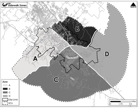
5)
Reimbursement.
The City may acquire land for sidewalks or make sidewalk improvements related to actual or potential development. If this occurs, the City may require subsequent sidewalk obligations to be a fee, rather than construction, to reimburse the City for the cost associated with acquisitions or construction.
6)
Fee Due.
Fees paid pursuant to this Section shall be remitted to the City when the guarantee of construction of public improvements for the proposed development is due or upon commencement of construction, whichever occurs first.
7)
Special Fund; Right to Refund.
All fees received by the City in lieu of sidewalk or multi-use path construction shall be deposited in a fund referenced to the sidewalk zone to which it relates. The City shall account for all fees in lieu of sidewalk construction paid under this Section with reference to the individual development involved. Any fee paid for such purposes must be expended by the City within ten (10) years from the date received by the City. Such funds shall be considered to be spent on a first-in, first-out basis. If not so expended, the landowners of the property on the expiration of such period shall be entitled to a prorated refund of such sum. The owners of such property must request a refund within one (1) year of entitlement, in writing, or such refund will be barred.
6.
Appeals.
The property owner or applicant for new development may appeal the following decisions to the Administrator:
a.
The applicability of required sidewalk or multi-use path construction;
b.
The determination regarding eligibility for a fee in lieu of construction or requirement to utilize fee in lieu of construction;
c.
The amount of sidewalk or multi-use path required or fee in lieu amount due; and/or
d.
The amount of the refund due, if any.
All appeals shall be taken within 30 days of notice of the action from which the appeal is taken.
The burden of proof shall be on the appellant to demonstrate that the amount of the required construction, fee in lieu, or refund was not calculated according to the requirements of this ordinance.
The appellant may appeal the decision of the Administrator to the Planning and Zoning Commission. A notice of appeal must be filed by the applicant with the Administrator within 30 days following the Administrator's decision. The filing of the appeal shall not stay the requirement for construction or collection of the fee in lieu, as applicable. If the notice of appeal is accompanied by a payment equal to the fee due as calculated by the City, the development application shall be processed.
L.
Bicycle Facilities.
1.
General.
Bicycle facilities are planned and located to provide connectivity to the existing street network, parks, schools, greenways, neighborhoods, and other key destinations; increase safety; and promote health and wellness.
2.
Timing.
Bicycle facilities shall be required in accordance with the Bicycle, Pedestrian, and Greenways Master Plan and the B/CS Unified Design Guidelines and constructed along with other public infrastructure required pursuant to this UDO.
3.
Types of Bicycle Facilities.
There are at least three (3) types of bicycle facilities that may be required. These types include the following:
a.
Multi-Use Path: a facility completely separated from auto traffic and within an independent right-of-way or the right-of-way of another public facility;
b.
Bike Lane: a facility where part of the roadway or shoulder is striped, signed, and marked for exclusive or preferential bicycle use and where vehicular parking is not permitted unless otherwise specified; and
c.
Bike Route: a facility designated by signing and sometimes pavement markings to help make motorists aware of the presence of bicycles that share the same area with motor vehicles.
4.
Geometric Design Criteria.
All facilities shall be designed to meet or exceed standards set forth in the "Guide for Development of Bicycle Facilities" published by the American Association of State Highway and Transportation Officials (AASHTO) and the B/CS Unified Design Guidelines. Signing and pavement markings for such facilities shall be in accordance with the Manual on Uniform Traffic Control Devices (MUTCD). Geometric design criteria for each type of bikeway facility are as follows:
a.
Bike Routes.
Bike routes shall be indicated as follows:
1)
The placement of bike route signage and shared lane pavement markings identifies bicycle-compatible streets that will serve as bike routes;
2)
A minimum of sixteen (16) feet-of the outer lane of streets measured from the outer lane line to the back of curb shall be required for bike routes. A typical bicycle route street is shown below; and
3)
Bike route signage should not end at a barrier. Information directing the bicyclist around the barrier should be provided.
Bike Route Street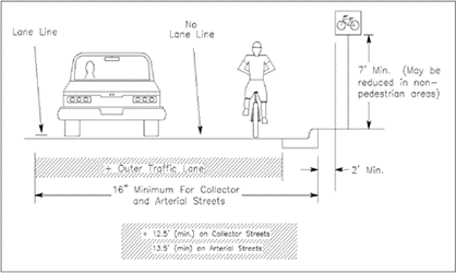
b.
Bike Lanes.
Bike lanes shall be as follows:
1)
The bike lane is located within the vehicular roadway in the outside lane and is intended for the exclusive use of bicycles. Bike lanes in the City of College Station must be developed as one-way facilities and carry traffic in the same direction as adjacent motor vehicle traffic; and
2)
In general, parking in bike lanes is prohibited. However, parking may be permitted in a bike lane in specific areas during specified times. Where parking in a bike lane is permitted, signs shall be installed to provide notice to bicyclists of when parking is allowed. Parking in a bike lane shall be limited primarily to spillover parking for public uses or events, but parking for non-public uses may also be considered.
c.
Multi-Use Paths.
The criteria for multi-use paths are as follows:
1)
Multi-use paths should be located primarily in greenways, parks, or occasionally within street rights-of-way. If a multi-use path is to be located in the right-of-way of a street, there should be a minimum of five (5) feet separating the multi-use path from the roadway;
2)
The standard width for a two-way multi-use path shall be ten (10) feet. In areas with projected high volumes of use, multi-use paths shall be twelve (12) feet wide;
3)
The minimum width of a one-directional bicycle path is five (5) feet. It should be recognized, however, that one-way bicycle paths often will be used as two-way facilities unless effective measures are taken to assure one-way operation. Without such enforcement, it should be assumed that bicycle paths will be used as two-way facilities and designed accordingly;
4)
A minimum of three (3) foot width graded area shall be maintained adjacent to both sides of the multi-use path to provide clearance from trees, poles, walls, fences, guard rails, or other lateral obstructions; and
5)
Multi-use paths shall be located in a public access easement of a minimum of twenty (20) feet in width.
M.
Water Facilities.
1.
All subdivisions shall have access to water supply and distribution systems for adequate fire protection and domestic use. All water mains, distribution, and service lines shall be provided to each lot and constructed in accordance with the B/CS Unified Design Guidelines and all applicable state and federal requirements. Where there is a conflict of standards, the more stringent standard shall apply, as determined by the City Engineer. The City shall accept for public use only water mains, distribution, and service lines that comply with these standards for construction.
2.
Water mains within the City of College Station Certificate of Convenience and Necessity (CCN) areas shall be extended in accordance with Chapter 40, Utilities of the City of College Station Code of Ordinances.
3.
Where a subdivision contains a water line as shown on the Water System Master Plan, such water line shall be designed and installed to maintain continuity in the approximate location as shown, and of the size indicated.
4.
Water distribution lines shall be extended from the nearest City approved point of connection to the furthest boundary line of the platted subdivision.
5.
For water systems that are not part of the City of College Station's water utility, the subdivider shall provide a letter with the construction documents from the non-City utility indicating that the non-City utility can properly serve the proposed subdivision. Construction of all water facilities within a subdivision must comply with the B/CS Unified Design Guidelines. Plans for such systems will be subject to City review and inspection. City involvement with such a water system ends with the sanitization of the line.
N.
Wastewater Facilities.
1.
All subdivisions shall have access to wastewater facilities. All collection mains and service lines shall be provided to each lot and constructed in accordance with the B/CS Unified Design Guidelines and all applicable state and federal requirements. Where there is a conflict of standards, the more stringent standard shall apply, as determined by the City Engineer. The City shall accept for public use only wastewater facilities that comply with these standards for construction.
2.
Wastewater mains within the City of College Station Certificate of Convenience and Necessity (CCN) areas shall be extended in accordance with Chapter 40, Utilities of the City of College Station Code of Ordinances.
3.
Where a subdivision contains a wastewater line as shown on the Wastewater System Master Plan, such wastewater line shall be designed and installed to maintain continuity in the approximate location as shown, and of the size indicated.
4.
For wastewater systems that are not part of the City of College Station's wastewater utility, the subdivider shall provide a letter with the construction documents from the non-City utility indicating that the non-City utility can properly serve the proposed subdivision. Construction of all wastewater facilities within a subdivision must comply with the B/CS Unified Design Guidelines. Plans for such systems will be subject to City review and inspection. Wastewater lines for these systems that are outside the subdivision are not required to meet City standards.
5.
Alternate Wastewater Facilities.
a.
If wastewater main extension is exempted per Chapter 40, Utilities of the City of College Station Code of Ordinances or if the subdivision is located outside of the City of College Station CCN or otherwise not served by the City, the subdivider may provide temporary alternative wastewater disposal as follows and as may be conditioned by Chapter 40, Utilities of the City of College Station Code of Ordinances or otherwise:
1)
Organized Wastewater Collection and Treatment System.
A subdivider may have a proposed subdivision served by a non-City organized wastewater collection and treatment system. Such system must be permitted to dispose of wastes by the Texas Commission on Environmental Quality (TCEQ) in accordance with 30 TAC Chapter 305 and obtain approval of engineering, planning, and materials for such systems under 30 TAC Chapter 317 from the TCEQ prior to City approval of the final plat.
2)
On-Site Sewage Facilities.
A subdivider may have a proposed subdivision served by on-site sewage facilities as set forth below:
a)
On-site facilities which serve single-family or multi-family residential dwellings with anticipated wastewater generation of no greater than five thousand (5,000) gallons per day must comply with 30 TAC Chapter 285 and other applicable laws;
b)
Proposals for sewerage facilities for the disposal of sewage in the amount of five thousand (5,000) gallons per day or greater must comply with 30 TAC Chapter 317 and other applicable laws;
c)
The Brazos County Health Department shall review proposals for on-site sewage disposal systems and inspect such systems as necessary to assure that the system is in compliance with Chapter 366 of the Texas Health and Safety Code and rule in 30 TAC Chapter 285, and particularly §§ 285.4, 285.5, and 285.30—285.39, and any other applicable rules or regulations within the purview of the Brazos County Health Department; and
d)
In addition to the unsatisfactory on-site disposal systems listed in 30 TAC § 285.3(i), pit privies and portable toilets are not acceptable waste disposal systems for lots platted under these rules.
b.
Sanitary Sewer Master Plan.
A gravity sanitary sewer master plan shall be designed for subdivisions that contain lots that are two (2) acres and smaller and that utilize alternative wastewater disposal methods. This master plan is required to assure that all lots, in the future, can be connected by gravity service line to the future sewer collection system. Adequately sized sewer lines shall be provided within the subdivision's sewer master plan such that they conform to the Wastewater System Master Plan. All lines designed within this master plan shall meet the B/CS Unified Design Guidelines and all applicable state and federal regulations. This master plan shall consist of verbiage explaining all design assumptions, plan and profile layouts of all future gravity lines to be constructed within the subdivision, and a minimum finished floor elevation established for each lot to assure a connection to the future gravity sanitary sewer collection system. All minimum finished floors established by this master plan shall be placed on the respective lots on the final plat.
O.
Special Flood Hazard Areas.
All development encroaching into a FEMA special flood hazard area shall be in accordance with the B/CS Unified Design Guidelines, the Flood Hazard Protection Article of Chapter 105, Floods of the City of College Station Code of Ordinances, and all applicable local, state, and federal requirements. Where there is a conflict of standards, the more stringent standard shall apply, as determined by the City Engineer. The City shall only accept improvements for public use that comply with these standards for construction.
P.
Drainage.
1.
All drainage shall be in accordance with the B/CS Unified Design Guidelines, the Flood Hazard Protection Article of Chapter 105, Floods of the City of College Station Code of Ordinances, and all applicable local, state, and federal requirements. Where there is a conflict of standards, the more stringent standard shall apply, as determined by the City Engineer. The City shall only accept improvements for public use that comply with these standards for construction.
2.
Rapid conveyance, the phasing of development, the use of control methods such as retention or detention, and/or the construction of off-site drainage improvements as means of mitigation, as provided in the B/CS Unified Design Guidelines and as may be required and approved by the City.
3.
No construction shall impede, constrict, or block the flow of water in any drainage pathway.
4.
Lot Grading.
a.
Lots shall be laid out to provide positive drainage away from all buildings. Individual lot drainage shall be coordinated with the general storm drainage for the area. Drainage shall be designed to avoid the concentration of storm drainage water from each lot to adjacent developable lots. A subdivision grading plan shall be provided with the construction documents. A general drainage pattern that meets all applicable rules and regulations shall be provided for each proposed block and lot. Subsequent permits for each lot shall comply with the approved grading plan.
b.
All single-family residential lots must be graded to meet the elevation of adjoining property with positive drainage. Multi-family and non-residential lots shall be graded to match elevations at adjoining properties to provide good access and minimize the use of retaining walls.
Q.
Gas or Oil Lines.
1.
Identification.
High-pressure flammable gas or fuel lines are defined as those which are operated or may be expected in the future to operate at a pressure of over sixty (60) pounds per square inch. High-pressure flammable gas or fuel lines, installed on public property, shall be buried with a minimum cover of thirty (30) inches and shall be marked by an all-weather typed sign, installed at each crossing and intervals of not more than three hundred (300) feet. The signs shall be installed by the utility company, state that the line is high pressure, identify the utility company name, provide an emergency phone number, and state the type of product or products transported therein.
2.
Notification to the Utility Company.
The subdivider shall provide written notification to the utility company regarding any proposed construction over an existing facility or within a utility's easement and provide proof of such notification to the City Engineer.
R.
Streetlights.
1.
General Standards.
a.
Streetlights shall be designed and installed according to the utility standards in effect at the time of subdivision construction or addition thereto.
b.
The quantity, size, and type of streetlight pole and fixture shall be selected by the subdivider from the College Station Utilities Construction Specifications, Electric Service, and Meter Installation Guidelines.
c.
The subdivider shall furnish public utility easements for the installation of streetlights, with said easements to normally be five (5) feet in width.
d.
Where underground electric service is provided, all street lighting and site lighting equipment shall be placed underground except for the poles on which the lights are to be affixed. Where overhead electric service is provided, street lighting and site lighting equipment may be placed overhead or underground.
2.
Streetlight Locations.
a.
Streetlights shall normally be required at all street intersections and access ways, in culs-de-sac, and at approximately three hundred (300) foot intervals along tangent streets.
b.
In rural residential subdivisions, streetlights are only required at street intersections and the end of culs-de-sac greater than three hundred (300) feet in length. The subdivider may request additional streetlights at other locations within the subdivision, provided the frequency does not exceed the general subdivision location standards recited above.
3.
Installation and Maintenance.
a.
The subdivider or their authorized construction representative shall be responsible for furnishing and installing all streetlight facilities in accordance with the electric utility's design and specifications and this UDO. All conduit installations shall be inspected prior to acceptance for conformance with the utility specifications.
b.
Streetlights shall be owned and maintained by an electric utility provider with a Certificate of Convenience and Necessity (CCN) for that area.
c.
The electric utility provider shall not be responsible for the installation or maintenance of streetlights on alleys, private streets, or drives.
S.
Electric Facilities.
1.
All subdividers shall ascertain which electric utility is certificated to serve the proposed subdivision. The electric utility design and facilities must meet all applicable City ordinances.
2.
The electric utility will design the electrical system for all lots within a subdivision.
3.
All electric utility services shall be installed underground in all subdivisions. All lateral electric lines and service lines supplying electric utility service shall be placed underground except rural residential subdivisions may have lateral electric lines and service lines supplying electric utility service placed overhead.
4.
Overhead feeder lines may be placed in the following locations:
a.
Along the perimeter of a platted subdivision;
b.
Adjacent to or within the right-of-way of thoroughfares identified on the Comprehensive Plan Functional Classification & Context Class Map and approved for the location of overhead utilities; and
c.
Within alleys or dedicated easements identified for the location of aerial utility feeder lines on the approved subdivision plat.
5.
The subdivider shall dedicate public utility easements upon forms approved by the City for the installation of electric utilities. All liens and other ownership interests shall be subordinated to the easement use.
6.
Where electric service is placed underground, all auxiliary equipment for such service, including but not limited to transformers, junction enclosures, and switching devices, shall be pad-mounted on grade or shall be placed underground.
7.
Where the electric service is placed underground, all street lighting and site lighting equipment shall be placed underground except for the poles on which the lights are to be affixed. The City or the electric utility shall not be responsible for the installation or maintenance of streetlights on alleys, private streets, or drives.
8.
The subdivider shall be responsible for the costs and installation of all conduit needed for underground feeder, lateral, and service lines utilized to provide electric utility service to the subdivision. The developer of a platted lot shall be responsible for the costs and installation of service conduit for the platted lot. The specifications for the conduit shall be provided by the electric utility prior to installation. All conduit installations shall be inspected prior to acceptance for conformance to utility specifications.
9.
Temporary utility service may be provided via overhead line extension.
10.
The subdivider shall contact the appropriate electric utility provider to determine any additional requirements.
T.
Monuments and Corner Markers.
1.
All block corners, angle points, points of curves, and all corners of boundary lines of subdivisions shall be marked with a one-half (0.5) inch steel rod, two (2) feet in length, set in the center of a concrete monument six (6) inches in diameter and thirty (30) inches deep, with the top flush with the finished ground surface.
2.
Where, due to topographic conditions, permanent structures, or other conditions, the view is obstructed between any two (2) adjacent monuments, intermediate monuments shall be set to ensure a clear view between adjacent monuments.
3.
Corner markers, consisting of a one-half (0.5) inch steel rod or three-fourths (0.75) inch pipe, two (2) feet in length, shall be driven flush with the ground surface to mark the corners of all lots.
U.
Owners Associations for Common Areas and Facilities.
1.
An owners association shall be established with direct responsibility to, and controlled by, the property owners involved to provide for operation, repair, and maintenance of all common areas, fences, walls, gate equipment, landscaping, and all other common facilities, including private streets and sidewalks, which are part of the subdivision.
2.
The owners association shall prepare and file for record a legal instrument establishing a plan for the use and permanent repair and maintenance of the common facilities and demonstrating that the association is self-perpetuating and adequately funded to accomplish its purpose and shall provide that the owners association hereby unconditionally and irrevocably agrees to indemnify, defend and hold the City and the City's officials, agents, employees and contractors harmless, from and against any loss, liability, demand damage, judgment, suite, claim deficiency, interests, fee, charge, cost or expense (including, without limitation, interest, court cost and penalties, attorney's fees and disbursement and amounts paid in settlement, or liabilities resulting from any charge in federal, state or local law or regulation or interpretation hereof) of whatever nature, even when caused in whole or in part by the City's negligence or the joint or concurring negligence of the City and any other person or entity, which may result or to which the City and/or any of the City's officials, agents, employees and contractors may sustain, suffer, incur or become subject to in connection with or arising in any way whatsoever out of the maintenance, repair use or occupation of the common facilities, or any other activity of whatever nature in connection therewith, or arising out of or by reason of any investigation, litigation or other proceedings brought or threatened, arising out of or based upon the operation, management, maintenance, repair and use of the common facilities, or any other activity in the subdivision.
3.
The budget for the owners association shall include a fund reserved for the repair and maintenance of common facilities in the amount approved by the City staff.
V.
Private Streets and Gating of Roadways.
1.
General Requirements.
The following applies to the platting of roadways:
a.
Gating of a public roadway is prohibited.
b.
Streets required to meet block length or street projection requirements shall not be private or gated.
c.
Private driveways are considered public roadways for the purpose of gating requirements herein.
d.
Vehicular access shall be provided on all private and public roadways at all times for police, fire, City inspection, mail delivery, garbage pickup, dial-a-rides, utility, school buses, and other health and safety related vehicles. Access must not require drivers to exit their vehicles.
e.
A private street may not cross an existing or proposed public thoroughfare as shown on the Comprehensive Plan Functional Classification & Context Class Map. A private street may not disrupt or cross an existing or proposed public park or pedestrian pathway as shown on the Bicycle, Pedestrian, and Greenways Master Plan.
f.
The gate design and implementation shall be such that it does not pose a threat to public health, safety, and welfare as determined by the City.
g.
Private streets must meet the requirements listed in the Single-Family Residential Parking Requirements for Platting Subsection below.
2.
Owners Association Requirements.
a.
All property owners within an existing residential area that is proposed to be gated or have private streets shall agree to become members of an operative owners association.
b.
The legal instrument establishing the owners association must provide for a street maintenance agreement and reserve fund as well as written permission for the City's access to the subdivision all of which must be submitted for approval by the City Attorney prior to the submission of the final plat.
c.
The City must have access to private roadways at any time without liability when on official business. This includes permission to remove obstructions including any gate and guard (house) upon non-compliance by the owners association with any terms of this UDO or as necessary for emergency vehicle access. In the event the City must remove obstructions to access the development, the owners association will be assessed for all costs substantially associated therewith.
d.
In the event the City deems that substantial repairs to the private street(s) within a gated community are necessary to ensure safe access and passage for emergency service vehicles, the City will notify the owners association, and a public hearing before the City Council will be set for input on the projected repairs. Should the owners association fail to provide the satisfactory repairs deemed necessary in a time frame set by the City at the public hearing, then the City will make the necessary repairs and assess the owners association all costs borne by the City in the repair of the private street(s). Should the owners association fail to reimburse the City within ninety (90) days, the owners association shall be subject to a lien and possibly foreclosure of all assets including but not limited to the maintenance reserve fund.
3.
Geometric Design Guidelines.
The following applies to the design of private roadways:
a.
Private streets shall be constructed to public street standards but located within a common area, private right-of-way, or private access easement.
b.
The gate(s) may not be placed on a public right-of-way or easement.
c.
All gate mechanical or manual operating functions shall meet College Station Fire Department requirements and provide passage with unobstructed vertical clearance.
d.
The throat depth for a gated entryway shall meet the following requirements (refer to figures below):
1)
A minimum of twenty (20) feet for one (1) residential single-family lot.
2)
A minimum of sixty (60) feet for up to twenty-five (25) single-family lots.
3)
A minimum of one hundred (100) feet for twenty-six (26) single-family lots or greater.
e.
Gated entryways shall provide adequate access for pedestrians and bicycles.
f.
Gated entryways to subdivisions shall provide adequate turnaround areas for vehicles that are denied access to prevent backing into a public street. (refer to figures below.)
g.
The gated entryway driveway pavement widths to subdivisions, for both egress and ingress, shall be a minimum of twenty (20) feet per driveway and are required to provide a minimum four (4) feet center median. (refer to figures below.)
h.
The gated area shall provide a minimum unobstructed vertical clearance of fourteen (14) feet and six (6) inches from the finished roadway surface over the entire width of the entry roadway.
i.
Public safety elements and signing shall be included in the gate entryway design.
4.
Converting Private Streets to Public Streets.
The following is required when converting private streets to public streets:
a.
Upon a written request signed by duly authorized owners association officers and submitted to the City Council, the dedication of private streets to the public may be accomplished providing the private streets are brought up to City standards for public streets and the City Council has agreed to accept the streets.
b.
The written request by the owners association officers will be accompanied by a petition containing the signatures of the owners of one hundred (100) percent of the existing lots in the subdivision, except when in the public interest.
c.
All repairs or reconstruction of private streets to City standards must be accepted by the City prior to conversion. All conversion dedication costs will be paid by the owners association.
5.
Existing Gates.
Any gate as defined by this Subsection existing as of November 13, 1997, which has received approval from either the City or the County is deemed exempt from the requirements of this Section except when the City must remove such gates to ensure access for the immediate health, safety, and welfare of the public. The owners association responsible for such gate assumes all costs associated therewith.
Throat Depth Figure for Sliding Gates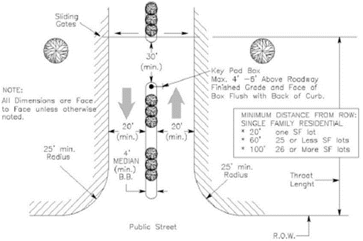
Throat Depth Figure for Hinged Gates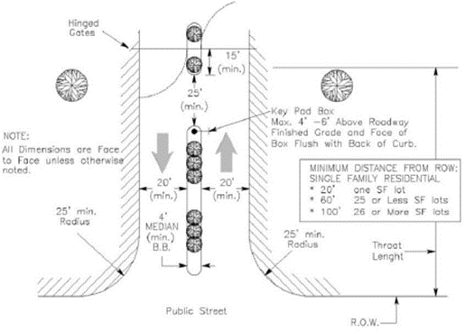
V.
Single-Family Residential Parking Requirements for Platting.
1.
Purpose.
The purpose of this Subsection is to establish requirements for new single-family and townhouse parking to aid in reducing neighborhood parking problems and maintain the certainty of access for emergency vehicles on local streets.
2.
General Requirements.
This Subsection applies to all new single-family and townhouse subdivisions.
a.
Each phase of a multi-phase project shall comply with this Section.
b.
Subdivisions may utilize multiple residential parking options so long as each phase meets the requirements, and all options are listed on the plat.
c.
Replats, amending plats, vacating plats, and development plats are exempt from this Section unless new streets are proposed with the subdivision.
d.
All "No Parking" areas shall be depicted on the preliminary plan.
e.
All "No Parking" signs shall be placed along the street to ensure adequate emergency access. The developer shall provide and install, at no cost to the City, all "No Parking" signs and associated poles and hardware to the City's specifications.
f.
Parking only may be removed on one or both sides of a street upon the City Council approving an ordinance removing parking from the street.
g.
Where on-street or alley parking is utilized in a townhouse subdivision, driveways shall be designed to allow a minimum of one (1) on-street or alley parking space per four (4) dwelling units. Driveway layouts shall be provided with the final plat.
3.
Residential Parking Options.
To provide adequate access for emergency vehicles, new single-family and townhouse subdivisions shall provide one option from the following:
a.
Wide Streets.
1)
Pavement width shall be a minimum of thirty-two (32) feet, up to a maximum of thirty-eight (38) feet.
2)
In addition to the right-of-way specified for the Residential Street Section in the B/CS Unified Design Guidelines, additional right-of-way width shall be dedicated equivalent to the increase in pavement width over twenty-seven (27) feet.
3)
To minimize adverse traffic impacts on residential neighborhoods, bulb-outs shall be provided at intersections of local streets. Bulb-outs shall not be required where a local street intersects a street classified as a collector or higher.
4)
As determined by the Development Engineer, engineering judgment shall override the requirement for bulb-outs set forth above if warranted by specific traffic conditions.
b.
Narrow Streets.
1)
Pavement width shall be a minimum of twenty-two (22) feet, up to a maximum of twenty-four (24) feet.
2)
No parking is allowed on narrow streets to ensure emergency vehicle access. Narrow streets must meet fire service standards as described in the City of College Station Site Design Standards.
3)
To provide adequate parking in residential neighborhoods, subdivisions choosing to incorporate narrow streets shall incorporate additional parking spaces through either the provisions of visitor alley-fed parking areas or visitor parking areas (See additional requirements for visitor alley-fed off-street parking and visitor parking areas below).
c.
Standard Streets.
1)
Standard streets shall be designed in accordance with the Residential Street Section in the B/CS Unified Design Guidelines.
2)
Parking shall be removed from one (1) or both sides of standard streets.
3)
To provide adequate parking in residential neighborhoods, subdivisions choosing to remove parking from both sides of a standard street shall incorporate additional parking spaces through the provisions of visitor alley-fed off-street parking or visitor parking areas. Visitor alley-fed off-street parking and visitor parking areas have additional requirements as specified below.
d.
Wide Lot Frontages.
1)
All lot widths shall be a minimum of seventy (70) feet as measured at the front setback.
e.
Visitor Alley-Fed Off-Street Parking.
1)
Visitor alley-fed off-street parking spaces shall be provided at a rate of one (1) parking space per four (4) dwelling units. Visitor alley-fed off-street parking is in addition to minimum off-street parking requirements. The Off-Street Parking Standards Section of Article 7, General Development Standards of this UDO lists additional requirements.
2)
Off-street parking spaces shall be located in an access easement or private common area.
f.
Visitor Parking Areas.
1)
Visitor parking shall:
a)
be provided at a rate of one (1) parking space per four (4) dwelling units;
b)
meet requirements of Off-Street Parking Standards and Access Management and Circulation Sections of Article 7, General Development Standards of this UDO, except requirements of alternative parking plans, and except as specifically exempted below;
c)
be developed at the same time as public infrastructure;
d)
be located no farther than five hundred (500) feet from the lot it is meant to serve. This distance shall be measured by a walkable route;
e)
be located in a common area and maintained by an owners association;
f)
be designed to prohibit backing maneuvers onto public streets, with the exception that two (2) or fewer parking spaces constructed to single-family driveway and parking standards are permitted backing maneuvers when accessing a local street; and
g)
not be counted towards common open space requirements for cluster developments.
2)
Visitor parking areas adjacent to a right-of-way shall be screened from the right-of-way. Screening is required along one hundred (100) percent of the street frontage (such as ten (10) shrubs for every thirty (30) linear feet of frontage), with the exception of areas within the visibility triangle. Screening may be accomplished using plantings, berms, structural elements, or combinations thereof, and must be a minimum of three (3) feet above the parking lot pavement elevation. Walls and planting strips shall be located at least two (2) feet from any parking area. Where the street and the adjacent site are at different elevations, the Administrator may alter the height of the screening to ensure adequate screening. Fifty (50) percent of all shrubs used for screening shall be evergreen. Two (2) or fewer parking spaces constructed to single-family driveway and parking standards are not required to be screened from the adjacent right-of-way.
3)
Visitor parking areas may be constructed of permeable surfaces as allowed in the Off-Street Parking Standards Section of Article 7, General Development Standards of this UDO.
4.
Private parking constructed for the use of subdivision amenities, such as a community pool, may be counted toward visitor parking if it meets all other requirements listed above and does not use permeable materials for private parking area surfaces.
(Ord. No. 2023-4453, Pt. 1(Exh. A), 8-10-2023; Ord. No. 2024-4496, Pt. 1(Exhs. F, G), 1-25-2024)
Sec. 8.4. - General Requirements and Minimum Standards of Design for Subdivisions within the City of College Station Extraterritorial Jurisdiction.
The following sets forth standards of design for subdivisions situated within the extraterritorial jurisdiction:
A.
Reserved Strips and Tracts Prohibited.
A plat shall not provide reserved strips or tracts of land. In addition, the effect of the phasing of a plat, provision of common areas, or other land or easement shall not unnecessarily restrict access to land, right-of-way, or easements dedicated or intended to be dedicated to the public by the subject plat or adjacent developments.
B.
Technical Standards.
All public infrastructure shall be designed and constructed in accordance with the Bryan/College Station Unified Design Guidelines, Bryan/College Station Unified Technical Specifications, Bryan/College Station Unified Construction Details, and all other applicable local, state, and federal requirements. Hereafter, these documents shall be referred to collectively as the "B/CS Unified Design Guidelines." Where there is a conflict of standards, the more stringent standard shall apply as determined by the City Engineer.
C.
Streets.
1.
Streets on the Comprehensive Plan Functional Classification & Context Class Map.
Where a subdivision encompasses or is adjacent to a thoroughfare as shown on the Comprehensive Plan Functional Classification & Context Class Map, the thoroughfare shall be constructed and included in the subdivision plat to maintain continuity in the approximate location as shown.
2.
Relation to Adjoining Street System.
a.
Where there is an existing street adjacent to or through the area to be subdivided, the necessary street intersections to the existing street shall be constructed.
b.
Existing and planned streets in adjacent or adjoining areas shall be continued in alignment therewith.
c.
When land is subdivided into larger parcels rather than ordinary building lots, such parcels shall be arranged to allow for the opening of future streets and logical further subdivisions.
3.
Street Projections.
a.
When a public street is provided internal to the platting property and adjoining areas are not platted, the platting subdivision shall provide street projections to such areas by projecting a public street at intervals no fewer than the maximum block length along the perimeter boundary of the subdivision.
b.
Where abutting properties are landlocked, a street connection or street frontage shall be provided through the platting property.
4.
Adequate Street Access.
a.
One (1) external street connection is required for a street serving as roadway access for thirty (30) or fewer lots.
b.
When there are more than thirty (30) lots to be served by external street connections, a minimum of two (2) street connections to external paved public streets shall be required. The Planning and Zoning Commission may allow remote emergency access where development phasing or constraints of the land prevent the provision of a second street connection. Notwithstanding the foregoing, two (2) street connections to externally paved public streets shall be required when one hundred (100) or more lots are served.
c.
Three (3) street connections to external paved public streets may be required by the Planning and Zoning Commission when two hundred (200) or more lots are served.
d.
Where more than one (1) external street connection is required, at least one (1) external street connection shall not be located over a potential hazard such as a high-pressure gas line or a creek where the one hundred (100) year floodplain overtops the street, regardless of its classification.
5.
Intersections.
In addition to the B/CS Unified Design Guidelines, proposed street intersections shall meet the minimum spacing and requirements of the Access Management and Circulation Section of Article 7, General Development Standards of this UDO.
6.
Dead-End Streets.
Dead-end streets shall be prohibited except for short stubs to permit future extensions. Temporary turnarounds shall be required for stubs of more than one hundred (100) feet in length or the depth of one (1) lot, whichever is less.
7.
Culs-de-Sac.
Culs-de-sac shall not exceed seven hundred fifty (750) feet in length. The length of a cul-de-sac is measured along the centerline of the cul-de-sac street from the center of the bulb to the edge of the nearest intersecting through the street right-of-way.
8.
Geometric Standards; Street Design Criteria.
Streets shall be designed and constructed in accordance with the B/CS Unified Design Guidelines with the following modifications:
a.
Local streets shall be constructed to the rural residential street standards with a minimum right-of-way width of seventy (70) feet; and
b.
All thoroughfares, regardless of classification, shall be constructed to the rural collector standard with a minimum right-of-way width of one hundred (100) feet or larger if the thoroughfare classification requires additional right-of-way width.
9.
Existing Substandard Street Right-of-Way.
a.
Whenever an existing right-of-way is within or adjacent to a proposed subdivision and such right-of-way width is substandard, the additional width for the street shall be dedicated. For development occurring on only one (1) side of such a roadway, the amount dedicated shall generally equal fifty (50) percent of the deficiency in width based on the classification and type of street, as measured from the existing centerline of the right-of-way. If the parcel(s) on the opposite side of the right-of-way previously dedicated a portion, the proposed plat shall dedicate the remaining width. If the opposite side of the right-of-way has a permanent constraint such as a railroad right-of-way or conservation easement, the full width of the deficiency may be required.
b.
The Administrator may reduce, increase, or eliminate the amount of right-of-way dedication based on design considerations, existing development on adjacent properties, and dimensions of the proposed subdivision or plat.
c.
Notwithstanding the foregoing, additional right-of-way dedication is not required for amending plats.
10.
Street Names and Addresses.
a.
Proposed streets that are extensions of existing streets shall bear the name of the existing street unless otherwise recommended by the Administrator.
b.
New streets shall be named to prevent conflict or confusion with identical or similar names in the city, Brazos County 911 District, or the extraterritorial jurisdiction.
c.
Streets shall not be named after any living person.
d.
A proposed street name may be disapproved if it too closely approximates phonetically the name of an existing street, is too difficult to pronounce, or carries undesirable meanings or connotations.
D.
Alleys.
Public alleys are prohibited in the extraterritorial jurisdiction.
E.
Blocks.
1.
To provide a public street network that is complimentary to the Thoroughfare Plan and that ensures uniform access and circulation, block length shall not exceed one thousand five hundred (1,500) feet.
2.
If a plat is not bounded by a public through street or another qualifying break to block length, the block length measurement shall continue to extend each way beyond the plat along the public through street until the nearest intersecting through street or qualifying break to the block is reached.
3.
Block length shall not require a new street to enter the face of a block when the surrounding area of the block is subdivided so that a through movement is not possible, or a new block cannot be created.
F.
Lots.
1.
Lots shall be identified in numerical order within a block.
2.
Lots shall be a minimum of one (1) acre in size.
3.
Lots shall be at least one hundred (100) feet in width as measured at the street, except for lots around the bulb of a cul-de-sac shall be at least seventy-five (75) feet in width.
4.
Lots established for special purposes such as common area, open space, parkland, floodplain, drainage, utilities, or other similar facilities shall be uniquely named and are not required to meet the minimum lot size or lot width.
5.
Side lot lines shall be substantially right angle to straight right-of-way or radial to the curved right-of-way.
6.
Lots shall be laid out so as not to cross municipal, county, school district, or utility service area boundaries.
G.
Easements.
1.
Utility Easements.
a.
Minimum Utility Easements.
Utility easements not less than sixteen (16) feet in width shall be provided along the front of all lots on each side of a street. Where the front easement is impractical on one (1) side of the street, a utility easement no less than twenty (20) feet in width shall be provided on the other side of the street. Utility easements ten (10) feet in width shall be required along the side and rear of all lots.
b.
Additional Utility Easements.
Additional utility easements or additional easement width other than as described above may be required by the City Engineer or B/CS Unified Design Guidelines based on the number, size, configuration, or depth of existing, proposed, or anticipated utilities. Where the proposed subdivision adjoins an unplatted area or future phase of the subdivision, the City Engineer may require twenty (20) foot width of easement along the rear of lots adjoining the unplatted area or ten (10) feet in width along the boundary of the subdivision or subdivision phase.
2.
Off-Site Easements.
All easements outside the boundaries of a plat that are necessary for the installation of public infrastructure to serve the subdivision or development plat shall be acquired by the applicant and conveyed by an instrument approved by the City Attorney.
H.
Access Ways.
Public Access Ways are prohibited in the extraterritorial jurisdiction.
I.
Sidewalks.
Public sidewalks are prohibited in the extraterritorial jurisdiction.
J.
Bicycle Facilities.
Public bicycle facilities are prohibited in the extraterritorial jurisdiction.
K.
Water Facilities.
1.
All subdivisions shall have access to water supply and distribution systems for adequate fire protection and domestic use. All water mains, distribution, and service lines shall be provided to each lot and constructed in accordance with the B/CS Unified Design Guidelines and all applicable state and federal requirements. Where there is a conflict of standards, the more stringent standard shall apply, as determined by the City Engineer.
2.
Water mains within the City of College Station Certificate of Convenience and Necessity (CCN) areas shall be extended in accordance with Chapter 40, Utilities of the City of College Station Code of Ordinances.
3.
Where a subdivision contains a water line as shown on the Water System Master Plan, such water line shall be designed and installed to maintain continuity in the approximate location as shown, and of the size indicated.
4.
Water distribution lines shall be extended from the nearest City approved point of connection to the furthest boundary line of the platted subdivision.
5.
For water systems that are not part of the City of College Station's water utility, the subdivider shall provide a letter with the construction documents from the non-City utility indicating that the non-City utility can properly serve the proposed subdivision. Construction of all water lines within a subdivision must comply with the B/CS Unified Design Guidelines. Water lines for these systems that are outside the subdivision are not required to meet City standards.
L.
Wastewater Facilities.
1.
Private Septic Systems.
On-site sewage disposal systems (private septic systems) shall be designed to meet all requirements of the County Health Department. These systems shall be licensed through the same agency and the license shall be kept current. A note shall be provided on the plat indicated such as above.
2.
Gravity Sanitary Sewer System.
Gravity sanitary sewer systems shall be in accordance with the B/CS Unified Design Guidelines and all applicable state and federal requirements.
M.
Special Flood Hazard Areas.
All Federal Emergency Management Agency (FEMA) special floodplain hazard areas shall be according to the requirements, jurisdiction, and enforcement of the applicable county regulations.
N.
Drainage.
1.
All drainage shall be in accordance with the B/CS Unified Design Guidelines and all applicable local, state, and federal requirements. Where there is a conflict of standards, the more stringent standard shall apply, as determined by the City Engineer.
2.
Rapid conveyance, the phasing of development, the use of control methods such as retention or detention, and/or the construction of off-site drainage improvements as means of mitigation, as provided in the B/CS Unified Design Guidelines and as may be required and approved by the City.
3.
No construction shall impede, constrict, or block the flow of water in any drainage pathway.
4.
Lot Grading.
Individual lot drainage shall be coordinated with the general storm drainage for the area. Drainage shall be designed to avoid the concentration of storm drainage water from each lot to adjacent developable lots. A subdivision grading plan shall be provided with the construction documents. A general drainage pattern that meets all applicable rules and regulations shall be provided for each proposed block and lot.
O.
Gas or Oil Lines.
1.
Identification.
High-pressure flammable gas or fuel lines are defined as those which are operated or may be expected in the future to operate at a pressure of over sixty (60) pounds per square inch. High-pressure flammable gas or fuel lines, installed on public property, shall be buried with a minimum cover of thirty (30) inches and shall be marked by an all-weather typed sign, installed at each crossing and intervals of not more than three hundred (300) feet. The signs shall be installed by the utility company, state that the line is high pressure, identify the utility company name, provide an emergency phone number, and state the type of product or products transported therein.
2.
Notification to the Utility Company.
The subdivider shall provide written notification to the utility company regarding any proposed construction over an existing facility or within a utility's easement and provide proof of such notification to the City Engineer.
P.
Streetlights.
Public streetlights are prohibited in the extraterritorial jurisdiction.
Q.
Electric Facilities.
1.
All subdividers shall ascertain which electric utility is certificated to serve the proposed subdivision.
2.
Electric utility facilities may be installed underground or overhead.
3.
The subdivider is responsible for contacting the appropriate electric utility provider to determine any additional requirements.
R.
Monuments and Corner Markers.
1.
All block corners, angle points, points of curves, and all corners of boundary lines of subdivisions shall be marked with a one-half (0.5) inch steel rod, two (2) feet in length, set in the center of a concrete monument six (6) inches in diameter and thirty (30) inches deep, with the top flush with the finished ground surface.
2.
Where, due to topographic conditions, permanent structures, or other conditions, the view is obstructed between any two (2) adjacent monuments, intermediate monuments shall be set to ensure a clear view between adjacent monuments.
3.
Corner markers, consisting of a one-half (0.5) inch steel rod or three-fourths (0.75) inch pipe, two (2) feet in length, shall be driven flush with the ground surface to mark the corners of all lots.
S.
Owners Associations for Common Areas and Facilities.
1.
An owners association shall be established with direct responsibility to, and controlled by, the property owners involved to provide for operation, repair, and maintenance of all common areas, fences, walls, gate equipment, landscaping, and all other common facilities, including private streets and sidewalks, which are part of the subdivision.
2.
The owners association shall prepare and file for record a legal instrument establishing a plan for the use and permanent repair and maintenance of the common facilities and demonstrating that the owners association is self-perpetuating and adequately funded to accomplish its purpose.
T.
Private Streets and Gating of Roadways.
1.
Gating of a public roadway is prohibited.
2.
Streets required to meet block length or street projection requirements shall not be private or gated.
3.
A private street may not cross an existing or proposed public thoroughfare as shown on the Comprehensive Plan Functional Classification & Context Class Map. A private street subdivision will not disrupt or cross an existing or proposed public park or pedestrian pathway as shown on the Bicycle, Pedestrian, and Greenways Master Plan.
4.
Private streets shall be constructed to public street standards but located within a common area, private right-of-way, or private access easement.
5.
All other private or gated street requirements shall be according to applicable county regulations.
U.
City Participation.
The City will not participate in the cost of the subdivision or utilities outside the city limits, including garbage collection and street maintenance except for utilities dedicated to the City with a development agreement. Such utility service shall be in accordance with City Council Resolution #2-9-2006-13.04 (as amended) Regarding the Extension of Water and Sewer Utility Services to Properties within the Extraterritorial Jurisdiction (ETJ).
(Ord. No. 2023-4453, Pt. 1(Exh. A), 8-10-2023)
Sec. 8.5. - Waiver of Subdivision Standards.
A.
The Planning and Zoning Commission may authorize a waiver from the regulation when, in their opinion, undue hardship will result from requiring strict compliance. In granting a waiver, the Commission shall prescribe only conditions that it deems not prejudicial to the public interest. In making the findings hereinbefore required, the Commission shall consider the nature of the proposed use of the land involved, the existing use of land in the vicinity, the number of persons who will reside or work in the proposed subdivision, the possibility that a nuisance will be created, and the probable effect of such waiver upon traffic conditions and public health, convenience, and welfare of the vicinity. No waiver shall be granted unless the Commission finds:
1.
That there are special circumstances or conditions affecting the land involved such that strict application of the provisions of this chapter will deprive the applicant of reasonable land use;
2.
That the waiver is necessary for the preservation and enjoyment of a substantial property right of the applicant;
3.
That the granting of the waiver will not be detrimental to the public health, safety, or welfare, or injurious to other property in the area, or to the City in administering this chapter; and
4.
That the granting of the waiver will not have the effect of preventing the orderly subdivision of other property in the area in accordance with the provisions of this UDO.
B.
Such findings of the Planning and Zoning Commission shall be incorporated into the official minutes of the meetings at which such waiver is granted. Waivers may be granted only when in harmony with the general purpose and intent of this UDO so that public health, safety, and welfare may be secured, and substantial justice is done.
C.
Waiver from Water Flow Requirements.
A waiver to fire flow provisions set out in the Water Facilities Subsection of the General Requirements and Minimum Standards of Design for Subdivisions within the City of College Station Extraterritorial Jurisdiction Section above is prohibited.
D.
Waiver from Lot Size.
With the exception of lots located within a City-authorized municipal utility district, a waiver to the minimum lot size provisions set out in the General Requirements and Minimum Standards of Design for Subdivisions within the City of College Station Extraterritorial Jurisdiction Section above is prohibited.
(Ord. No. 2023-4453, Pt. 1(Exh. A), 8-10-2023)
Sec. 8.6. - Responsibility for Payment for Installation Costs.
A.
Developer Responsibilities.
The developer shall be responsible for the designing and installing of all public improvements which primarily serve the subdivision. This includes being responsible for the costs associated therewith that are shown on the plat or that may be off-site but needed to ensure the adequacy of public facilities and services for the subdivision; and subject to participation by the City or other third parties as may be allowed or required by applicable law, such as participation by the City for costs associated with oversizing of public improvements beyond that which is necessary to serve the subdivision. Facilities required by this UDO and the City of College Station Code of Ordinances shall be considered as primarily serving the subdivision unless otherwise determined by the City.
B.
Streetlights.
The developer shall pay the entire cost of the subdivision streetlight installation, including the cost of service lines to supply electricity to the streetlights, and all engineering design costs. Once satisfactorily installed, approved, and accepted, the maintenance of the streetlights and the furnishing of electric energy to the streetlights shall be provided by the City.
C.
Street Signs.
The developer will provide and install, at no cost to the City, all street name signs, including associated poles and hardware.
D.
Engineering Inspection and Testing.
1.
The City will charge for engineering inspection during construction and for final inspection as established by City Council resolution from time to time; however, it is to be understood that the City will do no layout work or daily inspection.
2.
The City requires testing by an independent laboratory acceptable to the City to ensure compliance with the Bryan/College Station Unified Design Guidelines and the Bryan/College Station Unified Technical Specifications and approved plans and specifications of the construction of the infrastructure before final inspection and approval of that infrastructure. Charges for such testing shall be paid by the project owner/developer.
(Ord. No. 2023-4453, Pt. 1(Exh. A), 8-10-2023)
Sec. 8.7. - Construction, Guarantee of Performance, and Acceptance of Public Infrastructure.
Construction of private improvements is prohibited until the requirements for constructing or guaranteeing the construction of public infrastructure are met as set forth herein.
A.
Construction.
1.
Development Permit.
Upon approval of the construction documents by the City Engineer and issuance of a development permit, the subdivider may proceed with the construction of public infrastructure. Neither the developer nor the contractor nor the subcontractor shall make a connection to or tap into the City water distribution system, electric system, or sanitary sewer system until this requirement is met. The developer shall furnish all necessary materials to make the final tap or connection.
2.
Letter of Completion and Acceptance.
When the developer constructs the required public infrastructure, all such construction shall be inspected while in progress, by the City, and must be approved upon completion by the City Engineer. A letter of completion will be issued by the City Engineer when:
a.
The construction conforms to the approved plans and the Bryan/College Station Unified Design Guidelines and the Bryan/College Station Unified Technical Specifications and all applicable City, state, and federal regulations;
b.
The developer provides construction red-lined record drawings signed by the contractor acceptable to the City Engineer that contain the following attestation:
"I, ___________ General Contractor for ___________ development, certify that the improvements shown on this sheet were actually built, and that said improvements are shown substantially hereon. I hereby certify that, to the best of my knowledge, the materials of construction and sizes of manufactured items, if any are stated correctly hereon."
___________
General Contractor
c.
The developer and their agent/contractor, if applicable, sign the letter of completion which furnishes the City a written guarantee that all workmanship and materials shall be free of defects for one (1) year from the date of acceptance by the City Engineer; and
d.
Off-site easements relating to the public infrastructure have been recorded or are presented to the City and are acceptable to be recorded.
3.
Upon completion by the developer and formal acceptance by the City of the public infrastructure required to be completed by the developer, they shall become the property of the City of College Station.
B.
Guarantee of Performance.
1.
In lieu of the obligation to construct public infrastructure as set forth above, the developer may elect to file security guaranteeing the construction of the same to obtain final plat approval and to commerce construction of private improvements. This may be accomplished in one (1) of the following two (2) ways:
a.
Performance Bond.
The developer may file with the City Engineer a bond executed by a surety company holding a license to do business in the State of Texas, in an amount acceptable to the City Engineer of the City of College Station, and a form approved by the City Attorney. The developer shall state in writing a timeframe acceptable to the City by when such public improvements will be complete; or
b.
Letter of Credit.
The developer has filed with the City Engineer an irrevocable letter of credit, in a form approved by the City, signed by a principal officer of a local bank, local savings and loan association, or other financial institution, acceptable to the City, agreeing to pay to the City of College Station, on demand, a stipulated sum of money to apply to the estimated cost of installation of all improvements for which the developer is responsible under this Section. The guaranteed payment sum shall be the estimated costs and scheduling as prepared by the developer's engineer and approved by the City Engineer. The letter shall state the name of the subdivision and shall list the improvements which the developer is required to provide.
2.
If one (1) of the two (2) types of security is filed by the developer and accepted by the City as described above, the City Engineer shall inspect and approve the construction of public improvements in accordance with the requirements of this UDO when the same occurs. If the developer fails to properly construct some or all required public improvements, the City Attorney shall, on the direction of the City Council, proceed to enforce the guarantees provided in this Section.
3.
The City Engineer may extend the period by when completion of public improvements is to occur regardless of periods that may be iterated elsewhere in this UDO. No such extension shall be granted unless security, as provided herein, has been provided by the developer covering the extended period and provided that such extension does not jeopardize the general public health, safety, and welfare.
(Ord. No. 2023-4453, Pt. 1(Exh. A), 8-10-2023; Ord. No. 2024-4496, Pt. 1(Exh. H), 1-25-2024)
Sec. 8.8. - Requirements for Parkland Dedication.
A.
Purpose.
It is hereby declared by the College Station City Council that public parks, conservation, and greenway areas are valuable assets that advance the public's health, safety, and welfare. This Section is adopted to provide active and passive recreational areas in the form of park facilities as a function of subdivision and site development in the City of College Station and its extraterritorial jurisdiction. This Section is enacted in accordance with the home rule powers of the City of College Station granted under the Texas Constitution, and the statutes of the State of Texas, including, but not by way of limitation, Chapter 212 of the Texas Local Government Code, as amended.
This Section recognizes that parkland dedication is a fair, reasonable, and uniform method of financing these assets that do not impose an unfair burden on new or existing development. The intent is to require new development to pay its proportionate costs that are associated with providing new, expanded, and renovated parks, so they are borne by the new residents who are responsible for creating the additional demand. This is done by integrating such requirements into the procedure for planning and developing property or subdivisions in the city and its extraterritorial jurisdiction, whether such development consists of new construction on vacant land or rebuilding and remodeling of multi-family dwellings that increases the number of bedrooms on existing residential property.
The intent of these assets is to provide a variety of outdoor recreational opportunities for new residents within reasonable proximity of their homes. The primary cost of purchasing, developing, or improving parks should be borne by the landowners of residential property who, because of the proximity of their property to such parks, shall be the primary beneficiaries of such facilities. To ensure this nexus, park zones have been established by the City Council. They are shown on the Park Zones map below, and they shall be prima facie proof that any park area located therein is within a convenient distance from any residence located therein.
Parkland dedication is consistent with and furthers the objectives and policies of the Comprehensive Plan and the Recreation, Park, and Open Space Master Plan to protect the health, safety, and general welfare of the public. It is coordinated with other city policies, ordinances, and resolutions by which the City seeks to ensure the provision of adequate park facilities in conjunction with the development of land.
B.
Applicability.
1.
This Section applies to a landowner who develops land for residential use located within the city or its extraterritorial jurisdiction.
2.
The parkland dedication and park development fees required by this Section are waived for any unit that qualifies as new, affordable housing to be sold to low-and moderate-income households, as defined by the current U.S. Department of Housing and Urban Development Income Limits.
C.
Park Zones.
The City is hereby divided into park zones, as shown on the official Park Zones map below, together with all explanatory matter thereon.
Zone boundaries typically follow key topographic features such as major thoroughfares, streams, city limits, and extraterritorial jurisdiction boundary lines. New park zones may be created, or existing zones amended, pursuant to procedures for amending the UDO.
Park Zone Map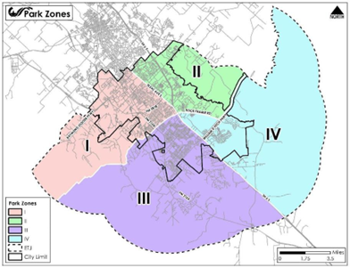
D.
Requirements.
1.
General.
The City Manager or their designee shall administer this Section with certain review, recommendation, and approval authorities being assigned to the Planning and Zoning Commission, the Parks and Recreation Advisory Board, and various City departments as specified herein.
Generally, the developer of residential property must address the following requirements pursuant to this Section: dedication of land for park use or payment of a fee in lieu thereof, and payment of a development fee for park improvements necessary to transform the land into a usable park. Requirements herein are based on actual dwelling units or bedrooms for the entire development. Increases or decreases in the final unit or bedroom count may require an adjustment in fees paid or land dedicated. If the actual number of dwelling units or bedrooms exceeds the original estimate, additional parkland and additional park development fees may be required in accordance with the requirements in this Section.
The delineation of park zones is identified in the Park Zones Subsection above. The schedule of fees and required land dedications are identified in the Parkland Dedication and Development Fees Subsection below.
2.
Land Dedication.
a.
The amount of land to be dedicated for park purposes shall be as set forth in the Parkland Dedication and Development Fees Subsection below.
The total amount of land dedicated for the development shall be dedicated to the City in fee simple:
1)
Prior to the issuance of any building permits for multi-family and multiplex development,
2)
Concurrently with the final plat for each phase of the development, or
3)
In accordance with the terms of a valid development agreement associated with the property.
If land dedication is to occur in future phases of a multiple-phase development, the developer may provide the City with financial security against the current dedication requirements by providing a bond, irrevocable letter of credit, or another alternative financial guarantee such as a cash deposit in the amount equal to the number of acres of parkland required in a form acceptable to the City. The amount of the financial guarantee shall be the amount of fee in lieu of land dedication and improvements as set forth in the Parkland Dedication and Development Fees Subsection below. The financial guarantee will be released to the developer, without interest, upon the filing of the final plat for the subsequent phase that dedicates the required parkland and payment of the fee for the required improvements.
b.
Since residents living in the extraterritorial jurisdiction are likely to use the City's park facilities, they should contribute to the cost of providing them. As a result of the difficulty faced by the City in maintaining property outside the city limits, the City will generally require a fee in lieu rather than the dedication of land. Alternatively, the dedication requirements of this Section may be met through the creation of private parkland in the same amount required as set forth in the Parkland Dedication and Development Fees Subsection below provided the developer enters into a written agreement that all such private parkland be dedicated to the City at the time of full purpose annexation into the city and provided that any plat related to such development is inscribed with a notation regarding same. If the private parkland option is chosen, a provision for private upkeep of the facilities as described in the Credit for Private Park Amenities Subsection below shall be made.
3.
Fee in Lieu of Land.
Instead of dedicating land for parks, a developer may request to meet some or all of the land dedication requirements through payment of a fee in lieu thereof in the amounts set forth in the Parkland Dedication and Development Fees Subsection below. Such fees shall be due at the same time as fees are due for final platting or for issuance of a building permit, based on the type of residential development.
4.
City Final Approval.
The City shall have the final authority in determining what proportion of land or fee may be accepted in lieu of required land dedication. The City may, from time to time, require that a fee be submitted in lieu of land dedication in amounts as set forth in the Parkland Dedication and Development Fees Subsection below. Likewise, the City may, from time to time, require that land be dedicated in amounts as set forth in the Parkland Dedication and Development Fees Subsection below and that no fee in lieu of land will be accepted.
5.
Approval Process for Parkland Dedication.
a.
For the land dedication of five (5) acres or more to be accepted by the City, the landowner must:
1)
Obtain a recommendation from the Parks and Recreation Advisory Board, and
2)
Obtain approval from the Planning and Zoning Commission pursuant to the Plats Section of Article 3, Development Review Procedures of this UDO.
The Planning and Zoning Commission shall consider the recommendation from the Parks and Recreation Advisory Board but may make a decision contrary to its recommendation by majority vote.
b.
The City of College Station will generally not accept dedications of land for parks that are less than five (5) acres, as maintaining small parks is inefficient and too costly for the City to sustain over the long term. However, the City Manager or their designee is authorized to accept and approve land dedications of less than five (5) acres if the following criteria are met:
1)
The proposed dedication provides a sufficient amount of parkland in the park zone of the proposed development for required parkland dedication, or such land provides a valuable link to the greater park system;
2)
The proposed dedication has especially attractive park features, as determined by the City Manager or their designee;
3)
Where the proposed dedication is insufficient for a park site under existing park design standards, some or all of the dedication requirements may be in the form of a fee in amounts as set forth in the Parkland Dedication and Development Fees Subsection below; and
4)
The proposed development of the park is consistent with the City of College Station's Recreation, Park, and Open Space Master Plan.
In making their decision, the City Manager or their designee may choose to submit such an application to the Parks and Recreation Advisory Board for its recommendation. In such event, the City Manager or their designee shall consider such recommendation but may make a decision contrary in accordance with the criteria set forth herein.
6.
Park Development Fee.
In addition to the land dedication requirements for parks, there are also park development fees established herein sufficient to develop parks in ways that meet the City Park Facility & Equipment Standards. The amount of development fees assessed to a developer subject to this Section for parks is as shown in the Parkland Dedication and Development Fees Subsection below. The process for the approval and collection of development fees shall be the same as for the parkland dedication requirements to which the development relates and shall be processed simultaneously with the parkland dedication requirements.
7.
Construction of Park Improvements in Lieu of Development Fee.
A developer may elect to construct park improvements in lieu of paying the associated development fees as set forth herein. In such an event:
a.
A park site plan, developed in cooperation with the Parks and Recreation Department staff, must be submitted and approved by the Director of the Parks and Recreation Department or their designee and the Parks and Recreation Advisory Board upon submission of the final plat or application for a site plan and/or building permit, whichever is applicable.
b.
Detailed plans and specifications for park improvements hereunder shall be due and processed in accordance with the procedures and requirements of public improvements for final plats, site plans, and building permit issuance, whichever is applicable.
c.
All plans and specifications shall meet or exceed the City Park Facility & Equipment Standards in effect at the time of the submission.
d.
If the improvements are constructed on land that has already been dedicated to and/or is owned by the City, then the developer must post payment and performance bonds equal to park development fees to guarantee the payment to subcontractors and suppliers and to guarantee the developer completes the work in accordance with the approved plans, specifications, ordinances, and other applicable laws.
e.
The construction of all improvements must be completed in accordance with the requirements relating to the construction of public improvements for final plats, site plans, and issuance of building permits, whichever is applicable. This includes the guaranteeing of performance in lieu of completing the park improvements prior to final plat approval. Notwithstanding any other applicable ordinances, park improvements should be completed within two (2) years from the date of the approval.
f.
Completion and Acceptance.
Park development will be considered complete, and a certificate of completion will be issued after the following requirements are met:
1)
Improvements have been constructed in accordance with the approved plans;
2)
All parkland upon which the improvements have been constructed has been dedicated as required under this Section; and
3)
All manufacturers' warranties have been provided for any equipment installed in the park as part of these improvements.
g.
Upon issuance of a certificate of completion, the developer warrants the improvements for one (1) year as set forth in the requirements in the City Park Facility & Equipment Standards.
h.
The developer shall be liable for any costs required to complete park development if:
1)
Developer fails to complete the improvements in accordance with the approved plans; or
2)
Developer fails to complete any warranty work.
8.
Submitting Fee.
Any fees required to be paid pursuant to this Section shall be remitted:
a.
Prior to the issuance of any building permits for multi-family development; or
b.
Upon the submission of each final plat for single-family, duplex, or townhouse development.
9.
Use of Fees.
Fees may be used only for the acquisition, development, and/or improvement of park facilities to which they relate; fees shall not be used for maintenance purposes. Fees in lieu of land dedication may only be used for the purchase, development, and/or improvement of parks located within the same zone as the development, or in an adjacent zone in a scenario where the development occurs close to a zone border.
10.
Reimbursement for City Acquired Park Land.
The City may from time to time acquire land for parks in advance of actual or potential development. If the City does take such action, then it may require subsequent dedications to be in fee in lieu of land only. The fees will serve to reimburse the City for the cost(s) of acquisition.
11.
Appeals.
The property owner or applicant for new development may appeal the following decisions to the Director of Planning and Development Services, or their designee:
a.
The applicability of the land dedication, fee in lieu, or development fee;
b.
The amount of the land dedication or fee due;
c.
The determination of credit for private property amenities; and/or
d.
The amount of the refund due, if any.
All appeals shall be taken within 30 days of notice of the action from which the appeal is taken.
The burden of proof shall be on the appellant to demonstrate that the amount of the dedication, fee, refund, or credit was not calculated according to the requirements of this ordinance.
The appellant may appeal the decision of the Director of Planning and Development Services to the City Council. A notice of appeal to the Council must be filed by the applicant with the City Secretary within 30 days following the Director's decision. The filing of an appeal shall not stay the collection of the fee due. If the notice of appeal is accompanied by a payment in an amount equal to the fee due as calculated by the City, the plat or building permit application shall be processed.
E.
Prior Dedication or Absence of Prior Dedication.
If a dedication requirement arose prior to enactment or amendment of this Section, subsequent development for the subject tract to which the dedication requirements apply may be subject to vesting as set forth in Chapter 245 of the Texas Local Government Code, as amended. Depending on the circumstances, additional dedication may be required for the increase in dwelling units or bedrooms from what was originally proposed.
F.
Comprehensive Plan Considerations.
The Recreation, Park, and Open Space Master Plan, adopted by the City Council in association with the Comprehensive Plan, is intended to provide the Parks and Recreation Advisory Board with a guide upon which to base its recommendations. Because of the need to consider specific characteristics in the site selection process and future development, the park locations indicated on the Plan are general. The actual locations, sizes, and number of parks will be determined when development occurs or when sites are acquired by the City, including by donations.
G.
Special Fund; Right to Refund.
The City shall account for all fees in lieu of land and all development fees paid under this Section with reference to the individual plat(s) involved. Any fees paid for such purposes must be encumbered or expended by the City within ten (10) years from the date received by the City for the acquisition, development, and/or improvement of a park as required herein. Such funds shall be considered to be spent on a first-in, first-out basis. If the funds are not so encumbered by contract of purchase order or expended, then the owners of the property on the last day of the ten (10) year period will be entitled to a refund of the unexpended sum upon request. The owners of the property as shown on the current tax roll or proven by another instrument, must request a refund within one (1) year of the expiration of the ten (10) year period. The request must be made in writing to the Director of Parks and Recreation.
H.
Credit for Private Park Amenities.
1.
Up to twenty-five (25) percent of the total fee in lieu and park development fee required by this Section to be paid by a developer may be eligible for reimbursement if the developer provides private parkland and/or amenities on the site. The remaining percentage is retained for deposit in the City's parkland dedication fund for the purpose of defraying the financial burden that new residential units impose on the existing public park system in the city, beyond the immediate development in which the dwelling is located.
2.
Private facilities eligible for parkland dedication credit are those outdoor amenities typically found in city public parks, which will substitute for the improvements otherwise funded by a dedication fee to meet the outdoor recreation needs of residents.
3.
The amount of credit shall be based on actual out-of-pocket dollar costs that the developer incurred in providing the outdoor recreation amenities:
a.
The improvements must be constructed in accordance with the City Park Facility & Equipment Standards.
b.
The developer is required to submit to the City all invoices paid toward the construction of the private amenities.
c.
To receive the credit, the improvement must be inspected and approved by all appropriate City staff.
4.
Yards, court areas, setbacks, and other open areas required to be maintained under the UDO, and other regulations, shall not be included in the credit computation.
5.
Private recreation improvements shall be owned by an incorporated nonprofit owners association comprised of all property owners in the subdivision. The organization should operate under a recorded land agreement through which each property unit owner in the subdivision is automatically a member, and each unit is subject to a charge for a proportionate share of expenses for maintaining the facilities.
6.
Should the owners association fail to maintain the developer-provided private park facilities in compliance with City standards, each property owner agrees that the City may access the facilities to operate, maintain, and repair them. The costs of such maintenance, operations, and repairs shall be charged to the owners association. Such requirement shall be by recorded covenant, which runs with the land in favor of future owners of the property, and which cannot be defeated or eliminated without the written consent of the City.
7.
Use of the private park shall be restricted for park and recreation purposes by a recorded covenant, which runs with the land in favor of future owners of the property, and which cannot be defeated or eliminated without the written consent of the City.
8.
Facilities must be similar or comparable to what would be required to meet public park standards and recreational needs as set forth in the Parkland Park Land Guidelines and Requirements Subsection below.
9.
The design of private park amenities must be reviewed and approved by the City prior to final plat approval.
10.
All private park amenities shall be constructed in accordance with the Construction of Park Improvements in Lieu of Development Fee Subsection above.
I.
Parkland Guidelines and Requirements.
Parks should be easy to access and open to public view to benefit area development, enhance the visual character of the city, protect public safety, and minimize conflict with adjacent land uses. The following guidelines and requirements shall be used in designing parks and adjacent development.
1.
Any land dedicated to the City under this Section must be suitable for park and recreation uses. The dedication shall be free and clear of all liens and encumbrances that interfere with its use for park purposes. The City Manager or their designee shall determine whether any encumbrances interfere with park use. Minerals may be reserved from the conveyance provided that there is a complete waiver of the surface use by all mineral owners and lessees. A current title report must be provided with the land dedication. The property owner shall pay all taxes or assessments owed on the property up to the date of acceptance of the dedication by the City. A tax certificate from the Brazos County Tax Assessor shall be submitted with the dedication or plat.
2.
Consideration will be given to land that is in the floodplain or may be considered "floodable" even though not in a federally regulated floodplain as long as, due to its elevation, it is suitable for park improvements. Sites should not be severely sloping or have unusual topography which would render the land unusable for recreational activities, as set forth in the City Park Facility & Equipment Standards.
3.
At the discretion of the City, land in floodplains will be considered on a three (3) for one (1) basis. Three (3) acres of floodplain will be equal to one (1) acre of parkland.
4.
Where feasible, park sites should be located adjacent to greenways and/or schools to encourage shared facilities and joint development of new sites.
5.
Unless intended to serve a larger area, park sites should be adjacent to residential areas in a manner that serves the greatest number of users and should be located to minimize users having to cross arterial roadways to access them. Furthermore, park sites should not be encumbered by overhead utility lines or easements which may limit the opportunity for park development.
6.
Where appropriate, sites with existing trees or other scenic elements are preferred.
7.
Detention/retention areas will not be considered to meet dedication requirements but may be accepted as a donation in addition to the required dedication. If accepted as part of the park, the detention/retention area design must meet specific park specifications in the City Park Facility & Equipment Standards.
8.
Where park sites are adjacent to greenways, schools, or existing or proposed subdivisions, access ways may be required to facilitate public access to parks.
9.
It is desirable that fifty (50) percent of the perimeter of a park should abut a public street.
J.
Warranty Required.
1.
All materials and equipment provided to the City shall be new unless otherwise approved in advance by the City Manager or their designee and all work shall be of good quality, free from faults and defects, and in conformance with the designs, plans, specifications, and drawings, and recognized industry standards. This warranty, any other warranties express or implied, and any other consumer rights, shall inure to the benefit of the City only and are not made for the benefit of any party other than the City.
2.
All work by the developer or landowner not conforming to these requirements, including but not limited to unapproved substitutions, may be considered defective.
3.
This warranty is in addition to any rights or warranties expressed or implied by law.
4.
Where more than a one (1) year warranty is specified in the applicable plans, specifications, or submittals for individual products, work, or materials, the longer warranty shall govern.
5.
This warranty obligation may be covered by any performance or payment bonds tendered in compliance with this Section.
6.
If any of the work performed by the developer or landowner is found or determined to be either defective, including obvious defects, or otherwise not in accordance with this Section, the designs, plans, drawings, or specifications within one (1) year after the date of the issuance of a certificate of completion of the work or a designated portion thereof, whichever is longer, or within one (1) year after acceptance by the City of designated equipment, or within such longer period as may be prescribed by law or by the terms of any applicable special warranty required by this ordinance, the developer shall promptly correct the defective work at no cost to the City.
7.
During the applicable warranty period and after receipt of written notice from the City to begin corrective work, the developer shall promptly begin the corrective work. The obligation to correct any defective work shall be enforceable under this Code of Ordinances. The guarantee to correct the defective work shall not constitute the exclusive remedy of the City, nor shall other remedies be limited to the terms of either the warranty or the guarantee.
8.
If within twenty (20) calendar days after the City has notified the developer of a defect, failure, or abnormality in the work, the developer has not started to make the necessary corrections or adjustments, the City is hereby authorized to make the corrections or adjustments or to order the work to be done by a third party. The cost of the work shall be paid by the developer.
9.
The cost of all materials, parts, labor, transportation, supervision, special instruments, and supplies required for the replacement or repair of parts and for correction of defects shall be paid by the developer, its contractors, or subcontractors or by the surety.
10.
The guarantee shall be extended to cover all repairs and replacements furnished, and the term of the guarantee for each repair or replacement shall be one (1) year after the installation or completion. The one (1) year warranty shall cover all work, equipment, and materials that are part of the improvements made under this Section of the ordinance.
K.
Parkland Dedication and Development Fees.
Parkland dedication and development fees for developments located within the city limits and extraterritorial jurisdiction are indicated below. The City shall review the fees established and the amount of parkland dedication required in this ordinance at least every five (5) years. Failure to review by the City shall not invalidate this ordinance. The amount indicated in the Collection Rate column shall be the amount required for each unit or bedroom proposed.
The following calculations were used to determine the proportionate rate for the dedication and fee amounts:
(Ord. No. 2023-4453, Pt. 1(Exh. A), 8-10-2023)
Sec. 8.9. - Certifications.
CERTIFICATE OF OWNERSHIP AND DEDICATION
STATE OF TEXAS
COUNTY OF BRAZOS
I (we) ___________, the owner(s) and developer(s) of the land shown on this plat, and designated herein as the ___________ subdivision to the City of College Station, Texas, and whose name(s) is/are subscribed hereto, hereby dedicate to the use of the public forever all streets, alleys, parks, greenways, infrastructure, easements, and public places thereon shown for the purpose and consideration therein expressed.
___________
Owner(s)
STATE OF TEXAS
COUNTY OF BRAZOS
Before me, the undersigned authority, on this day personally appeared ___________ known to me to be the person(s) whose name(s) is/are subscribed to the foregoing instrument and acknowledged to me that he/they executed the same for the purpose and consideration therein stated.
Given under my hand and seal on this _____ day of _______, 20___.
___________
Notary Public, Brazos County, Texas
(Seal)
CERTIFICATE OF SURVEYOR AND/OR ENGINEER
STATE OF TEXAS
COUNTY OF BRAZOS
I, ___________, Registered Public Surveyor (Engineer), No. ___________, in the State of Texas, hereby certify that this plat is true and correct and was prepared from an actual survey of the property and that property markers and monuments were placed under my supervision on the ground.
___________
Surveyor (Engineer)
CERTIFICATE OF CITY ENGINEER
I, ___________, City Engineer of the City of College Station, Texas, hereby certify that this subdivision plat conforms to the requirements of the subdivision regulations of the City of College Station.
___________
City Engineer, City of College Station
CERTIFICATE OF PLANNING AND ZONING COMMISSION (for plat requiring discretionary authority)
I, ___________, Chair of the Planning and Zoning Commission of the City of College Station, hereby certify that the attached plat was duly approved by the Commission on the _____ day of _______, 20___.
___________
Planning and Zoning Commission Chair, City of College Station
CERTIFICATE OF THE COUNTY CLERK
Leave a space four (4) inches wide and two (2) inches tall for the Certificate of the County Clerk.

___________
County Clerk, Brazos County, Texas
CERTIFICATE OF ADMINISTRATOR
I, ___________, Administrator of the City of College Station, Texas, hereby certify that this subdivision plat conforms to the requirements of the subdivision regulations of the City of College Station.
___________
Administrator, City of College Station
CERTIFICATE OF APPROVAL (for plats in the extraterritorial jurisdiction)
This subdivision plat was duly approved by the Commissioners Court of Brazos County, Texas as the final plat of such subdivision on _____ day of ___________, 20___. Signed this the _____ day of ___________, 20___.
___________
County Judge, Brazos County, Texas
CERTIFICATE OF NO ACTION TAKEN
I, ___________, Administrator, hereby certify that the plat was filed with the Planning and Development Services Department on the _____ day of ___________ and that the City of College Station failed to act on the plat within 30 days after the plat was filed.
___________
Administrator, City of College Station
(Ord. No. 2023-4453, Pt. 1(Exh. A), 8-10-2023; Ord. No. 2024-4496, Pt. 1(Exh. I), 1-25-2024; Ord. No. 2024-4534, Pt. 1(Exh. A), 7-25-2024)