
Colleton County Unincorporated
City Zoning Code
City Zoning Code
ARTICLE 14
08-2. - ZONING DISTRICT REGULATIONS
14.08-2.010. - Purpose, interpretation, and general provisions.
A.
Purposes of zoning.
1.
A zoning ordinance is adopted for the general purposes of guiding development in accordance with existing and future needs of the community and to promote the public health, safety, and welfare as established by S.C. Code 1976, § 6-29710. The intent of zoning, according to the 1994 South Carolina Comprehensive Planning Act, is:
a.
To provide for adequate light, air, and open space;
b.
To prevent the overcrowding of land, avoid undue concentration of population, and lessen congestion in the streets;
c.
To facilitate the creation of a convenient, attractive, and harmonious community;
d.
To protect and preserve scenic, historic, or ecologically sensitive areas;
e.
To regulate the density and distribution of populations and the uses of buildings, structures, and land for trade, industry, residence, recreation, agriculture, forestry, conservation, airports and approaches thereto, water supply, sanitation, protection against floods, public activities, and other purposes;
f.
To facilitate the adequate provision or availability of transportation, police and fire protection, water, sewage, schools, park, and other recreational facilities, affordable housing, disaster evacuation, and other public services and requirements;
g.
To secure safety from fire, flood, and other dangers; and
h.
To further the public welfare in any other regard specified by a local governing body.
2.
In order to further the purposes listed in subsection A.l of this section, a zoning ordinance may regulate the following:
a.
Use of buildings, structures, and land;
b.
Size, location, height, bulk, orientation, number of stories, erection, construction, reconstruction, alteration, demolition or removal in whole or in part of buildings and other structures, including signage;
c.
Density of development, use or occupancy of buildings, structures or land;
d.
Areas and dimensions of land, water and air space to be occupied by buildings and structures, and the size of yards, courts and other open spaces;
e.
Amount of off-street parking and loading that must be provided, and the restrictions or requirements related to the entry or use of motor vehicles on the land;
f.
Other aspects of the site plan including, but not limited to, tree preservation, landscaping, buffers, lighting, and curb cuts; and
g.
Other aspects of the development and use of land or structures necessary to accomplish the purposes set forth throughout the Comprehensive Planning Act.
B.
Use interpretation.
1.
Each zoning district has uses permitted by right, conditional uses, and special exception uses. Lists are shown for each district placing uses under one of the three categories. Uses not expressly permitted are prohibited. The following describes the processes the three categories must adhere to:
a.
Uses permitted by right. Administrative review and approval by the director or his designee subject to district provisions and other applicable requirements only.
b.
Conditional uses. Administrative review and approval by the director or his designee subject to district provisions, other applicable requirements, and conditions for approval as outlined in article 14.08-3.
c.
Special exceptions. Zoning board of appeals review and approval subject to district provisions, other applicable requirements, and conditions of approval. Some special exceptions may also be subject to conditions outlined in article 14.08-4.
2.
A mix of two or more uses on the same lot of record is permitted as long as each use listed is permitted within the zoning district. The requirements for approval of the most restricted use shall apply.
C.
Zoning map and interpretation.
1.
The county is hereby divided into zoning districts as shown on the county zoning map which, together with all explanatory matter thereon, is hereby adopted by reference and declared to be part of this chapter.
2.
The zoning map is maintained in the form of a machine-readable representation of a geographic phenomenon stored for display or analysis by a digital computer. The digital zoning database stored in the Geographical Information System (GIS) is hereby designated, established, and incorporated as part of these regulations and the originals thereof, which are on file at the offices of the information technology (IT) department, shall be as much a part of these regulations as if they were fully described in these regulations. Upon adoption of the ordinance from which this chapter is derived and any amendment thereto, the IT department may produce a paper version of the zoning map.
3.
Where uncertainty exists as to the boundaries of any district shown on the zoning map, the director or his designee shall employ the following rules of interpretation:
a.
Centerline. Where a boundary line lies within and follows a street or alley right-of-way, a railroad right-of-way, or utility easement, the boundary shall be construed to be in the center of such street or alley right-of-right, railroad right-of-way, or utility easement forming the boundary between two separate zoning districts is abandoned or removed from dedication, the district boundaries shall be construed as following the centerline of the abandoned or vacated road bed or utility easement.
b.
Edge line. Where a boundary line follows the edge of a street or alley right-of-way, a railroad right-of-way, or utility easement, the boundary shall be construed to be on the edge of such street or alley right-of-way, railroad right-of-way, or utility easement. If such a street or alley right-of-way, railroad right-of-way, or utility easement forming the boundary between two separate zoning districts is abandoned or removed from dedication, the district boundaries shall be construed as following the edge of the abandoned or vacated road bed or utility easement.
c.
Lot line. Boundaries indicated as approximately following lot lines shall be construed as following such lot lines. In the event that a district boundary line divides a lot or tract, each part of the lot or tract so divided shall be used in conformity with the regulations established by this chapter for the district in which said part is located.
d.
County/municipal limits. Boundaries indicated as approximately following county/municipal limits or extraterritorial boundary lines shall be construed as following the county/municipal limits or extraterritorial boundary lines.
e.
Watercourses. Boundaries indicated as approximately following the centerlines of streams, rivers, canals, lakes, or other bodies of water shall be construed to follow such centerlines.
f.
Extensions. Boundaries indicated as parallel to or extensions of street or alley rights-of-way, utility easements, lot lines, city limits, county lines, or extraterritorial boundaries shall be so construed.
g.
Scaling. In a case where a district boundary does not coincide with any boundary lines as above and no distances are described by specific ordinance; the boundary shall be determined by the use of the scale appearing on the map.
h.
Interpretation. Where the director or his designee determines that physical features existing on the ground, or actual property lines or other man-made boundary lines used to depict zoning district boundaries, are different than those shown on the zoning map, the zoning board of appeals shall have the authority to interpret zoning district boundaries.
D.
General provisions and exceptions. In addition to the requirements listed below as well as any district specific requirements, further requirements may be set forth in article 14.08-3 for those uses listed as conditional.
1.
Lot size and configuration.
a.
County and municipal uses, utility substations or sub-installations shall not be subject to the minimum lot size requirements.
b.
Family cemeteries with less than 15 internments shall not be subject to minimum lot size requirements.
c.
All new lots shall front upon a public road, private road, or private access easement in accordance with article 14.04-5. Each lot shall have a minimum frontage of 30 feet on said road or easement.
d.
Any combination of not more than two single-family detached dwellings and/or manufactured dwellings and their customary accessory structures may hereafter be erected on any lot, provided all lot area and setback requirements are met for both units and so arranged to ensure public access, except as allowed under a family group development.
2.
Setbacks.
a.
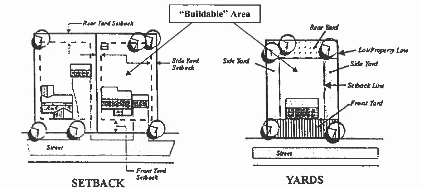
The required front, side, and rear yards for individual lots shall be measured inward toward the center of said lot from all points along the respective front, side, and rear property lines of the lot. Once the yard areas of a given lot have been established, the remaining area of the lot which is not included in any required front, side, or rear yard shall be known as the "buildable" area within which the approved structures shall be placed.
b.
Where a property abuts a street right-of-way or access easement, the setback shall be measured from the edge of the right-of-way line or access easement. Where lots may only be accessed by water, the front setback is applied from the high-water mark along the waterside with the access.
c.
Corner lots shall be considered to have two fronts with the secondary front yard setback 75 percent of the primary front yard setback for the district. The primary front is defined as the street frontage to which the E-911 address for the lot is assigned.
d.
Where the minimum lot width is not met at the front setback for the district, a front setback line shall be established where the minimum lot width for the district is met provided that a minimum of 30 feet of street frontage is provided.
e.
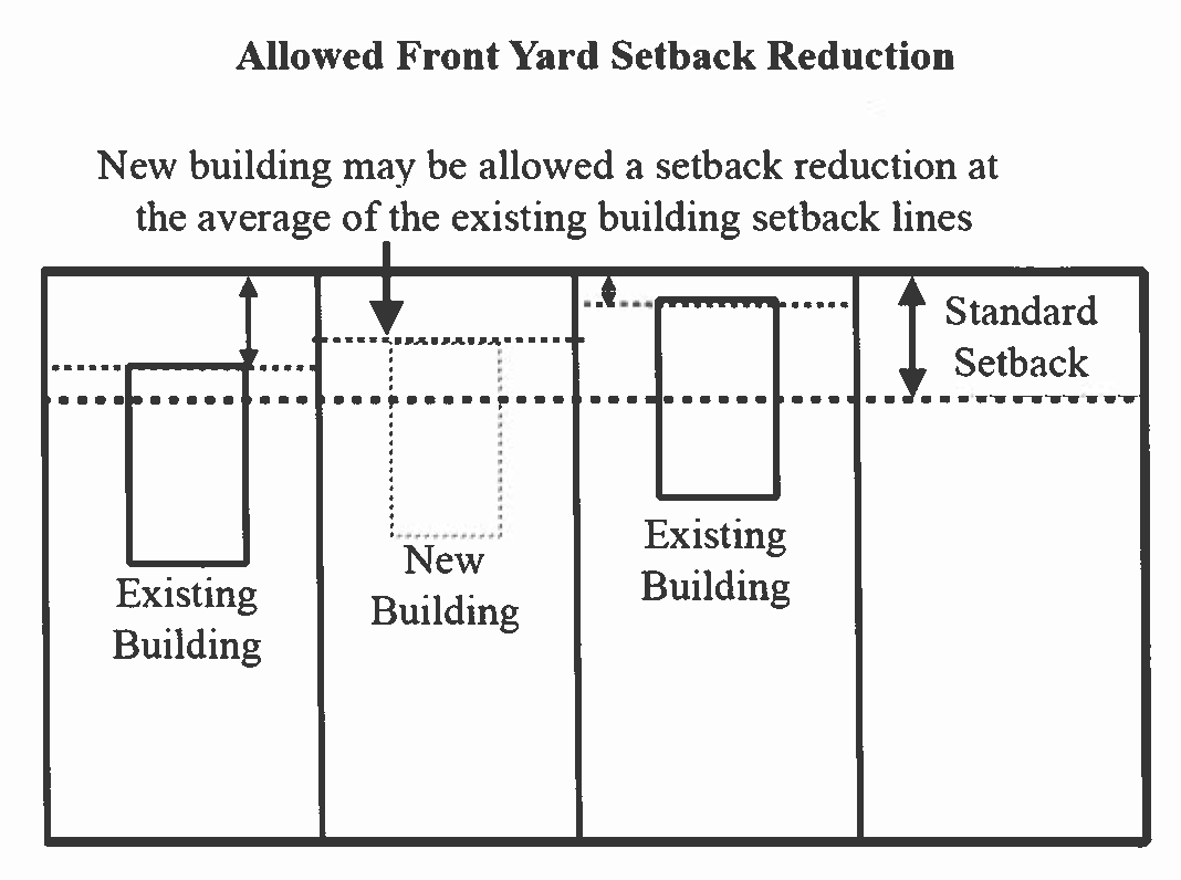
Where the majority of lots in a block fronting on the same side of a street between two intersecting streets are lawfully occupied with buildings having greater or lesser front yard depth than required by these regulations, no building hereafter erected or altered shall vary in the front yard setback by more than five feet from the average depth of said existing front yard setbacks without written approval of contiguous property owners. However, in no case shall setbacks be less than 15 feet. See following diagram.
f.
Whenever more than one principal building is located on a lot, the required yards shall be maintained around the group of buildings and buildings shall be separated by a horizontal distance that is at least equal to the height of the highest adjacent building. Accessory buildings are to be separated from principal or other accessory structures by at least five feet.
g.
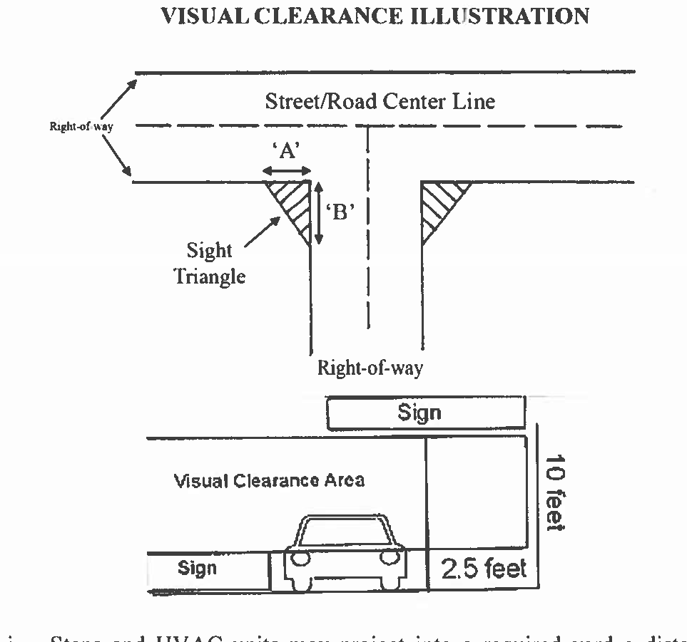
On any corner lot in any district, no planting shall be placed or maintained and no fence, building, wall, or other structure shall be constructed at any point between a height of 2 feet and nine feet above the upper face of the nearest curb (or street center line if no curb exists) within the sight triangle. The sight triangle is the area bounded on two sides by the street right-of- way lines and on the third side by a straight line connecting points on the two street right-of-way lines as required by the site triangular and vertical vision clearance illustration. However, poles and support structures less than 12 inches in diameter may be permitted in such areas.
h.
The side and rear setbacks in the CC, UD-1, and UD-2 districts shall not apply to the shared property line of attached buildings.
i.
The space in any required yard shall be open and unobstructed except for the ordinary projections of window sills, cornices, eaves, window air conditioning units, and other architectural features (i.e., siding, bricks and overhangs) provided that such features shall project no more than two feet into any required yard.
j.
Steps and HVAC units may project into a required yard a distance not to exceed five feet but no closer than three feet of a property line. Fences, walls, hedges, and septic lines may be located in any setback, so long as they remain on the property and don't create sight-triangle issues.
k.
Utility substations shall be exempt from district setback requirements.
3.
Height.
a.
The height of a building or structure shall be measured from the average grade elevation within 20 feet of the structure or from the base of a tree when computing height in the airport compatibility zone, to the highest point of the building, structure, or tree.
b.
The height limitations of this chapter shall not apply to the following (except in the AC-O):
i.
Belfries.
ii.
Chimneys.
iii.
Church spires.
iv.
Conveyors.
v.
Cooling towers.
vi.
Cupulas.
vii.
Domes.
viii.
Elevator and stair bulkheads.
ix.
Fire towers.
x.
Flagpoles.
xi.
Ornamental towers and spires.
xii.
Public monuments.
xiii.
Public utility poles.
xiv.
Silos.
xv.
Skylights.
xvi.
Smoke stacks.
xvii.
Stage towers or scenery lofts.
Such features shall be erected only to such height as is necessary to accomplish the purpose they are intended to serve and no height extension shall serve as a place for human habitation.
c.
The height of communication towers and antennas, and water tanks shall also be exempt from district height requirements, provided such structures shall be separated from any adjoining residential use by a distance equal to one foot for each one foot in height, or if engineered to collapse in on themselves, the distance away from the residential use as established by the engineer provided that the conditions in section 14.08-3.020(GG) are met.
d.
All unincorporated property on Edisto Island shall be permitted to build up to a height of 50 feet.
E.
Other requirements. In addition to zoning district regulations, see the following sections for other requirements:
1.
See article 14.08-3 for conditional and special exception uses.
2.
See article 14.08-4 for landscaping, buffering, and environmental protection.
3.
See article 14.08-5 for parking.
4.
See article 14.08-6 for signage.
5.
See article 14.08-7 for variances, special exceptions, appeals, and zoning board of appeals.
6.
See article 14.08-8 for permits, site plans, administration, and planning commission.
7.
See article 14.08-9 for nonconformities.
8.
See article 14.08-10 for zone changes, zoning and comprehensive plan map and text amendments.
(Ord. No. 22-O-05, § 2, 5-3-2022)
14.08-2.020. - Establishment of base zoning districts.
Base zoning districts are created to provide comprehensive land use regulations throughout the county. There are nine base zoning districts that provide for a variety of uses that are appropriate to the character areas in which they are located in accordance with the county comprehensive plan. These base zoning districts are as follows and they shall comply with all of the general and specific requirements of this chapter.
1.
Resource Conservation: RC-1 and RC-2.
2.
Rural Development: RD-1 and RD-2.
3.
Suburban Residential: RS.
4.
Community Commercial: CC.
5.
Village Commercial: VC.
6.
Urban Development: UD-1 and UD-2.
7.
Light Industrial: LID.
8.
Industrial: ID.
9.
Heavy Industrial: HID.
10.
Planned Development District: PDD.
(Ord. No. 22-O-05, § 2, 5-3-2022; Ord. No. 23-O-17, § 1, 11-7-2023)
14.08-2.030. - Resource Conservation Zoning District (RC-1).
A.
Purpose. The RC-1 Zoning District was established to protect fragile wetlands, marshes, beaches, sand dunes, rivers, creeks, islands, and other natural resources critical to the ecosystems within the ACE Basin. This is the most restrictive zoning district in the county and requires large lot development due to its environmentally sensitive resources. Most of the lands in this district are already protected by land conservancies; however, many large undeveloped tracts of land not suited for dense development within the ACE Basin are not under any type of permanent protection. This district allows for a low density development pattern that would help preserve the environmental characteristics of those areas, protecting them from the potential impacts of more concentrated development.
B.
Uses.
1.
Permitted uses.
a.
Agricultural production, crops.
b.
Agricultural support services.
c.
Cemeteries, family and accessory (excluding cemeteries as the principal use).
d.
Emergency services.
e.
Farms and ranches, general.
f.
Fishing, hunting, trapping (commercial, excludes hunting and fishing camps).
g.
Forestry.
h.
Government buildings (excluding correctional facilities).
i.
Greenhouses and nurseries, commercial.
j.
Places of worship.
k.
Public and private parks and recreation (indoor and outdoor).
l.
Public and private utilities (excluding electric generation, steam, and air supply).
m.
Single-family detached residential dwellings.
n.
Storage, indoor (up to 5000 square feet).
2.
Conditional uses (See article 14.08-3 for conditions).
a.
Accessory structures.
b.
Animal production (excluding hogs).
c.
Conservation subdivisions.
d.
Home occupations.
e.
Hunting and fishing camps, temporary.
f.
Family care home for the handicapped.
g.
Family group development.
h.
Gun clubs and outdoor shooting ranges.
i.
Manufactured homes (on individual lots).
j.
Temporary uses (except fireworks stands).
3.
Special exceptions (See article 14.08-3 for any conditions).
a.
Bed and breakfast inns.
b.
Communications towers.
c.
Golf courses and country clubs.
d.
Marinas.
e.
Mining.
f.
Museums, historical sites, sightseeing, and similar institutions.
g.
Recreational group quarters.
h.
Taxidermy and wild game processing.
i.
Park model trailers, campers and RVs as Living accommodations (on individual lots but not on Edisto Island).
C.
Dimensional requirements - (RC-1) Zoning District.*
*See section 14.08-2.010(D) for general provisions and exceptions to dimensional requirements.
_____
(Ord. No. 22-O-05, § 2, 5-3-2022)
14.08-2.040. - Resource Conservation Zoning District-2 (RC-2).
A.
Purpose. Many lands within the ACE Basin are suitable for low to moderate density development near and adjacent to areas where small scale community crossroads exist. Although near and adjacent to larger more environmentally sensitive areas within the RC-1, the lands with the RC-2 can support smaller lot development.
B.
Uses.
1.
Permitted uses.
a.
Agricultural production, crops.
b.
Agricultural support services.
c.
Cemeteries, family and accessory (excluding cemeteries as a principal use).
d.
Civic, fraternal, professional, and political organizations.
e.
Emergency services.
f.
Farms and ranches, general.
g.
Fishing, hunting, trapping (commercial, excludes hunting and fishing camps).
h.
Forestry.
i.
Fuel supply services (excluding automobile gas stations).
j.
Golf courses and country clubs.
k.
Government buildings (excluding correctional facilities).
l.
Greenhouses and nurseries, commercial.
m.
Museums, historical sites, sightseeing, and similar institutions.
n.
Places of worship.
o.
Public and private parks and recreation (indoor and outdoor).
p.
Public and private utilities (excluding electric generation, steam, and air supply).
q.
Single-family detached residential dwellings.
r.
Storage, Indoor (up to 5,000 square feet).
2.
Conditional uses (see article 14.08-3 for conditions).
a.
Accessory structures.
b.
Animal production (excluding hogs).
c.
Bed and breakfast inns.
d.
Conservation subdivisions.
e.
Family care home for the handicapped.
f.
Family group development.
g.
Gun clubs and outdoor shooting ranges.
h.
Home occupations.
i.
Hunting and fishing camps, temporary.
j.
Manufactured homes (on individual lots).
k.
Park model trailers, campers and RVs as living accommodations (on individual lots)
l.
Temporary uses.
3.
Special exceptions (see article 14.08-7 for special exceptions and article 14.08-3 for any conditions).
a.
Camps and recreational vehicle parks.
b.
Communications towers.
c.
Marinas.
d.
Mining.
e.
Recreational group quarters.
f.
Schools, elementary and secondary.
g.
Taxidermy and wild game processing.
_____
C.
Dimensional requirements (RC-2).*
*See section 14.08-2.010(D) for general provisions and exceptions to dimensional requirements.
_____
14.08-2.050. - Rural Development Zoning District-1 (RD-1).
A.
Purpose. The RD-1 Zoning District was established to conserve, sustain, and protect rural areas and resources, particularly agricultural/farm lands and areas of high flood potential. It is intended to accommodate low density residential uses, agricultural and farming uses, and related support services.
B.
Uses.
1.
Permitted uses.
a.
Agricultural production, crops.
b.
Agricultural support services.
c.
Animal services (no outdoor kennels).
d.
Building and special trade contractors (excluding heavy construction).
e.
Cemeteries.
f.
Civic, fraternal, professional, and political organizations.
g.
Emergency services.
h.
Farms and ranches, general.
i.
Farm supply stores.
j.
Fishing, hunting, trapping (commercial, excludes hunting and fishing camps).
k.
Forestry.
l.
Fuel supply services (excluding automobile gas stations and truck stops).
m.
Greenhouses and nurseries, commercial.
n.
Golf courses and country clubs.
o.
Government buildings (excluding correctional facilities).
p.
Landscape services.
q.
Marinas.
r.
Museums, historical sites, sightseeing, and similar institutions.
s.
Places of worship.
t.
Public and private parks and recreation (indoor and outdoor).
u.
Public and private utilities.
v.
Single-family detached residential dwellings.
w.
Taxidermy and wild game processing.
x.
Warehousing and storage (indoor, excluding mini-storage).
2.
Conditional uses (See article 14,08-3 for conditions).
a.
Accessory structures.
b.
Animal production (excluding hogs).
c.
Bed and breakfast inns.
d.
Campgrounds and recreational vehicle parks.
e.
Conservation subdivisions.
f.
Family care home for the handicapped.
g.
Family group development.
h.
Gun clubs and outdoor shooting ranges.
i.
Home occupations.
j.
Hunting and fishing camps, temporary.
k.
Lumber and saw mills.
l.
Manufactured homes (on individual lots).
m.
Mining.
n.
Park model trailers, campers and RVs as living accommodations (on individual lots but not on Edisto Island).
o.
Seasonal worker housing.
p.
Temporary uses.
3.
Special exceptions, (see article 14.08-3 for any conditions).
a.
Automotive services and other repair.
b.
Animal services (with outdoor kennels).
c.
Building materials and supply.
d.
Communications towers.
e.
Day care centers.
f.
Event venue.
g.
Health care services (excluding hospitals).
h.
Heavy construction contractors.
i.
Personal care services.
j.
Residential care facilities.
k.
Recreational group quarters.
l.
Schools, elementary and secondary.
m.
Schools, instructional.
n.
Schools, vocational.
o.
Solid waste landfill (excluding hazardous waste).
p.
Waste management services (excluding hazardous waste).
_____
C.
Dimensional requirements (RD-1).*
*See section 14.08-2.010(D) for general provisions and exceptions to dimensional requirements.
_____
(Ord. No. 22-O-05, § 2, 5-3-2022; Ord. No. 23-O-17, § 1, 11-7-2023)
14.08-2.060. - Rural Development Zoning District - 2 (RD-2).
A.
Purpose. This district is very rural in nature, though more developed than the RD-1 district. This district serves as a transition between the lower density RD-1 and higher density RS district. It allows for agricultural uses, rural residential development, and low intensity supporting uses. Most of the lands within this district are not heavily farmed or in significant flood prone areas. Some services may be available or planned with this district allowing for a greater density of residential development than the RD-1, but not as dense as the RS District.
B.
Uses.
1.
Permitted uses.
a.
Air strips (private use).
b.
Agricultural production, crops.
c.
Agricultural support services.
d.
Animal services (no outdoor kennels).
e.
Building and special trade contractors (excluding heavy construction).
f.
Cemeteries.
g.
Civic, fraternal, professional, and political organizations.
h.
Emergency services.
i.
Farms and ranches, general.
j.
Farm supply stores.
k.
Fishing, hunting, trapping (commercial, excludes hunting and fishing camps).
l.
Forestry.
m.
Fuel supply services (excluding truck stops).
n.
Greenhouses and nurseries, commercial.
o.
Golf courses and country clubs.
p.
Government buildings (excluding correctional facilities).
q.
Health care services (excluding hospitals).
r.
Landscape services.
s.
Libraries.
t.
Marinas.
u.
Museums, historical sites, sightseeing, and similar institutions.
v.
Office uses, general (up to 5,000 square feet).
w.
Personal care services.
x.
Places of worship.
y.
Public and private parks and recreation (indoor and outdoor).
z.
Public and private utilities.
aa.
Reserved.
bb.
Schools, elementary and secondary.
cc.
Schools, college and university.
dd.
Schools, instructional.
ee.
Schools, vocational.
ff.
Single-family detached residential dwellings.
gg.
Taxidermy and wild game processing.
hh.
Warehousing and storage (indoor, excluding mini-storage).
2.
Conditional uses (see article 14.08-3 for conditions).
a.
Accessory structures.
b.
Animal production (excluding hogs).
c.
Bed and breakfast inns.
d.
Building materials and supply.
e.
Conservation subdivisions.
f.
Family care home for the handicapped.
g.
Family group development.
h.
Gun clubs and outdoor shooting ranges.
i.
Home occupations.
j.
Hunting and fishing camps, temporary.
k.
Lumber and saw mills.
l.
Manufactured homes (on individual lots).
m.
Mining.
n.
Park model trailers, campers and RVs as living accommodations (on individual lots).
o.
Residential care facilities.
p.
Seasonal worker housing.
q.
Temporary uses.
3.
Special exceptions (See article 14.08-7 for special exceptions and article 14.08-3 for any conditions).
a.
Automotive services and other repair.
b.
Animal services (with outdoor kennels).
c.
Campgrounds and recreational vehicle parks.
d.
Communications towers.
e.
Day care centers.
f.
Event venue.
g.
Heavy construction contractors.
h.
Manufactured home parks.
i.
Outdoor markets.
j.
Retail uses.
k.
Restaurants and drinking establishments.
l.
Recreational group quarters.
m.
Solid waste landfill (excluding hazardous waste).
n.
Waste management services (excluding hazardous waste).
o.
Wholesale trade.
_____
C.
Dimensional requirements (RD-2).*
*See section 14.08-2.010(D) for general provisions and exceptions to dimensional requirements.
(Ord. No. 23-O-01, § 1, 3-14-2023; Ord. No. 23-O-17, § 1, 11-7-2023)
_____
14.08-2.070. - Suburban Residential Zoning District (RS).
A.
Purpose. The purpose of this district is to foster, sustain, and protect areas in which the principal use of land is for single-family dwellings and related support uses in areas at the edge of municipal boundaries within a suburban environment. This district is the transition district between the RD-1 and RD-2 Districts and more intense urban districts.
B.
Uses.
1.
Permitted uses.
a.
Agricultural production, crops and horses (excluding all other livestock).
b.
Cemeteries, family and accessory (excluding principal use).
c.
Emergency services.
d.
Forestry.
e.
Golf courses and country clubs.
f.
Government buildings (excluding correctional facilities).
g.
Libraries.
h.
Places of worship.
i.
Public and private parks and recreation (indoor and outdoor).
j.
Public and private utilities (excluding electric generation, steam, air supply and water/sewer treatment).
k.
Schools, elementary and secondary.
l.
Single-family detached residential dwellings.
2.
Conditional uses (See article 14.08-3 for conditions).
a.
Accessory structures.
b.
Animal production (horses only).
c.
Conservation subdivisions.
d.
Family care home for the handicapped.
e.
Home occupations.
f.
Single-family attached residential.
g.
Temporary uses.
3.
Special exceptions (See article 14.08-3 for any conditions).
a.
Bed and breakfast inns.
b.
Marinas.
_____
C.
Dimensional requirements (RS).*
*See section 14.08-2.010(D) for general provisions and exceptions to dimensional requirements.
_____
(Ord. No. 22-O-05, § 2, 5-3-2022)
14.08-2.080. - Community Commercial Zoning District (CC).
A.
Purpose. The Community Commercial Zoning District was established to provide small scale, very low intensity commercial development at rural crossroads in convenient and strategic locations of the county to meet "community needs." The community commercial districts are intended to be located nearest to the RD-1, RD- 2 and RC-2 areas at major intersections or established rural/community crossroads.
B.
Uses.
1.
Permitted uses.
a.
Agricultural production, crops.
b.
Animal services (no outdoor kennels).
c.
Auditorium/Indoor public assembly.
d.
Automotive parking and garages (as a principal use).
e.
Banks.
f.
Building and special trade contractors (excluding heavy construction).
g.
Bus and transit terminals and stops.
h.
Cemeteries, family and accessory (excluding principal use).
i.
Civic, fraternal, professional, and political organizations.
j.
Emergency services.
k.
Farm supply stores.
l.
Financial services and offices.
m.
Forestry.
n.
Funeral homes and services.
o.
Greenhouses and nurseries, commercial.
p.
Government buildings (excluding correctional facilities).
q.
Health care services.
r.
Landscape services.
s.
Libraries.
t.
Laundry and dry cleaning services.
u.
Marinas.
v.
Museums, historical sites, sightseeing, and similar institutions.
w.
Office general and professional.
x.
Personal care services.
y.
Places of worship.
z.
Public and private parks and recreation (indoor and outdoor).
aa.
Public and private utilities (excluding electric generation, steam, and air supply).
bb.
Railroad stations.
cc.
Restaurants and drinking establishments.
dd.
Retail uses.
ee.
Schools, elementary and secondary.
ff.
Service uses (indoor).
gg.
Single-family detached residential dwellings.
hh.
Telecommunications (excluding towers).
ii.
Wholesale trade.
3.
Conditional uses (See article 14.08-3 for conditions).
a.
Accessory structures.
b.
Animal production (excluding hogs).
c.
Automotive services and gas stations (no major repair or long-term vehicle storage, excluding truck stops).
d.
Bed and breakfast inns.
e.
Day care centers.
f.
Family care home for the handicapped.
g.
Home occupations.
h.
Manufactured homes (on individual lots).
i.
Mixed use buildings.
j.
Residential care facilities.
k.
Temporary uses.
4.
Special exceptions (See article 14.08-3 for any conditions).
a.
Animal services (with outdoor kennels).
b.
Automotive services (with major repair or long-term vehicle storage).
c.
Communications towers.
d.
Heavy construction contractors.
e.
Mini-warehouses.
f.
Outdoor markets.
g.
Park model trailers, campers and RVs as living accommodations (on individual lots)
_____
C.
Dimensional requirements (CC).*
*See section 14.08-2.010(D) for general provisions and exceptions to dimensional requirements.
_____
(Ord. No. 22-O-05, § 2, 5-3-2022)
14.08-2.090. - Village Commercial Zoning District (VC).
A.
Purpose. This district is intended to accommodate existing or developing community or "village" areas that have a mix of uses and commercial/community activities that are much greater than the influence of a country store at a Community Commercial District/rural crossroads, but not enough density to yet be classified as a town. Examples include Jacksonboro and Green Pond.
B.
Uses.
1.
Permitted uses.
a.
Agricultural production, crops.
b.
Animal services (no outdoor kennels).
c.
Auditorium/indoor public assembly.
d.
Automotive parking and garages (as a principal use).
e.
Automotive sales and rental.
f.
Banks.
g.
Building and special trade contractors (excluding heavy construction).
h.
Bus and transit terminals and stops.
i.
Cemeteries, family and accessory (excluding principal use).
j.
Civic, fraternal, professional, and political organizations.
k.
Emergency services.
l.
Farm supply stores.
m.
Financial services and offices.
n.
Forestry.
o.
Funeral homes and services.
p.
Greenhouses and nurseries, commercial.
q.
Golf courses and country clubs.
r.
Government buildings (excluding correctional facilities).
s.
Health care services.
t.
Hospitals.
u.
Hotels, motels, and inns.
v.
Landscape services.
w.
Libraries.
x.
Laundry and dry cleaning services.
y.
Marinas.
z.
Museums, historical sites, sightseeing, and similar institutions.
aa.
Offices, general.
bb.
Personal care services.
cc.
Places of worship.
dd.
Public and private parks and recreation (indoor and outdoor).
ee.
Public and private utilities (excluding electric generation, steam, and air supply).
ff.
Railroad stations.
gg.
Restaurants and drinking establishments.
hh.
Retail uses.
ii.
Schools, elementary and secondary.
jj.
Service uses (indoor).
kk.
Single-family detached residential dwellings.
ll.
Telecommunications (excluding towers).
mm.
Warehousing and storage (indoor).
nn.
Wholesale trade.
2.
Conditional uses (see article 14.08-3 for conditions).
a.
Accessory structures.
b.
Animal production (excluding hogs).
c.
Automotive services and gas stations (no major repair or long-term vehicle storage)
d.
Bed and breakfast inns.
e.
Day care centers.
f.
Family care home for the handicapped.
g.
Home occupations.
h.
Manufactured homes (on individual lots).
i.
Mixed use buildings.
j.
Residential care facilities.
k.
Temporary uses.
3.
Special exceptions (see article 14.08-7 for special exceptions and article 14.08-3 for any conditions).
a.
Animal services (with outdoor kennels).
b.
Automotive services (with major repair or long-term vehicle storage).
c.
Communications towers.
d.
Heavy construction contractors.
e.
Mini-warehouses.
f.
Outdoor markets.
_____
C.
Dimensional requirements (VC).*
*See section 14.08-2.010(D) for general provisions and exceptions to dimensional requirements.
_____
(Ord. No. 22-O-05, § 2, 5-3-2022)
14.08-2.100. - Urban Development Zoning District-1 (UD-1).
A.
Purpose. The UD-1 Zoning District is intended to accommodate urban growth in areas outside of municipalities. The UD-1 is an appropriate transition district between the RS and UD-2 Districts. The UD-1 district accommodates lower intensity uses than the more intense UD-2 district.
B.
Uses.
1.
Permitted uses.
a.
Air strips and airports.
b.
Agricultural production, crops.
c.
Agricultural support services.
d.
Animal services (no outdoor kennels).
e.
Auditorium/indoor public assembly.
f.
Automotive parking and garages (as a principal use).
g.
Automotive sales and rental.
h.
Banks.
i.
Building and special trade contractors (excluding heavy construction).
j.
Bus and transit terminals and stops.
k.
Cemeteries.
l.
Civic, fraternal, professional, and political organizations.
m.
Distribution.
n.
Emergency services.
o.
Farms and ranches, general.
p.
Farm supply stores.
q.
Financial services and offices.
r.
Fishing, hunting, trapping (commercial, excludes hunting and fishing camps).
s.
Forestry.
t.
Fuel supply services.
u.
Funeral homes and services.
v.
Greenhouses and nurseries, commercial.
w.
Golf courses and country clubs.
x.
Government buildings (excluding correctional facilities).
y.
Hospitals.
z.
Hotels, motels, and inns.
aa.
Landscape services.
bb.
Libraries.
cc.
Laundry and dry cleaning services.
dd.
Marinas.
ee.
Motion picture and sound industries.
ff.
Movie theater.
gg.
Museums, historical sites, sightseeing, and similar institutions.
hh.
Pawn shops.
ii.
Personal care services.
jj.
Places of worship.
kk.
Professional offices.
ll.
Public, private and commercial parks and recreation (indoor and outdoor).
mm.
Public and private utilities (excluding power generation from non-renewable sources).
nn.
Railroad stations.
oo.
Research facilities.
pp.
Restaurants and drinking establishments.
qq.
Retail uses.
rr.
Schools, elementary and secondary.
ss.
Schools, college and university.
tt.
Schools, instructional.
uu.
Schools, vocational.
vv.
Service uses (indoor).
ww.
Single-family detached residential dwellings.
xx.
Telecommunications, (excluding cell towers).
yy.
Two-family residential dwellings (duplexes).
zz.
Warehousing and storage (indoor, excluding mini-storage).
aaa.
Wholesale trade.
2.
Conditional uses (See article 14.08-3 for conditions).
a.
Accessory structures.
b.
Animal production (excluding hogs).
c.
Automotive services and gas stations (no major repair or long-term vehicle storage).
d.
Bed and breakfast inns.
e.
Building materials and supply.
f.
Camps and recreational vehicle parks.
g.
Conservation subdivisions.
h.
Day care centers.
i.
Family care home for the handicapped.
j.
Family group development.
k.
Home occupations.
l.
Hunting and fishing camps, temporary.
m.
Light manufacturing. (indoors)
n.
Lumber and saw mills.
o.
Manufactured homes (on individual lots).
p.
Mining.
q.
Mixed use buildings.
r.
Multi-family residential.
s.
Park model trailers, campers and RVs as living accommodations (on individual lots).
t.
Temporary uses.
3.
Special exceptions (See article 14.08-3 for any conditions).
a.
Animal services (with outdoor kennels).
b.
Automotive services (with major repair or long-term vehicle storage).
c.
Boarding and rooming houses.
d.
Communications towers.
e.
Event venue.
f.
Gun clubs and skeet shooting ranges.
g.
Health care services.
h.
Heavy construction contractors.
i.
Manufactured home parks.
j.
Mini-storage.
k.
Outdoor markets.
l.
Recycling (household paper, plastic, tins and glass).
m.
Residential care facilities.
_____
C.
Dimensional requirements (UD-1).*
*See section 14.08-2.010(D) for general provisions and exceptions to dimensional requirements.
_____
(Ord. No. 22-O-05, § 2, 5-3-2022; Ord. No. 23-O-01, § 1, 3-14-2023; Ord. No. 23-O-17, § 1, 11-7-2023)
14.08-2.110. - Urban Development Zoning District-2 (UD-2).
A.
Purpose. This district, in conjunction with UD-1, is intended to accommodate most of the projected growth in urban transition areas outside of municipalities. This district is intended to have most public facilities and infrastructure in support of urban development such as water, sewer, streets, and schools. The UD-2 district accommodates higher intensity uses than the UD-1 district.
B.
Uses.
1.
Permitted uses.
a.
Air strips and airports.
b.
Agricultural production, crops.
c.
Agricultural support services.
d.
Animal services (no outdoor kennels).
e.
Auditorium/indoor public assembly.
f.
Automotive parking and garages (as a principal use).
g.
Automotive sales and rental.
h.
Banks.
i.
Building and special trade contractors (excluding heavy construction).
j.
Bus and transit terminals and stops.
k.
Cemeteries.
l.
Reserved.
m.
Distribution.
n.
Emergency services.
o.
Entertainment uses (excluding pool/billiard halls and sexually oriented businesses).
p.
Farms and ranches, general.
q.
Farm supply stores.
r.
Financial services and offices.
s.
Fishing, hunting, trapping (commercial, excludes hunting and fishing camps).
t.
Forestry.
u.
Fuel supply services.
v.
Funeral homes and services.
w.
Greenhouses and nurseries, commercial.
x.
Golf courses and country clubs.
y.
Government buildings (excluding correctional facilities).
z.
Health care services.
aa.
Hospitals.
bb.
Hotels, motels, and inns.
cc.
Landscape services.
dd.
Libraries.
ee.
Reserved.
ff.
Laundry and dry cleaning services.
gg.
Marinas.
hh.
Mini-storage.
ii.
Motion picture and sound industries.
jj.
Movie theaters.
kk.
Museums, historical sites, sightseeing, and similar institutions.
ll.
Nonprofit organizations.
mm.
Pawn shops.
nn.
Personal care services.
oo.
Places of worship.
pp.
Professional offices.
qq.
Public, private and commercial parks and recreation (indoor and outdoor).
rr.
Public and private utilities (excluding power generation from non-renewable energy sources).
ss.
Railroad stations.
tt.
Research facilities.
uu.
Restaurants and drinking establishments.
vv.
Retail uses.
ww.
Schools, elementary and secondary.
xx.
Schools, college and university.
yy.
Schools, instructional.
zz.
Schools, vocational.
aaa.
Service uses (indoor).
bbb.
Single-family detached residential dwellings.
ccc.
Spectator sports (excluding automotive sports).
ddd.
Telecommunications.
eee.
Two-family residential dwellings (duplexes).
fff.
Warehousing and storage (indoor).
ggg.
Wholesale trade.
2.
Conditional uses (see article 14.08-3 for conditions).
a.
Accessory structures.
b.
Animal production (excluding hogs).
c.
Automotive services and gas stations (no major repair or long-term vehicle storage).
d.
Bed and breakfast inns.
e.
Boarding and rooming houses.
f.
Camps and recreational vehicle parks.
g.
Conservation subdivisions.
h.
Day care centers.
i.
Family care home for the handicapped.
j.
Family group development.
k.
Heavy construction contractors.
l.
Home occupations.
m.
Hunting and fishing camps, temporary.
n.
Light manufacturing.
o.
Lumber and saw mills.
p.
Manufactured homes (on individual lots).
q.
Mining.
r.
Mixed use buildings.
s.
Multi-family residential dwellings.
t.
Park model trailers, campers and RVs as living accommodations (on individual lots).
u.
Residential care facilities.
v.
Temporary uses.
3.
Special exceptions (see article 14.08-7 for special exceptions and article 14.08-3 for any conditions).
a.
Animal services (with outdoor kennels).
b.
Automotive services (with major repair or long-term vehicle storage).
c.
Bars and nightclubs (excluding sexually oriented businesses).
d.
Communications towers.
e.
Correctional facilities.
f.
Event venue.
g.
Gun clubs and skeet shooting ranges.
h.
Manufactured home dealers.
i.
Manufactured home parks.
j.
Outdoor markets.
k.
Pool/billiard halls.
_____
C.
Dimensional requirements (UD-2).*
*See section 14.08-2.010 for general provisions and exceptions to dimensional requirements.
_____
(Ord. No. 22-O-05, § 2, 5-3-2022; Ord. No. 23-O-17, § 1, 11-7-2023)
14.08-2.120. - Industrial Zoning Districts.
The economic development element of the 2030 Comprehensive Plan (2030 Update) finds that the service and retail industries are the largest employment industries in the county. While it is critical to support and grow the commercial sector of a local economy, manufacturing, and other industrial activities offer wage premiums that provide a stable, middle-income standard of living.
In addition to recognizing the importance of the Lowcountry Regional Airport and Colleton County Commerce Center, the 2030 update codifies the goals, objectives, and policies of the county council, SC Department of Commerce, Palmetto Railways, and the SC Power Team in developing the Highway 64 Mega Site. The mega site, in conjunction with other county industrial facilities, creates a competitive advantage for economic development efforts by offering a variety of industrial zoning options and are described as follows.
(Ord. No. 23-O-17, § 1, 11-7-2023)
Editor's note— Ord. No. 23-O-17, § 1, adopted November 7, 2023, repealed the former § 14.08-2.120, and enacted a new § 14.08-2.120 as set out herein. The former § 14.08-2.120 pertained to Industrial Zoning District (ID) and derived from Ord. No. 22-O-05, § 2, adopted May 3, 2022.
14.08-2.125. - Light Industrial Zoning District (LID).
A.
Purpose. The intent of this district is to accommodate the storage, distribution, wholesaling, processing, light manufacturing, provision of municipal or county public services, and general commercial uses in fully enclosed buildings. Generally, the LID may include open or enclosed storage and significant truck traffic requiring relatively short distances and ease of travel to major transportation corridors, such as Interstate 95. Such uses are usually controlled operations, relatively clean, quiet, and free of objectionable or hazardous elements, such as smoke, noise, odor or dust.
B.
Uses.
1.
Permitted uses.
a.
Automotive parking and garage.
b.
Automotive quick service station, including fuel and/or carwash.
c.
Distribution facilities.
d.
Dry cleaning plant.
e.
Electrical and similar repair.
f.
Emergency services.
g.
Forestry.
h.
Government buildings.
i.
Healthcare services.
j.
Hotels and motels.
k.
Motion picture and sound industries.
l.
Professional offices.
m.
Public, private and commercial parks and recreation.
n.
Public and private utilities.
o.
Railroad stations.
p.
Research and development facilities, including laboratory.
q.
Schools, vocational, business, and professional trade.
r.
Small engine and small equipment sales and repair.
s.
Telecommunications.
t.
Transportation station, including bus and rail.
u.
Utilities.
v.
Warehousing and storage (indoor).
w.
Wholesale trade.
2.
Conditional uses (See Article 14.08-3 for conditions).
a.
Accessory structures.
b.
Animal service with outdoor kennels.
c.
Automotive services.
d.
Building materials and supply.
e.
Building and special trade contractors.
f.
Commercial fishing and seafood operation.
g.
Communication towers.
h.
Light manufacturing.
i.
Mini-warehouses.
j.
Farm implement and heavy construction equipment.
k.
Freight container storage.
l.
Mixed use buildings.
m.
Restaurant and/or retail.
n.
Temporary uses.
o.
Waste management services.
3.
Special exceptions (See Article 14.08-3 for any conditions).
a.
Auditorium/stadium indoor/outdoor public assembly.
b.
Fuel supply services (excluding gas stations).
c.
Heavy manufacturing.
d.
Screened outdoor storage.
e.
Spectator sports.
_____
C.
Dimensional requirements (LID).*
*See section 14.08-2.010(D) for general provisions and exceptions to dimensional requirements.
_____
(Ord. No. 23-O-17, § 1, 11-7-2023)
14.08-2.130. - Industrial Zoning District (ID).
A.
Purpose. The intent of this district is to accommodate distribution, repair, assembly, and manufacturing or production of durable and nondurable goods and is generally contained within one or more buildings. The UID accommodates infill industrial activities in more urbanized environments that can coexist alongside transitional areas due to modern processes, controls, and equipment that keep nuisance issues at a minimum. This district may also accommodate the provision of municipal or county public services and limited commercial uses and generally requires ease of access and proximity to the Lowcountry Regional Airport and Interstate 95. Such uses are generally controlled operations within confined environments with carefully monitored mitigation of objectionable or hazardous elements, such as smoke, noise, odor or dust. The ID, like the LID, may include open or enclosed storage areas.
B.
Uses.
1.
Permitted uses.
a.
Air strips and airports.
b.
Automotive parking and garages (as a principal use).
c.
Automotive services.
d.
Building and special trade contractors.
e.
Distribution facilities.
f.
Dry cleaning plant.
g.
Electrical and similar repair.
h.
Emergency services.
i.
Forestry.
j.
Government buildings.
k.
Manufactured home dealers.
l.
Marinas.
m.
Mini-warehouses.
n.
Motion picture and sound industries.
o.
Museums, historical sites, sightseeing, and similar institutions.
p.
Professional offices.
q.
Public parks and recreation.
r.
Public and private utilities.
s.
Railroad stations.
t.
Research and development facilities, including laboratory.
u.
Schools, vocational, business, and professional trade.
v.
Small engine and small equipment sales and repair.
w.
Service uses (indoor).
x.
Telecommunications and towers.
y.
Transportation station, including bus and rail.
z.
Warehousing and storage (indoor).
aa.
Wholesale trade.
2.
Conditional uses (See Article 14.08-3 for conditions).
a.
Accessory structures.
b.
Automotive services and gas stations (excluding truck stops).
c.
Commercial fishing and seafood operation.
d.
Farm implement and heavy construction equipment.
e.
Manufacturing, heavy.
f.
Manufacturing, light.
g.
Restaurant and/or retail.
h.
Temporary uses.
i.
Waste management services.
3.
Special exceptions (See Article 14.08-3 for any conditions).
a.
Auditorium/stadium indoor/outdoor public assembly.
b.
Correctional facilities.
c.
Fuel supply services (excluding gas stations).
d.
Screened outdoor storage.
e.
Salvage yard, junkyard, and recycling operations.
f.
Sexually oriented businesses.
g.
Spectator sports.
_____
C.
Dimensional requirements (ID).*
*See section 14.08-2.010(D) for general provisions and exceptions to dimensional requirements.
**Buildings in excess of 60 feet shall observe an additional setback from side and rear property lines of one foot for each one foot in height over 60 feet; not to exceed 80 feet. Fixed, nonhabitable structures or equipment may exceed 80 feet, but may be subject to any FAA approach limitations if within the flightpath of the airport.
_____
(Ord. No. 23-O-17, § 1, 11-7-2023)
Editor's note— Ord. No. 23-O-17, § 1, adopted November 7, 2023, repealed the former § 14.08-2.130, and enacted a new § 14.08-2.130 as set out herein. The former § 14.08-2.130 pertained to Light Industrial Zoning District (LID) and derived from Ord. No. 22-O-05, § 2, adopted May 3, 2022; Ord. No. 23-O-01, § 1, adopted March 14, 2023.
14.08-2.135. - Heavy Industrial Zoning District (HID).
A.
Purpose. The intent of this district is to accommodate intensive industrial uses generally involving large land consumption, large or tall buildings, large nonhabitable structures or equipment, and high barriers to entry, all for the manufacture of large products or large quantities of products. The HID generally accommodates uses that manipulate raw materials and chemicals for supply chain products, energy production, and/or the manufacture of heavy machines and equipment. Activities in the HID include those that require significant outdoor storage and generate heavy truck and/or rail traffic.
B.
Uses.
1.
Permitted uses.
a.
Air strips and airports.
b.
Distribution facilities.
c.
Emergency services.
d.
Forestry.
e.
Freight container storage and repair.
f.
Public and private utilities.
g.
Railroad stations.
h.
Research and development facilities, including laboratory.
i.
Telecommunications and towers.
j.
Transportation station, including bus and rail.
k.
Warehousing and storage (indoor/outdoor).
l.
Wholesale trade.
2.
Conditional uses (See Article 14.08-3 for conditions).
a.
Accessory structures.
b.
Farm implement and heavy construction equipment.
c.
Fuel supply services.
d.
Lumber, sawmills, and pellet production.
e.
Manufacturing, light.
f.
Manufacturing, heavy.
g.
Temporary uses.
3.
Special exceptions (See Article 14.08-3 for any conditions).
a.
Correctional facilities.
b.
Mining.
c.
Salvage, junkyard, and recycling operations.
d.
Solid waste landfill (excluding hazardous waste).
_____
C.
Dimensional requirements (HID).*
** Maximum habitable building height is 100 feet. Fixed, nonhabitable structures or equipment may exceed 100 feet.
_____
(Ord. No. 22-O-05, § 2, 5-3-2022; Ord. No. 23-O-01, § 1, 3-14-2023; Ord. No. 23-O-17, § 1, 11-7-2023)
14.08-2.140. - Planned development district (PDD).
A.
Purpose. The intent of this overlay is to allow for flexibility to improve the design, character, and quality of new mixed use developments and preserve natural and scenic features of open spaces. The text of the plan provides for specific uses, densities, setbacks, and other requirements for the PDD. These provisions are tailored to the specific development and may vary from the regulations for other zoning districts concerning use, setbacks, lot size, density, bulk, and other requirements.
B.
Establishment.
1.
In accordance with S.C. Code 1976, § 6-29-740, in order to establish a PDD, which is a zone change from the base zoning to a PDD, the county council must amend the zoning ordinance text and zoning map, after having received a recommendation of approval from the planning commission.
2.
A sketch plan showing the proposed PDD shall be presented for approval along with the request to establish a PDD. The sketch plan shall adhere to the requirements of this section and shall show the information required by section 14.04-4.020.
3.
Action by the planning commission and county council may be to approve the PDD, which may include specific modifications to the plan, or to deny the PDD. If the PDD zone change is approved, the applicant may proceed in accordance with the approved PDD plan as supplemented or modified, and shall comply with any time or priority limitations established for initiating and/or completing the PDD in whole, or in specified stages.
4.
After a PDD has been approved, building and sign permits can then be issued in accordance with the approved PDD as a whole or in stages, or portions thereof, as approved.
C.
Uses.
1.
A PDD may include any use or combination of uses and intensity levels irrespective of existing zoning district requirements where it is to be located upon review and recommendation by the planning commission and approval by county council following a public hearing. (See Mikell v. Charleston County, 386 SC 153,687 S.E. 2d 326 (SC 2009).)
2.
Once approved, the proposed uses and no others shall be permitted. Said uses shall be identified and listed on the basis of classification and be binding on the applicant and any successor in title, so long as the PDD zoning applies to the land, unless otherwise amended by ordinance.
D.
Development standards.
1.
Minimum area requirements for establishing a PDD shall be five acres.
2.
Residential density, setbacks, impervious surface ratios, and building heights shall be determined by the scale of the project in relation to its surroundings and its impact on existing and proposed support facilities (i.e., transportation, water, and sewerage systems, recreation facilities, fire and police protection, etc.).
3.
Overall site design shall be harmonious in terms of landscaping, enclosures of principal and accessory uses, size of structures, street patterns, and use relationships. Variety in building types, heights, facades, setbacks, and size of open spaces shall be encouraged.
4.
Parking and loading. Off-street parking and loading spaces for each PDD shall be supported by a parking plan designed by a licensed professional engineer to accommodate all uses proposed for the PDD, and as approved by the director.
5.
Buffer areas shall be required for peripheral uses only, and shall be provided in accordance with article 14.08-4. Buffer areas not required for internal use. Other landscaping provisions apply.
6.
Private streets may be permitted in a PDD provided such streets meet the design and construction standards for private streets as outlined in article 14.04-5.
7.
Signage shall meet the requirements of article 14.08-6.
8.
Development of a PDD shall be in accordance with all of the requirements of chapter 14.04.
E.
Amendments to approved PDD.
1.
Except as provided in this section, approved PDD plans shall be binding on the owner and any successor in title.
2.
Minor changes in approved PDD site plans may be approved by the director or his designee on application by the applicant, upon making a finding that such changes are:
a.
In accordance with all applicable regulations in effect at the time of creation of the PDD district; or
b.
In accordance with all applicable regulations currently in effect.
3.
Major changes to an approved PDD shall require approval by the county council following recommendation by the planning commission. In reaching a decision as to whether the change is major, the director or his designee shall use the following criteria:
a.
Any increase in intensity or use resulting in added floor area, an increase in the number of dwelling or lodging units, or an increase in the amount of outside land area devoted to sales, displays, or demonstrations;
b.
Any change in parking areas resulting in an increase or reduction in the number of spaces;
c.
Structural alterations significantly affecting the size, form, style, and location of buildings as shown on the approved plan;
d.
Any reduction in the amount of open space or buffer area, or any change in the location or characteristics of open space;
e.
Any change in pedestrian or vehicular access or circulation.
f.
Any change in use or density.
(Ord. No. 22-O-05, § 2, 5-3-2022)
14.08-2.150. - Overlay districts.
A.
Gateway and Corridor Overlay Districts (GC-O).
1.
Purpose. The intent of the GC-0 overlay is to specify the types of uses and additional development standards needed in the gateways or corridors which have significant influence on the overall character and appearance of the county.
2.
Applicability. These overlays are as established on the zoning map as gateways (3,000-foot or 1,000-foot radius) and corridors (500 feet from centerline). These regulations shall apply to all new development and any existing development which meets the following criteria:
a.
Any change of use of a nonresidential property; and/or
b.
Any building expansion that increases the floor area of a nonresidential use by 20 percent or more or any parking addition of ten or more spaces.
3.
Uses. All uses allowed in the base zoning district are allowed in the GC-O overlay except the following:
a.
Air strips and airports.
b.
Automotive parking and garages (as a principal use).
c.
Camps and recreational vehicle parks.
d.
Manufactured homes parks.
e.
Mining.
f.
Correctional facilities.
g.
Flea markets.
h.
Gun clubs and skeet shooting ranges.
i.
Manufactured home dealers.
j.
Mini-warehouses.
k.
Pawn shops.
l.
Sexually oriented businesses.
4.
Development standards.
a.
Driveways. Driveways shall be installed and improved in accordance with SCDOT standards.
b.
Outdoor lighting.
i.
Where outdoor lighting is provided, it shall be L.E.D. directional lighting designed and located to prevent light trespass onto abutting properties and located at least ten feet from side and rear property lines.
ii.
No flickering or flashing lights shall be permitted.
c.
Outdoor storage. Outdoor storage shall be located in the side or rear yard and shall be screened from view of any street with a solid fence and/or landscaping to achieve an opaque (solid) screen. Chain-link fences with slats shall not be permitted.
d.
Parking.
i.
Parking areas shall be located to the side or rear of the principal structure for all nonresidential uses.
ii.
Parking shall be paved with concrete, asphalt, or similar approved paving materials.
iii.
Parking spaces shall be marked and comply with A.D.A. Standards.
e.
Landscaping.
i.
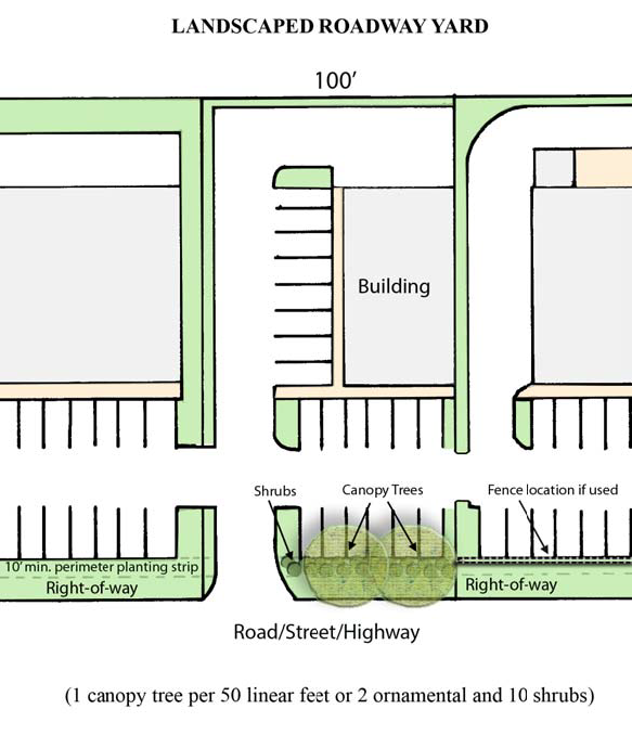
A landscaped roadway yard shall be provided to start five feet behind the right-of-way property line and be a minimum of ten feet wide, and contain the following:
(1)
Native shrubs shall be planted at a minimum rate of ten shrubs per 50 linear feet of street frontage (minus the driveway width). At least 75 percent of the required shrubs shall be native evergreen species.
(2)
Street trees shall be planted outside the right-of-way at a minimum rate of one large maturing (canopy) tree per 50 linear feet. Where overhead power lines exist, then a minimum of two small maturing (ornamental) trees per 50 linear feet may be installed.
ii.
Any chain-link or similar fencing visible from the street must be screened with a minimum of one shrub or ornamental tree (min. six feet tall) every ten feet.
B.
Airport Compatibility Overlay Zone (AC-O) - Lowcountry Regional Airport.
1.
Purpose. It is the intent of the AC-O district to protect the dual interests of the Lowcountry Regional Airport (LRA) and the neighboring land uses, and to:
a.
Protect and promote the general health, safety, and welfare of people using and living in the vicinity of the Lowcountry Regional Airport (LRA) environment;
b.
Prevent the impairment and promote the utility and safety of the airport, and protect the significant investment of local, state and federal dollars into the development of the airport;
c.
Promote land use compatibility between the airport and surrounding developments;
d.
Protect the character and stability of existing land uses; and
e.
Enhance environmental conditions in areas affected by the airport and its operations.
2.
Boundaries. The boundaries of an airport district shall be determined by application of the following zones around the Lowcountry Regional Airport (LRA). The surfaces and zones are based on the Code of Federal Regulations, Title 14, Part 77 (14 CFR Part 77), paragraph 77.19.
a.
Primary zone.
1.
The primary zone is longitudinally centered on a runway, extending 200 feet beyond each runway end. The elevation of any point on the primary surface is the same as the elevation of the nearest point on the runway centerline. The width of the primary zones at the LRA are:
(1)
Runway 5/23—1,000 feet.
(2)
Runway 17-35—500 feet.
(3)
Runway 9/27—500 feet.
b.
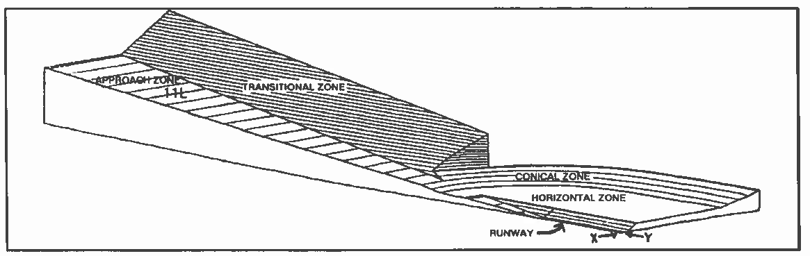
Approach zones.
i.
Approach zones include all land which lies directly under an imaginary runway approach surface longitudinally centered on the extended centerline of each runway. The inner edges of an approach surface are at the same width and elevation as the primary zone of each runway, unless otherwise specified.
ii.
The dimensions of an approach zone shall be determined on the basis of the following:
(1)
The runway protection zone is a trapezoidal shape located at the ends of each runway primary zone, and is identified as such on the LRA Layout Plan, which is not located herein due to lack of readability due to its large size, but it shall be made a part of this section as if included herein.
The dimensions of the runway protection zones for the LRA are: Runway 5—500 feet (inner width) x 1,700 feet (long) x 1,010 feet (outer width).
Runway 23—1,000 feet (inner width) x 1,700 feet (long) x 1,510 feet (outer width).
Runway 17—500 feet (inner width) x 1,700 feet (long) x 1,010 feet (outer width).
Runway 35—500 feet (inner width) x 1,700 feet (long) x 1,010 feet (outer width).
Runway 9—500 feet (inner width) x 1,000 feet (long) x 500 feet (outer width).
Runway 27—500 feet (inner width) x 1,000 feet (long) x 500 feet (outer width).
(2)
The runway approach zone is dependent upon the runway type, (i.e. the type of aircraft the runway is rated for) and the approach minimum the runway is rated for.
The dimensions of the runway approach zones at the LRA are: Runway 5—500 feet (inner width) x 10,000 feet (long) x 3,500 feet (outer width).
Runway 23—1,000 feet (inner width) x 50,000 feet (long) x 16,000 feet (outer width).
Runway 17—500 feet (inner width) x 10,000 feet (long) x 3,500 feet (outer width).
Runway 35—500 feet (inner width) x 10,000 feet (long) x 3,500 feet (outer width).
Runway 9—500 feet (inner width) x 5,000 feet (long) x 1,500 feet (outer width).
Runway 27—500 feet (inner width) x 5,000 feet (long) x 1,500 feet (outer width).
c.
Transitional zones.
i.
Transitional zones are the areas beneath the transitional surfaces. The transitional zone extends from the edge of the primary surface and extends to the horizontal zone. See subsection 4(b) for further descriptions of the transitional zone.
ii.
Transitional zone determination for heliports. These zones extend outward starting at 1.5 times the helipad surface to a horizontal distance of 4,000 feet at a slope of 8 to 1 measured from the approach and departure path centerline (see AC 150/5390 2c figure 2-7).
d.
Horizontal zones.
i.
The horizontal zone is established by an arc with a radius of 10,000 feet, measured out from the centerline end of all runways and connecting where each runway are intersects, all the way around the airport. The horizontal zone does not include the approach or the transitional zones.
e.
Conical zones.
i.
The conical zone is the area that extends outward from the outer limits of the horizontal zone for a horizontal distance of 4,000 feet.
Code of Federal Air Regulations (FAR) Part 77.19
3.
Prohibited uses in the airport zones. The following uses in subsections (a) and (b) below are prohibited in the airport zones, regardless of whether the base zoning district lists these uses as permitted:
a.
In all airport zones. Any use which would deleteriously:
i.
Create electrical interference with navigational signals or radio communications between the airport and aircraft;
ii.
Diminish the ability of pilots to easily distinguish between airport lights and other lights;
iii.
Create glare in the eyes of pilots using the airport;
iv.
Impair visibility in the vicinity of the airport;
v.
Create bird strike hazards, or otherwise endanger or interfere with the landing, takeoff, or maneuvering of aircraft using the airport.
b.
In the ultimate runway protection zone (See the Lowcountry Regional Airport Layout Plan).
i.
Single-family dwellings, including manufactured homes in excess of two units per acre;
ii.
Multi-family and cluster housing projects, manufactured home parks, and group housing; Transient lodging, motels and hotels;
iii.
Hospitals, sanatoriums, and nursing homes;
iv.
Schools and day care centers; and
v.
Churches, theaters, auditoriums, and similar places of assembly.
4.
Height restrictions. Except as otherwise provided herein, no structure or tree shall be located in any airport zone at a height in excess of the limits herein established for each of the following zones:
a.
Approach zones. Height limits within approach zones shall be determined by calculating a slope ratio (measured in feet outward and upward) from the elevation and end of each primary zone, as measured along the extended centerline of each runway, out to a prescribed horizontal distance and slope, as follows:
b.
Airport transitional zone. Height limits within transitional zones shall be determined by measuring outward and upward at a 7:1 slope from the sides and same elevation as the runway to the point of intersection with the horizontal zone or conical zone.
c.
Horizontal zone. Height limits in the horizontal zone are established at 150 feet above the airport elevation.
d.
Conical zone. Height limits in the conical zone are established by measuring out and up from the horizontal zone from an elevation of 150 feet above airport elevation at a 20:1 slope to a height of 350 feet above airport elevation.
5.
Noise restrictions.
a.
Noise restrictions shall apply within the approach zone of all instrument runways. Private airports shall be exempt from the provisions of this section.
b.
Where permitted in the approach zone, residential dwellings and portions of buildings which are open to the public shall be constructed to achieve an outdoor to indoor peak noise level reduction (NLR) of at least 30 decibels (db). Normal construction methods provide a NLR of 20 (db), so a reduction of only ten additional decibels is required, which can be achieved through sound insulating materials. All other permitted uses and structures are exempt from this section.
c.
A description of such methods and materials shall accompany all building applications for uses affected by this section, and shall be subject to approval by the director or his designee.
6.
Lighting regulations. No permitted use, subdivision, or development in an airport district shall have outdoor lighting or illumination arranged and/or operated in such a manner as to be misleading or pose a danger to aircraft operations, as determined by the airport manager.
7.
Regulations applicable to existing structures.
a.
Filing of the Federal Aviation Administration (FAA) Form #7460-1 - "Notice of Proposed Construction or Alteration" is required whenever a proposed structure is planned for development which breaks the plane of the 100 feet out to one foot up 100:1 slope ratio away from an airport, as required by the FAA. The FAA response to Form 7460-1 shall accompany all site and construction plans when submitting for a building permit application to the director.
b.
The owner of any existing structure or vegetation that is penetrating any referenced plane within an established airport district shall permit the installation, operation, and maintenance of whatever markers and lights deemed necessary by the FAA or the State Aeronautics Commission (SAC) to warn aircraft operators of the presence of an airport obstruction. These markers and lights shall be installed, operated, and maintained at the expense of the airport operator.
c.
However, the regulations prescribed in this section shall not be construed to require the removal, lowering, or other change or alteration of any existing structure or tree not conforming to these regulations when adopted, or otherwise interfere with the continuance of an existing use. Nothing contained herein shall require any change in the construction, or use of any structure, whose construction began prior to the adoption of these regulations. The exceptions above are subject to the following constraints:
i.
Any trees that were not conforming to these regulations when adopted, must be maintained at the same height at the time the exception was granted.
ii.
Existing buildings that were not conforming to these regulations when adopted, may remain as long as the building is utilized for the same purposes as at the time the exception was granted. The buildings may not be expanded, added to, or reconstructed in a manner that would increase the existing structures height beyond what existed when these regulations were adopted.
8.
Variances.
a.
Any person who determines that the strict application of the height restrictions imposed in the AC-O will cause them an undue hardship may apply for a variance from such regulations to the zoning board of appeals. The application for a variance shall be accompanied by an explanation of the hardship created where no other viable options exist for the development, along with a determination from the FAA as to the effect of the proposal on the operation of air navigation facilities and the safe, efficient use of navigable airspace.
b.
Additionally, no application for a variance may be considered by the board unless a copy of it is provided to the airport operator for advice as to the aeronautical effects of the variance. If the airport operator does not respond within 15 days after receipt, the board may act on its own to grant or deny the variance.
c.
Any permit or variance order granted, if such action is deemed advisable and reasonable, may contain conditions of approval, such as requiring the owner to install, operate, and maintain at the owner's expense, such markings and lights as may be deemed necessary by the FAA, the SAC, and the airport operator, or other such conditions deemed appropriate by the board.
C.
Solar Farm Floating Zone (SFFZ).
1.
Purpose: The intent of the solar farm floating zone (SFFZ) is to promote the use of solar energy as a source of electricity and facilitate the construction, installation, and operation of solar energy systems (SES) in Colleton County in a manner that promotes economic development and ensures the protection of health, safety, and welfare while also avoiding adverse impacts to important areas such as agricultural lands, endangered species habitats, conservation lands, and other sensitive lands. The SFFZ adds an extra layer of land use regulation over the underlying zoning which adds safeguards to ensure the proper development of facilities that generate electricity by means of solar power. This ordinance is not intended to supersede regulations from local, state, or federal agencies. Some important examples of such regulations include, but are not limited to: International Building Code, International Fire Code, National Electric Code, South Carolina Department of Health and Environmental Control, and Colleton County Flood Damage Prevention Ordinance.
2.
Applicability: A solar farm floating zone requires a zoning map amendment and requires a recommendation from the planning commission to county council in accordance with section 14.08-10 of the Colleton County Zoning Ordinance.
a.
The solar farm floating zone (SFFZ) may be utilized in any zoning district except for the resource conservation district, provided:
b.
The solar farm consists of a minimum of five acres;
c.
Any portion of the solar farm property boundary is within two miles of an existing electrical transmission line; and
d.
A conceptual plan which illustrates that the solar farm can meet the design and development standards set forth in article 14.08-2.150(C).
e.
Colleton County Council may require, at its sole discretion, a development agreement between the county and developers for properties developed as a SFFZ as a prerequisite to development plan approval.
Unless a deviation from such restrictions are provided elsewhere in this Article 14.082.150, property within the SFFZ shall be required to adhere to all provisions of the Colleton County Zoning Ordinance and Land Development Regulations otherwise applicable within the underlying zoning district, including all subdivision plats and development plan applications.
3.
Development standards:
a.
Unless otherwise addressed through private land covenants and agreements with adjacent property owners setting specific standards for setbacks, buffers, and fencing/landscaping requirements which are approved by Colleton County Council and recorded in the Colleton County Register of Deeds Office, the establishment and operation of a solar farm shall comply with the following design and development standards:
4.
Bufferyard:
*
Single family dwelling and all other residential use buffers may, at the council's discretion, be increased, or reduced with an approved berm and or landscaping and screening plan, which will screen the solar farm equipment from being seen from the exterior of the property.
*
Street buffer may, at the council's discretion, be reduced to 50 feet with an approved berm and or landscaping and screening plan, which will screen the solar farm equipment from being seen from the exterior of the property; see also section 14.08-2.150(c)(9)(i).
This buffer is separate and distinct from the buffering requirements of Colleton County Zoning Ordinance, article 14.08-4 and shall be measured from the property line. Only the following activities shall be permitted within the landscaped buffer:
a.
Vehicular access drives which tie into approved access points as determined by SCDOT and/or Colleton County;
b.
Landscaping and landscaping fixtures;
c.
Lighting;
d.
Fencing;
e.
Signage;
f.
Underground utility lines;
g.
Overhead utility lines;
h.
Drainage or stormwater detention or retention areas.
5.
Landscaping and Screening Requirements:
a.
In addition to buffering, screening shall be required by providing landscape within the buffer which achieves a minimum height of ten feet within three years. The intent is to provide sufficient screening, through a combination of buffers, fencing, landscaping, and/or landscaped berms to obscure the solar equipment from exterior view from adjoining property owners and public right of ways.
b.
A visually opaque screen shall be provided for any adjacent property that is zoned residential, has an existing residential use, and/or is zoned rural development and has been subdivided to five acres or less (these are protected properties). An opaque screen is intended to exclude a visual contact with the solar equipment from any protected property, public street or public right of way. An opaque screen may be composed of a wall, fence, building, landscaping, landscaped berm, or combination thereof. Natural areas as detailed below may also be used to meet screening requirements.
c.
Natural areas: An existing vegetated area located on the same property as the solar farm; is within or includes the required buffer; and is of sufficient height, length, and depth and contains adequate and sufficient healthy vegetation to provide a visually opaque screen where required. The director may determine that further screening improvements shall not be required.
6.
Setbacks:
a.
The setbacks for solar equipment associated with the solar energy system shall be 25 feet larger than the applicable bufferyard to allow for an access road around the perimeter of the property.
7.
Fencing:
a.
A security fence shall be required at least six feet in height to secure the solar equipment unless a taller fence is needed in order to obscure the solar equipment from exterior view (see also section 14.08-2.150(5)); the fence can be on top of the berm in order to achieve this goal. A chain link fence shall not be allowed unless it is screened from exterior view from adjoining property owners and public right of ways; screening may include plantings to create a "living fence," or to obscure the view of the fence. Breaks in fencing may be allowed or required by council to facilitate wildlife needs where natural features provide appropriate barriers to access by humans for security and safety purposes.
8.
Height:
a.
The solar energy system shall not exceed ten feet in height, as measured from the ground to the foremost/tip end of the solar collector, provided there is a demonstration that the screening prevents the system from being visible from the exterior of the property. Ancillary non solar collector structures, such as inverters, transformers, etc., may be taller than ten feet in height, provided that such are not visible from the exterior of the property.
9.
General requirements:
a.
Solar collectors shall be designed with anti-reflective coating to minimize glare. Mirrors are prohibited.
b.
On-site electrical interconnections and powerlines shall be installed underground to the extent feasible. Existing above ground utility lines shall be allowed to remain in their current location.
c.
A warning sign concerning voltage must be placed at the main gate that states the address of the site, the name of the solar farm operator, and a local phone number for the solar farm operator in the case of an emergency.
d.
Access to the site must be controlled by a six-foot wooden fence or gate if the fencing is visible from the exterior of the property. If the fencing/gate is within the interior 25 percent of the buffer, or is not visible from the exterior of the property, chain link gate and fencing may be used.
e.
Entrance roadway should include a dog leg or meander to obscure vision from the roadway.
f.
If lighting is provided at site, lighting shall be shielded and downcast such that the light does not spill onto the adjacent parcel or the night sky. Motion sensor control is preferred.
g.
Adequate provisions to reduce average/constant noise levels at the property boundary not to exceed 50 dBA at the property line, except during construction.
h.
A solar collection device or combination of devices are to be designed and located to avoid directing glare or reflection onto adjacent properties and adjacent roadways and shall not interfere with traffic or create a safety hazard.
i.
Planning commission may include special conditions in their recommendation to county council to implement the public health, safety, morals, convenience, order, appearance, prosperity, and general welfare set forth in Article 1 of the Colleton County Zoning Ordinance. County council may accept, modify, reject, or add additional conditions at its sole discretion.
10.
Site restoration/stabilization:
a.
Unless otherwise agreed by county council in its concept plan or development agreement approval process, the applicant shall submit a ten percent site restoration/stabilization guarantee in the form of a bond, irrevocable letter of credit and agreement, or other financial security acceptable to the county prior to issuance of the development permit. The site restoration/stabilization guarantee shall insure satisfactory grading, seeding, and stabilization of the site in case of default by the applicant and/or if the applicant does not install the required site improvements in a timely fashion as determined by the director, including the costs of landscaping, screening, and or fencing for the site or such portion thereof being permitted. The developer shall provide the county with an itemized engineer's estimate of the approved site improvements in conformity with article 1.8 of the Colleton County Land Development Regulations for approval and calculation of the bond amount. The site restoration guarantee may be refunded upon issuance of a certificate of project close-out for the site stabilization and improvements.
11.
Decommissioning:
a.
Unless otherwise agreed by county council in its concept plan or development agreement approval process, the applicant must provide a decommissioning plan signed by the party responsible for decommissioning and the landowner (if different) that describes the anticipated life of the solar farm, the estimated decommissioning costs in current dollars, the method for ensuring that funds will be available for decommissioning and restoration, and the anticipated timeline and manner in which the solar farm project will be decommissioned and the site restored to its condition prior to the development of the solar farm or such other conditions approved in the concept plan or required in a development agreement. If the property has been timbered within two years of re- zoning to the SFFZ, original condition means replanted with timber. Decommissioning will be required following a continuous period of 12 months in which no electricity is generated by the facility other than for mechanical, repair, replacement and/or maintenance purposes.
i.
The permit holder will have 12 months to complete decommissioning of the solar farm. Decommissioning shall include removal of solar panels, foundations, structures, cabling, electrical components, conduit, and any other associated facilities as described in the decommissioning plan.
ii.
Prior to issuance of development permit, the applicant must provide the county with a performance guarantee in the form of a bond, irrevocable letter of credit and agreement, or other financial security acceptable to the county in the amount of 125 percent of the estimated decommission cost minus the salvageable value, or $50,000.00, whichever is greater. Estimates shall be determined by an engineer licensed to practice in South Carolina.
iii.
Every five years a new engineer's estimate of probable cost of decommissioning shall be submitted for approval in the same manner as the initial submission, and the bond, letter of credit, or other financial security acceptable to the county shall be adjusted upward or downward as necessary.
iv.
Proof that the decommissioning plan has been recorded with the Colleton County Register of Deeds.
(Ord. No. 22-O-05, § 2, 5-3-2022; Ord. No. 23-O-01, § 2, 3-14-2023)