
Corte Madera City Zoning Code
CHAPTER 18
18 - SPECIAL PURPOSE OVERLAY DISTRICTS
18.18.005 - Purposes.
In addition to the objectives prescribed in Section 18.02.030, the special purpose overlay districts are established by this chapter to achieve the following purposes:
(1)
To ensure that development occurs in a manner that is consistent with applicable policies and proposals of the open space and conservation element of the general plan, including preservation of wetlands, unique marshland and related habitats, preservation of the natural appearance of the hills, ridgelines and other prominent scenic resources that comprise the town's visual setting, preservation of areas with high recreation resource value, preservation of areas containing significant archaeological sites and avoidance of areas that pose hazards to safety because of steepness of slope, erosion, fire potential and related constraints;
(2)
To ensure that development occurs in a manner that is consistent with applicable policies and proposals of the housing element of the general plan, including regulation of residential development in areas where potential hazards to life and property exist, maintenance of high standards of quality in the natural and man-made environment for all residential developments, promotion of diversity in the type and cost of housing, expansion of affordable housing opportunities, and promotion of equal opportunity for all citizens;
(3)
To ensure that development occurs in a manner that is consistent with applicable policies and proposals of the seismic safety element of the general plan, including avoidance of areas that pose hazards to safety because of slope instability, subsidence and seismic-induced failures resulting from liquefaction, accelerated compaction, shaking, ground rupture and tsunami;
(4)
To ensure that on hillside lands the intensity of development is consistent with the capacity of the land to sustain it, and is consistent with the level of services which reasonably can be provided by the town;
(5)
To establish for certain areas of the town a level of planning and development policy that is consistent with the general plan, but is sufficiently flexible to allow deviation from the standards and regulations of the underlying specific zoning district to encourage a more creative approach to land development that is highly responsive to the character of surrounding land uses, to encourage the most efficient and aesthetic use of the land within the constraints imposed by specific site conditions, to encourage desirable variety in the town's physical development pattern, and to encourage unique and innovative community design.
(Ord. 785 § 3(b) (part), 1994)
18.18.010 - Standards and requirements.
The following regulations are common to all special purpose overlay districts established by this chapter, and shall apply in all such districts:
(1)
Permitted and conditional uses shall be regulated by the underlying zoning district, except as otherwise provided in this chapter;
(2)
Standards for coverage, density, building heights, setbacks to properties not included in the project, off-street parking and loading, and signs shall be consistent with the regulations of the underlying zoning district, except as modified in the applicable overlay district or as shown on an approved preliminary or precise development plan;
(3)
Policies contained in the general plan shall be incorporated into the project design, established as conditions, and monitored through an appropriate mitigation monitoring plan. Such policies include but are not limited to those in the land use element, housing element, open space and conservation element, noise element and circulation element.
(Ord. 785 § 3(b) (part), 1994)
18.18.015 - Development review procedures.
(a)
The procedures for approval of developments within special purpose overlay districts are shown on chart in Section 18.18.020 included in this section, and are also described below;
(b)
For nonresidential projects containing less than two thousand four hundred ninety-nine square feet of gross floor area, for additions to existing structures that increase the floor area of the structure by less than two thousand five hundred square feet and by less than fifty percent of the area of the existing structure, and for construction of one single-family house on a site, design review approval pursuant to Chapter 18.30, Design Review, shall be required. However, if such an addition or house conflicts with a condition of an approved preliminary or precise development plan, then an amendment to the approved plan shall be required as specified in Sections 18.18.040 and 18.18.050;
(c)
For nonresidential projects containing two thousand five hundred to twenty-nine thousand nine hundred ninety-nine square feet of gross floor area and for residential projects containing two to nineteen dwelling units, approval of a preliminary plan and a precise plan by the planning commission shall be required prior to the issuance of any other development permit;
(d)
For nonresidential projects containing thirty thousand to ninety-nine thousand nine hundred ninety-nine square feet of gross floor area, and for residential projects containing twenty to forty-nine dwelling units, approval of a preliminary plan by the planning commission and town council, and approval of a precise plan by the planning commission, shall be required prior to the issuance of any other development permit;
(e)
For nonresidential projects containing one hundred thousand square feet or more of gross floor area and for residential projects containing fifty dwelling units or more, approval of a preliminary plan by the planning commission and town council, and approval of a precise plan by the planning commission and town council shall be required prior to the issuance of any other development permit;
(f)
All contiguous lands in common ownership shall be included in any application for preliminary development plan approval and in any application for design review approval, if no preliminary plan has been approved for the site;
(g)
Prior to approval of any other development permit, a preliminary development plan may be required for contiguous properties not in common ownership within any overlay district, if the planning commission makes any of the following findings:
(1)
A preliminary plan is required to implement the policies of the general plan,
(2)
Coordination of the development of the properties is essential to achieve a unified community design,
(3)
Coordination of the development of the properties is necessary to ensure that utilities and roads are appropriately located to serve all properties;
(h)
For amendments to a preliminary plan involving a change in use, density or intensity of two thousand five hundred square feet of gross floor area or less, approval of the amendment by the planning commission pursuant to Section 18.18.040 shall be required prior to issuance of any other development permit;
(i)
For amendments to a precise plan involving a change in use, density, or intensity of two thousand five hundred square feet of gross floor area or less, approval of the amendment by the planning commission shall be required prior to issuance of any other development permit.
(j)
All other amendments to approved preliminary and precise plans shall be treated as a new application for preliminary or precise plan approval and reviewed based on the size of the project as specified in Section 18.18.020;
(k)
Precise plan approval as specified by this chapter shall be carried out concurrently with design review approval as required by provisions of the underlying zoning district.
(Ord. 785 § 3(b) (part), 1994)
18.18.020 - Review authority in special purpose overlay districts.
18.18.025 - Design review application.
The application for design review approval shall be filed with the planning department in the manner prescribed in Chapter 18.30, Design Review, and shall be accompanied by the required fee and all supporting materials consistent with that chapter or as required by the planning director. Any additional materials required by Section 18.18.400 et seq. shall be provided for applications in the Christmas Tree Hill overlay district.
(Ord. 785 § 3(b) (part), 1994)
18.18.030 - Design review approval.
The decision making body as specified in Section 18.18.020, after public notification and/or a public hearing held in accord with the provisions of this title, may approve, conditionally approve or deny the application based on the findings of Chapter 18.30, Design Review, and/or Chapter 18.18, Special Purpose Overlay Districts.
(Ord. 785 § 3(b) (part), 1994)
18.18.035 - Preliminary plan application.
The application for preliminary plan approval shall be filed with the planning department on the prescribed form and shall be accompanied by the required fee and all supporting materials listed on the form.
(1)
The proposed preliminary plan shall include drawings showing the topography of the land, the proposed buildings, streets, open spaces, lot design, areas to be dedicated or preserved for public use, and uses to be established in the various buildings and areas of the property; preliminary sketch elevations of all buildings other than single-family dwellings may be required when appropriate to explain more fully or to describe site usage.
(2)
A proposed policy statement shall be provided by either an applicant or the town (depending on whether the project is privately or town initiated), describing the uses to be allowed and the conditions, specific and general, that will apply to any development.
(Ord. 785 § 3(b) (part), 1994)
18.18.040 - Preliminary plan approval.
(a)
The decision making body, as specified in Section 18.18.015, after a public hearing held in accord with the provisions of this title, may approve or conditionally approve the preliminary plan provided that all of the following findings are made:
(1)
The proposed development, or a major phase thereof, can be substantially completed within a period of four years;
(2)
Each individual phase of development, as well as the total development, can exist as an independent unit capable of creating an environment of sustained desirability and stability, and the proposed uses will be harmonious with present uses in the vicinity;
(3)
The proposed density of development will not exceed the capacity of the land to sustain it, and traffic generated by the development will not exceed the capacity of the local street system, including intersections;
(4)
The project will continue the development pattern of any adjacent residential neighborhoods without abrupt change and will not significantly affect traffic patterns, views and land use in adjacent residential neighborhoods;
(5)
Existing or proposed utility services are adequate to serve the proposed development, and adequate fire protection can be provided;
(6)
The proposed development conforms with the purposes of the overlay district in which the site is located, and conforms to the general plan and to all provisions of this title.
(b)
If the preliminary plan must be reviewed by both the planning commission and town council, then a decision of the planning commission to approve or conditionally approve the preliminary plan is a recommendation to the town council. If the planning commission denies the project, its decision may be appealed to the town council as prescribed in Chapter 18.34, Appeals. The town council may approve, conditionally approve or deny the project.
(c)
Approval of the preliminary development plan shall be limited to the general acceptability of the land uses and densities proposed and their interrelationships, and shall not be construed as approval of the precise location of uses, configuration of parcels, or engineering feasibility.
(d)
If an amendment to an approved preliminary plan is requested by the applicant, the planning commission and town council may review and amend all previous conditions of approval.
(e)
Failure to file an application for precise plan approval within one year of the date of approval or conditional approval of the preliminary plan shall terminate all approvals related to that application; provided, that upon application for an extension filed not less than thirty days prior to the expiration date, the planning commission may grant an extension of one year, which extension may be renewed upon reapplication to the planning commission for a period not to exceed one additional year.
(Ord. 785 § 3(b) (part), 1994)
18.18.045 - Precise plan application.
The applicant shall file with the planning department an application for precise plan approval on the prescribed form and accompanied by the required supporting maps, documents and fee. The precise plan application shall also include all information required for design review approval. The application and the supporting maps and documents shall be reviewed by the planning department to determine if the application is complete and, if a preliminary plan has been approved for the site, to determine if the precise plan is in substantial conformity with the approved preliminary plan and any condition of approval thereof.
(Ord. 785 § 3(b) (part), 1994)
18.18.050 - Precise plan approval.
(a)
The planning commission or town council, as appropriate, after a public hearing held in accord with the provisions of this title, may approve or conditionally approve the precise plan provided all of the findings required by Chapter 18.30, Design Review, and the following finding are made: the precise development plan is in substantial conformance with the approved preliminary development plan.
(b)
If the precise plan must be reviewed by the town council, then a decision of the planning commission to approve the precise plan is a recommendation to the town council.
(c)
The precise plan application may be denied by the planning commission subject to the procedures prescribed in Chapter 18.34, Appeals, or it may be denied by the town council.
(d)
If an amendment to an approved precise plan is requested by the applicant, the planning commission and town council may review and amend all previous conditions of approval.
(e)
Approval or conditional approval of a precise plan shall lapse and become null and void two years following the date the approval or conditional approval was given unless, prior to the expiration date, construction of improvements has commenced. The approval or conditional approval may be extended by the planning director for an additional period of one year upon application filed prior to the expiration date and provided that no change in conditions or requirements has occurred; but an application involving any change shall be treated as a new application.
(Ord. 785 § 3(b) (part), 1994)
18.18.100 - Generally.
The hillside land capacity overlay district established by this chapter is intended to apply to hillside parcels with a potential for substantial additional development, with a slope of more than ten percent, and which comprise any part of the ridges, sideslopes or extensions of Corte Madera Ridge, Meadowsweet Ridge or Tiburon Peninsula Ridge. The specific parcels within the HLC hillside land capacity overlay district are designated "hillsides, ridgelands, and related habitat" on Figure 8, Open Space, of the general plan and are shown on the town zoning map.
(Ord. 785 § 3(b) (part), 1994)
18.18.105 - Development standards.
The following regulations shall apply to the site of any proposed development within the district:
(1)
A geologic investigation and report by a qualified engineering geologist may be required for any proposed development, and shall be required for any proposed development on a site containing significant areas with slopes of thirty percent or more, and/or any site designated as "3" or "4" in the map entitled "Interpretation of the Relative Stability of Upland Slopes in the Tiburon Peninsula, Sausalito, and Adjacent Areas, Marin County, California, 1976," prepared by the California Division of Mines and Geology, which map forms the basis of Figure 11, Relative Slope Stability, in the general plan.
In addition, the planning director may require that a geologic investigation and report be prepared for areas off the site that may cause a hazard on the site.
(2)
No portion of a site with a slope of thirty percent or more, and no portion of a site designated as "4" in the map entitled "Interpretation of the Slope Stability of Upland Slopes in the Tiburon Peninsula, Sausalito, and Adjacent Areas, Marin County, California, 1976," prepared by the California Division of Mines and Geology, shall be proposed for development except as the boundaries of these areas may be refined on the basis of an engineering geologic investigation and report prepared by a qualified engineering geologist. The report shall identify those areas where unstable slopes and other geologic hazards can be eliminated with minor modification of the existing land form and vegetation, areas for which elimination of the hazard would result in major modification of the existing land form, removal of, or potential damage to, established natural vegetation, or exposure of slopes that cannot suitably be revegetated, and areas determined to be too hazardous for development.
(3)
Development shall preserve the natural qualities of sloping terrain rather than shaping a site for the purpose of facilitating development or increasing development intensity.
(4)
The density established on the general plan diagram for a parcel of land may be reduced if slope stability evaluation indicates a geologic or slope stability hazard; provided, that in no case shall a parcel be deemed undevelopable if it can meet health and safety standards.
(5)
No building shall be located directly on a visible ridge unless the planning commission finds that there is no other location on the site which can accommodate a building consistent with all other regulations and constraints applicable to the zone(s) in which the site is located. Any portion of any development proposed to be located within fifty vertical feet of the ridgeline as defined in Chapter 18.04, Definitions, points of elevation fifty feet below and on both sides of the ridgeline, or proposed to be located in any area identified within the scenic resources overlay district as shown on Figure 8, Open Space, in the general plan, shall be evaluated on the basis of a visual analysis prepared by an architect, landscape architect or other qualified professional. This analysis shall include view sections from areas within the town designated by the planning director and shall be subject to the special site plan and design guidelines prescribed by Chapter 18.30, Design Review.
The visual analysis shall consider the type and extent of natural vegetation and tree cover on the site and shall contain recommendations on: the limits to which the vegetation and tree cover can be removed without significant adverse visual impact; the most effective method of revegetation where a slope is cleared in preparing the site for development; and the treatment of building sites on hill slopes devoid of natural tree cover.
Dedication of ridgetop land and/or the provision of a trail segment through a portion of the site may be required as a condition of approval of a preliminary development plan or a precise development plan.
(6)
For proposed development within an area designated "high or moderately high fire hazard" by the safety element of the general plan, a study and report by a registered civil engineer and qualified biologist shall be required. The biologist's report shall include a classification of the site or portions of the site by degree of risk related to possible damage to structures from wildland fires in the existing plant communities and shall contain specific recommendations for preventing damage to structures from wildland fires. The civil engineer's report shall evaluate the adequacy of the water supply on the site for fire fighting purposes and shall contain specific recommendations for ensuring that all new development provides a water supply for firefighting meeting the standards of the town's fire chief.
(Ord. 785 § 3(b) (part), 1994)
18.18.110 - Permitted density of development.
The maximum number of units that may be permitted on a site shall be determined in the following manner:
(1)
All measurements shall be in square feet or, if in acres, to the nearest tenth of an acre, as most appropriate to the size of the site.
(2)
The total area of all portions of the site designated as "4" on the map entitled "Interpretation of the Slope Stability of Upland Slopes in the Tiburon Peninsula, Sausalito, and Adjacent Areas, Marin County, California 1976," prepared by the California Division of Mines and Geology, shall be calculated, and no credit shall be given for these areas except as provided below. For purposes of the preliminary development plan, the boundaries of these areas may be transferred from available maps. Adjustments of the boundaries may be made at a later stage in the review process on the basis of more precise data available from an engineering geologic soil report.
Where the engineering geologic soil report indicates that an identified hazardous condition can be eliminated with only minor modification of the existing land form and vegetation, the area may be considered eligible for purposes of the calculations prescribed in subsection (3) of this section; however, if the report reveals the presence of a hazardous condition that cannot be eliminated with only minor modification of existing land form and vegetation, such area shall not be considered eligible for purposes of the calculations.
(3)
The maximum number of units that may be permitted in a proposed development shall be determined by multiplying the area of land in each slope category by the capacity factor shown in the following schedule (Section 18.18.115), adding the products of these calculations converted to square feet, and dividing this figure by the required site area per unit in square feet prescribed in the underlying zoning district.
(4)
Parcels which fall entirely within the slopes of thirty percent or greater category, or entirely within the designation of "4" on Figure 11, Slope Stability, in the general plan shall be permitted to develop one single-family dwelling subject to the adequate provision of water, sewage disposal, access and geologic stability.
(Ord. 785 § 3(b) (part), 1994)
18.18.115 - Land capacity schedule—HLC overlay district.
* Required site area = 4,000 square feet per unit (8,000 square feet per site) in the R-2 district; 7,500 square feet in the R-1 district; 20,000 square feet in the R-1-A district; one acre in the R-1-B district; and five acres in the R-1-C district.
(Ord. 785 § 3(b) (part), 1994)
18.18.120 - Findings for approval of development.
Prior to the approval of any development within the HLC overlay district, the following findings shall be made:
(1)
The project mitigates any identified geologic or seismic hazard concerns;
(2)
No building is located within fifty feet of a ridge (provided, that there is another location on the site which can accommodate a building consistent with other regulations and constraints applicable to the district in which the site is located);
(3)
The visual impact of any development has been mitigated, including but not limited to retention of existing vegetation where possible and revegetation as directed;
(4)
The development incorporates adequate mitigation for fire protection as determined by the town's fire chief.
(Ord. 785 § 3(b) (part), 1994)
18.18.200 - Generally.
The baylands risk zone and natural habitat overlay district established by this chapter is intended to apply to lands which have a potential for substantial additional development, have less than ten percent slope, and are underlain by bay mud as defined in the map entitled, "Interpretation of the Relative Stability of Upland Slopes in the Tiburon Peninsula, Sausalito, and Adjacent Areas, Marin County, California, 1976," prepared by the California Division of Mines and Geology. The specific area within the BRNH baylands risk zone and natural habitat overlay district is designated "wetlands, unique marshland, and related habitat" and "waterbodies/waterways and related habitat" on Figure 2, General Plan Diagram, of the general plan, and is shown on the town zoning map.
(Ord. 785 § 3(b) (part), 1994)
18.18.205 - Development standards.
The following development standards shall apply to the site of any proposed development within the district.
(1)
A comprehensive geologic and soil investigation and report, prepared by a qualified engineering geologist, shall be required for any proposed development on a site underlain by bay mud or on a site which in its present form was created by man-made fill, as shown on the above-referenced maps. The report shall include a classification of the site or portions of the site by degree of risk related to possible damage to structures and improvements, including underground utilities, damage resulting from subsidence, differential settlement, seismic event, or other failure, taking into account all pertinent factors, including but not limited to the following:
(A)
Depth of bedrock;
(B)
Thickness of bay mud underlying the site;
(C)
Characteristics and thickness of layers and/or lenses of sand or shell deposits that may be present in the bay mud;
(D)
Thickness, age and type of fill that created the site or portion of the site, including an estimate of the amount of final settlement yet to occur;
(E)
An estimate of the probable effects of a major earthquake, including liquefaction, subsidence or differential settlement and fill failure caused by accelerated compaction, lateral flow of the mud beneath the fill, or other possible effects;
(F)
Areas likely to be inundated by a tsunami.
Based on the risk zone or zones so identified, the report shall contain specific recommendations with respect to portions of the site within which the risk is too great to permit any type of development involving a habitable structure, if any; types of uses and structures that would be appropriate considering the degree of risk; fill techniques that should be employed to minimize the possibility of failure; special engineering standards and requirements for utility installations, including emergency shutoff or bypass valve systems; special foundations and structural standards that should be employed for structures and other improvements; and any other safety standards that should be incorporated into the design of the proposed development.
Where authorized by the town engineer, the report may be prepared in two parts: the first containing a description and identification of problems associated with the site, including an analysis of the severity of the problems, to be submitted with the preliminary plan; and the second containing all of the required details and recommendations, to be submitted with the precise plan.
(2)
For a proposed development on a site designated as "unique marshland habitat" by the general plan, a study and report by a qualified environmental biologist or other specialist in the field shall be required. The report shall classify and document the site in terms of its unique, intrinsic value as wildlife habitat, and where there are differences in the value or sensitivity of portions of the site, shall rate them in order of lowest to highest wildlife resource value. Based on these classifications and ratings, the report shall contain specific recommendations on portions of the site that should not be disturbed in any manner, portions of the site that can sustain limited modification without major loss of resource value, and portions of the site best suited to development.
Within the areas found to be suitable for development, the report shall contain recommendations on the design and spacing of structures and improvements including buildings, roads, parking areas, fences or walls, utilities and landscaping that would provide the greatest amount of protection for the habitat, would be least disruptive to natural processes essential to its preservation, would result in minimum alteration of the natural setting, and would provide visual and/or public access to shoreline areas.
(3)
For a proposed development on a site designated as being within the area of "special flood hazard" by the flood insurance rate map of the U. S. Department of Housing and Urban Development, a study and report by a registered civil engineer shall be required. The report shall include a classification of the site, or portions of the site, by degree of risk related to possible damage to structures and improvements resulting from flooding and shall contain specific recommendations for preventing flood damage to structures and improvements.
Where authorized by the town engineer, the report may be prepared in two parts, the first containing a description of the problems associated with the site and a general description of the solutions, to be submitted with the preliminary plan, and the second containing all of the required details and recommendations, to be submitted with the precise plan.
(Ord. 785 § 3(b) (part), 1994)
18.18.210 - Permitted density of development.
Except for additional units that may be permitted in accord with Section 18.08.040, the maximum number of dwelling units that may be permitted on the site shall be determined in the following manner:
(1)
If adjacent to a natural waterway or tidal zone, the area of all portions of the site below 3.5 feet National Geodetic Vertical Datum shall not be counted;
(2)
After subtracting the total area prescribed in subsection (1) of this section from the area of the lot, the maximum number of units that may be permitted in the proposed development shall be determined by multiplying the area of land in each elevation category by the capacity factor shown in the following schedule (Section 18.18.215), adding the products of these calculations, and dividing this figure by the required site area per unit in square feet prescribed by the underlying zoning district.
(Ord. 785 § 3(b) (part), 1994)
18.18.215 - Land capacity schedule—BRNH overlay zone.
* Required site area = 4,000 square feet in the R-2 district; 7,500 square feet in the R-1 district; 20,000 square feet in the R-1-A district; one acre in the R-1-B district; and five acres in the R-1-C district.(Ord. 785 § 3(b) (part), 1994)
(Ord. No. 910, § 28, 4-21-2009)
18.18.220 - Findings for approval of development.
Prior to approval of any development in the BRNH overlay district, the following findings shall be made:
(1)
The project protects and preserves saltwater and freshwater wetlands and related habitats, and protects and preserves the water quality of wetlands;
(2)
The project provides an acceptable level of risk related to possible damage to structures and improvements, including underground utilities, resulting from subsidence, differential settlement, seismic event or other failure and flood hazard.
(Ord. 785 § 3(b) (part), 1994)
18.18.300 - Generally.
The planned development overlay district established by this chapter is intended to apply to undeveloped lands with the potential for substantial additional development not otherwise classified in the HLC hillside land capacity overlay district or the BRNH baylands risk zone and natural habitat overlay district. The area within which the P-D planned development overlay district may be applied is shown on the town zoning map.
(Ord. 785 § 3(b) (part), 1994)
18.18.305 - Purpose.
The purpose of the P-D planned development overlay district is to provide locations for well-planned developments that conform with the general plan, although the developments vary in certain aspects from the regulations of the zoning district with which it is combined. The planned development provisions are intended to allow freedom of design to obtain developments which will be an asset to the town by equalling or surpassing the quality required by the regulations of the district with which the planned development overlay district is combined. The objectives of the planned development overlay district are to achieve one or more of the following purposes:
(1)
To permit the development or enlargement of commercial districts in close proximity to residential areas, which protect the character and quality of the adjacent residential uses, and to permit appropriate and limited commercial uses within planned residential projects;
(2)
To permit clusters of multiple-unit residential developments in appropriate locations within single-family residential zones, with appropriate conditions imposed to protect surrounding areas;
(3)
To protect the appearance and character of areas of public interest or high visibility such as civic centers, public buildings and grounds, parks, monument areas, and features (natural or man-made) of local or historical significance;
(4)
To permit flexibility in the design and use of an individually owned property or a group of separately owned properties to allow for economy, convenience and amenity in development, provided conditions are met which are required by the planning commission, town council and this title.
(Ord. 785 § 3(b) (part), 1994)
18.18.310 - Application of district.
The P-D planned development overlay district shall be applied as shown on the town zoning map. Applications to rezone lands to the P-D overlay district shall be accompanied by a preliminary plan consistent with Section 18.18.035, except that where the P-D overlay district is initiated by the town council or the planning commission, the application may be accompanied only by a proposed policy statement describing the uses to be allowed and the conditions, general or specific, that are to apply to any development. In the event that a P-D overlay district, so initiated, is established with the approval of a policy statement only, all uses within the district shall require a conditional use permit, approved by the planning commission after a duly noticed public hearing.
(Ord. 785 § 3(b) (part), 1994)
18.18.315 - Development standards.
In considering a proposed preliminary plan and policy statement, the planning commission and the town council, in accordance with the purposes of this chapter, may require higher standards or allow different standards for the P-D overlay district than are required for the district with which it is combined with respect to building location, density, uses, heights, parking, traffic circulation, landscaping, lot sizes, and other standards and requirements provided such modified standards, requirements and regulations are adopted as part of the preliminary plan and policy statement, and are in conformance with the general plan.
(Ord. 785 § 3(b) (part), 1994)
18.18.320 - Maximum density of development.
(a)
Except for additional units that may be permitted in accord with Section 18.08.040, the maximum number of dwelling units that may be permitted on the site shall be determined by dividing the site area by the required site area per unit prescribed in the underlying zoning district.
(b)
The computation of the maximum number of units is intended solely to set up an absolute maximum. A lesser number of units may prove to be the maximum permitted based upon environmental constraints or compliance with other P-D planned development requirements.
(c)
No absolute minimum lot widths and depths are specified.
(d)
Buildable area is defined in Section 18.04.085.
(Ord. 785 § 3(b) (part), 1994)
18.18.325 - Zone change approval.
Adoption of the ordinance rezoning property to the P-D overlay district shall include approval of, at a minimum, preliminary plan and policy statement, except as provided in Section 18.18.310. Any planned development overlay district shall be subject to all conditions imposed by the ordinance establishing the district and shall be exempted from other provisions of this code only to the extent specified in such ordinance or the approved development plan and policy statement. Requests to modify, change or revise any approved development plan or policy statement shall be processed in the same manner as any other change of zone application, and shall be considered against the original development plan and policy statement and the conditions retained at the time the modification is requested, except that minor modifications which do not increase the approved density or change the approved uses may be allowed by design review approval.
(Ord. 785 § 3(b) (part), 1994)
18.18.330 - Status of approved plan for planned development.
The approved development plan and policy statement for a P-D overlay district shall govern all development of the property within the district. If approval is granted for subsequent division of property within a planned development district, the approved development plan and policy statement shall govern the development on each parcel created by the division.
(Ord. 785 § 3(b) (part), 1994)
18.18.335 - Subdivision of planned development.
The planning commission and town council may approve the division of a planned unit development into lots or into condominium ownership, subject to the finding that adequate provisions are provided to ensure the perpetual maintenance of all areas and improvements proposed to be owned in common, or to be maintained in common, and to ensure that additional development will conform with the approved development plan and policy statement.
(Ord. 785 § 3(b) (part), 1994)
18.18.340 - Design review approval.
Notwithstanding Section 18.18.015, all structures, buildings, or other improvements in a P-D overlay district shall obtain design review approval before building permits are issued, whether or not a precise plan is needed. In addition to criteria established in Chapter 18.30, Design Review, the planning commission shall evaluate the planned development design review application based on the following criteria:
(1)
In general, the project shall be designed to fit the existing topography; the site shall not be significantly graded to accommodate the project;
(2)
The proposed density does not exceed the maximum allowed density;
(3)
Final contours and slopes shall generally reflect existing landforms; in particular, building pads and terraces interspersed with slopes shall not be created, and ridgelines, knolls and significant tree masses shall be preserved;
(4)
The proposed development seeks to avoid significantly intruding into the views, privacy, and sunlight of adjoining residences;
(5)
Views from public open space areas, rights-of-way, and other public places and of major public open space areas are not significantly affected;
(6)
Wide pads or level areas are not created to accommodate roads. Roads should be fit into the existing topography; one-way roads may be preferred over two-way roads to reduce grading, and on-street parking should be parallel to the road, not perpendicular;
(7)
Buildings, parking, carports and landscaping shall be arranged so that view corridors from downslope lots are created.
(Ord. 785 § 3(b) (part), 1994)
18.18.345 - Findings for the adoption of a planned development overlay district.
Rezoning to the P-D overlay district shall be permitted subject to the following findings:
The project as set forth in the preliminary development plan has utilized the freedom of design permitted by the P-D district to obtain a development in conformance with the general plan and of superior quality and which is:
(1)
Compatible in appearance, character and scale with surrounding developments;
(2)
Environmentally sensitive;
(3)
Suitable in mass, bulk, and proportions for its use, the size of parcel(s), and the environmental qualities;
(4)
Achieves variety and interest of design and materials.
(Ord. 785 § 3(b) (part), 1994)
18.18.400 - Generally.
The purpose of the CTH Christmas Tree Hill overlay district is to implement the Christmas Tree Hill community plan and provide for infill development and reconstruction of existing development in a manner that preserves the neighborhood character, the environmental and scenic qualities of the area, and protects the health and safety of persons and property on the Hill.
Consistent with Section 18.18.010 (1) of this chapter, permitted densities, uses and development standards shall be regulated by the underlying zoning district.
The specific standards and regulations provided herein address the unique development conditions on Christmas Tree Hill:
(1)
The roads on Christmas Tree Hill are steep, narrow and winding;
(2)
There are many small developed lots with severely limited off-street parking;
(3)
Christmas Tree Hill is heavily vegetated and developed with numerous older, wooden structures resulting in high fuel loading and severe fire hazard;
(4)
The road configuration and proliferation of on-street parking limit emergency access to all Christmas Tree Hill residents and property, as well as evacuation of residents in the event of fire, natural disaster, or other emergency;
(5)
Infrastructure facilities, including drainage and roads, are limited in their ability to accommodate additional development, including, but not limited to, residential expansions, new residential units and additional dwelling units;
(6)
Retention of the single-family residential character is important to the residents of the Christmas Tree Hill community;
(7)
A variety of physical, economic, and social living environments is desirable to the Christmas Tree Hill community.
This district has been created for Christmas Tree Hill, consistent with the goals and policies of the Christmas Tree Hill community plan, and shall be applied as shown on the town zoning map.
(Ord. 785 § 3(b) (part), 1994)
18.18.405 - Development standards.
The following regulations shall apply to any proposed development within the district.
(1)
Definitions. The following definitions supersede or augment those found in Chapter 18.04, Definitions, of this title.
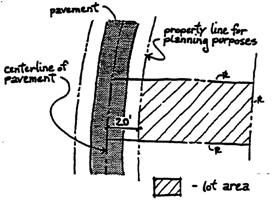
Frontage or Front Property Line. In the area of the Corte Madera Woods Subdivision, for planning purposes only, the frontage or front property line, or any property line adjacent to an existing paved roadway, shall be determined to be located twenty feet from the centerline of the existing roadway, regardless of extent of pavement.
Lot Size. For planning purposes only, lot size shall be calculated from the recorded subdivision maps. For lots created by the 1912 amended map of Corte Madera Woods, any roadway shown on the subdivision map which is included within the lot shall be subtracted from the total square footage to determine the lot area. Trails or trail easements are not deleted from calculation of lot area.
Figure 15
CHRISTMAS TREE HILL FRONT PROPERTY LINE AND LOT AREA
(2)
General Development Principles and Standards.
(A)
The location, orientation and design of building sites, fences and other structures, and streets and other circulation elements, shall maintain and preserve natural topography, vegetative cover, and significant landmarks and trees.
(B)
New construction and reconstruction shall minimize impact on surrounding properties and shall be in harmony with the cottage character of Christmas Tree Hill.
(C)
Building mass shall be in proportion to the lot size and shall maintain a feeling of open space on the lot. New construction shall be located on the least environmentally damaging and visually disruptive portions of the site.
(D)
Where health and safety conditions permit, exceptions to town street standards may be made to accomplish the purposes of this chapter.
(3)
Specific Development Standards.
(A)
Design review approval is prescribed for applicable projects in accordance with Chapter 18.30, the design review findings of this chapter, and the design review guidelines adopted by town council Resolution No. 2769 for Christmas Tree Hill.
(B)
Lot size shall be calculated as described above and in Chapter 18.04, Definitions. These calculations shall be used in the determination of subdivision potential and the establishment of building coverage.
(C)
Location of any property line adjacent to any existing roadway shall be determined as described above and in Chapter 18.04, Definitions, and shall be used in the determination of encroachments and the establishment of setbacks for structures.
(D)
Where the property line abuts an existing roadway, setbacks for yards shall be flexible, and shall be determined through the design review process based on specific site characteristics such as: slope stability, retention of existing vegetation, minimization of disruption to the site and surrounding area, privacy, view and sunlight for the subject parcel and neighboring parcels, maintenance of existing neighborhood character and scale, roadway line of sight, and visual and/or physical intrusion on the roadway. Unless specifically dictated by the above standards, side and rear yard setbacks shall be established by the underlying district (see R-1-A and R-1 zoning districts for side and rear yard setbacks).
(E)
The maximum height for structures is thirty feet, but may be reduced through the design review process.
(F)
A detailed site plan, as required in the design review application shall show the area and dimensions of the building envelope, building setbacks, and permissible coverage of lot by structures, shall be established upon design review approval as described in Section 18.30.070 of this title. The location of any new exterior construction shall be reviewed to determine the least environmentally damaging and visually disruptive placement.
(G)
A minimum of two off-street parking spaces per primary dwelling unit shall be provided, the location and design of which shall be determined in accordance with the principles and standards of Chapter 18.20, Off-Street Parking and Loading. Off-street parking requirements for all other uses within the district and standards for street parking facilities shall be as provided in Chapter 18.20, Off-Street Parking and Loading.
Where feasible, an apron for two tandem parking spaces shall be provided in addition to the required spaces. Notwithstanding Chapter 18.20, Off-Street Parking and Loading, size and dimension of individual parking spaces shall be determined on a site-specific basis, and all spaces may be uncovered. For purposes of health and safety, parking structures should be sited far enough from the travel lanes to permit a clear view of oncoming traffic.
(H)
Structures now located in the area on the roadside of the property line are deemed nonconforming, and their replacement, repair and maintenance shall be governed by Chapter 18.32, Nonconforming Uses, Structures, and Sites. Notwithstanding Section 18.32.070, where a nonconforming structure is voluntarily demolished to any extent, or required by law to be demolished to any extent, the planning commission may permit the rebuilding of the structure in the original footprint if the following findings are made:
(i)
The nonconforming location is the most appropriate location for the structure based on its use;
(ii)
The location of the structure within the original footprint does not create a hazard to public health or safety.
(I)
Encroachments into the public right-of-way as defined in this section and in Chapter 18.04, Definitions, shall be reviewed by the planning commission. A minimum setback of eighteen inches shall be required from the shoulder of the roadway for fences, walls and hedges except as allowed on a case-by-case basis for replacement structures.
(J)
Consistent with the recognition of the unique physical constraints on Christmas Tree Hill that create public safety concerns, as described in Sections 18.18.400 (1)—(4), this section seeks to limit and distribute accessory dwelling units and junior accessory dwelling units on the Hill, acknowledging that, if overdeveloped, accessory dwelling units and junior accessory dwelling units will jeopardize the health and safety of persons residing in the area. "Overloading the capacity of the neighborhood" is defined as the number of accessory dwelling units and junior accessory dwelling units exceeding ten percent of the total number of primary residential units existing in the area on August 2, 1994. Christmas Tree Hill has been divided into capacity districts. In each capacity district, the percentages of the total allowable accessory dwelling units and junior accessory dwelling units are as follows:
Example: With two hundred fifty dwelling units on Christmas Tree Hill, a total of twenty-five accessory dwelling units/junior accessory dwelling units are permitted within the capacity districts. Capacity District 4, with eight percent of the total dwelling units, is allowed two accessory dwelling units, two junior accessory dwelling units, or one of each.
(Ord. 785 § 3(b) (part), 1994)
(Ord. No. 992, § 6, 1-21-2020; Ord. No. 993, § 5, 5-19-2020; Ord. No. 1038, § 18, 7-16-2024)
18.18.410 - Additional dwelling units.
(a)
In recognition of the approximate pattern of town-approved accessory dwelling units to date, to minimize public safety impacts of accessory dwelling units and junior accessory dwelling units in any particular area given the unique characteristics of Christmas Tree Hill set forth in sections 18.18.400 (1)—(4), and to provide for an even, equitable distribution of these accessory dwelling units and junior accessory dwelling units, capacity districts have been delineated as shown on the Christmas Tree Hill capacity map (see Figure 16).
(b)
Accessory dwelling units and junior accessory dwelling units on parcels greater than twenty thousand square feet in size shall not be considered overloading the capacity of the neighborhood, and therefore shall not be included in calculating the maximum allowable number of accessory dwelling units and junior accessory dwelling units.
(c)
The allowed maximum total number of accessory dwelling units and junior accessory dwelling units shall include existing legal accessory dwelling units and junior accessory dwelling units and future accessory dwelling units and junior accessory dwelling units, except those excluded above. If a capacity district already contains more than its allotted number, by virtue of the existence of legal conforming and legal nonconforming accessory dwelling units and junior accessory dwelling units, these units shall not be rendered illegal by the provisions of this section.
(Ord. 785 § 3(b) (part), 1994)
(Ord. No. 992, § 6, 1-21-2020; Ord. No. 993, § 5, 5-19-2020; Ord. No. 1038, § 10, 7-16-2024)
18.18.415 - Figure 16 Christmas Tree Hill capacity district map.
(Ord. 785 § 3(b) (part), 1994)
18.18.420 - Design review findings.
In addition to the findings required in Section 18.30, Design Review, the following specific findings shall be made to grant design review approval in the CTH overlay district:
(1)
The grading plan is designed to retain the natural and existing features of the land; cuts and fills are minimized; and all graded areas are rounded and contoured to blend with the existing topography. Drainage swales, slopes, vistas and other natural features are retained to the maximum degree feasible, and all slopes are planted or otherwise protected from erosion, including benching or terracing where appropriate;
(2)
Building site locations and access to building sites are selected to reduce visibility of the development from the remainder of the community and structures and landscaping retain the natural features of the site and the character of Christmas Tree Hill as it is viewed from public roads on the Hill and distant views from off the Hill;
(3)
Yard setbacks have been determined based on specific site characteristics, line of sight from roadway, and relationships to adjoining properties;
(4)
All proposed structures in the public right-of-way conform to the design guidelines of this district and the standards for nonconforming structures in this chapter, and do not restrict safe vehicular and pedestrian circulation;
(5)
The proposed development and its use is in conformance with the adopted Christmas Tree Hill community plan and Christmas Tree Hill design review guidelines.
(Ord. 785 § 3(b) (part), 1994)
(Ord. No. 1038, § 18, 7-16-2024)
18.18.425 - Review procedures.
(a)
Public notice for all applications shall be given as prescribed in Chapter 18.36, Administration, except as follows:
If the application includes a request for a new house, new driveway, change in off-street parking, subdivision, lot line adjustment, notice of merger, certificate of compliance or conditional certificate of compliance, then public notice shall be mailed to all persons shown on the latest equalized assessment roll of the county as owning property within the Christmas Tree Hill area.
In addition, applications shall be noticed by mail to all interested community groups on file with the planning department.
(b)
Design review procedures shall be as prescribed in Chapter 18.30, Design Review.
(Ord. 785 § 3(b) (part), 1994)
(Ord. No. 1038, § 18, 7-16-2024)
18.18.500 - Generally.
The historical preservation overlay district established by this chapter is intended to provide for the review, evaluation, enhancement, protection and preservation of natural phenomena, sites and areas that possess unique character, special architectural appearance, or are reminders of people, events or eras that form an important link to Corte Madera's past.
The quality of life in the community will be enhanced by the stabilization of neighborhoods and will be culturally and educationally enriched by encouraging the study and the enjoyment of the town's heritage.
(Ord. 785 § 3(b) (part), 1994)
18.18.505 - Applicability.
The historic preservation overlay district shall be applied to areas or specific sites or structures which individually or collectively are historic resources.
(1)
"Historic resource" means structures, sites and areas which have one or more of the following characteristics:
(A)
A period, culture, event or person important in local, state or national history;
(B)
A unique or irreplaceable asset to the town neighborhood, which asset enriches human life and/or serves an educational benefit by providing future generations examples of the physical surroundings of the past;
(C)
The area's unique location or physical characteristics represent an established and familiar visual feature of a neighborhood;
(D)
An example essential to maintaining the overall historic character of a larger area;
(E)
A structure having architectural significance. A structure determined to have architectural significance shall be one which is valuable as an example of:
(i)
Architectural design that is attributable to an historic period,
(ii)
A commonly identified architectural style or method of construction,
(iii)
Architectural design that is unusual, beautiful, or ingenious,
(iv)
A notable work of a major builder or designer,
(v)
Unusual quality of workmanship,
(vi)
Unusual use of construction materials.
(2)
Properties, locations or structures having one or more of the characteristics described in Section 18.18.505 shall be zoned H-P historic preservation overlay district.
(Ord. 785 § 3(b) (part), 1994)
18.18.510 - Procedures for designating historic resources.
Historic resources may be designated by the town council through the zoning ordinance amendment procedures as prescribed in Chapter 18.36, Administration, and subject to the criteria set forth in Section 18.18.505.
(Ord. 785 § 3(b) (part), 1994)
18.18.515 - Development standards.
(a)
All applications for exterior work, demolition or sign permits proposed for properties zoned H-P historic preservation overlay district shall be subject to design review, and the following finding shall be made: the proposed work will not adversely affect the historic, architectural or aesthetic character of the structures, resource or neighborhood.
(b)
None of the provisions of this chapter shall prevent any reasonable measures of construction, alteration or demolition necessary to correct any condition which has been declared unsafe or dangerous by the town and where the proposed corrective measures have been declared necessary by the town.
(Ord. 785 § 3(b) (part), 1994)
18.18.520 - Maintenance of structures and premises.
All property owners in H-P districts shall maintain structures and premises in good repair. Structures and premises in good repair shall present no material variance in apparent condition from surrounding structures in compliance with the provisions of this chapter. "Good repair" includes, and is defined as, the level of maintenance that ensures the continued availability of the structure and premises for a lawfully permitted use, and prevents deterioration, dilapidation and decay of the exterior portions of the structure and premises. Building permit fees for such maintenance and repair shall be waived. Ordinary maintenance that does not affect the criteria established by this chapter shall be exempt from the requirements of this chapter.
(Ord. 785 § 3(b) (part), 1994)
18.18.600 - Generally.
The AHO, affordable housing optional overlay district established by this chapter is primarily intended to provide for affordable housing opportunities in the Old Corte Madera Square area. This overlay district secondarily encourages preservation of historic and architectural resources and a mix of housing types and uses in order to provide for a more interesting and diverse community. This overlay district serves to implement the housing element goal of providing new housing and addressing affordable housing needs.
(Ord. 880 § 5 (part), 2003)
18.18.605 - Uses.
The following uses are allowed in the AHO, Affordable Housing Optional Overlay District:
(a)
Permitted and conditional uses shall include those allowed by Section 18.08.020 for the R-2 low-density multiple-dwelling district and those allowed by the underlying zoning district.
(Ord. 880 § 5 (part), 2003)
18.18.610 - Development standards.
The development standards in the AHO, affordable housing optional overlay district shall be the same as for the underlying zoning district except as shown in Table 18.610-1. The AHO development standards shall apply to all properties that meet the affordable housing requirement described in Section 18.18.620.
TABLE 18.610-1
DEVELOPMENT STANDARDS
Note 1: Density subject to the provisions of Section 18.18.620.
(Ord. 880 § 5 (part), 2003)
18.18.615 - Parking.
Notwithstanding the provisions of Section 18.20.030, the following provisions apply within the AHO affordable housing optional overlay district:
(a)
An efficiency or one-bedroom affordable dwelling unit requires one parking space.
(b)
A two-bedroom affordable dwelling unit requires one and one-half parking spaces.
(c)
A three-bedroom or larger affordable dwelling unit requires two parking spaces.
(d)
One parking space per unit must be located in a garage or carport except that the spaces may be uncovered if the underlying zoning district is a non-residential district.
(e)
Any multi-family project containing ten or more dwelling units shall provide one visitor parking space per every ten dwelling units. These spaces need not be located in a garage or carport.
(f)
If two spaces are being provided for any one affordable dwelling unit, the spaces may be in tandem.
(g)
Shared parking pursuant to Subsection (4) of Section 18.20.020 shall be used for the mixed uses whenever possible.
(Ord. 880 § 5 (part), 2003)
18.18.620 - Affordable housing requirement.
Development within the AHO affordable housing optional overlay district shall provide the following minimum amount of affordable housing to qualify for provisions of the overlay district:
(a)
Moderate-income households fifty percent; and
(b)
Low-income households twenty percent; and
(c)
Very low-income households thirty percent.
This article will allow all of the units in very small projects to be in the moderate-income range.
The planning commission and/or town council may approve exceptions from the required minimum amount of affordable housing based on findings that the exception(s) is(are) necessary to achieve the goals of the housing element.
(Ord. 880 § 5 (part), 2003)
18.18.625 - Density of development.
Development within the AHO affordable housing optional district shall be subject to the following provisions:
(a)
Because all development within the AHO affordable housing optional district exceeds the standards of the state density bonus requirements, the density of development as provided in Section 18.18.710 is automatically increased by twenty-five percent to an overall allowable density range of twenty-five to thirty-one and one-half units per acre;
(b)
The density shall be calculated using gross density, which is the total horizontal area included within the boundary lines of the site. Portions of the site developed in non-residential uses may be included in the calculations of gross density.
(c)
The total cumulative bonus allowed for any project shall not exceed the bonus allowed by the state density bonus requirements as found in Government Code Section 65915.
(Ord. 880 § 5 (part), 2003)
18.18.630 - Continued affordability.
Prior to approval of building permits, the applicant shall execute an agreement with the town ensuring the continued affordability of the affordable dwelling units for a period of fifty-five years.
(Ord. 880 § 5 (part), 2003)
18.18.635 - Special and general requirements.
18.18.640 - Additional restrictions.
In those situations where the town makes a contribution of money or land to the project, the town may require that it share any appreciation in the sales price of the units and/or extend the period of continued affordability beyond fifty-five years, at the option of the town.
(Ord. 880 § 5 (part), 2003)
18.18.645 - Plan review.
Notwithstanding the provisions of Section 18.18.015 and Section 18.18.020, preliminary and precise plans shall not be required in the AHO affordable housing optional district. Development in the AHO affordable housing optional district shall be subject to design review approval. A design review application shall be processed concurrently with any other application for development in the AHO affordable housing optional district.
(Ord. 880 § 5 (part), 2003)
18.18.650 - Use permit required.
A use permit shall be required for residential uses on the first floor of buildings facing Old Corte Madera Square. The policy objective is to preserve the viability of ground floor building space for commercial uses.
(Ord. 880 § 5 (part), 2003)
18.18.655 - Design review findings.
The planning commission may approve a design review application as it was applied for or in a modified form if, on the basis of the application and evidence submitted, the planning commission finds that the application is consistent with the following standards:
(a)
The proposed development shall require minimal change to the defining characteristics of the existing building(s) on the site and its environment.
(b)
The historic character of a property shall be retained and preserved. The removal of historic materials or alteration of features and spaces that characterize a property shall be avoided.
(c)
The proposed changes shall not create a false sense of historical development, such as adding conjectural features or architectural elements from other buildings.
(d)
Architectural changes that have acquired historic significance in their own right shall be retained and preserved.
(e)
Distinctive features, finishes, and construction techniques or examples of craftsmanship that characterize an historic property shall be preserved.
(f)
Chemical or physical treatments, such as sandblasting, that cause damage to historic materials shall not be used. The surface cleaning of structures, if appropriate, shall be undertaken using the gentlest means possible.
(g)
New additions, exterior alterations, or related new construction shall not destroy historic materials that characterize the property. The new work shall be differentiated from the old and shall be compatible with the massing, size, scale, and architectural features to protect the historic integrity of the property and its environment.
(h)
New additions and adjacent or related new construction shall be undertaken in such a manner that if removed in the future, the essential form and integrity of the historic property and its environment would be unimpaired.
(Ord. 880 § 5 (part), 2003)
18.18.660 - Administrative fees.
Notwithstanding the provisions of Section 18.02.100, the town council may waive, reduce, or rebate fees for processing the various applications for development in the AHO affordable housing optional overlay district.
(Ord. 880 § 5 (part), 2003)
18.18.665 - Traffic impact mitigation fees.
The town council may waive, reduce, or rebate traffic impact mitigation fees on any dwelling unit subject to the provisions of Section 18.18.940.
(Ord. 880 § 5 (part), 2003)
18.18.700 - Park dedications and fees.
The town council may waive, reduce, or rebate dedications, reservations, or in-lieu fees for land used for park and recreational purposes imposed on any dwelling unit subject to the provisions of Section 18.18.940.
(Ord. 880 § 5 (part), 2003)
18.18.700 - Generally.
The affordable housing exclusive overlay district established by this chapter is intended to provide for areas where residential uses that include affordable housing units would be the exclusive use. This overlay district serves to implement the housing element goal of providing new housing and addressing affordable housing needs by establishing development regulations for designated housing opportunity sites. This overlay district requires that at least fifty percent of the housing units be affordable to moderate-income, low-income, and/or very low-income households.
(Ord. 877 § 12 (part), 2003)
18.18.705 - Uses.
The following uses are allowed in the AHE-A affordable housing exclusive overlay district:
(a)
Permitted and conditional uses shall include those allowed by Section 18.08.020 for the R-2 low-density multiple-dwelling district.
(Ord. 877 § 12 (part), 2003)
18.18.710 - Development standards.
The development standards for the AHE-A affordable housing exclusive overlay district shall be as shown in Table 18.710-1.
TABLE 18.710-1
DEVELOPMENT STANDARDS
Note 1: Density subject to the provisions of Section 18.18.730
(Ord. 877 § 12 (part), 2003)
18.18.715 - Parking requirements.
Notwithstanding the provisions of Section 18.20.030, parking requirements may be modified as follows:
(a)
An efficiency or one-bedroom affordable dwelling unit requires one parking space.
(b)
A two-bedroom affordable dwelling unit requires one and one-half parking spaces.
(c)
A three-bedroom or larger affordable dwelling unit requires two parking spaces.
(d)
One parking space per unit must be located in a garage or carport except that the spaces may be uncovered if the underlying zoning district is a non-residential district.
(e)
Any multi-family project containing ten or more dwelling units shall provide one visitor parking space per every ten dwelling units. These spaces need not be located in a garage or carport.
(f)
If two spaces are being provided for any one affordable dwelling unit, the spaces may be in tandem.
(Ord. 877 § 12 (part), 2003)
18.18.720 - Affordable housing requirement.
Development within the AHE-A affordable housing exclusive overlay district shall provide the following minimum amount of affordable housing:
(a)
Moderate-income households twenty-five percent;
(b)
Low-income households ten percent; and
(c)
Very low-income households fifteen percent.
The planning commission and/or town council may approve exceptions from the required minimum amount of affordable housing based on findings that the exception(s) is necessary to achieve the goals of the housing element.
(Ord. 877 § 12 (part), 2003)
18.18.725 - Density of development.
Development within the AHE-A affordable housing exclusive overlay district shall be subject to the following provisions:
(a)
Because all development within the AHE-A affordable housing exclusive overlay district exceeds the standards of the state density bonus requirements, the density of development as provided in Section 18.18.710 is automatically increased by twenty-five percent to an overall allowable density range of twenty-five to thirty-one and one-half units per acre;
(b)
The density shall be calculated using gross density, which is the total horizontal area included within the boundary lines of the site.
(c)
The total cumulative bonus allowed for any project shall not exceed the bonus allowed by the state density bonus requirements as found in Government Code Section 65915.
(Ord. 877 § 12 (part), 2003)
18.18.730 - Continued affordability.
Prior to approval of a final map or issuance of building permits, whichever is earlier, the applicant shall execute an agreement with the town ensuring the continued affordability of the affordable dwelling units for a period of fifty-five years.
(Ord. 877 § 12 (part), 2003)
18.18.735 - Additional restrictions.
In those situations where the town makes a contribution of money or land to the project, the town may require that it share any appreciation in the sales price of the units and/or extend the period of continued affordability beyond fifty-five years, at the option of the town.
(Ord. 877 § 12 (part), 2003)
18.18.740 - Plan review.
Notwithstanding the provisions of Section 18.18.015 and Section 18.18.020, preliminary and precise plans shall not be required in the AHE-A affordable housing exclusive overlay district. Development in the AHE-A affordable housing exclusive overlay district shall be subject to design review approval. A design review application shall be processed concurrently with any other application for development in the AHE-A affordable housing exclusive overlay district.
(Ord. 877 § 12 (part), 2003)
18.18.745 - Administrative fees.
Notwithstanding the provisions of Section 18.02.100, the town council may waive, reduce, or rebate fees for processing the various applications for development in the AHE-A affordable housing exclusive overlay district.
(Ord. 877 § 12 (part), 2003)
18.18.750 - Traffic impact mitigation fees.
The town council may waive, reduce, or rebate traffic impact mitigation fees on any dwelling unit subject to the provisions of Section 18.18.730.
(Ord. 877 § 12 (part), 2003)
18.18.755 - Park dedications and fees.
The town council may waive, reduce, or rebate dedications, reservations, or in-lieu fees for land used for park and recreational purposes imposed on any dwelling unit subject to the provisions of Section 18.18.730.
(Ord. 877 § 12 (part), 2003)
18.18.800 - Generally.
The affordable housing exclusive overlay district established by this chapter is intended to provide for areas where residential uses that include affordable housing units would be the exclusive use. This overlay district serves to implement the housing element goal of providing new housing and addressing affordable housing needs by establishing development regulations for designated housing opportunity sites. This overlay district requires that one hundred percent of the housing units be affordable to moderate-income, low-income, and/or very low-income households.
(Ord. 877 § 13 (part), 2003)
18.18.805 - Uses.
The following uses are allowed in the AHE-B affordable housing exclusive overlay district:
(a)
Permitted and conditional uses shall include those allowed by Section 18.08.020 for the R-2 low-density multiple-dwelling district.
(Ord. 877 § 13 (part), 2003)
18.18.810 - Development standards.
The development standards for the AHE-B affordable housing exclusive overlay district shall be as shown in Table 18.810-1.
TABLE 18.810-1
DEVELOPMENT STANDARDS
Note 1: Density subject to the provisions of Section 18.18.830
(Ord. 877 § 13 (part), 2003)
18.18.815 - Parking requirements.
Notwithstanding the provisions of Section 18.20.030, parking requirements may be modified as follows:
(a)
An efficiency or one-bedroom affordable dwelling unit requires one parking space.
(b)
A two-bedroom affordable dwelling unit requires one and one-half parking spaces.
(c)
A three-bedroom or larger affordable dwelling unit requires two parking spaces.
(d)
One parking space per unit must be located in a garage or carport except that the spaces may be uncovered if the underlying zoning district is a non-residential district.
(e)
Any multi-family project containing ten or more dwelling units shall provide one visitor parking space per every ten dwelling units. These spaces need not be located in a garage or carport.
(f)
If two spaces are being provided for any one affordable dwelling unit, the spaces may be in tandem.
(Ord. 877 § 13 (part), 2003)
18.18.820 - Affordable housing requirements.
Development within the AHE-B affordable housing exclusive overlay district shall provide the following affordable housing:
(a)
Moderate-income households fifty percent;
(b)
Low-income households twenty percent; and
(c)
Very low-income households thirty percent.
The percentage of moderate-income housing may be decreased if the difference is matched or exceeded by an increase in the total number of very low-income and/or low-income housing. The percentage of low-income housing may be decreased if the difference is matched or exceeded by an increase in the total number of very low-income housing.
(Ord. 877 § 13 (part), 2003)
18.18.825 - Density of development.
Development within the AHE-B affordable housing exclusive overlay district shall be subject to the following provisions:
(a)
Because all development within the AHE-B affordable housing exclusive overlay district exceeds the standards of the state density bonus requirements, the density of development as provided in Section 18.18.810 is automatically increased by twenty-five percent to an overall allowable density range of thirty-one and one-half units per acre;
(b)
The density shall be calculated using gross density, which is the total horizontal area included within the boundary lines of the site.
(c)
The total cumulative bonus allowed for any project shall not exceed the bonus allowed by the state density bonus requirements as found in Government Code Section 65915.
(Ord. 877 § 13 (part), 2003)
18.18.830 - Continued affordability.
Prior to the issuance of building permits, the applicant shall execute an agreement with the town ensuring the continued affordability of the affordable dwelling units for a period of fifty-five years.
(Ord. 877 § 13 (part), 2003)
18.18.835 - Additional restrictions.
In those situations where the town makes a contribution of money or land to the project, the town may require that it share any appreciation in the sales price of the units and/or extend the period of continued affordability beyond fifty-five years, at the option of the town.
(Ord. 877 § 13 (part), 2003)
18.18.840 - Plan review.
Notwithstanding the provisions of Section 18.18.015 and Section 18.18.020, preliminary and precise plans shall not be required in the AHE-B affordable housing exclusive overlay district. Development in the AHE-B affordable housing exclusive overlay district shall be subject to design review approval. A design review application shall be processed concurrently with any other application for development in the AHE-B affordable housing exclusive overlay district.
(Ord. 877 § 13 (part), 2003)
18.18.845 - Administrative fees.
Notwithstanding the provisions of Section 18.02.100, the town council may waive, reduce, or rebate fees for processing the various applications for development in the AHE-B affordable housing exclusive overlay district.
(Ord. 877 § 13 (part), 2003)
18.18.850 - Traffic impact mitigation fees.
The town council may waive, reduce, or rebate traffic impact mitigation fees on any dwelling unit subject to the provisions of Section 18.18.830.
(Ord. 877 § 13 (part), 2003)
18.18.855 - Park dedications and fees.
The town council may waive, reduce, or rebate dedications, reservations, or in-lieu fees for land used for park and recreational purposes imposed on any dwelling unit subject to the provisions of Section 18.18.830.
(Ord. 877 § 13 (part), 2003)
18.18.900 - Generally.
The affordable housing mixed use overlay district established by this chapter is intended to provide for mixed uses in commercial areas. This overlay district serves to implement the housing element goal of providing new housing and addressing affordable housing needs by establishing development regulations for designated housing opportunity sites.
(Ord. 877 § 14 (part), 2003)
18.18.905 - Uses.
The following uses are allowed in the AHMU affordable housing mixed use overlay district:
(a)
Permitted and conditional uses shall include those allowed by Section 18.08.020 for the R-2 low-density multiple-dwelling district.
(b)
All uses permitted and conditionally permitted by the underlying zoning district shall be allowed, provided that at least one-half of the total floor area in a development proposal shall be for residential uses.
(Ord. 877 § 14 (part), 2003)
18.18.910 - Development standards.
The development standards for the AHMU affordable housing mixed use overlay district shall be the same as for the underlying district except as shown in Table 18.910-1. The AHMU development standards shall apply to all properties that meet the affordable housing requirement described in Section 18.18.925.
TABLE 18.910-1
DEVELOPMENT STANDARDS
Note 1: Density subject to the provisions of Section 18.18.935
(Ord. 877 § 14 (part), 2003)
18.18.915 - Special and general requirements.
18.18.920 - Parking requirements.
Notwithstanding the provisions of Section 18.20.030, parking requirements may be modified as follows:
(a)
An efficiency or one-bedroom affordable dwelling unit requires one parking space.
(b)
A two-bedroom affordable dwelling unit requires one and one-half parking spaces.
(c)
A three-bedroom or larger affordable dwelling unit requires two parking spaces.
(d)
One parking space per unit must be located in a garage or carport except that the spaces may be uncovered if the underlying zoning district is a non-residential district.
(e)
Any multi-family project containing ten or more dwelling units shall provide one visitor parking space per every ten dwelling units. These spaces need not be located in a garage or carport.
(f)
If two spaces are being provided for any one affordable dwelling unit, the spaces may be in tandem.
(g)
Shared parking pursuant to Subsection (4) of Section 18.20.020 shall be used for the mixed uses whenever possible.
(Ord. 877 § 14 (part), 2003)
18.18.925 - Affordable housing requirement.
Residential development within the AHMU affordable housing mixed use overlay district shall provide the following minimum amount of affordable housing:
(a)
Moderate-income households twenty-five percent;
(b)
Low-income households ten percent; and
(c)
Very low-income households fifteen percent.
Exceptions from the required minimum amount of affordable housing may be approved by the planning commission and/or town council based on findings that the exception(s) is necessary to achieve the goals of the housing element.
(Ord. 877 § 14 (part), 2003)
18.18.930 - Density of development.
Development within the AHMU affordable housing mixed use overlay district shall be subject to the following provisions:
(a)
Because all development within the AHMU affordable housing mixed use overlay district exceeds the standards of the state density bonus requirements, the density of development as provided in Section 18.18.910 is automatically increased by twenty-five percent to an overall allowable density range of thirty-one and one-half units per acre; and
(b)
The density shall be calculated using gross density, which is the total horizontal area included within the boundary lines of the site. Portions of the site developed in non-residential uses may be included in the calculations of gross density.
(c)
The total cumulative bonus allowed for any project shall not exceed the bonus allowed by the state density bonus requirements as found in Government Code Section 65915.
(Ord. 877 § 14 (part), 2003)
18.18.935 - Floor area ratio.
A floor area ratio of up to 1.0 for non-residential uses only may be allowed at the discretion of the planning commission. The floor area ratio shall be calculated using gross area, which is the total horizontal area included within the boundary lines of the site. Portions of the site developed in residential uses may be included in the calculations of gross area.
(Ord. 877 § 14 (part), 2003)
18.18.940 - Continued affordability.
Prior to approval of building permits, the applicant shall execute an agreement with the town ensuring the continued affordability of the affordable dwelling units for a period of fifty-five years.
(Ord. 877 § 14 (part), 2003)
18.18.945 - Additional restrictions.
In those situations where the town makes a contribution of money or land to the project, the town may require that it share any appreciation in the sales price of the units and/or extend the period of continued affordability beyond fifty-five years, at the option of the town.
(Ord. 877 § 14 (part), 2003)
18.18.950 - Plan review.
Notwithstanding the provisions of Section 18.18.015 and Section 18.18.020, preliminary and precise plans shall not be required in the AHMU affordable housing mixed-use district. Development in the AHMU affordable housing mixed use overlay district shall be subject to design review approval. A design review application shall be processed concurrently with any other application for development in the AHMU, affordable housing mixed use overlay district.
(Ord. 877 § 14 (part), 2003)
18.18.955 - Administrative fees.
Notwithstanding the provisions of Section 18.02.100, the town council may waive, reduce, or rebate fees for processing the various applications for development in the AHMU affordable housing mixed use overlay district.
(Ord. 877 § 14 (part), 2003)
18.18.960 - Traffic impact mitigation fees.
The town council may waive, reduce, or rebate traffic impact mitigation fees on any dwelling unit subject to the provisions of Section 18.18.940.
(Ord. 877 § 14 (part), 2003)
18.18.1000 - MUGD Mixed-Use Gateway Overlay District.
18.18.1010—Purposes.
The Mixed-Use Gateway Overlay District is established by this chapter to achieve the following purposes:
(1)
To rezone the Gateway property currently zoned M Light Industrial District and as described in the housing element with a mixed use multi-family residential/local serving commercial overlay zoning designation (MUGD) that may be activated at the time of property redevelopment.
(2)
To provide for the continuation of legal land uses permitted by the existing underlying M Light Industrial District zoning of a property until the property is redeveloped for residential uses in accordance with the MUGD Mixed-Use Overlay District.
(3)
To provide a means of achieving the residential housing objectives of the housing element of the general plan, particularly by encouraging new high-density residential development (forty units per gross acre) that includes affordable housing on parcels of one or more acres in size.
(4)
To designate an appropriately located area for high-density residential development in conjunction with local-serving commercial uses to provide efficient use of land resources.
(5)
To limit the number of off-street parking spaces needed to serve new residential development by locating local serving commercial uses within a high-density residential complex and in an area served by transit.
(6)
To limit the number of off-street parking spaces required based on dwelling unit bedroom size or unit square footage.
(7)
To ensure adequate light, air privacy and open space for each high-density dwelling unit by providing less restrictive building height limits.
18.18.1020—MUGD applicability.
All provisions of Chapter 18.14 shall remain in effect until any property to which this ordinance is applicable is approved for redevelopment in compliance with the provisions of the MUGD Mixed-Use Gateway Overlay District. Upon approval of a project in accordance with the MUGD Mixed-Use Gateway Overlay District, all future uses of the property shall comply with the MUGD Overlay District regulations.
18.18.1030—Permitted and Conditional Uses in the Mixed-Use Gateway Overlay District.
The following schedule indicates by the symbol "P" uses that are permitted uses and the symbol "C" for uses that are conditional uses.
18.18.1040 - Mixed-Use Gateway Overlay District Development Standards.
The development standards for the MUGD Mixed-Use Gateway Overlay District shall be as shown in the following table. The MUGD development standards shall apply to all properties that meet the affordable housing requirement described in section 18.18.1070.
18.18.1050 - Special and General Provisions.
The provisions of Section 18.08.030 and Section 18.08.040 shall apply in that portion of all underlying zones redeveloped subject to this MUGD Mixed-Use Gateway Overlay District, except as specifically regulated or otherwise provided by this chapter.
18.18.1060—Density of Development/Residential Density Bonus.
The regulations in this section shall apply to all parcels designated MUGD as shown on the adopted town zoning map.
(1)
Residential: Residential density in the MUGD Overlay District shall be zero. Notwithstanding any other provision of this title relating to density, in the event that a project complies with the requirements of Section 18.18.1070, the minimum residential density shall be forty units per gross acre. For the purpose of this chapter, residential density means the number of dwelling units permitted per gross acre of land, usually described in acres. For the purposes of calculating residential density, portions of the site developed in non-residential uses shall be included in the calculation of gross area of land.
(2)
Commercial: The total area of commercial uses shall be limited to ten thousand square feet. Site area use for commercial uses may also be used to calculate the total permitted residential density for the site.
18.18.1070—Affordable Housing Requirement.
Residential development within the MUGD Mixed-Use Gateway Overlay District shall provide the following mix of affordable dwelling units:
(1)
Low-income households: seven percent of total units in the development;
(2)
Very low-income households: two percent of total units in the development;
(3)
Moderate-income households: one percent of total units in the development.
If the required percentages for a specific mix of affordable dwelling units yields a number with a fraction greater than half, the number shall be rounded up to the next whole number. In no case must the total number of affordable dwelling units exceed ten percent of the total number of units after rounding up to the next whole number.
No more than one-half of the required affordable dwelling units may be studio-efficiency units.
Exceptions from the mix of affordable dwelling units as set forth above may be approved by the planning commission and/or town council based on findings that the exception(s) is necessary to achieve the goals of the housing element.
18.18.1080—Continued affordability.
Prior to approval of building permits, the applicant shall execute an Agreement with the Town ensuring the continued affordability of the affordable dwelling units for a period of fifty-five years.
18.18.1090—Useable open space.
For each dwelling unit on the site, fifty square feet of useable open space shall be required subject to the following conditions:
(1)
The usable open space may be common space accessible to more than one dwelling unit, or may be private space for the exclusive use of the residents of the development.
(2)
Common usable open space shall have a minimum area of three hundred square feet, and shall have no dimension less than fifteen feet.
(3)
Private open space shall have a minimum area of fifty square feet, and shall have no dimension less than five feet.
(4)
All useable open space areas shall be maintained in a permanent and orderly condition.
18.18.1100—Plan review.
Notwithstanding the provisions of Section 18.18.015 and Section 18.18.020, Preliminary and Precise Plans shall not be required for redevelopment projects in the MUGD Mixed-Use Gateway Overlay District. Development in the MUGD district shall be subject to design review approval. A design review application shall be processed concurrently with any other application for development in the district.
18.18.1110—Design review.
Design review approval pursuant to Section 18.18.030 is required for all structures and improvements in the MUGD. However, neither the design review approval nor the conditions of design review approval shall result in prohibiting or financially impeding the applicant from attaining a residential density of forty units per gross acre.
18.18.1115—Incentives and concessions.
The following incentives and concessions may be requested of the town council to facilitate construction of a new high-density residential/affordable development that achieves the residential housing objectives of the housing element.
A.
Administrative Fees. Notwithstanding the provisions of Section 18.02.100, the town council may waive, reduce, or rebate fees for processing the various applications for development in the MUGD Mixed-Use Overlay District.
B.
Traffic Impact and Mitigation Fees. The town council may waive, reduce, or rebate traffic impact mitigation fees for the number of affordable dwelling units required by Section 18.18.1070.
C.
Park Dedications and Fees. The town council may waive, reduce, or rebate dedications, reservations or in-lieu fees for land used for park and recreational purposes for the number of affordable dwelling units required by Section 18.18.1070.
(Ord. No. 925, § 3, 4-19-2011)
18.18.1100 - Purposes for all sites in the Housing Element Overlay District.
(1)
To facilitate housing projects and create development standards for multi-family residential projects and mixed-use projects that include residential uses in order to meet the demand for housing in Corte Madera and Marin County;
(2)
To provide appropriately located areas for multi-family residential uses, including affordable housing, in close proximity to residential services and amenities, employment opportunities, and the best available public transit, in order to support mixed-use communities and minimize the need for vehicular trips;
(3)
To provide appropriately located areas for multi-family residential uses along commercial corridors and near freeway access, to limit vehicular trips in established residential neighborhoods;
(4)
To improve the appearance, productivity, and quality of existing commercial properties;
(5)
To encourage projects that include units for seniors, including residential care facilities for the elderly;
(6)
To ensure that the appearance of commercial and multi-family residential structures and uses complements existing development and is consistent, to the extent permissible by law, with the visual character of the town;
(7)
To provide improved pedestrian and bicycle infrastructure to encourage alternative modes of transportation;
(8)
To improve the visual appearance and engaging character of development from the street and sidewalk by promoting the location of parking to sides and rear of lots and pulling building closer to the street where appropriate; and
(9)
To provide predictable building sizes and forms irrespective of use.
(Ord. No. 1026, § 6, 1-17-2023)
18.18.1105 - Generally.
The regulations set forth in Sections 18.18.1100 through 18.18.1175 shall apply to a site developed with residential uses, including either a residential only project, a mixed-use project that includes residential uses, and residential care facilities as defined in Section 18.04.650. Any site developed with only nonresidential uses, with the exception of a residential care facility, shall be regulated by the underlying zoning district regulations applicable to such site.
(Ord. No. 1026, § 6, 1-17-2023)
18.18.1110 - Permitted and conditional uses in Housing Element Overlay Districts.
(1)
Residential uses are permitted as prescribed in Chapter 18.08 (Residential Districts—R-2/R-3), except that, a for-sale residential unit is a permitted use.
(2)
Commercial uses are permitted as prescribed in Chapter 18.13 (MX—Mixed-Use District), except that a residential care facility, as defined in Section 18.04.650, is a conditional use.
(Ord. No. 1026, § 6, 1-17-2023)
18.18.1112 - Development standards for residential care facilities.
(1)
A residential care facility, as defined in Section 18.04.650, shall be a conditional use at the sites located in the HE-1 and HE-2 sub-areas.
(2)
The development standards for a residential care facility located in the HE-1 subarea are prescribed in Sections 18.18.1120, except that the density standard does not apply.
(3)
The development standards for a residential care facility located in the HE-2 subarea are prescribed in Sections 18.18.1130, except that the density standard does not apply.
(4)
Required parking shall be one space per three employees on the largest shift, plus one space per three beds.
(5)
Building scale (i.e. FAR) and design will be established through the design review and conditional use permit process.
(Ord. No. 1026, § 6, 1-17-2023)
18.18.1113 - Special standards for senior housing projects.
(1)
An additional five dwelling units/acre beyond the allowable density stated in Sections 18.18.1120 and 18.18.1130 shall be permitted for a senior housing project, as defined in Section 18.04.365.
(2)
The vehicular parking standards prescribed in Section 18.18.1115(2) may be reduced by a maximum of twenty-five percent.
(3)
A minimum of one hundred fifty square feet per residential unit must be provided as usable open space/recreational space, subject to the following standards:
a.
Open space/recreational areas may include, but are not limited to, courtyards, patios, balconies, barbecue areas, bocce courts, swimming pools, gym/fitness centers, community clubhouse, and rooftop lounge areas.
b.
The usable open space may be common space accessible to more than one dwelling unit, or may be private space for the exclusive use of the residents of a development.
c.
Common open space shall have a minimum area of three hundred square feet, and shall have no dimension less than fifteen feet.
d.
Private usable open space located at ground level shall have a minimum area of one hundred fifty square feet, and shall have no dimension less than ten feet.
e.
Not more than one-half of the requirement may be satisfied by balconies or roof decks.
f.
Open space/recreational areas may be located anywhere on the same development parcel, including the roof of any building on the site.
(Ord. No. 1026, § 6, 1-17-2023)
18.18.1115 - Development standards for residential projects and mixed-use projects that include residential uses.
(1)
The maximum density for all sites shall be determined based on the "Net area of land" as defined in Section 18.04.530, except that Section 18.04.530 (a)(3) and (a)(4) shall not apply. If a fractional unit of one half or more is obtained, then the allowable units per site is rounded to the next whole number.
(2)
Vehicular Parking.
a.
Required parking shall be provided for each use as follows:
b.
Notwithstanding the above requirements, the required parking for a residential care facility shall be as established in Section 18.18.1112.
c.
Parking space sizes. Full-size parking spaces shall be a minimum nine feet in width and nineteen feet in length. Compact parking spaces shall be a minimum eight and one-half feet in width and seventeen feet in length. No more than thirty percent of the total required parking spaces shall be compact spaces. The length of the parking space may be reduced by two feet if the vehicles parked in them will overhang landscaping.
d.
Parking lot layout shall be as prescribed in Figure 17 in Chapter 18.20.
e.
Shared Parking. A parking plan for shared use of required parking spaces may be provided in accordance with the provisions of Section 18.20.020(4) and 18.20.030 (Required Number of Parking Spaces) related to multiple dwellings. Notwithstanding the foregoing, shared parking for Site 2 shall be as prescribed in Section 18.18.1127(1).
f.
Electric vehicle charging. Electric vehicle charging facilities shall be provided in compliance with Chapter 15.13.
(3)
Vehicle Mile Reduction Strategies.
a.
Car Share Parking Spaces.
i.
Car share parking spaces shall be provided in the amounts specified in the table below:
ii.
The required car share space(s) shall be made available, at no cost, to a car share service for purposes of providing car share services to its members.
iii.
Required car share space(s) shall be designed in a manner that the space(s) are accessible to both residents and to non-resident subscribers from outside the building.
iv.
If no car share service can make use of the dedicated car share parking spaces, the spaces may be occupied by non-car share vehicles; provided, however, that upon ninety days of advance written notice to the property owner from a car share service, the property owner shall make the spaces available to the car share for its use.
b.
Vehicle Miles Traveled (VMT) Mitigation.
i.
Residential projects shall submit a residential travel demand management plan (TDM), which shall include VMT reduction measure(s). Reduction measures shall include the following measures such that in combination, VMT is reduced to at least the minimum required by adopted mitigation measures:
1.
Unbundle parking costs (i.e. sell or lease parking separately from the housing unit).
2.
Provide car sharing, bike sharing, or scooter sharing programs.
3.
Subsidize transit passes for residents of affordable housing.
4.
Integrate affordable and below market rate housing.
The reduction measures shall be selected by the applicant and are subject to review and approval by the Planning & Building Director prior to the issuance of a building permit.
(4)
Bicycle Parking Requirements.
a.
Bicycle parking shall be provided in compliance with Section 18.20.040 (Required Number of Off-street Bicycle Parking Spaces), except that for residential uses, one space shall be provided per unit.
b.
The bicycle parking for residential uses shall be provided in a secure indoor parking facility for the exclusive use of the residential tenants.
c.
In a multi-story residential building, the indoor bicycle parking area may be divided into smaller spaces.
d.
Residential projects that include a bike share program may reduce the required number of bicycle parking for the residential uses by fifty percent.
(5)
Public Frontage Standards.
a.
Sidewalk widths shall be as follows:
i.
Minimum sidewalk width of ten feet, inclusive of required street trees, provided such trees are planted within a tree grate; or
ii.
Minimum eight-foot clear sidewalk width with a separated minimum four-foot wide planting strip adjacent to the curb and gutter.
(6)
Mechanical Equipment Screening.
a.
The following mechanical equipment is exempt from screening requirements:
i.
Free-standing or roof mounted solar equipment; and
ii.
Vents less than two feet in height.
b.
For new installation or relocation of existing mechanical equipment, the equipment shall be screened.
i.
Roof-Mounted Equipment. New buildings shall be designed to provide a parapet or other architectural element that is as tall as or taller than the highest point on any new mechanical equipment to be located on the roof of the building.
ii.
Wall and Ground-Mounted Equipment.
1.
All equipment visible from any public right-of-way shall be screened.
2.
All screen devices shall be as high as the highest point of the equipment being screened.
3.
Equipment and screening shall be in compliance with the setbacks of the site.
4.
Screening shall be architecturally consistent and include matching paint, finish, and trim cap as the building.
(7)
Lighting.
a.
Exterior lighting standards that apply to a multi-family residential project:
i.
All residential exterior lighting fixtures, including landscape lighting shall:
1.
Be certified as dark sky compliant by the International Dark-Sky Association (https://www.darksky.org) or
2.
Have a backlight, up light, and glare (BUG) rating that meets the following:
a.
B3 or less;
b.
U0 for area lighting, which includes outdoor parking areas;
c.
U2 or less for all other outdoor lighting, including decorative luminaires; and
d.
G2 or less.
ii.
Exterior lighting shall have a color temperature of three thousand five hundred Kelvin or lower (warm not cool).
b.
Exterior lighting standards that apply to a mixed-use development or a residential care facility:
i.
All exterior lighting fixtures, including landscape lighting, must comply with Section 5.106.8, Lighting Pollution Reduction, of the current California Green Building Code Standards.
ii.
Exterior lighting shall have a color temperature of three thousand five hundred Kelvin or lower (warm not cool).
iii.
The exterior lighting shall be controlled by dimmers and timers.
iv.
Exterior lighting associated with non-residential uses shall be set to turn off at the close of business.
v.
Motion-activated lighting, otherwise complying with the standards above, may be utilized without time restrictions.
c.
Sign Lighting.
i.
Illuminated signs shall not create excessive glare on adjoining streets and properties as determined at the sole discretion of the Planning Director or his/her designee.
ii.
Illuminated signs shall be controlled by dimmers.
iii.
Timers shall be set to turn off illuminated signs at the close of business or 11:00 p.m., whatever is earlier.
(8)
Landscaping.
a.
Landscaped Areas.
i.
An off-street parking area with ten or more parking spaces shall have landscaped areas equivalent to at least ten percent of the area of the parking lot.
ii.
One tree is required per every ten parking spaces; beginning at eleven total spaces. The trees shall be evenly spaced throughout the parking lot to provide uniform shade. For portions of parking areas covered by photo-voltaic solar collectors that also function as shade structures or parking garages, the minimum standard for trees does not apply.
iii.
Where parking areas adjoin a public right-of-way, a minimum five-foot wide landscaped planting strip shall be provided.
iv.
All landscaped areas shall be bordered by a concrete curb that is at least six inches high and six inches wide.
v.
Pedestrian paths shall be provided throughout the parking areas and related landscaped areas. Pedestrian paths shall connect the public sidewalks and parking areas to the building entrances in a safe manner.
vi.
Parking lots shall be separated by at least ten feet from buildings to provide room for a sidewalk, landscaping, and other planting between the building and the parking area. The required separation between parking lots and buildings may be eliminated to the rear of buildings in areas designed for unloading and loading of materials.
vii.
Landscaping areas shall integrate stormwater management features per Marin County Stormwater Pollution Prevention Program (MCSTOPP). Curbs within the parking areas shall include breaks to provide drainage to retention and filtration areas.
viii.
Where a property line of a site adjoins the Highway 101 right-of- way, a minimum of ten feet adjoining the property line shall be landscaped with permanently maintained plant materials including screening elements not less than ten feet in height at the time of planting.
b.
Species selection shall comply with the following:
i.
Native and drought tolerant species are required to meet the minimum standards of the Marin Municipal Water District (MMWD) Water Conservation Ordinance 414.
ii.
Landscape selection shall include native and drought tolerant vegetation, applicable to Marin County, in compliance with Water Use Classification of Landscape Species (WUCOLS).
iii.
Landscaping shall comply with Central Marin Fire Standard No. 220 (Vegetation Management Plan).
iv.
Street trees shall be a minimum of fifteen-gallons, double staked, and planted between the curb and back of sidewalk or planted back of the curb within a minimum four-foot planting strip.
v.
Street trees shall be planted along the entirety of the street frontage with a maximum spacing of thirty feet on center.
vi.
On-site trees shall be a minimum size of fifteen-gallons, and thirty percent shall be a minimum size of twenty-four-inch box.
vii.
Tree height at installation shall be a minimum of seven feet in vertical distance.
viii.
Minimum tree well size is five feet in any direction.
ix.
Shrubs shall be a minimum size of one gallon, and thirty percent shall be a minimum of five gallons.
x.
Ground cover shall be used instead of grass/turf.
c.
Existing Vegetation.
i.
On-site trees of any species, except those identified as undesirable species in Chapter 15.50 (Trees), having a caliper size of at least fifty inches circumference shall be incorporated into the landscaping to the extent practicable.
ii.
The removal of an on-site tree of any species, except those identified as undesirable species in Chapter 15.50 (Trees), having a caliper size of at least thirty inches in circumference shall be replaced by a minimum of two twenty-four-inch box trees.
d.
Maintenance. Landscaping shall be maintained in a clean and healthy condition. This includes, but is not limited to, pruning, weeding, removal of litter, fertilizing, replacement of plants or tree grates when necessary, and appropriate irrigation.
(9)
Retaining Walls and Fences.
a.
Retaining walls that are visible from the public sidewalk adjoining a site shall:
i.
Not exceed four feet in height as measured from the adjacent finished grade.
ii.
Include a landscape planter in front of the wall. The planter shall be at least eighteen inches deep, measured perpendicular to the wall. Installed landscaping shall comply with the applicable standards in subsection 8(b) above.
(10)
Signs. No sign, outdoor advertising structure, or display of any kind shall be permitted except as prescribed in Chapter 18.22, Signs. If there is an approved master sign program for a site, then the standards in the master sign program shall apply. The signage design guidelines shall be applied to the extent practicable.
(11)
All service areas, refuse collection areas and trash bins shall be completely screened by a landscaped solid fence, landscaped masonry wall or compact evergreen hedge not less than six feet in height, with solid gates, or shall be enclosed within a building.
(12)
All off-street loading facilities shall provide for direct loading or transfer of materials and equipment directly to or from vehicles into a building. All loading facilities shall be screened to limit visual impacts on residential uses either on the same site or adjacent sites, and from public streets.
(13)
No use shall be permitted and no process, equipment or material shall be employed which is found by the planning commission to be objectionable to persons residing or working in the vicinity by reason of odor, fumes, dust, smoke, cinders, dirt, refuse, water-carried wastes, noise, vibration, illumination, glare, or heavy truck traffic, or to involve any hazard of fire or explosion.
(14)
No exterior loudspeaker shall be allowed.
(15)
All businesses, services and processes shall be conducted entirely within a completely enclosed structure, except off-street parking and loading areas, outdoor dining areas, courtyards/patios, and outdoor recreational areas provided as part of a residential project. A use not conducted entirely within a completely enclosed structure may be required by the planning commission to be wholly or partially screened by a solid fence, masonry wall, or compact evergreen hedge not less than six feet in height.
(16)
The provisions of Section 9.36.030 (Specific Maximum Noise Levels) related to R-2 shall apply.
(17)
The provisions of Section 16.10.080 (Provisions for Flood Hazard Reduction) shall apply to all projects located entirely or partially within the special flood hazard area.
(Ord. No. 1026, § 6, 1-17-2023)
18.18.1120 - Development standards specific to the HE-1 Neighborhood District.
Development standards for Sites 1 and 2 shall be as prescribed in the following table:
1 Town-owned land shall not be included in the calculation of permitted density.
2 Non-residential uses on Site 2 must be retail uses on the ground floor and may not include any drive-through use. A drive-through use means any establishment, building, or structure where goods or services are provided, to the customer from a service window accessible to motor vehicles with access provided by a drive-through lane.
Encroachments into minimum setbacks for Sites 1 and 2 are allowed as follows:
1 An upper story encroachment into the front or street side setback area requires a minimum of eight feet vertical clearance.
(Ord. No. 1026, § 6, 1-17-2023)
18.18.1125 - Usable open space/recreational space requirements specific to HE-1 District.
(1)
A minimum of two hundred square feet per residential unit must be provided as usable open space/recreational space, subject to the following standards:
a.
Open space/recreational areas may include, but are not limited to, courtyards, patios, balconies, barbecue areas, bocce courts, swimming pools, gym/fitness centers, community clubhouse, rooftop lounge areas, and playgrounds.
b.
The usable open space may be common space accessible to more than one dwelling unit, or may be private space for the exclusive use of the residents of a development.
c.
Common open space shall have a minimum area of three hundred square feet, and shall have no dimension less than fifteen feet.
d.
Private usable open space located at ground level shall have a minimum area of one hundred fifty square feet, and shall have no dimension less than ten feet.
e.
Not more than one-half of the requirement may be satisfied by balconies or roof decks.
f.
Open space/recreational areas may be located anywhere on the same development parcel, including the roof of any building on the site.
(Ord. No. 1026, § 6, 1-17-2023)
18.18.1127 - Special regulations applicable to Site 2 within the HE-1 subarea.
(1)
Shared Parking.
a.
Parking for the residential component of the project shall not be shared with the commercial uses of the center. Residential parking shall be provided on the ground floor within the residential or mixed-use building. Residential parking shall not be permitted outside of the building or in any parking areas designed for commercial, business, or public use. The owners of the residential use shall provide signage indicating "No Residential Parking" for nearby parking areas designated for commercial, business, or public use.
(2)
Residential Location.
a.
Residential uses are only permitted on the portions of Lot 28 (APN: 026-071-28) that are not subject to a recorded easement agreement for parking or vehicular access.
(3)
Construction Management Plan. A residential project or a mixed-use project that includes residential uses at Site 2 shall submit a construction management plan (CMP). The CMP shall be reviewed and approved by the public works and planning departments prior to issuance of a building permit. The CMP shall include the following measures:
a.
A requirement that fire access through or around the development site, including any construction staging areas, remains open and available throughout construction of the project as prescribed and approved by the Central Marin Fire Department.
b.
A prohibition on any construction use, including for parking or staging, of land subject to a recorded easement agreement for parking or vehicular access.
c.
A prohibition on any construction staging use of public land used for public parking purposes or vehicular access during such time as the development site is in use for any retail activities.
d.
A requirement that any utility trenching work on land subject to a recorded easement agreement for parking or vehicular access be completed between 9:00 p.m. and 8:00 a.m. and that such land be plated prior to 8:00 a.m. each day so that it is available for uninterrupted parking and vehicular access between 8:00 a.m. and 9:00 p.m. to the extent that such night work can be authorized and permitted by applicable utility agencies. During night trenching work, there shall nonetheless be access to a portion of the parking in the easement area for the use of evening customers, employees, and contractors. If night work cannot be authorized and permitted by applicable utility agencies, then any daytime utility trenching work on land subject to a recorded easement agreement for parking or vehicular access shall occur on no more than either four parking spaces or one drive aisle at any given time and all other parking spaces and drive aisles shall remain fully open and available for use by customers and employees.
(Ord. No. 1026, § 6, 1-17-2023)
18.18.1130 - Development standards specific to the HE-2 Corridor District.
Development standards for Sites 3 through 9 shall be prescribed in the following table:
1 Height within the Neighborhood Zone (as prescribed in Chapter 18.18) is limited to a maximum of thirty-five feet and height in the Highway Zone (as prescribed in Chapter 18.18) is limited to a maximum of fifty feet.
2 Front setback is parallel to Tamal Vista Boulevard.
3 Stepback required above the third story provided no existing stepback exists; corner elements exempt.
4 Street side setback refers to side setback adjacent to the trail.
Encroachments into minimum setbacks for Sites 3 through 9 are allowed as follows:
1 An upper story encroachment into the front or street side setback area requires a minimum of eight feet vertical clearance.
(Ord. No. 1026, § 6, 1-17-2023)
18.18.1135 - Usable open space/recreational space requirements specific to HE-2 District.
(1)
A minimum of one hundred fifty square feet per residential unit must be provided as usable open space/recreational space, subject to the following standards:
a.
Open space/recreational areas may include, but are not limited to, courtyards, patios, balconies, barbecue areas, bocce courts, swimming pools, gym/fitness centers, community clubhouse, rooftop lounge areas, and playgrounds.
b.
The usable open space may be common space accessible to more than one dwelling unit, or may be private space for the exclusive use of the residents of a development.
c.
Common open space shall have a minimum area of three hundred square feet, and shall have no dimension less than fifteen feet.
d.
Private usable open space located at ground level shall have a minimum area of one hundred fifty square feet, and shall have no dimension less than ten feet.
e.
Not more than one-half of the requirement may be satisfied by balconies or roof decks.
f.
Open space/recreational areas may be located anywhere on the same development parcel, including the roof of any building on the site.
(Ord. No. 1026, § 6, 1-17-2023)
18.18.1136 - Massing standards specific to HE-2 District: Standards apply to sites with a street frontage of two hundred fifty feet or more.
(1)
For facades of residential portions of a project facing a street, the proportion of window openings shall be a minimum of twenty-five percent of the vertical wall area between the ground (finish grade) and the top of the uppermost floor (the percentage does not include parapet height).
(2)
Balcony railings shall have a minimum of twenty percent transparency distributed evenly throughout the railing.
(3)
Facades of residential portions of a project facing a street shall not exceed one hundred fifty feet in length without a composition change.
a.
A façade composition change is a substantial change in architectural elements on adjacent segments of an otherwise flat façade. The result is the impression of separate volumes. To qualify as a façade composition change, adjacent volumes shall feature a change such as one of the following:
i.
Change in wall cladding materials/colors.
ii.
Change in window pattern or form.
iii.
Incorporate a sub-volume such as a balcony, bay window, porch, or portico.
iv.
Utilization of a vertical expression line such as pier, molding, façade offset or butt joints simulating a party wall between adjacent volumes.
(4)
Facades of residential portions of a project facing a street shall not exceed one hundred fifty feet in length without a planar change.
a.
A planar change is a change to the primary wall plane resulting in a variation to the depth of the primary wall plane. To qualify as a planar change, the wall plane shall feature a change such as one of the following:
i.
Utilizing a change to the primary wall plane that is a minimum of three percent of the width of the largest adjacent horizontal façade element.
ii.
Utilizing a wall insert that is continuous for the full height of the building. Wall insert dimensions shall be as follows:
1.
Width of eight feet minimum; twelve feet maximum; and
2.
Depth of six feet minimum.
(Ord. No. 1026, § 6, 1-17-2023)
18.18.1140 - Development standards specific to the HE-3 Core District.
1 Refer to Section 18.18.1148 for additional height standards
2 Stepback required above fifth story; corner elements exempt.
Encroachments into minimum setbacks for site ten are allowed as follows:
1 An upper story encroachment into the front setback area requires a minimum of eight feet vertical clearance.
(Ord. No. 1026, § 6, 1-17-2023)
18.18.1145 - Usable open space/recreational space requirements specific to HE-3 District.
(1)
A minimum of one hundred square feet per residential unit must be provided as usable open space/recreational space, subject to the following standards:
a.
Open space/recreational areas may include, but are not limited to, courtyards, patios, balconies, barbecue areas, bocce courts, swimming pools, gym/fitness centers, community clubhouse, rooftop lounge areas, and playgrounds.
b.
The usable open space may be common space accessible to more than one dwelling unit, or may be private space for the exclusive use of the residents of a development.
c.
Common open space shall have a minimum area of three hundred square feet, and shall have no dimension less than fifteen feet.
d.
Private usable open space located at ground level shall have a minimum area of one hundred fifty square feet, and shall have no dimension less than ten feet.
e.
Not more than one-half of the requirement may be satisfied by balconies or roof decks.
f.
Open space/recreational areas may be located anywhere on the same development parcel, including the roof of any building on the site.
(2)
Public Space Requirements.
a.
A minimum contiguous quarter-acre public plaza shall be provided to create connectivity from the project site to the adjacent Village Retail Center. The plaza shall include but not be limited to landscaping, hardscape, lighting, and public seating areas.
b.
An additional quarter-acre shall be provided elsewhere on the site, and may include pocket parks, walkways, and landscaping. This area is not required to be contiguous.
(Ord. No. 1026, § 6, 1-17-2023)
18.18.1146 - Building massing articulation standards for HE-3 subarea.
(1)
For facades of residential portions of a project facing a street, the proportion of window openings shall be a minimum of twenty-five percent of the vertical wall area between the ground (finish grade) and the top of the uppermost floor (the percentage does not include parapet height).
(2)
Balcony railings shall have a minimum of twenty percent transparency distributed evenly throughout the railing.
(3)
Facades of residential portions of a project facing a street shall not exceed two hundred feet in length without a composition change.
a.
A façade composition change is a substantial change in architectural elements on adjacent segments of an otherwise flat façade. The result is the impression of separate volumes. To qualify as a façade composition change, adjacent volumes shall feature a change such as one of the following:
i.
Change in wall cladding materials/colors.
ii.
Change in window pattern or form.
iii.
Incorporate a sub-volume such as a balcony, bay window, porch, or portico.
iv.
Utilization of a vertical expression line such as pier, molding, façade offset or butt joints simulating a party wall between adjacent volumes.
(4)
Facades of residential portions of a project facing a street shall not exceed two hundred feet in length without a planar change.
a.
A planar change is a change to the primary wall plane resulting in a variation to the depth of the primary wall plane. To qualify as a planar change, the wall plane shall feature a change such as one of the following:
i.
Utilizing a change to the primary wall plane that is a minimum of three percent of the width of the largest adjacent horizontal façade element.
ii.
Utilizing a wall insert that is continuous for the full height of the building. Wall insert dimensions shall be as follows:
1.
Width of eight feet minimum; twelve feet maximum; and
2.
Depth of six feet minimum.
(Ord. No. 1026, § 6, 1-17-2023)
18.18.1148 - Building height articulation and measurement for HE-3 subarea.
(1)
Building shall be composed of at least three substantially different building heights.
(2)
Buildings shall have a maximum height of seventy feet with a maximum fifty-two-foot average. Thirty-five percent minimum of building footprint shall be no more than twenty-five feet; thirty-five percent maximum of building footprint may be sixty feet to seventy feet.
a.
Maximum building height of fifty feet is permitted within fifty feet of Redwood Highway or Tamalpais Drive.
b.
Maximum building height of sixty feet is permitted within one hundred feet of Redwood Highway or Tamalpais Drive.
(3)
Ground level residential shall be elevated a minimum of eighteen inches above finished grade, with a thirty-six inch maximum.
(4)
Overall building height shall be measured from the finished floor elevation of the ground level residential.
(Ord. No. 1026, § 6, 1-17-2023)
18.18.1150 - Affordable housing requirements.
Any new residential development project with dwelling units intended or designed for permanent occupancy shall be developed to provide affordable housing units to very low, low, moderate, and above moderate-income households in accordance with the provisions of the Town of Corte Madera Guidelines for the Administration of Affordable Housing in Section 18.24.120.
(Ord. No. 1026, § 6, 1-17-2023)
18.18.1155 - Density bonus.
The total cumulative bonus allowed for any project shall not exceed the bonus allowed by the state density bonus requirements as codified in Government Code Section 65915. An application for a state density bonus shall be submitted to the planning department pursuant to Section 18.24.125.
(Ord. No. 1026, § 6, 1-17-2023)
18.18.1160 - Plan review.
18.18.1165 - Preliminary review required.
An applicant seeking to develop a residential project, a mixed-use project that include residential uses, or a residential care facility shall submit an application for preliminary review with the planning department and the applicant's project shall require a minimum of one public meeting at a study session before the planning commission, unless expressly prohibited by state law.
(Ord. No. 1026, § 6, 1-17-2023)
18.18.1170 - Fee reductions.
The town council may waive, reduce or rebate fees (e.g. traffic impact mitigation fees, commercial linkage fees, and park dedication fees) for any residential development project that exceeds the inclusionary requirement as set forth in the Town of Corte Madera Guidelines for the administration of affordable housing in Section 18.24.120 by a minimum of ten percent.
(Ord. No. 1026, § 6, 1-17-2023)
18.18.1175 - General provisions and exceptions.
Notwithstanding the provisions set forth in this section, the following exceptions shall apply:
(1)
Elevator penthouses, stairwells, and mechanical appurtenances covering not more than ten percent of the ground area covered by the structure may be erected to a height not more than ten feet above the height limits prescribed in Sections 18.18.1120, 18.18.1130, and 18.18.1140.
(2)
Encroachments into minimum setbacks are allowed as stated in Sections 18.18.1120, 18.18.1130 and 18.18.1140.
(3)
Ramps required to provide ADA access are allowed within setbacks, but shall not encroach within the public right-of-way.
Figure A: Development Standards for Site 1 and 5
Figure B: Development Standards for Site 10: 1400 Redwood Highway
(Ord. No. 1026, § 6, 1-17-2023)