
Corvallis City Zoning Code
ARTICLE I
GENERAL PROVISIONS
CHAPTER 1.0 - INTRODUCTION
Sections:
CHAPTER 1.1 - THE CITY COUNCIL AND ITS AGENCIES AND OFFICERS
Sections:
CHAPTER 1.2 - LEGAL FRAMEWORK
Sections:
CHAPTER 1.3 - ENFORCEMENT
Sections:
CHAPTER 1.4 - NONCONFORMING DEVELOPMENT
Sections:
CHAPTER 1.6 - DEFINITIONS
Sections:
Section 1.0.10 - Adoption.
This document shall be known as the Land Development Code or this Code. This Code is adopted pursuant to the authority found in the Oregon Constitution, Article XI, Section 4; Corvallis Charter Section 4; and Oregon Revised Statutes 227.215 et seq.
Section 1.0.20 - Statement of Purposes.
a.
The land development regulations contained in this Code are in accordance with the Comprehensive Plan and are intended to ensure that development is of the proper type, design, and location; serviced by a proper range of public facilities and services; and in all other respects consistent with the goals and policies of the Corvallis Comprehensive Plan; and
b.
The development approval process shall not result in the exclusion of needed housing at densities permitted by the underlying zoning designations or result in unreasonable cost or delay.
Section 1.0.30 - Organization of this Code.
This Code is organized as a reference document. Tables and graphics are used to summarize and illustrate information.
a.
This Code is divided into four articles:
1.
Article I—General Provisions;
2.
Article II—Administrative Procedures;
3.
Article III—Development Zones; and
4.
Article IV—Development Standards.
b.
Article I describes the responsibilities of the City Council, Planning Commission, Historic Resources Commission, and Community Development Director. It also provides basic information on the legal framework of this Code, definitions of uncommon words, definitions of words that have specific meaning to this Code, and enforcement provisions.
c.
Article II contains administrative procedures and review criteria for land use actions that require some discretion in approval.
d.
Article III presents use type classifications and zones. Use types are divided into six general headings: Residential, Civic, Commercial, Industrial, Agricultural and Extractive. Development zones authorize specific use types and approval processes and contain zoning specifications for lot sizes, building setbacks, and building heights. All zones have been grouped into the following categories:
1.
Residential
2.
Commercial/Office
3.
Industrial
4.
Overlays
5.
Other Zones
e.
Article IV addresses provisions for new development or intensification of existing development, including standards for Improvements, Parking, Landscaping, Accessory Development, Land Divisions, Natural Hazard and Hillside Development, Minimum Assured Development Area (MADA), Significant Vegetation, Riparian Corridors and Locally Protected Wetlands, Solar Access, Signs, and special requirements for certain use types.
(Ord. No. 2021-06, eff. 5-25-2021)
Section 1.1.10 - The City Council.
1.1.10.01 Authority and Responsibility.
The State has delegated to the City Council responsibility for adopting land use plans and controls. The City has adopted this Code pursuant to its responsibilities to secure the health, safety, and welfare of its citizens and also pursuant to its home rule authority. The City Council has created a Planning Commission and a Historic Resources Commission to implement such plans and controls. In addition, the state has authorized the Council to act upon applications for development or to delegate its authority to act upon such applications.
The City Council has the following powers and duties in addition to any others it may now have, be given, or confer upon itself. The City Council:
a.
May adopt, amend, supplement, or repeal plans and policies for development of the community;
b.
May adopt, amend, supplement, or repeal the text of any provisions or regulations of this Code or the boundaries of zones established on the Official Zoning Map;
c.
Shall review decisions of the Planning Commission, Historic Resources Commission, and Director, upon appeal;
d.
Shall appoint members of the Planning Commission and Historic Resources Commission; and
e.
May establish a reasonable schedule of fees with respect to matters under this Code.
(Ord. No. 2021-06, eff. 5-25-2021)
Section 1.1.20 - The Planning Commission.
The Planning Commission, appointed in accordance with the Boards and Commissions Ordinance, Corvallis Municipal Code Section 1.16.235, shall have the powers and duties provided therein and provided by this Code.
(Ord. No. 2021-06, eff. 5-25-2021)
Section 1.1.40 - Historic Resources Commission.
The Historic Resources Commission shall be appointed in accordance with Municipal Code Section 1.16.325, as amended over time. The Commission shall have the powers and duties provided therein and provided by this Code.
Section 1.1.50 - Community Development Director.
1.1.50.01 Position.
The City Manager may delegate the powers and duties herein to the administrative officer of the City, defined as the Community Development Director, to supervise, organize, direct, and control activities defined under this Code. The Community Development Director shall be referred to as the Director throughout the Code.
The Director provides professional planning assistance to citizens, City Council, Planning Commission, Historic Resources Commission, and City Manager and is authorized to interpret provisions of this Code and to perform other such duties in the administration of the Land Development Code as are required herein. Such powers and duties may be accomplished by person(s) as designated by the Director.
(Ord. No. 2021-06, eff. 5-25-2021)
Section 1.1.60 - Conflict of Interest.
A member of a hearing authority shall not participate in any proceedings or action in which the member has a conflict of interest as defined by State law. Any actual or potential conflict of interest shall be disclosed at the meeting of the hearing authority where the action is being taken. Examples of conflict of interest include:
a.
Member owns property within the area entitled to receive notice of the public hearing;
b.
Member has a direct private interest in the proposal; or
c.
For any other valid reason, the member has determined that participation in the hearing and decision cannot be impartial.
Section 1.1.70 - Participation by Interested Officers or Employees.
No officer or employee of the City who has a financial interest in a land use decision shall participate in discussions with or give an official opinion to the hearing body without first declaring for the record the nature and extent of such interest.
Section 1.2.10 - Rules of Construction.
This Code will be construed liberally in order to achieve its purposes. Unless specifically prescribed otherwise in this Code, the following provisions govern its interpretation and construction:
a.
When consistent with the context, words in the present tense include the future, words in plural include the singular, and words in singular include the plural.
b.
Unless specified otherwise in this Code, any action authorized or required to be taken by the City may be accomplished by the Council or by an official or agent designated by the Council.
Section 1.2.20 - Severability and Constitutionality.
If any section, subsection, sentence, clause, or phrase of this Code is for any reason held illegal, invalid, or unconstitutional by the decision of any court of competent jurisdiction, such decision will not affect the validity of the remaining portions hereof. The Council hereby declares that it would have passed this Code and each section, subsection, sentence, clause, and phrase hereof irrespective of the fact that any one or more sections, subsections, sentences, clauses, or phrases be declared illegal, invalid, or unconstitutional. In the review of applications involving Planned Developments in non-residential zones, discretionary sections, subsections, sentences, clauses or phrases will only be applied to the non-residential uses in the Planned Development area, unless the applicant requests the alternative approval process described in ORS 197.307(6).
(Ord. No. 2018-27, eff. 11-5-2018; Ord. No. 2023-01, eff. 2-8-2023)
Section 1.2.30 - Descriptive Headings.
The paragraph captions and headings in this Code are for convenience and reference purposes only and do not affect in any way the meaning or interpretation of this Code.
(Ord. No. 2023-01, eff. 2-8-2023)
Section 1.2.40 - Calculation of Time.
Where the performance of any act, duty, matter, or payment is required and the period of time or duration for the performance is prescribed and fixed, the time will be computed to exclude the first day and include the last day of the prescribed or fixed period or duration of time. When the last day of the period falls on Saturday, Sunday, or a legal holiday, that day will be omitted from the computation. The word "day" means calendar day unless specified otherwise.
(Ord. No. 2023-01, eff. 2-8-2023)
Section 1.2.50 - Savings Clause.
The amended Corvallis City Ordinance 93-20, which is repealed by the ordinance adopting this Code, remains in force to authorize the arrest, prosecution, conviction, and punishment of a person who violates Corvallis City Ordinance 93-20, as amended, prior to the effective date of this Code.
(Ord. No. 2023-01, eff. 2-8-2023)
Section 1.2.60 - Revival.
The repeal of Corvallis City Ordinance 93-20, as amended, does not thereby revive any provision, ordinance, or section that was in effect prior to the adoption or amendment of Corvallis City Ordinance 93-20 as amended. This repeal does not affect any punishment, penalty, or fine incurred before the repeal took place or any prosecution or proceeding commenced or pending prior to the adoption of this Code.
Section 1.2.70 - Nondiscrimination.
The City will not discriminate on the basis of race, religion, national origin, age, color, gender, sexual orientation, or physical disability in the administration or enforcement of this Code.
(Ord. No. 2023-01, eff. 2-8-2023)
Section 1.2.80 - Text Amendments.
1.2.80.01 Background.
This Code may be amended whenever the public necessity, convenience, and general welfare require such amendment and where it conforms with the Corvallis Comprehensive Plan and any other applicable policies.
An amendment may be initiated through one of the following methods:
a.
Majority vote of the City Council; or
b.
Majority vote of the Planning Commission.
1.2.80.03 Review of Text Amendments.
The Planning Commission and City Council will review proposed amendments in accordance with the legislative provisions of Chapter 2.0—Public Involvement. The Planning Commission will conduct a legislative public hearing, deliberate, and provide a recommendation to the City Council concerning the proposed amendments. The City Council will conduct a legislative public hearing, deliberate, and make the final local decision concerning the proposed amendments.
(Ord. No. 2018-01, eff. 1-26-2018; Ord. No. 2023-01, eff. 2-8-2023)
Section 1.2.90 - The Official Zoning Map.
Zone Boundaries established by this Code are shown on the Official Zoning Map, which is on file in the Community Development office. The City's Official Zoning Map is the City's geographic information system (GIS) version of the Zoning Map, as retained by the City and as adopted on December 31, 2006, and amended from time to time. The Official Zoning Map and all amendments and other matters entered on the Official Zoning Map are a part of this Code and have the same legal effect as if fully set out herein.
1.2.90.01 Amendments.
Amendments to the Official Zoning Map are adopted as provided in Chapter 2.2—Zone Changes, Chapter 2.5—Planned Development, and Chapter 4.11—Minimum Assured Development Area.
The Director will adopt amendments to the Official Zoning Map after public rights-of-way are established so that public rights-of-way are not zoned.
The Director will adopt amendments to the Natural Resources Overlay and Natural Hazards Overlay that appear on the Official Zoning Map, as described in the Map Refinement and Map Correction procedures in Chapter 4.5—Floodplain Provisions, Chapter 4.12—Significant Vegetation Protection Provisions, Chapter 4.13—Riparian Corridor and Wetland Provisions, and Chapter 4.14—Landslide Hazard and Hillside Development Provisions.
After adoption of an amendment, the Director will alter the Official Zoning Map to indicate the amendment.
1.2.90.02 Interpretation of Zone Boundaries.
Zone boundaries shown on the Official Zoning Map will be located as described in the ordinance or order establishing and amending such zone boundaries. Public and private streets and highways are not zoned. If uncertainty exists as to the boundaries of the zones, and the uncertainty is not resolved by the ordinance or orders that establish and amend such boundaries, the following rules apply:
a.
Boundaries indicated as approximately following property lines will be construed as following such lines;
b.
Boundaries indicated as approximately following railroad lines will be construed as midway between the main track or tracks;
c.
Boundaries indicated as following the contours of certain elevations or soils of a particular type will be construed as following the actual height or soil contour as determined by accepted surveying practices;
d.
Boundaries indicated as parallel to, or extensions of natural or human-made features indicated in "a," through "c," above, will be so construed as following these features;
e.
Where a lot or parcel of land that is one acre or less in size is divided by a zone boundary, the applicable uses and development standards are be those of the zone that contains the majority of the land area of the lot or parcel of land as it existed as of December 31, 2006.
If a lot or parcel of land that is greater than one acre in size is divided by a zone boundary, the portions of the lot or parcel of land within each given zone are subject to the applicable uses and development standards, unless a portion of the lot or parcel of land within a given zone is less than 8,000 square feet in size, in which case, the applicable uses and development standards are those of the zone that contains the majority of the land area of the lot or parcel of land as it existed as of December 31, 2006 ; and
f.
Boundaries indicated as approximately following the center lines of alleys, streams, rivers, lakes, or other bodies of water will be construed as following such center lines.
Where uncertainties continue to exist after application of the above rules, the Planning Commission will determine the location of such boundaries.
(Ord. No. 2012-17, eff. 12-13-2012; Ord. No. 2021-06, eff. 5-25-2021; Ord. No. 2023-01, eff. 2-8-2023)
Section 1.2.100 - Development Review Fees.
1.2.100.01 Required Fees.
The Director is authorized to charge and collect fees for the provision of municipal services outlined in this Code. The City Council will set fees in accordance with the Council's financial policies and will charge no more than the actual or average cost of providing planning and development review services in accordance with ORS 227.175(1), as amended. The Director will maintain a current schedule of fees for public review.
Development review fees will be reviewed annually and revised to reflect the change in costs to the City, including, but not limited to, the wages and benefits of appropriate employees in the current fiscal year. The annual adjustment of fees will be effective July 1 of each year.
(Ord. No. 2014-11, eff. 8-28-2014; Ord. No. 2023-01, eff. 2-8-2023)
Section 1.2.110 - Development Review Process.
1.2.110.01 Ministerial Development.
Ministerial Development includes nondiscretionary development activities that are permitted outright, subject to compliance with the criteria and standards of this Code. Floodplain Development Permits processed in accordance with Chapter 2.11—Floodplain Development Permit, and those Uses that are listed in the zones in Article III as Permitted Uses are Ministerial Development activities. These Floodplain Development Permit applications and Uses require staff review upon application for a Floodplain Development Permit and/or a Building Permit and are subject to those zoning standards and other development provisions of this Code and applicable City ordinances and requirements which are objective and not subject to the exercise of discretion. These standards and provisions include the clear and objective standards and provisions from all acknowledged City-adopted plans such as the Transportation Plan, the public facilities master plans, the Parks Master Plan, etc. Applicants should also be aware that in addition to review under this Code by the City, these Floodplain Development Permit applications and Uses are subject to all applicable Federal and State standards and regulations, such as the Uniform Building and Fire Codes, regulations by the State Department of Environmental Quality (DEQ), the State Department of State Lands (DSL), the Federal Emergency Management Agency (FEMA), etc. Land use approval under this Code will not include approval under these regulations. Applicants must seek approval from the appropriate body for each of these regulations. Review of Floodplain Development Permits and Building Permits will be accomplished according to Ministerial Development procedures.
1.2.110.02 General Development.
General Development includes development activities that require at least some discretion. General Development requires less discretion than Special Development and involves review and approval by staff without a public hearing. General Development requires public notice prior to a staff decision, except for a Property Line Adjustment. A Notice of Disposition is provided to persons who respond in writing to the public notice. Appeals are made to the City Council in accordance with Chapter 2.19—Appeals. As with Ministerial Development, approval of a General Development use is subject to zoning standards and other development provisions of this Code and City ordinances and requirements.
General Development activities that may be approved by staff without a public hearing are described in the following sections of Article II—Administrative Procedures:
1.2.110.03 Special Development.
Special Development includes development activities that require considerable discretion. It involves a public hearing, in accordance with the provisions of Chapter 2.0—Public Involvement, as well as approval by an established hearing authority. As with Ministerial Development, approval of a Special Development use is subject to zoning standards and other development provisions of this Code and City ordinances and requirements.
Special Development activities are described in the following sections of Article II—Administrative Procedures:
1.2.110.04 Conditions of Approval.
a.
Decision makers have the authority to impose reasonable conditions of approval only when the conditions are required for an application to satisfy specific applicable review criteria and standards from the Land Development Code.
b.
Decision makers are required to impose reasonable conditions of approval if doing so allows approval of an application that otherwise does not fully satisfy the applicable review criteria and standards from the Land Development Code.
c.
Decision makers are permitted to list development related concerns as a courtesy to alert the applicant, City staff and other interested parties of other regulations and requirements the development will need to address, but failure of a decision maker to list a development related concern will not relieve an applicant of the requirement to comply with applicable regulations.
(Ord. No. 2018-01, eff. 1-26-2018; Ord. No. 2018-18, eff. 6-26-2018; Ord. No. 2021-22, eff. 11-24-2021; Ord. No. 2023-01, eff. 2-9-2023; Ord. No. 2023-24, § 4(Exh. A), eff. 9-12-2023; Ord. No. 2024-26, § 4(Exh. A), eff. 1-1-2025)
Section 1.2.120 - Rough Proportionality.
If an applicant intends to assert that he/she cannot legally be required, as a condition of Building Permit or development approval, to provide easements, dedications, or improvements at the level otherwise required by this Code, the Building Permit or site plan review application must include a Rough Proportionality Report submitted by the applicant and prepared by a qualified civil or traffic engineer, or qualified professional in the field of the issue in question as appropriate, showing:
a.
The estimated extent, on a quantitative basis, to which the improvements will be used by persons served by the building or development, whether the use is for safety or convenience;
b.
The estimated level, on a quantitative basis, of improvements needed to meet the estimated extent of use by persons served by the building or development;
c.
The estimated impact, on a quantitative basis, of the building or development on the public infrastructure system of which the improvements will be a part; and
d.
The estimated level, on a quantitative basis, of improvements needed to mitigate the estimated impact on the public infrastructure system.
For Building Permits that do not rely on approval of a Special or General Development application, the applicant must submit the report outlined above with the Building Permit application or any time prior to the Director issuing the building permit. For Building Permits that rely on approval of a Special or General Development application, the applicant must submit the report either prior to the mailing of any required public notice; or during the regular appeal period associated with the Special or General Development applications. Appeal processes are outlined in Chapter 2.19—Appeals.
(Ord. No. 2023-01, eff. 2-8-2023)
Section 1.2.130 - Deadline for Final Action and Extension of Deadline for Review of Land Use Applications and Permits.
Consistent with state law, the City's review of all applications subject to Oregon Revised Statute 227.178, must be completed within 120 days of the date an application is deemed complete, allowing for any possible appeals at the local level. This 120-day period may be extended only by written authorization of the applicant. Such authorization must specify the length of time by which the 120-day deadline is extended.
Consistent with state law, the City's review of qualifying residential developments subject to Oregon Revised Statute 197A.470, must be completed within 100 days of the date the application is deemed complete, allowing for any possible appeals at the local level.
Consistent with state law, the City's review of qualifying Expedited and Middle Housing Land Divisions subject to Oregon Revised Statute 197.365, must be completed within 63 days of the date the application is deemed complete.
Consistent with federal law, the City's review of a land use application or permit associated with a qualifying wireless telecommunication facility must be completed within the timeframe for review established by the federal law. Tolling of the timeframe for review will be administered consistent with federal law.
(Ord. No. 2012-17, eff. 12-13-2012; Ord. No. 2018-18, eff. 6-26-2018; Ord. No. 2023-01, eff. 2-8-2023; Ord. No. 2025-03, § 3(Exh. A), 3-27-2025)
Section 1.3.10 - Responsible Officer.
This Code shall be administered and enforced by the Director, except that matters relating to Chapters 2.11—Floodplain Development Permit and 4.5—Floodplain Provisions may also be administered and enforced by the Floodplain Administrator or designee.
Section 1.3.20 - Building Permit.
No Building Permit shall be issued by the Building Official for any development unless the Director or Floodplain Administrator or designee, as applicable, has determined that the:
a.
Proposed development complies with the provisions of this Code, including any Conditions of Approval established by the authority of the City Council, the Planning Commission, the Historic Resources Commission, or otherwise authorized by this Code, City Ordinances, or state law;
b.
Proposed development complies with all applicable City ordinances and requirements, including all City-adopted plans such as the Transportation Plan, the public facilities master plans, the Park and Recreation Facilities Plan, etc.;
c.
Proposed development complies with the Building and Fire Codes; and
d.
Required Special or General Development permit(s) have been issued.
It is the applicant's responsibility to ensure that Building Permit applications are consistent with applicable state and federal standards and regulations, such as those of the State Department of Environmental Quality (DEQ), the State Department of State Lands (DSL), etc., that are not regulated by the City through this Code, City ordinances and requirements, and/or Conditions of Approval.
(Ord. No. 2021-06, eff. 5-25-2021)
Section 1.3.30 - Certificate of Occupancy.
No certificate of occupancy shall be issued by the Building Official for any development unless all requirements of this Code have been met, including any Conditions of Approval established by the authority of the City Council, the Planning Commission, the Historic Resources Commission, or otherwise authorized by this Code, City Ordinances, or state law, or until the applicant has provided some written form of assurance acceptable to the Director or Floodplain Administrator or designee, as applicable, and guaranteeing the completion of all requirements.
(Ord. No. 2021-06, eff. 5-25-2021)
Section 1.3.40 - Noncompliance with the Approved Development Plans.
If the Director or Floodplain Administrator or designee, as applicable, determines that a development substantially differs from the approved plans or the provisions of this Code, including any Conditions of Approval established by the authority of the City Council, the Planning Commission, the Historic Resources Commission, or otherwise authorized by this Code, City Ordinances, or state law, the Director or Floodplain Administrator or designee, as applicable, shall notify the developer and Building Official in writing. Thereafter, the Building Official may issue orders to the developer as are within the range of authority available to the Building Official, and upon continued non-compliance may withhold site development permits and/or Building Permits for further construction or revoke those permits previously issued until compliance is achieved.
(Ord. No. 2021-06, eff. 5-25-2021)
Section 1.3.50 - Stop Work Order.
Whenever any work is done contrary to the provisions of this Code, including any Conditions of Approval established by the authority of the City Council, the Planning Commission, the Historic Resources Commission, or otherwise authorized by this Code, City Ordinances, or state law, the Director or Floodplain Administrator or designee, as applicable, may order the work stopped by notice in writing served on any persons engaged in the work, and any such persons shall immediately stop such work until authorized by the Director or Floodplain Administrator or designee, as applicable, to proceed.
(Ord. No. 2021-06, eff. 5-25-2021)
Section 1.3.60 - Violations.
Use of land in the City of Corvallis not in accordance with the provisions of this Code, including any Conditions of Approval established by the authority of the City Council, the Planning Commission, the Historic Resources Commission, or otherwise authorized by this Code, City Ordinances, or state law, constitutes a violation. Upon receiving information concerning a violation of this Code, the Director or Floodplain Administrator or designee, as applicable, may conduct an investigation to determine whether a violation exists. The Director or Floodplain Administrator or designee, as applicable, may request the assistance of other City agencies and officers in conducting such investigations.
The Director or Floodplain Administrator or designee, as applicable, may prepare and deliver to the City Attorney a request for prosecution indicating the location and nature of the suspected violation, applicable Code sections, and other information provided by the staff.
1.3.60.01 Classification of Violation.
Violations shall be identified by the Director or Floodplain Administrator or designee, as applicable, under one of the following classifications:
a.
Type I—Violations which represent a serious threat to public health, safety, and welfare, or those unapproved actions deemed potentially to create serious adverse environmental or land use consequences as the result of continued development activity; or
b.
Type II—Violations which do not pose a serious threat to public health, safety, and welfare, but do violate provisions of this Code, including any Conditions of Approval, as described in Section 1.3.60 above.
1.3.60.02 Notice of Violation.
a.
Type I—After receiving a report of an alleged Type I violation, the Director or Floodplain Administrator or designee, as applicable, will determine whether the violation requires that a citation be issued immediately or whether to provide notice of the violation prior to the issuance of a citation. Notice shall be in writing and shall be provided to the owner of record for tax purposes or to the person in charge of the property. Such a notice shall indicate the following:
1.
Location and nature of the violation; and
2.
Provision or provisions of this Code or Conditions of Approval which allegedly have been violated; and
3.
Whether immediate enforcement will be sought or if a specified time period will be allowed to correct or remove the violation.
b.
Type II—After receiving a report of an alleged Type II violation from the Director or Floodplain Administrator or designee, as applicable, the City Attorney shall, if he/she determines that probable cause exists, promptly give notice of the alleged violation by certified first-class mail, return receipt requested, or by personal service to the owner of record for tax purposes and to the person in charge of the property. Such a notice shall indicate the following:
1.
Location and nature of the violation; and
2.
Provision or provisions of this Code or Conditions of Approval which allegedly have been violated; and
3.
Whether immediate enforcement shall be sought or if 15 days will be allowed to correct or remove the violation; and
4.
The date when the notice was personally served or, if the notice was sent by first-class mail, the date three days after mailing if the address to which it was mailed is within this state and seven days after mailing if the address to which it was mailed is outside this State. However, a defect in the notice of violation with respect to this notice delivery provision shall not prevent enforcement of this Code.
1.3.60.03 City Attorney to Pursue Enforcement.
When the compliance deadline expires, the City Attorney shall proceed with any legal or equitable action deemed appropriate unless:
a.
It has been demonstrated to the City Attorney that the violation has been corrected, removed, or will not be committed; or
b.
A court of competent jurisdiction has halted enforcement pending the outcome of a proceeding concerning the violation.
Code violations may be subject to criminal, civil, or other sanctions authorized under ordinance of the City.
a.
Criminal Penalties - Unless specified otherwise, every violation of the terms of this Code is a Class A infraction, punishable by a fine of up to $500.00. Each day such violation continues shall be considered a separate offense. Sign Code violations are addressed in Chapter 4.7- Sign Regulations.
b.
Civil Penalties and Remedies - In addition to, or in lieu of, criminal actions, a violation of this Code or a permit issued hereunder may be the subject of a civil action in the nature of a debt or of any appropriate remedy issuing from a court of competent jurisdiction, including mandatory and prohibitory injunctions and orders of abatement. Sign Code violations are addressed in Chapter 4.7 - Sign Regulations.
1.
The Director or Floodplain Administrator or designee, as applicable, is authorized to impose a civil penalty of up to $1,000.00 for any violation of this Code.
2.
In imposing a penalty amount pursuant to the schedule authorized by this section, the Director or Floodplain Administrator or designee, as applicable, shall consider the following factors:
a)
The history of the person incurring a penalty in taking all feasible steps or procedures necessary or appropriate to correct any violation;
b)
Any prior violations of statutes, rules, orders, and permits pertaining to development regulations;
c)
The economic and financial conditions of the person incurring a penalty;
d)
The gravity and magnitude of the violation;
e)
Whether the violation was repeated or continuous; and
f)
Whether the cause of the violation was an unavoidable accident, negligence, or an intentional act.
3.
Imposition and enforcement of civil penalties is not an exclusive remedy, but shall be in addition to any other procedures or remedies provided by law. Imposition or payment of a civil penalty under this section shall not bar any criminal proceeding authorized under this ordinance.
4.
A civil penalty shall be imposed under this section by issuance of a notice of penalty. A civil penalty may be imposed for each 30 days the condition continues. The notice of penalty shall be provided in the manner as described under "5," below.
5.
Any civil penalty imposed under this section shall become due and payable when the notice of penalty is served upon the person incurring the penalty. Service shall be by personal service or by certified mail, return receipt requested, to the last known address of the person incurring the penalty. The notice of penalty shall include a:
a)
Reference to the particular provision or law violated;
b)
Statement of the matters asserted or charged;
c)
Statement of the amount of the penalty or penalties imposed;
d)
Statement of the owner's right to appeal the penalty; and
e)
Statement that if the penalty is not paid within the time required under "10," below, the penalty and any costs of service and recording fees shall be recorded by the City Recorder in the City Lien Docket and shall become a lien on the property of the person incurring the penalty.
6.
If the notice of penalty is returned to the City without service upon the named person, the Director or Floodplain Administrator or designee, as applicable, shall post a notice of penalty on the premises where the violation has occurred. The notice shall be posted so as to be visible from the public right-of-way and shall be delivered to a person, if any, occupying the premises. The posted notice shall be affixed to the premises and shall also indicate that tampering or removal of the notice shall constitute a misdemeanor.
7.
The person to whom the notice of penalty is issued shall have 20 days from the date of service of the notice in which to appeal the penalty before the municipal judge, after which time the notice of penalty becomes a final order. The appeal shall be as provided in "8," and "9," below.
8.
Any appeal shall be in writing and signed by the person against whom the penalty has been assessed or the attorney for that person. The appeal shall state the grounds of the appeal. The appeal shall be accompanied by a deposit in the amount of the civil penalty assessed and an appeal fee of $50.00. The appeal shall be filed with the municipal court and served upon the City Attorney. Failure to comply with these provisions shall result in the appeal's dismissal.
9.
The only issues to be decided by the municipal judge are determinations of whether the condition of the property was as alleged in the notice of penalty and if so, whether that condition violated this Code. If the judge finds that the alleged condition existed at the time and date specified on the notice of penalty, and that the condition violated this Code, the municipal judge shall issue an order affirming the penalty. The order shall contain a provision for court costs to be paid by the violator in the amount of $100.00. If the judge finds that the condition alleged in the notice of penalty did not exist at the time and date specified on the notice, the municipal judge shall void the notice of penalty. The order voiding the notice of penalty shall provide for return of the deposit, including the appeal fee. The judge's order is final.
10.
Unless the amount of penalty imposed under this Section is paid within 10 days after the notice of penalty or the order becomes final by operation of law or after appeal, the order shall constitute a lien on the owner's subject property and shall be recorded in the City Lien Docket. Where the service has been made by certified mail or other means providing a receipt, the returned receipt shall be attached to and made a part of the recorded order. The penalty and any added costs imposed by the order become a lien upon the real property. That lien shall have priority over all other liens and encumbrances of any form. The lien shall accrue interest at the rate applicable for municipal assessment liens from the date of docketing until clearance. The lien may be foreclosed on and the property sold as may be necessary to discharge the lien in the manner specified in ORS 223.505 through 223.650, as amended.
11.
Any lien for a civil penalty shall be released when the full amount determined to be due has been paid to the City, the owner or person making such payment shall receive a receipt stating that the full amount of penalties, interest, recording fees, and service costs have been paid, and that the lien is thereby released and the record of the lien satisfied.
1.3.60.05 Tampering with Official Notices.
a.
No person shall remove or tamper with a notice posted on property pursuant to the provisions of this chapter unless authorized by the Director or Floodplain Administrator or designee, as applicable.
b.
A violation of this provision shall be a Class "C" misdemeanor.
(Ord. No. 2021-06, eff. 5-25-2021)
Section 1.4.10 - Background.
As used in the Code, Legal Nonconforming Development includes Legal Nonconforming Structures and Legal Nonconforming Uses. A Legal Nonconforming Structure does not fully comply with development standards of the Zone that are applicable to structures such as setbacks, building height, Building Type, Floor Area Ratio, and/or Density. A Legal Nonconforming Use is not permitted outright or has not received conditional approval in the Zone in which it exists, but was lawfully begun prior to its becoming nonconforming.
Within the development zones established by this Code, development may exist that was lawful when it began, but is nonconforming and prohibited under the terms of this Code or future amendments.
In order to avoid undue hardship to applicants, nothing in this Code requires a change in the plans, construction, or designated use of any building which the City has approved or for which the applicant has filed a complete application for a development permit prior to the effective date of adoption or amendment of this Code.
(Ord. No. 2012-18, eff. 12-13-2012; Ord. No. 2022-12, eff. 6-1-2022)
Section 1.4.20 - Purposes.
a.
Permit Legal Nonconforming Development to continue, but not to encourage its perpetuation.
b.
Ultimately bring development into conformance with this Code and the Comprehensive Plan.
(Ord. No. 2012-18, eff. 12-13-2012)
Section 1.4.30 - Legal Nonconforming Structures.
1.4.30.01 Alteration of a Legal Nonconforming Structure.
Where the use of a structure is permitted by the applicable zone but the structure is legally nonconforming, an alteration, expansion, or relocation may be Ministerially approved if the improvement, evaluated separately from the existing structure, would be in compliance, and is not within a Vision Clearance Area as defined in Chapter 1.6—Definitions, and/or as determined by the City Engineer.
For structures in existence prior to December 31, 2006, reconstruction of structures (both residential and nonresidential) may occur consistent with how the structures previously existed in their legal nonconforming state, except for the following:
a.
Any Substantial Improvement to a Legal Nonconforming Structure located within the 100-year Floodplain shall conform to the provisions of Chapter 2.11—Floodplain Development Permit and Chapter 4.5—Floodplain Provisions and shall be accompanied by bringing the entire structure into conformance with those provisions. These requirements apply to all Legal Nonconforming Structures within the 100-year Floodplain, regardless of when the structure(s) was originally constructed, and irrespective of any prior improvements to the Legal Nonconforming Structures; and
b.
Where a structure is designated as Designated Historic Resource, any alteration, expansion, enlargement, extension, reconstruction, relocation, or demolition shall be consistent with the provisions in Chapter 2.9—Historic Preservation Provisions.
1.4.30.02 Damage to a Nonconforming Structure within the 100-Year Flood Plain.
If a Nonconforming Structure within the 100-year Floodplain is Substantially Damaged, then the provisions of Chapter 2.11—Floodplain Development Permit and Chapter 4.5—Floodplain Provisions apply and shall be accompanied by bringing the entire structure into conformance with those provisions. These provisions apply to all Nonconforming Structures within the 100-year Floodplain, regardless of when the structure(s) was originally constructed, and irrespective of any prior damage to the Nonconforming Structures. See Chapter 1.6—Definitions for a definition of Substantial Damage.
(Ord. No. 2012-18, eff. 12-13-2012)
Section 1.4.40 - Legal Nonconforming Uses.
1.4.40.01 Alterations of a Legal Nonconforming Use.
No building, structure, or land area devoted to a Legal Nonconforming Use shall be expanded. Reconstruction, relocation, or structural alteration shall conform to the provisions of this Code. Nothing in this Chapter shall be construed as prohibiting normal repair, maintenance, and nonstructural alterations to such development, nor the alteration, strengthening, or restoration to safe condition as may be required by law.
1.4.40.02 Continuance of a Legal Nonconforming Use.
A Legal Nonconforming Use shall not be expanded or relocated to a different or greater area of land, buildings, or structures than it occupied at the time it became nonconforming. Additionally, where a Legal Nonconforming Use exists on a site, its Use Type may continue to exist, provided it is in accordance with the provisions of this Code.
1.4.40.03 Discontinuance of a Legal Nonconforming Use.
Whenever a Legal Nonconforming Use is discontinued for more than 18 months, further use shall conform with the provisions of this Code. For purposes of this Code, rental payments or lease payments and taxes shall not be considered a continued use. Discontinued shall mean non-use and shall not require a determination of the voluntary or involuntary nature of the discontinuance or the intent to resume the Legal Nonconforming Use.
1.4.40.04 Damage to a Legal Nonconforming Use.
If a structure containing a Legal Nonconforming Use is Substantially Damaged, any future development on the site shall use a Use Type conforming to those allowed within the applicable zone in which it is located. See Chapter 1.6—Definitions for a definition of Substantial Damage.
1.4.40.05 Reclassification to Conditional Development.
Whenever a Legal Nonconforming Use is permitted conditionally, it shall be reclassified as conforming upon receipt of an approved Conditional Development application in accordance with Chapter 2.3—Conditional Development.
(Ord. No. 2012-18, eff. 12-13-2012)
Section 1.4.50 - Exceptions.
1.4.50.01 Commercial Uses Along SW 3 rd , SW 5 th , and SW 6 th Streets.
a. Specific Commercial Use Types in existence on individual sites as of December 31, 2006, in the RS-12 Zone along SW 5th and SW 6th Streets from SW Adams Avenue to Western Boulevard, shall not be classified as Nonconforming Development.
b. Specific Commercial Use Types in existence on individual sites as of December 31, 2006 (e.g., Automotive and Equipment—Light Equipment Repairs), at 2220 SW 3rd Street (Assessor's Map #12-5-11BC, Tax Lot 700 and 701), shall not be classified as Nonconforming Development. Upon further development, perimeter buffers shall be established consistent with current standards.
Uses that were permitted by the underlying zone prior to a subject property's re-zoning via ZDC00-00009 (the Zoning Map changes related to the Code Update Project), shall not be classified as Legal Nonconforming Development unless the use(s) on the subject property has been discontinued for a period of more than 18 months, in which case Section 1.4.40.03 shall apply.
1.4.50.03 Office Uses in the RS-9, RS-12, and RS-20 Zones.
Office Uses, defined in Chapter 1.6—Definitions, in existence as of December 31, 2006, in the RS-9, RS-12, and RS-20 zones shall not be classified as Nonconforming Development.
1.4.50.04 North Campus Area (defined in Chapter 1.6—Definitions).
Office Uses, defined in Chapter 1.6—Definitions, in existence as of December 31, 2006, are not classified as Nonconforming Development. However, redevelopment or expansion requires compliance with current parking standards contained in Chapter 4.1- Parking, Loading, and Access Requirements.
1.4.50.05 Legal Nonconforming Lots of Record and Uses.
A lot of record may not meet the Minimum Lot Area or Minimum Lot Width requirements of the zone in which it is located. Such a lot may be occupied by a Use permitted in the zone. Residential Building Types on legal nonconforming lots of record must comply with the provisions of Section 1.4.50.06.
1.4.50.06 Legal Nonconforming Lots of Record and Residential Building Types.
Single Detached dwellings and Duplexes are Residential Building Types permitted outright in all residential zones, including on a lot of record where the lot is smaller than the size required in its zone for that Residential Building Type. For Residential Building Types other than Single Detached dwellings and Duplexes, the number of dwelling units constructed on a lot of record must be consistent with the Minimum Lot Area requirements of the zone for that Building Type.
1.4.50.07 Dedications for Public Purposes.
The act of conveyance to or appropriation by a public agency for public purposes does not in itself render as nonconforming the use of land, structure, or other improvement maintained upon a lot.
1.4.50.08 Residential Building Types.
Any residential Building Type lawfully constructed but which is no longer allowed as a new residential Building Type in its zone, is not classified as a Nonconforming Structure, and may be modified, enlarged or rebuilt, provided it complies with required development standards of the zone.
(Ord. No. 2025-03, § 4(Exh. A), 3-27-2025)
1.4.50.09 OSU Campus Buildings.
Any buildings on the OSU Campus existing or approved prior to December 31, 2006 shall not be classified as Nonconforming Development, notwithstanding the height limitations established in the Primary and Secondary Transition Areas of the OSU Zone.
1.4.50.10 Maximum Floor Area Ratio in University Neighborhoods Overlay.
Where residential development within the University Neighborhoods Overlay has a floor area ratio that exceeds the allowed maximum, reconstruction of structures in existence prior to December 11, 2014, is permitted up to the legal nonconforming FAR.
(Ord. No. 2012-18, eff. 12-13-2012; Ord. No. 2014-18, eff. 12-11-2014; Ord. No. 2022-06, eff. 3-17-2022; Ord. No. 2022-12, eff. 6-1-2022; Ord. No. 2025-03, § 4(Exh. A), 3-27-2025)
Section 1.6.10 - General Meaning of Words.
All words and terms assume their dictionary definitions unless they are specifically defined in this Code or the context in which they are used clearly indicates to the contrary.
Section 1.6.20 - Common Words.
a.
All words in present tense include the future tense.
b.
All words in plural include the singular, and all words in singular include the plural unless the context clearly indicates to the contrary.
c.
The words "shall" and "must" are mandatory and the word "may" is permissive. Where a standard or procedure applies to residential development, that standard or procedure places a current obligation on the owner, applicant and developer.
d.
The word "building" includes the word "structure."
e.
The phrase "used for" includes the phrases "arranged for," "designed for," "intended for," "maintained for," and "occupied for."
f.
The words "land" and "property" are used interchangeably unless the context clearly indicates to the contrary.
g.
The words "lot" and "parcel" are used interchangeably unless the context clearly indicates to the contrary.
(Ord. No. 2023-01, eff. 2-8-2023)
Section 1.6.30 - Specific Words and Terms.
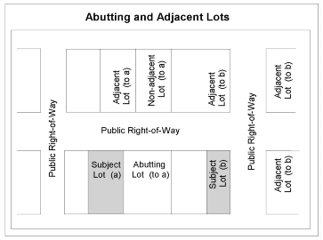
Abutting Properties—Two or more properties joined by a common boundary line or point, as shown in Figure 1.6-1—Abutting and Adjacent Lots.
Access—Place, means, or way by which ingress and egress are provided. See also definition for Solar Access.
Accessory Structure—Structure customarily incidental and subordinate to the main use of a property and located on the same lot as the main use; freestanding and structurally separated from the main use.
Accessory Use—Use customarily incidental and subordinate to the main use of a property and located on the same lot or site as the main use.
Accessway—Narrow strip of land connecting a Parcel created by Partition, to a public street right-of-way or a private street located within its own separate Tract. The Accessway ensures Access to the parcel. Where proposed, vehicle and pedestrian pavement widths within an Accessway are in accordance with the City's Site Development Design Standards.
Acre—Unit of land equal to 43,560 sq. feet
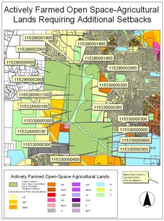
Actively Farmed Open Space-Agricultural Lands—Properties that are designated as Open Space-Agricultural on the Comprehensive Plan Map and are used for Agricultural Uses as defined in Section 3.0.30.05. For the purposes of requiring additional OS-AG setbacks, the setback requirements are limited to sites next to lands designated as OS-AG on the Comprehensive Plan Map and listed in the Benton County Assessor's Office as the Oregon State University Lands identified (on December 31, 2006) as Parcel Identification Numbers: 115290000500;115280002000; 115290000290; 115280001100; 115280001900; 115280001100; 115330000300; 11532A000100; 115330000500; or 115330000600 as shown.
Actual Construction—Permanent placing and fastening of construction materials.
Adjacent—Adjacent properties are either abutting or, in the absence of right-of-way, would be considered abutting. Uses are considered adjacent if they exist on adjacent properties, as shown in Figure 1.6-1—Abutting and Adjacent Lots.
Administrative Zone Change—Amendment to the boundaries of zones shown on the Official Zoning Map. A detailed definition for an Administrative Zone Change is contained in Section 2.2.50.b. Procedures for this type of land use application are outlined in Section 1.2.110.02—General Development and Section 2.2.50—Quasi-Judicial Change Procedures for Administrative Changes.
Affordable Housing—Housing for which ownership costs (mortgage loan principal, interest, property taxes, and insurance) or rental costs (unit rent and utilities) require no more than 30 percent of the gross monthly income of a household that has income at or below 80 percent of the Corvallis area median. The Corvallis area median is calculated annually by the U.S. Department of Housing and Urban Development (HUD) and applied based on household size. These numbers are updated annually by HUD and are on file in the City's Housing Division. See also; Eligible Affordable Housing Units.
Agriculture—Nursery, horticulture, and similar activities for the cultivation of commercial crops; pasturing, breeding, dairying, and similar uses of animals; and poultry farming for commercial use. Specific Agricultural Use Types are defined in Section 3.0.30.05—Agricultural Use Types.
Alley—Public or private right-of-way designed and intended to serve as primary or secondary vehicular Access to properties. An Alley is not an Accessway or a Street. Where Development is proposed to include or abut an Alley, the Alley must be in accordance with Chapter 4.0—Improvements Required with Development.
Alteration—Change, addition, or modification in construction or occupancy of a building or structure.
Annexation—The incorporation of land area in the City, with a resulting change in the boundaries of the City.
Application—Materials submitted or to be submitted.
Area, Gross—Total area of a Development Site, usually expressed in acres.
Area, Net—Total area of a Development Site, usually expressed in acres and excluding proposed public street rights-of-way and, if a developer desires, excluding public parks, protected Significant Natural Feature areas (with local, State, and/or Federal protections), land dedicated for other public purposes, and/or other areas permanently precluded from development due to development constraints or conservation easements.
Area of Shallow Flooding—See "Area of Shallow Flooding" in Section 1.6.40.
Area of Special Flood Hazard—See "Special Flood Hazard Area" in Section 1.6.40.
Average Setback (weighted by length of wall)—Formula for determining Average Setback is as follows: AS = (y 1 x SD 1 ) + (y 2 x SD 2 )+ (y n x SB n ), as shown below in Figure 1.6-2—Average Setback, where:
AS = Average Setback
y = Percent of wall length at a particular distance from property line
SD = Setback Distance (actual distance from the property line)
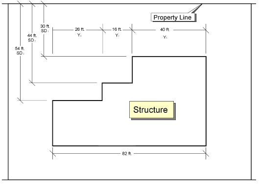
Figure 1.6-2—Average Setback
Example: Average Setback = 40.34 feet
y 1 = 40 feet ÷ 82 feet = 0.4878% = 49%
SD 1 = 30 feet
y 2 = 16 feet ÷ 82 feet = 0.1951% = 19%
SD 2 = 44 feet
y 3 = 26 feet ÷ 82 feet = 0.3171% = 32%
SD 3 = 54 feet
(0.4878 X 30) + (0.1951 X 44) + (0.3171 X 54) = 40.34 feet Average Setback
Base—Lowest (and often widest) visible part of a building, often distinctively treated. A base is distinguished from a foundation or footing in being visible rather than buried.
Base Flood—See "Base Flood" in Section 1.6.40.
Base Flood Elevation—See "Base Flood Elevation" in Section 1.6.40.
Basement—See "Basement" in Section 1.6.40.
Basin—Topographical entity within which all the surface water draining to a certain point falls; some of the surface water may come from ground water fed by geologic strata outside the Basin.
Bed and Breakfast—See Home Business for Bed and Breakfast businesses that rent up to two bedrooms within owner-occupied dwellings. See Section 3.0.30.03.u.3 for other Bed and Breakfast businesses.
Below-grade Crawlspace—See "Below-grade Crawlspace" in Section 1.6.40.
Bikeway—A facility intended and suitable for bicycle use, including but not limited to multi-use paths and on-street bicycle lanes.
Bioswale—Constructed shallow, wide vegetated ditch through which storm runoff travels and that uses natural methods of cleaning water such as sediment trapping and microorganism activity to remove pollutants.
Block—Tract(s) or parcel(s) of land bound by a connecting network of public or private streets with sidewalks. Under the specific exceptions identified in Chapter 4.0 of this Code, a block may be bound by walkways without streets, along one or more of its edges. The total distance around the perimeter of a block is commonly referred to as Block Perimeter.
Block Perimeter—The total distance around the outside perimeter of a block. For vehicle block perimeter, the distance is measured along the edges of the street / walkway rights-of-way, tracts and/or easements that abut the block. For pedestrian block perimeter, the distance is measured along the centerlines of the sidewalks or multiuse paths that form the block. See Figure 1.6-3—Block Perimeter and Chapter 4.0.
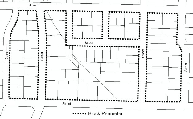
Figure 1.6-3—Block Perimeter
Bond—Form of security in an amount and form satisfactory to the City. See Performance Guarantee in Section 2.4.40.09.
Buffer—Area designed to provide space or distance, obstruct undesirable views, serve as an acoustic barrier, or generally reduce impacts of adjacent development.
Building—Structure having a roof supported by columns or walls and used or intended for the shelter, housing, or enclosure of any individuals, animals, processes, equipment, goods, or materials of any kind.
Building Codes—See "Building Codes" in Section 1.6.40.
Building Elevation—Scale drawing of the side, front, or rear of a given structure.
Building Envelope—Portion of a lot or development site exclusive of the areas required for front, side, and rear yards and other required open spaces; and which is available for siting and constructing a building or buildings.
Building Height—See Height of Buildings.
Building Line—Line on a plat indicating the limit beyond which buildings or structures may not be erected, or the minimum distance as prescribed by this Code between the property line abutting a street and the closest point of the foundation of any related building or structure.
Building Official—Development Services Manager or designee.
Building Types—
a.
Nonresidential—A building that contains only nonresidential Use Types, as defined in Chapter 3.0—Use Classifications.
b.
Residential—Group of building types that contain only residential Use Types, as defined in Chapter 3.0—Use Classifications, and comprising the following:
1.
Single Detached—One dwelling unit located on one lot, freestanding and structurally separated from other buildings. Does not include Cottage in a Cottage Cluster. Manufactured dwellings incorporated in the construction of this building type are subject to the provisions of Section 4.9.20 of this Code.
2.
Cottage—An individual dwelling unit that is part of a Cottage Cluster, as defined in Chapter 3.0. A Cottage is subject to floor area and ground floor footprint limitations specified in Section 4.10.55.02. Manufactured dwellings incorporated in the construction of this building type are subject to the provisions of Section 4.9.20 of this Code.
3.
Duplex—Two attached dwelling units in any vertical or horizontal arrangement located in one building on one lot. Units in a horizontal arrangement are placed so that some building walls are common for a minimum length of five feet Stacked Duplex units (where one unit is on top of another) are acceptable. Graphics below are examples of possible site layouts. Manufactured dwellings incorporated in the construction of this building type are subject to the provisions of Section 4.9.20 of this Code.
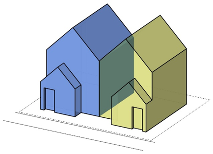
Figure 1.6-5(a)—Residential Duplex
(example of horizontal arrangement)
Figure 1.6-5(b)—Residential Duplex
(example of vertical arrangement / stacked units)
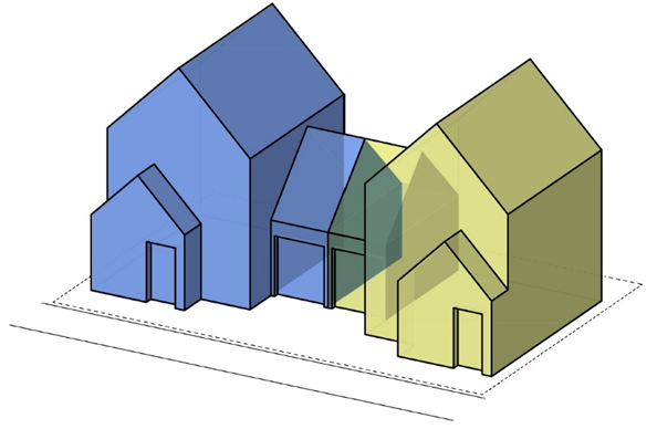
Figure 1.6-5(c)—Residential Duplex
(example of horizontal arrangement)
4.
Triplex—Three attached dwelling units in any vertical or horizontal arrangement located in one building on one lot. Units in a horizontal arrangement are placed so that some building walls are common for a minimum length of five feet Stacked units (where one unit is on top of another) are acceptable. Manufactured dwellings incorporated in the construction of this building type are subject to the provisions of Section 4.9.20 of this Code.
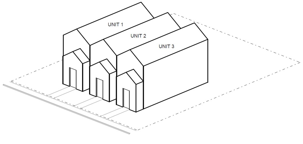
Figure 1.6-7(a)- Residential Triplex
(example of horizontal arrangement)
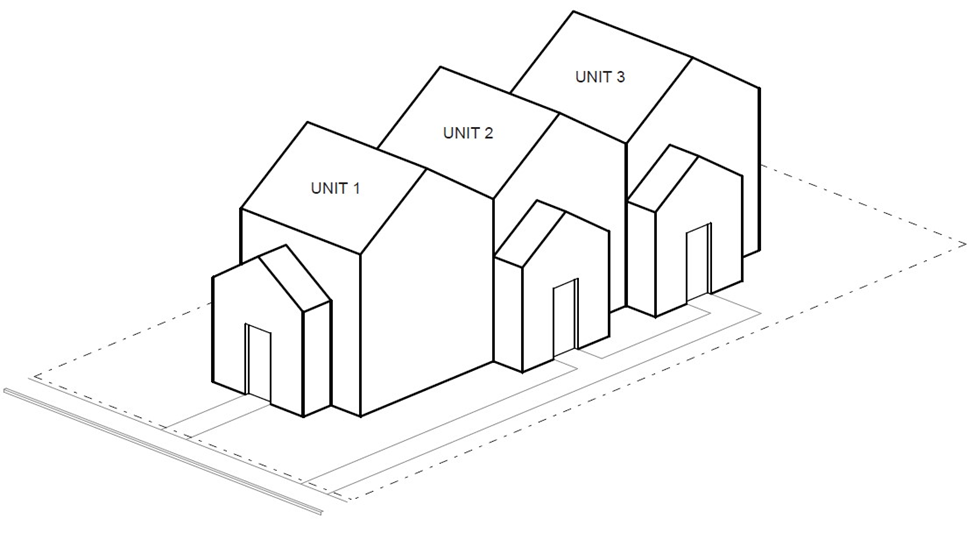
Figure 1.6-7(b)- Residential Triplex
(example of horizontal arrangement)
5.
Fourplex—Four attached dwelling units in any vertical or horizontal arrangement located in one building on one lot. Units in a horizontal arrangement are placed so that some building walls are common for a minimum length of five feet Stacked units (where one unit is on top of another) are acceptable. Manufactured dwellings incorporated in the construction of this building type are subject to the provisions of Section 4.9.20 of this Code.
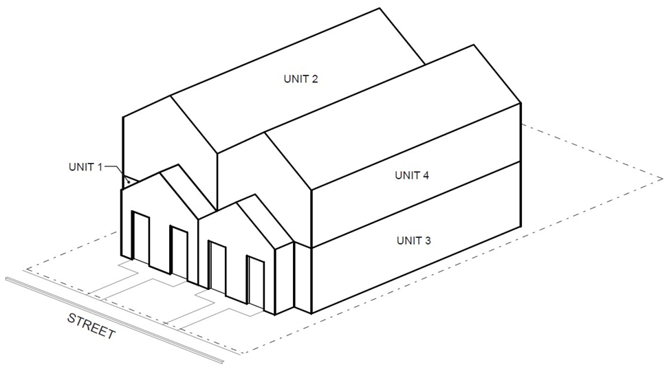
Figure 1.6.8 Residential Fourplex
(example of horizontal and vertical arrangement)
6.
Multi-dwelling—Five or more attached dwelling units in any vertical or horizontal arrangement located in one building on one lot. More than one multi-dwelling building may be located on one lot provided each building contains 5 or more dwelling units. Manufactured dwellings incorporated in the construction of this building type are subject to the provisions of Section 4.9.20 of this Code. Collections of buildings within this definition excludes Cottage Cluster and Manufactured Dwelling Facilities.
7.
Townhouse—Two or more attached dwelling units where each unit is on a separate lot, but placed side by side so that some building walls are in common for a minimum length of five feet at a common property line. Manufactured dwellings incorporated in the construction of this building type are subject to the provisions of Section 4.9.20 of this Code.
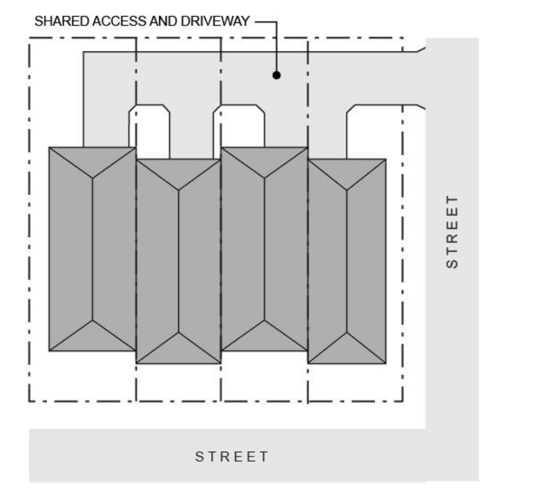
Figure 1.6-9—Townhouse (example of four attached Townhouses with shared driveway)
8.
Accessory Dwelling Unit—One dwelling unit, located on the same legally-created lot, parcel, or lot of record as, and used in connection with or accessory to, a primary dwelling unit. An Accessory Dwelling Unit may be interior to, attached to, or detached from the primary dwelling unit. Accessory Dwelling Units are subject to the provisions of Section 4.9.40 of this Code. Manufactured dwellings incorporated in the construction of this building type are subject to the provisions of Section 4.9.20 of this Code.
9.
Other—Building containing non-Household residential Use Types such as Group Residential, Residential Care Facilities, etc.
c.
Mixed Use—A building that contains both residential and nonresidential Primary Use Types, as defined in Chapter 3.0—Use Classifications.
Carpool/vanpool—At least two people sharing a vehicle, generally for the purpose of commuting to work.
Carport—Roofed structure or a portion of a building open on two or more sides; used primarily for parking of motor vehicles.
Cemetery—Land used or intended to be used for burial of the dead and related Cemetery activities, including columbarium, crematoriums, mausoleums, and mortuaries, when operated in conjunction with and within the boundary of the Cemetery.
Church—Permanently located, fully enclosed building used primarily for religious worship.
City—City of Corvallis, a municipal corporation of the State of Oregon, involved in activities in either its governmental or its corporate capacity; otherwise, that officer, department, or agency of the City indicated by the context; or City Manager where the context does not clearly indicate a specific officer, department, or agency.
City Limits—Boundary line that identifies land within the City.
Compatible—Ability of different uses to exist in harmony with each other. "Making uses compatible with each other" implies site development standards that regulate the impact of one use on another.
Comprehensive Neighborhood—Primarily residential area that offers a range of uses to provide for the daily needs and activities of residents within easy walking distance of residences. Comprehensive Neighborhoods contain a variety of housing opportunities, at overall densities that can support appropriately scaled commercial development and viable public transportation. The core of a Comprehensive Neighborhood contains a Major Neighborhood Center that serves community-wide shopping and office needs. The design of a Comprehensive Neighborhood fosters a sense of community with safe, vital public areas, while working to ensure compatibility and effective transitions between diverse uses.
Comprehensive Plan Amendment—Amendment to either the boundaries of Comprehensive Plan Map designations shown on the Official Comprehensive Plan Map or an amendment to the text of the Comprehensive Plan. Procedures for this type of land use application are outlined in Section 1.2.110.03—Special Development and Chapter 2.1—Comprehensive Plan Amendment Procedures.
Conceptual Development Plan—Land use process that is a type of Conditional Development and that provides a mechanism for achieving greater flexibility and improved design where the scope of the proposed modifications to this Code's pre-stated standards exceeds that permitted through Chapter 2.12—Development Standards Adjustment. This type of land development project is comprehensively planned as an entity via a unified site plan. Often it is proposed to allow for better preservation of Significant Natural Features and/or for innovation in site planning and architectural design. Approval requires compensating benefits that off-set the requested development standard modifications. The request must be followed by or processed concurrently with a Detailed Development Plan and the issuance of Building Permits is withheld until a Detailed Development Plan is approved. Procedures for this type of land use application are outlined in Section 1.2.110.03—Special Development, Chapter 2.5—Planned Development, and Section 2.5.40—Conceptual Development Plan Review Procedures.
Conditional Development—Land use process that provides an opportunity to allow a use when potential adverse effects can be mitigated or deny a use if concerns cannot be resolved to the satisfaction of the hearing authority. Procedures for this type of land use application are outlined in Section 1.2.110.03—Special Development and Chapter 2.3—Conditional Development.
Conditional Development Modification—Land use process that provides an opportunity to allow a limited amount of flexibility with regard to site planning and architectural design for a previously approved Conditional Development and provides benefits within the development site that compensate for requested variations from approved Conditional Development such that the intent of the original approval is still met. Procedures for this type of land use application are outlined in Section 1.2.110.02—General Development and Section 2.3.40—Conditional Development Modification.
Conditions of Approval—Requirements placed on a development for a number of purposes, which include but are not limited to:
a.
Ensuring adherence to the proposal that is approved;
b.
Ensuring that adequate public and private services and facilities are provided, consistent with adopted transportation and facility plans and applicable regulations;
c.
Ensuring that Natural Resources and Natural Hazards issues are addressed consistent with the applicable criteria and regulations;
d.
Bringing the development into compliance with applicable criteria and regulations, including but not limited to Comprehensive Plan Policies and/or this Code's standards;
e.
Helping to assure that negative impacts of a development are mitigated up front, particularly in the case of Conditional Development approvals; and
f.
Assisting applicants by identifying some of the requirements that will affect subsequent related application requests such as Final Plats, Building Permits, construction permits, Public Improvement by Private Contract (PIPC) Permits, etc.
Conservation Easement—Nonpossessory interest of a holder in real property imposing limitations or affirmative obligations, the purposes of which include retaining or protecting natural, scenic, or open space values of real property; ensuring its availability for agricultural, forest, recreational, or open space use; protecting Natural Resources or Natural Hazards; maintaining or enhancing air or water quality; or preserving the historical, architectural, archaeological, or cultural aspects of real property. Also defined in ORS 271.715, as amended.
Construction Specifications—Document containing the official City of Corvallis construction specifications, as published by the City Engineer and updated from time to time.
/Contiguous—Same as Adjacent. Properties separated by a street may also be considered contiguous.
Contractor Sidewalk/Street Stamps—Insignia or mark stamped into a sidewalk or street that includes information, such as the contractor's name and the date the work was performed, and which indicates that the stamp dates from 1956 or before.
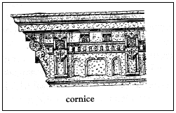
Figure 1.6-11—Cornice
Cornice—Any molded projection which crowns or finishes the part to which it is affixed. Also, the exterior trim of a structure at the meeting of the roof and wall; usually consists of bed molding, soffit, fascia, or crown molding. See Figure 1.6-11—Cornice
Corvallis Streams—All streams that are located either in part or entirely within the City's Urban Growth Boundary.
Critical Facility—See "Critical Facility" in Section 1.6.40.
Cupola—Small dome or tower-like structure on a roof.
Curb Cut—The width of the curb, driveway approach, or edge of pavement (unimproved street) that is utilized for vehicular access to a property.
Datum—The vertical datum is a base measurement point (or set of points) from which all elevations are determined. Historically, that common set of points has been the National Geodetic Vertical Datum of 1929 (NAVD29). The vertical datum currently adopted by the federal government as a basis for measuring heights is the North American Vertical Datum of 1988 (NAVD88).
Day(s)—Calendar days unless working days are specified.
Density—Number of dwelling units per acre of land, calculated in accordance with the definition for Density Calculation.
Density Calculation -
a.
Density, Gross—Number of dwelling units per gross area, in acres. See definition for Area, Gross in this Chapter.
b.
Density, Net—Number of dwelling units per net area, in acres. See definition for Area, Net in this Chapter.
c.
Maximum Density -
Development proposals on a Lot of Record—Maximum Density is determined based on the Minimum Lot Area requirement for the Building Type, as specified by the Zone. The subject property must contain at least the Minimum Lot Area required for the Residential Building Type, as specified by the Zone. An individual Duplex, Triplex, Fourplex, or Cottage Cluster development is exempt from the Maximum Density standard.
Partitions—Maximum Density is determined based on the Minimum Lot Area requirement(s) as specified by the Zone.
Subdivisions—Maximum Density is determined based on the Gross Density of the proposed development. When a fractional result is equal to or greater than 0.5, an additional dwelling unit will be allowed, but is not allowed when a fractional result is less than 0.5. The formula will be as follows:
Gross Area (expressed in acres) × Maximum Density per Acre established for the Zone = Maximum Density
d.
Minimum Density—Minimum Density is determined based on the Net Area of a development site and the Minimum Density requirement as specified by the Zone. See definition for Area, Net in this Chapter. Minimum Density is determined using the following formula:
Net Area (expressed in acres) × Minimum Density per Acre established for the Zone = Minimum Density
When the sum of the dwelling units is a fraction of a dwelling unit, and the fraction is equal to or greater than 0.5, an additional dwelling unit is required. If the fraction is less than 0.5, an additional dwelling unit is not be required.
Density Transfer—Permits residential density under a single development application to be shifted from one part of a development site and added to another part of the same site. It can be used to protect Significant Natural Features that are on the development site without losing overall density in the development. Density transfer does not permit an increase in the gross density for the entire development site.
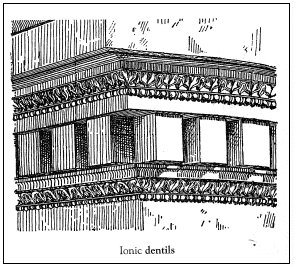
See Figure 1.6-13—Dentils
Dentil—See Figure 1.6-13—Dentils. One of a band of small, square, tooth-like blocks forming part of the characteristic ornamentation of the Iconic, Corinthian, and Composite orders, and sometimes Doric.
Dentil Band—
a.
Molding that occupies the position of a row of Dentils in classical architecture.
b.
Course of masonry that resembles a row of Dentils; for example, in brickwork, the tooth-like effect produced by the projection of alternate headers and smaller blocks.
DSL—Oregon Department of State Lands.
Detailed Development Plan—Land use process that is a type of Conditional Development and that provides a mechanism for achieving greater flexibility and improved design where the scope of the proposed modifications to this Code's pre-stated standards exceeds that permitted through Chapter 2.12—Development Standards Adjustment. This type of land development project is comprehensively planned as an entity via a unified site plan and must be based on a previously or concurrently approved Conceptual Development Plan. Such Plans are often proposed to allow for better preservation of Significant Natural Features and/or for innovation in site planning and architectural design. Approval requires compensating benefits that off-set the requested modifications to development standards. A Detailed Development Plan provides sufficient information for the issuance of building permits. Procedures for this type of land use application are outlined in Section 1.2.110.03—Special Development, Chapter 2.5 - Planned Development, and Section 2.5.50—Detailed Development Plan Review Procedures.
Detention Basin—Constructed pond and/or underground facility that is designed to temporarily collect runoff from a development to maintain the runoff rate to a specified pre-development flow.
Developer—Any person, including a governmental agency, undertaking development.
Development—Making a material change in the use or appearance of a structure or land, dividing land into two or more parcels, changing the land use designation, or creating or terminating a right of access. Where appropriate to the context, development refers to the act of developing or the result of development. For the definition of Development as applied to the 100-year Floodplain regulations contained in Chapter 2.11—Floodplain Development Permit and Chapter 4.5—Floodplain Provisions, please see Section 1.6.40, below.
Development Constraints—Conditions that limit or preclude development of an area or site such as location within: a Natural Hazard on the Natural Hazards Map; a Riparian Corridor or Wetlands on the Riparian Corridors and Wetlands Map; an area of Significant Vegetation on the Significant Vegetation Map; a 4th-level water service area (not served by City water); and/or an area that is permanently preserved via a conservation easement or a drainageway easement/dedication.
Development Constraints—Former—Development Constraints that no longer preclude development due to the application of the Minimum Assured Development Area (MADA) provisions. A formerly constrained area is one which would be protected through the Development Constraints in Chapters 4.5, 4.11, 4.12, 4.13, or 4.14, but can be developed by applying the MADA provisions in Chapter 4.11. Development can occur on the site and the constraining factors such as significant vegetation, etc. may be removed or reduced to accommodate the development. However, for MADA development in Floodway Fringe Areas, there are default standards required and they are the Partial Protection Floodplain Provisions. See Section 4.5.20.03 and Formerly Constrained Areas.
Development, Intensity of—Relative measure of development impact as defined by characteristics such as the number of dwelling units per acre, amount of traffic generated, and amount of site coverage.
Development-related Concerns—Requirements that are worthy of special attention for the developer or for permitting agencies. These requirements are identified on the Notice of Disposition for a development approval and are generally raised during the development review process.
Development Site—Legally established lots, parcels, or tracts of land involved in a land use application or building/construction permit application. Sites that are occupied or capable of being occupied by a building or group of buildings including accessory structures and accessory uses, together with yards or open spaces, setback areas, and access as required by this Code.
Development Standards Adjustment—Land use process that provides a means to vary the development standards normally applied in a particular Zone. Procedures for this type of land use application are outlined in Section 1.2.110.02—General Development, Section 1.2.110.03—Special Development, and Chapter 2.12—Development Standards Adjustment.
Digital Flood Insurance Rate Map—See "Digital Flood Insurance Rate Map" in Section 1.6.40.
Director—Community Development Director of the City of Corvallis, or the Director's official designee, with responsibility for administration of this Code.
Director's Interpretation—Land use process that seeks the Director's interpretation of either this Code or Comprehensive Plan provisions. These Interpretations may be legislative or quasi-judicial in nature. Procedures for this type of land use application are outlined in Section 1.2.110.02—General Development and Chapter 2.16—Request for Interpretation.
Discontinued Use—Use that has ceased to be active. Does not require a determination of the voluntary or involuntary nature of the discontinuance or intent to resume the use. Rental payments or lease payments and taxes are not considered a continued use.
Dominant Cover Type—One or more vegetative species that provide a minimum of 20 percent area cover within the corresponding vegetative layer.
Downtown Residential Neighborhood—As defined in the Comprehensive Plan, the area generally bound by Sixth Street on the east, Ninth Street on the west, Fillmore Avenue on the north, and Mary's River on the south. This area is intended to provide housing in close proximity to the Central Business designation on the Comprehensive Plan Map, and is identified below in Figure 1.6-16—Downtown Residential Neighborhood.
Figure 1.6-16—Downtown Residential Neighborhood
Drainageway—Natural or artificial Watercourse, including adjacent Riparian Vegetation, that transmits natural Stream or stormwater runoff from a higher elevation to a lower elevation.
Drainageway Dedication—Transfer, in fee-simple, of ownership of a given piece of property for the purpose of stormwater functions.
Drive-Through Facilities—Facilities that provide services directly to patrons in motor vehicles. These types of facilities typically rely on a long driveway or lane that provides adequate room for vehicle stacking at a drive-up service window.
Dwelling Unit—A single unit providing complete independent living facilities for one common household, including provisions for living, sleeping, eating, cooking (limited to one kitchen), and sanitation. A dwelling unit contains no more than six (6) rooms used for sleeping purposes in the unit that are offered for rent.
Easement—Right that a person has to use another's land for a specific purpose, such as for access or for utilities.
Effects of Buoyancy—Uplift force of water on a submerged or partially submerged object.
Elevated Building—See "Elevated Building" in Section 1.6.40.
Eligible Affordable Housing Units—Housing units that are affordable to and restricted to occupancy by low-income residents with a gross household income of:
• 80% or below the Corvallis median income, adjusted by family size, in the case of owner-occupied housing; or
• 60% or below the Corvallis median income, adjusted by family size, in the case of renter-occupied housing.
"Affordable" means that low-income households within a specified range pay no more than 30% of gross monthly income on mortgage payments (principle, interest, property taxes, and insurance), or monthly rent plus utilities. The applicable income and affordability restrictions shall be recorded by the City of Corvallis and/or State of Oregon in the form of deed restrictions or such other mechanism acceptable to the City of Corvallis and/or State of Oregon. These restrictions shall be for a minimum of 20 years, and will specify the method for calculating affordability that is to be applied to the property.
Endangered Species—Any species that is in danger of extinction throughout all or a significant portion of its range.
Endangered Species Act (ESA)—Federal regulatory program to protect fish, wildlife, and plants from extinction. It provides a means whereby the ecosystems upon which threatened and endangered species depend may be conserved to ensure the continued survival of the species.
Engineering Standards—Document containing the official City of Corvallis engineering standards, as published by the City Engineer and updated from time to time.
Enhance—To augment into a more desirable condition. In the context of natural features regulations, to improve the functions and values of an existing Natural Resource.
Erosion—Movement or displacement of soil resulting from natural and human-induced processes including weathering, dissolution, abrasion, corrosion, and transportation.
Excavation—Process of mechanically altering the natural grade by stripping or cutting and/or filling the earth. See Grading.
Existing Building or Structure—See "Existing Building or Structure" in Section 1.6.40.
Extension of Services—Land use process that implements City Charter Section 51 and allows an extension of City sanitary sewer, storm sewer, and/or water services outside the City limits in limited circumstances. Procedures for this type of land use application are outlined in Section 1.2.110.03—Special Development and Chapter 2.7—Extension of City Services Outside the City Limits.
FAR—See Floor Area Ratio.
Federal Emergency Management Agency (FEMA)—See "Federal Emergency Management Agency (FEMA)" in Section 1.6.40.
Final Plat—Final recorded version of a Subdivision plat, Replat, or Partition plat.
Final Plat, Partition—Final recorded map, diagram, drawing, replat, or other writing containing all the descriptions, locations, specifications, provisions, easements, dedications, and information concerning a partition.
Final Plat, Subdivision—Final recorded map, diagram, drawing, replat, or other writing containing all the descriptions, locations, specifications, provisions, easements, dedications, and information concerning a Subdivision.
Fish-bearing Streams—Fish-bearing streams are those indicated on maps developed by the Oregon Department of Fish and Wildlife and the Oregon Department of Forestry or those where fish presence is documented by the Natural Features Inventory or a recognized fish biologist.
Flag—A piece of fabric or other non-rigid material supported or anchored along only one edge, or supported or anchored at only two corners, with no dimension being more than three times as long as any other dimension.
Flag Parcel—Parcel not meeting the minimum street frontage requirements and that gains access to the nearest public or private street by means of a narrow strip of land.
Flood or flooding—See "Flood or flooding" in Section 1.6.40.
Flood Insurance Rate Map (FIRM)—See "Flood Insurance Rate Map (FIRM)" in Section 1.6.40.
Flood Insurance Study (FIS)—See "Flood Insurance Study" in Section 1.6.40.
Flood, 100-year—See "Flood, 100-year" in Section 1.6.40.
Floodplain—See "Floodplain" in Section 1.6.40.
Floodplain Development Permit—See "Floodplain Development Permit" in Section 1.6.40.
Floodplain Functions—See "Floodplain Functions" in Section 1.6.40.
Floodplain, 100-year—See "Floodplain, 100-year" in Section 1.6.40.
Floodway (Regulatory Floodway)—See "Floodway (Regulatory Floodway)" in Section 1.6.40.
Floodway, 0.2-feet—See "Floodway (Regulatory Floodway)" in Section 1.6.40.
Floodway, 1.0-feet—See "Floodway (Regulatory Floodway)" in Section 1.6.40.
Floodway Fringe—See "Floodway Fringe" in Section 1.6.40.
Floor Area, Gross—Consistent with the definition for Floor Area, Gross from the Oregon Structural Specialty Code.
Floor Area Ratio (FAR)—Unless defined otherwise, Floor Area Ratio (FAR) is the gross floor area of all buildings on a lot or development site divided by the net area of a lot or development site on which the buildings are located. See Floor Area, Gross and Area, Net. In cases where outdoor areas are directly related to the subject land use(s) (e.g., outdoor storage areas; planting areas for nurseries, tree farms, and agricultural businesses; portions of parking lots used for storage and circulation of moving vans associated with moving businesses; etc.), these outdoor areas may be included in the Floor Area Ratio square footage calculation. However, unless specified otherwise, in no case will standard parking and circulation areas, landscaping, etc., be included in the Floor Area Ratio square footage calculation.
Floor Area Ratio, Maximum (Max. FAR)—The gross floor area of all buildings on a lot or development site that, when divided by the net area of a lot or development site on which the buildings are located, does not exceed a specified decimal value. See Floor Area, Gross and Area, Net.
Flow-through Design—See "Flow-through Design" in Section 1.6.40.
Formerly Constrained Areas—Areas that contain areas that would be protected through the Development Constraints in Chapters 4.5, 4.11, 4.12, 4.13, or 4.14, but can be developed by applying the MADA provisions in Chapter 4.11. Formerly Constrained Areas can be developed, and the constraining factors such as significant vegetation may be removed or reduced to accommodate the development. However, for MADA development in Floodway Fringe Areas, there are default standards required and they are the Partial Protection Floodplain Provisions. See Section 4.5.20.03 and Development Constraints—Former.
Frontage—Portion of a development site that abuts a public or private street.
Frontage Occupation—The percentage of a Development Site's linear street Frontage, at the ground level that is occupied by one or more of the following within the maximum front yard setback and maximum exterior side yard setback abutting to a street for the Zone:
• Building facades
• Public parks
• Private parks or plazas that are legally available to the public, with minimum dimensions of 20 feet by 20 feet, and with at least 20 feet of frontage along the Front Lot Line
• Area reserved for outdoor seating placed directly between a street-facing building façade and the corresponding street, and directly associated with one or more on-site uses.
The following may be excluded from the linear street frontage measurement in areas where they prevent building placement within the maximum setback:
• Mid-block pedestrian corridors in accordance with LDC Section 4.0.30
• Preserved Significant Vegetation regulated under Chapter 4.12 and/or Preserved Wetlands or Riparian Corridors regulated under Chapter 4.13
Required vision clearance areas at the intersections of public streets and/or public alleys On Corner Lots, Frontage Occupation applies to each frontage (Front Yard and Exterior Side Yard) individually.
Figure 1.6-16.a—Examples of elements within the maximum setback that do (check mark)
and do not (X) count toward minimum Frontage Occupation requirements
General Development Decision—Development decision that requires some discretion in applying the criteria and standards of this Code. Requires review and approval by staff without a public hearing; public notice prior to the staff decision; and the mailing of a Notice of Disposition to persons who responded in writing to the public notice. Appeals are made in accordance with Chapter 2.19—Appeals.
Geographic Information System (GIS)—System of hardware, software, and data storage that allows for the analysis and display of information that has been geographically referenced.
Grade—(1) Average elevation of the land; (2) the percent of rise or descent of a sloping surface. Usually described as Finished Grade or Natural Grade, and measured in feet above sea level. There is a distinction between percent of slope and degree of slope. For example, a forty-five degree slope is a 100 percent grade. See also Slope.
Figure 1.6-17—Cut and Fill Cross Section
Grade, Finished—As shown in Figure 1.6-17—Cut and Fill Cross Section, final elevation of the ground level after development.
Grade, Natural—As shown in Figure 1.6-17—Cut and Fill Cross Section, elevation of the ground level in its natural state, before construction, filling, or excavation.
Grading—Stripping, cutting, filling, or stockpiling of earth or land, including the land in its cut or filled condition, to create new grades.
Green Area—Includes a site's landscaping, private preservation areas, and/or pedestrian amenities such as sidewalks, plazas, multi-use paths, unenclosed patios, and decks. Does not include areas covered by buildings, covered structures enclosed on one or more sides, parking areas, or vehicle circulation areas.
Habitable Floor—Floor usable for living purposes, which includes working, sleeping, eating, cooking, or recreation, or a combination of these.
Hearing Authority—City Council or an agency or officer of the Council designated by this Code to conduct public hearings regarding applications for development.
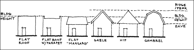
Figure 1-6-18a: Calculation of Height of Building Using Various Roof Types
Height of Buildings—Vertical distance above a reference datum measured to the highest point of any non-gabled roof (including a "mansard" roof), or to the average height of the highest gable of a pitched roof. To calculate building height for a gambrel roof, the height is determined using the midpoint of the total height of all roof pitches (from roof peak to eave). If the eave height is less than 10 feet above the reference datum, then it is assumed to be 10 feet for the purpose of computing building height. To calculate building height for a hip roof, the height is determined using the midpoint of the highest roof pitch (from roof peak to eave) The height of a stepped or terraced building is the maximum height of any segment of the building.
The reference datum will be selected by either of the following, whichever yields a greater height of building:
a.
As shown in Figure 1.6-18.b—Method 1 below, elevation of the highest adjoining sidewalk or ground surface within a five-feet horizontal distance of the exterior wall of the building when such sidewalk or ground surface is not more than 10 feet above lowest grade.
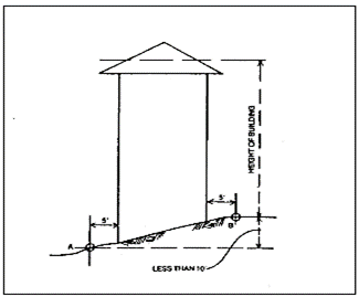
Figure 1.6-18.b: Method 1
b.
As shown in Figure 1.6-19—Method 2 below, elevation 10 feet higher than the lowest grade when the sidewalk or ground surface described in "a", is more than 10 feet above lowest grade.
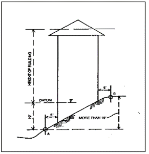
Figure 1.6-19: Method 2
Highest Adjacent Grade—See "Highest Adjacent Grade" in Section 1.6.40.
Historic Structure—See Section 1.6.40.
Home Business—Lawful commercial activity commonly conducted within a dwelling by members of the Household, with up to one additional employee not to exceed 40 hours per week. The residential character of the dwelling must be maintained and the activity conducted in such a manner as not to give an outward appearance nor manifest any characteristic of a business in the ordinary meaning of the term. The activity also does not infringe upon the right of neighboring residents to enjoy the peaceful occupancy of their homes. Garage sales are considered to be home businesses. Bed and Breakfast businesses that rent up to two bedrooms within owner-occupied dwellings are also considered to be Home Businesses. To be considered a Home Business, the Use must comply with all of the following:
a.
No display indicates from the exterior that the building is being used in whole or in part for any purpose other than a dwelling, except that signage consistent with Section 4.7.90.01 of Chapter 4.7—Sign Regulations is allowed. Garage sales are exempt from this provision.
b.
No outside storage of merchandise or materials. Garage sales are exempt from this provision.
c.
The amount of commercial activity is less intensive than activities permitted in a commercial zone.
d.
The use will not cause excessive or unusual traffic in the vicinity because of deliveries, pick-ups, parking, sales, or other activities.
e.
Noise, smoke, or odors do not exceed those created by normal residential use.
f.
Each garage sale is limited in duration to two consecutive days. No more than six garage sales in one calendar year may be conducted at a residence.
Home Occupation—See Home Business.
Homeowners' Association—Private, incorporated, nonprofit organization operating under recorded land agreements through which each lot owner of a Planned Development or other described land area is automatically subject to a charge for a proportionate share of the expenses for the organization's activities, such as maintaining a common property. Homeowners' associations are authorized by ORS Chapter 94, as amended, and are not City government organizations.
Household—Domestic establishment including a member or members of a family and/or others living under the same roof.
Human Occupancy—Consistent with the definition for Habitable Space (Room) from the Oregon Structural Specialty Code.
Hydrodynamic Load—See "Hydrodynamic Load" in Section 1.6.40.
Hydrostatic Load—See "Hydrostatic Load" in Section 1.6.40.
Impact—Consequences of a course of action; the effect of a goal, guideline, plan, or decision.
Improvement Plan—Maps or drawings showing the layout of improvements to be installed as a condition of approval for development.
Infill—Developing vacant and partially vacant land within a built environment. To be considered infill, such land must be less than 0.5 acres in size for residentially designated lands or less than 1.0 acre in size for lands designated otherwise.
Intermittent Stream—See Stream, Intermittent.
Invasive and/or Noxious Vegetation—Vegetation identified in the Oregon Department of Agriculture's Noxious Weed Policy and Classification System, as amended,, including weeds designated as "A," "B," and/or "T."
Noxious weeds, for the purpose of this system, will be designated "A" or "B" and may be given the additional designation of "T" according to the Oregon Department of Agriculture Noxious Weed Classification System.
• "A" Designated Weed—a weed of known economic importance which occurs in the state in small enough infestations to make eradication or containment possible; or is not known to occur, but its presence in neighboring states make future occurrence in Oregon seem imminent (Table 1).
Recommended action: Infestations are subject to eradication or intensive control when and where found.
• "B" Designated Weed—a weed of economic importance which is regionally abundant, but which may have limited distribution in some counties (Table 2).
Recommended action: Limited to intensive control at the state, county or regional level as determined on a case-by-case basis. Where implementation of a fully integrated statewide management plan is not feasible, biological control (when available) must be the main control methods.
• "T" Designated Weed—a priority noxious weed designated by the Oregon State Weed Board as a target on which the Oregon Department of Agriculture will develop and implement a statewide management plan. "T" designated noxious weeds are species selected from either the "A" or "B" list (Table 3).
Irrigation System—Manual or mechanically controlled method of supplying water to an area that needs it.
Jurisdictional Wetlands—See Wetlands, Jurisdictional.
Key Areas of Exchange—Locations within a watershed where ground water recharge from surface water occurs (e. g., permeable depressions) or where streams are fed by ground water (e.g., springs).
Kitchen—Any room used, intended, or designed for preparation of food and storage of food, including any room with a sink and either a 3/4-in. gas opening or provision for a range or stove.
Land Area, Net—See Area, Net.
Land Development Code Text Amendment—Amendment to the text of this Code. Procedures for this type of land use application are outlined in Section 1.2.80.
Land Division—Land divided to create legally separate areas in one of the following ways:
a.
Partition—Division of land that creates three or fewer parcels and/or tracts within a calendar year when such parcels exist as a unit or contiguous units of land under single ownership at the beginning of the year. Procedures for this type of land use application are outlined in Section 1.2.110.02—General Development and Chapter 2.4—Land Divisions, Replats, and Property Line Adjustments.
A Partition does not include division of land resulting from any of the following:
1.
Establishment or modification of a tax lot by the County Assessor;
2.
A lien foreclosure, foreclosure of a recorded contract for the sale of real property, or creation of cemetery lots;
3.
An adjustment of a property line where an additional unit of land is not created and where the existing unit of land reduced in size by the adjustment complies with any applicable zone criteria established by this Code;
4.
Sale or grant by a person to a public agency or public body for state highway, county road, City street, or other right-of-way purposes provided that such road or right-of-way complies with the applicable Comprehensive Plan policies and ORS 215.213 (2)(p) to (r) and 215.283 (2)(q) to (s), as amended. See Property Line Adjustment;
5.
Dividing land as a result of the recording of a subdivision or condominium plat; or
6.
Selling or granting by a public agency or public body of excess property resulting from the acquisition of land by the state, a political subdivision or special district for highways, county roads, city streets or other right of way purposes when the sale or grant is part of a property line adjustment incorporating the excess right of way into adjacent property. The property line adjustment will be approved or disapproved by the applicable local government. If the property line adjustment is approved, it must be recorded in the deed records of the county where the property is located.
b.
Subdivision—Division of land that creates four or more lots and/or tracts within a calendar year when such lots exist as a unit or contiguous units of land under a single ownership at the beginning of such year. A Subdivision does not include division of land resulting from any of the activities in "a," above. Procedures for this type of land use application are outlined in Section 1.2.110.02—General Development and Chapter 2.4—Land Divisions, Replats, and Property Line Adjustments.
Land, Parcel of—Unit of land with established boundaries or a unit of land created by a Partition. See Lot for a unit of land created by a Subdivision.
Large Wood (as found in streams)—In the analysis of the local streams of Corvallis that was done for the Endangered Species Act Salmon Listing Response Plan, Large Wood was identified as 10 centimeters (four inches) in diameter and three meters (10 feet) long.
Lateral Addition—See "Lateral Addition" in Section 1.6.40.
Legal Nonconforming Development—Lawful existing structure or use that does not conform to current requirements of this Code, but which existed before this Code or any amendment to it became effective.
Legislative Decision—Formulation of policy characteristic of the actions by a city council. Ex parte contact requirements are not applicable to legislative hearings. In general, personal notice to citizens of proposed changes is not required, although this Code specifies that in some cases, notice is mailed to property owners if a decision will change the land use designation. In general, the burden of being informed rests on the citizen. See also Limited Land Use Decision and Quasi-judicial Decision.
Letter of Map Change (LOMC)—See "Letter of Map Change (LOMC) in Section 1.6.40.
Limited Land Use Decision—Land use decision made by City staff through an administrative process and that qualifies as a Limited Land Use Decision under ORS 197.195, as amended. Limited land use decisions are among the types of decisions that are reviewed through the process set out in Chapter 1.2—Legal Framework as General Developments.
Local Wetlands Inventory (LWI)—See Wetlands, Local Wetlands Inventory.
Locally Protected Locally Significant Wetlands (LPLSW)—See Wetlands, Locally Protected Locally Significant Wetlands (LPLSW).
Locally Significant Wetlands—See Wetlands, Locally Significant (LSW).
Lot—Unit of land created by a Subdivision of land and intended as a unit for the purpose, whether immediate or future, of transfer of ownership and/or for development.
Lot Area—Total horizontal area within the lot lines of a lot.
Lot, Corner—Lot situated at the intersection of two streets, the interior angle of such intersection not exceeding 135 degrees.
Lot Coverage—Unless otherwise noted in a development zone, portion of a development site covered by building footprints, structures enclosed on one or more sides, parking areas, and vehicle circulation areas (including all gravel and paved surface areas).
Lot Depth—Distance from the midpoint of the front lot line to the midpoint of the rear lot line.
Lot, Interior—Lot with frontage on only one street.
Lot Line—Property line bounding a lot.
Lot Line, Front—In the case of an interior lot, a property line that abuts the public street or private street within a separate Tract. In the case of a corner lot, a lot where vehicular access is provided off an alley and there is no frontage on a public or private street, or a Through Lot, the front lot line is based on the structure's orientation and at least two of the following factors:
a.
Location of the front door;
b.
Location of the driveway (when accessed off a public or private street); or
c.
Legal street address.
For the purposes of remodeling, rebuilding, constructing additions or accessory structures, etc., a corner lot's front lot line that was determined at the time of original construction of structure(s) on the lot may be considered valid.
Lot Line, Side—Lot boundary other than a front or rear lot line.
Lot Line, Rear—As shown below in Figure 1.6-20.a—Rear Lot Line, lot line or lines most distant from and generally opposite the front lot line. In the case of an interior triangular lot or a lot with more than four sides, however, the rear lot line is a straight line 10 feet in length that:
a.
Runs parallel to the front lot line or its chord; and
b.
Intersects the other lot lines at points most distant from the front lot line.
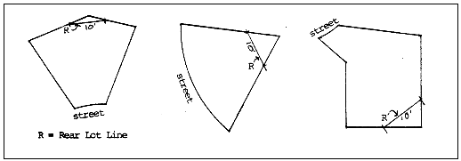
Figure 1.6-20.a—Rear Lot Line
Lot of Record—Lot or parcel created through applicable Land Division regulations before adoption of this Code.
Lot, Reversed Corner—Corner lot with a rear lot line bordering the side yard of another lot, whether or not separated by an alley.
Lot, Tax—Parcel of real property shown on the County Assessor's map and identified by a tax lot number. A Tax Lot is not necessarily a Lot of Record.
Lot, Through—See Through Lot.
Lot Width—The diameter of the largest circle that can be inscribed within the boundary of a lot of record (See Figure 1.6-20.b).
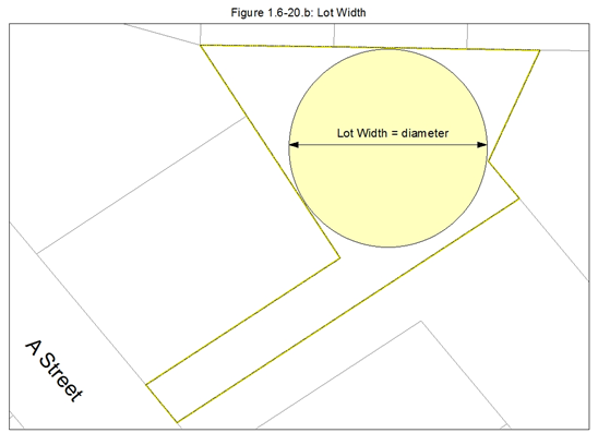
Figure 1.6-20.b—Lot Width
Lowest Floor—See "Lowest Floor" in Section 1.6.40.
Maintain—Support, keep, and continue in an existing state or condition without decline.
Manufactured Dwelling—A structure that is permanently anchored to the ground and complies with the minimum requirements for permanent connection of electrical and plumbing systems. It is constructed for movement on the public highways, has sleeping, cooking and plumbing facilities, is intended for human occupancy, is used for residential purposes, and was constructed in accordance with federal manufactured housing construction and safety standards and regulations in effect at the time of construction.
The term Manufactured Dwelling includes pre-fabricated and modular structures. The term Manufactured Dwelling does not include any building or structure constructed to conform to the State of Oregon Structural Specialty Code or the Low Rise Residential Dwelling Code, or any unit identified as a Recreational Vehicle by the manufacturer.
Manufactured Dwelling Space—Portion of a Manufactured Dwelling Facility designated for occupancy of a Manufactured Dwelling or Mobile Home. Includes space for accessory structures and outdoor living areas, but excludes common areas such as roadways, guest parking, etc. See Manufactured Dwelling Facility under Building Types.
Map Refinements—Adjustments made through professional analyses to refine the actual boundaries of some Natural Resources and Natural Hazards. Map Refinements must be made in accordance with this Code's provisions in Chapter 4.5—Floodplain Provisions, Chapter 4.13—Riparian Corridor and Wetland Provisions, and Chapter 4.14—Landslide Hazard and Hillside Development Provisions, and are specifically allowed to determine the location and extent of: the 0.2-feet Floodway; the 1.0-feet Floodway; the Floodway Fringe (in accordance with FEMA regulations); the Top-of-bank of streams and rivers; Riparian Corridors (once Top-of-bank is accurately determined); and Wetlands (through delineations approved by the Oregon Department of State Lands).
Mean Sea Level—See "Mean Sea Level" in Section 1.6.40.
Mezzanine—Consistent with the definition for Mezzanine from the Oregon Structural Specialty Code.
Minimum Assured Development Area (MADA)—Minimum area on a development site that is permitted to be disturbed for development, regardless of the Natural Resources or Natural Hazards Overlay designation(s) on the site. The methodologies for determining the MADA are listed in Chapter 4.11—Minimum Assured Development Area (MADA).
Ministerial Decision—Nondiscretionary decision made at a City staff level using the criteria and standards of this Code.
Mitigation—Methods used to alleviate or lessen the impact of development and/or to increase or improve Natural Resource functions within Natural Resource areas.
Mobile Home—Dwelling constructed for movement on public highways and constructed prior to adoption of June 15, 1976 U.S. Housing and Urban Development (HUD) standards, but meeting the requirements of Oregon's mobile home laws in effect at the time of original construction.
Mobile Home Park—See Manufactured Dwelling Facility under Building Types.

Figure 1.6-21—Modillion
Modillion—As shown in Figure 1.6-21—Modillion, horizontal bracket or console, usually in the form of a scroll with acanthus, supporting the corona under a Cornice. Found in Corinthian, Composite, and, less frequently, Roman Iconic orders.
Modular Structure—Structure built off-site, but placed on a permanent foundation. Meets State Building Code standards.
Mullion—As shown in Figure 1.6-22.a—Mullion, vertical member separating (and often supporting) windows, doors, or panels set in series.
Multi-use path—An off-street path that can be used by multiple transportation modes, including bicycles, pedestrians, and other non-motorized modes.
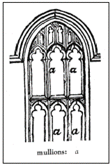
Figure 1.6-22.a
—Mullion
National Geodetic Vertical Datum—Elevation reference mark used in determining a flood boundary and floodway maps, formerly referred to as Mean Sea Level.
Natural Features Map Overlays—Comprehensive Plan and Zoning overlay designations for Natural Hazard areas and Natural Resource areas. Natural Features Map Overlays are designated on the Comprehensive Plan Map and the Official Zoning Map. The natural features are further identified on the Official Zoning Map's sub-maps entitled the Natural Hazards Map, the Significant Vegetation Map, and the Riparian Corridors and Wetlands Map.
Natural Hazards—Hazards regulated by Chapter 2.11—Floodplain Development Permit, Chapter 4.5—Floodplain Provisions, and Chapter 4.14—Landslide Hazard and Hillside Development Provisions.
Natural Resources—Resources regulated by Chapter 4.12—Significant Vegetation Protection Provisions, Chapter 4.13—Riparian Corridor and Wetland Provisions, and Chapter 4.14—Landslide Hazard and Hillside Development Provisions; as well as Significant Trees and Significant Shrubs, regulated by Chapter 4.2—Landscaping, Buffering, Screening, and Lighting.
Natural Swale—Naturally-occurring linear depression that carries surface water only after rainfall. It also transports sub-surface water either seasonally or throughout the year.
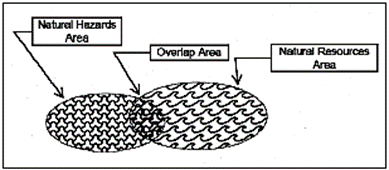
Figure 1.6-23—Net Aggregate Natural Features Area
Net Aggregate Natural Features Area—As shown in Figure 1.6-23, the area containing protected Natural Hazards, plus the area containing protected Natural Resources, minus the overlap area containing both Natural Hazards and Natural Resources so that areas are not double-counted.
New Construction—See "New Construction" in Section 1.6.40.
Nonconforming Development—See Legal Nonconforming Development. Also pertains to an unlawful existing structure or use that does not conform to the requirements of this Code or any of its predecessors.
North American Vertical Datum of 1988—The North American Vertical Datum of 1988 (NAVD 88) is the vertical control datum established in 1991 by the minimum-constraint adjustment of Canadian-Mexican-U.S. leveling observations.
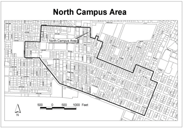
Figure 1.6-24.a—North Campus Area
North Campus Area—As shown in Figure 1.6-24.a, area generally located north of Monroe Avenue, south of Fillmore Avenue, east of Arnold Avenue, west of Eighth Street, and as particularly described in City Ordinance 92-28.
Notice of Disposition—Written communication that specifies the action of a Hearing Authority or Director concerning a development proposal.
NPDES—Refers to the National Pollution Discharge Elimination System, which is the permitting system established by the Environmental Protection Agency to administer the Federal Clean Water Act.
Nuisance—That which interferes with the enjoyment and use of property and is annoying, unpleasant, and/or obnoxious.
Office—Place designated for the Civic and Commercial Use Types of Administrative Services; Business Support Services; Financial, Insurance and Real Estate Services; Medical Services; and Professional and Research Services. See Chapter 3.0—Use Classifications for definitions of these Use Types.
Open Space—Undeveloped or predominately undeveloped land, including waterways, in and around an urban area. Open Space lands are reserved for general community use, and include parks, preserves, general drainageway corridors, and other areas permanently precluded from development.
Order—Final disposition of a case which can be affirmative, negative, injunctive, or declaratory in form. Includes grant, conditional grant, or denial of an application for development.
Outdoor Space, Common—Areas intended for common outdoor active or passive recreational use. Normally includes playgrounds/tot lots, swimming pools, recreation courts, patios, open landscaped areas, preserved natural areas, and/or greenbelts with pedestrian, equestrian, and/or bicycle trails, etc. Does not include off-street parking, loading areas, or driveways. Can be privately owned and maintained, or dedicated to the City.
Outdoor Space, Private—Areas intended for private outdoor active or passive recreational use by residents of an individual dwelling unit. Normally includes balconies, patios, and/or landscaped areas. Does not include off-street parking, loading areas, or driveways.
Overlay—Overlay on a development zone created by ordinance in recognition of a property's or area's unique characteristics, such as Historic Resources, Natural Resources, Natural Hazards, or Willamette River Greenway; or an overlay created by ordinance to signify that a Planned Development exists or is needed. An overlay is applied over the top of a property's main zone. For example, a Planned Development applied to all or a portion of a Low Density Residential (RS-6) property would result in a PD (RS-6) Overlay. See Natural Features Map Overlays.
Parcel—Unit of land created from a Partition and intended for immediate or future transfer of ownership and/or development. See also Land, Parcel of and Lot.
Partition—See Land Division.
Patio—Inner courtyard or a space for dining or recreation, adjacent to a dwelling, that has a permanent hard surface for a floor (not gravel).
Pedestrian-friendly—Built environment or development pattern that provides direct and convenient access for handicapped persons and persons on foot (pedestrians) within a development and from a development to adjacent public transportation facilities, Such as sidewalks, bus routes, and bus shelters. A pedestrian-friendly environment also provides amenities such as window space for visual relief along sidewalks (rather than parking areas), doorways adjacent to public sidewalks for ease of access, awnings and other weather protection, benches, plazas, etc., which help to make walking an efficient and desirable method of transportation.
Pedestrian Scale—Pedestrian Scale is an informal and relative standard. It suggests that the relationship between a person and the environment, whether natural or human-made, is comfortable, intimate, and contributes to the person's sense of accessibility. Additionally, Pedestrian Scale refers to the proportional relationship of a particular building, structure, or streetscape element to the human form and function.
Perennial Stream—See Stream, Perennial.
Periodic Review—Process between the state, local governments, and others, requiring local governments to update their Comprehensive Plans and land use regulations to carry out State and local goals and objectives. Required every four to 10 years.
Permeability—Ability of the soil to absorb water.
Permitted Outright—Development activity not subject to discretionary review. An example is a Single Detached residence in an RS-6 Zone.
Person—Individual, corporation, governmental agency, business trust, estate, personal trust, partnership, association, two or more people having a joint or common interest, or any other legal entity.
Plan Compatibility Review—Land use process that provides an additional review of certain uses to ensure that the intensity and characteristics of the uses are compatible with particular sites and nearby land uses. Procedures for this type of land use application are outlined in Section 1.2.110.02—General Development and Chapter 2.13—Plan Compatibility Review.
Planned Development—See Conceptual Development Plan and Detailed Development Plan.
Planned Development Modification (Major)—Land use process that provides an opportunity to allow flexibility with regard to site planning and architectural design for previously approved Conceptual or Detailed Development Plans. Such flexibility is in excess of the thresholds that define a Minor Planned Development Modification and provides benefits within the development site that compensate for requested variations from the approved Conceptual or Detailed Development Plan such that the intent of the original approval is still met. Procedures for this type of land use application are outlined in Section 1.2.110.03—Special Development and Section 2.5.60—Planned Development Modification.
Planned Development Modification (Minor)—Land use process that provides an opportunity to allow a limited amount of flexibility with regard to site planning and architectural design for previously approved Conceptual or Detailed Development Plans; and provides benefits within the development site that compensate for requested variations from the approved Conceptual or Detailed Development Plan such that the intent of the original approval is still met. Procedures for this type of land use application are outlined in Section 1.2.110.02—General Development and Section 2.5.60—Planned Development Modification.
Planned Development Overlay—One of two types of overlays. One type is a zoning overlay that exists for the life of an active Conceptual or Detailed Development Plan. Procedures for this first type of Planned Development land use application are outlined in Section 1.2.110.03—Special Development and Chapter 2.5—Planned Development. The other type is a zoning overlay established without an associated Conceptual or Detailed Development Plan. Procedures for this second type of Planned Development Overlay land use application are outlined in Section 1.2.110.03—Special Development and Chapter 3.43—PD (Planned Development) Zoning Overlay.
Plat—See Final Plat.
Plat, Partition—See Final Plat, Partition.
Plat, Subdivision—See Final Plat, Subdivision.
Policy—Decision-making guideline for actions to be taken in achieving goals and the community's vision.
Practicable—Capable of being effected; feasible.
Pre-existing Condition—Phrase used in the Stormwater Master Plan (SWMP) as a reference to the land characteristics and habitat condition prior to man-made modifications.
Preserve—To save from change or loss and reserve for a special purpose. The most strict non-degradation standard.
Pretreatment—Treatment of urban runoff prior to discharging into a public water body.
Primary Use—Main, principal, or predominant use.
Principal Use—See Primary Use.
Properly Functioning Condition (PFC)—National Marine Fisheries Service defines PFC as the sustained presence of natural habitat-forming processes that are necessary for the long-term survival of a species through the full range of environmental conditions.
Property Line Adjustment—Land use process that relocates all or a portion of the common property line between abutting properties that does not create or eliminate an additional lot or parcel, and where any reduced lot or parcel complies with the applicable zoning regulations. Procedures for this type of land use application are outlined in Section 1.2.110.02—General Development, Chapter 2.4—Land Divisions, Replats, and Property Line Adjustments, and Section 2.4.80.
Protect—To save or shield from loss, destruction, or injury or to save for future intended use.
Proximate Wetlands—See Wetlands, Proximate.
Quasi-judicial Decision—Similar to a court proceeding in which affected parties are afforded procedural safeguards. The quasi-judicial process is characteristic of most meetings of the Planning Commission and Historic Resources Commission. Personal notice must be mailed to property owners and occupants living within a prescribed distance from the affected area. Unlike legislative cases, the Planning Commission or Historic Resources Commission members are expected to avoid outside discussion of the business at hand and must declare ex parte contacts. See also Legislative Decision.
Recreational Vehicle—A vehicle that is:
a.
Built on a single chassis;
b.
400 sq. feet or less when measured at the largest horizontal projection;
c.
Designed to be self-propelled or permanently towed by a light duty truck; and
d.
Designed primarily not for use as a primary dwelling but as temporary living quarters for recreational, camping, travel, or seasonal use.
Redevelopment—Restoring or replacing existing buildings. See also Infill.
Replat—Land use process used when Lots, Parcels, or Tracts within a recorded Plat are reconfigured. A replat may also result in the creation or deletion of Lots, Parcels, or Tracts, as compared to the original, recorded Plat. Procedures for this type of land use application are outlined in Section 1.2.110.02—General Development and Chapter 2.4—Land Divisions, Replats, and Property Line Adjustments.
Reserve Strip—Strip of land dedicated to the City and reserved for use as part of a future public street or facility.
Residential Care—Services such as supervision; protection; assistance while bathing, dressing, grooming, or eating; management of money; transportation; recreation; and the provision of room and board.
Restoration—Process of returning an area to a close approximation of a former condition, and re-establishing functions.
Right-of-Way—Public travel route dedicated for vehicular, bicycle, or pedestrian use. Can and often does contain public and franchise utilities.
Riparian Area or Riparian Corridor—Land adjacent to a water body that directly affects or is affected by the aquatic environment. This includes Streams, rivers, and lakes and their side channels, Floodplains, and Wetlands, and portions of adjacent slopes that shade the channel or provide streamside habitat. The area of transition from an aquatic ecosystem to a terrestrial system.
Riparian Assessment Area—Bounded area inventoried for the Riparian Assessment portion of the Natural Features Inventory.
Riparian Corridor—See Riparian Area.
Riparian Management Zone—Area within the Willamette River Greenway, extending from the edge of the waterway to either the Top-of-bank or to the 10-year Floodplain, whichever is greater.
Riparian Corridors, Regulated—Riparian and associated upland areas regulated by Chapter 4.13—Riparian Corridor and Wetland Provisions to protect Riparian Areas and water resources. Regulated Riparian Corridors are clearly defined on the Comprehensive Plan Map, Official Zoning Map, and Riparian Corridors and Wetlands Map. Regulated Riparian Corridors have been identified for both Intermittent and Perennial Streams and widths are measured from Top-of-bank and based on areas drained. See Top-of-bank and Upland Natural Resources.
Riparian Function—A characteristic action or role provided by riparian areas, such as water quality, flood management, thermal regulation, and wildlife habitat.
Riparian Vegetation—For the purposes of these regulations, vegetation located within the Regulated Riparian Corridor.
Setback, Minimum—Minimum allowable horizontal distance from a property line (unless otherwise noted) to the nearest vertical wall of a building or structure, fence, or other element as defined by this Code.
Setback, Maximum—In zones with Frontage Occupation requirements, this measure is used for the specific purpose of calculating Frontage Occupation. In zones without Frontage Occupation requirements, this measure is the maximum allowable horizontal distance from a property line (unless otherwise noted) to the nearest vertical wall of a building or structure.
Shall—Expressing what is mandatory. Where a standard or procedure applies to residential development, that standard or procedure places a current obligation on the owner, applicant and developer.
Shallow Flooding, Area of—See "Area of Shallow Flooding" in Section 1.6.40.
Sharrow—A shared-lane marking in the center of a paved travel lane of a street indicating to motorists that bicyclists may use the full travel lane.
Should—Expressing what is desired, but not mandatory.
Sign—Device or medium affixed to property (including the device or medium's structure, lighting, materials, and component parts) which by reason of its form, color, wording, symbol, design, and illumination, visually communicates, identifies, advertises, informs, announces, or attracts attention to the subject thereof.
Significant—Feature that has been specifically identified as worthy of special recognition or protection such as a Significant Wetland, etc., or a resource that has been formally identified by the City through adopted plans and ordinances.
Significant Natural Features—See Natural Hazards and Natural Resources.
Significant Shrub—Excluding Invasive and/or Noxious Vegetation, a Significant Shrub is a living, standing plant that is either:
a.
Required to be preserved through the provisions of Chapter 2.11—Floodplain Development Permit, Chapter 4.5—Floodplain Provisions, Chapter 4.12—Significant Vegetation Protection Provisions, Chapter 4.13—Riparian Corridor and Wetland Provisions, and/or Chapter 4.14—Landslide Hazard and Hillside Development Provisions; or
b.
Over four feet in height and located outside any area inventoried by the Natural Features Inventory.
Significant Tree—Excluding Invasive and/or Noxious Vegetation, a Significant Tree is a living, standing woody plant that is either:
a.
Required to be preserved through the provisions of Chapter 2.11—Floodplain Development Permit, Chapter 4.5—Floodplain Provisions, Chapter 4.12—Significant Vegetation Protection Provisions, Chapter 4.13—Riparian Corridor and Wetland Provisions, and/or Chapter 4.14—Landslide Hazard and Hillside Development Provisions; or
b.
Located outside any area inventoried by the Natural Features Inventory and of a trunk size that is eight in. or greater in caliper at four feet above existing grade.
Significant Vegetation—Vegetation within Wildlife Habitat Areas and Isolated Tree Groves that was identified and assessed in the Natural Features Inventory and determined to be Significant through the Natural Features Project. Significant Vegetation is identified as either Highly Protected or Partially Protected based on the Significant Vegetation Map. See Chapter 4.12 - Significant Vegetation Protection Provisions.
Significant Vegetation Management Plan—Plan required by Chapter 4.12—Significant Vegetation Protection Provisions prior to the removal of any vegetation governed by the provisions of Chapter 4.12, and required either prior to or as part of a land use application, building permit application, or construction permit application, whichever comes first.
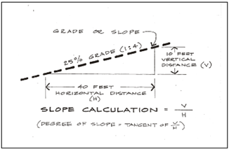
Figure 1.6-27—Slope
Slope—As shown in Figure 1.6-27—Slope, the deviation of a surface from the horizontal, usually expressed in percent or degrees. See also Grade.
Soil Bioengineering—Method of soil or land stabilization that uses living plant material selected for the specific site situation as the major structural or engineering component of the stabilization.
Solar Access—Line-of-sight path to the sun during hours that provide beneficial use of solar energy.
Solar Access Easement—Private agreement between property owners that protects Solar Access. Solar Easements are prepared and recorded pursuant to ORS 105.880-105.895, as amended.
Solar-access-friendly Trees—Trees with minimal effect on Solar Access during winter months because of their leafing and branching characteristics; deciduous trees.
Solar Access Permit (Type 1)—Land use process that provides and protects Solar Access for use of a property owner(s) by limiting shading of a solar collector by trees on adjacent properties. Procedures for this type of land use application are outlined in Section 1.2.110.02—General Development and Chapter 2.18—Solar Access Permits.
Solar Access Permit (Type 2)—Land use process that provides and protects Solar Access for use of a property owner(s) by limiting shading of a solar collector by structures on adjacent properties. Procedures for this type of land use application are outlined in Section 1.2.110.02—General Development and Chapter 2.18—Solar Access Permits.
Solar Access Protection—Right to unobstructed Solar Access for at least four hours between 9 a.m. and 3 p.m. on November 21 of each year.
Solar Collector—Heating or cooling system in which the thermal energy of solar radiation is captured and stored for later release.
Solar Energy System—Set of devices used to collect solar energy and convert and store it for purposes including heating and cooling of buildings or for the production of power.
a.
Active—Solar energy system that uses a separate collector to transform solar radiation into usable heat and a mechanical system to transfer heat to its point of use.
b.
Passive—Solar energy system that uses natural and architectural components to collect and store solar energy using minimal or no external mechanical equipment.
Solar Envelope—Drawing or representation by contour lines of a three-dimensional space over a lot or development site representing the allowable height of structures and vegetation that provides Solar Access protection for neighboring lots.
Special Development Decision—Development decision that requires considerable discretion in applying criteria and standards of this Code. Involves a public hearing in accordance with the provisions in Chapter 2.0—Public Involvement, as well as approval by an established Hearing Authority.
Special Flood Hazard Area—See "Special Flood Hazard Area" in Section 1.6.40.
Special Occupancy Structure—See "Special Occupancy Structure" in Section 1.6.40.
Special Zone—Zone created by ordinance in recognition of an area's unique characteristics such as environmental or historic resources, Natural Resources, Natural Hazards, or an identified need for redevelopment.
Specification Standards—Measurable standards applicable to development. These standards contain the minimum requirements for design and construction of improvements covered by this Code.
Staff—Administrative officers responsible for the operation and management of the City's departments and divisions.
Start of Construction—See "Start of Construction" in Section 1.6.40.
Stormwater—Rainfall or snow melt that drains into streams or pipes.
Stormwater Functions—Includes interception and temporary storage of precipitation, natural surface conveyance, stream subsurface flow, infiltration, ground water recharge, sediment and pollutant filtration, cooling, sustaining aquatic habitats, cleansing, nutrient transfer, and other beneficial functions.
Stormwater Phase II Rules—Federal Clean Water Act regulations that deal with runoff water quality issues, including pollutants and construction sediments.
Story—Consistent with the definition for Story from the Oregon Structural Specialty Code.
Stream—A channel such as a river or creek that carries flowing surface water, including Perennial Streams and Intermittent Streams with defined channels, and excluding man-made irrigation and drainage channels.
Stream Corridor—Corridor of land of variable width along each side of a stream channel that is primarily reserved for stormwater-related and other stream system functions and processes.
Stream, Intermittent—Stream that flows primarily during the wet seasons when the water table is high, and remains dry for a portion of the year. Most Intermittent Streams flow for a good portion of the year (DSL — ORS 196.800, as amended). Typically, when Intermittent Streams lack surface flow, they continue to have ground water flow through gravels below the surface. Intermittent Streams in Corvallis, defined through the Natural Features Scoping Project, are further defined as natural drainageways that:
a.
Do not have year-round flows in a water year (October 1 through September 30) based on a precipitation total at the time of determination that is within 20 percent of average total precipitation for the past 30 years; and
b.
Drain at least 20 acres.
Upon field verification, an Intermittent Stream may be defined to include a distinct channel upstream from the 20-acre drainage basin, provided that Riparian Vegetation is present.
Stream, Perennial—Stream that has flowing water year-round during a typical year. The water table is located above the streambed for most of the year. Ground water is the primary source of water for stream flow. Runoff from rainfall is a supplemental source of water for stream flow. Perennial Streams in Corvallis, defined through the Natural Features Scoping Project, are further defined as natural drainageways that include all stream segments inventoried through the City of Corvallis Endangered Species Act 2001 Inventory and other drainageways that:
a.
Have year-round flows in a water year (October 1 through September 30) based on a precipitation total at the time of determination that is within 20 percent of average total precipitation for the past 30 years; and
b.
Drain at least 20 acres.
Stream System—Channel, subsurface flow, and adjacent corridor, including the floodplain.
Streets—As designated and defined in the City of Corvallis Transportation System Plan. See also Chapter 4.0—Improvements Required with Development.
Structure—Combination of materials to form a construction for use, occupancy, or ornamentation whether installed on, above, or below the surface of land or water. For the definition of Structure as applied to the 100-year Floodplain regulations contained in Chapter 2.11—Floodplain Development Permit and Chapter 4.5—Floodplain Provisions, see Section 1.6.40.
Structure Height—See Height of Buildings.
Subdivision—See Land Division.
Substantial Damage—Damage to structures within the 100-year Floodplain and/or damage to structures containing Nonconforming Uses, as defined below:
a.
Substantial Damage to Structures within the 100-Year Floodplain—For the definition of Substantial Damage as applied to the 100-year Floodplain regulations contained in Chapter 2.11—Floodplain Development Permit and Chapter 4.5—Floodplain Provisions, see Section 1.6.40.
b.
Substantial Damage to Structures Containing Nonconforming Uses—Damage of any origin sustained by a structure containing a Nonconforming Use, to an extent exceeding 50 percent of the structure's market value before the damage occurred.
Substantial Improvement—Rehabilitation, repair, reconstruction, addition, or other improvement of a structure, the cost of which equals or exceeds 50 percent of the structure's market value before the Start of Construction of the improvement. This term includes structures which have incurred Substantial Damage, regardless of the actual repair work performed. The market value of the structure is:
a.
The appraised real market value of the structure prior to the start of the initial repair or improvement; or
b.
In the case of damage, the appraised real market value of the structure prior to the damage occurring. The term does not include either:
1.
A project for improvement of a structure to correct existing violations of state or local health, sanitary, or safety code specifications, which have been identified by the local code enforcement official and which are the minimum necessary to ensure safe living conditions; or
2.
Alteration of an Historic Structure, provided that the alteration will not preclude the structure's continued designation as an Historic Structure.
Sunchart—Photograph showing the sun's positions during different hours and seasons of the year and any trees, buildings, or topographies that obstruct Solar Access. The Sunchart includes as coordinates the solar altitude in 10-degree or smaller increments and solar azimuth in 15-degree or smaller increments.
Surface Parking Area—Portion of a Development Site, at Finished Grade, containing all paved surfaces intended for vehicular access including, but not limited to, parking spaces, drive aisles, driveways, and turnaround areas.
Sustainable—Able to be maintained or continued indefinitely.
Tenant Space—A portion of a structure occupied by nonresidential use(s) on the first floor of a building, with its own public entrance from the exterior of the building or through a shared lobby, atrium, mall, or hallway and separated from other tenant spaces by walls without doors.
Tentative Subdivision Plat—See "b" under Land Division.
Through Lot—Lot that fronts two parallel streets or that fronts two streets that do not intersect at the lot's boundaries.
Through Lot Easement—Landscape easement adjacent to a street and adjacent to or part of a Through Lot. Contains landscape screening.
Timber Harvest, Commercial—Cutting, removing, severing from the land, trees for wood production and/or for sale. Commercial Timber Harvesting may be regulated by the Oregon Forest Practices Act. Christmas tree farming is not a form of Commercial Timber Harvesting. It is an agricultural land use.
Timber Harvest, Noncommercial—Cutting, removing, severing from the land, trees for personal use such as fire wood, and/or clearance to create development areas. Wood is not sold to another party, and activities are generally not regulated by the Oregon Forest Practices Act.
Top-of-bank—Bankfull stage of a Stream or river which is the stage or elevation at which water overflows the natural banks of Streams or other waters of this state and begins to inundate the upland. In the absence of physical evidence, the two-year recurrence interval flood elevation may be used to approximate the bankfull stage or delineate the Top-of-bank.
Tract—A piece of land created and designated as part of a land division that is not a lot, lot of record, or parcel. Tracts are created and designed for a specific purpose. Land uses within a tract are restricted to those uses consistent with the stated purpose as described on the plat, or in the maintenance agreements, or through Conditions, Covenants and Restrictions (CC&Rs). Examples include stormwater management tracts, private access tracts, private street or alley tracts, tree preservation tracts, landscaping or common area tracts, environmental resource tracts, and open space tracts, etc.
Traffic Calming—Use of devices to slow traffic speeds. Devices include bulbed intersections, speed humps, raised planted medians, mid-block curb extensions, traffic circles, signage, and varied paving materials. Traffic Calming is addressed in the Transportation Plan and may be used on Neighborhood Collector and Local Streets.
Transportation uses and activities—For purposes of the Transportation System Plan, this phrase includes, but is not limited to, routine discretionary decisions on how existing streets will operate, such as speed limits, lane closures, bridge load capacity, and the timing of traffic signals.
Tree Canopy—A view which is dominated by the appearance of trees. As used in the Comprehensive Plan, Tree Canopy refers to those hillside areas where trees are the major visual feature when viewed from a horizontal plane or from lower elevations.
Tree Canopy Coverage—The percentage of a lot, parcel, tract, development site, and/or common area that is within the drip line of trees as measured on a horizontal plane.
a.
Mature Tree Canopy Coverage—The area that is expected to be within the drip line at the anticipated time of maturity of the tree by species.
b.
Fifteen-year Mature Tree Canopy Coverage—The area that is expected to be within the drip line at year fifteen from the date of planting based upon a planting of one- or 1.5-in. caliper trees and based upon the specific tree by species.
Tree Grove—A group of trees that are predominantly 25 feet or more in height and have continuous canopy cover of 0.5 acre or more and are identified in the Natural Features Inventory.
Tree Grove, Isolated—Tree Groves that are not located within other resource areas.
Tree Grove, Mitigation—Tree Groves required to be planted or retained as mitigation for development.
Tree, Hazardous—Trees which are determined by a certified arborist and/or the City Urban Forester to be of immediate health, safety, or welfare threat to persons or property. Immediate health, safety, or welfare threat includes damage to persons or property from tree collapse or limb breakage that is imminent or expected during average annual winter storm events. Hazardous Trees include trees that are cracked, split, leaning, or physically damaged to the degree that they are likely to fail and injure persons or property. Hazardous Trees also include trees that are sufficiently diseased, damaged, and/or decayed that treatment to restore their health is not warranted, and that without reasonable treatment and pruning, the disease is likely to spread to adjacent trees and cause such adjacent trees to become diseased or hazardous.
Tree, Large Canopy—Trees that, at maturity, are expected to have a Tree Canopy Coverage of 30 feet or more in diameter.
Tree, Medium Canopy—Trees that, at maturity, are expected to have a Tree Canopy Coverage of less than 30 feet in diameter.
Undeveloped Land in the 100-year Floodplain—Either: (1) land that does not contain a primary structure; or (2) in cases where land does contain a primary structure, then land that can be divided and the resulting vacant parcels can be developed per this Code.
Upland Natural Resources—Natural Resources, Natural Hazards, and areas outside of the Stream Corridor and the 100-year Floodplain that influence stormwater function and management. They include uplands, Wetlands, vegetation, swales, and ground water zones.
Urban Fringe—Area within the Urban Growth Boundary and outside the City limits.
Urban Growth Boundary—Line that circumscribes the Urban Fringe and the City Limits and that is intended by state and local regulations to contain the area available to urban development.
Use—Purpose of or activity on a site.
Use Type—Classification of a Use or Uses on the basis of common functional, product, or compatibility characteristics, thereby regulating Uses in accordance with criteria directly relevant to the public interest. See Chapter 3.0—Use Classifications for definitions of specific Use Types.
Vacate—Release of interest in a piece of property.
Vacating of Public Lands and Plats—Land use process that petitions to vacate all or parts of a public street, alley, easement, plat, or other public place if determined not to be harmful to the City or adjacent properties. Procedures for this type of land use application are outlined in Section 1.2.110.03—Special Development and Chapter 2.8—Vacating of Public Lands and Plats.
Vegetation Cover Types, ARA—ARA habitat classes in the Natural Features Inventory. The Vegetation Cover Types, or ARA habitat classes, are as shown below in Table 1.6-1—Vegetation Cover Types.
Vegetation Sub-polygon—A subarea within a wildlife habitat area containing a single Vegetation Cover Type such as conifer woodland or oak savanna. See the wildlife habitat assessment portion of the Natural Features Inventory for the definition of wildlife habitat area.
Vertical Addition—The addition of a room or rooms on top of an existing building.
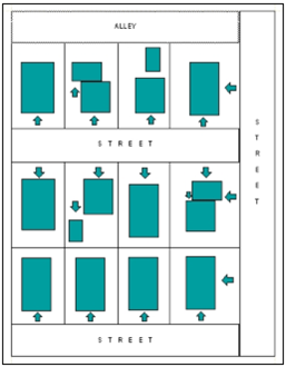
Figure 1.6-28—Visibility from Streets
Visible from Public Rights-of-way (Excluding Alleys) and Private Street Rights-of-way—As indicated by the arrows in Figure 1.6-28—Visibility from Streets, structures and appurtenances that face public rights-of-way (excluding alleys) and private street rights-of-way are considered visible unless screened consistent with "a" or "b" below.
In all cases the screen shall be of an equal or greater height and width as the structure being screened.
The structure or appurtenance shall be screened by:
a.
A solid structure; or
b.
A hedge or fence with a minimum opacity of 80%.
Vision Clearance Area—Specific distances and prohibitions on visual obstructions within Vision Clearance Areas are determined by the City Engineer.
Visual Obstruction—Fence, hedge, tree, shrub, device, wall, or structure between the elevations of two feet and eight feet above the adjacent curb height or above the elevation of the gutter line of a street edge where there is no curb, as determined by the City Engineer, and so located at a street, driveway, or alley intersection as to limit the visibility of pedestrians or persons in motor vehicles.
Walkway—A pedestrian way, including but not limited to a sidewalk or path, providing access within public right-of-way or on private property.
Watercourse—Any natural or artificial Stream, river, creek, ditch, channel, canal, conduit, culvert, drain, waterway, gully, ravine, or wash in which water:
a.
Flows in a definite direction or course, either continuously or intermittently;
b.
Has a definite channel, bed, and banks; and
c.
Includes an area adjacent thereto subject to inundation by reason of overflow or floodwater.
Water-dependent—Use or activity that can be carried out only on, in, or adjacent to water areas because the Use requires access to the water source or to the water body for water-borne transportation, recreation, or energy production.
Water-related—Use not directly dependent upon access to a water body, but that provides goods or services directly associated with Water-dependent land or waterway use and that, if not located adjacent to water, would result in a public loss of quality in the goods or services offered. Residences, parking lots, spoil and dump sites, roads and highways, restaurants, businesses, factories, and Manufactured Dwelling Facilities are not generally considered Water-dependent or Water-related.
Water Service Levels—The Corvallis Urban Growth Boundary is divided into four Water Service Levels based on elevation and associated water pressure in each area. These elevation ranges are:
a.
1 st level = 210 feet to 290 feet;
b.
2 nd level = 290 feet to 410 feet;
c.
3 rd level = 410 feet to 560 feet; and
d.
4 th level = above 560 feet
The 4 th Water Service Level is not served by City water.
Watershed—Drainage area of a specific stream system. Small Watersheds are components of larger Watersheds.
Water Surface Elevation—The height, in relation to a specific Datum, of floods of various magnitudes and frequencies in the Floodplains of coastal or riverine areas.
Wetlands—Areas that are inundated or saturated by surface water or ground water at a frequency and duration sufficient to support, and that under normal circumstances do support, a prevalence of vegetation typically adapted for life in saturated soil conditions. Wetlands are generally characterized by one of three parameters; certain soil types, aquatic plants, and hydrology.
Wetland Assessment—Determining the relative quality of a Wetland by assessing its functions and conditions. The methodology generally used to determine the relative quality of Wetlands for purposes of a Local Wetlands Inventory (LWI) is the Oregon Freshwater Wetland Assessment Methodology (Roth, et.al. 1996).
Wetland Delineation—Process of determining the boundary between a Wetland and an uplands. Delineations must be carried out following the guidelines of the U.S. Army Corps of Engineers and the Oregon Department of State Lands. A Wetland Delineation locates the boundary between the Wetland and upland, based on the field indicators of vegetation, soils, and hydrology.
Wetland Function—A characteristic action or behavior associated with a Wetland that contributes to a larger ecological condition such as wildlife habitat, water quality, and/or flood control.
Wetland Hydrology—Permanent or periodic inundation or prolonged soil saturation sufficient to create anaerobic conditions in the upper soil profile.
Wetlands, Jurisdictional—Wetlands regulated by the state and/or federal government.
Wetlands, Local Wetlands Inventory (LWI)—An inventory of all Wetlands greater than 0.5 acre within a jurisdiction using the standards and procedures of OAR 141-86-110 through 141-86-240, as amended over time. Local Wetlands Inventory information and mapping are intended for planning purposes only. Mapped Wetland boundaries are accurate to within 25 feet However, there may be unmapped Wetlands that are subject to state and federal regulation. In all cases, actual field conditions determine specific Wetland boundaries.
Wetlands, Locally Protected Locally Significant Wetlands (LPLSW)—Locally Significant Wetlands that are protected through local government regulations, in addition to any state or federal regulations.
Wetlands, Locally Significant Wetlands (LSW)—Wetlands determined to be locally significant in compliance with Oregon Administrative Rules (OARs), which meet the Oregon Freshwater Assessment Methodology criteria for Locally Significant Wetlands; and which have been adopted in the Local Wetlands Inventory as being locally significant. Locally Significant Wetlands are identified on the Locally Significant Wetlands Map.
Wetlands, Proximate—Jurisdictional Wetlands within or adjacent to a Riparian Corridor that are not limited to Locally Significant Wetlands. These Proximate Wetlands enhance Riparian Function and receive protection as part of a Riparian-related area.
Wetlands Regulations—Regulations pertaining to Wetlands in the State or Oregon, including:
a.
State of Oregon Department of State Lands regulations from the Removal-Fill Law outlined in ORS 196.800-196.990, as amended over time;
b.
U.S. Army Corps of Engineers through Section 404 of the Clean Water Act, as amended over time; and
c.
City of Corvallis regulations as amended over time and pertaining to:
1.
Locally Protected Locally Significant Wetlands;
2.
Wetlands located in Riparian Corridors, with respect to the Wetlands' Riparian Function and Floodplain Functions; and
3.
Wetlands located in the 100-year Floodplain, with respect to the Wetlands' Riparian Function and Floodplain Functions.
Willamette River Greenway Conditional Development—Land use process that is a type of Conditional Development required for development within lands subject to a Willamette River Greenway (WRG) Zoning Overlay, when the development is not considered Exempt per the provisions of Section 3.41.30—Exemptions. Procedures for this type of land use application are outlined in Section 1.2.110.03—Special Development, Chapter 3.41—WRG (Willamette River Greenway) Zoning Overlay, and Chapter 2.3—Conditional Development.
Yard—Open space unobstructed from the ground upward except as otherwise provided in this Code. In the case of a corner lot, the front, rear, and side yards that were determined at the time of original construction of structure(s) on the lot may be used for the purposes of remodeling, rebuilding, and/or constructing additions, accessory structures, etc.
Yard, Exterior Side—As shown in Figure 1.6-29—Exterior Side Yard below, the yard extending from the front yard to the rear lot line on the street side of a corner lot.
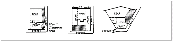
Figure 1.6-29—Exterior Side Yard
Yard, Front—As shown in Figure 1.6-30—Front Yard below, the yard extending across the full width of the lot, the depth of which is the minimum horizontal distance between the front lot line and a line parallel to the nearest point of the main building.
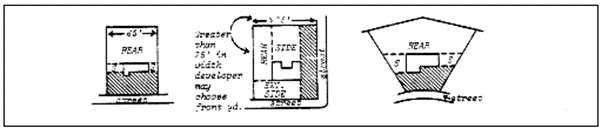
Figure 1.6-30—Front Yard
Yard, Rear—As shown in Figure 1.6-31—Rear Yard below, yard extending across the full width of the lot, the depth of which is the minimum horizontal distance between the rear lot line and a line parallel to the nearest point of the main building.
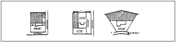
Figure 1.6-31—Rear Yard
Yard, Side—As shown in Figure 1.6-32—Side Yard below, yard between the main building and the side lot line extending from the front yard or front lot line where no front yard is required, to the rear yard. The width of the required side yard is the minimum horizontal distance between the side lot line and a line parallel to the nearest point of the main building.

Figure 1.6-32—Side Yard
Zone—Area of land within the Corvallis City limits designated for specific types of permitted developments and subject to the development requirements of that zone.
Zone Change—Amendment to the boundaries of zones shown on the Official Zoning Map. Procedures for this type of land use application are outlined in Sections 1.2.90.01 and 1.2.110.03—Special Development, and Chapter 2.2—Zone Changes.
(Ord. No. 2012-16, eff. 12-13-2012; Ord. No. 2012-17, eff. 12-13-2012; Ord. No. 2012-18, eff. 12-13-2012; Ord. No. 2012-19, eff. 12-13-2012; Ord. No. 2014-11, eff. 2-28-2014; Ord. No. 2014-18, eff. 12-11-2014; Ord. No. 2014-19, eff. 12-11-2014; Ord. No. 2018-01, eff. 1-26-2018; Ord. No. 2018-36, eff. 1-1-2019; Ord. No. 2019-08, eff. 3-14-2019; Ord. No. 2020-04, eff. 3-3-2020; Ord. No. 2021-06, eff. 5-25-2021; Ord. No. 2021-22, eff. 11-24-2021; Ord. No. 2022-06, eff. 3-17-2022; Ord. No. 2022-12, eff. 6-1-2022; Ord. No. 2022-22, eff. 7-15-2022; Ord. No. 2022-24, eff. 2-28-2022; Ord. No. 2023-01, eff. 2-8-2023; Ord. No. 2023-19, §§ 4, 5(Exh. A), eff. 6-30-2023; Ord. No. 2023-24, § 2(Exh. A), 8-21-2023; Ord. No. 2023-27, § 2(Exh. A), eff. 2-28-2024; Ord. No. 2024-26, §§ 1, 2, 5, 6(Exh. A), eff. 1-1-2025; Ord. No. 2025-03, §§ 2, 3(Exh. A), eff. 3-27-2025; Ord. No. 2025-25, § 2, 3(Exh. A), eff. 6-12-2025; Ord. No. 2025-28, § 3(Exh. A), eff. 6-26-2025; Ord. No. 2025-31, § 3(Exh. A), 7-21-2025)
Section 1.6.40 - Specific Words and Terms Particular To The 100-Year Floodplain Regulations In LDC Chapter 2.11—Floodplain Development Permit and Chapter 4.5—Floodplain Provisions.
| ***THE DEFINITIONS PROVIDED BELOW ONLY PERTAIN TO INSTANCES WHERE THE SUBJECT WORD OR TERM IS USED WITHIN THE CONTEXT OF 100-YEAR FLOODPLAIN REGULATIONS PRIMARILY PRESENTED IN LDC CHAPTER 4.5—FLOODPLAIN PROVISIONS & LDC CHAPTER 2.11—FLOODPLAIN DEVELOPMENT PERMIT. NOTE—WHERE DEFINED WORDS OR TERMS ARE USED WITHIN THE DEFINITIONS OF OTHER WORDS OR TERMS PROVIDED BELOW, THE DEFINITIONS FROM SECTION 1.6.40 APPLY*** | ||
|---|---|---|
| Word or Term | 100-year Floodplain Specific Definition | |
| Appeal | A request for a review of the interpretation of any provision of this ordinance or a request for a variance. See Chapter 2.11 and 2.19. | |
| Area of Shallow Flooding | A designated AO or AH Federal Flood Zone on a community's Flood Insurance Rate Map (FIRM) with base flood Depth Number(s) from one to three ft., and/or where a clearly defined channel does not exist, where the path of flooding is unpredictable and indeterminate, and where velocity flow may be evident. Also includes additional areas that meet the FEMA definition for the AO or AH Federal Flood Zones, but which are located in areas not currently identified in the Flood Insurance Study for Benton County, Oregon and Incorporated Areas, dated June 2, 2011. Such additional areas must be identified in an independent study that is developed by the State of Oregon or a registered engineer and approved by the Floodplain Administrator or designee, in accordance with Section 2.11.50.01.h. | |
| Area of Special Flood Hazard | See "Special Flood Hazard Area" in this Section 1.6.40. | |
| Base Flood | Flood that has a one percent chance of being equaled or exceeded in any given year. Also commonly referred to as the 100-year Flood, the Base Flood has been adopted by the Federal Emergency Management Agency (FEMA) for Floodplain management purposes, and refers to a flood event that inundates the entire 100-year Floodplain. See Floodplain, 100-Year and Flood, 100-Year. | |
| Base Flood Elevation | The water surface elevation during the Base Flood in relation to a specified Datum. The Base Flood Elevation (BFE) is depicted on the Flood Insurance Rate Map to the nearest foot and in the Flood Insurance Study to the nearest 0.1 foot. Not every potential Special Flood Hazard Area within the Urban Growth Boundary has been mapped by the Federal Emergency Management Agency through the Flood Insurance Study, Flood Insurance Rate Maps, and Digital Flood Insurance Rate Maps. The Floodplain Administrator or designee is authorized through Sections 2.11.50.01.h and 4.5.60.01.b to obtain the information necessary to determine the presence and extent of unmapped Special Flood Hazard Areas and the associated Base Flood Elevation as part of reviewing development proposals that affect the 100-year Floodplain. Such information will be used by the City of Corvallis to supplement the Flood Insurance Study, Flood Insurance Rate Maps, and Digital Flood Insurance Rate Maps. | |
| Basement | The portion of a structure with its floor sub grade (below ground level) on all sides. | |
| Below-grade Crawlspace | An enclosed area below the Base Flood Elevation in which the interior grade is not more than two feet below the lowest adjacent exterior grade and the height, measured from the interior grade of the crawlspace to the top of the crawlspace foundation, does not exceed 4 feet at any point. | |
| Breakaway Wall | A wall that is not part of the structural support of the building and is intended through its design and construction to collapse under specific lateral loading forces, without causing damage to the elevated portion of the building or supporting foundation system. | |
| Building Codes | The combined specialty codes adopted under ORS 446.062, 446.185, 447.020 (2), 455.020 (2), 455.496, 455.610, 455.680, 460.085, 460.360, 479.730 (1) or 480.545, but does not include regulations adopted by the State Fire Marshal pursuant to ORS chapter 476 or ORS 479.015 to 479.200 and 479.210 to 479.220. | |
| Critical Facility |
A facility that is critical for the health and welfare of the population and is especially
important to be located above the Base Flood Elevation following hazard events. The
following is the list of Critical Facilities for the purposes of Section 4.5.110.11:
a. Hospitals and other medical facilities having surgery and emergency treatment areas; b. Fire and police stations; c. Tanks or other structures containing, housing or supporting water or fire-suppression materials or equipment required for the protection of essential or hazardous facilities or special occupancy structures. These tanks or other structures do not include City water distribution facilities; d. Emergency vehicle shelters and garages; e. Structures and equipment in emergency-preparedness centers; f. Standby power generating equipment for essential facilities; g. Structures and equipment in government communication centers and other facilities required for emergency response; and h. Other facilities as determined by the Floodplain Administrator or designee. Some types of facilities may be critical to a community, but require location within or partially within Special Flood Hazard Areas because of the nature of the facilities. The Taylor Water Treatment plant along the Willamette River is an example of such a facility. It is pulling water from the Willamette River. Because of this fact, these types of facilities have purposefully been excluded the list above. | |
| Depth Number | The depth of a Base Flood in a designated AO or AH Federal Flood Zone. These AO and AH Federal Flood Zones consist of an Area of Shallow Flooding and the Base Flood depths in those Areas of Shallow Flooding are the Depth Numbers. These Depth Numbers typically range from one to three feet See "Area of Shallow Flooding" in Section 1.6.40. | |
| Design Flood Elevation (DFE) | One foot above Base Flood Elevation (BFE). | |
| Development | Any manmade change to improved or unimproved real estate, including, but not limited to, buildings or other structures, fencing, mining, dredging, filling, grading, paving, excavation or drilling operations or storage of equipment or materials located within the Special Flood Hazard Area. | |
| Digital Flood Insurance Rate Map | Depicts flood risk and Federal Flood Zones and flood risk information. The Digital Flood Insurance Rate Map (DFIRM) presents the flood risk information in a format suitable for electronic mapping applications. | |
| Elevated Building | A non-basement building which has its lowest elevated floor raised above ground level by foundation walls, shear walls, posts, piers, pilings, or columns. | |
| Existing Building or Structure | A Structure for which the Start of Construction commenced before June 2, 2011. | |
| Federal Emergency Management Agency (FEMA) | The agency with the overall responsibility for administering the National Flood Insurance Program. | |
| Federal Flood Zone | Federal Flood Zones are geographic areas that the Federal Emergency Management Agency (FEMA) has defined according to varying levels of flood risk. These Federal Flood Zones are depicted on a community's Flood Insurance Rate Map (FIRM) or on Floodplain study maps approved by the Floodplain Administrator or designee. Each Federal Flood Zone reflects the severity or type of flooding in the area. | |
| a. High Risk Areas—These areas are all in the Special Flood Hazard Area (the 100-yr. Floodplain). In communities that participate in the National Flood Insurance Program (NFIP), mandatory flood insurance purchase requirements apply to all of these Federal Flood Zones. | ||
| Federal Flood Zone | Description | |
| A | Areas with a one percent or greater chance of flooding in any given year and a 26 percent chance of flooding over the life of a 30-yr. mortgage. Because detailed analyses are not performed for such areas, no Depth Numbers or Base Flood Elevations are shown within areas with this Federal Flood Zone. | |
| Federal Flood Zone definition continued | AE & A1-A30 | The base Floodplain where Base Flood Elevations derived from detailed analyses are shown at selected intervals. Areas with a one percent or greater chance of flooding in any given year and a 26 percent chance of flooding over the life of a 30-yr. mortgage. The AE Federal Flood Zone is now used on the new format Flood Insurance Rate Maps (FIRMs) instead of the old format of A1—A30 Federal Flood Zones. |
| AH | Areas with a one percent or greater chance of shallow flooding in any given year, usually in the form of a pond, with an average Depth Number ranging from one to three feet These areas have a 26 percent chance of flooding over the life of a 30-yr. mortgage. Base Flood Elevations derived from detailed analyses are shown at selected intervals within areas with this Federal Flood Zone. | |
| AO | River or stream flood hazard areas, and areas with a one percent or greater chance of shallow flooding each year, usually in the form of sheet flow, with an average Depth Number ranging from one to three feet These areas have a 26 percent chance of flooding over the life of a 30-yr. mortgage. Average flood Depth Numbers derived from detailed analyses are shown within areas with this Federal Flood Zone. | |
| Federal Flood Zone definition continued | AR | Areas with a temporarily increased flood risk due to the building or restoration of a flood control system (such as a levee or dam). Mandatory flood insurance purchase requirements will apply, but rates will not exceed the rates for unnumbered A Federal Flood Zones if the structure is built or restored in compliance with Federal Flood Zone AR Floodplain management regulations. |
| A99 | Areas with a one percent or greater chance of flooding in any given year that will be protected by a Federal flood control system where construction has reached specified legal requirements. No Depth Numbers or Base Flood Elevations are shown within areas with this Federal Flood Zone. | |
| b. Moderate to Low Risk Areas—These areas are outside of the Special Flood Hazard Area. In communities that participate in the National Flood Insurance Program (NFIP), flood insurance is available to all property owners and renters in these Federal Flood Zones. | ||
| Federal Flood Zone definition continued | B & X (Shaded) | Area of moderate flood hazard, usually the area between the limits of the 100-yr. and 500-yr. floods. Federal Flood Zone B is also used to designate base floodplains of lesser hazards, such as areas protected by levees from the 100-yr. Flood, or shallow flooding areas with average Depth Numbers of less than one feet, or drainage areas less than one sq. mile. |
| C & X (Unshaded) | Area of minimal flood hazard, usually depicted on Flood Insurance Rate Maps (FIRMs) as above the 500-yr. flood level. Federal Flood Zone C may have ponding and local drainage problems that don't warrant a detailed study or designation as base floodplain. Federal Flood Zone X is the area determined to be outside the 500-yr. flood and protected by levee from the 100-yr. flood. | |
| V | Coastal areas with a one percent or greater chance of flooding in any given year and an additional hazard associated with storm waves. These areas have a 26 percent chance of flooding over the life of a 30-yr. mortgage. No Base Flood Elevations are shown within areas with this Federal Flood Zone. | |
| Federal Flood Zone definition continued | V & V1—30 | Coastal Areas with a one percent or greater chance of flooding in any given year and an additional hazard associated with storm waves. These areas have a 26 percent chance of flooding over the life of a 30-yr. mortgage. Base Flood Elevations derived from detailed analyses are shown at selected intervals on areas in this Federal Flood Zone. |
| c. Undetermined Risk Areas—
| ||
| Federal Flood Zone | Description | |
| D | Areas with possible but undetermined flood hazards. No flood hazard analysis has been conducted. Flood insurance rates are commensurate with the uncertainty of the flood risk. | |
| Flood or Flooding |
(a) A general and temporary condition of partial or complete inundation of normally
dry land areas from:
(1) The overflow of inland or tidal waters. (2) The unusual and rapid accumulation or runoff of surface waters from any source. (3) Mudslides (i.e., mudflows) which are proximately caused by flooding as defined in paragraph (a)(2) of this definition and are akin to a river of liquid and flowing mud on the surfaces of normally dry land areas, as when earth is carried by a current of water and deposited along the path of the current. (b) The collapse or subsidence of land along the shore of a lake or other body of water as a result of erosion or undermining caused by waves or currents of water exceeding anticipated cyclical levels or suddenly caused by an unusually high water level in a natural body of water, accompanied by a severe storm, or by an unanticipated force of nature, such as flash flood or an abnormal tidal surge, or by some similarly unusual and unforeseeable event which results in flooding as defined in paragraph (a)(1) of this definition. | |
| Flood Insurance Rate Map (FIRM) | An official map of a community, issued by the Federal Insurance Administration, delineating the Special Flood Hazard Areas and/or risk premium Federal Flood Zones applicable to the community. | |
| Flood Insurance Study (FIS) | The official report by the Federal Insurance Administration evaluating flood hazards and containing flood profiles, floodway boundaries and water surface elevations of the Base Flood. | |
| Flood, 100-year | Flood with a one percent chance of being equaled or exceeded in any given year. This is the flood most commonly used for regulatory purposes and is called the Base Flood. As shown below in Figure 1.6-33—Floodplain Cross Section, this flood event inundates the entire 100-year Floodplain. See Base Flood. | |
| Flood Map | A flood map is any map that shows flood risk zones and their boundaries and may also show floodways and Base Flood Elevations (BFEs). This includes independent flood studies and their associated maps, flood maps produced by FEMA (Flood Insurance Rate Map (FIRM), Flood Boundary and Floodway Map (FBFM), and Flood Hazard Boundary Map (FHBM)), and any map or data from any government agency that provides flood boundary information. | |
| Floodplain | As shown below in Figure 1.6-33—Floodplain Cross Section, the area adjacent to a stream or river channel that is covered by water when the river or stream overflows its banks. | |
| Floodplain Development Permit | Federally required permit required prior to construction and other development in any Special Flood Hazard Area (100-yr. Floodplain). See Chapter 2.11—Floodplain Development Permit. | |
| Floodplain Development Permit Variance | A grant of relief by Corvallis from the terms of a flood plain management regulation. See Section 2.11.60. | |
| Floodplain Functions | Hydrological and ecological functions including conveyance and temporary storage of floodwater, depositions of sediments outside of the channel, ground water recharge, water quality, reduction of floodwater velocity and erosive forces, nutrient exchange, refuges, and riparian vegetation conditions/wildlife habitat. | |
| Floodplain Mitigation Assessment | An assessment of the portions of a site that are within the special flood hazard area, performed by a Qualified Professional, that identifies existing site conditions before development occurs, describes the impact the proposed development would have on existing floodplain functions within the applicable portion of the existing site, and identifies the mitigation needed for the proposed development to result in no net loss of those floodplain functions. The city website includes the guidance prepared by the Federal Emergency Management Agency for preparation of a floodplain mitigation assessment. | |
| Floodplain, 100-year |
A land area adjacent to a river, stream, or other water body that is subject to a
one percent or greater chance of flooding in any given year. The Floodplain is divided
into two sections: the Floodway and Floodway Fringe areas (see Figure 1.6-33). The
100-year Floodplain is mapped by the Federal Emergency Management Agency (FEMA) on
Flood Insurance Rate Maps (FIRMs) or, for areas not mapped by FEMA, it is mapped via
Floodplain studies approved by the Floodplain Administrator or designee. It is referred
to as the Special Flood Hazard Area (SFHA) and is the area subject to Base Flood regulations.
Not every potential Special Flood Hazard Area within the Urban Growth Boundary has
been mapped by the Federal Emergency Management Agency through the Flood Insurance
Study, Flood Insurance Rate Maps, and Digital Flood Insurance Rate Maps. The Floodplain
Administrator or designee is authorized through Sections 2.11.50.01.h and 4.5.60.01.b
to obtain the information necessary to determine the presence and extent of unmapped
Special Flood Hazard Areas as part of reviewing development proposals that affect
the 100-year Floodplain. Such information will be used by the City of Corvallis to
supplement the Flood Insurance Study, Flood Insurance Rate Maps, and Digital Flood
Insurance Rate Maps and these areas are also subject to Base Flood regulations. See
Base Flood.
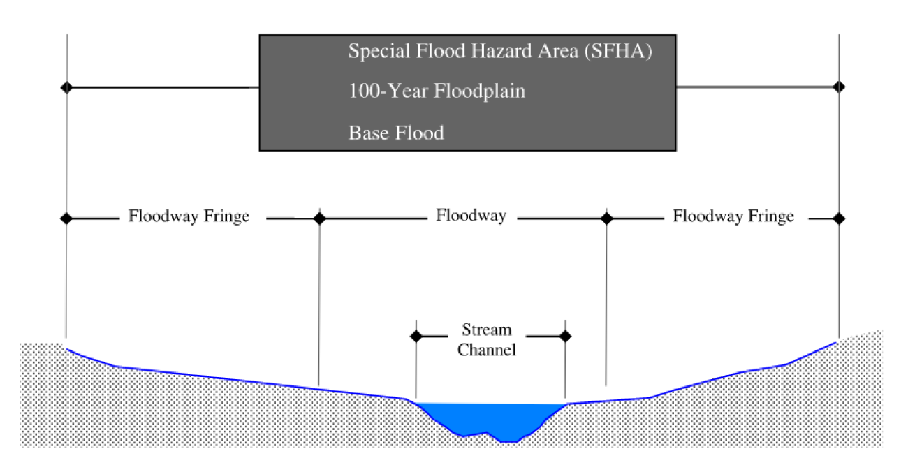 Figure 1.6-33--Floodplain Cross Section
| |
| Floodproofing | Any combination of structural and nonstructural additions, changes, or adjustments to structures which reduce or eliminate risk of flood damage to real estate or improved real property, water and sanitary facilities, structures, and their contents. | |
| Floodway (Regulatory Floodway) |
The channel of a river or other watercourse and those portions of the floodplain adjoining
the channel required to discharge and store the floodwater or flood flows associated
with the regulatory flood.
a. Floodway, 0.2-ft. - As shown above in Figure 1.6-33 - Floodplain Cross Section, river channel or other Watercourse and the adjacent land areas that must be reserved in order to discharge the Base Flood (100-year Flood) without cumulatively increasing the Water Surface Elevation more than 0.2 ft. The Regulatory Floodway for the City of Corvallis is the 0.2-ft. Floodway unless otherwise noted in the Benton County, Oregon and Incorporated Areas Flood Insurance Study. b. Floodway, 1.0-ft. - As shown above in Figure 1.6-33 - Floodplain Cross Section, river channel or other Watercourse and the adjacent land areas that must be reserved in order to discharge the Base Flood (100-year Flood) without cumulatively increasing the Water Surface Elevation more than 1.0 ft. The Regulatory Floodway for the City of Corvallis is the 0.2-ft. Floodway unless otherwise noted in the Benton County, Oregon and Incorporated Areas Flood Insurance Study. c. Floodway, Locally Adopted - As shown above in Figure 1.6-33 - Floodplain Cross Section, river channel or other Watercourse and the adjacent land areas that must be reserved in order to discharge the Base Flood (100-year Flood) without cumulatively increasing the Water Surface Elevation more than 0.2-ft or 1.0-ft based on a floodplain study provided by a licensed professional engineer that has been accepted by the City, but not submitted to the Federal Emergency Management Agency (FEMA) or included on the Federal Insurance Rate Map (FIRM). | |
| Floodway Fringe | As shown in Figure 1.6-33 - Floodplain Cross Section, the area of the 100-year Floodplain lying outside of the Regulatory Floodway. See Floodway (Regulatory Floodway). | |
| Flow-through Design | Typically a structure that does not displace surface floodwater or hinder or obstruct the movement of surface floodwater. | |
| Functionally Dependent Use | A use which cannot perform its intended purpose unless it is located or carried out in close proximity to water. The term includes only docking facilities, port facilities that are necessary for the loading and unloading of cargo or passengers, and ship building and ship repair facilities, and does not include long term storage or related manufacturing facilities. | |
| Highest Adjacent Grade (HAG) | The highest natural elevation of the ground surface prior to construction, adjacent to the proposed walls of a structure. Refer to the Elevation Certificate, FEMA Form 81-31, for more information. | |
| Historic Structure |
A structure that is:
a. Listed individually in the National Register of Historic Places (a listing maintained by the U.S. Department of Interior) or preliminarily determined by the Secretary of the Interior as meeting the requirements for individual listing on the National Register of Historic Places ; b. Certified or preliminarily determined by the Secretary of the Interior as contributing to the historical significance of a registered historic district or to a district preliminarily determined by the Secretary to qualify as a registered historic district; c. Individually listed on a state inventory of historic places and determined as eligible by states with historic preservation programs which have been approved by the Secretary of the Interior; d. Individually listed on a local inventory of historic places and determined as eligible by communities with historic preservation programs that have been certified either: 1. By an approved state program as determined by the Secretary of the Interior, or; 2. Directly by the Secretary of the Interior in states without approved programs. | |
| Hydrodynamic Load | Force of water in motion. | |
| Hydrostatic Load | Force of water at rest. | |
| Lateral Addition | An addition that requires a foundation to be built outside of the foundation footprint of the existing building. | |
| Letter of Map Change (LOMC) |
An official FEMA determination, by letter, to amend or revise effective Flood Insurance
Rate Maps and Flood Insurance Studies. LOMCs are issued in the following categories:
a. Letter of Map Amendment (LOMA)—A revision based on technical data showing that a property was incorrectly included in a designated Special Flood Hazard Area. A LOMA amends the current effective Flood Insurance Rate Map and establishes that a specific property is not located in a Special Flood Hazard Area. b. Letter of Map Revision (LOMR)—A revision based on technical data showing, usually due to manmade changes, alterations to Federal Flood Zones, flood elevations, floodplain and floodway delineations, and planimetric features. One common type of LOMR, a LOMR-F, is a determination that a structure has been elevated through the placement of fill above the Base Flood Elevation and is excluded from the Special Flood Hazard Area. c. Conditional Letter of Map Revision (CLOMR)—A formal review and comment by FEMA as to whether a proposed project complies with the minimum National Flood Insurance Program floodplain management criteria. A CLOMR does NOT amend or revise effective Flood Insurance Rate Maps, Flood Boundary and Floodway Maps, or Flood Insurance Studies. | |
| Lowest Floor |
Lowest Floor is defined as follows:
The Lowest Floor of buildings, structures, and manufactured dwellings is the lowest enclosed area (including basement). An unfinished or flood-resistant enclosure used solely for parking of vehicles, building access, or storage, in an area other than a basement, is not considered a structure's Lowest Floor, provided that the enclosed area is built and maintained in accordance with the applicable design requirements of the state Building Code. | |
| Manufactured Dwelling | A structure, transportable in one or more sections, which is built on a permanent chassis and is designed for use with or without a permanent foundation when attached to the required utilities. The term "manufactured dwelling" does not include a "recreational vehicle" and is synonymous with "manufactured home". | |
| Manufactured Dwelling Park or Subdivision | A Parcel (or contiguous Parcels) of land divided into two or more manufactured dwelling lots for rent or sale. | |
| Mean Sea Level | For purposes of the National Flood Insurance Program, the North American Vertical Datum of 1988 or other Datum, to which Base Flood Elevations shown on a community's FIRM are referenced. | |
| New Construction | A Structure for which the Start of Construction commenced after June 2, 2011, and includes subsequent Substantial Improvements to the Structure. | |
| No Net Loss | Means adverse impacts to Floodplain Functions are avoided or offset so that there is no net change in the applicable Floodplain Functions from the existing condition when a development application is submitted to the city, as further described in NMFS Consultation No. NWR-2011-3197. | |
| Qualified Professional |
A person who:
1. Has a minimum of a bachelor's degree in wildlife or fisheries habitat biology, or a related degree in a biological field from an accredited college or university with a minimum of four years' experience as a practicing fish or wildlife habitat biologist; or 2. Is listed on the Oregon Department of Transportation's official list of consultants qualified to provide Endangered Species Act Documentation. | |
| Recreational Vehicle |
A vehicle which is:
1. Built on a single chassis; 2. 400 square feet or less when measured at the largest horizontal projection; 3. Designed to be self-propelled or permanently towable by a light duty truck; and 4. Designed primarily not for use as a permanent dwelling but as temporary living quarters for recreational, camping, travel, or seasonal use. | |
| Regulatory Floodway | See "Floodway (Regulatory Floodway)" in this Section 1.6.40. | |
| Shallow Flooding, Area of | See "Area of Shallow Flooding" in this Section 1.6.40. | |
| Special Flood Hazard Area | The land in the floodplain within Corvallis subject to a one percent or greater chance of flooding in any given year. Federal Flood Zone designations on FIRMs include the letters A or V. Also known as the Special Flood Hazard Area (SFHA). See also "Floodplain, 100-yr." | |
| Special Occupancy Structure |
The following are Special Occupancy Structures:
a. Covered structures whose primary occupancy is public assembly with a capacity greater than 300 persons; b. Buildings with a capacity greater than 250 individuals for every public, private or parochial school through secondary level or child care centers; c. Buildings for colleges or adult education schools with a capacity greater than 500 persons; d. Medical facilities with 50 or more resident, incapacitated patients not included in subparagraphs "a" to "c," above; e. Jails and detention facilities; and f. All structures and occupancies with a capacity greater than 5,000 persons. | |
| Start of Construction | Includes Substantial Improvement and means the date the Building Permit was issued, provided the actual Start of Construction, repair, reconstruction, or improvement was within 180 days of the permit date. The actual start means either the first placement of permanent construction of a structure on a site, such as the pouring of slab or footings, the installation of piles, the construction of columns, or any work beyond the stage of excavation; or the placement of a manufactured home on a foundation. Permanent construction does not include land preparation, such as clearing, grading, and filling; nor does it include the installation of streets and/or walkways; nor does it include excavation for a basement, footings, piers, or foundations or the erection of temporary forms; nor does it include the installation on the property of accessory buildings, such as garages or sheds not occupied as dwelling units or not part of the main structure. For a Substantial Improvement, the actual Start of Construction means the first alteration of any wall, ceiling, floor, or other structural part of a building, whether or not the alteration affects the external dimensions of a building. | |
| Structure | A walled or roofed building, a manufactured dwelling, a modular or temporary building, or a gas or liquid storage tank that is principally above ground. | |
| Substantial Damage | Damage of any origin sustained by a structure located within the 100-year Floodplain, whereby the cost of restoring the structure to its prior condition would equal or exceed 50 percent of the structure's market value before the damage occurred. | |
| Substantial Improvement | See "Substantial Improvement" in the main list of definitions for this Chapter 1.6—Definitions. | |
| Variance | See "Floodplain Development Permit Variance" in this Section. | |
| Violation | The failure of a structure or other development to be fully compliant with the community's floodplain management regulations. A structure or other development without the elevation certificate, other certifications, or other evidence of compliance required in this ordinance is presumed to be in violation until such time as that documentation is provided. | |
| Water Surface Elevation | See "Water Surface Elevation" in the main list of definitions for this Chapter 1.6—Definitions. | |
(Ord. No. 2025-31, § 4(Exh. A), 7-21-2025)
Section 1.6.50 - Specific Words and Terms Particular to the Historic Preservation Provisions in LDC Chapter 2.9—Historic Preservation Provisions.
The definitions provided below apply to instances when the subject word or term is used within the context of Historic Preservation Provisions primarily presented in LDC Chapter 2.9 - Historic Preservation Provisions. Where defined words or terms are used within the definitions of other words or terms provided below, the definitions from Section 1.6.50 apply.
Archaeological Object - an object that is at least 75 years old; is part of the physical record of an indigenous or other culture found in the state or waters of the state; and is material remains of past human life or activity that are of archaeological significance including, but not limited to, monuments, symbols, tools, facilities, technological by-products and dietary by-products.
Archaeological Site—A geographic locality in Oregon, including, but not limited to, submerged and submersible lands and the bed of the sea within the state's jurisdiction that contains archaeological objects and the contextual associations of the archaeological objects with each other; or biotic or geological remains or deposits. Examples of archaeological sites include but are not limited to shipwrecks, lithic quarries, house pit villages, camps, burials, lithic scatters, homesteads and townsites.
Certified Local Government (CLG)—City or county that has been certified by the National Park Service, U.S. Department of the Interior, to carry out the purposes of the National Historic Preservation Act of 1966, as amended. The CLG program is administered by the State Historic Preservation Office (SHPO). The City of Corvallis is a Certified Local Government.
Corvallis Register of Historic Landmarks and Districts (Local Register)—City's official list of Locally-designated Historic Resources.
Demolition—Means any act that destroys, removes, or relocates, in whole or part, a significant historic resource such that its historic, cultural, or architectural character and significance is lost.
Designated Historic Resource—Historic resource that has been determined through an official action to meet criteria for Historic Significance, resulting in the resource being Locally-designated and/or Nationally-designated, as more specifically defined below. Chapter 2.9 - Historic Preservation Provisions applies to all Designated Historic Resources. Some Designated Historic Resources are listed in both the Local Register and the National Register of Historic Places.
a.
Locally-designated - Locally-designated Historic Resource is listed in the Corvallis Register of Historic Landmarks and Districts (Local Register). To list a property in the Local Register, a property Owner must obtain approval for a Zone Change to apply a Historic Preservation Overlay to the subject property. A Historic Preservation Overlay denotes the Locally-designated Historic Resource on the City's Zoning Map. Property Owner approval for local designation is required.
b.
Nationally-designated - Nationally-designated Historic Resource is listed in the National Register of Historic Places. To list a property in the National Register of Historic Places, approval must be obtained in accordance with state and federal processes and criteria listed in 36 CFR 60. Local level input regarding a proposed National Register of Historic Places nomination normally is solicited; however, official local action does not occur. Because Nationally-designated Historic Resources are subject to the Historic Preservation Provisions of Chapter 2.9, a notation indicating that a property is listed in the National Register of Historic Places is included on the City's Zoning Map.
Economically Feasible Rehabilitation—Relative to Designated Historic Resources, rehabilitation is economically feasible where the cost required to bring the structure up to minimum Building Code standards while maintaining its Historic Integrity does not exceed 75 percent of the structure's replacement value at a similar quality of construction. Calculations required in this definition shall be developed as follows:
a.
Estimates for the cost of bringing a structure up to minimum Building Code standards shall be limited to the costs associated with improving a structure to meet minimum Building Code standards - without regard to costs associated with other desired improvements;
b.
With respect to estimates for the cost of bringing a structure up to minimum Building Code standards, three estimates from contractors licensed in the State of Oregon shall be provided; and
c.
Replacement Value as used in this definition shall equal the Benton County Assessor's Office figures for Replacement Value.
Historic Integrity—Integrity of setting, location, materials or workmanship which is determined to be historic by fulfilling at least two of the following criteria:
a.
The historic resource is in its original location or is in the location in which it made a historical contribution;
b.
The historic resource remains essentially as originally constructed;
c.
Sufficient original workmanship and material remain to show the construction technique and stylistic character of a given Period of Significance;
d.
The immediate setting of the historic resource retains land uses, or landscaping and relationship with associated structures, consistent with the Period of Significance;
e.
The historic resource contributes to the architectural continuity of the street or neighborhood;
f.
The site is likely to contain artifacts related to prehistory or early history of the community; or
g.
The historic resource is now one of few remaining prime examples of an architectural style or design, or a type of construction that was once common.
Historic Preservation Permit (Director-level)—Land use process for review of changes to Designated Historic Resources. The changes address Alteration or New Construction activities that are minor in nature, not covered in Section 2.9.40 - Exemptions from Historic Preservation Permit Requirements, and decided upon by the Director. Specific procedures and clear and objective review criteria for this type of permit are listed in Chapter 2.9 - Historic Preservation Provisions Sections 2.9.50 and 2.9.60. Procedures for this type of land use application are outlined in Section 1.2.110.02 - General Development and Section 2.9.30.
Historic Preservation Permit (HRC-level)—Land use process for review of changes to Designated Historic Resources. The changes address Alteration or New Construction, Demolition, and Moving activities not covered by Director-level Historic Preservation Permits, and not covered in Section 2.9.40 - Exemptions from Historic Preservation Permit Requirements. The HRC-level Historic Preservation Permit requires a Historic Resources Commission public hearing review for compliance with discretionary review criteria listed in Chapter 2.9 - Historic Preservation Provisions Sections 2.9.50 and 2.9.70. Procedures for this type of land use application are outlined in Section 1.2.110.03 - Special Development and Section 2.9.30.
Historic Resource—Building, district, object, site, or structure that has a relationship to events or conditions of the human past, as defined in OAR 660-023-0200(1)(c) and 40 CFR 60.3.
Historic Significance (or Historically Significant)—Determination made for a resource that is in and of itself significant or that contributes to historic and cultural resources of the community. Such a determination is made when the resource is 50 years old or older and when at least one of the additional criteria listed below applies to it. Resources that are less than 50 years old may be considered eligible for historic designation if they are of exceptional importance, based on National Register of Historic Places Criteria for Evaluation (36 CFR 60).
a.
It is associated with events that have made a significant contribution to the broad patterns of political, economic, cultural, or industrial history of the City, county, state or nation;
b.
The resource is fundamentally related to the work, achievements, or life story of a person, group, organization, or institution that has made a significant contribution to the City, county, state or nation;
c.
It embodies distinctive characteristics of a type, Period of Significance, or method of construction;
d.
It may be a prime example of an architectural style or design, or may represent a type of construction that was once common and is now one of few remaining examples;
e.
It represents the work of a master, i.e., it is a noteworthy example of the work of a craftsman, builder, architect, or engineer significant in City, County, State, or national history;
f.
It demonstrates high artistic values in its workmanship or materials;
g.
It yields or is likely to yield information important in prehistory or history;
h.
It is a visual landmark; or
i.
It contributes to the continuity or the historic character of the street, neighborhood, and/or community, or contributes to the Historic Integrity of the Period of Significance represented.
Historically Significant Tree—Historically Significant Tree is defined as a tree that meets the criteria described in "a," "b," or "c," below:
a.
A tree that meets all of the following criteria:
1.
The tree is located on a Designated Historic Resource property, is at least 50 years old, and has been in existence since a time prior to, or during, the Designated Historic Resource's Period of Significance;
2.
The tree meets the definition of Significant Tree in this Chapter, with the exception that the minimum eight-inch caliper at four feet above grade requirement does not apply to a tree which, due to its species type, is not anticipated to reach a minimum eight-inch caliper by a 50-year date of maturity; and
3.
The tree is consistent with at least one of the statements in "a.3(a)" below, in the opinion of the Director. The Director's opinion shall be based on the items in "a.3(b)," below:
a)
Statements -
1)
The tree can be correlated to a Historically Significant event that contributed to Corvallis' history;
2)
The tree marks the site of a historic event; or
3)
The tree is fundamentally related to the work, achievements, or life story of a person or group, organization, or institution that has made a significant contribution to the City, County, State or nation.
b)
Information for Use by the Director -
1)
Documentation in Section 2.9.30.03.d and any additional documentation provided by the property Owner; and
2)
Consideration of the criteria referenced in "a.3(a)(3)," above relative to the Designated Historic Resource's Period of Significance.
b.
A tree that is either:
1.
Identified as a Designated Historic Resource on an individual basis; or
2.
In or adjacent to a National Register of Historic Places Historic District, within a private street right-of-way or a public right-of-way, and which meets both criteria "a.1" and "a.2" above, relative to the District.
c.
Individually identified as Historically Significant in an official historic inventory for a Designated Historic Resource or an approved National Register of Historic Places nomination;
In-kind Repair or Replacement—Repair or replacement of existing materials or features that match the old in design, color, texture, materials, dimensions, shape, and other visual qualities. This includes replacement of roofing, doors, windows, siding, and other structural elements, provided the replacements match the old in the manners described herein. Repair or replacement of windows or doors containing glass that substitute double-pane glass for single-pane glass is not considered to be In-kind Repair or Replacement. Additionally, while the repair or replacement of deteriorated materials In-kind is allowed, it is recommended that repair be considered by the property Owner prior to replacement.
Local Register—See Corvallis Register of Historic Landmarks and Districts.
Figure 1.6-34 - Muntin
Muntin, Window—A secondary framing member to hold panes within a window, window wall or glazed door, as shown in Figure 1.6-34. [1]
National Register of Historic Places Resource (National Register)—Buildings, structures, objects, sites, or districts listed in the National Register of Historic Places pursuant to the National Historic Preservation Act of 1966, as amended (PL 89-665; 16 U.S.C 470). The National Register of Historic Places is administered by the National Park Service, U.S. Department of the Interior. Historic resources may be added to the National Register of Historic Places on an individual basis and/or as part of a Historic District. Under state law, National Register of Historic Places historic resources are defined as historic resources of statewide significance.
National Register of Historic Places Historic District Classifications—Historic resources in an approved National Register of Historic Places Historic District are classified as Historic/Contributing, Historic/Noncontributing, or Nonhistoric/Noncontributing. The components of these classifications are defined as follows:
a.
Historic - At least 50 years old at the time of designation and called out as Historic in the Historic District Nomination.
b.
Nonhistoric - Not yet 50 years old at the time of designation or called out as Nonhistoric in the Historic District Nomination.
c.
Contributing - A resource in a National Register of Historic Places Historic District which, at the time of designation, retained a sufficient amount of Historic Integrity relevant to the Period of Significance to convey its historic appearance and Historic Significance.
d.
Noncontributing - A resource in a National Register of Historic Places Historic District which, at the time of designation, lacks Historic Integrity relevant to the Period of Significance, and/or which is not historic.
The City shall refer to the final approved National Register of Historic Places Historic District nomination forms to determine the appropriate classification that applies. In some cases, more than one classification may apply to a property; for example, a primary structure on a site, such as a Single-family detached home, may be classified as Historic/Contributing, while an accessory structure, such as a detached garage, may be classified as Nonhistoric/Noncontributing.
Vacant lots or parking lots shall be evaluated per the requirements for Nonhistoric/Noncontributing resources contained in this Code. Any reclassifications for these or any other Designated Historic Resources listed in a National Register of Historic Places Historic District shall be accomplished per state and federal requirements.
Nonhistoric—For historic resources not already specifically classified as part of a National Register of Historic Places Historic District (classifications for said District include Historic/Contributing, Historic/Noncontributing, and Nonhistoric/Noncontributing), the term Nonhistoric means resources that are less than 50 years old.
Owner:
i.
Means the owner of fee title to the property as shown in the deed records of the county where the property is located; or
ii.
Means the purchaser under a land sale contract, if there is a recorded land sale contract in force for the property; or
iii.
Means, if the property is owned by the trustee of a revocable trust, the settlor of a revocable trust, except that when the trust becomes irrevocable only the trustee is the owner; and
iv.
Does not include individuals, partnerships, corporations or public agencies holding easements or less than fee interests (including leaseholds) of any nature; or
v.
Means, for a historic resource with multiple owners, including a district, a simple majority of owners as defined in (i)-(iv).
vi.
Means, for National Register Resources, those individuals, partnerships, corporations or public agencies holding fee simple title to property. Owner or owners does not include individuals, partnerships, corporations or public agencies holding easements or less than fee interests (including leaseholds) of any nature.
Period of Significance—Period of Significance is the length of time when a property was associated with important events, activities, or persons, or attained the characteristics which qualify it for National Register of Historic Places listing and/or Local Register listing. Period of Significance usually begins with the date when significant activities or events began giving the property its Historic Significance; this is often a date of construction. Period of Significance usually ends with the date when the significant activities or events stopped giving the property its Historic Significance. For prehistoric properties, the Period of Significance is the broad span of time about which the site or district is likely to provide information; it is often the period associated with a particular cultural group.
Preservation Treatment—As used in this Code, preservation treatment means activities that stabilize and maintain properties at a high level of Historic Integrity. When repair of a feature is no longer possible, preservation includes actions such as In-kind Repair and Replacement and often allows review through a Ministerial process.
Primary Source Material—Primary source material includes historic photographs, design drawings or blueprints, or other information directly associated with a specific historic resource.
Figure 1.6-35 - Sash
Rehabilitation Treatment—As used in this Code, Rehabilitation Treatment includes activities that modify properties. Though removal of Historically Significant features is discouraged, replacement with new materials and even new additions may be allowed, if they are compatible with the property's historic materials, features, size, scale and proportion, and massing to protect the Historic Integrity of the property and its environment. Approval generally requires quasi-judicial review by the Historic Resources Commission.
Reversible—Refers to modifications that do not substantially change, obscure, damage, or destroy character-defining materials, features, or finishes. The intent is that the modification could be removed and any impacted character-defining materials, features, or finishes could then be restored.
Sash, Window—Any framework of a window; may be movable or fixed; may slide in a vertical plane (such as a double-hung window) or may be pivoted (such as a casement window). For the purposes of this definition, a window sash also includes the top and bottom rails and stiles as shown in Figure 1.6-35. [2]
Secondary Source Material—Secondary Source Material includes information such as photos, design drawings, or other information depicting structures or appurtenances similar to and/or from the same Period of Significance as the Designated Historic Resource for which a Historic Preservation Permit is being requested.
State Historic Preservation Office (SHPO)—Agency of state government delegated the authority from the federal government to administer a state's historic preservation program consistent with state and federal law.
(Ord. No. 2023-24, § 5(Exh. A), eff. 9-12-2023)
Harris, Cyril M. "Dictionary of Architecture and Construction, Fourth Edition" 2006
--- (2) ---
Harris, Cyril M. "Dictionary of Architecture and Construction, Fourth Edition" 2006