
Corvallis City Zoning Code
ARTICLE II
ADMINISTRATIVE PROCEDURES
CHAPTER 2.0 - PUBLIC INVOLVEMENT
Sections:
CHAPTER 2.1 - COMPREHENSIVE PLAN AMENDMENT PROCEDURES
Sections:
CHAPTER 2.2 - ZONE CHANGES
Sections:
CHAPTER 2.3 - CONDITIONAL DEVELOPMENT
Sections:
CHAPTER 2.4 - LAND DIVISIONS, REPLATS, AND PROPERTY LINE ADJUSTMENTS
Sections:
CHAPTER 2.5 - PLANNED DEVELOPMENT
Sections:
CHAPTER 2.6 - ANNEXATIONS
Sections:
CHAPTER 2.7 - EXTENSION OF SERVICES OUTSIDE THE CITY LIMITS
Sections:
CHAPTER 2.8 - VACATING OF PUBLIC LANDS AND PLATS
Sections:
CHAPTER 2.9 - HISTORIC PRESERVATION PROVISIONS[1]
Sections:
Editor's note—Ord. No. 2023-24, § 3(Exh. A), adopted August 21, 2023, repealed ch. 2.9, §§ 2.9.10—2.9.130 and enacted a new ch. 2.9 as set out herein. Former ch. 2.9 pertained to similar subject matter and derived from Ord. No. 2012-18, effective December 13, 2012; Ord. No. 2014-10, effective August 28, 2014; Ord. No. 2018-01, effective January 26, 2018; Ord. No. 2018-18, effective June 26, 2018; and Ord. No. 2023-01, effective February 8, 2023.
CHAPTER 2.10 - MAJOR NEIGHBORHOOD CENTER MASTER SITE PLAN REQUIREMENTS
Sections:
CHAPTER 2.11 - FLOODPLAIN DEVELOPMENT PERMIT
Sections:
CHAPTER 2.12 - DEVELOPMENT STANDARDS ADJUSTMENT[4]
Editor's note—Ord. No. 2024-26, § 2(Exh. A), effective January 1, 2025, repealed ch. 2.12, §§ 2.12.10—2.12.30 and enacted a new ch. 2.12 as set out herein. Former ch. 2.12 pertained to lot development option and derived from Ord. No. 2012-16, effective December 13, 2012; Ord. No. 2012-17, effective December 13, 2012; Ord. No. 2012-18, effective December 13, 2012; Ord. No. 2018-01, effective January 26, 2018; Ord. No. 2018-18, effective June 26, 2018; Ord. No. 2021-06, effective May 25, 2021; Ord. No. 2022-12, effective June 1, 2022; Ord. No. 2023-01, effective February 8, 2023; and Ord. No. 2023-19, § 2(Exh. A), effective June 30, 2023.
CHAPTER 2.13 - PLAN COMPATIBILITY REVIEW
Sections:
CHAPTER 2.16 - REQUEST FOR INTERPRETATION
Sections:
CHAPTER 2.18 - SOLAR ACCESS PERMITS
Sections:
CHAPTER 2.19 - APPEALS
Sections:
Section 2.0.10 - Background.
This chapter describes public involvement in the land-use process. The following procedures establish neighborhood meeting requirements, notice requirements, and the conduct of legislative and quasi-judicial public hearings required by the provisions of this Code. Where this Code and a provision of state law address the same subject, the requirement of state law shall take precedence.
Section 2.0.20 - Purposes.
a.
Provide an avenue for the public to be involved early on in the land-use process through Applicant Neighborhood Meetings; and
b.
Describe rules of conduct, notice requirements, order of proceedings, and action required for legislative and quasi-judicial hearings; and
c.
Provide clear and consistent rules to ensure that the legal rights of individual property owners and the general public are protected.
Section 2.0.25 - Applicant Neighborhood Meetings.
The purpose of an applicant neighborhood meeting is to ensure that applicants pursue early and effective public participation by providing a convenient forum to engage community members in the development process. These meetings are intended to describe the proposal in detail; answer questions; identify issues; opportunities; or concerns; and solicit feedback from the community.
a.
The applicant must hold an applicant neighborhood meeting prior to submittal of the following types of land-use applications:
1.
Annexations
2.
Comprehensive Plan Map Amendments (Quasi-Judicial)
3.
Zone Changes (Quasi-Judicial)
4.
Major Development Standards Adjustment
5.
Subdivisions of 10 or more lots
6.
Conditional Development per Section 2.3.30
7.
Planned Developments; limited to
a)
Conceptual Development Plans,
b)
Detailed Development Plans,
c)
Major Planned Development Modifications, and
d)
Planned Development Nullifications per Section 2.5.80.a
b.
The procedures for Applicant Neighborhood Meetings are those on file with the Community Development Department.
(Ord. No. 2021-06, eff. 5-25-2021; Ord. No. 2023-01, eff. 2-8-2023; Ord. No. 2024-26, § 7(Exh. A), eff. 1-1-2025)
Section 2.0.30 - Determination of Hearing Type.
Within seven days from the date of the Director's request for a hearing, the City Attorney shall determine whether a legislative or a quasi-judicial hearing is required. The decision shall be based upon consideration of applicable state regulations and relevant court decisions.
Section 2.0.40 - Legislative Hearings.
2.0.40.01 Notice.
a.
Notice Published in Newspaper - Notice of the hearing shall be published in a newspaper of general circulation at least 10 days prior to the hearing and shall contain the following information:
1.
Terms of, or a statement of, the proposed public action;
2.
Department of the City from which additional information can be obtained; and
3.
Time, place, date, and methods for presentation of views by interested persons.
b.
Notice Requirements Pursuant to ORS 227.186 - Notice shall be provided to property owners affected by legislative land use actions in the following manner:
1.
Notice Recipients - The statutory notices required by Oregon Revised Statute 227.186, as amended over time, shall be provided in addition to any other notice required by the Code. These notices include:
a)
Notice to all owners of property that will be re-zoned to comply with a proposed legislative amendment to the Comprehensive Plan, when the proposed legislative amendment is not required as part of Periodic Review;
b)
Notice to all owners of property that will be re-zoned as a result of a proposed ordinance;
c)
Notice to all owners of property that will be affected by a text amendment that limits or prohibits uses permitted by that zone, when the proposed amendment is not required as part of Periodic Review; and
d)
Notice to all owners of property that will be re-zoned as the result of a proposed amendment to the Comprehensive Plan or Zoning Ordinance that is a component of the Periodic Review process.
2.
Timing of Notices - Notices under "1.a" "1.b" and "1.c" above, shall be sent within 20 to 40 days before the first Planning Commission public hearing to review the proposed draft ordinance or amendment. Notices under "1.d" above, shall be sent 30 days before the first Planning Commission public hearing to review the proposed draft ordinance or amendment.
3.
Re-zoning Defined - Notices under this policy are required only if the legislation will require a change to the development zone of the property affected or if the legislation limits or prohibits land uses previously allowed in the affected zone. In cases where zoning standards are changed, such as setback changes, landscaping requirements, etc., a determination shall be made regarding whether the change would limit or prohibit land uses previously allowed. In cases where a previously allowed use would be limited or prohibited, notice is required.
4.
Re-notification Required - If, during the legislative land use action for which notices have been provided in accordance with ORS 227.186, as amended over time, the hearing authority has re-zoned property not previously noticed, or further limited or prohibited uses not previously identified, then re-notification shall occur in accordance with these provisions.
c.
Other Notice Requirements - Notice shall also be provided to the following parties affected by legislative land use actions:
1.
Impacted transportation facility and service providers, such as the Oregon Department of Transportation, Benton County and Corvallis Transit System; and
2.
Any other person, agency, or organization that has filed a request to the Director to receive emailed notices of hearings, or mailed paper notices and has paid a reasonable fee to cover noticing therefor.
d.
Source of Information for Mailed Notification - The County Assessor's Office most recent property tax assessment roll shall be used for mailed notification. Failure of property owners to receive notice shall not invalidate the action if a good faith attempt was made to notify all persons entitled to mailed notice.
2.0.40.02 Submission of Written Testimony.
Any person may submit written recommendations and comments regarding a public hearing item, copies of which shall be kept on file and made available for public inspection. Time limitations on the acceptance of written testimony shall be determined by the hearing authority.
2.0.40.03 Order of Proceedings.
Components of the Proceedings - The public testimony portion of the proceedings identified in "f" through "h" below, is presented in the order in which it shall occur. The order of the remaining components of the proceedings may be varied at the discretion of the hearing authority.
a.
The presiding officer shall state the case and call the public hearing to order, informing those present that testimony and evidence is to be directed toward the applicable criteria for the case. The presiding officer shall also inform those present that failure to raise an issue in a hearing, in person, or by letter, or failure to provide statements or evidence sufficient to afford the hearing authority an opportunity to respond to the issue, precludes appeal to the State Land Use Board of Appeals on that issue. The presiding officer shall also state that any participant may request that the written record remain open an additional seven days in order to present additional evidence, arguments, or testimony regarding the case. The presiding officer may establish the time allowed for presentation of information.
b.
City staff shall announce what the record contains.
c.
Any objections on jurisdictional grounds shall be noted in the record.
d.
Any abstentions or disqualifications shall be determined. Hearing authority members shall announce all potential conflicts of interest.
e.
City staff shall present reports. Staff may also present additional information when allowed by the presiding officer.
f.
Persons who support the proposed action shall present information or make inquiries.
g.
Persons who oppose the proposed action shall present information or make inquiries.
h.
Persons who do not necessarily support or oppose the proposed action shall present information or make inquiries.
i.
At the close of presentation of public testimony, the presiding officer shall declare that the hearing is closed unless there is a motion to continue the public hearing. If the hearing is closed, no further information shall be received and, unless the presiding officer has ordered otherwise, no further argument shall be received.
j.
Once a decision has been made, the presiding officer or staff shall announce the appropriate time and place for appeals. For appeals to the State Land Use Board of Appeals, the appeal period shall be 21 days from the date the decision is signed.
2.0.40.04 Action by Hearing Authority.
a.
The hearing authority may:
1.
Hold the written record open for at least seven days to allow the submittal of additional written testimony;
2.
Continue the public hearing;
3.
Refer the matter to a committee;
4.
Approve the action; or
5.
Deny the action.
Findings of fact in support of any decision shall be required by state law and shall be in the record of proceedings prior to any final action by the hearing authority.
c.
If a quorum of the hearing authority does not appear for a hearing, the hearing shall be continued to the date and time of the next regularly scheduled meeting.
The hearing authority shall state findings of fact prior to any final action. These findings include:
a.
Applicable policies, criteria, and standards against which a proposal was tested;
b.
Statements ensuring the compliance or noncompliance of the proposed actions with each applicable policy, criterion, and standard; and
c.
Reasons supporting a conclusion to approve or deny.
2.0.40.06 Signing of the Order.
A written order setting forth the action of the hearing authority shall be signed by the presiding officer and shall become effective upon the expiration of the appeal period unless an appeal has been filed in accordance with Chapter 2.19 - Appeals.
2.0.40.07 Notice of Disposition.
After the order is signed, the Director shall issue a Notice of Disposition that describes the decision of the hearing authority, a reference to findings leading to it, and appeal period deadline. The Notice of Disposition shall be issued to persons who participated in the public hearing orally and/or in writing. The Notice of Disposition shall also be sent to all owners of property proposed for re-designation.
(Ord. No. 2021-06, eff. 5-25-2021)
Section 2.0.50 - Quasi-Judicial Hearings.
Where a quasi-judicial hearing is required by this Code, it shall be conducted in accordance with the procedures set forth below. Applicants are urged to work closely with City staff and are strongly encouraged to attend a pre-application meeting prior to the application's initial submittal.
2.0.50.01 Acceptance of Application.
a.
The Director shall review applications for completeness as soon as possible after they are filed. Within 30 days of the original filing, each application shall be formally accepted as complete or rejected as incomplete. The applicant shall be notified of the acceptance or rejection of the application. If the application is rejected, the applicant shall be advised on information needed to complete the application. The applicant also shall be advised that the hearing authority will be unable to approve an incomplete application if it cannot ensure that required criteria have been met.
b.
After an application is accepted as complete, any revisions to it that result in the need for an additional public notice to be mailed shall be regarded as a new application. Such new application shall require additional filing fees and rescheduling of the required public hearing.
2.0.50.02 Processing an Application.
Unless ordered otherwise by the hearing authority, the Director shall process applications in the order in which they are filed.
2.0.50.03 Pre-notification to Neighborhoods and Interested Parties.
a.
Pre-notification is required for applications that require quasi-judicial hearings, with the following exceptions:
1.
HRC-level Historic Preservation Permits
2.
Zone Change to establish or remove a Historic Preservation Overlay
b.
Pre-notification shall be provided to the following:
1.
Property owners and residents whose property boundaries include or abut the subject property;
2.
Persons on file with the City as representing neighborhood associations whose boundaries are within 100 feet of the subject property;
3.
Persons on file with the City as having requested all public notices; and,
4.
Transportation facility and service providers, including but not limited to Oregon Department of Transportation, Benton County and Corvallis Transit System.
c.
Pre-notification shall contain the following information:
1.
Nature of the proposed development, and proposed uses that could be authorized;
2.
Address, legal descriptions, or some other means of identifying the subject property;
3.
Probable hearing authority;
4.
Statement that the scope of the application may change between the submittal date and the date the application is deemed complete;
5.
Statement that a public notice will be issued per LDC § 2.0.50.04 once the application has been deemed complete and a public hearing has been scheduled;
6.
Links to locations online where application materials and a flow chart of the application process can be reviewed; and,
7.
Name and phone number of a staff member from whom additional information can be obtained.
d.
When pre-notification is required per "a" above, it shall be issued within 30 days of a land use application's submittal, and before the 20-day time period referenced in Section 2.0.50.04.c. It may be issued by mail or electronically.
a.
Notice for Quasi-judicial Comprehensive Plan Amendment Applications
Notice of hearings for quasi-judicial Comprehensive Plan Amendment applications shall be as follows:
1.
Notice to all owners of property proposed to be re-designated, pursuant to Section 2.0.40.01.b;
2.
Notice to all owners of property affected by a text amendment that limits or prohibits uses permitted by the property's land use designation pursuant to Section 2.0.40.01.b;
3.
Notice to applicants (who are not owners of property involved in the quasi-judicial Comprehensive Plan Amendment application) and surrounding property owners shall be consistent with "b" through "g" of this Section; and,
4.
Notice to transportation facility and service providers whose facilities and services may be affected by the proposal, including but not limited to Oregon Department of Transportation, Benton County and Corvallis Transit System.
b.
Notice for Quasi-judicial Applications Not Involving Comprehensive Plan Amendments
Notice for hearings for quasi-judicial applications not meeting "a.1" or "a.2" above, shall contain the following information:
1.
Date, time and place of the hearing;
2.
Nature of the proposed development and the proposed uses that could be authorized;
3.
Legal description, address, or tax map designations;
4.
Map showing the location of the proposed development;
5.
Name and phone number of a staff member from whom additional information can be obtained;
6.
Where a zone change or site development plan is involved, the notice shall state that the hearing authority may consider modifications to the applicant's request;
7.
A list of Code and Comprehensive Plan criteria that apply to the decision;
8.
A statement that failure to raise an issue orally or in writing during the hearing, with sufficient specificity to afford the hearing authority an opportunity to respond, will preclude appeal to the State Land Use Board of Appeals on that issue;
9.
A statement that the following are available for inspection and will be duplicated upon request at reasonable cost:
a)
The application;
b)
All documents and evidence used by the applicant; and
c)
Applicable criteria.
10.
A statement that the staff report will be available for review at no cost seven days before the hearing and will be duplicated upon request at reasonable cost; and
11.
A description of the hearing procedure with encouragement for concerned community members to submit testimony orally or in writing.
c.
Notice List. The Director will send the public notice by mail and/or email at least 20 days prior to the hearing to the following persons:
1.
The applicant or authorized agent(s), and owner(s) of the property of the subject application if different from the applicant. For the purposes of this mailing, the property owner will be determined using the most recent Benton County Assessor's database supplied to the City;
2.
Any person who resides on or owns property within 500 ft., including street right-of-way, of a parcel of land proposed for:
a)
Major Development Standards Adjustment.
3.
Any person who resides on or owns property within 300 feet, including street right-of-way, of a parcel of land proposed for:
a)
Zone Changes or Comprehensive Plan Amendments - excluding establishing or removing Historic Preservation Overlay Zones and Research Technology Center time extensions;
b)
Conditional Development - including Willamette River Greenway Permits;
c)
Annexations;
d)
Planned Developments, including:
1)
Conceptual and/or Detailed Development Plans;
2)
Major Planned Development Modifications; and
3)
Planned Development Nullifications per Section 2.5.80.a:
e)
Refinement Plans and Refinement Plan Nullifications;
f)
HRC-level Historic Preservation Permits related to Demolitions; and
g)
Floodplain Development Permit Variances.
4.
Any person who resides on or owns property within 100 feet, including street right-of-way, of a parcel of land proposed for:
a)
Appeals of a General Development decision of the Director;
b)
Establishing or removing a Historic Preservation Overlay zoning designation, in accordance with Chapter 2.2 - Zone Changes, including appeals of Administrative Zone Changes;
c)
HRC-level Historic Preservation Permits, except those covered by "2.g" above;
d)
Minor Planned Development Modifications;
e)
Expedited Land Divisions;
f)
Request for Extension of Services outside the City limits. In addition, all property owners between the City limits and the subject property will be mailed a notice;
g)
Sign Variance;
5.
Tenants of an existing Manufactured Dwelling Facility for which a Zone Change is proposed;
6.
Any other person, agency, or organization required to receive notice per the requirements for vacating public lands, including Subdivision plats and street rights-of-way, as provided in Chapter 2.8 - Vacating of Public Lands and Plats and ORS 271.080, as amended;
7.
Any other person, agency, or organization that has filed a request to the Director to receive emailed notices of hearings, or paper notices and has paid a reasonable fee to cover noticing therefor;
8.
Any other person, agency, or organization that may be designated by this Code, the City Council, or its agencies;
9.
Any other resident owner of property whom the Director determines is affected by the application;
10.
Historic Resources Commission and State Historic Preservation Office, for the following:
a)
Appeals of Director-level and HRC-level Historic Preservation Permits; and
b)
Zone Change applications to establish or remove a Historic Preservation Overlay zoning designation in accordance with Chapter 2.2 - Zone Changes, including appeals of Administrative Zone Changes.
11.
Oregon Department of Parks and Recreation, for development on property with a Willamette River Greenway Overlay Zone; and,
12.
Transportation facility and service providers, including but not limited to Oregon Department of Transportation, Benton County and Corvallis Transit System.
d.
For the purpose of mailed notification, the County Assessor's most recent property tax assessment roll shall be used. Notices shall be sent to the occupant and owner in each case where the Assessor's records indicate that the owner's address differs from the site address. Persons whose names and addresses are not on file at the time of the filing of the application need not be notified of the action. Failure of property owners to receive notice shall not invalidate the action if a good faith attempt was made to notify all persons entitled to mailed notice.
e.
Notice shall be posted by the applicant in at least one conspicuous place along each street frontage of a site, at least 20 days prior to the hearing date. Notices shall be posted pursuant to administrative procedures established by the Director.
f.
Where a hearing is continued by the hearing authority to a specific date, no additional notice need be given.
The City Council or an agency of the City Council shall be designated by this Code as the hearing authority for specific types of development proposals that require a quasi-judicial hearing.
2.0.50.06 Order of Proceedings.
The public testimony portion of the proceedings identified in "i" through "l" below, is presented in the order in which it shall occur. The order of the remaining components of the proceedings may be varied at the discretion of the hearing authority.
a.
The presiding officer will state the case and call the public hearing to order, informing those present that testimony and evidence is to be directed towards the applicable criteria for the case. The presiding officer shall also inform those present that failure to raise an issue orally or in writing during the hearing, with sufficient specificity to afford the hearing authority an opportunity to respond, will preclude appeal to the State Land Use Board of Appeals on that issue. The presiding officer shall also state that any participant may request that the written record remain open an additional seven days in order to present additional evidence, arguments, or testimony regarding the application. The presiding officer may establish the time allowed for the presentation of information.
b.
City staff shall announce what the record contains.
c.
Any objections on jurisdictional grounds shall be noted in the record.
d.
Any abstentions or disqualifications shall be determined. Hearing authority members shall announce all potential conflicts of interest and areas of bias and shall disclose the time, place, and nature of any ex parte contacts they have had. Parties to the case shall have the opportunity to rebut any information contained in the ex parte contact.
e.
The hearing authority may view the area in dispute for purposes of evaluating the proposal, but shall state in the record the place, time, manner, and circumstances of such viewing.
f.
City staff shall present an overview of the case, including the location of the site and general information such as the applicable land use designations.
g.
The applicant or those representing the applicant shall present information.
h.
City staff shall present a report, including a list of criteria applying to the case. Staff may also present additional information when allowed by the presiding officer.
i.
Persons who support the proposed change shall present evidence or make inquiries. If additional evidence or documents are provided in support of an application, any party shall, upon request, be entitled to prepare a written rebuttal to the new evidence. If an opportunity for such written rebuttal is requested, the hearing authority shall hold the written record open for a minimum of seven days to allow for the submission of written rebuttals. When requested by the applicant, such a continuance is exempt from the time limits established in state law for development review processes.
j.
Persons who oppose the proposed change shall present evidence or make inquiries.
k.
Persons who do not necessarily support or oppose the proposed change shall present evidence or make inquiries.
l.
Rebuttal testimony may be presented by persons who have testified. The scope of material presented during rebuttal shall be limited to matters raised during the course of the hearing. The applicant or the applicant's representative shall present the first rebuttal, followed by surrebuttal by those who testified in opposition to the proposed change. Those persons who testified neutrally may not participate in surrebuttal. The presiding officer shall limit rebuttal and surrebuttal to avoid repetition. Prior to the close of the public hearing, the presiding officer shall ask the applicant to state a preference to either provide a final written argument within seven days or to waive that opportunity.
m.
At the close of presentation of public testimony, the presiding officer shall declare that the hearing is closed unless there is a motion to continue the public hearing. If the hearing is closed, any participant in the initial hearing may request that the record remain open for submittal of additional written testimony for seven days after the close of the hearing. At the discretion of the hearing authority, the record may be permitted to remain open for a longer period for the submittal of additional written testimony.
n.
Once a hearing has been closed, no further evidence shall be received except in response to specific questions directed to staff or one of the parties to clarify earlier evidence and except as allowed in "m", above. Opportunity for brief rebuttal shall also be afforded to adverse parties.
A closed hearing shall be reopened only upon a majority vote of the hearing authority and only after a reasonable showing that:
1.
There is evidence that was not reasonably available at the time of the hearing;
2.
Evidence is now available to the person seeking to reopen the hearing; and
3.
The evidence is factual, substantial, and material.
Upon reopening a hearing, any person may raise new issues that relate to the new evidence, testimony, or criteria for decision-making that apply.
o.
Once a decision has been made, the presiding officer or staff shall announce the appropriate time and place for appeals. For appeals from a lower City hearing authority to a higher City hearing authority, the appeal period shall be 12 days from the date the written decision is signed. Appeals to the State Land Use Board of Appeals shall be made in accordance with the provisions of state law.
2.0.50.07 Testimony Rules of Procedure.
a.
Formal rules of evidence shall not apply.
b.
Written exhibits, visual aids, affidavits, maps, and the like may be submitted as part of the evidence. Any signed writing presented to or received by any member of the hearing authority or by any other City agency or official outside the public hearing may be received as argument and placed in the record. Unless the hearing authority specifically allows later filing of argument, no writings received after the close of the hearing will be considered as argument.
c.
All information received by the hearing authority shall be retained, preserved, and transmitted to an appellate body in the event an appeal is filed in accordance with Chapter 2.19 - Appeals. Certified copies of original information may be substituted for original documents.
d.
All evidence and argument shall be as brief as possible, consistent with full presentation.
e.
Redundancy shall be avoided.
f.
With the exception of Code enforcement-related interruptions by the presiding officer, each person presenting information or argument shall be allowed to complete the presentation without interruption.
g.
Discussion of personalities shall be avoided to the extent possible in making a complete presentation.
h.
No person present shall engage in applause, cheers, or other vocal or outward expressions of approval or disapproval, agreement or disagreement. If any person persists in such conduct after receiving warning by the presiding officer, such person may be expelled from the hearing.
i.
The presiding officer has complete authority to enforce these provisions and to ensure that a fair hearing is held. The presiding officer also has the authority to expel from the public hearing and to bar from further appearance at the public hearing any person who willfully violates any of these provisions.
When a member of the hearing authority becomes ineligible to vote due to absence from a portion of the public hearing on the proposed development, the member may revive voting eligibility by listening to the completed tape recording of the portion of the hearing missed. The member shall then announce to the hearing authority that he or she has listened to the tapes.
2.0.50.09 Action by Hearing Authority.
The hearing authority shall act upon the development proposal application within 120 days after the application is deemed complete unless such time limitation is extended with the consent of the applicant or as required by law. Unless otherwise ordered by the hearing authority, the Director shall process applications in the order in which they are filed.
a.
The hearing authority may:
1.
Hold the written record open for at least seven days to allow the submittal of additional written testimony;
2.
Continue the public hearing;
3.
Refer the matter to a committee;
4.
Approve the applications as submitted;
5.
Deny the request; or
6.
Approve the request with Conditions of Approval in accordance with "b" below.
Findings of fact in support of any decision shall be required in accordance with Section 2.0.50.10 below, and shall be in the record of proceedings prior to any final action by the hearing authority to approve, approve with conditions, or deny a request.
b.
The following limitations shall be applicable to conditional approvals:
1.
Conditions of Approval shall be fulfilled within the time limitations set forth in the Conditions of Approval; and
2.
Conditions of Approval shall be related to approval standards set out in this Code or established by the Comprehensive Plan or City Facility Master Plans and incorporated by reference in this Code.
d.
The hearing authority may vote to continue any public hearing to a later date and time. If a quorum of the hearing authority does not appear for a hearing, the hearing shall be continued to the date and time of the next regularly scheduled meeting.
Findings shall include:
a.
A preamble summarizing basic facts regarding the property and action taken prior to the public hearing by the hearing authority. This preamble shall include but is not limited to statements regarding:
1.
Size and location of property in question, including tax lot numbers and map numbers;
2.
Purpose of application;
3.
Date of original application;
4.
Statement of applicant's legal interest in the property;
5.
Whether applicant represents self or another person;
6.
Date of all public hearings and actions taken at those hearings; and
7.
Other relevant background facts, as appropriate.
b.
Identification of applicable legal criteria for decision making. These may include this Code, the Corvallis Charter, Comprehensive Plan, applicable Statewide Planning Goals, and applicable state statutes.
c.
Conclusions, individually numbered. Such findings must relate relevant facts to the legal criteria identified previously. The findings may require an explanation of possible conflict between provisions of identified legal criteria and an explanation of how any such conflicts were resolved.
d.
All applicants shall prepare and submit draft written findings to staff for development of formal findings to be used for the consideration of the hearing authority in the event that the hearing authority's decision supports the applicant's proposal or a modified version thereof. The hearing authority may direct staff to prepare proposed findings, in the event that the hearing authority does not follow the applicant's proposal or a modified version thereof.
2.0.50.11 Signing of the Order.
A written order setting forth the action of the hearing authority shall be signed by the presiding officer or designate of the hearing authority and shall become effective upon the expiration of the appeal period unless an appeal has been filed in accordance with Chapter 2.19 - Appeals.
2.0.50.12 Notice of Disposition.
After the order is signed, the Director shall issue a Notice of Disposition that describes the decision of the hearing authority, a reference to findings leading to it, any Conditions of Approval, and appeal period deadline. The Notice of Disposition shall be issued to persons who participated in the public hearing, either orally or in writing. The Notice of Disposition shall also be sent to applicants and all owners of property involved in the application.
a.
A copy of these provisions shall be made available to any interested persons.
b.
Copies of the Testimony Rules of Procedure in Section 2.0.50.07 shall be available to the public within the hearing room prior to and during every public hearing conducted pursuant to this Chapter.
2.0.50.14 Applicant's Request for Delay.
Upon receipt of an applicant's written request for a delay in the processing of an application, the Director may allow the request, provided that the time that the application is placed on hold does not exceed one year from the date the request is filed with the Community Development Department, and provided that the applicant agrees in writing to waive the 120-day processing time frame. After this one-year period has expired, a new application and fee are required.
2.0.50.15 Reapplication Following Denial.
Upon final denial of a development proposal, a new application and fee for the same development or any portion thereof shall not be accepted for a period of one year from the date of denial. Upon consideration of a written statement by the applicant showing how the proposal has been sufficiently modified to overcome the findings for denial or that conditions have changed sufficiently to justify reconsideration of the original or a similar proposal, the Director may waive the one-year waiting period.
2.0.50.16 Multiple Applications Filed Together.
When more than one application has been filed at one time for a specific property or development, the review of those applications shall be coordinated as follows:
a.
If any of those applications would ordinarily be heard by the Planning Commission, all of the applications shall be heard by the Planning Commission at the same meeting, except as outlined in "b" below. For example, applications for Administrative Zone Changes are ordinarily acted on by the Director. When an Administrative Zone Change is sought simultaneously with a Conditional Development, however, the two applications shall be considered together by the Planning Commission and no action by the Director shall be required.
b.
Applications ordinarily heard by the Historic Resources Commission shall not be filed together (combined) with another application(s) requiring a public hearing that is ordinarily heard by some other hearing authority. Historic Preservation Permit applications and Historic Preservation Overlay-related Zone Change applications that are ordinarily decided upon by the Director, or the Director's designee, shall be filed together (combined) with applications ordinarily heard by the Historic Resources Commission. In these cases, the combination of historic applications shall be reviewed by the Historic Resources Commission and no prior action by the Director shall be required.
Unless specified otherwise in this Code, an application that has been filed on or before the last Monday of the month, and found to be complete within the next 30 days, shall be scheduled for a Planning Commission public hearing in the third month following the application submittal. For example, applications filed the last Monday in January, and found to be complete by the end of February, shall be heard by the Planning Commission in April.
(Ord. No. 2012-17, eff. 12-13-2012; Ord. No. 2014-11, eff. 8-28-2014; Ord. No. 2017-07, eff. 4-27-2017; Ord. No. 2018-01, eff. 1-26-2018; Ord. No. 2018-36, eff. 1-1-2019; Ord. No. 2021-06, eff. 5-25-2021; Ord. No. 2023-01, eff. 2-8-2023; Ord. No. 2024-26, § 7(Exh. A), eff. 1-1-2025)
Section 2.0.60 - Procedures for Hearings Involving Remands from the State Land Use Board of Appeals (LUBA).
Procedures for hearings involving both voluntary and involuntary remands from the State Land Use Board of Appeals shall be as follows:
a.
The Director shall present the remand directly to the City Council so that it can decide how to proceed. The Director shall inform the City Council of the nature of the remand, and the Council shall make a formal decision regarding procedures prior to any hearing to decide the matter. The Council may decide to do any of the following:
1.
Send the matter to another authorized hearing authority, such as the Historic Resources Commission or Planning Commission;
2.
Set a hearing date to decide the matter without re-opening the public hearing on the case; or
3.
Set a hearing date and re-open the public hearing for consideration.
b.
When considering a remand, the hearing authority may consider the case in whole or in part.
c.
Procedures for public notice and order of proceedings for remands on legislative matters shall be in accordance with Section 2.0.40.
d.
Procedures for public notice and order of proceedings for remands on quasi-judicial matters shall be in accordance with Section 2.0.50, except that in all cases, required mailing of notices shall occur a minimum of 20 days in advance of the public hearing to address the remand.
(Ord. No. 2021-06, eff. 5-25-2021)
Section 2.1.10 - Background.
The adopted Comprehensive Plan is the City's official statement of major policies concerning desired future development of the community. The Comprehensive Plan is the controlling land use planning instrument for the City and, as such, land development regulations and related actions are required to conform with the Plan.
This chapter pertains to lands within the City limits. Those portions of the Comprehensive Plan that apply to areas outside the City limits but within the Urban Growth Boundary shall be amended in accordance with the provisions of the Corvallis Urban Fringe Management Agreement.
Section 2.1.20 - Purposes.
This Chapter describes the review criteria and procedural requirements to accomplish the following:
a.
Respond to changing conditions and community attitudes;
b.
Ensure flexibility while maintaining the integrity of the Comprehensive Plan; and
c.
Establish procedures by which the Plan text and map may be amended.
Section 2.1.30 - Procedures.
2.1.30.01 Initiation.
Comprehensive Plan Amendments shall be initiated by one of the following:
a.
An application submitted by the property owners or their authorized agents; or
b.
A majority vote of the City Council. City Council initiation of Comprehensive Plan Map Amendments shall be considered to accomplish the following:
1.
Respond to changed circumstances;
2.
Correct inconsistencies with state goals;
3.
Accomplish legislative changes affecting a relatively large number of properties or community-wide issues;
4.
Correct inconsistencies between the Comprehensive Plan Map and other policies and maps;
5.
Respond to changes in property boundaries; and/or
6.
Respond to changes as a result of neighborhood or area-specific master planning efforts.
2.1.30.02 Frequency of Plan Amendments.
Applications for Comprehensive Plan Amendments initiated by property owners shall be reviewed semi-annually in March and September by the Planning Commission. The City Council may initiate amendments to the Comprehensive Plan at any time. Applications for Comprehensive Plan Amendments filed in conjunction with an application for Annexation shall be reviewed concurrently. Comprehensive Plan Amendments are exempt from the time limits established in state law for development review processes and shall be exempt from time restrictions set forth in this Code.
2.1.30.03 Application Requirements.
Notice shall be provided to the Land Conservation and Development Commission (LCDC) of any proposed amendment or new regulation as provided by state law. When the Director deems any requirement below unnecessary for the proper evaluation of a proposed application, it may be waived.
Prior to formal submittal of an application, the applicant is encouraged to participate in an informal pre-application conference with Community Development Department staff to discuss the proposal, the applicant's requirements, and the applicant's materials developed in response to this Code's applicable requirements.
Applications for Comprehensive Plan Amendments shall be made on forms provided by the Director and shall be accompanied by:
a.
Location and description of the subject property(ies), including all of the following, as relevant: address; tax assessor map and tax lot number; parcel number; written description of the boundaries of the proposal; and one set of assessor's maps of the subject site and surrounding area, with the subject site outlined in red;
b.
Signed consent by the subject property's owner(s) and/or the owner's legal representative(s). If a legal representative is used as a signatory, written proof of ability to be a signatory shall be furnished to the City. The owner's name(s) and address(es), and the applicant's name, address, and signature shall also be provided;
c.
Fifteen copies of the narrative, on 8.5- by 11-in. sheets, and 15 copies of graphics at an 8.5- by 11-in. size. The Director may request additional copies of the narrative and/or graphics for routing purposes, if needed. Related names/numbers must be legible on the graphics. The Director may also require some or all graphics at an 11- by 17-in. size if, for legibility purposes, such a size would be helpful;
d.
For Comprehensive Plan Map Amendments, six sets of full-scaled black line or blueprint drawings of the graphic(s), with sheet size not to exceed 24- by 36-in. Where necessary, an overall plan with additional detail sheets may be submitted;
e.
For Comprehensive Plan Text Amendments, the proposed text changes;
f.
An electronic version of these documents (both text and graphics, as applicable) if an applicant has produced part or all of an application in an electronic format. The applicant shall coordinate with the City regarding compatible electronic formats, to the greatest extent practicable;
g.
Graphic Requirements
Graphics shall include the following information where applicable:
1.
Public Notice Map - Typically a street map at one inch = 800 feet as per the City's public notice format;
2.
Zoning Maps - Existing and proposed Zoning Maps. Typically one in. = 400 feet, but up to one in. = 800 feet, depending on the size of the site, with a key that identifies each zone on the site and within 1,000 feet of the site as per City format;
3.
Comprehensive Plan Maps - Existing and proposed Comprehensive Plan Maps. Typically one in. = 800 feet with a key that identifies each land use designation on the site and within 1,000 feet of the site as per City format;
4.
Existing Land Use Map - Typically a topographic map that extends at least a 1,000 feet beyond the site. The map must include building footprints and distinguish between Residential, Commercial, and Industrial Uses and Building Types, as well as other significant features such as roads, parks, schools, and significant natural features identified by Chapter 2.11 - Floodplain Development Permit, Chapter 4.2 - Landscaping, Buffering, Screening, and Lighting, Chapter 4.5 - Floodplain Provisions, Chapter 4.12 - Significant Vegetation Protection Provisions, Chapter 4.13 - Riparian Corridor and Wetland Provisions, and Chapter 4.14 - Landslide Hazard and Hillside Development Provisions;
5.
Significant Natural Features Map(s) - Maps shall identify significant natural features of the site, including, but not limited to:
a)
All information and preservation plans required by Chapter 2.11 - Floodplain Development Permit, Chapter 4.2 - Landscaping, Buffering, Screening, and Lighting, Chapter 4.5 - Floodplain Provisions, Chapter 4.11 - Minimum Assured Development Area (MADA), Chapter 4.12 - Significant Vegetation Protection Provisions, Chapter 4.13 - Riparian Corridor and Wetland Provisions, and Chapter 4.14 - Landslide Hazard and Hillside Development Provisions, as applicable;
b)
All Jurisdictional Wetlands not already shown as part of "a," above. While not all Jurisdictional Wetlands are locally regulated by Chapter 4.13 - Riparian Corridor and Wetland Provisions, they need to be shown so that the City can route the application to the appropriate state and federal agencies for comment.
6.
For Comprehensive Plan Map Amendments, a legible vicinity map identifying the area to be amended and identifying adjacent City and County territory at least 300 feet beyond the boundaries of the subject site. The map shall include features such as existing streets and parcel boundaries; existing structures; driveways; utilities; significant natural features regulated by Chapter 2.11 - Floodplain Development Permit, Chapter 4.2 - Landscaping, Buffering, Screening, and Lighting, Chapter 4.5 - Floodplain Provisions, Chapter 4.12 - Significant Vegetation Protection Provisions, Chapter 4.13 - Riparian Corridor and Wetland Provisions, and Chapter 4.14 - Landslide Hazard and Hillside Development Provisions; Minimum Assured Development Area information from Chapter 4.11 - Minimum Assured Development Area (MADA), if applicable; and any other information that, in the Director's opinion, would assist in providing a context for the proposed Map Amendment. The Director may require that an applicant's graphics include information on lands in excess of 300 feet from the subject site, such as in cases where an adjacent property is large and a view of the whole parcel would be helpful, or when existing infrastructure is far away from the site.
h.
Statement of availability, capacity, and status of existing water, sewer, storm drainage, transportation, park, and school facilities. The applicant shall obtain this information using GIS base maps where available;
i.
Statement of increased demand for the facilities that will be generated by the proposed change in land use designation. The applicant shall refer to the criteria of the City's facility master plans, available via the City Engineer, to determine the methodology used to estimate public facility demands. Information related to an actual development proposal may be included for informational purposes. At minimum, the demand calculations associated with the full range of development potential (min. to max.) under current vs. proposed land use designations shall be addressed in the analysis;
j.
Statement of additional facilities required to meet the increased demand and phasing of such facilities in accordance with projected demand. The applicant shall review adopted public facility plans, master plans, and capital improvement programs, and state whether additional facilities are planned or programmed for the subject area. Information related to an actual development proposal may be included for informational purposes. At minimum, the demand calculations associated with the full range of development potential (min. to max.) under current vs. proposed land uses designations shall be addressed in the analysis;
k.
A traffic impact study shall be required in accordance with Section 4.0.60.a;
l.
Statement outlining the method and source of financing required to provide additional facilities;
m.
Statement of the reasons for the change, and how the proposal meets the review criteria in Section 2.1.30.06 or 2.1.30.07, whichever is applicable; and
n.
Oregon State Historic Preservation Office Notification Required - As provided under applicable Oregon or Federal law, the applicant will provide to the City a copy of any notice to SHPO of the existence of an Archaeological Site or Object located within the area proposed for designation; and
o.
Required fees as described in LDC § 1.2.100.01.
2.1.30.04 Acceptance of Application.
a.
The Director shall review the application in accordance with Chapter 2.0 Public Involvement.
b.
After accepting a complete application, the Director shall schedule a public hearing to be held by the Planning Commission. Notice of the hearing shall be provided in accordance with Chapter 2.0 - Public Involvement.
c.
After an application is accepted as complete, any revisions to it that result in the need for an additional public notice to be mailed shall be regarded as a new application. Such new application shall require additional filing fees and rescheduling of the required public hearing.
2.1.30.05 Staff Evaluation
The Director shall prepare a report that evaluates whether the proposal complies with the review criteria below. The report shall include a recommendation for approval or denial.
2.1.30.06 Review Criteria for the Majority of Comprehensive Plan Amendments.
a.
This Section addresses review criteria for the following:
1.
Text Amendments to the Comprehensive Plan; and
2.
Amendments to the Comprehensive Plan Map that do not involve a Map Amendment to Open Space-Conservation or Public Institutional, when such a Map Amendment is required as part of an Annexation request per Chapter 2.6 - Annexations.
Comprehensive Plan Amendments shall be reviewed to ensure consistency with the policies of the Comprehensive Plan, and any other applicable policies and standards adopted by the City Council.
b.
Amendments shall be approved only when the following findings are made:
1.
There is a demonstrated public need for the change;
2.
The advantages to the community resulting from the change outweigh the disadvantages; and
3.
The change proposed is a desirable means of meeting the public need.
c.
Proposed amendments to the Comprehensive Plan Map shall demonstrate compatibility in the following areas, as applicable:
1.
Basic site design (e.g., the organization of Uses on a site and the Uses' relationships to neighboring properties);
2.
Visual elements (scale, structural design and form, materials, etc.);
3.
Noise attenuation;
4.
Odors and emissions;
5.
Lighting;
6.
Signage;
7.
Landscaping for buffering and screening;
8.
Transportation facilities;
9.
Traffic and off-site parking impacts;
10.
Utility infrastructure;
11.
Effects on air and water quality (note: a DEQ permit is not sufficient to meet this criterion);
12.
Consistency with the applicable development standards, including the applicable Pedestrian Oriented Design Standards;
13.
Preservation and/or protection of significant natural features, consistent with Chapter 2.11 - Floodplain Development Permit, Chapter 4.2 - Landscaping, Buffering, Screening, and Lighting, Chapter 4.5 - Floodplain Provisions, Chapter 4.11 - Minimum Assured Development Area (MADA), Chapter 4.12 - Significant Vegetation Protection Provisions, Chapter 4.13 - Riparian Corridor and Wetland Provisions, and Chapter 4.14 - Landslide Hazard and Hillside Development Provisions. Streets shall also be designed along contours, and structures shall be designed to fit the topography of the site to ensure compliance with these Code standards.
d.
Transportation Planning Rule Compliance: Proposals to amend the Comprehensive Plan shall demonstrate the proposal is consistent with the adopted Transportation System Plan and the planned function, capacity and performance standards of the impacted facility or facilities. Proposals shall be reviewed to determine whether they significantly affect a transportation facility pursuant to Oregon Administrative Rule (OAR) 660-012-0060 (Transportation Planning Rule - TPR). Where the City, in consultation with the applicable roadway authority, finds that a proposed amendment would have a significant effect on a transportation facility, the City shall work with the roadway authority and applicant to modify the request or mitigate the impacts in accordance with the TPR and applicable law.
2.1.30.07 Review Criteria for Remainder of Comprehensive Plan Amendments.
a.
This Section addresses review criteria for Comprehensive Plan Map Amendments that involve a Map Amendment to Open Space- Conservation or Public Institutional, when such a Map Amendment is required as part of an Annexation request per Chapter 2.6 - Annexations. This type of a Comprehensive Plan Map Amendment shall be reviewed to ensure consistency with the policies of the Comprehensive Plan, and any other applicable policies and standards adopted by the City Council.
b.
Amendments shall be approved only when the following findings are made:
1.
The proposed Comprehensive Plan Map Amendment is part of an Annexation proposal; and
2.
The Annexation proposal includes areas planned for open space, general community use, or public or semi-public ownerships; and the proposed Comprehensive Plan Map Amendment to Open Space-Conservation or Public Institutional pertains to these lands, as follows:
a)
Areas planned for open spaces or future general community use, including planned parks, preserves, and general drainageway corridors, shall be redesignated on the Comprehensive Plan Map as Open Space-Conservation.
b)
Existing, proposed, or planned areas of public or semi- public ownership, such as Oregon State University facilities or lands, school sites, City reservoirs, and portions of the Corvallis Municipal Airport, shall be redesignated on the Comprehensive Plan Map as Public Institutional.
c.
Proposed amendments to the Comprehensive Plan Map shall demonstrate compatibility in the following areas, as applicable:
1.
Basic site design (e.g., the organization of Uses on a site and the Uses' relationships to neighboring properties);
2.
Visual elements (scale, structural design and form, materials, etc.);
3.
Noise attenuation;
4.
Odors and emissions;
5.
Lighting;
6.
Signage;
7.
Landscaping for buffering and screening;
8.
Transportation facilities;
9.
Traffic and off-site parking impacts;
10.
Utility infrastructure;
11.
Effects on air and water quality (note: a DEQ permit is not sufficient to meet this criterion);
12.
Consistency with the applicable development standards, including the applicable Pedestrian Oriented Design Standards;
13.
Preservation and/or protection of significant natural features, consistent with Chapter 2.11 - Floodplain Development Permit, Chapter 4.2 - Landscaping, Buffering, Screening, and Lighting, Chapter 4.5 - Floodplain Provisions, Chapter 4.11 - Minimum Assured Development Area (MADA), Chapter 4.12 - Significant Vegetation Protection Provisions, Chapter 4.13 - Riparian Corridor and Wetland Provisions, and Chapter 4.14 - Landslide Hazard and Hillside Development Provisions. Streets shall also be designed along contours, and structures shall be designed to fit the topography of the site to ensure compliance with these Code standards.
d.
Transportation Planning Rule Compliance: Proposals to amend the Comprehensive Plan shall demonstrate the proposal is consistent with the adopted Transportation System Plan and the planned function, capacity and performance standards of the impacted facility or facilities. Proposals shall be reviewed to determine whether they significantly affect a transportation facility pursuant to Oregon Administrative Rule (OAR) 660-012-0060 (Transportation Planning Rule - TPR). Where the City, in consultation with the applicable roadway authority, finds that a proposed amendment would have a significant effect on a transportation facility, the City shall work with the roadway authority and applicant to modify the request or mitigate the impacts in accordance with the TPR and applicable law.
2.1.30.08 Action by the Planning Commission.
The Planning Commission shall conduct a public hearing in accordance with Chapter 2.0 - Public Involvement. Following the close of the public hearing, the Commission shall make a recommendation to the City Council concerning the proposed Comprehensive Plan Amendment. The Commission's recommendations shall include findings that specify how the proposal has or has not complied with the above review criteria.
2.1.30.09 Action by the City Council.
Upon receipt of the Planning Commission's recommendation, the City Council shall set a public hearing in accordance with Chapter 2.0 - Public Involvement. Following the close of the public hearing, the City Council shall either deny the application or adopt an ordinance approving the proposed Comprehensive Plan Amendment or a modification thereof. The City Council's decision shall include findings that specify how the proposal has or has not complied with the above review criteria.
2.1.30.10 Notice of Disposition.
The Director shall provide the applicant with a Notice of Disposition in accordance with Chapter 2.0 - Public Involvement, that includes a written statement of the City Council's decision, a reference to findings leading to it, and the appeal period deadline. A Notice of Disposition shall also be mailed to persons who presented oral or written testimony at the public hearing.
If the City Council approves a Comprehensive Plan Map Amendment, but the Director discovers that the Comprehensive Plan Map was not altered to accurately reflect the Amendment, the Director shall correct the Comprehensive Plan Map to comply with the amendment without any additional public review. The Map Amendment shall not be corrected if the City Council subsequently approves a Comprehensive Plan Map Amendment affecting the initial approval. Map corrections made by the Director shall be reported to the Council and the owner of the property receiving the correction by noting the correction as a consent item on a Council agenda following the correction, and by mailing the property owner notification of the correction.
(Ord. No. 2012-17, eff. 12-13-2012; Ord. No. 2012-18, eff. 12-13-2012; Ord. No. 2014-19, eff. 12-11-2014; Ord. No. 2018-01, eff. 1-26-2018; Ord. No. 2018-36, eff. 1-1-2019; Ord. No. 2022-12, eff. 6-1-2022; Ord. No. 2023-24, § 6(Exh. A), eff. 9-12-2023)
Section 2.2.10 - Background.
The Official Zoning Map is consistent with the adopted Comprehensive Plan, as amended, and as such is a reflection of the City's land use planning goals. The map has also been adopted as part of this Code. Frequent and piecemeal amendments to the Official Zoning Map can threaten the integrity of the Comprehensive Plan and the likelihood of its successful implementation. Nevertheless, it may be necessary to amend the Official Zoning Map from time to time to correct errors or to respond to changing conditions or unforeseen circumstances, or to provide an incentive for the protection of Natural Resources and Natural Hazards.
When a zone is amended, there often must be a corresponding change to the Comprehensive Plan Map. There are, however, instances where more than one zone corresponds to a site's Comprehensive Plan designation. In these situations, the zone can be amended without a Comprehensive Plan Map Amendment. Table 2.2-1—Comprehensive Plan and Corresponding Zoning Map Designations, below illustrates the relationship between the Comprehensive Plan and the Official Zoning Map designations in the City.
Zone Changes are classified as legislative or quasi-judicial, depending on the number of properties involved. While only the City Council makes legislative decisions regarding Zone Changes, quasi-judicial decisions may be made by the:
a.
Community Development Director in the case of Administrative Zone Changes to:
1.
Remove a Historic Preservation Overlay in cases where a public hearing is not required. See Section 2.2.50;
2.
Apply a Conservation - Open Space Zone on lands that meet one or more of the conditions in Section 2.2.50.06.a;
3.
Change to a Residential Mixed Use (RMU) Zone; and
4.
Remove a residential Planned Development Overlay as mandated by the state. See Section 2.2.55.
b.
Planning Commission;
c.
Historic Resources Commission in the case of Zone Changes that require a public hearing and involve the application or removal of a Historic Preservation Overlay; and
d.
Upon appeal, by the City Council, depending on the nature of the proposed Change.
The City Council designates the Director as having the authority to make Administrative Zone Change decisions. The City Council designates the Planning Commission as having the authority to make quasi-judicial Zone Change decisions requiring a public hearing and designates the Historic Resources Commission as having the authority to make Zone Change decisions regarding the application or removal of a Historic Preservation Overlay in cases where a public hearing is required. An approved Zone Change is concluded when City Council, acting in its ministerial role, adopts an Ordinance directing Staff to update the Official Zoning Map.
(Ord. No. 2018-27, eff. 11-5-2018; Ord. No. 2021-06, eff. 5-25-2021; Ord. No. 2025-25, § 4(Exh. A), eff. 6-12-2025)
Section 2.2.20 - Purposes.
This Chapter describes review criteria and procedural requirements for legislative and quasi-judicial Official Zoning Map changes to accomplish the following:
a.
Maintain sound, stable, and desirable development within the City;
b.
Permit changes in zone boundaries where appropriate;
c.
Ensure Zone Changes are consistent with the community's land use policies and goals;
d.
Lessen the influence of individual economic interests in the land use decision-making process;
e.
Establish procedures and criteria for applying Historic Preservation Overlays to, or removing Historic Preservation Overlays from, Designated Historic Resources; and
f.
Establish procedures and criteria for reclassifying a Designated Historic Resource in a National Register of Historic Places Historic District.
(Ord. No. 2022-06, eff. 3-17-2022; Ord. No. 2022-12, eff. 6-1-2022; Ord. No. 2023-01, eff. 2-8-2023)
Section 2.2.30 - Legislative Change Procedures.
A Zone Change is considered a legislative act if the change applies uniformly to all properties in the City or to a sufficiently large number of properties as determined by contemporary legal principles.
2.2.30.01 Initiation.
a.
A legislative Zone Change may be initiated by a majority vote of the City Council or a majority vote of the Planning Commission upon finding sufficient cause to initiate a change.
b.
Property owners may petition the Planning Commission for a hearing by submitting the following:
1.
A petition representing a majority (over 50 percent) of property owners within the area of the proposed Zone Change; and
2.
A description and map of the area to be affected and information as may be necessary for an adequate review.
If the Planning Commission determines that there is sufficient cause, it shall initiate the Zone Change in accordance with Chapter 2.0 - Public Involvement.
c.
Where a motion by either the City Council or Planning Commission involves a Planned Development designation, the motion by either body need not include a Conceptual or Detailed Development Plan. However, residential Planned Development Overlays may not be unilaterally initiated by the City Council or the Planning Commission. See Chapter 3.44 - Residential Planned Development Overlays.
(Ord. No. 2023-01, eff. 2-8-2023)
City staff shall prepare a report that evaluates whether the proposal complies with the review criteria in Section 2.2.30.03 below. The report should include a recommendation for approval or denial.
Legislative Zone Changes shall be reviewed to determine how they affect City facilities and services, and to ensure consistency with the policies of the Comprehensive Plan, including compliance with the Transportation System Plan and the Transportation Planning Rule, and any other applicable policies and standards adopted by the City Council.
2.2.30.04 Action by the Planning Commission.
The Planning Commission shall conduct a public hearing in accordance with the provisions of Chapter 2.0 - Public Involvement. Following the close of the public hearing, the Commission shall make a recommendation to the City Council concerning the proposed Zone Change. The Commission's recommendation shall include findings that specify how the proposal has or has not complied with the above review criteria.
2.2.30.05 Action by the City Council.
Upon receipt of the Planning Commission's recommendation, the City Council shall set a public hearing in accordance with Chapter 2.0 - Public Involvement. Following the close of the public hearing, the City Council shall either deny the petition or adopt an ordinance approving the proposed Zone Change or a modification thereof. The City Council's decision shall include findings that specify how the proposal has or has not complied with the above review criteria.
2.2.30.06 Notice of Disposition.
The Director shall provide a Notice of Disposition in accordance with Chapter 2.0 - Public Involvement that includes a written statement of the City Council's decision, a reference to findings leading to it, and the appeal period deadline. A Notice of Disposition shall also be mailed to persons who presented oral or written testimony at the public hearing.
(Ord. No. 2012-18, eff. 12-13-2012; Ord. No. 2018-01, eff. 1-26-2018; Ord. No. 2018-36, eff. 1-1-2019)
Section 2.2.40 - Quasi-Judicial Change Procedures for Zone Changes Subject to a Public Hearing.
a.
Quasi-judicial Zone Changes - All Zone Changes not deemed legislative shall be quasi-judicial. Administrative Zone Changes are quasi-judicial Zone Changes that are not subject to a public hearing and are defined by and subject to the provisions of Section 2.2.50. All other quasi-judicial Zone Changes are subject to a public hearing and the provisions below.
b.
Adding a Historic Preservation Overlay - A Zone Change process involving a public hearing is required to add a Historic Preservation Overlay to a Historic Resource. Establishment of a Historic Preservation Overlay requires property Owner concurrence and approval by the Historic Resources Commission. Once a Historic Preservation Overlay is applied, the Historic Resource is listed in the Local Register, is defined as a Designated Historic Resource, and is subject to the City's Historic Preservation Provisions in Chapter 2.9 - Historic Preservation Provisions.
Historic Resources are listed in the National Register of Historic Places consistent with state and federal processes and criteria. Official action at the local level is not required as part of the National Register of Historic Places designation process. However, if a property Owner wishes to list a Nationally- designated Historic Resource in the Local Register, a Zone Change to add a Historic Preservation Overlay is required. In all cases, a Nationally-designated Historic Resource also is defined as a Designated Historic Resource and is subject to the City's Historic Preservation Provisions in Chapter 2.9 - Historic Preservation Provisions, unless as otherwise specified under state and federal law.
c.
Removing a Historic Preservation Overlay - A Zone Change process involving a public hearing is required to remove a Historic Preservation Overlay from a Designated Historic Resource, with the single exception that an Administrative Zone Change process shall be used to remove a Historic Preservation Overlay under the circumstances outlined in Section 2.2.50.
Once a Historic Preservation Overlay is removed, the Historic Resource is automatically removed from the Local Register, is no longer defined as a Designated Historic Resource, and is no longer subject to the Historic Preservation Provisions in Chapter 2.9 - Historic Preservation Provisions, unless it is still Nationally-designated listed in the National Register prior to February 10, 2017. If the Designated Historic Resource remains Nationally-designated, it is subject to Chapter 2.9 - Historic Preservation Provisions, despite de-listing from the Local Register and despite the removal of a Historic Preservation Overlay.
d.
Decisions Regarding National Register of Historic Places De-listings - Official action at the local level to de-list a National Register of Historic Places Designated Historic Resource is not required. National Register of Historic Places de-listings are state and federal issues. If a Nationally-designated Historic Resource is de-listed, and that Resource is not also listed in the Local Register, the Resource loses its Designated Historic Resource status will not be subject to the Historic Preservation Provisions in Chapter 2.9 - Historic Preservation Provisions. If a National Register of Historic Places Designated Historic Resource is de-listed per state and federal procedures, and that Resource also has a Historic Preservation Overlay and is listed in the Local Register, the Resource will continue to be defined as a Designated Historic Resource and will continue to be subject to the Historic Preservation Provisions in Chapter 2.9, unless an Administrative Zone Change removing the Historic Preservation Overlay is approved per Section 2.2.50.
(Ord. No. 2023-01, eff. 2-8-2023; Ord. No. 2023-24, § 7(Exh. A), eff. 9-12-2023)
2.2.40.01 Initiation.
a.
Initiation of a District Change that is quasi-judicial in nature may be accomplished by one of the following ways:
1.
Filing of an application by the owner(s) of the subject property(ies);
2.
A majority vote of the City Council or Planning Commission. However, for District Changes involving the application or removal of a Historic Preservation Overlay, property Owner consent shall be required in accordance with state law. If the Historic Resource is owned by more than one property Owner, the consent of all Owners shall be required; or
3.
District Changes involving the application or removal of a Historic Preservation Overlay may also be initiated by the Director. Property Owner consent shall be required in accordance with state law. If the historic resource is owned by more than one property Owner, the consent of all Owners shall be required.
b.
Where a motion by either the City Council or Planning Commission involves a Planned Development designation, the motion need not include a Conceptual or Detailed Development Plan. However, residential Planned Development Overlays may not be unilaterally initiated by the City Council or the Planning Commission. See Chapter 3.44 - Residential Planned Development Overlays.
(Ord. No. 2023-01, eff. 2-8-2023; Ord. No. 2023-24, § 7(Exh. A), eff. 9-12-2023)
2.2.40.02 Application Requirements.
When the Director deems any requirement below unnecessary for the proper evaluation of a proposed application, it may be waived.
Prior to formal submittal of an application, the applicant is encouraged to participate in an informal pre-application conference with Community Development Department staff to discuss the proposal, the applicant's requirements, and the applicant's materials developed in response to this Code's applicable requirements.
Applications for Zone Changes shall be made on forms provided by the Director and shall be accompanied by:
a.
General Requirements
1.
Location and description of the subject property(ies), including all of the following, as relevant: address; tax assessor map and tax lot number; parcel number; written description of the boundaries of the proposal, including the boundaries of any proposed Historic Preservation Overlay; and one set of assessor's maps of the subject site and surrounding area, with the subject site outlined in red;
2.
Signed consent by the subject property's owner(s) and/or the owner's legal representative(s). If a legal representative is used as a signatory, written proof of ability to be a signatory shall be furnished to the City. The owner's name(s) and address(es), and the applicant's name, address, and signature shall also be provided;
3.
Fifteen copies of the narrative, on 8.5 by 11 inch sheets, and 15 copies of graphics at an 8.5 by 11 inch size. The Director may request additional copies of the narrative and/or graphics for routing purposes, if needed. Related names/numbers must be legible on the graphics. The Director may also require some or all graphics at an 11 by 17 inch size if, for legibility purposes, such a size would be helpful;
4.
Six sets of full-scaled black line or blueprint drawings of the graphic(s), with sheet size not to exceed 24 by 36 in. Where necessary, an overall plan with additional detail sheets may be submitted;
5.
An electronic version of these documents if an applicant has produced part or all of an application in an electronic format. The applicant shall coordinate with the City regarding compatible electronic formats, to the greatest extent practicable;
6.
Graphic Requirements -
Graphics shall include the following information where applicable:
a)
Public Notice Map - Typically a street map at one in. = 800 feet as per City's public notice format;
b)
Zoning Maps - Existing and proposed Zoning Maps. Typically one in. = 400 feet, but up to one in. = 800 feet, depending on the size of the site, with a key that identifies each zone on the site and within 1,000 feet of the site as per City format;
c)
Comprehensive Plan Map - Typically one in. = 800 feet with a key that identifies each land use designation on the site and within 1,000 feet of the site as per City format;
d)
Existing Land Use Map - Typically a topographic map that extends at least a 1,000 feet beyond the site. The map shall include building footprints and distinguish between single-family, multi-family, Commercial, and Industrial uses, as well as other significant features such as roads, parks, schools, and significant natural features identified by Chapter 2.11 - Floodplain Development Permit, Chapter 4.2 - Landscaping, Buffering, Screening, and Lighting, Chapter 4.5 - Floodplain Provisions, Chapter 4.12 - Significant Vegetation Protection Provisions, Chapter 4.13 - Riparian Corridor and Wetland Provisions, and Chapter 4.14 - Landslide Hazard and Hillside Development Provisions;
e)
Significant Natural Features Map(s) - Maps shall identify significant natural features of the site, including, but not limited to:
1)
All information and preservation plans required by Chapter 2.11 - Floodplain Development Permit, Chapter 4.2 - Landscaping, Buffering, Screening, and Lighting, Chapter 4.5 - Floodplain Provisions, Chapter 4.11 - Minimum Assured Development Area (MADA), Chapter 4.12 - Significant Vegetation Protection Provisions, Chapter 4.13 - Riparian Corridor and Wetland Provisions, and Chapter 4.14 - Landslide Hazard and Hillside Development Provisions, as applicable;
2)
All Jurisdictional Wetlands not already shown as part of "a," above. While not all Jurisdictional Wetlands are locally regulated by Chapter 4.13 - Riparian Corridor and Wetland Provisions, they need to be shown so that the City can route the application to the appropriate state and federal agencies for comment.
7.
A legible vicinity map identifying the area to be amended and identifying adjacent City and County territory at least 300 feet beyond the boundaries of the subject site. The map shall include features such as existing streets and parcel boundaries; existing structures; driveways; utilities; Significant Natural Features regulated by Chapter 2.11 - Floodplain Development Permit, Chapter 4.2 - Landscaping, Buffering, Screening, and Lighting, Chapter 4.5 - Floodplain Provisions, Chapter 4.12 - Significant Vegetation Protection Provisions, Chapter 4.13 - Riparian Corridor and Wetland Provisions, and Chapter 4.14 - Landslide Hazard and Hillside Development Provisions; Minimum Assured Development Area information from Chapter 4.11 - Minimum Assured Development Area (MADA), if applicable; and any other information that, in the Director's opinion, would assist in providing a context for the proposed Zone Change. The Director may require that an applicant's graphics include information on lands in excess of 300 feet from the subject site, such as in cases where an adjacent property is large and a view of the whole parcel would be helpful, or when existing infrastructure is far away from the site.
8.
Statement of availability, capacity, and status of existing water, sewer, storm drainage, transportation, park, and school facilities. The applicant shall obtain this information using GIS base maps where available;
9.
Statement of increased demand for the facilities that will be generated by the proposed change in land use designation. The applicant shall refer to the criteria of the City's facility master plans, available via the City Engineer, to determine the methodology used to estimate public facility demands. Information related to an actual development proposal may be included for informational purposes. At minimum, the demand calculations associated with the full range of development potential (min. to max.) under current vs. proposed land uses designations shall be addressed in the analysis;
10.
Statement of additional facilities required to meet the increased demand and phasing of such facilities in accordance with projected demand. The applicant shall review adopted public facility plans, master plans and capital improvement programs, and state whether additional facilities are planned or programmed for the subject area. Information related to an actual development proposal may be included for informational purposes. At minimum, the demand calculations associated with the full range of development potential (min. to max.) under current vs. proposed land uses designations shall be addressed in the analysis;
11.
A traffic impact study shall be required in accordance with Section 4.0.60.a;
12.
Statement of the reasons for the Change, and how the proposal meets the review criteria in Section 2.2.40.05; and
13.
Oregon State Historic Preservation Office Notification Required - As provided under applicable Oregon or Federal law, the applicant will provide to the City a copy of any notice to SHPO of the existence of an Archaeological Site or Object located within the proposed for a district change.
b.
Requirements for District Change Applications to Add a Historic Preservation Overlay
1.
All requirements of "a," above;
2.
Map illustrating the location and bounds of the Historic Resource(s) proposed to receive the Historic Preservation Overlay;
3.
Statements explaining the following:
a)
How the proposed Historic Preservation Overlay is consistent with the review criteria for such designation in Section 2.2.40.05.b;
b)
If a Historic Preservation Overlay is proposed to add a Historic Resource to the Local Register, why the boundaries of the proposed Historic Preservation Overlay are appropriate, given the Historic Resources located in the proposed Historic Preservation Overlay; and
4.
Two sets of black and white photographs of, and inventory information for, each of the Historic Resource(s) proposed to be subject to a Historic Preservation Overlay. The photographs shall be four by six in., five by seven in., or eight by 10 in. Digital images meeting federal National Park Service photo policy standards, as amended, for National Register of Historic Places resources, are acceptable.
c.
Requirements for District Change Applications to Remove a Historic Preservation Overlay
1.
All requirements of "a" above;
2.
Map illustrating the location and bounds of the Historic Preservation Overlay proposed to be removed and any Designated Historic Resource(s) within that area;
3.
Statements explaining the following:
a)
How removal of the proposed Historic Preservation Overlay is consistent with the review criteria in Section 2.2.40.05.c;
b)
Why the applicant is requesting removal of the existing Historic Preservation Overlay;
4.
Two sets of black and white photographs of, and inventory information for, each of the Designated Historic Resource(s) within the Historic Preservation Overlay area proposed for removal. The photographs shall be four by six in., five by seven in., or eight by 10 in. Digital images meeting federal National Park Service photo policy standards, as amended, for National Register of Historic Places Designated Historic Resources, are acceptable.
d.
Required fees as described in LDC § 1.2.100.01.
(Ord. No. 2023-24, § 7(Exh. A), eff. 9-12-2023)
2.2.40.03 Acceptance of Application.
a.
The Director shall review the application in accordance with Chapter 2.0 - Public Involvement.
b.
After accepting a complete application, the Director shall schedule a public hearing. The public hearing will be conducted by:
1.
The Planning Commission, if the Zone Change is not a request to apply or remove a Historic Preservation Overlay;
2.
The Historic Resources Commission, if the request is to apply or remove a Historic Preservation Overlay and does not meet the definition for an Administrative Zone Change outlined in Section 2.2.50.b.
c.
After an application is accepted as complete, any revisions to it that result in the need for an additional public notice to be mailed shall be regarded as a new application. Such new application shall require additional filing fees and rescheduling of the required public hearing.
The Director shall prepare a report that evaluates whether the proposal complies with the review criteria below. The report shall also include a recommendation for approval or denial.
a.
Review Criteria for Zone Changes, Except Those Requesting to Apply or Remove a Historic Preservation Overlay
Quasi-judicial Zone Changes shall be reviewed to determine how they affect City facilities and services, and to ensure consistency with the policies of the Comprehensive Plan, and any other applicable policies and standards adopted by the City Council. The application shall demonstrate compatibility in the following areas, as applicable:
1.
Basic site design (e.g., the organization of uses on a site and the uses' relationships to neighboring properties);
2.
Visual elements (scale, structural design and form, materials, etc.);
3.
Noise attenuation;
4.
Odors and emissions;
5.
Lighting;
6.
Signage;
7.
Landscaping for buffering and screening;
8.
Transportation facilities;
9.
Traffic and off-site parking impacts;
10.
Utility infrastructure;
11.
Effects on air and water quality (note: a DEQ permit is not sufficient to meet this criterion);
12.
Consistency with the applicable development standards, including the applicable Pedestrian Oriented Design Standards;
13.
Preservation and/or protection of Significant Natural Features, consistent with Chapter 2.11 - Floodplain Development Permit, Chapter 4.2 - Landscaping, Buffering, Screening, and Lighting, Chapter 4.5 - Floodplain Provisions, Chapter 4.11 - Minimum Assured Development Area (MADA), Chapter 4.12 - Significant Vegetation Protection Provisions, Chapter 4.13 - Riparian Corridor and Wetland Provisions, and Chapter 4.14 - Landslide Hazard and Hillside Development Provisions. Streets shall also be designed along contours, and structures shall be designed to fit the topography of the site to ensure compliance with these Code standards.
14.
Proposals shall demonstrate consistency with the adopted Transportation System Plan and the planned function, capacity and performance standards of the impacted facility or facilities. Proposals shall be reviewed to determine whether they significantly affect a transportation facility pursuant to Oregon Administrative Rule (OAR) 660-012-0060 (Transportation Planning Rule - TPR). Where the City, in consultation with the applicable roadway authority, finds that a proposed amendment would have a significant effect on a transportation facility, the City shall work with the roadway authority and applicant to modify the request or mitigate the impacts in accordance with the TPR and applicable law.
b.
Review Criteria for Zone Changes to Apply a Historic Preservation Overlay.
1.
Historic Integrity of setting, location, materials or workmanship -
To meet this criteria, the applicant shall demonstrate that the application fulfills at least two of the following criteria:
a)
The Historic Resource is in its original location or is in the location in which it made a historical contribution;
b)
The Historic Resource remains essentially as originally constructed;
c)
Sufficient original workmanship and material remain to show the construction technique and stylistic character of a given Period of Significance;
d)
The immediate setting of the Historic Resource retains land uses, or landscaping and relationship with associated structures, consistent with the Period of Significance;
e)
The Historic Resource contributes to the architectural continuity of the street or neighborhood;
f)
The site is likely to contain artifacts related to prehistory or early history of the community; or
g)
The Historic Resource is now one of few remaining prime examples of an architectural style or design, or a type of construction that was once common.
2.
Historic Significance or contribution to historic and cultural resources of the community -
To meet this criteria, the applicant shall demonstrate that the resource is 50 years old or older and that at least one of the additional criteria listed below applies to it. Resources that are less than 50 years old may be considered eligible for historic designation if they are of exceptional importance, based on National Register of Historic Places Criteria for Evaluation (36 CFR 60).
a)
It is associated with events that have made a significant contribution to the broad patterns of political, economic, cultural, or industrial history of the City, County, State or nation;
b)
The resource is fundamentally related to the work, achievements, or life story of a person, group, organization, or institution that has made a significant contribution to the City, County, State or nation;
c)
It embodies distinctive characteristics of a type, Period of Significance, or method of construction;
d)
It may be a prime example of an architectural style or design, or may represent a type of construction that was once common and is now one of few remaining examples;
e)
It represents the work of a master. For example, it is a noteworthy example of the work of a craftsman, builder, architect or engineer significant in City, County, State, or national history;
f)
It demonstrates high artistic values in its workmanship or materials;
g)
It yields or is likely to yield information important in prehistory or history;
h)
It is a visual landmark; or
i)
It contributes to the continuity or the historic character of the street, neighborhood, and/or community, or contributes to the Historic Integrity of the Period of Significance represented.
c.
Review Criteria for Public Hearing Zone Changes to Remove a Historic Preservation Overlay.
1.
Removal of the Historic Preservation Overlay shall not adversely impact properties in the surrounding area or the Historic Integrity of the affected Local Register Historic District, if applicable.
2.
At least one of the following has occurred since the Historic Preservation Overlay was established -
a)
A re-evaluation of the original Designated Historic Resource determination, with the results being that, under current criteria, the Resource is no longer considered Historically Significant, and the change in the Historic Significance of the Resource was not the result of action or inaction by the property Owner. The determination of Historic Significance in this case shall be based on National Register of Historic Places Criteria for Evaluation (36 CFR 60);
b)
The Historic Integrity of the Resource has been substantially reduced or diminished due to unavoidable circumstances that were not a result of action or inaction by the property Owner; and/or Section 2.2.50.b.2;
c)
An evaluation of maintaining or removing the Historic Preservation Overlay demonstrates that removing the Overlay substantially outweighs maintaining the Overlay.
d.
Buildable Land Supply Factor
For Zone Change requests to a Conservation - Open Space (C-OS) Zone on lands that are not located on lands already designated with a Natural Resource and/or Natural Hazard Overlay, the applicant shall demonstrate the following:
1.
That the area requested for the Zone Change to C-OS is part of a larger development site;
2.
What the development potential is for the proposed C-OS land. This development potential shall be calculated using the same development per acre calculations specified in Tables 4.11-1 and 4.11-2 of Chapter 4.11 - Minimum Assured Development Area (MADA); and
3.
That the development potential associated with the proposed C-OS land is transferred to other land that:
a)
Will not be zoned C-OS;
b)
Is located on the same development site; and
c)
Is proposed for development concurrent with the Zone Change request so that it can be verified that the transfer of development potential is feasible.
2.2.40.06 Action by the Hearing Authority.
The hearing authority shall conduct a public hearing in accordance with the provisions of Chapter 2.0 - Public Involvement. Following the close of the public hearing, the hearing authority shall by motion either approve the proposed Zone Change, or deny the petition. The hearing authority's decision shall include findings that specify how the application has or has not complied with the above review criteria. If the request is to apply a Historic Preservation Overlay to a property, the Historic Resources Commission also shall identify in its findings the specific Historic Resource(s) that is Historically Significant and subject to future regulation under Chapter 2.9 - Historic Preservation Provisions.
2.2.40.07 Notice of Disposition.
The Director shall provide the applicant with a Notice of Disposition in accordance with Chapter 2.0 - Public Involvement that includes a written statement of the hearing authority's decision, a reference to findings leading to it, and the appeal period deadline. A Notice of Disposition shall also be mailed to persons who presented oral or written testimony at the public hearing. For all Zone Changes associated with historic preservation, the Notice of Disposition shall also be mailed to the Historic Resources Commission.
The decision of the Planning Commission or Historic Resources Commission may be appealed in accordance with Chapter 2.19 - Appeals.
The Zone Change decision is effective 12 days after the Notice of Disposition is signed, unless an appeal is earlier filed.
(Ord. No. 2012-17, eff. 12-13-2012; Ord. No. 2012-18, eff. 12-13-2012; Ord. No. 2014-19, eff. 12-11-2014; Ord. No. 2018-01, eff. 1-26-2018; Ord. No. 2018-36, eff. 1-1-2019; Ord. No. 2021-06, eff. 5-25-2021; Ord. No. 2023-24, § 7(Exh. A), eff. 9-12-2023; Ord. No. 2025-25, § 4(Exh. A), eff. 6-12-2025)
2.2.40.10 Updating the Official Zoning Map.
An approved Zone Change is concluded when City Council, acting in its ministerial role, adopts an Ordinance directing Staff to update the Official Zoning Map.
Decisions of the Planning Commission made in conjunction with a Comprehensive Plan Amendment will not take effect until and unless the necessary Comprehensive Plan Amendment has been implemented by the City Council.
(Ord. No. 2025-25, § 4(Exh. A), eff. 6-12-2025)
Section 2.2.50 - Quasi-Judicial Change Procedures for Administrative Zone Changes.
a.
Quasi-judicial Zone Changes - As stated in Section 2.2.40.a, all Zone Changes not deemed legislative shall be quasi-judicial. Administrative Zone Changes are quasi-judicial Zone Changes that are not subject to a public hearing and are defined by and subject to the provisions below. All other quasi-judicial Zone Changes are subject to a public hearing and the provisions of Section 2.2.40.
b.
Administrative Zone Change Defined - A Zone Change is considered an Administrative Zone Change if the Change applies to one or more of the situations in "1," through "3," below.
1.
Establishment of a Conservation - Open Space Zone - A Zone Change is requested to establish a Conservation - Open Space Zone per Section 2.2.50.06.a.
2.
Removal of Historic Preservation Overlay - A Zone Change is requested to remove a Historic Preservation Overlay and the criteria in either "a," or "b," below, are met:
i.
Property Owner Consent - "1," though "3," below are all true:
1.
The Historic Preservation Overlay was placed on the Designated Historic Resource before September 9, 1995 through a legislative action initiated by the City under circumstances outlined in ORS 197.772(3), as amended; and
2.
The applicant requesting the removal of the Historic Preservation Overlay (and, thus, removal from the Local Register) was the Owner of the property at the time the property was listed in the Local Register and has continued to own said property since this listing; and
3.
The applicant requesting the removal of the Historic Preservation Overlay (and, thus, removal from the Local Register) presented written or documented oral testimony in opposition to the property's being listed in the Local Register during the public hearing at which the property was so listed; or
ii.
Demolition of the Designated Historic Resource - Either "1," or "2," below is true:
1.
Local Register Designated Historic Resources -
a.
Approval has been granted for the Demolition of a Local Register Designated Historic Resource;
b.
The date of the approved Historic Preservation Permit for Demolition is effective; and
c.
The Designated Historic Resource has been demolished; or
2.
Historic Resources Listed in the National Register of Historic Places -
a.
The affected Designated Historic Resource is also listed in the Local Register;
b.
The City has notified the State Historic Preservation Office that a Historic Preservation Permit authorizing the Demolition of a Designated Historic Resource listed in the National Register of Historic Places is effective;
c.
The Designated Historic Resource has been demolished; and
d.
SHPO has provided the City with official notification that a de-listing of the Designated Historic Resource from the National Register of Historic Places has occurred in accordance with state and federal procedures, and that such de-listing is in effect.
3.
Change to a Residential Mixed Use (RMU) Zone per Section 2.2.50.06.d.
2.2.50.01 Initiation.
An Administrative Zone Change may be initiated by the filing of an application by the owner of the subject property. If the resource is owned by more than one property owner, the consent of all owners shall be required.
2.2.50.02 Application Requirements.
An application for an Administrative Zone Change shall be made on forms provided by the Director and shall include the following:
a.
Applicant's name, address, and signature;
b.
Owner's name(s), address(es), and signature(s), if different from applicant's. If a proposed Zone Change includes land in more than one ownership, the application must be submitted jointly by all of the owners and/or their legal representative(s). If a legal representative is used as a signatory, written proof of ability to be a signatory shall be furnished to the City;
c.
Location and description of the land associated with the proposed Zone Change, including all of the following, as relevant: address; tax assessor map and tax lot number; parcel number; and written description of the boundaries of the subject property(ies) and area proposed to be changed;
d.
Narrative and documentation addressing how the application meets the review criteria in Section 2.2.50.06 below;
e.
Maps, drawings, and such other information as may be needed for an adequate review of the application; and
f.
For requests to remove a residential Planned Development Overlay, copies of any applicable Notices of Disposition and documents that explain the background regarding the establishment of the Planned Development Overlay on the site and the status of any land use approvals on the site.
2.2.50.03 Acceptance of Application.
a.
The Director shall review the application to determine whether it is complete per the requirements in Section 2.2.50.02. If the application is incomplete, the Director shall notify the applicant and state what information is needed to make the application complete. The applicant shall have up to ten days from the date of the Director's notification to submit additional information.
b.
After an application is accepted as complete, any revisions to it that result in the need for an additional public notice to be mailed shall be regarded as a new application. Such new application shall require additional filing fees and rescheduling of the required public hearing.
The Director will provide public notice for an Administrative Zone Change consistent with Section 2.12.30.04.a. The Director will also provide public notice to the Historic Resources Commission and State Historic Preservation Office for applications to remove a Historic Preservation Overlay in accordance with Section 2.2.50.b.2.
The Director shall evaluate whether the proposal complies with the review criteria in Section 2.2.50.06, below.
a.
Establishment of a Conservation - Open Space Zone - The following criteria shall be utilized to evaluate an Administrative Zone Change application that meets the definition criteria in Section 2.2.50.b.1. Either "1," "2," or "3" below, must be true:
1.
The areas requested to be designated with the Conservation - Open Space Zone must already be designated as Open Space - Conservation on the Comprehensive Plan Map;
2.
The areas requested to be designated with the Conservation - Open Space Zone must already be designated with a Natural Hazard or Natural Resource Overlay on the Comprehensive Plan Map or Official Zoning Map; or
3.
The areas requested to be designated with the Conservation - Open Space Zone are associated with Open Space identified in an approved Planned Development, and the applicant seeks concurrent approval of a Zone Change to remove the residential Planned Development Overlay per Section 2.2.55.
b.
Removal of a Historic Preservation Overlay - The following criteria will be utilized to evaluate an Administrative Zone Change application that meets the definition criteria in Section 2.2.50.b.2.a. All criteria in "1" through "3", below must be true.
1.
Evidence demonstrates that the Historic Preservation Overlay was placed on the historic resource before September 9, 1995, through a legislative action initiated by the City, under circumstances outlined in ORS 197.772(3), as amended; and
2.
Evidence demonstrates that the Owner(s) requesting the removal of the Historic Preservation Overlay (and, thus, removal from the Local Register) was the Owner(s) of the property at the time the property was listed in the Local Register and has continued to own said property since its listing; and
3.
Evidence demonstrates that the Owner(s) requesting the removal of the Historic Preservation Overlay (and, thus, removal from the Local Register) presented written or oral testimony in opposition to the property's being listed in the Local Register during the public hearing at which the property was so listed.
c.
Removal of a Historic Preservation Overlay - The following criteria will be utilized to evaluate an Administrative Zone Change application that meets the definition criteria in Section 2.2.50.b.2.b, involving Demolition of a Designated Historic Resource. Either "1" or "2," below, must be true:
1.
Local Register Designated Historic Resources - Evidence demonstrates that:
a)
Approval has been granted for the Demolition of a Local Register Designated Historic Resource;
b)
The date of the approved Historic Preservation Demolition Permit is effective; and
c)
The Designated Historic Resource has been demolished; or
2.
Historic Resources Listed in the National Register of Historic Places - Evidence demonstrates that:
a)
The affected Designated Historic Resource is also listed in the Local Register;
b)
The City has notified the State Historic Preservation Office that a Historic Preservation Permit authorizing the Demolition of a Designated Historic Resource listed in the National Register of Historic Places is effective;
c)
The Designated Historic Resource has been demolished; and
d)
SHPO has provided the City with official notification that a de-listing of the Designated Historic Resource from the National Register of Historic Places has occurred in accordance with state and federal procedures, and that such de-listing is in effect.
d.
Change to a Residential Mixed Use (RMU) Zone - The following criteria will be utilized to evaluate an Administrative Zone Change application that meets the definition criteria in Section 2.2.50.b.3:
1.
The request is to change an RS-12 Zone to an RMU-12 Zone, or change an RS-20 Zone to an RMU-20 Zone.
2.
All of the area subject to the request is within a Minor or Major Neighborhood Center on the Comprehensive Plan Map.
2.2.50.07 Action by the Director.
On the basis of the review criteria in Section 2.2.50.06 above, the Director shall review the proposed Administrative Zone Change application submittal and either approve or deny the request. The Director's decision shall include findings that specify how the proposal has or has not complied with all the applicable review criteria in Section 2.2.50.06. If all the review criteria have not been met, the Director shall deny the Administrative Zone Change application.
2.2.50.08 Notice of Disposition.
a.
The Director shall provide the following parties with a Notice of Disposition:
1.
Applicant;
2.
Owners of record of property on the most recent property tax assessment roll where such property is located within 100 feet of the subject property;
3.
Any neighborhood or community organization recognized by the governing body and whose boundaries include the subject site;
4.
Persons who provided written comment on the application; and
5.
The Historic Resources Commission, in cases of Administrative Zone Changes to remove of a Historic Preservation Overlay per Section 2.2.50.b.3.
b.
The Notice of Disposition shall include the following information:
1.
Written statement of the decision and a reference to the findings leading to it;
2.
Nature of the application and the proposed Use or Uses which could be authorized;
3.
Street address or other easily understood geographical reference to the subject property;
4.
Name and phone number for staff contact person;
5.
Appeal period deadline; and
6.
A statement that a copy of the application, all documents and evidence submitted by or on the behalf of the applicant, and applicable criteria are available for inspection at no cost and copies can be provided at a reasonable cost.
The Director's decision may be appealed in accordance with Chapter 2.19 - Appeals.
Unless an appeal has been filed, the Director's decision shall become effective 12 days after the Notice of Disposition is signed. Once an Administrative Zone Change is approved and is in effect, the Official Zoning Map shall be amended accordingly.
2.2.50.11 Updating the Official Zoning Map.
An approved Zone Change is concluded when City Council, acting in its ministerial role, adopts an Ordinance directing Staff to update the Official Zoning Map.
(Ord. No. 2012-17, eff. 12-13-2012; Ord. No. 2018-27, eff. 11-5-2018; Ord. No. 2023-24, § 7(Exh. A), eff. 9-12-2023; Ord. No. 2024-26, § 8(Exh. A), eff. 1-1-2025; Ord. No. 2025-25, § 4(Exh. A), eff. 6-12-2025)
Section 2.2.55 - Quasi-Judicial Change Procedures for Removal of a Residential Planned Development Overlay.
2.2.55.01 Initiation.
An Administrative Zone Change request to remove a residential Planned Development Overlay may be initiated by the filing of an application by the owner of the subject property. The single criterion for eligibility of a residential Planned Development Overlay removal is that the underlying Zone designation is RS-6, RS-9, RS-12, RS-20, RMU-12, RMU-20, or MUR.
2.2.55.02 Application Requirements.
An application for an Administrative Zone Change to remove a residential Planned Development Overlay shall be made on forms provided by the Director and shall include the following:
a.
Applicant's name, address, and signature;
b.
Owner's name(s), address(es), and signature(s), if different from applicant's. If a proposed Zone Change includes land in more than one ownership, the application must be submitted jointly by all of the owners and/or their legal representative(s). If a legal representative is used as a signatory, written proof of ability to be a signatory shall be furnished to the City;
c.
Location and description of the land associated with the proposed Zone Change, including all of the following, as relevant: address; tax assessor map and tax lot number; parcel number; and written description of the boundaries of the subject property(ies) and area proposed to be changed;
2.2.55.03 Acceptance of Application.
The Director shall review the application to determine whether it is complete per the requirements in Section 2.2.55.02. If the application is incomplete, the Director shall notify the applicant and state what information is needed to make the application complete. The applicant shall have up to ten days from the date of the Director's notification to submit additional information.
2.2.55.04 Review Criteria and Action by the Director.
The application must meet the following criteria:
a.
The underlying Zone designation is RS-6, RS-9, RS-12, RS-20, RMU-12, RMU-20, or MUR.
b.
For properties subject to an approved Detailed Development Plan that includes proposed Open Space, and where Building or Construction Permits were issued, the request to remove the Residential Planned Development Overlay includes a concurrent request to designate the proposed Open Space with a Conservation - Open Space Zone, consistent with Section 2.2.50.06.a.3.
2.2.55.05 Notice of Disposition.
a.
The Director shall provide the applicant and property owner(s) with a Notice of Disposition.
b.
The Notice of Disposition shall include the following information:
1.
Written statement of the decision and a reference to the findings leading to it;
2.
Street address or other easily understood geographical reference to the subject property;
3.
Name and phone number for staff contact person; and
4.
A statement that a copy of the application, all documents and evidence submitted by or on the behalf of the applicant, and applicable criteria are available for inspection at no cost and copies can be provided at a reasonable cost.
Unlike other types of Administrative Zone Change requests outlined in this Chapter, a request to remove a residential Planned Development Overlay does not require public notice, an opportunity for public comment, or an opportunity for appeal.
2.2.55.06 Updating the Official Zoning Map.
An approved Zone Change is concluded when City Council, acting in its ministerial role, adopts an Ordinance directing Staff to update the Official Zoning Map.
(Ord. No. 2018-27, eff. 11-5-2018; Ord. No. 2022-06, eff. 3-17-2022; Ord. No. 2022-12, eff. 6-1-2022; Ord. No. 2025-25, § 4(Exh. A), eff. 6-12-2025)
Section 2.2.60 - Procedures for Reclassifying a Designated Historic Resource in a National Register of Historic Places Historic District.
Reclassification of a Designated Historic Resource in a National Register of Historic Places Historic District is accomplished per state and federal procedures. Upon notification from the State Historic Preservation Office that a reclassification of a Nationally-designated Historic Resource has been approved, the City shall amend its files accordingly. All future Historic Preservation Permit applications relating to this Nationally-designated Historic Resource shall be evaluated per the revised reclassification. If a property Owner believes that an error was made in the nomination papers for a Designated Historic Resource, the property Owner may petition the Director to help correct it. The Owner should explain the nature of the mistake, using sources of information in Section 2.9.30.03.d. The Director shall forward the property Owner's request for the correction, along with the property Owner's documentation, to the State Historic Preservation Office (SHPO) for consideration.
(Ord. No. 2023-24, § 7(Exh. A), eff. 9-12-2023)
Section 2.2.70 - Map Errors.
If the Planning Commission or City Council approves a Zone Change, but the Director discovers that the Official Zoning Map was not altered to accurately reflect the Zone Change, the Director shall correct the Official Zoning Map to comply with the Zone Change without any additional public review. The amendment shall not be corrected if the City Council subsequently approves a Zone Change affecting the initial approval. If the Director discovers an inconsistency between the Official Zoning Map and the Comprehensive Plan Map, the Director shall correct the Official Zoning Map to make it consistent with the Comprehensive Plan Map, without any additional public review. Map corrections made by the Director shall be reported to the Council and owner of the property receiving the correction by noting the correction as a consent item on a Council agenda following the correction, and by mailing the property owner notification of the correction.
(Ord. No. 2021-06, eff. 5-25-2021)
Section 2.3.10 - Background.
Certain Use Types listed in each zone require a public hearing to determine how they affect surrounding properties, neighborhoods, and the community as a whole. The Conditional Development review process provides an opportunity to allow a Use when potential adverse effects can be mitigated, or deny a Use if concerns cannot be resolved to the satisfaction of the hearing authority. It is the intent of this Chapter to permit Conditional Developments and Conditional Development Modifications consistent with the Comprehensive Plan, subject to procedures and criteria intended to mitigate potentially negative impacts.
Section 2.3.20 - Purposes.
Procedures and review criteria for Conditional Developments are established for the following purposes:
a.
Permit certain types of public and private development that provide a community service in locations related to their service areas;
b.
Permit commercial development in locations related to its service area;
c.
Ensure that Conditional Development is compatible with its immediate area and the affected part of the community;
d.
Permit Uses when potentially adverse effects can be mitigated; and
e.
Permit a mixture of residential development types.
Section 2.3.30 - Conditional Development Procedures.
When an application is filed for a Conditional Development or a Conditional Development Modification, it shall be reviewed in accordance with the following procedures.
2.3.30.01 Application Requirements.
When the Director deems any requirement below unnecessary for proper evaluation of a proposed application, it may be waived.
Prior to formal submittal of an application, the applicant is encouraged to participate in an informal pre-application conference with Community Development Department staff to discuss the proposal, the applicant's requirements, and the applicant's materials developed in response to this Code's applicable requirements.
Applications shall be made on forms provided by the Director and shall be accompanied by:
a.
Location and description of the subject property(ies), including all of the following, as relevant: address; tax assessor map and tax lot number; parcel number; written description of the boundaries of the proposal; and one set of assessor's maps of the subject site and surrounding area, with the subject site outlined in red;
b.
Signed consent by the subject property's owner(s) and/or the owner's legal representative(s). If a legal representative is used as a signatory, written proof of ability to be a signatory shall be furnished to the City. The owner's name(s) and address(es), and the applicant's name, address, and signature shall also be provided;
c.
Fifteen copies of the narrative, on 8.5- by 11-in. sheets, and 15 copies of graphics at an 8.5- by 11-in. size. The Director may request additional copies of the narrative and/or graphics for routing purposes, if needed. Related names/numbers must be legible on the graphics. The Director may also require some or all graphics at an 11- by 17-in. size if, for legibility purposes, such a size would be helpful;
d.
Six sets of full-scaled black line or blueprint drawings of the graphic(s), with sheet size not to exceed 24- by 36-in. Where necessary, an overall plan with additional detail sheets may be submitted;
e.
An electronic version of these documents (both text and graphics, as applicable) if an applicant has produced part or all of an application in an electronic format. The applicant shall coordinate with the City regarding compatible electronic formats, to the greatest extent practicable;
f.
Graphic Requirements
Graphics shall include the following information where applicable:
1.
Public Notice Map - Typically a street map at one in. = 800 feet as per the City's public notice format;
2.
Zoning Map - Typically one in. = 400 feet, but up to one in. = 800 feet, depending on the size of the site, with a key that identifies each zone on the site and within 1,000 feet of the site as per City format;
3.
Comprehensive Plan Map - Typically one in. = 800 feet with a key that identifies each land use designation on the site and within 1,000 feet of the site as per City format;
4.
Existing Land Use Map - Typically a topographic map that extends at least 1,000 feet beyond the site. The map shall include building footprints and distinguish between single-family, multi-family, Commercial, and Industrial Uses, as well as other significant features such as roads, parks, schools, and Significant Natural Features identified by Chapter 2.11 - Floodplain Development Permit, Chapter 4.2 - Landscaping, Buffering, Screening, and Lighting, Chapter 4.5 - Floodplain Provisions, Chapter 4.12 - Significant Vegetation Protection Provisions, Chapter 4.13 - Riparian Corridor and Wetland Provisions, and Chapter 4.14 - Landslide Hazard and Hillside Development Provisions;
5.
Significant Natural Features Map(s) - Maps shall identify Significant Natural Features of the site, including, but not limited to:
a)
All information and preservation plans required by Chapter 2.11 - Floodplain Development Permit, Chapter 4.2 - Landscaping, Buffering, Screening, and Lighting, Chapter 4.5 - Floodplain Provisions, Chapter 4.11 - Minimum Assured Development Area (MADA), Chapter 4.12 - Significant Vegetation Protection Provisions, Chapter 4.13 - Riparian Corridor and Wetland Provisions, and Chapter 4.14 - Landslide Hazard and Hillside Development Provisions, as applicable;
b)
All Jurisdictional Wetlands not already shown as part of "a," above. While not all Jurisdictional Wetlands are locally regulated by Chapter 4.13 - Riparian Corridor and Wetland Provisions, they need to be shown so that the City can route the application to the appropriate state and federal agencies for comment.
6.
Site Plan(s) and Other Graphics -
a)
Site plan(s) and other graphics shall be drawn to scale and shall contain a sheet title, date, north arrow, and legend placed in the same location on each sheet and contain the information listed in this Section and "b" below.
Graphics shall include features within a minimum 150-feet radius of the site, such as existing streets and parcel boundaries; existing structures; driveways; utilities; Significant Natural Features regulated by Chapter 2.11 - Floodplain Development Permit, Chapter 4.2 - Landscaping, Buffering, Screening, and Lighting, Chapter 4.5 - Floodplain Provisions, Chapter 4.12 - Significant Vegetation Protection Provisions, Chapter 4.13 - Riparian Corridor and Wetland Provisions, and Chapter 4.14 - Landslide Hazard and Hillside Development Provisions; Minimum Assured Development Area information from Chapter 4.11 - Minimum Assured Development Area (MADA), if applicable; and any other information that, in the Director's opinion, would assist in providing a context for the proposed development. The Director may require that an applicant's graphics include information on lands in excess of 150 feet from a development site, such as in cases where an adjacent property is large and a view of the whole parcel would be helpful, or when existing infrastructure is far away from the site.
b)
The site plan and related graphics shall also include:
1)
Boundary of the proposed development site and any interior boundaries related to proposed development phases or land divisions;
2)
Number of lots and their dimensions, including frontage, depth, and area in sq. feet;
3)
Location and floor area of existing and proposed structures and other improvements, including maximum heights, Building Types, and gross density per acre for residential developments; location of fire hydrants, overhead lines in the abutting right of way, easements, fences, walls, parking calculations, and walkways; and any proposed Use restrictions. Where required by the applicable zone, Lot Coverage and Green Area calculations shall be provided;
4)
Location and dimensions of all areas to be conveyed, dedicated, or reserved as common open spaces, common Green Area, public parks, recreational areas, school sites, and similar public and semi-public uses;
5)
Existing and proposed circulation system plan and dimensions including streets, driveways, bikeways, sidewalks, multi-use paths, off-street parking areas, service areas (including refuse), loading areas, direction of traffic flow, and major points of access to public rights-of-way. Illustrative cross-sections of streets shall be provided. Notations of proposed ownership (public or private) should be included where appropriate;
6)
Existing and proposed general pedestrian circulation system, including its interrelationship and connectivity with the existing and proposed vehicular, bicycle, and pedestrian circulation systems, and indicating proposed treatments for points of conflict;
7)
Detailed utilities plan indicating existing and proposed utility systems and their function, including sanitary sewer, storm sewer, and drainage and water systems;
8)
Identification of Significant Natural Features that were included on the Significant Natural Features map(s) required in "5" above, to indicate the relationship of the proposal to the site's Significant Natural Features;
9)
Existing and proposed topographic contours at two-feet intervals. Where the grade of any part of the development site exceeds 10 percent and where the development site abuts existing developed lots, a conceptual grading plan shall be required. The grading plan shall contain adequate information to evaluate impacts to the site and adjacent areas, consistent with Chapter 4.14 - Landslide Hazard and Hillside Development Provisions. If a grading plan is required, it shall indicate how these objectives are met, how runoff or surface water from the development will be managed, and how the development's surface waters will be disposed;
10)
Conceptual landscape plan drawn to scale and showing the location of existing trees and vegetation proposed to be removed from or to be retained on the site, the location and conceptual design for landscaped areas -types of plant materials as basic as trees, shrubs, and groundcover/lawn areas - and other conceptual landscape features including walls and fences;
11)
Exterior lighting plan indicating the location, size, height, typical design, material, color, method, and direction of illumination; and
12)
Typical elevations and floor plans of buildings and structures sufficient to indicate the architectural intent and character of the proposed development, indicate the entrance and exit points, and permit computations of parking, design, and yard requirements. The elevations shall specify building materials to be used, specifications as to type, color, and texture of proposed exterior surfaces, and information demonstrating compliance with Chapter 4.10 - Pedestrian Oriented Design Standards;
g.
Narrative Requirements
A written statement shall include the following information:
1.
Statement of the planning objectives to be achieved by the proposed development. This statement shall include a description of the proposed development, the rationale behind the assumptions and choices made, and a discussion of how the application meets the review criteria in Section 2.3.30.04 below, including the development standards required by this Code;
2.
Quantitative data for the following, where appropriate:
a)
Total number and type of dwelling units;
b)
Square footages of all structures;
c)
Parcel size;
d)
Proposed Lot Coverage of buildings and structures, where known;
e)
Gross densities per acre;
f)
Total square footage of Green Area;
g)
Total number of parking spaces (compact, standard, handicapped, bicycle) and a breakdown of how parking is consistent with this Code's requirements; and
h)
Total square footage of nonresidential construction;
3.
Detailed statement outlining timing, responsibilities, and financial assurances for all public and non-public improvements such as irrigation, private roads and drives, landscape, and maintenance;
4.
Statement describing phases of project, if proposed. Phases shall be:
a)
Substantially and functionally self-contained and self- sustaining with regard to access, parking, utilities, Green Areas, and similar physical features; and capable of substantial occupancy, operation, and maintenance upon completion of construction and development;
b)
Arranged to avoid conflicts between higher and lower density development;
c)
Properly related to other services of the community as a whole and to those facilities and services yet to be provided; and
d)
Provided with such temporary or permanent transitional features, buffers, or protective areas as may be required to prevent damage or detriment to any completed phases and to adjoining properties not in the Conditional Development.
5.
A traffic impact study shall be required in accordance with Section 4.0.60.a;
6.
Statement addressing compatibility of proposed development with adjacent land uses relating to such items as architectural character, Building Type, and height of proposed structures; and
7.
Proposals for setbacks or building envelopes, lot areas where land division is anticipated, and number of parking spaces to be provided per gross floor area or per number of units.
8.
Information required by Chapter 2.11 - Floodplain Development Permit, Chapter 4.5 - Floodplain Provisions, Chapter 4.11 - Minimum Assured Development Area (MADA), Chapter 4.12 - Significant Vegetation Protection Provisions, Chapter 4.13 - Riparian Corridor and Wetland Provisions, and Chapter 4.14 - Landslide Hazard and Hillside Development Provisions, as applicable.
h.
Oregon State Historic Preservation Office Notification Required - As provided under applicable Oregon or Federal law, the applicant will provide to the City a copy of any notice to SHPO of the existence of an Archaeological Site or Object located within the area proposed for conditional development or a modification to approved conditional development; and
i.
Required fees as described in LDC § 1.2.100.01.
2.3.30.02 Acceptance of Application.
a.
The Director shall review the application in accordance with Chapter 2.0 - Public Involvement.
b.
After accepting a complete application, the Director shall schedule a public hearing to be held by the Planning Commission. Notice of the hearing shall be provided in accordance with Chapter 2.0 - Public Involvement.
c.
After an application is accepted as complete, any revisions to it that result in the need for an additional public notice to be mailed shall be regarded as a new application. Such new application shall require additional filing fees and rescheduling of the required public hearing.
The Director shall prepare a report that evaluates whether the proposal complies with the review criteria below. The report shall include a recommendation for approval or denial and, if needed, a list of conditions for the Planning Commission to consider if an approval is granted.
Requests for Conditional Developments shall be reviewed to ensure consistency with the policies of the Comprehensive Plan, and any other applicable policies and standards adopted by the City Council. The application shall demonstrate compatibility in the following areas, as applicable:
a.
Basic site design (the organization of Uses on a site and the Uses' relationships to neighboring properties);
b.
Visual elements (scale, structural design and form, materials, etc.);
c.
Noise attenuation;
d.
Odors and emissions;
e.
Lighting;
f.
Signage;
g.
Landscaping for buffering and screening;
h.
Transportation facilities;
i.
Traffic and off-site parking impacts;
j.
Utility infrastructure;
k.
Effects on air and water quality (note: a DEQ permit is not sufficient to meet this criterion);
l.
Consistency with the applicable development standards, including the applicable Pedestrian Oriented Design Standards; and
m.
Preservation and/or protection of Significant Natural Features, consistent with Chapter 2.11 - Floodplain Development Permit, 4.2 - Landscaping, Buffering, Screening, and Lighting, Chapter 4.5 - Floodplain Provisions, Chapter 4.11 - Minimum Assured Development Area (MADA), Chapter 4.12 - Significant Vegetation Protection Provisions, Chapter 4.13 - Riparian Corridor and Wetland Provisions, and Chapter 4.14 - Landslide Hazard and Hillside Development Provisions. Streets shall also be designed along contours, and structures shall be designed to fit the topography of the site to ensure compliance with these Code standards.
Any Conditional Development request on residentially designated property shall also result in a clear and objective set of development standards, between the Conditional Development proposal, required adherence to this Code, and Conditions of Approval.
2.3.30.05 Action by the Hearing Authority.
The Planning Commission (or City Council for a Conditional Development Permit application involving a collocated wireless telecommunication facility) shall conduct a public hearing in accordance with Chapter 2.0 - Public Involvement.
Following the close of the public hearing, the hearing authority shall approve, conditionally approve, or deny the Conditional Development. The hearing authority's decision shall include findings that specify how the application has or has not complied with the above review criteria.
2.3.30.06 Notice of Disposition.
The Director shall provide the applicant with a Notice of Disposition in accordance with Chapter 2.0 - Public Involvement that includes a written statement of the Hearing Authority's decision, a reference to findings leading to it, any Conditions of Approval, and the appeal period deadline. A Notice of
Disposition shall also be mailed to persons who presented oral or written testimony at the public hearing. For development on property with a Willamette River Greenway Overlay Zone, a Notice of Disposition shall also be mailed to the Oregon Department of Parks and Recreation.
The decision of the Planning Commission may be appealed in accordance with Chapter 2.19 - Appeals.
Unless an appeal has been filed, the decision of the hearing authority shall become effective 12 days after the Notice of Disposition is signed.
2.3.30.09 Effective Period of Conditional Development Approval.
Conditional Development approval shall be effective for a four-year period from the date of approval. If the applicant has not begun the Conditional Development or its phases within the four-year period, all approvals shall expire.
2.3.30.10 Review Criteria for Determining Compliance with an Approved Conditional Development.
A Building Permit or other site development permit request shall be reviewed to determine whether the request is in substantial compliance with the approved Conditional Development. It shall be deemed to be in substantial compliance if it is consistent with the review criteria in Section 2.3.30.04, does not involve modifications to this Code's development standards, and does not involve changes to any specific requirements established at the time of Conditional Development approval. Specific requirements include Conditions of Approval, this Code's requirements, and all aspects of the applicant's proposal that were approved as part of the Conditional Development. Minor revisions shall be allowed if all of the following are met:
1.
Falls below the thresholds identified in Section 2.3.40.02.a;
2.
Does not affect any conditions of approval;
3.
Adds, or reduces, less than 1,000 sq. feet of floor area to the approved development plan, but does not result in the cumulative transfer of approved building square footage between approved buildings beyond 1,000 square feet;
4.
Complies with all applicable Land Development Code provisions; and
5.
When evaluated in relation to all prior approved minor revisions to the approved Conditional Development, does not result in changes that would cumulatively exceed the thresholds listed above.
(Ord. No. 2012-17, eff. 12-13-2012; Ord. No. 2012-18, eff. 12-13-2012; Ord. No. 2014-19, eff. 12-11-2014, Ord. No. 2018-01, eff. 1-26-2018; Ord. No. 2023-24, § 8(Exh. A), 8-21-2023)
Section 2.3.40 - Conditional Development Modification.
2.3.40.01 Purposes of a Conditional Development Modification.
a.
Provide a limited amount of flexibility with regard to site planning and architectural design for approved Conditional Developments; and
b.
Provide benefits within the development site that compensate for requested variations from approved Conditional Developments such that the intent of the original approval is still met.
2.3.40.02 Thresholds of a Conditional Development Modification.
a.
The factors identified here describe the thresholds that separate a Conditional Development Modification from the need to apply for a new Conditional Development Permit:
1.
Change in Use Type;
2.
Increase in dwelling unit density;
3.
Decrease in dwelling unit density by more than three units for development sites one acre or smaller in size; or decrease in dwelling unit density by more than five units or by more than 10 percent, whichever is less, for development sites larger than one acre;
4
Change in the ratio of the different types of dwelling units;
5.
Change in the type or location of commercial or industrial structures that would result in a less pedestrian-friendly environment (e.g., a pedestrian walk is eliminated, a parking lot is placed to separate, or further separate, a building from pedestrian facilities, etc.);
6.
Change in the type and location of accessways and parking areas where off-site traffic would be affected or which result in a less pedestrian-friendly environment;
7.
Increase in the number of parking spaces where such increase adversely affects Significant Natural Features or pedestrian amenities, or is inconsistent with a Condition of Approval or an applicable development standard of this Code, such as required Green Area;
8.
Increase in the floor area proposed for nonresidential Use by more than 10 percent;
9.
Decrease in the common and/or usable Green Area by more than 10 percent;
10.
Increase in the total ground area proposed to be covered by structures by more than 10 percent;
11.
Decrease in specific setback requirements by more than 25 percent;
12.
Decrease in project amenities for pedestrians or bicycles, recreational facilities, screening, and/or landscaping provisions by more than 10 percent; and
13.
Modification of architectural building elevations where any of the following occurs:
a)
Percentage of window coverage per elevation is decreased by more than 20 percent (may affect the number and/or shape of windows); or windows are installed on a previously specified blank wall on the perimeter of the site;
b)
Building materials for the main walls of the facades are changed;
c)
Any architectural feature is reduced by more than 20 percent. Architectural features include such items as the number of windows with trim, the number of dormers, the number of columns, the number of shutters, the square footage of porches, the number of window boxes, the linear footage of porch or deck railings, and/or the linear footage and/or height of parapets, reveals, and/or cornices, etc.;
d)
Roof pitch is reduced by more than 20 percent;
e)
Building off-sets or recesses are reduced by more than 20 percent; or
f)
Garages or carports are eliminated.
b.
A Modification that equals or exceeds the thresholds identified in Section 2.3.40.02.a shall be processed as a new Conditional Development Application.
c.
A Modification that falls below the thresholds identified in Section 2.3.40.02.a shall be processed as a Conditional Development Modification.
d.
In addition, only three such Modifications may be processed within one calendar year for any approved Conditional Development. If more than three such Modifications are proposed within a calendar year, the Modifications, or any single such Modification proposed following the third, shall be processed as a new Conditional Development and shall follow the procedures contained in Section 2.3.30.
e.
A Modification to specific requirements established at the time of Conditional Development approval, including Conditions of Approval, Code requirements, and all aspects of the Conditional Development proposal, may be considered as a Conditional Development Modification only if it falls within the definition of a Conditional Development Modification described in Section 2.3.40.02.c.
2.3.40.03 Procedures for a Conditional Development Modification.
a.
An applicant may petition for review of previously approved plans for purposes of modifying a Conditional Development, stating reasons for the change(s).
b.
Where the Director determines that the proposed changes qualify as a Conditional Development Modification in accordance with the thresholds outlined in Section 2.3.40.02, the Director shall process the application as a Conditional Development Modification. The Conditional Development Modification may be approved conditionally, approved, or denied by the Director. If the proposed changes exceed the thresholds outlined in Section 2.3.40.02, the changes shall be processed as a new Conditional Development and the applicant shall follow the procedures outlined in Section 2.3.30.
c.
In reviewing the proposed Modification, the Director shall follow the procedures herein required for Conditional Development submittal and review.
d.
To determine whether to authorize a Conditional Development Modification, the Director shall consider the review criteria in Section 2.3.30.04 and the following additional review criterion:
New elements are provided that functionally compensate for any negative effects caused by the requested variations from the original project design. New elements used to compensate for a negative effect shall be of at least equal value to the elements proposed to be changed. Applicants shall provide the Director with information substantiating the value of the new elements in comparison to the value of the elements to be changed. The value information shall be developed by a qualified professional in the field relevant to the elements being exchanged.
e.
Upon finding that the application qualifies as a Conditional Development Modification, the Director may consider the redesign in whole or in part of any Conditional Development, to the extent that the redesign still falls within the thresholds outlined in Section 2.3.40.02.
f.
The Director will provide public notice consistent with Section 2.12.30.04.a. For development on property with a Willamette River Greenway Overlay, the Director will provide an additional public notice and Notice of Disposition to the Oregon Department of Parks and Recreation.
g.
The Director will act on the application consistent with Section 2.12.30.07.a, and provide a Notice of Disposition consistent with Section 2.12.30.08.a. A Conditional Development Modification is subject to the appeals process, the effective date, and the effective period of approval in Sections 2.12.30.09.a, 2.12.30.10.a, and 2.12.30.11.a.
2.3.40.04 Determining Compliance with a Conditional Development Modification.
A Building Permit or other site development permit request shall be reviewed to determine whether the request is in compliance with any approved Conditional Development Modification. It shall be deemed to be in substantial compliance if it does not involve deviations from this Code's development standards and does not involve changes to any specific requirements established at the time of Conditional Development Modification approval. Specific requirements include Conditions of Approval, this Code's requirements, and all aspects of the applicant's proposal that were approved as part of the Conditional Development Modification.
(Ord. No. 2012-17, eff. 12-13-2012; Ord. No. 2024-26, § 9(Exh. A), eff. 1-1-2025)
Section 2.4.10 - Background.
The division of land and arrangement of property boundaries is the first step toward establishing a community's ultimate development pattern. Before a subdivision or partition plat may be recorded, the City must approve tentative and final plats. This Chapter sets out the standards and procedures applicable to tentative and final plats for subdivisions, partitions, and replats. This Chapter also provides standards and procedures for property line adjustments.
See definitions of Land Division, Replat, and Property Line Adjustment in Section 1.6.30.
Section 2.4.20 - Purposes.
This Chapter establishes review procedures for the following purposes:
a.
Preserve, protect, and promote the public health, safety, convenience, and general welfare;
b.
Provide rules, regulations, and standards governing the approval of land divisions and replats;
c.
Provide rules, regulations, and standards governing the approval of property line adjustments;
d.
Ensure that building sites are of sufficient size and appropriate design for their intended uses and that lots to be created are within density ranges permitted by the Comprehensive Plan;
e.
Ensure that new lots, parcels, and blocks meet the requirements of the underlying zoning of that land;
f.
Ensure access to streets and utilities;
g.
Minimize negative effects of development upon the natural environment and incorporate natural features into the proposed development where possible;
h.
Ensure economical, safe, and efficient routes for pedestrians, bicycles, and motor vehicles;
i.
Create residential living environments that foster a sense of neighborhood identity and that are protected from the adverse effects of heavy traffic and more intensive land uses; and
j.
Promote energy efficiency.
Section 2.4.30 - Expedited Land Division and Middle Housing Land Division.
An expedited land division and a middle housing land division, as defined by ORS 197.360(1), provides an alternative to the standards and procedures for a land division set forth in this Chapter. The expedited procedures must be used for any qualifying residential project per ORS 197.360 through 197.380 if requested by the applicant. When an applicant requests an expedited or middle housing land division, and an application meets the provisions in ORS 197.360, City Staff will review the application in accordance with ORS 197.360 through ORS 197.380. Alternatively, the applicant may request in writing to have City Staff review the application according to the Subdivision or Partition procedures contained in this Chapter.
Section 2.4.40 - Replat.
The act of replatting results in reconfiguring lots, parcels, tracts, and public easements within a recorded Subdivision or Partition plat, and may result in the creation or deletion of lots, parcels, tracts, and public easements as compared to the original, recorded plat. Replatting acts to vacate the platted lots, parcels, tracts, and public easements within the replat area.
Recording a subdivision plat containing four or more lots, as a means to replat or consolidate properties identified on a recorded plat, requires approval of a tentative and final subdivision plat in accordance with the provisions of this Chapter. Recording a partition plat containing three or fewer parcels, as a means to replat or consolidate properties identified on a recorded plat, requires approval of a tentative and final partition plat in accordance with the provisions of this Chapter.
Section 2.4.50 - Vacating Plats.
City Staff will review applications for Vacating a Plat in accordance with Chapter 2.8 - Vacating of Public Lands and Plats and with ORS Chapter 271.080, as amended.
Section 2.4.60 - Tentative Plat Review Procedures (Partition, Subdivision, Replat).
Tentative plat approval is the first step in any land division or replat process. City Staff will review applications for a Partition or Subdivision in accordance with the procedures in this Chapter. City staff will review an application to consolidate or replat existing platted lots or parcels in accordance with the procedures in this Chapter.
Following approval of a Tentative Plat, the applicant must comply with the Final Plat procedures in this Chapter, prior to recording the plat.
2.4.60.01 Prior to Filing Application.
a.
Prior to filing an application for a Subdivision containing 10 or more lots, the applicant must conduct an applicant neighborhood meeting, as described in Section 2.0.25.
b.
Prior to formal submittal of an application, the City encourages applicants to participate in an informal pre-application conference with Community Development Department staff to discuss the proposal, the applicant's requirements, and the applicant's materials developed in response to this Code's applicable requirements.
2.4.60.02 Application Requirements.
The Director may waive any application requirement that the Director deems to be unnecessary. The applicant must provide all application materials in a digital file format for electronic records management and archival purposes. The applicant must coordinate with the Director regarding compatible file formats. When necessary to facilitate review of large or complex proposals, the Director may additionally request paper copies of these application materials, with a page size sufficient to facilitate that review. Applicants must use forms provided by the Director and accompanied by:
a.
Location and description of the subject property(ies), including all of the following, as relevant: address; tax assessor map and tax lot number; parcel number; written description of the boundaries of the proposal; and one set of assessor's maps of the subject site and surrounding area, with the subject site outlined in red;
b.
Signed consent by the subject property's owner(s) and/or the owner's legal representative(s). If a legal representative is used as a signatory, written proof of ability to be a signatory must be furnished to the City. The owner's name(s) and address(es), and the applicant's name, address, and signature must also be provided;
c.
Graphic Requirements - All illustrations must be drawn to scale and must contain a sheet title, date, north arrow, bar scale, and legend placed in the same location on each sheet and contain the information listed below. The graphics must demonstrate compliance with the approval criteria in Section 2.4.60.06;
1.
Tentative Plat must include the following information, as applicable:
a)
Names of the owner, engineer, and surveyor who prepared the plat, as appropriate;
b)
Boundaries of the proposed development site and any interior boundaries related to proposed lots, parcels, tracts, and development phases or areas suitable for future division based on a submitted Urban Conversion Plan;
c)
Property line boundaries of all contiguous land in the same ownership as the area encompassed in the application;
d)
Proposed layout indicating dimensions of lot, parcel and tract boundary lines, areas (in square feet) for each lot, parcel and tract, and dimensions of the width for each lot and parcel (see definition of Lot Width in Section 1.6.30);
e)
Number and type of housing units proposed when housing type variation requirements of Section 4.9.80 apply;
f)
Location and width of all existing and proposed public or private rights-of-way, accessways (for flag parcels) and parking areas;
g)
Location of all existing and proposed public and private utilities, including water, sewer, and storm drainage and all areas to be dedicated to the public and their proposed Uses. This includes street rights-of-way, alleys, drainageways, and easements; and
h)
Where a proposed lot, parcel, or tract can be further divided, the applicant must show, either on the Tentative Plat or as an attachment (Urban Conversion Plan), that the Land Division will not preclude efficient division of land in the future in compliance with Section 2.4.90.02.c.
2.
Site Plan must include the following information, as applicable:
a)
Graphics must include features within 500-feet of the site, such as existing streets and parcel boundaries; existing structures; driveways; underground and overhead utilities on the property and in the adjacent right-of-way; fire hydrants; and any other information that, in the Director's opinion, would assist in providing a context for the proposed development. The Director may require that an applicant's graphics include information on lands in excess of 500 feet from a development site (e.g., such as in cases where an adjacent property is large and a view of the whole parcel would be helpful, or when existing infrastructure is far away from the site);
b)
If proposed lots or parcels contain existing structures intended to remain, Lot Coverage, Green Area and other calculations necessary to demonstrate compliance with the underlying Zone's development standards must be provided, as applicable;
c)
Approximate location and width of Watercourses for review in accordance with Chapter 2.11 - Floodplain Development Permit, Chapter 4.5 - Floodplain Provisions, and Chapter 4.13 - Riparian Corridor and Wetland Provisions;
d)
Significant Natural Features of the site, as illustrated on the City's Natural Hazards and Natural Resources maps, and provide all Code-required Significant Natural Feature information including, but not limited to:
1)
All information and preservation plans required by the Natural Features provisions in Article IV of this Code;
2)
All Jurisdictional Wetlands not already shown as part of "1)" above. While not all Jurisdictional Wetlands are locally regulated by Chapter 4.13 - Riparian Corridor and Wetland Provisions, they need to be shown so that the City can route the application to the appropriate state and federal agencies for comment;
3)
All information necessary to determine presence and extent of unmapped Special Flood Hazard Areas (see Section 4.5.20); and
e)
Location and dimensions of areas to be conveyed, dedicated, or reserved as common open spaces, common Green Area, public parks, recreational areas, school sites, and similar public and semi-public uses;
f)
Existing and proposed circulation system plan and dimensions including streets, driveways, bikeways, sidewalks, multi-use paths, off-street parking areas, service areas (including refuse), loading areas, direction of traffic flow, and major points of access to public rights-of-way. Illustrative cross-sections of streets must be provided. Notations of proposed ownership (public or private) should be included where appropriate;
g)
Existing and proposed general pedestrian circulation system, including its interrelationship and connectivity with the existing and proposed vehicular, bicycle, and pedestrian circulation systems, and indicating proposed treatments for points of conflict; and
h)
Location of mail delivery facilities consistent with Section 4.0.110 and the Engineering Standards.
3.
Conceptual Grading Plans - For development sites subject to the provisions in Chapter 4.14, a conceptual grading plan showing existing and proposed topographic contours at two-feet intervals.
The application must indicate how it meets the following objectives:
a)
how runoff or surface water from individual lots or parcels will be managed;
b)
how the proposal's surface waters will be managed, and
c)
how all excavation and grading proposed to occur prior to final plat complies with the Hillside Development Standards in Section 4.14.70.
4.
Conceptual Landscape and Irrigation Plans - A conceptual landscape and irrigation plan consistent with the provisions in Section 4.2.20.a.1. Lots, parcels, and tracts must be arranged and of sufficient width to ensure compliance with street tree and other applicable planting standards in Chapter 4.2.
5.
Solar Access Study (for Residential Subdivisions with a Planned Development Overlay, subject to the provisions in Chapter 4.6) that contains the following information:
a)
Existing structures and trees located on land adjacent to the development that, between 10 a.m. and 3 p.m. on November 21, will reduce Solar Access to the subject property;
b)
Location of existing structures and trees on the site that could reduce Solar Access to any buildable area within the development. The application must indicate the type and location of trees to be preserved, and the shadow patterns of trees at their mature height for the reference period from 9 a.m. to 3 p.m. on November 21;
c)
Location of solar collectors on land adjacent to the development for which Solar Access permits have been granted;
d)
Copy of the Tentative Plat showing which lots are intended to have Solar Access protection, and showing an area on each lot available for construction of a Solar Access-protected dwelling; and
e)
Proposed solar envelope for each lot as necessary for Solar Access protection consistent with Chapter 4.6 - Solar Access.
6.
Phasing Plan - If the applicant proposes to phase the final plat and/or related improvements, the applicant must provide an illustration clearly showing the geographic limits of each phase and associated improvements.
d.
Narrative Requirements - The applicant must provide a written narrative that includes the following information:
1.
Explanation of how the proposal complies with the review criteria in Section 2.4.60.06.
2.
Phasing - Statement describing phases of project, if proposed.
a)
Phases must be substantially and functionally self-contained and self-sustaining with regard to access, parking, transportation facilities, utilities, Green Areas, and drainage without reliance on any uncompleted phase; capable of substantial occupancy, operation, and maintenance upon completion of construction and development, and be designed such that the phases support the infrastructure requirements for the project.
b)
Each proposed phase, and the proposal as a whole, must be designed so that in addition to each proposed phase meeting all required infrastructure standards for that phase, at the completion of each phase all completed phases up to that point will cumulatively meet all infrastructure standards that would be required for a project consisting of the completed phases. Each phase must also be designed so that by completion of all proposed phases all components will meet all infrastructure requirements for the project.
c)
Phases must properly relate to other services of the community as a whole and to those facilities and services yet to be provided.
d)
Phases must be provided with such temporary or permanent transitional features, buffers, or protective areas as may be required to prevent damage or detriment to any completed phases and to adjoining properties not in the development site.
3.
Quantitative data for the following, where appropriate:
a)
Total number and type of dwelling units;
b)
Table listing parcel, lot and tract sizes (in square feet);
c)
Proposed Lot Coverage of existing buildings and structures, where known;
d)
Net and Gross densities per acre (for residential land divisions);
e)
Total square footage of Green Area; and
f)
Total square footage of nonresidential construction.
4.
Detailed statement outlining timing, responsibilities, maintenance, and financial assurances for all public and non-public improvements to be constructed or installed including:
a)
Provisions for domestic water supply including source, quality, and approximate quantity;
b)
Provisions for sewage disposal, storm drainage, and flood control;
c)
Provisions for improvements and maintenance of common areas and private roads and drives, if proposed; and
d)
Proposed landscaping and irrigation for all common areas, public and private streets, and alleys.
5.
Information required by Chapter 2.11 - Floodplain Development Permit, Chapter 4.5 - Floodplain Provisions, Chapter 4.11 - Minimum Assured Development Area (MADA), Chapter 4.12 - Significant Vegetation Protection Provisions, Chapter 4.13 - Riparian Corridor and Wetland Provisions, and Chapter 4.14 - Landslide Hazard and Hillside Development Provisions, as applicable.
e.
Traffic impact study - The applicant is required to provide a traffic impact study in accordance with Section 4.0.60.a.
f.
Oregon State Historic Preservation Office Notification Required - As provided under applicable Oregon or Federal law, the applicant will provide to the City a copy of any notice to SHPO of the existence of an Archaeological Site or Object located within the area proposed for a tentative plat; and
g.
The applicant must provide the required fees as described in Section 1.2.100.01.
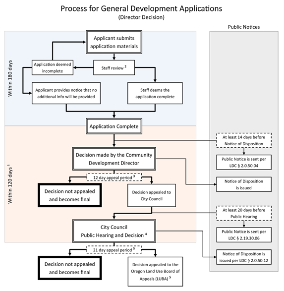
1. The 120 day period for final action may be extended at the request of the applicant (LDC § 1.2.130 and LDC § 2.0.50.14).
2. Within 30 days of the original filing, each application shall be formally accepted as complete or rejected as incomplete (LDC § 2.0.50.01).
3. The appeal period following a decision begins on the date that the Notice of Disposition is signed (LDC § 2.19.30.04).
4. A decision may require more than one meeting.
5. LUBA appeals are in accordance with ORS 197.805 to 197.860. LUBA may reverse, remand, or affirm Council's decision. See www.oregon.gov/luba.
2.4.60.03 Acceptance of Application.
a.
Per ORS 227, the Director will review the Tentative Plat application for compliance with the application requirements in Section 2.4.60.02. If the application is incomplete, the Director will notify the applicant within 30 days of receipt of the application and state what information is needed to make the application complete.
b.
After an application is accepted as complete, the Director will notify affected parties in accordance with Section 2.4.60.04.
c.
After an application is accepted as complete, any revisions the Applicant makes to an accepted application that result in the City needing to mail an additional public notice will be regarded as a new application. Such new application will require additional filing fees.
a.
The Director will provide notice to affected parties that an application for a Tentative Plat has been filed.
b.
"Affected parties" means:
1.
The applicant or authorized agent(s), and owner(s) of the property of the subject application if different from the applicant. For purposes of this mailing, the property owner must be determined using the most recent Benton County Assessor's database supplied to the City;
2.
Any person who resides on or owns property within 100 feet of the subject property;
3.
Any neighborhood organization recognized by the City and whose boundaries include or abut the subject property; and
4.
Any other persons whom the Director determines that the application affects.
c.
The notice will state that all comments concerning the proposed Tentative Plat must be submitted in writing and received by the Director within 14 calendar days from the date of mailing the notice. The notice must include the following:
1.
Street address or other easily understood geographical reference to the subject property;
2.
Applicable criteria for the decision;
3.
Place, date, and time when comments are due;
4.
Statement that copies of all evidence relied upon by the applicant are available for review, and that copies can be obtained at cost;
5.
Name and phone number of staff contact person;
6.
Statement that a Notice of Disposition will be provided to the applicant and any person who submits comments;
7.
Explanation of appeal rights; and
8.
Summary of the local decision making process.
City Staff will review the application and any comments received to ensure compliance with the review criteria in Section 2.4.60.06.
A Tentative Plat must comply with the following:
a.
The standards of all acknowledged City Facility Master Plans and Specific Area Plans;
b.
The Engineering Standards;
c.
For Development Sites containing existing structures, proposed Lot, Parcel, and Tract boundaries must not create new nonconformities with respect to the underlying Zone and any applicable Overlay Zones, and must comply with the adopted Oregon Building Codes;
d.
The adopted Corvallis Fire Code;
e.
The Construction Specifications;
f.
The City Site Development Design Standards;
g.
The general land division standards in Section 2.4.90;
h.
The development standards in Article IV of this Code;
i.
Approval will not prevent future access for City services or access from a public street to and through the subject properties or adjacent properties;
j.
Consistency with the Minimum Density requirement of the zone, where specified.
The City may approve a tentative plat containing less than the minimum number of lots or parcels necessary to achieve required Minimum Density if the applicant demonstrates that the tentative plat will not preclude the ability to achieve required Minimum Density with future land division(s). The applicant must obtain approval of an Urban Conversion Plan consistent with Section 2.4.90.02.c to meet this requirement; and
k.
Consistency with the Maximum Density requirement of the zone, where specified. Additionally, the City will only approve a Partition of property created by Subdivision subsequent to December 11, 2014, if the resultant density within the entire Subdivision remains within the specified density range of the Zone.
2.4.60.07 Action on Application.
Based on the review criteria in Section 2.4.60.06, the Director will review the proposed Tentative Plat and either approve, conditionally approve, or deny the application at the completion of the 14-day comment period.
2.4.60.08 Notice of Disposition.
The Director will provide the applicant with a Notice of Disposition that includes a written statement of the decision, a reference to findings leading to it, any Conditions of Approval, and appeal period deadline. A Notice of Disposition will also be mailed to persons who provided written comment on the mailed notice. A Notice of Disposition and all applicable information will be available in the Community Development Department.
Any person who provided written comments may appeal the decision of the Director in accordance with the provisions of Chapter 2.19 - Appeals. The City will process an appeal of an expedited land division in accordance with ORS 197.375 through ORS 197.380.
The Director's decision is effective 12 days after the Notice of Disposition is signed, unless an appeal is earlier filed.
2.4.60.11 Effective Period of Tentative Plat Approval.
The Director's approval of a Tentative Plat is valid for a four-year period from the effective date. The Tentative Plat approval expires if the applicant has not submitted to the City within the four-year period a Final Plat consistent with Section 2.4.70 and fulfilled all conditions of approval.
(Ord. No. 2023-24, § 9(Exh. A), 8-21-2023; Ord. No. 2023-27, 3(Exh. A), eff. 2-28-2024; Ord. No. 2025-25, § 5(Exh. A), eff. 6-12-2025; Ord. No. 2025-31, § 5(Exh. A), 7-21-2025)
Section 2.4.70 - Final Plat Review Procedures (Partition, Subdivision, Replat).
2.4.70.01 Application Requirements.
The applicant must submit the following:
a.
Narrative - A written narrative must be provided that includes an itemized list of the applicable conditions of approval, with a description for each that explains how the condition has been satisfied, or will be satisfied prior to recording of the final plat.
b.
Final Plat - Two paper originals of the Final Plat, as well as an electronic version of the Plat that is compatible with City formats, must be submitted to the Director. The Final Plat must conform to the approved Tentative Plat and Article IV - Development Standards and any conditions of approval. The Final Plat must also meet Benton County's survey and plat standards and show the following information:
1.
For Subdivisions: Name of the Subdivision, as approved by the County Surveyor;
2.
Date, north arrow, scale, legend, and existing features such as highways and railroads;
3.
Legal description of Subdivision or Partition boundary;
4.
Reference and bearings to adjoining recorded surveys;
5.
Exact location and width of streets and easements intersecting the boundary of the Subdivision or Partition;
6.
For Subdivisions: Subdivision, block, and lot boundary lines. Additionally:
a)
Lot numbers must begin with the number "1", and must be numbered consecutively in each block. The numbering generally follows the same sequence as sections in a township;
b)
Block numbers must begin with the number "1", and must be numbered consecutively without omission or duplication throughout the Subdivision. The numbers must be visible as required by state law and placed so as to not obliterate other elements of the Final Subdivision Plat. Block and lot numbers in an addition to a Subdivision of the same name must continue the numbering of the original Subdivision. The numbering sequence must follow the same sequence as sections in a township; and
c)
Block numbers may be omitted where blocks are of irregular shape. When block numbers are omitted, lots must be numbered consecutively throughout the Subdivision. Lots in an addition to a Subdivision of the same name must continue the numbering of the original Subdivision.
7.
Street rights-of-way indicating widths of the rights-of-way and lengths of center lines with dimensions to the nearest 0.01-ft; and bearings, deflection angles, radii, arcs, points of curvature, and tangent bearings. Subdivision boundaries, lot boundaries, and street bearings must be shown to the nearest 30 seconds with basis for bearings;
8.
The name of existing streets and, subject to Director approval, the name of proposed streets; the width of existing and proposed streets; and width on each side of street center lines. For streets on a curvature, curve data must be based on the street center line. In addition to center line dimensions, the radius and center angle must be indicated;
9.
Easements, clearly identified by fine dotted lines and, if already of record, their recorded reference. If an easement is not definitely located or recorded, a written statement defining the easement is required. The easement's width, length, bearing, purpose, and sufficient ties to locate it with respect to the Subdivision or Partition must be shown. If the easement is being dedicated via the Plat, it must be properly referenced in the owner's certificates of dedication. City Staff must approve written statements defining all easements;
10.
Locations and widths of waterways, drainageways, and other Watercourses for review in accordance with Chapter 2.11 - Floodplain Development Permit, Chapter 4.5 - Floodplain Provisions, Chapter 4.13 - Riparian Corridor and Wetland Provisions, and Chapter 4.14 - Landslide Hazard and Hillside Development Provisions;
11.
Locations and widths of railroad rights-of-way;
12.
Units of land to be dedicated to the City must be distinguished from lots intended for sale, with acreage and alphabetic symbols for each parcel;
13.
Notations indicating any limitations on rights of access to or from streets and lots or other units of land;
14.
Clear identification of lots that have Solar Access height limitations, including a brief explanation and a reference to documents that specify exact height limits for each lot. See Chapter 4.6 - Solar Access;
15.
For Developments of 5 Acres or Larger
a)
A separate copy of the proposed Final Plat must be provided with notation indicating the proposed Housing Types on the lots that satisfy Housing Type variation provisions if they exist within the relevant zone. See also Section 4.9.80. Single-family detached housing need not be identified;
b)
To enforce these required Housing Types, a deed declaration must be provided for each affected lot and recorded concurrently with the Final Plat; and
c)
A note must be provided on the Final Plat that informs lot owners about the existence of deed declarations for each affected lot, describing the Housing Type that is required.
16.
A designated space for the following approval signatures or stamps. The following certificates, established by state law, may be combined where appropriate.
a)
Subdivision -
1)
Certificate signed and acknowledged by the owner(s) of record of the land to be subdivided, offering to dedicate all parcels of land for public use and offering to dedicate rights of access to and from prescribed streets and lots of land. Owner certification must be notarized.;
2)
Stamp and signature of the registered or licensed surveyor who prepared the Plat;
3)
Certificate for execution by the Director;
4)
Certificate for execution by the City Engineer;
5)
Certificate for execution by the City Finance Director;
6)
Certificate for execution by the County Surveyor;
7)
Certificate for execution by the Director of the Benton County Department of Assessment;
8)
Certificate for execution by the Benton County Tax Collector; and
9)
Certificate for execution by the Chair of the Benton County Board of Commissioners.
b)
Partition -
1)
Certificate signed and acknowledged by the owner(s) of record of the land to be partitioned, offering to dedicate all parcels of land for public use and offering to dedicate rights of access to and from prescribed streets and parcels of land. Owner certification must be notarized.;
2)
Stamp and signature of the registered or licensed surveyor who prepared the Plat;
3)
Certificate for execution by the Director;
4)
Certificate for execution by the City Engineer;
5)
Certificate for execution by the County Surveyor;
6)
Certificate for execution by the Director of the Benton County Department of Assessment; and
7)
Certificate for execution by the Benton County Tax Collector.
2.4.70.02 Additional Materials.
The Applicant must submit the following additional information with the Final Plat:
a.
Complete and accurate survey made by a registered or licensed surveyor and pertaining to the land to be subdivided;
b.
Traverse data on standard work sheets or accurate and complete electronic computations, showing closure of the exterior boundaries of the Subdivision or Partition and of each block in the Subdivision;
c.
Three copies of all proposed covenants, conditions, and restrictions (CC&Rs) or a written statement signed by the applicant establishing no such restrictions. CC&Rs must reference this Code's requirements affecting the Housing Type and design of residential structures;
d.
Title guarantee by a Benton County title company doing business in Benton County, showing names of persons whose consent is necessary for preparation of the Final Plat and for any dedication to public use, and their interests therein. This guarantee must certify, for benefit and protection of the City, that persons therein named are all of the persons necessary to give clear title to streets and other easements offered for dedication;
e.
Statement by the Postal Service to verify location of proposed mail delivery facilities as shown on the Final Plat or accompanying sheet, and location to be approved by the City Engineer;
f.
Copy of solar envelopes for each lot as necessary for Solar Access protection consistent with Chapter 4.6 - Solar Access, as applicable; and
g.
Evidence that public assessments, liens, and fees with respect to the property have been paid, or a segregation of assessments and liens has been applied for and granted by the City Council.
2.4.70.03 Review of Final Plat Application and Review Criteria to Determine Compliance with a Tentative Plat.
The Director will review a Final Plat and any site development permit required as a condition of the Tentative Plat approval, to determine whether the request complies with the approved Tentative Plat and associated conditions of approval. The Director shall deem the Final Plat to be in compliance when the Final Plat does not involve modifications to this Code's development standards, and does not involve changes to any specific requirements established at the time of Tentative Plat approval. Specific requirements include Conditions of Approval, this Code's requirements, and all aspects of the applicant's proposal that were approved as part of the Tentative Plat.
Within 14 days after receiving an application for a Final Plat, the Director will review the Final Plat for compliance with the above submittal requirements and for consistency with the approved Tentative Plat. If an application is consistent with the approved Tentative Plat but is incomplete, the Director will notify the applicant and state what is needed for a complete application.
2.4.70.04 Dedications and Public Utility Requirements.
a.
The Applicant must dedicate the following items for public use at the time the Final Plat is filed:
1.
Lots, parcels or tracts of land shown on the Final Plat as intended for public use;
2.
Streets, sidewalks, multi-use paths, drainage channels, easements, and other rights-of-way shown for public use on the Final Plat; and
3.
Rights of access to and from streets, lots, and tracts shown on the Final Plat as intended to be surrendered.
b.
The Applicant must submit evidence of unencumbered and clear title prior to approval of the Final Plat for all land to be dedicated for public use, including but not limited to rights-of-way, drainageways, open space, and easements. Environmental assessments must be conducted in accordance with Chapter 4.0 - Improvements Required with Development.
2.4.70.05 Monumentation Requirements.
a.
The surveyor must set monuments according to provisions of state law.
b.
The surveyor will set sufficient permanent monuments prior to recording so that the survey or any part thereof may be retraced according to standards required by the City Engineer. Setting of interior monuments may be delayed with approval of the City Engineer as provided in "d" below.
c.
The minimum requirements for monumentation and accuracy for a Subdivision Plat or Partition Plat must comply with state law.
d.
Interior post monumentation may be permitted by approval of the City Engineer at the time of approval of the Tentative Plat or upon special request prior to filing the Final Plat, provided that the applicant:
1.
Shows that it is necessary and practical to delay interior monumentation;
2.
Agrees to furnish a bond or cash deposit in an amount equal to 120 percent of the estimated cost of performing the work for interior monuments; and
3.
Signs an agreement with the project surveyor and City Engineer. The agreement must state the following:
a)
Amount of the bond or cash deposit to be furnished at the time of submitting the Final Plat;
b)
Amount the surveyor is to be paid for the work of establishing the interior monuments;
c)
Adherence to the rules for post monumentation as provided in ORS Chapter 92, as amended;
d)
Date when monumentation will be completed; and
e)
Other particulars that may be necessary to ensure complete monumentation at a later date.
2.4.70.06 Installation of Required Improvements.
Before obtaining the signature of the City Engineer, the applicant must install required improvements, agree to install required improvements, or have gained approval to form an improvement district for installation of required improvements to public streets, sanitary sewers, storm drainages, water systems, sidewalks, and multi-use paths; electrical power, natural gas, cable television, and telephone services; and other improvements required with the Tentative Plat approval. This condition is required for acceptance and approval of the Final Plat. These procedures are more fully described as follows:
a.
Install Improvements - The applicant may install the required improvements for the Subdivision or Partition prior to recording the Final Plat. For this procedure, the Plat must contain all the required certifications except those of the County Surveyor and the Board of County Commissioners. The Final Plat will be held by the City until the improvements have been completed and approved by the City Engineer. Upon the City Engineer's approval, the City will forward the Final Plat to Benton County for certification and recording; or
b.
Agree to Install Improvements - The applicant may execute and file with the City an agreement with the City specifying the period within which required improvements must be completed. The agreement must state that if the work is not completed within the period specified, the City may complete the work and recover the full cost and expense thereof from the applicant. The City requires a performance guarantee as provided in Section 2.4.70.07 below. The performance guarantee agreement may provide for the construction of the improvements in increments and for an extension of time under specified conditions. The Applicant must provide assurances that franchise utility services will be provided as required by Section 2.4.70.08 below; or
c.
Form Improvement District - The applicant may have all or part of the public improvements constructed under an improvement district procedure. For this procedure, the applicant must enter into an agreement with the City proposing establishment of the district for improvements to be constructed, setting a schedule for installing improvements, and specifying the extent of the Plat to be improved. The City reserves the right under the improvement district procedure to limit the extent of improvements in a Subdivision or Partition during a construction year. The City may also limit the boundaries of the Final Plat to the area to be improved. The City requires a performance guarantee under the improvement district procedure.
2.4.70.07 Performance Guarantee.
If the applicant chooses options "b" or "c" in Section 2.4.70.06, above, the following provisions apply:
a.
The applicant must provide a performance guarantee in one of the following forms:
1.
A surety bond executed by a surety company authorized to transact business in the State of Oregon and in a form approved by the City Attorney; or
2.
In lieu of the surety bond, the applicant may:
a)
Deposit with the City Treasurer money to be released only upon authorization of the City Engineer;
b)
Supply certification by a bank or other reputable lending institution that money is being held to cover the cost of required improvements, to be released only upon authorization of the City Engineer;
c)
Supply certification by a bank or other reputable lending institution that a line of credit has been established to cover the cost of required improvements, to be released only upon authorization of the City Engineer;
d)
Provide bonds in a form approved by the City Attorney;
e)
Provide a lien on properties in a form approved by the City Attorney and of sufficient value as demonstrated by a professional appraisal; or
f)
Provide other financial security as approved by the City Attorney.
b.
Such assurance of full and faithful performance must be for a sum determined by the City Engineer as sufficient to cover the cost of required improvements, including related engineering and incidental expenses.
c.
If the applicant fails to carry out provisions of the agreement and the City incurs expenses as a result, the City will call on the performance guarantee for reimbursement. If the amount of the performance guarantee exceeds the expenses incurred, the remainder will be released. If the amount of the performance guarantee is less than the expenses incurred, the applicant is liable to the City for the difference.
2.4.70.08 Franchise Utility Service.
Unless specifically exempted during the review of the Tentative Plat, prior to approval of the Final Plat the applicant must:
a.
Install franchise utility services; or
b.
Provide financial assurances to the satisfaction of the City Engineer that electrical power, natural gas, cable television, and telephone service will be provided for each lot.
2.4.70.09 Removal of Existing Services.
If the City Engineer determines that existing public utilities or service connections are not required for the proposed Subdivision or Partition, these utilities or connections must be removed prior to approval of the Final Plat.
2.4.70.10 Coordination by Director and Required Signatures.
The Director will coordinate review of the Final Plat in accordance with the provisions in Sections 2.4.70.01 through 2.4.70.09. Upon notification by each agency that the Final Plat is satisfactory and confirmation that all Tentative Plat conditions of approval have been satisfied, the Director will notify the applicant that Final Plat mylars must be submitted to the City for signature. Upon receipt of the mylar copies of the Final Plat, the Director will circulate the original copies of the Final Plat for the signatures required in Section 2.4.70.01.b.16.
The City Engineer may enter the property to verify that the map is sufficiently correct.
The City's approval of the Final Plat does not relieve the applicant from other applicable provisions of this Code or from the Oregon Revised Statutes.
Authorization of the Final Plat will become effective when the Final Plat is recorded with the Benton County Clerk.
2.4.70.12 Notice of Recordation.
For land divisions subject to housing variety requirements, the Applicant must provide a copy of the recorded Final Plat and associated deed declarations to the Development Services Division. The copy must indicate the Housing Types on the lots that satisfy the Housing Type variation provisions within the relevant zone.
2.4.70.13 Issuance of Building Permits Prior to Installation of Public Improvements.
Prior to the issuance of Building Permits for construction on lots, parcels or tracts created by the Final Plat, the applicant must comply with Section 4.0.20 - Timing of Improvements.
Section 2.4.80 - Property Line Adjustment Procedures.
A Property Line Adjustment affects the configuration of existing legally described property ownership boundaries. A Property Line Adjustment cannot change configuration of tax lot boundaries or legally described lot and parcel boundaries created through a Partition or Subdivision plat. A Property Line Adjustment will not act to vacate any recorded easements or restrictions.
2.4.80.01 Application Requirements.
The City will process an application for a Property Line Adjustment in accordance with the Tentative Plat application requirements in Section 2.4.60.02.
2.4.80.02 Acceptance of Application.
Per ORS 227, the Director will review the Property Line Adjustment application for compliance with the application requirements in Section 2.4.80.01. If the application is incomplete, the Director will notify the applicant within 30 days of receipt of the application and state what information is needed to make the application complete.
City Staff will review the application to ensure compliance with the review criteria in Section 2.4.80.04.
The Director will approve a Property Line Adjustment if the following criteria have been met:
a.
The Property Line Adjustment must not result in creation of an additional unit of land;
b.
The Property Line Adjustment must result in any unit of land that is reduced in size by the Property Line Adjustment complying with all applicable zoning regulations;
c.
The Property Line Adjustment must not increase the degree of nonconformity that may exist on the subject lots;
d.
The Property Line Adjustment must not adversely affect the availability of both public and private utilities and required access;
e.
The Property Line Adjustment must result in any opposing or parallel side property lines being separated by a minimum distance of 15 feet, in addition to any applicable minimum lot width and frontage requirements. Existing side property lines that do not meet this standard are allowed to be maintained or adjusted, as long as the Property Line Adjustment does not worsen the non-compliant configuration.
f.
The Property Line Adjustment must not adjust properties with Natural Resources or Natural Hazards unless each resultant property contains an area unconstrained by Natural Resources or Natural Hazards. The unconstrained area must be equal to or greater than the applicable Minimum Assured Development Area(s) for each resultant property for the zone or zones is which the site falls. Exceptions to this requirement are:
1.
Properties with public park purposes; and
2.
Privately- or publicly-owned properties completely contained within an area zoned Conservation - Open Space.
g.
The Property Line Adjustment must not create new Tracts. Where the Applicant proposes such Tracts or such Tracts are required by this Code, a Land Division is required.
2.4.80.05 Action on Application.
Based on the review criteria above, the Director will review the proposed Property Line Adjustment and either approve, conditionally approve, or deny the application.
The Director will impose the following minimum Conditions of Approval on any Approval:
a.
The Applicant must record a deed or deeds with the Benton County Clerk, based on a metes and bounds legal description for all adjusted properties from the Property Line Adjustment. Each deed must include names of all parties and references to the original recorded documents and signatures of all parties with proper acknowledgment;
b.
The Applicant must produce and submit a Certified Boundary Survey map that reflects the approved Property Line Adjustment to the City. The Director and the City Engineer will sign the Certified Boundary Survey Map if it conforms to the approved Property Line Adjustment. The Applicant must then file the signed Certified Boundary Survey Map with the County Surveyor; and
c.
The Applicant must provide copies of the recorded deeds and filed Certified Boundary Survey Map to the City following recording.
2.4.80.06 Notice of Disposition.
The Director will provide the applicant with a Notice of Disposition that includes a written statement of the decision, a reference to findings leading to it, any Conditions of Approval, and appeal period deadline. A Notice of Disposition and all applicable information will be available in the Community Development Department.
Any person may appeal the decision of the Director in accordance with the provisions of Chapter 2.19 Appeals.
The Director's decision is effective 12 days after the Notice of Disposition is signed, unless an appeal is earlier filed.
2.4.80.09 Effective Period of Approval.
The Director's approval of a Property Line Adjustment is valid for a two-year period from the effective date. If the applicant has not submitted a Final Boundary Survey and draft deeds to the City and fulfilled all conditions of approval within the two-year period, the approval expires.
Section 2.4.90 - General Land Division Standards.
2.4.90.01 Applicability.
In addition to the review criteria in Section 2.4.60.06, all Tentative Plats must comply with the following standards.
2.4.90.02 General Requirements.
a.
All subdivision and partition proposals must comply with state regulations in Oregon Revised Statute (ORS) Chapter 92 Subdivisions and Partitions.
b.
Plat Boundary and Remaining Units of Land - Land divisions must include the entire parent unit of land in the surveyed boundary of the Subdivision or Partition. Each unit of land created must be a Lot, Parcel or Tract. Remaining portions of the parent unit of land that extend outside the surveyed boundary are not allowed.
c.
Urban Conversion Plan For Large Lots - The Applicant is required to provide an urban conversion plan when dividing land into large lots, parcels or tracts that have potential for future further Subdivision or Partition based on density allowances of the zone. The conversion plan must show street extensions, utility extensions, and lot/parcel patterns to indicate how the property may be developed to Comprehensive Plan densities and to demonstrate that the proposal will not inhibit development of adjacent lands. The conversion plan must also demonstrate consistency with the following:
1.
block perimeter requirements of Sections 4.0.30.b (Pedestrian Block Perimeter) and 4.0.60.o (Vehicle Block Perimeter) of Chapter 4.0 - Improvements Required with Development, if the parent unit of land is greater than two acres in size;
2.
housing type variation requirements of Section 4.9.80 if the parent unit of land is five acres or greater in size; and
3.
Minimum Assured Development Area provisions in Section 4.11.30 for sites containing Natural Hazards and Natural Resources
An urban conversion plan is necessary to demonstrate that the tentative plat, in combination with potential future land divisions, complies with the minimum density requirements of the Zone(s) and other standards applicable at time of land division. However, future land divisions on the subject property are not bound to the layout presented with the Urban Conversion Plan, with the exception that Minimum Assured Development Area may not be re-used as described in Section 4.11.30.c.
a.
General - Length, width, and shape of blocks are based on the minimum lot area requirements of the zone and street width and circulation standards in Chapter 4.0 Improvements Required with Development.
b.
Size - Blocks will be sized in accordance with the standards in Sections 4.0.30.b (Pedestrian Block Perimeter) and 4.0.60.o (Vehicle Block Perimeter) of Chapter 4.0 - Improvements Required with Development.
c.
Public Access Easements for Pedestrian Facilities - The applicant must grant a public access easement on the Final Plat consistent with the pedestrian facility requirements in Section 4.0.30.b and 4.0.30.c.
2.4.90.04 Lot and Parcel Standards.
The Applicant must number each Lot and Parcel consecutively. Lots and Parcels must meet the requirements of the applicable Zone as follows:
a.
Width - The minimum Lot width will be as required by the applicable zone.
b.
Area -
1.
Partitions - each Parcel must comply with the Minimum Lot Area, if specified in the Zone.
Exception:
For Flag Parcels, the area will be as required by the applicable Zone and must be provided entirely within the buildable site area, exclusive of any Accessway. See Figure 2.4-2 Lot Area Exclusive of Accessway, below.
Figure 2.4-2 - Lot Area Exclusive of Accessway
2.
Subdivisions - each Lot must comply with the Minimum Lot Area, if specified in the Zone.
c.
Side Lot Lines - Side Lot and Parcel lines must be at right angles to the street the Lots and Parcels face when possible.
d.
Any opposing or parallel Lot/Parcel lines must be separated by a minimum distance of 15 feet. For opposing or parallel Lot/Parcel lines that form the boundaries of a Flag Parcel accessway, the distance must be increased or decreased as specified in Section 2.4.90.08.
e.
Existing Structures: The boundary of each newly created Lot and Parcel must be placed to avoid creating a Nonconforming Structure. See Chapter 1.4.
Applicants must avoid creating Through Lots through a Land Division process except where essential to overcome specific disadvantages of topography and orientation. When Through Lots in low density residential zones are created through a Land Division process, the Applicant must comply with the following standards:
a.
A 1-feet wide Vehicular Non-Access Easement area must be provided along the full length of the lot's frontage abutting the higher classification street, and shown on the plat. If both frontages abut the same classification of street, the location of the Vehicular Non-Access Easement will be as determined by the City Engineer.
b.
No vehicular access will be permitted within or through the Vehicular Non-Access Easement area.
When provided, the applicant must identify each Tract with a letter (example: Tract A). The plat must clearly identify the purpose(s) for the Tract and the party or parties responsible for maintaining the Tract. See definition of Tract in Section 1.6.30. The boundary of each newly created Tract must be placed to avoid creating a Nonconforming Structure. See Chapter 1.4.
2.4.90.07 Access and Minimum Street Frontage.
a.
To ensure sufficient space is provided for required pedestrian facilities, utilities, street trees, emergency vehicle access, and (where applicable) on-street vehicle parking, each lot and parcel must abut a street for a distance of at least 20-ft. unless it complies with the exceptions listed in "1" or "2" below.
1.
On a lot or parcel zoned RS-6 or RS-9 and existing prior to December 31, 2006, an Applicant may use a Partition to create Flag Parcels that satisfy all of the following criteria:
a)
Each resulting parcel must contain an area equal to no more than 175 percent of the zone's minimum lot area for a Single Detached dwelling;
b)
No provision of the Code requires a street through any part of the site per Section 4.0.60; and
c)
The Applicant must provide Accessways that satisfy Section 2.4.90.08 requirements, below.
2.
The lot or parcel adjoins a public or private alley. The alley must comply with Section 4.0.60.j and be installed or financially secured by the applicant prior to final plat.
b.
For lots and parcels within the Climate-Friendly Areas (CFA) Overlay having a front lot line with a dimension less than 50 feet, direct vehicular access is limited to alleys in accordance with "1" below. For lots and parcels outside of the CFA Overlay having a front lot line with a dimension less than 50 feet, proposed off-street vehicle parking must comply with one of the following options:
1.
Alley Access: Vehicular access is limited to a public or private alley adjoining the side or rear property line. The alley must comply with Section 4.0.60.j and be installed or financially secured by the applicant prior to final plat. Additionally, the applicant provides a deed restriction that applies to the lot or parcel, limiting vehicular access to the adjoining alley. The Applicant must record the deed restriction concurrently with the final plat.
2.
Shared Driveway: Vehicular access is shared between two adjoining lots or parcels. The width of the shared driveway may not exceed 20 feet, for that portion between the street and five feet interior to the front property line. The applicant must grant a reciprocal access and utility easement as part of the land division. The Applicant must provide deed restrictions that apply to the lots or parcels, noting the requirement for shared access and limit on driveway pavement width. The Applicant must record the deed restriction concurrently with the Final Plat. Additionally, the shared driveway and easement is placed to allow a minimum of 20 feet of uninterrupted curb along the frontage of the adjoining lots or parcels.
3.
Shared Parking Area: Vehicle parking is provided in a shared common area Tract containing up to eight spaces. The shared parking area must not be placed between buildings and the streets to which those buildings are primarily oriented. The Tract must abut one or more of the lots or parcels it serves and must be located interior to the Block.
c.
Vehicular access is not required to a lot, parcel, or tract, except where the Fire Code requires it.
1.
For each proposed lot, parcel, and tract where vehicle Access is proposed, the Access must comply with the standards in Sections 4.0.60.q, 4.1.30, 4.2.30.b.3, City Site Development Design Standards, Engineering Standards, and the Transportation System Plan. Where necessary to comply, driveway locations must be consolidated and the Applicant must grant reciprocal access easements for shared driveways consistent with Section 2.4.90.10. See definition of Access and Frontage in Section 1.6.30.
2.
For each proposed lot, parcel, and tract where vehicle Access is not proposed, a 1 foot-wide Vehicular Non-Access Easement area must be provided along the full length of the frontage, and shown on the plat.
2.4.90.08 Accessways for Flag Parcels.
a.
For Partitions containing Flag Parcels, an Applicant may reduce and combine access requirements of Section 2.4.90.07 to provide an Accessway or combination of Accessways, in accordance with the standards in Table 2.4-1. See definition of Accessway in Section 1.6.30.
Table 2.4-1 Accessway Width Requirements
b.
Accessways must connect to a public or private street. The Director may allow an exception to the paving requirements for the existing dedicated right-of-way if the proposed Partition meets all of the following conditions:
1.
The Accessway connects to a paved street that is a minimum of 20 feet wide;
2.
The Accessway serves a single parcel and not more than four dwelling units;
3.
The property owner signs an irrevocable petition for public street improvements and records it with the property through the Benton County Recorder's Office; and
4.
The property owner demonstrates that the grade of the property will allow foundation drainage to be carried by gravity, without pumping, to a public storm drain or other drainage facility approved by the City Engineer.
2.4.90.09 Public, Private, and Franchise Utilities.
The Applicant must provide public and franchise utilities per Chapter 4.0. Private utilities such as sewer, water and stormwater laterals that cross property lines must be contained within private easements declared with the Final Plat.
2.4.90.10 Reciprocal Access and Utility Easements.
If an Accessway or common driveway serves more than one lot or parcel, the applicant must grant for the benefit of the owners of the created parcels or lots, a reciprocal access and utility easement to ensure access rights for ingress, egress, and private utility maintenance.
The width of the reciprocal access and utility easement for an Accessway must comply with the dimensional standards in Section 2.4.90.08 and Table 2.4-1.
The width of the reciprocal access and utility easement for a common driveway not located within a Flag Parcel Accessway must comply with the minimum driveway paving width and vehicle maneuvering standards contained in the City's Site Development Design Standards.
2.4.90.11 Preservation of Natural Features and Site Development Prior to Final Plat.
Construction of public and private infrastructure necessary to serve lots or parcels created through a Land Division often occurs prior to recording the Final Plat. For properties with Natural Resources or Natural Hazards, site development activities that occur prior to recording the Final Plat must comply with the provisions associated with preservation or protection of Natural Features contained in Article IV of this Code. Additionally:
a.
Excavation and grading must conform to Chapter 4.14 - Landslide Hazard and Hillside Development Provisions; and the City's Erosion Prevention and Sediment Control Manual.
b.
For Development Sites containing mapped or unmapped Special Flood Hazard Area as described in Section 4.5.20.01, the applicant must obtain approval of a Floodplain Development Permit, prior to Final Plat.
c.
Minimum Assured Development Area - For property with Natural Resources or Natural Hazards, proposed Land Divisions must demonstrate compliance with the Minimum Assured Development Area (MADA) provisions of Section 4.11.30.
d.
Where required by the provisions of Chapter 4.5 - Floodplain Provisions, Chapter 4.12 - Significant Vegetation Protection Provisions, Chapter 4.13 - Riparian Corridor and Wetland Provisions, or Chapter 4.14 - Landslide Hazard and Hillside Development Provisions; the applicant must grant on the Final Plat, Tracts or Conservation Easements delineating Protected and Preserved Areas.
(Ord. No. 2022-12, eff. 6-1-2022; Ord. No. 2023-19, §§ 6, 7(Exh. A), eff. 6-30-2023; Ord. No. 2023-27, 3(Exh. A), eff. 2-28-2024; Ord. No. 2025-25, § 5(Exh. A), eff. 6-12-2025; Ord. No. 2025-31, § 5(Exh. A), 7-21-2025)
Section 2.5.10 - Background.
It is the intent of this Chapter to establish procedures that permit flexibility in the land development process, allow for better preservation of Significant Natural Features, and allow for innovation in site planning and architectural design.
The Planned Development process is established to allow the review and approval of Conceptual and Detailed Development Plans, to provide the mechanism for achieving greater flexibility and improved design in cases where the scope of proposed modifications to pre-stated standards exceeds that permitted through a Development Standards Adjustment. A Development Standards Adjustment allows variations to certain development standards. The procedures and the types of development standards that may be varied are identified in Chapter 2.12 - Development Standards Adjustment.
a.
The Procedures of this Chapter are Applicable When -
1.
A property owner requests a Conceptual and/or Detailed Development Plan concurrent with a specific project review; or
2.
A Nonresidential or Residential Planned Development Overlay, established in accordance with the provisions of Chapter 3.43 - Nonresidential PD (Planned Development) Overlay or Chapter 3.44 - Residential PD (Planned Development) Overlay, respectively, exists on the site and is shown on the City's Official Zoning Map.
Depending on the level of detail provided in a Planned Development application, a Planned Development project proposal is called a Conceptual Development Plan or a Detailed Development Plan. A Conceptual Development Plan provides general concepts for development on a site. A Detailed Development Plan provides the specifics for development on a site and is required following or simultaneously with approval of a Conceptual Development Plan. When a Detailed Development Plan is processed simultaneously with a Conceptual Development Plan, it is called a Conceptual and Detailed Development Plan.
Upon Planning Commission approval of a Detailed Development Plan or a Conceptual and Detailed Development Plan, Building Permits are issued consistent with that Plan.
b.
Restrictions on Variations -
1.
Development Standards -
a)
The Conceptual and Detailed Development Plan process permits modifications to the site development standards of the underlying zone; and
b)
Approval of a Detailed Development Plan for a residentially designated site must provide a clear and objective set of standards, through the approved plan and related Conditions of Approval, for development to follow.
2.
Uses -
a)
The Conceptual and Detailed Development Plan process does not permit an expansion of Uses beyond those specified by the underlying zone;
b)
In cases where a property's underlying zoning designation was changed prior to December 31, 2006, and a valid (still active) Planned Development existed and was approved before December 31, 2006, the Conceptual and Detailed Development Plan process may be used to allow the Uses permitted by the new underlying zone; and
c)
The Conceptual and Detailed Development Plan process may also be used to modify zone-specific Use size or Tenant Space limitations.
c.
On Residentially Designated Properties - Upon approval of a Conceptual Development Plan on residentially designated land, a Residential Planned Development Overlay is placed on the site and shown on the Official Zoning Map for as long as the property owner desires to keep the Conceptual Development Plan active, up to the expiration period defined in Section 2.5.40.09. Upon approval of a Detailed Development Plan on residentially designated land, a Residential Planned Development Overlay is placed on the site and shown on the Official Zoning Map for as long as the property owner desires to keep the Detailed Development Plan active, up to the expiration period defined in Section 2.5.50.09. In cases where an approved Conceptual and/or Detailed Development Plan is no longer active, the associated Residential Planned Development Overlay is automatically removed from the Official Zoning Map.
d.
On Nonresidentially Designated Properties - Upon approval of a Conceptual Development Plan on nonresidentially designated land, a Nonresidential Planned Development Overlay is placed on the site and shown on the Official Zoning Map for as long as the Conceptual Development Plan remains active (unexpired). Upon approval of a Detailed Development Plan on nonresidentially designated land, a Nonresidential Planned Development Overlay is placed on the site and shown on the Official Zoning Map for as long as the Detailed Development Plan remains active, as defined in Section 2.5.50.09.c. In cases where an approved Conceptual and/or Detailed Development Plan is no longer active, the associated Nonresidential Planned Development Overlay is automatically removed from the Official Zoning Map.
e.
Applying a Nonresidential or Residential Planned Development Overlay Without a Conceptual or Detailed Development Plan -
Without approval of a Conceptual and/or Detailed Development Plan, a Nonresidential or Residential Planned Development Overlay can only be applied through the use of Chapter 3.43 - Nonresidential PD (Planned Development) Overlay and Chapter 3.44 - Residential PD (Planned Development) Overlay, respectively.
(Ord. No. 2022-06, eff. 3-17-2022; Ord. No. 2023-01, eff. 2-8-2023; Ord. No. 2024-26, § 10(Exh. A), eff. 1-1-2025)
Section 2.5.20 - Purposes.
Planned Development review procedures are established in this Chapter for the following purposes:
a.
Promote flexibility in design and permit diversification in location of structures;
b.
Promote efficient use of land and energy, and facilitate a more economical arrangement of buildings, circulation systems, land uses, and utilities;
c.
Preserve, to the greatest extent possible, existing Significant Natural Features and landscape features and amenities, and use such features in a harmonious fashion;
d.
Provide for more usable and suitably located pedestrian and/or recreational facilities and other public and/or common facilities than would otherwise be provided under conventional land development procedures;
e.
Combine and coordinate architectural styles, building forms, and building relationships within the Planned Development;
f.
Provide the applicant with reasonable assurance of ultimate approval before expenditure of complete design monies, while providing the City with assurances that the project will retain the character envisioned at the time of approval;
g.
Provide greater compatibility with surrounding land uses than would otherwise be provided under conventional land development procedures; and
h.
Provide benefits within the development site that compensate for the variations from development standards such that the intent of the development standards is still met.
Section 2.5.30 - General Provisions.
Planned Development is an alternative development process that provides an avenue for a developer to request variations from development standards while maintaining the purposes stated in Section 2.5.20 and meeting the review criteria outlined in Section 2.5.40.04.
The following procedures allow for Planning Commission review of a Conceptual Development Plan and/or Detailed Development Plan. An applicant may either elect to process a development proposal under a Detailed Development Plan when sufficient information has been submitted in accordance with Section 2.5.50, or may request approval of a Conceptual Development Plan in accordance with Section 2.5.40 and later apply for a Detailed Development Plan. However, prior to the issuance of any Building or Construction Permits, a Detailed Development Plan must be approved by the Planning Commission.
Section 2.5.40 - Conceptual Development Plan Review Procedures.
An application filed for a Conceptual Development Plan shall be reviewed in accordance with the following procedures.
2.5.40.01 Application Requirements.
When the Director deems any requirement below unnecessary for proper evaluation of a proposed application, it may be waived.
Prior to formal submittal of an application, the applicant is encouraged to participate in an informal pre-application conference with Community Development Department staff to discuss the proposal, the applicant's requirements, and the applicant's materials developed in response to this Code's applicable requirements.
Applications shall be made on forms provided by the Director and shall be accompanied by:
a.
Location and description of the subject property(ies), including all of the following, as relevant: address; tax assessor map and tax lot number; parcel number; written description of the boundaries of the proposal; and one set of assessor's maps of the subject site and surrounding area, with the subject site outlined in red;
b.
Signed consent by the subject property's owner(s) and/or the owner's legal representative(s). If a legal representative is used as a signatory, written proof of ability to be a signatory shall be furnished to the City. The owner's name(s) and address(es), and the applicant's name, address, and signature shall also be provided;
c.
Fifteen copies of the narrative, on 8.5 by 11 in. sheets, and 15 copies of graphics at an 8.5 by 11 in. size. The Director may request additional copies of the narrative and/or graphics for routing purposes, if needed. Related names/numbers must be legible on the graphics. The Director may also require some or all graphics at an 11 by 17 in. size if, for legibility purposes, such a size would be helpful;
d.
Six sets of full-scaled black line or blueprint drawings of the graphic(s), with sheet size not to exceed 24 by 36 in. Where necessary, an overall plan with additional detail sheets may be submitted;
e.
An electronic version of these documents (both text and graphics, as applicable) if an applicant has produced part or all of an application in an electronic format. The applicant shall coordinate with the City regarding compatible electronic formats, to the greatest extent practicable;
f.
Graphic Requirements
Graphics shall include the following information where applicable:
1.
Public Notice Map - Typically a street map at one in. = 800 feet as per the City's public notice format;
2.
Zoning Map - Typically one in. = 400 feet, but up to one in. = 800 feet, depending on the size of the site, with a key that identifies each zone on the site and within 1,000 feet of the site as per City format;
3.
Comprehensive Plan Map - Typically one in. = 800 feet with a key that identifies each land use designation on the site and within 1,000 feet of the site as per City format;
4.
Existing Land Use Map - Typically a topographic map that extends at least a 1,000 feet beyond the site. The map shall include building footprints and distinguish between single-family, multi-family, Commercial, and Industrial Uses, as well as other significant features such as roads, parks, schools, and Significant Natural Features identified by Chapter 2.11 - Floodplain Development Permit, Chapter 4.2 - Landscaping, Buffering, Screening, and Lighting, Chapter 4.5 - Floodplain Provisions, Chapter 4.12 - Significant Vegetation Protection Provisions, Chapter 4.13 - Riparian Corridor and Wetland Provisions, and Chapter 4.14 - Landslide Hazard and Hillside Development Provisions;
5.
Significant Natural Features Map(s) - Maps shall identify Significant Natural Features of the site, including, but not limited to:
a)
All information and preservation plans required by Chapter 2.11 - Floodplain Development Permit, Chapter 4.2 - Landscaping, Buffering, Screening, and Lighting, Chapter 4.5 - Floodplain Provisions, Chapter 4.11 - Minimum Assured Development Area (MADA), Chapter 4.12 - Significant Vegetation Protection Provisions, Chapter 4.13 - Riparian Corridor and Wetland Provisions, and Chapter 4.14 - Landslide Hazard and Hillside Development Provisions, as applicable;
b)
All Jurisdictional Wetlands not already shown as part of "a," above. While not all Jurisdictional Wetlands are locally regulated by Chapter 4.13 - Riparian Corridor and Wetland Provisions, they need to be shown so that the City can route the application to the appropriate state and federal agencies for comment.
6.
Site Plan(s) and Other Graphics -
a)
Site plan(s) and other graphics shall be drawn to scale and shall contain a sheet title, date, north arrow, and legend placed in the same location on each sheet and contain the information listed in this Section and "b" below.
Graphics shall include features within a minimum 150-feet radius of the site, such as existing streets and parcel boundaries; existing structures; driveways; utilities; Significant Natural Features regulated by Chapter 2.11 - Floodplain Development Permit, Chapter 4.2 - Landscaping, Buffering, Screening, and Lighting, Chapter 4.5 - Floodplain Provisions, Chapter 4.12 - Significant Vegetation Protection Provisions, Chapter 4.13 - Riparian Corridor and Wetland Provisions, and Chapter 4.14 - Landslide Hazard and Hillside Development Provisions; Minimum Assured Development Area information from Chapter 4.11 - Minimum Assured Development Area (MADA), if applicable; and any other information that, in the Director's opinion, would assist in providing a context for the proposed development. The Director may require that an applicant's graphics include information on lands in excess of 150 feet from a development site (e.g., such as in cases where an adjacent property is large and a view of the whole parcel would be helpful, or when existing infrastructure is far away from the site).
b)
The site plan and related graphics shall also include:
1)
Boundary of the proposed development site and any interior boundaries related to proposed development phases or Land Divisions;
2)
Number of lots and their dimensions, including frontage, depth, and area in sq. feet, as applicable;
3)
General location and floor area of existing and proposed structures and other improvements, including maximum building heights, Building Types, and gross density per acre for residential developments; and location of fire hydrants, overhead lines in the abutting right-of-way, easements, fences, walls, parking calculations, and walkways; and any proposed Use restrictions. Where required by the applicable zone, lot coverage and Green Area calculations shall be provided. An indication of approximate building envelopes may be required to evaluate building relationships;
4)
General location and dimensions of areas to be conveyed, dedicated, or reserved as common open spaces, common Green Area, public parks, recreational areas, school sites, and similar public and semi-public uses;
5)
Existing and proposed circulation system plan and dimensions including streets, driveways, bikeways, sidewalks, multi-use paths, off-street parking areas, service areas (including refuse), loading areas, direction of traffic flow, and major points of access to public rights-of-way. Illustrative cross-sections of streets shall be provided. Notations of proposed ownership (public or private) should be included where appropriate;
6)
Existing and proposed general pedestrian circulation system, including its interrelationship and connectivity with the existing and proposed vehicular, bicycle, and pedestrian circulation systems, and indicating proposed treatments for points of conflict;
7)
Utilities plan indicating existing and proposed utility systems and their function, including sanitary sewer, storm sewer, and drainage and water systems;
8)
Identification of Significant Natural Features that were included on the Significant Natural Features map(s) required in Section 2.5.40.01.f.5, above, to indicate the relationship of the proposal to the site's Significant Natural Features;
9)
Existing and proposed topographic contours at two-feet intervals. Where the grade of any part of the development site exceeds 10 percent and where the development site abuts existing developed lots, a conceptual grading plan shall be required. The grading plan shall contain adequate information to evaluate impacts to the site and adjacent areas, consistent with Chapter 4.14 - Landslide Hazard and Hillside Development Provisions. If a grading plan is required, it shall indicate how these objectives are met, how runoff or surface water from the development will be managed, and how the development's surface waters will be disposed;
10)
Conceptual landscape plan drawn to scale and showing the location of existing trees and vegetation proposed to be removed from or to be retained on the site, the location and conceptual design for landscaped areas (types of plant materials as basic as trees, shrubs, and groundcover/lawn areas), and other conceptual landscape features including walls and fences;
11)
For residential development, existing structures and trees located on land adjacent to the development that, between 9 a.m. and 3 p.m. on November 21, will reduce Solar Access to the subject property; and
12)
For residential development, indication of which buildings will have Solar Access protection, and appropriate documentation to verify how Solar Access will be protected.
g.
Narrative Requirements
A written statement shall include the following information:
1.
Statement of planning objectives to be achieved by the subject development. This statement shall include a description of the proposed development, the rationale behind the assumptions and choices made, and a discussion of how the application meets the review criteria in 2.5.40.04 below, including the development standards required by this Code;
2.
Quantitative data for the following where appropriate:
a)
Total number and type of dwelling units;
b)
Square footages of all structures;
c)
Parcel size;
d)
Proposed lot coverage of buildings and structures, where known;
e)
Gross densities per acre;
f)
Total square footage of Green Area;
g)
Total number of parking spaces (compact, standard, handicapped, bicycle) and breakdown of how parking is consistent with this Code's requirements; and
h)
Total square footage of nonresidential construction;
3.
General statement outlining timing, responsibilities, and financial assurances for all public and non-public improvements such as irrigation, private roads and drives, landscape, and maintenance;
4.
Statement describing phases of project, if proposed. Phases shall be:
a)
Substantially and functionally self-contained and self- sustaining with regard to access, parking, utilities, Green Areas, and similar physical features; and capable of substantial occupancy, operation, and maintenance upon completion of construction and development;
b)
Arranged to avoid conflicts between higher and lower density development;
c)
Properly related to other services of the community as a whole and to those facilities and services yet to be provided; and
d)
Provided with such temporary or permanent transitional features, buffers, or protective areas as may be required to prevent damage or detriment to any completed phases and to adjoining properties not in the Planned Development;
5.
A traffic impact study shall be required in accordance with Section 4.0.60.a;
6.
For residential development, a statement or map describing existing and proposed buildings with protected Solar Access consistent with Chapter 4.6 - Solar Access; and
7.
Information required by Chapter 2.11 - Floodplain Development Permit, Chapter 4.5 - Floodplain Provisions, Chapter 4.11 - Minimum Assured Development Area (MADA), Chapter 4.12 - Significant Vegetation Protection Provisions, Chapter 4.13 - Riparian Corridor and Wetland Provisions, and Chapter 4.14 - Landslide Hazard and Hillside Development Provisions, as applicable.
h.
Any proposed Floodplain Development Permit variation that exceeds the scope of Section 2.11.60.01.a shall also meet the Floodplain Development Permit Variance application requirements in Section 2.11.60.02 and, as applicable, Section 2.11.50.01.
i.
Oregon State Historic Preservation Office Notification Required - As provided under applicable Oregon or Federal law, the applicant will provide to the City a copy of any notice to SHPO of the existence of an Archaeological Site or Object located within the area proposed for conceptual development; and
j.
Required fees as described in LDC § 1.2.100.01.
2.5.40.02 Acceptance of Application.
a.
The Director shall review the application in accordance with Chapter 2.0 - Public Involvement.
b.
After accepting a complete application the Director shall schedule a public hearing to be held by the Planning Commission. Notice of the hearing shall be provided in accordance with Chapter 2.0 - Public Involvement.
c.
After an application is accepted as complete, any revisions to it that result in the need for an additional public notice to be mailed shall be regarded as a new application. Such new application shall require additional filing fees and rescheduling of the required public hearing.
The Director shall prepare a report that evaluates whether the Conceptual Development Plan complies with the review criteria below. The report shall also include a recommendation for approval or denial and, if needed, a list of conditions for the Planning Commission to consider if an approval is granted.
Requests for the approval of a Conceptual Development Plan shall be reviewed to ensure consistency with the policies and density requirements of the Comprehensive Plan, and any other applicable policies and standards adopted by the City Council. The application shall demonstrate compatibility in the areas in "a" below, as applicable, and shall meet the Natural Resource and Natural Hazard criteria in "b" below:
a.
Compatibility Factors -
1.
Compensating benefits for the variations being requested;
2.
Basic site design (the organization of Uses on a site and the Uses' relationships to neighboring properties);
3.
Visual elements (scale, structural design and form, materials, etc.);
4.
Noise attenuation;
5.
Odors and emissions;
6.
Lighting;
7.
Signage;
8.
Landscaping for buffering and screening;
9.
Transportation facilities;
10.
Traffic and off-site parking impacts;
11.
Utility infrastructure;
12.
Effects on air and water quality (note: a DEQ permit is not sufficient to meet this criterion);
13.
Design equal to or in excess of the types of improvements required by the standards in Chapter 4.10 - Pedestrian Oriented Design Standards ; and
14.
Preservation and/or protection of Significant Natural Features, consistent with Chapter 2.11 - Floodplain Development Permit, Chapter 4.2 - Landscaping, Buffering, Screening, and Lighting, Chapter 4.5 - Floodplain Provisions, Chapter 4.11 - Minimum Assured Development Area (MADA), Chapter 4.12 - Significant Vegetation Protection Provisions, Chapter 4.13 - Riparian Corridor and Wetland Provisions, and Chapter 4.14 - Landslide Hazard and Hillside Development Provisions. Streets shall also be designed along contours, and structures shall be designed to fit the topography of the site to ensure compliance with these Code standards.
b.
Natural Resources and Natural Hazards Factors -
1.
Any proposed variation from a standard within Chapter 2.11 - Floodplain Development Permit, Chapter 4.5 - Floodplain Provisions, Chapter 4.11 - Minimum Assured Development Area (MADA), Chapter 4.12 - Significant Vegetation Protection Provisions, Chapter 4.13 - Riparian Corridor and Wetland Provisions, or Chapter 4.14 - Landslide Hazard and Hillside Development Provisions shall provide protections equal to or better than the specific standard requested for variation; and
2.
Any proposed variation from a standard within Chapter 2.11 - Floodplain Development Permit, Chapter 4.5 - Floodplain Provisions, Chapter 4.11 - Minimum Assured Development Area (MADA), Chapter 4.12 - Significant Vegetation Protection Provisions, Chapter 4.13 - Riparian Corridor and Wetland Provisions, or Chapter 4.14 - Landslide Hazard and Hillside Development Provisions shall involve an alternative located on the same development site where the specific standard applies.
3.
Any proposed Floodplain Development Permit variation that exceeds the scope of Section 2.11.60.01.a shall also meet the Floodplain Development Permit Variance review criteria in Section 2.11.60.06 and, to the extent feasible, the base Floodplain Development Permit review criteria in Section 2.11.50.04.
2.5.40.05 Action by the Planning Commission.
The Planning Commission shall conduct a public hearing in accordance with Chapter 2.0 - Public Involvement. Following the close of the hearing, the Planning Commission shall approve, conditionally approve, or deny the Conceptual Development Plan. The Commission's decision shall include findings that specify how the application has or has not complied with the above review criteria.
2.5.40.06 Notice of Disposition.
The Director shall provide the applicant with a Notice of Disposition in accordance with Chapter 2.0 - Public Involvement that includes a written statement of the Planning Commission's decision, a reference to findings leading to it, any Conditions of Approval, and the appeal period deadline. A Notice of Disposition shall also be mailed to persons who presented oral or written testimony at the public hearing.
The decision of the Planning Commission may be appealed in accordance with the provisions of Chapter 2.19 - Appeals.
Unless an appeal is filed, the decision of the Planning Commission shall become effective 12 days after the Notice of Disposition is signed.
2.5.40.09 Effective Period of Conceptual Development Plan Approval.
Conceptual Development Plan approval shall be effective for a four-year period from the date of approval. If the applicant has not submitted a Detailed Development Plan for the Planned Development or its phases within the four- year period, all approvals shall expire.
a.
Conceptual Development Plans on Residentially Designated Property -
1.
If the Conceptual Development Plan pertains to residentially designated property, was established at the request of the property owner, and there is no active Detailed Development Plan on any portion of the site, the property owner may request and be granted nullification of the Conceptual Development Plan in accordance with Section 2.5.80.
(Ord. No. 2012-17, eff. 12-13-2012; Ord. No. 2012-18, eff. 12-13-2012; Ord. No. 2014-19, eff. 12-11-2014; Ord. No. 2018-01, eff. 1-26-2018; Ord. No. 2023-24, § 10(Exh. A), 8-21-2023)
Section 2.5.50 - Detailed Development Plan Review Procedures.
2.5.50.01 Application Requirements.
When the Director deems any requirement below unnecessary for the proper evaluation of a proposed application, it may be waived.
Prior to formal submittal of an application, the applicant is encouraged to participate in an informal pre-application conference with Community Development Department staff to discuss the proposal, the applicant's requirements, and the applicant's materials developed in response to this Code's applicable requirements.
An application filed for a Detailed Development Plan shall follow the requirements specified for a Conceptual Development Plan in Section 2.5.40 above and shall also include the following:
a.
Graphic Requirements -
In addition to the graphic requirements specified for a Conceptual Development Plan in Section 2.5.40.01, a Detailed Development Plan shall include:
1.
Location and floor area of existing and proposed structures and other improvements, including maximum heights, Building Types, and gross density per acre for residential developments; and location of fire hydrants, overhead lines in the abutting right of way, easements, fences, walls, parking calculations, and walkways. Where required by the applicable zone, Lot Coverage and Green Area calculations shall be provided. Parking calculations shall also be provided;
2.
Typical elevations and floor plans of buildings and structures (which may be submitted on additional sheets) sufficient to indicate the architectural intent and character of the proposed development, indicate the entrance and exit points, and permit computations of parking, design, and yard requirements. The elevations shall specify building materials to be used, specifications as to type, color, and texture of proposed exterior surfaces, and information demonstrating compliance with Chapter 4.10 - Pedestrian Oriented Design Standards;
3.
For residential development, the Housing Types within the development that satisfy the Housing Type variation provisions within the underlying zone. When a Subdivision is processed concurrently with a Detailed Development Plan, the developer shall note, on individual lots on the Subdivision Plat, the Housing Types within the development that satisfy the Housing Type variation provisions within the underlying zone. Single-family Detached housing need not be identified;
4.
Conceptual landscape plan drawn to scale and showing the location of existing trees and vegetation proposed to be removed from or to be retained on the site, the location and conceptual design for landscaped areas (types of plant materials as basic as trees, shrubs, and groundcover/lawn areas), other conceptual landscape features including walls and fences, and irrigation systems required to maintain plant materials;
5.
Detailed utilities plan indicating existing and proposed utility systems and their function, including sanitary sewer, storm sewer, and drainage and water systems;
6.
Existing and proposed circulation system plan and dimensions including streets, driveways, bikeways, sidewalks, multi-use paths, off-street parking areas, service areas (including refuse), loading areas, direction of traffic flow, and major points of access to public rights-of-way. Illustrative cross-sections of streets shall be provided. Notations of proposed ownership (public or private) should be included where appropriate;
7.
Location and dimensions of all areas to be conveyed, dedicated, or reserved as common open spaces, Green Area, public parks, recreational areas, school sites, and similar public and semi-public uses;
8.
Exterior lighting plan indicating the location, size, height, typical design, material, color, method, and direction of illumination;
9.
For residential development, location of existing and proposed structures and trees on the site that could reduce solar access to any buildable area within the development. The application shall indicate the type and location of trees to be preserved or planted, and the shadow patterns of the trees at their mature height between 9 a.m. and 3 p.m. on November 21; and
10.
For residential development, the location of solar collectors on land adjacent to the development for which Solar Access permits have been granted.
b.
Narrative Requirements -
In addition to the narrative requirements specified for a Conceptual Development Plan in Section 2.5.40.01 above, the Detailed Development Plan shall include:
1.
Proposals for setbacks or building envelopes, lot areas where Land Division is anticipated, and number of parking spaces to be provided (per gross floor area or per number of units);
2.
Detailed statement outlining timing, responsibilities, and assurances for all public and non-public improvements such as irrigation, private roads and drives, landscape, and maintenance;
3.
Proposed methods of energy conservation; and
4.
Statement addressing compatibility of proposed development to adjacent land uses relating to such items as architectural character, building type, and height of proposed structures.
c.
Tentative Plat -
If a Planned Development is to be subdivided, a Tentative Subdivision Plat may also be submitted in accordance with Chapter 2.4 - Subdivisions and Major Replats to permit simultaneous review.
d.
Required fees as described in LDC § 1.2.100.01.
2.5.50.02 Acceptance of Application.
a.
The Director shall review the application in accordance with Chapter 2.0 - Public Involvement.
b.
After accepting a complete application, the Director shall schedule a public hearing to be held by the Planning Commission. Notice of the hearing shall be provided in accordance with Chapter 2.0 - Public Hearings.
c.
After an application is accepted as complete, any revisions to it that result in the need for an additional public notice to be mailed shall be regarded as a new application. Such new application shall require additional filing fees and rescheduling of the required public hearing.
The Director shall prepare a report that evaluates whether the Detailed Development Plan complies with the review criteria in Section 2.5.50.04 below. The report shall include a recommendation for approval or denial and, if needed, a list of conditions for the Planning Commission to consider if an approval is granted.
2.5.50.04 Review Criteria for Determining Compliance with Conceptual Development Plan.
Request for approval of a Detailed Development Plan shall be reviewed to determine whether it is in compliance with the Conceptual Development Plan. The Detailed Development Plan shall be deemed to be in conformance with the Conceptual Development Plan and may be approved provided it is consistent with the review criteria in Section 2.5.40.04 above, provides a clear and objective set of development standards for residential Detailed Development Plans (considering the Detailed Development Plan proposal, required adherence to this Code, and Conditions of Approval), and does not involve any of the factors that constitute a major change in the Planned Development. See Section 2.5.60.02 - Thresholds that Separate a Minor Planned Development Modification from a Major Planned Development Modification.
2.5.50.05 Action by the Planning Commission.
The Planning Commission shall conduct a public hearing in accordance with Chapter 2.0 - Public Involvement. Following the close of the hearing, the Planning Commission shall approve, conditionally approve, or deny the Detailed Development Plan. The Commission's decision shall include findings that specify how the application has or has not complied with the above review criteria.
2.5.50.06 Notice of Disposition.
The Director shall provide the applicant with a Notice of Disposition in accordance with Chapter 2.0 - Public Involvement that includes a written statement of the Planning Commission's decision, a reference to findings leading to it, any Conditions of Approval, and the appeal period deadline. A Notice of Disposition shall also be mailed to persons who presented oral or written testimony at the public hearing.
a.
The decision of the Planning Commission may be appealed in accordance with Chapter 2.19 - Appeals.
b.
Where an appeal has been filed for a Detailed Development Plan subsequent to Conceptual Development Plan approval, an appeal shall be heard by the City Council only for those items specifically addressed by the Planning Commission for the Detailed Development Plan.
Unless an appeal is filed, the decision of the Planning Commission shall become effective 12 days after the Notice of Disposition is signed.
2.5.50.09 Effective Period of Detailed Development Plan Approval.
Detailed Development Plan approval shall be effective for a four-year period from the date of approval. The approval shall expire if the applicant has not, within the four-year period:
a.
Single-phase Development -
1.
Installed and/or bonded for all public improvements related to the project; or
2.
Applied for and received foundation permits for at least one building approved as part of the project.
b.
Multi-phase Development -
1.
Installed and/or bonded for all public improvements related to at least the first phase of the project; or
2.
Applied for and received foundation permits for at least one building approved as part of the project.
c.
An active Detailed Development Plan is defined as one that has -
1.
Not expired or been nullified;
2.
A Final Subdivision or Land Partition Plat filed and recorded;
3.
A Property Line Adjustment filed;
4.
Any Building or Construction Permits issued; or
5.
Any activities associated with Development as defined in Chapter 1.6 - Definitions.
2.5.50.10 Review Criteria for Determining Compliance with a Detailed Development Plan.
A Building Permit or other site development permit request shall be reviewed to determine whether the request is in compliance with the approved Detailed Development Plan. It shall be deemed to be in compliance if it is consistent with the review criteria in Section 2.5.40.04, does not involve any new modifications to this Code's development standards, and does not involve changes to any specific requirements established at the time of Detailed Development Plan approval. Specific requirements include Conditions of Approval, this Code's requirements, and all aspects of the applicant's proposal that were approved as part of the Detailed Development Plan. Minor revisions shall be allowed if all of the following are met:
1.
Falls below the thresholds identified in Section 2.5.60.02.a;
2.
Does not affect any conditions of approval;
3.
Does not affect any approved compensating benefits;
4.
Adds, or reduces, less than 1,000 sq. feet of floor area to the approved development plan, but does not result in the cumulative transfer of approved building square footage between approved buildings beyond 1,000 square feet;
5.
Complies with all applicable Land Development Code provisions; and
6.
Revisions to approved site design elements, such as landscaping, green areas, sidewalks and pedestrian routes, do not result in a change greater than 10% to those elements approved in the Detailed Development Plan.
7.
When evaluated in relation to all prior approved minor revisions to the approved Planned Development, does not result in changes that would cumulatively exceed the thresholds listed above.
2.5.50.20 Minor Plan Adjustments Considered to be in Compliance with an Approved Detailed Development Plan.
Minor plan adjustments to Planned Developments that otherwise comply with all applicable Land Development Code standards are permitted and considered to be in compliance with an approved Detailed Development Plan, subject to the following criteria, and the additional criteria in A, B, and C, below:
A.
The expansion falls below the thresholds identified in Section 2.5.60.02.a;
B.
The expansion does not affect any Conditions of Approval; and,
C.
The expansion does not affect any approved compensating benefits and would not allow for a reduction in enhancements provided to offset allowed flexibility from LDC standards
1.
Residential Minor Plan Adjustments Considered to be in Compliance with an Approved Detailed Development Plan - Minor plan adjustments to a Residential Planned Development are permitted for the following Residential Use Types and Residential Building Type:
a)
Group Residential
b)
Cooperatives and Fraternity and Sorority Houses
c)
Residential Care Facility
d)
Multi-dwelling Building Type
Minor Plan Adjustments to the above Residential Use Types and Residential Building Type are considered to be in compliance with an approved Detailed Development Plan, provided the adjustments fall below the thresholds below:
a.
The expansion adds floor area of 500 sq. feet or less; or
b.
The expansion adds floor area of 3,000 sq. feet or less and is equivalent to 20 percent or less of the existing structure's gross floor area; and,
c.
The proposed expansion, in conjunction with all prior development authorized under these provisions, constitutes no more than 10% of the total gross area approved under the Planned Development.
2.
Commercial, Civic, and Industrial Minor Plan Adjustments Considered to be in Compliance with an Approved Detailed Development Plan - Minor plan adjustments to a Commercial, Civic, or Industrial Planned Development are considered to be in compliance with an approved Detailed Development Plan, provided the adjustments fall below the thresholds below:
a.
The expansion adds floor area of 500 sq. feet or less; or
b.
The expansion adds floor area of 5,000 sq. feet or less and is equivalent to 20 percent or less of the existing structure's gross floor area; and,
c.
The proposed expansion, in conjunction with all prior development authorized under these provisions, constitutes no more than 20% of the total gross area approved under the Planned Development.
(Ord. No. 2018-01, eff. 1-26-2018; Ord. No. 2014-11, eff. 8-18-2014; Ord. No. 2012-17, eff. 12-13-2012; Ord. No. 2012-18, eff. 12-13-2012)
Section 2.5.60 - Planned Development Modification.
An applicant may request to modify an approved Conceptual and Detailed Development Plan using one of the following procedures, depending upon the degree of modification proposed:
• Development Standards Adjustment process described in Chapter 2.12 - Development Standards Adjustment. The Development Standards Adjustment process may only be used for modification of a specific standard at a specific location where no deviation from standards has already been approved.
• Minor Revisions to the Planned Development as described in Section 2.5.50.10.
• Minor Plan Adjustments as described in Section 2.5.50.20.
• Minor and Major Planned Development Modification processes described below.
2.5.60.01 Purposes of a Planned Development Modification.
a.
Provide a limited amount of flexibility with regard to site planning and architectural design for approved Conceptual or Detailed Development Plans; and
b.
Provide elements within the development site that compensate for requested variations from approved Conceptual or Detailed Development Plans such that the intent of the original approvals is still met.
2.5.60.02 Thresholds that Separate a Minor Planned Development Modification from a Major Planned Development Modification.
a.
The factors identified here describe the thresholds that separate a Minor Planned Development Modification from a Major Planned Development Modification.
1.
Change in Use Type, with the exception that for a valid (still active) Planned Development that existed or was approved before December 31, 2006, a Modification request shall be considered as follows:
a)
A request to add Uses permitted by the underlying zone to up to 25 percent of the total acreage within the Planned Development site shall be considered a Minor Planned Development Modification; and
b)
A request to add Uses permitted by the underlying zone to greater than 25 percent of the total acreage within the Planned Development site shall be considered a Major Planned Development Modification;
2.
Change in dwelling unit density of five percent, except as noted in "3" below;
3.
Decrease in dwelling unit density by more than three units for development sites one acre or smaller in size, or decrease in dwelling unit density by more than five units or by more than five percent, whichever is less, for development sites larger than one acre;
4.
Change in the ratio of the different types of dwelling units;
5.
Change in the type or location of commercial or industrial structures that would result in a less pedestrian-friendly environment, such as when a pedestrian walk is eliminated, a parking lot is placed to separate, or further separate, a building from pedestrian facilities, etc.;
6.
Change in the type and location of accessways and parking areas where off-site traffic would be affected or which result in a less pedestrian-friendly environment;
7.
Increase in the number of parking spaces where such increase adversely affects Significant Natural Features or pedestrian amenities, or is inconsistent with a Condition of Approval or an applicable development standard such as required Green Area;
8.
Increase in the floor area proposed for nonresidential Use by more than 10 percent;
9.
Decrease in the common and/or usable Green Area or open space by more than 10 percent;
10.
Increase in the total ground area proposed to be covered by structures by more than 10 percent;
11.
Change in specific setback requirements by more than 25 percent or by 15 percent for setback requirements previously reduced;
12.
Decrease in project amenities for pedestrians or bicycles, recreational facilities, screening, and/or landscaping provisions by more than 10 percent;
13.
Modification of architectural building elevations where any of the following occurs:
a)
Percentage of window coverage per elevation is decreased by more than 20 percent (may affect the number and/or shape of windows); or windows are installed on a previously specified blank wall on the perimeter of the site;
b)
Building materials for the main walls of the facades are changed;
c)
Any architectural feature is reduced by more than 20 percent. Architectural features include such items as the number of windows with trim, the number of dormers, the number of columns, the number of shutters, the square footage of porches, the number of window boxes, the linear footage of porch or deck railings, and/or the linear footage and/or height of parapets, reveals, and/or cornices, etc.;
d)
Roof pitch is reduced by 20 percent or more;
e)
Building off-sets or recesses are reduced by more than 20 percent; or
f)
Garages or carports are eliminated; and
14.
Change to any aspects of the Plan involving Natural Resources and/or Natural Hazards governed by Chapter 2.11 - Floodplain Development Permit, Chapter 4.5 - Floodplain Provisions, Chapter 4.11 - Minimum Assured Development Area, Chapter 4.12 - Significant Vegetation, Chapter 4.13 - Riparian Corridors and Wetlands, and Chapter 4.14 - Landslide Hazard and Hillside Development Provisions.
b.
A modification that equals or exceeds the thresholds identified in Section 2.5.60.02.a shall be processed as Major Planned Development Modification.
c.
A modification that falls below the thresholds identified in Section 2.5.60.02.a or that decreases the amount of variation from a standard that was previously approved shall be processed as a Minor Planned Development Modification.
d.
In addition, only three such Minor Planned Development Modifications may be processed within one calendar year for any approved Conceptual or Detailed Development Plan. If more than three such modifications are proposed within a calendar year, the modifications, or any single such modification proposed following the third, shall be processed as a Major Planned Development Modification and shall follow the procedures contained in Section 2.5.60.03.
e.
A modification to specific requirements established at the time of Planned Development approval, including Conditions of Approval, this Code's requirements, and all aspects of the Planned Development proposal, may be considered as a Minor Planned Development Modification only if it falls within the definition of a Minor Planned Development Modification described in Section 2.5.60.02.c.
2.5.60.03 Procedures for a Major Planned Development Modification.
If a modification is proposed that equals or exceeds the thresholds described in Section 2.5.60.02, or if modifications to more than three factors that fall below the thresholds identified in Section 2.5.60.02 are proposed within a single calendar year, the changes shall be processed as a Major Planned Development Modification.
a.
An applicant may petition for review of previously approved plans for purposes of modifying a Planned Development, stating reasons for the change.
b.
Where the Director determines that the proposed change is a Major Planned Development Modification in accordance with the thresholds described in Section 2.5.60.02, a hearing shall be scheduled before the Planning Commission in accordance with Chapter 2.0 - Public Involvement. The Planning Commission may approve, conditionally approve, or deny the Major Planned Development Modification.
c.
Upon finding that the petition is reasonable and valid, the Planning Commission may consider the redesign in whole or in part of any Detailed Development Plan.
d.
In reviewing the proposed Modification, the Planning Commission shall follow the procedures herein required for Detailed Development Plan submittal and review. The Commission shall consider the review criteria in Section 2.5.50.04 to determine whether to authorize a Major Planned Development Modification.
e.
Notice requirements, action on the application, issuance of the Notice of Disposition, processing of appeals, and establishment of the effective date and the effective period of a Major Planned Development Modification shall comply with the same provisions for a Detailed Development Plan.
2.5.60.04 Determining Compliance with a Major Planned Development Modification.
A Building Permit or other site development permit request shall be reviewed to determine whether the request is in compliance with any approved Major Planned Development Modification. It shall be deemed to be in compliance if it is consistent with the review criteria in Section 2.5.40.04, does not involve any additional deviations from this Code's development standards, and does not involve changes to any specific requirements established at the time of Major Planned Development Modification approval. Specific requirements include Conditions of Approval, this Code's requirements, and all aspects of the applicant's proposal that were approved as part of the Major Planned Development Modification.
2.5.60.05 Procedures for a Minor Planned Development Modification.
a.
An applicant may petition for review of previously approved plans for purposes of modifying a Planned Development, stating reasons for the change(s).
b.
Where the Director determines that the proposed changes qualify as a Minor Planned Development Modification in accordance with the thresholds described in Section 2.5.60.02, the Director shall administratively process the application as a Minor Planned Development Modification. If the proposed changes equal or exceed the thresholds identified in Section 2.5.60.02, the changes shall be processed as a Major Planned Development Modification, and the applicant shall follow the procedures described in Section 2.5.60.03.
c.
In reviewing the proposed Modification, the Director shall follow the procedures herein required for Minor Planned Development Modification submittal and review.
d.
The Director shall approve, approve with conditions, or deny a Minor Planned Development Modification based on the following criteria:
1.
With the proposed change(s), the Planned Development is compliant with Section 2.5.50.04;
2.
With the proposed change(s), the Planned Development provides new benefits that compensate for any negative effects caused by the requested Minor Modification(s). New elements used to compensate for a negative effect shall be of at least equal value to the elements proposed to be changed;
3.
The proposed change(s) does not increase a previously approved variation. The change(s) may reduce or eliminate a previously approved variation(s); and
4.
The proposed change(s) does not eliminate or reduce a compensating benefit(s) provided as part of the original Planned Development approval.
e.
Upon finding that the application qualifies as a Minor Planned Development Modification, the Director may consider the redesign in whole or in part of any Planned Development, provided the redesign still qualifies as a Minor Planned Development Modification.
f.
The Director will provide public notice for a Minor Planned Development Modification consistent with Section 2.12.30.04.a.
g.
The Director will act on the application consistent with Section 2.12.30.07.a, and provide a Notice of Disposition consistent with Section 2.12.30.08.a. A Minor Planned Development Modification is subject to the appeals process, the effective date, and the effective period of approval in Sections 2.12.30.09.a, 2.12.30.10.a, and 2.12.30.11.a.
2.5.60.06 Determining Compliance with a Minor Planned Development Modification.
A Building Permit or other site development permit request shall be reviewed to determine whether the request is in compliance with any approved Minor Planned Development Modification. It shall be deemed to be in compliance if it is consistent with the review criteria in Section 2.5.50.04, does not involve any additional deviations from this Code's development standards, and does not involve changes to any specific requirements established at the time of Minor Planned Development Modification approval. Specific requirements include Conditions of Approval, this Code's requirements, and all aspects of the applicant's proposal that were approved as part of the Minor Planned Development Modification.
(Ord. No. 2012-18, eff. 12-13-2012; Ord. No. 2018-01, eff. 1-26-2018; Ord. No. 2019-03, eff. 2-26-2019; Ord. No. 2024-26, § 10(Exh. A), eff. 1-1-2025)
Section 2.5.70 - Noncompliance With The Approved Detailed Development Plan.
If the Director determines that the development substantially differs from the approved plans, the Director shall notify the developer and Building Official in writing. Thereafter, the Building Official may issue orders to the developer as are within the range of discretion available to the Building Official, and upon continued noncompliance may withhold Building Permits for further construction or revoke those permits previously issued until compliance is achieved.
Section 2.5.80 - Planned Development Nullification.
a.
Conceptual Development Plan Nullification and Detailed Development Plan Nullification for Nonresidentially Designated Property -
1.
Property owner(s) or their authorized agents may apply to nullify an established Conceptual Development Plan or a Detailed Development Plan for nonresidentially designated property by filing an application form provided by the Director and shall include the following information:
a)
Description of the land (address, lot, block, or similar description);
b)
Maps, drawings, and such other information as may be needed for an adequate review of the application;
c)
Copies of any applicable Notices of Disposition and/or other documents that explain the background regarding the approval of the Conceptual or Development Plan on the subject site and the status of any other land use approvals on the site, including whether or not there is an active Detailed Development Plan on any portion of the Conceptual Development Plan site;
d)
If a proposed Nullification is to include land in more than one ownership, the application must be submitted jointly by all of the owners or their authorized agents; and
e)
Narrative information and supporting documents sufficient to address the review criteria in Section 2.5.80.a.2 below.
2.
Review Criteria - The burden of proof is on the applicant to justify Nullification of the Conceptual Development Plan or Detailed Development Plan, by giving substantial evidence that:
a)
Developing the property under conventional zoning standards and regulations will not create Nonconforming Development;
b)
Special circumstances such as building relationships, drainageways, public improvements, topography, etc., that were to be addressed through the Planned Development process can be dealt with as effectively through conventional standards.
c)
Conditions of Approval attached by the hearing authority to the approved Planned Development can be met or are no longer necessary; and
d)
No prior commitments involving the subject property were made that would adversely affect it, other related properties, or the City, as in the case of density transfer, public improvements and activities, building relationships, recreational facilities, open space, or phasing of development.
3.
Notice, action on the application, the Notice of Disposition, appeals, and the effective date of a Planned Development Nullification shall be in accordance with the same provisions for a Detailed Development Plan.
4.
If the Conceptual Development Plan or Detailed Development Plan is nullified, the Planned Development Overlay Designation shall be removed from the Official Zoning Map after the appeal period has expired.
(Ord. No. 2012-17, eff. 12-13-2012; Ord. No. 2018-27, eff. 11-5-2018)
Section 2.5.90 - Refinement Plan Procedures.
A Refinement Plan is more detailed than a Comprehensive Plan and applies to a specific geographic area. A Refinement Plan may be legislative or quasi-judicial and is designed to do the following:
a.
Establish efficient density ranges, including a minimum and maximum density for residential Uses;
b.
Establish minimum and maximum Floor Area Ratios or site coverage requirements for nonresidential Uses;
c.
Incorporate a Detailed Development Plan application and planning process as outlined in Section 2.5.50; and
d.
Include land use regulations to implement the Refinement Plan.
A plan will not be classified as a Refinement Plan, unless it is specifically adopted as one in accordance with the provisions of this Section. With the exception of the initiation procedures outlined below in Section 2.5.90.01, and the public hearing process as outlined in Chapter 2.0 - Public Involvement, the procedures for both legislative and quasi-judicial Refinement Plans shall be the same.
2.5.90.01 Initiation.
a.
Initiation Procedures for Legislative Refinement Plans -
A Refinement Plan is considered to be a legislative act if the Plan applies uniformly to a sufficiently large number of properties as determined by contemporary legal principles. Initiation procedures shall be as follows:
1.
A legislative Refinement Plan may be initiated by a majority vote of the City Council or Planning Commission, upon a finding that there is sufficient cause to initiate the Plan; or
2.
Property owners may petition the Planning Commission to initiate a hearing through the following procedure:
a)
A petition shall be considered only if it represents a majority (over 50 percent) of property owners within the area of the proposed Refinement Plan;
b)
A petition shall include a description of the Refinement Plan, a map of the area to be affected, and sufficient information to provide for an adequate review; and
c)
If the Planning Commission determines that there is sufficient cause, it shall initiate review of the Refinement Plan in accordance with Chapter 2.0 - Public Involvement.
b.
Initiation Procedures for Quasi-judicial Refinement Plans -
All Refinement Plans not deemed to be legislative shall be deemed quasi- judicial. Initiation of a quasi-judicial Refinement Plan shall be accomplished by one of the following ways:
1.
Filing of an application by the owner(s) of the subject property(ies); or
2.
A majority vote of the City Council or Planning Commission, following the same procedures used for legislative Refinement Plans discussed above.
2.5.90.02 Application Requirements.
Application submittal requirements for Refinement Plans shall be the same as the application submittal provisions outlined in Section 2.5.50 for a Detailed Development Plan, and shall be augmented by the following:
a.
Information identifying the density ranges, including the minimum and maximum density for residential Uses, within the proposed Refinement Plan area;
b.
Information identifying the minimum and maximum Floor Area Ratios or site coverage requirements for nonresidential Uses;
c.
Graphics establishing lot patterns for any portions of the Refinement Plan area where an Expedited Land Division is anticipated. See Section 2.14.90 Expedited Land Division Procedures; and
d.
Information identifying the proposed land use regulations to implement the Refinement Plan.
City staff shall prepare a report that evaluates whether the proposal complies with the review criteria below. The report shall include a recommendation for approval or denial and, if needed, a list of Conditions of Approval for the Planning Commission to consider.
A request for approval of a Refinement Plan shall be reviewed to determine the effects on City facilities and services and to ensure consistency with the purposes of Section 2.5.90, the provisions of this Code, the policies of the Comprehensive Plan, and any other applicable policies and standards adopted by the City Council. The Refinement Plan application shall:
a.
Establish efficient density ranges that are consistent with the Comprehensive Plan and that include a minimum and maximum density for residential Uses;
b.
Establish minimum and maximum Floor Area Ratios or site coverage requirements for nonresidential Uses;
c.
Meet the application submittal requirements in Section 2.5.90.02, above;
d.
Include land use regulations to implement the Refinement Plan;
e.
Be specifically referred to (and ultimately adopted) as a Refinement Plan; and
f.
Demonstrate compatibility in the following areas, as applicable:
1.
Compensating benefits for any requested variations from the provisions of this Code;
2.
Basic site design - the organization of Uses on a site and the Uses' relationships to neighboring properties;
3.
Visual elements (scale, structural design and form, materials, etc.);
4.
Noise attenuation;
5.
Odors and emissions;
6.
Lighting;
7.
Signage;
8.
Landscaping for buffering and screening;
9.
Transportation facilities;
10.
Traffic and off-site parking impacts;
11.
Utility infrastructure;
12.
Effects on air and water quality (note: a DEQ permit is not sufficient to meet this criterion);
13.
Design equal to or in excess of the types of improvements required by the standards in Chapter 4.10 - Pedestrian Oriented Design Standards ;
14.
Preservation and/or protection of Significant Natural Features, consistent with Chapter 2.11 - Floodplain Development Permit, Chapter 4.2 - Landscaping, Buffering, Screening, and Lighting, Chapter 4.5 - Floodplain Provisions, Chapter 4.11 - Minimum Assured Development Area (MADA), Chapter 4.12 - Significant Vegetation Protection Provisions, Chapter 4.13 - Riparian Corridor and Wetland Provisions, and Chapter 4.14 - Landslide Hazard and Hillside Development Provisions. Streets shall also be designed along contours, and structures shall be designed to fit the topography of the site to ensure compliance with these Code standards.
2.5.90.05 Action by the Planning Commission.
The Planning Commission shall conduct a public hearing in accordance with Chapter 2.0 - Public Involvement. Following the close of the hearing, the Planning Commission shall make a decision to approve, conditionally approve, or deny the proposed Refinement Plan. The Commission's decision shall include findings that specify how the proposal has or has not complied with the above review criteria.
2.5.90.06 Notice of Disposition.
The Director shall provide the applicant with a Notice of Disposition in accordance with Chapter 2.0 - Public Involvement that includes a written statement of the Planning Commission's decision, a reference to findings leading to it, any Conditions of Approval, and the appeal period deadline. A Notice of Disposition shall also be mailed to persons who presented oral or written testimony at the public hearing.
The decision of the Planning Commission may be appealed in accordance with Chapter 2.19 - Appeals.
Unless an appeal is filed, the decision of the Planning Commission shall become effective 12 days after the Notice of Disposition is signed. An approved Refinement Plan may be nullified in accordance with Section 2.5.90.09, below, but not modified. If modifications are desired, the Refinement Plan Nullification procedures outlined in Section 2.5.90.09 shall be followed and then a new Refinement Plan may be established via the procedures outlined in sections 2.5.90.01 through 2.5.90.08.
2.5.90.09 Refinement Plan Nullification.
a.
Nullification of a Refinement Plan shall be initiated consistent with the procedures outlined above in Section 2.5.90.01.
b.
The Planning Commission shall hold a public hearing and provide notice of the hearing and decision in accordance with Chapter 2.0 - Public Involvement.
c.
The burden of proof is on the applicant to justify Nullification of the Refinement Plan, giving substantial evidence that:
1.
Developing the property under conventional zoning standards and regulations will not create nonconforming development;
2.
Special circumstances such as building relationships, drainageways, public improvements, topography, etc., that were addressed through the Refinement Plan process can be dealt with as effectively through conventional standards;
3.
Conditions attached by the hearing authority to the approved Refinement Plan can be met or are no longer necessary; and
4.
No prior commitments involving the subject property were made that would adversely affect it, related properties, or the City, as in the case of density transfer, public improvements and activities, building relationships, recreational facilities, open space, or phasing of development.
(Ord. No. 2018-01, eff. 1-26-2018; Ord. No. 2018-21, eff. 8-6-2018)
Section 2.5.100. - Reserved..
Ord. No. 2018-21, effective August 6, 2018, repealed § 2.5.100.
Section 2.6.10 - Background and Purpose.
Annexation allows for the orderly expansion of the City within the limits established by the Urban Growth Boundary and the Comprehensive Plan. The procedures contained in this Chapter ensure adequate provisions for public facilities and services are made with each Annexation request. Annexation allows for development that uses land efficiently and meets State and Local goals for urbanization. This includes supporting development at urban intensity within the urban growth boundary, which is generally not possible without Annexation. These procedures and review criteria for proposed Annexations are established to implement State law, Statewide Planning Goals, and the Comprehensive Plan.
Section 2.6.20 - Procedures.
The City will review an application for Annexation in accordance with the following procedures. These procedures apply whether the application is initiated by an applicant or by the City.
2.6.20.01 Initiation.
The City Council may initiate an annexation of territory into the City upon its own motion. Owners of real property in the territory to be annexed may initiate an annexation by submitting an application or a petition on forms provided by the Director.
2.6.20.02 Annexations Not Requiring Voter Approval.
The City will process the following types of annexation requests without submitting the question of annexation to electors in the City and electors in the territory to be annexed.
a.
Type 1 Health Hazard Abatement Law Annexation: An Annexation subject to Health Hazard Abatement Law as determined by State law.
b.
Type 2 Minor Annexation: An Annexation by petition of all owners of land in the area proposed to be annexed, meeting all the requirements of State Law.
2.6.20.03 Annexations Requiring Voter Approval.
The City will process the following types of annexation requests by submitting the question of annexation to the electors of the City, consistent with the City Charter and State Law. Additionally, the City will submit the question of annexation to electors in the territory to be annexed where required by State Law.
Type 3 Major Annexation:
a.
The Annexation is by petition of less than all owners in the area to be annexed. An additional election in the area to be annexed may also be required in certain situations per State Law;
b.
The Annexation is initiated by the City for land that is not owned by the City; or
c.
The Annexation is not a type listed in Section 2.6.20.02.
2.6.20.04 Prior to Filing an Application.
a.
Prior to filing an application for Annexation, the applicant must conduct an Applicant Neighborhood Meeting, as described in Section 2.0.25.
Exception: Type 1 (Health Hazard Abatement Law Annexation)
b.
Prior to filing an application, the applicant is encouraged to participate in an informal pre-application conference with Community Development Department staff to discuss the proposal and this Code's applicable application requirements.
2.6.20.05 Application Requirements.
Applicants must include the following materials with an application for Annexation:
a.
A completed application form;
b.
A project narrative specifying the requested zone and describing how the project complies with applicable review criteria. Please note that if the requested zone would require a Comprehensive Plan Map amendment or is in a Comprehensive Plan Map designation where more than one zone could be applied, a separate, concurrent application and additional fees are required;
c.
A boundary survey of the property to be annexed, certified by a registered surveyor; and a legal description and associated rights-of-way to be annexed that includes the road or street right-of-way adjacent to the property. The applicant must provide copies of the legal description in written and electronic format;
d.
A record of the Applicant Neighborhood Meeting per Section 2.0.25. This is not required for a Type 1 (Health Hazard) Annexation;
e.
Graphics that include the following information:
1.
Existing Land Use Map: A topographic map of the site and at least 1,000 feet beyond the property boundaries of the site with two-foot contours. The map must include building footprints and distinguish between Use Types, as well as other significant features such as roads, and parks. The map must identify existing special service districts that serve the territory to be annexed;
2.
Transportation Infrastructure Map: Existing transportation infrastructure and proposed Transportation System Plan transportation infrastructure within the proposed Annexation area and within 1,000 feet of any border of the Annexation area;
3.
Existing Utilities Map: Existing public and private utilities within and up to 1,000 feet of any border of the Annexation area, including:
i.
Points of connection
ii.
Drainage ditches
iii.
Powerlines (trunk facilities only)
iv.
Gas lines (trunk facilities only)
v.
Wells (within annexation area only)
vi.
Septic tanks/fields (within annexation area only)
vii.
Heating oil tanks (within annexation area only)
viii.
Any other utility facilities needing to be upgraded;
f.
Except for annexations initiated by the City, the applicant must provide a signed consent agreeing to any restrictions imposed by the City, as authorized by the Land Development Code, that would apply to the property on the date of annexation, along with a waiver of claims under ORS 195.310 that could arise out of or result from the enactment or enforcement of any ordinance annexing the territory, or arise out of or result from the application or enforcement of Land Development regulations in existence upon the date of annexation. The consent and waiver must be in a form approved by the City Attorney;
g.
Irrevocable Petition for Public Improvements in a form approved by the City Attorney must be recorded against the property if the infrastructure serving the annexation site does not meet City infrastructure standards, including right-of-way;
h.
A statement of availability, capacity, and status of existing water, sewer, storm drainage, transportation, and franchise utilities. The Public Works Department and franchise utility companies must provide a written statement confirming their willingness to serve the site. The applicant must obtain this information from the affected service and utility providers;
i.
Environmental assessments must be provided for the territory to be annexed. An environmental assessment must include information necessary for the City to evaluate potential liability for environmental hazards, contamination, or required waste cleanups related to the territory to be annexed;
j.
A statement of availability, capacity, and status of parks and recreation facilities;
k.
An analysis that demonstrates the proposed annexation will meet the Fire Department's requirements for service;
l.
A transportation analysis sufficient to comply with the Transportation Planning Rule, as identified in the Oregon Administrative Rules; and
m.
Required fees as described in Section 1.2.100.01.
2.6.20.06 Acceptance of Application.
The Director will review an application in accordance with Chapter 2.0—Public Involvement. After accepting a complete application, the Director will schedule a public hearing if required. Refer to Table 2.6-1 for a list of annexation types that require public hearings.
The table below outlines required public hearings administered by the City for each type of Annexation:
1
Type 1 Annexations must follow the process(es) as set forth in the Oregon Health
Hazard Abatement Law.
2
;hg;Planning Commission public hearing only required if the territory to be annexed
is 5 acres or more.
The Director will prepare a report that evaluates whether the annexation proposal complies with the review criteria below. The report will include a recommendation for approval or denial.
For purposes of compliance with State Law, the Hearing Authority must determine that the criteria described in State Law apply to the territory proposed for annexation. The Hearing Authority will determine that the proposal conforms to all other requirements of the City's ordinances if the Hearing Authority finds the proposal complies with this section and the City Council must not refer to any other ordinance, code, or policy in its findings. The Hearing Authority will review requests for Annexation to ensure the proposal complies with the following criteria:
a.
The property to be annexed is located within the Corvallis Urban Growth Boundary and is contiguous to City Limits or separated from the City Limits by only a public right-of-way, railroad right-of-way, or a body of water;
b.
The property to be annexed consists of only complete, entire, lawfully-created lots, parcels, or tracts. The City will not annex partial lots, parcels, or tracts.
c.
The zone proposed for the property to be annexed is consistent with the Comprehensive Plan Map, or would be consistent with a concurrent adoption of an amendment to the Comprehensive Plan Map; and the annexation proposal is contingent upon City Council approval of the concurrent amendment to the Comprehensive Plan Map;
d.
The proposal demonstrates that City standard public utilities and transportation infrastructure can feasibly be provided to and through the site at the time of development consistent with adopted master plans and area plans, including compliance with the Transportation Planning Rule in the Oregon Administrative Rules. The City Council will determine that a proposal satisfies this criterion without further review if the City has demonstrated that it intends to provide urban services to the property based on its inclusion and full funding in the Capital Improvement Plan (CIP), consistent with State Law. If required by the specifics of the proposal, the Applicant may satisfy this provision through any mechanism the City Council decides is acceptable at the time of the Council's review of the annexation, including, but not limited to, the following:
• Annexation agreement
• Local improvement district
• Development agreement
e.
The applicant must provide an irrevocable petition and non-remonstrance for public improvements and assessments in a form approved by the City Attorney for any infrastructure improvements necessary to bring existing development in the annexation area to current City infrastructure standards;
f.
The property to be annexed meets the Fire Department's requirements for service;
g.
The property to be annexed is capable of being served by parks and recreation facilities consistent with the Parks and Recreation Master Plan.
h.
The annexation provides more advantages to the community than disadvantages.
2.6.20.09 Action by the Planning Commission.
All Annexations require the City to establish one or more zones on the property upon annexation. Zones must be established consistent with the Comprehensive Plan Map designation and the provisions in Chapter 2.2 - Zone Changes and are subject to review and a final decision by the City Council as part of the City Council's approval of the consolidated Annexation application. An applicant may also propose a Comprehensive Plan Map amendment in the manner set out in Chapter 2.1 - Comprehensive Plan Amendment Procedures as part of a consolidated Annexation application.
a.
Type 1 Annexations do not require Planning Commission review of the proposed Annexation or the proposed Zone.
b.
Type 2 Annexations less than 5 acres do not require Planning Commission review of the proposed Annexation or proposed Zone.
c.
For Type 2 Annexations 5 acres or larger and Type 3 Annexations, the Planning Commission will conduct a public hearing in accordance with Chapter 2.0—Public Involvement to evaluate the proposed Annexation and the proposed Zone. Following the close of the public hearing concerning a Type 2 Annexation 5 acres or larger or a Type 3 Annexation, the Planning Commission will forward its recommendation concerning the Annexation and Zone to the City Council.
2.6.20.10 Action by the City Council.
City Council approval of all annexation proposals will be by ordinance.
a.
Type 1 annexations do not require a City Council public hearing.
b.
Upon receipt of the Planning Commission's recommendation concerning a Type 2 Annexation 5 acres or larger or a Type 3 Annexation, or upon the completion of application for a Type 2 Annexation of less than 5 acres, City staff will set the proposed Annexation and Zone change for a public hearing before the City Council in accordance with Chapter 2.0—Public Involvement.
c.
If voter approval is required, the City Council will first review the proposal and determine if it is sufficient to place before the voters. If the City Council determines that the proposal is sufficient to place before the voters, the Council will schedule the annexation measure for the next available May or November election allowed by county or state deadlines.
2.6.20.11 Withdrawal from Special Service Districts.
a.
Withdrawal from special service districts must occur at the same meeting as the approval of the annexation ordinance. The Director will recommend consideration of the withdrawal of the annexed territory from special service districts to the City Council as specified in State Law. City Council approval of the withdrawal from special service districts must be by ordinance.
b.
In determining whether to withdraw the territory from any special service district, the City Council's sole criterion is to determine whether the withdrawal is in the best interest of the City.
2.6.20.12 Floodplain—Community Boundary Alterations.
The Floodplain Administrator will notify the Federal Insurance Administrator in writing whenever the boundaries of the community have been modified by annexation or the community has otherwise assumed authority or no longer has authority to adopt and enforce floodplain management regulations for a particular area, to ensure that all Flood Hazard Boundary Maps (FHBM) and Flood Insurance Rate Maps (FIRM) accurately represent the community's boundaries. The Floodplain Administrator must include within such notification a copy of a map of the community suitable for reproduction, clearly delineating the new corporate limits or new area for which the community has assumed or relinquished floodplain management regulatory authority.
(Ord. No. 2025-31, § 6(Exh. A), 7-21-2025)
Section 2.7.10 - Background.
The process of annexing land to the City allows for the orderly expansion of the City and efficient, economical provision of public services and facilities. City Charter Section 51 allows Extension of Services outside the City limits only after a City Council public hearing and adoption of an ordinance approving the Extension. This Chapter contains criteria and procedures for use in considering Extension of Service requests. Services refer to City sanitary sewer, storm sewer and water services.
Section 2.7.20 - Purposes.
Review procedures for Extension of Services have been established to:
a.
Implement City Charter Section 52;
b.
Ensure that any Extension of Services complies with the Comprehensive Plan and other applicable City standards and policies;
c.
Reaffirm the City's policy that Annexation is the principal method of urbanization; and
d.
Expedite provision of services needed to alleviate an identified Health Hazard.
Section 2.7.30 - Eligibility for Extension of Services.
City sanitary sewer, storm sewer, and water services may be extended outside the City limits only if the City Council finds that all of the following conditions exist:
a.
The property is within the City's Urban Growth Boundary;
b.
Service extension will not promote development of property in a manner inconsistent with the City's Comprehensive Plan;
c.
A Health Hazard exists on the subject property and extending City services is the most reasonable method of alleviating the Health Hazard; and
d.
The site cannot be annexed at this time, or the Annexation has been approved but has not yet taken effect.
Section 2.7.40 - Exceptions to Eligibility of Extension.
The following are the exceptions to Section 2.7.30:
a.
Properties with a written commitment of service on record prior to passage of City Charter Amendment incorporating Section 52, obligating the City to furnish services outside the City limits; and
b.
Provision of water to the City of Philomath pursuant to contractual agreements.
Section 2.7.50 - Procedures.
Extension of Service requests under Section 2.7.30 above shall be initiated and reviewed in accordance with the following procedures:
2.7.50.01 Initiation of Request.
An Extension of Services request may be initiated by either:
a.
An application submitted by the property owner(s) or their authorized agent(s); or
b.
A majority vote of the City Council.
2.7.50.02 Application Requirements.
An application for Extension of Services under the provisions of Section 2.7.30 shall include the items listed below. When the Director deems any requirement below unnecessary for proper evaluation of a proposed Extension of Services application, it may be waived.
a.
Consent to Annexation in a form suitable for recording with the Benton County Recorder and that meets the approval of the City Attorney;
b.
Map of the area to be serviced showing the relationship of the property to the Corvallis City limits and the Corvallis Urban Growth Boundary;
c.
Legal description of the property to be serviced and a boundary survey certified by a registered surveyor;
d.
Significant Natural Features Map(s) - Maps shall identify Significant Natural Features of the site, including, but not limited to:
1.
All information and preservation plans required by Chapter 2.11 - Floodplain Development Permit, Chapter 4.2 - Landscaping, Buffering, Screening, and Lighting, Chapter 4.5 - Floodplain Provisions, Chapter 4.11 - Minimum Assured Development Area (MADA), Chapter 4.12 - Significant Vegetation Protection Provisions, Chapter 4.13 - Riparian Corridor and Wetland Provisions, and Chapter 4.14 - Landslide Hazard and Hillside Development Provisions, as applicable;
2.
All Jurisdictional Wetlands not already shown as part of "a," above. While not all Jurisdictional Wetlands are locally regulated by Chapter 4.13 - Riparian Corridor and Wetland Provisions, they need to be shown so that the City can route the application to the appropriate state and federal agencies for comment.
e.
Site plan indicating types and intensities of existing and proposed development, Watercourses, adjoining development, and the Significant Natural Features identified in "d" above.
f.
Statement of the availability, capacity, and condition of existing water and sewer services.
g.
Statement indicating type and capacity of the proposed services and intended phasing of such services;
h.
Statement outlining the method and source of financing for proposed services;
i.
Statement from the Benton County Division of Environmental Health, the City Engineer, or the Oregon State Health Division declaring the specific nature and extent of the Health Hazard;
j.
Statement explaining why the subject property should not be annexed prior to the Extension of Services;
k.
Statement committing all service facilities required by the subject property to be built to City standards; and
l.
Brief narrative addressing compliance of the development with the Comprehensive Plan.
m.
Oregon State Historic Preservation Office Notification Required - As provided under applicable Oregon or Federal law, the applicant will provide to the City a copy of any notice to SHPO of the existence of an Archaeological Site or Object located within the area proposed for extension of services; and
n.
Required fees as described in LDC § 1.2.100.01.
2.7.50.03 Acceptance of Application.
a.
The Director shall review the application in accordance with Chapter 2.0 - Public Involvement.
b.
After accepting a complete application, the Director shall schedule a public hearing to be held by the Planning Commission. Notice of the hearing shall be provided in accordance with Chapter 2.0 - Public Involvement.
c.
After an application is accepted as complete, any revisions to it that result in the need for an additional public notice to be mailed shall be regarded as a new application. Such new application shall require additional filing fees and rescheduling of the required public hearing.
The Director shall prepare a report that evaluates whether the proposal complies with the review criteria below. The report shall include a recommendation for approval or denial.
Requests for Extension of Services outside of the City limits shall be reviewed to ensure consistency with the eligibility requirements in Section 2.7.30 above, policies of the Comprehensive Plan and other applicable policies and standards adopted by the City Council.
2.7.50.06 Action by the Planning Commission.
The Planning Commission shall conduct a public hearing in accordance with Chapter 2.0 - Public Involvement. Following the close of the public hearing, the Commission shall make a recommendation to the City Council concerning the request. The Commission's recommendations shall include findings that specify how the proposal has or has not complied with the above review criteria.
2.7.50.07 Action by the City Council.
Upon receipt of the Planning Commission's recommendation the matter shall be set for a public hearing before the City Council in accordance with Chapter 2.0 - Public Involvement. Following the close of the public hearing, the City Council shall either deny the application or adopt an ordinance conditionally approving the Extension of Services. The Council's decision shall include findings that specify how the proposal has or has not complied with the above review criteria.
2.7.50.08 Conditions of Approval.
Any ordinance for Extension of Services shall specify or limit Uses. In addition, the ordinance shall include appropriate Conditions of Approval, including the following:
a.
Extended City services shall be constructed in compliance with the City's adopted facility master plans;
b.
Extended City services shall be constructed in compliance with applicable City standards, regulations, and policies; and
c.
A non-remonstrance agreement for construction of municipal facilities shall be filed with the City Recorder.
2.7.50.09 Notice of Disposition.
The Director shall provide the applicant with a Notice of Disposition in accordance with Chapter 2.0 - Public Involvement. The Notice of Disposition shall include a written statement of the hearing authority's decision, a reference to findings leading to it, any Conditions of Approval, and the appeal period deadline. The Notice of Disposition shall also be mailed to persons who presented oral or written testimony at the public hearing.
The Extension of Service ordinance shall become effective 30 days after its passage by the Council and approval by the Mayor.
(Ord. No. 2012-17, eff. 12-13-2012; Ord. No. 2012-18, eff. 12-13-2012; Ord. No. 2018-01, eff. 1-26-2018; Ord. No. 2023-24, § 11(Exh. A), 8-21-2023)
Section 2.7.60 - Enforcement.
In addition to the penalties listed in Chapter 1.3 - Enforcement, a violation of the provisions of this Chapter may result in the City terminating sewer and/or water services to the subject property.
Section 2.8.10 - Background.
Petitions to vacate all or parts of a public street, alley, easement, plat, or other public place may be granted by the City Council if determined to not be harmful to the City or adjacent properties.
Section 2.8.20 - Exemptions.
Notwithstanding other provisions of this Code, exemptions from this Chapter include:
a.
The release of public easements for subsurface water, sanitary sewer, and storm drainage lines owned and operated by the City;
b.
Public Utility Easements (PUEs) for franchise utilities operating within the City's corporate limits that are no longer necessary to serve surrounding properties, as determined by the City Engineer. The City does not consider PUEs to be public places for the purposes of ORS 271, as amended. Vacating of City utility easements and PUEs may be initiated by City staff or private parties. It shall be the responsibility of the initiator to:
1.
Obtain a statement from all owners of property adjacent to the proposed vacating of a water, sanitary sewer, or storm drainage easement, verifying that they have been notified and do not oppose it;
2.
Obtain a statement from all franchise utilities licensed by the City verifying that they have been notified of the proposed vacating of the PUE and do not oppose it;
3.
Provide a completed easement release form for signature by the City Manager; and
4.
Record the easement release and provide the City a copy of the recorded document.
Section 2.8.30 - Purposes.
The procedures and review criteria established in this Chapter are used for vacating public lands and plats for the following purposes:
a.
Permit vacating of public lands not needed for municipal purposes where consistent with the community land use policies and goals;
b.
Permit private ownership of public land where the proposed use of the lands promotes the public welfare; or
c.
Permit vacating of all or part of undeveloped plats.
Section 2.8.40 - Procedures.
2.8.40.01 Initiation of Request.
Initiation of the request to vacate a public land or plat may be accomplished by one of the following ways:
a.
Filing of an application in accordance with this Chapter and ORS 271, as amended; or
b.
A majority vote of the City Council.
2.8.40.02 Application Requirements.
a.
Applications submitted by property owners shall be made on forms provided by the Director and shall be accompanied by a map of the area proposed to be vacated and other information necessary for an adequate review.
b.
At the time the application to vacate public land is submitted, the person(s) filing the application shall submit letter(s) of consent from affected property owners. For purposes of this Code and in compliance with ORS 271.080, as amended, affected property owners shall be defined as follows:
1.
All abutting property owners, and
2.
Owners of at least two-thirds of the real property associated with the Vacation. Real property, illustrated in Figure 2.8-1 Real Property, is the land surrounding the street or street portion to be vacated, including:
a)
Land extending laterally to the next street serving as a parallel street up to a maximum of 200 feet; and
b)
Land extending a distance of 400 feet from the end of the area to be vacated up.
3.
When vacating part or all of a plat, consent of the owners of at least two-thirds of the land included in the proposed Vacation is required. An exception to this provision shall occur where the Vacation includes a street, in which case the requirements in "2" above, apply.
REAL PROPERTY
Figure 2.8-1 - Real Property
c.
Consent of the affected property owners shall be submitted in writing, notarized, and duly acknowledged by the Director prior to scheduling of a public hearing for the requested Vacation.
d.
At the discretion of the City Engineer, the applicant may be required to remove or abandon utility connections prior to final approval.
e.
Required fees as described in LDC § 1.2.100.01.
2.8.40.03 Acceptance of Application.
a.
The Director shall review the application in accordance with Chapter 2.0 - Involvement Hearings and ORS 271, as amended. After accepting a completed application, the Director shall schedule a public hearing to be held by the City Council.
b.
After an application is accepted as complete, any revisions to it that result in the need for an additional public notice to be mailed shall be regarded as a new application. Such new application shall require additional filing fees and rescheduling of the required public hearing.
2.8.40.04 Notice of the Public Hearing.
Notice of the public hearing shall be provided in accordance with Chapter 2.0 - Public Involvement, and ORS 271.110, as amended.
The Director shall prepare a report that evaluates whether the proposal complies with the review criteria below. The report shall include a recommendation for approval or denial.
A Vacation may be approved if the City Council finds that the request meets the following criteria:
a.
Is consistent with the policies of the Comprehensive Plan, and any other applicable policies and standards adopted by the City Council;
b.
Will not negatively affect access between public rights-of-way or existing properties, potential lots, or public facilities/utilities;
c.
Will not negatively affect existing or future transportation circulation or emergency service protection; and
d.
Will serve the present and future public interest.
2.8.40.07 Action by City Council.
A public hearing shall be conducted by the City Council in accordance with Chapter 2.0 - Public Involvement and ORS Chapter 271, as amended. Following the close of the public hearing, the City Council shall approve, conditionally approve, or deny the requested Vacation. In the case of vacated plats, the Council shall not pass any ordinance for the Vacation of all or part of the plat until the City Recording Officer has verified that all City liens and taxes have been paid.
No street area shall be vacated without the consent of owners of abutting properties if the vacating would substantially affect the market value of these properties, unless the City Council directs a method by which the City provides for paying damages. Provisions for paying such damages may be made by a local assessment or in another manner as provided by the City charter. Two or more streets, alleys, avenues, and boulevards, or parts thereof, may be addressed in one proceeding provided they intersect or are adjacent and parallel to each other.
2.8.40.08 Notice of Disposition.
The Director shall provide the applicant with a Notice of Disposition in accordance with Chapter 2.0 - Public Involvement. The Notice of Disposition shall include a written statement of the City Council's decision, reference to
findings leading to it, any Conditions of Approval, and the appeal period deadline. The Notice of Disposition shall also be mailed to all persons who presented oral or written testimony at the public hearing.
The effective date of the vacating shall be the effective date in the signed ordinance vacating the property.
2.8.40.10 Existing Service Connections.
If the City Engineer determines that existing public utilities or service connections are not required for the proposed vacated land, they shall be removed prior to final action by the City Council.
(Ord. No. 2012-17, eff. 12-13-2012; Ord. No. 2012-18, eff. 12-13-2012; Ord. No. 2018-01, eff. 1-26-2018)
Section 2.8.50 - Vacation Records to Be Filed.
The City shall file with the City Recorder a certified copy of the ordinance and any other legally required document vacating any street or plat. The applicant shall bear the cost of recording, preparing, and filing the certified copy of the ordinance and map. The City shall then file with the County Assessor and County Surveyor a certified copy of the ordinance.
Section 2.9.10 - Background and Applicability.
The City of Corvallis recognizes that Historic Resources located within the City limits contribute to the unique character of the community and merit preservation. The City's Historic Preservation Provisions implement the policies in Comprehensive Plan Article 5, Section 5.4 - Historic and Cultural Resources. In doing so, the City's Historic Preservation Provisions establish procedures and standards for the review of development on properties involving Designated Historic Resources as defined in Chapter 1.6 - Definitions, and development on or within public rights-of-way and private street rights-of-way located within and adjacent to a National Register of Historic Places Historic District. As a Certified Local Government (CLG), the City has been certified by the National Park Service to carry out the purposes of the National Historic Preservation Act of 1966, as amended.
2.9.10.01 Applicability.
These provisions apply to:
a.
Properties subject to a Historic Preservation Overlay (HPO) as defined in Chapter 3.42;
b.
Historic Resources listed in the Corvallis Register of Historic Landmarks and Districts (Local Register);
c.
Public rights-of-way and private street rights-of-way located within and adjacent to a National Register of Historic Places Historic District; and
d.
Historic Resources listed in the National Register of Historic Places prior to February 10, 2017.
Historic Resources listed in the National Register of Historic Places on or after February 10, 2017 are subject to Sections 2.9.70.02 and 2.9.70.03. Application of additional protections to a Nationally-designated Historic Resource listed on or after February 10, 2017 must be processed through a Historic Preservation Overlay zone in accordance with the provisions in Chapter 2.2 - Zone Changes. These provisions also conform to Statewide Planning Goals and other state land use requirements.
2.9.10.02 Preservation of Archaeological Resources.
A variety of state and federal laws pertain to the protection of Archaeological Sites or Objects including ORS 358.905—358.962 and ORS 390.235. The state maintains an inventory of known resources and protection of such resources is coordinated with the State Office of Historic Preservation (SHPO) and Native American tribal governments.
(Ord. No. 2023-24, § 12(Exh. A), eff. 9-12-2023)
Section 2.9.20 - Purposes.
The City's purpose in enacting these Historic Preservation Provisions are to:
a.
Implement historic and cultural resource policies of Comprehensive Plan Article 5, Section 5.4 - Historic and Cultural Resources;
b.
Encourage, affect, and accomplish the protection, enhancement, and perpetuation of Historic Resources, Historic Resource improvements, and of historic districts that represent or reflect elements of the City's cultural, social, economic, political, and architectural history;
c.
Complement any National Register of Historic Places Historic sites and Districts in the City;
d.
Foster civic pride in the beauty and noble accomplishments of the past;
e.
Promote the use of historic districts and landmarks for education, pleasure, energy conservation, housing, and the public and economic welfare of the City;
f.
Provide processes and criteria for the review of Historic Preservation Permit applications for Designated Historic Resources for the following actions:
1.
Alteration or New Construction;
2.
Demolition; and
3.
Moving;
g.
Provide a clear and objective listing of activities exempt from the Historic Preservation Permit process;
h.
Provide procedures for addressing emergency actions affecting the Historic Resources in the City; and
i.
Adequately implement the Secretary of the Interior's Standards for Rehabilitation [2] and the Secretary of Interior's Standards for Preservation , since they were used in the development of review criteria for Historic Preservation Permit requests. The review criteria contained in this Chapter implement these standards in a manner that adequately protects Designated Historic Resources consistent with Secretary of the Interior's Standards for Rehabilitation and the Secretary of Interior's Standards for Preservation.
(Ord. No. 2023-24, § 12(Exh. A), eff. 9-12-2023)
https://www.nps.gov/subjects/taxincentives/secretarys-standards-rehabilitation.htm
https://www.nps.gov/articles/000/treatment-standards-preservation.htm
Section 2.9.30 - Procedures.
2.9.30.01 Application Initiation.
A property Owner, or a property Owner's designee, may initiate a Historic Preservation Permit application. Property Owner(s) consent to the application is required.
2.9.30.02 Application Requirements.
a.
Applicants for a Historic Preservation Permit for a Designated Historic Resource must use forms provided by the Director and must include, for both types of Historic Preservation Permits, Director-level and Historic Resources Commission(HRC)-level, the items listed below. The Director may waive any of the following requirements when the Director determines the information required by a part of this Section is unnecessary to properly evaluate the proposed Historic Preservation Permit:
1.
Applicant's name, address, and signature;
2.
Owner's name, address, and signature, if different from applicants. If the Designated Historic Resource is owned by more than one property Owner, the consent of all Owners is required;
3.
Location of the Designated Historic Resource, including address and tax assessor map and tax lot number;
4.
Map(s) illustrating the location of the Designated Historic Resource;
5.
Historic name of the resource, whether listed in the Local or National Register of Historic Places (or both), and (if pertinent) National Register of Historic Places Historic District Classification;
6.
A narrative description of the request in sufficient detail to allow for the review of the proposal;
7.
A narrative explanation of what the applicant proposes to accomplish;
8.
A narrative description regarding how the request complies with applicable review criteria, including applicable zone standards;
9.
A site plan, drawn to scale, showing the location of structures, driveways, and landscaped areas on the site, setback dimensions, and the general location of structures on adjacent lots;
10.
Elevation drawings, drawn to scale, in sufficient detail to show the general scale, mass, building materials, and architectural elements of the proposal;
11.
Information regarding whether or not there are any Historically Significant Trees on the site;
12.
A copy of any relevant Historic Resource inventory information;
13.
As applicable, any recommendations from SHPO or other state or federal agencies relative to any reviews required under state or federal law, including:
a)
Section 106 of the National Register Historic Preservation Act;
b)
Consultation review as required by ORS 358.653, as amended;
c)
Special Assessment Program requirements per ORS 358.475, as amended;
d)
National Transportation Act;
e)
National Environmental Protection Act;
f)
As provided under applicable Oregon or Federal law, the applicant will provide to the City a copy of any notice to SHPO of the existence of an Archaeological Site or Object located within the area proposed for a Historic Preservation Permit;
g)
Any other applicable state or federal law.
The applicant is required to provide these recommendations only if the proposed changes that are the subject of the listed state or federal reviews also require Historic Preservation Permit approval under the provisions of this chapter;
14.
Photographs or drawings of the resource from the applicable Period of Significance to provide context; and
15.
Any additional information reasonably necessary to evaluate compliance with the provisions of this Code as determined by the Director.
b.
The applicant must provide a narrative description for Historic Preservation Permits involving an HRC-level Alteration or New Construction Permit per Section 2.9.70 to install a Moved Designated Historic Resource on a site within the City limits. The narrative must include the following information, in addition to 2.9.30.02.a:
1.
A rationale for the new location for the Designated Historic Resource that also addresses the zone standards that apply to the new site;
2.
A site plan, drawn to scale, for the proposed new location for the Designated Historic Resource showing: the location of existing and proposed structures, driveways, and landscaped areas; setback dimensions; the general location of structures, walkways, sidewalks, and driveways on adjacent lots; the historic designation of adjacent properties; existing and proposed legal access and infrastructure for the proposed new site; and existing and proposed infrastructure improvements adjacent to the proposed new site; and
3.
A description of the Historic Integrity and Historic Significance of the specific structure, building, plant, or other historic element for which the change is requested.
c.
The applicant must provide a narrative description for Historic Preservation Permits involving an HRC-level Demolition. The narrative must include the following information in addition to 2.9.30.02.a:
1.
A description of the Designated Historic Resource's current physical condition, and its condition at the time it was inventoried;
2.
If within a National Register of Historic Places Historic District, a narrative description of the Designated Historic Resource's contribution to the District and the subsequent Historic Integrity of the District if the resource were to be demolished;
3.
A statement as to whether the applicant considered Moving the resource as an alternative to Demolition. If Moving was not found to be feasible, a description as to why not;
4.
A narrative explanation of why the proposed Demolition is needed and what alternatives were explored; and
5.
A statement regarding whether denial of the request will result in substantial economic or other hardship to the Owner of the Designated Historic Resource.
d.
The applicant must provide a narrative description for an HRC-level Historic Preservation Permit involving a Moving. The narrative must include information required in 2.9.30.02.a, 2.9.30.02.c.1 and 2.9.30.02.c.4, stated with respect to a Moving. Additionally, the narrative description for the proposed Moving must, if the resource is listed in a National Register of Historic Places Historic District, address the Designated Historic Resource's contribution to the District and the subsequent Historic Integrity of the District if the resource were to be moved. This provision pertains to the site from which the Designated Historic Resource is being moved and, if the site to which the Designated Historic Resource is moving is inside the City limits, then it also pertains to the new site.
2.9.30.03 Determination of Appropriate Historic Preservation Permit Review Procedure(s).
A Historic Preservation Permit is required for certain Alteration or New Construction, Demolition, or Moving activities affecting a Designated Historic Resource, even if no Building Permit is required by the Building Official. Accordingly, the City's Historic Preservation Provisions apply to: Historic Resources listed in the Corvallis Register of Historic Landmarks and Districts (Local Register); Historic Resources listed in the National Register of Historic Places; and public rights-of-way and private street rights-of-way located within and adjacent to a National Register of Historic Places Historic District. Different review procedures and criteria apply, depending on the nature of the permit request, and if the Designated Historic Resource is located in a National Register of Historic Places Historic District, the classification of the resource.
a.
Exempt Activities - Section 2.9.40 outlines activities affecting a Designated Historic Resource that are exempt from the requirement for a Historic Preservation Permit.
b.
Definition of Alteration or New Construction Involving a Designated Historic Resource -
An activity is considered an Alteration or New Construction involving a Designated Historic Resource when: the activity is not an exempt activity, a Demolition, or a Moving, as defined in Sections 2.9.40, 2.9.70.02, and 2.9.70.03, respectively; and the activity meets at least one of the three following descriptions:
1.
The activity alters the exterior appearance of a Designated Historic Resource. Exterior appearance includes a resource's facade, texture, design or style, material, or fixtures;
2.
The activity involves a new addition to an existing Designated Historic Resource or new freestanding construction on a Designated Historic Resource property; or
3.
The activity involves installation of a Designated Historic Resource at a new site location, following a Moving, if the new site is within the City limits. If the new site of the Designated Historic Resource is outside the City limits, no City evaluation of the resource's installation at that new site will occur because the City has no jurisdiction in these locations.
If an activity meets the definition for an Alteration or New Construction involving a Designated Historic Resource, as outlined in Section 2.9.30.03.b, then one of the two types of Historic Preservation Permits (Director-level or HRC-level) outlined in Section 2.9.30.03.c is required.
c.
Types of Historic Preservation Permits -
1.
Director-level Historic Preservation Permit - The Director-level Historic Preservation Permit addresses Alteration or New Construction activities that are minor in nature and not covered as a permit exemption listed in Section 2.9.40. Specific procedures and clear and objective review criteria for this type of permit are listed in Sections 2.9.30, 2.9.50 and 2.9.60. The Director-level Historic Preservation Permit is classified as General Development in Chapter 1.2 - Legal Framework and is a staff-level review. Applications for a Director-level Historic Preservation Permit must be consistent with the review criteria in Section 2.9.50 and 2.9.60.
The review of a Director-level Historic Preservation Permit may be accomplished concurrently with the review of any accompanying permit application(s), or individually if no accompanying permit application(s) exists.
2.
Historic Resources Commission-level Historic Preservation Permit - The HRC-level Historic Preservation Permit addresses Alteration or New Construction, Demolition, and Moving activities not covered by Section 2.9.30.03.c.1, and not covered as a permit exemption listed in Section 2.9.40. Specific procedures for this type of permit are listed in Sections 2.9.30. The HRC-level Historic Preservation Permit is classified as a quasi-judicial land use decision in Chapter 1.2 - Legal Framework, involves public notice, and requires an HRC public hearing review for compliance with Sections 2.9.30 and 2.9.50. The following additional review criteria apply based on the scope of the application:
a)
Alteration or New Construction - Alteration or New Construction requiring an HRC-level Historic Preservation Permit must be consistent with the review criteria in Section 2.9.70.01.
b)
Demolition - Demolition requiring an HRC-level Historic Preservation Permit must be consistent with the review criteria in Section 2.9.70.02; or
c)
Moving - Moving requiring an HRC-level Historic Preservation Permit must be consistent with the review criteria in Section 2.9.70.03.
d.
Sources of Information that Assist the Director in Determining Historic Significance and Appropriate Historic Preservation Permit Review Process - The Director may use any of the following information sources to determine the appropriate Historic Preservation Permit review process that applies:
1.
This Code Chapter and others referenced by it;
2.
The official historic inventory for the Designated Historic Resource;
3.
Findings from a final approved Order or Notice of Disposition summarizing the rationale for the placement of a Historic Preservation Overlay on the resource;
4.
An approved National Register of Historic Places nomination;
5.
Applicable state law;
6.
Other adopted City ordinances;
7.
Primary Source Material provided by the applicant; and
8.
Secondary Source Materials on history, architecture, design or style, materials, methods, or pertinent examples locally or elsewhere.
e.
Procedures for Establishing a Historic Preservation Overlay Zoning Designation - A Historic Preservation Overlay zoning designation may be established for a Designated Historic Resource in accordance with the provisions in Chapter 2.2 - Zone Changes.
f.
Procedures for Removing a Historic Preservation Overlay Zoning Designation - A Historic Preservation Overlay zoning designation may be removed from a Designated Historic Resource in accordance with the provisions in Chapter 2.2 - Zone Changes.
g.
Procedures for Reclassifying Historic Resources in a National Register of Historic Places Historic District - Reclassification of a Designated Historic Resource listed in the National Register of Historic Places must be accomplished in accordance with the state and federal provisions identified in Section 2.2.60 of Chapter 2.2 - Zone Changes.
h.
Emergency Actions - Emergency actions include the Alteration or New Construction, Demolition, or Moving of a Designated Historic Resource when the City Engineer, Building Official, or Fire Marshal determines that emergency action is required to address public safety due to an unsafe or dangerous condition or to resolve an immediate threat to the Designated Historic Resource itself. After the immediate hazard has been addressed, if the emergency action was not an exempted activity as defined in Section 2.9.40, the property Owner must apply for the appropriate Historic Preservation Permit and address any additional requirements specified by the Historic Preservation Permit. In the application, the property Owner must submit information documenting the need for the emergency action. This documentation must include photographs and a written evaluation by an engineer, architect, or a historic preservation consultant. Once a building is determined to be unsafe or dangerous in accordance with these provisions, property Owners are encouraged to consider, while addressing the hazard, the re-use of the structure or its materials, to the extent feasible under the hazardous circumstances. To decide upon the Historic Preservation Permit, the decision-maker must consider information from the City Engineer, Building Official, or Fire Marshal, depending on the authority(ies) that deemed the emergency removal necessary. Once made aware of the emergency action, the City must notify the HRC that the action has occurred.
a.
Director-level Historic Preservation Permits - No public notice is required.
b.
HRC-level Historic Preservation Permits -
1.
The Director will provide notice consistent with the procedures in Sections 2.0.50.04.b; 2.0.50.04.c; and 2.0.50.04.d-f; and
2.
For a proposed Demolition or Moving, the applicant will publish public notice in a newspaper of general circulation at least 10 days in advance of the HRC's public hearing.
Per ORS 227, the Director will review the application for compliance with the application requirements in Section 2.9.30.02. If the application is incomplete, the Director will notify the applicant within 30 days of receipt of the application and state what information is needed to make the application complete.
a.
Director-level Historic Preservation Permits - City staff will review the application to ensure consistency with the review criteria in Section 2.9.50 and 2.9.60.
b.
HRC-level Historic Preservation Permits - For all HRC-level Historic Preservation Permits, the Director will prepare a report that evaluates whether the permit request complies with the review criteria in Section 2.9.50 and 2.9.70. The report will also include, if needed, a list of approval conditions for the HRC to consider.
2.9.30.06 Action on Application.
a.
Director-level Historic Preservation Permits - Based on applicable review criteria, the Director will approve, conditionally approve, or deny the Historic Preservation Permit application. Conditional approval is limited to conditions that address specific defects in the application and are required for the application to comply with the criteria. The Director will issue a decision in writing no later than 45 days from the date the application is deemed complete.
b.
HRC-level Historic Preservation Permits - The HRC will conduct a public hearing in accordance with Chapter 2.0 - Public Involvement. Following the close of the hearing, the HRC will approve, conditionally approve, or deny the Historic Preservation Permit application. Conditional approval is limited to conditions that address specific defects in the application and are required for the application to comply with the criteria. The Commission's decision must include findings that specify how the application has or has not complied with the applicable review criteria. In accordance with Chapter 2.0, the hearing authority must act upon the application within 120 days after the application is deemed complete.
2.9.30.07 Notice of Disposition.
a.
Director-level Historic Preservation Permits - The Director will provide a Notice of Disposition that includes a written statement of the decision, a reference to the findings leading to it, any conditions of approval, and the appeal period deadline to the following entities:
1.
The applicant and the property Owner(s) (if different from the applicant);
2.
The HRC;
3.
Any person who resides on or owns property within 100 feet (excluding street right-of-way) of the parcel of land that is the subject of the Historic Preservation Permit application;
4.
Any person who requested notice on the proposal; and
5.
Any persons who submitted written comment on the proposal.
b.
HRC-level Historic Preservation Permits - The Director will provide the applicant and the HRC with a Notice of Disposition in accordance with Chapter 2.0 that includes a written statement of the HRC's decision, a reference to the findings leading to it, any conditions of approval, and the appeal period deadline. The Notice of Disposition must be provided to the property Owner(s) (if different from the applicant), any persons who presented oral or written testimony at the public hearing, and any person who requested notice on the proposal.
a.
The Historic Preservation Permit decision may be appealed in accordance with Chapter 2.19.
b.
Undue Hardship Appeals - The hearing authority for an appeal may consider claims of economic or undue hardship in cases where an applicant was either denied a Historic Preservation Permit or granted a Historic Preservation Permit with conditions of approval that the applicant believes to be an economic or undue hardship. The applicant must provide adequate documentation or testimony or both documentation and testimony at the appeal hearing to justify these claims. In addition to the information the applicant believes is necessary to make his/her case to the appeal hearing authority, the information listed in 2.9.30.08.b.1-6, as applicable, must be submitted for the appeal hearing authority to consider a hardship appeal. Not every item listed in 2.9.30.08.b.1-6 will apply to every case.
1.
Three estimates from contractors licensed in the State of Oregon of:
a)
The cost of the activity(ies) proposed under the denied or conditionally-approved Historic Preservation Permit; and
b)
Any additional costs which would be incurred to comply with the modified activity(ies) recommended by the decision-maker.
2.
An estimate of the appraised value of the property, performed by an appraiser who is licensed or certified in the State of Oregon and for whom the appraisal will fall into their scope of practice of their license or certification that shows the following values:
a)
The property in its current state;
b)
The property with the improvements that were denied or conditionally-approved for the Historic Preservation Permit; and
c)
The property with the modified activity(ies) proposed by the applicant.
3.
Information regarding the soundness of the affected structure(s), and the feasibility for rehabilitation which would preserve the historic character and qualities of the Designated Historic Resource. All this information must be developed by a contractor licensed in the State of Oregon.
4.
Any information concerning the mortgage or other financial obligations on the property that are affected by the denial or approval, as conditioned, of the proposed Historic Preservation Permit.
5.
Any past listing of the property for sale or lease, the price asked, and any offers received on that property.
6.
Information relating to any nonfinancial hardship resulting from the denial or approval, as conditioned, of the proposed Historic Preservation Permit.
If the hearing authority determines that the denial or approval, as conditioned, of the Historic Preservation Permit would pose an undue hardship on the applicant, then a Historic Preservation Permit noting the hardship relief must be issued, and the property Owner may conduct the activity(ies) outlined in the Historic Preservation Permit as modified by the appeal hearing authority.
The Historic Preservation Permit decision is effective 12 days after the Notice of Disposition is signed, unless an appeal is earlier filed.
2.9.30.10 Effective Period of Approval.
a.
Director-level Historic Preservation Permits - Director-level Historic Preservation Permits are valid for a two-year period from the effective date of the permit. If the applicant has not begun the development or its phases within the two-year period, the approval will expire.
b.
HRC-level Historic Preservation Permits - HRC-level Historic Preservation Permits are valid for a four-year period from the effective date of the permit. If the applicant has not begun the development or its phases within the four-year period, the approval will expire.
2.9.30.11 Re-application Following Denial, Modification(s) to an Approved Historic Preservation Permit, and Partial Approval of a Historic Preservation Permit
a.
Re-application Following Denial - Re-application for a Historic Preservation Permit following denial of that Permit is allowed in accordance with Section 2.0.50.15.
b.
Modification(s) to An Approved and Unexpired Historic Preservation Permit - A proposal to modify an approved Historic Preservation Permit will be processed as a new Historic Preservation Permit application, in accordance with the provisions of this Chapter. The new Historic Preservation Permit application must be considered in the context of the existing Historic Preservation Permit, the subject Designated Historic Resource, and any completed improvements done in accordance with the original Historic Preservation Permit. Approval of the new Historic Preservation Permit replaces the existing Permit in whole or in part, whichever is applicable.
c.
Partial Approval of a Historic Preservation Permit - An application for a Historic Preservation Permit may be approved in part, with a condition(s) clearly outlining the part(s) that is denied and the associated rationale (incompleteness or lack of compliance with applicable criteria). Re-application for a subsequent Historic Preservation Permit addressing the denied part of the original Permit is allowed, consistent with the criteria in Section 2.0.50.15. The new Historic Preservation Permit application must be considered in the context of the existing Historic Preservation Permit, the Designated Historic Resource, and any completed improvements done in accordance with the original Historic Preservation Permit.
The Director will administer and enforce these regulations and, to ensure compliance with these regulations, is authorized to take any action authorized by Chapter 1.3, as well as the remedies set out in criteria 2.9.30.12.a-b.
a.
Violations of these regulations must be remedied in accordance with Chapter 1.3. Additionally, if an after-the-fact Historic Preservation Permit is required to address a violation of these regulations, the decision-maker for that Historic Preservation Permit will have full authority to implement these regulations, regardless of what improvements have been made in violation of these regulations. This includes requiring the Designated Historic Resource to be restored to its appearance or setting prior to the violation, unless this requirement is amended by the decision-maker. This civil remedy will be in addition to, and not in lieu of, any other criminal or civil remedy set out in this Chapter or Chapter 1.3.
b.
Where the Alteration or New Construction, Demolition, or Moving of a Designated Historic Resource within a National Register of Historic Places Historic District or on any individually-listed property is in violation of these regulations, that Designated Historic Resource is protected by these regulations. Any person who intentionally causes or negligently allows the Alteration or New Construction, Demolition, or Moving of any Designated Historic Resource will be required to restore or reconstruct the Designated Historic Resource in accordance with the pertinent architectural characteristics, guidelines and standards adopted by this Chapter. These remedies are in addition to any other civil or criminal penalty set out in this Chapter or Chapter 1.3.
(Ord. No. 2023-24, § 12(Exh. A), eff. 9-12-2023)
Section 2.9.40 - Exemptions From Historic Preservation Permits.
The following changes to a Designated Historic Resource are exempt from the requirement for a Historic Preservation Permit. Property Owners are advised that other permits may be required to make these changes, such as other land use permits, Building Permits, and other provisions of this Code, such as landscaping requirements in Chapter 4.2.
a.
Interior Alterations - Changes to the interior of a Designated Historic Resource that do not alter the building exterior.
b.
Routine Maintenance or In-kind Repair or Replacement - Routine maintenance of any exterior feature of a Designated Historic Resource that does not involve a change in the design or style, dimensions, or material of the resource. A complete definition for In-kind Repair or Replacement is contained in Chapter 1.6. The In-kind Repair or Replacement of deteriorated materials is also allowed; however, it is recommended that repair be considered prior to replacement. Also included in routine maintenance are the following:
1.
Routine site maintenance - Pertains to landscaping maintenance, brush clearing and removal of debris, pruning of shrubs, and removal of shrubs not listed as original plantings in the official historic inventory, or other sources of information listed in Section 2.9.30.03.d;
2.
Pruning of trees - Pruning of trees that are located on Designated Historic Resource properties must be in accordance with the most current edition of American National Standards Institute (ANSI) A300 standards for Tree Care Operations. Under no circumstances will the maintenance or pruning be so severe that it compromises the tree's health, longevity, or resource functions; and
3.
Removal of trees that are not considered to be Historically Significant Trees, based on the definition in Chapter 1.6.
c.
Painting - Exterior painting or repainting of any portion of a Designated Historic Resource, including changes to paint color. This exemption does not apply to murals that are 50-years old or older, or painting over existing architectural features, such as signs, or previously unpainted metalwork, brickwork, stonework, and masonry. New signs are not exempt from the need for a Historic Preservation Permit under this criterion.
d.
Signs and Tablets - Installation of the following:
1.
Signs and tablets that are exempt from City Sign Code regulations per Section 4.7.70;
2.
Freestanding signs in the OSU Zone that are 32 square feet or less and otherwise exempt from the need for a Sign Permit per Section 4.7.90.05.a and b;
3.
Attached signs on Noncontributing buildings in the OSU Historic District, that are 32 square feet or less and otherwise exempt from City Sign Code regulations per Section 4.7.90.05.a and b; and
4.
Attached signs on Nonhistoric or Nonhistoric/Noncontributing buildings outside of the OSU Historic District that are:
a)
32 square feet or less; or
b)
If greater than 32 square feet, attached signs that:
1)
Replace existing signs;
2)
Are not variable message;
3)
Have the same approach to illumination as the sign to be replaced (none, internal, or external);
4)
Fit completely within the footprint of the original sign; and
5)
Are equal to or smaller than area of the sign to be replaced.
e.
Alterations to Nonhistoric and Nonhistoric/Noncontributing Structures - Exterior Alterations, including additions, to Nonhistoric/Noncontributing structures in a National Register Historic District, and to Nonhistoric structures on a Designated Historic Resource property outside of a National Register Historic District, if the applicable standards set out in 2.9.40.e.1-4 are met. This exemption does not include installation of freestanding Accessory Structures which are addressed in Section 2.9.40.h, nor equipment enclosures, which are addressed in Section 2.9.40.z.
1.
Windows and Doors on All Nonhistoric and Nonhistoric/Noncontributing Structures -
a)
Windows and Doors Visible from Public or Private Street Rights-of-way may be replaced with new windows and doors in the same location and of the same size and style.
b)
Windows and doors on facades not Visible from Public or Private Street Rights-of-way, excluding alleys from which they may be visible, may be replaced with windows and doors of different sizes and styles than existing windows and doors.
c)
New window and door openings may be created on facades not Visible from Public or Private Street Rights-of-way.
2.
Structures and Properties Not in the OSU National Register Historic District -
a)
The Alteration does not exceed the Structure Height of the structure being altered, except for chimneys, which may exceed the Structure's Height to the extent necessary to comply with the Building Code.
b)
The Alteration must not exceed a footprint of 200 square feet Cumulative expansions that exceed this standard are not permitted without Historic Preservation Permit approval.
3.
Structures within the OSU National Register Historic District -
a)
The Alteration does not exceed the Structure Height of the structure being altered, except for projections permitted under Section 4.9.50.01.
b)
An Alteration to the structure must not exceed a footprint of 400 square feet Cumulative expansions that exceed this standard are not permitted without Historic Preservation Permit approval.
4.
Not Visible from Public or Private Streets - Unless exempt under the criteria in this Section, alterations must not be Visible from Public or Private Street Rights-of-ways, except for alleys.
f.
Removable Screen and Storm Doors and Windows - Installation or removal of screen and storm doors and windows are exempt, provided they do not function as replacements for primary doors and windows, are installed in a manner that is Reversible, and do not damage or permanently alter external historic features of the Designated Historic Resource. A screen door is a secondary door attached over a structure's primary door to allow additional air flow when the door is open, while simultaneously providing some basic door functions. A storm door or window is a secondary door or window attached over a structure's primary door or window to protect the primary door or window against weather impacts. The use of unpainted metal as a primary material is not exempt.
g.
Removable Heating or Cooling Device - Installation or removal of a removable heating or cooling device, such as an air conditioning unit, in an existing building opening, provided that none of the external historic features of the resource are altered or damaged by the installation of the device.
h.
Accessory Structures -
1.
Accessory Structures Within the OSU Historic District - Installation of Accessory Structures within the OSU Historic District are exempt from the need for a Historic Preservation Permit if all of the following standards are met:
a)
The structure complies with applicable standards in Chapter 4.3; and
b)
The structure is free-standing, less than 200 square feet (floor area), and less than 14 ft, tall, unless a bicycle parking facility or transit shelter which may be up to 400 square feet; and
c)
The structure is not located within a Contributing open space area. Installation of a structure located in a Contributing open space area is exempt if:
1)
The structure's footprint, not including footings or foundations, does not exceed 25 square feet;
2)
The structure is a site furnishing or amenity such as, but not limited to, benches, bicycle parking racks, light poles, bike repair kiosks, security kiosks, trash/recycling receptacles. This exemption (2.9.40.h.1.c.2) does not include dumpsters, ground level mechanical equipment, transformers, similar structures, or associated screening, which are covered under Sections 2.9.40.y and 2.9.40.z.
2.
Accessory Structures Not Within the OSU Historic District - Installation of the following Accessory Structures is exempt from the need for a Historic Preservation Permit if all of the following standards are met:
a)
The structure complies with applicable standards in Chapter 4.3; and
b)
The structure is free-standing, less than 200 square feet (floor area) and less than 14 feet in Structure Height; and
c)
The structure is not Visible from Public or Private Street Rights-of-way, except lawn furniture and ornamental landscape accessories with footprints of 25 square feet or less.
i.
Moving or Demolishing Structures - Moving or Demolition of structures must not damage, obscure, or negatively impact a Designated Historic Resource, and:
1.
The structure is in a National Register Historic District, and is classified as Nonhistoric/Noncontributing, or Nonhistoric per the definition in Chapter 1.6; or
2.
The structure is on an individually Designated Historic Resource property outside of a National Register District; and
a)
Is Nonhistoric per the definition in Chapter 1.6; and
b)
Is a freestanding Accessory Structure, less than 200 square feet and less than 14 feet in Structure Height; and
j.
Satellite Dishes - Installation or removal of a satellite dish on a facade not facing public or private street rights-of-way, except for alleys, from which it may be visible, provided the dish is less than 30 inches in diameter.
k.
Access Ramps, Sidewalk Wheelchair Ramps, and Fire/Life Safety Devices - Installation, modification of, or removal of access ramps, sidewalk wheelchair ramps, and fire/life safety devices, such as wall or post mounted door opening sensors and Knox boxes, that are compliant with the Americans with Disabilities Act (ADA), provided the installation or modification is Reversible, none of the external historic features of the resource are damaged or permanently altered, and the following criteria, as applicable, are satisfied:
1.
Access Ramps on individually Designated Historic Resources, and Historic and Historic Contributing Resources Not within the OSU Historic District -
a)
Hand and guard rails must not exceed an opacity of 25%; and
b)
Ramps must be installed below grade or to 30 inches above grade, not including hand or guard rails.
2.
Access Ramps on Nonhistoric/Noncontributing Resources Not within the OSU Historic District -
a)
Hand and guard rails must not exceed an opacity of 25%; and
b)
Ramps must be installed below grade or to 48 inches above grade, not including hand and guard rails.
3.
Access Ramps on Buildings within the OSU Historic District -
a)
Hand and guard rails must not exceed an opacity of 25%; and
b)
Ramps must be installed below grade or to the first-level of the building.
4.
Sidewalk Wheelchair Ramps - In public or private street rights-of-way, provided they are installed or reconstructed to City of Corvallis Engineering Division Standard Specifications and are either installed at the same width as the existing sidewalk or widened only to the minimum extent necessary to comply with Americans with Disabilities Act (ADA) requirements.
5.
Fire/Life Safety Devices - If masonry or stone buildings are affected, anchors and wiring must be installed in mortar joints and not through brick or stone.
6.
Rooftop Fall Protection Rails and Anchors - If required to comply with the Building Code.
l.
Conversion of Existing Vehicular Parking Spaces to Achieve Compliance with the Americans with Disabilities Act (ADA) - Conversion of existing vehicular parking spaces to vehicular parking spaces that are needed to achieve compliance with the Americans with Disabilities Act (ADA), provided no additional impervious surface is created in Contributing open space areas.
m.
Fencing and Walls Installation, Extension, or Removal -
1.
Installation or extension of wood fencing, or the repair or replacement of existing wood fencing, provided the fencing meets applicable development standards for fencing in Section 4.3.30.
2.
Installation or extension of masonry walls, where the masonry walls match an existing masonry wall on the Designated Historic Resource site.
3.
Wood or metal gates may be incorporated into the fencing or wall.
4.
Removal of a fence or masonry wall, in whole or in part, provided the fence or wall to be removed is not identified as Historically Significant, based on any of the sources of information listed in Section 2.9.30.03.d. If in the OSU Historic District, installing and removing, or moving fencing provided the fencing standards in Section 4.3.30, and Chapter 3.36 are met, and the fence is not identified as Historically Significant based on any of the sources of information listed in Section 2.9.30.03.d. This exemption does not apply to Contributing open space areas within the OSU Historic District.
n.
Freestanding Trellises - Installation or removal of freestanding trellises that are less than 14 feet in Structure Height, reversible, are not identified in the official historic inventory or other sources of information listed in Section 2.9.30.03.d and does not damage any significant external architectural features of the Designated Historic Resource.
o.
Landscaping and Tree Planting - Installation, removal, repair, or replacement of landscaping, including tree planting, and related appurtenances, such as irrigation sprinklers. The installation or removal must not damage any significant external architectural features of Designated Historic Resource structures, or damage any Historically Significant Trees or other Historically Significant landscaping or landscapes on the Designated Historic Resource site, as identified in the official historic inventory or other sources of information listed in Section 2.9.30.03.d.
p.
Building Foundations - Altering a building foundation or installing a new foundation, provided the foundation material is not specifically identified as Historically Significant, and:
1.
The Alteration or New Construction is required to meet present-day Building Code requirements;
2.
The Building Height is not raised by more than 12 in.; and
3.
The existing foundation is 18 inches high or less.
q.
Gutters, Downspouts, Scuppers -
1.
Where not covered under Section 2.9.40.b, installation, repair, removal, or replacement of existing gutters and downspouts using materials that match the appearance of those that were typically used on similar-style buildings from the same Period of Significance based on evidence supplied by the property Owner. The new, replaced, removed, or repaired gutters and downspouts must not damage or obscure any significant architectural features of the structure.
2.
Changing the size of existing scuppers or installing new scuppers to comply with current Building Code standards. The resized or new scupper must not damage any significant architectural features of the structure.
r.
Utility Poles - Installing, relocating, or removing utility poles.
s.
Uncovered Rear Deck or Patio Additions - Installation or removal of an uncovered deck or patio, provided the deck or patio is obscured from view from public rights-of-way and private street rights-of-way by a fence, hedge, or other structure. The patio or deck may be visible from alleys. The deck must be 30 inches or less in height and constructed in a manner that is Reversible.
t.
Re-roofing - Replacement of roofing material with a material similar to, or different from, the existing or original material, provided the existing roofing material is not specifically identified as Historically Significant; and
1.
The roof is flat and not Visible from Public or Private Street Rights-of-way; or
2.
The roof is pitched and is being replaced with architectural composition shingles. Skylights are subject to provisions in Section 2.9.40.w, 2.9.60.h, or 2.9.70.01, as applicable.
u.
New or Expanded Walkways - Installation, removal, or expansion of walkways, provided the walkways are not within Contributing open space areas, e.g. OSU Memorial Quad, or identified as Historically Significant in the official historic inventory or other sources of information listed in Section 2.9.30.03.d.
v.
Utility Meters, Devices, Pipes, and Venting - Utility meters, pipes, penetration for conduit, wireless routers, security cameras, and venting may be installed on, moved, or removed from structures, provided they do not alter windows, doors, or architectural details. Installation, alteration or removal of brick, stone, and masonry chimneys are not exempt activities, except under Section 2.9.40.e. Within the OSU Historic District existing fume stacks may be replaced or extended to a maximum height of 16 feet above the existing Building Height.
w.
Skylights - The following activities involving skylights are exempt:
1.
Installation, removal, or alteration of skylights on Nonhistoric and Nonhistoric/Noncontributing buildings;
2.
If in a Historic District, removal or replacement of a skylight that was installed after the District's Period of Significance. If a skylight is replaced, it must be of an equal or lesser size than the existing skylight.
x.
Historically Significant Hazardous Trees - Removal of Historically Significant Trees that qualify as Hazardous Trees, based on the definition of Hazardous Tree in Chapter 1.6. The Hazardous Tree determination must be based on a Hazard Tree Evaluation that has been performed by an ISA Certified Arborist or ASCA Consulting Arborist using the 12-point hazard evaluation method, and the associated report must be filed with the Director and the City's Urban Forester. Removal may only occur following the City's Urban Forester's review and approval of the Hazard Tree Evaluation that recommends for removal of the tree. Following removal of the tree, the City must notify the HRC that the action has occurred. Additionally, if a tree is required in the subject location via other Code provisions, such as those in Chapter 4.2, the applicant must plant a new tree consistent with those applicable Code provisions.
y.
Ground-Level and Rooftop Equipment Servicing Buildings - Installation or removal of ground-level and rooftop equipment servicing buildings, including solar and hydronic equipment, and antennas not defined as Wireless Telecommunications Facilities, provided all of the following standards are met:
1.
Equipment must not be Visible from Public Rights-of-way or Private Street Rights-of-way, except that the equipment may be visible from alleys; and
2.
If attached to the Designated Historic Resource, it must be attached in a manner that does not damage any significant architectural features of the structure, and the installation must be Reversible.
Screening to conceal equipment so that it is not Visible from Public and Private Street Rights-of- way per Chapter 1.6 is exempt if it complies with the provisions in Section 2.9.40.z - Screening.
z.
Ground-level and Rooftop Equipment Screening -
1.
Ground-level Screening Within the OSU Historic District - Installation or removal of ground-level screening, including vegetation, walls, fences, and enclosures, provided the screen:
a)
Complies with development standards of Chapter 3.36;
b)
Does not exceed 10 feet in height and 20 feet in length or width, and does not enclose an area greater than 400 square feet;
c)
Is freestanding, or constructed at ground level and attached to the Designated Historic Resource in a manner that is Reversible and does not damage architectural features of the structure;
d)
Is composed of vegetation, stone, brick, masonry, wrought iron, solid wood fencing, or a combination of these materials. Metal gates/doors may be used to access enclosures.
1)
If attached to a Designated Historic Resource, the screening material must match materials used on the Designated Historic Resource structure, except in the case of vegetation.
2)
If freestanding, the screening material(s) must be reflective of, and complementary to, those found on any existing surrounding comparable Designated Historic Resources, except in the case of vegetation.
3)
If vegetation is used for screening, it must be consistent with the screening provisions in Chapter 4.2.
2.
Ground-level Screening Not within the OSU Historic District - Installation or removal of ground-level screening, including vegetation, walls, fences, and enclosures, provided the screen:
a)
Complies with development standards of the underlying zone;
b)
Is freestanding, or constructed at ground level and attached to the Designated Historic Resource in a manner that is Reversible and does not damage architectural features of the structure;
c)
Is composed of vegetation, masonry walls, solid wood fencing, or a combination of these materials and, except in the case of vegetation, the material matches materials used on the Designated Historic Resource structure. Metal gates/doors may be used to access enclosures. If vegetation is used for screening, it must be consistent with the screening provisions of Chapter 4.2; and,
d)
Does not exceed 6 feet in height, does not exceed 10 feet in length or width, and does not enclose an area greater than 100 square feet
3.
Rooftop Screening within the OSU Zone - Installation or removal of rooftop screening walls or enclosures on a flat roof surface at least 25 feet in Building Height are exempt provided the following criteria are met:
a)
The screen is attached to the Designated Historic Resource in a manner that is Reversible and does not damage architectural features of the structure.
b)
The screen matches the existing structure or blends into the surrounding environment.
c)
The screen complies with the applicable development standards of Chapter 3.36.
d)
The screen height is the minimum necessary to screen equipment from visibility per the requirements of Section 3.36.60.02 and does not exceed a 30% increase above the existing Building Height.
e)
The screen length does not exceed 35% of the length of each building façade it is installed above. The closest and most parallel façade to each screening wall will be measured. Cumulative expansions that exceed this standard are not permitted without HRC-level Historic Preservation Permit approval.
(Ord. No. 2023-24, § 12(Exh. A), eff. 9-12-2023)
Section 2.9.50 - General Review Criteria for all Historic Preservation Permits.
All Historic Preservation Permits must comply with the Building Code, as adopted and amended by the State of Oregon; and other applicable state and local Codes and ordinances related to building, development, fire, health, and safety, including other provisions of this Code. When authorized by the Building Official, some flexibility from conformance with Building Code requirements may be granted for repairs, alterations, and additions necessary for the preservation, restoration, rehabilitation, or continued use of a building or structure. In considering whether or not to authorize this flexibility from some Building Code standards, the Building Official will check to ensure that: the building or structure is a Designated Historic Resource; any unsafe conditions as described in the Building Code are corrected; the rehabilitated building or structure will be no more hazardous, based on life safety, fire safety, and sanitation, than the existing building; and the advice of the State of Oregon Historic Preservation Officer has been received.
(Ord. No. 2023-24, § 12(Exh. A), eff. 9-12-2023)
Section 2.9.60 - Director-Level Review Criteria.
The Director must approve a Historic Preservation Permit request for any of the Alteration or New Construction activities listed in Sections "a" through "l" of this Section, if the Alteration or New Construction is in compliance with the associated definitions and review criteria imbedded in this Section. Such Alteration or New Construction activities are classified as a Director-level Historic Preservation Permit. Some activities that are similar to Director-level Historic Preservation Permits may be exempt from permit review per Section 2.9.40 or may require review by the HRC.
a.
Solar or Hydronic Equipment - Installation of solar or hydronic equipment not exempt under Section 2.9.40.y, parallel to the roof surface with no part of the installation protruding more than 12 inches above the roof surface, provided the subject roof surface does not directly face a street. The equipment must be attached to the Designated Historic Resource in a manner that does not damage any significant architectural features of the structure. Additionally, the installation must be Reversible.
b.
Replacement Using Dissimilar Materials or a Different Design or Style for Select and Limited Site Features - Replacement of the following site features with dissimilar materials or a different design or style, provided the size of such features does not increase:
1.
Driveways;
2.
Bicycle parking areas; or
3.
Vehicular parking areas that involve 800 square feet or less.
c.
Addition of Vehicular Parking Spaces Needed to Achieve Compliance with the Americans with Disabilities Act (ADA) - Addition of vehicular parking spaces, if required to achieve compliance with Americans with Disabilities Act (ADA) requirements, provided the additional parking space is not located within Contributing open space areas. Conversion of existing parking spaces is exempt per Section 2.9.40.l.
d.
Certain Alteration or New Construction to Nonhistoric/Noncontributing Resources in a National Register of Historic Places Historic District - An exterior Alteration or New Construction more than 200 square feet to a property in a National Register of Historic Places Historic District that is classified in its entirety (including all structures on the site) as Nonhistoric/Noncontributing, provided the Alteration or New Construction is not Visible from public Rights-of-way and Private Street Rights-of-way, except for alleys, from which it may be visible, and does not exceed the existing Structure Height.
e.
Replacement of Windows -
1.
Replacement of Windows or Doors on individually Designated Historic Resources, Historic, Historic/Contributing, and Historic/Noncontributing Structures - Windows and doors may be replaced with new windows and doors containing double-pane glazing and meeting current Building Code energy efficiency standards if the following standards and criteria are satisfied.
a)
Except as otherwise provided in subsections 2.9.60.e.1.b-d, the replacements must match the replaced items in:
1)
Materials;
2)
Design and style;
3)
Size;
4)
Sash and Muntin dimensions (a ½-inch tolerance in size is permitted for Sashes, and a ⅛-inch tolerance in size is permitted for Muntins);
5)
Number and type of divided lites (either true or simulated lites are permitted; snap-on grids are not); and
6)
Shape.
b)
Metal-clad wood or fiberglass-clad wood may be substituted for the original, non-glass materials of the replaced items.
c)
On residential structures, non-wood doors and hollow-core doors may be replaced with doors of a dissimilar design, provided the replacement doors are solid wood or metal-clad solid wood or fiberglass-clad solid wood and are the same size, and in the same location as the door to be removed. Glass is permitted in the replacement door.
d)
Alterations involving decorative art glass and leaded glass windows must be reviewed by the HRC unless the alteration satisfies the Chapter 1.6 definition for In-kind Repair or Replacement.
2.
Replacement of Windows or Doors Visible from Streets on Nonhistoric, and Nonhistoric/Noncontributing Structures - Windows and doors Visible from Public or Private Street Rights-of-way may be replaced with new windows and doors if the following standards and criteria are satisfied.
a)
The window or door is the same style and in the same location as the window or door to be replaced; and
b)
The window or door is the same size as the window or door to be replaced, except that the size of windows and doors may be modified to the minimum extent necessary to comply with the Americans with Disabilities Act and emergency egress requirements.
f.
Extension of Fencing Other than Wood - The extension of existing fencing other than wood fencing, which is exempt under Section 2.9.40.m, with In-kind Repair or Replacement materials, provided that the type of fencing material was used during the Period of Significance for the Designated Historic Resource and the fence is not extended beyond the facade of the Resource facing a Front or Exterior Side Yard.
g.
Awnings - Installation of canvas awnings, limited to Designated Historic Resources and situations where awnings are required by this Code. These canvas awnings must either be installed where none previously existed or may reproduce historic canvas awnings from the applicable Period of Significance, as shown in documentation submitted by the applicant. In-kind Repair or Replacement of existing awnings is exempt per Section 2.9.40.b.
h.
Skylights - Activities involving existing skylights that are not already exempt via Section 2.9.40.w and new skylights are allowed on:
1.
Structures with flat roofs or where the skylight would otherwise be obscured by a parapet; or
2.
Portions of structures that are not Visible from Private Street Rights-of-way and Public Rights-of-way, except for alleys from which they may be visible.
All other modifications or installations of skylights must be processed via Section 2.9.70.01.
i.
Single (First) Story Exterior Steps and Stairways - Changes in step or stairway design or style that may be required to meet present-day Building Code requirements, including handrail or guardrail installation, provided these changes are conducted within the height of the first story of a Designated Historic Resource. When authorized by the Building Official, some flexibility from conformance with some Building Code requirements relative to this design, including the question of whether or not handrail or guardrail installation is required, may be granted as outlined in Section 2.9.50. The design or style must be architecturally compatible with the Designated Historic Resource based on documentation provided by the applicant.
j.
Driveway Width Expansion - Widening driveways to a maximum width of 12 feet using either the same materials and design in existence, or using dissimilar materials or a different design or style. The driveway length must not increase. In all cases, driveways are subject to the Site Development Design Standards and the provisions in Chapter 4.1 - Parking, Loading, and Access Requirements.
k.
Colocated/attached Wireless Telecommunication Facilities located in the OSU Zone - Colocated/attached Wireless Telecommunication Facilities that are Permitted Outright within the OSU Zone per section 3.36.30.01.b.7 and 8, if the following criteria are met:
1.
The facility is installed on a building at least 30 feet in Building Height.
2.
If attached to a Designated Historic Resource, the facility must be attached in a manner that does not damage any significant architectural features of the structure, and the installation must be Reversible.
3.
The facility is consistent with the Additional Provisions for Wireless Telecommunication Facilities outlined in Section 4.9.60.
l.
Colocated/attached Wireless Telecommunication Facilities located outside the OSU Zone - Colocated/attached Wireless Telecommunication Facilities that are Permitted Outright within the underlying zone are exempt if the following criteria are met:
1.
The facility is installed on a flat roof surface at least 30 feet in Building Height.
2.
The facility is attached in a manner that does not damage any significant architectural features of the structure, and the installation must be Reversible.
3.
The facility is consistent with the Additional Provisions for Wireless Telecommunication Facilities outlined in Section 4.9.60.
4.
Wiring, conduit, and other equipment associated with the facility is not attached on a façade directly facing a street (excluding alleys). Wiring and conduit must be combined with any existing conduit and must blend in with the building façade.
5.
Installation of rooftop screening walls or enclosures for Wireless Telecommunications Facilities are exempt if the following criteria are met:
a)
The screen is installed on a flat roof surface at least 30 feet in Building Height.
b)
The screen is attached to the Designated Historic Resource in a manner that is Reversible and does not damage architectural features of the structure.
c)
The screen matches the existing structure or blends into the surrounding environment.
d)
The screen height does not exceed the height of the equipment by more than one feet and does not exceed 10 feet in height above the existing Building Height.
e)
The screen length does not exceed 20% of the length of each building façade it is installed above. The closest and most parallel façade to each screening wall will be measured. Cumulative expansions that exceed this standard are not permitted without HRC-level Historic Preservation Permit approval.
(Ord. No. 2023-24, § 12(Exh. A), eff. 9-12-2023)
Section 2.9.70 - HRC-Level Review Criteria.
2.9.70.01 Alteration or New Construction Review Criteria.
Some exterior Alterations or New Construction involving a Designated Historic Resource may be needed to ensure its continued use. Rehabilitation of a Designated Historic Resource includes an opportunity to make possible an efficient contemporary use through such alterations and additions. Flexibility in new building design may be considered to accommodate contemporary uses, accessibility requirements, compliance with current zoning and development standards, and cultural considerations.
The HRC must approve a Historic Preservation Permit request for any of the following Alteration or New Construction activities if the Alteration or New Construction is in compliance with the associated definitions and review criteria listed below. These Alteration or New Construction activities are classified as an HRC-level Historic Preservation Permit.
a.
Parameters - Any Alteration or New Construction activity involving a Designated Historic Resource that is not exempt per Section 2.9.40, or eligible for review as a Director-level Alteration or New Construction activity per Section 2.9.60, is an HRC-level Alteration or New Construction activity.
b.
Review Criteria -
1.
General - The HRC must evaluate the Alteration or New Construction Historic Preservation Permit request against the considerations and review criteria listed in this Section. These considerations and criteria are intended to ensure that the design and style of the Alteration or New Construction is compatible with that of the Designated Historic Resource, if in existence, and proposed in part to remain, and with any existing surrounding comparable Designated Historic Resources, if applicable. Consideration must be given to:
a)
Historic Significance and classification;
b)
Historic Integrity;
c)
Age;
d)
Architectural design or style;
e)
Condition of the subject Designated Historic Resource;
f)
Whether the Designated Historic Resource is a prime example or one of the few remaining examples of a once common architectural design or style, or type of construction; and
g)
Whether the Designated Historic Resource is of a rare or unusual architectural design or style, or type of construction.
2.
In general, the proposed Alteration or New Construction must either:
a)
Cause the Designated Historic Resource to more closely approximate the original historic design or style, appearance, or material composition of the resource relative to the applicable Period of Significance; or
b)
Be compatible with the historic characteristics of the Designated Historic Resource or District or both the Historic Resource and District, as applicable, based on a consideration of the historic design or style, appearance, or material composition of the resource.
3.
Compatibility Criteria for Structures and Site Elements - The application must demonstrate compatibility with the items listed in Sections 2.9.70.01.b.3.a-m as applicable, and relative to the applicable Period of Significance. Alteration or New Construction must complement the architectural design or style of the primary resource, if in existence and proposed in part to remain; and any existing surrounding comparable Designated Historic Resources. Notwithstanding this paragraph and Sections 2.9.70.01.b.3.a-m, for Nonhistoric/Noncontributing resources in a National Register of Historic Places Historic District or resources within the Historic District that are not classified because the nomination for the Historic District is silent on the issue, Alteration or New Construction activities must be evaluated for compatibility with the architectural design or style of any existing Historic/Contributing resource on the site or, where none exists, against the attributes of the applicable Historic District's Period of Significance.
a)
Facades - Architectural features, such as balconies, porches, bay windows, dormers, or trim details must be retained, restored, or designed to complement the primary structure and any existing surrounding comparable Designated Historic Resources. Particular attention must be paid to those facades that are significantly visible from public areas, excluding alleys. Architectural elements inconsistent with the Designated Historic Resource's existing building design or style must be avoided.
b)
Building Materials - Building materials must be reflective of, and complementary to, those found on the primary Designated Historic Resource, if in existence and proposed in part to remain, and any existing surrounding comparable Designated Historic Resources. Siding materials of vertical board, plywood, cement stucco, aluminum, exposed concrete block, and vinyl must be avoided, unless documented as being consistent with the original design or style, or structure of the Designated Historic Resource.
c)
Architectural Details - Retention and repair of existing character-defining elements of a structure, such as molding or trim, brackets, columns, cladding, ornamentation, and other finishing details and their design or style, materials, and dimensions, must be considered by the property Owner prior to replacement. Replacements for existing architectural elements or proposed new architectural elements must be consistent with the Historic Resource's design or style. If any previously existing architectural elements are restored, such features must be consistent with the documented design or style of the Historic Resource. Conjectural architectural details must not be applied.
d)
Scale and Proportion - The size and proportions of the Alteration or New Construction must be compatible with structures on the site, if in existence and proposed in part to remain, and with any surrounding comparable structures. New additions or New Construction must generally be smaller than the impacted Designated Historic Resource, if in existence and proposed in part to remain. In rare instances where an addition or New Construction is proposed to be larger than the original Designated Historic Resource, it must be designed so that no single element is visually larger than the original Designated Historic Resource, if in existence and proposed in part to remain, or any existing surrounding comparable Designated Historic Resources.
e)
Height - To the extent possible, the height of the Alteration or New Construction must not exceed that of the existing primary Designated Historic Resource, if in existence and proposed in part to remain, and any existing surrounding comparable Designated Historic Resources. However, second story additions are allowed, provided they are consistent with the Building Height standards of the underlying zone designation and other Chapters of this Code, and provided they are consistent with the other review criteria contained in this Code.
f)
Roof Shape - New roofs must match the pitch and shape of the original Designated Historic Resource, if in existence and proposed in part to remain, or any existing surrounding compatible Designated Historic Resources.
g)
Window and Door Openings - To the extent possible window and door openings must be compatible with the original features of the existing Designated Historic Resource, if in existence and proposed in part to remain, in form (size, proportion, detailing), materials, type, pattern, and placement of openings.
h)
Building Orientation - Building orientation must be compatible with existing development patterns on the Designated Historic Resource site, if in existence and proposed in part to remain, and any existing surrounding comparable Designated Historic Resources. In general, Alteration or New Construction must be sited to minimize impacts to facade(s) of the Designated Historic Resource that are significantly visible from public areas, excluding alleys.
i)
Site Development - To the extent practicable, given other applicable development standards, such as standards in this Code for building coverage, setbacks, landscaping, sidewalk and street tree locations, the Alteration or New Construction must maintain site development patterns, if in existence and proposed in part to remain.
j)
Accessory Development/Structures - Accessory development as defined in Chapter 4.3 and items such as exterior lighting, walls, fences, awnings, and landscaping that are associated with an Alteration or New Construction Historic Preservation Permit application, must be visually compatible with the architectural design or style of the existing Designated Historic Resource, if in existence and proposed in part to remain, and any comparable Designated Historic Resources within the District, as applicable.
k)
Garages - Garages, including doors, must be compatible with the Designated Historic Resource site's primary structure, if in existence and proposed in part to remain, based on factors that include design or style, roof pitch and shape, architectural details, location and orientation, and building materials. In a National Register of Historic Places Historic District, the design or style of Alteration or New Construction involving an existing or new garage, Visible from Public Rights-of-way or Private Street Rights-of-way, must also be compatible with the design or style of other garages in the applicable Historic District that were constructed during that Historic District's Period of Significance.
l)
Chemical or Physical Treatments - Chemical or physical treatments, if appropriate, must be undertaken using the gentlest means possible. Treatments that cause damage to historic materials must not be used.
m)
Differentiation - New freestanding buildings and additions to buildings must be differentiated from the portions of the site's existing Designated Historic Resource(s) inside the applicable Period of Significance. However, they also must be compatible with said Designated Historic Resource's Historically Significant materials, design or style elements, features, size, scale, proportion, and massing to protect the Historic Integrity of the Designated Historic Resource and its environment. The differentiation may be subtle and may be accomplished between the Historically Significant portions and the new construction with variations in wall or roof alignment, offsets, roof pitch, or roof height. Alternatively, differentiation may be accomplished by a visual change in surface, such as a molding strip or other element that acts as an interface between the Historically Significant and the new portions.
4.
Additional Review Criteria for the Installation of a Designated Historic Resource on a New Site, Following a Moving - To install a Designated Historic Resource on a new site following transportation to a new site, the proposed site must meet the following criteria:
a)
The zone designation for the proposed site is appropriate to accept the Designated Historic Resource that was moved, in terms of land use(s) and development standards;
b)
Legal vehicular and Fire Department access to the proposed new site is available or can be provided; and
c)
Required infrastructure improvements for or adjacent to the proposed new site have been or will be provided.
c.
Status of Properties for Which an Alteration or New Construction HRC-level Historic Preservation Permit has been Approved to Install a Moved Historic Resource -
1.
Local Register Historic Resources - If approval has been granted for the installation of a moved Designated Historic Resource that was a Local Register-Designated Historic Resource at its previous location, a Historic Preservation Overlay may be applied to the new site to which the Designated Historic Resource is being moved through use of the provisions of Chapter 2.2, following the effective date of the approved Alteration or New Construction Historic Preservation Permit associated with the Moving. Once the City's Historic Preservation Overlay has been applied, future modifications affecting the Designated Historic Resource at its new site will be subject to the provisions of this Chapter.
2.
Historic Resources listed in the National Register of Historic Places - The City must notify the State Historic Preservation Office (SHPO) when a Historic Preservation Permit authorizing the installation of a moved Designated Historic Resource listed in the National Register of Historic Places becomes effective. A proposed listing or the maintenance of an existing listing of a National Register of Historic Places Historic Resource at its new site must be processed through state and federal procedures. Upon receipt of official notification from SHPO that a listing has occurred or has been maintained and is in effect and when the affected Designated Historic Resource is not listed in the Local Register, the affected Designated Historic Resource at its new site will be subject to the Historic Preservation Provisions of this Code. In cases where the Historic Resources is not listed in the Local Register, a Historic Preservation Overlay may be added to the new site to which the Designated Historic Resource is being moved through use of the provisions of Chapter 2.2, following the effective date of the approved Alteration or New Construction Historic Preservation Permit.
2.9.70.02 Demolition Involving a Designated Historic Resource Review Criteria.
a.
Parameters - An HRC-level Historic Preservation Permit is required for all activities meeting the definition for Demolition of a Designated Historic Resource.
1.
An activity is considered a Demolition of a Designated Historic Resource when the activity:
a)
Is not an exempt activity as defined in Section 2.9.40;
b)
Is not an Alteration or New Construction as defined in Section 2.9.30.03;
c)
Is not a Moving as defined in Section 2.9.70.03;
d)
Involves Demolition of a Designated Historic Resource as defined in Chapter 1.6; or
e)
Involves the removal of a Historically Significant Tree as defined in Chapter 1.6, unless the tree is officially sanctioned for removal via Section 2.9.40.x.
b.
Review Criteria -
The HRC will approve a Historic Preservation Permit for the Demolition of a Designated Historic Resource other than a Historically Significant Tree where the proposal has been demonstrated to have met criterion 2.9.70.02.b.1 and b.4 and either b.2 or b.3. The Criteria set out in Section 2.9.70.02.b.1-4 do not apply to requests to remove a Historically Significant Tree. The HRC will approve a Historic Preservation Permit to remove a Historically Significant Tree where the proposal meets criterion 2.9.70.02.b.5.
1.
The Historic Integrity of the Designated Historic Resource has been substantially reduced or diminished due to unavoidable circumstances that were not a result of action or inaction by the property Owner. Historic Integrity is defined in Chapter 1.6.
2.
The applicant has submitted evidence documenting the age of the affected structure and documentation that the Demolition will not damage, obscure, or negatively impact any Designated Historic Resource on the property that is classified as Historic/Contributing or that is called out as being Historically Significant, based on any of the sources of information listed in Section 2.9.30.03.d. To be considered under this criterion, the Demolition must involve only the following:
a)
A Nonhistoric structure on an individually Designated Historic Resource listed in the Local Register or National Register of Historic Places; or
b)
A Nonhistoric structure on a Designated Historic Resource property listed in a National Register of Historic Places Historic District, even if the approved National Register of Historic Places nomination for the District is silent on the issue.
3.
If the Demolition involves a Designated Historic Resource other than the structures outlined in Section 2.9.70.02.b.2, the Demolition may be allowed provided:
a)
The physical condition of the Designated Historic Resource is deteriorated beyond Economically Feasible Rehabilitation and either:
1)
Moving of the Designated Historic Resource is not feasible; or
2)
If within a National Register of Historic Places Historic District, Demolition of the Designated Historic Resource will not adversely affect the Historic Integrity of the District. To address this criterion, the applicant must provide an assessment of the Demolition's effects on the character and Historic Integrity of the subject Designated Historic Resource and District. Historic Integrity is defined in Chapter 1.6.
b)
Three of the following alternatives to Demolishing the Designated Historic Resource have been pursued, including the following, as appropriate:
1)
Public or private acquisition of the Designated Historic Resource with or without the associated land has been explored;
2)
Alternate structure or site designs that address the property Owner's needs, and which would avoid Demolition of the Designated Historic Resource, have been explored and documented;
3)
A For-Sale sign and a public notice have been posted on the Designated Historic Resource site. The sign and public notice must read: "HISTORIC RESOURCE TO BE DEMOLISHED — FOR SALE." The sign's lettering line height must be at least five inches and line width must be at least one-half inch. The sign and public notice must be posted within two feet of any street sidewalk abutting the property. Signs must be posted for a minimum of 40 days prior to the public hearing;
4)
The Designated Historic Resource has been listed for sale in local and state newspapers for a minimum of five days over a five-week period;
5)
The Designated Historic Resource has been listed for sale in at least two preservation publications for at least 30 days;
6)
A press release has been issued to newspapers of local and state circulation describing the Historic Significance of the resource, the physical dimensions of the property, and the reasons for the proposed Demolition; or
7)
Notification through other means of advertisement has been accomplished (e.g. internet, radio).
4.
National Register Resources listed on or after February 10, 2017 - In addition to criteria stated in subsections 2.9.70.02.b.1-3, the Commission must consider the following factors when reviewing an application for the demolition of a National Register Resource listed on or after February 10, 2017: condition, Historic Integrity, age, Historic Significance, value to the community, economic consequences, design or construction rarity, and consistency with and consideration of other policy objectives in the acknowledged Comprehensive Plan.
5.
Trees - A Historic Preservation Permit to remove a Historically Significant Tree as defined in Chapter 1.6, must meet at least one of the criteria in 2.9.70.02.5.a-e. Removal of a Historically Significant Tree that qualifies as a Hazardous Tree is addressed in Section 2.9.40.x. If removal of a Historically Significant Tree is approved through the provisions of this section (2.9.70.02), a replacement tree(s) may be required as mitigation if, in the opinion of the decision-maker, there is an opportunity either on the subject site, or within 750 feet of the site, to plant an additional tree(s):
a)
The Historically Significant Tree, in the opinion of the City's Urban Forester and City Engineer, negatively impacts existing public infrastructure, and both officials recommend removal of the tree;
b)
The Historically Significant Tree, in the opinion of the Building Official and the City's Urban Forester, negatively impacts existing structures on the development site that are intended to remain, and both officials recommend removal of the tree;
c)
The location of the Historically Significant Tree precludes the reasonable use of the property because the area needed to ensure preservation of the Historically Significant Tree, in the opinion of a certified arborist and the City's Urban Forester, encompasses an area that does not allow for the property Owner to make improvements on up to 75 percent of the otherwise buildable portion of the lot - the area excluding required setback areas, after consideration of lot coverage and landscaping standards;
d)
For the determination of buildable area in 2.9.70.02.5.c, an automatic 15 percent reduction in setbacks and 10 percent increase in Building Height limitation will be allowed and used to assist a property Owner in achieving reasonable use of property; or
e)
In the case of public infrastructure, the location of the Historically Significant Tree precludes construction of necessary public infrastructure improvements and, in the opinion of the City Engineer and the City's Urban Forester, design alternatives to accomplish the necessary public infrastructure and preservation of the tree are not feasible.
6.
Documentation Required Prior to Demolition of a Designated Historic Resource -
Documentation of a Designated Historic Resource that has been approved for Demolition through the issuance of a Historic Preservation Permit must occur using one or more of the methods outlined in 2.9.70.02.b.6.a-c. The method(s) of documentation must be specified as a Condition of Approval of the Historic Preservation Permit. The required documentation must be provided to the Director prior to the issuance of a Building Permit for Demolition.
a)
Documentation using guidelines in the Historic American Buildings Survey, including architectural drawings, photographs, and historical narrative;
b)
Documentation by cataloging historic and contemporary photographs of the Designated Historic Resource and site; or
c)
Documentation by salvaging Historically Significant architectural elements or artifacts from the Designated Historic Resource and site.
7.
Dispensation of Documentation Materials -
a)
Original documentation materials will remain the property of the Owner of the Designated Historic Resource being demolished;
b)
Copies of documentation materials identified in Sections 2.9.70.02.b.6.a-b, must be submitted to the Director for storage by the City or its designee; and
c)
The Director may require an applicant to submit a plan for dispensing of the documentation materials identified in Section 2.9.70.02.b.6.c. The plan must describe all re-use, sale, donation, or other actions investigated by the applicant.
8.
Status of Properties for Which Demolition Approved -
a)
Local Register Designated Historic Resources - If approval has been granted for the Demolition of a Locally-designated Historic Resource, the Historic Preservation Overlay may be removed through use of the provisions of Chapter 2.2, following the effective date of the approved Historic Preservation Permit, and provided the applicable provisions of Chapter 2.2 are met. Once the City's Historic Preservation Overlay has been removed, the affected resource will no longer be subject to the provisions of this Chapter, provided it is not listed in the National Register.
b)
Historic Resources listed in the National Register of Historic Places - The City must notify (SHPO) when a Historic Preservation Permit authorizing the Demolition of a Designated Historic Resource listed in the National Register of Historic Places becomes effective. A proposed delisting of such a Designated Historic Resource will be processed through state and federal procedures. Upon receipt of official notification from SHPO that a delisting has occurred and is in effect, and when the affected Designated Historic Resource is not also listed in the Local Register, the affected Designated Historic Resource will no longer be subject to the Historic Preservation Provisions of this Code. Upon receipt of official notification from SHPO that a delisting has occurred and is in effect, and when the affected resource is still listed in the Local Register, a Zone Change consistent with the provisions in Chapter 2.2, pertaining to the removal of the related Historic Preservation Overlay will need to be approved for the Designated Historic Resource to no longer be subject to the Historic Preservation Provisions of this Code. See 2.9.70.02.b.8.a.
9.
Temporary Stay of Demolition Building Permit for Publicly-owned Historic Resources Subject to a Pending Nomination for Listing in the National Register of Historic Places -
If the Director has received from SHPO official notification that a publicly-owned Historic Resource is the subject of a nomination application to list the resource in the National Register of Historic Places, and the nomination application is currently being reviewed by SHPO or the National Park Service, a Building Permit will not be issued for the Demolition of that publicly-owned Historic Resource for the period that the nomination application is under review, provided:
a)
The Director's receipt of official notification of the pending nomination of the publicly-owned Historic Resource for listing in the National Register of Historic Places occurred prior to the Director's receipt of an application for a Building Permit for Demolition of the affected publicly-owned resource;
b)
For a pending National Register of Historic Places Historic District nomination, if applicable, the temporary stay of the Demolition Building Permit applies only to any publicly-owned resources proposed for classification as Historic/Contributing or Historic/Noncontributing in the nomination application. Any publicly-owned resources proposed for classification as Nonhistoric/Noncontributing in the nomination application are not subject to this Section's stay requirement;
c)
For a pending nomination for a Historic Resource proposed to be individually listed in the National Register of Historic Places, if applicable, this Section's temporary stay does not apply to the issuance of a Demolition Building Permit for any publicly-owned resources on the subject site that are Nonhistoric as defined in Chapter 1.6; and
d)
The affected Historic Resource is owned by the City of Corvallis, Benton County, the Corvallis School District, a publicly-owned special district, the State of Oregon, or the federal government.
10.
Removal of a Temporary Stay - The temporary stay of the Demolition permit will end upon the Director's receipt of official notification from the Keeper of the National Register, the National Park Service, or SHPO regarding the final outcome of the proposed National Register of Historic Places listing. If the Historic Resource has been approved for listing in the National Register of Historic Places, the Demolition provisions of this Chapter apply in addition to any required Building Permits.
2.9.70.03 Moving a Designated Historic Resource Review Criteria.
a.
Parameters - An HRC-level Historic Preservation Permit is required for all activities meeting the definition for Moving a Designated Historic Resource below. An activity is considered to be Moving a Designated Historic Resource when the activity:
1.
Is not an exempt activity as defined in Section 2.9.40.i;
2.
Is not an Alteration or New Construction to a Designated Historic Resource as defined in Section 2.9.30.03;
3.
Is not a Demolition as defined in Section 2.9.70.02; and
4.
Involves relocating the Designated Historic Resource, in whole or in part, from its current site to another location. Review of the Moving request is limited to an evaluation of the removal of the Designated Historic Resource from its current location. Evaluation of the installation of the Designated Historic Resource at its new location is considered an Alteration or New Construction, and must occur in accordance with the provisions of Section 2.9.70.01, if the new site is within the City limits. If the proposed new site of the Designated Historic Resource is outside the City limits, no City evaluation of the resource's installation at that new site will occur because the City has no jurisdiction over these locations.
b.
Review Criteria - The HRC will approve a Historic Preservation Permit involving Moving of a Designated Historic Resource that complies with the following review criteria, as applicable:
1.
Evaluation of the current and potential future Historic Significance and Historic Integrity of the Designated Historic Resource, independent of its setting.
2.
The review criteria in Section 2.9.70.02.b.2, but with respect to Moving instead of Demolition.
3.
Moving the Designated Historic Resource will save it from Demolition.
4.
Moving the Designated Historic Resource has benefits that outweigh the detrimental impact of removing the resource from its designated site.
5.
National Register Resources listed on or after February 10, 2017 - In addition to criteria stated in subsections 2.9.70.03.b.1-4, the Commission must consider the following factors when reviewing an application for the relocation of a National Register Resource listed on or after February 10, 2017: condition, Historic Integrity, age, Historic Significance, value to the community, economic consequences, design or construction rarity, and consistency with and consideration of other policy objectives in the acknowledged Comprehensive Plan.
c.
Documentation Required Prior to Moving for an HRC-level Historic Preservation Permit Issued for Moving a Designated Historic Resource -
A Designated Historic Resource that has been approved for Moving through the issuance of an HRC-level Historic Preservation Permit must be documented in accordance with Section 2.9.70.02.b.6, but with respect to Moving instead of Demolition, as applicable.
d.
Status of Properties for Which Moving is Approved -
1.
Local Register Historic Resources - If approval has been granted for Moving a Locally-designated Historic Resource, the Historic Preservation Overlay may be removed from the site from which the Designated Historic Resource is being moved, through use of the provisions of Chapter, following the effective date of the approved Historic Preservation Permit for Moving. Once the City's Historic Preservation Overlay has been removed, the affected resource site will no longer be subject to the provisions of this Chapter.
2.
Historic Resources listed in the National Register of Historic Places - The City must notify SHPO when a Historic Preservation Permit authorizing the Moving of a Designated Historic Resource listed in the National Register of Historic Places becomes effective. The Historic status of the original site will be addressed in accordance with Section 2.9.70.02.b.8, except with respect to Moving instead of Demolition.
(Ord. No. 2023-24, § 12(Exh. A), eff. 9-12-2023)
Section 2.10.10 - Background.
As the core of a comprehensive neighborhood and as a site serving community-wide shopping and office needs, a Major Neighborhood Center is envisioned to encompass several acres of land and contain relatively intense commercial and residential development. Development of a new Major Neighborhood Center, and particularly major redevelopment of an existing Major Neighborhood Center, may ultimately involve multiple property owners and businesses that become involved in the development of the Center at different times. Consequently, the coordinated planning and development of a Major Neighborhood Center is important not only to the neighborhood, but also to a broader area.
The Master Site Plan review process is established to provide the mechanism for achieving compatibility between Uses and the surrounding area, as well as to facilitate future developments and redevelopment consistent with established requirements. The procedures of this Chapter are applicable when a property owner requests a Master Site Plan review prior to and/or concurrent with review of a specific project within a Major Neighborhood Center. Upon Planning Commission approval of the Master Site Plan, Building Permits may be issued consistent with that Plan.
Section 2.10.20 - Purposes of Master Site Plan.
Master Site Plan review procedures are established in this Chapter for the following purposes:
a.
Ensure that the requirements of the Neighborhood Center Zone are implemented and coordinated with respect to Major Neighborhood Centers;
b.
Establish a logical framework for development on the applicant's property(ies);
c.
Promote compatibility with surrounding land uses by identifying the relationships of proposed and future development with existing surrounding development and open spaces;
d.
Promote the efficient use of land and energy;
e.
Promote development patterns at a human scale and that meet the needs of pedestrians through the arrangement of buildings, circulation systems, land uses, and utilities;
f.
Provide the applicant with reasonable assurance of ultimate approval before expenditure of complete design monies, while providing the City and nearby property owners and occupants with assurances that the project will retain the character envisioned at the time of approval; and
g.
Provide a basis for discretionary review of an overall plan of development that can subsequently be developed in phases over time through ministerial approvals.
Section 2.10.30 - Applicability.
A Master Site Plan shall be required prior to development on any undeveloped site or on any site requiring major redevelopment within a Major Neighborhood Center. The subject property(ies) shall be specified by the applicant and property owner, and shall include only those property(ies) for which they have been authorized to apply. Major redevelopment includes individual or cumulative enlargements or extensions of structures involving floor area equivalent to 20 percent or more of the gross floor area of any existing building (or buildings if attached) on the site, or 3,000 sq. feet or more of floor area within the site, whichever is less.
2.10.30.01 Exceptions.
A Master Site Plan is not required for the following situations, provided that all other applicable requirements of this Code are met:
a.
Any independent or cumulative enlargements, extensions, or expansions involving floor area equivalent to 500 sq. feet or less for structures in existence and in compliance with this Code on December 31, 2006; and
b.
Expansion of, or redevelopment on, any existing developed site not involving major redevelopment, as defined above.
Section 2.10.40 - Master Site Plan Review Procedures.
An application filed for a Master Site Plan shall be reviewed in accordance with the following procedures.
2.10.40.01 Application Requirements.
When the Director deems any requirement below unnecessary for proper evaluation of a proposed application, it may be waived.
Prior to formal submittal of an application, the applicant is encouraged to participate in an informal pre-application conference with Community Development Department staff to discuss the proposal, the applicant's requirements, and the applicant's materials developed in response to this Code's applicable requirements.
Applications for a Master Site Plan shall be made on forms provided by the Director and shall be accompanied by the following:
a.
Location and description of the subject property(ies), including all of the following, as relevant: address; tax assessor map and tax lot number; parcel number; written description of the boundaries of the proposal; and one set of assessor's maps of the subject site and surrounding area, with the subject site outlined in red;
b.
Signed consent by the subject property's owner(s) and/or the owner's legal representative(s). If a legal representative is used as a signatory, written proof of ability to be a signatory shall be furnished to the City. The owner's name(s) and address(es), and the applicant's name, address, and signature shall also be provided;
c.
Fifteen copies of the narrative, on 8.5 by 11 in. sheets, and 15 copies of graphics at an 8.5 by 11 in. size. The Director may request additional copies of the narrative and/or graphics for routing purposes, if needed. Related names/numbers must be legible on the graphics. The Director may also require some or all graphics at an 11 by 17 in. size if, for legibility purposes, such a size would be helpful;
d.
Six sets of full-scaled black line or blueprint drawings of the graphic(s), with sheet size not to exceed 24 by 36 in. Where necessary, an overall plan with additional detail sheets may be submitted;
e.
An electronic version of these documents (both text and graphics, as applicable) if an applicant has produced part or all of an application in an electronic format. The applicant shall coordinate with the City regarding compatible electronic formats, to the greatest extent practicable;
f.
Graphic Requirements
Graphics shall include the following information where applicable:
1.
All graphics shall be drawn to scale and shall contain a sheet title, date, north arrow, bar scale, and legend placed in the same location on each sheet. Photos shall include scale references;
2.
Public Notice Map - Typically a street map at one in. = 800 feet as per the City's public notice format;
3.
Zoning Map - Typically one in. = 400 feet, but up to one in. = 800 feet, depending on the size of the site, with a key that identifies each zone on the site and within 1,000 feet of the site as per City format;
4.
Comprehensive Plan Map - Typically one in. = 800 feet with a key that identifies each land use designation on the site and within 1,000 feet of the site as per City format;
5.
Existing Land Use Map - Typically a topographic map that extends at least a 1,000 feet beyond the site. The map shall include building footprints and distinguish between single-family, multi-family, Commercial, and Industrial Uses, as well as other significant features such as roads, parks, schools, and Significant Natural Features identified by Chapter 2.11 - Floodplain Development Permit, Chapter 4.2 - Landscaping, Buffering, Screening, and Lighting, Chapter 4.5 - Floodplain Provisions, Chapter 4.12 - Significant Vegetation Protection Provisions, Chapter 4.13 - Riparian Corridor and Wetland Provisions, and Chapter 4.14 - Landslide Hazard and Hillside Development Provisions;
6.
Significant Natural Features Map(s) - Maps shall identify Significant Natural Features of the site, including but not limited to:
a)
All information and preservation plans required by Chapter 2.11 - Floodplain Development Permit, Chapter 4.2 - Landscaping, Buffering, Screening, and Lighting, Chapter 4.5 - Floodplain Provisions, Chapter 4.11 - Minimum Assured Development Area (MADA), Chapter 4.12 - Significant Vegetation Protection Provisions, Chapter 4.13 - Riparian Corridor and Wetland Provisions, and Chapter 4.14 - Landslide Hazard and Hillside Development Provisions, as applicable;
b)
All Jurisdictional Wetlands not already shown as part of "a" above. While not all Jurisdictional Wetlands are locally regulated by Chapter 4.13 - Riparian Corridor and Wetland Provisions, they need to be shown so that the City can route the application to the appropriate state and federal agencies for comment; and
c)
Archaeological sites recorded by the State Historic Preservation Office (SHPO).
7.
General Land Use Map - The General Land Use Map shall include an off-site analysis with sufficient information on land areas within at least 300 feet of the zone in which the subject property is located. The General Land Use Map shall indicate the relationship of the proposed development to adjacent land uses. An aerial photo may be used as the base for this off-site analysis. Ortho photos are available at City Hall.
At minimum, the General Land Use Map shall illustrate the following:
a)
Existing zones and approximate densities;
b)
Land uses, parcel lines, and existing buildings (building envelopes are acceptable);
c)
Transportation corridors (automobile, bicycle, and/or pedestrian), functional classifications of streets, and driveways/parking areas; and
d)
Significant Natural Features identified in "6" above, as applicable; and any other information that, in the Director's opinion, would assist in providing a context for the General Land Use Plan.
8.
Master Site Plan Map - The Master Site Plan of the subject property(ies) shall include an on-site plan with sufficient information to indicate the existing and planned relationships among the structures, circulation systems, Significant Natural Features, open spaces, and Green Areas on the subject property; other properties within the zone in which the subject property is located; and the land areas within at least 150 feet of the zone. At minimum, the Master Site Plan of the subject property(ies) shall illustrate the following:
a)
Factors to include for the subject property(ies) -
1)
Boundary of the proposed development site and any interior boundaries related to proposed development phases or land divisions;
2)
General location of improvements and existing and proposed structures (building envelopes are sufficient for proposed new buildings or expansions of existing buildings), including locations of entrances and exits; building types and gross density per acre; location of fire hydrants, overhead lines in the abutting right of way, easements, fences, walls, parking calculations, and walkways; and any proposed Use restrictions. Where required by the applicable zone, lot coverage and Green Area calculations shall be provided, as applicable;
3)
General location and dimensions of areas to be conveyed, dedicated, or reserved as common open spaces, common Green Area, public parks, recreational areas, school sites, and similar public and semipublic uses;
4)
Existing and proposed general circulation system plan and dimensions including streets, driveways, bikeways, sidewalks, multi-use paths, off-street parking areas, service areas (including refuse), loading areas, direction of traffic flow, and major points of access to public rights-of-way. Illustrative cross-sections of streets shall be provided. Notations of proposed ownership (public or private) should be included where appropriate;
5)
Existing and proposed general pedestrian circulation system, including its interrelationship and connectivity with the existing and proposed vehicular, bicycle, and pedestrian circulation systems, and indicating proposed treatments for points of conflict;
6)
General utilities plan indicating existing and proposed utility systems and their function, including sanitary sewer, storm sewer, and drainage and water systems; and natural gas, and electric power lines;
7)
Identification of Significant Natural Features that were included on the Significant Natural Features map(s) required in 2.10.40.01.f.6, above, to indicate the relationship of the proposal to the site's Significant Natural Features;
8)
Existing and proposed topographic contours at two-feet intervals. Where the grade of any part of the subject site exceeds 10 percent and where the site abuts existing developed lots, a conceptual grading plan shall be required. This conceptual grading plan shall contain adequate information to evaluate impacts to the site and adjacent areas, consistent with Chapter 4.14 - Landslide Hazard and Hillside Development Provisions. It shall indicate how these objectives are met, how runoff or surface water will be managed in terms of a conceptual drainage control system; and
9)
Identification of the Shopping Street.
b)
Factors to include for other properties within the zone in which the subject property(ies) are located and land areas within at least 150 feet of the zone -
1)
Parcel lines;
2)
General locations and types of circulation and parking systems including, but not necessarily limited to, reasonable approximation of the future extension of proposed Shopping Streets and pedestrian systems;
3)
General locations of public, private, and franchise utilities (e.g., sanitary sewer, storm sewer, water, natural gas, electric power); and
4)
Building locations (building envelopes are acceptable), and their approximate height and current Use Types.
g.
Narrative Requirements
A written statement shall include the following information:
1.
A legal description of the subject property, including the street(s) along the property's frontage. Copies of the legal description shall be provided in both written and electronic format;
2.
A statement of the planning objectives to be achieved by the Master Site Plan. This statement shall include a description of the character of the proposed development, a brief rationale behind the assumptions and choices made, and a discussion of how the application meets the review criteria identified below, including the development standards required by this Code;
3.
A statement describing project phases, if proposed. Phases shall be:
a)
Substantially and functionally self-contained and self- sustaining with regard to access, parking, utilities, Green Areas, and similar physical features; and capable of substantial occupancy, operation, and maintenance upon completion of the construction and development, and be designed such that the phases support the infrastructure requirements for the project;
b)
Properly related to other services of the community as a whole and to those facilities and services yet to be provided; and
c)
Provided with such temporary or permanent transitional features, buffers, or protective areas as may be required to prevent damage or detriment to any completed phases and to adjoining properties not included with the subject proposal.
4.
Quantitative data related to the subject site shall be provided for the following, where appropriate:
a)
Parcel sizes;
b)
Total number and type of dwelling units. A proposed range with a 10 percent difference is permissible;
c)
Gross residential densities per acre. A proposed range with a 10 percent difference is permissible;
d)
Gross square footage of floor areas for nonresidential and residential construction. A proposed range with a 10 percent difference is permissible;
e)
Floor Area Ratio(s). A proposed range with a 10 percent difference is permissible;
f)
Proposed Green Areas to structure footprint ratios. A proposed range with a 10 percent difference is permissible. For a definition of Green Area, refer to Chapter 1.6 - Definitions; and
g)
Number of parking spaces provided and any parking agreements with neighboring properties. A proposed range with a 10 percent difference is permissible.
5.
A traffic impact study shall be required in accordance with Section 4.0.60.a; and
6.
Information required by Chapter 2.11 - Floodplain Development Permit, Chapter 4.5 - Floodplain Provisions, Chapter 4.11 - Minimum Assured Development Area (MADA), Chapter 4.12 - Significant Vegetation Protection Provisions, Chapter 4.13 - Riparian Corridor and Wetland Provisions, and Chapter 4.14 -
Landslide Hazard and Hillside Development Provisions, as applicable.
h.
Required fees as described in LDC § 1.2.100.01.
2.10.40.02 Acceptance of Application and Staff Evaluation.
a.
The application shall be accepted and evaluated by City staff in accordance with the procedures identified in Sections 2.3.30.02 and 2.3.30.03 of Chapter 2.3 - Conditional Development, and with Chapter 2.0 - Public Involvement.
b.
After accepting a complete application the Director shall schedule a public hearing to be held by the Planning Commission. Notice of the hearing shall be provided in accordance with Chapter 2.0 - Public Involvement.
c.
After an application is accepted as complete, any revisions to it that result in the need for an additional public notice to be mailed shall be regarded as a new application. Such new application shall require additional filing fees and rescheduling of the required public hearing.
Requests for approval of a Master Site Plan shall be reviewed in accordance with the review criteria identified in Section 2.3.30.04 of Chapter 2.3 - Conditional Development. Additional review factors shall include the following:
a.
Development shall comply with the applicable Use and development standards for the Neighborhood Center Zone;
b.
Development of infrastructure systems shall not interfere with the operations of adjacent uses of property that are not party to the Master Site Plan; and
c.
Development shall not preclude reasonable opportunities for the adjacent properties within the subject Neighborhood Center Zone, and not party to the application, to develop or redevelop in accordance with City requirements.
2.10.40.04 Action by the Planning Commission, Notices, Notice of Disposition, Appeals, and Effective Date.
The public review process for a Master Site Plan request shall be in accordance with Sections 2.3.30.05 through 2.3.30.08 of Chapter 2.3 - Conditional Development.
2.10.40.05 Effective Period of Master Site Plan Approval.
a.
Master Site Plan approval shall be effective for a four-year period from the date of approval. The approval shall expire if the applicant has not, within four years:
1.
Installed and/or bonded for all public improvements related to the project - or the first phase, if the project was approved in phases; or
2.
Applied for and received foundation permits for at least one building approved as part of the project.
2.10.40.06 Review Criteria for Determining Compliance with an Approved Master Site Plan.
a.
An approval of a Master Site Plan shall apply only to the property(ies) included in the application. Development or major redevelopment on other properties adjacent to the subject properties and within the same Neighborhood Center Zone are also subject to the requirement for submittal of a Master Site Plan. Consistency between one property and another must be demonstrated through the submitted materials, review criteria, and conditions of approval.
b.
A site development permit request shall be reviewed to determine whether the request is in compliance with the approved Master Site Plan. It shall be deemed to be in compliance if it is consistent with the review criteria in Section 2.10.40.03, does not involve modifications to this Code's development standards, and does not involve changes to any specific requirements established at the time of Master Site Plan approval. Specific requirements include Conditions of Approval, this Code's requirements, and all aspects of the applicant's proposal that were approved as part of the Master Site Plan.
(Ord. No. 2012-17, eff. 12-13-2012; Ord. No. 2012-18, eff. 12-13-2012; Ord. No. 2014-19, eff. 12-11-2014; Ord. No. 2018-01, eff. 1-26-2018)
Section 2.10.50 - Master Site Plan Modification.
This Section identifies the processes by which an approved Master Site Plan may be modified. In general, such plans may be modified in two ways, depending upon the degree of modification proposed. These include the Minor and Major Master Site Plan Modification processes described below.
2.10.50.01 Purposes of a Master Site Plan Modification.
a.
Provide a limited amount of flexibility with regard to site planning and architectural design for approved Master Site Plans; and
b.
Provide elements within the development site that compensate for requested variations from approved Master Site Plans such that the intent of the original approvals is still met.
2.10.50.02 Thresholds that Separate a Minor Master Site Plan Modification from a Major Master Site Plan Modification.
a.
The factors identified in Section 2.3.40.02 - Thresholds of a Conditional Development Modification describe the thresholds that separate a Minor Master Site Plan Modification from a Major Master Site Plan Modification.
b.
A Modification that equals or exceeds the thresholds identified in Section 2.3.40.02 Thresholds of a Conditional Development Modification shall be processed as Major Master Site Plan Modification.
c.
A Modification that falls below the thresholds identified in Section 2.3.40.02 Thresholds of a Conditional Development Modification or that decreases the amount of variation from a standard that was previously approved shall be processed as a Minor Master Site Plan Modification.
d.
In addition, only three such Minor Master Site Plan Modifications may be processed within one calendar year for any approved Master Site Plan. If more than three such Modifications are proposed within a calendar year, the Modifications, or any single such Modification proposed following the third, shall be processed as a Major Master Site Plan Modification and shall follow the procedures contained in Section 2.10.50.03.
e.
A Modification to specific requirements established at the time of Master Site Plan approval, including Conditions of Approval, this Code's requirements, and all aspects of the Master Site Plan proposal, may be considered as a Minor Master Site Plan Modification only if it falls within the definition of a Minor Master Site Plan Modification described in Section 2.10.50.02.c.
2.10.50.03 Procedures for a Major Master Site Plan Modification.
If a Modification is proposed that equals or exceeds the thresholds described in Section 2.3.40.02 - Thresholds of a Conditional Development Modification, or if Modifications to more than three factors that fall below the thresholds identified in that Section are proposed within a single calendar year, the changes shall be processed as a Major Master Site Plan Modification.
a.
An applicant may petition for review of previously approved plans for purposes of modifying a Master Site Plan, stating reasons for the change.
b.
Where the Director determines that the proposed change is a Major Master Site Plan Modification in accordance with the thresholds described in Section 2.3.40.02 - Thresholds of a Conditional Development Modification, a hearing shall be scheduled before the Planning Commission in accordance with Chapter 2.0 - Public Involvement. The Planning Commission may approve, conditionally approve, or deny the Major Master Site Plan Modification.
c.
Upon finding that the petition is reasonable and valid, the Planning Commission may consider the redesign in whole or in part of any Master Site Plan.
d.
In reviewing the proposed Modification, the Planning Commission shall follow the procedures herein required for Master Site Plan submittal and review. The Commission shall consider the review criteria in Section 2.10.40.03 to determine whether to authorize a Major Master Site Plan Modification.
e.
Notice requirements, action on the application, issuance of the Notice of Disposition, processing of appeals, and establishment of the effective date and the effective period of a Major Master Site Plan Modification shall comply with the same provisions for a Master Site Plan.
2.10.50.04 Determining Compliance with a Major Master Site Plan Modification.
A Building Permit or other site development permit request shall be reviewed to determine whether the request is in compliance with any approved Major Master Site Plan Modification. It shall be deemed to be in compliance if it is consistent with the review criteria in Section 2.10.40.03, does not involve any additional deviations from this Code's development standards, and does not involve changes to any specific requirements established at the time of Major Master Site Plan Modification approval. Specific requirements include Conditions of Approval, this Code's requirements, and all aspects of the applicant's proposal that were approved as part of the Major Master Site Plan Modification.
2.10.50.05 Procedures for a Minor Master Site Plan Modification.
a.
An applicant may petition for review of previously approved plans for purposes of modifying a Master Site Plan, stating reasons for the change(s).
b.
Where the Director determines that the proposed changes qualify as a Minor Master Site Plan Modification in accordance with the thresholds described in Section 2.3.40.02 - Thresholds of a Conditional Development Modification, the Director shall administratively process the application as a Minor Master Site Plan Modification. The Minor Master Site Plan Modification may be approved, conditionally approved, or denied by the Director. If the proposed changes equal or exceed the thresholds identified in Section 2.3.40.02, the changes shall be processed as a Major Master Site Plan Modification, and the applicant shall follow the procedures described in Section 2.10.50.03.
c.
In reviewing the proposed Modification, the Director shall follow the procedures herein required for Minor Master Site Plan Modification submittal and review.
d.
To determine whether to authorize a Minor Master Site Plan Modification, the Director shall consider the review criteria in Section 2.10.40.03 and the following additional review criterion:
New benefits are provided that functionally compensate for any negative effects caused by the requested variations from the original project design. New elements used to compensate for a negative effect shall be of at least equal value to the elements proposed to be changed. Applicants shall provide the Director with information substantiating the value of the new elements in comparison to the value of the elements to be changed. The value information shall be developed by a qualified professional in the field relevant to the elements being exchanged.
e.
Upon finding that the application qualifies as a Minor Master Site Plan Modification, the Director may consider the redesign in whole or in part of any Master Site Plan, provided the redesign still qualifies as a Minor Master Site Plan Modification.
f.
Notice for a Minor Master Site Plan Modification shall be provided in accordance with Chapter 2.16 - Request for Interpretation.
g.
The Director's action on the application, including issuance of the Notice of Disposition, processing of appeals, establishment of the effective date, and the effective period of the Minor Master Site Plan Modification, shall be in accordance with Sections 2.12.30.07 through 2.12.30.11 of Chapter 2.12 - Lot Development Option.
2.10.50.06 Determining Compliance with a Minor Master Site Plan Modification.
A Building Permit or other site development permit request shall be reviewed to determine whether the request is in compliance with any approved Minor Master Site Plan Modification. It shall be deemed to be in compliance if it is consistent with the review criteria in Section 2.10.50.05.d, does not involve any additional deviations from this Code's development standards, and does not involve changes to any specific requirements established at the time of Minor Master Site Plan Modification approval. Specific requirements include Conditions of Approval, this Code's requirements, and all aspects of the applicant's proposal that were approved as part of the Minor Master Site Plan Modification.
(Ord. No. 2018-01, eff. 1-26-2018)
Section 2.11.10 - Background.
To participate in the National Flood Insurance Program (NFIP), a community must adopt and enforce a Floodplain management ordinance that regulates Development in the Floodplain. This Floodplain management ordinance is located primarily in Chapter 4.5 - Floodplain Provisions, but is in part addressed in other chapters of this Code. One of the basic Federal requirements for regulating Development in the Floodplain is a requirement for a Floodplain Development Permit before construction or other Development begins within any Special Flood Hazard Area (100-yr. Floodplain). In this context, the term "Development" is defined in Section 1.6.40 of Chapter 1.6 - Definitions. This chapter contains provisions for the Federally required Floodplain Development Permit and is consistent with the National Flood Insurance Program (NFIP) regulations.
(Ord. No. 2025-31, §§ 2, 7(Exh. A), 7-21-2025)
Section 2.11.20 - Purposes.
Procedures and standards for the review of Floodplain Development Permits are established in this Chapter for the following purposes:
a.
Protect human life, health and property;
b.
Minimize damage to public facilities and utilities such as water purification and sewage treatment plants, water and gas mains, electric, telephone and sewer lines, streets and bridges located in Floodplains;
c.
Help maintain a stable tax base by providing for the sound use and Development of flood-prone areas;
d.
Minimize expenditure of public money for costly flood control projects;
e.
Minimize the need for rescue and emergency services associated with flooding and generally undertaken at the expense of the general public;
f.
Minimize unnecessary disruption of commerce, access and public service during times of flood;
g.
Facilitate the notification of potential buyers that property is in a Special Flood Hazard Area;
h.
Compel those who occupy property within the Special Flood Hazard Area to assume responsibility for their actions; and
i.
Manage the alteration of Special Flood Hazard Areas, stream channels and shorelines to minimize the impact of Development on the natural and beneficial functions of the Floodplain.
(Ord. No. 2025-31, §§ 2, 7(Exh. A), 7-21-2025)
Section 2.11.30 - Applicability.
Unless exempt per Section 2.11.40, below, the applicant must obtain approval of a Floodplain Development Permit prior to initiating Development activities in any Special Flood Hazard Areas (SFHAs) established through Section 4.5.20.01. As defined in Section 1.6.40, Development means any manmade change to improved or unimproved real estate, including, but not limited to, buildings or other structures, fencing, mining, dredging, filling, grading, paving, excavation or drilling operations, or storage of equipment or materials located within a Special Flood Hazard Area.
(Ord. No. 2025-31, §§ 2, 7(Exh. A), 7-21-2025)
Section 2.11.40 - Exemptions.
The following types of Development are exempt from the Floodplain Development Permit process, if they are allowed by other applicable provisions in this Code. These activities may be prohibited by the provisions of Chapter 4.5 - Floodplain Provisions, Chapter 4.11 - Minimum Assured Development Area (MADA), Chapter 4.12 - Significant Vegetation Protection Provisions, Chapter 4.13 - Riparian Corridor and Wetland Provisions, or Chapter 4.14 - Landslide Hazard and Hillside Development Provisions; or other restrictions may apply.
a.
Placement of Fill in Residential Zones - Within the Floodway Fringe, placement of fill in the RS-6, RS-9, RS-12, RS-20, RMU-12, RMU-20, and MUR Zones, provided it is consistent with other applicable provisions of this Code and provided all of the following are met:
1.
The fill is used solely for the purpose of constructing a sandbox, a raised gardening bed, or other similar landscape feature;
2.
There are no undeveloped portions of the site that are outside the Floodway Fringe that can accommodate the items described in "a.1," above;
3.
The fill does not occupy an area that is greater than 10 percent of the minimum lot size of the corresponding zone or 10 percent of the area of the subject lot that is within the Floodway Fringe, whichever is less; and
4.
The average depth of the fill does not exceed six in. over the area described in "a.3," above;
b.
Construction of Fences and Walls - Installation, expansion, reconstruction, and replacement of fences and/or walls within the Floodway Fringe, provided the velocity of the flood waters where the fence or wall is proposed is less than 5 ft. per second, as documented in the Flood Insurance Study for Benton County and Incorporated Areas, dated June 2, 2011.
The applicant must obtain a Floodplain Development Permit for fencing and walls installed, expanded, reconstructed, and/or replaced in areas where the flood water velocity is greater than 5 ft. per second and the Development must comply with Section 4.5.110.14. If a Floodplain study is not available to confirm the velocity of flood water flow, either the flood water velocity will be determined consistent with Section 4.5.50.03.p to confirm whether the proposed fence and/or wall is exempt from obtaining a Floodplain Development Permit, or the flood water velocity will be assumed to be greater than 5 ft. per second, and the applicant must obtain a Floodplain Development Permit for the fence and/or wall and the fence and/or wall must be constructed consistent with the provisions in Section 4.5.110.14;
c.
Maintenance, repair, and/or replacement of existing infrastructure facilities, provided the facilities:
1.
Are in-kind maintenance, repair, and/or replacement; and
2.
Will not result in an increase to the Base Flood Elevation;
d.
Maintenance, minor repair, and/or improvement of existing structures, provided these activities do not:
1.
Result in an increase in size or intensity of use;
2.
Constitute repair of Substantial Damage; or
3.
Constitute a Substantial Improvement;
e.
Public agency placement of signs, markers, aids, etc.;
f.
Customary dredging associated with routine channel maintenance to maintain existing channel capacity, provided it is consistent with State and Federal laws and permits;
g.
Removal of vegetation activities, provided they are consistent with Section 4.5.80.03.a; and
h.
Landscape maintenance activities, provided they are consistent with Section 4.5.80.03.b.
(Ord. No. 2022-06, eff. 3-17-2022; Ord. No. 2022-12, eff. 6-1-2022; Ord. No. 2025-31, §§ 2, 7(Exh. A), 7-21-2025)
Section 2.11.50 - Procedures.
2.11.50.01 Application Requirements.
The Floodplain Administrator or designee may waive any application requirement that the Floodplain Administrator or designee deems to be unnecessary. However, the Floodplain Administrator or designee will ensure that enough information is submitted to properly evaluate a proposed application's adherence to the applicable criteria.
The applicant must provide all application materials in a digital file format for electronic records management and archival purposes. The applicant must coordinate with the Floodplain Administrator or designee regarding compatible file formats. Applicants must use forms provided by the Floodplain Administrator or designee and accompanied by:
a.
Location and description of the subject property(ies), including all of the following, as relevant: street address; tax assessor map and tax lot number; parcel number; written description of the boundaries of the proposal; and one set of assessor's maps of the subject site and surrounding area, with the subject site outlined in red;
b.
Signed consent by the subject property's owner(s) and/or the owner's legal representative(s). If a legal representative is used as a signatory, written proof of ability to be a signatory must be furnished to the City. The owner's name(s) and address(es), and the applicant's name, address, and signature must also be provided;
c.
Written Narrative - Approval Criteria: The narrative must describe how the application meets the review criteria in Section 2.11.50.04, below. The narrative must include supplemental information required by Section 4.5.50.03. Related names/numbers must be legible on the graphics. The Floodplain Administrator or designee may also require some or all graphics at a 24 by 36-in. size if, for legibility purposes, such a size would be helpful;
d.
Site Plan: Site plan graphic(s) must be drawn to scale and contain a sheet title, date, north arrow, bar scale, and legend placed in the same location on each sheet. Site plan graphics must show:
1.
Location of all proposed Development including infrastructure necessary to serve the proposed Development. Such infrastructure includes streets, driveways, water, sanitary sewer, and storm drainage;
2.
Land uses within 300-ft. of the Development Site;
3.
Date(s) of field check(s);
4.
A grading plan, if grading is to occur, showing existing and finished contours on the site, at two-ft. contour intervals;
5.
Sources of information, such as national, state, or local soil survey maps; and City maps such as Comprehensive Plan and Zoning Maps, the Natural Hazards Map, the Significant Vegetation Map, the Riparian Corridors and Wetlands Map; and date and scale of aerial photos, etc.;
6.
Building and Structure Elevations - Elevation in relation to the Highest Adjacent Grade and Base Flood Elevation (using the North American Vertical Datum 1988 (NAVD88)), or the elevation relative to the Flood Depth Number in AO or AH Federal Flood Zones and the Highest Adjacent Grade, as applicable, of the:
a.
Lowest enclosed area of all existing and proposed, relocated, or expanded buildings and structures. This includes Crawlspaces, basement floors, and attached garages, electrical equipment (except utility meters), heating and ventilation equipment, plumbing, air conditioning equipment, and/or other service facilities (including ductwork);
b.
Top of proposed garage slabs; and
c.
Next highest floor situated above the items in "a," and "b," above.
7.
Elevation to which any existing building or structure has been or is proposed to be flood-proofed; and certification by a registered professional engineer that the flood-proofing methods for any nonresidential structure meet the flood-proofing criteria in Section 4.5.110.08, below;
8.
The locations and sizes of all flood openings in any proposed buildings and structures;
9.
A description of the extent to which any Floodplain or Watercourse is proposed to be altered or affected as a result of proposed Development;
10.
Topographic Survey - A topographic survey of the Development site, showing existing and proposed topography in two-ft. contour intervals. The survey must indicate the location of Top-of-bank, consistent with the definition in Chapter 1.6 - Definitions. The survey must show the 0.2-ft. Floodway boundary and the 100-yr. Floodway Fringe boundary. The survey must also show the location of existing and proposed improvements on the site, including buildings, structures, fencing, walls, landscaping, storage of materials or equipment, drainage facilities, parking areas, and other impervious surface areas. The survey must be drawn to scale and note the distance from Top-of-bank to the improvements on the site;
11.
The extent of all mapped Special Flood Hazard Area on the Development Site.
12.
Information required by Chapter 4.2 - Landscaping, Buffering, Screening, and Lighting, Chapter 4.5 - Floodplain Provisions, Chapter 4.11 - Minimum Assured Development Area (MADA), Chapter 4.12 - Significant Vegetation Protection Provisions, Chapter 4.13 - Riparian Corridor and Wetland Provisions, and Chapter 4.14 - Landslide Hazard and Hillside Development Provisions, as applicable; and
13.
Any other information relevant to the proposal;
e.
Adequate information for the Floodplain Administrator or designee to assess whether or not a Substantial Improvement is proposed or Substantial Damage has occurred. See Floodplain Administrator or designee for specific requirements and procedures for these determinations;
f.
Base Flood Elevation Data: Any data submitted to substantiate Base Flood elevation(s), flood Depth Number(s), Regulatory Floodway boundaries, or 100-year Floodway Fringe boundaries must be compatible with the City's GIS system; and
g.
Written Narrative—Floodplain Mitigation Assessment: The applicant must include, in a written narrative:
1.
either:
a)
A statement confirming that the applicant has obtained a Floodplain Mitigation Assessment of the proposed development performed by a Qualified Professional;
b)
A statement that, in addition to being covered by the consultation and biological opinion issued by the National Oceanic and Atmospheric Administration's National Marine Fisheries Service (NMFS) for the Federal Emergency Management Agency's implementation of the National Flood Insurance Program in Oregon (NMFS Consultation No. NWR-2011-3197), the proposed Development is a project or project action that is covered by another formal consultation with NMFS or the United States Fish and Wildlife Service, pursuant to Section 4(d), 7, or 10 of the Endangered Species Act of 1973;
c)
A statement that the proposed Development fits within the nature and scope of the project types that are addressed in an existing full programmatic habitat assessment of all current and reasonably foreseeable future conditions; or
d)
A statement that the proposed Development is exempt from the requirement for a Floodplain Mitigation Assessment because it is one or more of the following activities:
i.
Normal maintenance, repairs, or remodeling of structures, such as re-roofing and replacing siding, that does not (1) alter the footprint or expand the roof of the structure or (2) constitute a Substantial Improvement or repair of Substantial Damage.
ii.
Routine maintenance of streets, sidewalks, paths and roads (including, but not limited to, filling potholes, repaving, and installing signs and traffic signals) that does not alter contours or culverts, that is less than six inches above grade, and that does not expand paved areas;
iii.
Routine maintenance of landscaping that does not include grading, excavation, or filling;
iv.
Routine agricultural practices such as tilling, plowing, harvesting, soil amendments, and ditch cleaning that does not alter the ditch configuration and that removes all spoils from the special flood hazard area or tills spoils into fields as a soil amendment;
v.
Routine silviculture practices (harvesting of trees), including hazardous fuels reduction and hazard tree removal with root balls left in place;
vi.
Removal of noxious weeds and hazard trees or replacement of non-native vegetation with native vegetation;
vii.
Normal maintenance of above and below ground utilities and facilities, such as replacing downed power lines and utility poles that does not result in a net change in footprint;
viii.
Normal maintenance of a levee or other flood control facility prescribed in the operations and maintenance plan for the levee or flood control facility (this does not include repair from flood damage, expansion of the prism, expansion of the face or toe or addition of protection on the face or toe with rock armor);
ix.
Habitat restoration activities;
x.
Activities with the sole purpose of creating, restoring, or enhancing natural functions associated with floodplains, streams, lakes, estuaries, marine areas, habitat, and riparian areas, provided the activities meet federal and state standards and do not include structures, grading, fill, or impervious surfaces;
xi.
Repair to onsite septic systems, provided ground disturbance is the minimal necessary and best management practices are utilized to prevent stormwater runoff and soil erosion; and
xii.
Pre-emptive removal of documented susceptible trees to manage the spread of invasive species.
2.
If the applicant has confirmed that it has obtained a Floodplain Mitigation Assessment under Section 2.11.50.01.g.1.a above, a statement confirming that the proposed development activities, as shown on the design plans and drawings submitted with the application, include measures to incorporate all mitigation identified in the Floodplain Mitigation Assessment as needed for no net loss of the floodplain functions for flood storage, water capacity, and riparian vegetation conditions.
The City will deny a permit to develop in the Special Flood Hazard Area unless the applicant submits a statement meeting the requirements of this Section.
h.
Determination of Unmapped 100-yr. Floodplain Information - The following information must be included with applications involving properties for which any of the items listed below have not been mapped consistent with Section 4.5.20.01.b, and contain or are suspected to contain a portion of the 100-yr. Floodplain. The Developer must submit a scope of work for a Floodplain study to the Floodplain Administrator or designee. The Floodplain Administrator or designee will review the scope of work to determine whether or not it is compliant with established procedures. The scope of work may or may not be required to include off-site areas. The final scope of work and Floodplain study must be prepared by a licensed engineer and reviewed and approved by the Floodplain Administrator or designee.
1.
The boundary of the 100-yr. Floodplain. Newly mapped 100-yr. Floodplain areas will be designated High Protection Floodplain;
2.
The boundary of the Regulatory Floodway;
3.
A determination of the corresponding Federal Flood Zone (e.g., "A1-30," "AE," "AH," approximate "A," and "AO"), as applicable; and
4.
The Base Flood Elevation for Federal Flood Zones "A1-30," "AE," "AH," and approximate "A," or flood Depth Number for Federal Flood Zone "AO," as applicable; and
i.
Other Agency Permits - The Developer must obtain all federally-mandated or state-mandated permits issued by other governmental agencies, or obtaining such permits will be a Condition of Approval to be satisfied prior to issuance of any construction permit. Such permits include but are not limited to Section 404 of the Federal Water Pollution Control Act Amendments of 1972, 33 U.S.C. 1334, 16 U.S.C. 1531-1544, and State of Oregon Removal-Fill permits, as amended.
j.
Provisions for New Technical Data When Conditional Letter of Map Revision (CLOMR) and Associated Letter of Map Revision (LOMR) Required -
Notwithstanding prohibitions contained in Sections 4.5.80.01, 4.5.90.02, and 4.5.100, exceptional circumstances directly related to the construction of public infrastructure may necessitate an increase in the Base Flood Elevation within the Regulatory Floodway and/or Floodway Fringe. The Floodplain Administrator or designee is responsible for determining whether exceptional circumstances exist. The Developer is also responsible for:
1.
Having technical data prepared in a format required for a Conditional Letter of Map Revision (CLOMR) or Letter of Map Revision (LOMR) and submitting such data to FEMA on the appropriate application forms. Submittal and processing fees for these map revisions is the responsibility of the Developer;
2.
Covering all costs associated with obtaining a CLOMR or LOMR from FEMA. The City of Corvallis is under no obligation to sign the Community Acknowledgement Form, which is part of the CLOMR/LOMR application;
3.
Obtaining FEMA approval for the CLOMR or LOMR and including the written documentation of the approval to the Floodplain Administrator or designee as part of the application materials for a Floodplain Development Permit required by Chapter 2.11 - Floodplain Development Permit; and
4.
Obtaining from FEMA, within six months of project completion, a LOMR reflecting the as-built changes to the FIRM, and providing a copy of the FEMA-approved materials to the Floodplain Administrator or designee. This provision applies when the applicant obtains an approved CLOMR from FEMA, or when the applicant's Development modifies Floodplain boundaries or Base Flood Elevations.
2.11.50.02 Acceptance of Application.
Per ORS 227, the Floodplain Administrator or designee will review the Floodplain Development Permit application for compliance with the application requirements in Section 2.11.50.01, above. If the application is incomplete, the Administrator or designee will notify the applicant and state what information is needed to make the application complete. Unless the Floodplain Administrator or designee determines that additional time is warranted, the applicant will have a maximum of 10 days from this notification to submit additional materials.
The Floodplain Administrator or designee will review an application and any comments that have been received to ensure the application is consistent with the review criteria in Section 2.11.50.04, below.
Requests for approval of a Floodplain Development Permit will be reviewed by the Floodplain Administrator or designee to ensure:
a.
Consistency with the standards from Sections 4.5.80, 4.5.90, and 4.5.100, as applicable;
b.
New Development and Subdivisions will have public utilities and facilities such as sewer, gas, electric and water systems located and constructed to minimize flood damage;
c.
On-site waste disposal systems will be located and constructed to avoid functional impairment, or contamination from them during flooding;
d.
Subdivisions will have adequate drainage provided to reduce exposure to flood hazards. In AO and AH Federal Flood Zones, stormwater management is provided by the applicant to guide floodwater around and away from all proposed and existing structures. These criteria will be considered satisfied if the proposed stormwater management is consistent with the provisions of the Building Code, Chapter 4.0 - Improvements Requirement with Development, and the provisions addressed in "e," below;
e.
Consistency with other applicable standards of this Code; the standards of all acknowledged City Facility Master Plans; the Engineering Standards; the adopted Oregon Structural Specialty Code; the adopted International Fire Code; the Construction Specifications; the adopted City Erosion Prevention and Sediment Control Ordinance; the City Site Development Design Standards; and any other applicable policies and standards adopted by the City Council;
f.
Preservation and/or protection of Significant Natural Features is achieved, consistent with Chapter 4.2 - Landscaping, Buffering, Screening, and Lighting, Chapter 4.5 - Floodplain Provisions, Chapter 4.11 - Minimum Assured Development Area (MADA), Chapter 4.12 - Significant Vegetation Protection Provisions, Chapter 4.13 - Riparian Corridor and Wetland Provisions, and Chapter 4.14 - Landslide Hazard and Hillside Development Provisions; and
g.
The applicant has provided a statement meeting the requirements of Section 2.11.50.01.g (Written Narrative - Mitigation Assessment).
2.11.50.05 Action on Application.
Based on the review criteria above, the Floodplain Administrator or designee will review the proposed Development and either approve, conditionally approve, or deny the Floodplain Development Permit application. Floodplain Development Permits are processed like Building Permits, using a Ministerial Development process.
2.11.50.06 Mandatory Conditions of Approval.
The following Conditions of Approval are mandatory and will be imposed on every approved Floodplain Development Permit:
a.
Required As-built Certification During Construction - For all new construction and Substantial Improvements, the permit holder must provide to the Floodplain Administrator or designee an as-built certification of the floor elevation or flood-proofing elevation immediately after the Lowest Floor or flood-proofing is placed and prior to further vertical construction. Any deficiencies identified by the Floodplain Administrator or designee must be corrected by the permit holder immediately and prior to work proceeding. Failure to submit certification or failure to make the corrections will be cause for the Floodplain Administrator or designee or the Building Official to issue a stop-work order for the project.
b.
Required Documentation Prior to Issuance of Certificate of Occupancy -
1.
In addition to the requirements of the Building Codes pertaining to Certificate of Occupancy, prior to the final inspection the owner or authorized agent must submit the following documentation to the Floodplain Administrator or designee and the documentation must be prepared and sealed by a registered surveyor or engineer:
a)
For elevated buildings and structures in Special Flood Hazard Areas (all A Federal Flood Zones), the as-built elevation of the Lowest Floor, including basement, or where no Base Flood Elevation is available the height above Highest Adjacent Grade of the Lowest Floor;
b)
For buildings and structures that have been floodproofed, the elevation to which the building or structure was floodproofed.
2.
Failure to submit certification or failure to correct violations will be cause for the Floodplain Administrator or designee or the Building Official to withhold a Certificate of Occupancy until such deficiencies are corrected.
The Floodplain Administrator or designee will provide the applicant with a permit that includes a written statement of the decision, a reference to the findings leading to it, any Conditions of Approval, and the appeal period deadline. The permit will also be mailed to any persons who request such a decision. The permit and all applicable information will be available in the Community Development Department.
2.11.50.08 Permanent Retention of Development Applications.
The Floodplain Administrator or designee will maintain both paper and electronic permanent records of all Floodplain Development Permits.
a.
The decision of the Floodplain Administrator or designee may be appealed in accordance with Chapter 2.19 - Appeals.
b.
Appeal Review Criteria - An appeal of a decision made by either the Floodplain Administrator or designee or the Planning Commission will be reviewed against the criteria set forth in Section 2.11.50.04. In acting on an appeal, the hearing body will make specific findings in response to each of the appeal review criteria.
Unless an appeal has been filed, the decision of the Floodplain Administrator or designee becomes effective 12 days after the permit is signed.
2.11.50.11 Effective Period of Approval.
a.
A Floodplain Development Permit expires 180 days after the permit is effective per Section 2.11.50.10, unless:
1.
Start of Construction for the permitted activity has occurred and thereafter is pursued to completion; or
2.
An extension consistent with Building Permit extension procedures is granted by the Floodplain Administrator or designee, in cases where Start of Construction has not yet occurred. However, the granting of such extension also requires the Floodplain Administrator or designee to review the Floodplain Development Permit activity(ies) relative to the applicable Code requirements to ensure that the Floodplain Development Permit is still consistent with Code provisions. If the Floodplain Administrator or designee finds that the Floodplain Development Permit is still consistent with the applicable Code requirements, then the extension will be granted by the Floodplain Administrator or designee. If the Floodplain Administrator or designee finds that the Floodplain Development Permit is no longer consistent with the applicable Code requirements, then the Floodplain Administrator or designee will deny the extension request.
b.
Commencement of work includes Start of Construction, when the permitted work requires a Building Permit.
(Ord. No. 2018-01, eff. 1-26-2018; Ord. No. 2023-27, § 4(Exh. A), eff. 2-28-2024; Ord. No. 2025-31, §§ 2, 7(Exh. A), 7-21-2025)
Section 2.11.60 - Variances.
An application filed for a Floodplain Development Permit Variance must comply with the following:
2.11.60.01 Limited Scope of Variance Applications.
a.
Variances are limited to the following:
1.
Altering the required elevation standard for new construction and Substantial Improvements on a lot less than or equal to one-half acre, provided the lot is contiguous to and surrounded by lots with existing structures constructed below the Base Flood Elevation;
2.
Allowing a Water Dependent use, provided structures or other Development are protected by methods that minimize flood damages during the Base Flood and create no additional threats to public safety;
3.
Reconstructing, rehabilitating, or restoring a Designated Historic Resource upon a determination that the proposed restoration, rehabilitation, or restoration will not preclude the structure's continued designation as a Designated Historic Resource and the Variance is the minimum necessary to preserve the historic character and design of the structure; or
4.
Allowing a lesser degree of floodproofing than watertight or dry-floodproofing for nonresidential buildings in very limited circumstances, where it can be determined that such action will have low damage potential and otherwise comply with Building Codes.
b.
Variance requests that exceed the limited scope described above in "a," above, must be made through the Planned Development process in Chapter 2.5 - Planned Development.
2.11.60.02 Variance Application Requirements.
When the Floodplain Administrator or designee deems any requirement below unnecessary for proper evaluation of a proposed application, it may be waived. The applicant must include the following in a Floodplain Development Permit Variance Application:
a.
The items listed above in Section 2.11.50.01;
b.
Narrative explaining the basis for the Variance request and how the request still meets the purposes in Sections 2.11.20 and 4.5.10;
c.
Other narrative and technical information sufficient to demonstrate compliance with the review criteria in Section 2.11.60.06. The applicant must also provide narrative and technical information sufficient to demonstrate compliance with the review criteria in Section 2.11.50.04 which can still be met, despite the Floodplain Development Permit Variance request; and
d.
Required fees as described in LDC § 1.2.100.01.
2.11.60.03 Acceptance of Variance Application.
An application for a Floodplain Development Permit Variance will be accepted and reviewed in accordance with the procedures in Section 2.12.30.02.b, except that public notice distance will be in accordance with Section 2.11.60.04, below.
2.11.60.04 Public Notice for a Variance Application.
The public notice for a Floodplain Development Permit Variance will be issued in accordance with the provisions in Section 2.0.50.04, except that the public notice distance is 300 ft., as required for the land use applications in Section 2.0.50.04.c.2.
The Floodplain Administrator or designee will prepare a report that evaluates whether or not the proposal qualifies as a Floodplain Development Permit Variance per Section 2.11.60.01, includes the required application materials per Section 2.11.60.02, meets the purposes in Sections 2.11.20 and 4.5.10, and complies with the review criteria in Section 2.11.60.06. The Floodplain Administrator or designee will also evaluate the proposed Floodplain Development Permit Variance with respect to the review criteria in Section 2.11.50.04, to see how many of the criteria can still be met. The report will include a recommendation for approval or denial and, if needed, a list of conditions for the Planning Commission to consider if an approval is granted.
2.11.60.06 Review Criteria for a Variance Application.
In reviewing requests for the approval of a Floodplain Development Permit Variance, the Planning Commission will consider the purposes of this Chapter, the purposes in Section 4.5.10, the Variance thresholds contained in Section 2.11.60.01, the base Floodplain Development Permit review criteria in Section 2.11.50.04, standards specified in other sections of this chapter and Chapter 4.5 - Floodplain Provisions, all technical evaluations, and the criteria in "a," through "d," below. All of the criteria in "a," through "d," below, must be met. In addition, all of the review criteria in Section 2.11.50.04 must be met, with the exception of specific aspects of the criteria that cannot be met because of the nature of the Floodplain Development Permit Variance request. It is the applicant's burden to show that the Variance is warranted and meets said criteria.
a.
Variances will not be issued within a designated Floodway if any increase in flood levels during the Base Flood discharge would result. [3]
b.
Variances will only be issued upon a determination that the Variance is the minimum necessary, considering the flood hazard, to afford relief.
c.
Variances will only be issued upon a:
1.
Showing of good and sufficient cause;
2.
Determination that failure to grant the Variance would result in exceptional hardship to the applicant;
3.
Determination that the granting of the Variance will not result in increased flood heights, additional threats to public safety, extraordinary public expense, or creation of nuisances; and
4.
Determination that the granting of the Variance will not cause fraud on or victimization of the public, or conflict with existing local laws or ordinances.
d.
Variances will consider the following additional factors:
1.
The danger that materials may be swept onto other lands to the injury of others as a result of approving the Variance request;
2.
The potential to endanger life and property due to flooding or erosion damage caused by approval of the Variance request;
3.
The susceptibility of the proposed facility and its contents to flood damage, and the effect of such damage on the individual owner and adjacent properties;
4.
The importance of the services provided by the proposed facility to the community;
5.
The necessity to the facility of a waterfront location, where applicable;
6.
The availability and viability of alternate locations for the proposed use that are not subject to flooding or erosion damage;
7.
The compatibility of the proposed use with existing and anticipated Development. This criterion will be considered satisfied if the proposed application meets the review criteria in Section 2.11.50.04.e;
8.
The relationship of the proposed use to the Floodplain management program for that area;
9.
The safety of access to the property in times of flood for ordinary and emergency vehicles;
10.
The expected heights, velocity, duration, rate of rise, and sediment transport of the flood waters, and the effects of wave action, if applicable, expected at the site; and
11.
The costs of providing governmental services during and after flood conditions, including maintenance and repair of public utilities and facilities such as sewer, gas, electrical, and water systems, and streets and bridges.
2.11.60.07 Action on Variance Application.
The Planning Commission will conduct a quasi-judicial public hearing in accordance with Chapter 2.0 - Public Involvement. Following the close of the public hearing, the Commission will approve, conditionally approve, or deny the Floodplain Development Permit Variance. The Commission's decision will include findings that specify how the application has or has not complied with the review criteria in Section 2.11.60.06. The Commission's decision will also include findings that specify the extent to which the application has or has not complied with the original Floodplain Development Permit review criteria in Section 2.11.50.04.
2.11.60.08 Notice of Disposition.
The Floodplain Administrator or designee will provide the applicant with a Notice of Disposition in accordance with Chapter 2.0 - Public Involvement that includes a written statement of the Planning Commission's decision, a reference to findings leading to it, any Conditions of Approval, and the appeal period deadline.
If a Variance is granted to allow the construction of a building below the Base Flood level, the Notice of Disposition will include the following statements directed to the property owner and applicant:
• the permitted building will have its Lowest Floor below the Base Flood Elevation or flood depth;
• such construction below the Base Flood Elevation increases risks to life and property;
• the cost of flood insurance likely will be commensurate with the increased flood damage risk; and
• flood insurance rate premiums are determined by federal statute according to actuarial risk and will not be modified by the granting of a variance
The Floodplain Administrator or designee will mail or email a Notice of Disposition to persons who presented oral or written testimony at the public hearing.
2.11.60.09 Permanent Retention of Variance Applications.
The Floodplain Administrator or designee will maintain a permanent record of all Floodplain Development Permit Variances, and report any Variances to the Federal Emergency Management Agency upon request.
The decision of the Planning Commission may be appealed in accordance with Chapter 2.19 - Appeals.
Unless an appeal has been filed, the decision of the hearing authority is effective 12 days after the Notice of Disposition is signed.
2.11.60.12 Effective Period of Approval.
a.
A Floodplain Development Permit Variance expires 180 days after issuance unless:
1.
Start of Construction for the permitted activity has occurred and thereafter is pursued to completion;
2.
An extension consistent with Building Permit extension procedures is granted by the Floodplain Administrator or designee, in cases where Start of Construction has not yet occurred. However, the granting of such extension will also require the Floodplain Administrator or designee to review the Floodplain Development Permit Variance activity(ies) relative to the applicable Code requirements to ensure that the scope of the Variance activities has not deviated further from Code provisions as a result of any subsequent Land Development Code Text Amendment(s). If the Floodplain Administrator or designee finds that the Floodplain Development Permit Variance has not deviated further from the applicable Code requirements, then the extension may be granted by the Floodplain Administrator or designee. If the Floodplain Administrator or designee finds that the Floodplain Development Permit Variance does indeed vary further from applicable Code requirements, then the Floodplain Administrator or designee will deny the extension request.
b.
Commencement of work includes Start of Construction, when the permitted work requires a Building Permit.
(Ord. No. 2012-17, eff. 12-13-2012; Ord. No. 2018-01, eff. 1-26-2018; Ord. No. 2021-06, eff. 5-25-2021; Ord. No. 2024-26, § 11(Exh. A), eff. 1-1-2025; Ord. No. 2025-31, §§ 2, 7(Exh. A), 7-21-2025)
There are unique circumstances under which the Floodplain Administrator or designee may allow a rise in Base Flood Elevation in the Floodway - see Sections 4.5.50.04 and 4.5.80.05. However, these exceptions are granted via the provisions of those two Code sections and not through the Variance provisions of this chapter.
Section 2.12.10 - Background.
A Development Standards Adjustment (DSA) provides an alternative approval process, as authorized under Oregon Revised Statute 197A, to obtain adjustments to numerically quantifiable development standards. A typical example is permitting a structure to be located closer to a property line than normally allowed by the Zone's development standards. This Chapter provides three types of DSAs: Minor DSA, Major DSA, and DSA - Housing Land Use Adjustment.
Proposed adjustments that exceed the allowed scopes of DSAs as outlined in this Chapter must be reviewed using the Planned Development process described in Chapter 2.5 - Planned Development.
(Ord. No. 2024-26, § 12(Exh. A), eff. 1-1-2025)
Section 2.12.20 - Purposes.
This Chapter establishes review procedures for the following purposes:
a.
Permit efficient use of land;
b.
Provide flexibility and innovation in site planning and architectural design;
c.
Encourage construction techniques and allow building locations that conserve energy;
d.
Minimize procedural delays and ensure due process in the review of unique development situations;
e.
Provide an avenue for better preservation of Significant Natural Features;
f.
Provide benefits within the development that compensate for the variations from development standards such that the intent of the development standards is still met; and
g.
Implement the Housing Land Use Adjustments requirements of Oregon Senate Bill 1537 (2024) as codified in ORS 197A, effective January 1, 2025.
(Ord. No. 2024-26, § 12(Exh. A), eff. 1-1-2025)
Section 2.12.30 - Minor and Major DSAS.
The applicant must state the request is for a Development Standard Adjustment per Section 2.12.30.
City Staff will review applications for a Minor or Major DSA in accordance with the following procedures:
2.12.30.01 Application Requirements.
The Director may waive any application requirement that the Director deems to be unnecessary. The applicant must provide all application materials in a digital file format for electronic records management and archival purposes. The applicant must coordinate with the Director regarding compatible file formats. When necessary to facilitate review of large or complex proposals, the Director may additionally request paper copies of these application materials, with a page size sufficient to facilitate that review.
Applicants must use forms provided by the Director and accompanied by:
a.
Location and description of the subject property(ies), including all of the following, as relevant: address; tax assessor map and tax lot number; parcel number; written description of the boundaries of the proposal; and one set of assessor's maps of the subject site and surrounding area, with the subject site outlined in red;
b.
Signed consent by the subject property's owner(s) and/or the owner's legal representative(s). If a legal representative is used as a signatory, written proof of ability to be a signatory must be furnished to the City. The owner's name(s) and address(es), and the applicant's name, address, and signature must also be provided;
c.
Narrative addressing all aspects of the requested adjustment(s), including the specific standard and code section being adjusted, the rationale behind the assumptions and choices made, and describing how the application meets the review criteria in Section 2.12.30.06 (Minor and Major DSA) or the review criteria in Section 2.12.40.04 (Housing Land Use Adjustment), below;
d.
Site plan(s) no larger than 11 by 17 in. suitable for photocopy reproduction. Site plan(s) and other graphics must be drawn to scale and contain a sheet title, date, north arrow, and legend placed in the same location on each sheet and show:
1.
Relationship of the site to adjoining properties, streets, alleys, structures, public utilities, and drainageways;
2.
Identification of all requested adjustments;
3.
Lot line dimensions;
4.
Existing and proposed structures;
5.
Structures on adjacent property(ies) affected by the request;
6.
Vehicle and pedestrian access points and accessways;
7.
Drainageways and any other prominent features;
8.
Location of trees and shrubs over three ft. in height;
9.
Fences and walls;
10.
Off-street parking facilities;
11.
Information required by Chapter 2.11 - Floodplain Development Permit, Chapter 4.2 - Landscaping, Buffering, Screening, and Lighting, Chapter 4.5 - Floodplain Provisions, Chapter 4.11 - Minimum Assured Development Area (MADA), Chapter 4.12 - Significant Vegetation Protection Provisions, Chapter 4.13 - Riparian Corridor and Wetland Provisions, and Chapter 4.14 - Landslide Hazard and Hillside Development Provisions, as applicable; and
12.
Any other information relevant to the proposal.
e.
Documentation that the lot(s) and/or parcel(s) under consideration fall within the thresholds for a Minor or Major DSA identified in Section 2.12.30.03, or for a Housing Land Use Adjustment identified in Section 2.12.40.01, below.
f.
The applicant must provide the required fees as described in Section 1.2.100.01.
2.12.30.02 Acceptance of Application.
a.
Minor DSA -
1.
Per ORS 227, the Director will review the application for compliance with the application requirements in Section 2.12.30.01. If the application is incomplete, the Director will notify the applicant within 30 days of receipt of the application and state what information is needed to make the application complete.
2.
After accepting a complete application, the Director will provide public notice consistent with Section 2.12.30.04.
3.
After an application is accepted as complete, any revisions that result in the need for an additional public notice to be mailed will be regarded as a new application. Such new application will require additional filing fees.
b.
Major DSA -
1.
Per ORS 227, the Director will review the application for compliance with the application requirements in Section 2.12.30.01 and in accordance with Chapter 2.0 - Public Involvement.
2.
After accepting a complete application, the Director will schedule a public hearing to be held by the Planning Commission. Notice of the hearing will be provided by the Director in accordance with Chapter 2.0 - Public Involvement.
3.
After an application is accepted as complete, any revisions that result in the need for an additional public notice to be mailed will be regarded as a new application. Such new application will require additional filing fees and rescheduling of the required public hearing.
2.12.30.03 Determination of DSA Type.
The Director will determine whether an application qualifies as a Minor or Major DSA in accordance with the following:
a.
Minor DSA - A Minor DSA is classified as General Development and will be processed consistent with this chapter. A DSA is considered Minor if it:
1.
Meets "c"—"e," below; and
2.
Falls within the thresholds in "h," below.
b.
Major DSA - A Major DSA is classified as Special Development and will be processed consistent with this chapter. A DSA is considered Major if it:
1.
Meets "c"—"e," below;
2.
Exceeds the thresholds of a Minor DSA in "h," below; and
3.
Falls within the thresholds in "i," below.
c.
The Minor and Major DSA processes may not be used to vary from the following:
1.
Any provision in Article I or II of this Code;
2.
Minimum and maximum density specified in each Zone;
3.
Minimum lot area in any residential Zone;
4.
Any Building Type or Use Type that is not permitted in the Zone;
5.
Minimum Floor Area Ratios (FARs);
6.
The standards in Chapter 2.11 - Floodplain Development Permit, Chapter 4.5 - Floodplain Provisions, Chapter 4.11 - Minimum Assured Development Area (MADA), Chapter 4.12 - Significant Vegetation Protection Provisions, Chapter 4.13 - Riparian Corridor and Wetland Provisions; and
7.
Except as expressly permitted in Section 4.14.70.04.e, the standards in Chapter 4.14 - Landslide Hazard and Hillside Development Provisions.
d.
A DSA request applies only to existing individual Lots, Parcels, or Lots of Record, or to proposed individual Lots or Parcels that are part of a Subdivision or Partition request. In the OSU Zone, a DSA request applies to an OSU Development Area.
e.
A DSA request is limited to a total of three adjustments to distinct development standards within a two-year period on the subject property(ies) and its parent recorded Partition or Subdivision plat, or OSU Development Area. If a single existing Lot, Parcel, Lot of Record, or OSU Development Area is involved, adjustments of up to three different development standards may occur. If a DSA request is filed concurrent with a Partition or Subdivision Application, up to three Lots or Parcels may be involved in adjustments from the same development standard or different development standards, provided there is no more than one standard being adjusted per Lot or Parcel.
f.
A variation that exceeds the thresholds described in "a" and "b," above, and that is not eligible for a Housing Land Use Adjustment under Section 2.12.40 below, requires approval of a Planned Development as described in Chapter 2.5 - Planned Development.
g.
A request to vary from standards in Chapter 4.0 - Improvements Required with Development will be processed as a Major DSA, except for variations to maximum Block Perimeter distances as described in "h-10" below.
h.
Minor DSA Thresholds - Minor DSA requests must involve clearly measurable, numerically quantifiable development standards that do not exceed the thresholds listed below:
1.
Reducing Minimum Front or Minimum Exterior Side Yard Setback in any residential Zone to a minimum of seven feet. This threshold cannot be applied to adjust a Zone's minimum garage/carport setback where the garage or carport entrance is facing or parallel to the street.
2.
Reducing Interior Side or Rear Yard Setback in any residential Zone to a minimum of three feet.
3.
Reducing minimum setbacks up to 100 percent for alterations to existing residential primary or accessory structures constructed prior to December 31, 2006.
4.
Increasing Maximum Structure Height of a primary or accessory structure (excluding fences) in any residential Zone by up to 25 percent.
5.
Increasing Maximum Structure Height of a fence by up to one foot.
6.
Decreasing Minimum Lot Width by up to 15 percent.
7.
Increasing Maximum Lot Coverage by up to 30 percent.
8.
Decreasing Minimum Green Area by up to 30 percent.
9.
Eliminating required Private Outdoor Space for up to 10 percent of the overall number of dwelling units.
10.
Increasing the maximum Block Perimeter distances in Sections 4.0.30.b.1, 4.0.60.o.2, or 4.0.60.o.3 by up to 50 percent.
11.
Increasing Maximum Floor Area Ratio (Max. FAR) specified in Section 3.40.50 by up to 10 percent, or 200 square feet, whichever is greater.
12.
In all Zones except the OSU Zone, adjusting by up to 20 percent, other applicable clearly measurable, numerically quantifiable development standards not addressed in "h-1" through "h-11" above.
13.
When inside the OSU Zone and within 100-ft of the OSU Zone boundary, adjusting by up to 20 percent any applicable, clearly measurable, numerically quantifiable, development standard.
14.
When inside the OSU Zone and further than 100-ft from the OSU Zone boundary, adjusting by up to 35 percent any applicable, clearly measurable, numerically quantifiable development standard.
i.
Major DSA Thresholds -
1.
Major DSA requests must involve clearly measurable, numerically quantifiable development standards that exceed the Minor DSA thresholds in Section 2.12.30.03.h, above.
2.
A request to vary from the requirements of Chapter 4.0 - Improvements Required with Development will be processed as a Major DSA, except for maximum Block Perimeter variations as described in the Minor DSA thresholds above.
j.
Adjustment of Percentage-Based Development Standard - Thresholds in Section 2.12.30.03.h that are associated with percentage-based development standards will be calculated by applying the identified percentage in the threshold to the applicable development standard.
Example: A Maximum Lot Coverage standard of 70 percent could be increased to 91 percent using the 30 percent Minor DSA threshold (70 × 1.3 = 91).
a.
Minor DSA - The Director will provide public notice for a Minor DSA consistent with "1," "2," and "3," below.
1.
The Director will notify by mail affected parties that an application for a DSA has been filed.
2.
Affected parties means any owner and occupants of property within 100 ft. of the subject property and any other persons whom the Director determines are affected by the application. In addition, notice will be provided to any neighborhood or community organization recognized by the City and whose boundaries include or are adjacent to the site.
3.
The notice will state that all comments concerning the proposed DSA must be submitted in writing and received by the Director within 14 calendar days from the date of mailing the notice. The notice will include the following:
a)
Street address or other easily understood geographical reference to the subject property;
b)
Applicable criteria for the decision;
c)
Place, date, and time comments are due;
d)
Statement that copies of all evidence relied upon by the applicant are available for review, and that copies can be obtained at cost;
e)
Name and phone number of staff contact person;
f)
Statement that a Notice of Disposition will be provided to the applicant and any person who submits written comments;
g)
An explanation of appeal rights; and
h)
A summary of the local decision making process.
b.
Major DSA - The Director will provide public notice for a Major DSA consistent with Section 2.0.50.04.
a.
Minor DSA, Except for Variations to Block Perimeter Standards - The Director will review the application and any comments that have been received to ensure consistency with the review criteria in Section 2.12.30.06.a, below.
b.
Minor DSA for Variations to Maximum Block Perimeter Standards - The Director will review an application to vary from Maximum Block Perimeter standards and any comments that have been received to ensure consistency with the review criteria in Section 2.12.30.06.b, below.
c.
Major DSA - The Director will prepare a report that evaluates whether the proposal complies with the review criteria in Section 2.12.30.06.c, below. The report will include a recommendation for approval or denial and, if needed, a list of conditions for the Planning Commission to consider if an approval is granted.
a.
Minor DSA - A Minor DSA must be consistent with the following criteria:
1.
The proposal is consistent with Section 2.12.30.03.a, c, d, e, h, and j;
2.
All proposed structures comply with Building and Fire Codes and Vision Clearance requirements established by the City Engineer;
3.
With the exception of the specific variation(s) requested, the proposed development is not contrary to any other applicable standards adopted by the City including the provisions of this Code;
4.
The proposed development does not substantially reduce the amount of privacy enjoyed by users of neighboring structures when compared to development located as specified by this Code; and
5.
The proposal provides benefits within the development that compensate for the variations from development standards such that the intent of the development standards is still met.
b.
Minor DSA for Variations to Block Perimeter Standards - A Minor DSA request to vary from the maximum Block Perimeter distances in Section 4.0.30.b.1, 4.0.60.o.2, or 4.0.60.o.3 must be consistent with the policies of the Comprehensive Plan, other applicable policies and standards adopted by the City Council, and the following criteria:
1.
The proposal is consistent with Section 2.12.30.03.a and Section 2.12.30.03.h.10; and
2.
The benefits to the public received by minimizing impacts to Significant Natural Features, to account for existing street and/or existing development patterns, and/or access management considerations, outweigh the benefits of providing the required Block Perimeter connectivity.
c.
Major DSA - A Major DSA must be consistent with the policies of the Comprehensive Plan, other applicable standards adopted by the City Council, and the following criteria:
1.
The proposal is consistent with Section 2.12.30.03.b, c, d, e, g, i, and j;
2.
All proposed structures comply with Building and Fire Codes and Vision Clearance requirements established by the City Engineer;
3.
With the exception of the specific variation(s) requested, the proposed development is not contrary to any other applicable standards adopted by the City including the provisions of this Code;
4.
The proposed development does not substantially reduce the amount of privacy enjoyed by users of neighboring structures when compared to development located as specified by this Code;
5.
With respect to the requested variations, the application demonstrates compatibility in the following areas, as applicable:
a)
Basic site design (the organization of Uses on a site and the Uses' relationships to neighboring properties);
b)
Visual elements (scale, structural design and form, materials, etc.);
c)
Noise attenuation;
d)
Odors and emissions;
e)
Lighting;
f)
Signage;
g)
Landscaping for buffering and screening;
h)
Transportation facilities;
i)
Traffic and off-site parking impacts;
j)
Utility infrastructure; and
k)
Effects on air and water quality (note: a DEQ permit is not sufficient to meet this criterion); and
6.
The proposal provides benefits within the development that compensate for the variations from development standards such that the intent of the development standards is still met.
2.12.30.07 Action on Application.
a.
Minor DSA - Based on the review criteria above and any written comments received from affected parties, the Director will review the proposed Minor DSA and either approve, conditionally approve, or deny the application after the completion of the 14-day comment period.
b.
Major DSA - The Planning Commission will conduct a public hearing in accordance with Chapter 2.0 - Public Involvement. Following the close of the public hearing, the Commission will approve, conditionally approve, or deny the Major DSA. The Commission's decision will include findings that specify how the application has or has not complied with the review criteria in Section 2.12.30.06.c.
2.12.30.08 Notice of Disposition.
a.
Minor DSA - The Director will provide the applicant with a Notice of Disposition that includes a written statement of the decision, a reference to the findings leading to it, any Conditions of Approval, and the appeal period deadline. The Notice of Disposition will be mailed to persons who provided written comment on the mailed notice.
b.
Major DSA - The Director will provide the applicant with a Notice of Disposition in accordance with Chapter 2.0 - Public Involvement that includes a written statement of the Planning Commission's decision, a reference to findings leading to it, any Conditions of Approval, and the appeal period deadline. The Notice of Disposition will be mailed to persons who presented oral or written testimony at the public hearing.
a.
Minor DSA - The decision of the Director may be appealed in accordance with Chapter 2.19 - Appeals.
b.
Major DSA - The decision of the Planning Commission may be appealed in accordance with Chapter 2.19 - Appeals.
a.
Minor DSA - Unless an appeal has been filed, the decision of the Director becomes effective 12 days after the Notice of Disposition is signed.
b.
Major DSA - Unless an appeal has been filed, the decision of the Planning Commission becomes effective 12 days after the Notice of Disposition is signed.
2.12.30.11 Effective Period of Approval.
a.
Minor DSA - Minor DSA approvals are effective for a two-year period from the date of approval. If the applicant has not begun the development or its phases within the two-year period, the approval will expire.
b.
Major DSA - Major DSA approvals are effective for a four-year period from the date of approval. If the applicant has not begun the development or its phases within the four-year period, the approval will expire.
(Ord. No. 2024-26, § 12(Exh. A), eff. 1-1-2025; Ord. No. 2025-03, § 6(Exh. A), 3-27-2025; Ord. No. 2025-41, § 3(Exh. A), 8-18-2025)
Section 2.12.40 - Housing Land Use Adjustment (HLUA)
For certain qualifying housing projects, and in lieu of a Minor or Major DSA, an applicant may choose to request a HLUA. The applicant must state the request is for a Housing Land Use Adjustment per Section 2.12.40.
City Staff will review applications for a HLUA in accordance with the following procedures:
2.12.40.01 Determination of Housing Land Use Adjustment (HLUA) Request.
a.
A DSA is classified as a HLUA if:
1.
The DSA is requested in conjunction with a building permit or a quasi-judicial, limited, or ministerial land use decision involving a housing project;
2.
The housing project is on lands zoned to allow for residential uses, including mixed-use residential uses;
3.
The housing project achieves a net (minimum) residential density of 10 dwellings per acre;
4.
The housing project results in net new Dwelling Units. For purposes of this provision, construction of a new Accessory Dwelling Unit counts;
5.
The DSA involves not more than 10 distinct adjustments to development standards as provided in Section 2.12.40.02; and
6.
If the proposed housing is located in a Mixed Use building, at least 75 percent of the developed floor area will be used for residential uses.
b.
The HLUA process may not be used to vary from the following:
1.
Any provision in Article I or II of this Code.
2.
Any development standard or provision in Article III and IV of this Code other than those listed in Section 2.12.40.02.
3.
Any Building Type or Use Type that is not permitted in the Zone.
2.12.40.02 HLUA Permissible Adjustments.
Each of the following is considered a distinct adjustment:
a.
Reducing Interior Side Yard setbacks by up to 10 percent.
b.
Reducing Rear Yard setback by up to 10 percent.
c.
Reducing Minimum Required Green Area, Common Outdoor Space, Private Outdoor Space and/or Vegetation of the Zone by up to 25 percent (example: Zone requires a minimum of 15% of the gross lot area to be vegetation; a reduction to 11.25% of the gross lot area is permitted by this adjustment).
d.
Increasing Maximum Lot Coverage by up to 10 percent.
e.
Reducing Minimum Lot Area by up to 10 percent.
f.
Reducing Minimum Lot Width by up to 10 percent.
g.
Reducing Minimum Bicycle Parking, provided the application includes at least one-half space per residential unit.
h.
An adjustment to the locational requirements for bicycle parking (Section 4.1.50.b.1), provided that lockable, covered bicycle parking spaces are on or Adjacent to the Development Site.
i.
For Development other than Cottage Cluster, an increase in Maximum Structure Height that is:
1.
in addition to existing applicable height bonuses, (if any - see Section 4.9.100 for eligibility); and
2.
not more than an increase of the greater of:
a)
one story; or
b)
a 20 percent increase to the Zone's Maximum Structure Height
j.
Increasing Maximum Structure Height by up to 50 percent, within a height-transition area identified in Section 3.4.50.02 (RS-20 Zone), Section 3.6.50.04 (MUR Zone), or Section 3.11.60 (CMU Zone Height Step Down).
k.
Any necessary increase of maximum density necessitated by the other requested adjustments in this Section.
l.
An exception to the prohibition of residential uses on the ground floor in the CMU Zone (Section 3.11.50). The exception will allow residential uses on the ground floor, provided that, at a minimum, the ground floor also includes non-residential space on at least one street facing façade. The depth of the street facing non-residential space must be no less than 20 ft.
m.
An exception to building orientation standards in Section 4.10.50.02.a, 4.10.55.03.a, or 4.10.70.02, not including transit street orientation requirements.
n.
An exception to an individual Design Variety Menu feature in Section 4.10.50.04.b (residential only project) or 4.10.70.05.b.3 (mixed use project).
o.
An exception to a required garage placement option in Section 4.10.50.03.b.
p.
For Residential Building Types, a reduction in window area percentage requirements in Section 4.10.50.02.b or Section 4.10.55.03.e, for up to a 30 percent reduction, provided the window area percentage is not less than 12 percent of the area of the façade.
q.
For the residential component of a Mixed Use Building Type, a reduction in window area percentage requirements in Section 4.10.70.05.b.2, for up to a 30 percent reduction.
2.12.40.03 Application Requirements, Acceptance of Application and Public Notice.
The applicant must provide materials for a HLUA consistent with the requirements of Section 2.12.30.01, except the applicant's narrative must address the review criteria in Section 2.12.40.04 below rather than the review criteria in Section 2.12.30.06.
The Director will review the application for compliance with the application requirements in Section 2.12.30.01, 2.12.30.02.a, and this Section. The Director will provide public notice, as set forth in Section 2.12.30.04.a.
2.12.40.04 Staff Evaluation and Review Criteria
The Director will approve a HLUA if the application states that at least one of the following is true:
a.
The adjustment(s) will enable development of housing that is not otherwise feasible due to cost or delay resulting from the unadjusted land use regulations;
b.
The adjustment(s) will enable development of housing that reduces the sale or rental prices per residential unit;
c.
The adjustment(s) will increase the number of housing units within the application;
d.
All of the units in the application are subject to an affordable housing covenant as described in ORS 456.270 to 456.295, making them affordable to moderate income households as defined in ORS 456.270 for a minimum of 30 years;
e.
At least 20 percent of the units in the application are subject to an affordable housing covenant as described in ORS 456.270 to 456.295, making them affordable to low income households as defined in ORS 456.270 for a minimum of 60 years;
f.
The adjustment(s) will enable the provision of accessibility or visitability features in housing units that are not otherwise feasible due to cost or delay resulting from the unadjusted land use regulations;
g.
All of the units in the application are subject to a zero equity, limited equity, or shared equity ownership model including resident-owned cooperatives and community land trusts making them affordable to moderate income households as described in ORS 456.270 to 456.295 for a period of 90 years.
2.12.40.05 Action on Application.
Based on the review criteria in Section 2.12.40.04, the Director will review the proposed HLUA and either approve, conditionally approve, or deny the application after the completion of the 14-day comment period.
2.12.40.06 Notice of Disposition.
The Director will provide the applicant with a Notice of Disposition that includes a written statement of the decision, a reference to the findings leading to it, any Conditions of Approval, and the appeal period deadline. The Notice of Disposition will be mailed to persons who provided written comment on the mailed notice. The Notice of Disposition and all applicable information will be available in the Community Development Department.
Only the Applicant may appeal the decision of the Director. Appeals will be processed in accordance with Chapter 2.19 - Appeals.
Unless an appeal has been filed, the decision of the Director becomes effective 12 days after the Notice of Disposition is signed.
2.12.40.09 Effective Period of Approval.
HLUA approvals are effective for a two-year period from the date of approval. If the applicant has not begun the development or its phases within the two-year period, the approval will expire.
All of the provisions of this Chapter that pertain to a Housing Land Use Adjustment are repealed on January 2, 2032.
(Ord. No. 2024-26, § 12(Exh. A), eff. 1-1-2025; Ord. No. 2025-03, § 6(Exh. A), 3-27-2025)
Section 2.13.10 - Background.
Each zone is intended for a predominant type of land use. Certain other Uses are permitted, but the intensity and characteristics of those Uses require review to ensure their compatibility with the site and with nearby land uses. For example, any of the following may indicate the need for an individual review of the circumstances of development:
a.
Building's size in relation to other buildings in the area;
b.
Residential, commercial, or industrial aspects of a proposed development;
c.
Character of surrounding development;
d.
Traffic capacity of adjacent streets; and
e.
Potential environmental effects.
Uses requiring Plan Compatibility Review are specified for each zone. For such Uses, Plan Compatibility Review is required before a Building Permit can be issued.
Section 2.13.20 - Purposes.
Procedures and review criteria for Plan Compatibility Review are established for the following purposes:
a.
Encourage originality, flexibility, and innovation in site planning and development, including architectural, engineering, and landscaping design;
b.
Protect neighboring property owners and residents by ensuring reasonable provisions have been made regarding surface water drainage; suitable sound and sight buffers; preservation of views, light, and air; and other aspects of design that may have substantial effects on neighboring land uses;
c.
Preserve the City's natural beauty and the quality of its visual character by ensuring proposed structures or improvements are compatible with the terrain and existing development; by preventing unnecessary and inappropriate destruction or blighting of natural landscapes or existing improvements; and by requiring that proper attention be given to the exterior appearance of structures, signs, parking areas, landscaping, and other improvements;
d.
Protect and ensure adequacy and usefulness of public and private facilities and services as they relate to each other and to the neighborhood or area;
e.
Maintain and improve the qualities of and relationships among individual buildings, structures, and physical improvements that best contribute to the amenities and attractiveness of a neighborhood or area; and
f.
Promote and encourage energy conservation.
Section 2.13.30 - Procedures.
When an application is filed for a Plan Compatibility Review, it shall be reviewed in accordance with the following procedures.
2.13.30.01 Application Requirements.
When the Director deems any requirement below unnecessary for proper evaluation of a proposed application, it may be waived.
An application for Plan Compatibility Review shall include the following:
a.
Location and description of the subject property(ies), including all of the following, as relevant: address; tax assessor map and tax lot number; parcel number; written description of the boundaries of the proposal; and one set of assessor's maps of the subject site and surrounding area, with the subject site outlined in red;
b.
Signed consent by the subject property's owner(s) and/or the owner's legal representative(s). If a legal representative is used as a signatory, written proof of ability to be a signatory shall be furnished to the City. The owner's name(s) and address(es), and the applicant's name, address, and signature shall also be provided;
c.
Narrative addressing all aspects of the requested variation(s) and describing how the application meets the review criteria in Section 2.13.30.05, below; and
d.
One set of plans no larger than 24- by 36-in. and one set of plans reduced to no larger than 11- by 17-in. Where necessary, additional detail sheets shall be provided. Site plan(s) and other graphics shall be drawn to scale and shall contain a sheet title, date, north arrow, and legend placed in the same location on each sheet and show existing and proposed:
1.
Relationship of the site to adjoining properties, streets, alleys, structures, public utilities, and drainageways;
2.
Lot line dimensions;
3.
Location of structures;
4.
Vehicle and pedestrian access points and accessways;
5.
General location of vegetated areas;
6.
Utility service areas;
7.
Fences and walls;
8.
Parking, maneuvering, loading, and refuse areas;
9.
Direction of traffic flow on the property;
10.
Drainage controls; and
11.
Modifications to existing grades.
e.
Exterior lighting plan, which may be shown on the site plan, indicating location, size, height, typical design, material, color, and method of illumination;
f.
Plans and elevations of structure(s) drawn to scale indicating:
1.
Heights of structures;
2.
Entrances and exits of proposed structures; and
3.
Architectural drawings or sketches, including floor plans, in sufficient detail to permit computation of yard requirements.
g.
Landscape plan drawn to scale showing:
1.
Location of existing trees and shrubs over three feet in height proposed to be removed or retained on the site;
2.
Location and design of landscaped areas;
3.
Proposed varieties and sizes of trees and plant materials;
4.
Other pertinent landscape features, including irrigation systems required to maintain plant materials.
h.
Data indicating:
1.
Square footage of site and structures;
2.
Building coverage (as a percentage of the site);
3.
Square footage of the site to be landscaped;
4.
Landscape coverage (as a percentage of the site);
5.
Number of parking spaces provided;
6.
Building materials to be used; and
7.
Specifications as to type, color, and texture of exterior surfaces of proposed structures.
i.
Information required by Chapter 2.11 - Floodplain Development Permit, Chapter 4.2 - Landscaping, Buffering, Screening, and Lighting, Chapter 4.5 - Floodplain Provisions, Chapter 4.11 - Minimum Assured Development Area (MADA), Chapter 4.12 - Significant Vegetation Protection Provisions, Chapter 4.13 - Riparian Corridor and Wetland Provisions, and Chapter 4.14 - Landslide Hazard and Hillside Development Provisions, as applicable;
j.
Any additional information that the Director may require for proper evaluation of the proposed site plan. Such additional information shall be required only where its need can be justified on the basis of special and/or unforeseen circumstances; and
k.
An electronic version of these documents (both text and graphics, as applicable) if an applicant has produced part or all of an application in an electronic format. The applicant shall coordinate with the City regarding compatible electronic formats, to the greatest extent practicable.
l.
Required fees as described in LDC § 1.2.100.01.
Figure 2.13-1
Typical Time Frame for Plan Compatibility Review
(Total length of time per ORS 227, as amended)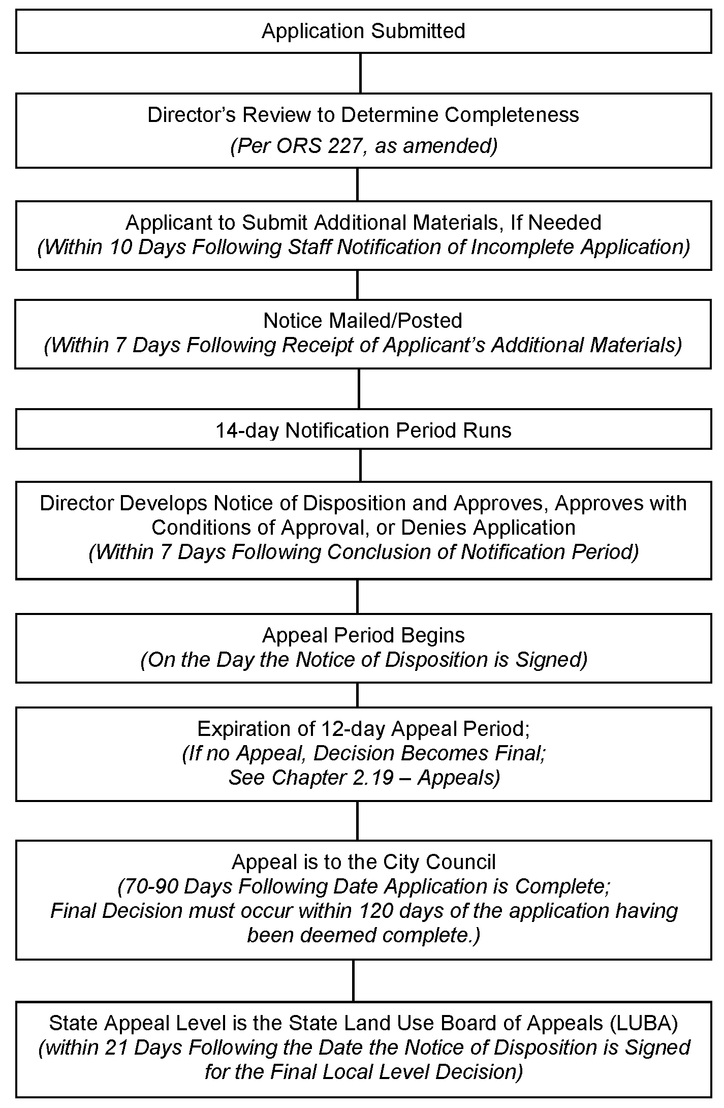
2.13.30.02 Acceptance of Application.
a.
Per ORS 227, the Director shall review the Plan Compatibility Review application for compliance with the application requirements in Section 2.13.30.01, above. If the application is incomplete, the Director shall notify the applicant and state what information is needed to make the application complete. The applicant shall have 10 days from this notification to submit additional materials.
b.
After an application is accepted as complete, any revisions to it that result in the need for an additional public notice to be mailed shall be regarded as a new application. Such new application shall require additional filing fees.
a.
The Director shall notify affected parties that an application for a Plan Compatibility Review has been filed.
b.
Affected parties shall mean any owner and occupants of property within 100 feet of the subject property and any persons whom the Director determines are affected by the application. In addition, notice shall be provided to any neighborhood or community organization recognized by the City and whose boundaries include or are adjacent to the site.
c.
The notice shall state that all comments concerning the proposed Plan Compatibility Review must be submitted in writing and received by the Director within 14 calendar days from the date of mailing the notice. The notice shall include the following:
1.
Street address or other easily understood geographical reference to the subject property;
2.
Applicable criteria for the decision;
3.
Place, date, and time comments are due;
4.
Statement that copies of all evidence relied upon by the applicant are available for review, and that copies can be obtained at cost;
5.
Name and phone number of staff contact person;
6.
Statement that a Notice of Disposition shall be provided to the applicant and any person who submits comments;
7.
An explanation of appeal rights; and
8.
A summary of the local decision-making process.
The application and any written comments that have been received shall be reviewed to ensure consistency with the review criteria in Section 2.13.30.05 below.
Uses requiring Plan Compatibility Review shall be reviewed to ensure compatibility with existing and potential Uses on nearby lands. The following factors shall be considered:
a.
Neighboring property owners and residents shall be protected through reasonable provisions regarding surface water drainage; suitable sound and site buffers; preservation of views, light, air; and other aspects of design that may have substantial effects on neighboring land uses;
b.
The proposed development shall not adversely affect traffic, parking, and access; and
c.
Where Significant Natural Features are involved, the proposed development shall not adversely impact Significant Natural Features regulated by Chapter 2.11 - Floodplain Development Permit, Chapter 4.2 - Landscaping, Buffering, Screening, and Lighting, Chapter 4.5 - Floodplain Provisions, Chapter 4.11 - Minimum Assured Development Area (MADA), Chapter 4.12 - Significant Vegetation Protection Provisions, Chapter 4.13 - Riparian Corridor and Wetland Provisions, and Chapter 4.14 - Landslide Hazard and Hillside Development Provisions.
2.13.30.06 Action on Application.
Based on the review criteria above and any written comments received from affected parties, the Director shall review the proposed development and either approve, conditionally approve, or deny the application after the completion of the 14-day comment period.
2.13.30.07 Revisions of Proposed Plan.
Any revisions of a proposed plan shall be made prior to Building Permit approval.
2.13.30.08 Notice of Disposition.
The Director shall provide the applicant with a Notice of Disposition that includes a written statement of the decision, a reference to findings leading to it, any Conditions of Approval, and the appeal period deadline. The Notice of Disposition shall also be mailed to persons who provided written comment on the mailed notice. The Notice and all applicable information shall be available in the Development Services Division of the Community Development Department.
The decision of the Director may be appealed in accordance with the provisions of Chapter 2.19 - Appeals.
Unless an appeal has been filed, the decision of the Director shall become effective 12 days after the Notice of Disposition is signed.
2.13.30.11 Effective Period of Approval.
Plan Compatibility Review approval shall be effective for a two-year period from date of approval. If the applicant has not begun the development within the two-year period, the approval shall expire.
(Ord. No. 2012-17, eff. 12-13-2012; Ord. No. 2012-18, eff. 12-13-2012; Ord. No. 2018-18, eff, 6-26-2018)
Section 2.16.10 - Background.
Property owners and developers often seek interpretations of this Code or Comprehensive Plan from the Director or other City staff. These Interpretations may be legislative in that they apply to a large geographic area, such as all properties within a given zone, or they may be quasi-judicial, such as Interpretations that apply to a specific site or area. Through the processes identified in this Chapter, an applicant can obtain an official written Interpretation from the City.
Section 2.16.20 - Purposes.
Requests for Interpretation may be made for the following purposes:
a.
Ensure uniformity of interpretations of this Code and the Comprehensive Plan through a formal process; and
b.
Provide an opportunity to appeal staff Interpretations while protecting owners, users, or developers of property from appeals that might otherwise be filed after an unreasonable delay.
Section 2.16.30 - Procedures.
A Request for an Interpretation of this Code or the Comprehensive Plan shall be reviewed in accordance with the following procedures.
2.16.30.01 Application Requirements.
Any person may file a Request for Interpretation. Requests shall be in writing. The form of the Request for Interpretation shall be as specified by the Director. Fees shall be provided as described in LDC § 1.2.100.01.
2.16.30.02 Acceptance of Application.
a.
Per ORS 227, the Director shall review a Request for Interpretation to verify that the request meets the requirements specified above. If a Request for Interpretation does not meet those requirements, the applicant shall be notified and given the opportunity to correct the deficiency. The Director may consult with the City Attorney to determine whether the request is legislative or quasi-judicial.
b.
Any revisions to an accepted application that result in the need for an additional public notice to be mailed shall be regarded as a new application. Such new application shall require additional filing fees.
2.16.30.03 Public Notice Prior to a Quasi-judicial Decision.
a.
The Director shall notify affected parties that a Request for a quasi-judicial Interpretation has been filed.
b.
Affected parties shall mean any owner and occupants of property within 100 feet of the subject property and any other resident owners of property whom the Director determines are affected by the application. In addition, notice shall be provided to any neighborhood or community organization recognized by the City and whose boundaries include or are adjacent to the site.
c.
The notice shall state that all comments concerning the interpretation must be submitted in writing and received by the Director within 14 calendar days from the date of mailing the notice. The notice shall include the following:
1.
Street address or other easily understood geographical reference to the subject property;
2.
Applicable criteria for the decision;
3.
Place, date, and time comments are due;
4.
Statement that copies of all evidence relied upon by the applicant are available for review, and that copies can be obtained at cost;
5.
Name and phone number of staff contact person;
6.
Statement that Notice of Disposition shall be provided to the applicant and any person who submits comments;
7.
An explanation of appeal rights; and
8.
A summary of the local decision-making process.
After accepting a Request for Interpretation that meets the requirements specified above, the Director may route copies of the request to other City divisions or departments for comments or suggestions regarding the Interpretations.
2.16.30.05 Action by Director.
a.
Within 30 calendar days after acceptance of a completed Request for Interpretation, the Director shall respond with a written Interpretation. The Director shall clearly state the Interpretation being issued and basis for such Interpretation.
b.
The Director may interpret provisions of this Code or the Comprehensive Plan, but shall not issue any legal opinion or interpretation of case law.
c.
Director's Interpretations are advisory only and do not bind the Historic Resources Commission, Planning Commission, or City Council in making their decisions.
d.
The Director may modify previously issued Interpretations if specific circumstances warrant such modification.
2.16.30.06 Notice of Disposition.
A copy of the Notice of Disposition and all applicable information shall be available in the Planning Division of the Community Development Department. The Notice of Disposition shall also be provided to the public in the following ways:
a.
Legislative Interpretation - Notice shall be published in a newspaper of general circulation in Corvallis and shall include a statement of the decision, reasons leading to it, and the appeals period deadline.
b.
Quasi-judicial Interpretation - The Director shall provide the applicant with a Notice of Disposition that includes a written statement of the decision, a reference to findings leading to it, any Conditions of Approval, and the appeal period deadline. A Notice of Disposition shall also be mailed to persons who provided written comment on the mailed notice.
The decision of the Director may be appealed in accordance with Chapter 2.19 - Appeals.
Legislative and Quasi-judicial Interpretations - Unless an appeal is filed, the Director's interpretation shall become effective 12 days after the Notice of Disposition is signed.
(Ord. No. 2012-17, eff. 12-13-2012; Ord. No. 2018-18, eff. 6-26-2018; Ord. No. 2021-06, eff. 5-25-2021)
Section 2.18.10 - Background.
Solar energy can make a significant long-term contribution to the City's energy supply. Use of solar energy can be encouraged by providing for and protecting the Solar Access of property owners. A Type 1 Solar Access Permit restricts shading of a solar collector by trees. A Type 2 Solar Access Permit includes protection provided by a Type 1 Permit in addition to protection and remedies to restrict shading of a solar collector by structures.
Section 2.18.20 - Purposes.
This Chapter provides permit procedures to accomplish the following:
a.
Identify a process to protect Solar Access to support the use of a solar collector; and
b.
Specify conditions under which Solar Access Permits are authorized.
Section 2.18.30 - Limits On Solar Permits.
A Solar Access Permit must not affect:
a.
A lot or portion thereof more than 150 feet south of the solar collector location;
b.
A lot located on a slope grade of 20 percent or more and facing within 45 degrees of true north;
c.
Any lot located in a Commercial Mixed Use 3 (CMU-3) Zone;
d.
Any tree or structure on a neighboring lot existing at the time the Solar Access Permit application is accepted;
e.
New structures that shade the solar collector unless a Type 2 Solar Access Permit has been previously approved and recorded;
f.
Proposed new structures resulting in shading of a Type 2 solar collector between 9 a.m. and 3 p.m. on November 21 in an amount that does not exceed the shading that would be caused by a flat-roofed structure half the allowed building height at the minimum setbacks for the zone; and
g.
Any new tree approved in the Solar Access Permit as a solar-access-friendly tree and listed by location and species consistent with Section 2.18.40.06.f, below.
(Ord. No. 2022-06, eff. 3-17-2022; Ord. No. 2023-01, eff. 2-8-2023)
Section 2.18.40 - Procedures.
An application for a Solar Access Permit shall comply with the following.
2.18.40.01 Application Requirements for Type 1 Solar Access Permit.
An application for a Type 1 Permit shall include:
a.
A statement of the solar heating hours for which Solar Access is sought;
b.
Scaled drawing of the solar collector and its dimensions, height above ground level, orientation, and slope from the horizontal;
c.
Sunchart for the proposed location of the solar collector, as measured from the center of the lower edge of the collector site and, if applicable, alternative locations for the solar collector. If the solar collector is more than 20 feet in length, a sunchart photograph shall also be provided from each end of the collector;
d.
Site plan showing lot lines and dimensions of the solar user's lot and neighboring lots that will be affected by the Solar Access Permit. The site plan shall indicate topography using two- or five-feet contour intervals, and the location of the solar collector, structures, and trees. The site plan information shall indicate tree species;
e.
Documentation showing that the solar collector would not be shaded between 9 a.m. and 3 p.m. on November 21 by a six feet-high fence located on the applicant's lot lines;
f.
Documentation showing that no reasonable alternative location exists for the solar collector that would result in fewer restrictions on a neighboring lot;
g.
Documentation showing that removing or trimming vegetation on the applicant's lot will not permit an alternative location for the solar collector that would result in fewer restrictions on a neighboring lot;
h.
A list by owner of record and address for all affected lots, together with an identification by lot of exempt structures and vegetation as defined in Section 2.18.30 Limits on Solar Permits; and
i.
Proposed solar envelopes for affected properties and, if applicable, proposed solar-access-friendly trees permitted to grow so as to only partly obstruct the Solar Access.
j.
Required fees as described in LDC § 1.2.100.01.
2.18.40.02 Application Requirements for Type 2 Solar Access Permit.
An application for a Type 2 Permit shall include information required in Section 2.18.40.01, above, in addition to the following:
a.
Evidence that minimum setbacks and allowable building heights for the zone do not ensure Solar Access protection; and
b.
Proposed solar envelopes prescribing allowed building heights for affected properties.
2.18.40.03 Acceptance of Application.
a.
The Director shall review the Solar Access Permit application for compliance with the application requirements in Section 2.18.40.01 or Section 2.18.40.02, whichever is applicable. If the application is incomplete, the Director shall notify the applicant within five days and state what information is needed to make the application complete. The applicant shall have 10 days from this notification to submit additional materials.
b.
After an application is accepted as complete, any revisions to it that result in the need for an additional public notice to be mailed shall be regarded as a new application. Such new application shall require additional filing fees.
a.
The Director shall notify affected parties that an application for a Solar Access Permit has been filed.
b.
Affected parties shall mean any owner and occupants of property within 100 feet of the subject property and any other persons whom the Director determines are affected by the application. In addition, notice shall be provided to any neighborhood or community organization recognized by the City and whose boundaries include or are adjacent to the site.
c.
The notice shall state that all comments concerning the proposed Solar Access Permit must be submitted in writing and received by the Director within 14 calendar days from the date of mailing the notice. The notice shall include the following:
1.
Street address or other easily understood geographical reference to the subject property;
2.
Applicable criteria for the decision;
3.
Place, date, and time comments are due;
4.
Statement that copies of all evidence relied upon by the applicant are available for review, and that copies can be obtained at cost;
5.
Name and phone number of staff contact person;
6.
Statement that Notice of Disposition shall be provided to the applicant and any person who submits comments;
7.
An explanation of appeal rights; and
8.
A summary of the local decision making process.
The application and any comments shall be reviewed to ensure consistency with the review criteria in Section 2.18.40.06, below.
Solar Access Permit applications shall be reviewed to ensure the following criteria are met:
a.
The solar collector shall have at least four hours of unobstructed Solar Access between 9 a.m. and 3 p.m. on November 21 of each year;
b.
After exempt vegetation has reached a mature height, sufficient Solar Access shall continue to exist for operation of the solar collector;
c.
The solar collector shall not be shaded between 9 a.m. and 3 p.m. on November 21 by a six feet-high fence located on the applicant's lot lines;
d.
No reasonable alternative location exists for the solar collector that would result in fewer restrictions on neighboring lots;
e.
Removing or trimming vegetation on the applicant's lot shall not permit an alternative location that would result in fewer restrictions on a neighboring lot; and
f.
To provide for residential privacy, street trees, or for energy conservation benefits, the Director may specify as a Condition of Approval that solar-access-friendly trees be planted or allowed to grow so that Solar Access is only partly obstructed. Solar-access-friendly trees, if applicable, shall be designated at the time the permit is approved by location, species, and amount of future shading allowed by the tree.
2.18.40.07 Action on the Application.
Based on the review criteria above and any comments received from affected parties, the Director shall review the proposed development and either approve, conditionally approve, or deny the application at the completion of the 14-day comment period.
2.18.40.08 Notice of Disposition.
The Director shall provide the applicant with a Notice of Disposition that includes a written statement of the decision, a reference to findings leading to it, any Conditions of Approval, and the appeal period deadline. The Notice of Disposition shall also be mailed to persons who provided written comment on the mailed notice. The Notice and all applicable information shall be available in the Planning Division of the Community Development Department.
The decision of the Director may be appealed in accordance with the provisions of Chapter 2.19 - Appeals.
Section 2.18.50 - Permit Recording.
Within 30 days after a Solar Access Permit and Building Permit for the solar energy system have been granted, the Director shall file the Solar Access Permit with the Benton County Recorder in such form as required by state law. The permit shall include approved solar envelopes for affected properties, exemptions to or limits on the solar right being created, and the solar collector drawing, sunchart, and site plan.
Section 2.18.60 - Obligation Created By Solar Access Permit.
The owner of any lot subject to a Solar Access Permit shall trim any nonexempt vegetation if subsequent vegetation growth is inconsistent with the Solar Access Permit. The cost of such trimming shall be paid by the owner of the vegetation.
Section 2.18.70 - Replacement of Trees.
Nothing in this Chapter shall prevent a property owner from replacing a species of tree that is partly obstructing Solar Access with a solar-access-friendly tree approved by the Director.
Section 2.19.10 - Background.
This Code is intended to permit flexibility in achieving the goals of the Comprehensive Plan. Some provisions of this Code, therefore, allow considerable discretion in decisions made by the City Council and its agencies and officers.
Criteria and standards have been adopted as part of this Code to ensure consistency in decisions made under its authority. To ensure due process it is also necessary to provide for review of land use, limited land use, and other decisions made under the authority of this Code, that are perceived to be inconsistent with the Comprehensive Plan and/or the requirements of this Code.
(Ord. No. 2018-18, eff. 6-26-2018)
Section 2.19.20 - Purposes.
Procedures and requirements in this Chapter are established for the following purposes:
a.
Provide an Appeal process wherein parties affected by decisions made under the authority of this Code may request review of such decisions;
b.
Establish the basis for valid Appeals;
c.
Establish who may appeal a decision made under the authority of this Code; and
d.
Provide for timely review of Appeals.
(Ord. No. 2018-18, eff. 6-26-2018)
Section 2.19.30 - Procedures.
Appeals shall be filed and reviewed in accordance with the following procedures:
2.19.30.01 General Provisions.
a.
Every decision relating to the provision of this Code substantiated by findings of every board, commission, committee, hearings officer, and official of the City is subject to review by Appeal in accordance with the provisions of this Chapter.
b.
Staying of Decisions -
1.
The filing of an Appeal to a higher level of City hearing authority, in accordance with the provisions of this Chapter, shall initiate the Appeal process and stay the order or decision appealed. The process shall include adequate public notice, a public hearing, and preparation of findings by the hearing authority that affirms, amends, or reverses the decision appealed.
2.
A final decision by the City that is appealed to a state agency shall be stayed only through the relevant state procedures. When State procedures do not require the stay of a final decision, applicants may obtain development and/or site improvement permits. However, applicants will be proceeding at their own risk, pending the outcome of the Appeal.
c.
All hearings on Appeals shall be held de novo (as a new public hearing). For any Appeal, the record of the decision made before the lower level of City hearing authority shall be part of the staff report on Appeal.
2.19.30.02 Hearings Authority.
a.
Appeals of decisions of the Director shall be reviewed by the City Council.
Exception: Appeals of decisions made by the Director on Expedited Land Divisions shall be processed in accordance with ORS 197.375 through ORS 197.380.
b.
Appeals of decisions of the Building Official that relate to the enforcement of this Code's requirements shall be reviewed by the City Council.
c.
Appeals of decisions made under the authority of this Code by the City Engineer and the Floodplain Administrator shall be reviewed by the City Council.
d.
Appeals of decisions made under the authority of this Code by the Planning Commission or the Historic Resources Commission shall be reviewed by the City Council.
e.
Appeals of decisions of the City Council shall conform with applicable ORS provisions, as amended.
Appeals may only be filed by parties affected by a decision made under the authority of this Code. For purposes of this Chapter affected parties shall include any of the following:
a.
The applicant or the applicant's authorized agent.
b.
Any person who testified orally or in writing before the hearing authority whose decision is being appealed.
c.
Any neighborhood organization that testified orally or in writing before the hearing authority whose decision is being appealed.
d.
Any City agency, officer, or department that is responsible for provision of City facilities and services to the proposed development.
e.
Ten registered voters who are City residents.
f.
Any person who was mailed a copy of the Notice of Disposition for a Director-level Historic Preservation Permit.
g.
Any person who is entitled to appeal a land use or limited land use decision pursuant to state law.
Appeals must have been filed within 12 days after a decision is signed. In the case of a legislative interpretation of this Code or the Comprehensive Plan, an Appeal must have been filed within 12 days of a published Notice of such Interpretation. Appeals to the State Land Use Board of Appeals shall be made in accordance with the provisions of state law.
Appeals must be filed by 5:00 p.m. on the final day of the appeal period. Where the final day of an appeal period falls on a weekend or holiday the appeal period shall be extended to 5:00 p.m. on the next work day.
2.19.30.05 Filing Requirements.
Appeals shall be filed in writing with the City Recorder and shall include the following:
a.
Name and address of the appellant;
b.
Reference to the subject development and case number, if any;
c.
Statement of the specific grounds for the Appeal, stated in terms of specific review criteria applicable to the case;
d.
Statement of the appellant's standing to appeal as an affected party; and
e.
Appropriate filing fee.
2.19.30.06 Notice and Hearing.
a.
The Director shall schedule a public hearing for complete and properly filed Appeals. Such hearing is to be held not later than 60 days after the receipt of the notice of Appeal. Incomplete or improperly filed Appeals shall be referred to the hearing authority for dismissal as noted in "b" below.
1.
The hearing authority shall give notice of time, place, and particular nature of the Appeal. At least 20 days prior to the hearing, notice shall be sent by mail to the appellant(s), to the applicant, to the property owner(s) if different from the applicant, to persons and neighborhood organizations that originally received notice of the application, and to anyone who testified or submitted written information for the record of the case. If the decision being appealed was the administrative decision of the Director, Building Official, City Engineer or Floodplain Administrator, notice shall be provided to residents and owners of properties within 100 feet of the subject property.
2.
Public hearings shall be conducted in accordance with Chapter 2.0 - Public Involvement.
b.
Appeals that are incomplete, filed late, or improperly filed may be denied by the hearing authority without further review.
2.19.30.07 Effective Date of Decision.
Unless an Appeal has been filed, approval of any development request shall become effective upon expiration of the appeal period. Where the hearing authority is the City Council, the effective date for filing an Appeal with the State Land Use Board of Appeals (LUBA) shall be in accordance with the provisions of state Law.
(Ord. No. 2018-18, eff. 6-26-2018; Ord. No. 2018-21, eff. 8-6-2018; Ord. No. 2021-06, eff. 5-25-2021)