
Corvallis City Zoning Code
ARTICLE III
DEVELOPMENT ZONES
CHAPTER 3.0 - USE CLASSIFICATIONS
Sections:
CHAPTER 3.1 - LOW DENSITY (RS-6) ZONE
Sections:
CHAPTER 3.2 - MEDIUM DENSITY (RS-9) ZONE
Sections:
CHAPTER 3.3 - MEDIUM-HIGH DENSITY (RS-12) ZONE
Sections:
CHAPTER 3.4 - HIGH DENSITY (RS-20) ZONE
Sections:
CHAPTER 3.5 - RESIDENTIAL MIXED USE (RMU) ZONES
Sections:
CHAPTER 3.6 - MIXED USE RESIDENTIAL (MUR) ZONE
Sections:
CHAPTER 3.10 - PROFESSIONAL AND ADMINISTRATIVE OFFICE (P-AO) ZONE
Sections:
CHAPTER 3.11 - COMMERCIAL MIXED USE (CMU) ZONES
Sections:
CHAPTER 3.12 - GENERAL COMMERCIAL (GC) ZONE
Sections:
CHAPTER 3.17 - CENTRAL BUSINESS FRINGE (CBF) ZONE
Sections:
CHAPTER 3.20 - LIMITED INDUSTRIAL—OFFICE (LI-O) ZONE
Sections:
CHAPTER 3.21 - LIMITED INDUSTRIAL (LI) ZONE[2]
Sections:
Editor's note—Ord. No. 2025-03, § 15(Exh. B), effective March 27, 2025, repealed ch. 3.21, §§ 3.21.10—3.21.60 and enacted a new ch. 3.21 as set out herein. Former ch. 3.21 pertained to similar subject matter and derived from Ord. No. 2012-16, effective December 13, 2012; Ord. No. 2012-18, effective December 13, 2012; Ord. No. 2012-19, effective December 13, 2012; Ord. No. 2022-23, effective September 17, 2022; Ord. No. 2023-19, §§ 19, 20(Exh. B), effective June 30, 2023 and Ord. No. 2024-26, § 24(Exh. B), effective January 1, 2025.
CHAPTER 3.22 - GENERAL INDUSTRIAL (GI) ZONE[3]
Sections:
Editor's note—Ord. No. 2025-03, § 16(Exh. B), effective March 27, 2025, repealed ch. 3.22, §§ 3.22.10—3.22.60 and enacted a new ch. 3.22 as set out herein. Former ch. 3.22 pertained to similar subject matter and derived from Ord. No. 2012-16, effective December 13, 2012; Ord. No. 2012-17, effective December 13, 2012; Ord. No. 2012-18, effective December 13, 2012; Ord. No. 2012-19, effective December 13, 2012; Ord. No. 2022-23, effective September 17, 2022; Ord. No. 2023-19, §§ 21, 22(Exh. B), effective June 30, 2023 and Ord. No. 2024-26, § 25(Exh. B), effective January 1, 2025,
CHAPTER 3.23 - INTENSIVE INDUSTRIAL (II) ZONE[4]
Sections:
Editor's note—Ord. No. 2025-03, § 17(Exh. B), effective March 27, 2025, repealed ch. 3.23, §§ 3.23.10—3.23.60 and enacted a new ch. 3.23 as set out herein. Former ch. 3.23 pertained to similar subject matter and derived from Ord. No. 2012-18, effective December 13, 2012; Ord. No. 2022-23, effective September 17, 2022; Ord. No. 2023-19, §§ 23, 24(Exh. B), effective June 30, 2023 and Ord. No. 2024-26, § 26(Exh. B), effective January 1, 2025.
CHAPTER 3.24 - RESEARCH TECHNOLOGY CENTER (RTC) ZONE[5]
Sections:
Editor's note—Ord. No. 2025-03, § 18(Exh. B), effective March 27, 2025, repealed ch. 3.24, §§ 3.24.10—3.24.60 and enacted a new ch. 3.24 as set out herein. Former ch. 3.24 pertained to similar subject matter and derived from Ord. No. 2012-16, effective December 13, 2012; Ord. No. 2012-18, effective December 13, 2012; Ord. No. 2012-19, effective December 13, 2012; Ord. No. 2014-19, effective December 11, 2014; Ord. No. 2022-06, effective March 17, 2022; and Ord. No. 2024-26, § 27(Exh. B), effective January 1, 2025.
CHAPTER 3.25 - MIXED USE TRANSITIONAL (MUT) ZONE
Sections:
CHAPTER 3.27 - MIXED USE EMPLOYMENT (MUE) ZONE[6]
Sections:
Editor's note—Ord. No. 2025-03, § 20(Exh. B), effective March 27, 2025, repealed ch. 3.27, §§ 3.27.10-3.27.80 and enacted a new ch. 3.27 as set out herein. Former ch. 3.27 pertained to similar subject matter and derived from Ord. No. 2012-16, effective December 13, 2012; Ord. No. 2012-18, effective December 13, 2012; Ord. No. 2012-19, effective December 13, 2012; Ord. No. 2020-10, effective July 30, 2020; Ord. No. 2022-06, effective March 17, 2022; Ord. No. 2023-19, §§ 27, 28(Exh. B), effective June 30, 2023; and Ord. No. 2024-26, § 29(Exh. B), effective January 1, 2025.
CHAPTER 3.30 - AGRICULTURE-OPEN SPACE (AG-OS) ZONE[7]
Sections:
Editor's note—Ord. No. 2025-03, § 21(Exh. B), effective March 27, 2025, repealed ch. 3.30, §§ 3.30.10—3.30.70 and enacted a new ch. 3.30 as set out herein. Former ch. 3.30 pertained to similar subject matter and derived from Ord. No. 2012-18, effective December 13, 2012; Ord. No. 2012-19, effective December 13, 2012; Ord. No. 2023-19, § 29(Exh. B), effective June 30, 2023 and (Ord. No. 2024-26, § 30(Exh. B), effective January 1, 2025.
CHAPTER 3.31 - CONSERVATION-OPEN SPACE (C-OS) ZONE
Sections:
CHAPTER 3.36 - OREGON STATE UNIVERSITY (OSU) ZONE[8]
Sections:
Editor's note—Ord. No. 2025-41, §§ 2, 4, adopted August 18, 2025, repealed ch. 3.36, §§ 3.36.10—3.36.90 and enacted a new ch. 3.36 as set out herein. Former ch. 3.36 pertained to similar subject matter and derived from Ord. No. 2018-16, effective June 25, 2018; Ord. No. 2018-36, effective January 1, 2019; Ord. No. 2019-09, effective March 1, 2019; Ord. No. 2019-026, effective October 17, 2019; Ord. No. 2022-16, effective March 17, 2022; Ord. No. 2023-01, effective February 8, 2023; Ord. No. 2023-05, §§ 2, 3(Exh. A), effective March 3, 2023; Ord. No. 2023-19, §§ 30—32(Exh. A), effective June 30, 2023; and Ord. No. 2023-27, 5(Exh. A), effective February 28, 2024.
CHAPTER 3.40 - UNIVERSITY NEIGHBORHOODS OVERLAY (UNO)
Sections:
The University Neighborhoods Overlay (UNO) can be applied to one or more Lots or Parcels in conjunction with any other residential zone within its adopted boundary, as may be amended over time. The standards implemented by the UNO reflect patterns of development that are integral to those neighborhoods within proximity of the Oregon State University campus. As such, its use should be limited to those neighborhoods unless expansion is justified by additional documentation and analysis of residential development patterns that may exist beyond the current boundary.
CHAPTER 3.41 - WILLAMETTE RIVER GREENWAY (WRG) OVERLAY
Sections:
CHAPTER 3.42 - HISTORIC PRESERVATION (HPO) OVERLAY
Sections:
CHAPTER 3.43 - NONRESIDENTIAL PLANNED DEVELOPMENT (PD) OVERLAY
Sections:
The Nonresidential Planned Development (PD) Overlay can be applied to a site in conjunction with any other nonresidential zone. Once a property is designated with a Nonresidential PD Overlay designation, it shall be developed in accordance with the provisions of Chapter 2.5 - Planned Development, unless the Nonresidential PD Overlay Zone designation has been removed in accordance with the provisions of Section 3.43.50.
CHAPTER 3.44 - RESIDENTIAL PLANNED DEVELOPMENT (PD) OVERLAY
Sections:
The Residential Planned Development (PD) Overlay can be applied to a site in conjunction with any other residential zone. However, application of this Residential Planned Development (PD) Overlay shall be solely at the discretion of the property owner. Once a property is designated with a Residential PD Overlay designation, it shall be developed in accordance with the provisions of Chapter 2.5 - Planned Development, unless the Overlay is removed in accordance with the provisions of Section 3.44.50, below.
CHAPTER 3.45 - CLIMATE-FRIENDLY AREAS (CFA) OVERLAY
Sections:
Section 3.0.10 - Purpose.
Use Classifications classify Use Types based on common functional, product, or compatibility characteristics, thereby regulating Uses according to relative compatibility. There are occasions, however, where a Use instead of a Use Type is listed. Where this occurs, reference is made to Chapter 1.6 - Definitions.
Section 3.0.15 - Legal Considerations.
a.
The Director has the authority to classify common Uses according to Use Types listed in Section 3.0.30 below. The classification of a Use is subject to the right of appeal in accordance with the provisions of Chapter 2.19 - Appeals.
b.
Use Types not specifically listed in a zone cannot be established except:
1.
As classified by the Director per (a) above;
2.
As authorized in this Code and in accordance with Chapter 2.16 - Request for Interpretation;
3.
As customarily incidental to the Primary Use in accordance with Chapter 4.3 - Accessory Development Regulations; or
4.
When permitted by the Code at the time of approval of a Conceptual or Detailed Development Plan overlying the subject property.
(Ord. No. 2022-06, eff. 3-17-2022; Ord. No. 2023-01, eff. 2-8-2023)
Section 3.0.20 - Classification of Combination of Primary Uses.
The following rules apply where a single lot contains two or more Uses:
a.
Separate Classification of Several Establishments with Different Uses - the Primary Uses conducted on a lot or development site by two or more establishments, managements, or institutions are separate Uses when the Uses resemble two or more different Use Types and are not classified as Accessory Uses in accordance with Chapter 4.3 - Accessory Development Regulations.
b.
Separate Classification of Same Establishment with Different Uses - the Primary Uses conducted on a lot or development site by a single establishment, management, or institution are separate Uses. Each Use must be classified in the Use Type(s) whose description most closely portrays its nature when the Uses resemble two or more different Use Types and are not classified as Accessory Uses in accordance with Chapter 4.3 - Accessory Development Regulations.
c.
Single Classification of Same Establishment with Same Use Types - Uses conducted on a lot or development site by a single establishment, management, or institution are considered to be a single Use, even if there is more than one Primary Use on the site, when the Uses fall within the same Use Types and are not classified as Accessory Uses in accordance with Chapter 4.3 - Accessory Development Regulations.
d.
Separate Classification of Different Establishments with Same or Different Uses - the Primary Uses conducted on a lot or development site by two or more establishments, managements, or institutions are considered to be more than one Use, whether the Uses are the same Use or Use Type or different Uses or Use Types and the Uses are not classified as Accessory Uses in accordance with Chapter 4.3 - Accessory Development Regulations.
(Ord. No. 2023-01, eff. 2-8-2023)
Section 3.0.30 - Listing of Use Classifications.
The primary activity on a lot or site is the Use. The Director will classify Uses as one or more Use Types. All Use Types in this Chapter are arranged by Use Type category to make them easier to locate. This Chapter lists Use Type categories in the following order: Residential, Civic, Commercial, Industrial, Agricultural and Extractive. The Use Types within each Use Type category are in alphabetical order.
In addition to Use Types, this Code defines residential, nonresidential, and mixed use Building Types, in Chapter 1.6 - Definitions. Each Zone lists one or more allowed Building Types. Any use or activity occurring within a building must be consistent with the Permitted Use Types of the Zone.
3.0.30.01 Residential Use Types.
Residential Use Types include the occupancy of living accommodations on a wholly or primarily non-transient basis. Also included is development that is Accessory to these Uses as specified in Chapter 4.3 - Accessory Development Regulations, and Home Business as defined in Chapter 1.6 - Definitions.
a.
Cottage Cluster - A type of household residential development that includes a minimum of three Cottages, with a footprint of less than 900 square feet each, and results in a density of four or more Cottages per acre, located on a single lot that includes a common courtyard. A Cottage Cluster comprised of manufactured dwellings is not a Manufactured Dwelling Facility.
b.
Day Care, Residential - Babysitting or care of 16 or fewer children, including resident family members, as Accessory to any Residential Use Type. Day Care, Residential is not subject to the definition of Home Business, as contained in Chapter 1.6 - Definitions. This Use Type is classified per ORS 329A.440 as a family child care home.
c.
Group Residential - A single unit with seven (7) or more rooms used for sleeping purposes that are offered for rent, but with rooms, individually or collectively, that do not constitute separate dwelling units. Typical uses include occupancy of boarding houses, cohousing, rooming houses, single room occupancies, fraternity and sorority houses, and cooperatives. A Group Residential use is limited to one unit per legal lot or parcel and is contained within a single Residential Building Type "Other" defined in Chapter 1.6 - Definitions.
d.
Home Business - A lawful activity commonly carried on for profit within a dwelling and that meets all provisions contained in the Home Business definition in Chapter 1.6 - Definitions.
e.
Household Residential - Residential occupancy of a dwelling unit. The dwelling unit is contained within one of the Residential or Mixed Use Building Types defined in Chapter 1.6 - Definitions. Household Residential excludes Group Residential uses.
f.
Manufactured Dwelling Facility - A type of residential development where four or more manufactured dwellings or mobile homes are located within 500 feet of one another on a lot. A Manufactured Dwelling Facility is not a Cottage Cluster. The primary purpose of the facility is to rent spaces for manufactured homes and/or mobile homes. The applicable Oregon Revised Statutes that pertain to Manufactured Dwellings and facilities are ORS 446.155 through ORS 446.285, and ORS 455.010. The Oregon Administrative Rule pertaining to Manufactured Dwellings is OAR Chapter 918, Division 500-520. The State of Oregon Manufactured Dwelling and Park Specialty Code, which is a min/max code, governs construction requirements for manufactured and mobile homes.
g.
Real Estate Services, Residential - Real estate sales office in a subdivision or residential development that contains more than 50 lots or dwelling units. Activities support the sale of lots or dwelling units within the development that remain available for sale to the public. The use is typically accessory to primary residential uses within the subdivision or development, but may occur within a building on its own lot. See ORS 197.312.
h.
Residential Care Facility - A facility licensed by the state that provides Residential Care in one or more buildings on contiguous properties for socially dependent individuals or individuals with physical disabilities, and to accommodate the resident staff persons engaged in their care. See ORS 443.400. A Residential Home, as defined in ORS 197.660, is not a Residential Care Facility.
Civic Use Types include the performance of utility, educational, recreational, cultural, protective, governmental, and other Uses strongly vested with public or social importance. Also included is development that is Accessory to these Uses, as specified in Chapter 4.3 - Accessory Development Regulations.
a.
Administrative Services - Consulting, record keeping, clerical, or public contact services that deal directly with the public, together with incidental storage and maintenance of necessary vehicles. This Use Type excludes Professional and Administrative Services. Typical Uses are governmental offices.
b.
Community Recreation - Recreational, social, or multi-purpose Uses typically associated with parks, play fields, golf courses, interpretive centers associated with parks, or community recreation buildings.
c.
Cultural Exhibits and Libraries - Museum-like preservation and exhibition of objects in one or more of the arts and sciences, gallery exhibition of works of art, or library collection of books, manuscripts, etc., for study and reading.
d.
Essential Services - Services necessary to support development such as installation and/or maintenance of utilities, services involving only minor structures such as lines and poles, phone booths, fire hydrants, bus stops, benches, and mailboxes.
e.
Group Assembly - Meetings and activities primarily conducted for members of such groups. Excludes Group Residential and Lodging Services Use Types. Typical Uses include synagogues, temples, and churches; and meeting places for civic clubs, lodges, or fraternal or veteran organizations. Includes activities customarily associated with the practices of a religious activity outlined in ORS 227.500.
f.
Schools - Public and private educational facilities, excluding Vocational or Professional Training facilities as defined in 3.0.30.03.ee.
g.
Major Services and Utilities - Services and utilities that have substantial impacts. Such Uses may be permitted when the public interest supersedes the usual limitations placed on land use and the Uses transcend the usual restraints of the zone for reasons of necessary location and community-wide interest. Typical Uses include sanitary landfills, airports, hospitals, detention and correctional institutions, and mass transit waiting stations or turnarounds. Excludes the University Services and Facilities Use Type.
h.
Minor Utilities - Public utilities that have a local minor impact on surrounding properties. Typical Uses include electrical and gas distribution substations, wind generators, and radio facilities. Excludes Wireless Telecommunication Facilities Use Types.
i.
Parking Services - Public parking garages and lots.
j.
Postal Services - the following are Postal Services Use Types:
1.
Customer - Mailing services and processing as traditionally operated or leased by postal and parcel service companies, provided the facilities serve an immediate neighborhood and are pedestrian-accessible, and the services and processing are oriented toward customers who can do business on the premises.
2.
Community-Based - Mailing services and processing as traditionally operated or leased by postal and parcel service companies, but which may or may not include customer access on the premises. These facilities may be distribution centers and/or larger facilities that serve a broad part of the community, as opposed to an immediate neighborhood.
k.
Public Safety - Services that provide protection to a zone or entity according to Fire and Life Safety Code sections, together with the incidental storage and maintenance of necessary vehicles. Typical Uses include fire stations, police stations, and ambulance services.
l.
Social Service Facilities - Facilities operated in the interest of the physical and mental health and welfare of the community's population. Typical services include two or more of the following: individual counseling, family counseling, meal services, medical and/or dental services in structures less than 3,000 sq. ft. in size, short-term overnight accommodations, and office and administrative functions related to any or all of these services. Excludes the Medical Services Use Type.
m.
University Services and Facilities - Services and facilities customarily associated with a major university. Typical Uses include housing facilities, classrooms, Research Services as defined in Section 3.0.30.03.y, recreational amenities, parking facilities, and Commercial Uses that directly serve the student/faculty population or research/educational mission of the university.
n.
Wireless Telecommunication Facilities - the site, structures, equipment, and appurtenances used to send and receive radio frequency transmissions for wireless telecommunication services such as cellular telephone, personal communication services, enhanced/specialized mobile radio, and commercial paging services. Such facilities include antennas, poles, towers, cables, wires, conduits, ducts, pedestals, vaults, buildings, electronics, and switching equipment.
1.
Colocated/Attached Wireless Telecommunication Facility - A facility attached to an existing pole, tower, or other structure including, but not limited to, a structure that can accommodate the future installation of two or more antenna systems.
2.
Freestanding Wireless Telecommunication Facility - A new tower, monopole, or other unattached structure erected to support wireless communication antennas and connecting appurtenances.
3.0.30.03 Commercial Use Types.
Commercial Use Types include the distribution, sale, and/or rental of goods and the provision of services other than those classified as Civic Uses. Also included is development that is Accessory to these Uses, as specified in Chapter 4.3 - Accessory Development Regulations.
a.
Agricultural Sales
1.
On-site sale of feed, grain, fertilizers, pesticides and similar goods. Typical Uses include nurseries, hay, and feed and grain stores; and
2.
On-site retail sale of agricultural food products, provided all of the following are met:
a.
The associated structures are used for the sale of farm crops and livestock grown on the site or in the local agricultural area, and grown at least in part by the operator of the facility;
b.
As used in this subsection "2" the phrase "farm crops and livestock" includes both fresh and processed farm crops and livestock grown on the site or in the local agricultural area, but does not include the sale or auctioning of live animals;
c.
As used in subsection "2.b" above, the phrase "processed crops and livestock" includes jams, syrups, apple cider, animal products and other similar farm crops and livestock that have been processed and converted into another product, but does not include food items prepared for immediate consumption;
d.
As used in this subsection "2" the phrase "local agricultural area" includes the Oregon counties of Benton, Linn, Lane, Marion, Polk, and Lincoln;
e.
The retail and associated structures do not include any dining areas and do not include any structures or outdoor areas for banquets, public gatherings or public entertainment; and
f.
The size of the space dedicated to the on-site retail sales of agricultural food products does not exceed 1,500 sq. ft. This space may be located in existing buildings, additions to existing buildings, and/or new buildings.
b.
Agricultural Services - Provision of agriculturally related services with incidental storage on off-site lots. Typical Uses include crop dusting and tree service firms.
c.
Animal Sales and Services - the following are Animal Sales and Services Use Types:
1.
Auctioning - Auctioning of livestock on a wholesale or retail basis with incidental storage of animals for a period not exceeding 72 hours. Typical Uses include animal auctions and livestock auction yards.
2.
Grooming - Grooming of dogs, cats, and similar small animals. Typical Uses include dog bathing, clipping salons, and pet grooming shops.
3.
Horse Stables - Boarding, breeding, or raising of horses not owned by the occupants of the premises, or riding of horses by other than the occupants of the premises or their nonpaying guests. Typical Uses include boarding stables and public stables.
4.
Kennels - Kennel services for dogs, cats, and similar small animals. Typical Uses include boarding kennels and dog training centers.
5.
Stockyards - Stockyard services involving temporary housing of livestock for slaughter, market or shipping. Typical Uses include stockyards and animal sales yards.
6.
Veterinary (Large Animals) - Veterinary services for large animals. Typical Uses include animal hospitals and veterinary hospitals for large animals.
7.
Veterinary (Small Animals) - Veterinary services for small animals. Typical Uses include pet clinics, dog and cat hospitals, and animal hospitals for small animals.
d.
Automotive and Equipment - Sales of motor vehicles or services related to motor vehicles, which do not fall into the description of Retail Sales. The following are Automotive and Equipment Use Types:
1.
Car Wash - Washing, polishing, or detailing of automobiles. Typical Uses include car washes. This Use Type does not include auto repair, auto equipment repair, or installation of auto parts, which is classified as Automotive and Equipment - Light Equipment Repairs.
2.
Fleet Storage - Storage of vehicles used regularly in business operation and not available for sale; or long-term storage of operating vehicles. Typical Uses include taxi fleets, mobile-catering truck storage, and auto storage garages.
3.
Parking Services - Temporary parking of motor vehicles within a privately owned off-street parking area. Typical Uses include commercial parking lots and garages.
4.
Heavy Equipment Repairs - Repair of trucks and other heavy equipment; sale, installation, or servicing of automotive equipment and parts; and body repairs, painting, and steam cleaning. Typical Uses include engine repair shops, auto body shops, and motor freight maintenance groups.
5.
Light Equipment Repairs - Repair of automobiles and the sale, installation, or servicing of automobile equipment and parts. Excludes auto body repairs and painting. Typical Uses include muffler shops, auto or motorcycle repair garages, and auto glass shops.
6.
Farm Equipment Sales/Rentals - Retail or wholesale sale and/or rental of farm equipment together with incidental maintenance. Typical Uses include farm equipment dealers.
7.
Heavy Equipment Sales/Rentals - Retail or wholesale sale and/or rental of heavy construction equipment, trucks, and/or aircraft, together with incidental maintenance. Typical Uses include aircraft dealers, heavy construction equipment dealers, tractor trailer dealers, motorhome and boat dealers, and recreational vehicles sales and rental agencies.
8.
Light Equipment Sales/Rentals - Retail or wholesale sale and/or rental of autos, noncommercial trucks, motorcycles, and/or trailers with less than 10,000 lbs. gross cargo weight, together with incidental maintenance, that is not entirely enclosed within a building. Typical Uses include automobile dealers and car rental agencies. Sales and/or rentals that are entirely enclosed within a building, with no exterior product storage or display, are considered Retail Sales.
9.
Storage of Nonoperating Vehicles - Storage of nonoperating motor vehicles. Typical Uses include storage of private parking towaways and impound yards.
10.
Storage of Recreational Vehicles and Boats - Storage of recreational vehicles and boats. Typical Uses include the collective storage of personal recreational vehicles and boats.
e.
Building Maintenance Services - Provision of maintenance and custodial services to commercial and industrial establishments. Typical Uses include janitorial, landscape maintenance, and window cleaning services.
f.
Business Equipment Sales and Services - Sale, rental, or repair of office, professional, and service equipment and supplies to firms rather than to individuals. Excludes Automotive and Equipment, Construction Sales and Services, and Farm Equipment Sales/Rentals Use Types. Typical Uses include office equipment and supply firms, small business machine repair shops, and hotel equipment and supply firms.
g.
Business Support Services - Provision of clerical, employment, protective, or minor processing services to firms rather than individuals. Storage of goods other than samples is prohibited. Typical Uses include secretarial services, telephone answering services, and blueprint services.
h.
Communications Service Establishments - Broadcasting and other information relay services accomplished through use of electronic and telephonic mechanisms. Excludes services classified as Major Services and Utilities and Minor Utilities. Typical Uses include television and radio studios, telecommunication service centers, and telegraph service offices.
i.
Construction Sales and Services - Construction activities and incidental storage on lots other than construction sites. Also includes the retail or wholesale sale, from the premises, of materials used in the construction, maintenance, and repair/remodel of buildings or other structures, provided that such retail or wholesale Uses include the sale of heavy construction material such as lumber, cement, fencing, and/or roofing materials. Excludes Use Types classified as Automotive and/or Heavy Equipment. Typical Uses include building materials stores, tool and equipment rental or sales, and building contracting/construction offices.
j.
Day Care, Commercial Facility - An institution, establishment, or place that commonly receives at one time more than 16 children not of common parentage, for a period not to exceed 12 hours per given day for the purposes of being given board, care, or training, apart from their parents or guardians, for compensation or reward in accordance to ORS 329A, as amended. This Use Type is classified per ORS 329A.440 as a child care center.
k.
Drive-through Facilities - Facilities that directly serve patrons in motor vehicles. Typically, this Use Type depends on a driveway or drive area that provides adequate room for vehicle stacking at a drive-up service window. See also Parking Lot Kiosk in "w" below.
l.
Eating and Drinking Establishments - Sale of prepared food and beverages for consumption on and/or off the premises. Typical uses include restaurants (sit-down or take-out), coffee shops, and bars.
m.
Explosive Storage - Storage of any quantity of explosives in accordance with ORS 480, as amended. Typical Uses include storage in the course of manufacturing selling, or transporting explosives or storage in the course of blasting operations.
n.
Financial, Insurance, and Real Estate Services - Financial, insurance, real estate or securities brokerage services. Typical Uses include banks, insurance agencies, and real estate firms.
o.
Funeral and Interment Services - Provision of services involving the care, preparation, or disposition of human dead. The following are Funeral and Interment Services Use Types:
1.
Cremating - Crematory services involving the purification and reduction of the human body by fire. Typical Uses include crematories and crematoriums.
2.
Interring - Interring services involving the storage of human bodies other than in cemeteries. Typical Uses include columbariums and mausoleums.
3.
Undertaking - Undertaking services involving preparing the dead for burial and arranging and managing funerals. Typical Uses include funeral homes and mortuaries.
4.
Cemeteries - A place for burying the dead; graveyard.
p.
Fuel Sales - Retail sale of petroleum products with incidental sale of tires, batteries, and replacement items, lubricating services, and minor repair services. Typical Uses include automobile service stations, filling stations and truck stops.
q.
Laundry Services - Laundering, dry cleaning, or dyeing services other than those classified as Convenience Sales and Personal Services. Typical Uses include laundry agencies, diaper services, and linen supply services.
r.
Lodging Services - Provision of temporary overnight accommodations with incidental food, drink, and other sales and services intended for the convenience of guests. The following are Lodging Services Use Types:
1.
Campground - Areas for travelers in recreational vehicles or tents. Typical Uses include recreational vehicle parks.
2.
Hotels/Motels - Provision of room or room and board in hotels or motels.
3.
Bed and Breakfast Facilities - Provision of room or room and board in bed and breakfast inns that do not comply with the Home Business definition in Chapter 1.6 - Definitions.
s.
Medical Services - Personal health services including prevention, diagnosis, treatment, and rehabilitation services provided by physicians, dentists, nurses, and other health personnel; and medical testing and analysis services. Typical Uses include hospitals, medical offices, dental laboratories, and health maintenance organizations. Excludes Civic and Group Residential/Group Care Use Types.
t.
Parking Lot Kiosk - A Commercial Use in a structure that is less than 120 sq. ft. in size and located within the parking lot of a development site. Parking Lot Kiosks typically contain Eating and/or Drinking Establishments, Food and/or Beverage Sales, Retail Sales, and/or Personal Services. Parking Lot Kiosks are allowed either when a zone identifies Drive-through Uses as Permitted Uses or when Parking Lot Kiosk is listed as a Permitted Use.
u.
Participant Sports and Recreation - Provision of sports or recreation primarily by and for participants. Spectators are incidental and present on a nonrecurring basis. The following are Participant Sports and Recreation Use Types for either general or personal use:
1.
Indoor - Conducted in an enclosed building. Typical Uses include bowling alleys, billiard parlors, swimming pools, and physical fitness centers.
2.
Outdoor - Conducted in open facilities. Typical Uses include driving ranges, miniature golf courses, golf courses, and swimming pools.
v.
Personal Services - Provision of personal services. Typical Uses include laundromats/dry cleaners, barbershops, and beauty salons.
w.
Professional and Administrative Services - Professional, executive, management or administrative offices of private firms or organizations. Typical Uses include administrative offices, legal offices, and architectural firms.
x.
Repair Services, Consumer - Provision of repair services to individuals and households, but not to firms. Excludes Automotive and Equipment Use Types. Typical Uses include appliance repair shops, apparel repair firms, and musical instrument repair firms.
y.
Research Services - Research of an industrial or scientific nature generally provided as a service or conducted by a public agency or private firm. Typical Uses include electronics research laboratories, environ-mental research and development firms, agricultural and forestry research labs, and pharmaceutical research labs.
z.
Retail Sales - Sale or rental of commonly used goods and merchandise for personal or household use. Excludes Agricultural Sales, Animal Sales and Services, Automotive and Equipment, Business Equipment Sales and Services, Construction Sales and Services, and Fuel Sales. Typical Uses include department stores, grocery stores, gift shops, bookstores, flea markets, liquor stores, and furniture stores. Also includes retail or wholesale sale and/or rental of autos, noncommercial trucks, motorcycles, and/or trailers with less than 10,000 lbs. gross cargo weight, that is entirely enclosed within a building and does not include exterior product display or storage.
aa.
Scrap Operations - Storage, sale, dismantling, or other processing of used, source-separated, or waste materials not intended for reuse in their original form. Typical Uses include automotive wrecking yards, junk yards, paper salvage yards and recycling facilities.
bb.
Spectator Sports and Entertainment - Provision of cultural, entertainment, athletic, and other events to spectators. Also includes events involving social or fraternal gatherings. The following are Spectator Sports and Entertainment Use Types:
1.
Limited - Uses conducted on a development site and in an enclosed indoor area that generate an attendance of 299 or fewer people. Typical Uses include small theaters and meeting halls.
2.
Other - Uses conducted on a development site in an open outdoor area and/or Uses conducted on a development site that generate an attendance of 300 or more people. Typical Uses include multi-plex theaters, large theaters, large exhibition halls, and sports stadiums.
cc.
Technology and Support Services - A center or facility where employees receive and make contact with the public to promote products and/or services, or provide technical support with regard to specific manufactured items. This use type also applies to facilities used to store and operate computer systems and associated components. Typical uses include call centers, customer support centers, data centers, technical support centers, and telemarketing centers.
dd.
Temporary Outdoor Markets - Retail sales, personal services, or food and beverage sales that are conducted wholly or partially in an outdoor setting oriented to pedestrian activity and public gathering, and temporary in nature. Temporary Outdoor Markets must not persist more than 45 days per calendar year per property. Permanent structures are not a part of these Uses. Typical Uses include farmers' markets, community festivals, and seasonal sales of produce and Christmas trees.
ee.
Vocational or Professional Training - Private businesses providing vocational or technical training services for adult learning that are not part of public or private K-12 educational uses, and are not part of an accredited institution of higher education.
ff.
Wholesale, Storage, and Distribution - Wholesaling, storage, distribution, and handling of materials and equipment other than live animals and plants. The following are Wholesaling, Storage, and Distribution Use Types:
1.
Mini-Warehouses - Storage or warehousing service within a building for individuals to store personal effects and for businesses to store materials for operation of an industrial or commercial enterprise elsewhere. Incidental Uses in a mini-warehouse may include the repair and maintenance of stored materials by the tenant, but in no case may storage spaces in a mini-warehouse facility function as an independent retail, wholesale, business, or service Use. Spaces may not be used for workshops, hobby shops, manufacturing, or similar Uses. Human occupancy is limited to that required to transport, arrange and maintain stored materials.
2.
Light - Wholesaling, storage, and warehousing services within enclosed structures. Typical Uses include wholesale distributors, storage warehouses and moving and storage firms.
3.
Heavy - Open-air storage, distribution, and handling of materials and equipment. Typical Uses include monument or stone yards and grain elevators.
3.0.30.04 Industrial Use Types.
Industrial Use Types include the on-site production of goods by methods not Commercial, Agricultural, or Extractive in nature. Also included is development that is Accessory to these Uses as specified in Chapter 4.3 - Accessory Development Regulations.
a.
Limited Manufacturing - Establishments that employ 20 or fewer persons per shift unless otherwise specified by the applicable zone, do not involve outside storage of materials, do not require state or federal air quality discharge permits (except for parking), are compatible with nearby Residential Uses because there are few or no offensive external effects, and are primarily engaged in one of the following:
1.
On-site production of hand-manufactured goods involving use of hand tools or light mechanical equipment. Products may be finished or semi-finished and are generally made for the wholesale market, for transfer to other plants, or to order for customers or firms. Goods are generally not displayed or sold on site, but if so, this activity(ies) is a subordinate part of total sales. Typical Uses include instruction studios, ceramic studios, woodworking and cabinet shops, custom jewelry manufacturing, and similar types of arts and crafts or small-scale manufacturing;
2.
Manufacturing or assembling of electronic components, medical and dental supplies, computers, or other manufacturing establishments with similar characteristics. Goods generally are not displayed or sold on site, but if so, this activity(ies) is a subordinate part of total sales; or
3.
On-site production or processing of food products. Food products may be finished or semi-finished and are generally made for the wholesale market, transfer to other businesses, or direct retail sales off-site. On-site retail sale of goods must be a subordinate part of total sales. Limited Manufacturing excludes the activities of slaughtering animals, and canning, rendering, tanning, and reduction of meat.
b.
Technological Production - Research and development, production, processing, assembling, or packaging of products that rely upon research and technological innovation. Typical Uses include manufacturing research instruments, electronic products, and surgical and medical instruments. Excludes Uses that require state or federal air quality discharge permits (except for parking).
c.
General Industrial
1.
Uses -
a)
Production, processing, assembling, packaging, or treatment of food and non-food products; or
b)
Manufacturing and/or assembly of electronic instruments and equipment and electrical devices.
2.
Attributes - General Industrial Uses may require state or federal air quality discharge permits, but do not have nuisance conditions that are detectable from the boundaries of the subject property. Nuisance conditions can result from any of the following:
a)
Continuous, frequent, or repetitive noises or vibrations;
b)
Noxious or toxic fumes, odors, or emissions;
c)
Electrical disturbances; or
d)
Night illumination into residential areas.
Exceptions: Noise and vibrations from temporary construction; noise from vehicles or trains entering or leaving the site; noise and vibrations occurring fewer than 15 minutes per day; an odor detected for fewer than 15 minutes per day; or noise detectable only as part of a composite of sounds from various off-site sources.
d.
Intensive Industrial - Manufacturing, processing, or assembling of materials in a manner that would create any of the commonly recognized nuisance conditions or characteristics described above in the General Industrial Use Type classification.
3.0.30.05 Agricultural Use Types.
Agricultural Use Types include the on-site production of plant and animal products by agricultural methods. Also included is development that is Accessory to these Uses, as specified in Chapter 4.3 - Accessory Development Regulations.
a.
Animal Husbandry - Raising and breeding of livestock.
b.
Animal Waste Processing - Processing of animal waste and by-products, including animal manure, animal bedding waste, and similar by-products of animal husbandry operations, for use as a commercial fertilizer, soil amendment or compost.
c.
Aquaculture - the cultivation of aquatic animals and plants, especially fish, shellfish, and seaweed, in natural or controlled marine or freshwater environments, typically for research or commercial purposes.
d.
Horticulture - Horticultural and flora cultural specialties such as flowers, shrubs, and trees intended for ornamental or landscaping purposes, or for the production of food producing plants, shrubs, or trees. The following are Horticulture Use Types:
1.
Cultivation - Cultivation of plants.
2.
Storage - Storage of plants, primarily in containers.
e.
Packing and Processing - Packing or processing of agricultural crops, animals, and their by-products that entails more than picking, cutting, sorting, and boxing or crating. Excludes the activities of canning, rendering, tanning, or reduction of meat. The following are Packing and Processing Use Types:
1.
Limited - Packing or processing of crops grown on the premises.
2.
General - Packing or processing of crops, animals, or their by-products regardless of where they were grown.
f.
Row and Field Crops - Cultivation of agricultural products grown in regular or scattered patterns. Crops include vines, field, forage, and other plant crops intended to provide food or fibers.
g.
Tree Crops - Cultivation of tree-grown agricultural products such as orchards for apples and cherries.
h.
Garden - A plot of ground, or other area such as on a rooftop, balcony, fence, wall, or window sill, that is used to grow food-producing or ornamental plants, shrubs, or trees. Gardens are intended for personal use or consumption, or for off-site sales. On-site sales of garden products are prohibited.
i.
Market Garden - Commercial production and processing of fruit, vegetables, flowers, and other plants, animal products, and honey. Market Gardens are only accessory uses to Residential Use Types, except in the OSU zone. The residential character of the associated dwelling must be maintained and the activity conducted in such a manner as not to give an outward appearance nor manifest any characteristics of a business in the ordinary meaning of the term. The activity also does not infringe upon the right of neighboring residents to enjoy the peaceful occupancy of their homes.
j.
Community Garden - A plot of ground, or other area such as on a rooftop, located on public or private land, and managed collectively by a group for the purpose of growing food-producing or ornamental plants. Community Gardens are only accessory uses to Civic Use Types, except in the OSU zone or as required in the RS-12 and RS-20 zones. Examples of community gardens include, but are not limited to, neighborhood gardens, school gardens, therapeutic gardens, demonstration gardens, and gardens operated on public lands. End products are typically consumed by those tending the garden, but may also be donated, or sold on or off-site.
3.0.30.06 Extractive Use Types.
Extractive Use Types include the on-site production of mineral products by extractive methods. Also included is development that is Accessory to these Uses as specified in Chapter 4.3 - Accessory Development Regulations.
Mining and Processing - Surface or subsurface mining of metallic and nonmetallic minerals, oil, or gas, together with essential on-site processing and production of only nonmetallic mineral products. Typical Uses are borrow pits, oil and gas drilling rigs, and concrete batch plants.
(Ord. No. 2023-01, eff. 2-8-2023; Ord. No. 2022-12, eff. 6-1-2022; Ord. No. 2022-06, eff. 3-17-2022; Ord. No. 2012-16, eff. 12-13-2012; Ord. No. 2012-19, eff. 12-13-2012; and Ord. No. 2012-18, eff. 12-13-2012; Ord. No. 2025-03, § 7(Exh. A), eff. 3-27-2025; Ord. No. 2025-25, § 6(Exh. A), eff. 6-12-2025)
Section 3.1.10 - Purpose.
The RS-6 zone implements the Low Density Residential Comprehensive Plan designation. It is intended to provide areas where Single Detached, Duplex, Triplex, Fourplex, Townhouses, and Cottage Clusters may be constructed under various ownership patterns. This variety of Residential Building Types is consistent with Comprehensive Plan policies that support comprehensive neighborhoods and affordable housing. The zone includes development standards that result in a low density setting with larger minimum lot areas and Green Area requirements compared to the Medium Density Residential zone.
(Ord. No. 2025-03, § 8(Exh. B), 3-27-2025)
Section 3.1.20 - Establishment of the RS-6 Zone.
The RS-6 Zone may only be applied to lands identified as Residential - Low Density on the Comprehensive Plan Map. With the exception of properties eligible for the C-OS (Conservation - Open Space) Zone, all Low Density Residential lands must be zoned RS-6 (Low Density) Residential upon their annexation.
(Ord. No. 2025-03, § 8(Exh. B), 3-27-2025)
Section 3.1.30 - Permitted Building Types.
The RS-6 Zone allows the following Building Types. Definitions for each Building Type are found in Section 1.6.30 of this Code.
(Ord. No. 2025-03, § 8(Exh. B), 3-27-2025)
Section 3.1.40 - Permitted Use Types.
The RS-6 Zone allows the following Use Types. Definitions for each Use Type are found in Chapter 3.0 of this Code.
(Ord. No. 2025-03, § 8(Exh. B), 3-27-2025)
Section 3.1.50 - RS-6 Development Standards.
(Ord. No. 2023-19, § 8(Exh. B), eff. 6-30-2023; Ord. No. 2025-03, § 8(Exh. B), 3-27-2025)
Section 3.1.60 - Multiple Residential Buildings On One Lot Or Parcel.
All Dwelling Units on a Lot or Parcel must be within a single building.
Exceptions:
• Cottage Cluster
• One detached Accessory Dwelling Unit in conjunction with one of the following Residential Building Types: Single Detached, Duplex, Triplex, Fourplex, Townhouse
• One detached Accessory Dwelling Unit in conjunction with a Cottage Cluster
(Ord. No. 2025-03, § 8(Exh. B), 3-27-2025)
Section 3.1.70 - Green Area, Vegetation, and Outdoor Space Requirements.
a.
A minimum of 40 percent of the gross lot area, and a minimum of 20 percent for Townhouses on interior lots, must be retained and improved or maintained as permanent Green Area, as defined in Chapter 1.6 - Definitions.
b.
A minimum of 15 percent of the gross lot area and a minimum of 10 percent for Townhouses on interior lots, must consist of vegetation consisting of landscaping or naturally preserved vegetation. Landscaping within the required Green Area must be permanently maintained in accordance with Chapter 4.2 - Landscaping, Buffering, Screening, and Lighting and primarily consist of ground cover, ferns, trees, shrubs, or other living plants with sufficient irrigation to properly maintain all vegetation. Drought-tolerant plant materials are encouraged. Design elements such as internal sidewalks, pedestrian seating areas, fountains, pools, sculptures, planters, and similar amenities may also be placed within the permanent Green Areas.
c.
Cottage Cluster development is exempt from Section 3.1.70.
(Ord. No. 2025-03, § 8(Exh. B), 3-27-2025)
Section 3.1.80 - Variations.
Variations from development standards in this Chapter may be allowed through the processes outlined in Chapter 2.5 - Planned Development and Chapter 2.12 - Development Standards Adjustment.
Provisions in Articles I and II of this Code are not eligible for variation.
(Ord. No. 2024-26, § 13(Exh. B), eff. 1-1-2025; Ord. No. 2025-03, § 8(Exh. B), 3-27-2025)
Section 3.2.10 - Purpose.
The RS-9 zone implements the Medium Density Residential Comprehensive Plan designation. It is intended to provide areas where Single Detached, Duplex, Triplex, Fourplex, Townhouses, and Cottage Clusters may be constructed under various ownership patterns. The zone provides a higher density and more intensive use of land than the Low Density Residential zone. The RS-9 Zone is intended to achieve efficiencies in provision of housing, streets, and utilities, and a more efficient use of land by allowing smaller minimum lot area and Green Area requirements compared to the Low Density Residential zone.
(Ord. No. 2025-03, § 9(Exh. B), 3-27-2025)
Section 3.2.20 - Establishment of the RS-9 Zone.
The RS-9 Zone may only be applied to lands identified as Residential - Medium Density on the Comprehensive Plan Map. With the exception of properties eligible for the C-OS (Conservation - Open Space) Zone, all Medium Density Residential lands must be zoned RS-9 (Medium Density) Residential upon their annexation.
(Ord. No. 2025-03, § 9(Exh. B), 3-27-2025)
Section 3.2.30 - Permitted Building Types.
The RS-9 Zone allows the following Building Types. Definitions for each Building Type are found in Section 1.6.30 of this Code.
(Ord. No. 2025-03, § 9(Exh. B), 3-27-2025)
Section 3.2.40 - Permitted Use Types
The RS-9 Zone allows the following Use Types. Definitions for each Use Type are found in Chapter 3.0 of this Code.
(Ord. No. 2025-03, § 9(Exh. B), 3-27-2025)
Section 3.2.50 - RS-9 Development Standards
(Ord. No. 2023-19, § 9(Exh. B), eff. 6-30-2023; Ord. No. 2025-03, § 9(Exh. B), 3-27-2025)
Section 3.2.60 - Multiple Residential Buildings On One Lot Or Parcel
All Dwelling Units on a Lot or Parcel must be within a single building.
Exceptions:
• Cottage Cluster
• Manufactured Dwelling Facility
• One detached Accessory Dwelling Unit in conjunction with one of the following Residential Building Types: Single Detached, Duplex, Triplex, Fourplex, Townhouse
• One detached Accessory Dwelling Unit in conjunction with a Cottage Cluster
(Ord. No. 2025-03, § 9(Exh. B), 3-27-2025)
Section 3.2.70 - Green Area, Vegetation, and Outdoor Space Requirements
a.
A minimum of 30 percent of the gross lot area, and a minimum of 20 percent for Townhouses on interior lots, must be retained and improved or maintained as permanent Green Area, as defined in Chapter 1.6 - Definitions.
b.
A minimum of 15 percent of the gross lot area and a minimum of 10 percent for Townhouses on interior lots must consist of vegetation consisting of landscaping or naturally preserved vegetation. Landscaping within the required Green Area must be permanently maintained in accordance with Chapter 4.2 - Landscaping, Buffering, Screening, and Lighting, and primarily consist of ground cover, ferns, trees, shrubs, or other living plants with sufficient irrigation to properly maintain all vegetation. Drought-tolerant plant materials are encouraged. Design elements such as internal sidewalks, pedestrian seating areas, fountains, pools, sculptures, planters, and similar amenities may also be placed within the permanent Green Areas.
c.
Cottage Cluster development is exempt from Section 3.2.70.
(Ord. No. 2025-03, § 9(Exh. B), 3-27-2025)
Section 3.2.80 - Conversion of a Structure to a Professional and Administrative Services Use Type.
The predominate purpose of the RS-9 Zone is to retain residential unit availability; however, within the zone there are structures that, due primarily to their size, condition, or age, should not be restricted to residential use only. Therefore, the City may allow conversion through a Conditional Development in accordance with Chapter 2.3 - Conditional Development, to the Professional and Administrative Services Use Type, using the review criteria below.
3.2.80.01 Eligibility.
a.
Structures must be 4,000 sq. ft. or more and built before December 31, 2006; or
b.
The lot must have frontage on or near an Arterial Highway, Arterial, Collector, or Neighborhood Collector Street.
The applicant must prove that:
a.
The structure cannot feasibly be used for the uses permitted outright in Section 3.2.40 without creating undue financial hardship for both tenants and owners. This may be proved by meeting both of the following:
1.
Providing factual data and information on the potential costs of using the structure for residential use compared to estimated potential rent or purchase prices for tenants or owners. Factual data and information on the potential costs of using the structure for residential use must pertain to items such as heating and cooling bills, costs of renovation and repair, continued maintenance, costs for acquisition of additional land, construction for parking, etc.; and
2.
Demonstrating that an earnest effort has been made to retain the structure for residential use through established marketing procedures such as advertising, brochures, telephone contact, contact with real estate and marketing professionals, etc.
OR
b.
It is in the best interest of the community to convert the structure to the Professional and Administrative Services Use Type. This may be proved by meeting either of the following:
1.
Showing that the structure is included on the Corvallis Register of Historic Landmarks and Districts; and, demonstrating that substantial alterations would be necessary to retain the structure for residential use and that alterations would result in the loss or reduction of Historical Significance or architectural significance.
OR
2.
Showing that the structures, or portions of structures, proposed to be converted meet the Eligibility criteria from 3.2.80.01; and demonstrating that the proposed conversion is consistent with the Zone Change Review Criteria in LDC Section 2.2.40.05. If all applicable criteria are met, a proposed conversion would be considered to be consistent with Comprehensive Plan Policies 8.10.5 and 8.12.4; however, proposed conversions in the North 9 th Street area will not be allowed, consistent with the direction of Comprehensive Plan Policy 8.12.1.
3.2.80.03 Development Site Design.
To ensure that the character of the structure and site will be preserved after conversion, the applicant must submit plans, in addition to the site plan required in Chapter 2.3 - Conditional Development, that indicate the following:
a.
Proposed exterior facade treatment;
b.
Interior remodeling with respect to major structural changes;
c.
Landscaping;
d.
Proposed signage;
e.
Changes resulting from the conversion that will upgrade the structure and site and aid in the retention of Historically Significant or architecturally significant elements; and
f.
Any other structural or site changes that would affect the structure's character.
Editor's note— Ord. No. 2023-19, § 2(Exh. B), effective June 30, 2023, repealed § 3.2.80.04. Former § 3.2.80.04 pertained to required off-street parking and derived from Ord. No. 2023-01, effective February 8, 2023.
Section 3.2.90 - Variations.
Variations from development standards in this Chapter may be allowed through the processes outlined in Chapter 2.5 - Planned Development and Chapter 2.12 - Development Standards Adjustment.
Provisions in Articles I and II of this Code are not eligible for variation.
(Ord. No. 2024-26, § 14(Exh. B), eff. 1-1-2025; Ord. No. 2025-03, § 9(Exh. B), 3-27-2025)
Section 3.3.10 - Purpose.
This is the primary zone that implements the Medium-high Density Residential Comprehensive Plan designation. It is intended to accommodate a wide variety of Residential Building Types and to serve as a transition area between lands with lower density and higher density residential designations.
(Ord. No. 2025-03, § 10(Exh. B), 3-27-2025)
Section 3.3.20 - Establishment of the RS-12 Zone.
The RS-12 Zone may be applied to lands identified as Residential - Medium high Density or Mixed Use Residential on the Comprehensive Plan Map.
(Ord. No. 2025-03, § 10(Exh. B), 3-27-2025)
Section 3.3.30 - Permitted Building Types.
The RS-12 Zone allows the following Building Types. Definitions for each Building Type are found in Section 1.6.30 of this Code.
(Ord. No. 2025-03, § 10(Exh. B), 3-27-2025)
Section 3.3.40 - Permitted Use Types.
The RS-12 Zone allows the following Use Types. Definitions for each Use Type are found in Chapter 3.0 of this Code.
(Ord. No. 2025-03, § 10(Exh. B), 3-27-2025)
Section 3.3.50 - RS-12 Development Standards.
(Ord. No. 2023-19, § 10(Exh. B), eff. 6-30-2023; Ord. No. 2025-03, § 10(Exh. B), 3-27-2025)
Section 3.3.60 - Multiple Residential Buildings On One Lot Or Parcel.
All Dwelling Units on a Lot or Parcel must be within a single building.
Exceptions:
• Cottage Cluster
• Manufactured Dwelling Facilities
• Multi-dwellings
• One detached Accessory Dwelling Unit in conjunction with one of the following Residential Building Types: Single Detached, Duplex, Triplex, Fourplex, Townhouse, Multi-dwellings
• One detached Accessory Dwelling Unit in conjunction with a Cottage Cluster
(Ord. No. 2025-03, § 10(Exh. B), 3-27-2025)
Section 3.3.70 - Green Area, Vegetation, and Outdoor Space Requirements.
3.3.70.01 Green Area.
a.
A minimum of 30 percent of the gross lot area and a minimum of 20 percent for Townhouses on interior lots, must be retained and improved or maintained as permanent Green Area, as defined in Chapter 1.6 - Definitions.
b.
A minimum of 10 percent of the gross lot area must consist of vegetation consisting of landscaping or naturally preserved vegetation. Landscaping within the required Green Area must be permanently maintained in accordance with Chapter 4.2 - Landscaping, Buffering, Screening, and Lighting. Landscaping must primarily consist of ground cover, ferns, trees, shrubs, or other living plants and with sufficient irrigation to properly maintain all vegetation. Drought-tolerant plant materials are encouraged. Design elements such as internal sidewalks, pedestrian seating areas, fountains, pools, sculptures, planters, and similar amenities may also be placed within the permanent Green Areas.
c.
Cottage Cluster development is exempt from Section 3.3.70.
3.3.70.02 Private and Common Outdoor Space Standards for Multi-Dwellings.
a.
A minimum 48 sq. ft. per dwelling unit of Private and/or Common Outdoor Space is required.
b.
Additional Private Outdoor Space standards:
1.
The required minimum area for each Private Outdoor Space is 48 sq. ft., with a minimum dimension of 5-ft. diameter.
2.
Private Outdoor Space must be directly accessible by door from the interior of the individual dwelling unit served by the space.
c.
Additional Common Outdoor Space standards:
1.
Each Common Outdoor Space must have minimum dimensions of 20 ft. by 20 ft.
2.
Common Outdoor Space must not be located within any required landscape buffer or minimum setback area abutting a street.
3.3.70.03 Outdoor Space Exception.
When a Development Site is Adjacent to a City park or within the Downtown Residential Neighborhood (as defined in Chapter 1.6 - Definitions), the total required Private/Common Outdoor Space area is reduced by 25 percent.
(Ord. No. 2025-03, § 10(Exh. B), 3-27-2025)
Section 3.3.80 - Conversion of a Structure to a Professional and Administrative Services Use Type.
The predominant purpose of the RS-12 Zone is to retain residential unit availability; however, within the zone there are structures that, due primarily to their size, condition, location, or age, should not be restricted to residential use only. Therefore, the City may allow conversion through a Conditional Development, in accordance with Chapter 2.3 - Conditional Development, to the Professional and Administrative Services Use Type, using the review criteria below.
3.3.80.01 Eligibility.
a.
Structures must be 4,000 sq. ft. or more and built before December 31, 2006; or,
b.
The lot must have frontage on or near an Arterial Highway, Arterial, Collector, or Neighborhood Collector Street.
The applicant must prove that:
a.
The structure cannot feasibly be used for the Uses permitted outright in Section 3.3.40 without creating undue financial hardship for both tenants and owners. This may be proved by meeting both of the following:
1.
Providing factual data and information on the potential costs of using the structure for Residential Use compared to estimated potential rent or purchase prices for tenants or owners. Factual data and information on the potential costs of using the structure for Residential Use must pertain to items such as heating and cooling bills, costs of renovation and repair, continued maintenance, costs for acquisition of additional land, construction for parking, etc.; and
2.
Demonstrating that an earnest effort has been made to retain the structure for Residential Use through established marketing procedures such as advertising, brochures, telephone contact, contact with real estate and marketing professionals, etc.
OR
b.
It is in the best interest of the community to convert the structure to the Professional and Administrative Services Use Type. This may be proved by meeting either of the following:
1.
Showing that the structure is included on the Corvallis Register of Historic Landmarks and Districts; and demonstrating that substantial alterations would be necessary to retain the structure for Residential Use and that alterations would result in the loss or reduction of Historical Significance or architectural significance;
OR
2.
Showing that the structures, or portions of structures, proposed to be converted meet the Eligibility criteria from 3.3.80.01; and demonstrating that the proposed conversion is consistent with the Zone Change Review Criteria in LDC Section 2.2.40.05. If all applicable criteria are met, a proposed conversion would be considered to be consistent with Comprehensive Plan Policies 8.10.5 and 8.12.4; however, proposed conversions in the North 9 th Street area will not be allowed, consistent with the direction of Comprehensive Plan Policy 8.12.1.
3.3.80.03 Development Site Design.
To ensure that the character of the structure and site will be preserved after conversion, the applicant is required to submit plans in addition to the site plan required in Chapter 2.3 - Conditional Development that indicate the following:
a.
Proposed exterior facade treatment;
b.
Interior remodeling pertaining to major structural changes;
c.
Landscaping;
d.
Proposed signage;
e.
Changes resulting from the conversion that will upgrade the structure and site and aid in the retention of Historically Significant or architecturally significant elements; and
f.
Any other structural or site changes that would affect the structure's character.
Editor's note— Ord. No. 2023-19, § 2(Exh. B), effective June 30, 2023, repealed § 3.3.80.04. Former § 3.3.80.04 pertained to required off-street parking and derived from Ord. No. 2023-01, effective February 8, 2023.
Section 3.3.90 - Redevelopment of Existing Offices.
Existing offices are Permitted Uses and may be redeveloped if desired. The redeveloped building may occupy the existing building envelope and redevelopment must meet the parking standards in Chapter 4.1 - Parking, Loading, and Access Requirements, even if these requirements interfere with the redevelopment.
(Ord. No. 2025-03, § 10(Exh. B), 3-27-2025)
Section 3.3.100 - Variations.
Variations from development standards in this Chapter may be allowed through the processes outlined in Chapter 2.5 - Planned Development and Chapter 2.12 - Development Standards Adjustment.
Provisions in Articles I and II of this Code are not eligible for variation.
(Ord. No. 2024-26, § 15(Exh. B), eff. 1-1-2025; Ord. No. 2025-03, § 10(Exh. B), 3-27-2025)
Section 3.4.10 - Purpose.
This is the primary zone that implements the High Density Residential Comprehensive Plan designation, which allows 20 or more dwelling units per acre. It is intended to provide areas accommodating the community's highest residential densities through a wide range of residential building types, group residential development, and other closely related and/or supportive uses.
(Ord. No. 2025-03, § 11(Exh. B), 3-27-2025)
Section 3.4.20 - Establishment of the RS-20 Zone.
The RS-20 Zone may be applied to lands identified as Residential—High Density or Mixed Use Residential on the Comprehensive Plan Map.
(Ord. No. 2025-03, § 11(Exh. B), 3-27-2025)
Section 3.4.30 - Permitted Building Types.
The RS-20 Zone allows the following Building Types. Definitions for each Building Type are found in Section 1.6.30 of this Code.
(Ord. No. 2025-03, § 11(Exh. B), 3-27-2025)
Section 3.4.40 - Permitted Use Types.
The RS-20 Zone allows the following Use Types. Definitions for each Use Type are found in Chapter 3.0 of this Code.
(Ord. No. 2025-03, § 11(Exh. B), 3-27-2025)
Section 3.4.50 - RS-20 Development Standards.
3.4.50.01 RS-20 Development Standards
(Ord. No. 2023-19, § 11(Exh. B), eff. 6-30-2023; Ord. No. 2025-03, § 11(Exh. B), 3-27-2025)
3.4.50.02 Structure Height and Building Mass.
a.
Where a property in the RS-20 Zone abuts a property in the RS-9 Zone, the height of structures in the RS-20 Zone is limited to a maximum of 35 ft. within a distance of 20 ft. from the Medium Density Residential property. Where a street separates the land zoned RS-20 from the land zoned RS-9, this height restriction must be in accordance with "c", below. See Figure 3.4-1—Required Height Transition Area When a Development is Zoned RS-20 and is Next to Land Zoned RS-9.
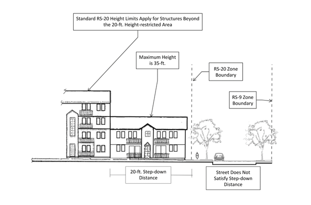
Figure 3.4-1—Required Height Transition Area When a Development is Zoned RS-20 and
is Next to Land Zoned RS-9
b.
Where a property in the RS-20 Zone abuts a property within the RS-6 Zone, the height of structures in the RS-20 Zone is limited to a maximum of 35 ft. and two stories in height within the first 50 ft.; and a maximum of 45 ft. in height within a distance of 50—100 ft. from the Low Density Residential property. Where a street separates the land zoned RS-20 from the land zoned RS-6, this height restriction must be in accordance with "c," below. See Figure 3.4-2—Required Height Transition Area When a Development is Zoned RS-20 and is Next to Land Zoned RS-6.
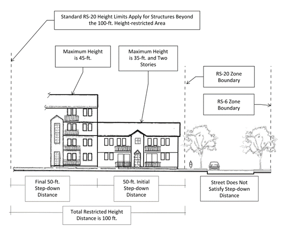
Figure 3.4-2—Required Height Transition Area When Development is Zoned RS-20 and is
Next to Land Zoned RS-6.
c.
Where the RS-20 Zone is separated from the Low or Medium Density Residential zone by an existing or planned street, the measurements outlined in "a," and "b," above, must be taken from the RS-20 side of the street, and the street must not be counted to satisfy the distance needed for the step-down in height. In cases where the RS-20 zoning boundary immediately abuts the Low or Medium Density Residential zoning boundary, and an existing or planned street is located within the RS-20 Zone and also abutting the Low or Medium Density Residential zoning boundary, the street must not be counted to satisfy the distance needed for the step-down in height. See Figure 3.4-1—Required Height Transition Area When a Development is Zoned RS-20 and is Next to Land Zoned RS-9 and Figure 3.4-2—Required Height Transition Area When a Development is Zoned RS-20 and is Next to Land Zoned RS-6.
d.
Where a property in the RS-20 Zone abuts a property in the RS-6 Zone, buildings on the perimeter of the RS-20 site and closest to the Low Density Residential Zone must be limited to 150 ft. in length.
e.
Exceptions:
Cottage Cluster development is subject to the maximum structure height provisions of Section 4.10.55—Standards for Cottage Clusters.
Architectural projections attached to a structure and not used for human occupancy, such as chimneys, spires, domes, elevator shaft housings, and towers must not exceed a height of 75 feet.
Flagpoles are subject to the maximum structure height provisions of Section 4.7.70.b of this Code.
(Ord. No. 2025-03, § 11(Exh. B), 3-27-2025)
Section 3.4.60 - Multiple Residential Buildings On One Lot Or Parcel.
All Dwelling Units on a Lot or Parcel must be within a single building.
Exceptions:
• Cottage Cluster
• Multi-dwellings
• One detached Accessory Dwelling Unit in conjunction with one of the following Residential Building Types: Single Detached, Duplex, Triplex, Fourplex, Townhouse, Multi-dwellings
• One detached Accessory Dwelling Unit in conjunction with a Cottage Cluster
(Ord. No. 2025-03, § 11(Exh. B), 3-27-2025)
Section 3.4.70 - Green Area, Vegetation, and Outdoor Space Requirements.
3.4.70.01 Green Area.
a.
A minimum of 25 percent of the gross lot area and a minimum of 15 percent for Townhouses on interior lots, must be retained and improved or maintained as permanent Green Area, as defined in Chapter 1.6 - Definitions.
b.
A minimum of 10 percent of the gross lot area must consist of vegetation consisting of landscaping or naturally preserved vegetation. Landscaping within the required Green Area must be permanently maintained in accordance with Chapter 4.2 - Landscaping, Buffering, Screening, and Lighting. Landscaping must primarily consist of ground cover, ferns, trees, shrubs, or other living plants and with sufficient irrigation to properly maintain all vegetation. Drought-tolerant plant materials are encouraged. Design elements such as internal sidewalks, pedestrian seating areas, fountains, pools, sculptures, planters, and similar amenities may also be placed within the permanent Green Areas.
c.
Cottage Cluster development is exempt from Section 3.4.50.01.
3.4.70.02 Private and Common Outdoor Space Standards for Multi-Dwellings.
a.
A minimum 48 sq. ft. per dwelling unit of Private and/or Common Outdoor Space is required.
b.
Additional Private Outdoor Space standards:
1.
The required minimum area for each Private Outdoor Space is 48 sq. ft., with a minimum dimension of 5-ft. diameter.
2.
Private Outdoor Space must be directly accessible by door from the interior of the individual dwelling unit served by the space.
c.
Additional Common Outdoor Space standards:
1.
Each Common Outdoor Space must have minimum dimensions of 20 ft. by 20 ft.
2.
Common Outdoor Space must not be located within any required landscape buffer or minimum setback area abutting a street.
3.4.70.03 Outdoor Space Exceptions.
When a Development Site is Adjacent to a City park or within the Downtown Residential Neighborhood (as defined in Chapter 1.6 - Definitions), the total required Private/Common Outdoor Space area is reduced by 25 percent.
(Ord. No. 2025-03, § 11(Exh. B), 3-27-2025)
Section 3.4.80 - Conversion of a Unit to a Professional and Administrative Services Use Types.
The predominant purpose of the RS-20 Zone is to retain residential unit availability; however, within the zone are structures that, due primarily to their size, condition, or age, should not be restricted to residential use only. Therefore, the City may allow conversion through a Conditional Development, in accordance with Chapter 2.3—Conditional Development, to the Professional and Administrative Services Use Type, using the review criteria below.
3.4.80.01 Eligibility.
a.
Structures must be 4,000 sq. ft. or more and built before December 31, 2006; or
b.
The lot must have frontage on or near an Arterial Highway, Arterial, Collector, or Neighborhood Collector Street.
The developer must prove that:
a.
The structure cannot feasibly be used for the uses permitted in Section 3.4.40 without creating undue financial hardship for both tenants and owners. This may be proved by meeting both of the following:
1.
Providing factual data and information on the potential costs of using the structure for Residential Use compared to estimated potential rent or purchase prices for tenants or owners. Factual data and information on the potential costs of using the structure for Residential Use must pertain to items such as heating and cooling bills, costs of renovation and repair, continued maintenance, costs for acquisition of additional land, construction for parking, etc.; and
2.
Demonstrating that an earnest effort has been made to retain the structure for Residential Use through established marketing procedures such as advertising, brochures, telephone contact, contact with real estate and marketing professionals, etc.; or
b.
It is in the best interest of the community to convert the structure to the Professional and Administrative Services Use Type. This may be proved by meeting either of the following:
1.
Showing that the structure is included on the Corvallis Register of Historic Landmarks and Districts; and demonstrating that substantial alterations would be necessary to retain the structure for Residential Use and that alterations would result in the loss or reduction of Historical Significance or architectural significance; or
2.
Showing that the structures, or portions of structures, proposed to be converted meet the locational criteria from 3.4.50.01.b; and demonstrating that the proposed conversion is consistent with the Zone Change Review Criteria in LDC Section 2.2.40.05. If all applicable criteria are met, a proposed conversion would be considered to be consistent with Comprehensive Plan Policies 8.10.5 and 8.12.4; however, proposed conversions in the North 9 th Street area will not be allowed, consistent with the direction of Comprehensive Plan Policy 8.12.1.
3.4.80.03 Development Site Design.
To ensure that the character of the structure and site will be preserved after conversion, the applicant must submit plans in addition to the site plan required in Chapter 2.3—Conditional Development, that indicate the following:
a.
Proposed exterior façade treatment;
b.
Interior remodeling pertaining to major structural changes;
c.
Landscaping;
d.
Proposed signage;
e.
Changes resulting from the conversion that will upgrade the structure and site and aid in the retention of Historically Significant or architecturally significant elements; and
f.
Any other structural or site changes that would affect the structure's character.
Editor's note— Ord. No. 2023-19, § 2(Exh. B), effective June 30, 2023, repealed § 3.4.80.04. Former § 3.4.80.04 pertained to required off-street parking.
(Ord. No. 2025-03, § 11(Exh. B), 3-27-2025)
Section 3.4.90 - Redevelopment of Existing Offices.
Existing offices are Permitted Uses and may be redeveloped if desired. The redeveloped building may occupy the existing building envelope and must meet the parking standards contained in Chapter 4.1—Parking, Loading, and Access Requirements, even if these requirements interfere with the redevelopment.
(Ord. No. 2025-03, § 11(Exh. B), 3-27-2025)
Section 3.4.100 - Variations.
Variations from development standards in this Chapter may be allowed through the processes outlined in Chapter 2.5 - Planned Development and Chapter 2.12 - Development Standards Adjustment.
Provisions in Articles I and II of this Code are not eligible for variation.
(Ord. No. 2024-26, § 16(Exh. B), eff. 1-1-2025; Ord. No. 2025-03, § 11(Exh. B), 3-27-2025)
Section 3.5.10 - Purpose.
The Residential Mixed Use (RMU) Zones are medium-high and high density residential zones designed to allow pedestrian-focused, neighborhood-scale nonresidential uses within Mixed Use buildings, and engaging public spaces. The RMU Zones are intended to contribute to comprehensive neighborhoods, as envisioned by the Comprehensive Plan, and are differentiated by numbers relating to the anticipated dwelling unit density.
The RMU-12 Zone implements the Medium High Density Residential Comprehensive Plan designation, which allows 12 to 20 dwelling units per acre. The RMU-20 Zone implements the High Density Residential Comprehensive Plan designation, which allows 20 or more dwelling units per acre. Both the RMU-12 and RMU-20 Zones also implement the Mixed Use Residential Comprehensive Plan designation.
(Ord. No. 2025-03, § 12(Exh. B), 3-27-2025)
Section 3.5.20 - Establishment of the RMU Zones.
The RMU-12 Zone may only be applied to lands identified as Residential - Medium-High Density or Mixed Use Residential on the Comprehensive Plan Map.
The RMU-20 Zone may only be applied to lands identified as Residential - High Density or Mixed Use Residential on the Comprehensive Plan Map.
(Ord. No. 2025-03, § 12(Exh. B), 3-27-2025)
Section 3.5.30 - Permitted Building Types.
Section 3.5.40 - Permitted Use Types.
(Ord. No. 2023-01, eff. 2-8-2023; Ord. No. 2022-24, eff. 9-28-2022; Ord. No. 2025-03, § 12(Exh. B), 3-27-2025)
Section 3.5.50 - General RMU Zones Development Standards.
1 The actual setbacks may be affected by Vision Clearance Areas, as determined by the City Engineer; easement areas, including any utility easements required by Section 4.0.100; and Private and Common Outdoor Space Provisions in Section 3.5.60.
(Ord. No. 2023-19, § 12(Exh. B), eff. 6-30-2023; Ord. No. 2025-03, § 12(Exh. B), 3-27-2025)
Section 3.5.60 - Additional Development Standards.
a.
Residential Requirement - Nonresidential Use Types are not permitted by right in RMU Zones. Nonresidential Use Types are only permitted in conjunction with a primary Residential Use Type in a Mixed Use building.
b.
Private and Common Outdoor Space Standards
1.
A minimum 48 sq. ft. per dwelling unit of Private and/or Common Outdoor Space is required.
2.
Additional Private Outdoor Space standards:
a)
The required minimum area for each Private Outdoor Space is 48 sq. ft., with a minimum dimension of 5-ft. diameter.
b)
Private Outdoor Space must be directly accessible by door from the interior of the individual dwelling unit served by the space.
3.
Additional Common Outdoor Space standards:
a)
Each Common Outdoor Space must have minimum dimensions of 20 ft. by 20 ft.
b)
Common Outdoor Space must not be located within any required landscape buffer or minimum setback area abutting a street.
4.
Exceptions: When a Development Site is Adjacent to a City park or within the Downtown Residential Neighborhood (as defined in Chapter 1.6—Definitions), the total required Private/Common Outdoor Space area is reduced by 25 percent.
(Ord. No. 2023-01, eff. 2-8-2023; Ord. No. 2025-03, § 12(Exh. B), 3-27-2025)
Section 3.5.70 - Variations.
Variations from development standards in this Chapter may be allowed through the processes outlined in Chapter 2.5 - Planned Development and Chapter 2.12 - Development Standards Adjustment.
Provisions in Articles I and II of this Code are not eligible for variation.
(Ord. No. 2024-26, § 17(Exh. B), eff. 1-1-2025; Ord. No. 2025-03, § 12(Exh. B), 3-27-2025)
Section 3.6.10 - Purpose.
The Mixed Use Residential (MUR) Zone is established to increase housing opportunities in close proximity to designated commercial zones. The MUR Zone is intended primarily for development of multi-dwelling housing at densities high enough to support the retail uses of the adjacent commercial zones and to provide residents with direct and convenient access to commercial services.
Varied Residential Building Types are encouraged in the MUR Zone. Small-scale retail, office, and service uses are also allowed when they are developed as part of a mixed-use building. Design standards for the MUR Zone emphasize intensive development with building orientation to the street, as described in Chapter 4.10 - Pedestrian Oriented Design Standards. These design standards are tailored to the type of use proposed, such as Townhouse, multi-dwelling, and/or mixed use.
(Ord. No. 2025-03, § 13(Exh. B), 3-27-2025)
Section 3.6.20 - Establishment of the MUR Zone.
The MUR Zone implements the Medium-high Density, High Density, and Mixed Use Residential Comprehensive Plan designation. However, in accordance with Comprehensive Plan Policy 9.3.6, new areas may not be zoned MUR and existing zones may not be changed to MUR.
(Ord. No. 2023-01, eff. 2-8-2023; Ord. No. 2025-03, § 13(Exh. B), 3-27-2025)
Section 3.6.30 - Permitted Building Types.
The MUR Zone allows the following Building Types. Definitions for each Building Type are found in Section 1.6.30 of this Code.
(Ord. No. 2025-03, § 13(Exh. B), 3-27-2025)
Section 3.6.40 - Permitted Uses
The MUR Zone allows the following Use Types. Definitions for each Use Type are found in Chapter 3.0 of this Code.
(Ord. No. 2023-01, eff. 2-8-2023; Ord. No. 2025-03, § 13(Exh. B), 3-27-2025)
Section 3.6.50 - MUR Zone Development Standards
3.6.50.01 Minimum/Maximum Residential Densities.
a.
Minimum residential densities for strictly residential development within an MUR Zone must be 20 units per acre.
b.
Minimum residential densities for developments that include mixed uses within an MUR Zone must be 12 units per acre. For these mixed use developments, if less than 20 units per acre are provided, the development must include a minimum of 10 percent of the total gross floor area in nonresidential uses.
c.
Maximum Density - none.
3.6.50.02 Nonresidential Uses.
a.
Nonresidential uses in the MUR Zone must not exceed a size of 3,000 sq. ft. of gross floor area per Tenant Space and, cumulatively, must be limited to a maximum of 20 percent of the total gross floor area in the development site.
b.
Nonresidential uses must be developed as part of a Mixed Use Building Type (with the exception of Civic Uses) and must be developed to maintain a minimum density of 12 dwelling units per acre. When a development site is composed of two or more phases, each phase must also meet this standard.
3.6.50.04 Structure Height and Building Mass.
a.
Where a property in the MUR Zone abuts a property in the RS-9 Zone, the height of structures in the MUR Zone is limited to a maximum of 35 ft. within a distance of 20 ft. from the Medium Density Residential property. Where a street separates the land zoned MUR from the land zoned RS-9, this height restriction must be in accordance with "d" below. See Figure 3.6-1 - Required Height Transition Area When a Development is Zoned MUR and is Next to Land Zoned RS-9.
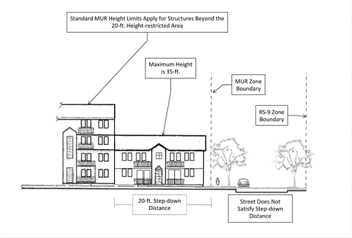
Figure 3.6-1 - Required Height Transition Area When a Development is Zoned MUR and
is Next to Land Zoned RS-9
b.
Where a property in the MUR Zone abuts a property in the RS-6 Zone, the height of structures in the MUR Zone is limited to a maximum of 35 ft. or two stories in height within the first 50 ft.; and a maximum of 45 ft. in height within a distance of 50 - 100 ft. from the Low Density Residential property. Where a street separates the land zoned MUR from the land zoned RS-6, this height restriction must be in accordance with "d" below. See Figure 3.6-2 - Required Height Transition Area When a Development is Zoned MUR and is Next to Land Zoned RS-6.
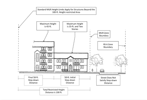
Figure 3.6-2 - Required Height Transition Area When a Development is Zoned MUR and
is Next to Land Zoned RS-6
c.
Where the MUR Zone is separated from the Low or Medium Density Residential zone by an existing or planned street, the measurements outlined in "b," and "c," above, must be taken from the MUR side of the street, and the street must not be counted to satisfy the distance needed for the step-down in height. In cases where the MUR zoning boundary immediately abuts the Low or Medium Density Residential zoning boundary, and an existing or planned street is located within the MUR Zone and also abutting the Low or Medium Density Residential zoning boundary, the street must not be counted to satisfy the distance needed for the step-down in height. See Figure 3.6-1 - Required Height Transition Area When a Development is Zoned MUR and is Next to Land Zoned RS-9 and Figure 3.6-2 - Required Height Transition Area When a Development is Zoned MUR and is Next to Land Zoned RS-6.
d.
Where a property in the MUR Zone abuts a property in the RS-6 Zone, buildings on the perimeter of the MUR site and closest to the Low Density Residential zone must be limited to 150 ft. in length.
e.
Exceptions:
Cottage Cluster development is subject to the maximum structure height provisions of Section 4.10.55 - Standards for Cottage Clusters
Architectural projections attached to a structure and not used for human occupancy, such as chimneys, spires, domes, elevator shaft housings, and towers must not exceed a height of 75 feet.
Flagpoles are subject to the maximum structure height provisions of Section 4.7.70.b of this Code.
(Ord. No. 2023-19, § 13(Exh. B), eff. 6-30-2023; Ord. No. 2025-03, § 13(Exh. B), 3-27-2025)
Section 3.6.60 - Multiple Residential Buildings On One Lot Or Parcel
All Dwelling Units on a Lot or Parcel must be within a single building.
Exceptions:
• Cottage Cluster
• Multi-dwellings
• One detached Accessory Dwelling Unit in conjunction with one of the following Residential Building Types: Single Detached, Duplex, Triplex, Fourplex, Townhouse, Multi-dwellings
• One detached Accessory Dwelling Unit in conjunction with a Cottage Cluster
(Ord. No. 2025-03, § 13(Exh. B), 3-27-2025)
Section 3.6.70 - Green Area, Vegetation, and Outdoor Space Requirements
3.6.70.01 Green Area.
a.
A minimum of 20 percent of the gross lot area and a minimum of 10 percent for Townhouses on interior lots, must be retained and improved or maintained as permanent Green Area, as defined in Chapter 1.6 - Definitions.
b.
A minimum of 10 percent of the gross lot area must consist of vegetation consisting of landscaping or naturally preserved vegetation. Landscaping within the required Green Area must be permanently maintained in accordance with Chapter 4.2 - Landscaping, Buffering, Screening, and Lighting. Landscaping must primarily consist of ground cover, ferns, trees, shrubs, or other living plants and with sufficient irrigation to properly maintain all vegetation. Drought-tolerant plant materials are encouraged. Design elements such as internal sidewalks, pedestrian seating areas, fountains, pools, sculptures, planters, and similar amenities may also be placed within the permanent Green Areas.
c.
Cottage Cluster development is exempt from Section 3.6.70.01.
3.6.70.02 Private and Common Outdoor Space Standards for Multi-Dwellings.
a.
A minimum 48 sq. ft. per dwelling unit of Private and/or Common Outdoor Space is required.
b.
Additional Private Outdoor Space standards:
1)
The required minimum area for each Private Outdoor Space is 48 sq. ft., with a minimum dimension of 5-ft. diameter.
2)
Private Outdoor Space must be directly accessible by door from the interior of the individual dwelling unit served by the space.
c.
Additional Common Outdoor Space standards:
1)
Each Common Outdoor Space must have minimum dimensions of 20 ft. by 20 ft.
2)
Common Outdoor Space must not be located within any required landscape buffer or minimum setback area abutting a street.
d.
Exceptions: When a Development Site is Adjacent to a City park or within the Downtown Residential Neighborhood (as defined in Chapter 1.6 - Definitions), the total required Private/Common Outdoor Space area is reduced by 25 percent.
(Ord. No. 2023-01, eff. 2-8-2023; Ord. No. 2025-03, § 13(Exh. B), 3-27-2025)
Section 3.6.100 - Variations
Variations from development standards in this Chapter may be allowed through the processes outlined in Chapter 2.5 - Planned Development and Chapter 2.12 - Development Standards Adjustment.
Provisions in Articles I and II of this Code are not eligible for variation.
(Ord. No. 2024-26, § 18(Exh. B), eff. 1-1-2025; Ord. No. 2025-03, § 13(Exh. B), 3-27-2025)
Section 3.10.10 - Purpose.
The Professional and Administrative Office (P-AO) Zone implements the Professional Office Comprehensive Plan designation. The P-AO Zone is intended to establish suitable urban areas for diversified office uses in concentrated centers and in appropriate isolated locations. Purposes of this zone also include the following:
a.
Accommodate location of intermediate uses between residential zones and areas of more intense development;
b.
Afford opportunities for employment and for business and professional services in close proximity to residential neighborhoods and transportation facilities;
c.
Provide a range of compatible and supportive uses;
d.
Promote user convenience and the conservation of energy; and
e.
Establish development standards that ensure consistency with the Comprehensive Plan.
Section 3.10.20 - Establishment of the P-AO Zone.
The P-AO Zone may only be applied to lands identified as Professional Office on the Comprehensive Plan Map.
(Ord. No. 2023-01, eff. 2-8-2023; Ord. No. 2025-03, § 14(Exh. B), 3-27-2025)
Section 3.10.30 - Permitted Building Types.
(Ord. No. 2023-01, eff. 2-8-2023; Ord. No. 2025-03, § 14(Exh. B), 3-27-2025)
Section 3.10.40 - Permitted Use Types.
(Ord. No. 2023-01, eff. 2-8-2023; Ord. No. 2025-03, § 14(Exh. B), 3-27-2025)
Section 3.10.50 - Additional Use Type Provisions.
a.
Residential Use Types may only be developed simultaneously with or following development of Nonresidential Primary Uses permitted outright.
(Ord. No. 2023-01, eff. 2-8-2023; Ord. No. 2025-03, § 14(Exh. B), 3-27-2025)
Section 3.10.60 - General P-AO Zone Development Standards.
1 The actual setbacks may be affected by Vision Clearance Areas, as determined by the City Engineer, and easements, including any utility easements required by Section 4.0.100.
(Ord. No. 2023-01, eff. 2-8-2023; Ord. No. 2025-03, § 14(Exh. B), 3-27-2025)
Section 3.10.70 - Variations.
Variations from development standards in this Chapter may be allowed through the processes outlined in Chapter 2.5 - Planned Development and Chapter 2.12 - Development Standards Adjustment.
Provisions in Articles I and II of this Code are not eligible for variation.
(Ord. No. 2023-01, eff. 2-8-2023; Ord. No. 2024-26, § 19(Exh. B), eff. 1-1-2025; Ord. No. 2025-03, § 14(Exh. B), eff. 3-27-2025)
Editor's note— Ord. No. 2025-03, § 14(Exh. B), adopted March 27, 2025, repealed § 3.10.70 and renumbered § 3.10.80 as § 3.10.70. Former § 3.10.70 pertained to additional development standards and derived from Ord. No. 2023-01, eff. 2-8-2023; Ord. No. 2023-19, § 14(Exh. B), effective June 30, 2023)
Section 3.11.10 - Purpose.
The Commercial Mixed Use (CMU) Zones are pedestrian-focused commercial zones designed to allow a variety of commercial and civic uses, with the option of supportive residential uses within Mixed Use buildings, and engaging public spaces. The CMU Zones are differentiated by ascending numbers correlating to the permitted development scale.
The CMU-1 and CMU-2 Zones implement the Mixed Use Commercial Comprehensive Plan designation, and are intended to form the commercial core of comprehensive neighborhoods as envisioned by the Comprehensive Plan. The CMU-1 Zone is anticipated within Minor Neighborhood Center Study Areas, and the CMU-2 Zone is anticipated within Major Neighborhood Center Study Areas, although they can be appropriate in other areas as well.
The CMU-3 Zone implements the Central Business Comprehensive Plan designation, and is intended to guide the development of the Central Business District, as envisioned by the Comprehensive Plan.
In addition, the CMU Zones work together with the Climate-Friendly Areas Overlay (CFAs) to ensure the City remains in full compliance with the land use requirements of Oregon Administrative Rules (OAR) 660-012-0320.
(Ord. No. 2025-25, § 7(Exh. A), eff. 6-12-2025)
Section 3.11.20 - Establishment of the CMU Zones.
The CMU-1 and CMU-2 Zones may only be applied to lands identified as Mixed Use Commercial on the Comprehensive Plan Map.
The CMU-3 Zone may only be applied to lands identified as Central Business on the Comprehensive Plan Map.
Section 3.11.30 - Permitted Building Types.
(Ord. No. 2022-24, eff. 9-28-2022; Ord. No. 2025-25, § 7(Exh. A), eff. 6-12-2025)
Section 3.11.40 - Permitted Use Types.
(Ord. No. 2022-24, eff. 9-28-2022; Ord. No. 2022-26, 9-28-2022)
Section 3.11.50 - Additional Use Type Provisions.
a.
Nonresidential Requirement - Residential Use Types are only permitted in conjunction with a primary nonresidential Use Type in a Mixed Use building.
b.
Ground Floor Dwelling Unit Limitation - Dwelling Units are not permitted on the ground floor.
c.
Exemptions to "a" and "b":
1.
Designated Historic Resources - Designated Historic Resources are exempt from "a" and "b" above, and may comprise any Residential Building Type.
2.
Affordable Housing - A building is exempt from "a" and "b" above if all Dwelling Units on the ground floor are legally restricted for use as Affordable Housing. Affordable Housing income restrictions must continue for as long as the ground floor Dwelling Units are in existence. A building with any ground floor Dwelling Unit allowed by this Affordable Housing exemption that ceases to comply with Affordable Housing legal restrictions is an illegal Nonconforming Structure and any ground floor residential uses will be illegal Nonconforming Uses, notwithstanding Section 1.4.50.08.
3.
Townhouses in the CFA Overlay - Townhouses in the CFA Overlay are exempt from "a" and "b" above.
(Ord. No. 2022-24, eff. 9-28-2022; Ord. No. 2025-25, § 7(Exh. A), eff. 6-12-2025)
Section 3.11.60 - General CMU Zones Development Standards.
(Ord. No. 2022-24, eff. 9-28-2022; Ord. No. 2023-01, eff. 2-8-2023; Ord. No. 2023-19, § 15(Exh. A), eff. 6-30-2023; Ord. No. 2025-25, § 7(Exh. A), eff. 6-12-2025)
Section 3.11.70 - Additional Development Standards.
a.
Two-Story Minimum Height - the Gross Floor Area of the second story must be at least 75 percent of the Gross Floor Area of the first story. Floor area on mezzanines may be counted toward meeting the second story Gross Floor Area.
(Ord. No. 2022-24, eff. 9-28-2022)
Section 3.11.80 - Variations.
A variation to Section 3.11.50 to allow ground floor Dwelling Units is allowed through the Planned Development process outlined in Chapter 2.5 ? Planned Development. Variations from development standards in this Chapter may be allowed through the processes outlined in Chapter 2.5 - Planned Development and Chapter 2.12 - Development Standards Adjustment.
Provisions in Articles I and II of this Code are not eligible for variation.
(Ord. No. 2022-24, eff. 9-28-2022; Ord. No. 2024-26, § 20(Exh. A), eff. 1-1-2025)
Section 3.12.10 - Purpose.
The General Commercial (GC) Zone implements the Mixed Use Commercial Comprehensive Plan designation in areas located outside the Commercial Mixed Use 1 and Commercial Mixed Use 2 Zones. It is intended to provide areas for those commercial and related services and businesses that generally require extensive outside storage, are not Retail or Office Uses, or have characteristics with less pedestrian orientation than other commercial zones. Site and building design in the GC Zone is intended to comply with pedestrian- and human-scale policies of the Comprehensive Plan, while recognizing and providing for Uses that may conflict with pedestrian access and the character of the other commercial zones.
(Ord. No. 2022-06, eff. 3-17-2022; Ord. No. 2022-24, eff. 9-28-2022; Ord. No. 2023-01, eff. 2-8-2023)
Section 3.12.20 - Establishment of the GC Zone.
Zone Changes to establish new GC Zones may be applied only to properties designated Mixed Use Commercial (MUC) on the Comprehensive Plan Map as of December 31, 2006, or as established though a subsequent or concurrent Comprehensive Plan Map Amendment. The GC Zone also may be applied through a legislative process in accordance with Chapter 2.0 - Public Involvement. The following locational and dimensional criteria apply to any new GC Zone.
a.
Locational Criteria - the following locational criteria apply to Zone Changes, in conjunction with Chapter 2.2 - Zone Changes.
1.
The GC Zone must have at least 50 ft. of frontage along a Collector or Arterial Street, as designated in the Corvallis Transportation Plan;
2.
New GC Zones are discouraged from abutting land designated Low Density Residential on the Comprehensive Plan Map.
b.
Zone Size and Dimensions - the minimum contiguous area for a new GC Zone is five acres. Additionally, when multiple lots or parcels are included, portions of individual lots or parcels at least one acre in size may be included, provided the size of the remainder of each lot or parcel is developable under its zone designation. Public street rights-of-way may not count toward the total area of a zone.
(Ord. No. 2018-01, eff. 1-26-2018; Ord. No. 2022-06, eff. 3-17-2022; Ord. No. 2023-01, eff. 2-8-2023)
Section 3.12.30 - Permitted Building Types.
(Ord. No. 2012-19, eff. 12-13-2012; Ord. No. 2022-06, eff. 3-17-2022; Ord. No. 2012-01, eff. 2-8-2023)
Section 3.12.40 - Permitted Use Types.
(Ord. No. 2023-01, eff. 2-8-2023; Ord. No. 2023-19, § 16(Exh. A), eff. 6-30-2023)
Section 3.12.50 - Additional Use Type Provisions.
a.
Residential Development - One Dwelling Unit is permitted per development site if it is developed simultaneously with or following development of nonresidential Primary and Accessory Uses permitted outright.
(Ord. No. 2023-01, eff. 2-8-2023; Ord. No. 2012-18, eff. 12-13-2012)
Section 3.12.60 - General GC Zone Development Standards.
(Ord. No. 2023-01, eff. 2-8-2023)
Section 3.12.70 - Additional Development Standards.
a.
Transit-Oriented Development - When a building is located within 100 ft. of an existing or planned transit stop or route, the building and at least one of its entrances must be oriented to the transit stop or route. This criterion is met by facing the entrance toward the bus stop or route and providing a direct pedestrian connection between the bus stop or route and the entrance, in conformance with Section 4.10.70.02 - Building Orientation.
b.
Zone Buffering/Screening - Landscaping and screening must be provided between GC Zones and other zones, consisting of an effective combination of ground cover, shrubbery and trees, and fences and/or walls. Further, when a site abuts a residential or mixed use Zone, landscaping must be at least six ft. in height and at least 80 percent opaque as viewed from any point along the lot boundary within 18 months following establishment of a Primary Use Type. Exceptions to this standard are provided for pedestrian accessways.
(Ord. No. 2023-01, eff. 2-8-2023)
Section 3.12.80 - Variations.
Variations from development standards in this Chapter may be allowed through the processes outlined in Chapter 2.5 - Planned Development and Chapter 2.12 - Development Standards Adjustment.
Provisions in Articles I and II of this Code are not eligible for variation.
(Ord. No. 2023-01, eff. 2-8-2023; Ord. No. 2024-26, § 21(Exh. A), eff. 1-1-2025)
Section 3.17.10 - Purpose.
The Central Business Fringe Zone implements the Central Business Comprehensive Plan designation and is intended to allow commercial activity necessary to support regional shopping facilities located downtown. Because of its unique location, site development in this area should contribute to a visually attractive entrance to the downtown area.
(Ord. No. 2023-01, eff. 2-8-2023)
Section 3.17.20 - Establishment of the CBF Zone.
The CBF Zone may only be applied to lands identified as Central Business on the Comprehensive Plan Map.
(Ord. No. 2023-01, eff. 2-8-2023)
Section 3.17.30 - Permitted Building Types.
(Ord. No. 2023-01, eff. 2-8-2023)
Section 3.17.40 - Permitted Use Types.
(Ord. No. 2023-01, eff. 2-8-2023)
Section 3.17.50 - General CBF Development Standards.
Section 3.17.60 - Additional Development Standards.
a.
Alley Access - Vehicular access to a garage, carport or other off-street parking facilities is limited to an alley for a Lot or Parcel with access along an alley.
b.
Green Area Landscaping - Landscaping within the required Green Area must be permanently maintained in accordance with Chapter 4.2 - Landscaping, Buffering, Screening, and Lighting. Landscaping must primarily consist of ground cover, ferns, trees, shrubs, or other living plants and with sufficient irrigation to properly maintain all vegetation. Drought-tolerant plant materials are encouraged. Design elements such as internal sidewalks, pedestrian seating areas, fountains, pools, sculptures, planters, and similar amenities may also be placed within the permanent Green Areas, except that a minimum of 15 percent of the required Green Area must be landscaping or preserved vegetation.
c.
Roof Pitch - Pitched roofs, with minimum 4:12 pitch, must be used where there is a predominance of pitched roofs on 90 percent or more of the structures on the same block or adjacent .50 blocks.
(Ord. No. 2023-01, eff. 2-8-2023)
Section 3.17.70 - Variations.
Variations from development standards in this Chapter may be allowed through the processes outlined in Chapter 2.5 - Planned Development and Chapter 2.12 - Development Standards Adjustment.
Provisions in Articles I and II of this Code are not eligible for variation.
(Ord. No. 2023-01, eff. 2-8-2023; Ord. No. 2024-26, § 22(Exh. A), eff. 1-1-2025)
Section 3.20.10 - Purpose.
The Limited Industrial-Office (LI-O) Zone implements the Limited Industrial-Office Comprehensive Plan designation. It is intended to create and preserve areas where Limited Manufacturing, development oriented to the large-scale Office industry (rather than small-scale, single-use, stand-alone Office buildings) and related Use Types may locate, as defined and guided by this Chapter.
Ancillary or customarily incidental non-industrial and non-office Uses that support the Primary Use activity are permitted, such as Administrative, Sales, and Service Uses. Together, all of these Uses are intended to reduce potentially adverse effects from, and provide a buffer between, Industrial Uses and non-industrial Uses. The LI-O Zone development standards and design guidelines are intended to ensure quality appearance at community gateways, consistent with the Comprehensive Plan.
(Ord. No. 2023-01, eff. 2-8-2023)
Section 3.20.20 - General Provisions—Establishment of the LI-O Zone.
Zone Changes to establish new LI-O Zones may be applied only to properties designated Light Industrial-Office (LI-O) on the Comprehensive Plan Map as of December 31, 2006, or as established through a subsequent or concurrent Comprehensive Plan Map Amendment. The LI-O Zone also may be applied through a legislative or quasi-judicial process in accordance with Chapter 2.0 - Public Involvement. The following locational and dimensional criteria apply to any new LI-O Zone.
a.
Locational Criteria
1.
All portions of the LI-O Zone must be located within 1/4 mile of existing or planned transit service, must have at least 50 ft. of frontage along a Collector or Arterial Street, and/or must be contiguous to a property that is zoned Industrial and that fronts onto a Collector or Arterial Street, as designated by the City's Transportation Plan; and
2.
The LI-O Zone must be located adjacent to an existing or planned General Industrial (GI) Zone, and function as a buffer between the GI Zone and adjacent non-industrial Uses;
OR
3.
The LI-O Zone must be located in areas determined, through a legislative process, to be necessary to provide employment opportunities and services to the community.
b.
Zone Size and Dimensions - A new LI-O Zone must consist of at least one whole parcel if the parcel is one acre in size or smaller. When multiple parcels are included, portions at least one acre in size of individual parcels may be included, provided the size of the remainder of each parcel is developable under its zone designation. Public street rights-of-way may not count toward the total area of a zone.
(Ord. No. 2018-01, eff. 1-26-2018; Ord. No. 2023-01, eff. 2-8-2023)
Section 3.20.30 - Permitted Building Types.
(Ord. No. 2012-16, eff. 12-13-2012; Ord. No. 2012-18, eff. 12-13-2012; Ord. No. 2012-19, eff. 12-13-2012; Ord. No. 2022-06, eff. 3-17-2022; Ord. No. 2022-23, eff. 9-17-2022; Ord. No. 2023-01, eff. 2-8-2023)
Section 3.20.40 - Permitted Use Types.
(Ord. No. 2023-01, eff. 2-8-2023; Ord. No. 2023-19, § 18(Exh. A), eff. 6-30-2023)
Section 3.20.50 - General LI-O Development Standards.
(Ord. No. 2012-18, eff. 12-13-2012; Ord. No. 2023-01, eff. 2-8-2023)
Section 3.20.60 - Additional LI-O Development Standards.
a.
Pedestrian Oriented Design Standards
1.
New Commercial and Civic Use Types - New Commercial and Civic Use Types in the LI-O Zone must conform to Chapter 4.10 - Pedestrian Oriented Design Standards, as follows:
• Section 4.10.70.02 - Building Orientation
• Section 4.10.70.03.a.1 - Continuous Internal Sidewalks and Multi-use Paths
• Section 4.10.70.03.a.2 - Sidewalks Along Building Walls
• Section 4.10.70.04.b - Corner Parcels
• Section 4.10.70.05.a.1 - Weather Protection, except that weather protection is required only at street-oriented entrances
• Section 4.10.70.05.b.1 - Loading/Service Facilities
• Section 4.10.70.05.b.2 - Windows, except that a minimum of 20 percent of the length and 10 percent of the ground-floor wall area of any street-facing facade must contain windows and/or glass doors
• Section 4.10.70.05.b.3.d - Base Treatments
• Section 4.10.70.05.b.3.e - Top Treatments
2.
New Industrial Use Types - New Industrial Use Types in the LI-O Zone must conform to Chapter 4.10 - Pedestrian Oriented Design Standards, as follows:
• Section 4.10.70.02 - Building Orientation
• Section 4.10.70.03.a.1 - Continuous Internal Sidewalks and Multi-use Paths
• Section 4.10.70.03.a.5 - Crossings
• Section 4.10.70.03.a.6 - Connections to Adjacent Properties or Streets
• Section 4.10.70.04.b - Corner Parcels
• Section 4.10.70.04.c - Parking Lot Access
• Section 4.10.70.05.b.1 - Loading/Service Facilities
• Section 4.10.70.05.b.3.d - Base Treatments
• Section 4.10.70.05.b.3.e - Top Treatments
3.
Expansions of Existing Structures - Independent or cumulative expansion of a commercial, industrial, or civic structure in existence and in compliance with the Code on December 31, 2006, or constructed after December 31, 2006 pursuant to a valid Conceptual or Detailed Development Plan approved on or before December 31, 2006, must comply with the pedestrian requirements of Chapter 4.10 - Pedestrian Oriented Design Standards as outlined in Section 4.10. 70.01.
b.
Pedestrian Accessibility
1.
At a minimum, a pedestrian walkway must be provided every 400 ft. along any street, connecting it to the next parallel street. See Figure 3.20-1 - Pedestrian Accessibility; and
2.
Through-lot pedestrian walkways are also required at any location where a public or private street pedestrian crossing stubs to a parcel with no other through-lot pedestrian walkway within 200 ft. Such stubbed pedestrian crossings consist of elements such as existing striped crossings or planned pedestrian crossings that are shown in adopted or approved plans. See Figure 3.20-1 - Pedestrian Accessibility.
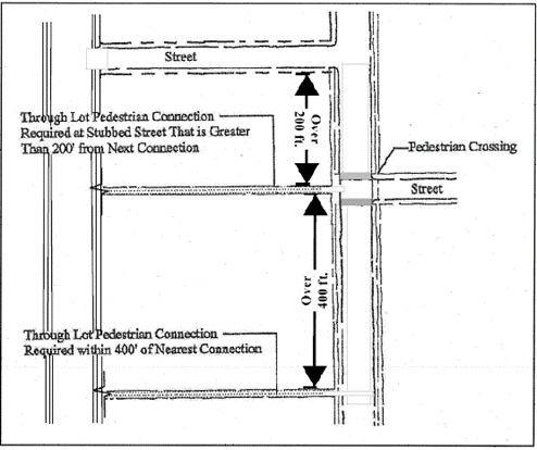
Figure 3.20-1 - Pedestrian Accessibility
c.
General Landscaping Standards - All developments must conform to the requirements of Chapter 4.2 - Landscaping, Buffering, Screening, and Lighting. In addition, the following standards apply to developments in the LI-O Zone:
1.
Zone Buffering/Screening - Landscaping and screening must be provided between property zoned LI-O and other zones, consisting of a combination of ground cover, shrubbery, and trees and fences and/or walls in accordance with Chapter 4.2 - Landscaping, Buffering, Screening, and Lighting. In addition, when a site abuts a residential or mixed use zone, landscaping must be at least six ft. in height and at least 80 percent opaque as viewed from any point along the parcel boundary within 18 months following establishment of a Primary Use Type. Exceptions to this standard are provided for pedestrian accessways.
2.
Storage and Refuse Areas - Stored materials must not be visible from streets, accessways, and adjacent properties.
d.
Building Orientation - the following Building Orientation standards apply to new commercial, civic, or industrial buildings:
1.
Buildings located on parcels abutting South Third Street must be oriented to that street; however, an exception to this requirement may be granted consistent with Chapter 2.13 - Plan Compatibility Review. In such cases, the setback may be increased by up to 100 percent of the requirement, and/or the orientation may be to another street, provided that one or more of the following additional factors are documented by the applicant:
a.
The required building orientation would inhibit reasonable operations of the business, such as the need for truck circulation around the building; and/or
b.
The building height exceeds 35 ft. and is deemed incompatible with the gateway purposes of the LI-O Zone; and
2.
When a building is located within 100 ft. of an existing or planned bus stop or route, the building and at least one of its entrances must be oriented to the bus stop or route. This criterion is met by facing the entrance toward the bus stop and providing a direct pedestrian connection between the bus stop and the entrance, in conformance with the standards in Section 4.10.70.02.
3.
Building elevations used to meet these Building Orientation standards must provide a minimum of one of the following features to break up large building masses and provide human-scale design:
a.
Windows covering 20 percent of the facade; and/or
b.
Building Off-sets or Projections -
i.
A minimum of one two-ft. off-set or projection for every 100 ft. of horizontal distance; and/or
ii.
Detailing, such as scored masonry, brick inlay, wainscoting, or similar facade materials. Paint color variation alone is not sufficient to meet this standard; and
c.
Pedestrian-scale Building Entrances - Recessed entries, canopies, clear-story windows, and/or other similar features must be used at the entries to buildings to create pedestrian scale
e.
Industrial Uses - Exterior building materials must consist of concrete tilt up, concrete masonry unit, brick, wood, or materials of similar quality. Metal building exteriors are permitted when used in conjunction with one or more of the other listed materials, but may not exceed 50 percent of the exterior building surface
f.
Projections - Projections such as chimneys, spires, domes, and towers not used for human occupancy and exceeding 75 feet in height, in accordance with Section 4.9.50 - Exceptions to Building Height and Projections, may be approved in accordance with Chapter 2.13 - Plan Compatibility Review, subject to the following limitation:
• If the site is adjacent to an RS-6 or RS-9 Zone, the projection may not exceed 20 ft. above the height of the structure or 55 ft. in height, whichever is less.
Note: Flagpoles are subject to height requirements in Section 4.7.70.b of Chapter 4.7 - Sign Regulations.
(Ord. No. 2023-01, eff. 2-8-2023)
Section 3.20.70 - Variations.
Variations from development standards in this Chapter may be allowed through the processes outlined in Chapter 2.5 - Planned Development and Chapter 2.12 - Development Standards Adjustment.
Provisions in Articles I and II of this Code are not eligible for variation.
(Ord. No. 2023-01, eff. 2-8-2023; Ord. No. 2024-26, § 23(Exh. A), eff. 1-1-2025)
Section 3.21.10 - Purpose.
This zone implements the Limited Industrial Comprehensive Plan designation. It is intended to create and preserve areas where Limited Manufacturing and related Use Types, described in Chapter 3.0 - Use Classifications, may locate. Limited Manufacturing Uses have few, if any nuisance characteristics. Also permitted are Accessory non-industrial Uses that support the Primary Use activity and are compatible with it, specifically Administrative, Sales, and Service Uses.
(Ord. No. 2025-03, § 15(Exh. B), eff. 3-27-2025)
Section 3.21.20 - Permitted Building Types.
Section 3.21.30 - Permitted Use Types.
(Ord. No. 2025-03, § 15(Exh. B), eff. 3-27-2025)
Section 3.21.40 - Development Standards.
3.21.40.01 Lot Area.
Lots shall be adequate to fulfill applicable Code requirements and standards of this Zone.
a.
Boundary Area -
1.
A setback of not less than 25 ft. shall be provided along each property line abutting any Residential, Agriculture-Open Space, or Special Zone. Off-street parking and loading shall be permitted in this area except for 15 ft. nearest the zone boundary line, which shall not be used for any Permitted Use, activity, or structure other than fences or walls, and shall be improved and maintained in accordance with Section 3.21.40.03 below.
2.
Exemptions from These Requirements -
a)
Those portions of property lines where driveways, accessways, and walkways are provided; and
b)
Lands along the Southern Pacific Railroad line south from Avery Avenue to the City limits.
b.
Along Streets - 20 ft. minimum
Where a yard abuts both a street and a zone boundary line, the 10 ft. nearest the zone boundary line shall not be used for any Permitted Use, activity, or structure other than fences or walls and shall be improved and maintained in accordance with Section 3.21.40.03 below. The boundary area in "a," above, may be counted in the calculation of required setbacks along streets.
c.
Except for those required by this Section and the Building Code, no additional yards/setbacks are required.
3.21.40.03 Landscaping, Lighting, Buffering, and Screening.
a.
Landscaping, lighting, buffering and screening must be provided in accordance with Chapter 4.2 - Landscaping, Buffering, Screening, and Lighting.
b.
The Boundary Area setback required in Section 3.21.40.02 above shall be vegetated with a combination of ground cover, shrubbery, and trees, to serve as a buffer area between the site and abutting zones. In addition, when a site abuts a Residential zone, a minimum 6-ft. tall fence, wall or landscape screen consistent with Section 4.2.50 must be provided along the common property line.
3.21.40.04 Height of Structures.
a.
No structure shall exceed 45 ft. in height.
b.
Projections such as chimneys, spires, domes, and towers not used for human occupancy and exceeding 75 ft. in height, in accordance with Section 4.9.50 of Chapter 4.9 - Additional Provisions, unless adjacent to an RS-6, RS-9 Zone, where the threshold is 20 ft. above the height of the structure or 55 ft. in height, whichever is less, require review in accordance with Section 2.13 - Plan Compatibility Review. Note: Flagpoles subject to height requirements in Section 4.7.70.b of Chapter 4.7 - Sign Regulations.
3.21.40.05 Performance Standards.
Each Use, activity, or operation within this Zone shall comply with applicable local, state, and federal standards, and shall not create a nuisance because of odor, noise, vibration, dust, smoke or gas.
3.21.30.06 Off-Street Parking Facilities.
Off-street parking must meet the requirements of Chapter 4.1 - Parking, Loading, and Access Requirements.
(Ord. No. 2025-03, § 15(Exh. B), eff. 3-27-2025)
Section 3.21.50 - Pedestrian Oriented Design Standards.
The requirements in Chapter 4.10 - Pedestrian Oriented Design Standards shall apply, as follows, to development in the LI Zone:
a.
New development on any site undeveloped prior to December 31, 2006, shall conform with Section 4.10.70.03.a.1.
b.
Independent or cumulative expansion of a commercial, industrial, or civic structure in existence and in compliance with this Code on December 31, 2006, or constructed after December 31, 2006, pursuant to a valid Conceptual and Detailed Development Plan approved on or before December 31, 2006, shall not be required to comply with Section 4.10.70.03.a.1, provided that:
1.
The expansion adds less than 500 sq. ft. or less; or
2.
The expansion adds floor area of 3,000 sq. ft. or less and is equivalent to 20 percent or less of the existing structure's gross floor area.
(Ord. No. 2025-03, § 15(Exh. B), eff. 3-27-2025)
Section 3.21.60 - Natural Hazards, Minimum Assured Development Area (MADA), and Natural Resources.
Natural Hazards, Minimum Assured Development Area (MADA), and Natural Resources shall be addressed in accordance with Chapter 2.11 - Floodplain Development Permit, Chapter 4.2 - Landscaping, Buffering, Screening, and Lighting, Chapter 4.5 - Floodplain Provisions, Chapter 4.11 - Minimum Assured Development Area (MADA), Chapter 4.12 - Significant Vegetation Protection Provisions, Chapter 4.13 - Riparian Corridor and Wetland Provisions, and Chapter 4.14 - Landslide Hazard and Hillside Development Provisions.
(Ord. No. 2025-03, § 15(Exh. B), eff. 3-27-2025)
Section 3.21.70 - Variations.
Variations from development standards in this Chapter may be allowed through the processes outlined in Chapter 2.5 - Planned Development and Chapter 2.12 - Development Standards Adjustment.
Provisions in Articles I and II of this Code are not eligible for variation.
(Ord. No. 2025-03, § 15(Exh. B), eff. 3-27-2025)
Section 3.22.10 - Purpose.
This is the primary zone that implements the General Industrial Comprehensive Plan designation. It is intended to provide appropriate locations for a variety of General Industrial Uses including Manufacturing and related activities with few, if any, nuisance characteristics. This zone prohibits Residential Uses except as authorized in Chapter 4.3 - Accessory Development Regulations.
(Ord. No. 2025-03, § 16(Exh. B), eff. 3-27-2025)
Section 3.22.20 - Permitted Use Types
(Ord. No. 2025-03, § 16(Exh. B), eff. 3-27-2025)
Section 3.22.30 - Development Standards.
3.22.30.01 Lot Area.
Lots shall be adequate to fulfill applicable Code requirements and minimum standards of this Zone.
a.
Boundary Area -
1.
A setback of not less than 100 ft. shall be provided along each property line abutting any Residential or Agriculture-Open Space Zone, or Willamette River Greenway. Off-street parking and loading shall be permitted in this setback area, except for the 35 ft. nearest the Residential, Agriculture-Open Space, or Willamette River Greenway property line, which shall not be used for any Permitted Use, activity, or structure other than fences or walls, and shall be maintained and improved in accordance with 3.22.30.03 below.
2.
Exemptions from These Requirements -
a)
Those portions of property lines where driveways, accessways, and walkways are provided; and
b)
Lands along the Southern Pacific Railroad line south from Avery Avenue to the City limits.
b.
Along Streets - the following minimum setback for any structure shall apply:
1.
Arterial Streets - 50 ft.
2.
Collector Streets - 40 ft.
3.
All other streets - 25 ft.
Where a yard abuts both a street and a zone boundary line, the 35 ft. nearest the zone boundary shall not be used for any Permitted Use, activity, or structure other than fences or walls, and shall be maintained and improved in accordance with Section 3.22.30.03 below. The boundary area as required in "a" above, may be counted in the calculation of required setbacks along streets.
c.
Except for those required in this Section and the Building Code, no additional yards/setbacks are required.
3.22.30.03 Landscaping, Lighting, Buffering, and Screening.
a.
Landscaping, lighting, buffering, and screening must be provided in accordance with Chapter 4.2 - Landscaping Buffering, Screening, and Lighting.
b.
The Boundary Area setback required in Section 3.22.30.02 above shall be vegetated with a combination of ground cover, shrubbery, and trees, to serve as a buffer area between the site and abutting zones. In addition, when a site abuts a Residential zone, a minimum 6-ft. tall fence, wall or landscape screen consistent with Section 4.2.50 must be provided along the common property line.
3.22.30.04 Height of Structure.
a.
No structure shall exceed 75 ft. in height.
b.
Projections such as chimneys, spires, domes, and towers not used for human occupancy and exceeding 75 ft. in height, in accordance with Section 4.9.50 of Chapter 4.9 - Additional Provisions, require review in accordance with Section 2.13 - Plan Compatibility Review. Note: Flagpoles subject to height requirements in Section 4.7.70.b of Chapter 4.7 - Sign Regulations.
3.22.30.05 Performance Standards.
Each Use, activity, or operation within this Zone shall comply with applicable local, state, and federal standards and shall not create a nuisance because of odor, vibration, noise, dust, smoke, or gas.
3.22.30.06 Off-Street Parking Facilities.
If provided, off-street parking must meet the requirements of Chapter 4.1 - Parking, Loading, and Access Requirements.
3.22.30.07 Special Provisions for Automotive and Equipment - Sales/Rentals, Light Equipment.
The purpose of reviewing the Automotive and Equipment-Sales/Rentals, Light Equipment Use Type as a Conditional Use is to determine appropriateness of the Use at a specific site based on the following criteria:
a.
The proposed site is needed due to a shortage of alternative sites that can accommodate this Use.
b.
Permitting the Use will not significantly reduce the overall supply and diversity of industrial land or negatively affect the developability of the balance of adjacent industrial land. Approval shall not be granted if the property was part of a larger parcel within the last 12 months.
c.
The site is a minimum of two acres and has frontage on an Arterial Street.
(Ord. No. 2025-03, § 16(Exh. B), eff. 3-27-2025)
Section 3.22.40 - Pedestrian Oriented Design Standards.
The requirements in Chapter 4.10 - Pedestrian Oriented Design Standards shall apply, as follows, to development in the GI Zone:
a.
New development on any site undeveloped prior to December 31, 2006, shall conform with Section 4.10.70.03.a.1.
b.
Independent of cumulative expansion of a commercial, industrial, or civic structure in existence and in compliance with this Code on December 31, 2006, or constructed after December 31, 2006, pursuant to a valid Conceptual and Detailed Development Plan approved on or before December 31, 2006, shall not be required to comply with Section 4.10.70.03.a.1, provided that:
1.
The expansion adds less than 500 sq. ft. or less; or
2.
The expansion adds floor area of 3,000 sq. ft. or less and is equivalent to 20 percent or less of the existing structure's gross floor area.
(Ord. No. 2025-03, § 16(Exh. B), eff. 3-27-2025)
Section 3.22.50 - Landscaping, Natural Hazards, Minimum Assured Development Area (MADA), and Natural Resources.
Landscaping, Natural Hazards, Minimum Assured Development Area (MADA), and Natural Resources shall be addressed in accordance with Chapter 2.11 - Floodplain Development Permit, Chapter 4.2 - Landscaping, Buffering, Screening, and Lighting, Chapter 4.5 - Floodplain Provisions, Chapter 4.11 - Minimum Assured Development Area (MADA), Chapter 4.12 - Significant Vegetation Protection Provisions, Chapter 4.13 - Riparian Corridor and Wetland Provisions, and Chapter 4.14 - Landslide Hazard and Hillside Development Provisions.
(Ord. No. 2025-03, § 16(Exh. B), eff. 3-27-2025)
Section 3.22.60 - Variations.
Variations from development standards in this Chapter may be allowed through the processes outlined in Chapter 2.5 - Planned Development and Chapter 2.12 - Development Standards Adjustment.
Provisions in Articles I and II of this Code are not eligible for variation.
(Ord. No. 2025-03, § 16(Exh. B), eff. 3-27-2025)
Section 3.23.10 - Purpose.
This is the primary zone that implements the Intensive Industrial Comprehensive Plan designation. It is intended to provide appropriate locations for intensive manufacturing activities that are characterized by their potential conflicts with residential and other land uses. Because this Zone does not specifically prohibit any types of Intensive Industrial Uses, all Intensive Industrial Uses are reviewed through a Conditional Development process.
(Ord. No. 2025-03, § 17(Exh. B), eff. 3-27-2025)
Section 3.23.20 - Permitted Use Types.
(Ord. No. 2025-03, § 17(Exh. B), eff. 3-27-2025)
Section 3.23.30 - Development Standards.
3.23.30.01 Lot Area.
Lots shall be adequate to fulfill applicable Code requirements and standards of this zone.
a.
Boundary Area -
1.
A setback of not less than 100 ft. shall be provided along each II Zone boundary line abutting any residential, Agriculture - Open Space, or Willamette River Greenway Zone. Off-street parking and loading shall be permitted in this area except for the 35 ft. nearest the zone boundary line, which shall not be used for any Permitted Use, activity, or structure other than fences or walls, and shall be maintained and improved in accordance with Section 3.23.30.03 below.
2.
Exemptions from These Requirements
a)
Those portions of property lines where driveways, accessways, or walkways are provided; and
b)
Lands along the Southern Pacific Railroad line south from Avery Avenue to the City limits.
b.
Along Streets - the following minimum setback for any structure shall apply:
1.
Arterial Streets - 75 ft.
2.
Collector Streets - 40 ft.
3.
All other streets - 25 ft.
Where a yard abuts both a street and a zone boundary line, the 35 ft. nearest the zone boundary shall not be used for any Permitted Use, activity, or structure other than fences or walls, and shall be maintained and improved in accordance with Section 3.23.30.03 below. The boundary area as required in "a" above may be counted in the calculation of required setbacks along streets.
c.
Except for those required in this Section and the Building Code, no additional yards/setbacks are required.
3.23.30.03 Landscaping, Lighting, Buffering, and Screening.
a.
Landscaping, lighting, buffering, and screening must be provided in accordance with Chapter 4.2 - Landscaping, Buffering, Screening, and Lighting.
b.
The Boundary Area setback required in Section 3.23.30.02 above shall be vegetated with a combination of ground cover, shrubbery, and trees, to serve as a buffer area between the site and abutting zones. In addition, when a site abuts a Residential zone, a minimum 6-ft. tall fence, wall or landscape screen consistent with Section 4.2.50 must be provided along the common property line.
3.23.30.04 Height of Structure.
a.
No structure shall exceed 75 ft. in height.
b.
Projections such as chimneys, spires, domes, and towers not used for human occupancy and exceeding 75 ft. in height, in accordance with Section 4.9.50 of Chapter 4.9 - Additional Provisions, require review in accordance with Section 2.13 - Plan Compatibility Review. Note: Flagpoles subject to height requirements in Section 4.7.70.b of Chapter 4.7 - Sign Regulations.
3.23.30.05 Off-Street Parking Facilities.
Off-street parking must meet the requirements of Chapter 4.1 - Parking, Loading, and Access Requirements.
3.23.30.06 Changes to an Established Intensive Industrial Use.
Changes to an established Intensive Industrial Use must be reviewed in accordance with Chapter 2.3 - Conditional Development when either of the following occurs:
a.
A change in operation or increase in production creates the need to secure approval from an environmental permitting agency to increase air, water, or noise emissions unless such emission levels were approved by the City through a previous land use process; or
b.
Specific limits or conditions related to operations, physical expansion, etc. established by a previous land use approval are exceeded.
(Ord. No. 2025-03, § 17(Exh. B), eff. 3-27-2025)
Section 3.23.40 - Pedestrian Oriented Design Standards.
The requirements in Chapter 4.10 - Pedestrian Oriented Design Standards shall apply, as follows, to development in the II Zone:
a.
New development on any site undeveloped prior to December 31, 2006, shall conform with Section 4.10.70.03.a.1.
b.
Independent or cumulative expansion of a commercial, industrial, or civic structure in existence and in compliance with this Code on December 31, 2006, or constructed after December 31, 2006, pursuant to a valid Conceptual and Detailed Development Plan approved on or before December 31, 2006, shall not be required to comply with Section 4.10.70.03.a.1, provided that:
1.
The expansion adds less than 500 sq. ft. or less; or
2.
The expansion adds floor area of 3,000 sq. ft. or less and is equivalent to 20 percent or less of the existing structure's gross floor area.
(Ord. No. 2025-03, § 17(Exh. B), eff. 3-27-2025)
Section 3.23.50 - Landscaping, Natural Hazards, Minimum Assured Development Area (MADA), and Natural Resources.
Landscaping, Natural Hazards, Minimum Assured Development Area (MADA), and Natural Resources shall be addressed in accordance with Chapter 2.11 - Floodplain Development Permit, Chapter 4.2 - Landscaping, Buffering, Screening, and Lighting, Chapter 4.5 Floodplain Provisions, Chapter 4.11 - Minimum Assured Development Area (MADA), Chapter 4.12 - Significant Vegetation Protection Provisions, Chapter 4.13 - Riparian Corridor and Wetland Provisions, and Chapter 4.14 - Landslide Hazard and Hillside Development Provisions.
(Ord. No. 2025-03, § 17(Exh. B), eff. 3-27-2025)
Section 3.23.60 - Variations.
Variations from development standards in this Chapter may be allowed through the processes outlined in Chapter 2.5 - Planned Development and Chapter 2.12 - Development Standards Adjustment.
Provisions in Articles I and II of this Code are not eligible for variation.
(Ord. No. 2025-03, § 17(Exh. B), eff. 3-27-2025)
Section 3.24.10 - Purpose.
This zone implements the Industrial Use designation of the Comprehensive Plan. It is intended to provide locations for Research and Technology Uses in a campus-like setting. The RTC Zone is designed to accommodate educational, scientific, industrial, and business research, development, planning, testing, and training activities and non-polluting manufacturing activities. Supporting Commercial Uses not to exceed 20 percent of the gross floor area may be located in RTC projects. The RTC Zone establishes standards that address compatibility of the center with surrounding Uses.
(Ord. No. 2025-03, § 18(Exh. B), eff. 3-27-2025)
Section 3.24.20 - General Provisions.
3.24.20.01 Establishment of the RTC Zone.
This Zone may be requested by an owner of property identified on the Comprehensive Plan Map as Limited Industrial, Limited Industrial-Office, General Industrial, General Industrial-Office, and Mixed Use Transitional areas. Establishment of this Zone requires a public hearing by the Planning Commission in conjunction with a Planned Development Overlay and a Conceptual Development Plan consistent with Chapter 2.5 - Planned Development.
The applicant has three years from date of approval of the Conceptual Development Plan to complete a Plan Compatibility Review and be issued a Building Permit for a Primary Use. If no Building Permit has been issued prior to the expiration date, the Conceptual Development Plan shall expire and a new Conceptual Development Plan approval shall be required prior to the issuance of Building Permits.
3.24.20.02 Time Extension of Conceptual Development Plan Approval.
Applications for additional one-year extensions may be filed in accordance with the following procedures:
a.
An owner of property with an RTC Conceptual Development Plan may apply to have the Conceptual Development Plan approval extended beyond the three-year limit, provided that an application, on forms provided by the Director, is properly filed before the expiration of the Conceptual Development Plan.
b.
The Director shall process the request and mail notice to owners and occupants of all properties within 300 ft. of the subject property in accordance with Chapter 2.16 - Request for Interpretation. The Director shall grant a one-year extension of the expiration date upon finding that:
1.
Unforeseen circumstances or conditions have caused the delay;
2.
The applicant has demonstrated reasonable diligence in attempting to meet the time limits imposed; and
3.
Facts upon which the approval was based have not changed to an extent sufficient to warrant re-filing.
(Ord. No. 2025-03, § 18(Exh. B), eff. 3-27-2025)
Section 3.24.30 - Permitted Use Types.
(Ord. No. 2025-03, § 18(Exh. B), eff. 3-27-2025)
Section 3.24.40 - Development Standards.
The Conceptual Development Plan for the entire RTC site shall comply with the standards listed below. When the Planning Commission reviews a proposed Conceptual Development Plan for the entire RTC site, it shall also ensure that the plan limits the Uses specified in Section 3.24.30.01.a.3 to 20 percent or less of the gross floor area of the development site.
The purpose of special limitations regarding the Uses in Section 3.24.30.01.a.3 is to ensure that the proposed Use or Uses will serve the shopping and service needs primarily of employees and businesses of the Uses in the RTC site. Building Permits for these Commercial Uses shall be approved only when subordinate to other existing RTC development. Permits for these subordinate Uses shall be issued concurrent with or following issuance of permits for the Primary Uses and shall not exceed the maximum gross floor area limitation of 20 percent of Uses established on the site at any time.
3.24.40.01 Lot Area.
Minimum lot area for a development site shall be 50 acres. Individual lot sizes shall be adequate to fulfill applicable Code requirements and minimum standards of this Zone.
a.
Boundary Area - the setback for the perimeter of a development site shall average 50 ft. along the building face for structures 30 ft. or less in building height. The minimum setback shall not be less than 30 ft. For a structure over 30 ft. in height, an additional setback of 2.5 ft. for every foot of height over 30 ft. shall be added to the average 50-ft. setback.
b.
Streets - Setbacks from streets along the perimeter of the development site shall average 60 ft. with a minimum setback of 40 ft.
c.
Interior Lot Lines - There are no requirements for separation between buildings or setbacks from any created interior lot lines other than those specified in the Building Code.
3.24.40.03 Height of Structure.
a.
No structure shall exceed 75 ft. in height.
b.
Projections such as chimneys, spires, domes, and towers not used for human occupancy and exceeding 75 ft. in height, in accordance with Section 4.9.50 of Chapter 4.9 - Additional Provisions, unless adjacent to an RS-6, RS-9 Zone, where the threshold is 20 ft. above the height of the structure or 85 ft. in height, whichever is less, require review in accordance with Section 2.13 - Plan Compatibility Review. Note: Flagpoles subject to height requirements in Section 4.7.70.b of Chapter 4.7 - Sign Regulations.
Building coverage shall not exceed 40 percent; total impervious surface excluding Green Area elements shall not exceed 60 percent of the entire development site. A minimum of 15 percent of the required Green Area shall be landscaping or preserved vegetation.
3.24.40.05 Performance Standards.
a.
Each Use, activity, or operation within this Zone shall comply with applicable state and federal standards and shall not create a nuisance because of odor, vibration, noise, dust, smoke, or gas.
b.
Mechanical equipment, outdoor storage areas, trash receptacles, and parking lots shall be screened from view from public places and neighboring properties, to the extent practicable, through use of features such as berms, fences, facades, and dense landscaping in accordance with Chapter 4.2 - Landscaping, Buffering, Screening, and Lighting.
c.
There shall be a 30 ft.-wide landscaped area in the boundary area containing trees and shrubs with a fence or a berm. Within the street setback area, a 40 ft.-wide landscaped area shall be provided.
d.
Landscaping shall be in accordance with Chapter 4.2 - Landscaping, Buffering, Screening, and Lighting. Landscaped areas shall be irrigated with permanent facilities sufficient to maintain the plant materials and shall be covered by living plant material capable of attaining 90 percent ground coverage within three years.
e.
Street trees and landscaping provisions not addressed differently in this Chapter are required in accordance with Chapter 4.2 - Landscaping, Buffering, Screening, and Lighting.
f.
Long expanses of fences or walls along public streets shall be designed to prevent visual monotony through the use of off-sets, landscaping, and change in materials.
g.
Earth sculpting and other techniques shall be used to reduce building scale along the development site perimeter.
h.
Where structures are set back less than 60 ft. along a perimeter street, the building arrangement shall provide for open space linkages such that the required open space extends from the street into the interior of the site.
i.
Parking, loading, and access requirements shall be in accordance with Chapter 4.1 - Parking, Loading, and Access Requirements.
j.
Access shall be designed to minimize interference with traffic movement on abutting streets. Where the Director determines it is necessary, additional right-of-way shall be dedicated to maintain adequate traffic circulation.
k.
Metal siding and roof surfaces shall be covered and maintained with nonreflective paint.
l.
Artificial lighting shall be arranged and constructed not to produce direct glare on adjacent residential properties and shall be consistent with Chapter 4.2 - Landscaping, Buffering, Screening, and Lighting.
m.
Signage shall be designed and oriented to primarily serve those within the RTC development. Structures or portions of structures used for commercial purposes shall be designed to serve primarily those within the RTC development.
n.
The requirements in Chapter 4.10 - Pedestrian Oriented Design Standards shall apply to the following types of development in the RTC Zone, except as modified by "o" below, in which case "o" below, shall apply:
1.
All new buildings or structures for which a valid permit application has been submitted after December 31, 2006;
2.
Developments subject to Conditional Development and/or Planned Development approval, as required by a Condition(s) of Approval(s); and
3.
Independent or cumulative expansion of a commercial or civic structure in existence and in compliance with the Code on December 31, 2006, or constructed after December 31, 2006 pursuant to a valid Conceptual or Detailed Development Plan approved on or before December 31, 2006, shall comply with the pedestrian requirements of Chapter 4.10 - Pedestrian Oriented Design Standards as outlined in Section 4.10.70.01.
o.
Section 3.27.50 - Design Guidelines and Standards of Chapter 3.27 - Mixed Use Employment (MUE) Zone shall apply to industrial development within an RTC site.
(Ord. No. 2025-03, § 18(Exh. B), eff. 3-27-2025)
Section 3.24.50 - Natural Hazards, Minimum Assured Development Area (MADA), and Natural Resources.
Natural Hazards, Minimum Assured Development Area (MADA), and Natural Resources shall be addressed in accordance with Chapter 2.11 - Floodplain Development Permit, Chapter 4.2 - Landscaping, Buffering, Screening, and Lighting, Chapter 4.5 - Floodplain Provisions, Chapter 4.11 - Minimum Assured Development Area (MADA), Chapter 4.12 - Significant Vegetation Protection Provisions, Chapter 4.13 - Riparian Corridor and Wetland Provisions, and Chapter 4.14 - Landslide Hazard and Hillside Development Provisions.
(Ord. No. 2025-03, § 18(Exh. B), eff. 3-27-2025)
Section 3.24.60 - Variations.
Variations from development standards in this Chapter may be allowed through the processes outlined in Chapter 2.5 - Planned Development and Chapter 2.12 - Development Standards Adjustment.
Provisions in Articles I and II of this Code are not eligible for variation.
(Ord. No. 2025-03, § 18(Exh. B), eff. 3-27-2025)
Section 3.25.10 - Purpose.
This Zone implements the Mixed Use Transitional (MUT) Comprehensive Plan designation. The MUT Comprehensive Plan designation should be applied to existing industrial areas that are identified, through an area Refinement Plan, as being desirable for transition over time to less intensive Uses. The MUT Zone provides a mechanism to permit the introduction of new, less intensive Uses while allowing General and Intensive Industrial Uses to remain during an indefinite period of transition. It also addresses limitations on re-intensification of Uses that have previously transitioned from General or Intensive Industrial Uses to less intensive activities.
Key objectives of the MUT Zone include reducing conflicts between Industrial and less intensive Uses located nearby; providing an opportunity to develop a mix of non-industrial Uses in the Zone that are compatible with surrounding land uses; transitioning to new, less conflicting Uses; and achieving the transition in a way that is fair and preserves value and flexibility for the industrial businesses located within the MUT Zone.
(Ord. No. 2025-03, § 19(Exh. B), eff. 3-27-2025)
Section 3.25.20 - General Provisions.
3.25.20.01 Establishment of the MUT Zone.
The MUT Zone may be applied to properties with an MUT designation on the Comprehensive Plan Map.
3.25.20.02 Zone Size and Dimensions.
The size of the MUT Zone shall be established through an area Refinement Plan. Public street rights-of-way shall not count toward the total area of the Zone.
(Ord. No. 2025-03, § 19(Exh. B), eff. 3-27-2025)
Section 3.25.30 - Permitted Uses.
Land use in the MUT Zone shall conform to the list of Permitted Use Types in Table 3.25-1 - Permitted Use Types. Ministerial Development involving Use Types permitted outright are identified with a P. General Development involving Use Types subject to Chapter 2.13 - Plan Compatibility Review are identified with a PC. Special Development involving Use Types subject to Chapter 2.3 - Conditional Development and Chapter 2.5 - Planned Development are identified with a CD and a PD, respectively. Uses identified with an N are not permitted.
(Ord. No. 2012-16, eff. 12-13-2012; Ord. No. 2012-18, eff. 12-13-2012; Ord. No. 2012-19, eff. 12-13-2012; Ord. No. 2022-06, 3-17-2022; Ord. No. 2023-19, § 25(Exh. B), eff. 6-30-2023; Ord. No. 2024-26, § 28(Exh. B), eff. 1-1-2025; Ord. No. 2025-03, § 19(Exh. B), eff. 3-27-2025)
Section 3.25.40 - Development Standards For General and Intensive Industrial Uses
a.
All General Industrial Uses shall conform to the development standards of the General Industrial Zone.
b.
All Intensive Industrial Uses shall conform to the development standards of the Intensive Industrial Zone unless specified otherwise.
(Ord. No. 2025-03, § 19(Exh. B), eff. 3-27-2025)
Section 3.25.50 - Development Standards For Civic, Commercial, and Limited Manufacturing Use Types.
The following provisions identify development standards within the MUT Zone for all development of a Civic, Commercial, or Limited Manufacturing Use Type.
3.25.50.01 Minimum Lot Area and Setback Requirements.
a.
A setback of not less than 25 ft. shall be provided along each MUT Zone boundary line abutting any Residential (RS) zone. Off-street parking and loading shall be permitted in this area except within 15 ft. of the Zone boundary line, which shall not be used for any Permitted Use, activity, or structure other than fences, walls, driveways, or walks.
b.
For maximum permitted setbacks, see Section 3.25.60.02.
Structure height shall not exceed 45 ft. unless a site is developed as a Planned or Conditional Development and in a manner compatible with any adjacent residential property(ies), in which case the structure height may be increased up to 75 ft. See Section 3.25.60.09 - Neighborhood Compatibility.
3.25.50.03 Green Area Standards.
A minimum of 20 percent of the total site area shall be retained as Green Area. Green Area may include landscape areas, natural areas, and/or pedestrian amenities consistent with Section 3.25.60.07, except that a minimum of 15 percent of the required Green Area shall be landscaping or preserved vegetation. The site design and building design standards of this Chapter shall also be met.
3.25.50.04 Off-street Parking.
When provided, off-street vehicle parking must comply with Chapter 4.1 - Parking, Loading, and Access Requirements.
(Ord. No. 2023-01, eff. 2-8-2023; Ord. No. 2023-19, § 26(Exh. B), eff. 6-30-2023; Ord. No. 2025-03, § 19(Exh. B), eff. 3-27-2025)
Section 3.25.60 - Design Guidelines and Standards For Civic, Commercial, and Limited Manufacturing Use Types.
3.25.60.01 Coordinated Development.
New development shall be designed in a manner that does not preclude development of adjacent property(ies) and that ensures the logical and efficient extension of public facilities and services, including but not limited to sanitary sewer, water, storm drainage, and street and pedestrian facility connections.
3.25.60.02 Building Orientation and Maximum Setbacks.
a.
All new buildings in the MUT Zone shall be oriented to existing or proposed public streets or to private streets as approved by the City. Building orientation is demonstrated by placing buildings and their public entrances close to streets so that pedestrians have a direct and convenient route from the street sidewalk to building entrances.
b.
At least one major public entrance should be oriented to each street that the building abuts. Corner entrances may be used to provide entrance orientation to two streets, provided that the length of the building adjacent to the street does not exceed 50 ft.
c.
Building setbacks from streets or plazas shall not exceed 20 ft. except when necessary to preserve healthy, mature tree(s), to provide pedestrian amenities in conformance with Section 3.25.60.07, or to accommodate handicapped access requirements. A further exception to these setback requirements may be considered when the site is fronted by more than two streets.
3.25.60.03 Corner Building Entrances.
For all new buildings or when redevelopment opportunities allow, the design of corner lot buildings should reinforce public intersections as public spaces. Corner building entrances with weather protection or other architectural features may be required to ensure that this guideline is met. The maximum allowable building setback in Section 3.25.60.02 may be increased when the building design incorporates seating, plazas, and other public amenities, as defined by Section 3.25.60.07.
3.25.60.04 Weather Protection.
a.
Where new industrial development is constructed adjacent to street sidewalks or pedestrian plazas, a six ft.-wide, weather-protected area such as awnings or canopies shall be provided over the primary entrance.
b.
Where new commercial or residential development is constructed adjacent to street sidewalks or pedestrian plazas, a six ft.-wide, weather-protected area, such as awnings or canopies, shall be provided along all portions of building(s) adjacent to the sidewalks and/or plazas.
c.
For existing development, weather protection, as identified in "a" and "b" above, shall be provided when there are alterations, repairs, or additions to existing structures. However, an exception to this weather protection standard may be requested where the applicant can demonstrate, to the satisfaction of the Director, that the cost of improvements to the existing structure is less than four times the cost of providing an awning. In addition, where existing weather protection is at least four ft. in width, an exception to this standard may be authorized.
3.25.60.05 Landscaping and Screening.
Landscaping and screening shall be required, in accordance with Chapter 4.2 - Landscaping, Buffering, Screening, and Lighting.
3.25.60.06 Street Connectivity and Internal Circulation.
a.
For new structures and substantial improvements to existing development, an applicant may be required to provide street or driveway stubs and reciprocal access easements to promote connectivity, dispersal of traffic, and efficient circulation between Uses and properties.
b.
Traffic lanes shall be internal to the site and shall not be located between buildings and sidewalks, except where drop-off facilities are provided, such as for handicapped access. Such facilities shall be designed to meet Americans with Disabilities Act (ADA) requirements and provide for direct pedestrian circulation.
3.25.60.07 Pedestrian Amenities.
a.
Number Required - For all new structures and substantial improvements in the MUT Zone, with the exception of existing residential dwellings and General and Intensive Industrial Uses, the applicant shall provide pedestrian amenities. The number of pedestrian amenities provided shall comply with the sliding scale in Table 3.25-2 - Number of Required Pedestrian Amenities.
b.
Acceptable Pedestrian Amenities Include -
1.
Sidewalks with ornamental treatments, such as brick pavers, or sidewalks 50 percent wider than required by this Code
2.
Benches and public outdoor seating
3.
Sidewalk planters
4.
Public art, such as a sculpture, fountain, clock, mural, etc., with a value equal to or greater than one percent of the construction value of the new or expanded structure(s)
5.
Pocket parks - minimum usable area of 300 sq. ft.
6.
Plazas - minimum usable area of 300 sq. ft.
7.
Street trees of a caliper 50 percent wider than otherwise required by this Code; may include preservation of healthy mature trees adjacent to the street sidewalk
8.
Other improvements approved through Chapter 2.12 - Development Standards Adjustment, or Chapter 2.5 - Planned Development
9.
Additional weather protection in excess of requirements of Section 3.25.60.04
c.
Pedestrian Amenities Shall Comply with the Following Standards and Guidelines -
1.
Amenities should be visible and accessible to the general public from an improved street. Access to pocket parks, plazas, and sidewalks shall be provided via a public right-of-way or a public access easement.
2.
The size or capacity of pedestrian amenities should be roughly proportional to their expected use, including use by employees, customers, residents, and other visitors. The minimum area standards for pocket parks and plazas may be increased based on this guideline.
3.
Amenities eligible for credit toward Green Area standards, and adjustment to the maximum 20 ft. setback standard, include plazas, pocket parks, seating areas, street furniture, and other areas that provide usable pedestrian space.
4.
Amenities should be consistent with the character and scale of the MUT area. For example, similarity in awning height, bench style, planter materials, street trees, and pavers is recommended to foster continuity in the design of pedestrian areas. Materials should be suitable for outdoor use, easily maintained, and have a reasonably long life cycle, such as 10 years before replacement.
5.
When provided at or near a bus stop, amenities should conform to standards of the Corvallis Transit System.
3.25.60.08 Minimum General Building Design Standards.
Special attention to building design is required in the MUT Zone because of the intermixing of a wide variety of land uses. The following standards are intended to be specific and quantifiable, while allowing for flexibility in design. Additional flexibility is provided through the Planned Development and Development Standards Adjustment review processes. This Section provides both required and optional design elements.
New structures and substantial improvements should be designed to provide architectural relief and interest, with emphasis at building entrances and along sidewalks, to promote and enhance a comfortable pedestrian scale and orientation. Blank walls shall be avoided when practicable by complying with the following minimum requirements:
a.
Ground-floor windows shall be provided for Civic and Commercial Use Types. The main front elevation(s) of buildings shall provide at least 60 percent windows or transparency at the pedestrian level. On corner lots, this provision applies to both street-facing elevations. The transparency is measured in lineal fashion, such that the example of a 100 ft.-wide building facade shall have a total of at least 60 linear ft. of windows.
b.
Ground-floor windows shall be provided for Limited Industrial Use Types. The main front elevation(s) of buildings shall provide at least 30 percent windows or transparency at the pedestrian level. On corner lots, this provision applies to both street-facing elevations. The transparency is measured in linear fashion, such that the example of a 100 ft.-wide building facade shall have a total of at least 30 linear ft. of windows.
c.
Ground-floor entrances shall include an off-set of at least eight ft. in depth and of sufficient width to allow the entrance location to be easily discerned. Such off-sets shall be items such as recesses, extensions, or other breaks in elevation.
d.
To break up vast expanses of single element building elevations, building design shall include a combination of architectural elements and features, including off-sets, windows, entry treatments, wood siding, brick, stucco, synthetic stucco, such as EIFS, textured concrete block, or textured concrete.
e.
Differentiation between ground-level spaces and upper stories shall be provided. For example, bays or balconies for upper levels, and awnings, canopies, or other similar treatments for lower levels can provide differentiation. Variation in building materials, trim, paint, ornamentation, windows, or other features such as the use of public art may also be used. Recognizing that other design solutions may be appropriate, a developer may propose alternatives for review and approval by the Director.
f.
Access shall be designed to minimize interference with traffic circulation. Where necessary, additional rights-of-way shall be dedicated to maintain adequate circulation.
3.25.60.09 Neighborhood Compatibility—Minimum Standards Adjacent to a Residential Zone.
a.
Height Step-down - New building roof elevation(s) shall gradually step down so that the height of the proposed structure does not exceed the height(s) of adjacent residential structures by more than one story. This provision applies to that portion of the structure closest, at least the closest 20 ft., to the adjacent residential structures.
b.
Compatible Architectural Characteristics - New development adjacent to residential zones shall incorporate architectural characteristics compatible with residential development. Each new structure shall contain at least two of the following elements:
1.
Roofs with a minimum 4:12 pitch;
2.
Flat roofs with a cornice, or other decorative treatment;
3.
At the discretion of the Director, horizontal wood lap siding, brick, stone, or other material consistent with residential character;
4.
Vertical breaks in roof elevation; and/or
5.
Additional off-sets in building elevation
c.
The site design shall preserve healthy, mature trees on the site to the maximum extent practicable. Trees likely to create a hazard for the development or adjacent properties may be removed, consistent with Chapter 4.2 - Landscaping, Buffering, Screening, and Lighting. However, this provision shall not conflict with the provisions outlined in Section 3.25.70. If there is a conflict, the provisions of Section 3.25.70 shall prevail.
d.
Artificial lighting shall be arranged and constructed not to produce direct glare on adjacent residential properties, and shall be consistent with the lighting provisions in Chapter 4.2 - Landscaping, Buffering, Screening, and Lighting.
(Ord. No. 2012-18, eff. 12-13-2012; Ord. No. 2024-26, § 28(Exh. B), eff. 1-1-2025; Ord. No. 2025-03, § 19(Exh. B), eff. 3-27-2025)
Section 3.25.70 - Natural Hazards, Minimum Assured Development Area (MADA), and Natural Resources.
Natural Hazards, Minimum Assured Development Area (MADA), and Natural Resources shall be addressed in accordance with Chapter 2.11 - Floodplain Development Permit, Chapter 4.2 - Landscaping, Buffering, Screening, and Lighting, Chapter 4.5 - Floodplain Provisions, Chapter 4.11 - Minimum Assured Development Area (MADA), Chapter 4.12 - Significant Vegetation Protection Provisions, Chapter 4.13 - Riparian Corridor and Wetland Provisions, and Chapter 4.14 - Landslide Hazard and Hillside Development Provisions.
(Ord. No. 2025-03, § 19(Exh. B), eff. 3-27-2025)
Section 3.25.80 - Variations.
Variations from development standards in this Chapter may be allowed through the processes outlined in Chapter 2.5 - Planned Development and Chapter 2.12 - Development Standards Adjustment.
Provisions in Articles I and II of this Code are not eligible for variation.
(Ord. No. 2024-26, § 28(Exh. B), eff. 1-1-2025; Ord. No. 2025-03, § 19(Exh. B), eff. 3-27-2025)
Section 3.27.10 - Purpose.
This Zone introduces some Commercial and Residential Uses into areas with industrial designations on the Comprehensive Plan Map, while maintaining the City's supply of industrially designated lands. It is intended to provide a variety of employment uses, including Limited Industrial Uses and Commercial, Civic, and Residential Uses, at a scale appropriate to surrounding employment areas. Key objectives of the Mixed Use Employment Zone include:
a.
Expand employment opportunities by allowing businesses to locate in a variety of locations;
b.
Provide services for employees in close proximity to their work place;
c.
Provide options for living, working, and shopping environments;
d.
Facilitate more intensive use of land while minimizing potentially adverse impacts; and
e.
Provide options for pedestrian oriented lifestyles.
(Ord. No. 2025-03, § 20(Exh. B), eff. 3-27-2025)
Section 3.27.20 - General Provisions—Establishment of the MUE Zone.
Consistent with Comprehensive Plan Policy 8.9.18, no new MUE Zones may be established.
(Ord. No. 2025-03, § 20(Exh. B), eff. 3-27-2025)
Section 3.27.30 - Permitted Building Types
(Ord. No. 2025-03, § 20(Exh. B), eff. 3-27-2025)
Section 3.27.40 - Permitted Use Types.
(Ord. No. 2025-03, § 20(Exh. B), eff. 3-27-2025)
Section 3.27.50 - Development Standards.
The following provisions identify development standards within the MUE Zone.
3.27.50.01 Preservation of Industrial Land Supply.
a.
A minimum floor area ratio (FAR) of 0.25 of Industrial structure/Use is required for all MUE-zoned properties. This requirement is to ensure that industrial land is preserved for primarily industrial purposes. This provision does not apply when a Commercial Use in an industrially designated property is applied to an existing residential building that existed prior to the adoption of this MUE Zone. This provision also does not apply when a Residential Use is applied to an existing commercial building within an industrial zone that existed prior to the adoption of this MUE Zone. This provision also does not apply to existing or new civic uses in the MUE Zone. The Industrial Uses on an MUE site are required to be developed prior to or concurrently with Residential and Commercial Uses, with the exception of Residential and/or Commercial Uses in existence as of the adoption of this MUE Zone.
b.
When a project is composed of two or more phases, the mixed use site shall be reviewed as a Planned Development in accordance with Chapter 2.5 - Planned Development, and each phase shall meet the minimum 0.25 FAR as described in "a," above.
c.
Where the square footage of the Residential and/or Commercial Use(s) exceeds the square footage of the Industrial Use(s), the development site shall be subject to a Plan Compatibility Review process in accordance with Chapter 2.13 - Plan Compatibility Review.
d.
When an MUE Zone is approved for a site, a deed restriction recognizing the industrial character and underlying industrial land use designation of the property shall be recorded on the parcel(s) involved at the time the MUE Zone is approved.
3.27.50.02 Minimum Setback Requirements.
a.
A setback of not less than 25 ft. shall be provided along each MUE Zone boundary line abutting any residential (RS) zone. Off-street parking and loading shall be permitted in this area except within 15 ft. of the Zone boundary line, which shall not be used for any Permitted Use, activity, or structure other than fences, walls, driveways, or walkways.
b.
The minimum setback requirements for structures containing a Residential Use shall be in accordance with Chapter 3.4 - High Density (RS-20) Zone.
c.
For maximum permitted setbacks, refer to Section 3.27.60.02.
Structure height shall not exceed 45 ft. on sites that have a Comprehensive Plan Map Designation of Limited Industrial or Mixed Use Employment. If a site's Comprehensive Plan Map designation is General Industrial, General Industrial-Office, or Intensive Industrial, structure heights may be 75 ft.
Projections such as chimneys, spires, domes, and towers not used for human occupancy may exceed the applicable maximum structure height by up to 10 ft.
Note: Flagpoles are subject to height requirements of Section 4.7.70.b.
3.27.50.04 Green Area Standards.
a.
A minimum of 20 percent of the total site area shall be retained as Green Area. Green Area may include landscape areas, natural areas, and/or pedestrian amenities consistent with Section 3.27.60.04, except that a minimum of 10 percent of the site shall be landscaping or preserved vegetation. The site and building design standards of this Chapter shall also shall be met.
b.
Landscaping, buffering, screening and lighting shall be in accordance with Chapter 4.2 - Landscaping, Buffering, Screening, and Lighting.
3.27.50.05 Off-Street Parking.
When provided, off-street parking must comply with the requirements of Chapter 4.1 - Parking, Loading, and Access Requirements.
(Ord. No. 2025-03, § 20(Exh. B), eff. 3-27-2025)
Section 3.27.60 - Design Standards.
3.27.60.01 Coordinated Development.
New development shall be designed in a manner not to preclude development of adjacent property(ies) and to ensure the logical and efficient extension of public facilities and services, including but not limited to sanitary sewer, water, storm drainage, street, and pedestrian facility connections.
3.27.60.02 Building Orientation and Maximum Setbacks.
a.
All new buildings in the MUE Zone shall be oriented to existing or proposed public streets or to private streets as approved by the City as follows:
1.
At least one public entrance must face each street that the building abuts. Corner entrances may be used to provide entrance orientation to two streets, provided that the length of the building adjacent to each street does not exceed 50 ft.
2.
Building setbacks from streets or plazas must not exceed 20 ft., except where necessary to preserve healthy, mature tree(s). Where a lot or parcel fronts on three or more streets, this requirement applies to only two of these streets.
3.27.60.03 Weather Protection.
a.
Where new industrial development is constructed adjacent to street sidewalks or pedestrian plazas, a six-ft.-wide, weather-protected area, such as awnings or canopies, shall be provided over the primary entrance.
b.
Where new commercial or residential development is constructed adjacent to street sidewalks or pedestrian plazas, a six ft.-wide, weather-protected area, such as awnings or canopies, shall be provided along the portion of building(s) adjacent to the sidewalks and/or plazas.
c.
For existing development, weather protection as identified in "a," and "b," above, shall be provided when alterations, repairs, or additions to existing structures are made. However, an exception to meeting this weather-protection standard may be requested where the applicant can demonstrate, to the satisfaction of the Director, that the cost of improvements to the existing structure is less than four times the cost of providing an awning. In addition, where existing weather protection is at least four ft. in width, an exception to this standard may be authorized.
3.27.60.04 Pedestrian Amenities.
a.
Required Number of Pedestrian Amenities - All new structures and substantial improvements in the MUE Zone, with the exception of existing residential dwellings, shall provide pedestrian amenities. The number of pedestrian amenities provided shall comply with the sliding scale in Table 3.27-3 - Number of Required Pedestrian Amenities.
b.
Acceptable Pedestrian Amenities - Acceptable Pedestrian Amenities include:
1.
Sidewalks with ornamental treatments, such as brick pavers, or sidewalks that are 50 percent wider than required by this Code.
2.
Benches and public outdoor seating.
3.
Sidewalk planters.
4.
Public art, such as a sculpture, fountain, clock, mural, etc., with a value equal to or greater than one percent of the construction value of the structure(s).
5.
Pocket parks - minimum usable area of 300 sq. ft.
6.
Plazas - minimum usable area of 300 sq. ft.
7.
Street trees of a caliper 50 percent wider than required by this Code - may include preservation of healthy, mature trees adjacent to the street sidewalk.
8.
Other improvements approved through Chapter 2.12 - Development Standards Adjustment or Chapter 2.5 - Planned Development.
9.
Additional weather protection in excess of the requirements of Section 3.27.60.03.
c.
Pedestrian Amenities Standards - Pedestrian amenities shall comply with the following standards:
1.
Amenities must be visible and accessible to the general public from an improved street. Access to pocket parks, plazas, and sidewalks must be provided via a public right-of-way or a public access easement.
2.
When provided at or near a bus stop, amenities must conform to standards of the Corvallis Transit System.
3.27.60.05 Building Design Standards.
New structures and substantial improvements must provide architectural relief and interest, with emphasis at building entrances and along sidewalks, by complying with the following minimum requirements:
a.
Ground-floor windows must be provided for Civic and Commercial Use Types. The main front elevation(s) of buildings shall provide at least 60 percent windows or transparency at the pedestrian level. On corner lots, this provision applies to both street-facing elevations. The transparency is measured in linear fashion, such that a 100-ft.-wide building facade shall have a total of at least 60 linear ft. of windows.
b.
Ground-floor windows must be provided for Industrial Use Types. The main front elevation(s) of buildings shall provide at least 30 percent windows or transparency at the pedestrian level. On corner lots, this provision applies to both street-facing elevations. The transparency is measured in linear fashion, such that a 100-ft.-wide building facade shall have a total of at least 30 linear ft. of windows.
c.
Ground-floor entrances must include an off-set of at least eight ft. in depth and of sufficient width to easily discern the entrance location. Examples of off-sets include recesses, extensions, or other breaks in elevation.
d.
To break up vast expanses of single-element building elevations, building design must include a combination of architectural elements and features such as off-sets, windows, entry treatments, wood siding, brick, stucco, synthetic stucco, such as EIFS, textured concrete block, textured concrete, etc.
e.
Provide differentiation between ground-level spaces and upper stories. For example, bays or balconies for upper levels and awnings, canopies, or other similar treatments for lower levels can provide differentiation. Variation in building materials, trim, paint, ornamentation, windows, or other features such as public art may also be used.
3.27.60.06 Neighborhood Compatibility - Minimum Standards Adjacent to a Residential Zone.
a.
Height Step-down - New building roof elevation(s) shall gradually step down so that the height of the proposed structure does not exceed the height(s) of adjacent residential structures by more than one story. This provision applies to the closest 20 ft. of the structure(s) in the MUE Zone.
b.
Compatible Architectural Characteristics - New development adjacent to residential zones shall incorporate architectural characteristics compatible with residential development. Each new structure shall contain at least two of the following elements:
1.
Roofs with a minimum 4:12 pitch;
2.
Flat roofs with a cornice, or other decorative treatment;
3.
Horizontal wood lap siding, brick, stone, or other material consistent with residential character;
4.
Vertical breaks in roof elevation; and/or
5.
Additional off-sets in building elevation
c.
Exterior lighting must be consistent with the lighting provisions in Chapter 4.2 - Landscaping, Buffering, Screening, and Lighting.
(Ord. No. 2025-03, § 20(Exh. B), eff. 3-27-2025)
Section 3.27.70 - Natural Hazards, Minimum Assured Development Area (MADA), and Natural Resources.
Natural Hazards, Minimum Assured Development Area (MADA), and Natural Resources shall be addressed in accordance with Chapter 2.11 - Floodplain Development Permit, Chapter 4.2 - Landscaping, Buffering, Screening, and Lighting, Chapter 4.5 - Floodplain Provisions, Chapter 4.11 - Minimum Assured Development Area (MADA), Chapter 4.12 - Significant Vegetation Protection Provisions, Chapter 4.13 - Riparian Corridor and Wetland Provisions, and Chapter 4.14 - Landslide Hazard and Hillside Development Provisions.
(Ord. No. 2025-03, § 20(Exh. B), eff. 3-27-2025)
Section 3.27.80 - Variations.
Variations from development standards in this Chapter may be allowed through the processes outlined in Chapter 2.5 - Planned Development and Chapter 2.12 - Development Standards Adjustment.
Provisions in Articles I and II of this Code are not eligible for variation.
(Ord. No. 2025-03, § 20(Exh. B), eff. 3-27-2025)
Section 3.30.10 - Purpose.
This Zone is intended to implement the Open Space - Agriculture Comprehensive Plan Map designation and recognize areas within the City suitable for Agricultural Research Use and for Uses compatible with Agricultural and Horticultural Research Use Types. The characteristics of such Use Types typically result in preservation of large open space areas. Residential Uses are Accessory to the Primary Uses.
(Ord. No. 2025-03, § 21(Exh. B), eff. 3-27-2025)
Section 3.30.20 - Permitted Building Types.
(Ord. No. 2025-03, § 21(Exh. B), eff. 3-27-2025)
Section 3.30.30 - Permitted Use Types.
(Ord. No. 2025-03, § 21(Exh. B), eff. 3-27-2025; Ord. No. 2025-11, § 2(Exh. A), eff. 4-17-2025)
Section 3.30.40 - Performance Standards.
Each Use, activity, or operation within this Zone shall comply with applicable local nuisance and animal control ordinances and state and federal standards.
(Ord. No. 2025-03, § 21(Exh. B), eff. 3-27-2025)
Section 3.30.50 - Setbacks.
The following minimum setbacks shall apply to all structures other than fences or walls in the AG-OS Zone.
a.
Boundary Area - A setback of not less than 25 ft. shall be provided along each AG-OS Zone boundary line abutting any residential zone.
b.
Along Streets - the following minimum setbacks shall apply:
1.
Arterial Streets - 100 ft.
2.
Collector Streets - 70 ft.
3.
All other streets - 25 ft.
(Ord. No. 2025-03, § 21(Exh. B), eff. 3-27-2025)
Section 3.30.60 - Special Buffering and Setbacks.
When residential development existed on December 31, 2006 on lands adjacent to the Actively Farmed OS-AG Land, special buffering and setback requirements apply as follows:
a.
Buffering - A minimum 50 ft.-wide continuous plant or plant/berm buffer is required adjacent to the existing residential development property lines.
b.
Setbacks - A minimum building setback of 100 ft. shall be maintained adjacent to the existing residential development's property lines. Streets may be located within this 100-ft. setback area, provided the minimum 50 ft.-wide required plant or plant/berm buffer required by Section 3.30.60.a, above, is provided between the street and the adjacent Actively Farmed OS-AG Lands.
(Ord. No. 2025-03, § 21(Exh. B), eff. 3-27-2025)
Section 3.30.70 - Landscaping, Natural Hazards, Minimum Assured Development Area (MADA), and Natural Resources.
Landscaping, Natural Hazards, Minimum Assured Development Area (MADA), and Natural Resources shall be addressed in accordance with Chapter 2.11 - Floodplain Development Permit, Chapter 4.2 - Landscaping, Buffering, Screening, and Lighting, Chapter 4.5 - Floodplain Provisions, Chapter 4.11 - Minimum Assured Development Area (MADA), Chapter 4.12 - Significant Vegetation Protection Provisions, Chapter 4.13 - Riparian Corridor and Wetland Provisions, and Chapter 4.14 - Landslide Hazard and Hillside Development Provisions.
(Ord. No. 2025-03, § 21(Exh. B), eff. 3-27-2025)
Section 3.30.80 - Variations.
Variations from development standards in this Chapter may be allowed through the processes outlined in Chapter 2.5 - Planned Development and Chapter 2.12 - Development Standards Adjustment.
Provisions in Articles I and II of this Code are not eligible for variation.
(Ord. No. 2025-03, § 21(Exh. B), eff. 3-27-2025)
Section 3.31.20 - Purpose.
This Zone may be applied to lands with any of the adopted Comprehensive Plan Map designations. It is intended to recognize high value Natural Resource and Natural Hazard areas within the City that are owned by public agencies or have been set aside by private owners. The purpose of this Zone is to limit development of such areas and maintain them in a near-natural state while, in some cases, allowing access to and through them for public infrastructure and/or enjoyment. Typically the existence of this Zone results in preservation of large open space areas. If desired, density may be transferred off property at the time that this Zone is applied, provided the area receiving the transfer is part of the same development site.
Section 3.31.20 - Permitted Uses.
3.31.20.01 Ministerial Development.
a.
Primary Uses Permitted Outright -
1.
Conservation Uses -
a)
Preservation and restoration of Natural Resource and/or Natural Hazard areas
b)
Provision of open space areas to protect Natural Resources and avoid Natural Hazards
c)
Preservation and restoration of Significant Shrubs, Significant Trees, and Significant Vegetation as defined in Chapter 1.6 - Definitions
d)
Preservation and restoration of Designated Historic Resources listed in the Corvallis Register of Historic Landmarks and Districts or the National Register of Historic Places
2.
Civic Uses -
a)
Community Recreation - limited to:
1)
Trails and associated viewing stations
2)
Picnic areas that do not exceed a ratio of one picnic table per five acres
3)
Parking areas that do not to exceed a ratio of five spaces per acre
4)
Portable restrooms
b)
Minor Utilities - limited to above-ground stormwater detention ponds and facilities installed underground. Examples include water, sewer, storm, gas, and electrical lines and associated elements, such as underground lift stations, pump stations, or vaults
c)
Construction of streets, roads, and pedestrian and bicycle facilities that are included in the City of Corvallis Transportation Plan, or in other adopted City Plans
d)
Construction of streets, roads, and vehicular and pedestrian and bicycle facilities necessary in order to maintain an acceptable functional classification of roadways adjacent to the property.
3.
Prior Established Uses -
a)
Uses existing prior to December 31, 2004, and in compliance with the Code on that date 1 ; and
b)
Uses permitted by the Code at the time of approval of a Conceptual or Detailed Development Plan overlying the subject property
b.
Accessory Uses Permitted Outright - Essential Services
3.31.20.02 Special Development.
Conditional Development - Subject to review in accordance with Chapter 2.3 - Conditional Development.
Community Recreation - Full range of Uses limited to Willamette Park. Elsewhere, Uses limited to interpretive centers.
Section 3.31.30 - Performance Standards.
a.
Each Use, activity, or operation within this Zone shall comply with applicable local nuisance and animal control ordinances, state and federal standards, and other provisions of this Code; and
b.
Uses and improvements shall be designed and constructed to minimize adverse impacts to significant Natural Resources and Natural Hazards, in accordance with Chapter 2.11 - Floodplain Development Permit, Chapter 4.2 - Landscaping, Buffering, Screening, and Lighting, Chapter 4.5 - Floodplain Provisions, Chapter 4.11 - Minimum Assured Development Area (MADA), Chapter 4.12 - Significant Vegetation Protection Provisions, Chapter 4.13 - Riparian Corridor and Wetland Provisions, and Chapter 4.14 - Landslide Hazard and Hillside Development Provisions.
Section 3.36.10 - Purpose.
The OSU Zone implements the Public Institutional Comprehensive Plan designation to allow a variety of civic, residential, commercial, agricultural, and industrial uses supportive of Oregon State University's mission as a land, sea, space, and sun grant university. The purpose of this zone is to facilitate university development; ensure adequate public utilities and transportation facilities; expedite the development review process; and apply standards to ensure compatibility between land uses in the OSU Zone and those in adjacent zones.
(Ord. No. 2025-41, § 4(Exh. A), 8-18-2025)
Section 3.36.20 - Establishment of Zone.
The OSU Zone may only be applied to lands identified as Public Institutional on the Comprehensive Plan Map.
(Ord. No. 2025-41, § 4(Exh. A), 8-18-2025)
Section 3.36.30 - Procedures and Determination of Compliance.
Development within the OSU Zone will be reviewed for compliance with the standards in this Code except as expressly modified by the provisions of this Chapter. Where conflicts exist between this Chapter and Chapter 4.0 - Improvements Required with Development, Chapter 4.1 - Parking, Loading, and Access Requirements and Chapter 4.2 - Landscaping, Buffering, Screening, and Lighting, the provisions in Chapter 3.36 prevail. Development proposals found to be compliant with these provisions, and which do not require a public hearing through the Conditional Development process, will be approved through the standard Building Permit process. Proposals to vary from standards will be reviewed in accordance with the Development Standards Adjustment procedures in this Chapter.
(Ord. No. 2025-41, § 4(Exh. A), 8-18-2025)
Section 3.36.40 - Definitions Specific to this Chapter.
The following definitions pertain only to instances where the term is used within the contents of Chapter 3.36 - OSU Zone.
Building Projection - Structure affixed to a building that does not contain occupiable space as defined by the Oregon Structural Specialty Code. Examples include, but are not limited to, vents and fume stacks, chimneys, spires, domes, towers, flagpoles, mechanical and HVAC equipment, and penthouses (elevator, mechanical, stair).
Cycle Track - A facility that provides space primarily for bicycles and is separated vertically or horizontally from other modes.
Development Area - The portion of land involved in a building/construction permit application or land use application. The Development Area includes all of the following that are associated with the development: buildings, yards, open spaces, setbacks, Development Frontage, abutting parking areas, and access. Within Chapter 3.36, the Development Area definition supersedes the Development Site definition found in Chapter 1.6 and takes the place of lots and parcels for determining the allowable number of Development Standards Adjustments (DSA).
Development Frontage - The portion of the Development Area that abuts and/or includes a public street or OSU Street.
Dining Center - A facility that prepares and serves food to residents, employees, and visitors to campus. Dining Centers typically offer a variety of meal options catering to diverse dietary needs and preferences. They may have multiple kitchens with specialized menus and typically include common or shared seating areas.
OSU Facility - A land improvement intended for a specific use(s) including, but not limited to, buildings, parking areas, recreational fields, parks, and Historic Resources.
OSU Street - An OSU Facility identified as an OSU-owned street in Figure 3.36-2: OSU Street Standards by Category. For the purposes of LDC Chapter 1.6 - Definitions and Chapter 2.9 - Historic Preservation Provisions, an OSU Street is a private street right-of-way.
Residence Hall - A building designed to provide housing for students and support staff but may be used to house others for short-term events such as conferences, camps, or other special programs. These halls typically offer a variety of living arrangements, such as single rooms, double rooms, or suites, and often include shared amenities like common areas, study rooms, laundry facilities, dining services, and other accessory uses.
Sharrow - A road marking used to indicate a shared lane environment for bicycles and automobiles.
Sidewalk - A pedestrian facility constructed of a permanent hard surface parallel to a public street or OSU Street and considered a component of that street.
Traffic Calming - The combination of mainly physical measures that reduce the negative effects of motor vehicle use, alter driver behavior, and improve conditions for non-motorized street users. Traffic calming includes such measures as bulbed intersections, raised intersections, raised pedestrian crossings, speed humps, raised planted medians, mid-block curb extensions, traffic circles, signage, and varied paving materials.
Walkway - A pedestrian facility constructed of a permanent hard surface that provides for pedestrian access within and through a Development Area. For purposes of the OSU Zone, a Walkway is not a Sidewalk.
(Ord. No. 2025-41, § 4(Exh. A), 8-18-2025)
Section 3.36.50 - Permitted Building Types.
Section 3.36.60 - Permitted Use Types.
(Ord. No. 2025-41, § 4(Exh. A), 8-18-2025)
Section 3.36.70 - Parcels Within the OSU Zone not Owned By OSU.
The two parcels listed below are within the OSU Zone but not owned by Oregon State University. The following applies to these parcels.
a.
Parcel 12503AC00100, address 1820 Stadium Avenue.
1.
Permitted Use Types: University Services and Facilities; Household Residential.
2.
Development Standards if privately owned:
a)
All Household Residential development must comply with the standards in Chapter 3.1 - Low Density (RS-6) Zone.
b)
University Services and Facilities use types must comply with the standards of Chapter 3.36 - OSU Zone.
3.
Development Standards if owned by OSU: Chapter 3.36 - OSU Zone.
b.
Parcel 115340000200, addressed 200 SW 35 th Street
1.
Permitted Use Types: University Services and Facilities.
2.
Development Standards (any property owner): Chapter 3.36 - OSU Zone.
(Ord. No. 2025-41, § 4(Exh. A), 8-18-2025)
Section 3.36.80 - OSU Zone Development Standards.
Table 3.36-3 - OSU Zone Development Standards
1 The actual setbacks may be affected by Vision Clearance Areas, as determined by the City Engineer, and easements, including any utility easements required by Section 4.0.100 - Land For Public Purposes.
Figure 3.36-1: Structure Heights by Campus Area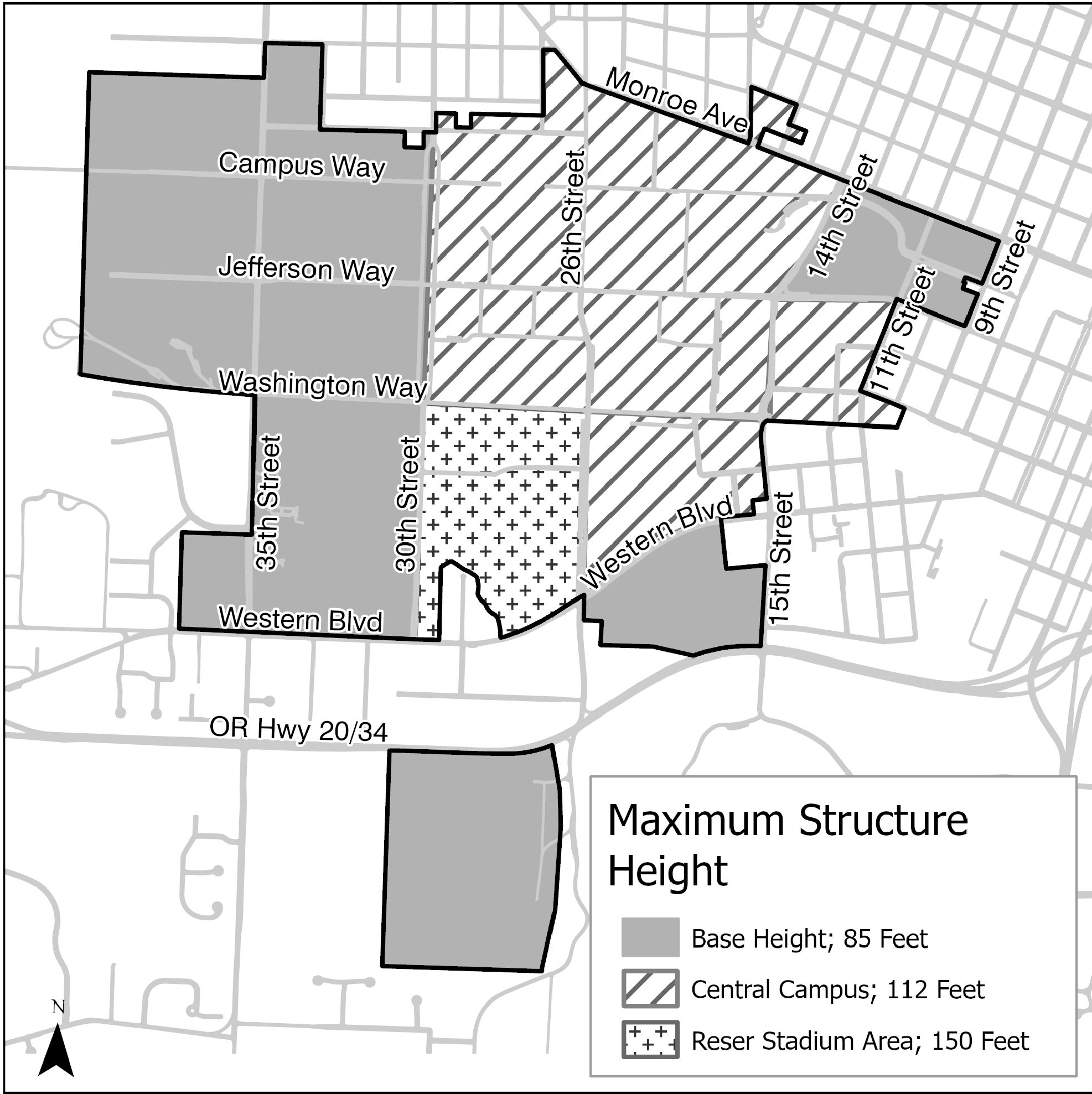
(Ord. No. 2025-41, § 4(Exh. A), 8-18-2025)
Section 3.36.90 - Additional Development Standards.
3.36.90.01 Building Entrances.
a.
Buildings designed for human occupancy with facades facing a public street or an OSU Street must have a building entrance facing the street, or, if on a street corner, a single building entrance may face the intersection of the streets rather than placing separate entrances on each street frontage.
b.
Buildings designed for human occupancy must include a pedestrian amenity, such as a porch, plaza, quad, courtyard, covered entryway, or seating area 100 sq. ft. minimum, as a component of building entrances, except entrances used exclusively for service access or emergency egress.
c.
Buildings such as sheds, barns, or garages, used exclusively for agricultural purposes, research, or for storage, are exempt from the above building entrances standards.
3.36.90.02 Ground Floor Windows.
a.
Buildings designed for human occupancy with facade(s) that face a public street or an OSU Street, multi-use path, and/or pedestrian plaza must have windows, pedestrian entrances, or display windows that cover at least 25 percent of the length and 15 percent of the surface area of the ground floor facade.
b.
Ground Floor is defined as the finished floor elevation of the first floor that qualifies as a story in a building, as defined in the State of Oregon Structural Specialty Code.
c.
Mirrored glass may not be used in ground floor windows.
d.
Parking structures either above or below ground are exempt from these ground floor window standards.
e.
Buildings or portions of buildings used exclusively for research or storage purposes are exempt from the ground floor window standards described in "a" through "c", above.
f.
If the exemption is applied per "e" above and the street facing portion of the building is within 25-ft of the street, a 5-ft wide landscape buffer consistent with Section 4.2.40 - Buffer Plantings must be installed along the exempt street-facing portion of the building.
3.36.90.03 Landscaping and Tree Plantings.
a.
General Landscaping Provisions - Except as provided below and modified by this Chapter, landscaping must be provided in accordance with Chapter 4.2 - Landscaping, Buffering, Screening, and Lighting.
b.
Required landscaping must comply with applicable sections of 4.2.20 - General Provisions except that:
1.
Installation - In the OSU zone, a letter of commitment from OSU must be provided in lieu of a landscape installation and/or landscape maintenance bond or other financial assurance for landscape and irrigation installation required by Section 4.2.20.a. The letter of commitment will include the following:
a)
A copy of the approved landscaping and irrigation plan;
b)
A commitment that the landscaping and irrigation will be installed prior to issuance of a final occupancy permit; and
c)
A commitment that the landscaping and irrigation will achieve 90 percent coverage within five years and be maintained by OSU.
2.
Coverage within Five Years - The applicant must install and maintain landscaping to ensure a minimum 90 percent ground coverage within five years.
3.
Street trees provided through the "Tree for a Fee" program are not subject to the requirement for a five-year maintenance financial guarantee.
4.
Irrigation Systems - Irrigation must be provided as required in Section 4.2.20.f - Irrigation Systems, except that the Director may waive the requirement for watering or irrigation systems if the applicant provides a plan for meeting the above coverage requirements. In all cases, required plantings must achieve 90 percent coverage within five years.
c.
Along OSU streets, trees must be planted in designated landscape planting strips or tree wells in accordance with the street tree spacing requirements of 4.2-1 - Street Trees.
1.
Landscape planting strips may be provided either between the curb and sidewalk or within the setback area between the sidewalk and the building or facility.
2.
Landscape planting strips on OSU Streets must be planted with medium or large canopy trees, except below overhead utility lines where small canopy trees may be used.
3.
If landscape planting strips are provided but are not available for tree planting due to tree/utility spacing conflicts as identified in Section 4.2.30.b, trees are not required.
d.
In addition to the requirements in Section 4.2.30.b, trees may not be planted within ten (10) feet of OSU historic style streetlights in the OSU zone.
Buffer plantings must be provided in accordance with Section 4.2.40 - Buffer Plantings.
Where screening is required, it must meet the standards below, not those in Section 4.2.50 - Screening.
a.
Ground Level Screening - If visible from a street, sidewalk, walkway, or within 50-ft of an abutting residential zone, trash/recycling dumpsters, ground-level air conditioning units and other ground-level mechanical equipment, transformers, and outdoor storage areas must be screened with a fence, wall, or plantings that achieve at least 80 percent opacity. The following additional standards apply:
1.
Screened items must not be placed within any required setback areas, nor within any required vision clearance areas.
2.
Screening must be at least as tall as the item(s) being screened, except that vegetation must reach the required height within 3-years.
3.
Screening may include one or more openings for access and maintenance, provided each opening contains an access gate that is at least equal in height to the facilities being screened.
4.
Transformers that are less than or equal to 30-inches wide by 30-inches deep by 30-inches tall are not required to be screened.
5.
Fences and walls used for screening must be constructed of wood, concrete, stone, brick, metal, or other commonly used materials. A chain link fence with slats qualifies for screening only if a landscape buffer is provided around the outside perimeter of the fence in compliance with Section 4.2.40 - Buffer Plantings.
6.
Where landscaping is used for required screening, it must be at least as tall as the item being screened and be at least 80 percent opaque, as seen from a perpendicular line of sight, within 3-years of final inspection.
7.
Earthen berms may be used to comply with screening requirements. The slope of a berm may not exceed 3:1. The faces of a berm's slope must be planted with vegetation.
b.
Roof Mounted Equipment - Roof mounted equipment must be screened by features such as parapets, walls, or paneling, or placed such that it is not visible from City and OSU Streets within or abutting the Development Area.
c.
Chain-link Fencing - Where visible from public rights-of-way or OSU Streets, chain link fences are prohibited unless coated with black vinyl.
a.
Site Lighting must comply with LDC Section 4.2.80 - Site Lighting, except where modified by this section.
b.
OSU historic style light fixtures with shielded luminaires must be used along sidewalks and walkways, except along walkways interior to parking lots.
c.
The historic style light fixtures must have poles and bases, and associated pole-mounted equipment such as banner hangers, etc., finished with black or other dark color.
d.
Outdoor field lighting may be installed on intramural and recreational playing fields, provided that the light is directed on the fields and not directed toward adjacent privately owned properties. Adjacent to residential areas, a lighting curfew of 10 p.m. will be imposed on these playing fields so that all events are completed prior to that time.
e.
With the exception of lighting for intercollegiate athletic facilities and intramural and recreational playing fields, light trespass onto surrounding residential properties must not exceed 0.1 footcandles, except in areas where additional lighting for safety and security, as determined by the University, is necessary. In such cases, light trespass onto surrounding residential properties must not exceed 0.25 footcandles. Testing of the lighting by the University to ensure compliance must be done after the lights have experienced 10 hours of illuminance or burn time.
f.
Stadium lighting for future expansions to Reser Stadium must be provided in a manner that does not increase light spillage outside of the stadium proper.
g.
Installation of field lighting for intercollegiate athletic facilities other than Reser Stadium must ensure that light trespass onto surrounding residential properties does not exceed 0.5 footcandles. Testing of the lighting by the University to ensure compliance must be done after the lights have experienced 10 hours of illuminance or burn time.
Vehicle parking must comply with the applicable standards in Chapter 4.1 - Parking, Loading, and Access Requirements except for the following standards from Section 4.1.30 - Standards for Vehicle Access, Maneuvering, and Parking:
4.1.30.i - Location
4.1.30.j - Maximum Surface Parking Allowed - CMU Zones
4.1.30.k - Structured Parking Required, and
4.1.10.l - Carpool and vanpool parking.
a.
New bicycle parking facilities are only required with the construction of new buildings; bicycle parking facilities are not required when an existing structure is altered and/or existing uses within the structure are changed. When bicycle parking facilities are required, they must comply with the applicable standards in Chapter 4.1 - Parking, Loading, and Access Requirements except as provided below. Where conflicts exist between this Chapter and Chapter 4.1, the provisions in Chapter 3.36 prevail.
b.
Quantity - Residence Halls and Dining Centers: 1 space per 1,500 sq. ft. GFA. All other use types: 1 space per 4,000 sq. ft. GSF.
c.
Location and Availability - Required bicycle parking facilities must be placed in a location within 500-ft of an entrance on the building generating the parking requirement.
d.
Covered Spaces - At least 70 percent of bicycle parking spaces required for Residence Halls and Dining Centers must be covered. For all other use types, at least 50 percent of required bicycle parking spaces must be covered.
e.
Unassigned Spaces - At least 15 percent of the total required parking spaces must be unassigned and located such that they are available for shared use by all visiting, residing, or working in the building or area.
(Ord. No. 2025-41, § 4(Exh. A), 8-18-2025)
Section 3.36.100 - Transportation Facilities.
The transportation system within the OSU Zone consists of public streets and OSU Streets and provides routes to and through campus for all modes of transportation. The following are standards for transportation facilities in the OSU Zone.
3.36.100.01 Timing of Transportation Improvements.
a.
Pedestrian Facilities:
1.
Public Streets - On public streets in the OSU Zone, sidewalks and planting strips consistent with the requirements of Chapter 4.0 - Improvements Required with Development are required when abutting Development Sites and Development Areas are developed.
2.
OSU Streets - On OSU Streets, sidewalks and planting strips consistent with the requirements of this Chapter are required when abutting Development Areas are developed.
b.
Bicycle Facilities:
1.
Public Streets - On public streets in the OSU Zone, on-street bike facilities are required with street improvements on Arterial Highway, Arterial, Collector, and Neighborhood Collector Streets, consistent with Chapter 4.0.
2.
OSU Streets - On OSU Streets, bike facilities are required with street improvements and must be constructed consistent with the standards in this Chapter.
c.
Street Improvements:
1.
On public and OSU Streets, street frontage improvements must be completed with development consistent with Section 4.0.20 - Timing of Improvements unless there is a Transportation Agreement that supersedes those requirements.
2.
On public and OSU Streets, improvements other than street frontage improvements must be completed as determined by the traffic evaluation requirements in LDC Section 4.0.60.a as modified in "a" and "b", below unless superseded by a Transportation Agreement.
a)
In accordance with the Institute of Transportation Engineers Trip Generation Manual, motor vehicle trip generation rates used in the traffic evaluation will be based on relevant local data when available.
b)
Exceptions - Trip generation reports and TIAs are not required for the following:
i.
Equipment, utility, trash, and bike parking enclosures.
ii.
Structures or portions of structures used for storage, including equipment, vehicle, and agricultural storage.
iii.
All Agricultural uses except packaging and processing; and
iv.
Wireless telecommunication facilities.
d.
Transportation Agreements - OSU and the City of Corvallis may establish Transportation Agreements.
1.
Transportation Agreements may be established independent of a development proposal or as a condition of approval of a development proposal in accordance with LDC 4.0.60.a.3.
2.
A transportation agreement must include the following:
a)
Definition of the Terms of the Agreement;
b)
A listing of the parties included in the Agreement;
c)
A listing of improvements to be included in the Agreement, if any, and if those improvements are associated with a development project, the Agreement must identify the project with which they are associated; and
d)
A time frame for the terms of the Agreement.
3.
Transportation Agreements may be established for reasons including, but not limited to, those provided below.
a)
OSU and the City may execute a Transportation Agreement that provides a strategy for the construction, financing, timing, and provision of right-of-way for improvements necessary to meet City mobility, operational and safety standards identified in the Transportation System Plan.
b)
OSU and the City may execute a Transportation Agreement to establish an OSU-specific trip generation rate or threshold for determining when a traffic evaluation is required.
c)
OSU and the City may execute a Transportation Agreement to establish an OSU-specific mobility standard for public and OSU streets in and abutting the OSU Zone as contemplated in Chapter 6 of the Transportation System Plan.
3.36.100.02 OSU Zone Street Standards.
a.
Applicability - The standards in Chapter 4.0 - Improvements Required with Development apply to streets in the OSU zone except as modified by this Chapter.
1.
All transportation improvements on OSU Streets, as shown in Figure 3.36-2: OSU Street Standards by Category, must be consistent with the standards in this Chapter based on the street's functional classification as shown in Table 3.36-4 - OSU Streets, Base Design Standards.
2.
OSU-owned transportation facilities not shown in Figure 3.36-2 are exempt from the transportation provisions of Chapter 4.0 and Chapter 3.36.
b.
General Provisions:
1.
Improvements required with development must meet the Construction Specifications except as modified in Chapter 3.36.
2.
For OSU-owned property within the OSU Zone, the provisions in Chapter 4.0 that refer to Development Sites apply to Development Areas, as defined in Section 3.36.40 - Definitions Specific to this Chapter.
3.
Any improvements required by Section 4.0.60 to OSU Streets within the OSU Zone must be improved to the standards in Section 3.36.100.02 - OSU Zone Street Standards, rather than City standards where those standards differ.
Figure 3.36-2: OSU Street Standards by Category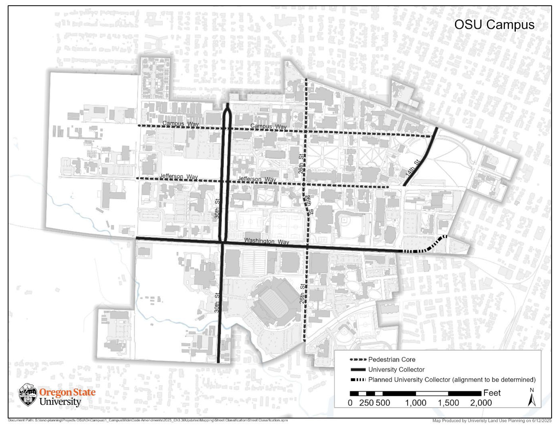
c.
OSU Streets—Base Design Standards - The following standards in Table 3.36-4 apply to OSU Streets.
Table 3.36-4 - OSU Streets, Base Design Standards
d.
OSU Street Sidewalks.
1.
Sidewalks must be provided along a project's development frontage to the edge of adjacent facilities when development and/or redevelopment occurs, except as otherwise provided in Section 3.36.100.01.c. Where Natural Hazards, Natural Resources, or railroad right-of-way prevent the installation of pedestrian facilities, sidewalk and landscape planting strips are not required along the adjacent side of the street.
2.
Sidewalks must provide a minimum of six feet in width of unobstructed passage except that the minimum unobstructed passage provided may be reduced to five feet to preserve Significant Tree(s), to preserve Historically Significant Tree(s), and to accommodate Historic Resources.
3.
Sidewalks must be constructed consistent with City Standard Construction Specifications except the location and width of the planting strip may vary consistent with the provisions of this Chapter.
4.
Sidewalks may either abut the curb or be separated from it by a landscape planting strip.
5.
Sidewalks must be separated from vehicle parking or maneuvering areas by grade, different paving material, bollards, or landscaping, except where they cross driveways.
6.
Where an existing sidewalk is located over a utility tunnel or where the construction of a planting strip of six feet in width would require the removal of a Significant Tree(s), the existing sidewalk location may be retained provided all of the following are met:
a)
The existing sidewalk width complies with the standards in this Chapter, or it is replaced to meet the standard width in Table 3.36-4 - OSU Streets, Base Design Standards;
b)
The existing or proposed sidewalk complies with ADA requirements; and
c)
Street trees are provided consistent with this Chapter.
7.
Prior to development, applicants must perform a site inspection in conformance with LDC 4.0.30.e.
8.
Except as noted in Section 3.36.90.03, construction of sidewalks and designated landscape planting strips in compliance with LDC Section 3.36.100.02 - OSU Zone Street Standards, along Pedestrian Core streets may be deferred until development of the development area and reviewed as a component of the Building Permit.
e.
Designated Landscape Planting Strips:
1.
A designated landscape planting strip with a continuous width of at least six (6) feet must be provided immediately adjacent to the sidewalk, either between the curb and sidewalk or within the setback area between the sidewalk and the facility. Alternatively, tree wells, placed either curb tight or at the back of the sidewalk, may be used.
Exceptions to this requirement must be granted when at least one of the following conditions exists:
a)
There is insufficient width between the curb and an existing facility to provide a five-foot-wide sidewalk and a six-foot-wide designated tree planting area.
b)
There is an existing sidewalk located over a utility tunnel and insufficient width on either side of the sidewalk to provide a six-foot-wide designated landscape planting strip.
c)
There is an existing sidewalk of at least five (5) feet in width and an existing designated landscape planting strip that is less than six (6) feet in width.
d)
Construction of a designated landscape planting strip of six (6) feet in width and a conforming sidewalk would require the removal of a Historically Significant Tree.
e)
The sidewalk is located within a Natural Resource area governed by one of the following chapters: Chapter 4.12 - Significant Vegetation Protection Provisions, Chapter 4.13 - Riparian Corridor and Wetland Provisions, drainageway areas governed by regulations in Chapter 2.11 - Floodplain Development Permit, or Chapter 4.5 - Floodplain Provisions.
2.
The designated landscape planting strip must be landscaped with trees and plant materials in accordance with LDC Section 3.36.90.03.
a.
Multi-use paths must be located as identified in the Corvallis Transportation System Plan or Parks and Recreation Master Plan.
b.
Multi-use paths must be constructed of a permanent hard surface including, but not limited to, asphalt or concrete.
c.
The standard width for a two-way multi-use path must be twelve (12) feet wide, but the standard width can be reduced to a minimum of eight (8) feet wide to preserve Significant Tree(s), to preserve Historically Significant Tree(s), to accommodate Historic Resources, or in locations abutting railroad right-of-way.
d.
Except for the required minimum width and pavement material, all other elements of multi-use paths must be constructed to City Engineering Standards.
a.
Walkways must provide at least 5-ft of unobstructed passage and be constructed of permanent hard surfaces such as pavers, brick, concrete, or other materials that meet ADA requirements.
b.
Except where walkways cross driveways, walkways must be separated from vehicle parking or maneuvering areas by grade, different paving materials, bollards, or landscaping.
c.
Walkways must be provided concurrent with development to connect building entrances, parking lots, and the development area's pedestrian circulation system with existing pedestrian facilities (i.e. walkways, sidewalks, multi-use paths) abutting the development area.
(Ord. No. 2025-41, § 4(Exh. A), 8-18-2025)
Section 3.36.110 - Variations.
Variations from development standards in this Chapter may be allowed through the processes outlined in Chapter 2.5 - Planned Development and Chapter 2.12 - Development Standards Adjustment.
(Ord. No. 2025-41, § 4(Exh. A), 8-18-2025)
Section 3.40.10 - Purposes.
This Overlay is intended to:
a.
Promote new development that is compatible with original patterns of neighborhood development, and that are appropriate to the site and area;
b.
Encourage incremental change in density while remaining conscious of the mass, scale, and form of original development within the affected neighborhoods;
c.
Supplement other development standards within this Code that are intended to facilitate housing diversity;
d.
Respond to adopted recommendations from the Collaboration Corvallis project regarding promotion of established neighborhood development patterns;
e.
Implement development standards that were created in response to the North Campus Area plan; and
f.
Implement policies of the City's Comprehensive Plan.
Section 3.40.20 - Implementation.
Only those properties with an underlying residential zone and located within the adopted boundary (see Figure 3.40-1 below) of the University Neighborhoods Overlay are subject to the provisions in this Chapter.
A University Neighborhoods Overlay designation may be applied to residentially zoned properties in accordance with the procedures of Chapter 2.2 - Zone Changes.
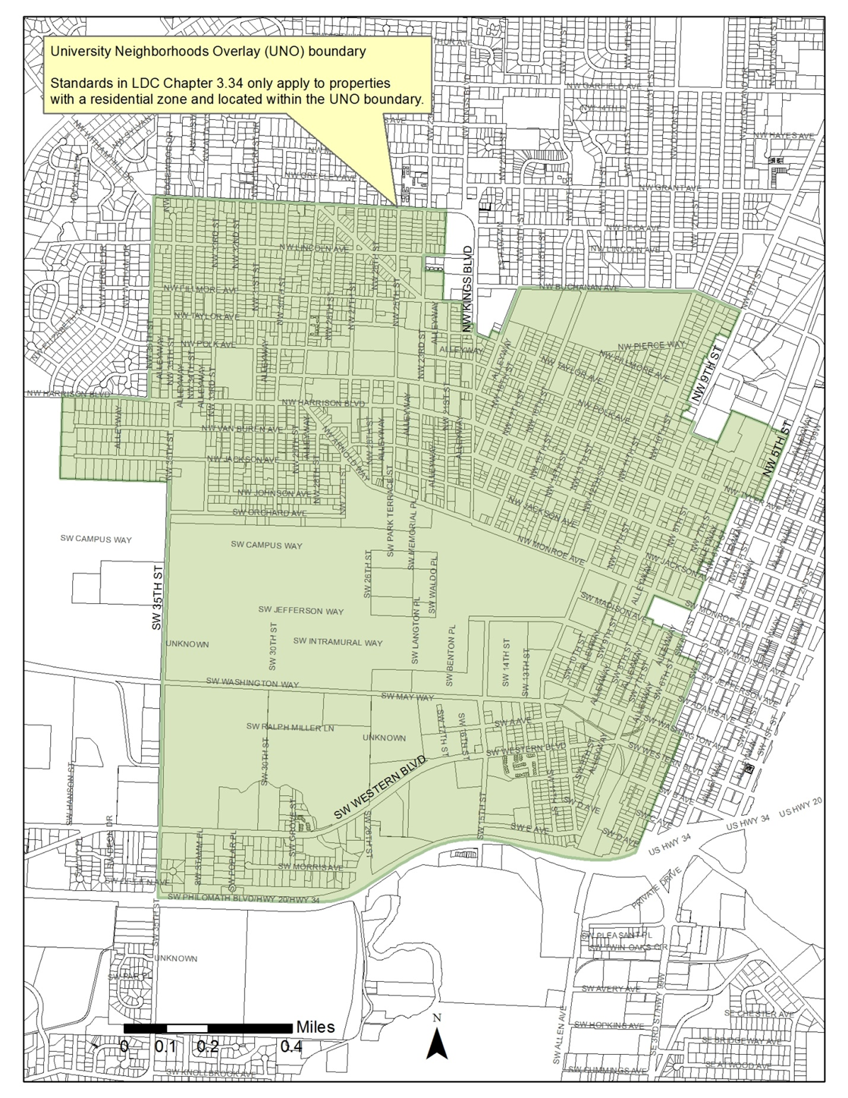
Figure 3.40-1: University Neighborhoods Overlay (UNO)
Section 3.40.30 - Removal.
A University Neighborhoods Overlay designation may be removed in accordance with the procedures of Chapter 2.2 - Zone Changes.
Section 3.40.40 - Permitted Uses.
Permitted uses consist of any uses listed in the underlying residential zone.
Section 3.40.50 - Maximum Floor Area Ratio.
a.
Maximum FAR per Zone - Unless provided otherwise, new or cumulative residential development, except Townhomes and Cottage Cluster development, must comply with the following:
b.
The following shall not count against a Max. FAR:
1.
Accessory structures not used for vehicle parking.
2.
Accessory Dwelling units (see Chapter 4.9).
3.
Basements, underground vehicle parking and circulation areas, and living space, provided the ceiling of which is four ft. or less above the lowest point on the public sidewalk abutting the respective property line of a structure's street-facing elevation; or
4.
Unenclosed porches, patios, decks, balconies, and roof-top open space.
c.
Exemptions for Garages
1.
Attached Garage/Carport - An attached garage or carport, up to 240 square feet in area, may be excluded from the gross floor area of a building when determining compliance with a Max. FAR.
2.
Detached Garage/Carport - A detached garage or carport, up to 480 square feet in area, the face of which is placed a minimum of 20 ft. behind the longest segment of the front wall of a primary structure's street-facing elevation(s), may be excluded from the gross floor area when determining compliance with a Max. FAR.
(Ord. No. 2022-12, eff. 6-1-2022; Ord. No. 2025-25, § 8(Exh. A), eff. 6-12-2025)
Section 3.40.60 - Garage, Carport and Off-Street Parking Access For Lots and Parcels With Improved Alley Access.
Orienting garages, carports, and off-street parking facilities toward a street within the University Neighborhoods Overlay may be inconsistent with original patterns of neighborhood development. Front-loaded, attached garages and carports have the greatest potential for conflicting with those patterns.
The minimum standards for driveway width and side yard setback contained in the Corvallis Off-street Parking and Access Standards are intended to facilitate narrow driveways and detached garages as part of redevelopment within the University Neighborhoods Overlay. For Lots or parcels without improved alley access, detached garages placed a minimum of 20 ft. behind the longest segment of the front wall of a primary structure's street-facing elevation(s) are strongly encouraged.
The following standards apply to Lots and Parcels with improved alley access.
a.
Alley Access Required - Vehicular access to a garage, carport or other off-street parking facilities is limited to an alley for a Lot or Parcel with access along an alley that is either improved consistent with Section 4.0.60.j or otherwise paved for its full length.
b.
Garage and Carport Orientation - Garages and carports must be placed and oriented consistent with Section 4.0.60.j.2.
Exception: An alteration to existing residential development on Lots or Parcels with existing public street vehicle access to a garage, carport or other off-street parking facility that does not involve an increase in the number of dwelling units.
(Ord. No. 2022-12, eff. 6-1-2022)
Section 3.40.70 - Reserved.
Editor's note— Ord. No. 2022-12, effective June 1, 2022, repealed § 3.40.70.
Section 3.40.80 - Variations.
Variations from development standards in this Chapter may be allowed through the processes outlined in Chapter 2.5 - Planned Development and Chapter 2.12 - Development Standards Adjustment.
Provisions in Articles I and II of this Code are not eligible for variation.
(Ord. No. 2024-26, § 31(Exh. A), eff. 1-1-2025)
Section 3.41.10 - Purpose.
The Willamette River Greenway is an Overlay that coincides with the adopted Greenway boundary and applies to all development permitted by the underlying zones. The objectives of this Overly and this Chapter are as follows:
a.
Protect, conserve, enhance, and maintain the natural, scenic, historical, economic, and recreational qualities of lands along the Willamette River;
b.
Maintain or improve air and water quality within the Greenway;
c.
Implement goals and policies of the State's Willamette River Greenway Program as required by the Oregon Revised Statutes, as amended;
d.
Implement policies of the City's Comprehensive Plan;
e.
Establish standards and requirements for the use of lands within the Willamette River Greenway in the City of Corvallis;
f.
Provide for review of any intensification of Use, change of Use, or development within the Greenway;
g.
Increase and maintain public access to and along the Willamette River to create urban recreational opportunities, provide linkages to other transportation corridors, and provide for multiple use of urban land; and
h.
Ensure development is consistent with floodwater flow mitigation and management of a Natural Resource or Natural Hazard.
Section 3.41.20 - Conditional Development.
Development within this Overlay, regardless of the classification in the underlying zone, requires Conditional Development approval in accordance with the provisions of Chapter 2.3 - Conditional Development. In addition to notification requirements of Chapter 2.0 - Public Involvement, written public notice and a Notice of Disposition shall be mailed to the Oregon Department of Parks and Recreation. Development as used in this Section includes change of Use, intensification of land, or intensification of Water-dependent or Water-related Uses, except for those activities listed as exemptions in Section 3.41.30 below. Development also includes proposed increases in air discharges that require permit approval by the Oregon Department of Environmental Quality (DEQ).
(Ord. No. 2018-01, eff. 1-26-2018)
Section 3.41.30 - Exemptions.
The following development activities do not require Conditional Development approval, provided they are consistent with requirements of Chapter 2.11 - Floodplain Development Permit, Chapter 4.5 - Floodplain Provisions, Chapter 4.11 - Minimum Assured Development Area (MADA), Chapter 4.12 - Significant Vegetation Protection Provisions, Chapter 4.13 - Riparian Corridor and Wetland Provisions, the Natural Resource provisions of Chapter 4.2 - Landscaping, Buffering, Screening, and Lighting, and Chapter 4.14 - Landslide Hazard and Hillside Development Provisions:
a.
Customary dredging and channel maintenance conducted under permit from the state;
b.
Seasonal increases in gravel operations under permit from the state;
c.
Erosion control operations not requiring a permit from the Oregon Department of State Lands and that constitute a reasonable emergency necessary for safety or the protection of property.
d.
Scenic easements acquired under ORS 390.332, as amended, and their maintenance as authorized by that statute and ORS 390.368, as amended.
e.
Addition or modification by public utilities for existing utility lines, wires, fixtures, equipment, circuits, appliances, and conductors.
f.
Flood emergency procedures and the maintenance and repair of existing flood control facilities, provided the maintenance and repair of existing flood control facilities is consistent with Section 2.11.40.
g.
Signs, markers, aids, and similar items, placed by a public agency to serve the public or located on private property separated from the Willamette River by public street right-of-way.
h.
Residential Accessory Development (excluding structures), such as lawns, gardens, and play areas outside of the areas required to be protected by Chapter 2.11 - Floodplain Development Permit, Chapter 4.5 - Floodplain Provisions, Chapter 4.11 - Minimum Assured Development Area (MADA), Chapter 4.12 - Significant Vegetation Protection Provisions, Chapter 4.13 - Riparian Corridor and Wetland Provisions, the Natural Resource provisions of Chapter 4.2 - Landscaping, Buffering, Screening, and Lighting, and Chapter 4.14 - Landslide Hazard and Hillside Development Provisions.
i.
Storage of equipment or material associated with Permitted Uses, providing it complies with applicable provisions of this Code.
j.
Minor repairs or alterations to an existing structure for which no Building Permit is required.
k.
A change of Use of a building or other structure that does not substantially alter or affect the land or water upon which it is situated.
l.
Landscaping consistent with Chapter 2.11 - Floodplain Development Permit, Chapter 4.2 - Landscaping, Buffering, Screening, and Lighting, Chapter 4.5 - Floodplain Provisions, Chapter 4.11 - Minimum Assured Development Area (MADA), Chapter 4.12 - Significant Vegetation Protection Provisions, Chapter 4.13 - Riparian Corridor and Wetland Provisions, and Chapter 4.14 - Landslide Hazard and Hillside Development Provisions.
m.
Construction of driveways.
n.
Maintenance and repair, usual and necessary for the continuance of an existing Use.
o.
Reasonable emergency procedures necessary for the safety or protection of property.
p.
Other activities similar to those listed in "a" through "o" above. The Director shall make such determinations and provide notice in accordance with Chapter 2.16 - Request for Interpretation.
(Ord. No. 2025-28, § 4(Exh. A), eff. 6-26-2025)
Section 3.41.40 - Review Criteria.
Conditional Development within the Willamette Greenway Overlay may be approved only when the Planning Commission, after considering cumulative effects within the City's Greenway, finds that the development standards in Section 3.41.50 and the following criteria are met:
a.
Public access to and along the river shall be provided to the maximum extent practicable and to the extent that public access does not interfere with established Uses on the property.
b.
Significant Natural Hazards and Natural Resources shall be protected consistent with the requirements of Chapter 2.11 - Floodplain Development Permit, Chapter 4.5 - Floodplain Provisions, Chapter 4.11 - Minimum Assured Development Area (MADA), Chapter 4.12 - Significant Vegetation Protection Provisions, Chapter 4.13 - Riparian Corridor and Wetland Provisions, the Natural Resource provisions of Chapter 4.2 - Landscaping, Buffering, Screening, and Lighting, and Chapter 4.14 - Landslide Hazard and Hillside Development Provisions.
c.
Significant natural and scenic areas, viewpoints, and vistas shall be preserved.
d.
The quality of air, water, and land resources in the Greenway shall be protected to the maximum extent practicable.
e.
The Minimum Assured Development Area (MADA) shall be consistent with Chapter 4.11 - Minimum Assured Development Area (MADA).
f.
The natural vegetative fringe along the river shall be protected and enhanced to the maximum extent practicable to ensure scenic quality, protection of wildlife, protection from erosion, and screening of Uses from the river.
g.
Any public Recreational Use or facility shall not substantially interfere with established Uses on adjoining property.
h.
Maintenance of public safety and protection of public and private property, especially from vandalism and trespass, shall be provided to the maximum extent practicable.
i.
Extraction of aggregate deposits shall be conducted in a manner designed to minimize adverse effects on water quality, fish and wildlife, vegetation, bank stabilization, stream flow, visual quality, noise, and safety, and to guarantee necessary reclamation.
j.
Development, change, or intensification of Use shall provide the maximum possible landscaped area, open space, or vegetation between the activity and the river.
k.
Development shall be sited to maximize distance from the river to the greatest extent practicable.
l.
In applying "a" through "k" above, to development proposals within the Willamette River Greenway, consideration should be given to the provisions of this Code, Corvallis 2020 Vision Statement, Comprehensive Plan, Downtown Streetscape Plan, Riverfront Commemorative Park Plan, and other applicable City documents. However, where conflicts arise, direction must be taken from the Corvallis Comprehensive Plan and this Code.
Section 3.41.50 - Development Standards.
Proposed development within the Willamette Greenway Overlay shall comply with the following standards:
a.
Site Modifications
1.
Except as provided in Section 3.41.30, above, existing predominant topographical features of the bank line and escarpment shall be protected and maintained.
2.
Disturbance necessary for construction or establishment of a Water-related or Water-dependent Use, as defined in Chapter 1.6 - Definitions, and measures necessary to reduce existing or potential bank and escarpment erosion, landslides, or flood hazard conditions may be permitted upon approval by the Director or Floodplain Administrator or designee. However, such activities shall be consistent with Chapter 2.11 - Floodplain Development Permit and Chapter 4.5 - Floodplain Provisions.
3.
Stability shall be assured considering the stress imposed on the bank and land area between the low water mark of the river and Top-of-bank.
4.
The hydraulic and flood carrying capacity of the river and the hydraulic effect of the river on the bank shall be considered, and steps shall be taken to ensure minimal adverse effects by and upon the proposal, consistent with Chapter 2.11 - Floodplain Development Permit and Chapter 4.5 - Floodplain Provisions.
5.
The applicant shall demonstrate adherence to the provisions of Chapter 2.11 - Floodplain Development Permit, Chapter 4.5 - Floodplain Provisions, Chapter 4.11 - Minimum Assured Development Area (MADA), Chapter 4.12 - Significant Vegetation Protection Provisions, Chapter 4.13 - Riparian Corridor and Wetland Provisions, the Natural Resource provisions of Chapter 4.2 - Landscaping, Buffering, Screening, and Lighting, and Chapter 4.14 - Landslide Hazard and Hillside Development Provisions.
6.
If applicable, the applicant shall submit certification by a registered professional engineer that the standards specified in "2" and "3" above, have been met. Where necessary to properly evaluate a proposal, an applicant may be required to furnish further studies such as a soils survey and analysis, foundation study, or hydrologic study performed by competent professionals.
b.
Landscaping, Natural Hazards, and Natural Resources - the following provisions shall apply:
1.
All areas of the site within the WRG Overlay shall be landscaped and addressed consistent with the provisions of the underlying zone; and the provisions of Chapter 2.11 - Floodplain Development Permit, Chapter 4.2 - Landscaping, Buffering, Screening, and Lighting, Chapter 4.5 - Floodplain Provisions, Chapter 4.11 - Minimum Assured Development Area (MADA), Chapter 4.12 - Significant Vegetation Protection Provisions, Chapter 4.13 - Riparian Corridor and Wetland Provisions, and Chapter 4.14 - Landslide Hazard and Hillside Development Provisions.
2.
Required landscaped areas shall be continuously maintained, irrigated with permanent facilities sufficient to maintain the plant material, and covered by living plant material capable of attaining 90 percent ground coverage within three years. Required vegetation areas shall be subject to the provisions of Section 4.13.50.d. Landscaping and lighting shall be in accordance with Chapter 4.2 - Landscaping, Buffering, Screening, and Lighting. If there is a conflict between the provisions of Section 4.13.50.d and Chapter 4.2 - Landscaping, Buffering, Screening, and Lighting, Section 4.13.50.d shall prevail.
3.
Living plant materials shall be compatible with and enhance the riparian environment.
c.
Structures - All buildings and structures, including supporting members, and all exterior mechanical equipment shall be screened, colored, or surfaced to blend with the riparian environment. Surfaces shall be nonreflective.
d.
Signs and Graphics - In addition to compliance with applicable provisions relating to signs and graphics in Chapter 4.7 - Sign Regulations, no sign or graphic display inconsistent with the purposes of the Greenway shall have a display surface oriented toward or visible from the Willamette River, except for signs exempt under Section 3.41.30.g above.
e.
Parking and Unenclosed Storage Areas
1.
Parking, loading, and unenclosed storage areas located within the WRG Overlay shall be screened from the river to the extent practicable in accordance with Chapter 4.1 - Parking, Loading, and Access Requirements and Chapter 4.2 - Landscaping, Buffering, Screening, and Lighting.
2.
Parking, loading, and unenclosed storage areas located outside of but adjacent to the WRG Overlay shall be screened from such Overlay to the extent practicable.
f.
Greenway Setback - Minimum building setback distances from the ordinary high water line of the Willamette River shall be as outlined in Table 3.41-1 - Minimum Setbacks.
(Ord. No. 2025-28, § 4(Exh. A), eff. 6-26-2025)
Section 3.42.10 - Background and Applicability.
The City of Corvallis recognizes that historic resources located within its boundaries contribute to the unique character of the community and merit preservation. The City's Historic Preservation Overlay provisions assist in implementing the policies in Comprehensive Plan Article 5.4 - Historic and Cultural Resources. The procedural provisions implementing this Chapter are located in Article II - Administrative Procedures. These provisions also conform with Statewide Planning Goals and other state land use requirements.
A Historic Preservation Overlay (HPO) designation applies to all Historic Resources listed in the Corvallis Register of Historic Landmarks and Districts (Local Register). A Historic Preservation Overlay Designation does not apply to Designated Historic Resources listed in the National Register of Historic Places unless those Designated Historic Resources are also listed in the Local Register. Historic resources are listed in the National Register of Historic Places under state and federal processes and criteria. If a property Owner wishes to list a Nationally-designated Historic Resource in the Local Register, a Zone Change to add a Historic Preservation Overlay is required in accordance with Chapter 2.2 - Zone Changes.
(Ord. No. 2023-24, § 13(Exh. A), eff. 9-12-2023)
Editor's note— Ord. No. 2023-24, § 13(Exh. A), effective September 12, 2023, renumbered §§ 3.42.10—3.42.30 as §§ 3.42.20—3.42.40.
Section 3.42.20 - Purposes.
This Overlay is intended to:
a.
Implement, through Chapter 2.9 - Historic Preservation Provisions, historic and cultural resource policies of Comprehensive Plan Article 5.4 - Historic and Cultural Resources;
b.
Encourage, effect, and accomplish the protection, enhancement, and perpetuation of such historic resource improvements and of Historic Districts which represent or reflect elements of the City's cultural, social, economic, political, and architectural history;
c.
Complement any National Register of Historic Places Historic Districts in the City;
d.
Foster civic pride in the beauty and noble accomplishments of the past; and
e.
Promote the use of Historic Districts and landmarks for education, pleasure, energy conservation, housing, and public welfare of the City.
(Ord. No. 2023-24, § 13(Exh. A), eff. 9-12-2023)
Editor's note— See editor's note, § 3.42.10.
Section 3.42.30 - Permitted Uses.
Uses permitted for properties with a Historic Preservation Overlay designation are the same as Uses permitted in the underlying zone.
(Ord. No. 2023-24, § 13(Exh. A), eff. 9-12-2023)
Editor's note— See editor's note, § 3.42.10.
Section 3.42.40 - Implementation.
Chapter 2.2 - Zone Changes and Chapter 2.9 - Historic Preservation Provisions contain procedural requirements for the following:
a.
Section 2.2.40 - Quasi-judicial Change Procedures for Zone Changes Subject to a Public Hearing
b.
Section 2.2.50 - Quasi-judicial Change Procedures for Administrative Zone Changes
c.
Section 2.2.60 - Procedures for Reclassifying a Designated Historic Resource in a National Register of Historic Places Historic District
d.
Section 2.9.70.01 - Alteration or New Construction Activities Involving a Designated Historic Resource
e.
Section 2.9.70.02 - Demolition Involving a Designated Historic Resource
f.
Section 2.9.70.03 - Moving a Designated Historic Resource
(Ord. No. 2023-24, § 13(Exh. A), eff. 9-12-2023)
Editor's note— See editor's note, § 3.42.10.
Section 3.43.10 - Purposes.
This Overlay is intended to:
a.
Promote flexibility in design and permit diversification in location of structures;
b.
Promote efficient use of land and energy and facilitate a more economical arrangement of buildings, circulation systems, land uses, and utilities;
c.
Preserve to the greatest extent possible existing landscape features and amenities, and utilize such features in a harmonious fashion;
d.
Provide for more usable and suitably located recreation facilities and other public and common facilities than would otherwise be provided under conventional land development procedures;
e.
Combine and coordinate architectural styles, building forms and building relationship within the site with the Nonresidential PD Overlay designation;
f.
Provide the applicant with reasonable assurance of ultimate approval before expenditure of complete design monies, while providing the City with assurances that the project will retain the character envisioned at the time of approval;
g.
Promote and encourage energy conservation; and
h.
Provide greater compatibility with surrounding land uses than what may occur with a conventional project.
Section 3.43.20 - Permitted Uses.
Permitted Uses consist of any Uses listed in the underlying zone.
Section 3.43.30 - Implementation.
Property may be designated with a Nonresidential PD Overlay in any of the following ways:
a.
Upon Annexation in accordance with Chapter 2.6 - Annexation;
b.
In conjunction with a Comprehensive Plan Map Amendment in accordance with Chapter 2.1 - Comprehensive Plan Amendment; or
c.
In conjunction with a Zone Change in accordance with Chapter 2.2 - Zone Changes.
A Nonresidential PD Overlay can also be applied through the use of the provisions in Chapter 2.5 - Planned Development, which allow such an Overlay in conjunction with approval of a Conceptual and/or Detailed Development Plan. However, Nonresidential PD Overlay established in accordance with Chapter 2.5 only remain as long as there is an active Conceptual Development Plan on the site (active defined in Section 2.5.40.09) or an active Detailed Development Plan on the site (active defined in Section 2.5.50.09).
Section 3.43.40 - Initiation.
A Nonresidential PD Overlay may be initiated in any of the following ways:
a.
An application filed by a property owner on property(ies) with a nonresidential land use designation, in conjunction with an Annexation, Comprehensive Plan Map Amendment, or Zone Map Change; and under circumstances when the property owner states and the hearing authority finds the applicable underlying zone standards are not adequate to do address the following concerns:
1.
Circulation or other common facilities issues;
2.
Resolution of issues related to an unusual site configuration, steep topography, or Significant Natural Feature;
3.
Assurance of comprehensive planning and coordinated development where the property is large and/or has mixed uses; or
4.
Compatibility issues where it is desirable to locate more intensive land uses next to less intensive residential land uses.
b.
By the hearing authority, on property(ies) with a nonresidential land use designations(s), in conjunction with an Annexation, Comprehensive Plan Map Amendment, or Zone Map Change when the hearing authority finds the applicable underlying zone standards are not adequate to address any of the concerns in Section 3.43.40.a.1—4, above.
Section 3.43.50 - Removal.
All Nonresidential PD Overlay designations that exist on sites without an active Conceptual Development Plan or active Detailed Development Plan on any portion of the site, may be requested to be removed by use of the provisions for a Quasi-judicial Zone Map Change involving a public hearing and outlined in Section 2.2.40 of Chapter 2.2 - Zone Changes.
Section 3.44.10 - Purposes.
This Overlay is intended to:
a.
Promote flexibility in design and permit diversification in location of structures;
b.
Promote efficient use of land and energy and facilitate a more economical arrangement of buildings, circulation systems, land uses, and utilities;
c.
Preserve to the greatest extent possible existing landscape features and amenities, and utilize such features in a harmonious fashion;
d.
Provide for more usable and suitably located recreation facilities and other public and common facilities than would otherwise be provided under conventional land development procedures;
e.
Combine and coordinate architectural styles, building forms and building relationship within the site with the Residential PD Overlay designation;
f.
Provide the applicant with reasonable assurance of ultimate approval before expenditure of complete design monies, while providing the City with assurances that the project will retain the character envisioned at the time of approval;
g.
Promote and encourage energy conservation; and
h.
Provide greater compatibility with surrounding land uses than what may occur with a conventional project.
Section 3.44.20 - Permitted Uses.
Permitted uses consist of any uses listed in the underlying residential zone.
Section 3.44.30 - Implementation.
Upon request by a property owner, property may be designated with a Residential PD Overlay in any of the following ways:
a.
Upon Annexation in accordance with Chapter 2.6 - Annexation;
b.
In conjunction with a Comprehensive Plan Map Amendment in accordance with Chapter 2.1 - Comprehensive Plan Amendment; or
c.
In conjunction with a Zone Map Change in accordance with Chapter 2.2 - Zone Changes.
A Residential PD Overlay can also be applied through the use of the provisions in Chapter 2.5 - Planned Development, which allow such an Overlay in conjunction with approval of a Conceptual and/or Detailed Development Plan. However, Residential PD Overlay established in accordance with Chapter 2.5 only remain as long as there is an active Conceptual Development Plan on the site (active defined in Section 2.5.40.09) or an active Detailed Development Plan on the site (active defined in Section 2.5.50.09).
Section 3.44.40 - Initiation.
A Residential PD Overlay may only be initiated by an application filed by a property owner, on property(ies) with a residential land use designation(s). Such application must be in conjunction with an Annexation, Comprehensive Plan Map Amendment, or Zone Map Change; and under circumstances where the property owner states and the hearing authority finds that the applicable underlying zone standards are not adequate to address any of the following concerns:
a.
Circulation or other common facilities issues;
b.
Resolution of issues related to an unusual site configuration, steep topography, or Significant Natural Feature;
c.
Assurance of comprehensive planning and coordinated development where the property is large and/or has mixed uses; or
d.
Compatibility issues where it is desirable to locate more intensive land uses next to less intensive residential land uses.
Section 3.44.50 - Removal.
All Residential PD Overlay designations shall be removed upon concurrence by the property owner, in accordance with the Administrative Zone Change procedures of Section 2.2.55 of Chapter 2.2 - Zone Changes.
Section 3.45.10 - Purposes.
Oregon Administrative Rules (OAR) 660-012, Transportation Planning, requires cities with a population of more than 10,000 within an urban growth boundary to adopt and maintain one or more Climate-Friendly Areas (CFAs) that, cumulatively, have a zoned residential building capacity sufficient to accommodate at least 30 percent of the total identified number of housing units necessary to meet all current and future housing needs. OAR 660-012-0320 prescribes the land use requirements for adopted CFAs. The CFA Overlay Zone, as designated on the Official Zoning Map, works together with the Commercial Mixed Use (CMU) Zone to ensure the City remains in full compliance with the land use requirements of OAR 660-012-0320. Modifications to the CFA Overlay Zone must be consistent with OAR 660-012 and the policies of the Corvallis Comprehensive Plan.
(Ord. No. 2025-25, § 9(Exh. A), eff. 6-12-2025)
Section 3.45.20 - Permitted building types.
Permitted Building Types are the same as in the CMU Zone.
(Ord. No. 2025-25, § 9(Exh. A), eff. 6-12-2025)
Section 3.45.30 - Permitted use types.
Permitted Use Types are the same as in the CMU Zone.
(Ord. No. 2025-25, § 9(Exh. A), eff. 6-12-2025)
Section 3.45.40 - Development standards.
Except as noted below, development standards are the same as in the CMU Zone.
a.
Maximum Building Height: 85 feet
Buildings may benefit from a height bonus in accordance with Section 4.9.100 - Mixed Use Building Incentives.
b.
Townhouses - In addition to the development standards of the CMU Zone, Townhouses are subject the following standards:
1.
Minimum Density: 20 units per net acre
2.
Minimum Lot Width: 15 ft.
c.
Mixed Use Buildings - In addition to the development standards of the CMU Zone, Mixed Use Buildings have a minimum density of 15 units per net acre.
Achieving Minimum Density is not required when:
1.
Residential units are being added within an existing building in a way that does not expand the existing building envelope, or;
2.
The building has a Floor Area Ratio of 2.0 or greater. Within the CFA Overlay, Floor Area Ratio (FAR) is the ratio of the Gross Floor Area of all buildings on a Development Site, excluding areas within buildings that are dedicated to vehicular parking and circulation, in proportion to the Gross Area of the Development Site. A Floor Area Ratio of 2.0 would indicate that the total floor area of all buildings was twice the Gross Area of the site.
d.
Pedestrian Connections - The following standards must be met with Development, except where the proposed Development qualifies for an exception to street and sidewalk improvements under Section 4.0.20.a.5.
1.
For Development Sites with more than 350 feet of Frontage along any street, no segment of Frontage may exceed 350 feet without one of the following extending from the Frontage to the opposite property line:
i.
A public sidewalk;
ii.
A multi-use path identified in City master plans; or
iii.
A mid-block pedestrian corridor subject to the standards in LDC 4.0.30.b.2.
In cases where a Development Site has multiple street frontages that each exceed 350 feet of Frontage, this standard applies to each applicable individual Frontage.
2.
When a Development Site abuts the end of a multi-use path or mid-block pedestrian corridor provided in accordance with "1," the facility must be extended through the Development Site to a public sidewalk, multi-use path, or mid-block pedestrian corridor.
3.
Exceptions - This pedestrian connection requirement will not apply to that portion of the Frontage where the opposite property line abuts or includes the following features:
i.
Arterial Highways - Except where a pedestrian or multi-use facility is required on the same side of the highway by a corridor study accepted by the Oregon Department of Transportation.
ii.
Railroads.
iii.
Preserved Significant Natural Features.
iv.
Sloped areas 15 percent or greater.
v.
Public parks, public schools, Taylor Water Treatment Plant, Wastewater Treatment Plant or the Public Works compound.
(Ord. No. 2025-25, § 9(Exh. A), eff. 6-12-2025)